1
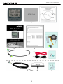
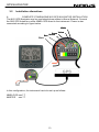
GPS Navigator
- Instrument -
Installation and Operation Manual
English
English
GPS NAVIGATOR
1
GPS NAVIGATOR
Introduction
Thank you for choosing NX2 GPS Navigator instrument. We are convinced that you will
appreciate all the valuable information either you are a cruiser or a racer. It is important
that you are following this instruction regarding installation and operation.
If the instrument are to be used in a Nexus Network, there are some systems settings
that are dependent on where the transducers are installed, i.e. at the instrument or at
the Server.
This manual is written for NX2 GPS Navigator instrument version 2.01 – 2.10
Edition: March 2007
2
GPS NAVIGATOR
1
2
3
4
5
6
Part specifications.................................................................................................................. 5
INTRODUCTION ...................................................................................................................... 7
2.1
Basic Features................................................................................................................ 8
2.1.1
Position (POS) ....................................................................................................... 8
2.1.2
Navigation (NAV) ................................................................................................... 8
2.1.3
Waypoint (WP)....................................................................................................... 8
2.1.4
Route (ROUTE) ..................................................................................................... 8
2.1.5
MAN OVER BOARD.............................................................................................. 8
2.1.6
TIME ...................................................................................................................... 8
2.2
EXTRA NEXUS FEATURES .......................................................................................... 9
Installation............................................................................................................................. 10
3.1
Mounting the instrument ............................................................................................... 11
3.2
Installation alternatives ................................................................................................. 13
3.3
CABLE CONNECTIONS .............................................................................................. 16
FIRST START ........................................................................................................................ 17
4.1
DEFAULT SETTINGS FROM FACTORY..................................................................... 18
4.2
GPS STATUS and OPERATION.................................................................................. 19
HOW TO USE THE 5 PUSH BUTTONS ................................................................................ 20
5.1
PAGE BUTTON ............................................................................................................ 20
5.2
LIGHT CONTROL......................................................................................................... 20
5.3
MINUS BUTTON .......................................................................................................... 20
5.4
PLUS BUTTON............................................................................................................. 20
5.5
SET BUTTON ............................................................................................................... 20
5.6
ACCESS TO SETTINGS .............................................................................................. 21
5.7
CLEAR (or ERASE) a WP or value. ............................................................................. 21
5.8
MAN OVER BOARD..................................................................................................... 21
5.9
ESCAPE (or ABORT) from edit mode. ......................................................................... 21
5.10
"BACK STEP" ............................................................................................................... 21
5.11
GENERAL WAYPOINT SEARCH ................................................................................ 21
NAVIGATION FUNCTIONS ................................................................................................... 23
6.1
POS .............................................................................................................................. 24
6.1.1
POSITION and ALTITUDE .................................................................................. 24
6.1.2
DATE and TIME................................................................................................... 24
6.1.3
BATTERY VOLTAGE .......................................................................................... 25
6.1.4
SATELLITE STATUS and SIGNAL to NOISE. .................................................... 25
6.2
WP ................................................................................................................................ 26
6.2.1
MARK WP ........................................................................................................... 26
6.2.2
EDIT WP.............................................................................................................. 26
6.2.3
COPY WP............................................................................................................ 27
6.2.4
MOVE WP ........................................................................................................... 28
6.2.5
DELETE............................................................................................................... 28
6.2.6
ED B/R................................................................................................................. 28
6.3
NAV .............................................................................................................................. 29
6.3.1
COMBI VIEW and X~TRACK ERROR ................................................................ 29
6.3.2
ETA and TTG....................................................................................................... 29
6.3.3
DRIFT .................................................................................................................. 29
6.3.4
WCV and CTS ..................................................................................................... 30
6.3.5
GOTO WP ........................................................................................................... 31
6.4
ROUTE ......................................................................................................................... 32
6.4.1
SAIL PLAN .......................................................................................................... 32
6.4.2
ROUTE CALL ...................................................................................................... 35
6.4.3
REVERSE CALL ................................................................................................. 36
6.4.4
DELETE............................................................................................................... 36
3
GPS NAVIGATOR
6.4.5
ROUTE STORE ...................................................................................................36
SETTINGS ..............................................................................................................................38
7.1
UNITS............................................................................................................................38
7.2
ALARMS........................................................................................................................39
7.2.1
Arrival line ON/OFF. .............................................................................................39
7.2.2
Auto change .........................................................................................................39
7.2.3
X-track error limit. .................................................................................................39
7.2.4
start time...............................................................................................................39
7.3
GPS Settings.................................................................................................................40
7.3.1
Dampening of SOG, COG....................................................................................40
7.3.2
latitude correction .................................................................................................40
7.3.3
longitude correction ..............................................................................................40
7.3.4
Altitude correction ................................................................................................40
7.3.5
Set Time ...............................................................................................................40
7.3.6
Init position ...........................................................................................................40
7.4
DGPS ............................................................................................................................41
7.5
NMEA ............................................................................................................................41
7.5.1
Select NMEA output. ............................................................................................41
7.6
OPTIONS ......................................................................................................................42
7.6.1
MAGNETIC VARIATION. .....................................................................................42
7.6.2
Push button beep .................................................................................................42
7.6.3
WP-BANK.............................................................................................................42
7.6.4
Chart Page ...........................................................................................................43
7.7
CONFIG ........................................................................................................................44
7.7.1
CHOICE OF POSITION SOURCE.......................................................................45
7.7.2
STANDARD NX2 NAVIGATION SETUP .............................................................45
7.7.3
NX2 REPEATER SETUP .....................................................................................45
7.7.4
NMEA REPEATER SETUP..................................................................................45
8
NMEA DATA ...........................................................................................................................46
9
SPECIAL NMEA AND NEXUS APPLICATIONS....................................................................49
10
FAULT FINDING ...............................................................................................................53
11
TECHNICAL DATA ...........................................................................................................54
12
MAINTENANCE ................................................................................................................55
13
WARRANTY ......................................................................................................................55
14
ABBREVIATIONS .............................................................................................................56
15
Specifications ..................................................................................................................57
15.1
Technical specifications ................................................................................................57
15.2
Nexus Network introduction and user policy .................................................................57
16
Optional Accessories ......................................................................................................58
17
Abbreviations ...................................................................................................................60
18
Warranty ........................................................................................................................... 61
7
4
GPS NAVIGATOR
1
Part specifications
NX2 GPS Navigator is delivered with all parts for mounting. Check prior to installation.
Wind Data instrument
Qty.
1
1
1
1
1
2
2
1
1
2
1
1
5
5
Description
Reference
Instrument, NX2 GPS Navigator
Instrument front cover
Drill template
Installation and user manual
Warranty card
Pin bolts for instrument mounting
Nuts for instrument mounting
Tube of silicon grease
Connection cover
4-pol screw terminal
Instrument Cable 8m
Power cable, red and black, 3 m (9 ft)
Extra wire protectors, 0,25 mm (1/100”)
Extra wire protectors, 0,75 mm (1/32”)
1
2
3
4
5
6
6
6
6
6
7
8
9
9
Additional in GPS Navigator complete with GPS Antenna
1
3
GPS Antenna
Mounting screws for Antenna
10
11
Registering of this product
Once you have checked that you have all the listed parts, please take time to fill in the
warranty document and return it to your national distributor.
By returning this document, it will assist your distributor to give you prompt and expert
attention, in the event of your experiencing difficulties with this product. Keep your proof
of purchase. Also, your details are added to our customer database so that you
automatically receive new product catalogues as and when they are released.
5
GPS NAVIGATOR
6
GPS NAVIGATOR
2
INTRODUCTION
THANK YOU FOR CHOOSING THE NX2 GPS NAVIGATOR.
The GPS system is operated by the DOD (Department Of Defence) USA and the
Systems accuracy and maintenance is totally within their responsibility.
Remember that a GPS navigator is a '1tool" or a navaid to common navigation
methods, and should therefore be used as a complement to maps and compass, and
not as a replacement.
Please read about the GPS system in the NX2 GPS Antenna manual.
The NX2 GPS navigator system.
The NEXUS GPS NAVIGATOR offers TRUE multiple nav-station operation. When
operating, ONLY ONE WP database is in use for the whole NEXUS system. Therefore,
you may store or delete waypoints, create or call up a route on any NEXUS GPS or
Multi Center instruments.
By adding this GPS navigator into the NEXUS series of instruments, you will benefit
from the high integration level that makes navigation simple, precise and reliable.
7
GPS NAVIGATOR
2.1
Basic Features
2.1.1
Position (POS)
Position is given in latitude and longitude to 3 decimal places with selectable set-up for
minutes and seconds or minutes and 1 000ths of minute. Altitude in METRES or FEET
can also be displayed.
2.1.2
Navigation (NAV)
Course and Speed Over Ground (COG/SOG) in knots, km/h or miles/h.
Select either magnetic or true, for both course over ground and bearing to waypoints.
This will be clearly "flagged" with the reversed text MAGNETIC on the LCD to prevent
confusion and uncertainty. Distance to WP is selectable in nautical miles, kilometres or
miles. Actual X-track error is displayed to 3 decimal places which is perfect for high
precision Differential GPS navigation.
2.1.3
Waypoint (WP)
Store up to maximum 399 WP in lat/long each with a 7 character name. You may Copy,
Move or Delete a single WP or in a block.
2.1.4
Route (ROUTE)
Up to 25 "named" routes can be stored with 24 WP in each route.
They can also be called and used "reversed" (e.g. return to harbour).
2.1.5
MAN OVER BOARD
For your safety, the M.O.B. (Man over board) function can be activated very easily.
Please see chapter 5.8.
2.1.6
TIME
Month, day and time is displayed (local time can be set). When navigating towards a
waypoint, both ETA (estimated time of arrival) and TTG (estimated time in hours and
minutes to go) is displayed.
8
GPS NAVIGATOR
2.2
EXTRA NEXUS FEATURES
•
For sailracing (with a complete NEXUS System), the built in race timer
clock become extra valuable. The exact GPS time is used to "trigger" the NEXUS
instruments start timer up to 1 8h and down to the last second (hh:mm:ss) before the
actual start.
•
With the PC-interface and software, you may transmit receive
waypoints; log selected data to a file; monitor NEXUS information in real time, using a
PC.
GOOD LUCK AND HAPPY SAILING!
9
GPS NAVIGATOR
3
Installation
You can install the NX2 GPS Navigator in two different ways:
•
•
The GPS antenna connected directly to the NX2 GPS Navigator instrument
The installation may also include a NX2 Server where all transducers may be
connected. All data including power will pass along one cable.
•
1.
2.
3.
4.
5.
6.
The installation includes 6 major steps:
Read the installation and operation manual.
Plan where to install the transducers and instruments.
Run the cables.
Install the transducers and instruments.
Take a break and admire your installation.
Learn the functions and calibrate your system.
Before you begin drilling ... think about how you can make the installation as neat
and simple as your boat will allow. Plan where to position the transducers, Server
and instruments. Think about leaving space for additional instruments in the future.
•
−
−
−
−
−
A few ”do nots” you should consider:
Do not cut the cables too short. Allow extra cable length at the Server so it
can be disconnected for inspection without having to disconnect all
attached cables.
Do not place sealant behind the display. The instrument gasket eliminates
the need for sealant.
Do not run cables in the bilge, where water can appear.
Do not run cables close to fluorescent light sources, engine or radio
transmitting equipment to avoid electrical disturbances.
Do not rush, take your time. A neat installation is easy to do.
•
The following material is needed:
Wire cutters and strippers.
Small and large Philips and small flat head screw driver.
Hole saw for the instrument clearance hole 63 mm (2½").
5 mm (1/4") drill for the mounting holes.
Plastic cable ties
If you are doubtful about the installation, obtain the services of an experienced
technician.
10
GPS NAVIGATOR
3.1
Mounting the instrument
•
Place the adhesive drill template on the desired location for the instrument. Drill the
2 holes using a 5 mm (1/4") drill for the two pin bolts. Use a 63 mm (2½") hole saw to
machine the clearance hole for the instrument connection socket. Remove the
template.
•
•
•
Screw the two pinbolts to the instrument
Put the instrument in place
Screw the two nuts from the back
Note! The two nuts must just be tighten by hand
•
•
•
Run the Nexus Network cable from the Server
to the instrument.
If you want to cut the Nexus Network cable to
length, disconnect 4-pole jack plug and cut
the cable. Peel off about 35 mm (1,4") of the
cable insulation. Remove about 6 mm (1/4")
from the 3 isolated wires (the 4th wire is an
earth / screen). Attach the 4 cable protectors
to the wires using a pair of flat pliers.
Connect the 4 cable protectors to the 4-pole
jack plug as shown. Apply silicon paste on all
locations as shown.
Note: Must be done to avoid corrosion.
11
Silicon paste
GPS NAVIGATOR
•
•
Apply silicon paste to the instrument connection pins at the back of the instrument.
Press the jack plug onto the instrument pins. Press the cable in to the cable leads.
Mount the connection back cover with the screw.
12
GPS NAVIGATOR
3.2
Installation alternatives
A.
COMPLETE STANDALONE NX2 GPS NAVIGATOR INSTALLATION
The NX2 GPS Navigator may be used stand alone without a Nexus Network. Connect
the NX2 GPS Antenna or other NMEA GPS direct to the instrument. Power is also
connected according to figure below.
White
Black
Green
Red Screen
Yellow
In this configuration, the instrument has to be set up as follows:
NMEA POS see 7.7
MASTER see 7.7
13
GPS NAVIGATOR
B.
IN A NEXUS NETWORK
The NX2 GPS Navigator may be used in a Nexus Network. Connect the NX2 GPS
Antenna or other NMEA GPS direct to the Server. Connect the Nexus Network cable to
the instrument. Power will be supplied via the Nexus Network Cable
Green
Yellow
White
Screen
In this configuration, the instrument has to be set up as follows:
NEXUS POS see 7.7
MASTER see 7.7
14
GPS NAVIGATOR
C.
AS A REPEATER IN A NEXUS NETWORK
If you already have a NX2 GPS Navigator or another GPS in the Nexus Network that is
Navigating (storing the waypoints and calculates Bearing and Distance to WP etc.) you
may use an other NX2 GPS Navigator as a repeater.
In this configuration, the instrument has to be set up as follows:
NEXUS POS see 7.7
REPEATER see 7.7
15
GPS NAVIGATOR
3.3
CABLE CONNECTIONS
The 3 m red and black power cables connect 12 V supply, ALWAYS USE WITH 3A
FUSE.
Cable wiring on the instruments backside.
NEXUS databus and power. +12V
DATA
DATA
GROUND
NMEA 0183 output A.
(RS 422) output B.
NMEA 0183 input.
(Opto)return
GREEN
YELLOW
WHITE
SCREEN
TERMINAL 1
TERMINAL 2
TERMINAL 3
TERMINAL 4
16
GPS NAVIGATOR
4
FIRST START
After installation and before switching the power on, make sure that
the GPS Antenna is away from anything that may obscure the
satellites.
The instrument will then ask you to press the button to be able to
give the instrument an ID or a "logical" NEXUS number.
You will then see the software VERSION and its ID number (Your
instruments version number may differ from this example).
If the instruments are accessed in random order, you may reset the
ID numbers for all NEXUS instruments and then start again by
pressing SET in preferred number (remote access) order.
Just press Clear during the time when VER ID is displayed. Then
press the SET in preferred number order (always wait for the OK
text before pressing the SET on the next instrument).
17
GPS NAVIGATOR
4.1
DEFAULT SETTINGS FROM FACTORY
UNITS are set to Nautical Mile for distance, Knots for speed and
Metres for altitude.
POSITION presentation is set to present position in degrees
minutes and 1/1000 of a minute. Alternative is degrees minutes
and seconds.
TRUE bearing and course over ground. MAGNETIC course can be
set as an alternative. Local magnetic variation must then be set.
CONFIGuration is set for this instrument and the NX2 GPS
Antenna. For repeaters or other combinations, please see settings
in chapter 7.7.
18
GPS NAVIGATOR
4.2
GPS STATUS and OPERATION
Non of the 2D or 3D flag will be lit during satellite search before
navigation can start. When the GPS is tracking satellites, the status
symbols 2D or 3D will be displayed at the top of the LCD, as online
information If a DGPS receiver is connected and working correctly,
the symbol text DGPS will also be displayed.
When 3 satellites have been found and tracked, the 2D symbol is
displayed; 3D when more that 3 satellites are tracked.
No Symbol
Acquisition of data from satellites.
2D
2 dimensional position (with locked altitude) for
marine navigation.
3D
3 dimensional position for all land navigation.
DGPS
differential GPS is active.
The initial GPS receiver start is called a COLD START and will be
performed if the GPS has been moved a large distance, or if used
for the first time. It will take about 3 minutes and is indicated by
neither of the 2D or 3D flag is on.
Warm start takes from 35 seconds up to 2 minutes depending on
the age of the emphemeris almanac and your position (within 4
hours).
19
GPS NAVIGATOR
5
HOW TO USE THE 5 PUSH BUTTONS
5.1
PAGE BUTTON
Is used for selecting main function. Each press on this key will
change to a new main function (from left to right). The selected
main function will be indicated with the LCD arrow.
When editing any value, this key will also move cursor key to edit
numbers or text characters with the same functions as above.
5.2
LIGHT CONTROL
Is accessed with a long press (> 2 secs) on the PAGE button.
Three light levels, LOW, MED, MAX plus light OFF can be
selected.
5.3
2 sec
MINUS BUTTON
Is used to "pull down" next function from the selected main menu.
When in edit mode, this button is used to increase a digit value or a
text character.
5.4
PLUS BUTTON
Is used to "pull up" previous function from the selected main menu.
When in edit mode, this button is used to decrease a digit value or
a text character.
5.5
SET BUTTON
This is the SET KEY that will "unlock" a value, text or function to be
set or altered, then "lock" when ready.
It is also used as a toggle page when a secondary function is
available, e.g. to toggle between the Combi function and X-track
error.
20
2 sec
GPS NAVIGATOR
5.6
ACCESS TO SETTINGS
Press minimum 2 secs. on the SET button.
2 sec
5.7
CLEAR (or ERASE) a WP or value.
5.8
MAN OVER BOARD
To engage Man Over Board, press the two outer keys.
5.9
&
ESCAPE (or ABORT) from edit mode.
Press the Cursor key (PAGE) for minimum 2 seconds.
2 sec
5.10 "BACK STEP"
Press the PAGE and MINUS simultaneously to "back step" to
previous function or for moving the cursor to the left.
5.11 GENERAL WAYPOINT SEARCH
The SEARCH METHOD is the same for all searches. You will use it
when searching for "NAMED" waypoints to edit, when activating a
WP to navigate towards, or calling up a "NAMED" route, The same
method is also used when selecting a "NAMED" geodetic datum.
1.
Search for a waypoint number by scrolling PLUS or MINUS
(increase or decrease the waypoint numbers). As an example,
function EDIT WP is chosen.
To find e.g. WP "BUOY", select EDIT WP and press SET (No:023
shows the next free waypoint)
The display shows FREE no:023. Digits flashing, press MINUS to
scroll backwards to find the waypoints that
you have stored earlier under WP function.
21
&
GPS NAVIGATOR
The display shows ex. "BUOY" no:022. This is the last stored
waypoint.
Scroll MINUS for other waypoints to EDIT or PLUS to create a new
waypoint from a FREE number. Press SET and proceed with the
editing. See chapter 6.2.2. regarding editing of WP's.
2. Search in "ALPHABETICAL" order by scrolling PLUS or
'DOWN".
This example is demonstrating alphabetical scrolling in the GOTO
WP function.
Select GOTO WP and press SET
The display shows ex. "NAME" no:023 as last edited waypoint
(digits flashing).
Press the PAGE (cursor) button once and the "NAME" starts to
flash. Use PLUS or MINUS button to scroll through all waypoints in
"ALPHABETICAL" order.
3.
character.
Single character search, starting with the left hand
Press the PAGE (cursor) button once more and the first "character"
in the "NAME" will flash.
By pressing the PLUS character in alphabetic is found in the
memory
button you will display the next order and the FIRST waypoint that
with that character is shown.
By pressing the MINUS button, you will display the previous
character in alphabetical order and the LAST waypoint that is found
in the memory with that character is shown.
22
GPS NAVIGATOR
4.
Finding a WP by entering the WP number.
If we use the same example as before, there are two ways of
moving the cursor to the three digit position (no:nnn).
A. Repeated press on the PAGE button until the left hand digit is
flashing.
B.
Press both PAGE and MINUS buttons to backstop the cursor.
When the desired digit is flashing, enter the number with the PLUS
or MINUS button and then move the cursor to the next digit. Press
SET lock.
6
NAVIGATION FUNCTIONS
The definition of navigation is to know where you are, where to go,
and how to get there.
You may simply utilise POSition data to navigate or fully utilise the
waypoint features, after the following steps.
Prepare for WAYPOINT NAVIGATION.
1.
LOCATE on your chart, the LAT and LON position
of your waypoint's.
2.
STORE the WP's in the WP bank.
3,
SELECT one of the WP's stored in the GOTO WP
function. Prepare for SAIL PLAN NAVIGATION.
4.
ADD ON additional WP's in the SAIL PLAN queue.
The first WP in that queue is already selected in the GOTO WP
function ( point 3 above).
5.
SAVE the complete SAIL PLAN as a ROUTE for
later use.
A SAIL PLAN is a list of pointers (up to 24) to your pre programmed
waypoints in the navigator memory. The navigator will then
navigate towards the waypoints, in a sequence, one by one. You
may also store the complete SAIL PLAN as a ROUTE (up to 25
routes).
When a ROUTE is called up, it will be added to the SAIL PLAN.
23
GPS NAVIGATOR
6.1
POS
Access levels and summary of the POS functions.
"FIRST SHOWN"
"Press DOWN"
"Press DOWN"
ch. 6.1.3.
"Press DOWN"
ch. 6.1.4.
POSITION and ALTITUDE, ch. 6.1.1.
DATE and TIME (local or UTC), ch.6.1 .2.
BATTERY VOLTAGE (inside the instrument),
SATELLITE STATUS and SIGNAL to NOISE,
Tip !, Use the PLUS button to get access to the last function.
6.1.1
POSITION and ALTITUDE
Latitude (top) and longitude (bottom) in selected geodetical
datum.
Press MINUS to display the ALTITUDE above sea level.
6.1.2
DATE and TIME
Press SET to set Local time zone. Add or subtract one or more
hours to UTC (GMT) (GPS) time to make local time. Find out your
time zone with help of the time zone map on page 2.
Note! The unit will not accept 1/2 hour time differences.
Plus indication, "_" will flash, use PLUS to change to minus sign, "". Use plus indication when situated east of Greenwich and minus
sign, west of Greenwich.
Move cursor with PAGE button to set hour difference.
Increase/decrease flashing value by pressing PLUS or
MINUS.
Lock the required value by pressing SET
24
GPS NAVIGATOR
6.1.3
BATTERY VOLTAGE
The battery voltage is measured inside the instrument and will differ
from the NEXUS Multi Control instrument, where the battery
voltage is measured in the Server.
6.1.4
SATELLITE STATUS and SIGNAL to NOISE.
HDOP (Horizontal Dilution Of Precision) has normally a low value. If
higher than or equal to 1 0, the 2D or 3D will start to flash as a
warning of bad satellite geometry
Note Not with NX2 GPS Antenna
4 SAt indicates the number of satellites used mm 3 and max 15.
The GPS will internally track up to 12 satellites.
25
GPS NAVIGATOR
6.2
WP
Note! This page is only accessible when the NX2 GPS Navigator is in MASTER or SLAVE mode.
Not accessible when operating as a REPEATER. See 7.7.
Access levels and summary of the WP functions
"FIRST SHOWN" MARK WP (Marks a waypoint from pre sent
position), chapter 6.2.1.
"Press MINUS"
EDIT WP ( EDIT a WP in Lat/Lon), chapter
6.2.2.
"Press MINUS "
COPY WP (Copy one or a block of WP's to
another memory part), chapter 6.2.3.
"Press MINUS "
MOVE WP (As with COPY but clears the "from"
memory when done), chapter 6.2.4.
"Press MINUS "
DELETE (DELETES one or a block of WP's),
chapter 6.2.5.
"Press MINUS "
ED B/R (EDIT a WP in Bearing and range),
chapter 6.2.6.
Notel All waypoints are stored and identified with an unique number
and with any 7 alphanumeric "NAME".
6.2.1
MARK WP
Use MARK WP when passing a position to store for later use. The
position will be stored directly when the SET is pressed.
The first free waypoint is shown in the example as no 002.
Press SET and you are invited to optionally give the waypoint a
name. Enter the character with PLUS or MINUS buttons and move
to the next character with the PAGE button (cursor). Press SET
when ready.
Next free WP to MARK will now be ready.
6.2.2
EDIT WP
EDIT WP (In latitude/longitude)
Use EDIT WP when creating a new WP or when editing an old WP.
26
GPS NAVIGATOR
Press SET and the text FREE is displayed with the WP number
flashing. Accept this free WP by pressing the SET.
Note! When editing an "old" WP you may search for it by scrolling
through the numbers with PLUS or MINUS button. You may also
use the GENERAL WAYPOINT SEARCH, see ch 5.11.
Give your WP a name (optional) and follow the same routine as
described in chapter 6.2.1, then press SET.
Now, the position is shown in latitude and longitude Enter the
correct latitude with PLUS / MINUS and PAGE (cursor) and press
SET Enter correct longitude in the same way and press SET
Note! Make sure you set the correct hemisphere for lat (N/S) and long
(E/W).
DELETE a WP
You may also delete a WP and make it a FREE position by CLEAR
WARNING!
If you have created a ROUTE and then later change or delete a WP
that is within that ROUTE, the ROUTE will be affected
Our recommendation is to decide early how to organise the
waypoints You may use the first 1 GO WP for "temporary"
waypoints and the rest as more "permanent" WP's for use in
ROUTES Always check that the GPS datum and the chart datum
match
6.2.3
COPY WP
Copy one or a block of WP's to another position without erasing the
original block of waypoints
Press SET
Press SET (first digit flashing)
Select the FIRST WP (12) in the "block" and press SET Select the
LAST WP (200) in the "block" and press SET
27
GPS NAVIGATOR
Select the TO WP number for the WP block 012-123 Set this WP
for example "address" to 200 and press SET
DONE!
6.2.4
MOVE WP
MOVE WP
Is the same as COPY with the difference that it will first copy the
selected WP's to the new block position before the original
waypoints will be erased.
6.2.5
DELETE
Deletes a single or a block of WP's by use of the same procedure
as in COPY and MOVE.
Warning ! There is no way back if DELETE is fully executed. But if
you accidentally press the SET, you may ESCAPE without
DELETING with a long press on the PAGE button.
6.2.6
ED B/R
ED B/R (EDIT a WP in Bearing and range from present position).
Note! BEARING and RANGE is ALWAYS in TRUE NORTH from
PRESENT POSITION.
Press SET and FREE is displayed, accept or select an other free
WP number and press SET.
Enter the WP's "NAME" (as described iii chapter 6.2.1) and press
SET.
"WP NAME"(example shows distance 1 2.24 NM and bearing 205
from 1 2.34 205 present position)
28
GPS NAVIGATOR
6.3
NAV
Access levels and summary of the NAV functions
"FIRST SHOWN" COMBI VIEW and X-TRACK ERROR, chapter
6.3.1
"Press MINUS"
ETA and TTG (Arrival time or time to go to WP),
chapter 6.3.2
"Press MINUS "
DRIFT (Tidal and boat drift), chapter 6.3.4.
"Press MINUS "
WCV (VMG to WP) and CTS (Course To Steer
including Drift), chapter 6.3.5.
"Press MINUS "
XTE (Cross track error)
6.3.1
COMBI VIEW and X~TRACK ERROR
The most used function in NAV is the COMBI VIEW where you will
see;
SPEED and COURSE OVER GROUND, DISTANCE and
BEARING TO WAYPOINT (When a WP is active)
The X-track error is the distance of 90° from your track. The symboI
indicates that the error is to the left, or right, of your track.
Note! To make COG (Course Over Ground) stable, use higher
dampening at low speeds and lower dampening at high speeds. Try
to keep dampening as low as possible. Row to set dampening, see
chapter 7.4.
6.3.2
ETA and TTG
Estimated Time of Arrival
Note! ETA is calculated on the assumption that both speed and
direction will be constant during travel towards the waypoint.
Press MINUS
TTG or Time To Go in hours and minutes to the WP with the same
criteria as ETA.
6.3.3
DRIFT
When both Compass heading and log data are available, the boats
drift including tide (speed and direction) can be calculated. In the
29
GPS NAVIGATOR
example, the boat is drifting on a bearing 234~ with the speed 0,8
knots.
Press SET to set the damping of SET/DRIFT and CTS (please see
below).
Note! The dampening setting will affect all instruments and is not
local, as with boat speed and compass.
The damping will correspond to the following;
D0 =
D3 =
D6 =
D9 =
5s
40s
5min
40min
d1 =
d4 =
d7 =
10s
1 min 20s
10min
d2 = 20s
d5 = 2 min 40s
d8 = 20min
6.3.4
WCV and CTS
WCV (Waypoint Closing Velocity) is the speed made good towards
the waypoint. CTS (Course To Steer) is the course (selectable
TRUE or MAGNETIC) that the boat must keep to be able to reach
that waypoint in a straight line. CTS includes compensation for the
boats drift.
See DRIFT chapter 6.3.4.
Note! CTS does not include the calculation for changes in tidal
direction.
30
GPS NAVIGATOR
6.3.5
GOTO WP
The GOTO WP function is the fastest way of selecting a WP to go
to and it is normally accessed by pressing the SET button once
wherever you are in the NAV page except in DRIFT (where SET
sets the dampening) in the Nav function.
Press PLUS or MINUS to select the waypoint you want to go to.
Press the SET again to select your WP to GOTO, in this example,
"BOUY NE" was the last edited WP.
Last edited WP is displayed
Digits "flashing", ( you may select another WP)
Press the SET to accept this WP and the navigation will start
WP 000 is defined as the "present position" and is used as the
FROM waypoint and WP 134 "BOUY NE" is the TARGET waypoint
4
I
How to use GOTO WP in combination with the SAIL PLAN
The GOTO WP function is actually a direct jump to the SAIL
PLAN's first LEG (the "active" WP), then replacing that WP with a
new "GOTO WP" waypoint
Example; You have set up a SAIL PLAN with 1 2 WP's and on the
first LEG you are navigating towards is WP134 "BOUY NE", then by
some reason you decide to go to WP1O4 "BOUY NW" instead
To make this easy, start from the Combi Nav display and press
SET to the GOTO WP function, select WP1 04 "BOUY NW", then
press SET again (navigation starts)
Press MINUS to return to the Combi Nav display where you will see
your new Distance and Bearing to "BOUY NW"
Note! The "old" PROM WP will be replaced with "present position"
to begin a new X-N-ack error calculation. When the Arrival alarm
criteria appears, next WP in the SAIL PLAN is activated as normal.
31
GPS NAVIGATOR
6.4
ROUTE
Note! This page is only accessible when the NX2 GPS
Navigator is in MASTER or SLAVE mode. Not accessible when
operating as a REPEATER. See 7.7.
Access levels and summary of the ROUTE functions
"FIRST SHOWN"
"Press DOWN"
"Press DOWN"
"Press DOWN"
"Press DOWN"
6.4.1
SAIL PLAN (Create, or edit the sail plan),
chapter 6.4.1
ROUTE CALL (Call a route for use),
chapter 6.4.2
REVERSE CALL (Call a route for use in
the opposite direction), chapter 6.4.3.
DELETE (Delete a route), chapter 6.4.4.
ROUTE STORE (Store the complete sail
plan as a route), chapter 6.4.5.
SAIL PLAN
The SAIL PLAN is the "tool" where you can create, delete or
insert one or more WP's to form a number of LEG's. The
complete SAIL PLAN can then be stored and named in ROUTE
STORE. Up to 24 WP's can be used in plan ( Each ROUTE can
then consist of maximum function each sail 24 WP's).
NOTE! A route is a stored Sail Plan. The Sail Plan is the current list of waypoint to go to and when
you pass a waypoint, it will disappear from the Sail Plan list. (However, the waypoint is still in
memory)
How to make the first LEG:
Press SET in SAIL PLAN
WP 000 is defined as present "START" position. NXT (Next)
indicates that the next WP is ready to be selected to form the first
LEG.
Note! You may choose any other waypoint as the "START" WP.
Press the MINUS button.
To select another FROM WP, press the SET and select your start
WP. The primary effect is that the X-track error will be calculated by
use of the new FROM WP and the TARGET WP, see drawing
32
GPS NAVIGATOR
Normally, WP 000 (current position/present position) is accepted as
the "START" WP.
Press the PLUS button (LEG 01) and press SET.
The last edited WP is displayed flashing. Use the GENERAL
WAYPOINT SEARCH, chapter 5.11 for finding the first WP to go to
and press SET.
As an Example we choose "BOUY SW" and then press
SET.
Note! Before distance and bearing to the target WP is displayed,
the LEG number is shown.
The distance to "BOUY SW" is 32.34 NM and the bearing is 2340 in
this first LEG.
Press the PLUS button for NEXT LEG;
WP 103 will be the FROM WP for the NEXT LEG (LEG 2).
Press SET, get next WP and press SET.
33
GPS NAVIGATOR
Repeat until a maximum of 24 WP's (LEG's) have been included in
the SAIL PLAN.
Also, make it a habit to always VERIFY the Distance and Rearing
for all LEG's in the SAIL PLAN, especially if stored as a ROUTE
Important! You will affect the ROUTE if you change the lat/ long
position for a waypoint that is used within that route.
CLEAR SAIL PLAN.
To clear the complete SAIL PLAN, press CLEAR, PLUS and
MINUS buttons simultaneously when the text SAIL PLAN is
displayed. The display will then show CLEAR PLAN for a short
moment.
INSERT A LEG INTO THE SAIL PLAN.
EXAMPLE. Insert a new leg (WP 1 27) between the present WP
103 and WP 107. This will move WP 107 one LEG minus in the
SAIL PLAN queue list. Use the PLUS and MINUS buttons for
scrolling through the different LEG's in the SAIL PLAN.
LEG 02 is first displayed, then distance and bearing;
BEFORE,
WP 1O3 ----- LEG 2 ----- WP 107
INSERT of a new LEG by pressing both PLUS and SET buttons
simultaneously at the preferred "LEG INSERT" location.
The text INSERT appears followed by the normal "search" window
where you select WP 127.
AFTER THE INSERT,
WP 1O3 ----- LEG 2 ----- WP 127
----- LEG 3 ----- WP 107
34
GPS NAVIGATOR
DELETE A LEG
Example; Delete WP 1 27 in LEG 2 without any other effect in the
SAIL PLAN Use PLUS and MINUS buttons for scrolling through the
different LEG's
LEG 2 is first displayed, then distance and bearing;
DELETE WP 1 27 in this LEG by pressing both PLUS and MINUS
buttons simultaneously at the preferred "LEG" location (LEG 02)
BEFORE,
AFTER,
WP 003---LEG 2---WP 127---WP024
WP 003---LEG 2---WP 024
6.4.2
ROUTE CALL
At least one ROUTE must have been stored to be able to use this
function
This function will ADD a selected ROUTE to the SAIL PLAN in the
same way as it was created It is therefore possible to ADD ON (or
"link") a new ROUTE into the SAIL PLAN as long as the number of
WP's are less then 25
Tip! It is practical to ADD ON a new ROUTE when only 2 or 3 WP's
are remaining in the SAIL PLAN, thus creating a long "seamless"
ROU]T
WARNING!!
If you have created a ROUTE and then later change or delete a WP
within that ROUTE, it will be affected
Press SET
"012 flashing", select your ROUTE and press SET
The ROUTE is now ADDED to the SAIL PLAN and you will see the
LEG number briefly, then Distance and Bearing between "FROM"
and "TO" will be displayed
Note! If you are ADDING the ROUTE to another ROUTE, you will
get into the SAIL PLAN's actual LEG number for this Route’s first
WP
35
GPS NAVIGATOR
6.4.3
REVERSE CALL
At least one ROUTE must have been stored to be able to use this
function.
The selected ROUTE will be copied to the SAIL PLAN in reverse
order. It is ADDED to the SAIL PLAN as in the ROUTE CALL.
Press SET, "012 flashing"
Select your ROUTE and press SET (it will now be your REVERSE
ROUTE).
See also ROUTE CALL regarding ADDING Route’s.
6.4.4
DELETE
Delete a selected ROUTE in memory.
Press SET
Select the ROUTE which shall be deleted and press SET
Warning! There is no way back if DELETE is executed.
6.4.5
ROUTE STORE
Store the SAIL PLAN as a ROUTE (in chapter 6.4~1)
Press SET, "001 flashing"
36
GPS NAVIGATOR
The first free ROUTE is no 001, press SET and give the route a
name by using the PLUS, MINUS and PAGE buttons
Press SET and the number of stored WP's are displayed
37
GPS NAVIGATOR
7
SETTINGS
Enter the SETTINGS by pressing the SET button minimum 2 secs.
2 sec
There are seven groups of SETTINGS
UNITS
ALARMS
GPS
DGPS
NMEA
OPTIONS
CONFIG
RETURN
Scroll between the main settings with PLUS or MINUS, press the
SET in any of the main settings to enter the submenu
Then select from the submenu with PLUS or MINUS and press
SET.
Press PAGE to return back to a "higher" level or back to normal
operation mode.
7.1
UNITS
DST NM
SPD KTS
ALT M
SECONDS OFF
RETURN
Select NM, KM or MILES
Select KTS, Km/h or MPH
Select M or FT
Select ON when using charts with degrees,
minutes and seconds (OFF = minutes and 1/1000
of a minute)
Return from UNIT set-up
38
GPS NAVIGATOR
7.2
ALARMS
Arrival circle alarm, within the set radius.
Ex. shows circle with 0.20 Nautical miles radius.
Note! The Circle Alarm MUST be in Nautical Mile.
7.2.1
Arrival line ON/OFF.
(see drawing;).
7.2.2
Auto change
Auto change to next WP in the sail plan. Can be important when
used with autopilots.
7.2.3
X-track error limit.
Ex. shows alarm value entered, 2.5 NM.
Note! The XTE Alarm MUST be in Nautical Mile
7.2.4
start time
Set actual start time (within 18 hrs) to be used to trig the NX2
Multi Control start timer.
RETURN from ALARM set-up.
39
GPS NAVIGATOR
7.3
GPS Settings
7.3.1
Dampening of SOG, COG
The damping will correspond to the following;
d0 = 0s d1 = 1.8s
d5 = 40s d6 = 1'20s
d2 = 2s
d3 = 10s
d7 = 2'40s d8 = 5'
d4 = 20s
d9 = 10'
This dampening affects Speed Over Ground and Course Over
Ground.
7.3.2
latitude correction
Note! This is only possible for older Nexus GPS Antennas that are
Nexus network compatible (Art no. 21000
Manual latitude correction from WGS-84 in Nautical 0'205 Miles,
Note! Only in 1/1000ths of a minute.
7.3.3
longitude correction
Note! This is only possible for older Nexus GPS Antennas that are
Nexus network compatible (Art no. 21000
Manual longitude correction from WGS-84 in Nautical 0'023
Miles, Note! Only in 1/1000ths of a minute.
7.3.4
Altitude correction
Note! This is only possible for older Nexus GPS Antennas that are
Nexus network compatible (Art no. 21000
Altitude correction in selected unit (metres or 025feet) from WGS84 to selected geodetic datum
7.3.5
Set Time
T-ZONE, YEAR, DATE, TIME,
Note! This is only possible for older Nexus GPS Antennas that are
Nexus network compatible (Art no. 21000)
7.3.6
Init position
Note! This is only possible for older Nexus GPS Antennas that are
Nexus network compatible (Art no. 21000
Set initial estimated position (within 100 km), speeds up the time to
first FIX.
RETURN from GPS setup
40
GPS NAVIGATOR
7.4
DGPS
This is a special POP UP feature for future differential receivers.
7.5
NMEA
Receive NMEA 0183 waypoints ON/OFF.
Send out internal WP's once via the NMEA port. Select an
individual WP or a group of WP's.
7.5.1
Select NMEA output.
Select NMEA output for the 8 channels
Each one of the 8 channels can also be set to -, meaning, no
output.
See further information in NMEA 0183 DATA
RETURN from NMEA setup.
41
GPS NAVIGATOR
7.6
OPTIONS
Magnetic bearing
Magnetic bearing is displayed for BTW, HDC, COG, CTS and
SET. The MAGNETIC flag is then displayed.
7.6.1
MAGNETIC VARIATION.
Max 99.9 degrees. (EAST-- +, WEST-- ).
Note! This setting will directly by affect the compass if it is
present.
7.6.2
Push button beep
Push button beep ON/OFF.
7.6.3
WP-BANK
Select for use with Multi instruments,(000, 100, 200, 300….)
Example, if you select WP bank 200 then all waypoints
accessed from a Multi instrument will be in this bank (200
299). This means that when you edit waypoint no: 22 in a
Multi, you are actually changing waypoint no: 222.
This is a special function for transfer (import) of WP's FROM a
NEXUS MASTER GPS Navigator instrument TO a NEXUS
repeater instrument,
Important! IMPORT can only be done from a NEXUS repeater
instrument.
You must also select WP-BANK since IMPORT will transfer in
blocks of 100 WP's. You can IMPORT another NEXUS GPS
instrument.
42
GPS NAVIGATOR
Example 1.
Move all 99 WP's from the Server to this instrument's WP BANK
300. The Servers WP's from 1 to 99 will then be stored in memory
position 301 to 399.
Do as follows,
1.
Set to NEXUS REPEATER in the CONFIG
2.
Switch POWER OFF then ON to activate this mode change.
3.
Set the WP-BANK to 300.
4.
Select IMPORT and press the SET
5.
Set to MASTER in the CONFIG mode and switch POWER
OFF and ON again.
6.
You are now able to use the Servers waypoints 1 99 as WP's
300-399.
Example 2.
Move WP 100 to 200 from NEXUS GPS navigator "A" to NEXUS
GPS navigator instrument "B" (into memory position).
-instrument the same
Do as follows,
1.
Set to MASTER in the CONFIG for NEXUS GPS
"A".
2.
Set to NEXUS REPEATER in the CONFIG mode
for NEXUS GPS "B".
3
Switch POWER OFF then ON to activate this
mode change.
4.
Set the WP-BANK to 300 (in "A" or "B")
5.
Select IMPORT in "B" and press the SET.
7.6.4
Chart Page
Reserved for future POP UP use, set to OFF.
RETURN from OPTION set-up.
43
GPS NAVIGATOR
7.7
CONFIG
MASTER, NEXUS-REPEATER or NMEA-REPEATER.
NEXUS POS or NMEA P0S.
NMEA input or RTCM input.
RETURN from CONFIG setup.
Important! Always switch POWER OFF then ON to activate a
mode change.
MASTER
Primary navigation is performed in the MASTER instrument. Only
one MASTER instrument is allowed.
NEXUS REPEATER
The MASTER instrument can be remotely controlled from this
instrument. There is no difference in functions between a MASTER
and a REPEATER.
NMEA REPEATER
Navigation is processed by an external NMEA navigator and then
repeated here. The NMEA navigator is connected to THIS
instrument, you must therefore also select NMEA P05 as the
position source (see chapter 7.7.1). You can NOT use the GOTO
WP or ROUTES, as long as this instrument acts as a pure NMEA
repeater. The NMEA data is also converted and is sent out on the
NEXUS Network.
44
GPS NAVIGATOR
7.7.1
CHOICE OF POSITION SOURCE
This GPS navigator instrument can as an option, use NMEA
position data from a GPS receiver or from an active GPS Antenna.
If NMEA P0S is selected, you must connect the NMEA source to
this instruments NMEA 0183 input port, on the back of the
instrument, see chapter 3.3.
Note! A SILVA GPS Antenna or GPS COMPASS will automatically
take over and transmit position data when connected. The NMEA
POS set-up is therefore only important when a NMEA position
source is to be used.
CONFIG:
CONFIG:
7.7.2
NMEA-POS - Standard set-up with NX2 GPS
NEXUS-POS - Optional set-up when instrument
used as a Repeater
STANDARD NX2 NAVIGATION SETUP
CONFIGuration is: MASTER and NMEA POS.
This is the default CONFIGuration for the sole GPS Navigator
instrument connected to the SILVA GPS Antenna.
7.7.3
NX2 REPEATER SETUP
New CONFIG: NEXUS REPEATER and NEXUS P0S.
All additional GPS Navigator instruments (for multiple Nav-stations)
must be set as NEXUS REPEATERS. There can be only ONE
MASTER in the system.
7.7.4
NMEA REPEATER SETUP
New CONFIG: NMEA REPEATER and NMEA POS.
When used as a Navigation REPEATER. This set-up will enable
NMEA NAVIGATION data from the external navigator or PC, then
convert and REPEAT it on to the NEXUS Network.
45
GPS NAVIGATOR
When used as a navigator, it will take the NMEA position data from a NMEA GPS
Antenna or a navigator, then use the internal waypoints and sail plans as if it was a sole
GPS NAVIGATOR.
8
NMEA DATA
SILVA NMEA 0183 Input/Output
This document gives a description of the NMEA 0183
sentences sent and received by the GPS navigator instrument
HDC (Heading Comppass) and BSP (Boat speed) is also sent out on NMEA when
available from the NEXUS Network.
When used as a NMEA repeater, all data will be retransmitted on to the NEXUS
Network.
Note! In the CONFIG SETUP there is a choice between
NMEA-01i83 and , RTCM Input. If RTCM is selected the NMEA
Input port is used for RTCM (DGPS) corrections only. The
NMEA 0183 output will only operate normal as long as the
RTCM Input is set to 4800 baud (bits/sec).
Output
The output from the GPS Navigator instrument is divided into 8 different "time-slots".
The required NMEA sentence can, be selected (or de-activated) individually for each
slot. The complete period for all slots is two seconds, so the time between each slot is
¼ sec.
Data that is not available will be sent with null fields.
Checksum is added on all sentences. Talker ID (address character 1 and 2) is always
GP (GPS source).
46
GPS NAVIGATOR
The following sentences can be selected (in the SETUP in the sending
Instrument:
No:
Sentence:
Contents:
0
No sentence sent
1
APB
Autopilot "B"
2
BOD
Bearing, origin to destination
3
BWC
Bearing & Distance to Waypoint
4
GLI
Geographic position
5
GGA
Global Positioning System
Fix Data
6
HDT
Heading Coarse (True)
7
RMB
Minimum Navigation data
8
RMC
Minimum Specific GPSI
TRANSIT data
9
VDR
Set & Drift
10
VHW
Water speed and heading
11
VTG
Track made good and ground
speed
12
WCV
Waypoint Closure Velocity
13
WPL
Waypoint Location
14
XTE
Cross-Track-Error
15
ZDA
Time & Date
Examples of each sentence listed above:
$IIAPB,A,A,0.002,L,N,,, 1 48,T,004, 1 48,T, 151 ,T* 1 D
$IIBOD,1 48,T,145,M,004,000*24
$IIBWC,090502,591 2.888,N,01 81 2.577,E, 1 48,T, 1 45,M, 15.661 ,N,004* 1 E
$IIGLL,5926.144,N,01 756.232,E,090502,A*3C
$IIGGA,090502,5926. 1 44,N,01 756.232,E, 1,4,1.49,1 7,M,,,, *27
$IIHDT,027,T*39
$IIRMB,A,0.002,L,000,004,59 1 2.888,N,01 81 2.577,E, 15.660,148,0.53, * 58
$IIRMC,090503,A,5926. 1 44,N,01 756.232,E,0.64, 173,1 50295,003,E*5F
$IIVDR,226,T,224,M, 1.21 ,N,2.24,K*58
$IIVHW,028,T,025,M,0.00,N,0.00,K*58
$IIVTG,253,T,250,M,0.94,N, 1 .74,K*55
$IIWCV,0.00,N,004*OA
$IIWPL,591 2.888,N,01 81 2.577,E,004*60
$IIXTE,A,A,0.058,L,N *44
$IIZDA,090753,1 5,02,1 995,-Ol ,*79
47
GPS NAVIGATOR
Note! The WPL (WayPoint Location) sentence, only contains the position of
the destination Waypoint. All other Waypoints will be sent out when the SENDWP function is activated in the SETUP.
Waypoint ID's are equal to the true (none banked) WP number in the NEXUS
Network (with digits). There is no Waypoint Base Number as in the ServerUnit.
Input
The NMEA input in the GPS navigator instrument is exclusively used for
POSITION and NAVIGATION data (including Waypoints).
The received data is divided into three categories:
1)
Basic POSITION related data: POSITION, SOG/COG, TIME/DATE and a
limited satellite status if the sender is a GPS.
This information is received and sent out on to the NEXUS Network, but ONLY
IF the NMEA-POS is selected in the CONFiGuration SETUP.
2)
NAVIGATION data: BTW, DTW, BOD, XTE plus Set and Drift
This information is received ONLY IF the NMEA-REPEATER is selected in the
CONFiGuration SETUP.
The GPS instrument will automatically calculate related data that is used in the
NEXUS Network, such as: Set and Drift, WCV, TTG and CTS (Coarse To
Steer).
3)
WAYPOINTS: Waypoints are received from WPL sentences if the RECWPT is ON in the NMEA SETUP.
If the receiving GPS instrument isn't the active navigator (MASTER) the
Waypoint will automatically be sent to the active navigator through the NEXUS
Network.
See further in the Multi Control manual for using NMEA with the Nexus Server.
48
GPS NAVIGATOR
9
SPECIAL NMEA AND NEXUS APPLICATIONS
In some applications, you might need an EXTRA NMEA input port. This is possible by
using the NEXUS Server (with one Multi Control instrument) together with one NEXUS
GPS navigator instrument. This CONFIGuration will convert NMEA position to NEXUS
Network and the NEXUS GPS Navigator instrument will do the Navigation.
Example:
A boat is equipped with a NMEA GPS Antenna (or a NMEA 0183 navigator) and a
NEXUS Chartplotter (see also page 43,44 Tip! for the Chartplotter).
The active NMEA GPS Antenna is connected direct to the
NEXUS Server's NMEA input port and the Chartplotter is
connected to the NMEA input port and output port on the
NEXUS GPS NAVIGATOR instrument.
CONFIGuration in the NEXUS GPS instrument is: MASTER and NEXUS P0S.
The Server will then have one NMEA output port free for use with an Autopilot, radar,
MAXI Repeater or any other NMEA application. On the NEXUS Network, additional
transducers can be used for wind speed, wind angle, depth, log and compass heading.
49
GPS NAVIGATOR
NMEA INPUT
The NEXUS GPS NAVIGATOR input port (normally used as the
NMEA 0183 input) can also be set to receive the RTCM 104
messages for the SILVA GPS COMPASS. It is preferable to use
4800 baud on the RTCM data to utilise the NMEA 0183 standard
output data specified at this baud-rate.
Alternative RTCM, Then select baud rate, see below.
Select baud rate if RTCM is selected and then RETURN.
Note! If possible, always use 4800 baud for RTCM data, it will NOT
then affect the baud rate for the NMEA output (4800 is the
standard).
9.1
TOGETHER WITH NEXUS CHARTPLOTTER
The link between paper charts and electronic navigation instruments. It is used as the
navigation tool that will make both WP navigation and position identification extremely
simple, fast and reliable.
When the Chart plotter is used with this navigator instrument and the SILVA GPS
Antenna, it is preferable to connect the Chart plotter direct to the instrument.
Connect battery POWER, NMEA IN and NMEA OUT without further cabling.
See connection diagram.
50
GPS NAVIGATOR
Navigation tips!
Select WP 001 in the GOTO WP function on the GPS navigator and then select
WP 01 the WAYPOINT mode on the Chart plotter.
Now move the "puck" to the position you want to go to and press the top left button.
That position co-ordinate will then be "transferred" as WP 01. The NEXUS
NAVIGATOR immediately starts navigating towards that WP, whenever a new "WP" to
go to is preferred, move the puck to it and "click". This unique feature makes WP
navigation very easy as there is no need for storing and recalling waypoints.
If you prefer to use the Chart plotter as the tool for fast storing of a great number of
waypoints (over 100), you must first enter the Chart plotters set-up and select WP block
number according to this:
0183
0183-1
0183-2
for WP's 00 and up to 099
for WP's 00 and up to 099
for WP's 00 and up to 099
When this set up is correct, the WP's will be received and stored in the corresponding
NEXUS NAVIGATOR's memory.
9.2
SPECIAL USE TO GET EXTRA WP's.
When two or more navigator instruments are connected to the NEXUS Network and if
more than one "skipper" or family are using the boat, it is sometimes practical to utilise
two completely separate WP bank's.
This can be done by changing the CONFIG in the two instruments, giving two users 399
WP's each. This can also be done with more than two instruments (up to 32 navigator
instruments !!).
Do as follows:
Dedicate the instruments between you "personal" navigators. Enter the CONFIG set up
on "your partners" navigator and set it to NEXUS REPEATER
51
GPS NAVIGATOR
Then enter the CONFIG set-up on "your" instrument and set it to MASTER. Turn the
power OFF and then ON again to activate this change. The waypoints are now used
from the new MASTER instead. Both (or all) instruments can now use the "new"
waypoint bank.
9.2
EXTRA FEATURES WITH SILVA NEXUS NETWORK
Integrate the navigator with the NEXUS Multi Control and Server by adding compass
and speed transducers. You will then get compass heading, boat speed, drift and tidal
data (its speed and direction).
PC-INTERFACE CABLE
The interface, (RS 232 to RS 485) is built-in in the 25-pole D-SUB connector which
connects to the PC (use 25-9 pole adapter if necessary).
Connect the interface cable (art.no. 20913 or 21122) between PC and GPS. Select the
function REMOTE, then run the interface software (see instructions).
Contact your SILVA dealer for more information.
52
GPS NAVIGATOR
10 FAULT FINDING
Check:
-
Sufficient battery voltage.
Cables for damage.
Faulty contact in connectors.
Connector corrosion caused by poor protection.
Short circuit on the NEXUS Network.
The following error messages can appear on the display:
Some errors are made by improper connections or when calling for unconnected
functions (missing transducers).
01 =
Stack error.
02 =
SILVA BUS missing, Check databus colours and connections.
03 =
Watchdog Timout, Check the connections.
04 =
EEPROM: Read-error.
Os =
EEPROM: Write-error.
06 =
RAM-MEMORY Read-error
07 =
UART Queue-Pointer-error
OB =
Break Point Reset
09 =
EEPROM-Initialization
10 =
Range-error caused by incorrect format, e.g. 17070 minutes East.
11 =
Remote command that can not be performed (calibration-error)
12 =
No response, or missing navigator unit
13 =
WayPoint Not DEFined
14 =
Oporation that can not be done with external NMEA navigator.
15 =
Operation that can not be done in AUTO-Pilot Mode
16 =
(notused)
17 =
(notused)
18 =
(notused)
19 =
(notused)
20 =
GPS -> CPU: Communication Error.
21 =
GPS AQUISITION - failure (time out during indoor use).
22 =
CPU -> GPS: Communication errori
23 =
DGPS (RTCM) overrun
24 =
Bad-Fix (1-Fix timout)
25 =
(not used)
26 =
(not used)
27 =
Extended Object Server Error (set the GPS to Master)
28 =
Route command error (bank, full..)
53
GPS NAVIGATOR
11 TECHNICAL DATA
Dimensions:
113 x 113 x 23 mm
Data cable:
8 m. Battery cable 3 m.
Battery voltage:
Mm. 6.0 V, max. 16.5 V.
Power consumption:
Without light 0,1 W, With light 0,8 W.
Temperature range:
Weight:
Operation -20C to +70C. Storage -30C to + 80C.
Instrument: 280 g
54
GPS NAVIGATOR
12 MAINTENANCE
Clean the instrument with mild soap solution only
- Do not use high-pressure washing equipment!
- It is advisable to remove the instrument during long cold periods.
- Put silicon grease on each contact.
- Check terminals and use wire protection.
13 WARRANTY
SILVA SWEDEN AB gives a two year warranty against manufacturing faults or faulty
components. The supplied warranty card together with a purchasing receipt must be
shown if a warranty claim is made. The warranty does not apply to damage caused by
careless handling or faulty installation. The warranty does not apply to secondary
damage caused by faults in instruments or transducers. The right to change the
specification is reserved by the manufacturer.
SILVA SWEDEN AB reserves the right to change product specifications without notice.
55
GPS NAVIGATOR
14 ABBREVIATIONS
2D
3D
ALT
AQU
BOD
BRG
BTW
COG
COR
CTS
DGPS
DoD
DTW
EDIT
ETA
F
GPS
HDOP
INIT P05
MAG VAR
MOB
NAV
NMEA
POS
RTCM
SAT
UG
VMG
WCV
WP
XTE
2-dimensional navigation
3-dimensional navigation
Altitude
Acquisition
Bearing origin destination (the FROM WP)
Bearing
Bearing To Waypoint
Course Over Ground
Correction of LATILON from WG584
Course To Steer
Differential GPS
Department of Defence
Distance To Waypoint
Programme /enter or alter a value or a name
Estimated Time of Arrival
Figure of merit
Global Positioning System
Horizontal Dilution of Precision
Initialisation of a known position in cold start
Magnetic Variation
Man Over Board
Navigate
National Marine Electronic Ass.
Position
Differential Correction Standard
Satellites used in navigation.
Time to go to next WP.
Velocity Made Good
Waypoint Closure Velocity
Waypoint
X-Track Error
56
GPS NAVIGATOR
15 Specifications
15.1 Technical specifications
Dimensions:
Wind Data instrument: 110 x 110 mm.
(4.3x4.3 inch)
Instrument cable:
Power sPLUSply:
Power consumption
Instrument:
Log- and temp sensor:
Wind transducer:
Temperature range:
Weight:
Enclosure:
12 V DC (10-16 V). The instrument is polarity
protected.
0,08 W
0.8 W (at max illumination)
12 mW
50 mW
Storage: From -30°C to +80°C.( -22°F to 176°F)
Operation: From -10°C to +70°C. (14°F to 158°F)
Instrument: 283 g (9.98 oz).
Transducer: 293 g (10.33 oz).
Instrument. Water proof
CE approval
The products conforms to the EMC requirements for immunity and emission according to
EN 50 08-1,
15.2 Nexus Network introduction and user policy
Introduction:
The Nexus Network is a Multi talker Multi receiver data bus specially designed for
marine navigation applications. It utilises the RS485 standard with PLUS to 32 senders
and/or receivers to form a Local Area Network. Data is transmitted synchronously with 1
start-bit, 8-data-bits, 1 parity-bit, two stop-bits in 9600 baud.
User policy:
The Nexus Network is open for new users and applications without the licence or a
licence fee. The data bus however is, the property of the manufacturer, which means
the specification must be followed in order to protect the manufacturer’s commitments
to the Nexus Network performance and safety.
For most PC-applications, the full dPLUSlex interface (Art. No. 21248), will be a very
useful tool for monitoring real time data, to edit and store Waypoints to PC-file or to
Server and/or to the NX2 GPS. The interface is sPLUSplied with a cable for connection
from PC to the Server or NX2 instruments and/or the NX2 GPS. A 9-pole D-sub
connector is connected to the RS232 port on the PC.
57
GPS NAVIGATOR
16 Optional Accessories
Below find a selection of optional accessories available. Please contact your local NX2
dealer for more information.
22118-3
22118-2
22118-1
22118-4
22118-5
22118-6
NX2 Completes
Multi Control instrument and Server, 8m cable
Multi Control and Server with Speed Log and depth transducer, 8m cable
Speed log with log transducer, 8m cable
Wind Data, with transducer, 25m cable, mast bracket
Compass Data, with transducer 35°, 8 m cable
GPS Navigator, with GPS Antenna, 8+10m cable
22120-1
20707
19915-8
21731
20860
20721
20721-1
20594
21721
69980
21970
21735
NX2/Nexus Transducers
Server compl with 3m power cables
Log/Temp transducer, 8 m cable (for Nexus and Star)
Depth transducer, 8m cable (for NX2 only)
Compass transducer 35°, 8m cable
Compass transducer 45°, 8m cable
Wind transducer, 25m cable, mast bracket
CF-wind transducer, Carbon Fibre, 1260mm long, 380g, no mast cable incl.
Nexus mast cable 25m
MTC (Mast Twist Compensation) box, 8m cable, for Wind Data instr.
MRC (Mast Rotation Sensor Compensation) box
GPS Antenna, with NMEA 0183 output
Bracket for GPS Antenna and 35° Compass transducer for bulkhead mount
22117-1
22117-3
22117-4
22117-5
22117-6
22117-7
NX2 Digital Instruments (all supplied with 0.2m cable)
Speed log instrument
Multi Control instrument
Wind Data instrument
Compass Data instrument
GPS Navigator instrument
Autopilot instrument
22115-01
22115-02
22115-03
22115-05
22115-06
22115-07
22115-08
22115-09
22115-10
22115-11
22115-12
22115-13
NX2 Analog Instruments (all supplied with 0.2m cable)
NX2 Analog Wind Angle
NX2 Analog Steer Pilot
NX2 Analog Speed Trim
NX2 Analog Speed 0-16kts
NX2 Analog Speed 0-50kts
NX2 Analog Depth 0-200m
NX2 Analog Depth 0-600ft
NX2 Analog Rudder angle
NX2 Analog Compass
NX2 Analog GPS Speed 0-16kts
NX2 Analog GPS Speed 0-50kts
NX2 Analog GPS Course
21210
21218-1
20966
Nexus Remote Control Instrument
Remote Control Instrument (RCI), with Autopilot control, 5m cable, bracket
Bracket Remote Control instrument
Connector 4-pole, NEW model (Allows cable - cable connection)
58
GPS NAVIGATOR
21680-1
21684-1
69995
Nexus Multi XL
Multi XL instrument, 4m cable (RCI or Multi Center needed to control Multi XL)
Multi XL Set, Multi XL instrument and Remote Control instrument
Mast bracket XL, in aluminium for Multi XL and Nexus / Star 110x110mm instr.
22118-6
22117-6
21970
20992-2
21735
NX2 GPS
GPS Navigator, with GPS Antenna, 8+10m cable
GPS Navigator instrument
GPS Antenna, with NMEA 0183 output
Bracket GPS Antenna, plastic with female thread 1" x 14 tpi
Bracket for GPS Antenna and 35° Compass transducer for bulkhead mount
22117-7
21210
22115-09
Nexus Autopilot components
Autopilot instrument
Remote Control instrument, with Autopilot control, 5m cable, bracket
NX2 Analog Rudder angle
21035-2
20860
21731
21036
69981
Servo Unit A-1510, 8m cable
Compass transducer 45°, 8m cable
Compass transducer 35°, 8m cable
Rudder Angle Transmitter RFU-25, 15m cable, ball joint linkage 230mm x 2
Linear Rudder Angle Transmitter
21134
21134-24
21341
21341-24
21136
69991-12
Pumpset PF-0.3 12V
Pumpset PF-0.3 24V
Pumpset PF-0.3S 12V, with solenoid
Pumpset PF-0.3S 24V, with solenoid
Linear Drive AN-23, stroke 229mm, peak thrust 680kg
Integrated Linear Drive HP-40, stroke 254mm, peak thrust 500kg
59
GPS NAVIGATOR
17 Abbreviations
BSP
BTW
C
F
KM
KTS
MH
LCD
LOW
MID
MAX
RET
SOG
TRP
_
Boat Speed
Bearing To Waypoint
Celsius
Fahrenheit
KiloMetre
KnoTS
Miles per Hour
Liquid Crystal Display
LOW
MID
MAX
RETurn
Speed Over Ground
TRiP
Minus
Plus
60
GPS NAVIGATOR
WARRANTY
GENERAL
All our products are designed and built to comply to the highest class industry standards. If the
products are correctly installed, maintained and operated, as described in the installation and
operation manual, they will provide long and reliable service. Our international Network of
distributors can provide you with the information and assistance you may require virtually anywhere
in the world.
Please read through and fill in this warranty card and send it to your national distributor for
product registration.
LIMITED WARRANTY
The warranty covers repair of defective parts due to faulty Manufacturing and includes labour when
repaired in the country of purchase. The warranty period is stated in the product manual, and
commences from the date of purchase. The above warranty is the Manufacturer’s only warranty
and no other terms, expressed or implied, will apply. The Manufacturer specifically excludes the
implied warranty of merchantability and fitness for a particular purpose.
CONDITIONS
•
The supplied warranty card and receipt with proof of purchase date, must be shown to validate
any warranty claim. Claims are to be made in accordance with the claims procedure outlined
below.
•
The warranty is non-transferrable and extends only to the original purchaser.
•
The warranty does not apply to Products from which serial numbers have been removed,
faulty installation or incorrect fusing, to conditions resulting from improper use, external
causes, including service or modifications not performed by the Manufacturer or by its national
distributors, or operation outside the environmental parameters specified for the Product.
•
The Manufacturer will not compensate for consequential damage caused directly or indirectly
by the malfunction of its equipment. The Manufacturer is not liable for any personal damage
caused as a consequence of using its equipment.
•
The Manufacturer, its national distributors or dealers are not liable for charges arising from
sea trials, installation surveys or visits to the boat to attend to the equipment, whether under
warranty or not. The right is reserved to charge for such services at an appropriate rate.
•
The Manufacturer reserves the right to replace any products returned for repair, within the
warranty period, with the nearest equivalent, if repair within a reasonable time period should
not be possible.
•
The terms and conditions of the warranty as described do not affect your statutory rights.
CLAIMS PROCEDURE
Equipment should be returned to the national distributor, or one of its appointed dealers, in the
country where it was originally purchased. Valid claims will then be serviced and returned to the
sender free of charge.
Alternatively, if the equipment is being used away from the country of purchase, it may be returned
to the national distributor, or one of its appointed dealers, in the country where it is being used. In
this case valid claims will cover parts only. Labour and return postage will be invoiced to the sender
at an appropriate rate.
DISCLAIMER
Common sense must be used at all times when navigating and the Manufacturer’s navigation
equipment should only be considered as aids to navigation.
The Manufacturers policy of continuous improvement may result in changes to product
specification without prior notice.
61
GPS NAVIGATOR
File id:
WARRANTY CARD
TO BE RETURNED TO YOUR NATIONAL DISTRIBUTOR
OWNER:
Name:
Street :
City/Zip Code :
Country:
Product name:
Serial number:
A
B
C
1
2
3
4
5
6
7
Date of purchase: _______________Date installed ________________
Dealers stamp:
Tick here if you do not wish to receive news about future products
62
Copyright ©:
Nexus Marine AB
Kuskvägen 4, 191 62 Sollentuna, Sweden
Tel: +46 -(0) 8 – 506 939 00. Fax: +46 -(0) 8 -506 939 01
www.nexusmarine.se
63
22136-1 Edition 1
GPS NAVIGATOR