1
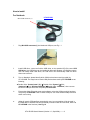
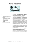
UT-41R-USB
USB Interface
Water Proof GPS Receiver
User Manual
General description of what GPS is and how it works.
GPS (Global Positioning System) is the only system today able to show you your exact position
on the Earth anytime, in any weather, anywhere. GPS satellites, 24 in all, orbit at 11,000 nautical
miles above the Earth. They are continuously monitored by ground stations located worldwide.
The satellites transmit signals that can be detected by anyone with a GPS receiver. Using the
receiver, you can determine your location with great precision.
The satellites are positioned so that we can receive signals from six of them nearly 100 percent of
the time at any point on Earth. You need that many signals to get the best position information.
Satellites are equipped with very precise clocks that keep accurate time to within three
nanoseconds- that's 0.000000003, or three billionths of a second. This precision timing is
important because the receiver must determine exactly how long it takes for signals to travel from
each GPS satellite. The receiver uses this information to calculate its position.
Although GPS was designed for military use, many thousands of civil jams make use of it. The
satellites actually broadcast two signals, one is only for military use, and one can be used by both
military and civilians. Since GPS is passive (you only need to receive the signal), there are no
restrictions on who can use the signal available to civilians.
GPS technology can be used in variety of fields besides providing navigation for vehicles on the
sea, in the air and on the ground. GPS applications also include keeping track of where a fleet of
trucks, trains, ships or planes are and how fast they are moving; direction emergency vehicles to
the scene of an accident; mapping where a city's assets are located ; and providing precise
timing for endeavors that require large-scale coordination.
UT-41R-USB User’s Manual (Version 1.0 , Sep/2006)---------1
How to install
For Notebook
Mini USB connector (1)
i.
UT-41R-USB
Plug Mini USB connector(1) into Notebook USB port, see Fig 1.1
Fig1.1
ii.
Install USB driver, users can find the USB driver on the attached CD (file name: GPS
USB driver), the USB driver can be installed for Microsoft Windows, XP and Mac system.
User can easily install USB driver, the USB driver can automatically install the driver
when user execute it.
iii.
Turn on Notebook, please identify which COM port has been used (occupied) by
UT-41R-USB. The ways how to check COM port has been used by UT-41R-USB are as
following ;
z Double clicks “Control panel ( C )“Æ Double clicks “System”Æ Click
“hardware”ÆClick “Hardware Manager”ÆDouble clicks “COM Port”, then user can
find which COM port has been occupied by UT-41R-USB.
iv.
Execute the eMap (Electrical street map) software; select the COM port which has been
occupied by UT-41R-USB. How to check COM port, user must read the eMap instruction
which user is using.
v.
eMap will search GPS satellites automatically, users’ current position will be showed in
the eMap after 3 satellites has been searched.(it needs to take 45-50 seconds, when use
UT-41R-USB in the first time). See Fig 1.2
UT-41R-USB User’s Manual (Version 1.0 , Sep/2006)---------2
Fig 1.2
vi.
How to identify UT-41R-USB working status, please read the following description LED
Indicator.
LED INDICATOR
.
UT-41R-USB User’s Manual (Version 1.0 , Sep/2006)---------3
SECTION 1
Introduction
1.1 Overview
The UT-41R-USB GPS Receiver is intended for use in a wide range of applications. The receiver
simultaneously tracks up to twelve satellites, provides accurate satellite positioning data with fast
time-to-first-fix (TTFF) and low power consumption. It is designed for high performance and
maximum flexibility in a wide range of applications including mobile asset tracking, in-vehicle
automotive guidance, location sensing, telematics and so on. The highly integrated receiver
achieves high performance, minimizes board size and power consumption requirements. The
UT-41R-USB is designed to withstand harsh operating environments; however, it should be used
inside an enclosure as a part of the application product designed by the system integrator.
1.2 FEATURES
The UT-41R-USB GPS receiver offers following features:
.
• Twelve parallel tracking channels
.
• Fast TTFF and low power consumption
.
• Compact design suitable le for applications requiring small space
.
• On-board rechargeable battery sustained real-time clock and memory for fast satellite
acquisition during power-up
.
• High accuracy one-pulse-per-second output
.
• Supports NMEA-0183 protocol
.
• Full navigation accuracy achievable with Standard Positioning Service
.
• Optimized for navigation in urban-canyon environments
.
• Automatic cold start with no user initialization required
Satellite acquisition and tracking process. Under normal open-sky condition, position-fix can be
achieved within approximately 45 seconds (within 15 seconds if valid ephemeris data is already
collected from recent use). After receiver position has been calculated, valid position, velocity and
time information are transmitted through the on board serial interface.
The receiver uses the latest stored position, satellite data, and current RTC time to achieve rapid
GPS signal acquisition and fast TTFF. If the receiver is transported over a large distance across
the globe, cold-start automatic-locate sequence is invoked. The first position fix may take up to
five minutes searching the sky for the GPS signal. The acquisition performance can be improved
significantly if the host initializes the receiver with a rough estimate of time and user position.
As soon as GPS signal is acquired and tracked, the UT-41R-USB will transmit valid navigation
information through its serial interface. The navigation data contains following information:
.
.
.
.
.
• Receiver position in latitude, longitude, and altitude
• Receiver velocity
• Time
• DOP error-magnification factor
• GPS signal tracking status
The UT-41R-USB will perform 3D navigation when four or more satellites are tracked. When
three or fewer satellites are tracked, altitude-hold is enabled using the last computed altitude and
2D navigation mode is entered.
UT-41R-USB User’s Manual (Version 1.0 , Sep/2006)---------4
With signal blockage or rising and setting of the satellites, where a change in satellite
constellation used for position fix occurred, large position error may result. The UT-41R-USB
incorporates a proprietary algorithm to compensate the effect of satellite constellation change,
and maintains an accurate smooth estimate of the receiver position, velocity, and heading.
2.1 Receiver Specification
FEATURES
General
Sensitivity
Update Rate
Accuracy
Acquisition
Reacquisition
Dynamics
Operation Temperature
Storage Temperature
Operating Humidity
Primary Power
Current Consumption
Serial Interface
Protocol
Datum
Antenna
NMEA Message
Dimension
DESCRIPTIONS
L1 frequency, C/A code, 12 Parallel Channels
-140dBm acquisition, -150 dBm tracking
1Hz
Position: 5m CEP
Velocity : 0.1m/sec
Cold start: < 50sec (typical)
Warm start: < 25sec (typical)
Hot start: < 10sec
<1 sec
Altitude: < 18,000m
Velocity: 515m/sec
Acceleration: 4g
-40°C to +85°C
-55°C to +90°C
5% to 95%
+3.8V ~ 8V DC
<38 mA
RS-232
NMEA-0183 v3.01 @ 4800 baud, 8-None-1
Default: WGS-84 Other: selectable for other
Datum
On-Board Patch Antenna
GGA, GLL, GSA, GSV, RMC, VTG, ZDA
42 mm x 42 mm x 15.9mm (W x L x H)
3.1 NMEA OUTPUT MESSAGE SPECIFICATION
The UT-41R-USB supports NMEA-0183 output format as defined by the National Marine
Electronics Association (http://www.nmea.org). The currently supported NMEA messages for
GPS applications are:
GGA
GLL
GSA
GSV
RMC
VTG
Global Positioning System Fix Data
Geographic Position Latitude /
Longitude
GNSS DOP and Active Satellites
GNSS Satellites in View
Recommended Minimum Specific
GNSS Data
Course Over Ground and Ground
Speed
UT-41R-USB User’s Manual (Version 1.0 , Sep/2006)---------5
3.1.1 NMEA Checksum Calculation
The optional NMEA checksum can be enabled or disabled when setting up the NMEA protocol.
The checksum consists of a "*" and two hexadecimal digits derived by exclusive-OR of all the
characters between, but not including, the "$" and "*" characters.
APPENDIX B
Default Values
The product has the following factor preset default values
Datum: 000 (WGS-84)
NMEA Enable Switch: GGA ON GLL OFF GSA ON GSV ON RMC ON VTG OFF
Checksum ON
Checksum ON
Baud Rate: 4800 Baud
Elevation Mask: 5 degrees
DOP Mask:
DOP Select: Auto GDOP: 20 PDOP: 15 HDOP: 8
Receiver Operating Mode: Normal Mode (without 1PPS)
Commands can be issued to the UT-41R-USB to change the settings of the receiver. The new
settings will remain effective on next power-on as long as the on-board rechargeable backup
battery is not discharged. After the backup battery is discharged, factory preset default settings
will be used.
UT-41R-USB User’s Manual (Version 1.0 , Sep/2006)---------6