1
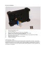
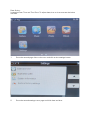
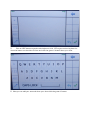
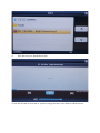
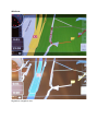
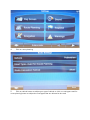
X Map OFF-ROAD 3000 Navigation system Introduction : Thank you for buying the Xmap navigation system. We take great pride in designing each of our products. Our goal is to provide high-end rugged products. We strive to improve our quality by using up-to-date high performance technology. At X Map we reinvest 100% of our earnings back into the company. This enables us to support research and development to ensure our reliability in the future. We advise you to read this manual carefully as we will guide you through the functions of the system. Instructions about the navigation system will be given and in about 2 minutes you will enjoy the possibilities of this all-round product. Please read through the User’s Manual before using. When you use the product, we think you have read through this manual. The information provided in this manual, is as accurate as possible after being revised carefully. If any printing error or translating mistake occurred in the manual, our company would not bear the outcome due to such mistake or error. The X Map OFF-ROAD 3000 is hi-tech product, including operating system and the software provided by the third parties. The producer has fulfilled its obligation in the manufacturing of hardware and in the developing and applying of software to ensure the product works normally. If there is something wrong with the product, the producer will shoulder the repair responsibility against the Quality Warrant and will not make any compensation to the property and economy losses incurred from using the product. The electronics map to be used by the X Map OFF-ROAD 3000 is provided by the third party, who has the copyright of the electronics map and the copyright is subject to the law. The users are not allowed to replicate or use for other purpose, except to use in the X Map OFF-ROAD 3000. The X Map OFF-ROAD 3000 producer will not make any warrant or guarantee in denotation or in pretermission to the validity, integrity and accuracy of the information in the electronic map used by the navigator. The producer will not make any compensation to the person and property and economy losses incurred from using the electronic map. The ownership and copyright of the manual belong to our company. The manual is not allowed to replicate or translate in whole or in part for any commercial activity. Our company reserves the final explanation right to the manual contents. GPS navigating equipment works by receiving the signals from geostationary satellites for positioning. It may not receive the signals inside the room or in dense buildings, and the signals under viaduct may fade. When receiving signals from geostationary satellites, the GPS navigating equipment is corresponding to different satellites in different locations, which is called “ephemeris”. An ephemeris covers 300KMs at most. If an ephemeris is confirmed in Location A, you move over 300km with your X Map it will shut off, the X Map will be under another ephemeris. The satellites searched last time will be all researched to determine the ephemeris, which will last a longer time. It will save plenty of time to click “GPS Reset” button to clean up all the previous satellites with “GPS Test” function for another search. In high speed moving, it is a little difficult for GPS navigator to search satellite. You’d better stop your vehicle to search satellite to determine your location. When you charge your X Map with travel charger or home charger, you are required to use our company’s original charger. You are required not to charge with your own charger; otherwise you bear the loss incurred from it. Index: -‐ -‐ -‐ -‐ -‐ -‐ -‐ -‐ -‐ -‐ -‐ -‐ Included in box checklist First use guide Menu overview Functions Overview Sim card installation Charger Installation Micro SD Card Usage Setting explanation Access text menu Access music player Access photo viewer IGO guide Included in box checklist : The X Map OFF-ROAD box should contain the following below listed items after unboxing. -‐ -‐ -‐ -‐ -‐ One X Map OFF-Road 3000 navigation system. Industrial ATV/Quad and motor mount Home charger Vehicle charger RS-232 cable (for professional use only) If any of the above articles is broken or missing, please contact immediately the distributor or retailer where you purchased the X Map. First use guide : This paragraph is important to read before using the X Map navigation system. To make sure all functions are ready for use, you must go through the 7 steps below. 1. Check that all the items are in the box. 2. Before the first use: charge your battery for 4 hours. Make sure to use the full battery after charging for the first time. After the first cycle, three hours of charging will be enough to fully charge the navigation system. 3. Install the sim card; see sim card installation guide for more information. 4. Start up your X Map OFF-Road 3000 by using the button on top. Hold the button for approximately 2 seconds. 5. You will access the main menu of the X map OFF-Road 3000. 6. Choose your function by pressing on the button of the function you would like to use. 7. Enjoy you X Map The installation, repair should be made by our company authorized personnel or professional maintenance person from the distributor or retailer. Without our company’s permission, do not install, disassembly and assembly, or repair. Otherwise, you will lose the warranty service right. Menu overview : Number : 1 2 3 4 5 Button / Icon : Battery GPS Phone reception Time Call center 6 7 8 9 10 11 12 13 Navigate Phone Call records Contacts New Msg Inbox Phrases Menu switch buttons Function : Battery lifetime display GPS satellite connection display Phone connection quality display Current time display Connection with call center for assistance 24/7, available soon. IGO European navigation system In the phone applications you can call hands free Recent phone-calls Phone contact list Send a new text message Text messages inbox Notepad Switch between first and second menu page 14 15 16 17 18 13 Out box Music player Photo viewer Ebook Settings Menu switch buttons View outgoing text messages Play your own music Watch your photos Read books Enter settings menu Switch between first and second menu page Functions Overview : Intellectual GPS/GPRS/GSM all in one device is a brand new concept product newly developed by our company, integrated GPS navigation/tracking and GSM/GPRS communication functions, which is a vital application revolution in GPS industry. Intellectual GPS/GSM/GPRS all-in-one device relies on the net operation customer service center, combining the professional GPS geographical information system and vehicle phonetic navigating technology and maintaining the traditional VMT intellectual information terminal position monitoring and position tracing functions. The GPS/GSM/GPRS all in one device is a brand new product, perfectively integrated VMT intellectual navigating terminal with independent navigator. The independent navigators can real time display the user’s position and the geographical information around. Meantime, is also a friendly interchanging platform interface for the VMT terminal user? The user can interchange VMT terminal and service center on the platform. Technical functions X Map OFF-ROAD 3000 : Number Technical index : : 1 Processor Technical Parameters and Performance : 2 3 4 5 6 7 8 9 10 11 Memory Flash DDR2 Operation System Display Screen Resolution Touch Screen GPS Module GPS Sensitivity Location Time 12 13 14 15 16 Location Precision Speed Precision GSM Module Receive Frequency Working Temperature Samsung S3C2451 553MH, Basic Frequency 500MHz DDR2, 128M NAND Flash, MLC 512MB-4GB 64M / 128 MB Windows CE5.0 5” Samsung TFT screen 800X480 Four-Line Resistance-type SIRFIII >-140dBm Cold Start ≤60sec Warm Start ≤40sec Hot Start ≤20sec Re-location ≤1sec <25m CEP without SA 0.1m/sec(S/A off) M35 Tri-Band, GPRS class 8/10 GSM/GPRS 900/1800/1900MHz -20℃~+70℃ 17 Storage Temperature -40℃~+80℃ 18 Relative Humidity 19 Video Input 20 21 22 23 24 25 26 27 28 29 30 31 Serial Port Micro SD slot USB interface Earphone interface SIM Slot Speaker Battery Charge time Working voltage GPS antenna MIC SIM card slot 95%(+40℃) Support CVBS signal input ( X Map camera & software will follow soon) 1 x RS232 Micro SD card inserting, support max up to 32GB Mini USB 2.0 standard interface Φ3.5mm standard earphone interface Standard SIM slot Build-in 8Ω 1.5W speaker inside 900mAh Lithium battery inside 2 Hours 5V±0.2V Built-in ceramic antennas Build-in microphone inside Inserting GSM SIM card Sim card installation : 1. 2. 3. 4. 5. 6. 7. 8. 9. Unscrew the battery cover Take the battery out Next to the battery cable you find a sim card holder Take the sim card holder out of the X Map OFF-ROAD 3000. Makes sure your sim card pincode is disabled. Put the sim card in the holder and place the holder faced towards the X Map Replace the battery back Fasten the battery cover back on the X Map Test the connection VMT telephone / SMS : This X Map OFF-Road 3000 has internally integrated mobile phone function, can provide high-definition hands free voice calls and short text messages. Transmission and receiving functions, and send out commands via the monitoring center to limit the Call in/Call out functions. It is hand free; you can make call directly by the vehicle Hi-Fi build-in speaker and mini build-in microphone. Charger Installation : 1. Vehicle charger uses 12V auto standard voltage. Home USB charger voltage from 100V—240V, output voltage is +5V. 2. For vehicle charger, connect Mini USB end of the power cable to the X Map OFFROAD 3000 power supply jack, the other end cigar lighter connects to the cigar lighter plug of the vehicle. 3. For home USB charger, connect the output jack to the power supply jack of the X Map OFF-ROAD 3000, the input end to the AC standard voltage plug. 4. The engine is still in working status after shutting down the vehicle, so when you do not use the navigator, please power off the system and take out the power supply cable for longer battery life time. 5. After start the vehicle, put into the vehicle charger out to avoid the damage to X Map OFF-ROAD 3000 during the starting moment. Micro SD Card Usage : 1. Press the top of the Micro SD card gently; the memory will pop up automatically. 2. When taking out the memory card, make sure that the memory card is not in reading status. Otherwise it will make the system halted or the data can be lost. 3. Do not set the Micro SD card in protect or locked status so that the system can be used. 4. In operation, if the memory card is taken out by incaution, the X Map OFF-ROAD 3000 will display Error Information. Please return the memory card to its correct position and click the Enter button, it will return back to normal or reboot the system. The Micro SD capability is bigger then internal storage, the storage will be much bigger, can support Micro SD cards with 32MB till 32GB. Once Micro SD card is inserted, the navigator will identify automatically. The Micro SD card can be used to store music, photos and maps, etc Setting explanation : Click setting icon on the second page of the main menu to enter into setting interface, Setting interface contains Language, Sound, Power, Communications settings, GPS Monitor, Calibrate, Date & time Application path, System information, Restore factory settings. Language : The default language is set to be English, other language will soon be available. Sound : Sounds interface contains swipe screen touching sound setting, volume control. You can adjust the following sound functions. -‐ Select or not select sound while touching. -‐ Select or not select sound for “text to speech” for hands free text message. -‐ Volume, adjust the sound volume. Power : Power interface contains battery capacity check, screen brightness adjust, LCD off time setting and automatic power off time setting. You can adjust the following sound functions. -‐ -‐ -‐ -‐ Screen lightness, to adjust the brightness of the screen. Battery capacity, to check the current battery capacity used. LCD Shut off time, to set the backlight time when not in use to save power. Power off time, to set the shut down time in order to save power. Communications settings : This function is locked only available for distributor or retailer. GPS Monitor : GPS monitor mainly observes X Map OFF-ROAD 3000 status of receiving satellite signals. GPS reset: Click this icon, you can re-start GPS receiver. Calibrate : Click the calibrating icon to enter into the calibrating status. Click the center of “+”, and let it off after the icon is moved, repeat this operation. Click anywhere of the screen till the icon fades away, X Map OFF-ROAD 3000 will now reboot. Date & time : It contains Date, Time and Time Zone. To adjust date, time or time zone see the below overview. 1. Go to the second page of the main menu and click on the settings button. 2. Go to the second settings menu page and click: date and time. 3. Adjust the time and date by using the arrows. Application path : Click the application path icon to enter into the application path root, here you can find the folder the application uses. System information : Click the system information icon to enter into the system information overview page. Here you see your firmware vision, Divice ID, Storage space, free space. To enter Windows CE 5.0 click multiple times in the left corner of the information overview page. Restore factory settings. Click the restore to factory icon to reset the X Map OFF-Road 3000 to standard factory settings. After clicking the restore to factory icon you get a alert message to confirm your action. Access text menu : 1. Go to the fist page of the main menu and click on New Msg to go the the message writer. 3. 4. Enter on the number button to add a contact or a number. Write a text message by clicking on the white surface to enter the text input screen. 5. Click on ABC button to get the abc keyboard, click 123 to get number keyboard or draw the letters on the white surface and click the green V button when your done. 6. Now you can add your text and when your done click the green V button. Access music player : 1. Go to the second main menu page and click on Music, now you will enter the root. 2. After entering the root click on SDMMC 3. Click the song you would like to play. 4. Use the arrows to click next or previous songs and the music slide to adjust volume. Access photo viewer : 1. Go to the second main menu page and click on Photo, now you will enter the root. 2. Click on SDMMC 3. Click the photo you would like to view. 4. Zoom in or zoom out by using the magnifier or use the arrows to navigate thought the photos. IGO Guide : Daytime navigation view Nighttime navigation view 1. Go to the first page of the main menu and click on navigate. 2. You entered the main menu of the navigation system. 3. Click on settings 4. Click on route planning 5. Click on vehicle button to adjust your type of vehicle or click on road types used for route planning button to adjust the road types that are allowed to be used. 6. Select the type of vehicle that you currently use. 7. 8. Select the the road type you would like to use. Start navigation