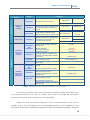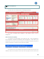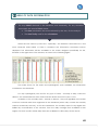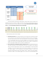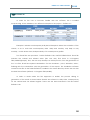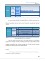
1
 April
2010
IAHRIS 2.2
USER´S MANUAL
CAROLINA MARTÍNEZ SANTA‐MARÍA
JOSÉ A. FERNÁNDEZ YUSTE
FERNANDO MAGDALENO MAS
Title:
Indicators of Hydrologic Alteration in RIverS (IAHRIS)
User´s Manual
Version 2.2
ISBN: 978-84-693-7959-2
This manual can be used, copied and distributed freely, with indication of the following
reference:
Martínez Santa-María, C. et al. 2010. IAHRIS 2.2 Indicators of Hydrologic Alteration
in Rivers. User’s Manual.
Authors:
Methodology:
Carolina Martínez Santa-María
José Anastasio Fernández Yuste
Software:
INCLAM, S.A.
User´s Manual
Carolina Martínez Santa-María
José Anastasio Fernández Yuste
Fernando Magdaleno Mas
Edition:
AHRIS is a software financed by the Spanish Ministry of the Environment, with the
technical advice of CEDEX
Copyright: © Ministry of the Environment. Polytechnic University of Madrid.
IAHRIS is a free software.
Any commercial utilization of IAHRIS is totally forbidden.
Authors and editors are not responsible of the mistakes or flaws of the software. User must
check the results of IAHRIS, and both its use and application will be of his entire
responsibility.
ACKNOWLEDGMENTS
Authors first wish to express their gratitude to Inmaculada García Cob, who
set the bases of this software, and had the ability to understand and interpret our
ideas, and also to answer, always with a smile, our never-ending proposals.
We also want to thank Juan Manuel Varela Nieto and Fernando Magdaleno
Mas (Area of Environmental Engineering - Centre of Study of Applied Techniques of
CEDEX) and Francisco Javier Sanchez Martínez (General Directorate of Water –
Ministry of the Environment) their help to publish the book that includes the
technical fundamentals of the Indicators of Hydrologic Alteration in River
Ecosystems, and also their understanding of the convenience of complementing
this book with an appropriate software. IAHRIS would not be possible without their
enthusiastic support.
1
IAHRIS v2.2: USER´S MANUAL 2010 INDEX
CHAPTER
SECTION
WHY EVALUATING THE ALTERATION OF THE NATURAL
FLOW REGIME?
WHAT IS IAHRIS?
WHICH WAS THE CRITERIA TO SELECT THE PARAMETERS?
HOW IS THE ALTERATION OF THE FLOW REGIME
INTRODUCTION
QUANTIFIED?
WHAT INFORMATION IS NECESSARY?
WHAT RESULTS SHALL WE GET?
WHICH IS THE APPLICATION OF IAHRIS?
TO KNOW MORE
WHICH ARE THE SYSTEM REQUIREMENTS?
DISCHARGE AND EXECUTION OF THE INSTALL
INSTALLATION
WHICH ARE THE FILES INSTALLED AND WHERE ARE THEY
LOCATED?
WHICH ARE THE DATA TO BE USED?
THE SOFTWARE AND ITS DATABASE
THE DATA
WHICH MUST BE THE STRUCTURE OF THE DATA FILES?
HOW CAN BE THE DATA FILES EASILY GENERATED?
FIRST APPROACH
AREA OF DATA DECLARATION
AREA OF SELECTION OF POINTS AND SERIES
THE SOFTWARE
AREA OF DATA INFORMATION
AREA OF RESULTS
PRACTICAL CASE
RESULTS: A PANORAMIC VIEW
HOW DO DATA CHARACTERISTICS INFLUENCE IAHRIS
RESULTS?
THE RESULTS
HOW ARE THE RESULTS PRESENTED?
HOW ARE THE REPORTS LINKED TO THE DATA
CHARACTERISTICS?
PAGE
4
5
6
10
12
14
18
19
21
21
22
24
25
26
29
33
36
43
45
49
50
55
59
61
63
2
INTRODUCTION 1
WHY EVALUATING THE ALTERATION OF
THE NATURAL FLOW REGIME?
WHAT IS IAHRIS?
WHICH WAS THE CRITERIA TO SELECT THE PARAMETERS?
HOW IS THE ALTERATION OF THE FLOW REGIME QUANTIFIED?
WHAT INFORMATION IS NECESSARY?
WHAT RESULTS SHALL WE GET?
WHICH IS THE APPLICATION OF IAHRIS?
L
TO KNOW MORE
3
IAHRIS v2.2: USER´S MANUAL 2010 WHY EVALUATING THE ALTERATION OF THE NATURAL FLOW
REGIME?
This question can be answered by focusing on three different approaches: the legal,
the scientific and the management approach.
From a legal approach, the evaluation of the hydrologic alteration is necessary, as a
core requirement of the Water Framework Directive (WFD). This Directive fixes, as the most
important target of the water management, the establishment of a good ecological status
of the associated ecosystems. In order to reach this target, it is necessary to make use of
protocols that allow for an efficient and objective knowledge of the ecological status of
rivers. The WFD, in its Annex V, determines a set of elements of the river ecosystem that must
be considered in order to assess its ecological status. Between those, the flow regime is
expressively quoted.
From a scientific approach, the transcendence of the flow regime as a linking
element of the river ecosystem has been widely recognized, reaching its maximum
expression with the publication of the natural flow regime paradigm: “the whole range of
intra and interannual variability of the flow regime, with its associated characteristics of
magnitude, seasonality, duration, frequency and rate of change, is critical to maintain the
natural biodiversity and the integrity of the aquatic ecosystems” (Poff et al., 1997).
Connotations of this axiom are immediate: the success in the conservation of the
biodiversity and functioning of our rivers depend on our ability to know, protect and/or
restore the main components of the natural flow regime.
Public agents, dealing with river management, need to know the status of the most
relevant environmental components of the flow regime. Only from this knowledge it is
possible to formulate adequate diagnosis, to establish management politics that allow
advances in the consecution of the “good ecological status”. Also for the water bodies
eventually designated as “heavily modified”, it is necessary to characterize both the
situation of its flow regime, and its optimum hydrological potential, compatible with the
conditions that enhance this status.
4
WHAT IS IAHRIS?
Indicators of Hydrologic Alteration in RiverS is a software designed to obtain:
•
Parameters that characterize the flow regime, both the natural1and the
altered2regime, in a section of the river. These parameters assess different hydrologic
aspects of the flow regime with environmental transcendence (droughts duration,
floods seasonality…).
•
If the user enters data of the natural and the regulated flow regime, the software
calculates a set of indicators that evaluate the degree of alteration of the most
relevant environmental aspects of the flow regime.
•
In the conditions cited below the software calculates the hydrologic alteration by
IPH (Spanish Hydrologic Planning Instruction, Point 3.4.2. HEAVILY MODIFIED WATER
BODIES) and assess the condition of high alteration by two criteria (P10-90 and IAHMMA)3.
•
The software obtains a set of environmental flows scenarios associated with certain
flow conditions in natural regime, following the RAC Methodology (Régimen
Ambiental de Caudales).4
1
A flow regime is considered NATURAL when its characteristics – magnitude, frequency, seasonality, duration and rate of change – are not noticeably altered by humans. 2
A flow regime is considered ALTERED when humans have modified the natural regime by regulation, abstraction and/or incorporation of flows. Environmental flow regimes are also included in this category. 3
Users can find further information in “Indicators of heavily modified water bodies: Methodological Reference Manual” Users can find further information in “Environmental Flow Regime: Methodological Reference Manual “ 4
5
IAHRIS v2.2: USER´S MANUAL 2010 REMEMBER:
9 PARAMETER: Each variable that, numerically, makes possible the characterization of the components of the flow regime with the highest environmental meaning. 9 INDICATOR: Relationship between the values of the same parameter, in the natural and the altered condition. It allows the quantification of the differences between the reference status – natural flow regime – and any other – altered flow regime. WHICH WAS THE CRITERIA TO SELECT THE PARAMETERS?
The paradigm of the flow regime already establishes the most environmentally
meaningful aspects of the flow regime. Links of these aspects to the key elements of the
fluvial ecosystem may be summarized as follows:
•
Magnitude: determines the general availability of water in the freshwater
ecosystem.
•
Frequency of a flow event in an interval of time: determines the variability of the
flow regime, the ecological and geomorphological dynamics, and thus, the
diversity.
•
Duration or interval of time associated with certain flow conditions: in extreme
situations, floods and droughts, duration is closely linked to resilience thresholds of
the different species.
•
Seasonality or regularity of the flow event in a season: determines closely and with
synchrony the life cycles of the different species (fluvial, estuarine and coastal).
•
Rate of change: determines the velocity of change of the flow values, affecting the
capacity of answer of the biota.
Thus, the process of characterization of the flow regime must endorse these five
aspects.
The characterization must be done attending both to the normal or habitual values
(determinants of the general availability of water in the ecosystem) and the extreme data –
6
floods and droughts – (since they define the most critical conditions in the ecosystem),
considering the intra and inter-annual variability.
Table 1 summarizes, for every component of the flow regime, the aspects and
parameters proposed for its characterization. The detailed definition and formulation used
to quantify each of these parameters can be looked up in the Methodological Reference
Manual.
With this set of parameters – four for habitual values, eight for floods and seven for
droughts – a quantitative characterization of the flow regime may be fulfilled, that includes
all the elements with the highest environmental meaning and transcendence. This
characterization can be obtained for any flow regime with enough available data, natural
or altered (resulting from a real regulation and/or abstraction, or a simulation under
different management scenarios).
7
IAHRIS v2.2: USER´S MANUAL HABITUAL DATA
COMPONENTS OF THE
REGIME
MONTHLY OR
ANNUAL
VOLUMES
DAILY FLOWS
ASPECT
MAXIMUM
VALUES of the
daily flows
(FLOODS)
Average of the annual volumes
VARIABILITY
Difference between the maximum and
the minimum monthly volume along
the year
SEASONALITY
Month with the maximum and the
minimum water volume along the year
VARIABILITY
Difference between the average flows
associated to the percentiles of
excedeence10% and 90%
VARIABILITY
EXTREME DATA
DURATION
SEASONALITY
MAGNITUDE
AND
FREQUENCY
MINIMUM
VALUES of the
daily flows
(DROUGHTS)
PARAMETER
MAGNITUDE
MAGNITUDE
AND
FREQUENCY
VARIABILITY
DURATION
SEASONALITY
2010 Wet year
Normal year
Dry year
WEIGHTED YEAR (P1)
Wet year
Type of year
Normal year
Dry year
WEIGHTED YEAR (P2)
Wet year
Type of year (P3)
Normal year
Dry year
Wet year
Type of year
Normal year
Dry year
WEIGHTED YEAR (P4)
Type of year
Average of the maximum daily flows
along the year
Effective discharge
Connectivity discharge
Flushing flood (Q5%)
Coefficient of variation of the
maximum daily flows along the year
Coefficient of variation of the ordinary
floods series
Maximum number of consecutive days
in the year with q> Q 5%
Average number of days in the month
with q> Q 5%
Average minimum daily flows along
the year
Qc (P5)
QGL (P6)
Q CONEC (P7)
Q 5% (P8)
CV(Qc) (P9)
CV (Q5%) (P10)
Flood duration (P11)
12 values (one for each month) (P12)
Qs (P13)
Q95% (P14)
Ordinary drought discharge (Q 95%)
Coefficient of variation of the minimum
daily flows along the year
Coefficient of variation of the ordinary
droughts series
Maximum number of consecutive days
in the year with q < Q 95%
Average number of days in the month
with a daily flow equal to zero
Average number of days in the month
with q<Q 95%
CV(Qs) (P15)
CV (Q95%) (P16)
Droughts duration (P17)
12 values (one for each month) (P18)
12 values (one for each month) (P19)
Table 1.- Parameters (P1-P19) for the characterization of the flow regime.
Should it be observed, in the set of parameters included in IAHRIS, the inexistence of
any parameter linked to the rates of change. Future versions of IAHRIS will incorporate
parameters matched to this component of the flow regime.
Eager users may find further information on the characterization of the rates of
change, both in the ascending and the descending branches of the hydrograph, in the
book titled “ÍNDICES DE ALTERACIÓN HIDROLÓGICA EN ECOSISTEMAS FLUVIALES” (Martínez
8
Santa-María, C. & Fernández Yuste, J.A. 2006. CEDEX. Mº de Fomento - Mº de Medio
Ambiente).
This publication includes the conceptual and methodological bases implemented
by IAHRIS. Nevertheless, the development of the software has motivated minor changes.
These changes are detailed in the so-called Indicators of Hydrologic alteration:
Methodological Reference Manual, also part of the documented section of the software.
9
IAHRIS v2.2: USER´S MANUAL 2010 HOW IS THE ALTERATION OF THE FLOW REGIME QUANTIFIED?
The WFD establishes the characterization of the ecological status, through the
comparison of the real situation and the scenario used as reference. For any of the
elements
to
be
considered
–
flow
regime,
macroinvertebrates,
phytobenthos,
ichtyofauna…- the following items must be checked:
1) Definition of the variables to be measured, attending to their capacity to reflect the
environmental integrity of the analyzed element.
2) Establish the reference status, i.e., the values of these variables in a scenario of
minimum alteration.
3) Calculation of the Ecological Quality Ratios (EQR), as the ratios between the values
of the variables for the real and the reference scenarios.
Once accepted the role of the natural flow regime as most determinant for the
integrity of the fluvial ecosystem, and being the necessary tools – parameters – ready for
the quantification of the most meaningful environmental aspects of the flow regime, it is
time for the formulation of a set of indicators to assess, in the most objective way, the
degree of alteration of a regulated regime (purely altered or environmental) from the
natural regime. The similarity or difference will determine the real or potential integrity of the
river.
Attending
to
CIS-WDF
recommendations (2003) for
the analysis of the EQR (figure
1),
most
ALTERATION
INDICATORS
have
OF
been
defined as the ratios between
the parameter values in the
altered and in the natural flow
regimes.
Figure 1.- Recommendations of CIS-WFD for the Ecological Quality Ratio.
Table 2 shows the correspondence between the Indicators of Hydrologic Alteration
already calculated by IAHRIS and the aspects of the flow regime whose alteration is
assessed, and the parameter used to calculate the indicator.
10
The details of definition and formulation used for each of these indicators can be
looked up in the Methodological Reference Manual.
ASPECT MAGNITUDE HABITUAL DATA VARIABILITY SEASONALITY MAGNITUDE AND FREQUENCY CODE NAME IAH 1
IAH 2
IAH 3
IAH 4
IAH 5
IAH 6
IAH 7
IAH 8
Magnitude of the annual volumes Magnitude of the monthly volumes Habitual variability Extreme variability Seasonality of maximum values Seasonality of minimum values Magnitude of the maximum floods Magnitude of the effective discharge Frequency of the connectivity discharge Magnitude of the flushing floods Variability of the maximum floods Variability of the flushing floods Floods duration Floods seasonality (12 values, one for each month) Magnitude of the extreme droughts Magnitude of the habitual droughts Variability of the extreme droughts Variability of the habitual droughts Droughts duration Number of days with null flow (12 values, one for each month) Droughts seasonality (12 values, one for each month) IAH 9 DURATION
IAH 10
IAH 11
IAH 12
IAH 13
SEASONALITY IAH 14 MAGNITUDE AND FREQUENCY IAH 15 IAH 16 IAH 17
IAH 18
IAH 19
FLOODS VARIABILITY VARIABILITY DROUGHTS DURATION SEASONALITY IAH 20 IAH 21 All indicators, in order to homogenize and make easier their understanding, can vary
between cero and one. Cero means the maximum alteration and one the absence of
alteration. Following the recommendations for the EQR, five levels or hydrological status
have been established, linearly, in the 0-1 range of the indicators, assigning the
corresponding colour codes (figure 2).
HYDROLOGICAL STATUS : PARTIAL INDICATORS (ΙAH)
LEVEL I
LEVEL II
LEVEL III
LEVEL IV
LEVEL V
0.8< ΙAH ≤1 0.6<ΙAH ≤0.8
0.4<ΙAH ≤0.6 0.2<ΙAH ≤0.4
0≤ΙAH ≤0.2 Figure 2.- Criteria for the assignation of qualitative categories to the Indicators of Alteration
In order to make easier the global analysis for the three main elements of the regime
– habitual values, floods and droughts - two procedures are offered.
11
IAHRIS v2.2: USER´S MANUAL 2010 On the one hand, a network graphic, designed to observe simultaneously the values
of the indicators for the assessed parameters (figure 3).
This graphic shows clearly the distance of the value for
every indicator –in red colour in the figure- from their
associated values in natural conditions, which is
always 1, following the initial assumptions.
Figure 3.- Calculation of the Global Alteration Indicators (IAG) from
partial indicators (IAH)
On the other hand, an indicator of global
alteration is calculated for each component - habitual values, floods and droughts. This
indicator sums up the values of the indicators selected to assess all aspects considered for
this component of the regime. The global indicator is evaluated as the ratio between the
area inside the polygon for the altered regime (surrounded by the red line in figure 4), and
the area inside the polygon for the natural regime (i.e., the area associated to value 1 for
all indicators – the blue line in figure 4). Also for these indicators of global alteration a
coloured code has been established (figure 4).
Should it be remarked that global indicators compare areas. That means they are
based on the square values of the indicators for the chosen component – habitual values,
floods or droughts. Thus, the range for the different status is not the same to that for the
normal indicators, following a quadratic law.
HYDROLOGICAL STATUS : GLOBAL INDICATORS (IAG)
LEVEL I
LEVEL II
LEVEL III
LEVEL IV
LEVEL V
0.64< ΙAG ≤1 0.36<ΙAG ≤0.64
0.16<ΙAG ≤0.36 0.04<ΙAG ≤0.16
0≤ΙAG ≤0.04 Figure 4.- Criteria of assignation of qualitative categories
Indicators of Global Alteration.
WHAT INFORMATION IS NECESSARY?
The software was designed to generate results only if the user enters, at least, a
series with a length of fifteen complete years be these data daily or monthly flows. This
threshold was determined on the basis of the minimum amount of information considered
12
necessary to get reasonable results in relation to variability and extreme values. Data in
those series can be daily flows (m3/s) or monthly volumes (hm3). If the user enters daily and
monthly flow series of the same regime and period of time, the software will only consider
for the analysis the information resulted from the daily data. Thus, daily and monthly flows
must only be entered if they cover a different range of time.
Data are grouped in two types:
•
NATURAL flow series: Contains data associated to the natural flow regime. In every
point of the river used for the analysis, a maximum of two series may be entered in
the software, one with monthly volumes and the other one with daily flows. The
software requires a minimum length of fifteen complete years, with monthly and
daily data of the natural flow regime.
•
ALTERED flow series: Contains data associated to an altered flow regime. This regime
can be motivated by:
i)
An abstraction or regulation of the river throughout a number of years.
ii)
A simulated scenario of management from a hydraulic infrastructure, a
simulated scenario associated to an environmental flow regime or any other
hypothesis derived from the hydrological planning of the system.
The software can run, in every point
of the analysis, as many altered flow
regimes as the user wishes to study. For all
these regimes, a maximum of two series
would
be
entered,
one
with
monthly
volumes and a second one with daily flows.
The data entered in the software
determines
the
results.
Particularly,
the
results depend on the data periodicity –
daily or monthly – and the contemporary
ESSENTIAL: In order for the software to work successfully, at least a daily or monthly natural flow data series must be entered, with a minimum length of fifteen complete years, not necessarily consecutive. character of the natural and altered flow
regime that are being compared. The
following chapter shows the different reports generated by the software, attending to the
afore-mentioned characteristics: periodicity and contemporary character of the flow data.
13
IAHRIS v2.2: USER´S MANUAL 2010 WHAT RESULTS SHALL WE GET?
Previous sections remark the results generated by the software are directly
dependent on the data entered in it. When the most complete data is used in a point of
analysis – i.e., daily, contemporary flows, both in the natural and the altered flow regimes –
the software offers:
For the characterization of the natural flow regime:
•
Inter-annual variability, with a classification of years in wet, normal or dry
years, attending to the position of their annual accumulated volume in the quartile
associated to the highest – wet – values, in the quartile associated to the lowest –
dry – values, or in the two quartiles associated to the intermediate – normal – values.
•
Intra-annual variability. For the three types of year – wet, normal, dry – the
median monthly volume for every month is calculated.
•
Nineteen parameters (numerical variables that characterize the most
meaningful aspects of the flow regime):
o
Four parameters for the characterization of the habitual values of the
regime.
o
Eight parameters for the characterization of the flood events.
o
Seven parameters for the characterization of the drought events.
•
Flow Duration Curve.
For the characterization of the altered regime:
•
Intra-annual variability. For the three types of year – wet, normal, dry – and
following the criteria obtained with the natural flow regime, the median monthly
volume for every month is calculated, using the data associated to the altered
regime.
•
Nineteen parameters (numerical variables that characterize the most
meaningful aspects of the flow regime):
o
Four parameters for the characterization of the habitual values of the
regime.
•
o
Eight parameters for the characterization of the flood events.
o
Seven parameters for the characterization of the drought events.
Flow Duration Curve
14
For the characterization of the alteration in contemporary regimes: Indicators of
alteration (generally calculated as the ratio between the value of the parameter in the
altered regime and the value of the same parameter in the natural regime):
•
Twenty-one individual indicators – every indicator evaluates the alteration of
a parameter:
o
Six indicators for the characterization of the habitual values of the regime.
o
Eight indicators for the characterization of the flood events.
o
Seven indicators for the characterization of the drought events.
•
Three global indicators - every indicator evaluates the alteration of a
component; it considers, globally, the alteration of the parameters used for the
characterization of that component. It synthesizes the results given for the twentyone individual indicators:
o
Indicator of alteration for habitual values.
o
Indicator of alteration for flood events.
o
Indicator of alteration for drought events.
For the characterization of the alteration in non-contemporary regimes: Indicators of
alteration (generally calculated as the ratio between the value of the parameter in the
altered regime and the value of the same parameter in the natural regime):
•
Twenty-two individual indicators – every indicator evaluates the alteration of
a parameter:
o
Seven indicators for the characterization of the habitual values of the
regime.
o
Eight indicators for the characterization of the flood events.
o
Seven indicators for the characterization of the drought events.
•
Three global indicators - every indicator evaluates the alteration of a
component; it considers, globally, the alteration of the parameters used for the
characterization of that component. It synthesizes the results given for the twentyone individual indicators:
o
Indicator of alteration for habitual values.
o
Indicator of alteration for flood events.
o
Indicator of alteration for drought events.
For the characterization of heavily modified water bodies
o
A report calculated by P10-90 methodology. Point 3.4.2 of IPH (pg 38514 of
BOE of 22-09-08) sets: ...A water body is heavily modified if it presents a
significant deviation in the magnitude of the parameters which characterize
15
IAHRIS v2.2: USER´S MANUAL 2010 monthly and annual conditions of the hydrologic regime... It is assumed that
we have a significant deviation if the magnitude of the annual/monthly
parameter is significantly away from the values corresponding to the 10%
and 90% percentiles of the natural regime data series.
In this report of IAHRIS it has assumed that a water body is heavily modified if
the nº total of months or the nº total of years with the condition cited above
is less than the 50%. If the percentage is equal or surpassed the 50%, no
classification is assigned.
Refer to monthly volumes, green color means that the percentage that
verifies this condition is >50%; red color means that the percentage that
verifies this condition is ≤50. This representation helps user to make easier the
degree of monthly alterations.
o
A report calculated by IAH-MMA methodology. Point 3.4.2 of IPH (pg 38514
of BOE of 22-09-08) sets: ...… The hydrologic alteration degree corresponding
to a water body must be characterized by indicators of hydrologic
alteration… by these indicators we can compare the natural or reference
regime characteristics with the altered one. ...The metrics used must
characterize the most environmental characteristics of the hydrologic
regime such as magnitude, duration, frequency, seasonality and rate of
change...
In this report of IAHRIS it has assumed that a water body is heavily modified if
six or more indicators (IAH) display alterations greater than or equal to the
50% of the metric value in natural regime (IAH≤0,5). If this condition is not
reached, no classification is assigned.
The Reference handbook contains the criterion used in the special case of
six indicators with IAH≤0,5(criterion C1a).
For the environmental flow regime scenarios definition:
o
Monthly volumes (hm3) and daily flows (m3/s) corresponding to a specific
environmental flow regime. User can generate by an interactive sheet of an
Excel book so many scenarios of environmental flows as he wishes to study.
o
Annual volumes (hm3) in natural and environmental regime.
o
12 parameters to characterize low flows. If the user introduces natural daily
flows, IAHRIS calculate a set of 12 parameters to define these critical
conditions in order to use them in the establishment of low flow thresholds in
the environmental regime.
16
All these results, including numerical tables and graphics, are offered by IAHRIS, in
reports, ordered as sheets of an Excel book. Table 3 shows the list of reports offered
by IAHRIS.
(*) if only monthly data are available
Table 3.- List of reports offered by IAHRIS, with indication of the information contained in them. The number of
reports offered in an analysis depends on the data entered by the user. Chapter 5 “RESULTS” offers
further details on the links between the data entered and the subsequent reports.
17
IAHRIS v2.2: USER´S MANUAL 2010 WHICH IS THE APPLICATION OF IAHRIS?
Time, experience and suggestions from the users will answer this question, but we
hope IAHRIS will contribute to answer some of the following subjects, in a rigorous and
objective manner.
Why using IAHRIS?
•
To handle the scientific and the water management communities a tool
specifically designed to help in the fulfilment of those WFD requirements associated
to the characterization of the hydrological status of the water bodies.
•
To quantify, objectively, the hydrological alteration caused by water
abstractions on the natural flow regime.
•
To interpret the affections of the alteration of the flow regime on the integrity
of the fluvial ecosystem.
•
To serve as test-bed:
o
Assessing the alteration induced by different management scenarios
on the natural flow regime.
o
In heavily modified water bodies, characterizing the optimum
hydrological potential, as that regime derived of the alterations linked to the
strict consideration of the conditions that enhance the heavily modified
character.
•
To identify the elements of the flowing regime most directly linked to the
rehabilitation or recovery of the reach under analysis.
•
To fix objective criteria, in order to establish priorities in the restoration of the
fluvial.
•
To define environmental flow regimes, which reproduces the most important
environmental aspects of the natural flow regime
•
To identify heavily modified water bodies by objective criteria
18
LTO KNOW MORE
Preparing the necessary data and executing the software (with their associated
reports) should become easy tasks, if the recommendations included in the coming
chapters are followed. Nevertheless, it is fully advisable taking the time to know, in detail, (i)
the basic principles and assumptions of
the methodology, (ii) the justification of
the parameters selected to characterize
the aspects and components of the flow
REMEMBER: regime, (iii) the formulation of these
9 In order to interpret, assess and apply adequately the results offered by IAHRIS, it is necessary to take time enough to become familiar with the conceptual and methodological details included in the Manual of Methodological Reference. parameters
and
their
associated
indicators, and (iv) the singularities that
could emerge and the criteria adopted
for their solution. This process will be the
only way to interpret, assess and apply
adequately the results offered by the
software.
IAHRIS is born as free-delivering
software, designed to offer, to the scientific, technical and management communities, a
tool that may contribute to know and understand the hydrological status of our rivers.
Improving the base methodology of IARHIS and the software can and must be a perennial
target of all its users. To make possible the global participation in the improvement of IARHIS,
we
would
acknowledge
getting
your
suggestions,
proposals
and
comments
in
[email protected]
Unfortunately, it is NOT possible to give technical assistance to users. Thus, it must be
emphasized that questions sent to this mail address will be answered as far as possible, but
we can not guarantee an answer in all cases.
19
IAHRIS v2.2: USER´S MANUAL 2010 INSTALLING IAHRIS WHICH ARE THE SYSTEM REQUIREMENTS?
¬
2
DISCHARGE AND EXECUTION
OF THE INSTALL FILE
WHICH ARE THE FILES INSTALLED AND WHERE ARE THEY LOCATED?
20
WHICH ARE THE SYSTEM REQUIREMENTS?
The software was developed in Microsoft
ESSENTIAL: Visual Studio 2005, and written in Visual Basic
language. Thus, its adequate functioning
9 Microsoft.NET Framework 2.0 9 Microsoft Excel 2003 or higher requires
the
previous
discharge
and
installation of Microsoft.NET Framework 2.0,
free available in:
http://www.microsoft.com/downloads/details.aspx?displaylang=es&FamilyID=085
6eacb-4362-4b0d-8edd-aab15c5e04f5
All the results generated by IAHRIS are transferred to an Excel file. Thus, it is also necessary
having this commercial software, Microsoft Excel 2003 or a higher version, installed in your
computer.
Finally, all data entered and used by the software are stored in a database, in format
Microsoft Access 2000, which is totally managed by IAHRIS with no necessary installation of
a user licence. However, if the user wants to visualize or export the data stored in it, it is
necessary to count on this licence for its use.
¬DISCHARGE AND EXECUTION OF THE INSTALL
Installation of the software is executed with
the
file
guides
install_IAHRIS_2.00.00.exe.
the
user
installation process.
throughout
the
This
file
whole
ESSENTIAL: 9 Before executing the install file, it is necessary to install in the system Microsoft.NET Framework 2.0 21
IAHRIS v2.2: USER´S MANUAL 2010 WHICH ARE THE FILES AND WHERE ARE THEY INSTALLED?
The install file sets, in the directory chosen by the user (default,
C:\Program Files\IAHRIS) all the files required by the software. The install file
also incorporates the icon associated to the executable file in the desktop.
When the icon is pressed, a window emerges, offering the user this main window:
It also adds the folder “IAHRIS” to the programs files, including the uninstall file of the
whole software.
Files set in the directory of the software should be kept in this place for the
adequate functioning of IAHRIS.
22
THE DATA 3
WHICH ARE THE DATA TO BE USED?
L
THE SOFTWARE AND ITS DATABASE
WHICH MUST BE THE STRUCTURE OF THE DATA FILES?
HOW CAN BE THE DATA FILES EASILY GENERATED?
23
IAHRIS v2.2: USER´S MANUAL 2010 WHICH ARE THE DATA TO BE USED?
The software uses temporal data series with daily flows, in m3/s, and/or monthly
volumes, in hm3. In both situations, every value – flow or volume – must indicate the
associated date, day, month and year in the daily flows, and month and year in the
monthly volumes.
Only two series in natural regime may be entered for every point in the river, one
series with the daily flows and a second series with monthly volumes.
In the altered flow regime, the user can enter any number of series. For instance, if it
is the case of a dam under exploitation for a number of years, it may be used a unique
series associated to the altered flow regime, or different series if management criteria has
been modified along the time. Thus, each of these series, associated to the different periods
of time, would be computed as an independent series, but all of them characterized as
linked to the altered regimes and matched to the same point in the river.
Another situation with series linked to altered regimes, and the same point in the
river, would be that where different management strategies for a hydraulic infrastructure
are analyzed. For each of these hypotheses, with a similar or different period of time, a
simulated series would be generated, and each of these series would be a different altered
regime, associated to the same point in the river.
This option, when the user can link different regulated scenarios to a point in the
river, makes the software prevail a specific treatment for these series.
24
LTHE SOFTWARE AND ITS DATABASE
To understand adequately the structure, data management and functioning of the
software, it should be noted that its core element is its database.
There are three main concepts in the software for the organization and
management of data, calculations and results:
• PROJECT:
It is the main reference of a specific analysis. A project includes one o
several points of calculus, with their alterations and data series associated.
•
POINT: A point is a section or reach of the river, where daily or monthly data are
available. All points to be stored in the database require an IDENTIFICATION CODE
and a DESCRIPTION. It may be entered any number of points in the software, always
their IDENTIFICATION CODE is different (In data base, each point must have a
different code).
•
SERIES: Daily flow or monthly volume data series associated to a specific POINT. All
SERIES used by the software should have the following elements assigned:
Type of periodicity: MONTHLY or DAILY
Type of regime: NATURAL or ALTERED
POINT code associated
ALTERATION code associated (only for series linked to an altered regime)
The maximum number of series matched to a specific point is 2*(1+Number of
associated alterations), since each point may be associated to two different series (daily
flows and monthly volumes) for any type of regime.
•
ALTERATION: As mentioned in the first paragraphs of this chapter, different series can
be considered in a point of the river, each of them linked to different regimes of
alteration. To make easier the management of this information, the software requires
any altered series to be associated to a POINT. These altered series should also be
declared in the database with an IDENTIFICATION CODE of the alteration and a
DESCRIPTION. For a specific POINT, any number of altered regimes can be entered,
but the IDENTIFICATION CODE would be different from any other linked to an
alteration, independently to the project and point associated to the former.
25
IAHRIS v2.2: USER´S MANUAL 2010 WHICH MUST BE THE STRUCTURE OF THE DATA FILES?
The software only reads csv files (comma separated values). This is a single text file
type, where columns are separated by a specific character (in our case, this will be the
semicolon), and files are separated by newlines.
These files can be created with different editors. However, their structure can be
easily managed by Microsoft Excel. Thus, this is the recommended editor for their
management, since the whole data set may be ordered in columns, and saved as csv files.
The import files, to be valid, should include, in the first line, the necessary information
to establish the data type, the data periodicity, and the associated point of analysis and
alteration – the last, only when dealing with an altered data series. The rest of lines – none of
them in blank – include the associated period (month and year) or date (day, month and
year), and the value of the series for that period or date.
The FIRST LINE of a valid file should contain, in this order:
•
Type of periodicity of the series: only the types MENSUAL (if the user
introduces monthly volumes) or DIARIO (for DAILY flows), in capital letters, are
admitted.
•
; (semicolon): as mentioned earlier, this is the only separator admitted.
•
Type of regime of the series: only the types NATURAL (for natural regime) or
ALTERADO (for altered regime), in capital letters, are admitted.
•
; (semicolon)
•
Code of the POINT of analysis associated to the series (it should be declared
previously in the database – see chapter 4 – in order for the series to be included
successfully)
Just for the series linked to an altered regime, the following additional information is
required:
•
; (semicolon)
•
Code of the ALTERATION associated to the series (it should be declared previously in
the database – see chapter 4 – in order for the series to be included successfully)
The REST OF LINES, containing the temporal information of the series, have a different
structure, attending to its periodicity:
26
SERIES OF DAILY VALUES:
•
Date associated to the value, in the format dd/MM/yyyy (for instance,
03/07/2007). It is not admitted neither erasing the cero for days or months lower to
10, no using a character different to the slash (/) to separate the digits. Besides, the
digits must be kept in the order shown.
•
; (semicolon)
•
Average daily flow, in m3/s (the decimal separator –period or comma-, must
be the same used in the language configuration, in the control panel of the
computer).
SERIES OF MONTHLY VALUES:
•
Year associated to the monthly value, in the format yyyy (for instance, 2007)
•
; (semicolon)
•
Month associated to the data value, in the format m (an only digit for the first
nine months: 1 for January, 2 for February,... , 10 for October, etc.)
•
; (semicolon)
•
Monthly volume, in hm3 (the decimal separator –period or comma-, must be
the same used in the language configuration, in the control panel of the computer).
COMMENTS:
¾
The temporal information contained in an import file must not be necessarily
ordered according to the date, since that information is ordered, later on, in the
database. Nevertheless, inexistent or redundant dates (redundant = two or more
lines with the same date or period) are not admitted.
¾
Files cannot contain lines in blank, and each line must include all the
necessary information.
¾
The software is designed to reject any file not strictly adjusted to the afore-
mentioned format requirements.
¾
If Microsoft Excel is used to generate the *.csv files, it is fully recommendable
to read, in detail, the following chapter (How can be the data files easily
generated?)
In figure 5, different files, valid as import files in the software, are shown (they are
visualized with the notepad).
27
IAHRIS v2.2: USER´S MANUAL 2010 Figure 5.- Sample of csv files, valid for use in the software
28
HOW CAN BE THE DATA FILES
EASILY GENERATED?
REMEMBER: It should be reminded that csv
files
can
be
easily
generated
with
Microsoft Excel. It is only necessary to
create
a
spreadsheet
following
the
recommendations of the former section,
9 The user must analyze the file data characteristics, and decide the most convenient editor to generate the csv file, with the according structure to be read by the software. considering the unnecessary introduction
of the semicolon (;) as separator, since
this role is played by the different
columns of the spreadsheet.
In order for IAHRIS to run successfully, the user must verify, in his PC, the role of the
semicolon (;) as list separator, and the date format as dd/MM/yyyy. This check is to be
fulfilled by entering in Control Panel ⇒ Configuration ⇒ Options ⇒ Personalize. The tab Numbers shows, among other elements, the list separator recognized by the
system. If the semicolon (;) is not selected, the options panel should be displayed, and this
character would be chosen. In the tab Date the format may be verified, and if necessary,
the adequate format for IAHRIS would be chosen.
To make the user familiar with the process of
creation of csv files in Excel, a practical case is
offered. Figure 6 shows the Excel sheet containing
the data in the valid structure:
First line declares the Periodicity of the data, Type
and Code of the Point, each of them in a column
and in capital letters. In this case, these are DAILY
data, in NATURAL regime, and with the point code
GALLEGO.
The rest of lines include the date and flow data,
each of them in a different column.
Figure 6.- Sample of data file prepared with Excel.
29
IAHRIS v2.2: USER´S MANUAL 2010 Once the file is completed, the user must save the file, in the format csv. This is
fulfilled by opening the tab Save as, offered by Excel, and then choosing CSV.
The name employed by the user to save the files is totally free, although the
following sequence is recommended:
POINTCODE_PERIODICITY_REGIMETYPE_ALTERATIONCODE.csv
Thus, the file name identifies, undoubtedly, the information included in it, and makes
considerably easier the file management.
The user must ALWAYS open, with the Notepad or some other similar text editor, the
*.csv file generated in Excel to VERIFY its commitment of the necessary requirements to be
read with IAHRIS.
Sometimes, when Excel is used as the tool to generate the csv files, these have blank
lines after the final data line. This circumstance may be easily
watched when the file *.csv is opened with the Notepad, and the
shift bar is used to access the end of the data list. If a situation
occurs like that shown in the image, that file will NOT be read by
IAHRIS, since it will interpret there are blank lines, easily identified
as only containing the semicolon.
To solve this possible problem, the user can erase the blank
lines directly on the file *.csv with the Notepad, or erase, in Excel,
all the lines after the last line with data available; apparently, we
would be erasing lines with no data, but when converted into a
csv format, they constitute blank, problematic lines. The file *.csv
generated after this action should be totally valid.
30
9
9
9
9
9
9
REMEMBER: The software is structured around a database, where POINT CODE is the linking element between the point of analysis and all the available information associated to it. The first action to be fulfilled by the user is the Project declaration. Afterwards, the second action is the POINT declaration. The CODE assigned to this point should be used as the necessary information in all the series analyzed to study the flow regime in that point. Furthermore, this will be the code of identification of the point in the different views and reports developed by the software. Thus, the election of the Code must be carefully done, and it should always be considered when the data files are generated, since it will be necessarily introduced in the first line of all these files. This way, once the files are imported into the database, they will be automatically linked to the associated point. The software only reads csv files. These files may be generated with different editors, and very easily with Excel, selecting the option referred to this file type in the tab Save as Type, under the option Save As. It is important to check (i) there are no blank lines, and (ii) all the lines contain the value and date. When Excel is used, it is recommendable to revise the csv files generated, so as to verify they commit the necessary requirements for IAHRIS. On some occasions, Excel adds blank lines at the end of the csv files, making the file useless for IAHRIS. The software rejects any file not strictly structured after those formal requirements. 31
IAHRIS v2.2: USER´S MANUAL 2010 THE SOFTWARE L
L
L
L
L
1
FIRST APPROACH
4
AREA OF DATA DECLARATION
AREA OF SELECTION OF POINTS AND SERIES
AREA OF DATA INFORMATION
AREA OF RESULTS
PRACTICAL CASE
32
LFIRST APPROACH
The main view of the software shows the following appearance:
AREA OF DATA DECLARATION AREA OF DATA BASE MANAGEMENT OTHERS MENUS AREA OF DATA INFORMATION AREA OF SELECTION OF POINTS AND SERIES AREA OF RESULTS
Four areas, containing menus designed to fulfil different aspects, may be
distinguished:
AREA OF DATA DECLARATION
It is situated in the page header, and contains four tabs – Project Management;
Point Management; Alterations Management; Series Management – which allow for the
development of the actions necessary to declare in the database the project, the points of
analysis, the alterations considered and the data series available.
The software stores in the database all the elements declared. They are kept in the
database, unless the user decides to erase them. After the project has been selected, the
33
IAHRIS v2.2: USER´S MANUAL 2010 next step in any analysis is based on the declaration the point, series – both essential – and,
if necessary, the alterations.
AREA OF SELECTION OF POINTS AND SERIES
It occupies the left area of the central body of the viewer. This area enhances the
selection of the point by the user, it gives information about the series available for the
analysis, and it holds the selection, between the altered series, of that preferred to make
the calculations.
The left window allows for the selection of the point of analysis, spotting it between those
declared by the database. Once selected, the window shows its code, its description and
the number of altered series linked to the point and the first month of the hydrological year.
In the central area, the software identifies, automatically, the
natural flow series linked to the point, and indicates if the
data are daily, monthly or both, and also the altered series.
Those series, natural and altered, must be necessarily
declared in a previous step in the database, using the tabs
Series
Management
necessary,
and,
if
Alterations
Management.
If
the
point
is
linked to more than one altered
series, the user can select any of
them
for
the
analysis.
The
software shows the description
linked to the selected series and the data type.
ÁREA DE DECLARACIÓN DE DATOS
AREA OF DATA INFORMATION
It occupies the right area of the central body of the viewer. It is displayed as a
matrix, showing, in detail, the data available and some of their characteristics. Columns
finished in SERIES refer to the information included in the file entered by the user. Columns
finished in CALCULATED inform about the data used by the software to calculate the
parameters and the indicators.
34
AREA OF RESULTS
It occupies the third lowest area of the viewer, and it shows the list of reports that the
software is capable of doing. That list varies accordingly to the information available for the
point under analysis.
On the right hand, after the software checks the data and links available to fulfil the
necessary calculations, the button of CALCULATE, which must be pressed to perform them,
gets active.
AREA OF DATA BASE MANAGEMENT
This menu allows you to import/export data bases one user to another.
OTHERS MENUS
This menu allows you to:
•
Select the language: Spanish/English.
•
Load the User´s Manual and the Methodological Reference Manuals. There are
three Reference Manuals:
•
Indicators of Hydrological Alteration, about characterization of flow
regime and assessment of hydrologic alteration
•
Indicator of heavily modified water bodies
35
IAHRIS v2.2: USER´S MANUAL •
2010 RAC Methodology, about environmental flow regime methodology,
scenarios definition and monthly volumes assessment.
LAREA OF DATA DECLARATION
REMEMBER:
9 The first step is to define the PROJECT, by selecting between existing o declarating new one; the second step is to declarate the POINT of calculus (Add Point). If there are data of Alterations available, the third step will be declaring the Alteration (Add Alteration). Then, if the CSV files are ready with the data series, it is necessary to load the SERIES in the software database (Add Series). PROJECT MANAGEMENT
It is designed to add a new project. A project is the main reference of a specific analysis. It
includes one o several points of calculus, with their alterations and data series associated.
The user must provide for the project in which we will work:
a) If the project has already been declared, the user must select it at the right time (see
DECLARE THE PONT)
b) If user want declare a new project:
•
Press Projects Management
•
Press Add Project: A new project may be
entered. Selecting the option, the
following window emerges:
It is designed to enter, in two text boxes,
the Name, and Description. Two different
buttons are displayed, in order to Accept
the new project or Cancel the operation. Up to 12 characters are admitted for the
Name, and up to 20 for the Description.
36
•
Delete project: It is designed to erase, in the database, any project previously
entered. Selecting this option, the following window emerges:
POINT MANAGEMENT
It is designed to manage the set of points necessary for the calculations. When the
menu is selected, the following options are displayed:
•
Add point: A new point may be entered. Selecting the option, the following window
emerges:
It is designed to enter, in two text boxes, the Point Code, and the Description. Then it
is necessary to select the project. Different buttons are displayed, in order to Accept the
new point or Cancel the operation. Up to 12 characters are admitted for the Code, and up
to 20 for the Description.
If a Point Code, already registered in the linked database, is entered, a message
emerges indicating this circumstance and cancelling the operation. On the contrary
situation, the new point is registered, in order to enter, afterwards, all the linked alterations
and series available.
37
IAHRIS v2.2: USER´S MANUAL •
2010 Delete point: It is designed to delete, in the database, any point previously entered.
Selecting this option, the following window emerges:
It contains, on the left, a pull-down list, in order to select any of the Points previously
declared. The selection of one of these points will enhance its appearance, showing it on a
blue background, and on the list on its right, the alterations linked to it, if any, will be
displayed. Besides, the button Delete, situated on the lower right area of the window, will
become active, in order to allow the erase of the selected point. As it is indicated on the
own window, the delete of a point means the delete of all the alterations and series linked
to this point. Finally, in the upper right area of the window, there exists a button to exit the
window and go back to the main window, inactive whereas the erase window is present.
ALTERATION MANAGEMENT
Similarly managed to the former, it allows the management of the regime
alterations, linked to the points previously declared. When the associated menu is selected,
the following options are offered:
• Add alteration: A new alteration may be entered, always linked to a point of calculus.
Should
the
option
be
selected,
the
following
window
will
emerge:
38
A pull-down list is available for the selection of an associated Point, between the set of
points previously declared, and two buttons are also available, to Accept or Cancel this
operation. The button of Acceptance will only work when a point has been selected, and
when its Alteration Code and Description have been declared, through the textboxes
displayed with that aim.
Up to 12 characters are admitted for the declaration of the Code, and 20 for the
declaration of the Description. If the code alteration was already declared (n this or other
project), a message will emerge, rejecting the entering of that alteration. On the contrary
situation, this will be added to the database, returning to the main window of the software.
• Delete alteration: It allows the removal of any alteration in the database. When this option
is selected, the following window will emerge:
It contains, on the left, a pull-down list, in order to select any of the Points previously
declared. The selection of one of these points will enhance its appearance, showing it on a
blue background, and on the list on its right, the Alterations linked to it, if any, will be
displayed. Selecting one of these, it will also show a blue background, and the button
Delete, situated on the lower right area of the window, will become active, in order to allow
the erase from the database. As it is indicated on the own window, the removal of a point
means the removal of all the alterations and series linked to this point. Finally, in the upper
right area of the window, there exists a button to exit the window and go back to the main
window.
39
IAHRIS v2.2: USER´S MANUAL 2010 IMPORTANT:
9 The CODE assigned to every POINT, and the CODE assigned to every ALTERATION must necessarily appear, in the first line of the csv file containing the associated data. Only in this way, the database will link those data to their associated POINT or ALTERATION. SERIES MANAGEMENT
Similarly managed to the former, it is designed to add or delete, from the database,
a temporal series. It includes the following options:
•
Add series: This command allows the addition of a temporal series to the database;
in all cases, this series should be one of the possible types, and should be associated to
some of the points and alterations previously declared. With that aim, all the information
linked to a temporal series must be first situated on a definite file. The files to be used must
be *.csv type, and should be structured in the formats already described. Once the option
is selected, the following window will
emerge:
Pressing the button Browse, another
window will emerge, in order to select
the position of the file, and the own
csv file, with the temporal series
required for the database.
Selecting a csv file with the appropriate information in it (the software will have read the first
line of the file, containing the most relevant data, as showed afterwards), just the button
Load must be pressed. If the csv file does not fits the required conditions (the first line must
include the type of periodicity and the type of regime, and also the registered codes for
the point and the alteration, and besides, the dates for the observed data must be
adequate), when the user is back to the window to Load the data series, an emerging
message will abort the import operation.
After pressing the button to Load the series included in the csv file, the software will firstly
check if that series (characterized by the data included in the first line of the file) is already
part of the database. If so, a message will emerge, showing this circumstance and offering
40
two options to the user: (i) erase all the information previously loaded and include, then, all
the information of the selected file, or (ii) cancel the loading operation. In any other case,
the information included in the file will be entered.
Loading of information, from a csv file, is fulfilled line to line, checking the formats of dates
and values, and according to the following recommendations. Should any mistake be
detected, during the loading process, a message will emerge. This message will indicate
the flaw, and the database will be left in the former status to the loading operation.
•
Delete series: A temporal series may be totally erased from the associated
database. Once the option is selected, the following window will emerge:
Operating on the left list, prepared for the Selection of a Point by the user, in order to delete
one or any of the associated series, the Point will be displayed on a blue background.
The combo box prepared for the Selection of an alteration, with the set of alterations linked
to the point, if any, will be filled. This way, one of those alterations can be selected. At the
same time, all the buttons designed to Delete a Daily Natural, Monthly Natural, Daily
Alteration or Monthly Alteration Series, will become active. If any of them is pressed, the
software will delete all the information associated to that series, previously entered in the
database. Finally, the window shows a button, situated on the upper left corner, to exit the
window and go back to the main window of the software.
DATA BASE MANAGEMENT
This command allows the import o export data base from one user to another.
41
IAHRIS v2.2: USER´S MANUAL 2010 If Import data base button is pressed, this window will appear:
•
Select data base to import: Pressing the button Browse, the user can select the data
base to import. The files to be used must be *.mdb type
After, the user can choose between two possibilities:
a) To import a whole project
b) To import points to a project: in this case a new window will emerge, in order to
select the points. The user must select the final project among existing or define
a new one.
If export data base button is pressed, the user can select the location of the data base to
export. In this case the whole data base source is exported.
42
9 For any POINT declared in the database, and selected, this area will: •
Inform the user about the series included in the database, and associated to the POINT. •
Allow the selection of the altered series to be used in the calculation of Indicators and Parameters, if not a unique series is available. LAREA OF SELECTION OF POINTS AND SERIES
The central body of the main window in the software is designed to manage the
information stored in the database. In its upper left area, a panel can be found – Project–
where any project may. After, the user will select the Point in the box Point Data – where any
point may be selected. Before the selection of any, the window will show the appearance
of the sample included in the chapter first contact. Once the user has selected a point, the
window will have the appearance of the attached figure.
First, the display list included in the panel will bring out, in blue colour, the point
selected. Meanwhile, the labels, named after Code, Description and Number of Alterations
43
IAHRIS v2.2: USER´S MANUAL 2010 linked to the point, and situated below the list, will include the data registered in the
database. It is possible to select the first month of the Hydrological year.
In relation to the general information of the Natural
Series associated to the Point, it will indicate if the Daily and
Monthly Series are available. This is shown in the former figure.
Concerning the Altered Series, if the number of Alterations
associated to the point are more than zero, the Codes of the
different
Alterations
will
be
incorporated into the combo box,
and will be ready for use.
Default, no alteration will be
selected. If the user acts on that
combo box, selecting some of the
alterations registered, its Description
will appear in its label, showing if the Daily and Monthly Series are available. This is shown in
the attached figure.
44
LAREA OF DATA INFORMATION
9 For any POINT declared in the database, and eventually, for any alteration associated, this area INFORMS about: •
The data contained in the series selected, by the user, for the analysis. •
The data finally used for the calculations. When the user selects a point and – optionally – an alteration associated to it, and
some temporal series linked to them is declared, the information associated will be
displayed. This information will be available in the matrix designed specifically for this,
situated on the right area of the window, as shown in the following figure.
The matrix shows, for the series and hydrological* years available, the information
contained in the database.
For any hydrological year and for any type of series – monthly or daily, natural or
altered – the matrix indicates if the series includes all the data in the year, or not.
In relation to the monthly series – natural or altered -, the years signalled in the matrix
could not coincide with those registered in the database (which only contain the monthly
volumes entered by the user). As for the calculations, the monthly series for any regime are
fulfilled by accumulation of the volumes, from the daily average flows available in that
regime, for those months where daily data are available for all the days in the month.
45
IAHRIS v2.2: USER´S MANUAL 2010 When all necessary (daily) data are not available in a month, but still there exists
monthly data on the accumulated volume, this will be taken from the monthly series,
previously entered in the database. For this reason, and in relation to the monthly data, the
software indicates if all the monthly data for a hydrologic year have been obtained. Also, if
they were calculated from the daily flows, according with the legend –CD- included, too, in
the window.
Apart from the available data, the matrix shows the data that are going to be used
in the calculations. First of all, in order for the data of a series to be utilized, should 15
complete years exist, be those, or not, consecutive. Furthermore, the lack of natural data
entails neither fulfilling the calculations associated to that regime, nor fulfilling those
associated to the altered regime.
The contemporary character of the natural and altered series is a core
characteristic to be known by the user, before making any discussion on the results. Ideally,
the series should be contemporary; thus, the alterations expressed by the indicators would
have no relation with the variability of the different periods of time used in the analysis.
An option would be requiring that contemporary character for the extraction of the
indicators, but this strategy could leave behind interesting cases. This is why IAHRIS allows
the user to get results, even when the
series are not contemporary. Thus, the
matrix indicates the contemporary
REMEMBER: years available, both for monthly and
daily series. There exist some important
questions to be discussed about the
contemporary character of the series.
They will be analyzed with the help of
9 Data are considered CONTEMPORARY when the natural and the altered series include 15 common complete years, not necessarily consecutive. the following figure
46
If the period with contemporary data includes, at least, fifteen years, as shown in the
example (21 years from 59/60 to 79/80), and there are other non-contemporary data, the
checks situated below the matrix will become active: Use Contemporary Data for Habitual
Values and Use Contemporary Data for Floods and Droughts.
There are three options for the analysis:
a) Activate both checks. The software will only use the period with contemporary data
for the extraction of the parameters and indicators (habitual, floods and droughts).
That same period will be used for the characterization of the inter-annual variability
of the natural regime and the intra-annual variability of the natural and the altered
regime. This is the most recommendable option when the number of contemporary
years is only slightly smaller than the number of available years.
b) Only activate Use Contemporary Data for Habitual Values. The software will only use
the data associated to the contemporary period for the analysis of the habitual
data. That same period will be used for the characterization of the inter-annual
variability of the natural regime and the intra-annual variability of the natural and
the altered regime. For the parameters and indicators referred to floods and
droughts, all data will be used (in the example: 41/42 – 79/80 for the natural regime,
and 59/60 – 08/09, for the altered regime). This is the most recommendable option
47
IAHRIS v2.2: USER´S MANUAL 2010 when the number of available years is notably bigger than the number of
contemporary years.
c) Only activate Use Contemporary Data for Floods and Droughts. The software will only
use the data associated to the contemporary period for the analysis of the floods
and droughts. All available natural data will be used for the characterization of inter
and intra-annual variability of the natural regime (in the example, 41/42 – 79/80).
However, this characterization is not possible for the altered regime. For habitual
data, all available years in both regimes will be used. In this case, the parameters
and indicators specifically proposed for NON CONTEMPORARY SITUATIONS will be
calculated (see Methodological Reference Manual). Except for specific targets or
complementary results, this is the least recommendable option.
L
9 When the checks become active, user will always know the result of this action, since the matrix will show the years included in the different series and the list of reports offered by the software in that case. 48
LAREA OF RESULTS
L
9 For each calculation, the software offers the results in an Excel book. Each spreadsheet in the book refers to a specific aspect of the regime, to the parameters for its characterization, to the indicators of alteration or the environmental flow regime. 9 The reports are prepared to be printed in A4 format. 9 The number and content of the reports depend on the characteristics of the data –periodicity (daily or monthly); contemporary or not; number of years. The panel named after Reports, situated on the lower left end of the window, will
always show the reports that the software is capable of writing, according to the options
previously selected.
In those cases with the appropriate series, and after the user has selected them, the
button for Calculate will become active. Once this button is pressed, the software will
prepare the reports. They will be stored in an Excel book, whose name will be automatically
generated, according to the codes of the point, the associated alteration, and the
required contemporary character for the monthly and daily data.
The location of the file and its definitive name may be chosen by the user.
Files with the results may be read and printed with Microsoft Excel. They include a list
of results, each in a different spreadsheet. All of them show the identifiers of the selected
point and altered regime. The first spreadsheet includes, furthermore, the list of reports
created and the set of available and finally employed data. In the other spreadsheets, the
user can find the different parameters, indicators, and graphics.
49
IAHRIS v2.2: USER´S MANUAL 2010 1EXAMPLE
In order for the user to become familiar with the software, this is installed
incorporating, in the database, two different examples in the project “EJEMPLOS”:
CÓDIGO DATOS
Example 1 includes contemporary daily data. Example 2 allows the activation of the
checks, so as to work with contemporary data –daily and monthly, only daily or only
monthly-, or with all the data, independently of its contemporary profile.
Two Excel files are provided - DATOS EJEMPLO1.xls; DATOS EJEMPLO2.xls. Each file
includes the natural and altered series (the user may find them in C:\Program
Files\IAHRIS\Ejemplo). Thus, the user may develop an entire process, from the generation of
the *.csv files, till all the required declarations for the database – point, alteration, series-,
finishing with the calculations and the generation of the reports. The installation software
creates those files in the folder EJEMPLO, installed in the same directory where the user has
located the software (default, C:\Program Files\IAHRIS).
In order to make easier the first approach to IAHRIS, the process driving to
generation of the results is shown below. Results are referred to daily data, contemporary
for the natural and the altered regime. These are the data included in the file DATOS
EJEMPLO1.xls
50
PREVIOUS PHASE
Choose a Code for the Point (maximum, 12 characters)
and for the Alteration (maximum, 12 characters)
In this example, we will use PUNTO_PRUEBA as the Point
Code, and ALTER_PRUEBA, as Alteration Code
CONTROL PANEL
Check the system configuration, to confirm the semicolon
(;) is the list separator, and the date format dd/MM/aaaa
EXCEL
ACTION
Open with Excel the data file and verify:
• The decimal separator used by the system (point or
comma) is the same as in the flow data
• There are no blank lines
• There are no blank cells in any of the two columns
COMMENTS
The software is structured
around a database, where
the POINT CODE is the
linking element between
that point and all the
available associated data.
The POINT CODE shall be
used as the necessary
information for all the series
that are going to be used
in the analysis of the flow
regime in that point.
Besides, that code will
appear in the different
windows and generated
reports, as the point
identifier. Thus, its election
must be careful, and it
should always be
considered in the
generation of the data
files, since it must be
entered in the header of
every file. By doing this,
once the files are imported
into the database, they will
be automatically linked to
their associated point.
Checking entails pressing
the button Control Panel –
Configuration – Options –
Personalize. The list
separator used by the
System is shown in the tab
Numbers. Should the semicolon not be selected, it
should be marked
between the different
available options. The
date format may be
verified in the tab Date,
and if necessary, select
the appropriate for IAHRIS
(dd/MM/aaaa)
These checks are core,
since any of these
characteristics would
make the *.csv file useless
for utilization in IAHRIS
The final two checks must
be done in
DATOS_EJEMPLO1.xls, both
in the NATURAL and the
ALTERED spreadsheets
51
NOTEPAD
EXCEL
IAHRIS v2.2: USER´S MANUAL Generate the data file, in natural regime, in cvs format:
• Activate the spreadsheet NATURAL
• In the third column of the first line, the point code
must be replaced by the code selected by the user
or the code proposed for this example:
PUNTO_PRUEBA
• Press Save As and select CSV Type
• Choose the folder where the file is going to be
loaded
• The user may save the file with any name. We
propose: PUNTO_PRUEBA_DATOS_DIARIO_NATURAL
Generate the data file, in altered regime, in cvs format:
• Activate the spreadsheet ALTERED
• In the third column of the first line, the point code
must be replaced by the code selected by the user
or the code proposed for this example:
ALTER_PRUEBA
• In the fourth column of the first line, the alteration
code must be replaced by the code selected by
the user or the code proposed for this example:
PUNTO_PRUEBA
• Press Save As and select CSV Type
• Choose the folder where the file is going to be
loaded
• The user may save the file with any name. We
suggest: PUNTO_PRUEBA_DATOS_DIARIO_ALTERADO
Check the *.csv files:
• Open the folder where the files were saved
• Mark one of these files with the right button of the
mouse, and in the display list select Open With and
NotePad
• Check the data are separated with semicolon.
Check there are no lines after the final data line
• Repeat the check with the other csv file
IARHIS
Open the software pressing the icon IAHRIS in the desktop,
or pressing IAHRIS.exe after entering Program Files - IAHRIS
2010 In the first line, the cell of
the first column declares
the periodicity of the data
(in this case, we use daily
data and we must write
DIARIO); the cell of the
second column declares
the type of regime (in this
case, NATURAL). Both
words must be necessarily
written in capital letters
In the first line, the cell of
the first column declares
the periodicity of the data
(we use daily data and we
must write DIARIO); the cell
of the second column
declares the type of
regime (in this case,
altered, we must write
ALTERADO). Both words
must be necessarily written
in capital letters
Select English in the main
window pressing
Language ⇒English
Provide for the project in which we will work:
c) If the project has already been declared, the user
must select it at the right time (see DECLARE THE
PONT)
In this case the user must select Ejemplos
Declare the the Point:
• Press Points Management
• Press Add Point
• Enter the Point Code: PUNTO_PRUEBA
• Enter Description (additional information for the
user. Maximum, 20 characters
• Select Project Ejemplos
• Press Accept
It is very important to be
sure the Point Code is
exactly linked to the Code
declared in the first line of
the data files
52
Declare the Alteration:
• Press Alterations Management
• Press Add Alteration
• Enter the Alteration Code: ALTER_PRUEBA
• Enter Description (additional information for the
user. Maximum, 20 characters)
• Press the display list of the Associated Point and
select PUNTO_PRUEBA
• Press Accept
Declare the series:
•
•
•
•
•
•
Press Series Management
Press Add Data Series
Press Examine and explore till finding the folder with
the csv data files
Mark one of the files, for instance,
PUNTO_PRUEBA_DATOS_DIARIO_NATURAL.csv, and
press the button Load, when it becomes active
Press, again, Examine, and load the file
PUNTO_PRUEBA_DATOS_DIARIO_ALTERADO.csv
Close the window
Select Point:
IAHRIS
It is very important to be
sure the Alteration Code is
exactly linked to the Code
declared in the first line of
the altered data files
In the window Point Data, mark the point PUNTO_PRUEBA
Select the first month of the hydrological year
Select Alteration:
The windows Code,
Description and Number of
associated alterations will
show the relevant
information
Once this step is fulfilled,
the Area of Data
Information and the Area
of Information of Results will
be automatically filled out,
offering that information to
the user
Press Calculate
Save the report of IAHRIS in the folder selected by the user
Since the report is an Excel
book, the user will be able
to manage the data with
the Excel tools
53
IAHRIS v2.2: USER´S MANUAL 2010 THE RESULTS L
RESULTS: A PANORAMIC VIEW
5
HOW DO DATA CHARACTERISTICS INFLUENCE IAHRIS RESULTS?
HOW ARE THE RESULTS PRESENTED?
HOW ARE THE REPORTS LINKED TO THE DATA CHARACTERISTICS?
54
LRESULTS: A PANORAMIC VIEW
IAHRIS is a software designed to obtain PARAMETERS for the characterization of the
flow regime, both the natural and the altered regime, and INDICATORS, for the evaluation
of the degree of alteration of the flow regime in those aspects with the highest
environmental meaning. Thus, parameters and indicators are the most valuable results
offered by IAHRIS.
IF CONTEMPORARY DATA ARE AVAILABLE
Table 1 shows the entire range of parameters potentially used by the software for
the characterization of the natural and altered regimes. For the comfort of the reader, they
are shown below. The Methodological Reference Manual offers the definitions and
specifications
for
each
parameter.
Independently
of
its
reading,
the
following
recommendations should be considered:
•
Parameters P1, P2 and P4 characterize the weighted year. Thus, the isolated
characterization of these parameters is necessary for every type of year considered in
the analysis. For instance, estimating P1 requires the calculation of P1-wet, P1-normal
and P1-dry, which respectively characterize the wet, normal and dry years. These three
values are aggregated in P1, weighting the percentage of each year type in the series
(25 % for wet and dry years and 50% for normal years).
P1 = 0,25*(P1wet + P1dry) + 0,50* P1normal
•
Parameters P12, P18 and P19 are specified at a monthly level: P12 October,
P12 November…
55
IAHRIS v2.2: USER´S MANUAL HABITUAL DATA
COMPONENTS OF THE
REGIME
ASPECT
MONTHLY OR
ANNUAL
VOLUMES
DAILY FLOWS
MAXIMUM
VALUES of the
daily flows
(FLOODS)
Average of the annual volumes
VARIABILITY
Difference between the maximum and
the minimum monthly volume along
the year
SEASONALITY
Month with the maximum and the
minimum water volume along the year
VARIABILITY
Difference between the average flows
associated to the percentiles 10% and
90%
VARIABILITY
EXTREME DATA
DURATION
SEASONALITY
MAGNITUDE
AND
FREQUENCY
MINIMUM
VALUES of the
daily flows
(DROUGHTS)
PARAMETER
MAGNITUDE
MAGNITUDE
AND
FREQUENCY
VARIABILITY
DURATION
SEASONALITY
2010 Average of the maximum daily flows
along the year
Effective discharge
Connectivity discharge
Flushing flood (Q5%)
Coefficient of variation of the
maximum daily flows along the year
Coefficient of variation of the flushing
flood
Maximum number of consecutive days
in the year with q> Q 5%
Average number of days in the month
with q> Q 5%
Average of the minimum daily flows
along the year
Wet year
Normal year
Dry year
WEIGHTED YEAR (P1)
Wet year
Type of year
Normal year
Dry year
WEIGHTED YEAR (P2)
Wet year
Type of year (P3)
Normal year
Dry year
Wet year
Type of year
Normal year
Dry year
WEIGHTED YEAR (P4)
Type of year
Qc (P5)
QGL (P6)
Q conec (P7)
Q5% (P8)
CV(Qc) (P9)
CV (Q5%) (P10)
Flood duration (P11)
12 values (one for each month) (P12)
Qs (P13)
Q95% (P14)
Ordinary drought discharge (Q 95%)
Coefficient of variation of the minimum
daily flows along the year
Coefficient of variation of the ordinary
droughts series
Maximum number of consecutive days
in the year with q < Q 95%
Average number of days in the month
with a daily flow equal to zero
Average number of days in the month
with q<Q 95%
CV(Qs) (P15)
CV (Q95%) (P16)
Droughts duration (P17)
12 values (one for each month) (P18)
12 values (one for each month) (P19)
Table 1.- Range of parameters (P1-P19) for the characterization of natural regimes and
contemporary altered regimes.
Table 2 is also presented, once more, including the range of Indicators of Alteration
offered by the software. The Methodological Reference Manual offers the definitions and
specifications for each indicator. Independently of its reading, the following two
recommendations should be considered:
•
All the Indicators referred to Habitual Values are calculated separately
according to the type of year. As a resume of the alteration, the weighted value is
offered.
56
•
The indicators IAH14, IAH20 and IAH21, are specified at a monthly level, and
the annual average of those monthly values is offered.
ASPECT
CODE
IAH 1
MAGNITUDE
IAH 2
HABITUAL
DATA
VARIABILITY
SEASONALITY
IAH 3
IAH 4
IAH 5
IAH 6
IAH 7
MAGNITUDE AND
FREQUENCY
IAH 8
IAH 9
IAH 10
FLOODS
IAH 11
VARIABILITY
IAH 12
DURATION
IAH 13
SEASONALITY
IAH 14
MAGNITUDE AND
FREQUENCY
IAH 15
IAH 16
IAH 17
VARIABILITY
DROUGHTS
IAH 18
IAH 19
DURATION
SEASONALITY
IAH 20
IAH 21
NAME
Magnitude of the annual
volumes
Magnitude of the monthly
volumes
Habitual variability
Extreme variability
Seasonality of maximum
values
Seasonality of minimum values
Magnitude of the maximum
floods
Magnitude of the effective
discharge
Frequency of the connectivity
discharge
Magnitude of the flushing flood
Variability of the maximum
floods
Variability of the flushing
floods
Floods duration
Flood seasonality (12 values,
one for each month)
Magnitude of the extreme
droughts
Magnitude of the habitual
droughts
Variability of the extreme
droughts
Variability of the habitual
droughts
Droughts duration
Number of days with null flow
(12 values, one for each
month)
Droughts seasonality (12
values, one for each month)
LINKED PARAMETER
P1
P4
P2
P3
P5
P6
P7
P8
P9
P10
P11
P12
P13
P14
P15
P16
P17
P18
P19
Table 2.- Range of Indicators of Hydrologic Alteration (IAH1– IAH21)
for contemporary regimes.
IF CONTEMPORARY DATA ARE NOT AVAILABLE
Should this be the scenario, the parameters for the characterization of the habitual
values of the altered regime are different (table 4).
57
IAHRIS v2.2: USER´S MANUAL ASPECT
2010 PARAMETERS
ANNUAL
VOLUMES
HABITUAL
DATA
MONTHLY
VOLUMES
MAGNITUDE
AND
VARIABILITY
Median of annual volumes(H2)
MAGNITUDE
AND
VARIABILITY
Average of monthly volumes: 12 values (H4)
Median of monthly volumes : 12 values (H5)
Coefficient of variation iof monthly volumes: 12 values (H6)
Extreme variability (H7)
SEASONALITY
DAILY FLOWS
Average of annual volumes (H1)
VARIABILITY
Coefficient of variation of annual volumes (H3)
Relative frequency of maximum for each month: 12 values (H8)
Relative frequency of minimum for each month: 12 values (H9)
Difference between the average flows for the percentiles 10%
and 90% (P4)
Table 4.- Range of parameters for the characterization of Habitual Values in altered regimes
when the contemporary natural regime is not available
Also the associated indicators are modified (table 5). It should be noted that those
parameters that characterize floods and droughts (P5-P19), and their corresponding
indicators (IAH7-IAH21), are the same to those used when contemporary data are
available.
ASPECT
MAGNITUDE
HABITUAL DATA
VARIABILITY
SEASONALITY
CODE
NAME
LINKED PARAMETER
M1
M2
M3
V1
V2
V3
V4
IAH3
E1
E2
Magnitude of the annual volumes
Magnitude of the monthly volumes
Magnitude of the monthly volumes: 12 values
Variability of the annual volumes
Variability of the monthly volumes
Variability of the monthly volumes: 12 values
Extreme variability
Habitual variability
Seasonality of maximum values
Seasonality of minimum values
H1
H4
H4
H3
H6
H6
H7
H4
H8
H9
Table 5.- Range of Indicators of Hydrologic Alteration for Habitual Values, when the natural
and altered regime are not contemporary
It has been clearly stated that results of the analyses depend on the information
entered into the software. The range of situations derived from the data supplied is rather
complex. The two generic cases offered in the previous paragraphs do not fit all the
possibilities. Nevertheless, they could be the initial step for further and more complex
situations. Thus, this manual offers, in the following sections:
1. Description of the different characteristics potentially supplied to the software by
the data.
2. Description of the range of reports which the software is capable of fulfilling.
3. Flow diagram to guide the user on the way IAHRIS works with the different
combinations of data types and reports.
58
HOW DO DATA CHARACTERISTICS INFLUENCE IAHRIS RESULTS?
The series may be characterized according to the three following aspects:
periodicity, nature and contemporary character. The way these characteristics determine
the results of the software are briefly resumed, next.
PERIODICITY: They could include two types of data: average daily flows (m3/s) or
monthly volumes (hm3). Each series may only contain data from a type.
How does periodicity influence the results?
o
If only the monthly volumes are available, results will be limited to three
parameters –P1; P2 and P3-, and five indicators –IAH1; IAH2; IAH4; IAH 5 and
IAH6-. Parameters and indicators will be strictly referred to Habitual Values.
o
In this case, the indicator of heavily modified water bodies is derived from
these five indicators.
o
Monthly volumes (hm3) corresponding to a specific environmental flow
regime are calculated, but not the set of 12 parameters to characterize low
flows.
NATURE: The data, be daily or monthly, could be linked to natural or altered regimes.
The natural regime is unique, since two series could be available, one with daily
data and the other with monthly entries. Different altered regimes could be
considered, as many as the user has data on.
How does the type of regime influence the results?
It is essential having the whole natural series, at least, with 15 years of data, not
necessarily consecutive. If an altered series, at least 15 years long, is not entered in
the software, IAHRIS will not be able to offer Indicators of Alteration.
CONTEMPORARY CHARACTER: That is, the data contained in the natural and altered
series, linked to a point in the river, is referred to the same period of time.
How does the contemporary character influence the results?
In an ideal situation, where the most detailed results may be offered by IAHRIS, the
user would have contemporary series, natural and altered, at least 15 years long.
Then, the software would offer, for each regime, the 19 parameters (table 1) and the
21 Indicators of Alteration (table 2), plus the 3 Indicators of Global Alteration (for
habitual values, floods and droughts). Nevertheless, when the natural and altered
series do not have 15 contemporary years (or more), or still being contemporary,
when the user does not make use of this circumstance (in both cases, IAHRIS would
59
IAHRIS v2.2: USER´S MANUAL 2010 identify the situation as NON CONTEMPORARY), the software would be working with
the Parameters and Indicators specifically associated to this situation (see
Methodological Reference Manual).
In each case, the indicator of heavily modified water bodies is obtained from the indicators
previously calculated.
60
HOW ARE THE RESULTS PRESENTED?
To make easier the ordering and systematization of the results offered by the
software, they are structured in REPORTS. These reports are strictly SPREADSHEETS of an
EXCEL BOOK. Each report – spreadsheet – joins notably homogeneous aspects of the results.
Next, a portion of a spreadsheet (report) of one of these books is shown (see the tabs in the
lower end, to give access to the different reports of the book, extracted from the analysis).
The book of results includes, for the practical case incorporated, twelve reports
(number 1, 1a, 2, 3, 4, 5, 6, 7a, 7d, 8, 8a and 9) and the presentation interface.
Table 6 showed the range of reports which the software can elaborate. This table is
shown below, once more, to allow the user an easy interpretation of this chapter. The user
may become familiar with the content of the reports, by using those generated by IAHRIS
with the data of the practical cases included in the database.
61
IAHRIS v2.2: USER´S MANUAL 2010 Table 6.- List of reports potentially offered by IAHRIS
(*) If only monthly data are available.
REMEMBER:
•
The software does never offer, simultaneously, all the reports listed in table 6. The data characteristics will determine, in all cases, the reports effectively generated by IAHRIS. 62
HOW ARE THE REPORTS LINKED TO THE DATA CHARACTERISTICS?
The effective influence of the data characteristics on the results –reports- generated
by IAHRIS may be analyzed in the following diagrams. Two practical cases are presented, in
order to make the presentation easier:
PRACTICAL CASE A: ONLY MONTHLY DATA ARE ENTERED
63
IAHRIS v2.2: USER´S MANUAL 2010 PRACTICAL CASE B: DAILY DATA ARE ENTERED
64