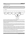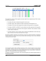
1
User Manual
Revision 2.2 / November 21, 2011
Copyright © 2010-2011 senseFly LLC
Disclaimer
SenseFly LLC reserves all rights related to this document and the information contained herein. REPRODUCTION, USE OR DISCLOSURE TO THIRD PARTIES
WITHOUT WRITTEN PERMISSION FROM SENSEFLY LLC IS STRICTLY PROHIBITED.
SenseFly LLC makes no warranties based on the accuracy or completeness of the contents of this document and reserves the right to make changes to
specifications and product descriptions at any time without notice.
By using senseFly LLC software and products you accept senseFly warranty and liability terms.
Product limited warranty
SenseFly LLC warrants that the product will be free from defects in workmanship and materials for a period of twelve (12) months from the date that the
item was first purchased. During Warranty Period, should the covered product, in senseFly LLC’s sole opinion, malfunction due to any defect in material
and/or workmanship, your sole remedy and senseFly LLC’s sole liability shall be, at senseFly LLC’s option, to either repair or replace the malfunctioning
product with a similar product at no charge or to reimburse the purchase payment, provided that the malfunctioning product is returned, with proof
of purchase in the form of your original copy of the sales receipt, within the applicable Warranty Period.
The warranty shall exclude defects due to normal wear and tear, including but not limited to deterioration of the airframe after first flight, normal degradation, misuse, moisture or liquids, proximity or exposure to heat, accidents, excessive strain, abuse, neglect, misapplication, repairs or modifications
made by anyone other than senseFly LLC, damage due to manual operation, damage due to take-off or landing location with obstacles, damage due
to low altitude flight, damage due to lost of data radio connection, damage due to strong wind, rain or humidity or other causes for which senseFly LLC
is not answerable. Any claim related to in-flight malfunction of the product will be considered by senseFly LLC only if accompanied with the related
flight log.
There are no express or implied warranties, representations or conditions other than those stated in this limited warranty. The remedy set forth herein
shall be the sole, exclusive remedy with respect to the product.
Product liability
UNDER NO CIRCUMSTANCES WILL SENSEFLY LLC BE LIABLE FOR ANY DIRECT, INDIRECT, SPECIAL, INCIDENTAL OR CONSEQUENTIAL DAMAGES (EVEN
IF SENSEFLY LLC IS NOTIFIED OF THE POSSIBILITY OF SUCH DAMAGES) INCLUDING, BUT NOT LIMITED TO, ANY DAMAGES CAUSED BY YOU OR A THIRD
PARTY WHILE OPERATING OR USING THE PRODUCT, ANY LOSS OF REVENUE, LOSS OF PROFIT, OR LOSS OF DATA WHETHER BASED UPON ANY ALLEGED
BREACH OF WARRANTY, REPRESENTATION OR CONDITION, CONTRACT, OR ANY OTHER CONDUCT INCLUDING NEGLIGENCE (INTENTIONAL OR OTHERWISE), GIVING RISE TO SUCH CLAIM.
UNDER NO CIRCUMSTANCES WILL SENSEFLY LLC BE LIABLE FOR ANY DIRECT, INDIRECT, SPECIAL, INCIDENTAL OR CONSEQUENTIAL DAMAGES (EVEN
IF SENSEFLY LLC IS NOTIFIED OF THE POSSIBILITY OF SUCH DAMAGES) INCLUDING, BUT NOT LIMITED TO, ANY DAMAGES CAUSED BY FAILURE OF THE
AUTOPILOT, ELECTRONICS OR SOFTWARE. YOU SHALL NOT OPERATE THE PRODUCT IN AREAS OR UNDER CIRCUMSTANCES WHERE A FAILURE COULD
CAUSE DAMAGES AND/OR HARM TO OBJECTS AND/OR PEOPLE.
ALL USE OF SENSEFLY LLC PRODUCTS, INCLUDING BUT NOT LIMITED TO THE USE CONFORM TO THE APPLICABLE LAW OF THE COUNTRY IN WHICH THE
PRODUCT IS OPERATED, IS UNDER YOUR SOLE RESPONSIBILITY. INFORM YOURSELF BEFORE USING THE PRODUCT. SOME COUNTRIES MAY HAVE LAWS
THAT LIMIT THE USE OF UNMANNED AIRCRAFT TO ‘LINE-OF-SIGHT’ OPERATIONS AND/OR PROHIBIT THE USE OF UNMANNED AIRCRAFT IN SPECIFIC
AREAS.
Address and technical support
senseFly LLC
Route de la Brûlée, 4B
1024 Ecublens
Switzerland
Website: http://www.sensefly.com
E-mail: support@sensefly.com
Skype hotline: sensefly.com
User Manual
Contents
1 Package contents
5
2 Operation scenarios
6
2.1
Overview . . . . . . . . . . . . . . . . . . . . . . . . . . . . . . . . . . . . . . . .
6
2.2
Scenario 1: Simple demo flight without ground station . . . . . . . . . . . . . . .
7
2.3
Scenario 2: Preprogrammed photo flight . . . . . . . . . . . . . . . . . . . . . . .
7
2.4
Scenario 3: Interactive photo flight . . . . . . . . . . . . . . . . . . . . . . . . . .
8
3 Preparing for flight
9
3.1
Charging the swinglet battery packs . . . . . . . . . . . . . . . . . . . . . . . . .
9
3.2
Charging the camera battery . . . . . . . . . . . . . . . . . . . . . . . . . . . . .
10
3.3
Charging the ground station (laptop) . . . . . . . . . . . . . . . . . . . . . . . . .
10
3.4
Pre-plan the flight . . . . . . . . . . . . . . . . . . . . . . . . . . . . . . . . . . .
10
4 Executing a photo flight
11
4.1
Weather check . . . . . . . . . . . . . . . . . . . . . . . . . . . . . . . . . . . . .
11
4.2
Terrain check . . . . . . . . . . . . . . . . . . . . . . . . . . . . . . . . . . . . . .
12
4.3
Preparing the swinglet . . . . . . . . . . . . . . . . . . . . . . . . . . . . . . . . .
12
4.4
Preflight-check . . . . . . . . . . . . . . . . . . . . . . . . . . . . . . . . . . . . .
13
4.5
Start-up . . . . . . . . . . . . . . . . . . . . . . . . . . . . . . . . . . . . . . . . .
14
4.6
Establishing communication . . . . . . . . . . . . . . . . . . . . . . . . . . . . . .
15
4.7
Take-off and flight . . . . . . . . . . . . . . . . . . . . . . . . . . . . . . . . . . .
15
4.8
Landing . . . . . . . . . . . . . . . . . . . . . . . . . . . . . . . . . . . . . . . . .
18
4.9
Processing flight data . . . . . . . . . . . . . . . . . . . . . . . . . . . . . . . . .
18
5 Programming and monitoring the swinglet
19
5.1
About e-mo-tion . . . . . . . . . . . . . . . . . . . . . . . . . . . . . . . . . . . .
19
5.2
Connecting to the swinglet . . . . . . . . . . . . . . . . . . . . . . . . . . . . . . .
20
5.3
General principles of operation . . . . . . . . . . . . . . . . . . . . . . . . . . . .
21
5.4
Understanding the map window . . . . . . . . . . . . . . . . . . . . . . . . . . .
22
5.5
Using the waypoint editor . . . . . . . . . . . . . . . . . . . . . . . . . . . . . . .
25
5.6
Monitoring and controlling the swinglet status using the cockpit . . . . . . . . . .
27
5.7
Setting the swinglet’s parameters . . . . . . . . . . . . . . . . . . . . . . . . . . .
33
Copyright © 2010-2011 senseFly LLC
3/51
User Manual
5.8
Getting information about the swinglet . . . . . . . . . . . . . . . . . . . . . . . .
6 Taking pictures with the swinglet CAM
36
6.1
Triggering picture acquisition . . . . . . . . . . . . . . . . . . . . . . . . . . . . .
36
6.2
Using the photo location editor . . . . . . . . . . . . . . . . . . . . . . . . . . . .
37
6.3
Using the picture footprint display . . . . . . . . . . . . . . . . . . . . . . . . . .
38
6.4
Using the automatic flight planning . . . . . . . . . . . . . . . . . . . . . . . . . .
38
6.5
Configuring the picture acquisition . . . . . . . . . . . . . . . . . . . . . . . . . .
41
7 Maintenance and repair of the swinglet
43
7.1
Storage . . . . . . . . . . . . . . . . . . . . . . . . . . . . . . . . . . . . . . . . .
43
7.2
Cleaning the swinglet . . . . . . . . . . . . . . . . . . . . . . . . . . . . . . . . .
43
7.3
Repairing the swinglet airframe . . . . . . . . . . . . . . . . . . . . . . . . . . . .
43
8 Appendix
4/51
35
44
8.1
Installing e-mo-tion and the radio module drivers . . . . . . . . . . . . . . . . . .
44
8.2
Updating the swinglet software . . . . . . . . . . . . . . . . . . . . . . . . . . . .
44
8.3
Accessing the flight log . . . . . . . . . . . . . . . . . . . . . . . . . . . . . . . .
45
8.4
Camera settings . . . . . . . . . . . . . . . . . . . . . . . . . . . . . . . . . . . .
46
8.5
Adding custom imagery to the map window . . . . . . . . . . . . . . . . . . . . .
46
8.6
Using the remote control . . . . . . . . . . . . . . . . . . . . . . . . . . . . . . .
47
8.7
swinglet technical specifications . . . . . . . . . . . . . . . . . . . . . . . . . . . .
50
8.8
e-mo-tion requirements . . . . . . . . . . . . . . . . . . . . . . . . . . . . . . . .
51
Copyright © 2010-2011 senseFly LLC
User Manual
1 Package contents
The swinglet package contains the following items:
1. one carry case with protecting foam;
2. one swinglet with built-in autopilot;
3. two propellers;
4. four propeller attachment rubber bands;
5. two Lithium-Polymer battery packs for swinglet;
6. one Lithium-Polymer battery charger and balancer;
7. one remote control including battery pack;
8. one charger for the remote control (including cables);
9. one USB ground station radio module, including a USB cable;
10. one still camera, including memory card, battery and charger;
11. (optional) one laptop including charger and installation CD;
12. printed documentation.
Please verify upon delivery that your package is complete. In case of a missing item, contact senseFly
LLC immediately.
Note: This manual refers to the version 1.1.2 of the swinglet software. Check the software
version included in your package and consult the Release Notes for potential changes
included in more recent versions of the software.
Copyright © 2010-2011 senseFly LLC
5/51
User Manual
2 Operation scenarios
Goal of this section:
This section provides a brief overview of how the swinglet can be operated.
2.1 Overview
Flight
preparation
Pre-flight
checks
Take-off
Home
waypoint
After
2 min.
Landing
Security
issue
Waypoint
route
In preparation for each flight, all the batteries should be fully charged and the swinglet prepared for
flight. This is described in section ‘Preparing for flight’ on page 9.
A flight always begins with pre-flight checks. It is of utmost importance to cautiously perform preflight checks to ensure flight safety. Also, the user must make sure that the environment is sufficiently
clear from obstacles for the swinglet to be operated. This procedure is described in section ‘Executing
a photo flight’ on page 11.
After take-off, the swinglet will, by default, join and circle around the home waypoint, which is automatically set above the position where the swinglet is switched into take-off mode. Without further
user action, the swinglet will land after a predefined holding period (by default 2 minutes) by spiraling
around the home waypoint down to the ground.
Alternatively, the swinglet can be programmed to follow a specific waypoint route after take-off and
to take photos at predefined locations or in a continuous or systematic manner. This can be achieved
by programming the swinglet using the provided ground station software called e-mo-tion (Electronic MOnitoring staTION). This procedure is described in section ‘Programming and monitoring
the swinglet ’ on page 19. Automatic flight planning to systematically cover a predefined area is described in section ‘Using the automatic flight planning’ on page 38.
At anytime, if a security issue arises such as low battery level, strong wind or reaching of the working
area boundary, the swinglet will try to fly back to the home waypoint at a default height of 75 metres
and land after the holding period (unless further action is taken by the user using e-mo-tion).
Using a switch on the provided remote control, the user can engage the manual mode. In this mode,
6/51
Copyright © 2010-2011 senseFly LLC
User Manual
the swinglet is directly controlled by the remote control’s sticks. Note that this should be done only by
experienced RC aircraft pilots. Be aware that the swinglet is not a very easy-to-fly aircraft in manual
operation because it is lightweight and very dynamic. Switching from automatic mode to manual
mode and back can be done at anytime during the flight if the swinglet is within range of of the remote control. Switching from manual to automatic should only be done when the swinglet is flying
straight and level at relatively low speed. See section ‘Using the remote control’ on page 47 for more
infomation.
Caution: The swinglet is a small airplane that is not made to fly in rain or strong wind conditions (more than 25 km/h or 7 m/s).
Caution: Any obstacles (such as trees, electrical wires or buildings) within 40 metres of the
take-off location may result in a crash during take-off or landing. The swinglet must
therefore be used only in areas with sufficient clearance.
Caution: In case of a problem occurring during flight, the swinglet will fly towards the home
waypoint at a height of 75 metres. Therefore, the presence of any taller objects in the
working area (hills, buildings, etc.) increases the risk of crash if the safety procedure
is triggered by the autopilot.
2.2 Scenario 1: Simple demo flight without ground station
Without any programming, the swinglet will, by default, climb to 75 metres above ground after takeoff, circling around the home waypoint and landing after the holding period of 2 minutes. During the
flight, the swinglet will automatically take photos at regular intervals if no computer is connected to it.
Required reading:
1. Parts of section ‘Preparing for flight’ on page 9
2. Parts of section ‘Executing a photo flight’ on page 11
2.3 Scenario 2: Preprogrammed photo flight
For photo flights, a waypoint route including photo locations or photo sequences must be programmed into the swinglet autopilot. In this scenario, the waypoint route is carefully prepared using the
e-mo-tion software and saved into the memory of the autopilot. Before take-off – or after take-off
when the swinglet is on the home waypoint – the swinglet can be instructed to start following the
route. It will take photos at the programmed locations. If the route includes a landing waypoint, the
swinglet will execute it. Otherwise, it will follow the route until the battery is low and then will try fly
back to the home waypoint for landing.
Copyright © 2010-2011 senseFly LLC
7/51
User Manual
Caution: It is the sole responsibility of the operator to ensure that the battery level is sufficient
for the swinglet to be able to fly back to the home waypoint. As a rule of thumb, a
mostly level flight with a fully-charged battery should not exceed 25 minutes at an
average ground speed of 7 to 10 m/s. High winds or frequent altitude changes will
decrease the endurance of the swinglet.
In this scenario, the swinglet can be monitored using e-mo-tion, but will continue to perform its flight
even in case of temporary loss of communication (e.g. caused by flying beyond specified range or
the presence of radio-frequency interferences).
Required reading:
1. Section ‘Preparing for flight’ on the next page
2. Section ‘Executing a photo flight’ on page 11
3. Section ‘Programming and monitoring the swinglet ’ on page 19
2.4 Scenario 3: Interactive photo flight
Caution: Certain actions performed through e-mo-tion when the swinglet is airborne may
lead to unsafe or catastrophic situations. For example, configuring an inadequately
low altitude for a waypoint may lead to a crash of the swinglet. Therefore, only expert users with a thorough understanding of the system should use the swinglet in
this way.
It is possible to activate, deactivate and modify waypoints and photo locations while the swinglet is
in flight using e-mo-tion. This allows the user to dynamically re-route the swinglet to perform ondemand actions. In this scenario, the swinglet flies autonomously but the user constantly monitors
the swinglet and reprograms waypoints or photo locations as necessary.
Using the swinglet according to this scenario requires it to be kept within the communication range
of the radio modem (see section ‘swinglet technical specifications’ on page 50). A loss of communication might lead to unsafe situations depending on the user’s actions.
Required reading:
1. Section ‘Preparing for flight’ on the next page
2. Section ‘Executing a photo flight’ on page 11
3. Section ‘Programming and monitoring the swinglet ’ on page 19
8/51
Copyright © 2010-2011 senseFly LLC
User Manual
3 Preparing for flight
Goal of this section:
Good preparation is important for a successful photo flight. This section
reviews the steps needed to prepare the swinglet for flight. The preparation can be done in advance and should preferably be carried out in a
place with Internet access and electrical power.
3.1 Charging the swinglet battery packs
When delivered, the battery may not be fully charged. We recommend that you fully charge them
before each flight.
main power
cables – leave
disconnected
power cable
LiPoly
battery charger
battery pack
To charge a swinglet battery pack, connect it to the battery charger as illustrated above. Depending
on the charger type, the power cable is either part of a wall adapter power supply or a simple power
cable. Make sure that the main power cables are left unconnected. LEDs will indicate the status of
the charge. The charger provided with the swinglet individually balances the voltage of each of the
3 cells contained in the battery pack. This ensures optimal performance and battery life. Charging
can last up to 3 hours, depending on the charge level of the battery and the required cell balancing
work. For further information on the charger, refer to the notes written on the charger itself.
Note: The battery packs provided with the swinglet are of the following type: LiPoly 1350 mAh
3 cells in series. While alternative chargers may be used to recharge these battery packs,
senseFly LLC cannot be held responsible for any consequences. In particular, using a
charger improperly configured or designed for other types of batteries may lead the
battery pack to be permanently damaged or to catch on fire.
Caution: If a LiPoly battery is discharged below 3 volts per cell, that is 9 volts for the swinglet
battery pack, the battery may be irreversibly damaged and it may become dangerous to charge. Therefore, make sure to disconnect the swinglet’s battery before it
reaches this voltage, which can be monitored in the e-mo-tion cockpit (see section
‘Monitoring and controlling the swinglet status using the cockpit’ on page 27.
Note: LiPoly batteries do not exhibit any memory effect. We recommend that you always fully
charge them after use even when they are only partially discharged.
Copyright © 2010-2011 senseFly LLC
9/51
User Manual
3.2 Charging the camera battery
We recommend that you always fully charge the camera battery before flight in order to be sure not
to miss photos due to low battery level. Note that, when delivered, the camera battery may not be
fully charged.
To charge the camera battery, take it off the camera and insert it into its charger. Plug the charger
into a power outlet. The charge LED will light red when charging commences. Once the battery is
fully charged, the LED will turn to green. Charging takes approximately 1 hour and 30 minutes.
Note: More information concerning the camera charger can be found in the camera manual
on the original Canon CD or the support section of our website.
3.3 Charging the ground station (laptop)
In most cases, a laptop will be used to program and monitor the swinglet during the mission. For
maximum security, make sure that the laptop batteries are charged before each flight.
3.4 Pre-plan the flight
It is recommended to make a brief pre-planning of the flight at a place with internet connection, in
order to have access to online maps.
1. Switch the swinglet on by connecting the battery (see section ‘Start-up’ on page 14).
2. Make sure the ground station computer is connected to the Internet.
3. Start e-mo-tion and connect to the swinglet (see section ‘Connecting to the swinglet ’ on page 20).
4. Move the map to the area where you plan to fly (see section ‘Understanding the map window’ on page 22). Note that if the flight area is close-by and the swinglet has acquired its GPS
localisation, you can use the ‘Center on robot’ command in the ‘Map’ menu.
5. Place the waypoints as required and save the list of waypoints to the swinglet using the ‘Save to
autopilot’ button in the Waypoint Editor (see section ‘Using the waypoint editor’ on page 25).
Optionally, you may save the list to your local hard-disk by using the ‘Export...’ button.
6. Quit e-mo-tion and disconnect the swinglet battery.
10/51
Copyright © 2010-2011 senseFly LLC
User Manual
4 Executing a photo flight
Goal of this section:
The section describes the steps that must be performed at the launching site in order to initiate a flight.
This section describes the procedure to operate the swinglet during flight. Before initiating a flight,
the swinglet must be ready for flight - see the previous section for instructions.
By default, the swinglet is programmed to fly at a height of 75 metres in cirlces with a radius of 20 metres around the take-off location (see section ‘Programming and monitoring the swinglet ’ on page 19
to change this behaviour). After the holding period of 2 minutes, the swinglet will perform a landing
within an area with a radius of 20 metres around the take-off location. Important: for a safe landing,
there should be no obstacles within 40 metres of the take-off location. The zero altitude reference is
taken during the startup procedure as soon as the swinglet acquires its first GPS fix.
Caution: Any obstacles (such as trees or buildings) within 40 metres of the take-off location
may result in a crash during take-off or landing. Take-off and landing must occur
only in areas with sufficient clearance.
battery
camera
autopilot LED display
pitot probe
servo rods
propeller
ailerons
Top face of the swinglet CAM
airframe
winglets
4.1 Weather check
Before each flight, you should be aware of the weather conditions. The swinglet is a small airplane
that cannot fly in rain or strong wind conditions. In case of doubt, make sure to check a weather
bulletin including wind estimations in the flight area. Note that wind is often stronger at higher
altitudes. Therefore the wind perceived at the surface is not a good reference to estimate the wind
at 75 metres height. Cloud velocity, or tall tree movements can help you to estimate the wind speed
once you are out in the field.
Copyright © 2010-2011 senseFly LLC
11/51
User Manual
Caution: The swinglet should not be launched if the wind speed exceeds 25 km/h or 7 m/s.
Note: While flying, if the swinglet detects that the wind is dangerously strong (over 25 km/h
or 7 m/s), it will emit a warning and automatically try to return to its home waypoint
at a height of 75 metres. Once the home waypoint is reached, it will initiate landing
after 2 minutes of loitering above home location, unless another action is initiated via
e-mo-tion.
Note: Best photo quality is obtained in low wind conditions (less than 3-4 m/s) and on sunny
or bright days.
4.2 Terrain check
Select a take-off location that has no obstacles (buildings, rocks, power lines, trees, etc.) within a
radius of 40 metres around the take-off position. In case a go home procedure is triggered during
flight (either automatically due to a warning or manually using e-mo-tion) the swinglet will do it at a
height of 75 metres. Therefore, the presence of any objects taller than 65 metres in the working area
(hills, buildings, trees, etc.) increases the risk of crash.
Note: In case of strong-wind conditions, the swinglet may drift even further than 40 metres
away from the take-off location when trying to land around the home waypoint. Therefore, it may be wise to plan for even more clearance in the downwind direction.
4.3 Preparing the swinglet
The swinglet comes ready for flight. The only preparation required before use is the installation of
the propeller and of the battery pack.
battery pack
2
motor
insert the battery into
the compartment
power cables
1 connect the cables
propeller
propeller
attachment
rubber bands
swinglet’s nose
To install the propeller on the swinglet, follow these steps:
12/51
Copyright © 2010-2011 senseFly LLC
User Manual
1. Insert the propeller on the motor axis. Important: the metal ring of the propeller should be
on the motor side.
2. Secure the propeller using two attachment rubber bands as illustrated above (left).
After extensive use, the rubber bands may develop cracks. This is normal and is caused by to the
aging of the rubber material. For maximum security, inspect the rubber bands regularly and discard
them if they show cracks.
Caution: Failure to use two rubber bands may result in the loss of the propeller in flight!
Note: For storage, it is best to remove the propeller from the swinglet. Long-duration strain
on the rubber bands may accelerate the aging process.
To install the battery, first make sure that none of the power cables of the swinglet are damaged by
slightly pulling the connectors while firmly holding the cables. Then, connect the battery pack and
insert it into the compartment, as shown by the arrow in the illustration above. Make sure that the
battery is well attached to the swinglet by applying vertical pressure.
Important: Only connect the battery cables to the swinglet when you are ready for start-up. Do not
leave the battery connected for extended periods of time when the swinglet is on the ground, as this
may discharge the batteries below the absolute minimum of 9 volts (beyond this value, the battery
pack will be irreparably damaged). When connected and not in flight, the swinglet will briefly move
its ailerons up and down every minute as a reminder that it is switched on.
4.4 Preflight-check
Before connecting the battery, the swinglet must be checked for potential damages as follows.
1. Airframe
Check the foam airframe for cracks or other damage. Verify that the winglets are solidly attached to the airframe.
2. Propeller
Verify that the propeller is attached with two rubber bands. Ensure that the rubber bands do
not show cracks or other ageing signs.
3. Servo rods
Verify that the linkage between the servos and the control surfaces are not damaged and firmly
attached at both ends.
4. Pitot probe
Verify that the pitot probe is properly attached to the airframe and the two rubber tubes are
well in place.
5. Camera
Make sure that the memory card and a fully-charged battery are in the camera before inserting
it into the swinglet and securing it with the attachment strap.
Copyright © 2010-2011 senseFly LLC
13/51
User Manual
6. Battery
Verify that a fully-charged swinglet battery is in place (see previous section).
Caution: Note that swinglet CAM has not been designed to fly without the camera. Attempting to fly without the camera may render the swinglet unstable, which may eventually lead to a crash.
Note: For best image quality, make sure that the camera is configured according to Section
‘Camera settings’ on page 46.
4.5 Start-up
Once the airframe is checked, the swinglet can be switched on using the following procedure.
1. Lay the swinglet horizontally on the ground in the vicinity of the take-off position, with the top
face up. It is important that the swinglet is not inclined more than 10 degrees in order to start
up properly.
2. Connect the battery to the swinglet. Caution: Make sure that the colours of the cables match
and insert the connectors firmly to the end in order to avoid undesired disconnection when in
flight. Take care to keep the propeller area clear, in case it suddenly starts spinning.
3. Wait for the aileron motion and for the ‘GO’ indication on the autopilot LED display while the
swinglet performs self-checks and acquires GPS signal. This may last from a few seconds to
several minutes in the case of poor GPS signal reception. Note: The zero altitude reference is
recorded when the GPS fix occurs the first time after startup.
4. Make sure the camera is properly connected. To verify this connection, you can shake the
swinglet three time up and down (in approx. 3 seconds) while holding it horizontally. The
camera should then turn on and the optics should extend below the swinglet. Repeat the same
movement to switch-off the camera. Caution: Always make sure that the optics is retracted
(camera switched off) before putting down the swinglet. Otherwise, the optics will come into
direct contact with the surface, potentially causing irreversible damage.
5. If you plan to use the remote control, switch it to ‘Manual’. Move the aileron stick on the remote
control to verify proper reception by the swinglet and correct servo direction. Caution: Always
check that the thrust lever is in the low position to prevent the propeller from spinning.
Note: If the remote control is switched on and in manual mode, the ailerons will not move
when the self-checks are completed and the GPS fix is acquired.
Once the battery is connected to the swinglet, the LED display will show the following information:
1. the firmware revision;
14/51
Copyright © 2010-2011 senseFly LLC
User Manual
2. a waiting indicator (rotating segment);
3. the ‘GO’ indication (upon successful completion of the self-checks) or a start-up error code (if
a problem has been detected).
…
…
firmware revision
Note: Digits are displayed
sequentially on the LED
display.
…
waiting indicator
performing selfchecks and waiting
for GPS signal
ready for take-off
…
…
error code
Table 1 on the next page summarises the possible start-up error codes.
Note: Other error codes may be displayed after the start-up procedure. See table 4 on page 29
and table 5 on page 30 for more information.
4.6 Establishing communication
Start the software e-mo-tion on the laptop and connect to the swinglet (see section ‘Connecting to
the swinglet ’ on page 20 for more info). The status message should show ‘Idle (ready to take-off)’ and
the map should display the flight plan. Check the flight plan and modify as necessary (see section
‘Programming and monitoring the swinglet ’ on page 19).
4.7 Take-off and flight
Caution: Make sure to keep the propeller area free and firmly hold the swinglet with two
hands in the ’holding area’ as shown in figure below.
Once the swinglet shows the ‘GO’ indicator, it is ready for take-off using the following procedure:
1. Gently shake the swinglet back and forth 3 times longitudinally (within approx. 3 seconds).
This will switch the motor to full power. Note: Once this is done, do not hurry to launch it
into the air. If case you want to return to idle mode, just repeat the back and forth three times
movement and the motor will stop.
2. Orient the swinglet against the wind, with approximately 30 degrees nose up and level wings.
Make sure that the take-off direction is free of obstacles (see Section ‘Terrain check’ on page 12).
Copyright © 2010-2011 senseFly LLC
15/51
User Manual
Table 1: List of start-up error codes
Label
Error code
Action
Memory write error
E01
Memory read error
E02
Memory data error
E03
Battery low
E04
Recharge the battery or use another battery.
Attitude sensing
error
E05
Make sure the swinglet is placed horizontally on the
ground with the top facing up, disconnect and reconnect the battery. If this error occurs repeatedly, contact
senseFly LLC.
Airspeed error
E06
Barometer error
E07
Navigation error
E08
Disconnect and reconnect the battery. Contact senseFly
LLC if this error occurs repeatedly.
Verify that the pitot probe and the rubber tubes are well
in place. Disconnect and reconnect the battery and
make sure that the swinglet is not exposed to significant
wind until start-up is completed.
Contact senseFly LLC if this error occurs repeatedly.
Unknown error
E99
3. Release the swinglet by gently accompanying it with the two hands symmetrically placed on
either side in a purely forward motion, as illustrated below. Note: If the wind is calm, it is best
to increase the initial launch speed. This can be achieved by walking 1-2 steps forward before
releasing it.
It is unsafe to take off if the battery voltage is below 11 volts. In this case, the swinglet will not start its
motor and will display a LOW BAT error. If this happens, the battery should be changed before commencing the start-up procedure. If any other warning has happened before take-off (such as LOSS
OF FIX) and has not been acknowledged using e-mo-tion, the the motor will not start. See section
‘Monitoring and controlling the swinglet status using the cockpit’ on page 27 for more information.
Caution: The swinglet must be launched against the wind for it to be able to take off. Launching the swinglet along the wind or with cross-wind may result in a crash.
16/51
Copyright © 2010-2011 senseFly LLC
User Manual
shake 3 times
back and forth
no holding
zone
1
30°
3
propeller
danger zone
2
30° nose up
Caution: always orient the swinglet
against the wind for take-off!
Note: The home waypoint position is updated to the take-off location each time the swinglet
is switched into take-off mode. However, the zero altitude reference is defined at
startup when the GPS fix occurs and will remain the same until the swinglet is switched
off. See section ‘Setting the swinglet’s parameters’ on page 33 for information about
resetting the zero altitude reference.
Caution: The procedure to initiate take-off by shaking the swinglet forces the autopilot to
enter into flight mode. If the remote control is used for a manual take-off without
following the take-off procedure, the swinglet will not enter into flight mode and
will crash when switched to autonomous mode or if the RC link is lost.
After take-off, the swinglet maintains its initial direction with full thrust until reaching a height of
30 metres (see section ‘Setting the swinglet’s parameters’ on page 33 to change this parameter). At
this point, it will switch into waypoint navigation mode. See section ‘Programming and monitoring
the swinglet ’ on page 19 for further information about programming a flight plan including photo
sequences or photo locations.
Copyright © 2010-2011 senseFly LLC
17/51
User Manual
Note: The swinglet automatically calibrates its air speed sensor in flight to compensate for
any drift due to temperature variations. To ensure an optimum performance of this
calibration, the swinglet should execute at least two complete orbits on a waypoint at
the beginning of every flight.
4.8 Landing
When landing is initiated (manually or automatically after 2 minutes of loitering around the home
waypoint), the swinglet will switch off its motor and glide down to the ground by circling around the
home waypoint. After touch-down, the swinglet will automatically switch back to idle mode after a
few seconds of inactivity.
4.9 Processing flight data
Once the swinglet has landed, the images taken during the flight can be downloaded to a computer.
To download the images, connect the camera to a computer using the provided USB cable. For more
information, check the camera user manual on the original Canon CD or the support section of our
website.
You can export KML and GPX files based on the telemetry data logged during the flight by using
PostFlight Suite provided by senseFly LLC. KML files can be opened in Google Earth and contain a 3D
rendition of the flight trajectory. GPX files also contain the trajectory data and are compatible with
most software capable of dealing with GPS-acquired geographic data.
Using PostFlight Suite, you can also geotag the images acquired during the flight. The process of
geotagging images consists of writing the GPS coordinates of the position at which the image has
been taken into the image file. PostFlight Suite also allows supports uploading images to senseFly
LLC’s online image processing service PostFlight Services¹, which produces georeferenced orthoimages and DEMs. Alternatively, several other programs and web services can use geotagged images
to position images on a map or to create georeferenced mosaics.
¹ http://www.sensefly.com/support/postflight-services
18/51
Copyright © 2010-2011 senseFly LLC
User Manual
5 Programming and monitoring the swinglet
Goal of this section:
For most flights, the swinglet must be programmed and monitored using the ground station software. This section describes the use of e-motion, the ground station software provided with the swinglet.
5.1 About e-mo-tion
e-mo-tion (Electronic MOnitoring staTION) is the user interface of the swinglet. Its main functions are
to:
• monitor and control the status of the swinglet;
• program the flight plan and photo locations;
• display the position of the swinglet and navigation information;
• modify the flight plan during the flight;
• display status and error messages.
See section ‘Installing e-mo-tion and the radio module drivers’ on page 44 for information on the
installation of e-mo-tion and the drivers for the USB ground station radio module.
Note: For convenience, we cover everything related to flight programming and monitoring
in this section. For information on using the camera and acquiring photos, see section
‘Taking pictures with the swinglet CAM’ on page 36.
map controls
status panel
toolbar
waypoint editor
cockpit
photo location
editor
map window
The main screen of e-mo-tion is split into three windows:
Copyright © 2010-2011 senseFly LLC
19/51
User Manual
• the map window (see section ‘Understanding the map window’ on page 22);
• the waypoint editor (see section ‘Using the waypoint editor’ on page 25);
• the photo location editor (see section ‘Using the photo location editor’ on page 37);
The map window contains the following items:
• the cockpit (see section ‘Monitoring and controlling the swinglet status using the cockpit’ on
page 27);
• the toolbar, which provides access to several functions and dialogue boxes;
• the status panel, which indicates the current action being taken by the swinglet.
To access the main screen, e-mo-tion must first be connected to the swinglet.
5.2 Connecting to the swinglet
Before connecting to the swinglet, the USB radio module must be properly connected to the computer. e-mo-tion can then be started and will display the connection dialogue box.
connection profile
serial port
To connect to the swinglet, use the ‘swinglet cam’ connection profile to automatically configure the
connection options. The only option that must be manually set is the serial port. On Mac OS X, the
name of the serial port corresponding to the USB ground station radio module starts with ‘cu.usbserial’.
On Windows, the COM port corresponding to the USB ground station is labelled with ‘Digi PKG-U Serial Port Adapter’ (or ‘MaxStream PKG-U Serial Port Adapter’).
20/51
Copyright © 2010-2011 senseFly LLC
User Manual
Note: On Windows, the operating system will configure the drivers the first time the USB
ground station radio module is connected. It may be necessary to disconnect and
reconnect the radio module for it to function properly after this initial configuration
phase.
After acknowledging the connection option by clicking the ‘OK’ button, e-mo-tion will connect to the
swinglet and display its status.
Caution: Connecting to the swinglet through e-mo-tion should never take place during flight.
On occasion, it may happen that the connection fails. In this case, ‘NO CONNECTION AVAILABLE’ will
be indicated in red in the status panel in the map window. This can be due to an interference that
occurred during the connection process. If this happens, quit and relaunch e-mo-tion, disconnect and
reconnect the swinglet’s battery and restart the connection process. Contact senseFly LLC in case of
repeated connection problems.
5.3 General principles of operation
The swinglet uses waypoints to navigate. It will either circle around them or navigate on a straight
line when switching from one active waypoint to the next. The entire list of waypoints is stored in
the swinglet autopilot and can be remotely edited using e-mo-tion. All modifications made to the
waypoint list will be lost when the swinglet is switched off, unless the list is explicitly saved into the
autopilot using the corresponding button in the waypoint editor (see Section ‘Using the waypoint
editor’ on page 25).
us
vio
pre oint
m
fro ayp
w
radi
us
directio
n
to next
waypoin
t
altitude above
start-up position
position (GPS coordinates)
A waypoint essentially consists of a circle about a given position. Its trajectory is defined by the
following parameters:
1. the GPS coordinates about which to circle;
2. the radius of the circle;
3. the direction of the circle (clockwise or counter-clockwise);
4. the altitude above the startup position.
Copyright © 2010-2011 senseFly LLC
21/51
User Manual
Table 2: Waypoint parameters
Label
Description
Active
Indicates whether the waypoint is active or not. The swinglet will never navigate
to an inactive waypoint. If no waypoint is active, the swinglet will raise a NO ROUTE
cautionary warning (see table 5 on page 30) and remain on the home waypoint.
Auto next
Indicates whether the swinglet should remain on the waypoint upon reaching it or
automatically continue to the next active waypoint.
Action
Indicates which action the swinglet should execute upon reaching the waypoint
(see table 3 below for a list of possible actions).
Note: By default, after take-off, the swinglet flies to the home waypoint, which is automatically
created at the position where the swinglet is started (see section ‘Start-up’ on page 14)
and updated when the swinglet is switched into take-off mode (see section ‘Take-off
and flight’ on page 15).
In addition to these parameters, waypoints also contain information that defines how the swinglet
should behave when reaching them. They are listed in table 2 and table 3.
Note: Some of the behaviours described above occur upon reaching the waypoint (for example, the ‘Auto next’ and the ‘Action’ functions). The waypoint is considered ‘reached’
only when the swinglet circles about it at the waypoint’s altitude. If the swinglet reaches
the waypoint’s position before the waypoint’s altitude, it will keep circling about the
waypoint until the altitude is attained, irrespective of the waypoint’s settings.
5.4 Understanding the map window
The map window provides an overview of the current position of the swinglet as well as its waypoint
route. The top part of the window contains buttons to adjust the zoom level of the map and to select
between a street view or a satellite imagery view. In addition to these two types of map background,
the map window has the possibility to display custom imagery provided by the user (see section
‘Adding custom imagery to the map window’ on page 46 for more information).
Moving around the map is done by clicking and dragging at any place not occupied by a symbol
(such as a waypoint or the swinglet symbol). Zooming in and out of the map is done using the slider
at the top or using the mouse wheel (if your mouse has one). Alternatively, the map can be set to
automatically follow the swinglet by selecting the ‘Auto-center’ item of the ‘Map’ menu. Selecting
this item again deactivates this feature. To centre the map on the swinglet once, without following
it, use the ‘Center on robot’ item of the ‘Map’ menu. The map can be scrolled to an arbitrary location
by using the ‘Center on coordinate’ item of the ‘Map’ menu and entering the target GPS coordinates.
22/51
Copyright © 2010-2011 senseFly LLC
User Manual
Table 3: Waypoint actions
Label
Description
Landing
Upon reaching the waypoint, the swinglet will initiate landing, as if
the INITIATE LANDING button had been clicked (see section ‘Monitoring and controlling the swinglet status using the cockpit’ on page 27).
Note that the swinglet will remain on the waypoint for landing even
if the waypoint is set as ‘Auto next’.
Go home
Upon reaching the waypoint, the swinglet will navigate and stay at
the home waypoint, eventually landing if no further action is taken
by the user.
Photo sequence
When the swinglet navigates between two waypoints whose action is
‘Photo sequence’, it will take pictures repeatedly (see section ‘Taking
pictures with the swinglet CAM’ on page 36). Note that both waypoints must be marked as ‘Photo sequence’ for the swinglet to take
pictures.
Start continuous photo
Upon reaching the waypoint, the swinglet will engage the continuous photo mode (see section ‘Taking pictures with the swinglet CAM’
on page 36).
Stop continuous photo
Upon reaching the waypoint, the swinglet will disengage the continuous photo mode (see section ‘Taking pictures with the swinglet
CAM’ on page 36).
Note: The map data (street or satellite view) is downloaded by e-mo-tion from the Internet as
required and locally cached on the hard drive. If you anticipate the use of e-mo-tion in
conditions where connecting to Internet is impossible, you can preload the map data
by scrolling and zooming into the target region beforehand when you are connected
to the Internet.
Copyright © 2010-2011 senseFly LLC
23/51
User Manual
swinglet’s current position
swinglet’s altitude over ground
90 m
planned trajectory
recent trajectory
0
100 m
home waypoint
H
non-auto-next segment
auto-next segment
75 m
photo location
waypoint
A
waypoint’s direction
1
START
100 m
waypoint’s action
waypoint’s altitude over ground
working area
The illustration above describes the various symbols displayed on the map and their meaning. Waypoints are represented as circles with their actual radius, as well as their index number (or ‘H’ for
the home waypoint) and their altitude above start-up position. Segments connecting waypoints are
drawn with a solid line if the originating waypoint is set as ‘Auto next’. Otherwise, the segment is
drawn as a dashed line. The recent trajectory of the swinglet is displayed with a thin line and the
swinglet is connected to its immediate destination waypoint with a straight thin line. The large circle
with a hatched border illustrates the working area boundaries beyond which a TOO FAR cautionary
warning will be issued (see table 6 on page 32). Finally, photo locations are displayed with a solid
dot and labelled with a letter.
24/51
Copyright © 2010-2011 senseFly LLC
User Manual
The waypoints and photo locations can be moved around by dragging them on the map (see section ‘Taking pictures with the swinglet CAM’ on page 36 for information on photo locations). This
will directly send a message to the swinglet to update its onboard waypoint list. If the message is not
acknowledged by the swinglet (for example due to a temporary loss of communication link), the waypoint will move back to its previous position on the map to accurately reflect the current waypoint
list status within the autopilot.
Note: Clicking on a waypoint will automatically select the corresponding line in the waypoint
editor (see next section).
5.5 Using the waypoint editor
This section explains how to program waypoints and photo locations and how to activate a waypoint
route.
home waypoint
(read only)
waypoint list
selected waypoint
editor
global options
The primary way to edit waypoints is through the waypoint editor. The waypoint editor is split into
three sections:
• the waypoint list contains all the waypoints currently stored into the swinglet autopilot;
• the selected waypoint editor displays the details of the waypoint that is currently selected in
the list;
• the global options section offers options that apply to the entire list of waypoints.
Copyright © 2010-2011 senseFly LLC
25/51
User Manual
The waypoint list contains all the waypoints currently stored in the swinglet memory. The list shows
the following information.
• The column ‘ON’ shows whether the waypoint is active or not.
• The column ‘NEXT’ shows whether the Auto next parameter of the waypoint is set.
• The column ‘CUR’ shows which waypoint the swinglet is flying towards or circling about.
• The columns ‘HEIGHT’ and ‘RADIUS’ show the altitude and radius parameter of the waypoint.
• The column ‘DIR’ shows the direction of the waypoint (clockwise if the checkbox is ticked,
counter-clockwise otherwise).
• The colour indicator in the last column shows whether the modifications made to the waypoints have been successfully transmitted to the swinglet.
To change a waypoint’s parameters, the check boxes in the list can directly be clicked. To modify the
HEIGHT or RADIUS, first double-click on the parameter before modifying its value. Each modification
is directly sent to the swinglet.
In the selected waypoint editor, additional parameters of the selected waypoint can be inspected
and modified. Changes made to the selected waypoint are sent to the swinglet immediately after
selecting an item in the popup menu or upon hitting the ‘Enter’ key in the text fields. See table 3 on
page 23 for a description of the possible waypoint actions.
In addition to changing the parameters of the selected waypoint, the selected waypoint editor has
the following functions:
26/51
Copyright © 2010-2011 senseFly LLC
User Manual
• By clicking the ‘Place on map’ button, the selected waypoint will be activated and positioned
at the desired position by clicking on the map (see section ‘Understanding the map window’
on page 22).
• The ‘Reset’ button reverts the selected waypoint to a default state.
The global option section provides functions that apply to the entire list of waypoints.
• The ‘Save to autopilot’ button instructs the swinglet to save the currently defined route. Once
a route is saved in the permanent memory, it will become the default route the next time the
swinglet is started.
• The ‘Refresh all’ button downloads the complete waypoint route from the swinglet to the monitoring software in order to ensure that the data displayed corresponds to the data used by the
swinglet.
• The ‘Export’ and ‘Import’ buttons saves the current waypoint route in an XML file for later reuse.
Caution: Do not use the ‘Save to autopilot’ button while the swinglet is in flight as it may
temporarily affect the autopilot, which may compromise flight safety.
5.6 Monitoring and controlling the swinglet status using the cockpit
The cockpit is the central place to monitor and control the swinglet when in flight. It contains the
following panels:
• the warning panel;
• the battery level;
• the action buttons;
• the information panel;
• the primary flight display.
Copyright © 2010-2011 senseFly LLC
27/51
User Manual
Cockpit
warning panel
action buttons
battery
information panel
primary flight display
The battery level displays the current voltage of the battery. As the battery’s charge level decreases,
the voltage decreases as well. A fully charged battery has a voltage of 12.6 V. A fully discharged
battery has a voltage of about 9 V.
Note: With a fully charged battery, the swinglet will fly for about 30 minutes. Frequent altitude changes, presence of wind, use of old batteries and/or frequent photo acquisition
may significantly reduce the flight endurance. Therefore, the battery level should be
monitored carefully to ensure that enough charge remains for the intended flight.
Note: The battery voltage does not depend only on the charge level, but also on the motor power and the outside temperature. It is normal for the voltage to drop when the
swinglet uses its motor at high power, such as during take-off. Likewise, batteries perform better at medium or high air temperature and it is normal to observe lower voltage
in cold weather. In this case, flight time may also be slightly reduced.
The warning panel includes a set of cautionary warnings that light up in yellow and a set of emergency warnings that light up in red. The following table lists the possible emergency warnings, along
with error codes displayed by the LED display on the swinglet.
When an emergency situation arises, the swinglet will immediately perform an emergency landing.
For a LOSS OF FIX situation, the swinglet does not have the ability to navigate. The emergency landing thus consists of gliding down to the ground around a large circle, at a slow speed and with the
28/51
Copyright © 2010-2011 senseFly LLC
User Manual
cautionary warnings
emergency warnings
Warning panel
acknowledge button
Table 4: Possible emergency warnings
Label
Error code
Description
LOSS OF FIX
E30
The GPS position (or ‘fix’) is no longer available, which makes it
impossible for the swinglet to navigate.
EMPTY BAT
E31
The battery is completely empty.
INS FAIL
E32
An INS (Inertial Navigation System) failure is occurring, which
makes it impossible for the swinglet to stabilise itself.
motor off. In an EMPTY BAT situation, the swinglet switches off its motor and will perform an emergency landing at a slow speed along the planned flight path. In an INS FAIL situation, the swinglet
cannot stabilise itself anymore and thus cannot achieve a gliding emergency landing. In this case,
the swinglet will fully deflect its ailevons with the motor off, which will result in an uncontrolled descent (deep stall or spin). This procedure is designed to limit the speed on impact with the ground
(the vertical speed is less than 10 metres per second) and reduce the amount of lateral drift in case
of wind. If the emergency condition disappears, e.g. the GPS fix is reacquired in the case of a LOSS
OF FIX situation, the swinglet will abort the emergency landing and will navigate back to the home
waypoint at the altitude of 75 metres. A red frame will be visible around the emergency warning
displays to indicate that an emergency warning has occurred. To clear it and allow the swinglet to
navigate back to its route, the acknowledge button must be clicked.
In case of a security issue, the corresponding cautionary warning lights up in yellow. If the severity
of the issue warrants it, the swinglet will abort its current navigation plan and fly towards the home
waypoint. Once the home waypoint is reached and without further action from the user, the swinglet
will land after the holding period of 2 minutes. To resume normal navigation, the acknowledge button must first be pressed to clear the cautionary warning. Table 5 on the following page lists the
possible cautionary warnings, along with error codes displayed by the swinglet LED display.
Copyright © 2010-2011 senseFly LLC
29/51
User Manual
Table 5: Possible cautionary warnings
Label
Error code
Description
TOO FAR
E21
The swinglet has passed the boundary of the working area,
which is set by default to 500 metres from the home waypoint.
See section ‘Setting the swinglet’s parameters’ on page 33 for
information on changing this parameter.
NO ROUTE
E22
No waypoint is active.
CAMERA
E27
An error has occurred with the camera, indicating that the
camera may be out of battery or improperly connected to the
swinglet.
STRONG WING
E24
The wind is too strong for the swinglet to navigate safely.
INT. ERROR
E26
An internal error occurred. If this error arrises repeatedly, contact senseFly LLC.
LOW BAT
E23
The battery level is too low to pursue safe navigation. This error may also happen during take-off procedure if the battery
is not fully charged.
WARNING
E25
An emergency situation (see Table 4 on the preceding page) is
occurring or has occurred in the past.
Action buttons
The action buttons allows the operator to directly control the swinglet while it is in flight.
The GO TO HOME WAYPOINT button instructs the swinglet to join the home waypoint immediately.
The GO TO NEXT WAYPOINT button instructs the swinglet to fly towards the next active waypoint. If
the swinglet is currently on the home waypoint or the last active waypoint, it will join the first active
waypoint.
The INITIATE LANDING button instructs the swinglet to initiate the landing phase. If the swinglet is
flying around a waypoint, it will remain on that same waypoint and follow a descending spiral (in
30/51
Copyright © 2010-2011 senseFly LLC
User Manual
gliding mode, with motor off) until it reaches the ground or the ABORT LANDING button is clicked.
If the swinglet is flying between waypoints, it will immediately initiate a descent along the planned
route. If it reaches the next waypoint before the ground, it will follow a descending spiral on that
waypoint until it reaches the ground.
Landing can be aborted using the ABORT LANDING button at any time. In this case, the swinglet will
climb to the route altitude and follow the current waypoint route. If the button is pressed while the
swinglet is landing on the home waypoint, it will remain on the home waypoint and climb back to its
nominal altitude (75 metres).
See section ‘Taking pictures with the swinglet CAM’ on page 36 for more information on the TAKE
PHOTO and CONTINUOUS buttons.
Information panel
The information panel contains information about the swinglet and the wind. Table 6 on the following page describes the information that it displays.
Note: The wind direction and speed estimated by the swinglet is valid only if the swinglet
recently performed at least one complete circle around a waypoint. The precision decreases if the swinglet flies along straight trajectories for extended periods of time. It
is therefore adviseable to let the swinglet navigate several times around a waypoint at
the beginning of every flight.
current heading in degrees
Primary flight
display
current air speed
in metres per second
current altitude over ground
at start location in metres
desired air speed
desired altitude over ground
attitude with respect
to artificial horizon
The primary flight display shows the current flight parameters of the swinglet.
Copyright © 2010-2011 senseFly LLC
31/51
User Manual
Table 6: Information panel content
Label
Description
WIND DIR
The arrow shows the direction of the wind as measured by the swinglet.
WIND SPD
Wind speed in metres per second.
GROUND SPD
Speed of the swinglet with respect to the ground. Note that the swinglet always attempts to regulate its flight speed with respect to the air. Ground
speed is provided for information only.
DIST. TO HOME
Horizontal distance between the current location and the home waypoint.
ALT AMSL
TIME IN FLIGHT
THRUST
Altitude above mean sea level. Note that the swinglet always regulates its
altitude with respect to the ground level at the start-up location. Altitude
above mean sea level is provided for information only.
Time elapsed since take-off in minutes and seconds.
Motor power currently applied shown as a percentage of the full thrust.
REMOTE CTRL
‘ON’ if the remote control signal is received or ‘NO LINK’ otherwise. Note that
this reflects proper signal reception independently of whether the remote
control is in automatic or manual mode.
CONTROL
‘MAN’ when the swinglet is controlled manually (i.e. the remote control signal is received and the autopilot switch is set to manual) or ‘AUTO’ when the
swinglet operates autonomously.
The column on the left displays the current air speed of the swinglet as well as the desired air speed.
Both values are in metres per second.
The column on the right displays the swinglet’s current altitude over take off position, as well as the
desired altitude over take the startup position. Both values are in metres. The desired altitude over
ground depends on the configuration of the current waypoint (see section ‘Using the waypoint editor’ on page 25).
The bar at the top displays the current heading of the swinglet in degrees. North is indicated as 0
degrees, East as 90 degrees, South as 180 degrees and West as 270 degrees.
32/51
Copyright © 2010-2011 senseFly LLC
User Manual
Note: Starting in version 1.1.2, a compact cockpit is available to accommodate small screens.
This layout is accessible by choosing the ‘swinglet cam compact’ connection profile.
Although the layout is somewhat different than the default layout described in this section, it displays the same information.
5.7 Setting the swinglet’s parameters
swinglet settings
The parameters of the swinglet can be modified in the ‘swinglet parameters’ dialogue box, which is
accessible using the corresponding button in the toolbar. The parameters that can be modified are
listed in table 7 on the following page.
The parameters are applied to the swinglet as soon as the ‘OK’ button is clicked and will be applied
immediately. They are, however, not saved by default and will be reset to default values when the
swinglet is switched off. In order to save the parameters permanently to the autopilot, check the
‘Save parameters to autopilot’ button before acknowledging the dialogue box.
Copyright © 2010-2011 senseFly LLC
33/51
User Manual
Table 7: swinglet parameters
Parameter
Description
Working area radius
Radius around the home waypoint (in metres) that defines the
working area. When the swinglet crosses its boundary, a ‘TOO
FAR’ cautionary warning is generated (see section ‘Monitoring
and controlling the swinglet status using the cockpit’ on page 27).
Take-off transition altitude
Altitude above start-up location (in metres) where the swinglet
will switch from take-off flight phase to regular navigation.
Time on home before land
Time (in seconds) after which the swinglet will automatically land
once it has reached the home waypoint.
Ignore RC signals
Controls whether signals from the remote control are taken into
account (see section ‘Using the remote control’ on page 47). Reception of RC signal may be disabled if the remote control is not
used and third-party signals perturb the swinglet.
Disable wind check
Controls whether the wind check is active or not. If disabled,
‘STRONG WIND’ cautionary warnings will not be generated (see
section ‘Monitoring and controlling the swinglet status using the
cockpit’ on page 27). Note that this may lead to the complete loss
of the swinglet in case of strong wind.
Save trims
Resets the internal trim values of the swinglet based on the signals
currently sent by the remote control.
Reset pressure sensors
Resets the reference value of the speed and altitude sensors to
the current value.
Caution: ‘Save trims’ and ‘Reset pressure sensors’ are advanced functions that should be used
only if instructed by senseFly’s engineers. By default, these functions are not visible.
To enable them, the ‘Enable advanced functions’ button must be checked when connecting to the swinglet (see section ‘Connecting to the swinglet ’ on page 20).
Caution: By default, the swinglet is configured with appropriate parameters. Changing the
parameters may affect the behaviour of the swinglet and should be done only by
experienced users.
34/51
Copyright © 2010-2011 senseFly LLC
User Manual
5.8 Getting information about the swinglet
swinglet info
Information about the swinglet can be obtained in the ‘swinglet information’ dialogue box, which is
accessible using the corresponding button in the toolbar. The dialogue box displays the firmware
version, the serial number for both the swinglet and autopilot, the total number of flights as well as
the total time of flight.
Copyright © 2010-2011 senseFly LLC
35/51
User Manual
6 Taking pictures with the swinglet CAM
Goal of this section:
This section describes the various ways in which photo flights can be
planned and executed. Photo flights range from the acquisition of individual images to systematic area coverage, which allows the creation of
georeferenced orthomosaics and DEMs (see section ‘Processing flight
data’ on page 18.
6.1 Triggering picture acquisition
The swinglet automatically switches the camera on or off depending on the flight phase. Under normal flight conditions, the camera is switched on after take-off, when the swinglet reaches 45 metres
or more above the start-up location. The camera is then switched off in case any of the following
events occur:
• take-off is requested by shaking the swinglet three times;
• the swinglet descends to 35 metres (or less) above the start-up location (see section ‘Configuring the picture acquisition’ on page 41 to change this parameter);
• the swinglet (automatically or manually) initiates a landing.
The status of the ‘TAKE PHOTO’ button in the cockpit reflects the status of the camera. The button is
enabled (blue) when the camera is on and disabled (grey) otherwise.
The swinglet CAM offers four possibilities for taking pictures:
• manual clicking on the ‘TAKE PHOTO’ button in the cockpit;
• define specific photo locations along the flight path (see section ‘Using the photo location
editor’ on the next page);
• photo acquisition between two PHOTO SEQUENCE waypoints (in this case, each of them should
be defined as ‘Photo sequence’, see table 3 on page 23);
• enabling the CONTINUOUS mode to trigger continuous photo acquisition along every transition between waypoints.
When taking a picture, the swinglet always proceeds according to the following sequence of actions
independently of how the picture was triggered:
1. the motor is first cut off to avoid vibrations;
2. a level position is maintained;
3. the camera shutter is triggered to take a photo;
36/51
Copyright © 2010-2011 senseFly LLC
User Manual
4. the regular navigation resumes.
To enable the CONTINUOUS mode, click on the ‘CONTINUOUS’ button in the cockpit (see section
‘Monitoring and controlling the swinglet status using the cockpit’ on page 27). The status of the
button reflects whether the CONTINUOUS mode is enabled or not. When the CONTINUOUS mode is
enabled (blue), every waypoint acts as if it was a PHOTO SEQUENCE waypoint. This means that the
swinglet will repeatedly take pictures along the transition between the waypoints. This is valid for
every waypoint except the home waypoint.
Note: During a photo sequence or when crossing a photo location, the swinglet may decide
not to take a photo for flight safety reasons. This can happen if the swinglet has not
reached the altitude set in its flight plan, if it is facing strong wind, if the camera is not
switched on, if the swinglet is too far from the planned path, or if its heading is not
aligned with its planned flight direction. The swinglet will however always take a photo
when clicking on the ‘TAKE PHOTO’ button.
6.2 Using the photo location editor
The photo location editor allows the operator to enable and to edit the locations at which the swinglet
will take a picture. The list shows the following information.
1. The column ‘ON’ shows whether the photo location is active or not.
2. The columns ‘LATITUDE’ and ‘LONGITUDE’ show the GPS coordinate of the photo location.
3. The colour indicator in the last column shows whether the modifications made to the waypoints have been successfully transmitted to the swinglet.
In addition to the parameter display in the list, the ‘Place on map’ button allows the operator to
place the selected photo location by clicking on a position on the map. Finally, the button ‘Refresh
all’ downloads the complete list of photo locations from the swinglet to the monitoring software, in
order to ensure that the data displayed corresponds to the data stored inside the swinglet.
Note: The photo locations are not part of the swinglet’s flight plan. This means that the
swinglet will not navigate to a photo location. The waypoint route must cross each
active photo locations in order to take photos at these positions.
Copyright © 2010-2011 senseFly LLC
37/51
User Manual
6.3 Using the picture footprint display
Whenever the swinglet takes a picture, e-mo-tion records the location and orientation of the swinglet
and computes the approximate span of the photo on the ground (or ‘footprint’) and displays it in the
map window.
show/hide footprints
clear all footprints
The display of the footprints can be controlled using two buttons on the toolbar. The footprints can be
shown or hidden using the corresponding button. When hidden, the footprints are kept in memory
and new photos continue to be recorded, but nothing is displayed on the map. Clicking on the ‘clear
all footprints’ button removes all the footprints recorded so far from the memory. Footprints for
subsequent photos will continue to be recorded.
Note: Clearing or hiding the footprints has no influence on what is logged by e-mo-tion during
the flight, such as the information required to geotag the images after the flight.
Note: Since the ground is assumed to be flat and to have the same altitude as the start-up
location, the footprints displayed on the map are only an approximate estimation of the
actual ground coverage of the corresponding image. Cross-wind may also introduce
errors in the orientation of the displayed footprint compared to the actual coverage.
6.4 Using the automatic flight planning
Creating flight plans for systematic coverage of an area to be mapped is tedious and error prone. The
automatic flight planning feature of e-mo-tion automates this process by configuring the waypoints
to cover a designated area with a given ground resolution and lateral overlap. See section ‘Processing
38/51
Copyright © 2010-2011 senseFly LLC
User Manual
flight data’ on page 18 for information on how to process the images acquired during a systematic
coverage using PostFlight Services or other software.
automatic flight planning
To initiate the automatic flight planning, click the corresponding button in the toolbar.
1
3
2
4
5
Follow these steps to automatically setup the waypoints:
1. When the automatic flight planning button is clicked, a grey zone is displayed on the map to
designate the target area to cover.
2. Adjust the location of the target area using the handles around it. The area can be relocated by
dragging the grey zone. The four square handles can be used to resize the area and the round
handle can be used to rotate it. The black arrow indicates the direction in which the swinglet
will start the coverage.
3. When the target area is correctly positioned, click on the ‘Create Flight Plan’ button at the
bottom of the map window. This will display the ‘Flight Plan Setup’ dialogue box.
4. In the ‘Flight Plan Setup’ dialogue box, enter the desired parameters and click ‘OK’. The flight
plan will be calculated and the waypoints configured accordingly.
5. Launch the swinglet and direct it towards the first waypoint of the flight plan.
Copyright © 2010-2011 senseFly LLC
39/51
User Manual
Table 8 lists the parameters that can be modified in the ‘Flight Plan Setup’ dialogue box. Whenever the chosen parameters result in a flight plan that cannot be achieved by the swinglet, because
it would exceed its endurance, for example, a warning icon is displayed next to the problematic parameter.
It is good practice to use an initial waypoint close to the take-off location in order to let the swinglet
circle a few times at the beginning of the flight. The waypoint 0 is typically used for this. For this
reason, the default starting waypoint index is 1 in the ‘Flight Plan Setup’ dialogue box. An added
advantage of this practice is that the swinglet will automatically fly back to waypoint 0 after the flight
plan is executed and stay there until landing is requested (assuming auto-next is not enabled for this
waypoint).
Table 8: Auto flight planning parameters
Parameter
Description
Ground resolution
The target ground resolution to be achieved, expressed in
centimetres per pixel. This parameter is directly linked to
the flight altitude: a higher resolution (few centimetres
per pixel) requires a lower flight altitude, while a lower
resolution (many centimetres per pixel) requires a higher
flight altitude. Note that this parameter is dependent
upon the type of camera installed on the swinglet. This
is automatically taken into account by e-mo-tion based on
the factory-programmed camera information.
Lateral image overlap
The percentage of overlap between the ground coverage
of pictures from adjacent flight lines. For most mapping
purposes, a minimum of 50% is usually required. Higher
coverage values may increase the mapping quality but will
increase the flight duration.
Starting waypoint
The number of the first waypoint used to implement the
flight plan. By default, waypoint 1 is used to leave the
waypoint 0 as a convenient holding point for the beginning and the end of the mission. When planing for a second area to be covered in the same flight, the ’After previous’ button sets the starting waypoint after the waypoints
used for the previous area.
Deactivate subsequent waypoints
If this option is enabled, any active waypoint after those
used for the flight plan will be deactivated.
40/51
Copyright © 2010-2011 senseFly LLC
User Manual
Note: The longitudinal overlap is configured and achieved independently from the automatic
flight planning. See section ‘Configuring the picture acquisition’ for more information.
Note: For its overlap calculation, the automatic flight planning assumes that the ground is flat
and has the same altitude as the start-up location. Actual lateral overlap and/or ground
resolution may vary if the terrain is not flat.
Caution: When clicking ‘OK’ in the ‘Flight Plan Setup’ dialogue box, the waypoints required
for the flight plan will be directly modified in the swinglet. If the swinglet is flying
towards or around one of these waypoints, its navigation will be affected.
Caution: The automatic flight planning is not aware of any obstacle that may exist in the area.
The resulting flight plan should be carefully reviewed in order to avoid any collision
with uneven terrain or tall objects such as buildings.
6.5 Configuring the picture acquisition
camera parameters
The parameters for the picture acquisition can be edited in the ‘Camera parameters’ dialogue box,
which is accessible using the corresponding button in the toolbar. Table 9 on the next page describes
the parameters that can be modified.
Copyright © 2010-2011 senseFly LLC
41/51
User Manual
Table 9: Camera parameters
Parameter
Description
Pitch angle
Pitch angle (in degrees) used during the photo capture process. A small positive angle (about 10 degrees) limits the
loss of altitude while the motor is off (see section ‘Triggering picture acquisition’ on page 36).
Automatic timing mode
This parameter selects the method that swinglet uses to
trigger pictures. Triggering can be setup such as to achieve
either a fixed longitudinal overlap or a fixed time interval.
When fixed longitudinal overlap is selected, the swinglet
automatically adjust the delay between two subsequent
photos in order to obtain a given longitudinal overlap.
Longitudinal image overlap
The longitudinal overlap percentage used when the timing
mode is set to fixed longitudinal image overlap.
Time interval
The time interval used when the timing mode is set to fixed
time interval.
Minimum altitude for camera ON
The altitude below which the camera is switched of by the
swinglet.
The parameters are applied to the swinglet as soon as the ‘OK’ button is clicked and will be in use
immediately. They are however not saved by default and will be reset to default values when the
swinglet is switched off. In order to save the parameters permanently to the autopilot, check the
‘Save parameters to autopilot’ button before acknowledging the dialogue box.
Note: To compute the delay between photos when the timing mode is set to fixed longitudinal overlap, the swinglet assumes that the ground is flat and has the same altitude
as the start-up location. If the ground is not flat, the actual overlap may vary. Also, a
minimum delay of about 4 seconds is required, so the desired overlap may not always
be achieved, especially at low altitude (typically below about 100 metres).
Caution: Setting the minimum altitude for camera ON to values below 35 metres may lead
to the swinglet reaching the ground with the camera switched on and its optics deployed. This may damage the camera.
42/51
Copyright © 2010-2011 senseFly LLC
User Manual
7 Maintenance and repair of the swinglet
Please contact senseFly LLC if you have questions for maintenance or repair of your swinglet. Our
customer service can help you if you need support.
7.1 Storage
In order to avoid structural deformation of the wing, it is recommended to store the swinglet either
in its transport case or on a flat surface at room temperature. Avoid exposing the swinglet to high
temperature for prolonged periods of time. In particular, leaving the swinglet exposed to the sun in
a car should be avoided.
7.2 Cleaning the swinglet
Use a damp cloth to wipe off dirt from the swinglet.
Caution: Never bring the swinglet into direct contact with water.
7.3 Repairing the swinglet airframe
Small repairs of cracks in the airframe can be done using contact glue such as UHU® POR glue. Take
care to use only contact glues that are specifically designed for Expanded Polypropylene (EPP).
Note: If you have doubts about the extent of the damage, always contact senseFly LLC to verify
if the damage can be easily repaired by yourself or if you need to send your swinglet for
repair to senseFly LLC.
Caution: Never fly your swinglet if it has cracks in the airframe.
Copyright © 2010-2011 senseFly LLC
43/51
User Manual
8 Appendix
8.1 Installing e-mo-tion and the radio module drivers
Windows XP/Vista/7
To install e-mo-tion on Windows, simply execute the provided installer and follow the on-screen instructions. The e-mo-tion software will be available in the ‘Start’ menu.
Drivers for the USB ground station radio module will automatically be installed by the installer. In
case a problem arises after first connecting the radio module to the computer, you may need to point
Windows to the driver directory for reinstallation. In this case, Windows should be redirected to the
following directory:
C:\Program Files\e-mo-tion\driver\
Note: The provided Windows drivers are not signed. A warning may therefore be displayed
during installation and should be accepted.
Mac OS X 10.5/10.6
To install e-mo-tion on Mac OS X, simply execute the provided installer and follow the on-screen
instructions. The e-mo-tion software will be available in the ‘Applications’ folder and the drivers for
USB ground station radio module will be automatically installed.
8.2 Updating the swinglet software
Occasionally, senseFly LLC releases a software upgrade for the swinglet CAM to provide additional
features to our users or to correct potential issues. This section describes the procedure to upgrade
the swinglet’s firmware and the e-mo-tion ground station software. To proceed, you will need a update bundle from senseFly’s support web page or provided by senseFly on a CD. You will also require
the PICkit 2 USB programmer included in the swinglet transport case to transfer the firmware data
from a computer to the swinglet.
To upgrade e-mo-tion to the latest version, follow the standard install procedure (see section ‘Installing e-mo-tion and the radio module drivers’ ). It is not necessary to uninstall previous version of
e-mo-tion before installing the new one.
To upgrade the firmware of the swinglet, perform the following steps:
1. Disconnect the battery of the swinglet and remove the camera from its compartment.
2. Connect the PICkit 2 USB programmer to the connector in the camera compartment and to a
USB port on your computer.
3. Launch the provided ‘swinglet CAM Updater’ software (located in the upgrade bundle on Mac
OS X or in the ‘Start’ menu after installing e-mo-tion on Windows).
44/51
Copyright © 2010-2011 senseFly LLC
User Manual
4. In ‘swinglet CAM Updater’, click the ‘Update’ button.
to PICkit
It is important that both the swinglet and e-mo-tion have the same software version for them to
work properly together. Make sure that you keep both up-to-date. To check the e-mo-tion’s version,
use the ‘About e-mo-tion...’ item in the ‘Window’ menu on Windows or the ‘About e-mo-tion’ item
in the ‘e-mo-tion’ menu on Mac OS X. The swinglet firmware’s version can be checked on the LED
display at startup (see section ‘Start-up’ on page 14) or in the swinglet information dialogue box
once connected (see section ‘Getting information about the swinglet ’ on page 35).
Caution: We are constantly working to improve the performance of our products and dedicated to providing our customers with the newest software as soon as it becomes
available. Since the highest level of flight safety can only be achieved with the latest
software release, senseFly LLC can only offer warranty service for products that have
been properly updated.
8.3 Accessing the flight log
As soon as the swinglet takes off and until it lands, e-mo-tion logs flight data. This data is saved in the
‘log’ subdirectory of the ‘e-mo-tion’ directory. The ‘e-mo-tion’ directory is created in ‘My Documents’
(on Windows) or ’Documents’ (on Mac OS X). In order to provide support, senseFly LLC may request
the log files for inspection. In particular, the warranty may be void if the log files reveal inappropriate
use (e.g. if the crash occurred while the swinglet was manually controlled or due to high wind).
Caution: e-mo-tion can log flight data only if it is connected to the swinglet. Since log files
are needed for senseFly LLC to provide support and warranty, it is recommended to
connect to the swinglet for every flight.
Note: After regular use of the swinglet, the flight logs will accumulate and may use a significant amount of disk space. Old log files may be deleted to save space.
Copyright © 2010-2011 senseFly LLC
45/51
User Manual
8.4 Camera settings
The configuration of the camera is critical for the acquisition of quality images. In case of unwanted
configuration changes, the camera can be configured to a suitable state using the following procedure.
1. Restore default settings (‘Reset All…’ in ‘Camera Settings’ menu)
2. Switch to ‘Program’ mode (middle position of the program selector switch)
3. Deactivate the flash (left of the multipurpose controller)
4. In the ‘Shooting settings’ menu:
(a)
(b)
(c)
(d)
(e)
Set ‘AF Frame’ to ‘Center’
Set ‘AF-assist Beam’ to off
Set ‘Red-Eye Lamp’ to off (in the ‘Flash Settings…’ sub-menu)
Set ‘Review’ to off
Set ‘IS Mode’ to off
5. In the ‘Camera Settings’ menu:
(a) Set ‘Mute’ to on
(b) In the ‘Power Saving…’ sub-menu:
i. Set ‘Auto Power Down’ to off
ii. Set ‘Display Off’ to 3 minutes
For more information, refer to the camera manual on the original Canon CD or the support section
of our website.
8.5 Adding custom imagery to the map window
In addition to the satellite imagery and street view mode of the map window (see section ‘Understanding the map window’ on page 22), e-mo-tion has the capability to display custom imagery
provided by the user. This imagery must have the form of a hierarchical tile set following the web
tiling standard. Such tile set can be created from any georeferenced imagery using a third-party
software such as ‘MapTiler’². The folder containing the hierarchical tile set should be placed in the
e-mo-tion/tiles/ subdirectory of the My Documents directory on Windows or the ∼/Documents
directory on Mac OS X. Note that you may have to create the tiles folder first. Several tile sets can be
present and they can be named arbitrarily. The resulting file hierarchy would thus be the following:
[My] Documents/e-mo-tion/tiles/MyCustomTileSet/18/...
[My] Documents/e-mo-tion/tiles/MyCustomTileSet/17/...
[My] Documents/e-mo-tion/tiles/MyCustomTileSet/16/...
...
² http://www.maptiler.org
46/51
Copyright © 2010-2011 senseFly LLC
User Manual
[My] Documents/e-mo-tion/tiles/MyOtherTileSet/18/...
...
When creating the tile set, make sure that at least zoom level 18 is generated, with zoom level 19 as
well if possible, since this is typically needed for precise flight planning with the swinglet. In ‘MapTiler’,
the ‘Google Maps compatible’ option should be selected to generate a tile set compatible with e-motion.
Note: If you use PostFlight Services (see section ‘Processing flight data’ on page 18), a tile set
will be generated for each project. This tile set can be viewed in Google Earth and is directly compatible with e-mo-tion. You can therefore create your own map background
using the swinglet CAM.
8.6 Using the remote control
Caution: The remote control is preconfigured for use with the swinglet. Changing the remote
control’s configuration may compromise its functionality with the swinglet.
When switched on, the remote control provided with the swinglet displays the battery voltage. A
voltage of 9.5V or below indicates a low battery charge.
6
remote
control
remote control
charger
7
To recharge the remote control (6), follow these steps:
1. Switch the remote control (6) off.
2. Connect the remote control to its charger (7) according to the illustration above.
During charge, a red LED will be on. Once the charge is completed, the LED will switch to green.
Copyright © 2010-2011 senseFly LLC
47/51
User Manual
autopilot
switch
manual
auto
elevator
ailerons
thrust
remote
control
Note: The remote control is equipped with Ni-MH batteries that are subject to the ‘memory
effect’. To ensure optimal performance and battery life, recharge the remote control
only when the batteries are fully discharged. Leaving the remote control on until it
beeps can help to completely discharge the batteries.
Caution: Manually controlling the swinglet requires the skills of an experienced RC aircraft pilot. The manual operation of the swinglet is not recommended. SenseFly LLC cannot
be held responsible for the use of the swinglet and its consequences.
By default, the swinglet flies autonomously and doesn’t need the provided remote control to be
switched on. However, by using the remote control, it is possible to override the onboard autopilot by switching to manual mode. In this mode, the swinglet is directly controlled using the remote
control’s sticks.
The right stick controls the elevator and the ailerons in the same way as a typical aircraft control stick
(or the joystick with a flight simulator). Note that the swinglet is actually equipped with two ‘ailevons’
that collectively function as ailerons and elevator. When the ailerons function in the same direction,
they act as the elevator. When the function in opposite motion, they act as ailerons.
The left stick controls the thrust. For safety reasons, the left stick should remain at the lowest position
at all times, except during flight.
The top left switch controls whether the signal from the remote control should override the autopilot.
When the switch is pulled towards the user, the swinglet will function fully autonomously. When
the switch is pushed away from the user, the remote control will completely override the autopilot.
Manual control of the swinglet can be achieved at any time if the swinglet is within range of the
remote (see section ‘swinglet technical specifications’ on page 50).
The remote control has been preprogrammed to match the swinglet airframe and autopilot. If, for
any reason, the preset settings should be lost, contact senseFly. For more information on using the
remote control, refer to the original user manual reproduced below).
48/51
Copyright © 2010-2011 senseFly LLC
User Manual
Note: As the remote control may reduce the range of the USB radio module, we recommend
that the remote control is switched off when not in use.
Copyright © 2010-2011 senseFly LLC
49/51
User Manual
8.7 swinglet technical specifications
Size
Wingspan: 80 cm
Wing area: 0.22 m2
Weight
500 g
Battery
3-cell Lithium-Polymer
Capacity: 1350 mAh
Endurance¹
Range²
Propulsion
Flight speed
Communication link³
Approx. 30 minutes
Up to 20 km
Electric brushless motor
Nominal static thrust: 0.45 kgf (4.4 N)
Nominal cruise speed: 10 m/s
Remote control:
• 35 MHz, range: approx. 1 km (s/n: up to SC-03-xxx)
• 2.4 GHz, range: approx. 1 km (s/n: SC-04-xxx and higher)
Data: 2.4 GHz, range: approx. 1.5 km
Navigation
Photos
up to 20 waypoints
up to 5 photo locations
¹ Endurance can vary greatly depending on external factors such as wind, altitude change and temperature.
² Range can vary greatly depending on external factors such as wind, altitude change and temperature.
³ Range of communication can vary greatly depending on external factors such as cruise altitude, presence of obstacles
and radio-frequency interferences.
50/51
Copyright © 2010-2011 senseFly LLC
User Manual
8.8 e-mo-tion requirements
Operating system
Hardware
Screen
Windows XP / Vista / 7
Mac OS X 10.5 or later
1 GHz processor
1 GB RAM
500 MB free space
min. resolution: 1280×900
(1024×768 with the compact cockpit)
visible outdoors
Copyright © 2010-2011 senseFly LLC
51/51