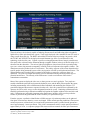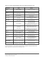
1
FINAL Field Sampling Workplan: Appendix A, Quality Assurance Project Plan University of California, Berkeley Richmond Field Station, Richmond, California April 15, 2010 Prepared for Office of Environment, Health & Safety University of California, Berkeley 317 University Hall No. 1150 Berkeley, California 94720 Prepared by TETRA TECH EM INC. 1999 Harrison Street, Suite 500 Oakland, California 94612 CONTENTS EXECUTIVE SUMMARY ...........................................................................................................1 1.0 PROJECT DESCRIPTION ..............................................................................................1 1.1 FACILITY DESCRIPTION .............................................................................................1 1.2 FACILITY HISTORY....................................................................................................5 1.3 PURPOSE OF INVESTIGATION .....................................................................................6 2.0 PROJECT ORGANIZATION AND RESPONSIBILITIES .........................................9 3.0 QUALITY ASSURANCE OBJECTIVES .....................................................................12 4.0 3.1 DATA QUALITY OBJECTIVE PROCESS .....................................................................12 3.2 QUALITY ASSURANCE OBJECTIVES FOR MEASUREMENT DATA ..............................14 3.2.1 Sensitivity .............................................................................................. 14 3.2.2 Precision and Accuracy ......................................................................... 15 3.2.2.1 Precision ................................................................................. 16 3.2.2.2 Accuracy ................................................................................. 16 3.2.3 Representativeness................................................................................. 16 3.2.4 Completeness ......................................................................................... 17 3.2.5 Comparability ........................................................................................ 17 SAMPLING PROCEDURES .........................................................................................18 4.1 SOIL AND SEDIMENT SAMPLING ..............................................................................18 4.1.1 Sampling Devices .................................................................................. 18 4.1.1.1 Hand Auger............................................................................. 19 4.1.1.2 Split and Solid Barrel ............................................................. 19 4.1.1.3 Piston-Activated Systems ....................................................... 21 4.1.1.4 Latch-Activated Systems ........................................................ 22 4.1.1.5 Dual-Tube Systems................................................................. 22 4.1.2 Soil Sampling for Volatile Organics...................................................... 23 4.1.2.1 Sampling Protocol 1 ............................................................... 23 4.1.2.2 Guidance for the Implementation of Method 5035 ................ 24 4.1.2.3 Regulatory Considerations for Sample Shipping for Method 5035 ........................................................................................ 24 4.1.2.4 Relevant ASTM Standards and Other Resources................... 24 4.1.3 Drilling Methods.................................................................................... 25 4.1.3.1 Direct Push ............................................................................. 25 4.1.3.2 Hollow-Stem Auger................................................................ 26 Field Sampling Workplan: Appendix A, Quality Assurance Project Plan UC Berkeley, Richmond Field Station A-i April 15, 2010 CONTENTS (Continued) 4.1.3.3 4.1.3.4 4.1.3.5 4.1.3.6 4.1.3.7 4.2 4.3 Direct Rotary .......................................................................... 28 Water Rotary........................................................................... 28 Air Rotary ............................................................................... 29 Mud Rotary............................................................................. 30 Dual-Wall Reverse Circulation............................................... 30 SENSORS AND PROBES ............................................................................................31 4.2.1 Geotechnical Sensors............................................................................. 32 4.2.1.1 Lithostatic Pressure Sensors ................................................... 32 4.2.1.2 Hydrostatic Pressure Sensors.................................................. 33 4.2.1.3 Video Imaging Tools .............................................................. 34 4.2.1.4 Stacked Tools.......................................................................... 35 4.2.2 Induced Fluorescence Tools .................................................................. 36 4.2.2.1 Target Analytes....................................................................... 38 4.2.2.2 Interferences ........................................................................... 38 4.2.2.3 Detection Limits ..................................................................... 38 4.2.2.4 Calibration .............................................................................. 39 4.2.2.5 Quality Control ....................................................................... 39 4.2.2.6 Precision and Accuracy .......................................................... 40 4.2.2.7 State of California Validation................................................. 40 4.2.3 Membrane Interface Probes ................................................................... 41 4.2.3.1 Field Considerations ............................................................... 43 4.2.3.2 Target Analytes....................................................................... 43 4.2.3.3 Performance............................................................................ 43 4.2.3.4 Detection Limits ..................................................................... 44 4.2.3.5 Calibration .............................................................................. 44 4.2.3.6 Sample Preparation................................................................. 44 4.2.3.7 Quality Control ....................................................................... 44 4.2.3.8 Precision and Accuracy .......................................................... 44 4.2.4 Sonic Drilling......................................................................................... 45 4.2.4.1 Advantages ............................................................................. 45 4.2.4.2 Limitations.............................................................................. 45 GROUNDWATER WATER SAMPLING METHODS AND EQUIPMENT ............................46 4.3.1 Direct-Push Grab Samplers ................................................................... 47 4.3.1.1 Exposed-Screen Samplers ...................................................... 48 4.3.1.2 Waterloo Profiler .................................................................... 48 4.3.1.3 BAT Sampler .......................................................................... 48 Field Sampling Workplan: Appendix A, Quality Assurance Project Plan UC Berkeley, Richmond Field Station A-ii April 15, 2010 CONTENTS (Continued) 4.3.1.4 4.3.1.5 4.3.1.6 4.3.1.7 4.3.1.8 4.3.2 4.4 Surface Water Sampling Equipment...................................................... 66 DNAPL SAMPLING AND RIBBON SAMPLERS ..........................................................68 4.5.1 4.6 Equipment and Methods for Traditional Monitoring Wells .................. 50 4.3.2.1 Bailers ..................................................................................... 50 4.3.2.2 Syringe Samplers .................................................................... 51 4.3.2.3 Bladder Pumps........................................................................ 52 4.3.2.4 Electrical Submersible Pumps ................................................ 52 4.3.2.5 Centrifugal Submersible Pump............................................... 53 4.3.2.6 Progressive Cavity (Helical-Rotor) Pumps ............................ 53 4.3.2.7 Gas-Driven Piston Pumps....................................................... 53 4.3.2.8 Suction Lift Pumps ................................................................. 53 4.3.2.9 Low-Flow Purging/Sampling ................................................. 54 4.3.2.10 Minimum/No Purge Sampling................................................ 55 4.3.2.11 Purge to Dryness and Sampling.............................................. 56 4.3.2.12 Filtration ................................................................................. 56 4.3.2.13 Passive Diffusion Samplers .................................................... 59 SURFACE WATER SAMPLING...................................................................................65 4.4.1 4.5 Dual Tube ............................................................................... 49 Multiport Samplers ................................................................. 49 Mini Wells .............................................................................. 49 Advantages of Direct Push Grab Samplers ............................ 49 Limitations of Direct-Push Grab Samplers............................. 50 Ribbon Samplers.................................................................................... 68 4.5.1.1 Advantages ............................................................................. 69 4.5.1.2 Limitations.............................................................................. 69 4.5.1.3 Quality Assurance................................................................... 69 4.5.1.4 Practical Considerations ......................................................... 69 SOIL-GAS SAMPLING ..............................................................................................69 4.6.1 Passive Soil Gas..................................................................................... 70 4.6.2 Active Soil Gas ...................................................................................... 70 4.6.2.1 Continuous Sampling Tools ................................................... 71 4.6.2.2 Discrete Sampling Tools......................................................... 71 4.6.2.3 Advantages ............................................................................. 71 4.6.2.4 Limitations.............................................................................. 72 4.6.3 Vapor Probes.......................................................................................... 72 4.6.3.1 Permanent Probes ................................................................... 72 Field Sampling Workplan: Appendix A, Quality Assurance Project Plan UC Berkeley, Richmond Field Station A-iii April 15, 2010 CONTENTS (Continued) 4.6.3.2 4.6.3.3 4.6.3.4 4.7 4.8 Temporary Driven Probes....................................................... 73 Field Activities During Soil Gas Sampling ............................ 73 Typical Methods for Soil Vapor Analysis .............................. 74 GEOPHYSICAL METHODS ........................................................................................74 4.7.1 Electrical Conductivity/Resistivity ........................................................ 79 4.7.1.1 Advantages ............................................................................. 79 4.7.1.2 Limitations.............................................................................. 79 4.7.1.3 Quality Assurance and Quality Control.................................. 79 4.7.2 Electromagnetic Methods ...................................................................... 80 4.7.2.1 Terrain Conductivity............................................................... 80 4.7.2.2 Fixed Source Time Domain Electromagnetics ....................... 81 4.7.3 Ground Penetrating Radar ..................................................................... 81 4.7.3.1 Interferences ........................................................................... 83 4.7.3.2 Quality Control ....................................................................... 83 4.7.3.3 Precision and Accuracy .......................................................... 83 4.7.3.4 Advantages ............................................................................. 83 4.7.3.5 Limitations.............................................................................. 83 4.7.4 Magnetometry........................................................................................ 83 4.7.4.1 Instrument Accuracy.............................................................. 84 4.7.4.2 OSHA Standard for Handling Buried Drums and Containers 84 4.7.4.3 Interferences .......................................................................... 84 4.7.4.4 Detection Limits ..................................................................... 85 4.7.4.5 Calibrations............................................................................. 85 4.7.4.6 Quality Control ....................................................................... 85 4.7.4.7 Precision and Accuracy .......................................................... 86 4.7.4.8 Advantages ............................................................................. 86 4.7.4.9 Limitations.............................................................................. 86 4.7.5 Seismic Reflection/Refraction ............................................................... 87 4.7.5.1 Seismic Reflection .................................................................. 87 4.7.5.2 Advantages ............................................................................. 88 4.7.5.3 Limitations.............................................................................. 88 4.7.6 Borehole Geophysical Methods............................................................. 88 4.7.6.1 Advantages ............................................................................. 91 4.7.6.2 Limitations.............................................................................. 92 REPRESENTATIVE SAMPLING DESIGN METHODS ....................................................92 4.8.1 Multi-Incremental Sampling.................................................................. 92 Field Sampling Workplan: Appendix A, Quality Assurance Project Plan UC Berkeley, Richmond Field Station A-iv April 15, 2010 CONTENTS (Continued) 5.0 6.0 7.0 4.8.2 Judgmental Sampling............................................................................. 92 4.8.3 Random Sampling ................................................................................. 93 4.8.4 Systematic Grid Sampling ..................................................................... 94 4.8.5 Systematic Random Sampling ............................................................... 94 4.8.6 Stratified Random Sampling.................................................................. 95 4.8.7 Ranked Set Sampling............................................................................. 95 4.8.8 Sequential sampling............................................................................... 96 4.8.9 Adaptive Cluster Sampling.................................................................... 96 4.8.10 Transect Sampling ................................................................................. 97 4. 8.11 Geostatistical Sampling Design Methods .............................................. 97 4.9 FIELD QUALITY CONTROL SAMPLES .......................................................................98 4.10 DECONTAMINATION PROCEDURES ..........................................................................99 4.11 MANAGEMENT OF IDW ..........................................................................................99 SAMPLE CUSTODY ....................................................................................................100 5.1 SAMPLE IDENTIFICATION ......................................................................................100 5.2 SAMPLE LABELS ...................................................................................................100 5.3 SAMPLE DOCUMENTATION ...................................................................................100 5.4 CHAIN OF CUSTODY ..............................................................................................101 5.5 SAMPLE SHIPMENT.........................................................................................102 CALIBRATION PROCEDURES ................................................................................103 6.1 FIELD EQUIPMENT ................................................................................................103 6.2 LABORATORY EQUIPMENT ....................................................................................103 ANALYTICAL PROCEDURES ..................................................................................105 7.1 FIELD ANALYTICAL METHODS AND MEASUREMENTS ..........................................105 7.1.1 Groundwater Field Parameters ............................................................ 105 7.1.1.1 pH ......................................................................................... 106 7.1.1.2 Dissolved Oxygen................................................................. 106 7.1.1.3 Oxidation-Reduction Potential ............................................ 106 7.1.1.4 Temperature.......................................................................... 107 7.1.1.5 Turbidity ............................................................................... 107 7.1.2 Test Kits............................................................................................... 108 Field Sampling Workplan: Appendix A, Quality Assurance Project Plan UC Berkeley, Richmond Field Station A-v April 15, 2010 CONTENTS (Continued) 7.1.2.1 7.1.2.2 7.1.2.3 7.1.2.4 7.1.2.5 7.1.2.6 7.1.2.7 7.1.2.8 7.1.2.9 7.1.2.10 Analytical Equipment ........................................................... 110 Sample Preparation............................................................... 112 Target Analytes..................................................................... 113 Interferences ......................................................................... 114 Detection Limits ................................................................... 115 Calibration ............................................................................ 115 Quality Control ..................................................................... 116 Precision and Accuracy ........................................................ 117 Advantages ........................................................................... 117 Limitations............................................................................ 118 7.1.3 Immunoassays and Enzymatic Assays ................................................ 119 7.1.3.1 EPA-Approved Methods ...................................................... 119 7.1.3.2 System Components ............................................................. 120 7.1.3.3 Operational Considerations .................................................. 121 7.1.3.4 Sample Preparation............................................................... 121 7.1.3.5 Sample Analysis ................................................................... 122 7.1.3.6 Analysis Times ..................................................................... 122 7.1.3.7 Target Analytes..................................................................... 123 7.1.3.8 Interferences ......................................................................... 123 7.1.3.9 Detection Limits ................................................................... 124 7.1.3.10 Calibration ............................................................................ 125 7.1.3.11 Quality Control ..................................................................... 125 7.3.1.12 Precision and Accuracy ........................................................ 126 7.1.3.13 Advantages ........................................................................... 126 7.1.3.14 Limitations............................................................................ 127 7.1.3.15 Immunosensors ..................................................................... 127 7.1.3.16 Enzymatic Assays................................................................. 128 7.1.3.17 Enzyme-Based Tests for the Bioavailability of Heavy Metals .............................................................................................. 128 7.1.3.18 Rapid Toxicity Testing ......................................................... 129 7.1.4 Explosives............................................................................................ 129 7.1.4.1 Colorimetric Field Methods (Methods 8510 and 8515) ....... 129 7.1.4.2 Immunoassay Field Method (Methods 4050 and 4051) ....... 131 7.1.4.3 Gas Chromatography Field Method ..................................... 132 7.1.5 X-ray Flourescence .............................................................................. 133 7.1.5.1 Operational Considerations .................................................. 134 7.1.5.2 Target Analytes..................................................................... 136 Field Sampling Workplan: Appendix A, Quality Assurance Project Plan UC Berkeley, Richmond Field Station A-vi April 15, 2010 CONTENTS (Continued) 7.1.5.3 7.1.5.4 7.1.5.5 7.1.5.6 7.1.5.7 7.1.5.8 7.1.5.9 7.1.5.10 8.0 Interferences ......................................................................... 136 Detection Limits ................................................................... 137 Calibration ............................................................................ 137 Sample Preparation............................................................... 138 Quality Control ..................................................................... 139 Precision and Accuracy ........................................................ 140 Advantages ........................................................................... 140 Limitations............................................................................ 141 7.2 LABORATORY ANALYTICAL METHODS .................................................................141 7.3 REPORTING LIMITS ...............................................................................................144 7.4 SELECTION OF ANALYTICAL LABORATORIES ........................................................144 DATA REDUCTION, VALIDATION, AND REPORTING.....................................146 8.1 FIELD DATA VERIFICATION ..................................................................................146 8.2 LABORATORY DATA VERIFICATION......................................................................146 8.3 LABORATORY DATA VALIDATION ........................................................................146 8.3.1 Cursory Data Validation ...................................................................... 146 8.3.2 Full Data Validation............................................................................. 146 9.0 INTERNAL QUALITY ASSURANCE .......................................................................148 10.0 PERFORMANCE AND SYSTEMS REPORTING ...................................................149 11.0 PREVENTATIVE MAINTENANCE ..........................................................................151 11.1 MAINTENANCE OF FIELD EQUIPMENT ...................................................................151 11.2 MAINTENANCE OF LABORATORY EQUIPMENT ......................................................151 12.0 DATA ASSESSMENT PROCEDURES AND CORRECTIVE ACTIONS .............152 13.0 QUALITY ASSURANCE REPORTS..........................................................................153 13.1 PROGRESS REPORTS ..............................................................................................153 13.2 QUALITY CONTROL SUMMARY REPORTS ..............................................................153 14.0 LABORATORY CERTIFICATION ...........................................................................154 15.0 REFERENCES...............................................................................................................155 Field Sampling Workplan: Appendix A, Quality Assurance Project Plan UC Berkeley, Richmond Field Station A-vii April 15, 2010 CONTENTS (Continued) Tables A-1 Key Personnel ......................................................................................................... A-10 A-2 QC Samples for Precision and Accuracy................................................................ A-15 A-3 Laboratory Target Analytes and PDB Samples ...................................................... A-63 A-4 Surface Water Sampling Equipment....................................................................... A-67 A-5 Summary of Vapor Intrusion Analytical Methods.................................................. A-75 A-6 Common Geophysical Methods Applied to Environmental Problems................... A-76 A-7 Common Borehole Geophysical Methods .............................................................. A-78 A-8 Field Stabilization Parameters for Groundwater Sampling .................................. A-105 A-9 EPA Colorimetric and Turbidimeteric Methods................................................... A-110 A-10 EPA Published Immunoassay Methods ................................................................ A-120 A-11 Detection Limits for the Colorimetric Method 8330 Target List ......................... A-131 A-12 Common Analytical Methods used by the UC Berkeley RFS Project Team ....... A-143 Figures A-1 Site Location Map..................................................................................................... A-2 A-2 Site Map .................................................................................................................... A-3 A-3 Physical Features Map .............................................................................................. A-4 Field Sampling Workplan: Appendix A, Quality Assurance Project Plan UC Berkeley, Richmond Field Station A-viii April 15, 2010 ACRONYMS AND ABBREVIATIONS µg/m3 µl µm Microgram per cubic meter Microliter Micrometer 2-D 3-D 95% UCL Two-dimensional Three-dimensional 95 percent upper confidence limit AC ACE AChE APHA API AST ASTM ATV AVO Alternating current Acetylthiocholine Acetyl cholinesterase American Public Health Administration American Petroleum Institute Aboveground storage tank American Society for Testing and Materials Acoustic televiewer Amplitude variation with offset BAPB Bay Trail bgs BTEX Biologically Active Permeable Barrier East Bay Regional Park District Bay Trail Below ground surface Benzene, toluene, ethylbenzene, and xylene Cal EPA CCR CH4 C2H4 C2H6 cm CO CO2 CPT California Environmental Protection Agency Current Conditions Report Methane Ethylene Ethane Centimeter Carbon monoxide Carbon dioxide Cone penetrometer DC DDT DELCD DL DMA DNAPL DNT Direct-current Dichlorodiphenyltrichloroethane dry electrolytic conductivity detector Detection limit Demonstration of methods applicability Dense nonaqueous-phase liquid Dinitrotoluene Field Sampling Workplan: Appendix A, Quality Assurance Project Plan UC Berkeley, Richmond Field Station A-ix April 15, 2010 ACRONYMS AND ABBREVIATIONS (Continued) DO DOT DPP DQA DQO DTSC DU Dissolved oxygen Department of Transportation Direct-push platform Data quality assessment Data quality objective Department of Toxic Substances Control Decision unit ECD EDI EDXRF EIA EM EPA ETV eV EWI Electron capture detector Equal discharge-increments Energy-dispersive X-ray fluorescence Enzyme immunoassay Electromagnetic U.S. Environmental Protection Agency Environmental Technology Verification Electron volt Equal width-increments FID FFD FLUTe FP FPXRF FSP FSW Flame ionization detector Fuel fluorescence detector Flexible Liner Underground Technologies, Ltd. Fundamental parameters Field-portable X-ray fluorescence Field sampling plan Field sampling workplan g GC GC/MS GPR GPS Gram Gas chromatograph Gas chromatograph/mass spectrometer Ground-penetrating radar Global Positioning System HMX HPFM H2S cyclotetramethylene-tetranitramine Heat pulse flow meter Hydrogen sulfide ICP IDW ITMS ITRC Inductively coupled plasma Investigation-derived waste Ion-trap mass spectrometer Interstate Technology and Regulatory Council Field Sampling Workplan: Appendix A, Quality Assurance Project Plan UC Berkeley, Richmond Field Station A-x April 15, 2010 ACRONYMS AND ABBREVIATIONS (Continued) keV kg Kiloelectron volts Kilogram LARWQCB LCS LDPE LIF L/min LNAPL Los Angeles Regional Water Quality Control Board Laboratory control sample Low-density polyethylene Laser-induced fluorescence Liters per minute Light nonaqueous-phase liquid m MCAWW MCL MDL MEC MHz mg mg/kg MIP MIS ml ml/min mm MS ms/m mS MSD MTBE mV Meter Methods for Chemical Analysis of Water and Wastes Maximum contaminant level Method detection limit Munitions and explosives of concern Megahertz Milligram Milligram per kilogram Membrane interface probe Multi-increment sample Milliliter Milliliter per minute Millimeter Matrix spike milliseconds per meter MilliSiemens Matrix spike duplicate Methyl tert butyl ether Millivolt N2 NAPL NCASI NG NIOSH nm NMOC nT NTU Nitrogen Nonaqueous-phase liquid National Council of Industry for Air and Stream Improvement Nitroglycerine National Institute for Occupational Safety and Health Nanometer Non-methane organic compound NanoTesla Nephelometric Turbidity Units Field Sampling Workplan: Appendix A, Quality Assurance Project Plan UC Berkeley, Richmond Field Station A-xi April 15, 2010 ACRONYMS AND ABBREVIATIONS (Continued) O2 ORP OSHA OSWER Oxygen Oxidation-reduction potential Occupational Safety and Health Administration Office of Solid Waste and Emergency Response PAH PARCC PCB PCDD PCDF PCE PCP PDB PETN PID ppb ppbv ppm ppt PTFE PVC Polycyclic aromatic hydrocarbon Precision, accuracy, representativeness, completeness, and comparability Polychlorinated biphenyl Polychlorinated dibenzodioxins Polychlorinated dibenzofurans Tetrachloroethene Pentachlorophenol Passive diffusion bag Pentaerythritol tetranitrate Photo-ionization detector Parts per billion Parts per billion by volume Parts per million Parts per trillion polytetrafluorothylene Polyvinyl chloride QA QAPP QC Quality assurance Quality assurance project plan Quality control RDX RFS RNS ROST RPD RSD RWQCB Cyclotrimethylenetrinitramine Richmond Field Station Ribbon NAPL sampler Rapid optical screening tool Relative percent difference Relative standard deviation California Regional Water Quality Control Board SADA SCAPS SOP SPE SPMD SRM Spatial Analysis and Decision Assistance Site Characterization and Analysis Penetrometer System Standard operating procedure Solid phase extraction Semipermeable membrane device Standard reference materials Field Sampling Workplan: Appendix A, Quality Assurance Project Plan UC Berkeley, Richmond Field Station A-xii April 15, 2010 ACRONYMS AND ABBREVIATIONS (Continued) SSCS SVOC Site-specific calibration standard Semivolatile organic compound TarGOST TCD TCE TDEM Tetra Tech TID TNT TPH Tar-specific green optical screening tool Thermal conductivity detector Trichloroethene Time domain electromagnetics Tetra Tech EM Inc. Thermionic ionization detector Trinitrotoluene Total petroleum hydrocarbons UC UC Berkeley URS USACE USGS UV UVOST University of California University of California, Berkeley URS Corporation U.S. Army Corps of Engineers U.S. Geological Service Ultraviolet Ultraviolet optical screening tool VOA VOC VOH Volatile organic analysis Volatile organic compound Volatile organic halide WTA Western Transition Area XRF X-ray fluorescence Zeneca Zeneca, Inc. Field Sampling Workplan: Appendix A, Quality Assurance Project Plan UC Berkeley, Richmond Field Station A-xiii April 15, 2010 EXECUTIVE SUMMARY This QAPP is one element of a Field Sampling Workplan (FSW). The FSW is intended to be used as a facility-wide guide for the field, laboratory, and data reporting efforts associated with sampling and reporting to fill the data gaps at Richmond Field Station (RFS). In addition to the QAPP, the FSW includes a facility-wide Health and Safety Plan, and site specific Field Sampling Plan (FSP) addenda. The QAPP addresses the quality assurance and quality control aspects of the field, laboratory, and data reporting efforts associated with the proposed activates to address the data gaps. The success of an environmental data collection effort depends on the quality of the data collected and used to make decisions. The intent of this QAPP is to establish protocols for assuring quality data collection and criteria for determining the quality of resultant data. Section 1.0 – Project Description: This section gives a brief overview of the history of the site as well as a description of the current conditions at the Richmond Field Station (RFS). For more information about past or current conditions at the site, please refer to the “Current Conditions Report, University of California, Berkeley, Richmond Field Station, Richmond, California,” Tetra Tech EM Inc., November 2008. Section 2.0 – Project Organization: This describes the overall organization of the project, including the roles and responsibilities of RFS decision makers. It also contains a table summarizing the key project personnel, their specific roles, and their contact information. Section 3.0 – Quality Assurance Objectives: The first subsection provides detailed guidelines for the formulation of the data quality objectives that are used to ensure that the type, quantity, and quality of data collected are appropriate to support decisions that will be based on that data. The second subsection gives a broad description of the quality control (QC) effort and the specific quality assurance (QA) objectives for sensitivity, accuracy, precision, representativeness, completeness, and comparability of data. It does not identify specific procedures for QA or QC, which are discussed in detail in relevant sections throughout the Quality Assurance Project Plan. Section 4.0 – Sampling Procedures: This section presents specific procedures for various sampling methods, and is intended to assist in the selection and use of sampling technologies. – Subsection 4.1 – Soil and Sediment Sampling: Equipment and methods for soil and sediment sampling for both volatile and nonvolatile chemicals are discussed in this subsection. Various tools used for surface and near-surface sampling are described in detail, along with drilling methods for subsurface investigations. In addition, this subsection presents detailed procedures for the collection of multi-incremental soil samples. – Subsection 4.2 – Sensors and Probes: This subsection contains a discussion of the variety of geotechnical sensors and probes that can be utilized to obtain geologic, hydrogeologic, and contaminant information on site. The performance specifications, advantages, and limitations of specific tools are described in detail. – Subsection 4.3 – Groundwater Sampling: This subsection describes equipment and methods for groundwater sampling. Available technologies for both direct-push grab samples and traditional monitoring wells are described. Also, passive diffusion methods are discussed for the collection of averaged groundwater samples. Field Sampling Workplan: Appendix A, Quality Assurance Project Plan UC Berkeley, Richmond Field Station A-ES-1 April 15, 2010 – Subsection 4.4 – Surface Water Sampling: This subsection discusses proper procedures and equipment for surface water sampling. – Subsection 4.5 – Dense Nonaqueous-Phase Liquid (DNAPL) Sampling: A description of equipment used for the detection and investigation of dense nonaqueous phase liquid is presented in this subsection. Ribbon samplers, in particular, are described in detail. – Subsection 4.6 – Soil-Gas Sampling: This subsection contains a detailed description of procedures and equipment for both passive and active soil gas sampling. It discusses methods for discrete and continuous soil gas sampling to detect contaminants in the vadose zone as well as volatile chemicals in the soil and groundwater. General guidelines for the construction and installation of vapor probes are also included. – Subsection 4.7 – Geophysical Methods: This subsection presents a summary of applicable geophysical technologies that may be employed at the RFS to identify geologic structures and buried objects that may act as sources or pathways of contamination. The advantages, limitations, applicability, and proper procedures for each method are discussed. Methods for the proper handling of buried drums and containers are also included. – Subsection 4.8 – Representative Sampling Design: This subsection provides definitions of and potential uses for various representative sampling schemes, including multiincremental, judgmental, random, systematic grid, systematic random, stratified random, ranked set, and sequential. It also contains guidelines on when it is appropriate to use each type of sampling along with their associated proper procedures. – Subsection 4.9 – Field Quality Control Samples: The various types of field quality control samples, such as trip blanks and replicates, are described in this subsection. Proper procedures for the handling of field quality control samples are discussed. – Subsection 4.10 – Decontamination Procedures: This is a brief subsection discussing what types of equipment must be decontaminated, when the decontamination must occur and the proper procedures for decontamination. – Subsection 4.11 – Management of Investigation Derived Waste: This subsection details the proper procedures for handling investigation-derived waste at the RFS. Section 5.0 – Sample Custody: This section describes sample handling procedures including sample identification, labeling, documentation, and chain-of-custody forms. It also discusses proper practices for packing and shipping samples to laboratories. Section 6.0 – Calibration: This section presents proper procedures for maintaining the accuracy of field equipment and laboratory instruments and specifies when calibration of equipment and instruments should occur. Section 7.0 – Analytical Procedures: Section 7 describes the field and laboratory methods that may be used at the RFS for measurements and analysis. These methods are the same as those approved by the Environmental Protection Agency (EPA) unless otherwise documented. Field Sampling Workplan: Appendix A, Quality Assurance Project Plan UC Berkeley, Richmond Field Station A-ES-2 April 15, 2010 – Subsection 7.1 – Field Methods and Measurements: A summary of the proper procedures for field-based measurements and analysis is presented in this subsection, including the field determination of groundwater parameters. Also included are detailed discussions on the proper use of field test kits, immunoassays, immunosensors, and enzymatic assays for the quantitative and quantitative identification of contaminants. Several additional field methods used for detecting select groups of contaminants, like heavy metals or explosive residues, are also described. – Subsection 7.2 – Laboratory Methods: This subsection provides a summary of the EPAapproved laboratory analytical methods that will be used for the analysis of RFS samples. In addition, this section documents the information necessary to complete an analytical service purchase order request form. – Subsection 7.3 – Reporting Limits: Analytical laboratories will be required to ensure that reporting limits are sufficiently low to allow comparison to the screening criteria indentified in project-specific data quality objectives. This subsection also presents procedures to be followed if the above requirement is not met. – Subsection 7.4 – Laboratory Selection: This subsection presents the criteria to be considered when evaluating contract laboratories. Section 8.0 – Data Reduction, Validation, and Reporting: This section describes the methods used for verifying and validating data in the field, laboratory, and office. Section 9.0 – Internal Quality Assurance: This section describes the process to rapidly and thoroughly correct field quality assurance problems through corrective action. It includes definitions and examples of routine corrective action, immediate corrective action, and long-term corrective action. Section 10.0 – Performance and Systems Reporting: This section presents methods to promptly identify and correct laboratory quality assurance problems. Section 11.0 – Preventive Maintenance: This section outlines the testing, inspection, and maintenance procedures that will be used to keep both field and laboratory equipment in good working condition. Section 12.0 – Data Assessment Procedures: Included in this section is a description of the EPA’s five-step data quality assessment (DQA) method. Also included are assessment guidelines for use when the five-step DQA method cannot be enacted due to project-specific data quality objectives. Section 13.0 – Quality Assurance Reports: This section describes progress reports and quality control summary reports that will be used to address any project-specific quality issues and to facilitate timely communication of those issues. Section 14.0 – Laboratory Certification: This section summarizes current certifications that a laboratory must possess to work on the RFS project. Section 15.0 – References: This section lists site reports, scientific reference materials, and regulatory guidance and standards cited throughout the document. Field Sampling Workplan: Appendix A, Quality Assurance Project Plan UC Berkeley, Richmond Field Station A-ES-3 April 15, 2010 1.0 PROJECT DESCRIPTION The University of California, Berkeley (UC Berkeley), prepared this Field Sampling Workplan (FSW): Quality Assurance Project Plan (QAPP) in response to the California Environmental Protection Agency (Cal EPA), Department of Toxic Substances Control (DTSC), Site Investigation and Remediation Order No. IS/E-RAO 06/07-005 (the Order). As required by the Order, UC Berkeley prepared a Current Conditions Report (CCR) (Tetra Tech, EM Inc. [Tetra Tech] 2008) that provided a comprehensive summary of current conditions at the Richmond Field Station (RFS). The CCR addresses the 96 acres of upland and 13 acres of tidal marsh and transition habitat as specified in the DTSC Order. The CCR identified data gaps needing additional characterization at the RFS. The DTSC Order requires preparation of a FSW to conduct site investigations to address these data gaps. The objective of the site investigation is to identify immediate or potential risks to public health and the environment and prioritize and implement response actions using removal actions and operable units, if appropriate, based on the relative risks at the site. The FSW is intended to be used as a facility-wide guide for the field, laboratory, and data reporting efforts associated with sampling and reporting to fill the data gaps at RFS. This QAPP is one element of a FSW. In addition to the QAPP, the FSW includes a facility-wide Health and Safety Plan, and site specific Field Sampling Plan (FSP) addenda. The QAPP addresses the quality assurance and quality control aspects of the field, laboratory, and data reporting efforts associated with the proposed activates to address these data gaps. The success of an environmental data collection effort depends on the quality of the data collected and used to make decisions. The intent of this QAPP is to establish protocols for assuring quality data collection and criteria for determining the quality of resultant data. 1.1 FACILITY DESCRIPTION The RFS is an academic teaching and research facility, located at 1301 South 46th Street, Richmond, California, along the eastern shoreline of the Richmond Inner Harbor of the San Francisco Bay and northwest of Point Isabel (see Figure A-1), approximately 6 miles northwest of the UC Berkeley Central Campus. The portion of the RFS covered under The Order consists of 96 acres of uplands used for academic institutional activities, approximately 7.5 acres of tidal salt marsh, and 5.5 acres of marsh edge habitat and transition area. Between the late 1800s and 1948, several companies, including the California Cap Company, manufactured explosives at the RFS. In 1950, The Regents of the University of California (UC) purchased the property from the California Cap Company. UC Berkeley initially used the RFS for research for the College of Engineering; later, it was also used by other campus departments. In this QAPP, the RFS is described in terms of types of habitat because future use and potential receptors vary by the type of habitat available. Three habitat type areas have been identified: (1) the Upland Area, (2) the Transition Area, and (3) the Western Stege Marsh (see Figure A-2). Current existing RFS buildings and the site features can be seen on Figure A-3. Field Sampling Workplan: Appendix A, Quality Assurance Project Plan UC Berkeley, Richmond Field Station A-1 April 15, 2010 Garvin § ¦ ¨ ia nnsylv San a nPablo 780 So l a § ¨ ¦ 80 580 Barrett Harbor 24 V U UC Berkeley Main Campus § ¦ § ¨ ¦ ¨ 80 § ¨ ¦ Ohio Berkeley Berkeley 880 13 V U 980 22 Oakland Oakland nd Ohio San San Francisco Francisco § ¦ ¨ 880 § San ¦ ¨ Francisco Bay Cutting t u § ¨ ¦ 80 580 Marina 280 39th 61 V U § ¦ ¨ Dimm 101 velt 37th ¦ ¨ Macdonald § t u UC BERKELEY RICHMOND FIELD STATION 23rd Richmond Richmond Ro os e 4 U V 3 0 th 101 on t u Wils San Pablo Bay 101 C § ¨ ¦ ar ls on 580 Wright no Potrero M ea d M ar in a Ba y T B a eh m a w ay v i e Sa nM Richmond Field Station Property Boundary covered under DTSC Order at e o 1,000 0 1,000 2,000 Feet Richmond Field Station University of California, Berkeley AREA OF DETAIL FIGURE A-1 SITE LOCATION MAP CALIFORNIA Appendix A Quality Assurance Project Plan 2008-11-19 v:\misc_gis\richmond_field_station\projects\current_conditions_report\site_location_map_sza.mxd TtEMI-SF andrew.bley HI GH ST RE ET MEAKER AVENUE SOUTH 34TH STREET MEAKER AVENUE ER LA ND SO N ~ ~ W AY ~ 58 0 C AR ~ ~ ~ 454 ~ M EA ~ D E ~ 452 453 W AY REGATTA BOULEVARD OW RO BIN # * 0 ~ ~ IVE 0 ~ 490 H AY W < < 58 D 0 58 ~ A-18-7 W AY UL EV AR IG H ` `[ `[ [ !! H BO ~ A-18-5 DR IG T 451 L ROBIN DRIVE H ST R EE LS O N 450 280B ~ 400 486 JAY WA Y EG R ! A 180 ! ! < EE T ST R TH TG ! ! 117 120 114 116 EET 197 STR T-197 SO U Asp halt Pad B ON TH 46T H T-55 125 113 111 Former California Cap Company Transformer House ` [ 112 SO ET WA Y 178 # * 0 EG R As ph alt Pa dC TM A-18-2 175 Two Water Supply Wells 118 HE RO N UE 176 !! 201 EPA Lab DRIV E ME RY AVE N EAS " U # * 0 # * 0 TGO 198 121 128 ON E 150 149 TM < 152 RIV 177 < SOUTH 32ND STREET 153 195 A A 276 A LAR KD H EAS 179 275 TH EG R < < !! T-54 155 46 ! A-18-6 T-53 151 TH 194 196 161 159 154 SO U < 190 ET WA Y < ! 158 1901 167 ! A 160 T-56 ! A ! A 475 RESEARCH WELL FIELD 38 162 470 ! A < E 164 OW LW AY WA Y CE T AVO < WA Y B < WD RIV 472 471 E 47 B B B B B CR O A-18-3 473 420 PLO VER DR IV ! A ! A !! ! A A AA !A ! ! !A! ! A !A !!!A ! AA A A !A A !!A ! A !A ! A !A A 165 277 # *# 0 * 0 # * 0 485 ! ! A ! RD ! 421 280A ! C ! C ! C A-18-4 484 RIV E PC Fo B- rme Co rly nta ini ng 487 Ó A-18-1 ND OW L B B B FLUME WR E B B B B BB B B BB B B ÓÓÓ ÓÓÓ Ó Ó Ó Ó ÓÓ ÓÓ Ó HELIPAD Ó Ó 300 Ó Ó `[ [ `[ ` 488 ST RE ET B 445 SO UT STARLING WAY ET REGATTA BOULEVARD RE ET WA Y ST 478 474 Ó GEOSCIENCES WELL FIELD DE ~ EA M 482 480 460 DR IVE 185 110 163 SEA 102 Concrete Pad ¨ ¨ ¨ ¨ ¨ ¨ ¨ ¨ ¨ HARBOR DRIVE ¨ ¨ ¨ ¨ ¨¨¨¨¨¨¨¨ ¨ T OUR VE C ROCKPORT COURT L CO STA CRY ¨ E DRIVE ¨ ¨ ¨¨ ¨ ¨ ¨¨ 300 0 300 Feet Asphalt/Concrete Pads Well Field Boundary Former Underground Storage Tank (UST) Open Well (Not in Use) ! Aboveground Storage Tank (AST) ! A Closed Well (Pressure Grouted) B Transformer Locations: # * 0 Pad-Supported, Non PCB-Containing " U Pad-Supported, Former PCB-Containing (Removed) Notes: Some locations are approximate. ` [ Pole-Mounted, Non PCB-Containing PCB Polychlorinated biphenyls ! C Pole-Mounted, Former PCB-Containing (Removed) Property Boundary ~ Approximate Property Boundary Fenceline ¨¨¨¨ Biologically Active Permeable Barrier Wall Former Seawall (Approximate) Slurry Wall Sanitary Sewer Lines: < ! ! Ó A Surface Water Geoscience Well < Existing Building (Building Numbers Shown in Blue) Former California Cap Company Transformer House Storm Drain Lines: FIGURE A-3 PHYSICAL FEATURES MAP Open Swale Existing Sewer Line Underground Culvert Removed Sewer Line Underground Culvert, Abandoned (Grouted at Manholes) Abandoned Sewer Line 2008-11-19 Richmond Field Station University of California, Berkeley v:\misc_gis\richmond_field_station\projects\current_conditions_report\buildings_transformers_tanks_wells.mxd TtEMI-SF andrew.bley Appendix A Quality Assurance Project Plan The Upland Area consists of 96 acres of land bounded by Meade Street and Hoffman Boulevard to the north, South 46th Street to the east, the Transition Area to the south, and Meeker Slough and Regatta Boulevard to the west. The Transition Area occupies approximately 5.5 acres and is bounded to the north by the Upland Area at the location of a buried, former seawall that is believed to have been the edge of the historic mudflats, and to the south by Western Stege Marsh at the 5-foot elevation upper extent of the marsh (National Geodetic Vertical Datum 29). The Transition Area is believed to consist entirely of artificial fill placed on historic mudflats. Western Stege Marsh occupies approximately 7.5 acres and is bounded by the Transition Area to the north, the RFS connector trail to the East Bay Regional Parks District’s Trail (Bay Trail) and Eastern Stege Marsh to the east, the Bay Trail to the south, and Meeker Slough and Marina Bay housing development to the west (see Figure A-2). 1.2 FACILITY HISTORY Between the 1880s and 1948 and prior to UC ownership, the California Cap Company operated facilities on portions of the RFS property for the manufacturing of blasting caps, shells, and explosives (UC Berkeley 1973). Two small companies, the U.S. Briquette Company and the Pacific Cartridge Company, are presumed to have operated on a portion of the RFS property. By 1920, the California Cap Company was the only remaining explosives manufacturer on site. Operations of the California Cap Company plant included manufacturing explosives (primarily mercury fulminate), shells, and blasting caps; testing explosives; and storing explosives (URS Corporation [URS] 1999). All components of the blasting caps were manufactured on site, including explosives, shells, copper containers, tin boxes, paper cartons, and insulated wire. In October 1950, the California Cap Company property was purchased by UC with the agreement that the California Cap Company would remove all hazardous materials from the property. However, subsequent site observations and testing revealed the presence of hazardous materials on RFS. For example, several explosions reportedly occurred between 1950 and 1953 during a controlled burn for clearing. These explosions likely were associated with residual chemicals used by the California Cap Company. Previous investigations in the test pit and explosive storage area found a single detection of explosives at a concentration close to the detection limit (URS 2000). The RFS was initially established by UC Berkeley for large-scale engineering research that required significant space and resources that were not available on UC Berkeley’s central campus in downtown Berkeley. Studies more suited to an off-campus location included research on solid waste and sewage, transportation and lighting studies, and beach erosion modeling (McGauhey 1974). Research projects have been and are conducted under the supervision of professors from numerous UC Berkeley colleges and departments. Current research activities are conducted by the College of Engineering, the College of Natural Resources, Art Practice, the Center for Tissue Engineering, Earthquake Engineering, the Institute for Transportation Studies, the Center for Occupational and Environmental Health’s Ergonomics Program, the Northern Regional Library Facility, and others. The research is performed by graduate students, professors, and researchers, supplemented by support staff and technicians (UC Berkeley 2006). In addition to UC Berkeley-related operations, the UC Regents have leased space to non-UC Berkeley tenants. Current tenants include the U.S. Environmental Protection Agency (EPA) Region 9 Laboratory; Schlumberger, Inc.; The Watershed Project; and Stratacor, Inc. In 1989, UC Berkeley management estimated that 250 to 300 people worked at the RFS (Ensco Environmental Services, Inc. 1989). Current staffing remains at around 300 people. Field Sampling Workplan: Appendix A, Quality Assurance Project Plan UC Berkeley, Richmond Field Station A-5 April 15, 2010 Many of the RFS buildings historically housed (and currently house) offices, laboratories, warehouses, and workshops used to support engineering projects (UC Berkeley 2006). Many of the buildings used by the California Cap Company were torn down when UC Berkeley purchased the RFS property, but some still remain—including two buildings that were formerly homes and several buildings used for a laboratory, offices, and storage. In a few cases, RFS moved buildings to new locations on the property (UC Berkeley 2006). A summary of historical academic research and teaching activities associated with the RFS is presented in the final Current Conditions Report (Tetra Tech 2008). 1.3 PURPOSE OF INVESTIGATION UC Berkeley has completed extensive investigations to assess the nature and extent of chemicals present at the RFS and has completed three phases of remediation and two time-critical removal actions to remove contamination found in the Upland Area, the Transition Area, and Western Stege Marsh. In addition, in 2006, DTSC required additional characterization of chemicals in the shallow and intermediate groundwater zones along the property boundary between RFS and the former Zeneca Inc. (Zeneca) site. Chlorinated hydrocarbons (cis-1,2-dichloroethene, tetrachloroethene [PCE], and trichloroethene [TCE]) have been detected in groundwater along the eastern property boundary that RFS shares with the former Zeneca site. Respondents to DTSC Order No. IS/E-RAO 06/07-005 are continuing to evaluate under DTSC’s oversight the groundwater flow directions and groundwater quality along the eastern RFS property boundary. Although there have been many investigations, some areas of the RFS were identified in the CCR as data gaps which warrent additional characterization. The sampling strategy and data quality objectives (DQO) for all areas and media will be developed in concurrence with DTSC. For many of the data gaps, there is no evidence from any source that spills occurred in these areas; however, because chemicals were used or stored there, UC Berkeley proposes further investigation. UC Berkeley plans to use various sampling or screening methods to evaluate the need for further investigation. Soil Soil data gaps identified in the CCR are generally related to possible surface or near-surface spills associated with historic and current activities at RFS. Current and Historic Research Facilities. Many current and historical research facilities used or stored hazardous chemicals at RFS. Although there are no indications from any other sources that spills have occurred in these areas, there has been limited or no sampling conducted in these areas. These areas include the earthquake engineering facilities at Buildings 420 and 421, and Buildings 102, 110, 111, 112, 113, 114, 117, 118, 121, 125, 138, 150, 151, 158, 175, 177, 197, 278, 280A, 280B, 450, 460, 470, 474, 478, 480, and 482. In addition, spills have been reported in the vicinity of Building 120 and the RFS Corporation Yard; and these areas are also included as data gaps as no sitespecific data is available for these two areas to confirm or deny releases have occurred. Aboveground Storage Tanks (AST). Aboveground storage tanks are present at RFS. The ASTs are in good condition and there have been no reports of releases from the ASTs; however, no site-specific data is available for the vicinity of the tanks to confirm or deny releases have occurred. Field Sampling Workplan: Appendix A, Quality Assurance Project Plan UC Berkeley, Richmond Field Station A-6 April 15, 2010 PCB-Containing Transformers. Previously, PCB-containing transformers have existed on the RFS property. These transformers have either been replaced or retrofitted. Some of the transformers were retrofitted on their pads, and some were stored with other electrical equipment on a concrete pad in the northern portion of Building 280B. While there are no records of PCB leaks or spills, samples will be collected in the areas where the former PCB-containing transformers were located, retrofitted, or stockpiled to confirm or deny releases have occurred. Western Transition Area (WTA). The Bulb area, located in the WTA, was identified as a data gap based on an historical interview with a former employee who claimed debris may have been dumped in this area. This area has been investigated, using Geoprobe borings and a magnetic survey. The magnetometer showed a strong anomaly southwest of the concrete pad in the Bulb. This area will be further investigated to determine the source of the anomaly and to confirm or deny the possibility of buried debris. In 2008 a TCRA was performed in this area to remove a small patch of ash and debris with detected concentrations of PCBs. During the excavation of Campfire Area II, debris including miscellaneous laboratory glassware was noted in excavated soils and excavation sidewalls. After DTSC approval, these areas were lined with clear, 6 mil plastic, sample locations and excavation extents surveyed, and backfilled with clean soils (Tetra Tech 2009). California Cap Company Operations. The former operations of the California Cap Company have been identified as a data gap. Specifically, the former California Cap Company Test Pit and Dry House were identified as areas where explosions may have occurred during California Cap Company operations. No site-specific characterization data for explosive residues is available for these areas. In addition, no site-specific characterization data exists for the California Cap Company’s tram lines. The construction, use, maintenance, or history of releases along the former tram lines is not known. Other Former Operations. The U.S. Briquette Company and Pacific Cartridge Company have been identified on historical Sanborn maps from 1912 and 1916 as operating on the property when it was owned by the California Cap Company. No site-specific characterization data exists for the areas where these companies reportedly operated. Western Stege Marsh. Although the eastern portion of Western Stege Marsh has been remediated, additional information is needed to determine if the surface water and sediment concentrations in the native marsh pose a significant risk to human and ecological receptors. Groundwater Groundwater data gaps identified in the CCR are related to general comments regarding limited hydrogeologic and groundwater data at RFS, as well as several site-specific data gaps. Site-Wide Groundwater Conditions. Additional data is needed to evaluate general hydrogeologic information for the shallow, intermediate, and deep groundwater zones in various areas across RFS. This includes collecting general hydrogeologic information (groundwater elevations and lithology) to generate a hydrogeologic model, and groundwater quality data (chemical concentrations, total dissolved solids concentrations, metals bioavailability data, etc.). Field Sampling Workplan: Appendix A, Quality Assurance Project Plan UC Berkeley, Richmond Field Station A-7 April 15, 2010 Northeastern Property Boundary. Additional data is needed for the characterization of groundwater near Building 478 where shallow-zone groundwater containing VOCs has been identified in the vicinity of the adjacent Campus Bay Site Lot 1 removal action performed by Cherokee Simeon Ventures I, LLC in the summer of 2008. Eastern Property Boundary. Additional data is needed to characterize the shallow, intermediate, and deep groundwater zones along the portion of the RFS/former Zeneca site property boundary between the area south of the Building 478 area and the southern end of the slurry wall, where metals, pesticides, and VOCs have been identified in groundwater. The Biologically Active Permeable Barrier wall. The effectiveness of the portion of the BAPB wall located on the RFS property has yet to be assessed, and additional information is needed to characterize the shallow and intermediate zones’ groundwater quality in the vicinity of the wall. Engineering Geosciences Well Field. The Geosciences Well Field was installed in the 1980s and has been used and continues to be used primarily for research on borehole-tosurface electrical resistivity to accurately map subsurface groundwater flow. No sitespecific characterization data is available for these wells. Western Transition Area. Groundwater conditions at the WTA, including the southern portion of the Western Storm Drain line where metals (cadmium, copper, mercury, nickel, and zinc) and PCBs may be present at elevated concentrations, are unknown. Utilities The CCR identified data gaps related to the possible transport of contaminants through or along utility lines throughout RFS. These utility lines, including current and former sanitary sewer and storm drain lines operated by UC Berkeley and the California Cap Company, and former hydraulic and fuel lines used by the California Cap Company may have served as pathways for contaminants to travel across the RFS. Contaminants may be present in the lines or in nearby soil and groundwater based on direct releases from the lines or transport of contaminants to the storm drains via stormwater. Field Sampling Workplan: Appendix A, Quality Assurance Project Plan UC Berkeley, Richmond Field Station A-8 April 15, 2010 2.0 PROJECT ORGANIZATION AND RESPONSIBILITIES The roles and responsibilities of the RFS project team members with respect to sampling and analysis are provided in Table A-1. Principal decision makers are further defined in the accompanying Project Management Plan. Field Sampling Workplan: Appendix A, Quality Assurance Project Plan UC Berkeley, Richmond Field Station A-9 February 27, 2009 Table A-1: Key Personnel Name Organization Role Greg Haet UC Berkeley Office of Environment, Health & Safety Project Coordinator Gwojen Fung UC Berkeley Capital Projects Project Finance Manager Karl Hans UC Berkeley Office of Environment, Health & Safety Project Scientist/ UC on-site environmental health and safety project coordinator University of California, Berkeley On-Site EH&S at the Richmond Field Station. Assists in managing the project [email protected] Coordinator and in reporting to and interacting with the DTSC and Respondents. Reviews all submittals and notifications to DTSC and other agencies. Actively participates in the data quality objectives development process. Provides management and technical oversight during data collection. Gene Barry 4LEAF, Inc. Project Construction Manager Performs construction management and oversight duties during various construction phases of the project and other on-site activities. Assists the project consultant and project coordinators in managing project information and data and completion of project deliverables. Interacts with the Respondents’ representatives as appropriate. 4LEAF, Inc. [email protected] Kevin Hoch Tetra Tech Project QA Officer Responsible for providing guidance to the Tetra Tech team that is preparing FSPs. Verifies that data collection methods specified in the FSP comply with UC Berkeley and Tetra Tech requirements. Conducts laboratory evaluations as necessary. Tetra Tech, Oakland, CA [email protected] (510) 302-6304 Jason Brodersen Tetra Tech Project Manager Responsible for ensuring all Tetra Tech activities are performed in accordance with current UC Berkeley and contract requirements. Conducts field evaluations and audits, as necessary. Tetra Tech, Oakland, CA [email protected] (510) 302-6283 Field Sampling Workplan: Appendix A, Quality Assurance Project Plan UC Berkeley, Richmond Field Station Responsibilities Contact Information Directs environmental health and safety compliance of the project. Receives notices, comments, approvals, and related communications from DTSC and forwards them to Respondents’ representatives. Reports to and interacts with the DTSC for all Order tasks and/or public outreach. Reports to and interacts with Respondents’ representatives. University of California, Berkeley [email protected] Manages contracts, schedules, and budgets. Authorizes work to proceed. Interacts with the Respondents’ representatives as appropriate. Has authority to suspend project activities if UC Berkeley quality requirements are not met. University of California, Berkeley [email protected] A-10 April 15, 2010 Table A-1: Key Personnel (Continued) Name Organization Role Sara Woolley or Carolyn Ferlic Tetra Tech Field team Leader Dave Brown Tetra Tech Sara Woolley Tetra Tech Responsibilities Responsible for directing day-to-day field activities conducted by Tetra Tech and subcontractor personnel. Verifies that field sampling and measurement procedures follow the FSP. Provides project manager with regular reports on status of field activities. Health and Safety Responsible for implementing health and safety plan and for Officer determining appropriate site control measures and personal protection levels. Can suspend operations that threaten health and safety. Analytical Coordinator Responsible for working with project team to define analytical requirements. Assists in selecting a prequalified laboratory to complete required analyses. Contact Information Tetra Tech, Oakland, CA [email protected] (510) 302-6311 [email protected] (510) 302-6233 Tetra Tech, San Diego, CA [email protected] (619) 321-6722 Tetra Tech, Oakland, CA [email protected] (510) 302-6311 Coordinates with laboratory project manager on analytical requirements, delivery schedules, and logistics. Reviews laboratory data before they are released to project team. Winnie Kwong Tetra Tech Database Manager Responsible for developing, monitoring, and maintaining project database under guidance of project manager. To be determined Laboratory Project Manager Responsible for delivering analytical services that meet To be determined requirements of QAPP and FSP. Reviews FSP to understand analytical requirements. Works with Tetra Tech project chemist to confirm sample delivery schedules. Reviews laboratory data package before submittal. Field Sampling Workplan: Appendix A, Quality Assurance Project Plan UC Berkeley, Richmond Field Station A-11 Tetra Tech, Oakland, CA [email protected] (510) 302-6328 April 15, 2010 3.0 QUALITY ASSURANCE OBJECTIVES The intent of this QAPP is to establish protocols for assuring quality data collection and criteria for determining the quality of resultant data. Data collection, reporting requirements, and analytical protocols are established to meet the needs of UC Berkeley. The QAPP emphasizes the use of proven, validated, and EPA-approved sampling methods and analytical methods such as Test Methods for Evaluating Solid Waste (SW-846) (EPA 1996). These and other sampling and analytical methods are identified in appropriate sections of this QAPP and will be followed to meet environmental data collection requirements and DQOs presented in the FSW and the project-specific FSP addenda. The QAPP documents how environmental data collection operations are planned and implemented and how the results are assessed. The QAPP defines the specific QA and quality control (QC) activities that will be applied to ensure that the environmental data collected are of the type and quality needed. In addition, the project-specific FSPs are critical planning documents for technical support that requires the collection and use of environmental data. 3.1 DATA QUALITY OBJECTIVE PROCESS The EPA DQO process is a systematic planning tool designed to ensure that the type, quantity, and quality of environmental data collected are the most appropriate for supporting decisions that will be based on that data. The DQO process will be used for data collection activities to provide the most effective use of program resources. This section describes how the DQO process will be applied to determine the type of data required and presents specific QA objectives for measurement data. Data quality depends on the intended use of the data and the decisions to be made based on the data. For projects that require data collection, UC Berkeley will follow EPA’s DQO process as described in “Guidance on Systematic Planning Using the Data Quality Objectives Process (EPA QA/G-4)” (EPA 2006a) and “Systematic Planning: A Case Study for Hazardous Waste Site Investigations (EPA QA/CS1)” (EPA 2006b). The DQO process provides a systematic procedure for defining the criteria that a data collection design should satisfy and is a preliminary step for developing project-specific FSPs. For project-specific FSPs, the DQO process will be used to: (1) clarify study objectives and decisions to be made based on the data collected; (2) define the most appropriate type of data to collect; (3) determine the most appropriate conditions for collecting the data; and (4) specify acceptable decision error limits which will be used as the basis for establishing the quantity and quality of data needed to support the decision. The DQO process consists of the following seven steps: Step 1—State the problem. The purpose of step 1 is to summarize the problem that will require environmental data collection and to identify resources available to resolve the problem. The description of the problem should include the regulatory and programmatic context of the problem as well as appropriate action levels for evaluating and responding to the problem. The primary output of step 1 is a complete description of the problem. Information developed during step 1 (such as site background information and previous sampling results) can be used to complete appropriate sections of the project-specific FSP. Step 2—Identify the goal of the study. The purpose of step 2 is to identify the decision that will be made based on the environmental data collected. Examples of decisions to be made include whether contaminant concentrations pose a threat to human health and the environment, whether contaminant concentrations at a site exceed action levels, or whether cleanup levels have been achieved. Step 2 also identifies the actions that might be taken as a result of the decision. Field Sampling Workplan: Appendix A, Quality Assurance Project Plan UC Berkeley, Richmond Field Station A-12 April 15, 2010 Step 3—Identify information inputs. During step 3, the information needed to make the decision is identified. This information can include previously collected data and new environmental measurements. This step will determine whether the decision can be made based on monitoring, modeling, or a combination of approaches. Step 3 will also identify the types of samples to be collected, specific contaminants to be measured, and potential sampling and analysis methods. Step 4—Define the boundaries of the study. This step defines the spatial and temporal boundaries of the study. UC Berkeley in conjunction with the DTSC will define the boundaries of study for each specific project by considering such factors as site-specific contaminants, potential migration pathways for contamination, physical and chemical characteristics of the site, and future site use. Spatial boundaries for a site can include property boundaries or exposure areas. Temporal boundaries can include determining the time frame over which the study data must apply as well as the most appropriate times for sample collection. For example, if the decision to be made is related to the marsh area, it would be appropriate to consider the tides when deciding what time to sample. Step 5—Develop the decision rules. The purpose of this step is to define specific parameters of interest, specify action levels for these parameters, integrate this information with outputs from previous DQO steps, and describe a logical basis for choosing an appropriate action based on study results. An example of a decision rule might be “If reported chemical concentrations do not exceed the California Human Health Screening Levels, no further action is required.” Step 6—Specify performance or acceptance criteria. Step 6 evaluates the consequences of making incorrect decisions based on the data collected. For example, at a site with a large number of nearby possible receptors, UC Berkeley may determine that the threat of health effects is a more serious consequence than spending extra resources for remedial action. In this case, the consequences of incorrectly concluding that contaminant concentrations do not exceed action levels are more serious than the consequences of incorrectly concluding that action levels are exceeded. By taking this information into account, a sampling plan can be developed that provides an acceptable level of uncertainty. Step 7—Develop the plan for obtaining data. The purpose of step 7 is to develop the most resource-effective sampling and analysis approach to generate data that will satisfy the DQOs specified in the previous steps. These design elements are documented in the project-specific FSP and include sample types, sample collection methods, sampling locations, analytical methods, and QA/QC requirements. All seven steps of the DQO process may not be applicable to all environmental data collection activities. Examples include activities where specific decisions cannot be identified or studies that are exploratory in nature. In these situations, the steps of the DQO process that are applicable to help plan the data collection effort will be used. The DQO process is not complete without a final evaluation, after sample collection and analysis has been completed, of whether the DQOs were achieved. All project-specific FSPs will follow the DQO process and include all applicable steps. Field Sampling Workplan: Appendix A, Quality Assurance Project Plan UC Berkeley, Richmond Field Station A-13 April 15, 2010 3.2 QUALITY ASSURANCE OBJECTIVES FOR MEASUREMENT DATA The overall QA objective is to develop and implement procedures for field sampling, chain-of-custody, laboratory analysis, and data reporting that will provide results that are usable for their intended purpose. This section addresses the level of QC effort and the specific QA objectives for sensitivity, accuracy, precision, representativeness, completeness, and comparability of data. Specific procedures for sampling, chain-of-custody, laboratory instrument calibration, laboratory analysis, reporting of data, internal QC, preventive maintenance of field equipment, and corrective action are described in other sections of this QAPP. Because of the general nature of this facility-wide QAPP, it is not possible to provide specific quantitative QA objectives for each environmental measurement and each type of sample matrix. In addition, QA objectives will depend on the results of the project-specific DQO processes. Each project-specific FSP will identify the matrices to be sampled, the numbers of samples that will be collected, and the types of field and laboratory measurements that will be applied to the samples. For each sample matrix and environmental measurement type, the project-specific FSP will specify QA objectives in terms of the following information: Types of QC samples and measurements involved Frequency of collection and analysis of QC samples and measurements How the QA objective is measured Acceptance criteria or QC limits for that measurement Corrective action to be taken when a QC limit is exceeded. Analytical data will be evaluated for compliance with QC limits. Typically, when analytical data do not meet the QC limits, corrective action must be initiated or the data will be qualified or rejected. Corrective action includes stopping the analysis; examining instrument performance, sample preparation, and analysis information; recalibrating instruments; re-preparing and reanalyzing samples; and informing the appropriate UC Berkeley project staff member of the problem. The following subsections address the level of QC effort and general objectives for sensitivity; accuracy and precision; and representativeness, completeness, and comparability of data. 3.2.1 Sensitivity The QA objective for sensitivity is generally expressed in the form of the method quantitation limit for the analytical method selected. Each project-specific FSP will provide the concentrations of concern for contaminants known or suspected to be present at the sampling location. The concentrations of concern will be based on riskbased criteria, regulatory limits, and other similar guidelines. The project-specific FSP will also provide the required quantitation limits for these analytes in various matrices based upon their concentrations of concern. Quantitation limits reflect the influences of the sample matrix on method sensitivity and are typically higher than detection limits. Quantitation limits provide a reliable indication of the amount of material needed to produce an instrument response that can be routinely identified and reliably quantified when applying a particular analytical method to real environmental samples. Field Sampling Workplan: Appendix A, Quality Assurance Project Plan UC Berkeley, Richmond Field Station A-14 April 15, 2010 The RFS project team will select analytical methods with sensitivities appropriate to the intended data use. Current, routinely used analytical methods will be specified such that matrix-specific method quantitation limits are lower than any contaminant concentrations of concern. In the event that it is not possible to achieve laboratory method reporting limits less than the screening criteria, it is generally acceptable to use the laboratory quantitation limit for the chemical of concern, with concurrence from DTSC, unless reasonable grounds are established for pursuing nonroutine methods. 3.2.2 Precision and Accuracy Precision and accuracy will be evaluated quantitatively by collecting the QC samples listed in Table A-2. The default, or preferred frequency, for these parameters is listed in Table A-2; however, project-specific frequencies may be proposed to best meet project DQOs. Table A-2: QC Samples for Precision and Accuracy QC Type Field QC Laboratory QC Laboratory QC QA Sample Type Precision / Accuracy Default Frequency Field Replicates Precision 1 every 10 water samples Field Replicates Precision 1 every 10 DUs Equipment Rinsate Accuracy 1 per day per type of non-disposable sampling equipment Source Water Blank Accuracy 1 per source of decontamination water Trip Blanks Accuracy 1 per shipping container containing volatile samples Temperature Blanks Accuracy 1 per shipping container Field Split Samples Precision & Accuracy Project specific Method Blanks Accuracy 1 per every batch of samples, type of matrix, or 20 samples (whichever is more frequent) MS/MSD Percent Recovery Precision 1 per every 20 samples Laboratory Replicates (blind) Precision 1 per every 20 samples LCS or Blank Spikes Percent Recovery Accuracy 1 per every batch of samples, type of matrix, or 20 samples (whichever is more frequent) Surrogate Standard Percent Recovery Accuracy Every sample for organic analysis by gas chromatography Notes: LCS MS/MSD RPD QC Laboratory control sample Matrix spike/matrix spike duplicate Relative percent difference Quality control The sections below describe how each of the precision, accuracy, representativeness, completeness, and comparability (PARCC) parameters will be assessed. Field Sampling Workplan: Appendix A, Quality Assurance Project Plan UC Berkeley, Richmond Field Station A-15 April 15, 2010 3.2.2.1 Precision Precision is the degree of mutual agreement between individual measurements of the same property under similar conditions. Usually, combined field and laboratory precision is evaluated by collecting and analyzing field replicates and then calculating the variance between the samples, typically as a relative percent difference (RPD): RPD A B A B / 2 x 100% where: A B = = First duplicate concentration Second duplicate concentration Laboratory analytical precision is evaluated by analyzing laboratory replicates or a matrix spike (MS) and matrix spike duplicate (MSD). The results of the analysis of each MS/MSD and sample duplicate pairs will be used to calculate an RPD for evaluating precision. 3.2.2.2 Accuracy Sample spiking will be conducted to evaluate laboratory accuracy. This includes analysis of the MS and MSD samples, laboratory control samples (LCS) or blank spikes, surrogate standards, and method blanks. MS and MSD samples will be prepared and analyzed at a frequency of 5 percent. LCS or blank spikes are also analyzed at a frequency of 5 percent. Surrogate standards, where available, are added to every sample analyzed for organic constituents. The results of the spiked samples are used to calculate the percent recovery for evaluating accuracy. Percent Recovery S C T x 100 where: S C T = = = Measured spike sample concentration Sample concentration True or actual concentration of the spike Results that fall outside the project-specific accuracy goals will be further evaluated on the basis of the results of other QC samples. 3.2.3 Representativeness Representativeness expresses the degree to which data accurately and precisely represents a characteristic of a population, parameter variations at a sampling point, a process condition, or an environmental condition. Representativeness is a qualitative parameter that depends on the proper design of the sampling program and proper laboratory protocol. The sampling network for each investigation will be designed to provide data that are representative of environmental conditions. During development of the sampling network, consideration will be given to past waste disposal practices, existing analytical data, current and former on-site physical setting and processes, state-of-the-art sampling methodologies, and other relevant information. Field Sampling Workplan: Appendix A, Quality Assurance Project Plan UC Berkeley, Richmond Field Station A-16 April 15, 2010 Representativeness can also be affected by the time, place, and manner in which the samples are collected. In many cases, project planners account for the difficulty in knowing when, where, and how to collect representative samples by developing statistical or random sampling networks; collecting more samples than would otherwise be needed; collecting samples at several different phases of natural or anthropogenic cycles; sampling at different locations within the project area; collecting composite samples as opposed to grab samples; and verifying and validating the sampling techniques in separate studies. The project-specific FSP will identify specific methods for achieving and demonstrating the representativeness of the samples to be collected. Representativeness will also be satisfied by ensuring that this QAPP and the project-specific FSP are followed, samples are collected in accordance with the appropriate DTSC guidance or by proper sampling techniques when DTSC guidance is not available, proper analytical procedures are followed, and holding times of the samples are not exceeded in the laboratory. 3.2.4 Completeness Completeness is a measure of the percentage of data that are valid. Valid data are obtained when samples are collected and analyzed in accordance with QC procedures outlined in this QAPP or a project-specific FSP, and when none of the QC criteria that affect data usability is exceeded. When all data validation is completed, the percent completeness value may be calculated by dividing the number of useable sample results by the total number of sample results. Completeness will also be evaluated as part of the data quality assessment process (EPA 2006b). The degree of completeness will be calculated by dividing the number of useable sample results by the total number of number of sample results. This evaluation will help determine whether there are any limitations on the decisions to be made based on the data collected. A minimum of 95% completeness per matrix type will be required for usable data. 3.2.5 Comparability Comparability expresses the confidence with which one data set can be compared with another. Comparability of data will be achieved by consistently following standard field and laboratory procedures and by using standard measurement units in reporting analytical data. Field Sampling Workplan: Appendix A, Quality Assurance Project Plan UC Berkeley, Richmond Field Station A-17 April 15, 2010 4.0 SAMPLING PROCEDURES This QAPP presents some of the sampling methods and equipment that are expected to potentially be of use at RFS. Suggestions are provided for the controlled use of these methods and technologies. This information is intended to assist project team members during the selection and use of technologies that could be used across the site, with the intent of limiting the need for extensive standard operating procedures (SOP) in each of the FSPs to be prepared for the site. The procedures presented are taken from selected reference materials published by EPA’s Office of Superfund Remediation and Technology Innovation and other available sources including, but not limited to, other relevant state guidance manuals and vendor information concerning technical specifications and expected performance. Sampling methods and tools have become extremely sophisticated over the last several decades. Improvements in miniaturization and durability have made what used to be research instruments into commonly used tools that now have been applied for a sufficient length of time that inherent advantages and limitations are well documented. The proper application of these methods and tools should streamline almost any type of environmental investigation and restoration project. Field methods for the analysis of soil and water are discussed in Section 7.1. Physical methods for sample collection have also evolved over the last 10 years with the emergence of many different types of soil and groundwater devices. For example, latch-activated type soil samplers and dual tube systems have become commonplace, but pose they challenges under certain conditions and project requirements. Water sampling methods like pore water sampling and passive diffusion bag methods for groundwater sampling are also being used, but they each have distinct use limitations that must be considered. For example, passive diffusion bag sampling is generally not as viable when looking for oxygenates like methyl tert butyl ether (MTBE), but is extremely useful for the monitoring of chlorinated solvent compounds when averaged concentrations are desired as part of a long-term monitoring program. Sampling design schemes have also evolved to meet the increased need for problem delineation to support costing of remedial strategies and the accurate estimation of risks to human health and the environment. Software packages have emerged that allow practitioners to understand results in near realtime and then focus on targeted specific areas of concern using an appropriate sampling scheme that meets the intended use of the data. 4.1 SOIL AND SEDIMENT SAMPLING In the following section, a summary is provided that identifies some of the basic sampling equipment and procedures for both volatile and less volatile chemicals of potential concern at the site. Typically the project team will use direct-push soil sampling systems where subsurface sampling is required and contamination is confined to a discrete depth range, or at sites where the available sampling area is limited. Direct-push methods benefit a project because they do not generate the cuttings that are typical of other drilling and sampling methods. Sampling devices are available in a variety of diameters and lengths, allowing for the collection of varying sample volumes. Most soil sampling tools use a similar design, with technical refinements to increase sampling rates and decrease cross-contamination. 4.1.1 Sampling Devices Many different types of sampling devices can be used to collect solid samples. Some of the more commonly used varieties, their inherent advantages and limitations, and associated reference materials are discussed in the following subsections. Field Sampling Workplan: Appendix A, Quality Assurance Project Plan UC Berkeley, Richmond Field Station A-18 April 15, 2010 4.1.1.1 Hand Auger A hand auger equipped with extensions and a “T” handle is used to obtain samples from a depth of up to 6 feet. If necessary, a shovel may be used to excavate the topsoil to reach the desired subsoil level. If topsoil is removed, its thickness should be recorded. Samples obtained using a hand auger are disturbed in their collection, so that determining the exact depth at which samples are obtained is difficult. The hand auger is screwed into the soil at an angle of 45 to 90 degrees from horizontal. When the entire auger blade has penetrated soil, the auger is removed from the soil by lifting it straight up without turning it, if possible. If the desired sampling depth has not been reached, the soil is removed from the auger and deposited onto plastic sheeting. This procedure is repeated until the desired depth is reached and the soil sample is obtained. The auger is then removed from the boring, and the soil sample is collected directly from the auger into an appropriate sample container. 4.1.1.2 Split and Solid Barrel A split or solid barrel sampler can be attached to the direct-push drill rig. Split spoons are tubes constructed of high-strength alloy steel with a tongue-and-groove arrangement running the length of the tube, allowing it to be split in half. The two halves are held together by a threaded drive-head assembly at the top and a hardened shoe at the bottom, with a beveled cutting tip. The sampler is driven by a 140pound weight dropped through a 30-inch interval. When the split spoon is brought to the surface, it is disassembled and the core removed. Barrel samplers are similar to split spoons except they cannot be taken apart; a core extruder might be required to remove the core from the barrel. Split spoons provide samples from cohesive soils. Solid barrels are more appropriate in sand, silts, and clays. A series of consecutive cores may be extracted with a split-spoon sampler to give a complete soil column profile, or an auger may be used to drill down to the desired depth for sampling. The split spoon is then driven to its sampling depth through the bottom of the augured hole, and the core extracted. The following procedure for split-spoon sampling describes the collection and extraction of undisturbed soil cores 18 or 24 inches in length: 1. Assemble the sampler by aligning both sides of the barrel and then screwing the drive shoe on the bottom and the head piece on top. 2. Place the sampler in a perpendicular position on the sample material. 3. Using a well ring, drive the tube. Do not drive past the bottom of the head piece, or compression of the sample will result. 4. Record in the site logbook or on field data sheets the length of the tube used to penetrate the material being sampled, and the number of blows required to obtain this depth. 5. Withdraw the sampler and open by unscrewing the bit and head and splitting the barrel. The amount of recovery and soil type should be recorded on the boring log. If a split sample is desired, a cleaned, stainless steel knife should be used to divide the tube contents in half, lengthwise. This sampler is typically available in 2- and 3½-inch diameters. However, in order to obtain the required sample volume, use of a larger barrel may be required. 6. Without disturbing the core, transfer it to appropriate labeled sample container(s) and seal tightly. Field Sampling Workplan: Appendix A, Quality Assurance Project Plan UC Berkeley, Richmond Field Station A-19 April 15, 2010 For the purposes of this QAPP, split spoon and solid core samples can be used to collect samples for the following listed target analytes. Special precautions described later in this section also apply when collecting any type of samples for volatile analysis. 1. Nonhalogenated VOCs 2. Nonhalogenated Semivolatile Organic Compounds (SVOC) 3. Halogenated VOCs 4. Halogenated SVOCs 5. Polycyclic Aromatic Hydrocarbons (PAH) 6. Pesticides/Herbicides 7. Metals 8. Radionuclides 9. Inorganics 10. Explosives 11. Total Petroleum Hydrocarbons (TPH) Some models have a liner that allows removal of the sample with minimum contact to air. A basket or spring retainer can be placed inside the tube near the tip to reduce the loss of sample material. Disturbance of core samples prevents their use for laboratory measurements of formation properties. The collection of soil samples using a split spoon is usually ineffective in sediments containing large cobbles and/or boulders. Measurement of soil compaction is not always consistent, usually due to outside influences. Sample retention is often less than 100 percent, primarily for fine, dry soils. 4.1.1.2.1 Advantages Can be used up to 25 feet beyond an existing access hole to achieve greater depth below the soil surface. Sample is available quickly. Small volume of waste. Commercially available and routinely used field technology. 4.1.1.2.2 Limitations Not for use in consolidated formations. Split spoons are ineffective in cohesionless sands. Solid barrels have questionable recovery and quality below the water table. Technology has not participated in the Cal EPA certification and/or Consortium for Site Characterization Technology verification program. Field Sampling Workplan: Appendix A, Quality Assurance Project Plan UC Berkeley, Richmond Field Station A-20 April 15, 2010 4.1.1.2.3 4.1.1.3 Relevant American Society for Testing and Materials (ASTM) Standards D1586-84 Test Methods for Penetration Test and Split-Barrel Sampling of Soils D3550-84 Practice for Ring-Lined Barrel Sampling of Soils D4700-91 Soil Sampling from the Vadose Zone D6169 Guide for Selection of Soil and Rock Sampling Devices with Drill Rigs for Environmental Investigations Piston-Activated Systems The simplest direct-push soil samplers make use of a piston-activation mechanism. In this system, the tool consists of a hollow sample tube with a retractable drive point. The drive point is connected to a narrow piston rod that runs the length of the sample tube and is attached to a stop-pin at the uphole end of the tool. The tool is advanced to the desired depth, at which time the operator uses extension rods lowered through the drive rods to unscrew the drive point-piston rod assemblage. The drive point may be drawn back a small distance to create a slight vacuum, thereby increasing sample recovery rates. With the drive point loosened, the tool is then driven by the cutting shoe which is a sharpened edge on the open sample tube. The tool is advanced to the required depth to fill the open sample tube with unconsolidated material. When full, the entire assemblage is brought to the surface. If samples are needed from deeper layers, the entire process is repeated, introducing the possibility of cross-contamination if the sample must be collected from the same borehole. After the tool is removed, sidewall material may slough into the borehole; but fall-in is less likely in cohesive sediments. The acceptability of sloughing cross-contamination from sloughing should be decided on a case-by-case basis, depending on data quality objectives. If this minimal amount of cross-contamination is not acceptable, samples at greater depths must be collected from an adjacent another borehole. Split spoon samplers split into two hemicylindrical pieces, allowing the soil or sediment to be directly accessed. Most tools can also be used with acetate or metal liners that are pushed out of solid sample tubes or directly accessed in split spoon samplers. Once the soil sample is removed, the sample tool is decontaminated and reintroduced into the borehole to sample other depths, or moved to another location. Split sampler with acetate liner Field Sampling Workplan: Appendix A, Quality Assurance Project Plan UC Berkeley, Richmond Field Station A-21 April 15, 2010 4.1.1.4 Latch-Activated Systems Latch-activated systems are similar to those that use piston-activation mechanisms, but they can collect samples more rapidly. Because they are sensitive to vibration, they generally cannot be used with percussion hammer platforms. In latch-activated systems, the drive point is connected to the downhole end of the tool, using three retractors. Once the tool has been pushed to the desired depth, it is pulled back 2 inches, unlocking the drive point from the sample tool. As the tool is advanced, the unlocked drive point is pushed up into the hollow sample tube by the soil and sediment filling the sampler. The tool and the soil sample are then brought to the surface. Latch-activated systems are faster to use, but the length of the sampling tube is shortened by the length of the drive point, about 3 inches. 4.1.1.5 Dual-Tube Systems Sampling rates can also be increased by using dual-tube samplers. Dual-tube systems consist of an outer drive casing and inner drive rods. The rods can be attached to either a drive point or a barrel sampler with liners. In the drive point mode, the tool is driven to the desired sampling depth, where the drive point is withdrawn and replaced with the barrel sampler. The outer casing and sampler are then driven the length of the sample tube (3 to 5 feet, depending upon the equipment), at which point the sample tube is withdrawn. Continuous sampling can be carried out quickly by using multiple samplers. The dual-tube sampling system is recommended for continuous sampling as the outer casing prevents sloughing and cross-contamination from other depths. 4.1.1.5.1 Advantages Speed and ease of use. Very little investigation-derived waste. 4.1.1.5.2 Limitations Depth of penetration generally less than 100 feet below ground surface (bgs). Dual tube systems can be used to isolate contaminants and limit contaminant migration. Sample volume is more limited then with some other methods. 4.1.1.5.3 Relevant ASTM Methods for Direct-Push Sampling Methods D6519-08 Standard Practice for Sampling of Soil Using the Hydraulically Operated Stationary Piston Sampler D1587 Practice for Thin-Walled Tube Geotechnical Sampling of Soils D420 Guide to Site Characterization for Engineering, Design, and Construction Purposes D6169 Guide for Selection of Soil and Rock Sampling Devices Used with Drill Rigs for Environmental Investigations Field Sampling Workplan: Appendix A, Quality Assurance Project Plan UC Berkeley, Richmond Field Station A-22 April 15, 2010 4.1.2 Soil Sampling for Volatile Organics This section was generated to help implement sample collection and handling procedures that will minimize losses of VOCs in solid samples and thus obtain more representative VOC results. The two analytical techniques that will be addressed are methanol extraction and vapor partitioning. The “low-level” method for VOCs is by vapor partitioning per Method 5035 (heated purge-and-trap). The “high-level” VOC method is performed using methanol extraction per Method 5035. After the solid samples are extracted with methanol (or some other water miscible solvent), as described in Method 5035, the extracts are diluted with water and are analyzed essentially as aqueous samples per Method 5030A (purge-and-trap). In order to minimize VOC losses, sample collection techniques for a cohesive granular material should include a hand-operated coring device of appropriate size for laboratory analysis such that cylindrical soil columns can be extruded into vials using disposable plastic syringes with the tapered front ends removed. Chemical preservatives (e.g., sodium bisulfate solution or methanol) should be present in the collection vial as appropriate prior to introducing the subsample for both the revised low-level and high-level methods. Field personnel transfer samples immediately into pre-weighed vials containing chemical preservatives. The vials are weighed in the field before use and are subsequently reweighed after the sample aliquots are added to obtain the net sample weights. Alternatively, in order to avoid weighing and preserving the samples in the field, samples for both the low-level and high-level methods may be collected and subsequently stored without preservation, for a maximum of 48 hours, in a coring device such as the EnCore 2 sampler. 4.1.2.1 Sampling Protocol 1 This sampling protocol consists of a coring device that also serves as a shipping container. The disposable EnCore or equivalent sampler was designed to be a single-use coring device that can also store soil in a sealed, headspace-free state without loss in sample integrity. Most soils that require sampling will consist of cohesive granular materials that allow use of such a coring device. EnCore currently has available a hand-operated coring tool for obtaining 5-gram samples. A 25-gram sampler is also available for the purposes of Toxicity Characteristic Leaching Procedure testing. The following is general guidance for the collection of a soil sample using the EnCore sampler (or other types of coring tools such as a disposable plastic syringe). After the split spoon is opened and a fresh surface is exposed to the atmosphere, the sample collection process should be completed in a minimal amount of time. Visual inspection and an appropriate screening method may be selected to determine the interval of the soil core to be sampled. Removing a sample from a material should be done with the least amount of disruption (disaggregation) as possible. Additionally, rough trimming of the sampling location’s surface layers should be considered if the material may have already lost VOCs (been exposed for more than a few minutes) or if it may be contaminated by other waste, different soil strata, or vegetation. Removal of surface layers can be accomplished by scraping the surface using a clean spatula, scoop, or knife. When inserting a clean coring tool into a fresh surface for sample collection, air should not be trapped behind the sample. An undisturbed sample is obtained by pushing the barrel of the coring tool into a freshly exposed surface and removing the corer once filled. Then the exterior of the barrel should be quickly wiped with a clean disposable towel to ensure a tight seal, and the cap snapped on the open end. The sampler should be labeled, inserted into the sealable pouch, immediately cooled to 4 ± 2 °C and prepared for shipment to the lab. If samples are going to be shipped near the weekend or a holiday, it is Field Sampling Workplan: Appendix A, Quality Assurance Project Plan UC Berkeley, Richmond Field Station A-23 April 15, 2010 critical to coordinate with the receiving lab to ensure the holding time of 48 hours for the EnCore sampler is met. Note that a coring device made from a disposable syringe cannot be used for storage or shipment. A separate collocated sample must be collected to determine moisture content. This sampling protocol is advantageous because weighing and the addition of preservatives in the field are not required. Because sample preparation is performed at the laboratory, exposure to hazards and the Department of Transportation (DOT) shipping issues arising from the field application of preservatives such as methanol are avoided. However, samples must be stored at 4 ± 2 °C and prepared for analysis within 48 hours of collection. The short holding time for sample preparation usually requires additional coordination with the analytical laboratory and may incur additional costs. Furthermore, the sampling protocol will not be applicable to all solid environmental matrices. Some geological materials are impossible to core (e.g., gravels and hard dry clays). 4.1.2.2 Guidance for the Implementation of Method 5035 It is anticipated that cohesive soils (and other aggregate granular material) will primarily be the matrices of interest and Method 5035 will primarily be used to perform both the low-level and high-level VOC analyses. If other methods are necessary, the SOP for that method will be added to the applicable Field Sampling Plan. 4.1.2.3 Regulatory Considerations for Sample Shipping for Method 5035 DOT regulations associated with the use of preservatives in the field may be avoided by using the Sampling Protocol 1 (e.g., EnCore core samples do not require chemical preservation in the field). The DOT and International Air Transportation Association regulations for the shipment of samples prepared in the field for laboratory analysis by Method 5035 include three possible sample shipment scenarios: (1) small quantity exception; (2) limited quantity DOT hazardous material; or (3) fully regulated DOT hazardous material. For more information concerning shipping requirements, project personnel should check with their local shipper, and more information is provided in the following U.S. Army Corps of Engineers (USACE) guidance document (upon which this section was based): http://www.cluin.org/download/stats/sampling.pdf. 4.1.2.4 Relevant ASTM Standards and Other Resources D6418-04 Standard Practice for Using the Disposable EnCore Sampler for Sampling and Storing Soil for Volatile Organic Analysis D4547 Guide for Sampling Waste and Soils for Volatile Organics D4687 Guide for General Planning of Waste Sampling Preservation Techniques for Volatile Organic Compound Soil Sample Analyses, WSC # 99-415, Common Wealth of Massachusetts, Office of Environmental Affairs, http://www.mass.gov/dep/cleanup/laws/99-415.pdf USACE, Sample Collection and Preparation Strategies for Volatile Organic Compounds in Solids, October 1998, http://www.clu-in.org/download/stats/sampling.pdf Field Sampling Workplan: Appendix A, Quality Assurance Project Plan UC Berkeley, Richmond Field Station A-24 April 15, 2010 4.1.3 Drilling Methods Primary drilling methods expected to be of potential use at the RFS site include traditional auger drilling, direct-push methods, and potentially some type of small sonic drilling tools. Because of the proximity of the site to buildings and workers, the preferred methods will generally be direct-push methods because they are agile and create less of a disturbance, and are mobile and can be moved easily and quickly based on field sampling results. 4.1.3.1 Direct Push Direct-push platforms have gained widespread acceptance in the environmental industry over the past decade because of their versatility, relatively low cost, and mobility. Using the weight of the truck in combination with a hydraulic ram or hammer, a tool string is pushed into the ground. The two major classes of direct-push platforms are cone penetrometer (CPT) and percussion hammer systems. The distinction between these units is that CPT units advance the tool string by applying a hydraulic ram against the weight or mass of the vehicle alone, while percussion hammer units add a hammer to the hydraulic ram to compensate for their lower mass. These platforms share the same principle of operation, similar tools, and a number of advantages and limitations. They differ in scale, application, and to some extent the types of instruments and tools that have been developed for each. For these reasons, CPT and percussion hammer platforms fill different niches in the environmental field. CPT rigs can generally push to greater depths and push larger-diameter rods; they allow sampling from depths that are inaccessible using percussion hammer rigs. Percussion hammer rigs are generally smaller, more portable, and require less training to use; they allow samples to be collected from places, including inside of buildings that are inaccessible to a CPT rig. Although they are sometimes limited in the depths to which they can penetrate, some of the smaller percussion hammer units as well as smaller CPT rigs can be anchored to the ground using earth augers to add to the reaction mass of the vehicle alone. Because of their methods of operation, direct-push systems provide some unique advantages when collecting soil and soil-gas samples. In particular, direct-push systems are quicker and more mobile than traditional drill rigs. Sampling and data collection are faster, reducing the time needed to complete an investigation and increasing the number of sample points that can be collected during the investigation. Soil sampling systems have been developed in response to a need to collect samples of unconsolidated material from a range of depths, without generating large volumes of cuttings. Direct-push soil samplers also allow investigators to collect soil samples from a specific depth, with minimal disturbance to soil stratigraphy. Soil-gas sampling systems are used to collect samples of vadose-zone gases for analysis at the surface, or to permit real-time chemical monitoring of soil gases in conjunction with direct-push analytical sensors. Some of the most powerful tools for site characterization combine the ability to collect soil-gas, soil, and groundwater samples from the same borehole. 4.1.3.1.1 Advantages Direct-push technologies are particularly well suited for application of the EPA Triad Approach to site investigations, for sites with shallow subsurface contamination in unconsolidated soils and sediments. The Triad Approach makes use of on-site analytical tools, in conjunction with systematic planning and dynamic work plans, to streamline sampling, analysis, and data management conducted during site assessment, characterization, and cleanup. Field analysis in general and direct-push systems in particular are often used to speed collection and reduce costs on projects where the sites are large, a high volume of data points are needed, the sites are partly or totally inaccessible by a large drill rig, or to minimize sampling disturbances in sensitive habitats. Field Sampling Workplan: Appendix A, Quality Assurance Project Plan UC Berkeley, Richmond Field Station A-25 April 15, 2010 In general, direct-push techniques are quicker and more mobile than traditional methods. Sampling and data collection are faster, reducing the time necessary to complete the investigation and increasing the number of sample points. Investigations are less invasive, and these platforms offer the ability to perform many functions downhole, often multiple functions and at multiple depths within the same boring. 4.1.3.1.2 Limitations Direct-push platforms and technologies do have some inherent limitations. Practical vertical sampling depth limits are about 60 feet for rotary hammer rigs and 100 feet for CPT rigs. Direct-push technologies generally are limited to unconsolidated materials and, in general, are limited to depths of less than 100 feet. They cannot be used to penetrate rock layers, thick (greater than 1 foot) concrete footings or foundations, or other high-density barriers. Large changes in density between stratigraphic layers can also limit the use of these technologies. The presence of soft layers overlying hard layers can cause alteration in the alignment of the probe and, ultimately, the bending or breaking of the rod. 4.1.3.2 Hollow-Stem Auger Hollow-stem augers are readily available and are recommended for penetrating unconsolidated materials when direct-push applications are not appropriate. Auger rigs are light and maneuverable. Each section or flight is typically 5 feet in length. A head is attached to the first flight, and cuttings are rotated to the surface as the borehole is advanced. A pilot bit (or center bit) can be held at the base of the first flight with drill rods to prevent cuttings from entering. When the bit is removed, formation samples can be obtained through the auger using split-spoon or thin-wall samplers. Generally, fluids do not need to be introduced; therefore, groundwater quality usually is not affected. The inside diameter of the hollow-stem auger is generally used to specify size, not the diameter of the hole drilled. Appropriate clearance should be available to provide effective space for materials placement. The augers are removed as the well is installed. If space is insufficient, bridging of the materials may bind the casing and auger together, resulting in the extraction of the well as the auger is removed. Additionally, insertion of a tremie pipe may be difficult. The most widely available size is 3.25-inch (6.25-inch outside diameter, including the flights), which has been used to install 2-inch (2.378 outside diameter) monitoring wells; however, this allows limited access. It is doubtful that materials can be placed adequately at depths below 15 feet considering the relatively small amount of clearance offered. The minimum size that should be used for installation of 2-inch diameter casing is 4.25 inches; however, larger augers may be necessary. The depth capability of hollow-stem auguring depends on site geology and the size of the rig and stem. In general, greater depths can be reached when penetrating clays than when penetrating sands; however, clays may cause the auger to bind, which limits depths. The size of the rig and stem affects the downward pressure and torque on the stem. Greater depths may be reached by smaller augers. Depths of 200 + feet can be reached utilizing a 4.25-inch hollow-stem auger, whereas 10.25-inch augers can reach a maximum depth of approximately 75 feet. Field Sampling Workplan: Appendix A, Quality Assurance Project Plan UC Berkeley, Richmond Field Station A-26 April 15, 2010 Typical Auger Drilling Tool 4.1.3.2.1 Advantages One of the major advantages of hollow-stem augers is that they allow for well installation directly through the auger into noncohesive material. 4.1.3.2.2 Limitations Hollow-stem auguring presents some disadvantages. It cannot penetrate cobbles and boulders, nor most rock formations. In some cases, obstructions can be pushed aside by spinning the augers in place. When this is not successful, replacing the pilot assembly with a small tricone bit may allow penetration. Additionally, carbide-tipped cutting teeth have been developed for the upper portions of weathered bedrock, which may be useful when the unconsolidated/bedrock interface is the zone of interest. The use of hollow-stem augers may be hindered by “heaving sands,” which occur when a confined, saturated sand unit is encountered. Infiltration of the sand and water into the augers causes them to bind. Common strategies to alleviate this include water being added to maintain a positive downward pressure to offset the pressure of the formation. Drilling muds can be added to further offset formation pressure. The lower portion of the auger may be perforated to allow formation water to enter. This will equalize the hydraulic pressure and prevent entrance of sediments. The pilot bit can be kept in place, or a knock-out plug or winged clam can be added to the base of the hollow-stem auger to prevent infiltration. The most common approach is to add water to the hollow-stem auger. If this is done, only clean, potable water of known chemical quality should be used. Drilling muds are not recommended because the quality of water samples and the integrity of the formation matrix may be affected. Screened augers may be viable. The pilot bit, knock-out plug, or winged clam may not be useful when formation samples are needed because the removal of these devices to sample will result in the entrance Field Sampling Workplan: Appendix A, Quality Assurance Project Plan UC Berkeley, Richmond Field Station A-27 April 15, 2010 of sand. The knock-out plug may be useful if prior site characterization eliminates the need for the collection of formation samples. 4.1.3.3 Direct Rotary Direct rotary drilling is known for the speed at which it penetrates. A bit is rotated against the sides of the borehole. Circulation of fluids (i.e., water or mud) or air lubricates and cools the bit, removes cuttings, and maintains and seals the borehole wall. The fluid and cuttings return to the surface between the drill pipe and borehole wall. One of two methods is used to rotate the drill bit: a table drive, or a top head drive. The rotating motion of the table or top head is transferred to the drill rods, which rotate the bit. Several types of bits may be utilized, including drag, roller cone, and tricone. Drag bits are used to penetrate unconsolidated and semiconsolidated deposits. Roller cone bits are preferred when drilling through consolidated rock. Tricone bits are effective for every type of formation (Driscoll 1986). In situ samples may be collected by using a bit with an opening through which sampling tools can fit. However, circulation must be broken to collect samples. Though samples can be obtained directly from the stream of circulated fluid by placing a collection device in the discharge flow, their quantity is insufficient. 4.1.3.4 Water Rotary Water rotary is effective for penetrating most hydrogeologic environments (EPA 1992). It can readily penetrate both soil and rock to essentially unlimited depths (ASTM Method D6286-98). However, it is recommended only where the water will have limited effects on the formation matrix and groundwater chemistry. Clean, potable water of known chemical quality transported from off site should be used. This method works best when penetrating rock formations where a stable borehole can be maintained. Use of water rotary is limited because the water may mix and/or react with formation water and hamper the identification of water-bearing zones. In addition, the water cannot maintain the borehole wall or prevent the inflow of fluids from unconsolidated formations, nor can it prevent cross-contamination. It may be desirable to drive casing during drilling. Another option is to complete a multiple-cased well where each section is grouted and successively smaller-diameter holes and casing are completed. Heaving sands may cause a problem unless proper pressure can be maintained in the borehole water column. Field Sampling Workplan: Appendix A, Quality Assurance Project Plan UC Berkeley, Richmond Field Station A-28 April 15, 2010 Typical Direct Rotary Drill Rig 4.1.3.5 Air Rotary Air rotary involves forcing air down the drill string to cool the bit and remove cuttings through the annulus. No muds are used that “cake” onto the borehole wall, although water and/or foams often are added to improve penetration rates (foam should not be used because it can affect the borehole chemistry [ASTM Method D6286-98]). Air removes cuttings effectively and maintains a clean borehole wall, thus allowing for a greater ease in well completion and development. This method can provide a wide range of borehole diameters and is readily available. Air rotary is best justified for penetrating rock (competent or fractured). The depth of drilling is unlimited for all practical purposes (ASTM Method D6286-98). Its use in unconsolidated formations is limited due to potential borehole instability. Overburden casing is commonly necessary (ASTM Method D6286-98). Hollow-stem augers are often used to drill through the unconsolidated deposits, while air rotary is used to complete boreholes into the bedrock. The identification of thick water-bearing zones is relatively easy, but the identification of thin zones within dry formations can be difficult due to the pressure of the air, its drying effects, and sorption of moisture by the cuttings. Where thin zones are anticipated, drilling should be slowed or stopped to allow any groundwater to enter the borehole. This method will work only for the uppermost zones, because shallow infiltration hinders the detection of lower zones. Increased grain size of cuttings also may aid in the identification of water-bearing zones as the size of cuttings, typically fine-grained, increases once water is encountered or added. Downhole hammer bits often are substituted for the roller cone bit for a percussion effect to speed penetration through very hard rock (Aller et al. 1991), boulders, and cobbles. A pneumatic drill hammers the rock while the bit is slowly rotated (ASTM Method D6286-98). Field Sampling Workplan: Appendix A, Quality Assurance Project Plan UC Berkeley, Richmond Field Station A-29 April 15, 2010 4.1.3.6 Mud Rotary Mud rotary is common in the oil and water well industry. Typically, bentonite-based mud is added to maintain positive pressure and the borehole walls. The introduction of mud generally “cakes” the formation with fine material that must be extracted during well development. This virtually prevents the identification of water-bearing zones. Also, mud commonly infiltrates and affects water quality by sorbing metals and polar organic compounds. If organic polymer additives are used, bacteria levels in the formation will increase and cause local biodegradation that may affect organic compound analysis. Only in rare cases should this method be used. 4.1.3.7 Dual-Wall Reverse Circulation Dual-wall reverse circulation rotary involves the circulation of either mud, water, or air between inner and outer casings of the drill string. The inner casing rotates, acting as the drill pipe, while the outer pipe acts as casing. The fluid is pumped down the outer casing to cool and lubricate the bit. The fluid then returns to the surface with cuttings through the inner casing. The dual wall maximizes the energy at the bit with minimal loss of fluids. The outer casing allows for stabilization of the borehole, prevents caving around the bit, minimizes cross-contamination from cuttings, and allows minimal vertical contaminant migration. This method may not be readily available in some areas. It is best suited for deep (> 150 feet) drilling through unconsolidated materials, but it is also efficient for penetrating rock. Dual-wall reverse circulation can drill rapidly to depths exceeding 1000 feet. Wells may be completed in the open hole or through the inner casing. A variety of fluids are utilized with the dual-wall method. The introduction of mud is not recommended. Only clean, potable water (pre-analyzed with rigid QA/QC) should be used. If air is used, in-line filters are necessary to prevent the introduction of lubricants into the hole. Downhole air hammer bits often are used with the dual-wall method. As with air rotary, the need for lubricants in the hammer bit makes this tool unacceptable. Split spoon samplers and Shelby tubes may be inserted through the inner casing and the open-faced bit to sample undisturbed material ahead of the drill string. Penetration rates of 60 feet per hour in unconsolidated sediments to depths of 300 to 450 feet are possible. A third outer casing can be driven while the dual-wall string advances. This is called “triple-wall” drilling. The extra casing is used to prevent cross-contamination by sealing off an upper, shallow, contaminated zone when drilling to a lower zone. 4.1.3.7.1 Advantages Technical, economic, and safety considerations determine the choice of drilling method. Compared to mud drilling, air drilling can have the advantages of minimizing formation damage, reducing lost circulation problems, increasing penetration rates, facilitating penetration of hard rocks, forming straighter holes, minimizing drill mud costs, and allowing cleaner operating conditions. Air techniques are primarily used in drilling production wells where the geology is well known, the rock is stable, water inflows are not significant, and the formations being drilled are not highly pressurized. Under favorable conditions, the advantages of air rotary drilling can reduce costs by reducing rig operating time and thus can make it a preferred technology. 4.1.3.7.2 Limitations The disadvantages of rotary drilling include, but may not be limited to the following: Field Sampling Workplan: Appendix A, Quality Assurance Project Plan UC Berkeley, Richmond Field Station A-30 April 15, 2010 Because oil is required in the air stream to lubricate the hammer bit, air hammer rotary techniques are not recommended for most environmental applications. The potential for cross-contamination is great due to the lack of casing to seal off specific zones. Therefore, air rotary techniques should not be used when upper layers are contaminated. The effect on formation geochemistry and water quality due to the introduction of air, water, or mud is of concern. Air can change redox state and also may enhance biodegradation and volatilization. Through time and proper well development, these effects eventually may disappear. Knowledge of the local geochemistry and potential contaminants must be obtained and weighed into the determination of whether a rotary drilling method is appropriate. A disadvantage of air rotary is that compressors often introduce hydrocarbon-related contaminants to the borehole. As a result, in-line filters need to be installed and checked regularly for clogging. Conversely, the air stream can potentially strip volatile contaminants from the borehole wall. In addition, control and containment of cuttings at contaminated sites may be difficult. Added safety precautions should be considered due to the abundance of dust, mists and potential volatilization of organic compounds when using air rotary techniques. Air rotary drilling is limited to geologic regions where the rock formations are stable because there is little or no drilling fluid pressure to support the borehole wall and prevent sloughing or “squeeze-in.” There is a limited ability to cope with significant volumes of water entering the annulus from water-producing formations when using air rotary methods. The energy required to remove the water reduces the energy available to remove drill cuttings and reduces the efficiency of the drilling process. Fluid handling equipment must also be available on site when using air rotary to place and cement casing, which can require a duplication of equipment and a time-consuming switching back and forth from air- to mud- to air-filled boreholes. Because of its disadvantages, direct rotary drilling is not typically used at locations where the rock is not self supporting and may cave or squeeze into the borehole, where high water inflows may be encountered, and where casing requirements necessitate frequent switching between air- and mud-filled boreholes. 4.2 SENSORS AND PROBES There are a variety of sensors and probes that can be used to optimize sampling and analyses at hazardous waste sites. Geotechnical sensors can provide an indication of where historical fill materials could be present, and they can be used to refine data processing of geophysical data. In addition, geotechnical sensors like the CPT can be used to obtained detailed geologic information, and highresolution versions of the CPT can be used to delineate a water table and even to predict where vertical gradients could be present. Other types of probes and sensors are designed specifically to target the identification of contamination in the subsurface, like the membrane interface probe (MIP) or fluorescence tools that look for hydrocarbons. These instruments are generally stacked together such that the maximum amount of information for a particular portion of a site is collected as efficiently as possible. These tools are extremely valuable, but Field Sampling Workplan: Appendix A, Quality Assurance Project Plan UC Berkeley, Richmond Field Station A-31 April 15, 2010 are also selective in terms of the type of data they can generate and the requirements for collecting data under controlled conditions. The MIP is a tool that is becoming more and more commonly used during modern investigations, like the laser-induced fluorescence version of fluorescence tools. Each of the specific configurations for the analytical tools strung together to analyze gas samples collected using these tools must be selected carefully and then managed aggressively. Back-end tools that are attached to an MIP, for example, can vary widely from simple photo-ionization and flame ionization detectors through sophisticated directsampling ion-trap mass spectrometers. Each has specific benefits and limitations, and each has specific QA and QC criteria that are discussed in greater detail in the analytical methods sections of this QAPP. 4.2.1 Geotechnical Sensors Geotechnical sensors can provide information about the physical properties of the subsurface environment, for example, density, competence, and thickness of layers of soil or sediment. Sensors can provide information about stratigraphy, estimate depth to groundwater, or approximate hydraulic conductivity. An investigator must understand the properties and structure of soils and sediments to characterize a site accurately, as these conditions will affect sampling strategies and selection of technologies. Knowledge of the subsurface will also be critical when determining the location, extent, fate and transport, and attenuation of subsurface contaminants. Well-logging instruments have been standard geotechnical tools for nearly a century, developed initially to characterize petroleum reservoirs. The Schlumberger Oilfield Glossary provides additional definitions and information for most of the terms in this section, as well as those associated with many other downhole applications. In the years since their initial development, many of these tools have been adapted for environmental and water resource applications. Although there are many commercially available sampling devices developed for both the CPT and rotary hammer systems, there are a few basic varieties of sampling tools with a wide range of technical enhancements. Tool sets include those that make use of measurements of pressure, electrical resistivity, and seismic properties, as well as visual observations. In the most sophisticated systems, these tools can be stacked to analyze several parameters simultaneously. Geotechnical tools that use pressure to investigate the subsurface can be divided into two types: lithostatic pressure (CPT) and hydrostatic pressure (pore-pressure transducer) instruments. In both cases, the force of the advancing probe is used to apply pressure to the soil and sediment and to any groundwater held in pores. The resulting resistance to the probe is measured to provide information about physical properties. These tools are usually used together as part of a stacked system. In general, because of the greater mass available using CPT technology, these tools have been more widely developed for CPT rigs. However, some rotary hammer developers are beginning to adapt pressure tools for use with lighter rigs. 4.2.1.1 Lithostatic Pressure Sensors Cone penetrometers make use of sensors in the cone tip to measure soil and sediment resistance to penetration (tip resistance). Tip resistance is a measure of the pressure exerted (force per area) on the tip of the cone as it is advanced at a constant speed. Cone penetrometers also measure the amount of friction (sleeve friction) on the sides of the probe rods. Sleeve friction is the sum of friction and adhesion on the side of the rods when advanced at a constant speed. Friction and pressure sensors inside the cone are usually connected to a data acquisition system on the surface, either using cables or data transmitters. Using on-site computers, data from the sensors can characterize soils and aquifer materials before the samples are collected. Field Sampling Workplan: Appendix A, Quality Assurance Project Plan UC Berkeley, Richmond Field Station A-32 April 15, 2010 Different types of materials respond differently to the advancing cone. Using the amount of tip resistance, soil or sediment type can be inferred. In general, fine-grained materials such as clay and silt create less tip resistance, whereas coarse materials such as sand and gravel create more tip resistance. This classification can be further refined by comparing the amount of tip resistance to the relative amount of sleeve friction. Greater amounts of sleeve friction are associated with more consolidated materials such as hardpan or more cohesive materials such as clay. There is not a unique relationship between tip resistance, sleeve friction, and soil type, and a number of classification systems have been developed. 4.2.1.2 Hydrostatic Pressure Sensors Pore pressure transducers, also known as piezocones, measure the response of groundwater in pores in soil or sediment to the force of the advancing point. When impermeable materials such as clays are compacted, their pore fluids cannot easily escape, leading to anomalously high fluid pressure within the pore. Pore pressure can then be used to estimate the hydraulic conductivity of the materials. When the probe is not advancing, the same sensors can be used to measure the pressure head at a given location. The tool itself consists of a fluid-filled chamber enclosed by a permeable membrane. A pressure sensor in the tool rod senses changes in the chamber fluid caused by the higher-pressure pore fluid. As with cone penetrometer tools, the pressure sensors in a pore-pressure transducer are connected to surface data acquisition systems. An example of a typical readout from a CPT is provided later in this section. Electrical Conductivity Sensor Electrical conductivity probe with Wenner array electrodes. Courtesy of Geoprobe Systems. Direct-current (DC) resistivity and conductivity sensors measure the apparent ability of soils and sediments to conduct an electrical current. This property varies with soil or sediment type, and it is often used in conjunction with data from pressure sensors to further refine soil stratigraphy measurements. During resistivity surveys, electrical current is passed into the earth through a pair of current electrodes on the surface of the tool. A second pair of electrodes (potential electrodes), also on the tool surface, measures the resulting difference in voltage as the current travels through the ground, and the apparent resistivity is calculated. The resistivity of soils is a complicated function of porosity, permeability, the ionic content of pore fluids, and degree of clay mineralization. (As a side note, drastic differences in apparent resistivity may be noted when the probe encounters free product, providing an indication of contamination; this technique was initially for petroleum exploration.) The apparent resistivity is the bulk average resistivity of all soils influencing the flow of current. It is calculated by dividing the measured potential difference by the input current and multiplying by a geometric factor specific to the array being used and the spacing of the electrodes. Different kinds of tools use different arrangements of current and potential electrodes for different applications. Examples are the dipole-dipole, Schlumberger, and Wenner arrays. Field Sampling Workplan: Appendix A, Quality Assurance Project Plan UC Berkeley, Richmond Field Station A-33 April 15, 2010 Electric log generated using rotary hammer rig with associated stratigraphy. Although resistivity surveys are dependent on the type and amount of pore fluid, soil types can be inferred from the data. Because of their greater clay mineral content (and the associated charged surfaces) and lower permeability (resulting in a higher ionic content in pore water), clays and silts are generally more conductive. Sands and gravels usually have more dilute pore water and fewer charged surfaces and, as a result, are less conductive. 4.2.1.3 Video Imaging Tools Several downhole video imaging systems have been developed for direct push probes by government and commercial developers. These systems allow viewers to characterize lithologic properties, map significant fracture patterns, and confirm the presence of gross free-product contamination in the subsurface. These systems are designed to be used as a cross-check against other geotechnical sensors such as tip resistance, sleeve friction, and DC resistivity. Investigators are able to visually inspect ambiguous or very thin soil features or potential contaminant layers, reducing the requirements for soil sampling and saving time and money. These systems use miniature video cameras with magnification and focusing lens systems integrated into the probe to obtain images of soil. Light-emitting diodes provide illumination; in some systems, laser-induced fluorescence probes can be used to image contaminant globules. The signal from the camera is sent to the surface where it can be viewed in real time on a video monitor, recorded on a standard videocassette, or digitized for further analysis. With 100x magnification factor, objects as small as about 20 µm (1 millionth of a meter) can be resolved on a standard 13-inch monitor. Some firms are developing algorithms to classify soils electronically from the video image. Examples of clean sand (first and second from left) and sand contaminated with coal tar. Images taken with a direct push video sensor. Courtesy of Applied Research Associates. Field Sampling Workplan: Appendix A, Quality Assurance Project Plan UC Berkeley, Richmond Field Station A-34 April 15, 2010 4.2.1.4 Stacked Tools The most useful geotechnical tools make use of multiple, stacked instruments. Output from these tools allows a geologic cross-section format that shows the various instrument measurements at the same relative depth. Multiple interpretations are possible for any one instrument. Presenting the data in this format allows the analyst to cross-check data from several instruments. Example of output from stacked geotechnical sensors. 4.2.1.4.1 Advantages Direct-push geotechnical sensors allow the investigator to gather rapidly a great deal of information on subsurface conditions, including profiling soil types, estimating hydraulic conductivity, and even gathering construction and engineering parameters. In particular, the use of direct-push platforms to deploy geotechnical sensors also conveys a number of advantages. The continuous nature of the data from many of the instruments provides more complete coverage than many traditional methods, such as logging drill rig cuttings, and is much faster than visually logging soil cores. Stacking multiple instruments allows the user to cross-check geotechnical data from several instruments, increasing the accuracy of soil classifications and identification of contaminant migration pathways while simultaneously characterizing contaminant distribution. Field Sampling Workplan: Appendix A, Quality Assurance Project Plan UC Berkeley, Richmond Field Station A-35 April 15, 2010 4.2.1.4.2 Limitations Geotechnical analysis using direct-push platforms has its own set of particular limitations. Conclusions about soil type based on tip resistance and sleeve friction should always be calibrated with actual soil samples that are representative of the range of materials present on the site. Analyses such as grain-size evaluation from soil samples to determine porosity and permeability, and slug tests to quantify hydraulic conductivity in the saturated zone follow rigorous and well-accepted standards for classification. Although many direct-push geotechnical methods are proven techniques based on extensive use in traditional boreholes, the classification methodologies and standards may vary. Variation in operator techniques may reduce the precision and accuracy of some geotechnical data. For example, CPTs and pore-pressure transducers depend on a constant rate of advance to translate pore-pressure and tipresistance into permeability and grain-size. Studies indicate that direct-push systems may provide significant savings over conventional site assessment and characterization methods. Cost information varies greatly among the different technologies as well as for projects of different scope. The sites listed below provide information about the costs associated with a variety of technologies. 4.2.2 Induced Fluorescence Tools There are two basic delivery systems that can be used to detect hydrocarbons in the subsurface. One is a laser-induced fluorescence (LIF) set of tools and another is the fuel florescence detection (FFD) systems. Both provide a method for real-time, in situ, field screening of hydrocarbons in subsurface soil and groundwater. The technologies are intended to provide highly detailed, qualitative to semiquantitative information about the distribution of subsurface petroleum contamination. LIF and FFD sensors are generally deployed as part of integrated mobile CPT systems that are operated by highly trained technicians familiar with the technology and its application. LIF and FFD systems can, with relative degrees of success depending on the tool configuration, detect gasoline, diesel fuel, jet fuels, fuel oil, motor oil, grease, and coal tar in the subsurface. The data can be used to guide an investigation or removal action or to delineate the boundaries of a subsurface product contamination plume prior to installing monitoring wells or taking soil samples. There are currently four major induced-fluorescence systems available to private sector clients: the rapid optical screening tool (ROST) systems, the ultraviolet optical screening tool (UVOST), tar-specific green optical screening tool (TarGOST), and FFD (see the table below). The Site Characterization and Analysis Penetrometer System (SCAPS) LIF system is one of several CPT-mounted sensors developed through a collaborative effort of the Army, Navy, and Air Force under the Tri-Services Program, but it is only available for federal facility projects. The ROST system was developed by Loral Corporation and Dakota Technologies, Inc. The SCAPS LIF is available only through the USACE and the US Navy. ROST is available commercially through Fugro, Inc. The UVOST and the TarGOST are available commercially from several vendors including Dakota Industries. All of these systems, while differing in some respects, are very similar in their theories and methods of operation. Field Sampling Workplan: Appendix A, Quality Assurance Project Plan UC Berkeley, Richmond Field Station A-36 April 15, 2010 The tools all use a device that is capable of inducing fluorescence from PAHs using either a downhole light bulb or a fiber optic-based laser system. Tools can be deployed with a standard 20-ton CPT truck or using a small direct push rig. The ROST unit and the FFD must be deployed using a large truck, while the UVOST and TarGOST can be deployed on small hammer rigs due to several advances in the technology in the last few years. Light at a specific wavelength generated from a lamp is passed down a fiber optic cable or directed at the formation through a sapphire window in the tip of the rod string as it is advanced into the subsurface. The various light wavelengths are chosen based on the expected product type (two- or three-ring aromatic compounds, or PAHs) in the soil adjacent to the sapphire window. The instrument causes the product in the soil to fluoresce. The relative response of the sensor depends on the specific analyte being measured because of the varying ratios of PAHs in each hydrocarbon mixture. The induced fluorescence from the PAHs is returned to the surface or sensed by a detector where it is quantified. The peak wavelength and intensity provide information about petroleum product type or potential interferences. The intensity of the fluorescence is used as an indicator of the relative contaminant concentration. Most of the systems are deployed with a two- to three-person crew and a geologist. Two people are needed to handle the push rods and operate the hydraulic press, and the third person operates the sensor, including measurements of the calibration and control standards, and monitoring the real-time CPT geotechnical data and fluorescence response from the soils. Once the system has been calibrated by the operator, the CPT truck is set up over the designated location for a push. Continuing calibration checks should be performed using a calibration standard held against the sapphire window before and after each push. Calibrations are particularly important when fluorescence intensity will be used to predict the volume of product in the ground and the relative mobility of a particular fuel type. From the systems, a qualitative identification of different types of petroleum products can be gathered from plots of fluorescence intensity versus wavelength. Under normal operating conditions, fluorescence emission spectra are collected once per second as the penetrometer probe is pushed into the ground at a rate of approximately 1 meter per minute. This yields a measurement with a vertical spatial resolution of approximately 0.2 feet. A computer equipped with custom software controls the fiber optic fluorometer Field Sampling Workplan: Appendix A, Quality Assurance Project Plan UC Berkeley, Richmond Field Station A-37 April 15, 2010 sensor system and stores fluorescence emission spectra and conventional CPT sleeve friction and tip resistance data. The computer also generates real-time depth plots of fluorescent intensity at the spectral peak, wavelength of spectral peak, sleeve friction and tip resistance, and soil type characteristics as interpreted from the CPT data. The fluorescent intensity in the spectral window is plotted as a function of depth in real time as the probe is pushed into the soil, creating a semiquantitative representation of the subsurface contamination. The entire fluorescent emission spectrum is also stored on a fixed hard disk for post-processing or comparison with confirmatory data. The FFD systems can only distinguish between light and heavy products, whereas the LIF systems can distinguish four or more product types ranging from heavy- to light-range hydrocarbons. 4.2.2.1 Target Analytes As shown in the above table, the available tools have similar types of products that they can detect in the subsurface; these include gasoline, diesel fuel, jet fuels, fuel oil, motor oil, grease, and coal tar. Most of the tools are focused on the lighter-range fuels such as gasoline and diesel. These tools are impacted by monotonic behavior when they encounter heavier fuel products like crude oil or coal tar, and can provide false negative readings. The TarGOST system was specifically designed to eliminate the fluorescence quenching that occurs in other units when the targeted contaminant is heavy hydrocarbons like coal tar. 4.2.2.2 Interferences The in situ fluorescence response of the LIF sensor to hydrocarbon compounds is sensitive to a number of interferences, but variations in the soil matrix are the most pronounced. LIF and FFD sensitivity to petroleum hydrocarbons in soil has been shown to be inversely proportional to the available surface area of the soils. Sandy soils tend to have a much lower total available surface area than clay soil, so hydrocarbon compounds in sandy soil generally yield a higher fluorescence response than they do in clayrich soil. Although intended to specifically target petroleum hydrocarbons, the excitation energy produced by the LIF and FFD systems may cause other substances to fluoresce as well, which may cause interference problems. Many common fluorescent minerals such as calcite can produce a measurable LIF or FFD signal. Other man-made, non-hydrocarbon fluorescent material may be found in the subsurface environment: de-icing agents, antifreeze additives, and many detergent products are all known to fluoresce very strongly, for example. Naturally occurring organic matter, which can include PAHs, also can fluoresce. In many cases it is possible for an experienced operator to differentiate between the fluorescent signatures of hydrocarbons and other interfering compounds. 4.2.2.3 Detection Limits Fluorescence tool data quality is sufficient for qualitative screening, and relative intensities may be considered quantitative screening-level data only. Site-specific detection limits vary from levels of 50 to 1,000 mg/kg, but exact detection limits are difficult to determine and will vary between sites and petroleum products. For example, according to results published in an EPA Innovative Technology Verification Report, the SCAPS LIF detection threshold is approximately 100 to 300 mg/kg for TPH, as confirmed by EPA Method 418.1 The effective upper detection range of both LIF detectors depends on the specific hydrocarbon analyte as well as the particular matrix. Generally, the response curves generated during calibration remain linear until approximately 10,000 mg/kg, when the response trails off. The upper effective range may be extended to higher concentrations by the operator, but this results in decreased sensitivity at lower concentrations. Field Sampling Workplan: Appendix A, Quality Assurance Project Plan UC Berkeley, Richmond Field Station A-38 April 15, 2010 4.2.2.4 Calibration Fluorescence systems measure the relative intensity of fluorescence in soil caused by hydrocarbon contamination. It is critical that these measurements be accurate if the data are to be useful for project decision-making. For this reason, all of the systems must be calibrated prior to use. The sensors are generally calibrated using spiked soil samples representative of the site. Diesel fuel marine standard or other petroleum hydrocarbons with a fluorescence response appropriate for the site are used to spike the soil samples. The ROST system is calibrated with a proprietary blend of synthetic motor oil and other substances. In all cases the calibration standards should be run in triplicate at the beginning of each day and again if equipment is changed or the product being identified has changed in terms of the character of response. After measurement, the average and standard deviation is computed for each sample, and the sample is rerun if the standard deviation exceeded 20 percent. A calibration curve is generated by plotting the average of maximum fluorescence peak intensity versus the concentration of fuel product added to the calibration soil sample. When it is desirable to predict the mobility of hydrocarbons in the subsurface, it is suggested that collocated soil sample and core analyses be considered to determine fluid properties and saturation indices. 4.2.2.5 Quality Control Even though they are not quantitative systems, the data generated by fluorescence systems must be of a known and acceptable quality if it is to be useful for project decision-making. For this reason, it is critical that the quality of the data produced by a system be determined and documented. There are several types of quality control checks that can be applied to assess whether a florescence system is functioning properly and producing accurate and useable data. The sensor’s response is checked using a standard solution before and after each push. This measurement is a check of system performance and provides a means for normalizing measurements. If the fluorescent intensity changed by more than 20 percent of the initial value determined during pre-push calibration, system troubleshooting procedures are initiated. A system check using a reference solution is performed before and after each ROST push as well. The reference is a selected mixture of hydrocarbons in solution contained in a standard fluorescence cuvette that can be strapped onto the sensor tip outside the sapphire window. Both wavelength and intensity of the standard are monitored. If the wavelength differs by greater than 5 nanometers from the known value, a wavelength calibration is performed. If the intensity changes by more than 20 percent, system troubleshooting is required. A clean sand blank may be measured pre- and post-push as part of the standard data collection procedure. The blank helps assure that the sapphire window does not become contaminated and that the sensor does not develop a “memory effect” from previous samples. If the clean sand blank measurement varies beyond 50 percent of its pre-push calibration value, troubleshooting procedures must be initiated. Finally, a qualitative assessment can be made by comparing subsurface contaminant cross-sections generated from the fluorescence tool to borehole logs or cross-sections prepared using conventional methods such as a hollow-stem auger rig and sampling data generated using EPA-approved analytical methods. Field Sampling Workplan: Appendix A, Quality Assurance Project Plan UC Berkeley, Richmond Field Station A-39 April 15, 2010 4.2.2.6 Precision and Accuracy Precision refers to the reproducibility of measurements of the same characteristic, usually under a given set of conditions. Accuracy refers to the degree of agreement of a measurement to the “true” value, as determined by traditional analytical methods. Both provide a measure of a system’s performance and can help determine how useful its data are. Precision is usually assessed by comparing the results of duplicate analyses. However, because both fluorescence sensors are in situ sensors, it is not possible to obtain true duplicate analyses. Instead, an estimate of the instrumental precision can be obtained by evaluating the results from multiple measurements of their respective calibration check samples, which are analyzed before and after each push. During an U.S. EPA Environmental Technology Verification (ETV) study of the SCAPS, the standard deviation of 20 check sample measurements was less than 1 percent of the mean count. The standard deviation of 20 check sample measurements during a corresponding ROST demonstration was 2.2 percent of the mean count. Because fluorescence systems may not be calibrated to provide quantitative results, accuracy is assessed qualitatively by measuring the agreement between “detect-nondetect” determinations made by the system and corresponding confirmatory laboratory samples. For example, if the laboratory result was above the system detection limit and the average data from the push at the corresponding depth exceeded the fluorescence threshold, the results agree. If the average fluorescence data were below the threshold and the corresponding analytical data were above the corresponding detection threshold, the result was a “false negative,” which is the most serious error in terms of environmental sampling. At least 90 percent of the samples analyzed during the ETV demonstration of the ROST agreed with the confirmatory results, and the false negative rate ranged from 3.3 to 10 percent, depending on the confirmatory method used. 4.2.2.7 State of California Validation Technology field validation studies at nine sites were conducted for the state of California for the SCAPS LIF system. Between 16 and 45 CPT pushes, along with three to eight confirmation soil sample borings, were completed at each site. For the 164 TPH analyses completed, there were nine (5.5 percent) false positives and 12 (7.3 percent) false negatives. For the 164 total recoverable petroleum hydrocarbon analyses, there were six (3.7 percent) false positives and sixteen (9.8 percent) false negatives. The California Military Environmental Coordination Committee guidance lists fluorescence tools as a screening tool and indicates that they should not be used to generate definitive data. However, these tools have been demonstrated to result in a more complete understanding of complex sites when the distribution of contamination is extremely heterogeneous. 4.2.2.7.1 Advantages The primary advantage of using LIF systems is their ability to provide real-time chemical and geological information while in the field. This data can reduce and focus the amount of physical sampling and laboratory analysis, as well as optimize monitoring well placement. Systems are capable of achieving 200 to 300 feet of pushes in a 10-hour work day. The vertical spatial resolution is near 2 cm, which allows small zones of contamination to be delineated that might be missed by conventional sampling protocols. Field Sampling Workplan: Appendix A, Quality Assurance Project Plan UC Berkeley, Richmond Field Station A-40 April 15, 2010 No drill cuttings are produced with the system, saving the logistical requirement of handling drums of cuttings and eliminating disposal costs. The sample holes can be grouted as the push rod is pulled from the hole. Also, the push rod can be decontaminated remotely as it is retracted from the hole. All the decontamination fluids are containerized in the process. 4.2.2.7.2 Limitations The operation of the fluorescence system takes considerable experience. It takes many days and numerous projects to become familiar with the operation of the technology. Operation of the technologies is provided as services by their respective vendors for this reason. Although these sensors provide a relative degree of contamination that closely matches reference method data, little direct, quantitative correlation has been found to individual or classes of petroleum compounds. The cost of the large, truck-mounted versions of these systems may be prohibitive for small-scale projects. However, recent advancements in the delivery systems and laser electronics are making fluorescence systems capable of tackling almost any size job economically. Some maintenance of the CPT tools and the LIF sensors is required, and breakdowns can be expected on long-term projects. Downtime due to breakage of fiber optic cables and push rods, fogging of the sapphire window, and problems with the grout pump or decontamination unit may occur. These systems can only be used where direct push is feasible, such as in unconsolidated sediments. The sensors are limited to a depth of 50 meters because of attenuation in the optical fiber umbilical cord. Minerals such as calcite, naturally occurring organic matter, and man-made chemicals also can fluoresce, which may cause interference problems. Smearing and a memory effect on the sensor may occur when pushing through fine-grained sediments such as clays. 4.2.3 Membrane Interface Probes An MIP is a semiquantitative field screening device that can detect VOCs in soil and sediment. It is used in conjunction with a direct-push platform (DPP), such as a CPT testing rig or a rig that uses a hydraulic or pneumatic hammer to drive the MIP to the depth of interest to collect samples of vaporized compounds. The probe captures the vapor sample, and a carrier gas transports the sample to the surface for analysis by a variety of field or laboratory analytical methods. Additional sensors may be added to the probe to facilitate soil logging and identify contaminant concentrations. The results produced by an MIP at any location are relative and subject to analytic verification. MIP technology is capable of sampling VOCs and some SVOCs from subsurface soil in the vadose and saturated zones. It is typically used to characterize hydrocarbon or solvent contamination. Its ability to rapidly locate and identify contaminants reduces uncertainty in management decisions associated with costly cleanup projects, such as those commonly involving source zones of dense nonaqueous-phase liquid (DNAPL) and light nonaqueous-phase liquid (LNAPL). MIP technology uses heat to volatilize and mobilize contaminants for sampling. Heating the soil and/or groundwater adjacent to the MIP’s semipermeable membrane volatilizes the VOCs, which then pass through the probe’s membrane and into a carrier gas for transportation to the ground surface. Field Sampling Workplan: Appendix A, Quality Assurance Project Plan UC Berkeley, Richmond Field Station A-41 April 15, 2010 The MIP is mounted on a DPP, which drives the probe into the soil and estimates the probe’s depth. The MIP consists of a small polymer (tetrafluoroethene) port, or membrane, that is permeable to gas but impermeable to liquid. The port is secured onto a steel block that also contains a resistive heater coil and a thermocouple, allowing the temperature of the membrane to be controlled and monitored. The heater coil heats the soil near the membrane to 80 to 125 ºC (160 to 232 ºF), which allows VOCs in the soil and groundwater to partition across the membrane in saturated or unsaturated soil. The subsurface temperature needs to be at or above the boiling point of the target compound(s). Nitrogen is the most commonly used carrier gas, but helium has been used in some applications. The carrier gas sweeps across the back of the membrane, entrains the VOC sample, and carries the VOC to the detection device located at the surface. MIP with Conductivity Probe Tip Typically, the MIP probe includes a tip that measures soil or water conductivity at a known distance below the membrane. The conductivity measurements can help correlate contamination to known soil stratigraphy. The probe conductivity measurements cannot identify the specific type of soil (based on grain size) distribution that is encountered unless the conductivity measurements can be compared to actual site soil core data. In the absence of on-site data, the MIP conductivity measurements identify changes in the soil’s electrical behavior that can be related to changes in stratigraphy or groundwater quality. Analytical devices commonly used with an MIP include gas chromatography (GC)-grade detectors (e.g., photo-ionization [PID], flame ionization [FID], electron capture [ECD], and dry electrolytic conductivity [DELCD] detectors) that establish the presence of VOC vapor, dissolved phase LNAPL, or DNAPL in soil. These detectors may be deployed singly or in line depending upon the site’s contamination. PIDs are best used for detecting aromatic compounds, such as BTEX (benzene, toluene, ethylbenzene, and xylene isomers). FIDs are used to detect petroleum hydrocarbons (straight and branched chain alkanes). ECDs and DELCDs are used to identify chlorinated hydrocarbons (e.g., PCE, TCE, dichloroethene, carbon tetrachloride). Speciation of the contaminants can be accomplished either by collecting the off-gas on carbon or Tenax traps and subsequently desorbing the contaminants into a GC/mass spectrometer, or by direct injection into an on-site ion-trap mass spectrometer (ITMS). Since the ITMS lacks a GC, its ability to resolve complex mixtures of contaminants is limited. Field Sampling Workplan: Appendix A, Quality Assurance Project Plan UC Berkeley, Richmond Field Station A-42 April 15, 2010 Another approach to analyzing vapor samples collected by MIP that is under development is a DPP-delivered halogen-specific detector, which can be positioned immediately behind a MIP. This probe is not currently commercially available. However, a newly designed version of the probe, which is expected soon, will offer higher spatial resolution for delineation of DNAPL source terms and lower sensor acquisition and operating costs. It also can be operated in concert with other chemical and physical sensors. 4.2.3.1 Field Considerations All necessary point-installation permits for digging, coring, drilling, and groundwater monitoring should be obtained prior to mobilizing equipment to the field. Prior to initiating any intrusive subsurface activities, the proposed sampling locations should be cleared, and all utility lines in the investigation area should be marked. Care should be taken not to cross-contaminate deeper aquifers by puncturing an aquitard underlying the contaminated groundwater or DNAPL source. The MIP is pushed into the ground at a rate of about 1 minute per foot. The push strategy depends upon the data quality objectives, soil matrix, and the chemical species that are expected to be present. For example, benzene in sand might allow continuous sampling, while a less volatile compound in a clay matrix may require a push-and-hold strategy that provides more thorough heat transfer to the soil matrix. The manufacturer of the probe recommends a push-and-hold strategy. The time it takes for the carrier gas to transport the sample to the surface varies with the length of the carrier tubing. The detector and carrier tubing can become saturated when driving the probe through an LNAPL or DNAPL. While the carrier tubing usually can be cleared by continuous carrier-gas purging, in some instances, the probe has to be pulled and the tubing replaced. The carrier gas can be injected directly into a measuring device. Some contractors offer logs from three detectors, including PID, ECD, and FID, as part of their normal DPP/MIP service. When a greater degree of speciation is required, an ITMS, GC, or GC/mass spectrometer may be used, as discussed above. At the conclusion of subsurface investigations, each sampling push location that is not used to install a groundwater monitoring point or well should be properly sealed with bentonite chips or pellets, grout, or other appropriate material to eliminate any potential for contaminant migration to the groundwater. 4.2.3.2 Target Analytes Target analytes typically sampled with MIP technology include VOCs, such as BTEX and halogenated hydrocarbons. Some SVOCs also can be sampled. 4.2.3.3 Performance DPP/CPT rigs are generally capable of surveying 75 meters (250 feet) or more of subsurface per day and hence are far cheaper to use than obtaining similar stratigraphic information and samples for laboratory analysis with a conventional drill rig. Because the MIP is usually advanced at a rate that allows the soil matrix to be heated, a more modest 37 to 62 meters (120 to 200 feet) per day is typical. It generally takes about 75 seconds for the carrier gas (nitrogen) to travel through 200 feet of inert tubing to reach the detectors. About 20 samples per day can be analyzed when GC/mass spectrometer is used as the analytic device. Field Sampling Workplan: Appendix A, Quality Assurance Project Plan UC Berkeley, Richmond Field Station A-43 April 15, 2010 4.2.3.4 Detection Limits The MIP’s detection limits depend on the soil type, temperature, and detector used. PIDs used to detect benzene, toluene, and ethylbenzene have a detection limit of about 1 part per million (ppm). ECDs to detect chlorinated hydrocarbons with a nitrogen carrying gas have a detection limit of nearly 2.5 parts per billion (ppb). DELCDs to detect chlorinated hydrocarbons with nitrogen as the carrying gas have a detection limit of nearly 1 ppm. 4.2.3.5 Calibration The MIP is calibrated by inserting the probe into a sand or water standard prepared in advance with known concentrations of the VOCs of concern. For information on preparing calibration standards, see the MIP SOP (CLUIN disclaimer policy http://www.cluin.org/usenotice.cfm) 4.2.3.6 Sample Preparation While no sample preparation is needed, when MIP is deployed from a DPP, hard surfaces, such as concrete or caliche, may require drilling or cutting prior to advancing the probe into the ground. 4.2.3.7 Quality Control Several types of QC checks can be applied to assess whether the MIP systems are functioning properly and are producing accurate data that will be useful for project decision-making. One of the most important steps is calibration with clean sand-blank measurements taken pre- and post-push as part of the standard data collection procedure. This step ensures there is no carry-over from the previous push. To ensure that the membrane itself is functioning correctly, the manufacturer’s SOP states as follows: A probe membrane is considered in good working condition as long as two requirements are met: (1) the butane sanity test result is greater than 1.0E+06 uV response, and (2) the flow of the system has not varied more than 3 milliliters per minute (ml/min) from the original flow of the system (a flow meter or bubble flow meter should be kept with the system at all times). If either one of these requirements are not met, a new face must be installed. A qualitative assessment may be conducted by comparing subsurface contaminant cross-sections generated from MIP data to borehole logs or cross-sections prepared using dual-tube direct-push soil sampling techniques coupled with on-site GC or GC/mass spectrometer confirmation data. 4.2.3.8 Precision and Accuracy Precision refers to the reproducibility of measurements of the same characteristic, usually under a given set of conditions. Accuracy refers to the degree of agreement of a measurement to the “true” value, as determined by traditional analytical methods. Both provide a measure of the MIP system’s performance and can help determine how useful the data are. Precision is usually assessed by comparing the results of duplicate analyses. However, because MIP samples are taken in situ, it is not possible to obtain true duplicate samples. Instead, an estimate of the instrumental precision can be obtained for the entire system by evaluating the results from multiple measurements of their respective calibration check samples, which are analyzed before and after each push. Field Sampling Workplan: Appendix A, Quality Assurance Project Plan UC Berkeley, Richmond Field Station A-44 April 15, 2010 Because MIP analytical detection systems do not provide fully quantitative results, accuracy is assessed qualitatively by measuring the agreement between detect and nondetect determinations made by the MIP and by corresponding confirmatory laboratory samples. Interpretation of MIP data produced by total detectors is best done by comparing relative responses rather than absolute values. 4.2.3.8.1 Advantages Real time data and limited investigation derived waste. 4.2.3.8.2 Limitations MIPs provide screening-level data that need to be supplemented with analytical soil or groundwater data to fully support human health risk assessments or remediation decisions. Determining the depth at which the sample was taken when the sampler is in a near-continuous operating mode and the push rate is variable can be difficult. Compounds may be found in the subsurface for which the detectors were not calibrated. As with all direct push devices, MIP is only useful for deployment in unconsolidated matrices. Speciation with the ITMS can be problematic when the gas stream contains a complex mixture of chemicals. In many cases, the detection limit of MIP equipment for specific contaminants is above the detection limit required for human health risk assessment. ITMS-MIP overestimates contaminant concentrations for most vadose zone soils when compared with validation results, and it underestimates contaminant concentrations for clay-type vadose zone soils (Myers 2002). 4.2.4 Sonic Drilling Sonic, rotasonic, sonicore, vibratory, or resonant sonic drilling all refer to the same technology. The resonant sonic drilling method is a relatively new technique that is being used successfully throughout the United States. The method performs most efficiently at depths of 30 to 300 feet bgs. It combines rotation with high-frequency vibration to advance a core barrel to a desired depth. The vibration is stopped, the core barrel is retrieved, and the sample is vibrated or hydraulically extracted into plastic sleeves or sample trays. This drilling technique vibrates the entire drill string at a frequency between 50 and 150 cycles per second. When the vibrations coincide with the natural frequency of the steel drill rod or casing, a natural phenomenon called resonance occurs. 4.2.4.1 Advantages Resonance allows the drill rig to transfer the vibrational energy into the top of the drill string, allowing for very fast (up to 1 foot/second in certain formations) penetration rates (Boart Longyear Co. 1998). Monitoring wells can be installed through an outer casing. Continuous, relatively undisturbed samples can be obtained through virtually any formation. Conventional sampling tools can be employed as attachments (i.e., hydropunch, split spoon, shelby tube, etc.). No mud, air, water, or other circulating medium is required. The sonic method can drill easily at any angle through formations such as rock, sand, clay permafrost, or glacial till. In addition, the method minimizes the amount of waste byproducts generated. 4.2.4.2 Limitations One of the major disadvantages of sonic methods is the limited availability of the rigs and experts to operate them. Current rigs are operated somewhat by feel and by ear. Although numerous gauges monitoring hydraulic pressures are usually present, successful drilling is accomplished because of the skill of the driller. In addition, the equipment is relatively expensive and the cost per foot of penetration is higher than for conventional methods; however, the method has been shown overall to be cost- and Field Sampling Workplan: Appendix A, Quality Assurance Project Plan UC Berkeley, Richmond Field Station A-45 April 15, 2010 schedule-effective for hazardous waste site characterization. Penetration rates of 15 to 60 feet per hour have been cited for some projects. The resonant sonic method can create elevated temperatures in samples from certain formations. This is a potential problem when projects are evaluating the occurrence of VOCs (ASTM Method D6286-98). Another potential problem is that the speed of sample generation may overwhelm the geologist responsible for logging the borehole. In addition, the amount of samples to be tested may be beyond the capacity of a laboratory to analyze on a timely schedule if it is not prepared to handle large quantities. If the project manager recognizes this, he/she can plan for these problems prior to the start of drilling. An additional problem is that the method may destroy soft bedrock (i.e., shales); therefore, sample recovery may be low. 4.3 GROUNDWATER WATER SAMPLING METHODS AND EQUIPMENT At the RFS site it may be necessary to collect grab samples across a decision unit for both surface water and groundwater. In addition, it may also be necessary to collect pore water samples to evaluate the potential interactions between groundwater and surface water at the site. In this section, traditional methods and equipment for grab groundwater sampling are described. In addition, passive diffusion methods are also discussed for collection of averaged groundwater samples from monitoring wells. A complete discussion of the methods for evaluating the interaction between groundwater and surface water is beyond the scope of this QAPP. Less standard methods for tracking the interactions between contaminant plumes, groundwater, and surface water, such as isotopic analyses or forensics, will be covered in individual addenda or provided in specific field sampling plans for particular areas of the site on an as-needed basis. A variety of sampling and purging equipment is available. Depending on the situation, all types have advantages and disadvantages. There is no device that can be used in every situation. Site-specific hydrogeology, geochemistry, types of contaminants, and well design may affect equipment performance. Ultimately, the ideal scheme should employ inert material, should not subject samples to negative pressures or high positive pressures, and should minimize exposure of samples to the atmosphere (ASTM, Method D4448-01). Characteristics of devices and sampling approaches should be considered when selecting the appropriate equipment. The characteristics include: Device composition The chosen device should have sample-contacting parts made of “inert” materials that limit the potential for bias through sorption or leaching of contaminants, degradation, or corrosion. For components requiring rigid material (casing, screen, bailers, etc.), the acceptable materials are fluorocarbon polymer (e.g., Teflon®), stainless steel (316 and 304), and polyvinyl chloride (PVC). Disposable bailers can also be composed of polyethylene and polypropylene. When sampling for organics, pump tubing should be composed of fluorocarbon polymer, or fluorocarbon polymer-lined polyethylene. Polyethylene tubing is also acceptable for sampling for inorganics (U.S.Geological Survey [USGS], EPA 2002, ASTM 4088). Device design and technique of use The device should deliver samples with minimal atmospheric exposure, should not apply negative pressures (vacuum), and should limit agitation, both in the well and in the transfer process. Furthermore, the tool should not introduce air or non-inert gas into samples as part of its lift mechanism. Field Sampling Workplan: Appendix A, Quality Assurance Project Plan UC Berkeley, Richmond Field Station A-46 April 15, 2010 Flow rate control and capacity When pumps are used, low flow rates are desirable to limit agitation and turbulent flow, especially for VOCs (Barcelona et al. 1985, EPA 1986a). The ability to maintain a steady low flow varies significantly. If the device is being used for purging and sampling, then it should be capable of being operated at variable flow rates suitable for both applications. Flow control that involves “valving” should be avoided, since it can cause pressure changes and subsequent sample alteration. Instead, a mechanism that directly controls the rate (i.e., a rheostat to vary the power supplied to an electric submersible pump) should be utilized. Operation and Maintenance The device should be easy to operate and maintain. If personnel are not properly trained, the margin of potential error is greater. The device should be designed for in-field maintenance. Mechanically simple equipment that can be easily repaired with inexpensive, replaceable parts is preferable. If decontamination is necessary, the device should be easy to decontaminate. Devices that are constructed to minimize the surface area that comes into contact with groundwater samples and that are easy to disassemble and reassemble are best. Use of dedicated or disposable equipment at each well or sampling point eliminates the need for decontamination, saving valuable field time and reducing the potential for cross-contamination of samples. Device reliability, durability, and portability The device should operate reliably for extended periods and be able to withstand a variety of chemical and physical environments. Dedicated equipment may need to withstand extended contact with groundwater and any existing contamination. Equipment that is transported into locations where access is limited should be sufficiently portable. Excess weight and volume of battery packs, generators, air compressors, tubing, etc. can limit portability. Capital, operation, and maintenance costs These should be considered; however, they should not be overriding factors. Obtaining a sample that is representative of site conditions should be of more importance than cost, particularly when the costs of well installation, chemical analysis, and possible litigation resulting from discrepant analytical results are considered. These costs often far outweigh equipment purchase costs (Nielsen and Yeates 1985). Devices not mentioned in this QAPP may be acceptable if they are peer-reviewed and have been demonstrated to be capable of collecting representative samples. For additional information, see ASTM D4448-01, ASTM D6634-01, Barcelona et al. (1985), Nielsen and Yeates (1985), Electric Power Research Institute (EPRI, 1985, 1987), Gillham et al. (1983), Nielsen and Nielsen (2006), Parker (1994), Pohlman and Hess (1988), EPA (1992), and Yeskis and Zavala (2001). 4.3.1 Direct-Push Grab Samplers Grab samplers collect a sample at discrete depths with or without being pumped or lifted to the surface. Sealed-screen samplers typically consist of a short screen contained within a sealed, water-tight body. To collect the sample, the tool is driven to the desired depth, where the protective outer rod is withdrawn, exposing the screen to groundwater. The water flows through the screen and into the drive rods or sample chamber. O-ring seals placed between the drive tip and the tool body help ensure that the sampler is water tight as it is driven to the target depth. The integrity of the seal can be checked by lowering an electronic water level indicator into the sampler prior to withdrawing the outer rod. Because the tool is sealed, the potential for cross-contamination is greatly reduced and a true depth-specific sample can be collected. The sample volume collected with some sealed screen samplers is limited by the volume of the sample chamber. Field Sampling Workplan: Appendix A, Quality Assurance Project Plan UC Berkeley, Richmond Field Station A-47 April 15, 2010 These types of samplers can only sample one interval per push. If the sampler uses the walls of the rod for containing the groundwater until it can be retrieved by bailer or pump, care should be taken to ensure that the target contaminants are not sensitive to interaction with iron (e.g., dissolved oxygen, redox potential, and trace metals). 4.3.1.1 Exposed-Screen Samplers Exposed-screen samplers are capable of collecting groundwater samples at multiple intervals as the sampling tool is advanced, without having to withdraw the tool for sample collection or decontamination. The terminal end of a typical exposed-screen sampler has a 6-inch- to 3-foot-long screen made up of fine-mesh, narrow slots, or small holes. The screen remains open to formation materials and water while the tool is advanced. This allows samples to be collected either continuously or periodically as the tool is advanced to vertically profile groundwater chemistry and aqueous-phase contaminant distribution. Exposed-screen samplers can be used to measure water levels at discrete intervals within moderate- to high-yield formations to assist in defining vertical head distribution and gradient. Additionally, some of these tools can be used to conduct hydraulic tests at specific intervals to characterize the hydraulic conductivity of formations to identify possible preferential flow pathways and barriers to flow. 4.3.1.2 Waterloo Profiler The Waterloo Profiler® minimizes the potential for cross-contamination. It uses a 6-inch-long, uniform diameter, stainless-steel sampling tool into which several inlets or sampling ports have been drilled and covered with fine-mesh screen. As the tool is advanced, distilled or deionized organic-free water is slowly pumped down tubing that runs inside the drive rod and leads to the sampling ports in the tool. The water keeps groundwater from entering the tool while it is advanced. A peristaltic pump is typically used for water head depths less than 25 feet. A double-valve pump can be used for sampling at greater depths. After the first target interval is reached, the flow of the pump is reversed and the sampling tube is purged so water representative of the aquifer is obtained. After the sample is collected, the pump is reversed and distilled or deionized organic-free water is again pumped through the sampling ports. The tool is then advanced to the next target interval where the process is repeated. 4.3.1.3 BAT Sampler The BAT® system consists of a tip, screen, and housing with sampling chamber. The top of the chamber is sealed with a disc containing a flexible septum. The tip is constructed of high-strength thermoplastic or stainless steel. The screen, which is either ceramic or porous polyethylene, allows water to enter the sampling chamber when put under vacuum. To take a sample, the tool is driven to the desired sampling depth. A sample holder containing an evacuated sample vial (35 to 500 ml) with a septum cap and a double-ended hypodermic needle is then lowered down the push rod. When the vial encounters the top of the sample chamber, the needle penetrates the chamber septum at the same time it penetrates the vial septum, allowing water to enter the vial. When the vial is full, it is retrieved and stored for subsequent analysis. The procedure is repeated until sufficient water is collected to meet analytical needs. The tool can then be driven to another depth and sampled or withdrawn, cleaned, and driven in a different location. Open-hole sampling is conducted by advancing drive rods with a drive point to the desired sampling depth. Upon reaching the sampling depth, the rods are withdrawn slightly, which separates them from the drive tip and allows water to enter. The water can be sampled by lowering a bailer into the rods or by Field Sampling Workplan: Appendix A, Quality Assurance Project Plan UC Berkeley, Richmond Field Station A-48 April 15, 2010 pumping. The open-hole method is only feasible within formations that are fairly cohesive; otherwise, the formation soil may flow upward into the rods when they are withdrawn, preventing water samples from being collected. With single-rod systems, open-hole sampling can only be conducted at one depth within a borehole because the borehole cannot be flushed out between sampling intervals and cross contamination may occur. 4.3.1.4 Dual Tube Dual-tube systems provide continuous soil sampling capabilities. The cores can be examined and chemically screened as they are taken, and decisions made as to whether a groundwater sample should be taken at that level. Because the dual tube has an outside casing that is driven with the drive point, it minimizes drag-down potential and allows multiple-level sampling within the outer casing. The water that is in the casing between sampling points will need to be purged to ensure a representative sample. Many vendors that offer sealed sampling tools prefer to use dual-tube systems to advance the rods to the desired point of sampling and either lower the screen to the bottom of the hole and withdraw the outer casing, allowing fresh water in, or drive the sampler to a point slightly ahead of the rods. By lowering the tool to the bottom of the already driven hole, or driving it a short distance into the ground ahead of the rods, the life of the tool is extended and excellent stratigraphical information is obtained from the cores. 4.3.1.5 Multiport Samplers Multiport sample collectors are another technological advance that expands the single-use functionality and increases the understanding of aquifer characteristics. In one system, a multiport sleeve and a deflated membrane are placed using a hollow rod. Holding the assemblage in place, the rod is retracted, and the membrane is inflated, usually with water. This pushes the multilevel sampler to the side of the borehole. Small diameter screens with blank casing are pushed down into the sleeve. Perforations in the sleeve allow groundwater to enter the screens. Generally, up to three depths can be sampled from a single borehole. The whole assemblage can be removed by taking the miniwells out of the sleeves and deflating the membrane, or it can be left downhole to function as a multiport monitoring well. Another type of multiport sampler uses blank PVC casing as a support and places stainless steel screened ports that are connected to the surface with tubing at depths of interest. The 2-inch casing with ports is lowered into the outer drive rod casing to the bottom of the hole. As the casing is pulled, the soil is allowed to naturally collapse around the string. Depending upon the configuration, the system can measure up to 15 different zones. 4.3.1.6 Mini Wells In the simplest sampling tools (e.g., open hole), groundwater can be collected as it would be from a conventionally installed well. Miniaturized water-level indicators and small-diameter bailers are available for most direct push wells. 4.3.1.7 Advantages of Direct Push Grab Samplers Field analysis and direct-push systems are often used to speed collection and reduce costs on projects where the sites are large, a high volume of data points are needed, the sites are partly or totally inaccessible by a large drill rig, or to minimize sampling disturbances in sensitive habitats. (See http://www.triadcentral.org/ for examples.) Field Sampling Workplan: Appendix A, Quality Assurance Project Plan UC Berkeley, Richmond Field Station A-49 April 15, 2010 Groundwater sampling using direct-push technologies provides many advantages over sampling using conventionally installed wells. Direct-push systems are quicker and more mobile than traditional drill rigs. Small percussion hammer rigs can even be used to sample inside buildings. The smaller footprint of many of the direct-push rigs also minimizes surface and subsurface disturbance. Sampling and data collection are faster, reducing the time needed to complete an investigation and increasing the number of sample points that can be collected during the investigation. 4.3.1.8 Limitations of Direct-Push Grab Samplers Groundwater sampling using direct-push systems has limitations that are important to keep in mind when considering its use for site characterization. Direct-push technologies cannot be used to collect samples from consolidated aquifers, and, in general, are limited to depths of less than 100 feet. Because some of the tools lack filters or have filters that are less effective than those of completed monitoring wells, samples may be turbid. Turbidity can usually be reduced by using wells with prepacked filters, selecting sampling tools with more complete filtration systems, or using low-flow sampling techniques. The smaller sampling interval, an advantage in some cases, can be a limitation when the goal of the investigation is depth-averaged trend analysis. Also, the smaller-diameter sampling chambers available for some sampling tools can sometimes lead to smaller available sample volumes. 4.3.2 Equipment and Methods for Traditional Monitoring Wells A complete review of monitoring well design requirements is beyond the scope of this QAPP. Users are referred to the following guidance for additional information: “Monitoring Well Design and Construction for Hydrogeologic Characterization, Guidance Manual for Ground Water Investigations” (DTSC 1995), which can be found at http://www.dtsc.ca.gov/SiteCleanup/upload/SMP_Monitoring_Well_Design.pdf. In the following sections, sampling considerations for traditional monitoring wells are described. 4.3.2.1 Bailers Bailers are the most portable of all sampling devices. A bailer can be constructed of virtually any rigid or flexible material, including materials that are inert to chemical contaminants. For sampling groundwater, acceptable compositions include Teflon®, stainless steel, PVC, polyethylene, and polyprolyene. Disposable bailers are often the choice of the environmental industry. The cord used to raise and lower the bailer should be of a nonreactive substance (e.g., stainless steel, teflon-coated wire/rope, polypropylene). Bailers are readily available in a variety of diameters. Their diameter should be 75 percent (or less) of the inside diameter of the well casing to allow for adequate clearance. There are several types of bailers (ASTM D 6634-01, D6699-01): A top filling bailer is designed such that water flows through its top. Because of the agitation of the sample, this bailer is only appropriate for sampling LNAPLs. A single check valve bailer (open bailer) has a valve at its bottom that seals the sample chamber when the bailer is withdrawn. A double check valve bailer (point source bailer) is designed to sample discrete zones in a water column. Water flows through valves at both ends as the bailer is lowered. When the desired level is reached, the bailer is pulled back, both valves close, and water from the interval is retained. However, if appropriate procedures are not carefully followed, samples collected may not be representative of the depth interval of interest. The double check valve bailer is also effective in collecting DNAPLs. Field Sampling Workplan: Appendix A, Quality Assurance Project Plan UC Berkeley, Richmond Field Station A-50 April 15, 2010 A differential pressure bailer consists of a sealed canister body with two small-diameter tubes of different heights. The bailer is rapidly lowered into the well. When the descent has stopped, differences in hydrostatic pressure between the two tubes allow the bailer to fill through the lower tube as air is displaced through the upper tube. This minimizes the exposure of the sample to air, especially if the bailer is fitted with internal 40 ml vials for direct sample-bottle filling. However, because the bailer is lowered rapidly, it will agitate the water column. The use of bailers is discouraged. Current research indicates that bailers generally are not the best available technology to collect groundwater samples. Various studies (laboratory and field) have been conducted to investigate the potential differences in VOC analytical results between samples collected by bailing and low-flow techniques. Some studies have demonstrated that levels of VOCs in samples obtained with bailers are statistically lower than in samples obtained with other devices (Imbrigiotta et al. 1988; Tai et al. 1991). In addition, bailing can cause increased turbidity (Puls and Powell 1992; Puls et al. 1992; Backhus et al.1993). In contrast, a literature survey by Parker (1994) found that bailers can recover representative samples under certain circumstances and that loss of volatile and oxidizable analytes can be reduced by careful use of bottom-emptying devices. In addition, a Wisconsin Department of Natural Resources study comparing results from a bottomemptying bailer and a Keck® helical-rotor pump operated at low flow pumping rates determined that differences in VOC concentrations were relatively small (Karkins 1996). Though current research indicates that bailers generally are not the best available technology, they may be the only practicable option for sampling some groundwater zones. Bailers may be preferred where the water column is small or the saturated zone is very deep. They may be preferred when concentrations of contaminants are extremely high because they are easier to decontaminate and are less expensive to replace than pumps. Disposable bailers eliminate the need to decontaminate. Personnel sampling with bailers need to be properly trained, since the results are highly dependent on the skill, care, and consistency of the operator. This training should be documented in the FSP. If bailers are used, double check valve bottom-draining bailers are recommended. This allows for lessened sample disturbance during transfer to the container. The bailer should be composed of Teflon®, stainless steel, PVC, polyethylene, or polypropylene. Either fluorocarbon polymer-coated or colorless (white) polypropylene cord should be used to lower and raise the bailer. Polypropylene cord is inexpensive enough to be discarded after one use. A bailer should always be lowered and raised slowly to minimize sample agitation associated with degassing, aeration, and turbidity, and to the extent possible, to avoid hitting the sides of the well. A tripod and pulley may be used to remove the bailer. Pouring water from the top of a bailer either directly into a container or to a transfer vessel may agitate/aerate the sample and alter its chemistry; therefore, the pouring should be done with care. 4.3.2.2 Syringe Samplers Syringe samplers may be used for low-volume sampling for inorganics and nonvolatile organics. These samplers can operate at great depths to provide discrete samples from specific intervals or zones. A sample container is pressured or evacuated and lowered into a well. The sample is collected by opening the container or releasing the pressure, drawing water into the sampler (Nielsen and Nielsen 2006). The syringe sampler is withdrawn and the sample is transferred to a collection bottle, or alternatively, the syringe sampler can be utilized as the sample container. Syringe devices cannot be used for purging large Field Sampling Workplan: Appendix A, Quality Assurance Project Plan UC Berkeley, Richmond Field Station A-51 April 15, 2010 volumes and are ineffective for collecting large samples. In addition, groundwater containing high concentrations of suspended solids may cause the syringe device to leak (EPA 1992). Researchers have concluded that these samplers are inferior in comparison to other devices when sampling for VOCs (lmbrigiotta et al. 1988). Therefore, syringe samplers are not recommended. 4.3.2.3 Bladder Pumps A bladder pump consists of a flexible bladder inside a rigid housing. Water enters the bladder from the bottom and is squeezed to the surface through a discharge line by gas pressure applied to the outside of the bladder. An air compressor and regulator turn the pressure on and off, allowing new water to enter the bladder, and the cycle is repeated. The separate bladder chamber does not allow the sample to come into contact with the compressed air. Check valves at the top and bottom prevent backwash from the sample tube and bladder. Flow can be readily controlled, and low rates of 100 ml/min are easily obtainable. Teflon bladders and Teflon/stainless steel outer shells are readily available and recommended. Bladder pumps have been used to depths greater than 200 feet and are available in sizes designed for 2-inch wells. The need for a power source and compressed air limits mobility, especially in remote areas. Potential problems include sediment damaging the inner bladder and high suspended solids concentrations causing failure of check valves for some models (Nielsen and Nielsen 2006). Strainers or screens are available that attach below the bladder to filter material. Note that samples collected through a strainer or screens are not considered to be filtered. Bladder pumps are generally recognized as the best overall sampling device for both inorganic and organic constituents (EPA 1992). Muska et al. (1986) found that bladder pumps generate reproducible analytical results. Kasper and Serkowski (1988) concluded that the sampling rate and reliability of the bladder pump outperformed both the gas and mechanically driven piston pumps. Tai et al. (1991) concluded that a bladder pump yielded representative recoveries of VOCs compared to a control sample. Pohlmann and Hess (1988) determined that bladder pumps are suitable for collecting samples for almost any constituent. Bladder pumps are recommended for purging and sampling. Whenever possible, the pump should be dedicated to the well. Doing so eliminates the need to transport and decontaminate the pump, thereby reducing the potential for cross-contamination as well as saving time and reducing project cost. 4.3.2.4 Electrical Submersible Pumps A variety of electrical submersible pumps are available. In the past, electrical submersible pumps were primarily designed for use in water supply wells and could not be used for contaminant monitoring purposes. However, manufacturers have since designed low-flow electrical submersible pumps for 2inch-diameter monitoring wells that are capable of collecting representative samples. Submersible pumps designed for groundwater sampling incorporate nonsorptive materials (e.g., stainless steel, Teflon®, etc.) that are appropriate for collecting VOCs and other sensitive parameters. One disadvantage is that the heat generated by the motor could increase sample temperature, resulting in the loss of dissolved gases and VOCs and subsequent precipitation of trace metals (Nielsen and Nielsen 2006). Therefore, after sampling, it is recommended that a sample be withdrawn and the temperature measured to assess whether the pump has increased the water temperature. Another disadvantage is the number of intricate parts, which may cause decontamination and maintenance to be time consuming and difficult. Two available types of submersible pumps are the centrifugal and the progressive cavity (helical-rotor) pumps. Both are positive displacement devices. Field Sampling Workplan: Appendix A, Quality Assurance Project Plan UC Berkeley, Richmond Field Station A-52 April 15, 2010 4.3.2.5 Centrifugal Submersible Pump Centrifugal submersible pumps designed for 2-inch monitoring wells are usually cooled and lubricated with water rather than hydrocarbon-based coolants and lubricants that could contaminate samples. The electric motor spins or rotates an impeller (or series of impellers) that causes water to be accelerated outward and then upward into and through the pump’s discharge lines. The higher the pumping rate, the greater the potential for sample alteration by agitation, increased turbulence, and pressure changes. Therefore, a variable-speed centrifugal submersible pump capable of low-flow purging and sampling is essential for collecting a representative sample. Low-flow centrifugal submersible pumps appear to perform similarly to low-flow bladder pumps with respect to preserving sample integrity. 4.3.2.6 Progressive Cavity (Helical-Rotor) Pumps Progressive cavity (helical-rotor) pumps are appropriate for collecting sensitive samples if low-flow pumping rates are used. An electric motor at the base turns a corkscrew-like helical rotor near the top. The helical rotor causes an upward movement of water trapped in the vacuities of the rotor, and the water moves up and through the discharge line. A check valve at the top ensures that water in the discharge line (sampling tube) does not re-enter the pump. A controller box at the surface allows for variable flow rates. 4.3.2.7 Gas-Driven Piston Pumps Although not commonly used, the gas-driven piston pump is acceptable as long as the parts contacting samples are chemically inert (i.e., will not affect sample representativeness). This device utilizes gas pressure to drive a piston between two chambers, one for gas and one for water. Gas is injected through one of two tubes to lower the piston in the gas chamber, allowing water to fill the upper water chamber. Pressure is then applied to a separate tube that pushes the piston upward and propels the sample to the surface. Water and gas remain separated. These pumps can operate at great depths and collect large-volume samples. Disadvantages are that valves and pistons are known to be damaged by fine-grained sediments, and mobility is limited by the need for a gas supply. Additionally, the valving mechanism may cause a series of pressure drops that could cause sample degassing and pH changes (EPA 1992). 4.3.2.8 Suction Lift Pumps Suction lift pumps deliver samples by applying a vacuum at the surface. The negative pressure is applied by a portable pump attached to a tube lowered into the well. Suction pumps are limited by practical suction limits, which restrict their use to wells with water levels less than 25 feet below ground. Surface centrifugal and peristaltic are the two major types of suction lift pumps. The peristaltic offers greater advantages over the surface centrifugal. Surface centrifugal pumps must be primed before being operated, and should employ a vacuum flask to prevent contact of the sample with moving parts. Peristaltic pumps are self-priming and create a vacuum by a series of rotating wheels that compress the sample tubing. As the sample only contacts the tubing when using a peristaltic pump, no moving parts need to be decontaminated. Usually, disposable tubing is used. Peristaltic pumps generally cause less agitation than surface centrifugal pumps. Suction lift pumps are very portable, widely available, and relatively inexpensive. Flow rates are controlled easily, providing adequate rates for sampling. These devices typically can be used in wells of any diameter and plumbness. The major drawback is that the application of strong negative pressures promotes degassing; therefore, these devices are not recommended for collecting samples to be analyzed for volatile, semivolatile, pH, reduction potential, dissolved metals, dissolved gases, and other gas-sensitive parameters. The National Council of Industry Field Sampling Workplan: Appendix A, Quality Assurance Project Plan UC Berkeley, Richmond Field Station A-53 April 15, 2010 for Air and Stream Improvement (NCASI 1984) found a 10 to 30 percent loss in VOC concentrations from peristaltic/vacuum flask systems compared to results for bailers, bladder pumps, or submersible pumps. Imbrigiotta et al. (1988) also attributed losses of VOCs due to the vacuum created by peristaltic pumps. 4.3.2.9 Low-Flow Purging/Sampling Low-flow purging, also referred to as low-stress purging, low-impact purging, minimal drawdown purging, or Micropurging®, is a method of well purging/sampling that does not require large volumes of water to be withdrawn. The term low-flow refers to the fact that water enters the pump intake with a low velocity. The objective is to minimize drawdown of the water column in the well, avoid disturbance of the stagnant water above the well screen, and draw fresh water through the screen at a rate that minimizes sample disturbance. Usually, this will be a rate less than 500 ml/min and may be as low as 100 ml/min. Once drawdown stabilizes, the sampled water is isolated from the stagnant water in the well casing, thus eliminating the need for its removal (Powell and Puls 1993). The method is based on the principle that water within the screened zone passes through continuously and does not mix with water above the screen. After drawdown has stabilized and indicator parameters have stabilized, water in the screen can be considered representative of water in the formation. Given this, purging of multiple well volumes is not necessary (Kearl et al. 1994; Powell and Puls 1992; Nielsen and Nielsen 2002; ASTM Method D6771-02). A packer assembly may be necessary in fractured bedrock. Low-flow sampling offers several advantages. It lessens the volume of water to be purged and disposed of, reduces aeration or degassing, maintains the integrity of the filter pack, and minimizes disturbance within the well water column and surrounding materials, thus reducing turbidity. Accordingly, filtering of samples may be avoided, and low-flow sampling may allow for the quantification of the total mobile dissolved phase and the contaminants sorbed to mobile particles. Disadvantages include higher initial setup costs, need for greater setup time in the field, and increased training needs. In addition, this procedure does not address sampling from wells with LNAPL or DNAPL. When performing low-flow purging and sampling, it is recommended that the pump be set in the center of the well screen interval to help prevent disturbance of any sediments at the bottom of the well. If known, the pump can be placed adjacent to the areas with the highest hydraulic conductivity or highest level of contaminants. The use of dedicated pumps is preferred to minimize disturbance of the water column. If a portable pump is used, the placement of the pump can increase turbidity and displace water into the formation. Therefore, the pump must be placed far enough ahead of the time of sampling so that the effect of the pump installation has completely dissipated. The time between pump placement and sampling may vary from site to site, but may be in excess of 48 hours (Kearl, et al. 1992; Puls and Barcelona 1996; Nielsen and Nielsen 2002). A submersible pump with an adjustable rate, such as a low-flow centrifugal or bladder pump, should be used. The pumping rate should be adjusted to less than 1 liter per minute (L/min); pumping rates as low as 500 ml/min to 100 ml/min may be needed. If using a bladder pump, the manufacturer’s recommendations for adjusting the emptying/filling cycle must be followed to minimize the potential for turbid flow. During subsequent sampling events, sampling personnel should try to duplicate as closely as possible the intake depth and the stabilized extraction rate from the previous events. Because the object during low-flow purging and sampling is to minimize drawdown, it is important to measure the water level in the well before pumping. To begin purging, the pump should be started at the lowest speed setting and then the speed can be slowly increased until water begins discharging. The water level should be checked and the pump speed slowly adjusted until there is little or no drawdown or drawdown has stabilized. The stabilization should be documented. Water level should be monitored Field Sampling Workplan: Appendix A, Quality Assurance Project Plan UC Berkeley, Richmond Field Station A-54 April 15, 2010 frequently during purging; every 3 to 5 minutes is recommended. In practical terms, to avoid drawing stagnant water into the pump, the water level should not exceed the distance between the top of the well screen and the pump intake (Nielsen and Nielsen 2006). The water level should not be allowed to fall to the pump intake level. If the static water level is above the well screen, the water level should not be allowed to fall below the top of the screen. To minimize disturbance, pumping rate adjustments are best made within the first fifteen minutes of purging. A sample can be considered representative when both drawdown and water quality indicators have stabilized. In general, at least one screen volume will typically need to be purged; however, stabilization can occur before or after one screen volume. Stabilization measurements should begin after drawdown of the water level has stabilized. Indicator parameters (such as pH, temperature, specific conductance, dissolved oxygen, turbidity, and oxidation/reduction potential) should be monitored frequently. The measurements should be with a hand-held meter or a flow-through cell and be at least 3 to 5 minutes apart. When using a flow meter, the capacity of the cell should be such that the flow of water in the cell is replaced between measurements. An indicator parameter can be considered stable when at least three consecutive readings have stabilized (see Section 7.1). When all parameters have stabilized, the well may be considered purged, and sampling may commence. A turbidity level of less than 10 Nephelometric Turbidity Units (NTU) is desirable. If the recharge rate of the well is less than the lowest achievable pumping rate, and the well is essentially dewatered during purging, a sample should be taken as soon as the water level has recovered sufficiently to collect the sample, even if the parameters have not stabilized. When conducting low-flow sampling at new wells or established wells being sampled for the first time by low-flow procedure, it is recommended that the purging process be verified by continuing to purge 9 to 15 minutes, then retaking the stabilization parameters. If the parameters remained stable, then the purging procedure can be established for that well based on pump location, rate of purging, and frequency of obtaining the three sets of stabilization parameters. This will help support whether an appropriate amount of water has been purged from the system. 4.3.2.10 Minimum/No Purge Sampling Minimum/no purge sampling is best suited for wells that have a tendency to go dry when using other purging and sampling techniques. Minimum/no purge sampling should only be conducted when volumetric or low-flow sampling is not feasible (e.g., well yields less than 100 ml/min) and where there is sufficient water to ensure submergence of the pump intake during purging and sampling (Nielsen 2002). It is considered less disruptive then well evacuation. This method obtains the sample from within the well screen above the pump intake and removes the least possible volume of water prior to sample collection, which is generally limited to the volume of the sampling system (i.e., pump and discharge tubing). A sample is collected immediately after this volume is withdrawn, and is presumed to represent formation water. Very low flow rates are used for minimum/no purge sampling, generally 100 ml/min or less. With minimum/no purge sampling, indicator parameters for chemical stabilization are not monitored; however, indicator measurements may still be needed for other purposes (.e.g., regulatory requirements, evaluation of general quality of the groundwater). Where the volume of water available is limited, a low-volume flow-through cell can be used to measure indicator parameters. The volume of water available for sampling within the well screen located above the pump intake should be determined before purging and sampling to avoid drawing down stagnant water from the overlying water column into the well screen interval and compromising the sample. Because of the low hydraulic conductivity and flow rates, the yield may not be sufficient to meet the demands of the pump; thus, drawdown is unavoidable. Drawdown should be measured during pumping to ensure that the water above the screened interval is not drawn into the pump. The amount of drawdown should be no more than the Field Sampling Workplan: Appendix A, Quality Assurance Project Plan UC Berkeley, Richmond Field Station A-55 April 15, 2010 distance from the top of the screen and the position of the pump intake within the screen, minus a 2-foot safety margin (Nielsen and Nielsen 2002). 4.3.2.11 Purge to Dryness and Sampling Traditionally, low-yielding wells have been sampled by purging a well dry and obtaining a sample upon sufficient recovery of the well. However, there are concerns when a well is purged dry, including the following (Nielsen and Nielsen 2002; EPA 2001): Cascading water as the well recovers may result in a change of dissolved gases and redox state, thus affecting the concentration of the analytes of interest through oxidation of dissolved metals. In addition, the cascading water can strip volatile organic constituents that may be present. Stressing the formation may increase sample turbidity by inducing soil fines into the well or stirring up any sediments that may have accumulated at the bottom of the well. Draining the water from the filter pack may result in air being trapped in the pore spaces, with lingering effects on dissolved gas levels and redox states. The time required for sufficient recovery of the well may be excessive, affecting sample chemistry through prolonged exposure to atmospheric conditions. Attempts should be made to avoid purging to dryness; however, in some situations it may be the only feasible method (e.g., low yielding wells, insufficient water column to use minimum/no purge). If purging to dryness is unavoidable or inadvertent, then samples should be taken as soon as there is a sufficient amount of water. Extended recovery times after purging (hours) allow the groundwater to equilibrate with atmospheric conditions. In the case of a well with very slow recharge, sample collection may continue for several days. However, sample collection should be attempted at least every 24 hours. Herzog et al. (1988) concluded that the common practice of next-day sampling for low yield, slow recovery wells is adequate. The intervening time should be consistent from event to event. In addition, it is important to evaluate all data from slowly recovering wells based on the possibility that it may be unrepresentative of actual conditions. 4.3.2.12 Filtration Groundwater samples collected from monitoring wells may contain noticeable amounts of sediment. This sample “turbidity” is an important field concern for samples to be analyzed for metals (e.g., cadmium, nickel, zinc) or metalloids (e.g., arsenic, selenium). If large, immobile particles to which metals are bound are allowed to remain in field-acidified samples, laboratory “total” analyses will overestimate the true concentration of mobile species because acidification dissolves precipitates or causes adsorbed metals to desorb. Additionally, changes in the relative degree of sedimentation over time (due to changes in well performance, sampling device, or sampling personnel) and space (due to natural hydrogeologic variations) can result in data interpretation difficulties. Removal of sediment by filtration prior to containerization and acidification also presents problems. The potential for filter clogging, variable particle size retention, filter media leaching, and aeration is well documented (Puls and Powell 1992). Also, filtration has the potential to remove particles that may be mobile in certain hydrogeologic environments. As described by McCarthy and Zachara (1989) and Puls et al. (1990), colloidal material (particles less than 10 micron) may be transported large distances. Because of these difficulties, some investigators (Puls and Barcelona 1989a, 1989b; Kearl et al. 1992; Field Sampling Workplan: Appendix A, Quality Assurance Project Plan UC Berkeley, Richmond Field Station A-56 April 15, 2010 Puls and Powell 1992) have recommended against field-filtering. Further, federal regulations [40 CFR 258.53(b)] for groundwater monitoring at municipal solid waste landfills specify that analyses for metals be performed on unfiltered samples. Filtration may be appropriate in some instances, provided it is done properly. Significant turbidity is sometimes unavoidable, and filtration may be necessary to remove immobile particles. For example, reducing turbidity may be difficult when a clay-rich glacial deposit is monitored. Clay and natural organic matter can attract contaminants and physically retard particle movement. Therefore, particles in groundwater may be presumed to be immobile in formations primarily containing natural organic material and clays. Additionally, while unfiltered data generally would be preferred for a risk assessment of the drinking water pathway, filtered data may be used if there is an obvious discrepancy between filtered and unfiltered data or if secondary maximum contaminant levels (MCL) are exceeded (EPA 1991). In this case, unfiltered samples might be too turbid to represent drinking water. It is recommended that entities work closely with EPA to define project requirements. The following sections provide general recommendations concerning filtration. 4.3.2.12.1 Deciding When to Filter A general framework is recommended for making decisions as to whether filtering is appropriate. As the framework indicates, adequate monitoring wells and sampling techniques that minimize disturbance should be confirmed before any decision is made. Filtration generally should occur only when all of the following conditions are present: The samples have been collected from monitoring wells that are properly designed, installed, and developed. Adequate wells are essential to minimizing turbidity and obtaining representative samples. When turbidity is an issue at an existing well, the well should be redeveloped. The samples have been collected using procedures that minimize disturbance. Low flow purging and sampling procedures are recommended to minimize agitation of the water column and minimize turbidity. Achieve stabilization of indicator parameters prior to sampling to ensure that the sample is representative of natural groundwater conditions. Turbidity has been demonstrated to stabilize above 10 NTU. Professional judgment indicates that the formation sampled does not exhibit a high degree of particle mobility, making it reasonable to assume that a portion of the sediment in the samples may be attributable to immobile particles. In general, this judgment can be based on the geology of the groundwater zone. For example, clays, because the size of the pores, would prevent particle mobility. Examples of formations that do show significant particle mobility include, but are not limited to, karst; bedrock with open, interconnected fracture, and clean, highly porous gravel-to-boulder sized deposits. Note that one should exercise professional judgment when applying this approach. Deviations may be necessary if the practices would cause undesirable problems in data interpretation. For example, if a site is underlain by karst bedrock and the historical data for metals has been based on analyses of filtered samples, filtration could be continued to ensure data consistency and comparability. If a single zone is monitored both by wells that are capable of providing samples that meet the turbidity criterion and wells that are not capable of meeting it, it may be prudent to filter all of the samples to ensure spatial consistency and valid statistical comparisons. Some entities may wish to collect both filtered and unfiltered samples. The advantage of having both types of data is that a comparison can help determine Field Sampling Workplan: Appendix A, Quality Assurance Project Plan UC Berkeley, Richmond Field Station A-57 April 15, 2010 the form in which a chemical exists (e.g., primarily adsorbed to particulate matter or primarily dissolved) (EPA 1989). The comparative data may help justify which data set is more appropriate. 4.3.2.12.2 Recommended Procedure/Equipment When Filtering is Necessary If filtration is necessary, the following are recommended: Use “in-line” filtering whenever possible. In-line methods use positive pressure provided by a sampling pump to force the sample through an attached filter. The advantage is that samples remain isolated prior to atmospheric exposure. Stolzenburg and Nichols (1986) compared different filtering methods and found inline to provide the best results. If bailers are used for sampling, in-line filters cannot be used unless a pressure or vacuum hand pump (i.e., peristaltic) is utilized to force the sample through. If it is not possible to filter in-line, “open system" techniques may be used. These techniques require a transfer of the sample before filtration, thus allowing for additional exposure and agitation. Open system filtration should be conducted immediately in the field, at the wellhead, and prior to sample acidification and containerization. If filtration does not occur immediately, metals can begin to precipitate and, upon filtration, be removed, causing laboratories to underestimate actual concentrations. Agitation should be kept to a minimum, and the use of "double" filtration is not recommended. "Double" refers to filtering a sample twice using filters with progressively smaller pore sizes. This has been used to speed up filtration; however, it can cause excessive agitation. Open system techniques offer varying degrees of portability and ease of decontamination. In addition, changes in pressure and aeration/oxygenation can alter sample representativeness. Open system filtration is primarily driven by either pressure or vacuum mechanisms. For pressure, only pure, inert gas should be used (i.e., nitrogen). If a pump is used, the peristaltic is commonly employed. Whereas pressure "pushes" the sample using compressed gas or a pump, vacuum "pulls" the sample through the filter. Vacuum can cause extensive degassing, which can seriously alter metals concentrations (EPA 1986a; EPRI 1987; Barcelona et al. 1985); therefore, vacuum is not recommended. The extensive alteration is due to an exacerbation of the pressure decrease inherent with bringing a sample to the surface. Filter samples using a polycarbonate or cellulose acetate filter. Filtration media should be inert and selected to minimize bias. Polycarbonate membrane filters are recommended. Puls and Barcelona (1989b) have stated that this material should be used due to its more uniform pore size, ease of cleaning, and minimization of adsorptive losses. The NCASI (1982) also found polycarbonate to be most appropriate. Cellulose membranes and glass microfiber filters have been used commonly. Prepare the filter prior to collecting the sample. Filters must be pre-rinsed following manufacturer’s recommendations to remove the residue from the manufacturing, packing, or handling. In-line filters should be flushed with sample water before collection to create a uniform wetting front. Field Sampling Workplan: Appendix A, Quality Assurance Project Plan UC Berkeley, Richmond Field Station A-58 April 15, 2010 4.3.2.13 Use of a 5 micron filter is recommended to ensure that the mobile fraction of turbidity is sampled. While a 5 micron size filter is recommended, a filter with a different pore size may be used based upon site conditions. Theoretically, the filter pore size should equal the size of the largest mobile particles in the formation, although differences in particles passing different sizes may be lessened significantly by clogging. Traditionally, 0.45 micron filters have been used; however, different pore sizes can be used in specific instances if justified. Puls and Powell (1992) suggested a coarse filter size such as 5 micron. If estimates of dissolved metal concentrations are desired, use of 0.1 micron filters is recommended (Puls and Powell 1992). Samples filtered with a medium with a small pore size (e.g., 0.1 micron for dissolved concentrations) may be appropriate for geochemical modeling (Puls and Powell 1992). Dispose of the filtration medium between wells. If the groundwater is highly turbid, periodic filter changes may be necessary (e.g., between samples). Decontaminate the filtration device, tubing, etc. between samples. Passive Diffusion Samplers Passive diffusion bag (PDB) samplers use a low-density polyethylene diffusion membrane filled with deionized water to collect water samples for VOC analysis. The polyethylene acts as a semipermeable membrane allowing volatile contaminants to diffuse into the deionized water. Once chemical equilibrium is reached, a water sample that is representative of the VOC concentrations may be obtained for the interval at which the sampler is placed. Use of multiple PDB samplers at different depths within a well screen interval can allow for a vertical profile of the VOC contamination within the well. Advantages of PDB sampling include its low cost, minimal purging and water disposal, and the ability to monitor a variety of VOCs. A disadvantage is that they are not applicable to inorganics and other contaminants that do not readily diffuse across the semipermeable membrane. PDB sampling may not be applicable for sites where water in the well casing may not be representative of the saturated zone adjacent to the well screen. This may occur when water in the well casing is stagnant, or when there is a vertical flow within the well. In addition, PDB samplers do not provide a discrete time-interval sample, but rather an average of the concentrations in the well over the equilibrium period. Passive diffusion bag samplers are appropriate for long-term monitoring at well-characterized sites. The target analytes should be limited to chemicals that have been demonstrated to diffuse through polyethylene (i.e., most VOCs and limited non-VOCs), as listed in the Interstate Technology and Regulatory Council’s (ITRC) PDB sampler guidance document (ITRC 2004). As the compound list may change as further tests are conducted, ITRC (http://www.itrcweb.org) should be contacted for the most recent list of chemicals favorable for sampling with PDB. The site sampled should have sufficient groundwater flow to provide equilibrium between the water in the well screen and the surrounding groundwater zone. ITRC (2004) suggests that care should be given in interpreting PDB results when the hydraulic conductivity is < 10-5 cm/second, the hydraulic gradient is <0.001, or the groundwater velocity is < 0.5 feet/day. Use of PDBs is not appropriate when a vertical flow in the well exists. A deployment time of at least 2 weeks is recommended to allow for diffusion of the analytes across the membrane (ITRC 2004, Vroblesky 2001; Vroblesky and Hyde 1997; Yeskis and Zavala 2001; USGS 2002). Field Sampling Workplan: Appendix A, Quality Assurance Project Plan UC Berkeley, Richmond Field Station A-59 April 15, 2010 Passive diffusion samplers are a simple and inexpensive way to sample monitoring wells for a variety of VOCs. The sampler bags are retrieved from the well after the equilibration period and the enclosed water is immediately transferred to the sample container. Passive diffusion sampling is recommended only for long-term groundwater monitoring of VOCs at well characterized sites (ITRC 2004). PDB sampling is not applicable for inorganics, were there is vertical flow, or when discrete interval samples are needed. Both types of PDB samplers available today take advantage of semipermeable membrane technology to gather contaminants from water. One type of PDB sampler is an equilibrium sampler. It typically contains reagent-grade organic-free water in a semipermeable membrane. When this sampler is placed into contact with an ambient medium (contaminated water), contaminants diffuse across the semipermeable membrane into the reagent-grade organic-free water. After some time, the bag is retrieved and the water inside is drained into a sampling vial for later analysis. This type of sampler can be used to monitor groundwater and determine contaminant entry points in groundwater-surface water interaction areas. In some designs, a 40-ml vial is placed in the bag to collect the volatile organic compounds that diffuse into the vial air, which is later analyzed. Another type of passive sampler contains a sorbent material that collects but does not release contaminants that come in contact with it inside the semipermeable membrane. This is not an equilibrium sampler and provides a total concentration that can be used to obtain an average over the period it is deployed. The semipermeable membrane device (SPMD) is an example of this kind of nonequilibrium passive sampler. Typical polyethylene passive diffusion bag sampler with stainless steel cable and weight Passive diffusion water sampling requires sufficient contact time between the chemical contaminants and the semipermeable membrane for the chemical contaminants to reach equilibrium on both sides of the membrane. Nonequilibrium samplers, such as the SPMDs, need to be in contact with the sampling medium long enough to retain a sufficient quantity of contaminants to analyze the average contaminant concentration over time. Reported equilibration times range from 48 hours to 4 weeks, depending on the temperature and contaminant of interest. PDB samplers are generally used to reduce sampling costs primarily when long-term monitoring is required. They also are used to increase the number of discrete data points taken within a well screen and decrease the uncertainty of remedial design or optimization efforts. Field Sampling Workplan: Appendix A, Quality Assurance Project Plan UC Berkeley, Richmond Field Station A-60 April 15, 2010 PDB samplers can collect nonpolar VOCs in groundwater, surface water, and sediment pore water. They are most frequently used at sites with long-term VOC monitoring programs to collect low levels of chlorinated solvents, such as PCE and petroleum derivatives, such as BTEX, in groundwater. SPMD samplers are typically used to collect semivolatile organics in surface water and groundwater. Other nonequilibrium samplers that use charcoal or other similar sorbents are used for volatiles. Deploying multiple PDB samplers can detect heterogeneity in contaminant concentrations within the screened interval. PDB groundwater sampling methods can be used to identify contaminated zones within wells with large screens by stringing a series of bags together across the screened interval. Contaminants concentrations can vary widely even within a 10-foot screening interval. Data from PDB samplers can be used to help isolate the zones where contamination is highest so that remedial systems can be designed appropriately. Although PDB sampling methods reduce overall sampling costs dramatically in comparison to conventional methods, PDB technology has some significant limitations. The semipermeable membrane can foul easily, and PDB samplers cannot accurately measure some chemical constituents, such as alcohols and ketones; chemicals greater than about 10 angstroms are generally too large to pass through the polyethylene. They also are inadequate for the collection of natural attenuation parameters and other basic water quality indicators, such as redox potential, pH, and dissolved oxygen. A typical PDB equilibrium sampler for groundwater sampling consists of a 1- to 2-foot long low-density polyethylene (LDPE) tube, sealed at each end, and filled with laboratory-grade reagent water. PDB samplers are available either prefilled with deionized organic-free water or unfilled. Unfilled samplers can be filled by the operator through a plug, which also allows for sample recovery. PDB samplers used in 2-inch-diameter wells are about 1.2 inches in diameter. Other sampler diameters are proportional to the size of the well. A polyethylene mesh is occasionally used to protect the sampler from abrasion. Field Sampling Workplan: Appendix A, Quality Assurance Project Plan UC Berkeley, Richmond Field Station A-61 April 15, 2010 Typical components for a single PDB sampler deployment The PDB sampler is attached to a weighted line and lowered into position at the target sampling depth. If the sampler has an attachment point of sufficient strength, weights may be attached directly to the sampler. The line used to suspend the PDB must be strong enough to support the PDB sampler and the weights. The line should be nonbuoyant and resistant to stretching. Examples of suitable lines are braided polyester, stainless steel wire, and Teflon®-coated stainless steel wire. Rope and wire that cannot be decontaminated prior to reuse could contribute to cross-contamination of future samples and therefore should not be reused. A standard SPMD is 2.5 cm wide by 91.4 cm long, and it contains 1 ml of triolein. SPMDs of different sizes can be made by maintaining the ≈ 100 cm2/g SPMD ratio (ITRC 2006). They are typically deployed in rigid perforated canisters for protection. PDB samplers are deployed at the target horizon within a screened or open interval of a well that is between 5 and 10 feet in length. If the screened interval is greater than 10 feet in length, the most appropriate target horizon must be identified. Multiple PDB samplers or results from real-time measurements, such as those obtained using a membrane interface probe, can be useful when identifying the target horizon for monitoring. Chemical stratification caused by slight changes in stratigraphy may be significant even in wells completed in permeable aquifers. When each PDB sampler is retrieved from a well, it should be examined for biofilms, iron coatings, or tears in the membrane. All observations should be noted in the field log-book. Torn PDB membranes should be discarded before analysis. Transfer of the water from inside the PDB to 40-ml volatile organic analysis (VOA) vials should occur immediately after the sampler is retrieved from the well. Failure to transfer the contents immediately Field Sampling Workplan: Appendix A, Quality Assurance Project Plan UC Berkeley, Richmond Field Station A-62 April 15, 2010 might result in the loss of some contaminants that diffuse out of the bag. Some PDBs have a discharge device inserted into the bag so that the water may be easily poured into the VOA vial, while others require cutting the end of the bag with decontaminated scissors to release the contents inside. Samples in VOA vials should be preserved according to the requirements of the analytical method and stored at 4 °C in accordance with standard analytical protocols. SPMDs are transported to and from the sampling site in gas-tight metal cans. After being field-deployed, SPMDs are retrieved from the well and should be stored frozen or at least on ice until processing. Chemical residues in the SPMD are recovered through organic solvent dialysis, which involves submersing the SPMD in an organic solvent, such as hexane. The analytes diffuse out into the hexane while the lipids remain inside the tubing. Following dialysis, all targeted chemicals are in the hexane, and the used SPMD can be discarded (ITRC 2006). 4.3.2.13.1 Target Analytes PDB samplers are generally used to detect low levels of VOCs. If contaminant concentrations are high, the sampling media of the PDB can become saturated and less representative of actual VOC concentrations. Oxygenated or more polar substances, such as the methyl ketones, tend not pass through the LDPE as effectively as less polar substances. Detectable sensitivities can be in the low ppb range. Typical groundwater parameters, such as dissolved oxygen, conductivity, and natural attenuation parameters, cannot be collected using PDB samplers. SPMDs are used to sample hydrophobic, bioavailable SVOCs, such as PCBs, PAHs, organochlorine pesticides, dioxins and furans, selected organophosphate and pyrethroid pesticides, and many other nonpolar organic chemicals (ITRC 2006). Table A-3: Laboratory Target Analytes PDB Samplers Benzene Bromodichloromethane Bromoform Chlorobenzene Carbon tetrachloride Chloroethane Chloroform Chloromethane 2-Chlorovinylether Dibromochloromethane Dibromomethane 1,2-Dichlorobenzene 1,3-Dichlorobenzene 1,4-Dichlorobenzene Dichlorofluoromethane 1,2-Dichloroethane 1,1-Dichloroethene cis-1,2-Dichloroethene trans-1,2-Dichloroethene 1,2-Dichloropropane cis-1,3-Dichloropropene Ethylenedibromide trans-1,3-Dichloropropene Ethylbenzene Naphthalene Toluene 1,1,1-Trichloroethane 1,1,2-Trichloroethane Trichloroethene Trichlorofluoromethane 1,2,3-Trichloropropane 1,1,2,2-Tetrachloroethane Tetrachloroethene Vinyl chloride Xylenes Tested compounds showing poor correlation (> 20 percent difference) Acetone 4.3.2.13.2 Methyl tert-butyl ether Styrene Methyl isobutyl ketone Method Reporting Limits The size of the PDB used for sample collection may limit the use of analytical methods that require higher sample purge volumes to increase instrument sensitivities. Reporting limits can be lowered using a higher volume of purge water during the analysis. The usual volume required for VOC analysis using methods such as SW-846 method 8260B is around 25 ml per analysis. The project team can ensure the collection of a sufficient volume by using a larger sampler. As with most types of analyses, the sensitivity can be driven by the presence of contaminants other than those targeted for the project. When relatively few contaminant species are present, maximum sensitivity Field Sampling Workplan: Appendix A, Quality Assurance Project Plan UC Berkeley, Richmond Field Station A-63 April 15, 2010 is generally achievable. When complex mixtures of constituents, such as hydrocarbons with chlorinated solvents are present, however, bag performance and analytical sensitivities may become less optimal. Before PDB sample collection is selected as the preferred alternative when complex mixtures exist, a direct comparison between traditional methods and the PDB samplers should be considered. 4.3.2.13.3 Sampling Design Considerations Geologic and hydrogeologic factors must be reviewed carefully before a PDB sampling scheme is designed. In general, equilibration times can be longer in low-permeability materials. Prior to choosing a PDB sampler, vertical flow data should be collected from the wells. When well screens are less than 5 feet and the suspected vertical gradients are minimal (much less than 0.5 L/min [Church and Granato 1996]) in the formation, the bag sampler is usually placed in the middle of the screened interval. When screened intervals are greater than 5 feet, multiple samplers should be used to limit the potential for missing contaminants that slip into preferred pathways at specific depths. Where vertical flows are likely, or stratification appears to control contaminant distributions, alternative sampling methods, such as straddle packers, can be used to limit vertical mixing and ensure the representativeness of the data. 4.3.2.13.4 Quality Assurance and Control Prior to the final placement of PDB samplers in a well, the samplers must be prepared for use. Such handling can introduce systematic or other biases into the sampling results. Thus, an equipment blank should accompany the shipment of bags to and from the field. Acetone, a common laboratory contaminant, does not easily pass through the PDB samplers; therefore, the presence of acetone may indicate a source of laboratory-related artifacts. A longer sampler may be needed when additional quality control samples are collected as matrix spikes or replicates. 4.3.2.13.5 Sample Throughput Sample throughput and retrieval times depend on the depth of the well and the number of PDB samplers needed per well to meet project objectives. Diffusion sampling field tests published by the USGS provide information on throughput for PDB samplers. During a field test at Hanscom Air Force Base, 70 diffusion samplers were deployed in 2 days. After equilibration, the samplers were retrieved over a 4-day period. 4.3.2.13.6 Advantages Multiple samplers, spaced vertically, can provide a vertical profile of groundwater samples at 1-foot intervals. Passive diffusion sampling reduces or potentially eliminates purge water associated with well sampling, and it reduces the labor, logistical requirements, and expense of traditional sample collection. The relative ease of deploying and recovering passive diffusion samplers lowers the level of technical expertise involved and therefore the cost required to employ the technique. Passive diffusion samplers are disposable, and thus they reduce the risk of cross-contamination that can result from incomplete decontamination of traditional samplers. Sampling pumps do not need to be decontaminated. The impacts of sediments on the sampling results are reduced by the small (less than 10 angstroms) pore size of LDPE, which does not allow sediment to pass into the bag. When determining the contaminant flux between groundwater and surface water, PDBs can be buried in the sediments to measure pore water contamination. 4.3.2.13.7 Limitations Two mobilizations are required to place and later retrieve the samplers from wells. Passive samplers do not provide direct or real-time data. The number of compounds for which passive sampling can be used is limited. Biofouling can make PDBs less effective. Field Sampling Workplan: Appendix A, Quality Assurance Project Plan UC Berkeley, Richmond Field Station A-64 April 15, 2010 PDB sampling in monitoring wells relies on the presence of an uninhibited horizontal water flow. Other factors, such as vertical flow, biofilms, or iron fouling may negatively affect the quality of PDB sampling data. Well stratification can be an issue even in wells with small screened intervals. If PDB samplers are used to identify the highest potential concentration in a well, numerous linked samplers may be needed to decide on the optimal placement of the final sampler. This use can increase the initial analytical program costs. 4.4 SURFACE WATER SAMPLING When sampling a water body, the following critical factors must be considered to ensure that the sample is representative: points of sampling, frequency of sampling, and maintenance of integrity of sample prior to analysis. Proper field sample collection and preparation methods are as important as proper sampling equipment selection. Sample collection refers to the physical removal of water from a water body for the purposes of either screening or laboratory analysis, and includes sample quantity and sample volume. Field sample preparation refers to all aspects of sample handling, from collection to the time the sample is received by the laboratory. The collection of samples from water bodies presents unique challenges. Some samples involve merely collection by a direct method in shallow waters. Often, however, site-specific conditions may dictate the use of special equipment to access the sample location, increased health and safety concerns, and proper timing to consider tidal fluctuations and/or flow rates. How a sample is collected can affect its representativeness. The greater the number of samples collected from a site and the larger the volume of each sample, the more representative the analytical results should be. However, sampling activities are often limited by sampling budgets and project schedules. Sampling objectives and analytical methods are considerations in determining appropriate sample volume and number. The volume of a sample should be sufficient to perform all required laboratory analyses, with an additional amount remaining to provide for analysis of QA/QC samples (including duplicate analyses). The volume of water samples can vary depending on the requirements of the laboratory and the analytical method(s). The minimum volume collected should be three to four times the amount required for the analysis. Typically, no more than 8 liters are required for each water sample. Always consult the analytical laboratory during sampling design to determine the adequate volume required for each matrix and location. Sometimes site conditions may limit the available sample volume; creek waters may be shallow during a dry season, or the sediments may consist of a rocky substrate. Review the site conditions when selecting laboratory analyses. Where sample volume may be limited, it may be necessary to reduce the number of analyses to those most critical to the investigation and its objectives. The number of sample locations will depend upon site-specific requirements and must satisfy the investigation objectives. A few selected locations may be enough to identify the existence of contamination, or multiple-location, systematic sampling may be required to delineate the full extent of contamination. Both strategies may be used during different phases of a site investigation. The physical characteristics of the water body might also dictate sample numbers. A complicated, well-developed system of tributaries, changes in flow, and sediment deposition will necessitate additional sample locations to ensure that samples are representative of site contaminant migration conditions. The number of samples may vary according to the particular sampling approach used at the site. Field Sampling Workplan: Appendix A, Quality Assurance Project Plan UC Berkeley, Richmond Field Station A-65 April 15, 2010 Sampling situations vary widely and therefore no universal sampling procedure can be recommended. Sampling considerations and guidelines, however, do apply to every case. Prior to sample collection, review the characteristics of the water body. When sampling surface waters, always collect the water samples before sediment samples to avoid disturbing sediments into the water and biasing the water sample. Avoid surface scum. Sampling should proceed from downstream to upstream locations to minimize disturbance. Determine tidal influences and flow rates, which can affect sample collection. Surface water samples are generally collected as grab samples because of the natural mixing effect of flowing waters. However, compositing samples may assist in the attempt to document intermittent or sporadic contaminant discharges. This is particularly of concern with effluent releases that are highest during certain times of the day. 4.4.1 Surface Water Sampling Equipment Sample collection requires an understanding of the capabilities of the sampling equipment, since the use of inappropriate equipment may result in nonrepresentative samples. Select approved sampling equipment based on the sample type and medium, matrix, physical location of the sample point, sampling objectives, and other site-specific conditions. Site-specific conditions may dictate that only one method or type of equipment will work. Also consider the equipment design. For example, a device that aerates a sample during collection might release VOCs and thus not yield a sample representative of actual conditions. Also consider the compatibility of the contaminants being sampled with the composition of the sampling device. All sampling devices should be of good quality. They should be made of material that will not affect the outcome of analytical results; they must not contaminate the sample being collected and must be able to be cleaned easily in order to reduce the risk for cross-contamination. The use of a device constructed of undesirable material may compromise sample quality by having components of its material leach into the sample or adsorb constituents of the sample. If a sampling device cannot be easily decontaminated, consider the cost-effectiveness of disposable equipment. Standard construction materials typically include Teflon®, PVC, glass, stainless steel, and steel. Selection is commonly determined by considering the substance to be sampled and the cost of sampling. This section provides appropriate uses, advantages, and disadvantages of select examples of surface water sampling equipment. Representative sampling requires that appropriate sampling equipment be chosen for each sampling objective and location. The surface water sample collected may represent all phases or a specific stratum present in the water, as required by the sampling objective. Construction material, design and operation, decontamination procedures, and the procedures for proper use are factors to consider when selecting equipment. The following characteristics of surface water can affect the representativeness of a sample: density, analyte solubility, temperature, and currents. A sampling device should have a capacity of at least 500 ml, if possible, to reduce the number of times the liquid must be disturbed and to reduce sediment agitation. Table A-4 below provides examples of commonly used surface water sampling equipment, but the list is not exhaustive. The advantages and disadvantages listed represent only highlights of the equipment use. Field Sampling Workplan: Appendix A, Quality Assurance Project Plan UC Berkeley, Richmond Field Station A-66 April 15, 2010 Table A-4: Surface Water Sampling Equipment Sampler Uses Advantages Used to collect samples from surface and shallow depths of surface water bodies • Quick and easy to use • No decontamination required • Disposable • Reduces risk of cross-contamination from sampling equipment • Reduces the loss of volatile fraction during transfer to a sample container • Preferred if there is an oily layer on the sample surface; the layer will not stick to a sampling device and thus miss being transferred to the sample container Stainless steel, Teflon®, or other inert composition material devices to transfer the sample directly into a sample container at a near shore location • Easy to use and decontaminate • Allows collection without a loss of preservative in the sample container Used to collect samples in a water body or impoundment at predetermined depth • Easy to decontaminate • Simple to operate • Sampler remains unopened until at desired sampling depth Laboratory-cleaned Sample Container (Direct Method) Scoop, Ladle, Beaker (Transfer Devices) Weighted Bottle Sampler Pond Sampler Peristaltic Pump Used for near shore sampling where cross-sectional sampling is not appropriate and for • Easy to fabricate using a telescoping tube; not usually commercially available • Can sampling from outfall pipe or along a disposal pond, lagoon, or pit bank where direct access is sample at depths or distances up to 3.5 meters (can sample areas difficult to reach with limited extension) Used to extend the reach of sampling effort by allowing the operator to reach into the water body, sample at depth, or sweep the width of narrow streams through the use of Teflon® or other tubing • Very versatile • Easy to carry and operate; fast • With medical-grade silicone, it is suitable to sample almost any parameter including most organic contaminants • Sample large bodies of water • Capable of lifting water from depths in excess of 6 meters • Easy to use • No power source needed • Bailers can be dedicated to sample locations • Disposable equipment available • Can be constructed of a variety of materials • Can take discrete samples at specific depths • Can sample at great depths • Kemmerer Bottle/Van Used when access is from a boat or structure such as a bridge or pier, and where discrete Kemmerer Bottle lowers vertically; Van Dorn Sampler lowers horizontally, which is more samples at specific depths are required Dorn Sampler appropriate for estuary sampling Bacon Bomb Used to collect samples from discrete depths within a water body; generally used when • Remains unopened until the sampling depth • Can collect a discrete sample at desired access is from a boat or structure depth/stratum • Widely used and available Sampler • Long handle allows access from a discrete location • Sample container is not opened Wheaton Dip Useful for sampling liquids in shallow areas or from areas where direct access is limited; also until specified sampling depth • Sampler can be closed after sample is collected useful when sampling from an outfall pipe Sampler ensuring integrity • Easy to operate Used to collect water and suspended sediment samples; used with the EWI and EDI • Allows for collection of representative samples of suspended materials • Samples Depth-Integrating composite sampling techniques proportionate to the velocity of the water body Samplers Bailer PACS Grab Sampler Used for collecting samples in deep bodies of water where cross-sectional sampling is not appropriate Used to collect water samples from impoundments, or ponds with restricted work areas • Allows discrete samples to be collected at depth Note: Standard operating procedures and example figures of some of the equipment is available in the U.S. EPA , OSWER Compendium of ERT Surface Water and Sediment Sampling Procedures Directive 9360.4-03. Abbreviations EWI = equal-width-increment EDI = equal-discharge-increment Field Sampling Workplan: Appendix A, Quality Assurance Project Plan UC Berkeley, Richmond Field Station A-67 April 15, 2010 4.5 DNAPL SAMPLING AND RIBBON SAMPLERS When present at a site, DNAPL exists within the subsurface in either a free-phase form that moves downward through the soil along a path of least resistance until some geological impediment causes it to stop and pool, or in a residual form whereby it becomes trapped in soil pores or rock fractures. Relatively small quantities of DNAPLs that accumulate below the water table constitute a long-term source of groundwater contamination. Due to the complex nature of DNAPL fate and transport, characterization and remediation of DNAPL-contaminated sites pose significant challenges to site managers. Numerous site-specific investigations and remedial efforts have shown recently that DNAPL trapped in fractured bedrock is particularly difficult to identify and remove. 4.5.1 Ribbon Samplers The Ribbon NAPL Sampler (RNS) is a direct sampling device that provides detailed depth discrete mapping of nonaqueous-phase liquids (NAPL) in a borehole. This characterization technique uses the Flexible Liner Underground Technologies, Ltd. (FLUTe) membrane system to deploy a hydrophobic absorbent ribbon in the subsurface. The system is pressurized against the wall of the borehole, and the ribbon absorbs the NAPL that is in contact with it. The FLUTe membrane consists of an airtight liner that is pneumatically and/or hydraulically installed in a borehole. The rugged flexible tubular membrane supports and seals the borehole wall and can be installed in the saturated and vadose zones by several techniques. The membrane technology has been used to place sampling ports and sensors in varying sized boreholes to depths of 800 feet. Removal of the membrane is accomplished by turning the membrane inside out by pulling on a tether connected at the bottom of the liner. The membrane can be reused for multiple deployments. The absorbent ribbon is a sleeve that covers the FLUTe membrane and is manufactured from a material that will repel water and absorb liquid solvents and petroleum products (NAPLs). This hydrophobic material readily "wicks" NAPL compounds from the adjacent borehole sediments. The primary analysis method uses a hydrophobic ribbon impregnated with a powdered oil dye (Sudan IV). The dye dissolves in NAPLs that are absorbed into the ribbon and stains the ribbon bright red. The ribbon is replaceable for additional deployments with the same FLUTe membrane. In noncollapsing vadose zone boreholes, the Ribbon NAPL Sampler is deployed with air pressure. The hydrophobic ribbon is attached to the membrane and the membrane is everted (turned inside out) from a pressure canister. This eversion method prevents the ribbon from sliding along the borehole and smearing the NAPL on the membrane. The membrane is retrieved and then re-everted at the surface and inspected for the presence of NAPL. The reusable membrane is available in custom lengths and can use any length of the replaceable hydrophobic ribbon. A 2-inch-diameter membrane is used in CPT boreholes, and other diameters are available. The installation method for the CPT allows for installing the RNS below the water table and in collapsing sediments in the vadose zone. The RNS is fabricated with a bundled ribbon around the membrane and comes assembled to specified lengths from FLUTe. One of the current designs is for the standard CPT rods with a 1.75-inch outer and 1-inch inner diameter. Once the CPT rods are pushed to depth, the bundled RNS is lowered into the CPT rods and the rods are retrieved a few feet to release the sacrificial tip and anchor the membrane in the sediments. For each CPT rod retrieved, water is measured into the bottom inside of the membrane through the tether tube to expand the membrane and hold the borehole open. Water is also added between the membrane and CPT rods to balance the fluid pressure and reduce friction. Once all the rods are retrieved and the membrane has been in contact with the formation, the Field Sampling Workplan: Appendix A, Quality Assurance Project Plan UC Berkeley, Richmond Field Station A-68 April 15, 2010 RNS is retrieved by pulling the tether up and turning the membrane inside out. The inversion brings the ribbon up on the inside away from the sediments. The water inside the RNS is clean. The RNS is turned right side out and the locations of depth discrete NAPL, indicated by dyed portions of the membrane, are recorded. The RNS can be rebuilt with a new bundled ribbon. The membrane system is left in place in the subsurface for 30 minutes to 1 hour. The actual length of exposure is determined by knowledge of suspected DNAPL residuals and contaminant distribution. 4.5.1.1 Advantages Specific advantages of the RNS include: 4.5.1.2 Provides a continuous record of the distribution of zones contaminated with separate phase contaminants. At many sites, it is difficult to validate the presence of NAPL using groundwater (and sometimes sediment) sampling. Significant cost savings. Significant reduction in the amount of secondary waste generated during sample collection, analysis, and disposal. Reduction in the risk of human exposure during sample collection and analysis. Limitations Because the system depends on a dye to change color, it can be prone to interferences and potentially false positives. Some experience is required during deployment to assure the representativeness of results. 4.5.1.3 Quality Assurance Sections of the ribbon with red dye indicating the presence of NAPL should be cut and analyzed in the laboratory for specific identification of the NAPL compounds present. The liner can be reused, but the vendor must replace the ribbon. Reusing the liner will significantly reduce the cost of materials for the subsequent deployment. 4.5.1.4 Practical Considerations In most applications, a three-person CPT crew can install the ribbon. In the case of installation below the water table or in collapsing sediments, installation through the rods can be time consuming. A typical 60foot deployment takes 3 to 4 hours. The use of RNS significantly reduces the amount of secondary waste relative to the baseline method of sediment sampling. The use of CPT virtually eliminates drilling waste. The only potential waste disposal issue would be disposal of the membrane, which can be rolled into a small bundle. 4.6 SOIL-GAS SAMPLING Soil-gas sampling tools can substantially increase the accuracy and precision of sampling in other media, as well as provide information about vadose zone contaminants. In particular, soil-gas studies have been shown to provide valuable data on the distribution and concentration of VOCs in soil and groundwater. Field Sampling Workplan: Appendix A, Quality Assurance Project Plan UC Berkeley, Richmond Field Station A-69 April 15, 2010 By detecting elevated concentrations of VOCs in soil gases, investigators are better able to choose locations for soil and groundwater sampling, especially when on-site laboratory facilities are available to analyze vapor samples. Soil-gas sampling is especially valuable in areas in which the waste disposal history is not well known and time or resources for sampling soil or groundwater are limited. In addition to their use in guiding soil and groundwater sampling, direct-push-installed soil-gas samplers can be used as part of a vapor-monitoring program, such as those used in and around landfills. In addition, human health risk assessments regulatory agencies such as EPA and DTSC typically require soil-gas sampling. 4.6.1 Passive Soil Gas Passive sampling techniques rely on diffusion and adsorption and can be used to sample for VOCs and SVOCs, depending on the adsorbent selected and the diffusion membrane used. The developers of passive soil gas samplers state the passive samplers allow for equilibrium to develop between the soil gases and the sorbent over a period of several days to weeks. Further, the developers state that exposure of the passive samplers to the soil gas over extended periods concentrates the mass of VOCs and SVOCs absorbed to the sampler, thereby enhancing contaminant detection sensitivity. 4.6.2 Active Soil Gas All active soil gas will be collected following DTSC/California Regional Water Quality Control BoardLos Angeles Region (LARWQCB) advisory (DTSC/LARWQCB 2003). Active soil gas samplers can be divided into two basic classifications—continuous and discrete. Continuous sampling tools are driven in “sniffing” mode; that is, vapor samples are collected as the tool is driven. For discrete sampling, the tool is driven to the target depth, and the sample is collected. Depending on the vapor sampler selected, the tool may be pushed to the next sampling depth or removed and decontaminated before it is used again. Discrete tools may be used multiple times in the same borehole if the hole remains open between sampling. Discrete sampling tools have the advantage of collecting a sample from a precise depth, more accurately locating the source of contamination. Continuous sampling tools have the advantage of more quickly characterizing a soil sequence. However, continuous sampling tools have also been found to produce more false positive results than discrete sampling tools due to residual VOCs in vapor transfer tubes. Stainless-steel Summa canisters for collecting soil vapors. Courtesy of Thermo Andersen. Field Sampling Workplan: Appendix A, Quality Assurance Project Plan UC Berkeley, Richmond Field Station A-70 April 15, 2010 4.6.2.1 Continuous Sampling Tools Continuous sampling tools consist of a filter-probe module located immediately behind the drive point. Gases enter the probe and are brought to the surface using pumps or inertial displacement. These tools can be used to collect groundwater as well as soil gases. When sampling is complete, the tool is advanced to the new target depth. This system has the advantage of collecting soil-gas samples at multiple depths while simultaneously obtaining soil stratigraphy with geotechnical sensors. Vapor samples can be analyzed as they are collected using PIDs or FIDs; collected into a syringe, syringe vial, or Tedlar® bag for analysis by gas chromatography in the field; or collected into Summa canisters for analysis by off-site laboratory. Continuous sampling provides the advantages of speed and convenience. However, with some tools, organic vapors may be diluted by other gases in the sampling rods, and false positives may be recorded as a result of residual VOCs in sampling equipment. In addition, sampling ports may become clogged with sediment when sampling in fine-grained soil or sediment, reducing the chances of collecting samples of good quality. 4.6.2.2 Discrete Sampling Tools The common discrete-interval soil-gas tool consists of a steel tip that screws into the end of the tool string and holds a disposable drive point. The tool is advanced to the desired sampling interval and then retracted as the drive point is held in place. By retracting the tool, soil is exposed below the opening of the sample chamber such as a Summa canister; a vapor sample is collected using a vacuum pump and disposable tubing that opens into the sample chamber. The tool is then brought back to the surface. After decontamination, a new drive point can be mounted on the tool and the tool can be redriven to sample other depths or moved to another location. A vapor sample may also be collected by gas transfer tubes that transport soil gas to the surface using an inert carrier gas such as nitrogen. These vapors may be analyzed onsite or trapped for later analysis. Another configuration uses a retractable probe but the tip is not disposable and following the sample taking they are reattached for further probing. This tool also allows for downhole replacement of the tubing without having to bring the probe to the surface. Technical innovations have improved on this basic design. In some systems, a dual-tube arrangement can be used to retrieve all drive mechanisms and to hold open the gas sampling chamber. This arrangement is helpful in areas with loose soil or sediment which is likely to collapse into the sampling area. Some soilgas sampling tools have screened sampling ports to keep sampling chambers clear. Other vapor sampling tools use gas permeable membranes that allow soil gas to enter sampling chambers while excluding sediment. Collected vapors are then transferred to the surface for on-site analysis. Soil-gas sampling systems have also been developed as part of multiple-use sampling tools. The Simulprobe soil sampler can be used in its “drive and sniff” mode, allowing soil gases to be continuously collected while advancing the sampler into the subsurface. Based on the field screening of the soil-gas sample, a collocated soil sample can be immediately collected. Similarly, the ConeSipper can be used to collect soil-gas samples in the vadose zone, and then collect groundwater samples as the tool advances below the water table. Finally, most dual-tube sampling systems can be used for alternating soil and soilgas sampling. 4.6.2.3 Advantages Soil and soil-gas sampling using direct-push technology provides many advantages over sampling using conventional methods. Direct-push systems are quicker and more mobile than traditional drill rigs. Small percussion hammer rigs can even be used to sample inside buildings. The smaller footprint of direct-push Field Sampling Workplan: Appendix A, Quality Assurance Project Plan UC Berkeley, Richmond Field Station A-71 April 15, 2010 rigs also minimizes surface and subsurface disturbance. Sampling and data collection are faster, reducing the time needed to complete an investigation and increasing the number of sample points that can be collected during the investigation. Closed sampling systems and on-board analytical instruments allow soil-gas samples to be analyzed in the field, avoiding laboratory turnaround time, remobilization time, and associated expenses. Soil and groundwater samples can then be collected immediately from the area of suspected contamination, based on soil-gas results. For all these reasons, direct-push technologies are particularly well suited for application of EPA’s Triad Approach to site investigations for sites with shallow subsurface contamination in unconsolidated soils and sediments. The Triad Approach makes use of on-site analytical tools, in conjunction with systematic planning and dynamic work plans, to streamline sampling, analysis, and data management conducted during site assessment, characterization, and cleanup. Field analysis in general and direct-push systems in particular are often used to speed collection and reduce costs on projects where the sites are large, a high volume of data points are needed, the sites are partly or totally inaccessible by a large drill rig, or to minimize sampling disturbances in sensitive habitats. 4.6.2.4 Limitations In spite of its advantages, soil and soil-gas sampling using direct-push technologies does have limitations that are specific to the direct-push platform. Because of the nature of direct-push drilling, investigators may be unable to collect samples from consolidated materials, and, in general, direct-push rigs are limited to depths of less than 100 feet. In addition, soil or sediment sampling in areas with significant soil calcification is problematic. 4.6.3 Vapor Probes This section provides useful construction information and details for the installation of vapor probes. Please note that the information is intended as general guidelines and not specific recommendations for all sites. Site-specific considerations, professional judgment, and regulatory requirements will dictate the methods and procedures used at any particular site. 4.6.3.1 Permanent Probes As described in California Regional Water Quality Control Board (DTSC/LARWQCB 2003), Lahvis (2002), Hartman (2002), and BP (1998), the following construction details should be considered for the installation of permanent probes: Use short individual sampling intervals (e.g., 6 to 12 inches). Color code or tag tubing or probes at the surface to be sure that the sampling depth is easily identifiable for future sampling events. Use self-sealing, quick-connect fittings to provide easy and vapor-tight connection to the sampling equipment. Complete and seal permanent probes at the ground surface (e.g., road boxes, locked caps). If multiple sampling intervals are installed as nested probes, consider installing a groundwater sampling probe as part of the soil-gas-sampling cluster, especially if a groundwater plume is the vapor source. Field Sampling Workplan: Appendix A, Quality Assurance Project Plan UC Berkeley, Richmond Field Station A-72 April 15, 2010 4.6.3.2 When using augured borings for the installation of soil-gas sampling probes, the following should be considered: – Install sampling probes with sand-pack intervals of about 1 foot. – Seal each sampling interval with bentonite or grout above and below the sand pack in the annulus of the boring. – If dry bentonite is placed in the boring, care should be taken to fully hydrate the bentonite. Placing the bentonite in small increments (e.g., < 6 inches) followed by water is helpful. Alternatively, the bentonite can be added using a combination of dry and hydrated bentonite, or in slurry form if the boring is of sufficient diameter. – Use down-hole support rods, which may offer practical benefits during installation (DTSC/LARWQCB 2003). When using direct-push borings for the installation of soil-gas-sampling probes, the following should be considered: – Avoid lateral movement of the probes once they are in the ground to prevent leakage of atmospheric air. – Installing sand-pack intervals and seals in small-diameter borings may be difficult. Temporary Driven Probes As described in DTSC/LARWQCB (2003) and Hartman (2002), the following construction details should be considered for the installation of temporary driven probes: Seal probes at the surface with bentonite before sampling. Warning: sealing temporary probes at the ground surface can make the field operations difficult and a bit messy due to the exposed, wet clay. If a sampling tube is used inside the driven rods, seal it inside the rod to prevent shortcircuiting. Attach the soil-gas-sampling probe tip to the sampler tubing or to the driven rods, depending on the method used. 4.6.3.3 Field Activities During Soil Gas Sampling This section provides information about related field activities that should be considered during the installation of soil-gas-sampling probes or during soil-gas-sampling events. Conduct a vapor survey with a field instrument (e.g., PID or FID) of all underground utilities to determine if the utilities are preferential vapor-migration pathways. Note the current weather conditions (e.g., temperature, barometric pressure, humidity, sunny/cloudy). Note the date of the last precipitation event and the approximate rainfall depth. If permanent probes are installed, make a photo record of the soil core, if collected, and collect several soil samples for moisture content analysis. Field Sampling Workplan: Appendix A, Quality Assurance Project Plan UC Berkeley, Richmond Field Station A-73 April 15, 2010 4.6.3.4 If the vapor source, or soil source, is not well defined, then collect soil samples during the installation of the soil-gas-sampling probes at each sample interval for laboratory analyses of chemicals of concern. Field screening of the soil samples also should be conducted, and other more qualitative indicators of impacts should be noted (e.g., odors and staining). Typical Methods for Soil Vapor Analysis The following table (Table A-5) summarizes typical methods for soil vapor analysis. Specific sampling and sample collection procedures are provided in American Petroleum Institute (API) (2005), DTSC/LARWQCB (2003), and EPA (2004a). 4.7 GEOPHYSICAL METHODS Increasingly, traditional geophysical technologies have found new and innovative uses at hazardous waste sites. Geophysical technologies have been used for decades in other industries, principally the petroleum and mining industries, for their ability to describe geological structures deep within the earth’s crust. This proven track record has been transferred to the characterization of hazardous waste sites. In fact, geophysical technologies, such as ground-penetrating radar, electromagnetometry, and magnetometry, are in wide use already at hazardous waste sites to locate buried drums and structures that often constitute source areas. The following tables (Table A-6 and Table A-7) summarize some of the commonly used geophysical methods that might be applicable at RFS. Most of these technologies are discussed in more detail in the sections that follow. For additional information concerning the technologies listed in this table, refer to the resources available on EPA’s technologies website, cluin.org. Field Sampling Workplan: Appendix A, Quality Assurance Project Plan UC Berkeley, Richmond Field Station A-74 April 15, 2010 Table A-5: Summary of Vapor Intrusion Analytical Methods Method No. TO-1 3 TO-2 3 Type of Compounds VOC TO-3 TO-12 Tenax® solid sorbent TO-13A TO-14A TO-15 Methodology GC/MS or GC/FID Detection Limit2 Reference 3 0.02 – 200 ug/m (0.01-100 ppbv) Molecular sieve sorbent GC/MS 0.2 – 400 ug/m (0.1-200 ppbv) EPA 1999/Laboratory SOP4 VOC Cryotrap GC/FID 0.2 – 400 ug/m3 (0.1-200 ppbv) EPA 1999/Laboratory SOP4 Canister or on-line FID 3 EPA 1999/Laboratory SOP4 VOC NMOC 3 Collection Device 3 200 – 400,000 ug/m (100-200,000 ppbvC) 3 EPA 1999/Laboratory SOP4 PAH Polyurethane foam GC/MS 0.5-500 ug/m (0.6 – 600 ppbv) EPA 1999/Laboratory SOP4 VOC (nonpolar) Specially-treated canister GC/MS 0.4 – 20 ug/m3 (0.2-2.5 ppbv) EPA 1999/Laboratory SOP4 3 EPA 1999/Laboratory SOP4 EPA 2000b/Laboratory SOP4 VOC (polar/nonpolar) Specially-treated canister GC/MS 0.4 – 20 ug/m (0.2-2.5 ppbv) TO-15A VOC Specially-treated canister GC/MS 0.005 ug/m3-0.02 ug/m3 (0.002-0 .04 ppbv) 3 VOC Single/multi-bed adsorbent GC/MS, FID 0.4 – 20 ug/m3 (0.2-2.5 ppbv) Method 3C N2, O2, CO2, and CH4 Canister GC/TCD 20,000 – 150,000 ug/m3 (10,000 ppbv) Method 16 H2S Tedlar® Bag, Canister GC/FPD 100 - 700 ug/m3 (50 ppbv) EPA 1999/Laboratory SOP4 EPA 2002a/Laboratory SOP4 EPA 2002a/Laboratory SOP4 8015B/8015D TPH/VOC Tedlar® Bag, Canister, Glass vials GC/FID 300 – 3000 ug/m3 (100 – 10,000 ppbv) EPA 1998/Laboratory SOP4 TO-17 8021B VOC Tedlar® Bag, Canister, Glass vials GC/PID 3 4.0 – 60.0 ug/m (0.3 ppbv-30 ppbv) EPA 1998/Laboratory SOP4 8260B VOC Canister, Glass vials GC/MS 10.0 – 50.0 ug/m (0.6 ppbv-25 ppbv) EPA 1998/Laboratory SOP4 8270C SVOC Tedlar® Bag, Canister, Glass vials GC/MS 1,000 ug/m3 (20,000 ppbv-100,000 ppbv) D1945-03 natural gases and mixtures H2, O2, CO2, CO, CH4, C2H6, and C2H4 Tedlar® Bag, Canister, Glass vials GC/TCD 800 – 29,000 ug/m3 (10,000 ppbv) Tedlar® Bag, Canister, Glass vials GC/TCD 800 – 18,000 ug/m3 (10,000 ppbv) EPA 1998/Laboratory SOP4 ASTM 2003/Laboratory SOP4 ASTM 1990/Laboratory SOP4 D1946-90(2000) 3 Notes: 1 This is not an exhaustive list. Some methods may be more applicable in certain instances. Other proprietary or unpublished methods may also apply. 2 Detection limits are compound specific and can depend upon the sample collection and the nature of the sample. Detection limits shown are for the range of compounds reported by the analytical methods. 3 To achieve high sensitivity, the indicated methods utilize a trapping-type sampling method, and relation of results to airborne concentrations may not be possible. 4 Prior to awarding analytical work, the laboratory will provide the SOP for appropriate analytical method. C2H6= ethane GC/FID = Gas chromatography/flame ionization detector N2 = Nitrogen SVOC = Semivolatile organic compound C2H4 = ethylene GC/FPD = Gas chromatography/flame photometric detector NMOC = Non-methane organic compound VOC = Volatile organic compounds CH4 = Methane GC/MS = Gas chromatography/mass spectrometry O2 = Oxygen ug/m3 = micrograms per cubic meter CO = Carbon monoxide GC/TCD = Gas chromatography/thermal conductivity detector PAH = Polycyclic aromatic hydrocarbons CO2 = Carbon Dioxide H2S = Hydrogen Sulfide ppbv = parts per billion by volume Field Sampling Workplan: Appendix A, Quality Assurance Project Plan UC Berkeley, Richmond Field Station A-75 April 15, 2010 Table A-6: Common Surface Geophysical Methods Applied to Environmental Problems Category Magnetics Gravity Seismic Electrical Resistivity Operation Common Methods Typical Application Typical Final Product Measures the total magnetic field intensity that changes or is disturbed above subsurface features of contrasting magnetic properties. Typical units of measure: nanoTesla (nT), or nanoTesla/meter (nT/m) for gradient. Some environmental geophysics users still prefer gammas and gammas/meter. Sensing technologies vary and will determine speed of operation. Range of detection increases with size of buried anomalies. Total Field Magnetometry (uses one sensor – and base station recommended) Locating buried ferrous metal objects such as munitions and explosives of concern (MEC), drums, tanks, and utilities landfills, waste pits foundations. Requires some type of correction to diurnal changes. (base station required) Gradient Magnetometry (uses two sensors) Locating buried ferrous metal objects such as tanks, drums, utilities, MEC, landfills, waste pits, and foundations. When used in combination with electromagnetic methods, can help delineate metal by ferrous and nonferrous. Color contoured and/or Color filled plan view maps showing characteristic magnetic intensity responses from targets of interest (anomalies) in contrasting colors to background (ambient) responses. Data profiles along survey lines may also be produced, showing response curves that can be compared to standard models. Product may also indicate the amount of mass present below ground). Other methods cannot provide this information. Gravimetry Mapping subsurface structural features such as voids and sinkholes Microgravimetry Mapping subsurface structural features such as voids and sinkholes Measures seismic energy travel time which is converted into velocity contrasts in subsurface medium. Units of measure: Travel time/wave velocity in milliseconds and milliseconds per meter (ms/m). Range of detection determined by geology and type of sound source to generate energy. Seismic Refraction Mapping subsurface stratigraphy in bedrock, low velocity unconsolidated materials and structural features such as voids and sinkholes. Particularly useful for finding depth to bedrock and groundwater. Travel time curves in which 2-Demensional (2-D) and 3-Demensional (3-D) models are created. Seismic Reflection Mapping subsurface bedrock stratigraphy and fine geologic structural features such as voids and sinkholes. Seismic cross-sections showing reflectors from rock interfaces in alternating black and white lines or shades of color. Several cross-sections can be used to create a 3-D model. Electrical current applied to ground by a series of surface electrodes and the potential field (voltage) is measured at the surface between another set of electrodes. Electrode position, applied current, and the measured electric field are used to calculate resistivity. Unit of measure: Ohm-meter DC Resistivity Mapping subsurface structural features and stratigraphy; identifying disturbed zones, significantly conductive or resistive groundwater plumes, and depth to groundwater and bedrock. 2-D cross-sections showing lateral and vertical changes in resistivity of subsurface features along a single survey line. The cross-sections are mathematically derived from raw data pseudo sections and must be interpreted in light of available geologic information. 3-D models can be derived from several cross-sections. Measures total attraction of the earth’s gravity field which changes over subsurface media of contrasting density. Units of measure: Milligals (mgals) or Microgals (ugals) Field Sampling Workplan: Appendix A, Quality Assurance Project Plan UC Berkeley, Richmond Field Station A-76 April 15, 2010 Table A-6: Common Surface Geophysical Methods Applied to Environmental Problems (Continued) Category Electromagnetic (EM) Operation Common Methods Typical Application Measures the ratio of the applied to received (induced) electric and magnetic fields from subsurface media. This ratio is converted into a relative response, conductivity, or resistivity. Units: milliVolts, milliSiemens per meter (mS/m) Range of detection (frequency domain) dependent on coil spacing. Range of detection limited to about 10-15 feet max. Best in sands poorest in clays. Not recommended to operate two EM instruments at same time – will interfere. Frequency Domain Terrain Conductivity Mapping lateral changes in soil, ground conductivity, contaminant plumes (only if significant thickness and difference exists between background conditions), and both geologic and anthropogenic features. Also useful in locating buried metal objects, such as drums, tanks, landfills, waste pits, foundations and utilities. Averages large bulk area within range of transmitter and receiver. Time Domain Metal Detection Locating ferrous and nonferrous metal objects such as tanks, drums, utilities, MEC, landfills, waste pits, and foundations. Measures area directly under coils – which allows operator to detect shape of anomaly (i.e. for a tank, operator can detect lateral extents of tank). Measures radar (electromagnetic) travel time, which is converted into velocity contrasts in subsurface media. Units of measure: Travel time/wave velocity in nanoseconds and nanoseconds per meter (ns/m) Often must test-run area to determine depth of penetration. Signals may not penetrate past first metallic objects. Ground Penetrating Radar (GPR) Mapping subsurface structural features and stratigraphy; identifying disturbed zones, conductive or resistive groundwater plumes, and depth to groundwater and bedrock. Secondary application in locating buried objects such as MEC, drums, tanks, landfills, waste pits, foundations and utilities. May be good at determining if buried objects have rounded or flat surface. Typical Final Product Contour Maps Similar to magnetic data Profiles or cross-sections similar to seismic records. Several GPR lines can be used to create 2-D plan view and full 3-D displays. Note: Some information for this table derived from Hoover et al. 1996. Field Sampling Workplan: Appendix A, Quality Assurance Project Plan UC Berkeley, Richmond Field Station A-77 April 15, 2010 Table A-7: Common Borehole Geophysical Methods Method Casing Status/Type Required for Operation Operation Typical application Oriented 360˚ digital photo of borehole wall. Some optical units only show video view of hole (not orientated). Fracture/void zones, orientation of fractures, orientation of strata, lithology, well construction, casing condition, screen condition or elevation location. Requires clear fluids for camera to view through. Oriented 360˚ acoustic image of borehole wall Open fracture zones, orientation of open fractures, orientation of strata, well construction. Does not require clear fluids, can work in holes filled with mud. PVC, Open Records the electrical conductivity or resistivity of the rocks and water surrounding the borehole. Significantly conductive contaminants, fracture zones, lithology (clay layers). Locate steel centralizers outside PVC casing (Caution: centralizers could be interpreted as clay or conductive interval). PVC, Steel, Open Records natural gamma radiation emission from formation. Lithology (clay layers) Screened, Open Measures temperature/resistivity of water within borehole. Fractures, transmissive zones (includes leaking casing intervals) Optical Televiewer Open or Cased Acoustic televiewer (ATV) Open EM induction logging Gamma logging Fluid temperature and resistivity Normal/lateral resistivity (electric logs) Open Uses variably spaced electrodes to measure resistivity of borehole and materials surrounding borehole. Logs are affected by bed thickness, borehole diameter, and borehole fluid. Resistivity of borehole conditions, surrounding rock, and surrounding water Caliper / Acoustic Caliper Open Mechanical arms / acoustic waves measure variation in borehole diameter. Fracture zones, lithology changes, well construction casing joints, voids, changes in casing diameter Heat pulse flow meter (HPFM) Screened, Open Measures vertical flow of water by tracking the movement of a pulse of heated water. Transmissive zones, vertical groundwater flow Colloidal borescope (lateral flow meter) Screened, Open Measures naturally occurring particles in groundwater moving through a well’s screened interval. Observes flow at the pore scale, measure velocities ranging from 0 to 25 mm/sec. Groundwater velocity, direction, capture zones, particle size, tidal influences Various Measures physical properties of subsurface media between two or more boreholes. Commonly EM, resistivity, and seismic methods are used. Lithology, fracture zones, conductive contamination, and more Spontaneous potential Open Records potentials or voltages developed between the borehole fluid and the surrounding rock and fluids. Lithology, water quality Borehole ISE (Idronaut tool) Screened, Open Probe analysis tool that logs well conditions, allows long-term tracking. Temperature, flow conductivity, oxygen, pH, oxidation and reduction potential, Acoustic Doppler flow meter Screened, Open Measures the velocity of water by physical principle of Doppler shift. Water current and flow profiler Cross-hole /tomography Field Sampling Workplan: Appendix A, Quality Assurance Project Plan UC Berkeley, Richmond Field Station A-78 April 15, 2010 4.7.1 Electrical Conductivity/Resistivity Electrical conductivity/resistivity is an inherent property of a material to conduct an electrical current, and the electrical properties of soils can be measured using conductivity probes. Current is injected into the earth through a pair of electrodes, and the potential difference is measured between the pair of potential electrodes. The current and potential electrodes are usually arranged in a linear array. Common arrays include the dipole-dipole array, pole-pole array, Schlumberger array, and the Wenner array. Variations in shallow soil conductivity (resistivity is the inverse of conductivity) are caused by changes in soil moisture content, conductivity of groundwater, and properties that can be related to lithology. Soil conductivity is a function of grain size, with finer grains producing higher values and coarser grains resulting in lower values. There are several types of electrical resistivity surveys, which differ in the arrangement of the electrodes. One type is profiling. The distance between electrodes is maintained as the array is moved across the area to be surveyed. The actual measurements may or may not be continuous depending on the array usage, and an appropriate spacing between measurements should be chosen based on the resolution and depth of penetration required by the project. When the spacing between the electrodes is constant, the instruments measure the averaged resistivity at approximately (depending upon the formation resistivity) a constant depth. This measure is useful when estimating the lateral extent of a conductive or resistive contaminant groundwater plume or when mapping a sand (resistive) filled channel in a clay (conductive) setting. Another type of survey is sounding. Sounding surveys are conducted when the goal is to determine the vertical variation of resistivity with depth. The electrodes are kept on the same transect but are moved increasingly farther apart. Each measurement provides an averaged resistivity to an increasing depth. Vertical resolution varies, but as a rule of thumb it is difficult to resolve a layer that is thinner than the depth to its upper surface (Greenhouse et al. 1998). In general, for environmental surveys, both techniques are used. An inverted Schlumberger array can provide both lateral and depth information. 4.7.1.1 Advantages Resistivity surveys are generally preferred to electromagnetic frequency techniques for examining horizontally layered stratigraphy because they generally can resolve more layers (EPA 1993b). Resistivity is also superior to EM for locating thin near-surface resistive layers, such as sand layers. 4.7.1.2 Limitations Dipping strata and lateral heterogeneity of the soil matrix greatly complicate interpretation of the data (EPA 1993b). Two-D and 3-D modeling can help with the interpretations in these situations. Unless holes are drilled for the electrodes, the equipment cannot be used in paved areas or directly on rock. 4.7.1.3 Quality Assurance and Quality Control Before using any of the geophysical methods described in this QAPP, project personnel should confer with an experienced vendor and company personnel experienced at the application of geophysical methods. As is described in more detail in this section, the depth of penetration, target size, and many other factors will need to be considered before using a particular technology at a site. A demonstration of methods applicability (DMA) is suggested before almost any type of method is applied at the site. For more information on the need for and design of a DMA, EPA’s technology bulletin on the subject can be found at the following website: http://www.cluin.org/download/char/demonstrations_of_methods_applicability.pdf Field Sampling Workplan: Appendix A, Quality Assurance Project Plan UC Berkeley, Richmond Field Station A-79 April 15, 2010 4.7.2 Electromagnetic Methods The EM method is based on measuring the response of an electromagnetic field induced into the earth. A small coil transmits low-frequency signals, 1 to 10 kilohertz. The low-frequency, very long wavelength EM fields produced by the transmitter induce current flow in electrically conductive media in the earth. This induced current flow produces secondary EM fields that radiate back to the surface. A receiving coil detects the secondary field and measures its strength and phase relative to the transmitted signal. The data are presented as the relative amplitude of the secondary signal, in ppm. The depth of penetration of the transmitted field is a function of the frequency of operation. Lower frequencies penetrate deeper, while higher frequencies are attenuated more rapidly. This frequency-dependent penetration depth provides the opportunity to interpret multifrequency EM data to evaluate the depth and size of targets. They can be operated in the frequency domain or the time domain. There are a number of deployment configurations. Frequency EM systems have a transmitter coil that generates a primary EM field at the surface. As this field propagates into the subsurface it induces a voltage, which causes current to flow in conductors. The current in turn produces a secondary magnetic field which is measured by a receiver at the surface. Most commercial systems include a receiver coil that can measure both the primary (in-phase) and the secondary (quadrature phase) EM fields. The measured currents are proportional to the electrical conductivity of the subsurface materials. Variations in those values can be interpreted as stratigraphic changes, the presence of conductive bodies, or buried wastes. The strength of the secondary EM fields is a function of the type of soil or rock, its porosity, degree of connectivity, degree of saturation, and the conductivity of the fluids that fill the pore spaces. EM measurements can be made in either the frequency or time domain. Frequency domain measurements sense the subsurface response of EM fields at one or more transmitted frequencies and generally measure the in-phase and quadrature phase of the signal. Time domain measurements measure the decay in the secondary magnetic fields after the primary EM signal has been abruptly turned off. The decay time decreases with increasing resistivity. Time domain systems generally can resolve more layers than frequency systems, have greater depth penetration, and are less affected by shallow conductive layers. For environmental surveys, EM instruments can be divided into several groups according to the manner in which the survey is conducted. One group uses relatively small diameter receiver/transmitter coils that are moved at a fixed distance from each other over the survey area. This group is generally used for shallow investigations. A second group uses a fixed coil that can be deployed as a long cable grounded at both ends or a circular or rectangular transmitting coil laid out on the ground, with the receiver placed either inside or outside of the coil. A third group uses coincident transmitter and receiver coils that can continuously acquire data. 4.7.2.1 Terrain Conductivity Terrain conductivity surveys are conducted with frequency domain fixed-loop systems. The instruments generally have transmitting and receiving coils attached to the ends of a rigid structure that can be manually carried across the area of concern. Terrain conductivity is useful above 100 mS/m; these conditions begin to break down and the accuracy of the instrument deteriorates (Greenhouse et al. 1998). The fixed distance of the coils essentially limits the instrument to subsurface profiling (as opposed to sounding). Depending upon the model and vendor, the instrument can have multiple or single frequency capabilities. Since the depth of penetration is dependent in part on frequency, instruments with multiple frequency capabilities give the investigator more freedom to adjust the instrument to project needs and may allow some sounding capabilities. Measurements can be made continuously or at stations on a preset Field Sampling Workplan: Appendix A, Quality Assurance Project Plan UC Berkeley, Richmond Field Station A-80 April 15, 2010 grid. While the in-phase signal is not linearly related to subsurface conductivities, it is very sensitive to buried metals and is often used for locating buried drums or other metallic targets. Generally, the effective depth of exploration is about 6 meters (m) (20 feet) but varies with the site. Data are usually displayed on contour maps as apparent conductivities. 4.7.2.1.1 Advantages Terrain conductivity has been extensively used for mapping shallow, conductive, groundwater contamination plumes. If a conductive plume contained the dissolved phase of DNAPL chemicals, it would be a useful surrogate for guiding a hydrogeologic investigation. While terrain conductivity has had limited success in locating large, shallow LNAPL pools, it generally cannot resolve smaller residual DNAPL masses. 4.7.2.1.2 Limitations The method has limited depth penetration capabilities and is affected by nearby surface metal (vehicles, fences), radio station transmitters, and power lines. It does not provide a unique solution, and the results need to be compared to a known stratigraphic profile or investigated directly. 4.7.2.2 Fixed Source Time Domain Electromagnetics Time domain electromagnetics (TDEM), also known as transient-field methods, measure the decay of induced secondary magnetic fields when the primary electrical current is abruptly shut off. Investigators generally place a square loop of wire (0.5 to over 200 m or 1.5 to over 656 feet on a side) on the ground and pulse a current through it. The direction of the current is changed after each pulse to avoid polarization of the ground. The receiver unit can be the wire loop itself or a separate unit that is placed at the center of the loop or just outside. The receiver unit samples the eddy currents over time. The sampling occurs immediately after the current is turned off and includes many preset separate time windows (gates). Reading times can be related to the depths of the decaying currents directly if the ground or target conductivity is known or estimated. Readings taken immediately after current interruption represent conductive bodies near the ground surface, and those taken later represent deeper conductors. The process is repeated and the results are stacked to provide better resolution. TDEM is capable of providing a stratigraphic profile to depths of 1,000 m (3,281 feet) or more. Newer instruments can resolve layers as shallow as 1 to 3 m (3 to 10 feet). The resolution of older units begins on the order of tens of meters deeper and may not be able to resolve thin resistive (sand, DNAPL) layers. Data are usually presented as combined plots of the calculated apparent resistivity versus time and the modeled resistivity versus depth. Interpretation of the data generally requires modeling (Greenhouse et al. 1998). 4.7.2.2.1 Advantages Its use is generally confined to mapping stratigraphic units. 4.7.2.2.2 Limitations Conventional TDEM is not likely to be able to resolve a DNAPL residual mass, and TDEM solutions are not unique. 4.7.3 Ground Penetrating Radar GPR is a geophysical method that has been developed for shallow, high-resolution, subsurface investigations of the earth. GPR uses high frequency pulsed electromagnetic waves (generally 10 megahertz [MHz] to 1,000 MHz) to acquire subsurface information. Energy is propagated downward into Field Sampling Workplan: Appendix A, Quality Assurance Project Plan UC Berkeley, Richmond Field Station A-81 April 15, 2010 the ground and is reflected back to the surface from boundaries at which there are electrical property contrasts. GPR is commonly used for environmental, engineering, archeological, and other shallow investigations. As with most geophysical techniques, the results are nonunique and should be compared with direct physical evidence. GPR is used to map geologic conditions that include depth to bedrock, depth to the water table, depth and thickness of soil and sediment strata on land and under fresh water bodies, and the location of subsurface cavities and fractures in bedrock. Other applications include the location of objects such as pipes, drums, tanks, cables, and boulders, mapping landfill and trench boundaries, mapping contaminants, and conducting archeological investigations. Integration of GPR data with other surface geophysical methods, such as seismic, resistivity, or electromagnetic methods, reduces uncertainty in site characterization. GPR is now a widely accepted field screening technology for characterizing and imaging subsurface conditions. The ASTM has an approved “Standard Guide for Using the Surface Ground Penetrating Radar Method for Subsurface Investigation.” The most common mode of GPR data acquisition is referred to as the reflection profiling method. In the reflection mode of operation, radar waves are transmitted, received, and recorded each time the antenna has been moved a fixed distance across the surface of the ground, in a borehole, or across any other material that is being investigated. In addition to surveys on land and ice, surveys can also be made in lakes and rivers with low-conductivity water. 3-D GPR involves collecting GPR data on closely spaced (less than 1 meter) lines. Computers are then used to composite these lines into a 3-D data volume that can be observed from any angle using any subset of the data. The types of displays of surface GPR data include: (1) one-dimensional trace, (2) two-dimensional crosssection, and (3) three-dimensional display. Borehole data can be displayed as a 2-D cross-section, or processed to be displayed as a velocity or attenuation tomogram. A one-dimensional trace does not have very much value until several traces are placed side-by-side to produce a 2-D cross-section, or placed in a 3-D block view. The performance of the GPR method depends upon the site-specific surface and subsurface conditions. Performance specifications include requirements for or information about reflections, depth of investigation, resolution, interferences, calibration, quality control, and precision and accuracy. As with most geophysical methods a simple demonstration of performance should be conducted before full-scale implementation is considered. The principal limiting factor in depth of penetration of the GPR method is attenuation of the electromagnetic wave in the earth materials. The attenuation predominantly results from the conversion of electromagnetic energy to thermal energy due to high conductivities of the soil, rock, and fluids. Scattering of electromagnetic energy may become a dominant factor in attenuation if a large number of inhomogeneities exist on a scale equal to the wavelength of the radar wave. GPR depth of penetration can be more than 30 meters in materials having a conductivity of a few mS/m. In certain conditions, such as thick polar ice or salt deposits, penetration depth can be as great as 5,000 meters. However, penetration is commonly less than 10 meters in most soil and rock. Penetration in conductive (e.g., smectites) clays and in materials having conductive pore fluids may be limited to less than one meter. Field Sampling Workplan: Appendix A, Quality Assurance Project Plan UC Berkeley, Richmond Field Station A-82 April 15, 2010 4.7.3.1 Interferences The GPR method is sensitive to unwanted signals (“noise”) caused by various geologic and cultural factors. Geologic (natural) sources of noise can be caused by boulders, animal burrows, tree roots, and other inhomogeneities that cause unwanted reflections or scattering. Cultural sources of noise can include reflections from nearby vehicles, buildings, fences, power lines, and trees. Shielded antennas can limit these types of reflections. Electromagnetic transmissions from cellular telephones, two-way radios, television, and radio and microwave transmitters may cause noise on GPR records. 4.7.3.2 Quality Control Quality control activities can be appropriately applied to the procedures, processing, and interpretation phases of the survey. Good quality control requires that standard procedures (e.g., those given in ASTM Standard Guide D6432-99) are followed and appropriate documentation made. 4.7.3.3 Precision and Accuracy Precision is a measure of the repeatability between measurements. Precision can be affected by the location of the antennas, tow speed, coupling of the antennas to the ground surface, variations in soil conditions, and ability and care involved in picking reflections. Assuming that soil conditions (e.g., soil moisture) remain the same, repeatability of radar measurements can be 100 percent. Accuracy is defined as a measure of closeness to the true value. The accuracy of a GPR survey is dependent upon picking appropriate travel times, and proper attention to processing, interpretation, and site-specific limitations, such as unknown changes in radar velocities (lateral and vertical) or the presence of steeply dipping layers. 4.7.3.4 Advantages GPR measurements are relatively easy to make and are not intrusive. Antennas may be pulled by hand or with a vehicle from 0.8 to 8 kilometers per hour, or more. GPR data can often be interpreted right in the field without data processing. Graphic displays of GPR data often resemble geologic cross-sections. When GPR data are collected on closely spaced (less than 1-meter) lines, these data can be used to generate multidimensional views that greatly improve the ability to interpret subsurface conditions. 4.7.3.5 Limitations The major limitation of GPR is its site-specific performance. Often, the depth of penetration is limited by the presence of conductive clays or high conductivity pore fluid. Interpretation of GPR data requires a highly trained operator. 4.7.4 Magnetometry Magnetometers measure variations in the magnetic field of the earth, and local disruptions to the earth’s field, including the presence of naturally occurring ore bodies and man-made iron or steel objects. Whether on the surface or in the subsurface, iron objects or minerals cause local distortions or anomalies in the earth’s magnetic field. When used together, the use of both total field magnetic and magnetic susceptibility logs allows for the detection of ferromagnetic minerals. A magnetometer’s response is proportional to the mass of iron in the target. The effectiveness of magnetometry results can be reduced or inhibited by interference (noise) Field Sampling Workplan: Appendix A, Quality Assurance Project Plan UC Berkeley, Richmond Field Station A-83 April 15, 2010 from time-variable changes in the earth’s field and spatial variations caused by magnetic minerals in the soil, or iron debris, pipes, fences, buildings, and vehicles. There are several advantages to using magnetics in the field, including fast data acquisition, ease of use, and portability. A person with a general background in magnetics and field data acquisition techniques can easily learn the operating basics of a magnetometer in a day or less. However, proficiency in its use is obtained by mastering the selection of optimal intervals for data collection specific to the type of object(s) being investigated. Good data collection techniques are keyed to specifications related to the type of target of interest (size, shape, depth, mass, ferrous content, condition), thus optimizing the method. Most magnetometers are designed for ease of operation by the operator, although a background in basic physics, environmental waste issues, mapping techniques, and interpolating X, Y (position coordinates), and Z (magnetic data) plots are essential to the operator. 4.7.4.1 Instrument Accuracy Accuracy is usually measured in nT or gammas, which are two commonly used magnetic units. NanoTeslas is the official International System unit; however, some geophysicists tend to use the gamma as a unit (1 nT = 1 gamma). If several tens of watts are available to power the aligning process, these magnetometers can be moderately sensitive. Measuring once per second, standard deviations in the readings in the 0.01 nT to 0.1 nT range can be obtained. Magnetic impurities in the sensor and errors in the measurement of the frequency are the two causes of errors in magnetometers. 4.7.4.2 OSHA Standard for Handling Buried Drums and Containers The Occupational Safety and Health Administration (OSHA) has established a standard for handling buried drums and containers. It requires that some type of detection system or device be used to estimate the location and depth of buried drums or containers prior to handling. Several geophysical methods could be used to comply with this standard, including magnetics, which can provide an accurate location. Depth estimates could be determined from magnetic modeling programs or from other geophysical methods. The standard is 29 CFR Part 1910.120 (j) (1) (x), revised as of July 1, 1998, and can be found using the following web page: http://www.osha.gov/. Performance specifications include information about interference, detection limits, calibration, quality control, and precision and accuracy. 4.7.4.3 Interferences A number of factors can affect the detection and sensing elements. Some interferences can be inherent to the engineering limitations of the instrument; other interferences are caused by outside factors such as nearby ferrous objects. To obtain useful data, it is important that the analyst understand potential interferences. Some effects are described below. External interferences: These can include electrical noise from alternating current (AC) power lines (proton precession magnetometers are also susceptible to DC voltage); transformers or other radiating transmitter sources; high magnetic gradients from underlying rocks/soil/minerals; nearby visible or hidden iron alloy objects (cars, railroad tracks, manhole covers, fence lines, grates, etc.). Whenever external interferences that may influence data are visible and obvious to the operator, field notes should reflect their specific location and an accurate description. Inherent interferences: These interferences may not be easily observed by an inexperienced operator and are varied to the specific type of magnetometer used. Optically pumped magnetometers have a “dead Field Sampling Workplan: Appendix A, Quality Assurance Project Plan UC Berkeley, Richmond Field Station A-84 April 15, 2010 zone” in each sensor due to the structure of internal components, which limits how certain ambient magnetic field angles intercept the sensor. To optimize sensitivity around the dead zone, most vendors provide a supplemental program to calculate the best angle to mount the sensor for the specific latitude where the work is conducted, thus making the sensor more efficient. Some proton precession sensors typically are constructed in a manner in which orientation of the sensor (usually due north or south) is an important factor to optimize magnetic field measurements. Solar interferences: Atmospheric effects are mainly of concern when a magnetometer is used in the total field mode. Problems associated with this type of phenomenon can be minimized by using a gradiometer or obtaining total field measurements in conjunction with a properly set-up base station. 4.7.4.4 Detection Limits Detection limits for magnetometers will vary according to the physical method used (proton precession or optically pumped). Generally speaking, older technologies will have larger (less effective) detection limits. For example, inexpensive fluxgate systems can have a detection limit of 10 gammas; proton precession tools will range around 0.1 or 0.2 gammas; and optically pumped systems will have a detection limit near 0.01 gamma. It is important to note that any detection limit is only relevant if the magnetic field of the object being evaluated is within range of the sensor so that the field can be distinguished from background. If a magnetic field from a buried ferrous object does not extend beyond the ground surface (for buried objects), it will not be detectable no matter how small the detection limit of a particular method. 4.7.4.5 Calibrations Generally no calibration is needed for optically pumped magnetometers, if handled properly and not subjected to shock. Most magnetometers have a built-in self test mechanism capable of evaluating its own working condition. Although most proton precession magnetometers have onboard monitoring systems, they may also require a minor adjustment if the magnetometer’s total field range was previously set for a field intensity significantly different (thousands of gammas) from the current background location. Such an adjustment is made with through the instrument’s onboard numeric key pad. The correct value can be checked by using a reference map showing the Earth’s total magnetic field intensity and matching the general total field background value closest to the desired geographic location. Once an approximate value is entered for the geographic location, the instrument will be able to automatically fine-tune the value after the gross value has been entered. 4.7.4.6 Quality Control To ensure that the data generated are valid, there are four procedures that can be done to monitor quality control. One is to evaluate and monitor solar activity by using information from the following web site: http://www.sel.noaa.gov/today.html. This web site will provide daily information and a forecast of solar events that may disrupt magnetic measurements. Knowing this type of information will allow the operator to determine the optimal time window to obtain total field measurements or when a gradiometer should be used. Another quality control is to select a background area free of ferrous materials and establish this point as background, then average several measurements at this location. Several times during the survey, the operator should return to the background point and resample. If the readings are similar, the instrument is performing properly. A third type of quality control is inherent to some instruments, which have built-in monitoring systems so that the operator can observe the functionality of the system during a survey. Finally, before each survey, the operator should keep the instrument stationary and obtain data while walking an equidistant circle around the instrument. If the data remains similar during this test, the operator is assured that nothing on his or her person was detectable by the sensor(s), which could bias the data. Field Sampling Workplan: Appendix A, Quality Assurance Project Plan UC Berkeley, Richmond Field Station A-85 April 15, 2010 4.7.4.7 Precision and Accuracy Precision is a measure of the reproducibility of data from measurement to measurement and is affected mainly by the analyst’s technique. Accuracy is a measure of how close the result of an analysis comes to the “true” locational estimation of an anomaly. Several factors can affect the precision and accuracy of an anomaly’s response. For with the higher sensitivity magnetometers, such as the proton precession and optically pumped systems, precision of the tools is highly refined. Duplicating a measurement to an exact tenth of a gamma or nanoTesla would be difficult to accomplish. Any slight changes in sensor orientation, elevation, location, or path over an object and changes in path direction over an object will contribute very slight changes in the data. Even if all these parameters were constant, differences could still occur due to the internal statistical averaging that occurs before a value is displayed or posted within the system. However, none of these parameters is significant enough to render the values unacceptable since most of the time differences are in the single-digit range. Accuracy of data to locate the “true” location of an object is a variable that relies on the experience of the person interpreting the data. Typically an anomaly will have peaking positive and/or negative values due to the composition, orientation, and how the sensor traversed over the target of the mass, among other factors. An experienced data analyst can accurately pinpoint the center of an anomaly; however, larger masses have a more extensive magnetic field that emanates from the main body and thus can be detected before the target is actually reached. Thus, the exact endpoints of a target may only be accurate within several feet. Smaller targets will not have large emanating fields and thus their extents can be established more accurately. Note that accuracy is mainly considered for defining lateral extents over a target. Depth estimates are difficult to determine unless details such as target shape, orientation, and mass are known and can be applied to a modeling program. 4.7.4.8 Advantages There are numerous advantages for using magnetics in the field. Speed, portability, ease of use, and relatively low cost are some advantages cited most commonly. Magnetometers are very discriminatory in what they can detect: They are limited to ferrous metals (iron, cobalt, nickel) and their alloys. Most magnetometer systems can be packed in a single case that can easily be transported to a site in the trunk of a car or van. Other support equipment such as measuring tapes, GPS units, or flagging materials would not be included in this one case, but could easily be transported in a separate case within the same car or van as the magnetometer. Systems are mobile and self-contained, so no external power or additional connections are needed. The definition of lateral extents of mass are fairly accurate. Magnetic values often provide some indication of relative mass—i.e., large mass versus small mass. Magnetics typically can “see through” certain interference that would limit other geophysical methods. For example, assume there is a paved parking lot reinforced with wire mesh or rods, and a steel tank lies beneath it at an unknown location. A magnetometer would be able to locate the tank since its magnetic field would be greater than that of the reinforcement material. Of all the portable hand-carried geophysical equipment, magnetometers are better able to detect a significant ferrous mass furthest from a specific measuring point than any other tool. 4.7.4.9 Limitations While there are many advantages to magnetics, it is important that the user understand its limitations, if the technology is to be used properly for generating data that meets the needs of a project. Magnetometers are subject to magnetic fields from unwanted ferrous materials which may be on or near the survey area. Such materials would include ferrous fences, vehicles, buildings, ferrous scrap and debris, natural soil minerals, Field Sampling Workplan: Appendix A, Quality Assurance Project Plan UC Berkeley, Richmond Field Station A-86 April 15, 2010 aboveground or underground utilities, and lightning. Total field systems are sensitive to atmospheric fluctuations in the Earth’s magnetic field. Gradiometers, or adapting base station measurements can correct for this phenomenon. Depth estimates of ferrous mass may be difficult to determine in some situations. Skilled personnel are needed to configure the optimal data collection patterns and to analyze/interpret the results. Low batteries, or low fluids in proton precession systems, can produce erroneous data. Magnetometers typically will not work inside buildings. 4.7.5 Seismic Reflection/Refraction Seismic methods use an artificial seismic source to create direct compressional waves that travel into the ground, where they are reflected back to the surface when the waves encounter boundaries between soil layers with different electrical properties. Some waves are refracted along the interface of such layers by traveling along the contact between geologic boundaries. The signals continue until they reach the surface. Subsurface stratigraphy is mapped by measuring the travel time necessary for a wave to pass through one layer to another, refract along the interface, and return to the geophones at the surface. Reflection energy is received by the geophone and recorded as a trace. Each trace represents a station, and each subsurface reflector or event should be visually identifiable on the trace and connected to other traces within the survey. The ability to visually connect traces with an identifiable reflector, such as the bedrock surface, across many such traces can be an indicator of the seismic survey accuracy within localized areas. Acoustical sources can range from hitting a sledge hammer on a steel plate to setting dynamite charges at depth in a borehole. The penetration by acoustical waves generated by a hammer is generally limited to 10 m (33 feet) and by shotgun shells to 20 to 30 m (66 to 100 feet). If deeper penetration is needed, a hydraulic thumper can be used. Source measurements by electromechanical transducers (geophones) of the reflection or refraction of these waves allows for the construction of stratigraphic cross-sections of major units. Reflection and refraction are the two seismic surveys that are used to measure S- and P-wave propagation in the subsurface. The data from both surveys are usually plotted on time-distance graphs and as a profile of stacked data of distance versus time. Most seismic instrumentation is capable of drawing vertical cross-sections through the ground—or profiles—that appear as a layer-cake representation of depth to acoustic boundaries (stratigraphic horizons) and of showing some types of acoustic anomalies. Maximum depth and resolution of the data depend upon the energy and frequency of the initial pulse and the acoustic geometry of the geophones. While seismic methods (especially reflection) are relatively more expensive than other geophysical techniques, they can be cost effective in the information they provide compared to nongeophysical intrusive methods. The equipment is readily available, portable, and nonintrusive. The measurements have good resolution and provide relatively rapid (compared to intrusive methods) coverage of a large area. 4.7.5.1 Seismic Reflection Seismic reflection surveys use geophones to record the arrival of reflected P-waves after they have bounced back over time from a subsurface acoustic horizon. There are a number of arrays in which the source and geophones can be deployed. Two typical deployments are optimum offset and line transect. In optimum offset, a single source and geophone with a multi-channel seismograph are used. This technique is employed to map a known target, such as a bedrock surface, or to obtain detailed information on the overburden structure. An offset distance between the seismic source and geophone must be selected to “optimize” the receipt of the target reflection. The survey is carried out by moving the source and the geophone in sequence down a transect, keeping them the same distance apart until the transect is Field Sampling Workplan: Appendix A, Quality Assurance Project Plan UC Berkeley, Richmond Field Station A-87 April 15, 2010 completed. The data recovered from optima offset are relatively straightforward and do not require significant manipulation for interpretation as line transect techniques do. Seismic reflection can define sequential stratigraphy to great depths (> 1,000 m or 3,281 feet), although a thick sequence of dry gravel can greatly affect its depth of penetration. Depending upon the application, seismic reflection can resolve layers down to 1-m (3-foot) thicknesses, and unlike GPR, it is not affected by highly conductive electrical surface layers. Although the shallowest depth that can generally be resolved is around 3 m (10 feet) bgs, Baker et al. (2000, 2001) reported some success in surveying at less than that depth by increasing the density of the geophones and reducing the source energy. 4.7.5.2 Advantages Seismic reflection is an excellent tool for mapping subsurface stratigraphy and for determining potential preferential pathways for contaminant migration. It has good vertical resolution and may be used in conductive subsurfaces where GPR fails. If the contaminant mass is large enough, the amplitude variation with offset (AVO) method might be able to detect and map it. Because of its expense, the amplitude variation with offset (AVO) method might best be deployed when the general location of a DNAPL is already known and the remedial technology under consideration requires a good understanding of its actual size and location. 4.7.5.3 Limitations Disadvantages lie in the difficulty in interpreting the data, which requires substantial expertise. The performance of seismic methods can be significantly affected by cultural noises, such as highways and airports, as well as by buried building foundations. Seismic methods do not perform well in heterogeneous settings in which thin discontinuous soil layers may be missed. Intrusive verification of the stratigraphy and extent of a source is necessary for geological interpretation and positive identification. The technique can be more expensive to execute than other geophysical techniques, and the AVO method is more expensive than regular reflection. 4.7.6 Borehole Geophysical Methods Borehole geophysical surveys use a wide variety of physical principals to analyze the physical properties in test wells or monitoring wells. Probes that measure different properties are lowered into the borehole to collect a continuous data set or in some techniques (e.g., flow analysis), a point data set. These data are represented graphically as a geophysical log. Multiple logs are typically collected to take advantage of a joint analysis of the physical characteristics of the borehole. Measurements obtained in a borehole can provide information about the well construction, rock lithology and fractures, permeability and porosity, water quality, and a number of other parameters. With borehole geophysical data, rapid interpretation is possible. When combined with surface geophysics, the application of borehole geophysical methods offers a three-dimensional understanding of site conditions. Selection of a logging program should be considered carefully. Factors such as project goals, geophysical information desired, instrumentation, and surface and subsurface conditions will affect the logging program. Borehole equipment for shallow environmental investigations is usually portable, and can be easily brought to a job site in a small van or pickup truck. Traditional methods used in environmental applications include, but may not be limited to the following: Field Sampling Workplan: Appendix A, Quality Assurance Project Plan UC Berkeley, Richmond Field Station A-88 April 15, 2010 Natural Gamma Ray Caliper Resistance or Resistivity Self Potential Electromagnetic Induction Fluid Resistivity or Conductivity Fluid Temperature Traditional geophysical techniques are borehole methods that are conducted in a single borehole and are available either through a well logging service company or other geophysical survey firms, or with minimal training, can be conducted by site personnel by renting the equipment. The traditional and most common borehole logs include the natural gamma, single-point resistance, and spontaneous potential. These measurements are commonly housed in one probe. Measurement of natural gamma is surveyed during one “run” up the hole, while the single point resistance and spontaneous potential are surveyed during a second run up the hole. Resistance and spontaneous potential are performed in an open fluidfilled hole. Measurements are usually conducted coming out of the hole in the case of potential obstructions that may be in the hole. Natural gamma logs, one of several methods that can be conducted in open or cased holes, record the amount of natural gamma radiation emitted by the rocks surrounding the borehole. The most significant naturally occurring sources of gamma radiation are potassium-40 and daughter products of the uraniumthorium decay series. Clay and shale-bearing rocks commonly emit relatively high amounts of gamma radiation. They include weathered components of potassium feldspar and mica, and tend to concentrate uranium and thorium by ion absorption and exchange. Borehole – Traditional Methods Natural Gamma Single Point Resistance Spontaneous Potential Normal Resistivity Induction 5 Field Sampling Workplan: Appendix A, Quality Assurance Project Plan UC Berkeley, Richmond Field Station A-89 April 15, 2010 Single point resistance logs measure electrical resistance of the formation rock. In general, the resistance increases with an increase in grain size and decreases with increasing borehole diameter, fracture density, and dissolved solids concentration in the water. This survey must be conducted in a water-filled or drilling-fluid-filled hole. Spontaneous potential logs record potentials (voltage) that are developed between the borehole fluid and the surrounding rock and fluids. Spontaneous potential logs can be used to determine lithology in the borehole and water quality. This survey must be conducted in a water-filled or drilling-fluid-filled hole. Normal resistivity logs record the electrical resistivity of the borehole environment and surrounding rocks and water as measured by variably spaced potential electrodes on the logging probe. Typical spacing for the potential electrodes are 16 inches for “short-normal” and 64 inches for “long normal” resistivity. Normal resistivity logs are affected by bed thickness, borehole diameter, and borehole fluid. These surveys must be conducted in a water-filled or drilling-fluid-filled hole. Electromagnetic induction is an important technique for logging information about the conductivity of the geologic material in a borehole. This method is extremely useful because the method can be performed in uncased or PVC-cased holes. In addition, it is not necessary to have fluid in the hole. Several other commonly used and important borehole techniques include the fluid conductivity method, caliper, and temperature probes. The fluid conductivity probe records the electrical conductivity of the water in the borehole. Changes in conductivity reflect differences in dissolved solids concentration of water. These surveys are useful for delineating water bearing zones, and identifying the vertical flow in a borehole. The fluid temperature log records the water temperature in the borehole. These logs are also useful for delineating water-bearing zones and identifying vertical flow between zones of differing hydraulic head penetrated by wells. Caliper logs record the diameter of the borehole. Changes in borehole diameter are related to well construction and the competence of the geologic formation. The caliper survey measures the diameter of the hole mechanically. It can provide information about the geology, fracturing or caving along the borehole wall. Because borehole diameter commonly affects log response, the caliper log is useful in analysis of other geophysical logs that may be influenced by the hole diameter variations. Borehole surveys that may be affected include single point resistance and neutron. More advanced borehole techniques include but may not be limited to the following: Acoustic Televiewer Borehole Image Processing Full Waveform Sonic Variable Density Borehole Radar Flow meter Video Camera The acoustic televiewer is an ultrasonic imaging device that provides high-resolution information used for measuring the orientation and distribution of borehole fractures and other features. Recent advances in computer technology have improved the quality and accuracy of ATV data and the presentation of the ATV images. The method is useful for formation evaluation, distribution and fracture orientation, and borehole inspections for casing or well bore breakouts. The optical televiewer provides a very high resolution oriented borehole image data set. This is an excellent alternative for borehole imaging where Field Sampling Workplan: Appendix A, Quality Assurance Project Plan UC Berkeley, Richmond Field Station A-90 April 15, 2010 the turbidity of the well bore fluid prevents use of the higher-resolution Borehole Image Processing System data. The ATV data can also be acquired at a faster rate than the Borehole Image Processing System, at about 10 feet per minute. Because this is an acoustic measurement, it functions only in fluidfilled portions of the borehole. Full waveform sonic logs measure sound properties in open hole, fluid filled formations. The full waveform sonic logs can be used for fracture identification, lithologic determination, waveform analysis, and rock property analysis such as porosity, permeability, competency, and rock strength. The probe can also be used in the fluid-filled portion of the borehole to determine the well cement bonding to the well casing. The full waveform sonic log can be used to determine amplitude and travel time (velocity) of formations, useful for assisting seismic survey interpretations. Borehole – Advanced Techniques Acoustic Televiewer Borehole Image Processing Full Waveform Sonic Variable Density Borehole Radar Flow meter Video Camera Colog 7 Borehole radar can be used to assist, along with some of the traditional and other advanced techniques, in determining lithology and fractures in the borehole. Flow meters and video cameras are also helpful for evaluating hydrogeologic conditions, predicting oil saturations, and many other applications related to hazardous waste site characterization. 4.7.6.1 Advantages Borehole geophysical surveys are useful for the determination of specific details about a geologic formation that may be missed in some borehole situations using traditional geologic or lithologic logs derived from borehole cuttings. The borehole tools can provide detailed information about the physical properties of the subsurface. These physical properties can assist in the selection of the proper geophysical tool to use for surface geophysical surveys. Consideration of borehole techniques should be conducted in advance of construction of monitoring wells or well completion. Uncased holes can be used by a variety of borehole tools. PVC-cased holes can be surveyed using natural gamma and electromagnetic induction conductivity. Steel-cased holes can be used by a limited number of borehole techniques. Cross-borehole techniques such as electrical resistance and seismic tomography and cross-borehole radar can be useful in expanding the interpretation of the subsurface between boreholes. Field Sampling Workplan: Appendix A, Quality Assurance Project Plan UC Berkeley, Richmond Field Station A-91 April 15, 2010 4.7.6.2 Limitations Limitations of borehole surveys include, for a number of the techniques, the requirement of an open hole for measuring the physical properties. This could result in a collapse of the hole in unconsolidated formations. Electrical probes require an open fluid-filled hole in order to obtain information about the electrical properties of the borehole. The measurement of nearly all physical parameters is only within a small radius of the borehole. Multiple boreholes provide a better understanding of the subsurface, and allow some confidence in the formations between boreholes when borehole techniques are applied. Borehole geophysical surveys are fairly rapid; however, these surveys result in downtime of the drilling contractor. 4.8 REPRESENTATIVE SAMPLING DESIGN METHODS Representative sampling approaches include multi-incremental, judgmental, random, systematic grid, systematic random, transect, and stratified sampling. The random and systematic random approaches are not very practicable for sampling water systems, and are more appropriate to sediment samples than to surface water. The remaining approaches may be applied to both surface water and sediment sampling plans. Selection of a representative sampling approach must also consider the practicability of reaching sediments and obtaining a sample from a specific location, particularly difficult in surface waters. A representative sampling plan may use one or a combination of the approaches, each of which is described below. 4.8.1 Multi-Incremental Sampling Multi-increment sampling is probably one of the most underutilized strategies for managing decision uncertainty introduced by spatial variability. It can be applied to both search and population characterization objectives. When computing averages, the more sample results that contribute to the average, the more reliable the average is. Multi-increment samples are doing physically what is done mathematically when we are computing averages. By adding samples from a number of locations systematically distributed across an area, homogenizing them, and analyzing the result, we are obtaining an estimate of the average concentration for that area is obtained. The more increments that are used, the more likely the analyzed average will accurately reflect the true average concentration. Multi-increment sampling leverages the fact that the physical act of collecting samples (particularly surface samples) is typically at least an order of magnitude less expensive than the analysis of those samples. If one wants an accurate estimate of the average concentration for an area, it is much cheaper to accomplish that goal with one multi-increment sample than it is with multiple sample analyses of the individual increments. Multi-increment sampling can be used to improve both hot spot identification and determining population parameters such as the mean or median of a decision unit. For hot spots, increments contributing to a sample are selected over a small area to control short-scale spatial variability. When determining means or medians for decision units, the increments would typically be distributed over larger areas to address longer scale spatial variability. 4.8.2 Judgmental Sampling Judgmental sampling is the biased selection of sampling locations based on historical information, visual inspection, and professional judgment. Judgmental sample collection is most appropriate when knowledge of the contaminant or its origin is available or when sampling nonstatic systems, such as flowing bodies of water. Judgmental sampling includes no randomization in the sampling strategy, Field Sampling Workplan: Appendix A, Quality Assurance Project Plan UC Berkeley, Richmond Field Station A-92 April 15, 2010 precluding statistical interpretation of the sampling results. Criteria for selecting the sampling location depend on the sampling objectives and best professional judgment. Judgmental sampling does not necessitate sampling from the middle of the water body, but may consider factors such as source locations, tributaries, or depositional areas for more representative samples. Judgmental sampling also enables the investigator to select sampling locations with the fewest physical barriers impeding sample collection (e.g., docks, piers, stumps, dry stream beds). Judgmental sampling allows no statistical analysis of error or bias. It is not always representative of site conditions, and tends to document “worst-case” scenarios. Judgmental sampling meets the objective to qualify hazardous substances on site, but not to quantify them. The judgmental approach is best used as a screening investigation to be followed with a statistical approach when determining extent of contamination or action alternatives. Judgmental approaches should be incorporated into sampling designs for remedial investigations and large-scale early and long-term response actions. 4.8.3 Random Sampling Random sampling, also referred to as simple random sampling, is the arbitrary collection of samples having like contaminants within defined boundaries of the area of concern. Obtaining a representative sample depends on random chance probabilities. Random sampling is useful when there are many sampling locations available and no criteria for selecting one location over another. Choose random sampling locations using a random selection procedure (e.g., a random number table). The arbitrary selection of sampling points ensures that each sampling point is selected independently from all other points, so that all locations within the area of concern have an equal chance of being sampled. Randomization is necessary in order to make probability or confidence statements about the sampling results. The key to interpreting these statements is the assumption that the site or water body is homogeneous with respect to the parameters being sampled. The higher the degree of heterogeneity, the less adequately the random sampling approach will characterize true conditions. Random sampling is useful for sites with little background information available, or for sites where obvious contaminated areas do not exist or are not evident. Random sampling is not recommended in flowing water bodies. The following figure demonstrates a simple random sampling design. Simple random designs are recommended when little is known about a site. Field Sampling Workplan: Appendix A, Quality Assurance Project Plan UC Berkeley, Richmond Field Station A-93 April 15, 2010 4.8.4 Systematic Grid Sampling Systematic grid sampling involves subdividing the area of concern by using a square of triangular grid and collecting samples from the nodes (intersections of the grid lines). Select the origin and the direction for placement of the grid using an initial random point. From that point, construct a coordinate axis and grid over the area of concern. Generally, the more samples collected (and the smaller the grid spacing), the more reproducible and representative the results. Shorter distances between sampling locations improve representativeness. Systematic sampling can be used to characterize nonflowing (static) bodies and their sediment load as well as sites with a long history of surface disposal. Systematic grids induce an inherent bias that can result in missing areas of contamination with a distinct orientation and are not generally recommended. Systematic sampling patterns are differentiated by those that apply to spatial vs. temporal/periodic situations. Spatial patterns include rectangular grids (including square grids), triangular grids (equilateral and isosceles), radial patterns, and hybrids of each of these types. Spatial systematic patterns are preferred when the objective is to locate hot spots or to map the pattern of contamination over a large area using geostatistical techniques. Gilbert (1987) provides examples of hot spot analysis using square, rectangular, and triangular grids. Myers (1997; http://www.gemdqos.com) provides detailed discussion on the application of geostatistical techniques for analyzing spatial patterns. Systematic patterns suffer from a reduced ability to maintain equiprobability because once the first point is chosen, every other location is known. To mitigate this effect, the origin of the grid should be chosen randomly. It should not be chosen to maximize the number of samples in an area or to maximize/minimize the effects of hot spots or uncontaminated areas. Judgmental positioning of the origin will introduce a bias into the estimate of the parameter of interest. To enhance equiprobability further, some authors suggest using the spatial grid cell as a cell in which the location of the sample is chosen randomly. (See the following subsection, Systematic Random Sampling.) This approach maximizes the equiprobability for grid patterns. Temporal systematic designs revert to one-dimensional situations, where samples are taken every minute, hour, week, quarter, and so on. Temporal systematic patterns are even more susceptible to periodic cycles than spatial patterns. Waste process streams, daily air contaminants in a city, and groundwater concentrations can all exhibit periodic cycles. If the sampling interval corresponds with a high, low, or mean in the cycle, then the data collected may be biased. 4.8.5 Systematic Random Sampling Systematic random sampling is a flexible design for estimating the average pollutant concentration within grid cells. Subdivide the area of concern using a square or triangular grid (as mentioned above), and then collect samples from within each grid cell using random selection procedures. Systematic random sampling allows for the isolation of cells that may require additional sampling and analysis. Like systematic grid sampling, systematic random sampling can be used to characterize sediment in an impoundment or nonflowing (static) water body; it is not recommended or practicable for surface water in any system. Systematic random sampling allows for the isolation of cells that may require additional sampling and analysis. Like systematic grid sampling, systematic random sampling can be used to characterize sediment in an impoundment or nonflowing (static) water body; it is not recommended or practicable for surface water in any system. It is the preferred method for searching in areas with a long history of activities, but where little is known about a site. Use of the approach with an adaptive grid pattern is an effective means of isolating and characterizing hot spots. Field Sampling Workplan: Appendix A, Quality Assurance Project Plan UC Berkeley, Richmond Field Station A-94 April 15, 2010 4.8.6 Stratified Random Sampling Stratified random sampling is a variation on simple random sampling where knowledge or judgment is used to subdivide the site into two or more units, called strata. The strata defined should be contiguous, non-overlapping, and mutually exclusive areas. The use of strata implies that areas of differing heterogeneity exist at the site. The objective of the stratification is to define areas that have relatively equivalent heterogeneity. If the stratification is done properly, each stratum will have a lower internal variability than the variability of the entire population. Note, however, that like simple random sampling, the objective must still be to obtain an estimate on a specific parameter of interest over all strata, such as the mean. For very heterogeneous wastes, stratified random sampling can be a more efficient way to estimate the mean than simple random sampling, as it mitigates the clustering effect of random samples to some degree. If the objective is to make decisions about each individual stratum, then separate sampling designs should be developed for each stratum. Similarly, if the goal is to analyze nonrandom spatial patterns at the site, alternative techniques such as geostatistical appraisal should be considered. The determination as to how to define the strata can be subject to multiple factors. Some of these factors include stratum components (soil types, vegetation types), contaminant differences (mixed waste vs. non-mixed waste areas, high concentration vs. low, different contaminants), depth or layering considerations, soils vs. groundwater, elevation differences, and so forth. Several advantages exist to the stratified random sampling approach. These include: More uniform coverage of the overall target population. All sub-areas contribute to the variability or lack of variability. May achieve greater precision for certain estimation problems. Typically more cost-effective than simple random sampling, even if strata definition is imperfect. The downsides to stratified random sampling are: 4.8.7 More difficult to implement in the field. More complex statistical calculations than for simple random sampling. Optimal apportionment amongst the strata makes the approach more complicated. Ranked Set Sampling Ranked set sampling is a variation on simple random sampling that can significantly improve on the efficiency of simple random sampling by increasing the chance that representative samples will be obtained (McIntyre 1952). Ranked set sampling adds either professional judgment or field analytical data to the process so that costs may be reduced and representativeness increased. Field analytical data or professional judgment serves as an auxiliary variable or quantitative measure of the expensive measurement that would normally be taken. For example, visual inspection for soil color, soil staining, or amount of plant defoliation might be used on a judgmental basis. Similarly, field x-ray fluorescence (XRF) measurements for metals, field ultraviolet fluorescence for BTEX, a PID for volatile organics, or immunoassay kits for PCBs may be used as an auxiliary variable. Field Sampling Workplan: Appendix A, Quality Assurance Project Plan UC Berkeley, Richmond Field Station A-95 April 15, 2010 4.8.8 Sequential sampling Sequential sampling approaches analyze one or more samples until sufficient data result to meet the statistical confidence level prescribed during the systematic planning process. This approach is particularly useful when contaminant levels are relatively low or relatively high as compared to the action level, as sufficient data quickly accumulate to conclude that the standard is either met or exceeded. Sequential sampling can be beneficial when sampling and/or analysis are quite costly, when information regarding the variability is unavailable, when the waste and site characteristics are stable over the time frame of the sampling effort, or when the objective is to test a specific hypothesis. However, if rapid decision-making is needed or multiple constituents are of interest, this approach may not be efficient. Also, at some point, it will be more cost-effective to make a decision rather than to continue sampling. Successful sequential sampling programs generally require: A strong emphasis on the pre-planning effort between the field and the laboratory. This may include developing a system of pre-planned paperwork and sample containers. Arranging a rapid delivery system to the laboratory. Rapid laboratory turnaround. Rapid data turnaround to planners, supervisors, and other responsible decision-makers. Based on these requirements, it can be all the more beneficial to consider field-based and real-time analytical technologies for sequential sampling programs. 4.8.9 Adaptive Cluster Sampling Adaptive cluster sampling is useful in two-dimensional situations where hot spots are anticipated or where the boundary of a plume needs to be defined. The idea is to take a series of random or systematic samples in the area of interest. Based on the results, additional samples are located near where the initial samples exceeded the threshold concentration. The process is iterative, often requiring several rounds of sampling to achieve the desired results. As a result, adaptive cluster sampling goes hand-in-hand with field analytical techniques that can provide rapid turnaround times for analyses. By design, adaptive cluster sampling focuses a large percentage of the sample data in areas where concentrations exceed the action level. This approach tends to bias the mean high. To obtain a more accurate estimate of the mean value and the standard deviation, aerial weighting, kriging, or other declustering techniques should be applied to minimize the bias introduced by the sampling approach. The following figure demonstrates adaptive cluster sampling. Field Sampling Workplan: Appendix A, Quality Assurance Project Plan UC Berkeley, Richmond Field Station A-96 April 15, 2010 4.8.10 Transect Sampling Transect sampling involves establishing one or more transect lines across a surface. Collect samples at regular intervals along the transect lines at the surface and/or at one or more given depths. The length of the transect line and the number of samples to be collected determine the spacing between sampling points along the transect. Transect sampling can best be accomplished when surface water bodies are small in size and the sampling locations within the transect grid boundaries are easily accessible. This is not the most desirable method in large lakes and ponds, or inaccessible areas where surface water samples can be obtained only by boat. Multiple transect lines may be parallel or not parallel to one another, or may intersect. If the lines are parallel, the sampling objective is similar to systematic grid sampling. The primary benefit of transect sampling is the ease of establishing and relocating individual transect lines. Transect sampling is applicable to characterizing water flow and contaminant characteristics and contaminant depositional characteristics in sediments, such as distinguishing erosional versus depositional zones. 4. 8.11 Geostatistical Sampling Design Methods Geostatistical sampling design methods are generally conducted in both 2-D and 3-D space. Myers (1997; http://www.gemdqos.com) provides detailed discussion on the application of geostatistical techniques for analyzing spatial patterns. Geostatistical methods require a skilled operator knowledgeable in the use of software for sampling design. In essence, geostatistical methods measure the spatial variability evidenced in existing data sets and predict the probability of contaminant distributions based on available data. Geostatistical methods are suggested along with 3-D visualization routines at sites where spatial variability and stratigraphy are complex and there is sufficient data to establish statistical trends in the available information. Geostatistical software tools are available from EPA at the following web site: http://www.tiem.utk.edu/~sada/index.shtml . Spatial Analysis and Decision Assistance (SADA) is free software that incorporates tools from environmental assessment fields into an effective problem solving environment. These tools include integrated modules for visualization, geospatial analysis, statistical analysis, human health risk assessment, ecological risk assessment, cost/benefit analysis, sampling design, and decision analysis. The capabilities of SADA can be used independently or collectively to address site specific concerns when characterizing a contaminated site, assessing risk, determining the location of future samples, and when designing remedial action. Field Sampling Workplan: Appendix A, Quality Assurance Project Plan UC Berkeley, Richmond Field Station A-97 April 15, 2010 4.9 FIELD QUALITY CONTROL SAMPLES Field QC samples will be collected and analyzed to assess the quality of data generated from sampling activities. These samples may include trip blanks, equipment rinsate blanks, field replicates, and field split samples. Field QC measurements may include field replicate measurements and checks of instrument responses against QC standards. Field replicate multi-increment samples are replicates made up of a minimum of 30 different systematic or stratified random increments from within the same DU. The replicate samples are prepared and analyzed in the same manner as carried out for the initial sample. Triplicate samples (i.e., initial MIS plus two replicates) are preferred and more useful than just replicates for statistical evaluation. Trip blanks are used to assess the potential for sample contamination during handling, shipment, and storage. One trip blank is usually included within every shipping cooler of liquid samples to be analyzed for VOCs. Trip blanks are sample bottles filled by the analytical laboratory with organic-free water. The trip blanks are sealed and transported to the field; kept with empty sample bottles and then with the investigative samples throughout the field effort; and returned to the laboratory for analysis with the investigative samples. Trip blanks are never opened in the field. Equipment rinsate blanks are collected when sampling equipment is used. These blanks assess the cleanliness of sampling equipment and the effectiveness of equipment decontamination. Equipment rinsate blanks are typically collected for each type of decontaminated sampling equipment. Equipment rinsate blanks are collected by pouring analyte-free water over surfaces of cleaned sampling equipment that contact sample media. Equipment rinsate blanks are collected after sampling equipment has been decontaminated but prior to being reused for sampling. Source blanks are collected from the water used for the final decontamination rinse of equipment. They are used to assess contamination in the water used for decontamination. One source blank is collected from each source of water used for decontamination. Field replicate samples are independent samples collected as close as possible in space and time to the original investigative sample. Typically, field replicates are collected at a frequency of one for every 10 investigative water samples. Collection of soil replicates are decided based on the DQOs for each site. Immediately following collection of the original sample, the field duplicate sample is collected using the same collection method. Care should be taken to collect the field duplicate sample as close to the location of the original sample as possible. Field duplicate samples can measure how sampling and field procedures influence the precision of an environmental measurement. They can also provide information on the heterogeneity of a sampling location. Temperature blanks are used to assess the temperature of the samples upon arrival at the laboratory. A sample container is filled with distilled water and placed each cooler. Upon arrival at the laboratory, the temperature of the water is measured. The temperature blank is not analyzed. Field split samples are usually a set of two or more samples taken from a larger homogenized sample. UC Berkeley may collect field split samples to monitor how closely laboratories are meeting project-specific QA objectives. The larger sample is usually collected from a single sampling location, but can also be a composite sample. Field split Field Sampling Workplan: Appendix A, Quality Assurance Project Plan UC Berkeley, Richmond Field Station A-98 April 15, 2010 samples can be sent to two or more laboratories and are used to provide comparison data between the laboratories. 4.10 DECONTAMINATION PROCEDURES All reusable equipment will be decontaminated according to the following procedures. All reusable sampling tools will be decontaminated before sampling begins and between sample locations. Reusable sampling tools will be decontaminated by scrubbing in a solution of potable water and nonphosphate detergent (Alconox or Liquinox). The tools will then be double-rinsed with distilled water. Sampling tools that are not used immediately after decontamination will be allowed to air dry and wrapped in plastic. 4.11 MANAGEMENT OF IDW All soils and debris generated from soil borings and well installations, and water from well purging and decontamination will be contained as IDW. The soil or water will be placed in 55-gallon drums, labeled, and stored on a concrete containment pad in a fenced containment area in the Corporation Yard at the Richmond Field Station Property. Samples will be collected from the drums for characterization of the waste. The results of the sample will dictate the exact disposal requirements. The drums will then be shipped off site to the appropriate facility. Waste that is determined to be hazardous waste will be disposed of within ninety days. Personal protective equipment and miscellaneous waste from sampling (paper towels, aluminum foil, and plastic sheeting) will be placed in large garbage bags, sealed, and disposed of in facility trash receptacles. Any personal protective equipment and waste that has been grossly contaminated with a known hazardous substance will be stored in a container and disposed of at a proper off-site facility to prevent exposure to unauthorized personnel. Field Sampling Workplan: Appendix A, Quality Assurance Project Plan UC Berkeley, Richmond Field Station A-99 April 15, 2010 5.0 SAMPLE CUSTODY The sections below describe sample handling procedures, including sample identification and labeling, documentation, chain of custody, and shipping. 5.1 SAMPLE IDENTIFICATION A unique sample identification number will be assigned to each sample collected during the various RFS data gap investigations. The sample numbering system allows each sample to be uniquely identified and provides a means of tracking the sample from collection through analysis. The site-specific FSPs will identify the sample identification numbers to be used for each investigation. 5.2 SAMPLE LABELS A sample label will be affixed to all sample containers. The label will be completed with the following information, written in indelible ink: Project name and location Sample identification number Date and time of sample collection Preservative used Sample collector’s initials Analysis required After it is labeled, each sample will be refrigerated or placed in a cooler that contains wet ice to maintain the sample temperature at or below 4 ±2°C. 5.3 SAMPLE DOCUMENTATION Documentation during sampling is essential to ensure proper sample identification. Sampling personnel will adhere to the following general guidelines for maintaining field documentation: Documentation will be completed in permanent black ink. All entries will be legible. Errors will be corrected by crossing out with a single line and then dating and initialing the lineout. Unused portions of pages will be crossed out, and each page will be signed and dated. The field team leader is responsible for ensuring that sampling activities are properly documented. Field Sampling Workplan: Appendix A, Quality Assurance Project Plan UC Berkeley, Richmond Field Station A-100 April 15, 2010 5.4 CHAIN OF CUSTODY Standard sample custody procedures will be conducted to maintain and document sample integrity during collection, transportation, storage, and analysis. A sample will be considered to be in custody if one of the following statements applies: It is in a person’s physical possession or view. It is in a secure area with restricted access. It is placed in a container and secured with an official seal such that the sample cannot be reached without breaking the seal. Chain-of-custody procedures provide an accurate written record that traces the possession of individual samples from the time of collection in the field to the time of acceptance at the laboratory. The chain-of-custody record also will be used to document all samples collected and the analysis requested. Information that the field personnel will record on the chain-of-custody record includes: Project name and number Sampling location Name and signature of sampler Destination of samples (laboratory name) Sample identification number Date and time of collection Number and type of containers filled Analyses requested Preservatives used (if applicable) Filtering (if applicable) Sample designation (i.e. grab or composite) Sample media Signatures of individuals involved in custody transfer, including the date and time of transfer Air bill number (if applicable) Project contact and phone number Field Sampling Workplan: Appendix A, Quality Assurance Project Plan UC Berkeley, Richmond Field Station A-101 April 15, 2010 Unused lines on the chain-of-custody record will be crossed out. Field personnel will sign chain-of-custody records that are initiated in the field, and the air bill number will be recorded. The record will be placed in a waterproof plastic bag and taped to the inside of the shipping container used to transport the samples. Signed air bills will serve as evidence of custody transfer between field personnel and the courier, and between the courier and the laboratory. Copies of the chain-of-custody record and the air bill will be retained and filed by field personnel before the containers are shipped. Laboratory chain of custody begins when samples are received and ends when samples are discarded. Laboratories analyzing samples must follow custody procedures at least as stringent as are required by the EPA Contract Laboratory Program statements of work (EPA 2003, 2004). The laboratory should designate a specific individual as the sample custodian. The custodian will receive all incoming samples, sign the accompanying custody forms, and retain copies of the forms as permanent records. The laboratory sample custodian will record all pertinent information concerning the samples, including the persons who delivered the samples, the date and time they were received, condition of the sample at the time it was received (sealed, unsealed, or broken container; temperature; or other relevant remarks), the sample identification numbers, and any unique laboratory identification numbers for the samples. When the sample transfer process is complete, the custodian is responsible for maintaining internal logbooks, tracking reports, and other records necessary to maintain custody throughout sample preparation and analysis. The laboratory will provide a secure storage area for all samples. Access to this area will be restricted to authorized personnel. The custodian will ensure that samples that require special handling, including samples that are heat- or light-sensitive, radioactive, or have other unusual physical characteristics, will be properly stored and maintained prior to analysis. 5.5 SAMPLE SHIPMENT The following procedures will be implemented when collected samples are shipped: The chain-of-custody records will be placed inside a plastic bag. The bag will be sealed and taped to the inside of the shipping container. The air bill, if required, will be filled out before the samples are handed over to the carrier. The laboratory will be notified if the sampler suspects that the sample contains any substance that would require laboratory personnel to take safety precautions. The shipping container will be closed and taped shut with strapping tape around both ends. If the shipping container has a drain, it will be taped shut both inside and outside of the shipping container. Signed and dated custody seals will be placed on the front and side of each shipping container. Wide clear tape will be placed over the seals to prevent accidental breakage. The chain-of-custody record will be transported within the taped sealed shipping container. When the shipping container is received at the analytical laboratory, laboratory personnel will open the shipping container and sign the chain-of-custody record to document transfer of samples. Multiple shipping containers may be sent in one shipment to the laboratory. The outside of the shipping container will be marked to indicate the number of shipping containers in the shipment. Field Sampling Workplan: Appendix A, Quality Assurance Project Plan UC Berkeley, Richmond Field Station A-102 April 15, 2010 6.0 CALIBRATION PROCEDURES This section describes the procedures for maintaining the accuracy of field equipment and laboratory instruments used for field tests and laboratory analyses. The equipment and instruments should be calibrated before each use or on a scheduled, periodic basis when not in use. 6.1 FIELD EQUIPMENT Equipment used to collect field samples or take field measurements will be maintained and calibrated with sufficient frequency and in such a manner that the accuracy and reproducibility of results are consistent with the manufacturer’s specifications and with project-specific DQOs. Field measurements will vary according to project requirements. Project-specific FSPs will identify the types of field equipment to be used, identify the equipment requiring calibration, and include SOPs covering equipment calibration procedures, requirements for calibration standards and apparatus, calibration frequencies, and requirements for maintaining calibration records and traceability. The project-specific FSP will also discuss any unique, project-specific calibration requirements. 6.2 LABORATORY EQUIPMENT All laboratory equipment used to analyze samples collected will be calibrated based upon written SOPs maintained by the laboratory. Calibration records (including the dates and times calibration and the names of the personnel performing the calibration) will be filed at the location where the analytical work is performed and maintained by the laboratory personnel performing QC activities. Calibration records will be subject to QA audits. Most laboratory work for the UC Berkeley RFS investigations will be conducted by subcontractor laboratories. In all cases, the laboratory subcontractor QA manager is responsible for ensuring that all laboratory instruments are calibrated in accordance with the requirements in this QAPP and in any project-specific FSP. When analyses are conducted in accordance with SW-846 or other standard EPA methods, calibration procedures and frequencies specified in the relevant method should be followed as closely as possible. The project-specific FSP will provide any additional calibration requirements (such as equipment requiring calibration, calibration procedures, requirements for calibration standards and apparatus, requirements for maintaining calibration records and traceability, calibration frequency, acceptance criteria, number of calibration points, and internal or external standards) that deviate from or are not specified in the published EPA-approved method. Such deviations will be outlined in the project-specific FSP or in an appendix as part of a laboratory SOP. For analytical methods that are not EPA-approved or standard published methods, a complete SOP including the calibration procedures for the method will be included as an appendix to the project-specific FSP. Laboratory SOPs describing calibration procedures for such nonstandard methods should include the following information: Detailed calibration procedure for each instrument used Internal standard or external standard calibration requirements and procedures Calibration requirements for confirmatory results (second column, second detector, mass spectral confirmation, and so forth) Frequency of calibration and continuing calibration checks Field Sampling Workplan: Appendix A, Quality Assurance Project Plan UC Berkeley, Richmond Field Station A-103 April 15, 2010 Number of calibration standards used, concentrations, and preparation methods Traceability of calibration standards and continuing calibration check standards Numerical acceptance criteria for initial calibration and continuing calibration checks Corrective action procedures for situations where calibration procedures are not performed properly or calibration acceptance criteria are not met Instructions for recording calibration information and results, including what information is to be recorded and where it is recorded and stored Field Sampling Workplan: Appendix A, Quality Assurance Project Plan UC Berkeley, Richmond Field Station A-104 April 15, 2010 7.0 ANALYTICAL PROCEDURES UC Berkeley will use EPA-approved methods for field measurements and analyses where applicable. For example, “Methods for Chemical Analysis of Water and Wastes (MCAWW)” (EPA 1983) or SW-846 (EPA 1996) may be used to determine field parameters such as pH, specific conductance, dissolved oxygen, and temperature. The following sections describe the field methods that may be used for the RFS investigations. When minor changes to an EPA method are needed to meet project requirements, these changes will be documented in the project-specific FSP. 7.1 FIELD ANALYTICAL METHODS AND MEASUREMENTS Field-based sampling and analyses are an important part of any good investigative program. Field-based measurements are generally used to assure the representativeness of subsequent sampling efforts by either narrowing down an area where contamination is expected, screening an area to determine if it warrants further investigation, or assuring that the information collected is representative of a particular condition of interest at the site. Some field-based methods have already been discussed in Section 4 because they are integrated with sampling platforms used to physically collect samples for later analysis at a fixed laboratory. This section discusses stand-alone methods for the analyses of solid and liquid samples in the field. Methods to be discussed include, but may not be limited to groundwater sampling parameters, test kits, immunoassay methods, explosives, and x-ray fluorescence. As mentioned previously in this QAPP, the intent of providing this information is to limit the need for general sampling and analysis guidance in the individual sampling plans to be prepared for the site. However, the information provided in this and other sections of this QAPP does not preclude the need for site-specific SOPs that may be required. SOPs will be developed on an as-needed basis to augment the information provided in the QAPP, depending on the nature of the technology and the intended use of the data. 7.1.1 Groundwater Field Parameters Table A-8 provides information regarding groundwater sampling parameters. The following sections describe measurement of these parameters. Table A-8: Field Stabilization Parameters for Groundwater Sampling Field Sampling Workplan: Appendix A, Quality Assurance Project Plan UC Berkeley, Richmond Field Station A-105 April 15, 2010 7.1.1.1 pH pH is a measure of the effective concentration (or activity) of hydrogen ions and is expressed as the negative base-10 logarithm of the hydrogen-ion activity in moles per liter. Uncontaminated groundwater typically exhibits a pH ranging from 5 to 9 (Brownlow 1979; Ohio EPA 2003). While pH has commonly been used as a purge water stabilization indicator, it is not particularly sensitive in distinguishing stagnant casing water from formation water. However, pH measurements are important for the interpretation of groundwater quality data (Puls and Barcelona 1996), as pH indicates the relative solubility of metals and speciation of many other chemicals (Garner 1988). First, pH measurements reflect chemical reactions that produce or consume hydrogen ions (Hem 1992), and therefore, changes in pH from background may indicate the presence of groundwater contamination or that existing contamination has spread. Second, pH can be very useful in identifying well construction or maintenance problems. For example, pH readings that consistently increase during purging (7.8, 8.3, 8.8, 9.4...) may indicate grout contamination in the sand pack and screened interval. 7.1.1.2 Dissolved Oxygen Dissolved oxygen (DO) has been demonstrated to be a reliable indicator of the chemical stabilization of purge water under most groundwater purging and sampling circumstances (e.g., Barcelona et. al. 1994). DO is a good indicator when sampling for VOCs, because erratic or elevated DO readings may reflect procedures that are causing excessive agitation and aeration of the groundwater being drawn from the well and subsequent loss of VOCs (Pennino 1988). Artificially aerated groundwater may also adversely affect dissolved metals analyses. Concentrations of DO in groundwater (1 to 4 mg/l, Testa and Winegardner 1991) tend to be lower than surface water concentrations (7 to 14 mg/l, Deutsch 1997), but are generally measurable using field probes, even in deep aquifers (Hem 1992; Rose and Long 1988). Atmospheric oxygen is the principal electron sink for redox processes in the hydrosphere (Hem 1992), and DO in groundwater is depleted by reactions involving both inorganic and organic constituents. Accordingly, relatively low DO concentrations (< 1 mg/l) in groundwater may indicate the biodegradation of organic contaminants, including VOCs (EPA 1997). For example, low DO concentrations may indicate the presence of petroleum products, industrial solvents, or a solid waste leachate plume. 7.1.1.3 Oxidation-Reduction Potential Oxidation-reduction potential (ORP), also referred to as redox potential or Eh, is a numerical index of the intensity of the oxidizing or reducing conditions within an aqueous solution such as groundwater. Oxidizing conditions are indicated by positive potentials, and reducing conditions are indicated by negative potentials. ORP measurements are generally expressed in millivolts (mV). The ORP of natural (uncontaminated) groundwater typically ranges from +500 to -100 mV (Brownlow 1979). Groundwater contaminated with organic compounds generally exhibits depressed ORP values compared to background conditions, and may exhibit ORP values as low as -400 mV (Wiedemeier et. al. 1997). ORP may not be an appropriate stabilization parameter for some groundwater conditions (Yeskis and Zavala 2002). ORP data is useful for evaluating the expected oxidation state of dissolved metals and other chemical species in a general sense, especially when collected with pH data. Such information may be helpful for fate-andtransport modeling. However, aquifers and other saturated zones are open systems that are affected by many variables, and therefore, the actual chemical species present in groundwater will not necessarily correspond to measured ORP and pH data (Hem 1992; Rose and Long 1988). In addition, ORP values cannot be used to derive or infer dissolved oxygen values, and vice versa (Rose and Long 1988). Field Sampling Workplan: Appendix A, Quality Assurance Project Plan UC Berkeley, Richmond Field Station A-106 April 15, 2010 7.1.1.4 Temperature Temperature is not necessarily an indicator of groundwater chemical stabilization, and is generally not very sensitive in distinguishing between stagnant casing water and formation water (Puls and Barcelona 1996). Nevertheless, temperature is important for data interpretation. For example, stabilized temperature readings that are representative of typical groundwater conditions help demonstrate that the sample was collected in a manner that minimized exposure to elevated temperature variations, e.g., heating from the electric motor of a submersible pump. Elevating the temperature of a sample may result in loss of VOCs or the progression of chemical reactions that may alter the sample quality in an undesirable manner. 7.1.1.5 Turbidity Turbidity, which is the visible presence of suspended mineral and organic particles in a groundwater sample, also is not an indicator of groundwater chemical stabilization and does not distinguish between stagnant casing water and formation water. However, turbidity can be useful to measure during purging. Relatively high or erratic measurements may indicate inadequate well construction, development or improper sampling procedures, such as purging at an excessive rate that exceeds the well yield (Puls and Powell 1992; Paul et. al. 1988). Purging and sampling in a manner that produces low-turbidity water is particularly important when analyzing for total metals, which may exhibit artificially elevated concentrations in high-turbidity samples (Gibbons and Sara 1993). Generally, the turbidity of in situ groundwater is very low (Nightingale and Bianchi 1977). When sampling for contaminants or parameters that may be biased by turbidity, EPA recommends stabilizing the turbidity readings at or below 10 NTUs. It is recognized that some groundwater zones may have natural turbidity higher than 10 NTUs. If turbidity is being used as a stabilization parameter, it may be necessary to evaluate the stabilization criteria on a site-by-site basis. The stabilization criteria would be ± 10 percent. The table at the end of this section provides stabilization criteria for each parameter discussed above. It is recommended that specific conductance plus two additional parameters be selected. A parameter can be considered stable when at least three consecutive readings have stabilized. The interval between measurements is discussed in the particular purging/sampling methodology section. Field measurements performed to fulfill regulatory requirements, beyond those used to measure for stabilization, should be obtained after purging and before samples are collected for laboratory analysis. Portable field instruments should be used. Probes enabling downhole measurement can be used and may increase data representativeness. All in-well instruments and probes should be appropriately decontaminated before use to prevent contamination of the well water. Flow-through cells can be used when sampling with pumps. Calibration of turbidity instruments should occur in the field, as close to the time of use as possible and, at least, be at the frequency suggested by the manufacturer. A pH meter should be periodically calibrated with a two-point calibration by using two buffer solutions that bracket the expected pH range of the groundwater. If field measurements fall outside the calibrated range, then the meter may need to be recalibrated with appropriate solutions. Calibration of dissolved oxygen meters should be done at least once a day and possibly more if changes in elevation or atmospheric pressure occur. Checking and documenting the performance of an electronic dissolved oxygen meter against a titration method at least once per day is recommended. A conductivity meter should be checked with standard solutions prior to going out in the field. If it is out of the prescribed tolerances, it may need servicing prior to use. Checking and documenting the performance of the conductivity meter may be done in the field with two audit solutions. All calibration and recalibration checks should be recorded in a field notebook or on field forms. Field Sampling Workplan: Appendix A, Quality Assurance Project Plan UC Berkeley, Richmond Field Station A-107 April 15, 2010 Field stabilization parameters, as discussed above, should be monitored for stability to determine if additional purging is necessary. For volumetric purging, it is suggested that stabilization parameters be collected every ½ well-screen volume after an initial 1 to 1½ well volumes are purged (EPA 2002). The volume removed between readings can be adjusted as well-specific information is developed. Field meters or flow-through cells that allow continuous monitoring of stabilization parameters can be used. When using a flow meter, the capacity of the cell should be such that the flow of water in the cell is replaced between measurements of the stabilization parameters. Purging should be at or below rates used for development and those observed for well recovery. Excessive rates may result in the introduction of groundwater from zones above or below the well screen, which could dilute or increase contaminant concentration in samples. Over-purging also may cause formation water to cascade down the screen, enhance the loss of VOCs, and introduce oxygen into the subsurface, which may alter water geochemistry and affect chemical analysis. As indicated by Puls and Powell (1992), excessive rates may also lead to increased sample turbidity and the exposure of fresh surfaces capable of adsorbing dissolved metals. If bailers are used for purging, entry and withdrawal to and from the water column should be as slow as possible. Water entrance velocities into bailers can correspond to unacceptably high purging rates (Puls and Powell 1992). Monitoring wells should be sampled immediately after purging, unless site-specific conditions preclude it (e.g., if some wells are too low-yielding). This minimizes the time for physical and chemical alteration of water in the well casing. Where immediate resampling is precluded, sample collection should begin no later than 24 hours after purging. 7.1.2 Test Kits Test kits are self-contained analytical kits that generally use a chemical reaction that produces color to identify contaminants, both qualitatively and quantitatively. Numerous different kits are used in the environmental field, in applications ranging from simple paper test strips used to assay various water quality parameters to sophisticated colorimetric reactions measured by ultraviolet (UV) fluorescence that give quantitative results for definitive site characterization. Test kits also can be used after an initial site characterization phase to monitor the operating conditions of a remediation system or to confirm that contaminated soils have been removed. There are numerous advantages to using test kits in the field, including speed, portability, ease of use, low cost per sample, and the range of contaminants that can be analyzed. With supervision, a beginner can immediately begin to use some of the simpler tests, such as paper test strips, or colorimetric indicator tubes that typically do not involve the addition of reagents. While more sophisticated reagent kits, such as immunoassays, are designed specifically for easy operation, a background in environmental chemistry and familiarity with analytical techniques is an advantage for the operator. Although some field test kits are based on EPA methods used for reference and produce equivalent results, many kits are screening analytical methods, which means that the impact of potentially significant analytical interferences, imprecision, and bias need to be considered when interpreting kit responses, and comparing the results to results from other analytical procedures. For these reasons, the choice of kit, its application to project decision-making, and associated QA/QC procedures should be overseen by properly trained and experienced personnel. Many of the test kits that are employed in groundwater, surface water, and waste water investigations are well known, and have been commercially available for many years. These kits may employ “microtitrations,” where the titrant is added drop-wise to a small amount of sample collected in a vial containing an indicator that changes color in response to the presence of the analyte of concern. More usually, the kits employ colorimetric reactions, where color is developed in response to the parameter of interest and compared to a color chart, or is measured using a photometer. Paper test strips are the simplest, most familiar and perhaps occasionally overlooked field test kits available for water Field Sampling Workplan: Appendix A, Quality Assurance Project Plan UC Berkeley, Richmond Field Station A-108 April 15, 2010 investigations. These test strips are simply dipped into the sample, and the color developed on the strip is compared to a chart supplied by the manufacturer. Parameters that can be assessed using test strips include: free chlorine, pH, arsenic, copper, total dissolved iron, ammonia and nitrite/nitrate. More sophisticated test kits, termed “Water Quality Labs” by the manufacturer, are available and can analyze 20 water quality parameters, such as ammonia, chloride, acidity, alkalinity, hexavalent chromium, copper, iron, manganese, molybdenum, nitrite/nitrate, pH, sulfate, sulfide, and reactive phosphate. These kits are fully portable; reagents and meters and all the disposable supplies needed to run 100 tests for 19-20 parameters are packed into an attaché case. Specialized test kits are available for drinking water, wastewater, storm water and surface water investigations. Test kits can be customized by the manufacturer on request. As some of the tests included in these kits are based on EPA “wet chemistry” methods, the results from the test kit can be considered equivalent to those obtained from an off-site laboratory. Single test kits are available for parameters such as zinc, iron, hexavalent chromium, ammonia, arsenic, and lead. Test kits for air monitoring are also well known in the context of industrial hygiene, where Draeger Tubes™ may be used to monitor the concentrations of contaminants in ambient air to protect site workers. These tubes employ a colorimetric reaction to determine the presence of an airborne contaminant. However, their use can be expanded to aid site characterization. In addition to the traditional test kits used to determine water and ambient air quality, several innovative technologies are listed below that expand the range of the field test kit to the detection of organic analytes in soil, water, and oil matrices. Although not a comprehensive list, these examples of reagent kits represent the diverse group of more recent products that are now commercially available and could be of use at RFS: The Hanby Field Test Kit - Petroleum products and PCBs in soil and water The Clor-N-Oil and Clor-N-Soil kits - PCBs in soil and oil The Dexsil L2000DX analyzer - Chlorinated organics in soil, water, dielectric fluids, and surface wipes The PetroFLAG™- TPH in soil SiteLab® - Aromatic compounds derived from petroleum-based fuels in soil, sediment, and water The SDI Quick - Total Volatile Organic Halides (VOH) in soil and water AQR Color-Tec® – Total VOHs in soil and water As previously noted, test kits have a wide variety of field applications. Water quality can be assessed and some metals determined in groundwater and surface water investigations. The ability to analyze VOHs in the field facilitates groundwater “plume chasing.” Plumes of halogenated volatiles can be delineated using field data from direct-push wells and field VOH analysis. The concentration of total iron in groundwater can be monitored in real time using a field kit during the addition of ferrous iron to a groundwater system in the course of remedial action. The effectiveness of a remedial technology to remove arsenic, lead, or VOHs from groundwater can be monitored using a suitable field test kit. The aerial extent of soil contamination from many types of petroleum-based fuel oils can be estimated using test kits. Similarly, the extent of soil contamination from PCBs can be determined. Field test kits can be used to assess the need for the excavation of additional soil during a soil removal action, and to determine the point at which cleanup verification sampling can begin. Field Sampling Workplan: Appendix A, Quality Assurance Project Plan UC Berkeley, Richmond Field Station A-109 April 15, 2010 Although indicator tubes are used most frequently for indoor or outdoor health and safety monitoring to measure contamination in ambient air in the breathing zone of field personnel, they also can be used to directly characterize ambient air and soil gas on hazardous waste sites. The tubes can be placed in a tank, down a sewer, at the top of a monitoring well, or in many other locations to detect gases and vapors produced by solids and liquids, such as soils, sludges, and groundwater. Table A-9 presents EPA has published colorimetric/turbidimetric methods and contaminants: Table A-9: EPA Colorimetric and Turbidimetric Methods EPA SW-846 Method Number 7.1.2.1 Method Name 8510 Colorimetric Screening Procedure for cyclotrimethylenetrinitramine (RDX) and cyclotetramethylenetetranitramine (HMX) in Soil 8515 Colorimetric Screening Method for Trinitrotoluene (TNT) in Soil 8535 Screening Procedure for Total VOH in Water 9074 Turbidimetric Screening Procedure for Total Recoverable Hydrocarbons in Soil 9077 Test Methods for Total Chlorine in New and Used Petroleum Products (Field Test Kit Methods) 9078 Screening Test Method for Polychlorinated Biphenyls in Soil 9079 Screening Test Method for Polychlorinated Biphenyls in Transformer Oil Analytical Equipment The amount of equipment included with each test kit varies widely by the type and manufacturer of the kit. Some kits come with color wheels or color charts to be used for semiquantitative analysis; electronic analyzers that detect and analyze the color change electronically also may be ordered with many kits. The complexity of the kit will depend on the type of test, the sample medium, and the level of data quality required. The only equipment necessary to use indicator tubes are the tubes and a hand pump. To work properly, the tubes and pump must be obtained from the same manufacturer because the pumps are designed to deliver specific volumes of air to which the individual tube’s tests are calibrated. Most reagent kits on the market contain several basic pieces of equipment, including sample containers, reagents, and calibration standards. Some kits provide color charts to be used in estimating the degree of color intensity (sample concentration); while others use such instrumentation as spectrophotometers or proprietary analytical detectors to produce more precise results than can be obtained by using color charts. Common accessories include graduated cylinders, pipettes, balances, extraction apparatus, and timers. Examples include the following: Field Sampling Workplan: Appendix A, Quality Assurance Project Plan UC Berkeley, Richmond Field Station A-110 April 15, 2010 The Hanby Field Test Kit (http://clu-in.org/char/technologies/hanby.htm) comes in a carrying case that contains all the materials needed to perform an analysis. The Hanby Field Test Kit consists of glassware, an electronic balance, reagents for 15 tests, video and written instructions, and all other components necessary for the 15 analyses. Eleven calibration photographs of more common substances (fuels, solvents, transformer oils, used motor oil, and others) are included in the kit. Additional calibration photographs can be obtained from the vendor. The Clor-N-Oil and Clor-N-Soil kits from Dexsil® (http://cluin.org/char/technologies/dexsel.htm) consist of two plastic test tubes that contain ampoules of reagent and assorted accessories, such as the pipettes that are necessary for one analysis. A color chart also is included to illustrate examples of positive and negative results. The PetroFLAG™ test system from Dexsil (http://cluin.org/char/technologies/petroflag.htm), which comes in a carrying case, consists of a hand-held digital analyzer, a portable electronic balance, a timer, two calibration standards (a blank and 1,000 ppm), and enough reagents to perform 10 tests. The analyzer weighs less than a pound and will analyze as many as 18,000 samples before the 9-volt battery must be replaced. Minimal training is required to operate the menu-driven software. The Dexsil L2000DX analyzer comes packed in a carrying case that in addition to the analyzer contains: an AC/DC transformer, a PC upload cable, a portable electronic balance, 5 ml pipettor, vial rack, timer, marking pen, 2 empty glass vials, data manager software CD, instruction manual, certificate of calibration, material safety data sheets, ion-specific electrode, polishing strips, and test tube rack. The test kit that contains all the tubes and reagents necessary for sample extraction and preparation for measurement is purchased separately. SiteLab® test kit, packed in a field case, includes the UVF 3100A analyzer, optical emission filters, balance, adjustable pipette, solvent dispenser, tissues and markers, software, and user’s manual. The SDI Quick single-measurement system consist of the Envirometer instrument; a volumetric pipette, a small balance; and test kits, which are sold separately as disposable supplies. Each test kit contains premeasured calibration standards for conducting the initial calibration of the instrument and a calibration verification solution for making periodic checks of the calibration, extraction solvents, and colorimetric reagents for the analysis of five soil samples. The kits also contain an electronic balance for weighing soil samples, a filter medium for extracts, and other items needed for particular tests, such as a solid-phase extraction (SPE) cartridge for concentrating extracted TCE. The prepared sample is placed in a sample cuvette in a small portable photometer called the Envirometer. The Envirometer produces quantitative results of the analysis on the basis of the calibration curve stored in its memory. The AQR Color-Tec® system’s (http://clu-in.org/char/technologies/aqrcolortec.htm) starter package includes a RAE® piston pump, pump stand, hotplate, stainless steel water bath, digital thermometer, heating rack, decontamination syringe, disposable supplies sufficient for 20 tests, and a QA/QC kit. The nondisposable items of hardware are packed in a carrying case. Field Sampling Workplan: Appendix A, Quality Assurance Project Plan UC Berkeley, Richmond Field Station A-111 April 15, 2010 7.1.2.2 Sample Preparation Test kit operation can be very simple or rather complicated, depending on the particular method and the data quality level needed. Qualitative screening tests generally are simple to run. At the other extreme, some quantitative test kits involve numerous steps in sample preparation and analysis. The SW-846 Methods manual recommends that these methods be “restricted to use by or under the supervision of trained analysts,” and “each analyst must demonstrate the ability to generate acceptable results.” Nontechnical personnel would require training in the use of the test kits. Because of the potential for interferences, interpretation of the data requires an understanding of analytical chemistry and the matrix being analyzed. The operation of indicator tubes is straightforward. The tip of the indicator tube is broken and the tube is inserted into the pump. To collect a sample, a known volume of air is drawn through the tube by pumping the pump a specific number of times, as indicated in the manufacturer’s instructions for the specific test. A colored stain will be produced in the tube’s reagent layer if the target gas is present. The length of the color stain is proportional to the concentration of the gas; the concentration can be read by a scale printed on the tube. The analysis takes approximately 1 minute. Use of a Hanby Field Test Kit to analyze a soil sample involves weighing 5 grams of soil sample, placing it into a beaker, adding an ampoule of solvent to the soil, and stirring the sample for approximately two minutes to extract the contaminant. The extract then is poured from the beaker into a marked test tube, and the catalyst is added to the test tube. The mixture is shaken for two minutes while the color change develops. The developed color of the precipitate is compared with a calibration photograph to obtain quantitative results. T he water test is performed in the same manner, with the exception that a 500-ml water sample is extracted with solvent in a 500 ml separatory funnel, which is included in the water test kit. The procedure takes approximately 10-20 minutes. The Dexsil Clor-N-Oil and Clor-N-Soil kits measure the total chlorine in PCB molecules. Several grams of soil sample are introduced into a vial that contains an ampoule of organic solvent, and the PCBs are extracted from the sample medium with the solvent. The extract is treated with metallic sodium to strip chlorine from the biphenyl compound as chloride ions. An acidic buffer is added to the extract to quench any unreacted sodium and to transfer the chloride ions into the aqueous phase. Finally, chloride ions are measured colorimetrically by an indicator solution that creates a purple or yellow color depending on the presence of chloride ions. The purple color indicates the absence of chloride, and therefore the absence of PCBs, in the sample. A yellow or clear color indicates the presence of chloride, and therefore the presence of PCBs, in the sample. The test takes approximately 10-15 minutes. The procedure for the analysis of oil samples is the same, except that no solvent extraction step is required. Samples for analysis using the Dexsil L2000DX analyzer are prepared in a similar manner to those intended for Clor-N-Soil or Clor-N-Oil analysis. No extraction step is required for the preparation of oil samples before reaction with sodium, but all other matrices require extraction. Using soil as an example, a 10 g weight of soil is solvent extracted. The extract is dried and cleaned using a syringe mounted drying column, then reacted with metallic sodium and catalyst. The inorganic chloride generated by this reaction is extracted into an aqueous buffer that is filtered and then analyzed. The PetroFLAG™ kit uses a two-point calibration—a blank and a 1,000 ppm standard. The analyzer’s software package is used to adjust the calibration mathematically to quantify the particular petroleum fraction of interest. The PetroFLAG™ analysis involves weighing 10 grams of soil by an electronic balance, placing the soil sample in a test tube, adding extraction solvent to the tube, shaking the tube intermittently for four minutes, filtering the extract into a vial that contains development solution, and allowing the solution to react for 10 minutes. The filtration step is important because the analyzer Field Sampling Workplan: Appendix A, Quality Assurance Project Plan UC Berkeley, Richmond Field Station A-112 April 15, 2010 measures the “turbidity” or “optical density” of the final solution. Approximately 25 samples can be analyzed per hour. The vial of developed solution is placed in the meter, and the instrument produces a quantitative reading that reveals the concentration of hydrocarbons in the soil sample. The SiteLab® system for soil analysis requires a 5 g sample to be weighed into a jar, and extracted with 10 ml of methanol. The methanol extract is filtered using a syringe mounted filter, then diluted and poured into a cuvette for analysis. The SDI Quick uses a photochemical reaction to produce a color proportional to the concentration of the analyte of interest. A small portable photometer called the Envirometer is used to measure the reaction. Three standards provided with each test kit are used to calibrate the Envirometer. The standard curve for the photochemical reaction is stored electronically in the unit. A calibration verification solution, also provided with each test kit, is used to verify the calibration curve. A soil sample is weighed, extracted with a solvent, and then filtered. The single analyte test system entails using an organic solvent to extract the analytes from soil and employs various combinations of solid phase extraction, liquid-liquid transfer and acid-base cleanup techniques to separate the analytes into an organic solvent. The extraction procedure used varies according to the specific test to be performed. Filtration helps to reduce interferences. The sample is placed in the Envirometer and the degree of absorbency of the sample is measured and converted into a concentration of total VOHs. The entire extraction and analysis procedure requires approximately 20-30 minutes. The AQR Color-Tec® system relies on the color change in a Gastec® tube to detect VOHs. Water samples are placed in a 40 ml glass VOA vial for purging. Soil samples are also placed in a 40 ml VOA vial to be purged. Approximately 30 g of soil plus organic-free water are added to the vial. The sample is purged with a defined volume of air. The air is pushed through the vial’s septum to the bottom of the vial it by the pump, via a hollow needle. Air containing the purged VOHs is extracted from the headspace above the sample, and passed through a colorimetric indicator, the Gastec® tube. Both the samples and colorimetric tubes require heating to 40 °C in a water bath before purging and analysis to optimize the efficiency of both systems. 7.1.2.3 Target Analytes Test kits are available for almost all classes of environmental contaminants, as well as hundreds of individual compounds. Some kits analyze for general classes of compounds, while others analyze for specific contaminants. Several kits can be used to test for more than one analyte. Indicator tubes are available commercially for almost 300 gases and vapors (both organic and inorganic), including common industrial gases and solvents. Reagent kits have been developed for use in analyses for numerous analytes, as well. Typical organic analytes detectable by reagent kits include petroleum hydrocarbons, BTEX, PCBs, PAHs, trihalomethanes, and nitroaromatics (explosives such as TNT). Some specific examples are: The Hanby test kits provide analytical results for petroleum fuels and constituents, such as gasoline, diesel fuel, jet fuel, crude oil, motor oil, BTEX, and PAHs, as well as PCBs in soil and water samples. The Clor-N-Oil and Clor-N-Soil kits are capable of detecting PCBs in oil, soil, or surface wipe samples. Field Sampling Workplan: Appendix A, Quality Assurance Project Plan UC Berkeley, Richmond Field Station A-113 April 15, 2010 7.1.2.4 The PetroFLAG™ kit detects and provides quantitative results for gasoline, diesel fuel, jet fuel, fuel oil, motor oil, transformer oil, hydraulic oil, greases, and many other types of hydrocarbons in soil. The Dexsil L2000DX analyzer detects total chlorinated organics in soil, water, dielectric fluids, and surface wipes. If the species of chlorinated organics is known at a site, the analyzer can be programmed to convert and report quantitative results as the contaminant of interest. (Note this does not apply to known mixtures.) SiteLab® measures aromatic compounds derived from petroleum based fuels in soil and water. The SDI Quick quantitates total volatile organic halocarbons in soil and water. AQR Color-Tec® gives qualitative and semiquantitative measurement of total volatile organic halocarbons in water and soil. Interferences Interferences can affect the detection and quantification of analytes in a sample. Some interferences can be inherent in the method of analysis. Other interferences may be inherent to the sample matrix and will vary according to the particular test and manufacturer. Manufacturers list specific interferences in their instructions. To produce useful data, it is important that the analyst understand the types of interferences and their effects on the results of analysis. Some of the effects are described below. High relative humidity (higher than 90 percent) may interfere with the results of some tests by indicator tubes. If more than one type of aromatic compound is present, interpretation of results obtained by the Hanby test kit may be inaccurate because of interference from other petroleum hydrocarbons. The Hanby test is not capable of distinguishing different hydrocarbon fractions in a complex mixture. Clor-N-Oil and Clor-N-Soil kits may produce false positives for PCBs because of the presence of other chlorinated organics, since the two tests measure total concentrations of chlorine. It is important to know whether other chlorinated compounds are likely to be present before the test kits are used. Inorganic chloride salts present in road salt or seawater may produce false positive results in oils as no extraction is performed on these samples. The extraction process for soil samples leaves salts behind in the soil and only organochlorides are pulled into the solvent. A high sulfur content (> 4 percent) will positively interfere with the Clor-N-Oil analysis. The presence of organohalides, such as polybrominated or iodinated compounds, will bias results high for the Dexsil L2000DX analyzer. The PetroFLAG™ may produce false positive results if naturally occurring waxes and oils, such as vegetable oils, are present in the sample. PetroFLAG™ analyzes for total petroleum hydrocarbons with the results mathematically corrected to estimate the particular fraction present in the sample. Quantitation of individual petroleum products with PetroFLAG™ is possible only when the types of hydrocarbons to be analyzed for are known. There is little evidence of chemical interference with the SiteLab® system, and soil moisture content probably has a very limited effect. Field Sampling Workplan: Appendix A, Quality Assurance Project Plan UC Berkeley, Richmond Field Station A-114 April 15, 2010 The SDI Quick is not susceptible to significant chemical interference, although 2,2,2-trichloroethanol has an interferent effect at a concentration of 2,000 micrograms per liter. AQR Color-Tec® is subject to interferences present in the ambient air used as a purge. The presence of toluenes and xylenes give a negative interference to the development of color in the tube designed to detect volatile organic halocarbons. The presence of airborne toluenes/xylenes can be confirmed by the use of another Gastec® tube designed for the analysis of those compounds. Airborne volatile organic halocarbons will give a positive interference to volatile organic halocarbon analysis by this method. 7.1.2.5 Detection Limits Most indicator tubes have detection limits in the range of ppms. A few can detect compounds in the range of hundreds of ppbs. The Hanby test kit typically achieves detection limits of 1.0 mg/kg for soil and 0.10 mg/L for water. The typical range of the test is 1.0 to 1,000 mg/kg for soil and 0.10 to 20 mg/L for water. Clor-N-Oil kits are available at concentrations of 20, 50, 100, or 500 ppm Aroclor 1242. Clor-N-Soil kits are available at a concentration of 50 ppm Aroclor 1242. The kits are prepared for those specific concentrations because those levels are common regulatory thresholds. The Dexsil L2000DX analyzer has a range of 2 to 2000 ppm for chlorinated organic compounds in soil and 0.01 to 2,000 ppm in water. The PetroFLAG™ test kit will detect hydrocarbons at concentrations in the range of 20 to 2,000 ppm. Higher concentrations can be measured by diluting the sample or using a sample of a smaller size. The PetroFLAG™ system exhibits a lower detection limit of about 20 ppm for heavier hydrocarbons, such as oil and grease. The detection limit for light fuels is higher—for example, 200 ppm for jet fuel and 400 ppm for weathered gasoline. SiteLab® reports detection limits (in ppm) of 0.5 for gasoline range organics, 0.1 for diesel range organics, 0.025 – 0.05 for PAHs, 0.5 for TPH in the C10 to C40 carbon range, and 5.0 for crude oil. The SDI Quick test kit for total VOHs has a method detection limit of 3-5 parts per billion in water, and 0.33 - 0.46 ppm in soil. The AQR Color-Tec® system is semiquantitative, but is sensitive, and can detect small quantities (approximately 2 micrograms per liter) of VOHs if a large volume (200 ml) of air is used for the purge. Although the method is semiquantitative, it can give an indication of the amount of VOHs present, high, low, or medium. A conversion table is used to provide an estimated concentration for each tube reading. 7.1.2.6 Calibration There is no calibration involved in the use of colorimetric indicator tubes. The tubes are designed to produce an acceptable result if the appropriate volume of air is drawn through them, as required for each specific test. The Clor-N-Soil and Clor-N-Oil kits are prepared carefully with premeasured solvents and reagents to produce results at a set threshold level. Kits can be purchased for several different “threshold” concentrations that trigger different regulatory requirements. Field Sampling Workplan: Appendix A, Quality Assurance Project Plan UC Berkeley, Richmond Field Station A-115 April 15, 2010 Calibration standards provided with the unit are used to perform a two-point calibration for the PetroFLAG™. A blank and a 1,000 ppm standard are run by the analyzer unit to create an internal calibration curve. The Dexsil L2000DX analyzer is calibrated daily, before use. Calibration solution is provided by the manufacturer in the test kit that supplies the extraction solvents and other reagents. The results obtained from analysis of the calibration standard establish whether the electrode is working within an acceptable range of output and temperature. SiteLab® UVF-3100A analyzer is calibrated using 5 calibration solutions to give a 5 point curve. The manufacturer provides calibration kits (each containing 5 standards) for gasoline range organics, diesel range organics, PAHs, and TPH -oil. The SDI Quick uses three standards provided with each test kit to calibrate the Envirometer. A continuing calibration verification solution, also provided with each test kit, is used to verify the calibration curve. AQR Color-Tec® system uses colorimetric tubes, and does not require calibration. However, the manufacturer recommends the use of spiked samples to monitor the efficiency of the analytical system. 7.1.2.7 Quality Control Ensuring that the data generated is of a known quality is vital to ensuring the usefulness of those data. QC measures take several forms. They can be performed in the field, during sample analysis, or after sample data have been collected. The type and extent of QC necessary will vary according to the test to be performed and the data quality objectives of the project. A much higher level of QC is necessary to produce defensible data that will be used alone to support specific decisions than to produce screening data that will not be used alone to support decision-making. A fuller discussion of QC for field analytical systems is presented in “Using Dynamic Field Activities for On-Site Decision Making: A Guide for Project Managers” (EPA 2003). In addition, this document contains a comprehensive list of the types of QC samples and the information they provide, at: http://www.epa.gov/superfund/programs/dfa/download/guidance/40r03002.pdf. Typical QC measures are discussed below and in the next section, which focuses on precision and accuracy. Several of the reagent kits require that calibration standards be analyzed before analysis begins. When several standards of known concentration are analyzed, the test kit’s relative response at each concentration can be estimated. In that way, the concentrations in samples that fall anywhere within the range can be determined accurately. Method blanks are “clean” samples of the same matrix as field samples that are taken through all the sample preparation and analysis steps through which the regular samples pass. Method blanks are used to monitor for contaminants inherent in any of the disposable supplies or reagents; for cross-contamination; or for contamination caused by any other sources, such as poor decontamination procedures for reusable items. Method blanks can be prepared and run with all the test kits described here. Typically, one method blank should be analyzed for every 20 regular samples. The sample should not contain any target analytes at concentrations above the test kit’s detection limit. If such concentrations are above the detection limits, the technician should review the instructions supplied with the test kit to verify that all steps were followed properly, and ensure that reusable equipment and supplies used are properly decontaminated. Field Sampling Workplan: Appendix A, Quality Assurance Project Plan UC Berkeley, Richmond Field Station A-116 April 15, 2010 Duplicate analyses are two analyses performed on the same sample. Replicates are used to monitor the precision or reproducibility of the analytical technique and should be analyzed at a frequency of one for every 20 regular samples. Care must be taken so that samples are homogeneous before splitting for duplicate analysis or else the duplicate comparison will be invalid. The variation between the results should be consistent with the QA/QC requirements of the project or with the recommendations of the manufacturer of the test kit. 7.1.2.8 Precision and Accuracy Precision is a measure of the reproducibility of sample data between measurements and is affected by the homogeneity of the sample matrix, consistency of the test kit, and the analyst’s technique. Accuracy is a measure of how close an analysis comes to the true concentration in a sample. There are several means of assessing the precision and accuracy of a test kit. Control samples are used to assess the accuracy of the operator, the method, and kit being used. The samples are solutions of known concentrations, often supplied by the manufacturer. They are analyzed with each set of calibration standards before analysis of the regular samples. The concentration in the control sample must fall within a specified range if the method is to be considered accurate. Third-party control samples having known concentrations of contaminants can be purchased for use with other reagent kits. Confirmatory samples are collected from the same sample that is analyzed on site with the test kit but are sent to a laboratory off site for formal analysis. The results of the on-site analyses are compared with the results of the analyses by the off-site laboratory. The purpose of collecting confirmatory samples is to support proper interpretation of the results from the test kit and to judge the accuracy of the kit’s data from the standpoint of making correct project decisions. The same caveat applies to confirmatory samples as to duplicate samples—if care is not taken to ensure that samples are homogeneous before splitting for off-site analysis, the comparison between the test kit result and the confirmatory result will be invalid because of sample variability. The rate of confirmatory samples should be sufficient to allow for management of analytical uncertainty so that the use of the kit’s data can be defended as scientifically valid. The rate of confirmatory samples will therefore vary from project to project depending on the kit, the complexity of the matrix being examined, how the data are being used, and the likelihood that interferences could be causing erroneous results. Confirmatory analysis should not be used as a substitute for proper QA/QC during test kit use. Many QC measures can be applied when using test kits, such as blanks, duplicate analyses, control samples, and carefully selected confirmatory analyses that build confidence that decisions at an action level are being made correctly. Confirmatory soil and water samples should be collected if it is necessary to provide definitive determination of contaminant concentrations in a sample. Air samples may be collected in a Summa canister or other appropriate container for formal analysis by an off-site laboratory. 7.1.2.9 Advantages The major advantage of test kits is their ease of use. Nontechnical personnel can operate many kits with minimal training as long as clearly written operating procedures and sufficient supervision are provided. Test kit selection, sampling design, QA/QC protocol design, trouble-shooting of problems, and interpretation of results should be under the direct control of appropriately trained and experienced personnel who can use professional judgment to decide what is appropriate to meet project data needs. Field Sampling Workplan: Appendix A, Quality Assurance Project Plan UC Berkeley, Richmond Field Station A-117 April 15, 2010 Colorimetric indicator tubes and reagent kits are available for most common classes of contaminants. Colorimetric indicator tubes are available for air monitoring of several hundred compounds. The portability of test kits is also a major advantage. Many do not require batteries or a power source, and others can run on disposable batteries. Most test kits provide rapid results compared with off-site laboratory analysis, which may take days to weeks. Indicator tubes and semiquantitative test kits can provide results in just a few minutes. Other reagent kits that require sample extraction may take more time. The PetroFLAG™ kit can analyze approximately 25 samples per hour. 7.1.2.10 Limitations Results obtained by indicator tubes are qualitative to semiquantitative at best. The tubes are designed to test ambient air and gas samples and can detect volatile gases emanating from soil and water only indirectly. The tubes have temperature limitations of 0 to 40 °C and relative humidity limits typically of 10 to 90 percent. Many detector tubes and reagent kits are subject to interferences, which are listed in the instruction sheets. The limitations of the Hanby Field Test Kit may include inaccurate comparison of color if the sample is dark in color. Further, concentrations may be underestimated for highly refined petroleum fuels (those that are lacking in aromatic compounds). Interpretation of results may be inaccurate because of interference from other petroleum fractions. The Dexsil Clor-N-Oil and Clor-N-Soil kits also can produce inaccurate color comparison if sample extracts are dark in color. In addition, interferences (false positive results) may occur because of the presence of other chlorinated compounds, such as pesticides or chlorinated solvents. It is important to know whether other chlorinated compounds are present before the test kits are used. Inorganic chloride salts present in road salt or seawater can produce false positive results in oil samples that do not undergo an extraction process. However, inorganic chlorides are eliminated in the extraction process for soils, waters, and swipes. Results from the Dexsil L2000DX can be biased high by the presence of iodinated and brominated organic compounds in a sample. For accurate quantitation with PetroFLAG™, the analyte to be tested for must be known, so that the instrument can be calibrated correctly. False positive results may occur if naturally occurring waxes and oils, such as vegetable oils, are present in the sample. The manufacturer recommends that the instrument be recalibrated if the ambient temperature varies by ±10 °C from the temperature at the time of initial calibration. The use of the SiteLab® UVF-3100A analyzer is relatively simple, but on occasion, analytical experience is required to determine that a low reading sample may in fact be over-range. Guidance is given in the instruction manual that deals with “swamping” the detection system. The SDI Quick uses reagents sensitive to UV light, and testing should be performed away from direct sunlight, in a trailer, vehicle, or under a covering. The AQR Color-Tec® analytical system requires a 120v AC electrical outlet to run the hotplate used for the heated purge, and warning the color indicator tubes. This requirement may limit the use of the system to an on-site trailer with electrical utilities, or may require taking a generator on site. Field Sampling Workplan: Appendix A, Quality Assurance Project Plan UC Berkeley, Richmond Field Station A-118 April 15, 2010 7.1.3 Immunoassays and Enzymatic Assays Three categories of field analytical methods use biological systems to measure target analytes that could be of use at the Richmond Field site: Immunoassays Immunosensors Enzyme-based assays that do not require the binding of an antibody to a target analyte as antigen Immunoassay is the oldest, best known, and most widely used of these three field analytical technologies. Although, in general, clinical chemistry has used immunoassay for many years, the approach began to be used in the environmental field in the early 1990s, when test kits became commercially available. Immunosensors employ the same basic biological technology as immunoassay, but the assay system is mounted on an optical fiber or membrane. As yet, immunosensors are not widely available, although systems have been developed for eventual field analytical use. While enzyme-based assays have been used in clinical chemistry for many decades, they are only now coming into use in environmental field applications, such as measuring toxicity and bioavailablity, which are not quantifiable by other field analytical technologies. Immunoassay technologies use antibodies to identify and quantify organic compounds and a limited number of metallic analytes. The technology is used widely for environmental field analysis because the antibodies can be highly specific to the target compound or group of compounds, and immunoassay kits are relatively quick and simple to use. Antibodies have been developed to bind with a target compound or class of compounds. Sensitive colorimetric reactions, linked to the immobilization of the target compound by the antibody, are used to identify analyte concentrations. The determination of the target analyte’s presence is made by comparing the color developed by a sample of unknown concentration with the color formed by the standard containing the analyte at a known concentration. The concentration of the analyte is determined by the intensity of color in the sample. The color intensity may be estimated roughly by the naked eye and compared to the color/concentration values on a chart, or it can be measured more accurately with a photometer or spectrophotometer and the measurement compared to a reference value. 7.1.3.1 EPA-Approved Methods Immunoassay is now a widely accepted field technology for the analysis of many organic contaminants and classes of contaminants (and at least one inorganic contaminant). Various immunoassay kits and methods are tailored to specific classes of environmental contaminants. For example, EPA has approved immunoassay methods for a number of contaminants, most of which are published in EPA SW-846: Field Sampling Workplan: Appendix A, Quality Assurance Project Plan UC Berkeley, Richmond Field Station A-119 April 15, 2010 Table A-10: EPA Published Immunoassay Methods Method Number 4010 A Note: Method Name Screening for PCP by Immunoassay 4015 Screening for Dichlorophenoxyacetic Acid by Immunoassay 4020 Screening for PCBs in Soil by Immunoassay 4025 Screening for Polychlorinated Dibenzodioxins and Polychlorinated Dibenzofurans (PCDDs/PCDFs)by Immunoassay 4030 Soil Screening for Petroleum Hydrocarbon by Immunoassay 4035 Soil Screening for Polynuclear Aromatic Hydrocarbons by Immunoassay 4040 Soil Screening for Toxaphene by Immunoassay 4041 Soil Screening for Chlordane by Immunoassay 4042 Soil Screening for dichlorodiphenyltrichloroethane (DDT) by Immunoassay 4050 TNT Explosives in Soil by Immunoassay 4051 Hexahydro-1,2,5-trinitro-1,3,5-triazine (RDX) in Soil by Immunoassay 4425 Screening Extracts of Environmental Samples for Planar Organic Compounds (PAHs, PCBs, PCDDs/PCDFs) by a Reporter Gene on a Human Cell Line 4500 Mercury in Soil by Immunoassay 4670 Triazine Herbicides as Atrazine in Water by Quantitative Immunoassay Methods 4025 and 4425 both require that samples be prepared using the traditional fixed laboratory, solvent extraction methodology typically employed to prepare samples for GC/MS analysis. In addition, Method 4425 requires laboratory experience with cell cultures. However, time and cost savings may be realized by the use of these methods as an alternative to high-resolution GC/MS analysis. 7.1.3.2 System Components Most immunoassay kits include test tubes, the enzyme conjugate, the chromogen, other necessary solutions, and calibration standards. If the test tubes themselves are not coated with antibodies, a solution containing iron filings or latex particles coated with antibodies also will be included. Solid samples, such as soils and sediments, need to be prepared for analysis, and the materials necessary for these extractions are provided in kits that are purchased separately from the immunoassay kits. If some samples are likely to exceed the calibrated range of the analysis, sample dilution kits are also available from kit vendors. In addition to the basic supplies, some or all of the following accessory equipment may be needed for extraction and analysis, depending on the type of kits and techniques used: Test tube rack or magnetic separation rack Balance Pipettes and tips Timer Differential photometer or spectrophotometer Vortex mixer Supplies necessary to dry very wet soil/sediment samples Field Sampling Workplan: Appendix A, Quality Assurance Project Plan UC Berkeley, Richmond Field Station A-120 April 15, 2010 The accessory equipment usually is not supplied with the collection and extraction kit or the test kit. Accessory equipment can be purchased or rented from the manufacturer. Most manufacturers will rent all necessary equipment as a package. Some of the items, such as a balance, pipettes, and pipette tips, can be purchased from another vendor. Fixed-volume, adjustable, and repeating pipettes often are needed. If the immunoassay test kits are to be used for a number of projects, it is more economical in the long run to purchase equipment than to rent it. The spectrophotometers usually can be operated on battery power. 7.1.3.3 Operational Considerations Although designed for field use, most immunoassay kits usually are used in a sample trailer, mobile laboratory, or other fixed location because of the amount of equipment required, the requirements for some kits to be stored under refrigeration, and the advantages of working in climate controlled conditions. The manufacturer provides step-by-step instructions for the analytical method to be used. Most immunoassay test kits follow a “cook book” procedure that is designed to allow a novice to use them proficiently. However, some training is required in the use of some test kits, particularly those intended for quantitative analysis. Training can be obtained from the manufacturer, often at the job site. However, a background in basic laboratory techniques, such as pipetting, and the generation of calibration curves and calculations is beneficial. The basic steps in the use of the kits are described in the two sections below. 7.1.3.4 Sample Preparation Preparation may be required before samples can be analyzed with an immunoassay kit. Immunoassay techniques can be used to analyze liquid samples. For that reason, water samples may not require preparation before analysis. Soil samples cannot be analyzed directly and therefore must be prepared. Contaminants must be extracted from solid samples into a solution amenable to analysis. Preparation of each type of sample is discussed below. While soil samples cannot be analyzed directly, water samples require no sample preparation before analysis unless they are turbid. When water samples contain sediment, they must be filtered through a 0.45-micrometer filter before they are analyzed. Permission from the regulatory agency to filter a sample is generally required. When contaminants are in a solid media, such as soil, they must be extracted into a solution amendable to analysis. Typically, soil collection and extraction kits include the following: (1) soil collection devices, (2) filters, (3) an extract solution (often methanol), (4) vials for collecting the extract, and (5) diluent (buffer) solution. Soil collection and extraction kits are sold separately from the immunoassay test kit, and they differ slightly from one manufacturer to another. Collection and extraction kits may be packed in one or two small, easily portable cardboard boxes. A typical soil collection and extraction kit contains enough materials to collect and extract from 4 to 20 soil samples. Five to 10 grams of a soil sample are weighed into a plastic soil collection device, and 10 to 20 milliliters of solvent, usually methanol, are added to extract the target analytes from the soil. The mixture then is shaken (or put on a vortex mixer) for 1 to 2 minutes and allowed to settle for a few minutes. Some manufacturers add steel balls to the collection devices to help break up the soil particles. After the mixture has settled, a filter cap is placed on the plastic collection device, and the extract is filtered into a vial. Then the extract is diluted with a buffer solution so that the matrix of the solution is similar to the standards used for calibration, the diluted extract is ready for analysis. Manufacturers provide step-bystep instructions with the kits to guide the user through the extraction process. Field Sampling Workplan: Appendix A, Quality Assurance Project Plan UC Berkeley, Richmond Field Station A-121 April 15, 2010 Very heavy, tight clay soils may not settle quickly and may take several filtration attempts to produce sufficient extract for analysis. In this instance, it is good practice to allow extra materials for sample extraction. Very wet soils or sediments may require extra preparation to remove excessive water before analysis. The manufacturers of the kits usually provide guidance on this issue. Gentle sample drying methods that compromise the analysis of nonvolatile analytes include decanting standing water from the top of the sample and gently blotting the sample with paper towels or diapers. 7.1.3.5 Sample Analysis If the antibodies are coated on the inside surface of the test tube, the sample and enzyme conjugate are combined directly in the test tube. If the antibodies are coated on magnetic particles or latex particles, a carefully measured amount of the solution that contains the coated particles is added to the test tube. Measured amounts of both the enzyme conjugate and the actual sample containing the target analyte are added to the test tube. The action is a timed incubation step. During the incubation, the analyte in the sample competes with the known amount of labeled antigen in the enzyme conjugate for the limited number of antibody binding sites. After incubation, the excess unbound enzyme conjugate is washed (removed) from the test tube. The amount of the enzyme conjugate that remains in the test tube is measured through the use of a colorimetric reaction. An enzyme substrate and a chromogen are added to the test tube to cause the formation of the color. That action also is a timed step, after which a solution is added to stop the formation of color. Because the amount of bound enzyme conjugate determines the amount of color, the amount of color is inversely proportional to the amount of analyte present in the sample. The color of the sample can be compared visually with a zero solution or blank for a “yes or no,” or qualitative, result. A semiquantitative result can be obtained by using either a color chart for visual comparison or a differential photometer to compare the degree of light absorbance of a sample with that of a standard or standards. A quantitative result can be obtained by generating a calibration curve of absorbance compared with a concentration obtained using a spectrophotometer, hand calculator, calibration standards, and a zero solution. The light absorbance of the sample can be read from the spectrophotometer and converted into a concentration using the calibration curve. Each batch will include quality control samples such as a negative and positive control. Once the process has begun, all samples must be carried through the timed steps in equal fashion. That requirement limits the number of samples that should be analyzed simultaneously as it is very difficult to maintain the time schedule if a large number of samples are being analyzed. Consistency is crucial to achieve the greatest possible precision. Pipetting reagents must be consistent for each sample, and the analyst must be careful to avoid cross-contamination. The procedure can be monitored for consistency and cross-contamination by duplicating standards, analyzing control samples, and analyzing method blanks. Novices will require practice to perfect their pipetting techniques. 7.1.3.6 Analysis Times The time required for preparation and analysis of samples varies, depending on the immunoassay kit used, the sample matrix, the required detection limits, and the amount of precision and accuracy desired. Liquid samples, such as groundwater samples, can be analyzed directly or after one or several dilutions if the concentration of the analyte is above the kit’s calibration range. Soil samples must be subjected to extraction to remove the target analytes into a solution. The total preparation time required could range from minutes to 2 hours or more per batch of 20 samples, and the time required for analysis typically ranges from 30 minutes to 2 hours. Field Sampling Workplan: Appendix A, Quality Assurance Project Plan UC Berkeley, Richmond Field Station A-122 April 15, 2010 Because of the wide variation among kits and preparation times, throughput of samples also can vary considerably. Throughput is lower for soil samples than for water samples because no extraction is necessary for water samples. The actual throughput depends on several factors: (1) the experience of the operator, (2) the size of the batches of samples analyzed together, (3) the exact brand of immunoassay test kit, (4) the number of dilutions required if a quantitative test kit is used, and (5) the number of quality control samples analyzed with the investigative samples. An efficient analyst could run as many as 50 to 60 water samples per day, while typical throughput of as many as 30 to 50 samples per day is common for soils because of the additional extraction step. If a number of complex dilutions are required, 20 to 25 samples in a day might be the maximum throughput. Other factors can affect throughput, as well. For example, if samples are being delivered to the analyst a few at a time, the analyst may have to wait until a complete batch of samples has been received before performing the analysis. All enzymatic reactions are sensitive to temperature, and cold conditions will slow the reactions and color development, reducing sample throughput. 7.1.3.7 Target Analytes Immunoassay kits are available for a wide variety of organic contaminants, including gasoline, diesel fuel, jet fuels, BTEX, PAHs, various individual pesticides and classes of pesticides, explosives and propellants, and individual Aroclors (PCBs) and mixtures of PCBs in soil and water. Currently, one immunoassay kit is available for an inorganic contaminant, mercury. Some kits are designed for classes of compounds (PAHs, for example), and will provide a concentration of total PAH, but will not indicate the concentrations of individual compounds. A test kit for carcinogenic PAHs also is available. Kits for various analytes are relatively slow to come to market because developing compound-specific antibodies is technically challenging and time-consuming. Kits are available for a number of petroleum compounds and classes of compounds, including BTEX. Immunoassay test kits primarily measure lighter aromatic petroleum fractions, because straight-chain hydrocarbons do not elicit immune system responses. The test kits for petroleum hydrocarbons do not perform well in analyzing for heavy petroleum products with few aromatic components, such as motor oil or grease, or for highly degraded petroleum fuels, since the lighter aromatic constituents have been driven off. Immunoassay test kits are available for numerous pesticides and herbicides, such as triazine herbicides; 2,4-dichlorophenoxyacetic acid; organophosphates; cyclodienes; carbamates; dichlorodiphenyltrichloroethane (DDT); and many more. Some test kits for pesticides respond to only one compound, while others respond to an entire class of compounds. Immunoassay test kits can detect PCBs in soil, water, and wipe samples. Quantitative test kits have been developed for specific Aroclors, and several kits can measure the overall concentration of a mixture of Aroclors, i.e., total PCBs. Other kits can detect pentachlorophenol (PCP), commonly found in soil and water at wood treating sites. Immunoassay test kits that analyze for PCP also respond in various degrees to other chlorophenols. 7.1.3.8 Interferences Several factors can interfere with the detection and quantification of elements in a sample. Some interferences, such as cross-reactivity, are inherent in the analytical method. Other interferences may be caused by outside factors, such as the sample matrix. Field Sampling Workplan: Appendix A, Quality Assurance Project Plan UC Berkeley, Richmond Field Station A-123 April 15, 2010 Cross-reactivity is the degree to which an antibody binds to a substance other than its target, which usually occurs when different compounds of similar structure can fit into an antibody’s “lock.” The manufacturer provides information about potential cross-reactivity for compounds similar to the target analyte. The information is presented in terms of the concentration of another compound that produces a detectable response (or interference) when the immunoassay test kit is used. Sometimes, 100 to 1,000 times the concentration of another compound is necessary to cause an interference. However, in some instances, compounds other than the target analyte may give as great a response. The 4000 series of immunoassay methods described in SW 846 provide information on cross-reactivity. It is particularly important to consider cross-reactivity when using immunoassay kits that analyze for classes of compounds. For example, a BTEX test kit will respond to all six BTEX components (including isomers) in different degrees but will not provide concentrations of individual compounds. However, the BTEX test kit is as sensitive to naphthalene as it is to the xylenes, and the xylenes produce the greatest response to immunoassay, followed by ethylbenzene, and then benzene. Cross-reactivity can be desirable. An antibody’s ability to bind with similar compounds can make it possible to identify a number of similar constituents, such as carcinogenic PAHs, rather than individual compounds, thereby determining the overall amount of that class of contamination present at a site. Cross-reactivity is undesirable, however, when the user wishes to determine the concentration of a specific compound and avoid interference from similar compounds that may be present. Such interferences can cause false positive results. For example, if a user wishes to determine the concentration of benzene in soil or groundwater at a site contaminated with gasoline, immunoassay is not the best technology to choose for the analysis. This consideration can be particularly important when defining the extent of contamination or when performing a risk assessment. Thus, it is imperative to have some knowledge of the contaminants of concern at a site before an immunoassay test kit is selected. Interferences can be introduced from the sample matrix. For example, when an immunoassay kit is used to test samples of contaminated clay soil, the results of the analysis may not be as reliable because the fine clay particles tend to adsorb contaminants to a greater extent than silty and sandy soils and are more difficult to break up for extraction. A good sampling and analysis plan that specifies rigorous sample extraction procedures and requires confirmatory sampling to assess whether the results of the on-site analysis are biased low helps manage such interferences and allow for their correction. Many of the sample reagents, including the antibodies and chromogens, are highly sensitive to direct sunlight, which can break down the reagents or cause a change in the colorimetric reaction. For those reasons, most immunoassay kits cannot be used effectively in direct sunlight, and care must be taken to provide good shade when working outdoors. 7.1.3.9 Detection Limits Detection limits for immunoassay often are comparable to or even lower than those for conventional analytical methods. Although the detection limits vary depending on the test kit manufacturer, target analytes, sample matrix, and interferences, kits are available that can achieve ppm, ppb, and even parts per trillion (ppt) detection limits in water samples. Detection limits are higher for soils because extraction is necessary. In some cases, when the range of detection for a particular target analyte is actually too low to be useful, one or more dilutions may be performed. For example, if the action level for a contaminant is 50 ppm, it may be necessary to perform a 1:10 dilution of samples to be analyzed by a kit that has a detection limit of 50 ppb and an upper range of 5 ppm. Field Sampling Workplan: Appendix A, Quality Assurance Project Plan UC Berkeley, Richmond Field Station A-124 April 15, 2010 7.1.3.10 Calibration Whether a quantitative or a semiquantitative test kit is used, calibration standards are analyzed with each batch of samples. A standard contains a known concentration of the target analyte and is prepared for analysis in exactly the same way the environmental samples are prepared, ensuring that the standard is analyzed under the same conditions as the samples that are checked against the standard. For quantitative test kits, it is typical practice to generate a calibration curve, using three standard concentrations and a zero standard. 7.1.3.11 Quality Control Ensuring that the data generated are of a known quality is vital to ensuring their usefulness. QC measures take several forms and can be performed in the field, during sample analysis, and after sample data have been collected. The amount and type of QC necessary will depend on the immunoassay test kit and the DQOs of the project. A much higher level of QC is necessary to produce definitive data. Typical QC measures, some or all of which may be used in immunoassay analysis for a given project or method, are discussed below and in the section in which precision and accuracy are discussed. Whether a quantitative or semiquantitative test kit is used, calibration standards are analyzed with each batch of samples to ensure that the standards are analyzed under the same conditions as the samples that are checked against the standards. For quantitative test kits, it is typical practice to generate a calibration curve, using three standards and a zero standard. The manufacturer will specify a minimum correlation coefficient, such as 0.99, that must be met. In the case of a quantitative test kit, the standards usually are analyzed in duplicate, and the manufacturer will specify the acceptable range of variation in absorbency or optical density. Method blanks are samples taken during the various steps of the sample preparation and analysis process to monitor for: (1) contaminants present in any of the disposable supplies or reagents; (2) crosscontamination caused by poor pipetting; or (3) contamination caused by any other source, such as inadequate decontamination of reusable items. One method blank should be analyzed for every 20 samples. The method blank should not contain any target analytes in concentrations above the method detection limit. Two analyses performed on the same sample are called duplicate analyses, and they are used to monitor the precision or reproducibility of the analytical technique. Replicates should be analyzed at a frequency of one for every 20 samples. The variation between the results should be consistent with those provided by the manufacturer, or they must fall within a range determined by the analytical method. MS and MSDs are used to evaluate the extraction efficiency of the method and are another check of precision. The samples are prepared by spiking a known concentration of a target analyte into a sample representative of the matrix being analyzed. The spiking solution can be purchased from the manufacturer or from another reputable vendor. Quality control measures such as MS and MSD are usually applied during fixed laboratory analyses and are not techniques routinely used during field analyses. However, these techniques may be employed in field laboratories to generate defensible data. As previously stated, the amount and type of QC necessary depends on the immunoassay test kit and the data quality objectives of the project. For example, data used to direct excavation would require significantly less QC than analyses verifying that remediation efforts have met established action levels. Field Sampling Workplan: Appendix A, Quality Assurance Project Plan UC Berkeley, Richmond Field Station A-125 April 15, 2010 7.3.1.12 Precision and Accuracy Precision is a measure of the reproducibility of sample data from measurement to measurement, and it is affected by both the consistency of the test kit and the analyst’s technique. Accuracy is a measure of how close the result of an analysis comes to the true concentration in a sample. There are several means of assessing an immunoassay sample’s precision and accuracy. Precision and accuracy are measures applied to quantitative immunoassay data. It is impossible to measure the precision or accuracy of semiquantitative data reported as either greater or less than a given value, or within a range of pre-established values. Precision is assessed by conducting several analyses of an environmental sample or a control sample and calculating the relative standard deviation of the sample results. That practice provides a measure of the variability of the results. The acceptance range for sample precision is determined by the data quality objectives for the project or is specified in the analytical method or the test kit vendor’s instructions. Control samples also are used to assess the accuracy of the immunoassay method and the kit being used. Control samples are solutions of known concentration, often supplied by the manufacturer. They are analyzed with each set of calibration standards before the samples are analyzed. The control sample will have an acceptance range that approximates the known concentration. If the method is to be considered accurate, the concentration obtained by the user for the control sample must fall into that range. Performance evaluation samples, purchased from a specialist vendor, also can be used to check the accuracy of the method. Performance evaluation samples are solutions of known concentrations of target analytes. While the user usually is aware that a particular sample is a performance evaluation sample, the user should not know the concentration of the analyte in it nor the acceptance range. Confirmatory samples are collected from the same sample material that is analyzed on site, but they are sent to an off-site laboratory for formal analysis. The results of the on-site analysis are compared with the results of the off-site analysis to determine whether they are within the acceptable range. The acceptable range is determined by the analytical method, if applicable, or by the user. The purpose of a confirmatory sample is to judge the accuracy of the data obtained on site and allow for corrections, if necessary. To start with, one confirmatory sample usually is submitted for every 10 to 20 samples analyzed on site. This number can be raised or lowered depending upon the results of the off-site analyses. 7.1.3.13 Advantages There are numerous advantages to using immunoassay in the field, rather than formal analysis in a fixed laboratory. Speed, portability, relative ease of use, low cost per sample, real-time results, and the range of contaminants that can be analyzed are some advantages cited most commonly. The detection limits for almost all analytes in water samples are lower than applicable maximum contaminant level (MCLs), and the detection limits for some analytes, such as pesticides, in water are an order of magnitude lower than MCLs. The detection limits in soil are comparable to, or lower than, those for conventional analytical techniques and lower than most action levels or remediation goals, as well. All necessary supplies and reagents are provided in two or three small boxes that can be transported easily to a site in the trunk of a car or van. Many tests can be performed on a small table or a counter. No electricity is required, unless a photometer or spectrophotometer is used. Field Sampling Workplan: Appendix A, Quality Assurance Project Plan UC Berkeley, Richmond Field Station A-126 April 15, 2010 A beginner can learn how to use an immunoassay test kit in a day or less. Most people become proficient at using a test kit after analyzing just two or three batches of samples. The test kits are designed specifically for easy operation, although a background in environmental science and chemistry is helpful. Depending upon the matrix, throughput as high as 30 to 60 samples a day is possible. Little, if any, sample preparation is required for water samples. The user therefore can generate data while field work is in progress; thereby reducing the likelihood that costly remobilization to a site will be necessary. The typical cost of an analysis ranges from $10 to $30 per water sample and $20 to $40 per soil sample, plus the cost of labor. Because of the cost of labor and equipment rental, the cost per sample decreases as the number of samples increases. 7.1.3.14 Limitations Prior knowledge of analytes (contaminants present or suspected to be present) and potential interferences is necessary to select the correct immunoassay test kit and use it effectively. Obtaining that information may require the collection of samples for off-site analysis to determine the nature of contamination. The petroleum hydrocarbon test kits do not perform well for heavy petroleum products, such as motor oil or grease, or for highly degraded petroleum fuels. Methanol is not the best extraction solvent for heavy hydrocarbons, and the immunoassay test kits primarily measure lighter aromatic constituents. In the cases of the analytes identified above, there is a potential for false negative results. As previously noted, there also is the potential for false positive results due to cross-reactivity. When reagents require refrigeration, it is necessary to have a cooler or refrigerator on site. It is preferable to have some degree of climate control when using immunoassay. Some reagents are sensitive to sunlight, so sometimes it is not practical to analyze samples outdoors, and wide fluctuations in ambient temperature can compromise the ability to use immunoassay kits in the field. All enzymatic reactions are temperature-dependent, and proceed very slowly at temperatures below 50 °F and rapidly at temperatures above 80 °F. Data collected from an immunoassay system giving a sluggish response during the cold temperatures encountered on a cold spring morning may not be comparable to data collected later in the day when temperatures have risen considerably. Care should be taken to ensure that all test and quality control samples are analyzed at the same ambient temperature. While analysis with some kits can be accomplished quickly, analysis with other kits can be timeconsuming to perform. 7.1.3.15 Immunosensors Immunosensors are biological detection systems (biosensors) that are coupled to a signal transducer. Like an immunoassay, an immunosensor uses an antibody to recognize an antigen (an environmental contaminant). The antibodies in the immunosensor may be mounted on a membrane that can be inserted into a portable analyzer or on a fiber optic probe. The antigen/antibody coupling generates a signal, such as a change in electrical potential, which is measured by an electrochemical transducer. Changes in fluorescence, reflectance, or absorbance can generate signals that an optical transducer can measure. While immunoassay kits are discarded after one use as the binding between the antibody and antigen is irreversible, immunosensor antibody/antigen binding can be reversible, thereby enabling multiple uses. Immunosensors also may be used as continuous monitoring devices. Field Sampling Workplan: Appendix A, Quality Assurance Project Plan UC Berkeley, Richmond Field Station A-127 April 15, 2010 In the late 1990s, the Naval Research Laboratory developed two immunosensor systems to detect the explosives RDX and TNT in environmental media. One system employed a flow cell technique, with a membrane-mounted fluorescent displacement immunoassay. The other had a competitive fluorescent system located on a fiber optic probe. More information is available on the flow cell immunosensor system in “Review of Field Technologies for Long-Term Monitoring of Ordnance-Related Compounds in Groundwater” (2005) ERDC/EL TR-05-14 (http://www.clu-in.org/download/char/trel05-14.pdf ). 7.1.3.16 Enzymatic Assays Enzymatic test kits and biosensor sticks are now commercially available to determine whether drinking water presents a toxic hazard due to contamination with carbamate or organophosphate pesticides. Enzymatic test kits and biosensor sticks use the same basic technology to detect these contaminants, namely the inhibition of the action of the enzyme acetyl cholinesterase (AChE) on a substrate, acetylthiocholine (ACE). One test kit system uses the hydrolysis of ACE by AChE to react with 5,5’-dithiobis-(2-nitrobenzoic acid) with a resulting yellow color. If the action of AChE is inhibited by organophosphates/carbamates then less color is produced. The reduction in color produced by the addition of a drinking water sample to the enzyme system can be compared to the color of a negative control. The color of the negative control and test samples can be read on a photometer, or a visual comparison can be made. Another system links the inhibition of the enzyme/substrate reaction to a change in pH, which is measured using a pH meter. The enzymatic test kit (colorimetric endpoint) includes freeze-dried enzyme, substrate, and all other reagents necessary to run the assay. Disposable pipettes and sample tubes are also included in the kit. The photometer is not included in the kit. Incubation steps are required in this assay, but they can be performed at room temperature (70 ºF ± 20 °F). Although this kit must be stored in a refrigerator, all reagents should be at room temperature before analysis. Further information on enzymatic assays is available at: http://www.epa.gov/etv/verifications/vcenter1-38.html. 7.1.3.17 Enzyme-Based Tests for the Bioavailability of Heavy Metals Enzyme-based tests can measure the bioavailability of heavy metals. The amount of a heavy metal available to a biological system is known as its bioavailability, a parameter that is similar to, but not always equivalent to the solubility of the metal in water. Bioavailability is a useful measurement in determining the toxicity of a metal in environmental matrices. Genetically modified bacteria are used as whole-cell biosensors capable of detecting the bioavailable fraction in various environmental matrices, such as soil, sediments, water, and leachates. These modified bacteria contain a contaminant-sensing gene, linked to a reporter gene that is capable of producing a detectable signal. The presence of a heavy metal produces a metabolic change in the bacterial cells and activates the production of the enzyme luciferase, which causes the bacteria to emit light. If no heavy metal is present, no light is emitted. Test kits are commercially available for determining the bioavailability of mercury and arsenic. The kits contain all the bacterial suspensions and other reagents necessary to conduct 30 tests, but the kits do not include the luminometer. The luminometer can be purchased separately from the kit vendor. The kit vendor describes a simple procedure for these measurements, with few steps: Introduction of the sample suspension into a cuvette Addition of the bacterial sensor suspension to the cuvette Field Sampling Workplan: Appendix A, Quality Assurance Project Plan UC Berkeley, Richmond Field Station A-128 April 15, 2010 Two hours incubation at 37 °C Addition of the substrate to the cuvette 1/2-hour incubation Read luminosity More information on heavy metal bioavailability is available at Interactions between metals, anaerobes and plants - bioremediation of arsenic and lead contaminated soils (Turpeinen 2002) 7.1.3.18 Rapid Toxicity Testing Rapid toxicity testing kits have been developed that determine whether drinking water poses a toxic threat. These kits use enzyme systems isolated from bacteria or the enzyme systems within whole small organisms, such as freshwater crustaceans, bacteria, or algae. The enzyme systems are linked to fluorescent markers that emit light if the system is functioning. Toxins inhibit enzyme function and consequently depress the production of light. Rapid toxicity assays respond to a range of stressors, including botulinum toxin, cyanide, ricin, thallium sulfate, and nerve agents. However, the enzyme system is reacting to a toxic insult and not to a specific compound or class of compounds. If a sample was determined to be contaminated, further analysis would be necessary to determine the nature of the contamination. Rapid toxicity assays are generally intended to evaluate drinking water toxicity, but some test kits can be used on soils and sediments. The EPA Environmental Technology Verification Program has issued verification reports and statements on 15 rapid toxicity testing systems, and these are available at: http://www.epa.gov/etv/verifications/vcenter1-27.html. 7.1.4 Explosives Several field analytical methods have been developed for explosives residues. This section presents two approaches that have been accepted by the EPA: two colorimetric methods (Methods 8510 and 8515) and two immunoassay methods (Method 4050 and 4051), as well as a field portable gas chromatography method that was evaluated under the EPA’s Environmental Technology Verification Program for field analytical explosives measurements. The presentation of the colorimetric methods focuses on the analysis of TNT and RDX, since these are the two most frequently detected explosive analytes. Colorimetric methods have also been customized to detect 2,4-dinitrotoluene (2,4-DNT) and ammonium picrate. 7.1.4.1 Colorimetric Field Methods (Methods 8510 and 8515) To prepare a soil sample for the colorimetric analysis (i.e., Methods 8510 and 8515), a 20-gram portion of field moist or dried soil is mixed with 100 ml of acetone containing 3 percent distilled water. Extraction is performed over a 30-minute period, facilitated by several 3-minute intervals of vigorous shaking. Typically, this extraction procedure is sufficient to achieve near-complete recovery of the energetics. After extraction, the sample is allowed to settle prior to filtering. Very heavy clays often need more time to settle than sandy and loamy soils. The extracts are then subjected to different reagents in preparation for the analysis of nitroaromatics (i.e., TNT) or nitramines (i.e., RDX) and nitrate esters (i.e., nitroglycerine [NG]). In the TNT procedure, the initial absorbance of the acetone extract at 540 nanometer (nm) is obtained using a portable spectrophotometer. Potassium hydroxide and sodium sulphite (or a drop of EnSys reagent) are added to 25 ml of extract, agitated for 3 minutes, and filtered. Extracts are evaluated visually. If the extract has a reddish or pinkish color, it contains TNT; if it has a bluish color, it contains 2,4-DNT; if it has an orange color, it contains tetryl; if it has a reddish-orange color, it contains picric Field Sampling Workplan: Appendix A, Quality Assurance Project Plan UC Berkeley, Richmond Field Station A-129 April 15, 2010 acid. The absorbance peak at 540 nm is used to verify the presence of TNT, and represents the optimal wavelength to maximize absorbtivity and minimize interference from humics. A field spectrophotometer that is adequate for this method is the Hach DR/2010 Portable Data logger. For RDX, 25 ml of the acetone extract is passed through an anion exchange resin to remove any nitrate and nitrites present (this step may be avoided when the site is not suspected of containing detectable levels of these ions). Zinc and acetic acid are then added to the extract; this converts the RDX to nitrous acid. Note that the same reaction will occur with HMX, NG, or pentaerythritol tetranitrate (PETN) because they are all degraded to nitrous acid using this treatment. The test can therefore be used to estimate if any one of these four explosives is present, or their sum. The extract is then filtered and placed in a vial with a Hach Nitriver 3 powder pillow. If the extract develops a pinkish color, it contains at least one of the analytes. The maximum absorbance of the colored reaction end product is measured at 507 nm. 7.1.4.1.1 Advantages These colorimetric field methods have several advantages. They are rapid (35 minutes or less per soil sample), use only inexpensive solvents, are easy to learn, and have shown a strong correlation with results obtained by EPA Method 8330 (Jenkins et al. 1997). These methods have a low incidence of false negative responses and low detection limits for most analytes (See the table below). 7.1.4.1.2 Limitations The main limitation of the spectrophotometric colorimetric method for TNT is that the procedure is subject to positive interference from humic materials (often a yellow hue), particularly if the requirement to visually detect a reddish hue in the extract after base addition is not followed. Compared to the immunoassay field method, the spectrophotometric colorimetric method requires more in-field manipulations. However, the spectrophotometric colorimetric methods produce more precise results, and have a larger analytical range (0-200 ppm) as compared to the immunoassay field methods. In addition, the reagents used for the colorimetric methods have a much longer shelf life and are far less sensitive to temperature. Lastly, because of the larger sample size for soils (even larger than 20-g samples could be handled if desirable), heterogeneity, especially when dealing with a moist material, is not as significant a variable as compared to the immunoassay method, which uses only a 2-g sample. Strategic Diagnostics, Inc. markets a set of colorimetric kits referred to as the EnSys colorimetric methods that contain all the reagents (except acetone) for these tests. Field Sampling Workplan: Appendix A, Quality Assurance Project Plan UC Berkeley, Richmond Field Station A-130 April 15, 2010 Table A-11: Detection Limits for the Colorimetric Method 8330 Target List Compound Detection Limit (mg/kg)* 2,4,6-Trinitrotoluene 1 2,4-Dinitrotoluene 0.5 2,6-Dinitrotoluene 2 2-Nitrotoluene >100 3-Nitrotoluene >100 4-Nitrotoluene >100 4-Amino-2,6-dinitrotoluene >100 2-Amino-2,6-dinitrotolune >100 RDX 1 HMX 2 1,3,5-Trinitrobenzene 0.5 Nitrobenzene >100 Tetryl 0.9 1,3-Dinitrobenzene ca. 0.5 Note: * The lowest concentration at which the analyte is distinguishable from a matrix blank by two standard deviations. 7.1.4.2 Immunoassay Field Method (Methods 4050 and 4051) The immunoassay field methods are immunochemical detection methods based on a reaction between target analytes and a specific antibody, which are quantified by monitoring a color change or by measuring radioactivity or fluorescence. Immunochemical methods use predominantly antibodies obtained from rabbits, sheep, or goats for polyclonal preparations or rats and mice for monoclonal preparations. The D-Tech enzyme immunoassay (EIA) test kits for RDX and TNT are commercially available from Strategic Diagnostics, Inc. The test kits are named D-Tech Environmental Detection Systems and were developed in 1994 - 1995. The components of the EIA include RDX- and TNTspecific antibodies covalently linked to small latex particles that are collected on the membrane of the cup assembly. A color-developing solution added to the surface of the cup assembly reveals a color inversely proportional to the concentration of RDX or TNT in the sample. RDX and TNT are best measured in the ranges between 0.5 - 6 ppm and between 0.5 - 5 ppm, respectively. In the case where concentrations are higher than these upper working range limits, a dilution of the extracts can be made to obtain a result within the effective range of the test. Field Sampling Workplan: Appendix A, Quality Assurance Project Plan UC Berkeley, Richmond Field Station A-131 April 15, 2010 To use the D-Tech methods, soils are extracted using an equivalent ratio of soil-acetone (1:5) as for the colorimetric procedure. However, the recommended weight of the soil sample is 2 g. A 1.0-ml aliquot of the filtered acetone extract is transferred into a bottle of buffer solution (bottle 2 in the extraction pack). Then, prescribed volumes of the buffered soil extracts are added to the vials containing enzyme-labeled RDX or TNT and antibody-coated latex particles. The mixtures are allowed to stand for 2 minutes (TNT) and 5 minutes (RDX) to allow the explosive molecules to interact with the binding sites of the antibodies. A control reference is processed with each analysis. Samples and references receive identical treatment, and both solutions are poured into their respective sides (test or reference) of the porous membrane of the cup assembly. The conjugate solutions are allowed to pass through the membranes, and are then washed and treated with a color-developing solution. The reference side of the cup is used to determine the endpoint of the color development, with all readings done at room temperature. The time for complete color development is less than 10 minutes for TNT and 15 minutes for RDX, respectively. The results from the test kits are determined with the DTECHTOR environmental field test meter (Strategic Diagnostics, Inc.). This device is a hand-held reflectometer powered by a 9 Volt plug-in battery. It measures the amount of light reflected from the surfaces of the color-developed test and reference sides of the cup assembly. Readings are given in percentages and are then translated into TNT or RDX equivalent concentrations. This procedure is well documented in the field test kit package. 7.1.4.2.1 Advantages and Limitations The D-Tech EIA field method is an excellent method to use as a positive/negative field test to identify which samples are to be sent to laboratory for analysis and to discriminate between high and low levels of contamination. However, the requirement for multiple tests per sample, particularly for highly concentrated explosives, increases the amount of manipulations and cost per sample. Moreover, the use of a reference test and the reflectometer also represent a limitation since the operator must be very attentive to take an accurate reading at the correct time. Erroneous results can easily be obtained should all procedures not be carefully followed. However, this technique does have the advantages of being easy to perform in the field and requiring little training and minimal space to operate. Lastly, the method was designed only for RDX and TNT; therefore, the EIA field test methods are more selective than the colorimetric methods previously discussed. 7.1.4.3 Gas Chromatography Field Method Gas chromatography has not achieved wide use for quantitative explosives analysis due to the thermal instability of several of the important analytes. However, it has been demonstrated that analysis of the normal suite of explosives is possible by using a short-fused silica macrobore column (0.53 mm), a deactivated injection port liner, and high linear velocities for the carrier gas. Recently a fieldtransportable GC that has many of these features and is equipped with a thermionic ionization detector (TID) was found to be well suited for the estimation of explosives in soil. This detector is selective for compounds containing multiple nitro functional groups, which are present in most military explosives. Indeed, all of the explosives cited in Method 8330, plus NG, 3,5-dinitroamine, and PETN, can be detected by GC-TID. The dynamic ranges of detection are analyte-specific and extend over two to four orders of magnitude (e.g., 10 - 0.01 mg/kg), with detection limits often below 0.1 mg/kg. Lastly, because this detector is selective, hardware-store-grade acetone can be used, eliminating the need to ship large quantities of solvent to the field. Soil sample preparation follows the same guidelines as for the colorimetric procedures. A 20-g portion of field moist soil is extracted with an equal to five times greater volume of acetone depending on the objectives of the study. Following extraction, an aliquot of the acetone is then drawn into a disposable plastic syringe and filtered by passing through a 25-mm Millex FH (0.45-µm) filter that attaches via a Luer-Lok fitting. Field Sampling Workplan: Appendix A, Quality Assurance Project Plan UC Berkeley, Richmond Field Station A-132 April 15, 2010 A field-transportable SRI Model 8610C gas chromatograph equipped with a heated (250 °C) TID detector, a heated (225 °C) on-column injection port, and an internal air compressor can be used on site for the detection of explosives (Hewitt et al. 2001). In tests by Hewitt and others (2001), separations were performed on a Crossbond 100 percent dimethyl polysiloxane column (DB-1), 15 m x 0.53 mm i.d., 0.5 µm df (coating thickness). Injections of 1 microliter (µl) were made manually with a 10-µl glass syringe. The oven temperature program, carrier gas and flow rate, detector voltage, and the use of a supply of air to the detector should be optimized for the explosives analytes of concern. When the analytes of concern include nitroaromatics, nitramines, and nitrate esters explosives, ultra high purity nitrogen should be used for a carrier gas, with the TID potential set at 3.40 V (Hewitt et al. 2001). 7.1.4.3.1 Quality Assurance/Quality Control This on-site method can be used to measure several explosives at concentrations well below current action levels. Currently, this task cannot be achieved using on-site colorimetric techniques since those techniques lack adequate selectivity, while the enzyme immunoassay methodologies measure exclusively TNT and RDX. Quality control sample analyses are similar to those described previously for other types of test kit applications. Comparative analyses are essential because of the potential for interferences with many of the test kit methods. Each kit will identify specific interferences and response factors that should be considered when attempting to use any of these technologies. 7.1.5 X-ray Flourescence Energy dispersive x-ray fluorescence (EDXRF) is a method of detecting metals and other elements, such as arsenic and selenium, in soil and sediment. Some of the primary elements of environmental concern that EDXRF can identify are arsenic, barium, cadmium, chromium, copper, lead, mercury, selenium, silver, and zinc. Field-portable x-ray fluorescence (FPXRF) units that run on battery power and use a radioactive source were developed for use in analysis for lead-based paint and now are accepted as a stand-alone technique for lead analysis. In response to the growing need for field analysis of metals at hazardous waste sites, many of these FPXRF units have been adapted for use in the environmental field. The field-rugged units use analytical techniques that have been developed for analysis of numerous environmental contaminants in soils. They provide data in the field that can be used to identify and characterize contaminated sites and guide remedial work, among other applications. More recently, FPXRF analyzers have been used to detect metals in water. The water samples must be filtered and concentrated with an ion exchange membrane to achieve detection limits in the low ppb range, lower than applicable MCLs. Many manufacturers of FPXRF units currently are conducting research to refine the procedures for preparation of water samples to make FPXRF analysis a practical field analytical technique for metals in water. An FPXRF system has two basic components: the radioisotope source and the detector. The source irradiates the sample to produce characteristic x-rays, as described above. The detector measures both the energy of the characteristic x-rays that are emitted and their intensity to identify and quantify the elements present in the sample. The following sections describe each of the components in greater detail. An x-ray source will excite characteristic x-rays from an element only if the source energy is greater than the binding energy, or absorption edge energy, of the electrons in a given electron shell. A given individual source can analyze only certain elements. Analysis is more sensitive for an element with an absorption edge energy similar to, but less than, the excitation energy of the source. For example, when Field Sampling Workplan: Appendix A, Quality Assurance Project Plan UC Berkeley, Richmond Field Station A-133 April 15, 2010 using a cadmium-109 (C-109) source, FPXRF would exhibit more sensitivity to zirconium, which has a K shell energy of 15.7 kiloelectron volts (keV), than for chromium, which has a K shell energy of 5.41 keV. The radioisotope sources that are becoming standard in FPXRF units are Fe-55, Cd-109, and Am-241. Elements that those sources commonly analyze include: Fe-55: sulfur (S), potassium (K), calcium (Ca), titanium (Ti), and chromium (Cr) Cd-109: vanadium (V), Cr, manganese (Mn), iron (Fe), cobalt (Co), nickel (Ni), copper (Cu), zinc (Zn), arsenic (As), selenium (Se), strontium (Sr), zirconium (Zr), molybdenum (Mo), mercury (Hg), lead (Pb), rubidium (Rb), and uranium (U) Am-241: cadmium (Cd), tin (Sn), antimony (Sb), barium (Ba), and silver (Ag) Because individual sources by nature reliably analyze only a limited number of sources, FPXRF instruments that use more than one source have been developed, allowing them to analyze a greater number and range of elements. Typical arrangements of such multisource instruments include Cd-109 and Am- 241, or Fe-55, Cd-109, and Am-241. Miniature x-ray tube sources are now being employed by a number of vendors. The advantage of the x-ray tube sources is that it does not require licensing or special shipping, as do XRF units employing radioactive sources. These units usually have a low-power hot-filament cathode x-ray tube. The transmission anode operates at a high enough energy range (~35 keV) in order to simultaneously excite a large range of elements (k through u). Interferences and sensitivity problems associated with high energy sources are corrected using sophisticated software built into the XRF unit. Two basic types of detectors are used in FPXRF units: gas-filled and solid-state. Each detector has its advantages and limitations and is better suited to some applications than to others. Common solid-state detectors include Si(Li), HgI2, and silicon pin diode. Among those detectors, the Si(Li) is capable of the highest resolution but is quite temperature-sensitive and will register signal “noise” if not cooled sufficiently. The Si(Li) has a resolution of 170 electron volts (eV) if cooled to at least –90 °C, either with liquid nitrogen or by thermoelectric cooling that uses the Peltier effect. The HgI2 detector can operate at a moderately subambient temperature and is cooled by use of the Peltier effect. It has a resolution of 270 to 300 eV. The silicon pin diode detector operates near ambient temperatures and is cooled only slightly by use of the Peltier effect. It has a resolution of 250 eV. Some elements produce peaks that are near each other in the spectrum, while very high concentrations of one element may produce a peak that overwhelms the peaks of other elements that are present at lower concentrations. The higher the resolution, the better able the detector is to separate characteristic peaks. The XRF operator must be careful to select an FPXRF unit that has sufficient resolution to satisfy the data quality needs of the project. The following link provides an illustration of this concept by providing the resolution differences among some common XRF detectors. Resolution is discussed in greater detail in a later section. 7.1.5.1 Operational Considerations The radioisotope source or sources are housed in a metal turret, with additional lead shielding inside the probe. To perform an analysis, a sample is positioned in front of the plastic film measurement window of the probe and measurement of the sample is initiated, usually by depressing a trigger or start button. Doing so exposes the sample to the source radiation. For units that use multiple sources, after the sample Field Sampling Workplan: Appendix A, Quality Assurance Project Plan UC Berkeley, Richmond Field Station A-134 April 15, 2010 has been exposed to one source, the turret is rotated to expose it to the next source. The length of time the sample actually is exposed to each source is referred to as the count time. The sample is exposed to the radioactive source for a number of seconds. Fluorescent and backscattered x-rays from the sample reenter the analyzer through the window and are counted by the instrument’s detector. X-rays emitted by the sample at each energy level are called “counts.” The detector records the counts, measures the energy of each x-ray and builds a spectrum of analyte peaks on a multichannel analyzer. The unit’s software integrates the peaks to produce a readout of concentrations of analytes, and, usually, the standard deviation for each analyte. Numerous sample results and spectra can be stored for later viewing, downloading into a computer, or printing. Some units also allow the operator to recall previous results and even to view their spectra. At the completion of the exposure time, the instrument software statistically computes a concentration from the readings collected from each energy level along the spectrum. Count times are not to be confused with the total analytical time, which includes all of the analytical functions, such as rotation of the source into position, and processing of the results by the instrument software, in addition to the count time of each source. Count times from 30 seconds per source to as long as 200 seconds per source can be employed, depending on the data quality needs of the project. As count times increase, the detector collects a larger number of x-rays from the sample, including more x-rays from elements that are present at comparatively lower concentrations. For that reason, the longer the count time, the lower the detection limits; typically, quadrupling the count time will cut the detection limit in half. For example, if a 50-second count time yields a detection limit of 100 ppm for a given element, increasing the count time to 200 seconds will lower the detection limit to approximately 50 ppm. Using the instrument's software, the operator can select the appropriate count times. An FPXRF detector can be operated in the in situ or the intrusive mode. Count times of 30 to 60 seconds per source are common for in situ analysis, while count times for intrusive analysis may be as long as 200 seconds per source. The particular requirements of the job, such as the required detection limits or data sample precision, and the purpose of sampling--for field screening or for definitive analysis--will determine which mode is appropriate and what count times are needed. Descriptions of each mode follow. In situ analysis (http://clu-in.org/char/technologies/xrfinstrument.htm) refers to the rapid screening of soils in place. For in situ operation, the window of the probe is placed in direct contact with the surface to be analyzed, and a trigger is pulled, much as one would fire a gun. Because analyses in this mode typically are completed very quickly (in less than 1 minute) and heterogeneity of the samples sometimes is a concern, it is recommended that three to four measurements be taken in a small area and the values be averaged to determine the concentrations of metals. Intrusive analysis (http://clu-in.org/char/technologies/xrfpic.htm) is used to ensure greater precision when lower detection limits are needed. Those goals are achieved through more extensive sample preparation and longer analysis times to reduce heterogeneity among samples and increase the sensitivity of the instrument, respectively. For intrusive operation, a sample is collected, prepared (usually by homogenizing, drying, grinding, and sieving), and placed in a 31- or 40-mm polyethylene sample cup that has a transparent Mylar window. The sample cup is placed over the probe window (some units provide a safety cover for intrusive analysis) and analyzed. Some FPXRF instruments can analyze samples in either mode, while others have only one mode of operation. Thorough homogenization will improve the precision and accuracy of the analysis dramatically; an “in situ prepared” sample can be collected, homogenized, and analyzed right next to the sample location (possibly right through a plastic bag used for homogenization). Drying the sample also may improve the Field Sampling Workplan: Appendix A, Quality Assurance Project Plan UC Berkeley, Richmond Field Station A-135 April 15, 2010 results significantly, and, depending on the project’s data quality objectives, homogenization and drying may be all the preparation required for an intrusive analysis. Preparation of samples is discussed in greater detail in a later section. 7.1.5.2 Target Analytes The target analytes are metals and other nonmetallic elements, such as arsenic and selenium. 7.1.5.3 Interferences There are a number of factors, known as interferences, that can affect the detection and quantification of elements in a sample. Some interferences can be inherent in the method of analysis, while others are the result of the instrument’s setup, such as calibration methods. Other interferences may arise from outside sources, such as the sample matrix (for example, soils and sediment). Some factors can be prevented or minimized through careful preparation and sample design; others are natural effects that must be taken into consideration. To produce useful data, it is important that the analyst understand the interferences. Their effects and the procedures used to evaluate them are described below. 7.1.5.3.1 Matrix Effects Matrix effects can cause a great deal of variation in sample analyses. Physical matrix effects result from variations in the physical character of the sample soils, such as particle size, uniformity, homogeneity, and condition of the surface. The FPXRF demonstration conducted under EPA’s Superfund Innovative Technology Evaluation program provided convincing evidence that the heterogeneity of the sample generally has the greatest effect on comparability with confirmatory samples. Every effort should be made to homogenize soil samples thoroughly before analysis. One way to reduce particle size effects is to grind and sieve all soil samples to a uniform particle size. 7.1.5.3.2 Moisture Effects Moisture content above 20 percent may cause problems, since moisture alters the soil matrix for which the FPXRF has been calibrated. This problem can be minimized by drying, preferably in a convection or toaster oven. Drying by microwave can increase variability between the FPXRF data and confirmatory data and can cause arcing if fragments of metal are present in the sample. 7.1.5.3.3 Sampling Effects In environmental samples, typical x-ray penetration depths range from 0.1 to 1 mm. Inconsistent positioning of samples in front of the probe window is a potential source of error because the x-ray signal decreases as the distance from the radioactive source increases. Maintaining a consistent distance between the window and the sample minimizes that problem. For best results, the window of the probe should be in direct contact with the sample. 7.1.5.3.4 Chemistry Effects Chemical matrix effects also can occur as x-ray absorption and enhancement phenomena. For example, iron tends to absorb copper x-rays, while chromium actually will be enhanced in the presence of iron. The effects can be corrected mathematically through the FPXRF instrument’s software. Field Sampling Workplan: Appendix A, Quality Assurance Project Plan UC Berkeley, Richmond Field Station A-136 April 15, 2010 7.1.5.3.5 Detector Resolution Effects The resolution of the detector may cause problems in analyzing some elements. If the energy difference between the characteristic x-rays of two elements (as measured in eV) is less than the resolution of the detector in eV, the detector will not be able to resolve the peaks. In other words, if two peaks are 240 eV apart, but the resolution of the detector is 270 eV, the detector will have difficulty in differentiating those peaks. A common example is the overlap of the arsenic K peak with the lead L peak. With the use of mathematical corrections that subtract the lead interference, lead can be measured from the lead L peak and arsenic still can be measured from the arsenic K peak. However, concentrations of arsenic cannot be calculated efficiently for samples that have lead to arsenic ratios of 10 to 1 or more, because the lead peak will overwhelm the arsenic peak completely. 7.1.5.4 Detection Limits An FPXRF operator must consider two types of detection limits: instrument detection limits (DL) and method detection limits (MDL). A DL is the absolute threshold concentration of a given element that a particular instrument can resolve, as determined by the standard deviation of an individual analytical result. DLs of 10 to 100 ppm are typical for soil samples, although DLs may be higher for elements like chromium and cadmium that have characteristic x-ray peaks far removed from the energy level of the sources typically used. MDLs depend on the analytical method (such as preparation and analysis times) and may be higher than DLs. The results of replicate measurements of a low-concentration sample can be used to generate an average site-specific MDL. The MDL is defined as three times the standard deviation of the results for a replicate analysis of a low-concentration sample. With the exception of chromium, which has an MDL as high as 900 mg/kg depending on the instrument being used, the MDLs for most analytes are in the range of 40 to 200 mg/kg. 7.1.5.5 Calibration FPXRF units are calibrated by any of several methods. The methods will vary according to the make of the unit and the use to which the data are to be put, such as for screening or for definitive analysis. Basically, there are two types of calibration, with some overlap between the two. 7.1.5.5.1 Fundamental Parameters Calibration The fundamental parameters (FP) calibration is a “standardless” calibration. Rather than calibrating a unit’s calibration curve by measuring its response to standards that contain analytes of known concentrations, FP calibration relies on the known physics of the spectrometer’s response to pure elements to set the calibration. Built-in mathematical algorithms are used to adjust the calibration for analysis of soil samples and to compensate for the effects of the soil matrix. The FP calibration is performed by the manufacturer, but the analyst can adjust the calibration curves (slope and y-intercept) on the bases of results of analyses of check samples, such as standard reference materials (SRM), which are analyzed in the field. 7.1.5.5.2 Empirical Calibration In performing an empirical calibration, a number of actual samples, such as site-specific calibration standards (SSCS), are used, and the instrument’s measurement of the concentrations of known analytes in the samples are measured. Empirical calibration is effective because the samples used closely match the sample matrix. SSCSs are well-prepared samples collected from the site of interest in which the concentrations of analytes have been determined by inductively coupled plasma (ICP), atomic absorption, Field Sampling Workplan: Appendix A, Quality Assurance Project Plan UC Berkeley, Richmond Field Station A-137 April 15, 2010 or other methods approved by EPA. The standards should contain all the analytes of interest and interfering analytes. Manufacturers recommend that 10 to 20 calibration samples be used to generate a calibration curve. 7.1.5.5.3 Compton Normalization The Compton normalization method incorporates elements of both empirical and FP calibration. A single, well-characterized standard, such as an SRM or a SSCS, is analyzed, and the data are normalized for the Compton peak. The Compton peak is produced from incoherent backscattering of x-ray radiation from the excitation source and is present in the spectrum of every sample. The intensity of the Compton peak changes as various matrices affect the way in which source radiation is scattered. For that reason, normalizing to the Compton peak can reduce problems with matrix effects that vary among samples. Compton normalization is similar to the use of internal standards in analysis for organic analytes. 7.1.5.6 Sample Preparation Procedures for sample preparation for in situ and intrusive analysis vary considerably, since the two methods serve completely different purposes. Sample preparation for in situ analysis is fairly straightforward, while sample preparation for intrusive analysis can be fairly complicated, depending on the data quality required. In situ or “point-and-shoot” analysis requires little sample preparation. First, any unrepresentative debris, such as rocks, pebbles, leaves, vegetation, roots, and so forth, should be removed from the surface of the soil. Second, the surface must be smooth, so that the probe window makes good contact with the soil surface. Last, the surface of the soil should not be saturated to the point that ponded water is present. For an “in situ prepared” sample: Soil from the sampling point is collected, and all unrepresentative debris, such as rocks, pebbles, leaves, vegetation, roots, and so forth, is removed. The soil is thoroughly homogenized. The sample probe is placed directly on the soil for analysis, as with a true in situ sample, or the sample can be analyzed directly through a plastic bag used for homogenization. For intrusive analysis, the sample first must be collected and then prepared for analysis in a sample cup. Some or all of the following steps are necessary, depending on the data quality needed: The most important preparation step is thorough homogenization. Mixing the sample in a plastic bag works well. Any large unrepresentative debris should be removed from the sample. If the sample contains more than 20 percent moisture, the sample should be dried, preferably in a convection or toaster oven. Drying in a microwave oven is discouraged because doing so can increase the variability of results and arcing can occur when metal fragments are present in the sample. Field Sampling Workplan: Appendix A, Quality Assurance Project Plan UC Berkeley, Richmond Field Station A-138 April 15, 2010 If a high degree of precision is required, the sample should be passed through a sieve. If the sample is not wet (has a moisture content of less than 20 percent) and is not high in clay content, the sample can be sieved in the field before it is placed in a container. Otherwise, the sample is ground with a mortar and pestle and passed through a 40- or 60-mesh sieve after drying. Finally, the sample is placed in a 31- or 40-mm polyethylene cup and covered with Mylar film. 7.1.5.7 Quality Control Ensuring that the data generated by FPXRF analysis are of a known quality is vital to ensuring the usefulness of those data, regardless of their purpose. QC measures take several forms and can be performed in the field, during sample analysis, and after sample data have been collected. The amount and type of QC necessary will depend on the project’s data quality objectives. A much higher degree of QC is necessary to produce defensible, definitive data, but analytical results from intrusive analysis have been demonstrated to compare favorably with results obtained through traditional laboratory methods, given that sample preparation has been thorough and QC adequate. By nature, results obtained in situ are of lower quality because of the lack of sample preparation, but, with the use of proper QC, in situ data can be corrected. A typical QC program would include the following measures: An energy calibration check sample at least twice daily An instrument blank for every 20 environmental samples A method blank for every 20 samples A calibration verification check sample for every 20 samples A precision sample for every 20 environmental samples A confirmatory sample for every 10 environmental samples Each of the measures identified above is discussed in detail below. Energy calibration check samples are used to test FP calibrations. A check sample consists of a pure element, such as iron, lead, or copper, and is analyzed to determine whether the characteristic x-ray lines are shifting, which would indicate drift in the detector. The check also serves as a gain check in the event that ambient temperatures are fluctuating significantly (more than 10 to 20 °F). The energy calibration check should be run at a frequency consistent with the manufacturer’s recommendations. Generally, the check would be performed at the beginning of each working day, after the batteries have been changed or the instrument shut off, at the end of each working day, and at any other time at which the instrument operator believes that drift is occurring during analysis. Two types of blanks can be used during FPXRF analysis. The first is an instrument blank, which is used to verify that there is no contamination in the spectrometer or on the probe window. The instrument blank can be silicon dioxide, a Teflon block, or a quartz block. The instrument blank should be analyzed a minimum of once daily, preferably once for every 20 samples, and should not contain any target analytes at levels higher than the MDL. The second type of blank is a method blank. The method blank is used to monitor sampling and analysis methods for laboratory-induced contaminants or interferences. The method blank can be “clean” silica sand or lithium carbonate that undergoes the same sample preparation procedures as the environmental samples. The method blank should be analyzed with the same frequency as the instrument blank and should not contain any target analytes at levels higher than the MDL. Field Sampling Workplan: Appendix A, Quality Assurance Project Plan UC Berkeley, Richmond Field Station A-139 April 15, 2010 7.1.5.8 Precision and Accuracy Calibration verification check samples are used to check the accuracy of the instrument and assess the stability and consistency of the analysis of the target analytes. Accuracy is a measure of the instrument’s ability to measure the “true” concentration of an element in a sample. The check sample can be an SSCS or an SRM, such as the National Institute of Standards and Technology SRMs that contains the target analytes, preferably at concentrations near any action levels for the site. The check sample should be run at the beginning and the end of each day or for every 20 environmental samples. The percent difference between the true value and the measured value should be less than 20 percent. Instrument precision refers to an instrument’s ability to produce the same result for a number of measurements of the same sample. The precision of FPXRF measurements is monitored by performing several analyses of samples that contain low, medium, and high concentrations of target analytes. It is especially important to know the precision of the instrument in measuring concentrations that are similar to action levels, because precision is dependent on analyte concentrations of analytes: as the concentration increases, the precision increases. A minimum of one precision sample should be run per day by conducting from 7 to 10 replicate measurements of the sample. The precision is assessed by calculating an RSD of the replicate measurements for the analyte. The RSD values should be less than 20 percent for most analytes, except chromium, for which the value should be less than 30 percent. Confirmatory samples are collected from the same sample material that is analyzed on site, but are sent to an off-site laboratory for formal analysis. The results of the on-site analysis are compared with the results of the off-site analysis to determine whether they are comparable within the acceptable range. The acceptable range is determined by the analytical method, if applicable, or by the user. The purpose of a confirmatory sample is to judge the accuracy of the data obtained by analysis on site and to allow corrections, if necessary. One confirmatory sample usually is submitted for every 10 to 20 samples analyzed on site, depending on the nature of the job. 7.1.5.9 Advantages Most instruments weigh less than 30 pounds and can be operated using battery power for 8 to 10 hours. A sample can be analyzed in less than 5 minutes. Throughput is a measure of the maximum rate of analysis that realistically can be obtained when using an instrument. That measure includes not only analytical time, but all sample preparation, QC, and data processing necessary to produce useable results. Throughput usually is expressed in samples per hour or samples per day. A throughput of 50 to 100 samples a day typically can be achieved for intrusive analysis and as many as 150 samples per day can be analyzed in situ. Analyses of as many as 35 elements can be performed simultaneously in a single analysis. The sample is not destroyed during preparation or analysis; therefore, it is possible to perform replicate analyses on a sample and send the same sample for confirmatory analysis, so that comparability studies can be performed. The sample also can be archived for later use as a soil standard. Because no solvents or acids are used for sample extraction, no waste is generated; disposal costs therefore are eliminated. Operators usually can be trained in 1 or 2 days. The software is menu-driven. No data manipulation is required. Instruments are marketed for use by general scientists. Field Sampling Workplan: Appendix A, Quality Assurance Project Plan UC Berkeley, Richmond Field Station A-140 April 15, 2010 Little or no sample preparation is required; therefore, sample throughput is enhanced and time and money are saved. 7.1.5.10 Limitations Detection limits for chromium are 200 mg/kg or higher. Action levels for some elements, such as arsenic or cadmium, may be lower than the detection limits of XRF. Concentrations of elements in different types of soil or matrices might change, causing interferences—for example, between arsenic and lead. Site-specific calibration standards can compensate for some of those effects. Any instrument that has a Si(Li) detector will require liquid nitrogen and a dewar (aluminum container) to hold the liquid nitrogen. This requirement adds the time and cost of obtaining and handling liquid nitrogen to cool an instrument with a Si(Li) detector before analysis can be performed. 7.2 LABORATORY ANALYTICAL METHODS Laboratory analytical methods will vary with each investigation conducted by UC Berkeley and will be identified in the project-specific FSP. To select appropriate methods for sample preparation, cleanup, and analysis, UC Berkeley will consider the specific parameters of interest, sample matrices, and minimum detectable concentrations needed to accomplish project DQOs. Whenever possible, UC Berkeley will select methods from EPA, such as those specified in SW-846 (EPA 1996) or MCAWW (EPA 1983). When EPA-approved methods are not available or appropriate for project-specific requirements, other recognized standard analytical methods, such as those published by the ASTM or the National Institute for Occupational Safety and Health (NIOSH), may be used. Guidance documents containing these analytical methods include: American Public Health Association (APHA), American Water Works Association, Water Environment Federation. 2005. “Standard Methods for the Examination of Water and Wastewater.” 21st Edition (APHA 2005). ASTM. (Updated yearly). “Annual Book of Standards.” ASTM, West Conshohocken, Pennsylvania. NIOSH. 1994. NIOSH Manual of Analytical Methods, Fourth Edition. Publication No. 94-113 (NIOSH 1994). The published methods mentioned above are updated at various time intervals. Hence, both old and new versions of these published methods exist, and future updates of these published methods will also be produced. Unless otherwise stated, laboratories conducting work for UC Berkeley will use the most current version of any specified analytical method. An analytical service purchase order request form will be used for laboratory services that are subcontracted by UC Berkeley. This form will contain certain basic information, modified as needed to meet project-specific requirements. The form will be submitted to the laboratory performing the analyses. The purchase order form includes the following information: Field Sampling Workplan: Appendix A, Quality Assurance Project Plan UC Berkeley, Richmond Field Station A-141 April 15, 2010 General description of analytical service requested Number and types of samples to be collected Purpose of analysis Estimated dates of sample collection Dates and methods of sample shipment Holding time requirements Analytical protocols required, including method required, required detection limits, reporting limits, precision, and accuracy Special technical instructions if outside the scope of analytical protocol Required data deliverables and number of days after sample receipt that the data will be required Other additional requirements (e.g., multi-incremental sample processing) Sampling and shipping contact information Project-specific data reduction or validation criteria On rare occasions, project-specific conditions might require the use of an analytical method that is either a modification of an EPA-approved method or is not an EPA-approved or standard method. These methods will typically be provided by the laboratory performing the method and will include a detailed description of sample preparation, instrument calibration, sample analyses, method sensitivity, associated QA/QC requirements, and acceptance criteria. The laboratory or method developer must provide method performance study information to confirm the performance of the method for each applicable matrix; if previous performance studies are not available, they must be developed during the project and included as part of the project results. If an analytical system fails, UC Berkeley will be notified and corrective action will be taken. In general, corrective actions will include stopping the analysis, examining instrument performance and sample preparation information, and determining whether instrument recalibration and repreparation and re-analysis of samples are warranted. The most commonly used methods are described in Table A-12 below. This is not an exhaustive list of methods that may be used; it is meant to identify the most often used methods. Field Sampling Workplan: Appendix A, Quality Assurance Project Plan UC Berkeley, Richmond Field Station A-142 April 15, 2010 Table A-12: Common Analytical Methods Used by the UC Berkeley RFS Project Team Contaminant Media Methods Volatiles Soil or Sediment Prep by SW-846 Method 5035 SW-846 Method 8260B Volatiles Vapor TO-15 Volatiles Groundwater Surface Water Prep by SW-846 Method 5030B SW-846 Method 8260B Semivolatiles Soil or Sediment Prep by SW-846 Method 3500C SW-846 8270C Semivolatiles Soil Vapor SW-846 Method 8270C modified TO-15 Semivolatiles Groundwater Surface Water Prep by SW-846 Method 3500C SW-846 Method 8270C Soil or Sediment Prep by SW-846 3050B SW-846 Method 6010B SW-846 Method 7195 (Hexavalent chromium) SW-846 Method 7470A (Mercury) Groundwater Surface Water Prep by SW-846 3005A or 3050B SW-846 Method 6010B & 6020 SW-846 Method 7195 (Hexavalent chromium) SW-846 Method 7470A (Mercury) Polychlorinated biphenyls Soil or Sediment Groundwater or Surface Water Prep by SW-846 Method 3500C SW-846 Method 8082 Pesticides Soil or Sediment Groundwater or Surface Water Prep by SW-846 Method 3500C SW-846 Method 8081A Herbicides Soil or Sediment Groundwater or Surface Water Prep by SW-846 Method 3500C SW-846 Method 8151A Dioxin Soil or Sediment Groundwater or Surface Water Prep by SW-846 Method 3500C SW-846 Method 8280A SW-846 Method 8290 (low-level) Total extractable petroleum hydrocarbons Soil or Sediment Groundwater or Surface Water Prep by SW-846 Method 3500C SW-846 Method 8015B Total purgeable petroleum hydrocarbons Soil or Sediment Groundwater or Surface Water Prep by SW-846 Method 5030B/5035 SW-846 Method 8015B Metals Metals Protocols for laboratory selection and for ensuring laboratory compliance with project analytical and QA/QC requirements are presented in the following sections. Field Sampling Workplan: Appendix A, Quality Assurance Project Plan UC Berkeley, Richmond Field Station A-143 April 15, 2010 7.3 REPORTING LIMITS Project-specific DQOs will determine the ultimate use of the analytical data. To ensure DQOs are met, analytical laboratories will be required to ensure reporting limits are sufficiently low to allow comparison to the screening criteria identified in the DQOs. A table noting, at a minimum, the chemical, screening criteria, and laboratory reporting limit will be included in the project-specific FSP addenda. If the laboratory reporting limit for a given chemical is not sufficiently low to allow comparison to the selected screening criteria, a further discussion of that chemical is required. This discussion will detail the possible effects that not achieving the required reporting limit will have on the overall DQOs. For example, if the Western Storm Drain Line is being investigated, and the laboratory results are not achieving required reporting limits for silver, which is not a metal of concern, may have little effect on project DQOs. If, however, the selected laboratory cannot achieve the required reporting limit for copper or nickel, the project team may not have sufficient information to make appropriate decisions about the site and should consider an alternative laboratory or analytical method. In the event that laboratory detection limits are above the screening criteria, it is generally acceptable to use the laboratory method reporting limit for the chemical of concern, with concurrence from DTSC. 7.4 SELECTION OF ANALYTICAL LABORATORIES The RFS project team will prepare a set of established protocols, sampling methodologies, and reporting requirements consistent with the requirements identified in this QAPP. The following criteria will be considered when evaluating contract laboratories: Quality assurance and quality control documents governing laboratory operations Status of laboratory certification and the most recent laboratory audit conducted Initial demonstration of proficiency results for all analysts on all methods performed Availability of technical support regarding methods to be used Standard operating procedures for the desired analyses Method detection limits and quantitation limits for the desired analyses Laboratory past performance on performance evaluation samples Additional criteria to be considered include: Laboratory capacity for the desired analyses Costs per analysis or batch of analyses Typical turn-around times for the type of analytical work requested Method development/optimization protocol Capability to process multi-incremental samples Field Sampling Workplan: Appendix A, Quality Assurance Project Plan UC Berkeley, Richmond Field Station A-144 April 15, 2010 The source of analytical services to be provided will in part be determined by the project-specific DQOs, the intended use of the resulting data, and specific requirements and constraints such as quick turnaround of data. UC Berkeley will obtain analytical services from predetermined laboratory subcontractors. If, however, a predetermined laboratory is unable to implement a specific analytical method or to achieve quantitation limits required by DQOs, UC Berkeley will procure the required analytical services from alternative sources in order to meet the objectives of the FSP. The project-specific FSP will identify the laboratories that have been selected to provide analytical services. Field Sampling Workplan: Appendix A, Quality Assurance Project Plan UC Berkeley, Richmond Field Station A-145 April 15, 2010 8.0 DATA REDUCTION, VALIDATION, AND REPORTING The following section describes the methods used for verifying and validating data. 8.1 FIELD DATA VERIFICATION Project team personnel will verify field data through reviews of data sets to identify inconsistencies or anomalous values. Any inconsistencies discovered will be resolved as soon as possible by seeking clarification from field personnel responsible for data collection. All field personnel will be responsible for following the sampling and documentation procedures described in this QAPP so that defensible and justifiable data are obtained. Data values that are significantly different from the population are called “outliers.” A systematic effort will be made to identify any outliers or errors before field personnel report the data. Outliers can result from improper sampling or measurement methodology, data transcription errors, calculation errors, or natural causes. Outliers that result from errors found during data verification will be identified and corrected; outliers that cannot be attributed to errors in sampling, measurement, transcription, or calculation will be clearly identified in project reports. 8.2 LABORATORY DATA VERIFICATION Laboratory personnel will verify analytical data at the time of analysis and reporting and through subsequent reviews of the raw data for any nonconformances to the requirements of the analytical method. Laboratory personnel will make a systematic effort to identify any outliers or errors before they report the data. Outliers that result from errors found during data verification will be identified and corrected. 8.3 LABORATORY DATA VALIDATION Data validation is a systematic process for reviewing and qualifying data against a set of criteria to determine whether they are adequate for their intended use. Reviewing and evaluating all analytical data for their PARCC parameters verifies adequacy. For most projects, a minimum of 100 percent of the data undergoing cursory validation and 10 percent full validation is recommended. The projectspecific FSP will indicate the level of validation required for the data. Criteria for data qualification during the cursory and full review are derived from EPA guidelines (EPA 1999, 2004), the QAPP, FSW, FSP addenda, and associated analytical methods. General requirements for cursory and full validation are listed below. 8.3.1 Cursory Data Validation Cursory review of the analytical reports includes evaluating the following parameters, as applicable: holding times, initial and continuing calibrations, laboratory and field blanks, accuracy, laboratory precision, and analytical and matrix performance. An overall assessment of the data will also be conducted. 8.3.2 Full Data Validation Full review includes all the elements of a cursory review as presented above, and the following additional items, as applicable: Field Sampling Workplan: Appendix A, Quality Assurance Project Plan UC Berkeley, Richmond Field Station A-146 April 15, 2010 Method compliance, instrument performance check samples, cleanup performance, system performance check samples, system performance, ICP or atomic emission spectroscopy interference check samples, and overall assessment of the data Target analyte identification Analyte quantitation Detection and quantitation limit verification Field Sampling Workplan: Appendix A, Quality Assurance Project Plan UC Berkeley, Richmond Field Station A-147 April 15, 2010 9.0 INTERNAL QUALITY ASSURANCE Rapid and thorough correction of QA problems, through an effective corrective action program, minimizes the possibility of questionable data or documentation. The two types of corrective action are immediate and long-term. Immediate corrective actions include correcting procedures, repairing instruments that are working improperly, and correcting errors or deficiencies in documentation. Longterm corrective actions eliminate the sources of problems by correcting systematic errors in sampling and analytical procedures, replacing procedures that produce questionable results, and manipulating similar cause-and-effect relationships. All QA problems and corrective actions applied are documented to provide a complete record of QA activities. These records assist the UC Berkeley management team in identifying long-term QA problems and enable application of long-term corrective actions such as personnel training and replacement of instruments. The RFS project team QA Officer has the authority to discontinue or limit environmental data measurements that are compromised until corrective action is complete and data quality is no longer questionable. The UC Berkeley Project Coordinator may also order the re-collection or re-analysis of samples or remeasurement of field parameters since the last documented evidence that the measurement system was in control based on the QA Officer’s recommendations. Technical staff and project personnel involved in sample collection or field measurement activities are responsible for initiating routine corrective actions by reporting all suspected technical or QA nonconformances and deficiencies to the UC Berkeley project staff. Corrective actions for sample collection and field measurements may include, but are not limited to, the following: Repeating measurements to check for error Checking that instruments are properly adjusted for ambient conditions such as temperature Checking batteries Checking calibration and recalibrating equipment if necessary Replacing the instrument or measurement devices Collecting additional samples Stopping work (if necessary) Field Sampling Workplan: Appendix A, Quality Assurance Project Plan UC Berkeley, Richmond Field Station A-148 April 15, 2010 10.0 PERFORMANCE AND SYSTEMS REPORTING As with field problems, the rapid and thorough correction of laboratory QA problems, through an effective corrective action program, minimizes the possibility of questionable data or documentation. The two types of corrective action are immediate and long-term. Immediate corrective actions include correcting procedures, repairing instruments that are working improperly, and correcting errors or deficiencies in documentation. Long-term corrective actions eliminate the sources of problems by correcting systematic errors in sampling and analytical procedures, replacing procedures that produce questionable results, and manipulating similar cause-and-effect relationships. All QA problems and corrective actions applied are documented to provide a complete record of QA activities. These records assist the UC Berkeley management team in identifying long-term QA problems and enable application of long-term corrective actions such as personnel training, replacement of instruments, and improvement of sampling and analytical procedures. The RFS Project Coordinator has the authority to discontinue or limit environmental data measurements that are compromised until corrective action is complete and data quality is no longer questionable. The Project Coordinator may also order the re-collection or re-analysis of samples, or remeasurement of field parameters since the last documented evidence that the measurement system was in control. Each laboratory that participates as a subcontractor is required to have written SOPs summarizing procedures for initiating, developing, approving, implementing, and documenting corrective actions. The existence of such a program does not exempt the laboratory from following the corrective action requirements outlined in this programmatic QAPP or in any project-specific FSP. When errors, deficiencies, or out-of-control situations arise, systematic corrective actions must be taken to resolve problems and restore properly functioning analytical systems. Laboratory personnel, the project team QA Officer, and the UC Berkeley Project Coordinator are alerted that corrective actions may be necessary if any of the following situations arise: Sample volumes are not sufficient to perform required analyses QC data are outside the acceptable limits for precision and accuracy Blanks contain contaminants above acceptable levels Undesirable trends are detected in spike recoveries or in the RPD between replicates Unusual changes in detection limits arise Deficiencies are detected during internal or external audits or from the results of performance evaluation samples Inquiries concerning data quality are received from clients If sample volumes are insufficient to complete the required analyses, the laboratory will notify the project staff. Laboratory corrective action procedures are often initiated at the bench level by the analyst, who reviews the preparation or extraction procedure for possible errors; checks the instrument calibration; checks the spiking levels, calibration solutions, and standards; and checks instrument sensitivity. If the problem persists or cannot be identified, the matter may be referred to the laboratory supervisor, UC Berkeley project staff, or RFS project team QA Officer for further investigation. Every effort must be made to Field Sampling Workplan: Appendix A, Quality Assurance Project Plan UC Berkeley, Richmond Field Station A-149 April 15, 2010 determine the cause of the problem so that a permanent solution can be developed and implemented. Once a problem is resolved, full documentation of the corrective action procedure is filed with the project records. Investigations initiated by laboratory technical or QA personnel that result in corrective actions must be documented and reported to the RFS project team QA Officer. Documentation of investigations of negative performance on performance evaluation samples and corrective actions taken will be forwarded to the appropriate certifying agencies when required. Field Sampling Workplan: Appendix A, Quality Assurance Project Plan UC Berkeley, Richmond Field Station A-150 April 15, 2010 11.0 PREVENTATIVE MAINTENANCE This section outlines the testing, inspection, and maintenance procedures that will be used to keep both field and laboratory equipment in good working condition. 11.1 MAINTENANCE OF FIELD EQUIPMENT Preventive maintenance for most field equipment is carried out in accordance with procedures and schedules recommended in the equipment manufacturer’s literature or operating manual. More stringent testing, inspection, and maintenance procedures and schedules may be required when field equipment is used to make critical measurements. A field instrument that is out of order will be segregated, clearly marked, and not used until it is repaired. The field team lead will be notified of equipment malfunctions so that service can be completed quickly or substitute equipment can be obtained. Unscheduled testing, inspection, and maintenance should be conducted when the condition of equipment is suspect. Any significant problems with field equipment will be reported in the field QC report. 11.2 MAINTENANCE OF LABORATORY EQUIPMENT Laboratories will prepare and follow a maintenance schedule for each instrument used to analyze samples collected. All instruments will be serviced at scheduled intervals necessary to optimize factory specifications. Routine preventive maintenance and major repairs will be documented in a maintenance logbook. An inventory of items to be kept ready for use in case of instrument failure will be maintained and restocked as needed. The list will include equipment parts subject to frequent failure, parts that have a limited lifetime of optimum performance, and parts that cannot be obtained in a timely manner. The laboratory’s QA plan and written SOPs will describe specific preventive maintenance procedures for equipment maintained by the laboratory. These documents identify the personnel responsible for major, preventive, and daily maintenance procedures; the frequency and type of maintenance performed; and procedures for documenting maintenance. Laboratory equipment malfunctions will require immediate corrective action. Actions should be documented in laboratory logbooks. No other formal documentation is required unless data quality is adversely affected or further corrective action is necessary. On-the-spot corrective actions will be taken as necessary in accordance with the procedures described in the laboratory QA plan and SOPs. Field Sampling Workplan: Appendix A, Quality Assurance Project Plan UC Berkeley, Richmond Field Station A-151 April 15, 2010 12.0 DATA ASSESSMENT PROCEDURES AND CORRECTIVE ACTIONS After environmental data have been reviewed, verified, and validated, the data must be further evaluated to determine whether DQOs have been met. To the extent possible, the UC Berkeley project team will follow EPA’s data quality assessment (DQA) process to verify that the type, quality, and quantity of data collected are appropriate for their intended use. DQA methods and procedures are outlined in EPA’s “Data Quality Assessment: A Reviewer’s Guide” (EPA 2006c). The DQA process includes five steps: (1) review the DQOs and sampling design; (2) conduct a preliminary data review; (3) select a statistical test; (4) verify the assumptions of the statistical test; and (5) draw conclusions from the data. When the five-step data quality assessment process cannot be completely followed because the DQOs are qualitative, the UC Berkeley project team will systematically assess data quality and data usability. This assessment will include the following elements: A review of the sampling design and sampling methods to verify that these were implemented as planned and are adequate to support project objectives. A review of project-specific data quality indicators for PARCC parameters and quantitation limits to determine if acceptance criteria have been met. A review of project-specific DQOs to evaluate whether they have been achieved by the data collected. An evaluation of any limitations associated with the decisions to be made based on the data collected. For example, if data completeness is only 90 percent compared with a project-specific completeness objective of 95 percent, the data may still be usable to support a decision, but at a lower level of confidence. The final report for the project will discuss any potential effects of these reviews on data usability, will clearly define any limitations associated with the data, and will outline any corrective action measures to be implemented. Field Sampling Workplan: Appendix A, Quality Assurance Project Plan UC Berkeley, Richmond Field Station A-152 April 15, 2010 13.0 QUALITY ASSURANCE REPORTS Effective management of environmental data collection requires (1) timely assessment and review of all activities and (2) open communication, interaction, and feedback among all project participants. UC Berkeley will use the reports described below to address any project-specific quality issues and to facilitate the timely communication of issues. 13.1 PROGRESS REPORTS Field personnel will prepare progress reports to summarize activities throughout the project. These reports will describe sampling and field measurements, equipment used, personnel on site, QA/QC and health and safety activities, problems encountered, corrective actions taken, deviations from the QAPP, and explanations for the deviations. The progress report is prepared by the field team leader and submitted to the UC Berkeley project staff as needed. The content of the reports will be summarized and included in the final report submitted for the field investigation. 13.2 QUALITY CONTROL SUMMARY REPORTS A QC summary report will be submitted with the final report for the field investigation. The QC summary report will include a summary and evaluation of QA/QC activities, including any field or laboratory assessments, completed during the investigation. Particular emphasis will be placed on evaluating whether project DQOs were met and whether data are of adequate quality to support required decisions. Field Sampling Workplan: Appendix A, Quality Assurance Project Plan UC Berkeley, Richmond Field Station A-153 April 15, 2010 14.0 LABORATORY CERTIFICATION UC Berkeley will conduct a pre-award assessment of each laboratory before it may perform work for the UC Berkeley RFS facility. These assessments include reviews of laboratory certifications, and initial and annual demonstrations of the laboratory’s ability to analyze satisfactorily single-blind performance evaluation samples. The laboratory shall have current certification from the California Department of Health Services Environmental Protections Laboratory Accreditation Program to perform Hazardous Materials analysis for each method specified in this QAPP or the project-specific FSP. Field Sampling Workplan: Appendix A, Quality Assurance Project Plan UC Berkeley, Richmond Field Station A-154 April 15, 2010 15.0 REFERENCES Alaska, Department of Environmental Conservation, Division of Spill Prevention and Response, Contaminated Sites Program. 2007. Guidance on Multi-Increment Soil Sampling. March 12, 2007. American Petroleum Institute (API). 2005. “Data Collection to Support Sound Screening for Vapor Intrusion to Indoor Air at Petroleum Release Sites, Data Collection and Interpretation Procedures.” American Public Health Association, American Water Works Association and Water Environmental Federation (APHA). 2005. “Standard Methods for the Examination of Water and Wastewater, 21st Edition.” APHA Publication Office. American Society for Testing and Materials (ASTM) Method D4448-01. Standard Guide for Sampling Groundwater Monitoring Wells. ASTM Method D4750-87(2001). Standard Test Method for Determining Subsurface Liquid Levels in a Borehole or Monitoring Well (Observation Well). ASTM Method D5088-02. Practice for Decontamination of Field Equipment Used at Nonradioactive Waste Sites. ASTM Method D6323-98(2003). Standard Guide for Laboratory Subsampling of Media Related to Waste Management Activities. ASTM D6517-00. Standard Guide for Field Preservation of Ground-Water Samples. ASTM Method D6634-01. Standard Guide for the Selection of Purging and Sampling Devices for Ground-Water Monitoring Wells. ASTM Method D6699-01. Standard Practice for Sampling Liquids Using Bailers. ASTM Method D6771-02. Standard Practice for Low-Flow Purging and Sampling for Wells and Devices Used For Ground Water Quality Investigations. Boart Longyear Co. 1998. Sonic Drilling Tech Data. http://www.boartlongyear.com California Department of Toxic Substances/Los Angeles Regional Water Quality Control Board (DTSC/LARWQCB). 2003. Advisory – Active Soil Gas Investigations. January 13, 2003. Turpeinen, Riina. 2002. Interaction between Metals, Microbes and Plants – Bioremediation of Arsenic and Lead Contaminated Soils. Academic Dissertation, University of Helsinki, Faculty of Science, Department of Ecological and Environmental Sciences. May 2002. California Department of Toxic Substances Control (DTSC). 2004. “Interim Final, Guidance for the Evaluation and Mitigation of Subsurface Vapor Intrusion to Indoor Air.” December 15, Revised February 7, 2005. Driscoll, F.G. 1986. Groundwater and Wells, Second Edition. Johnson Screens, St. Paul, MN. Field Sampling Workplan: Appendix A, Quality Assurance Project Plan UC Berkeley, Richmond Field Station A-155 April 15, 2010 Ensco Environmental Services, Inc. 1989. “Environmental Assessment of University of California Richmond Field Station.” Richmond, California. August. Gy, Pierre. 1998. Sampling for Analytical Purposes. John Wiley & Sons Ltd. West Sussex. England. http://www.wiley.com/WileyCDA/WileyTitle/productCd-0471979562.html Hartman, B. 2002. How to Collect Reliable Soil-Gas Data for Risk-Based Applications, Part I: Active Soil-Gas Method. LUST Line Bulletin 42. October 2002. Hoover, D.B.,, Heran, W.D., and Hill, P.L., eds. 1996. The Geophysical Expression of Selected Mineral Deposits: United States Department of the Interior, Geological Survey, Open File Report 92-557, p. 85-88 Jenkins, T., et al. 2005. “Representative Sampling for Energetic Compounds at Military Training Range.” Environmental Forensics, Volume 6, pp. 45–55. http://www.environmentalforensics.org/journal.htm Lahvis, M.A. 2002. Guidance on Use of Soil-Gas Surveys to Assess Vapor Transport to Indoor Air. Shell Global Solutions (U.S.), Inc., Houston, TX. McGauhey, P.H. 1974. “The Sanitary Engineering Research Laboratory: Administration, Research, and Consultation, 1950-1972—An Interview Conducted by Malca Chall.” Regional Oral History Office, University of California, Berkeley. National Institute of Safety and Health (NIOSH). 1994. NIOSH Manual of Analytical Methods, Fourth Edition. Publication No. 94-113. Pitard, F.F. 1993. Pierre Gy’s Sampling Theory and Sampling Practice. 2nd Edition, CRC Press, Inc., Boca Raton, Florida. 1993. http://www.crcpress.com/shopping_cart/products/product_detail.asp?sku=8917 Ramsey, C. and A. Hewitt. 2005. A Methodology for Assessing Sample Representativeness. Environmental Forensics 6:71-75. http://urlx.org/ingentaconnect.com/a385d Rose, S. and A. Long. 1988 . Monitoring Dissolved Oxygen in Ground Water: Some Basic Considerations. Ground Water Monitoring Review. Tetra Tech EM Inc. (Tetra Tech). 2008. “Current Conditions Report, University of California, Berkeley, Richmond Field Station, Richmond, California.” November 21. U.S. Environmental Protection Agency (EPA). 1982. “Handbook for Sampling and Sample Preservation of Water and Wastewater.” Office of Solid Waste and Emergency Response 9950.1. Washington, D.C. EPA. 1983. “Methods for Chemical Analysis of Water and Wastes.” EPA-600/4-79-020. March. EPA. 1986a. “RCRA Ground Water Technical Enforcement Guidance Document.” Office of Waste Program Enforcement, Office of Solid Waste and Emergency Response. Field Sampling Workplan: Appendix A, Quality Assurance Project Plan UC Berkeley, Richmond Field Station A-156 April 15, 2010 EPA. 1993 . “Subsurface Characterization and Monitoring Techniques: A Desk Reference Guide.” Volume I: Solids and Ground Water, Appendices A and B. Office of Research and Development, 498 pp. EPA 625/R-93/003a. http://nepis.epa.gov/EPA/html/Pubs/pubtitleORD.htm EPA. 1995. Groundwater Well Sampling, SOP No. 2007, Revision 0.0. Environmental Response Team (ERT). January 26. EPA. 1996. “Test Methods for Evaluating Solid Waste, 3rd Edition.” SW-846. Promulgated revisions. EPA Region 1. 1996. Low-Stress (Low-Flow) Purging and Sampling Procedure for the Collection of Ground Water Samples from Monitoring Wells, SOP No. GW 0001, Revision 2. EPA. 1999. “Correct Sampling Using the Theories of Pierre Gy.” Environmental Sciences Division of the National Exposure Research Laboratory. March 1999. http://www.epa.gov/esd/factsheets/csutpg.pdf EPA Region 9. 1999. Groundwater Well Sampling, SOP No. 1220, Revision 1. September. EPA. 2003. Guidance for Obtaining Representative Laboratory Analytical Subsamples from Particulate Laboratory Samples, EPA/600/R-03/027. November 2003. EPA. 2003. “USEPA Contract Laboratory Program Statement of Work for Organic Analysis.” Document Number OLM04.3. March. EPA. 2003. “Using Dynamic Field Activities for On-Site Decision Making: A Guide for Project Managers” (EPA/540/R-03/002 May 2003). EPA Region 1. 2003. Groundwater Sampling, Revision 0. January 9. EPA. 2004a. “Guidance for the Evaluation and Mitigation of Subsurface Vapor Intrusion to Indoor Air.” Month. EPA. 2004b. “USEPA Contract Laboratory Program National Functional Guidelines for Inorganic Data Review.” Document Number EPA-540/R-04-004. October. EPA. 2005. Groundwater Sampling and Monitoring with Direct Push Technologies, EPA 540/R-04/005. Office of Solid Waste and Emergency Response, 78 pp. http://www.cluin.org/download/char/540r04005.pdf EPA. 2006a. “Guidance on Systematic Planning Using the Data Quality Objectives Process. (EPA QA/G-4)”. Document Number EPA/240/B-06/001. February. EPA. 2006b. “Systematic Planning: A Case Study for Hazardous Waste Site Investigations. (EPA QA/CS-1)”. Document Number EPA/240/B-06/004. February. EPA. 2006c. “Data Quality Assessment: A Reviewer’s Guide. (EPA QA/G-9R)”. Document Number EPA/240/B-06/002. February. Field Sampling Workplan: Appendix A, Quality Assurance Project Plan UC Berkeley, Richmond Field Station A-157 April 15, 2010 EPA. 2006d. Nitroaromatics, Nitramines, and Nitrate Esters by High Performance Liquid Chromatography (HPLC), Revison 2. SW846 Methods, Method 8330B. October 2006. http://www.epa.gov/SW 846/pdfs/8330b.pdf (local copy, 285kb) University of California, Berkeley (UC Berkeley). 1973 . Sanitary Engineering Research Laboratory News Quarterly. Volume XXIII, No. 2. Richmond, California. April. UC Berkeley. 2006. Interview regarding RFS Operational History. Between Scott Shackleton, Karl Hans, Larry Bell, and Greg Haet, UC Berkeley; and Julia Vetromile and Leslie Lundgren, Tetra Tech EM Inc. November 14. URS Corporation (URS). 1999. “Final Field Sampling and Analysis Plan and Tiered Risk Evaluation, University of California, Berkeley, Richmond Field Station.” December 10. URS. 2000. “Field Sampling and Analysis Results, University of California Berkeley, Richmond Field Station/Stege Marsh.” December. Field Sampling Workplan: Appendix A, Quality Assurance Project Plan UC Berkeley, Richmond Field Station A-158 April 15, 2010