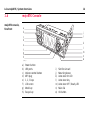
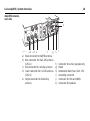
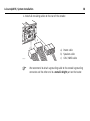
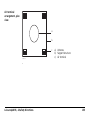
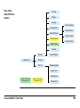
1
Leica User Manual Version 1.5 English 2 Leica mojoRTK, Introduction Introduction Purchase Congratulations on the purchase of a mojoRTK system. This manual contains important safety directions as well as instructions for setting up the product and operating it. Refer to "10 -2Safety Directions" for further information. Read carefully through the User Manual before you switch on the product. To ensure safety when using the system, please also observe the directions and instructions contained in the User Manual and Safety Handbook issued by the: • Agricultural machinery manufacturer. Product identification The type and serial number of your product are indicated on the type plate. Enter the type and serial number in your manual and always refer to this information when you need to contact your agency or Leica Geosystems authorized service workshop. Type: _______________ Serial No.: _______________ Symbols used in this manual The symbols used in this manual have the following meanings: Type Description Danger Warning Caution Leica mojoRTK, Introduction Indicates an imminently hazardous situation which, if not avoided, will result in death or serious injury. Indicates a potentially hazardous situation or an unintended use which, if not avoided, could result in death or serious injury. Indicates a potentially hazardous situation or an unintended use which, if not avoided, may result in minor or moderate injury and/or appreciable material, financial and environmental damage. Important paragraphs which must be adhered to in practice as they enable the product to be used in a technically correct and efficient manner. 3 Leica mojoRTK, Table of Contents 4 Table of Contents In this manual Chapter 1 2 Page System Overview 10 1.1 1.2 1.3 1.4 1.5 1.6 10 11 12 14 19 23 General mojoRTK System Information Components of mojoRTK System Unpacking the mojoRTK System mojoRTK Console mojoRTK Console LCD Screen mojoRTK Base Station System Installation 24 2.1 2.2 2.3 24 26 32 32 34 Before Installation Antenna Installation mojoRTK Console Installation 2.3.1 Before Installation 2.3.2 mojoRTK Console Installation 3 4 mojoRTK Base Station Operation 42 3.1 3.2 44 48 50 50 51 52 53 54 55 56 56 57 58 59 Base Station Setup Base Station Operation 3.2.1 How to Change the Language 3.2.2 Region Selection 3.2.3 Changing the Radio Channel 3.2.4 How to Activate / Deactivate GLONASS 3.2.5 Adjusting Contrast 3.2.6 Software Upgrade 3.2.7 Rollback Software 3.2.8 How to Reset Defaults 3.2.9 System Information 3.2.10 Additional Features 3.2.11 Selecting Data Format (if available) 3.2.12 Setting Position Mode (if available) Running the mojoRTK Console for the First Time 60 4.1 4.2 4.3 4.4 4.5 60 62 64 72 73 Setting up the mojoRTK Console System Wizard Vehicle Wizard Base Radio Wizard Completion of Initial Setup Wizard Leica mojoRTK, Table of Contents 5 Leica mojoRTK, Table of Contents 5 6 6 Tuning 74 5.1 5.2 5.3 5.4 5.5 5.6 75 76 78 79 81 82 Tuning Wizard Sensitivity Aggressiveness Overshoot Speed Adjust Tuning Tips Normal System Operation 6.1 6.2 6.3 6.4 6.5 6.6 6.7 6.8 6.9 6.10 6.11 6.12 6.13 6.14 6.15 Starting up the System Setting Waypoints (or A-B Points) Setting the Line Spacing Setting the Implement Offset Using Auto-steer Roading mojo Feature Setting the Field Offset Manually Setting the Vehicle Sensitivity Viewing Serial Numbers System Rescue Network RTK Glide Wayline Storage High Accuracy NMEA Output 84 84 85 87 88 90 91 92 94 96 97 98 99 103 110 119 7 8 9 Entertainment Function 126 7.1 7.2 7.3 7.4 7.5 7.6 126 127 127 128 129 130 Selecting an Entertainment Mode MP3 Input Aux Input Setting and Recalling Preset Stations Manual Tuning of the Frequency Adjusting Radio Controls Service 132 8.1 8.2 8.3 8.4 8.5 8.6 8.7 132 133 134 135 136 137 138 Virtual Wrench™ Upgrading Console Software via USB Memory Key Upgrading Console Software via Virtual Wrench™ Restoring the Previous Version of Console Software Backing up the Current Console Software Backing Up the Current Console Configuration Restoring the Console Configuration Care and Transport 140 9.1 9.2 9.3 140 141 142 Transport Storage Cleaning and Drying Leica mojoRTK, Table of Contents 7 Leica mojoRTK, Table of Contents 10 Safety Directions 10.1 10.2 10.3 10.4 10.5 10.6 10.7 10.8 10.9 General Introduction Intended Use Limits of Use Responsibilities Hazards of Use Electromagnetic Compatibility EMC FCC Statement, Applicable in U.S. ICES-003 Statement, Applicable in Canada Labelling 11 Technical Data 11.1 mojoRTK Console Technical Data 11.1.1 General Technical Data 11.1.2 Tracking Characteristics 11.1.3 Positioning Accuracy 11.2 mojoRTK Red Antenna Technical Data 11.3 mojoRTK Black Antenna Technical Data 11.4 mojoRTK Base Station Technical Data 11.4.1 General Technical Data 11.4.2 Tracking Characteristics 11.5 Conformity to National Regulations 11.5.1 mojoRTK Console 11.5.2 mojoRTK Base Station 8 144 144 145 147 148 149 158 161 163 164 166 166 166 169 172 173 176 178 178 182 185 185 188 12 International Limited Warranty, Software Licence Agreement 190 Appendix A Flow Chart 192 Appendix B Additional mojoRTK Information 196 B.1 B.2 B.3 Unlock Codes On Screen Keyboard Formatting USB Flash Drives 196 198 199 Appendix C GNU General Public License 206 Appendix D Glossary 208 Leica mojoRTK, Table of Contents 9 Leica mojoRTK, System Overview 1 System Overview 1.1 General mojoRTK System Information General information • • • 10 Leica Geosystems’ mojoRTK is a GPS-based guidance system that provides assisted steering to various pieces of agricultural equipment. The mojoRTK works with a lightweight and easy-to-transfer mobile base station that provides highly reliable accuracy without incurring GPS subscription fees. The unique and compact design of the mojoRTK allows you to move it from one piece of equipment to the next, covering your entire fleet. This is easily accomplished by the patented design and installation into a DIN slot or radio receptacle. Beyond its capabilities of steering accuracy, the mojoRTK also provides remote service and diagnostics for your guidance system and agricultural machinery, remote upgrades, and 24/7 service and assistance, eliminating costly on-site service calls. 1.2 Components of mojoRTK System mojoRTK components a bc d mojoRTK_018 a) mojoRTK base station b) mojoRTK Red Antenna Leica mojoRTK, System Overview c) mojoRTK Black Antenna d) mojoRTK console 11 12 Leica mojoRTK, System Overview 1.3 Unpacking the mojoRTK System Container for mojoRTK base station c a d b e mojoRTK_019 a) mojoRTK base station b) Whip antenna c) Battery GEB221, 2x d) Shoulder strap for carry case e) 12V power cable, with crocodile clips Apart from mojoRTK base station, all other parts are delivered in a cardboard box. Cardboard box for all other mojoRTK parts e a f b g h c i d j mojoRTK_020 a) b) c) d) e) Red whip antenna Red GPS antenna Cable to red whip antenna Cable to red GPS antenna mojoRTK console Leica mojoRTK, System Overview f) g) h) i) j) Black whip antenna Black GPS antenna Cable to black GPS antenna Cleaning wipes Cable to black whip antenna 13 14 Leica mojoRTK, System Overview 1.4 mojoRTK console, forefront mojoRTK Console a b i j c d e k l m n o f g h mojoRTK_001 a) b) c) d) e) f) g) h) Power button USB ports Volume control button MP3 plug 1, 2, 3 keys LCD screen Mode key Escape key i) j) k) l) m) n) o) Slot for simcard Mounting sleeve Auto-steer On LED Auto-steer key Auto-steer Off / Ready LED Main dial OK button Buttons, Keys Button, Key Leica mojoRTK, System Overview Function Power button Turns unit on or off. Volume control button Adjusts radio volume. Pressing the volume control provides access to stereo system settings (bass, treble, balance, and fade). Mode key Switches between GPS and Entertainment modes. Auto-steer key Starts/Stops auto-steer system. 1, 2, 3 keys Press for A-B Setup. Press for mojo Setup. Press for Virtual WrenchTM. 1, 2, 3 keys may also be used for up, down, and tab. 15 16 Leica mojoRTK, System Overview Button, Key Function Escape button Returns to previous menu. OK button Press to confirm an action or to enter a menu. Main dial Used to tune radio, select menu options and change setting values. Screen, LEDs, ports Module Leica mojoRTK, System Overview Function LCD screen Viewing screen for all modes. Refer to "1.5 mojoRTK Console LCD Screen" for details. Auto-steer Off / Ready LED Red LED lights when mojoRTK system is "ready": Sufficient satellites are found and radio communication to mojoRTK base station is good. Auto-steer On LED Green LED lights when mojoRTK system is ready and engaged: System works and auto-steering is activated. MP3 plug in Allows an MP3 player to play through the vehicle stereo system. USB ports Used for data transfer and storage as well as mojoRTK software upgrades. 17 18 Leica mojoRTK, System Overview mojoRTK console, rear side j k mojoRTK_021 ab cd e f g a) Black connector for AM/FM antenna b) Blue connector for black GPS antenna (GPS L1) c) Red connector for red whip antenna d) Green connector for red GPS antenna (GPS L2) e) Purple connector for black whip antenna h f) g) h) i) j) k) i Connector for service purpose only Power Automotive Blade Fuse (10A, 32V) Grounding connector Connector for CAN and NMEA Connector for speakers 1.5 mojoRTK Console LCD Screen mojoRTK screen a b mojoRTK_002 Leica mojoRTK, System Overview c d e f a) b) c) d) e) f) Base station GPS Satellites Accuracy to Working Line Working Line Virtual WrenchTM Cellular Phone Signal 19 20 Leica mojoRTK, System Overview Icon description Icon Description Base station Icon • • • • GPS Satellites / Signal Strength • • • • Accuracy to Working Line • A solid icon with three bars means you have an excellent signal from the base station. A solid icon with two bars means you have a good signal from the base station. A solid icon with one bar means you have a poor signal from the base station. A flashing icon with an X means the system is trying to lock on to the base station signal. A solid satellite icon with three bars means you have an excellent signal. A solid satellite icon with two bars means you have a good signal. A solid satellite icon with one bar means you have a poor signal. A flashing satellite icon means the system is not seeing enough satellites. This icon shows the accuracy of the system relative to the current working line while in motion. Icon Description Working Line Leica mojoRTK, System Overview • The Working Line is in bold, and zero is displayed below the tractor icon for the first pass; all other passes are numbered to the left (L) and right (R) of the center line. An X through the tractor indicates roading is enabled. Virtual WrenchTM • The Virtual WrenchTM in a flashing speech bubble indicates attempting to connect. • The Virtual WrenchTM in a solid speech bubble indicates waiting for a technician. • The Virtual WrenchTM with a box under it indicates that remote service is operating. 21 22 Leica mojoRTK, System Overview Icon Description Cellular Phone Signal • • • • A solid icon with three bars means you have an excellent signal. A solid icon with two bars means you have a good signal. A solid icon with one bar means you have a poor signal. A solid icon with an X means there is no cellular signal. Note that in this condition Virtual Wrench will be unavailable. 1.6 mojoRTK Base Station Base station overview a b Power Charge c ESC OK d e g h f i mojoRTK_022 a) b) c) d) e) Whip antenna Keyboard and display USB Port and protection cap Charger connector Accessories connector Leica mojoRTK, System Overview f) g) h) i) Cover for interfaces Cover for battery compartment Battery GEB221, 2 x Thread for tripod screw 23 Leica mojoRTK, System Installation 2 System Installation 2.1 Before Installation General installation information • • • 24 Installation does not require specialist knowledge. The installer is assumed to be familiar with the required knowledge by reading and studying the present user manual including the safety directions. The installer must be able to use the system in accordance with the user manual. However, Leica Geosystems recommends that installation of the mojoRTK equipment be performed by a qualified technician because installation requires making electrical connections. The following instructions are to be used as a general guide during the installation of the mojoRTK. For more specific instructions, please visit www.mojoRTK.com to view additional platform information and recommended vehicle settings. Understand that the system will not operate at peak performance if steering joints and linkage assemblies are not within the manufacturer’s specifications. Check for worn steering components by turning the steering wheel. As the steering wheel is turned, the wheels should begin to move. If results are undesirable, please consult your vehicle manufacturer’s maintenance manual. Install the system in a clean and dry shop environment. Failure to do so may cause the system to short or promote product malfunction. Any moisture on • • the roof of the vehicle will also prevent the antenna mounting tape from sticking properly. Route and secure all cables and wiring to ensure that they do not chafe or rub, causing premature failure. The average installation time will vary, but it should be approximately two to four hours per vehicle. The time of installation may be more or less, based on vehicle type. Leica mojoRTK, System Installation 25 Leica mojoRTK, System Installation 2.2 Preparations 26 Antenna Installation You should also refer to the installation hints specific to your tractor type and/or steer kit if applicable. These may be obtained at www.mojoRTK.com or may have been supplied with your system, depending on how you purchased your system. 1. Read all instructions before assembly and installation. 2. Clean the cab roof to prepare for the mojoRTK Red Antenna and the mojoRTK Black Antenna. Approved cleaning products are denatured alcohol and Windex® glass cleaner. Position of the GPS antennas 1. First find the locations that allow the antennas to have a large separation and be as close to the front of the tractor as possible. b c c = d a = mojoRTK_023 a) b) c) d) Red (Black) antenna offset Center line Measurement dots Antenna separation, minimum distance 80 cm/32” The center dimple on the antenna is where measurements need to be taken from. The antennas must be square with one another, meaning that one antenna should not be closer to the back of the vehicle than the other. 2. Mark out these locations on the roof of the tractor. Leica mojoRTK, System Installation 27 28 Leica mojoRTK, System Installation Prepare GPS antennas Start all antenna cable connections by hand before using the wrench to tighten. Do not overtighten the cable connections. Run the threads to the end and tighten only 1/8 turn more. 4 1 2 3 mojoRTK_024 red to red / black to black 1. Connect the color coded cables to mojoRTK black and mojoRTK red antenna black coded cable to black antenna, red to red. 2. Insert the thread of the whip antenna cable as shown, bring on the washer and fix with the nut. The whip antenna cables are also color coded. 3. Run the cables through the circular slot provided on the bottom side of the cover. Align each cable with the slot and push it into the slot using the antenna cable grommets and antenna cable supports provided. 4. You have several options for how you want the cables to exit the antenna cover; choose whatever works best for your application. 5. Install a whip antenna on each of the two GPS antennas. mojoRTK_006 The whip antennas are color coded to the GPS antennas; red to red and black to black. Keep in mind that the whip antennas should be mounted on the GPS antennas to buckle backwards if needed. Leica mojoRTK, System Installation 29 30 Leica mojoRTK, System Installation Mount the GPS antennas Use the supplied cleaning wipes to clean the installation area. . 1 2 3 mojoRTK_004 1. Remove the protective strip on the double-sided tape. 2. Mount the red antenna in its previously marked out position, ensuring that it is on the right-hand side of the vehicle when looking forward from the operator's seat. 3. Mount the black antenna accordingly on the left-hand side. Be careful removing the backing tape from the sticking blocks. Make sure that you only peel off the tape and do not rip the adhesive from the backing tape. Keep in mind that both GPS antennas should mount with the whip antennas in the forward position. 4. Select the radio/DIN slot that the mojoRTK console will be installed into and remove either the radio that is there or the blanking plate in the selected slot. 5. Run the antenna cables to the rear of the selected radio/DIN slot for connection to the mojoRTK console, making sure that there is enough slack in the cables to reach outside the selected radio/DIN slot. Route the cables through existing grommets if possible; if not, modification may be required to route the cables to the desired location. If creating a new entry point, make sure to use a grommet to protect the cables. The cables must not be cut, kinked, or bent tightly or their performance will be degraded and may even result in system failure. Leica mojoRTK, System Installation 31 Leica mojoRTK, System Installation 2.3 mojoRTK Console Installation 2.3.1 Before Installation • • Before installation 32 You should also refer to the installation hints specific to your tractor type or steer kit if applicable. These can be obtained from our website at www.mojoRTK.com or may have been supplied with your system. The make and model of your vehicle will determine how you complete each of the following tasks. Before the console is installed, you must do the following: 1. Check or prepare for console power connection: Depending on the vehicle type, you may already have the correct connectors to plug into the unit. Otherwise, you will have to use the plugs supplied and hook them up to the vehicle wiring per the console connection diagram. Refer to mojoRTK console, rear side, page 18. Please contact Leica Geosystems or your local reseller for more information. 2. Check or prepare for console speaker connections: Again, depending on vehicle type, you may already have the correct connectors to plug into the unit. Otherwise you will have to use the plugs supplied and hook them up to the vehicle wiring per the console connection diagram. Refer to mojoRTK console, rear side, page 18. Please contact Leica Geosystems or your local reseller for more information. 3. Install steering cable (CAN bus): There are many possible combinations for this step, depending on vehicle type and/or the steer kit used. The cable specific for your vehicle should be purchased with your system. For more information on each of these important steps, please refer to the installation hints specific to your vehicle or steer kit. Please find these installation hints at www.mojoRTK.com, How to Guides. Leica mojoRTK, System Installation 33 Leica mojoRTK, System Installation 34 2.3.2 mojoRTK Console Installation Console installation It may be necessary to remove the current radio in the DIN slot. Refer to the user manual for the existing radio for instructions on its removal. If removing a current radio, the sleeve in place may or may not fit the mojoRTK console. Please check the mounting before installation. Use caution with metal work; it may be sharp and could cause injury if care is not taken. 1. Carefully remove the console from its packaging. 2. Push in the locks on the side by using the removal tools supplied and slide the mounting sleeve off the unit. mojoRTK_026 3. Slide the mounting sleeve into the selected slot, and using the most suitable bend points on the sleeve, secure the sleeve into position. mojoRTK_027 There are several different types of mounting on radio systems. Some are locked only by the DIN sleeve, and others will have a retention nut on the rear of the radio. Leica mojoRTK, System Installation 35 Leica mojoRTK, System Installation 36 4. When Virtual WrenchTM is purchased and your system is equipped with a GSM or HSDPA internal modem: Take the SIM card holder out off the housing and turn it upside down. Put the SIM card into the SIM card holder, the chip facing up. Now flip over the SIM card holder again and insert it into the SIM card slot. mojoRTK_028 1. Pull the vehicle’s AM/FM antenna cable out of the slot and connect it to the adaptor cable from the mojoRTK kit. Connecting cables mojoRTK_029 2. Pull all the cables that need to be connected to the back of the console, including the antenna cables, power, speaker, and CAN bus cables, through the sleeve ready to be connected. 3. Attach all antenna cables to the rear of the console: a mojoRTK_030 Leica mojoRTK, System Installation b c d e a) Black connector with cable from AM/FM antenna b) Red connector with cable from red GPS whip antenna c) Purple connector with cable from black GPS whip antenna d) Blue connector with cable from black GPS antenna e) Green connector with cable from red GPS antenna 37 38 Leica mojoRTK, System Installation 4. Attach all remaining cables to the rear of the console: b a c mojoRTK_031 a) Power cable b) Speakers cable c) CAN / NMEA cable We recommend to attach a grounding cable to the console’s grounding connector and the other end to a metallic bright part on the tractor. 5. Slide the console into the sleeve and push back until you hear the clips catching on both sides. mojoRTK_008 Verify that the console is firmly mounted and cannot move. If movement is possible, performance may be degraded. Leica mojoRTK, System Installation 39 Leica mojoRTK, System Installation Removal of the mojoRTK console 40 For removal of the mojoRTK console, insert the supplied removal tools in the corners of the radio faceplate until a click is heard or felt. Apply outward pressure on the tools and gently pull back at the same time. mojoRTK_007 Leica mojoRTK, System Installation 41 Leica mojoRTK, mojoRTK Base Station Operation 3 42 mojoRTK Base Station Operation This chapter contains instructions for everyday operation of the mojoRTK base station. Charging / first-time use • The batteries must be charged prior to using for the first time because it is delivered with an energy content as low as possible. • The permissible temperature range for charging is between 0°C to +35°C /+32°F to +95°F. For optimal charging we recommend charging the batteries at a low ambient temperature of +10°C to +20°C/+50°F to +68°F if possible. • It is normal for the battery to become warm during charging. Using the chargers recommended by Leica Geosystems, it is not possible to charge the battery if the temperature is too high. • For new batteries or batteries that have been stored for a long time (> three months), it is effectual to make only one charge/discharge cycle. • For Li-Ion batteries, a single discharging and charging cycle is sufficient. We recommend carrying out the process when the battery capacity indicated on the charger or on a Leica Geosystems product deviates significantly form the actual battery capacity available. Operation/Discharging • The batteries can be operated from -20°C to +55°C / -4°F to +131°F. • Low operating temperatures reduce the capacity that can be drawn; very high operating temperatures reduce the service life of the battery. Warning Batteries not recommended by Leica Geosystems may be damaged if charged or discharged. They may burn and explode. Precautions: Only charge and discharge batteries recommended by Leica Geosystems. Leica mojoRTK, mojoRTK Base Station Operation 43 44 Leica mojoRTK, mojoRTK Base Station Operation 3.1 Base Station Setup The batteries must not be removed or added into the mojoRTK base station whilst it is either in operation or connected to external power. Fit the batteries, charging 1 2 mojoRTK_032 1. Remove the battery cover with a straight blade screwdriver. 2. Insert the batteries into the base station, ensuring they are installed correctly. Reinstall the battery cover. Do not overtighten screws; tighten to 2.3 Nm/20 in-lb. 3. Screw the whip antenna on top of the base station. 4. Connect the plug of the external charger into the back of the base station. This plug is keyed. Do not force-fit the plug. Once the plug is connected, handtighten the finger nut to fasten the cable to the base station. 5. Plug the base station charger into an outlet and charge for 24 hours. When charging is complete, remove the charging cable. 3 4 5 mojoRTK_005 Leica mojoRTK, mojoRTK Base Station Operation 45 Leica mojoRTK, mojoRTK Base Station Operation Base station setup 2 4 3 1 mojoRTK_009 46 1. Pull open the tripod lever locks, two per leg, and extend the tripod legs to your needs. The locks can hold the leg at any length. 2. Loosen the hand screw at the top of the tripod and extend the top section, set the height to the desired level, and lock down by tightening the hand screw. 3. Lock the legs in the desired position using the lock screw located on the center support tube. 4. Screw the base station on top of the tripod. • • • • • • • Standard use setup would configure the tripod as high as possible with the legs at maximum distance. Sandbag or weight the tripod to improve the stability of the base station. Protect the base station from animals and farm equipment. Be aware that other equipment may interfere with the base station. This includes but is not limited to generators, radio transmitters, electrical equipment, and other base stations. The base station should be mounted on the tripod or be fixed in the open. It should not be placed under or near roofs, trees, large bodies of water, or awnings. Any obstacle may affect GPS and radio transmissions. The base station requires line of sight to the console. Vehicles, buildings, solid fences, or trees can all affect operation. When using the base station as a permanently installed reference station a power cable can be purchased for power supply and no batteries are needed. Please contact Leica Geosystems or your local reseller for more information. Leica mojoRTK, mojoRTK Base Station Operation 47 48 Leica mojoRTK, mojoRTK Base Station Operation 3.2 Base Station Operation Keyboard, display a) b) c) d) e) f) mojoRTK_003 a Power LED: Charge LED: First time use b c d e f Power button Escape / return button Scroll up button Scroll down button OK button/Selection Control LEDs for power and charge status Red LED lights when mojoRTK system is working. Lights orange, when base station batteries are being charged. Flashes orange, when base station batteries are fully charged. When turned on for the very first time a setup wizard will come up on the base station. It has two items in the following order: • Language; refer to "3.2.1 How to Change the Language" • Region; refer to "3.2.2 Region Selection" Operation 1. Ensure base station setup has been completed and batteries are fully charged. for two or three seconds until the screen 2. Push and hold the power button comes on. 3. The screen will become active and begin a count down as it searches for satellites. It will then go to the main menu and to find the position of the base station. 4. While the base station is calculating the position, the screen will read fixing…pls wait. 5. In a few minutes from when is pushed, the screen will go from fixing…pls wait to Position Fixed. Initial startup of the base station can take up to several minutes to acquire due to downloading the GPS almanac. Also, startup times can be increased after long storage periods. 6. At this time, the base station has a fixed position. 7. Now check the radio channel and ensure it is the same as the mojoRTK console. It is suggested to start with channel 0 unless interference is detected. If the base station can not get a GPS fix in two minutes it may enter a quiet mode where the system will appear to shut down and restart. This can happen a maximum of three times. Leica mojoRTK, mojoRTK Base Station Operation 49 50 Leica mojoRTK, mojoRTK Base Station Operation 3.2.1 How to Change the Language Change the language, step-bystep 1. Using , scroll to Settings and press 2. Using , scroll to Language and press 3. Using , select a language and press . . . 4. To leave this menu, press the Escape button screen. 3.2.2 Region Selection Region selection, step-by-step 1. Using , scroll to Region and press 2. Using , scroll to Country and press 3. Using until you return to the main • • . . , select the region you are operating in and press . The base station will program the integrated radio and restart. The base station is then ready to provide position. Selecting the correct country may help to increase the optimal satellite search. By selecting the wrong country, you may be breaching regulatory requirements. 3.2.3 Change the radio channel, step-bystep Changing the Radio Channel 1. Use the Scroll Up and Down buttons OK button to scroll to Channel and press the . 2. The current channel the base station is set to will be displayed. 3. To change the channel from 0-4 Europe (0-9 North America and Australia), use and press on your selection. 4. The base station will say channel changed and is ready for use. Remember the channel setting. Ensure the same channel setting is entered on your mojoRTK console or the system will not work. Leica mojoRTK, mojoRTK Base Station Operation 51 52 Leica mojoRTK, mojoRTK Base Station Operation 3.2.4 Activate / deactivate GLONASS, step-by-step How to Activate / Deactivate GLONASS GLONASS is the Russian version of the US-run GPS system. The mojoRTK can be activated to make use of the GLONASS satellites. To utilise the GLONASS satellite software upgrade, GLONASS must be enabled on the mojoRTK console. 1. Using , scroll to Settings and press 2. Using , scroll to GLONASS and press 3. Using . , enable or disable GLONASS and press . If this option is selected, the base station will reboot. This will take approximately one minute. 4. To leave this menu, press . until you return to the main screen. GLONASS is activated by default, it is recommended that it be deactivated if the mojoRTK console is not enabled to receive GLONASS as doing so will increase the run time of the base station whilst on batteries. 3.2.5 Adjust contrast, step-by-step Adjusting Contrast 1. Using , scroll to Settings and press . 2. Using , scroll to Contrast and press . 3. Using , select % of contrast and press Leica mojoRTK, mojoRTK Base Station Operation . 53 54 Leica mojoRTK, mojoRTK Base Station Operation 3.2.6 Software Upgrade Software upgrade, step-by-step When performing a software upgrade, ensure that the batteries are charged and the base station is connected to external power. It is vitally important that the device is not turned off during an upgrade. Refer to "B.3 Formatting USB Flash Drives" for important information about using USB drives with the mojoRTK products. 1. Using , scroll to Service and press 2. Using , scroll to Software Upgrade and press . . 3. Insert the USB stick containing the new software into the USB port. 4. Press to select the software version displayed. If the USB stick contains multiple software versions, select the desired version. 5. The current and new software versions will be displayed. Press to proceed. A software upgrade consists of a number of steps that will be displayed on the screen including Checking, Erasing, Installing, Power Down, and Loading. This will take a few minutes. 6. If a software upgrade is not your choice, press screen. until you return to the main 3.2.7 Rollback Software Rollback software, step-by-step 1. Using , scroll to Service and press 2. Using , scroll to Rollback Software and press 3. Using select. , select Yes or No to select the software version and press When performing a software rollback, ensure that the batteries are charged and the base station is connected to external power. It is vitally important that the device is not turned off during rollback. . . to Rollback software consists of a number of steps that will be displayed on the console, including Rebooting, Power Down, and Loading. This will take approximately one minute. Rollback software is only available when an earlier version of software was previously installed on the base station. Leica mojoRTK, mojoRTK Base Station Operation 55 56 Leica mojoRTK, mojoRTK Base Station Operation 3.2.8 Reset defaults, step-by-step How to Reset Defaults 1. Using , scroll to Settings and press 2. Using , scroll to Reset Defaults and press 3. To reset defaults, press Access system information, stepby-step . again. If this option is selected, the base station will reboot. This will take approximately one minute. 4. To leave this menu, press 3.2.9 . until you return to the main screen. System Information 1. Using , scroll to Service and press 2. Using , scroll to System Info and press 3. By using . . , you can view the serial number, firmware version and software version, unlock code status, and current position. 4. Once viewed, press until you return to the main screen. 3.2.10 Use additional features, step-bystep Additional Features This menu is used for manual input of the unlock code for purchased product features, for example Additional Data Formats. 1. Using , scroll to Service and press 2. Using , scroll to Add Features and press 3. Use to find each digit or letter and press has been entered; use . . Repeat until the full code to go back a space if required. 4. Check the number and press . if correct. The base station may reboot to implement the new feature. Please contact Leica Geosystems or your local reseller for more information. Leica mojoRTK, mojoRTK Base Station Operation 57 58 Leica mojoRTK, mojoRTK Base Station Operation 3.2.11 Selecting Data Format (if available) General information The Additional Data Formats option is available at a cost with an unlock code. The options are: • mojo1 [default] • CMR • RTCM3.0 Different data formats are used for operating a mojoRTK console with other GPS devices that do not accept the proprietary mojo1 format that is used by default. Without the unlock code the option for this menu is not shown. Select data format, step-by-step 1. Using , scroll to Settings and press 2. Using , scroll to Data Format and press 3. Using , select the desired format and press . . . Please contact Leica Geosystems or your local reseller for more information. 3.2.12 Setting Position Mode (if available) General information This option is available at a cost with an unlock code. The options are: • Snap to Previous [default] • Fixed Position • First Fix • Averaged Without the unlock code the option for this menu is not shown. Setting position mode, step-bystep 1. Using , scroll to Settings and press 2. Using , scroll to Position Mode. This will tell you what type of position fix . you are using. 3. If you want to change the position type, use 4. If you do not want to change the position type, press menu. and press . to get back to the main Please contact Leica Geosystems or your local reseller for more information. Leica mojoRTK, mojoRTK Base Station Operation 59 60 Leica mojoRTK, Running the mojoRTK Console for the First Time 4 Running the mojoRTK Console for the First Time 4.1 Setting up the mojoRTK Console Set up the console Before starting the mojoRTK console in the tractor: • Have the base station set up and running with a fixed position as described in chapter "3 mojoRTK Base Station Operation". • Note the channel number that the base station is running on (by default this is channel 0). 1. Press and hold for 2-3 seconds and the unit will turn on and the Leica logo screen will come up. Introduction Welcome to the mojoRTK Setup Wizard Press Ok to continue Ok S mojoRTK 001 2. Press to continue. The mojoRTK Setup Wizard is actually three wizards run one after the other: • System Wizard, • Vehicle Wizard, and • Base Radio Wizard. These wizards guide you through the setup process. Leica mojoRTK, Running the mojoRTK Console for the First Time 61 62 Leica mojoRTK, Running the mojoRTK Console for the First Time 4.2 System Wizard, step-by-step System Wizard 1. Use the main dial to select the Language and press . 2. Use the main dial to select Region and press Region . Select region North America Ok S_mojoRTK_002 3. Use the main dial to select the measurement units (US Standard or Metric) and press Units . Select units US Standard Ok S_mojoRTK_003 4. Use the main dial to adjust the display contrast to your liking. The contrast changes as you turn the main dial. Press Contrast once you have the desired setting. 62% S_mojoRTK_004 5. Use the main dial to adjust the display backlighting brightness and press when you have the desired setting. Leica mojoRTK, Running the mojoRTK Console for the First Time 63 Leica mojoRTK, Running the mojoRTK Console for the First Time 4.3 Vehicle Wizard, step-by-step 64 Vehicle Wizard 1. The Vehicle Wizard starts with the mojoRTK orientation. The mojoRTK orientation describes the orientation of the console in the tractor. 90° 0° mojoRTK_010 -90° Press and adjust the number to represent how the system is mounted in the cab. If the system is mounted directly in front of you (when sitting in the seat), the setting should be 0°. If the unit is at 90° on your right, then the setting is 90. If the unit is at 90° on your left-hand side, then the value is -90°. Press when you have entered the correct value. For the tests that follow, you will need to drive the tractor and be in an open area with room to move. 2. Drive the tractor to flat ground and press when fully stopped. The mojoRTK console will automatically perform a terrain tuning operation. Terrain Compensation Drive to flat ground and press OK once stopped. Skip OK S_mojoRTK_005 Do not move vehicle until instructed. To ensure accurate tuning, it is advised that both front wheels are clearly marked on the ground. Terrain Compensation Tuning in progress. Do not move until finished. S_mojoRTK_006 Leica mojoRTK, Running the mojoRTK Console for the First Time 65 66 Leica mojoRTK, Running the mojoRTK Console for the First Time 3. When complete, the console will ask you to turn the vehicle around. Turn the vehicle around 180° Terrain Compensation back to the same position. Press when back in the same spot and fully stopped. Turn the vehicle around. Press OK after stopping. OK S_mojoRTK_007 Terrain compensation tuning will continue. Do not move vehicle until completed. Terrain Compensation Tuning in progress. Do not move until finished. S_mojoRTK_008 4. Console will say Tuning complete. Vehicle may now be moved. Press to continue. Terrain Compensation Tuning complete. Updates will be required if you receive an Accuracy Warning. OK S_mojoRTK_046 5. The next screen is for compass tuning, and the console will ask you to drive to a flat and open location. Press once you have done this. Compass Tuning Please drive to a flat, open area. Press OK when ready. Skip Be • • • OK S_mojoRTK_009 You need sufficient space to perform the next tuning operation. aware that compass tuning can fail if: the speed of the vehicle is too high or not constant while tuning. the tuning is conducted under, over or near, a metallic mass. the tuning is performed, under, over or near, power lines. Leica mojoRTK, Running the mojoRTK Console for the First Time 67 68 Leica mojoRTK, Running the mojoRTK Console for the First Time 6. The console will ask you to drive slowly in circles. Compass Tuning Please drive slowly in circles. Tuning part1 in progress. S_mojoRTK_010 Drive slowly (below 3.2 km/h or 2 mph) in circles in one direction until the console shows that both compass tuning operations (parts 1 and 2) are complete. Compass Tuning Please drive slowly in circles. Tuning part 2 in progress. S_mojoRTK_011 The console will say Compass tuning successful. Press stop the vehicle. Compass Tuning to continue. You can now Compass tuning successful. OK S_mojoRTK_012 7. Use the main dial to select the vehicle type or steer kit for your installation and press . You should see a message stating the steer kit communications status, for example CAN Bus Connected, Steering Kit Active. Vehicle Type Select vehicle type None OK S_mojoRTK_013 There may be extra steps required at this point or even later depending on which vehicle type or steer kit you select. 8. The next screen explains that you are about to enter the Antenna Separation. Make sure that you have measured the distance between the center of the black and the red GPS antenna accurately. Refer to "Position of the GPS antennas", page 27. Press to continue. Measure from the molded dot in the center on the antenna. Leica mojoRTK, Running the mojoRTK Console for the First Time 69 70 Leica mojoRTK, Running the mojoRTK Console for the First Time 9. Use the main dial and/or the 1.2.3 buttons to enter the spacing between the black and the red GPS antennas on the roof and press done. Ant. Separation when 0.82 m S_mojoRTK_014 10. The next screen explains that you are about to enter the red antenna offset. The red antenna offset is the distance from the center line of the tractor to the center of the red antenna. This distance should be half the antenna separation when the antennas are installed correctly. Measure the red antenna offset to ensure the best system performance. Refer to "Position of the GPS antennas", page 27. Press to continue. 11. Use the main dial and/or the 1.2.3 buttons to enter the measured red antenna offset on the roof. Press Red Ant. Offset when complete. 0.41 m S_mojoRTK_015 12. The next screen explains that you are about to enter the Vehicle Height. The vehicle height is the measured distance from the ground to the bottom of the red GPS antenna. Press to continue. 13. Use the main dial and/or the 1.2.3 buttons to enter the vehicle height. Press Vehicle Height when done. 2 .95m S_mojoRTK_016 Leica mojoRTK, Running the mojoRTK Console for the First Time 71 72 Leica mojoRTK, Running the mojoRTK Console for the First Time 4.4 Base Radio Wizard 1. The Base Radio Wizard starts with Base Radio Channel. Use the main dial to select the base radio channel. It is suggested to start with channel 0 unless inter- Base Radio Wizard, step-by-step ference is detected. Press when done. The channel on the base station needs to be the same as the console. For information about changing the channel, refer to "3.2.3 Changing the Radio Channel". 2. The screen will then display Base Radio Status. This is the base connection status. • If the country has been changed, this screen may not appear. If base status is not good, try changing the channel on the base station. Press • when done. The base station must be running and on the same channel for good signal strength and base data reception. 3. If base status is not good, try changing the channel on the base station first and then on the mojoRTK console by pressing the Escape button on the console to go back to base channel setting menu. Ensure that the base station and console are configured to the same region. 4.5 Setup Wizard completion, stepby-step Completion of Initial Setup Wizard 1. At this point, the display will say Setup Complete, setup has completed. Press to restart the device. 2. Press to restart the console. 3. As the system shuts down, it will program some of the configurations into the unit. Please be patient and do not disconnect power during this stage. 4. The system will shut itself down and restart itself. If for any reason it doesn’t start back up by itself, turn it back on with . You may be asked to perform an additional tuning operation for steering; this varies from kit to kit. Refer to www.mojoRTK.com for your specific steering kit tuning. Leica mojoRTK, Running the mojoRTK Console for the First Time 73 Leica mojoRTK, Tuning 74 5 Tuning General information The tuning of the mojoRTK is preloaded based on your selected vehicle/steering kit type and should be a reasonable starting point for tuning refinement. To refine the tuning of the system, there are four parameters: • Sensitivity • Aggressiveness • Overshoot • Speed Adjust For optimal performance, the system tuning must be refined for your steering kit/vehicle. 5.1 Tuning Wizard General information Sensitivity, Aggressiveness, Overshoot, and Speed Adjust can be found in the Vehicle Tuning Wizard. • Get the following parameters right at 5 km/h / 3 mph and then you should only have to adjust speed. • Settings in the Tuning Wizard are applied immediately but not saved unless • is pressed. Some steering kits/vehicles do not require tuning, so this wizard may be replaced by a specific one for your selected steering kit/vehicle. Leica mojoRTK, Tuning 75 76 Leica mojoRTK, Tuning 5.2 Sensitivity Setting the Sensitivity The sensitivity will control the rate that the tractor turns and how sensitive it is when it is on the line. Sensitivity should be the only parameter that you need to adjust to adapt the control performance to the current working conditions after the tuning refinement is done. 1. Sensitivity is the first item in the menu dialogue. Press to display the menu. Menu Sensitivity 85% Line Spacing Roading 5.00m Yes Base Channel 1 S_mojoRTK_018 2. Use the main dial to move between menu items and press Sensitivity to display the Sensitivity. 3. Use the main dial to adjust the Sensitivity, and press to save the setting. 85 0cm S mojoRTK 019 Explanation • • • The sensitivity can be set between 50% and 150%. The standard setting is 100%. In general, higher sensitivity is for slower travelling speed, lower sensitivity for faster speed. Different sensitivity settings and their approach to the working line: 150% 100% 50% mojoRTK_011 Leica mojoRTK, Tuning 77 78 Leica mojoRTK, Tuning 5.3 Aggressiveness Setting the aggressiveness The aggressiveness will control the rate that the tractor attacks the line and how well it holds the line. When adjusting the aggressiveness, look for these qualities: 1. Use the main dial to adjust the Aggressiveness, and press Aggressiveness to save the setting. 115 0cm S mojoRTK 021 Explanation Different aggressiveness settings and their approach to the working line: 150% 100% 50% mojoRTK_012 The standard setting is 100%. 5.4 Overshoot Setting the overshoot The overshoot value will control the rate at which the tractor will drive at the line and the rate that the tractor will round off as it approaches the line. A low value will cause the tractor to hold off the line longer while a high value will cause the tractor to converge quickly and possibly drive past the line. 1. Use the main dial to adjust the Overshoot, and press Overshoot to save the setting. 120 0cm S_mojoRTK_022 Leica mojoRTK, Tuning 79 80 Leica mojoRTK, Tuning Explanation Different overshoot settings and their approach to the working line: 150% 100% 50% mojoRTK_013 The standard setting is 100%. 5.5 Speed Adjust Setting the speed adjust The speed adjust should be used to fine tune the performance of the control system for higher speeds than the tuning speed of 5 km/h / 3 mph. Typically, the vehicle can steer side to side at higher speeds, and this can be resolved by reducing the speed adjust. If the vehicle does not hold the line as desired at the desired speed, then increase the speed adjust. 1. Use the main dial to adjust the Speed Adjust, and press Speed Adjust to save the setting. 120 0cm S mojoRTK 023 The speed adjust has no effect at or below 5 km/h / 3 mph. . Leica mojoRTK, Tuning 81 82 Leica mojoRTK, Tuning 5.6 Tuning Tips General tuning tips When dealing with the tuning, each parameter must be treated separately, even though they may have interactions between them. When tuning for: • turning rate and twitch on the line, use Sensitivity. • line holding, oscillations, and line approach speed, use Aggressiveness. • amount of overshoot or undershoot, use Overshoot. • variation over speed, use Speed Adjust. Get these parameters right at 5 km/h / 3 mph, and then tune for higher speeds with only the Speed Adjust. In-depth tuning tips Symptom Resolution Tractor is too slow to approach the line. Increase the Aggressiveness. Tractor is too fast to approach the line or Decrease the Aggressiveness. the tractor oscillates. Tractor straightens up before it gets to the line. Increase the Overshoot. Symptom Resolution Tractor drives past the line then comes back onto to the line. Decrease the Overshoot. Tractor turns very slowly to drive toward Increase the Sensitivity. the line. Tractor turns very aggressively to drive toward the line and twitches when on the line. Reduce the Sensitivity. Tractor oscillates only at higher speeds. Reduce the Speed Adjust. Tractor does not hold the line at higher speeds. Increase the Speed Adjust. Leica mojoRTK, Tuning 83 Leica mojoRTK, Normal System Operation 6 Normal System Operation 6.1 Starting up the System Start up, step-bystep 84 1. Start the base station in an open area and within line of sight of the console. Refer to "3.1 Base Station Setup" for more information. 2. Press and hold for 2-3 seconds to start the mojoRTK console in the vehicle. Wait about one minute for the system to start. 3. The mojoRTK controller will be ready for use when the Auto-steer Off / Ready LED turns red. The Auto-steer Off / Ready LED is the main way to know if the system is ready to steer. 6.2 Setting Waypoints (or A-B Points) General information The waypoints are used to define a line in the field that all working lines will be parallel to. Waypoints need to be set before auto-steer can be used. Setting waypoints, step-by-step Before you can set waypoints, the system must have a good position fix. If auto-steer is not engaged and the system has a good position fix, the Auto-steer Ready LED will be lit. 1. Position your vehicle in the field where you want to start (Waypoint A). 2. Press twice to enter the setup for Waypoint A. Press press Press [OK] to set point A to set Waypoint A or to cancel. S_mojoRTK_024 3. Drive to your desired ending point in the field (Waypoint B). Leica mojoRTK, Normal System Operation 85 86 Leica mojoRTK, Normal System Operation 4. Press The minimum distance should be at least 30 metres (100 feet). The greater the distance between the waypoints, the better the accuracy of the working line. Where possible, set the waypoints at either end of the field. to set Waypoint B. Press [OK] to set point B S_mojoRTK_025 If wayline storage is activated on your mojoRTK console please refer to "6.14 Wayline Storage". 6.3 Setting the Line Spacing General information The line spacing sets how far apart the working lines are. This distance is essentially the width of the implement you are using. Setting line spacing, step-bystep 1. From the main navigation screen, press Line Spacing by pressing to enter the main menu and select . 2. If measurement is correct as it is, press . 3. Use or the main dial to set the line spacing according to the measured implement width - from end tool to end tool. Once you have set the whole units to the desired value press , this will then allow you to change the fractional units (after the decimal point). 4. Press Line Spacing 12 .00m S_mojoRTK_027 to confirm the new setting. Leica mojoRTK, Normal System Operation 87 88 Leica mojoRTK, Normal System Operation 6.4 Setting the Implement Offset General information The implement offset is used when the center of the implement is not in line with the center of the vehicle. It is used to adjust the vehicle paths for offset implements. Setting implement offset, step-bystep 1. From the main steering screen, press to enter the main menu. 2. Turn the main dial to select Settings, and then press . 3. Use the main dial to select Guidance, and then press . 4. Use the main dial to select Implement Offset. The current offset is shown on the right side of the screen. Press 5. Use to change the implement offset. or the main dial to set a new Implement Offset implement offset. 10 .00m Right S_mojoRTK_029 6. Press When you are sitting in the seat of the vehicle, if the center of the implement is 1 m/3 ft from the center of the vehicle to your right, the implement offset will be 1.00 m/36.00” Right. Likewise, if the implement is 1 m/3 ft to the left of the center of the vehicle, the implement offset will be 1.00 m/36.00” Left. to confirm the new offset. 7. To exit without applying the new setting, press steering screen. Leica mojoRTK, Normal System Operation until you return to the main 89 Leica mojoRTK, Normal System Operation 6.5 Using Auto-steer General information Using auto-steer, step-by-step 90 If auto-steer is not engaged and the system has a good position fix, the red light to the right of the main dial will be lit. 1. Before you can engage auto-steer, the system must have a good position fix. 2. Steer your vehicle to a desired line and press system will now guide the vehicle. while in motion. The steering 3. To disengage the automatic steering system, press . Auto-steer will also disengage if you turn the steering wheel to the left or right (if this is supported in your vehicle) or you come to a complete stop. • • Refer to "6.6 Roading" for details on the Roading safety feature. Certain vehicles/steering kits may have a separate engage switch that will replace the functionality of the mojoRTK console engage button. 6.6 Roading General information The Roading feature is a safety tool that is designed to prevent accidentally engaging auto-steer when auto-steer should not be engaged, such as when roading or working near obstacles. Each time the mojoRTK console is turned on, Roading is turned on too, which will disable auto-steer. Turn roading off There are two ways to turn Roading off: • From the navigation screen, press Roading, and press Press • to enter the menu, scroll down to . to get back to the navigation screen. When you try to engage auto-steer with Roading turned on, the console will ask you to confirm that you want to turn Roading off. If you want to use auto-steer and therefore turn Roading off, turn the main dial counter-clockwise to Yes and press . If you do not want to turn Roading off, for example because you accidentally hit , press . The Roading feature must be enabled at all times when activation of guidance could cause damage or injury, for example when travelling on a road. Leica mojoRTK, Normal System Operation 91 92 Leica mojoRTK, Normal System Operation 6.7 mojo Feature General information The mojo feature allows you to automatically adjust the A-B line with respect to your current position. Using mojo feature, step-bystep 1. Press to display button options. A-B mojo GG S mojoRTK 030 2. Press again. You will be asked to drive to the correct position. mojo Field Offset Manually drive vehicle to the correct position for the current line and press OK S_mojoRTK_031 3. Press once you are in position, and the A-B line will be adjusted to your current position. Leica mojoRTK, Normal System Operation 93 94 Leica mojoRTK, Normal System Operation 6.8 Setting field offset manually, step-bystep Setting the Field Offset Manually The field offset is used to move the original AB line to a new desired location. This will be used most often if the base station has been moved. The field offset can be manually set or automatically set. This section describes the manual setting. 1. From the main steering screen, press to enter the main menu. 2. Turn the main dial to select Settings, and then press . 3. Use the main dial to select Guidance, and then press . 4. Use the main dial to select Field Offset. The current offset is shown on the right side of the screen. Press 5. Use offset. to change the field offset. or the main dial to set a new field Field Offset 1.00m S_mojoRTK_047 6. Press to confirm the new offset. 7. To exit without applying the new setting, press steering screen. Leica mojoRTK, Normal System Operation until you return to the main 95 96 Leica mojoRTK, Normal System Operation 6.9 Setting the Vehicle Sensitivity General information The Vehicle Sensitivity changes the sensitivity of the tractor steering. The higher the sensitivity, the more quickly the vehicle will respond; the lower the sensitivity, the more slowly the vehicle will respond when it steers. Setting vehicle sensitivity, stepby-step 1. From the navigation screen, press to enter Menu. 2. Turn the main dial to select Sensitivity, and then press 3. Adjust the Sensitivity level with the main dial or and . Sensitivity . 50% S_mojoRTK_033 4. Press to confirm the new setting. 5. When you are finished, press to save the selected value, or press you return to the navigation screen if you wish to keep the old setting. until 6.10 Viewing serial numbers, step-bystep Viewing Serial Numbers 1. From the navigation screen, press to enter Menu. 2. Turn the main dial to select Service, and then press . 3. Use the main dial to select Statistics, and then press 4. Use the main dial to select Serial Numbers, and then press . . Serial Numbers Article 675502 Unit Number 000107 GSM355633000697994 ME3 Serial BYY08091198 S_mojoRTK_035 5. Use the main dial to scroll up and down to see all of the serial numbers stored in the system. 6. To exit the menu, press Leica mojoRTK, Normal System Operation until you return to the Navigation screen. 97 98 Leica mojoRTK, Normal System Operation 6.11 System Rescue General information If you accidentally change the language and can’t understand the menus to change it back or you adjust the contrast of the screen so that you can’t see the display anymore, there are special key sequences that you can press to recover the default language and contrast. Restore the language To restore the language, press Restore the contrast To restore the contrast, press Reset factory settings To enable the factory reset option in the main menu, press System shut down For a non-responsive system, hold down for 10 seconds to power down. The system will shut down as the button is released. by by by three times followed by three times, within 8 seconds, followed by three times followed by three times, within 8 seconds, followed by three times, followed by three times followed . three times followed . three times followed three times, within 8 seconds, followed by . 6.12 Network RTK This is an optional software upgrade to the base model in all regions. Benefits The Network RTK feature allows the mojoRTK console to be operated without the need for a local base station. The RTK corrections are instead received from a network provider over the internet using the console’s internal modem. The Network RTK feature replaces the local base station with a network of permanent base stations operated by a network provider. Network RTK offers very quick convergence times (similar to using the mojoRTK base station) compared to other correction sources available. The Network RTK base stations are survey quality and mounted in fixed positions, offering repeatability from year to year. Limitations Network RTK can only be used when a good connection to the internet is present. Internet connections are only supported through the mojoRTK console’s internal modem and so cellular coverage is required in all areas you intend to operate guidance. In order to use Network RTK, it is necessary to be within the bounds of the network being used. Only correction streams providing CMR, CMR+ or RTCM 3 format corrections are supported. GLONASS is only supported with the RTCM 3 format. Leica mojoRTK, Normal System Operation 99 100 Leica mojoRTK, Normal System Operation Required items • • • Network Upgrade unlock code Network Data Plan unlock code Subscription to local Network RTK provider Please contact Leica Geosystems or your local reseller for further details on activating this optional software module. Configuration For information about the installing the unlock codes refer to "B.1 Unlock Codes" Using the On Screen Keyboard For information about the On Screen Keyboard (OSK) refer to "B.2 On Screen Keyboard". Setting up Network RTK, step-by-step 1. Switch on the mojoRTK console and wait for a basic GPS fix to be achieved (satellite icon shows one or more bars). 2. The mojoRTK console needs to have good internal modem signal strength (1 or more bars). 3. If you are not on the navigation screen then press 4. Press to enter the main menu. 5. Use the main dial to scroll down to Base Channel. until it comes up. 6. Press to enter the Base Channel Wizard. 7. Use the main dial to scroll through the different options. Select Network RTK and then press . 8. You will be prompted to enter the following details: • Host/Server IP address • Host/Server port • Username • Password They will be supplied by your Network RTK provider when you create an account with them. 9. After entering the above details the mojoRTK console will attempt to connect to the selected source. If any problems occur an appropriate message will be displayed. 10. Once the console successfully contacts the Network RTK server you will be prompted to select a stream to use. 11. A stream represents a combination of correction format and base location. Select the closest stream with a compatible reference format. Leica mojoRTK, Normal System Operation 101 Leica mojoRTK, Normal System Operation 102 12. After selecting a stream press to confirm the selection. The mojoRTK console will attempt to connect to the stream and will report if any problems occur. 13. After successfully connecting to the stream the console may need to restart before a good fix can be achieved. 14. The mojoRTK console will remember these settings and will reconnect automatically when it connects. 6.13 Glide This is an optional software upgrade to the base model in all regions. Description • • • • Glide allows the operator to continue working for a period of time after the loss of signal being received from the base station. The mojoRTK must be receiving GPS data for Glide to be enabled. Following the restoration of signals from the base station the mojoRTK console will correct for offset if the offset error is less than the limit set for Maximum Drift. Glide is primarily a fallback mechanism and accuracy to the line will degrade over time. Benefits Using Glide allows the mojoRTK to continue to guide the vehicle for up to ten minutes after the base station signal has been lost. The loss of signal may be due to terrain, vegetation, or interference. Limitations • • • Glide can not be initiated until a GPS fix has been obtained on both the mojoRTK and the base station. Glide will cease to operate if the mojoRTK looses GPS fix. Glide, when activated, will initiate 30 seconds after a loss of signal from the base station. Leica mojoRTK, Normal System Operation 103 Leica mojoRTK, Normal System Operation • • Required items • • • 104 Glide operation is limited to a maximum of ten minutes without receiving corrections from the base station. The mojoRTK console must receive at least 15 seconds of continuous reference corrections for the ten minute interval to reset. If the position drift upon signal restoration is greater than the Maximum Drift set, guidance will be disabled and an error screen will be displayed on the mojoRTK console. Unlock code to unlock the Glide feature on the mojoRTK base station and console. Service Pack 4 or later software Updated ME3 firmware (v3.610 or later) Please contact Leica Geosystems or your local reseller for further details on activating this optional software module. Unlock codes For information about installing the unlock codes refer to "B.1 Unlock Codes". Glide Under Glide the vehicle may drift left or right. Over time this drift may become significant. The default maximum drift limit is 0.1m. The user has the option to set a maximum drift value for Glide. Navigate to Menu -> Settings -> Guidance -> Max. Drift. The maximum allowable value is 10.00m. Guidance Implement Offset Max.Drift 0.00m 0.10 m Backup Waylines Load Waylines Max. Drift 0.10m S_mojoRTK_048 S_mojoRTK_049 With the Glide feature enabled, Glide will automatically activate following the loss of signal from the base station. In a typical scenario the user would set up for the days work. A GPS fix would be obtained by the mojoRTK console and the base station. The user would then commence operating. The base station icon would have at least one bar and the satellite icon would have at least one bar. GG S_mojoRTK_050 Leica mojoRTK, Normal System Operation 105 106 Leica mojoRTK, Normal System Operation If at some point the signal to the base station is lost, after 15 seconds the user is presented with the continue on Glide screen. Confirm You are now running outside RTK accuracies, do you wish to continue on Glide? Yes No Always S_mojoRTK_051 Selecting No will disengage steering. Selecting Yes will allow steering to remain engaged. The next time Glide activates the confirmation screen will be displayed. • Selecting Always will allow steering to remain engaged. Glide will remain activated for a maximum of ten minutes. • • • • Glide GG S mojoRTK 052 If Always has been selected the prompt to activate Glide will not be shown unless the mojoRTK console has been restarted. If Yes or Always has been selected then Glide will remain activated for a maximum of ten minutes. After the ten minutes a RTK fix will be needed before Glide can • Nudge offset be used again. Be aware there will be some drift and it may be necessary to make some corrections using Nudge Offset. If guidance is being performed using the JD Greenstar 1 or 2 then the nudge function cannot be performed on the mojoRTK console. It must be performed on the Greenstar. Nudge Offset provides the operator a mechanism to correct the drift that will occur while Glide is activated. To use the Nudge Offset press repeatedly until the main screen is displayed. Press and you are presented with the Nudge Offset menu. Nudge Offset Drive to the line and press Ok or use the main dial to nudge left and right 5cm. S_mojoRTK_053 Either drive to the line and press vehicle left or right 5cm per click. or tune the main dial left or right to nudge the The Nudge Offset is a temporary offset and will not be kept after corrections are re-acquired. Leica mojoRTK, Normal System Operation 107 108 Leica mojoRTK, Normal System Operation When the base station signal is re-acquired, the mojoRTK console determines what the error. If the error is outside of the maximum drift the mojoRTK console will issue an audible warning, turn off the steering and display a message on a red background. Drift Limit Returning to RTK Positioning, drift too high Recommended Actions Drive to line and S_mojoRTK_054 Drift Limit re-enage Error Code: 0800 OK S_mojoRTK_055 Press to acknowledge and clear the error, drive to within the engage limits for the wayline and engage guidance. Alternatively if the error is under the maximum drift limit the mojoRTK console will snap back to the wayline. Returning to RTK 4R S_mojoRTK_056 Depending on the error there can be between 0.1 to 10.00 metre difference in the current working line and the RTK working line. a b c d mojoRTK_041 a) b) c) d) Glide starts Drift commences PRS acquired RTK steering These jumps can be mitigated using the nudge functionality. Leica mojoRTK, Normal System Operation 109 Leica mojoRTK, Normal System Operation 6.14 Wayline Storage This is an optional software upgrade to the base model in all regions. Description • • 110 Unlocking the wayline storage feature allows the user to save and recall up to 100 stored waylines. The stored waylines can be transferred between mojoRTK consoles using a USB stick. Refer to "B.3 Formatting USB Flash Drives" for important information about using USB drives with the mojoRTK products. Benefits Using Wayline Storage removes the need for the user to continually redo the setting of their wayline when working with multiple waylines. Limitations • • For repeatability the base station must be placed in exactly the same position as when the wayline was set. To avoid incorrect recall of waylines only the waylines set with the base station in the current position will be available for recall. If the base station has been moved at all and not replaced in exactly the same spot then use of the mojo feature may be required. The base position is stored on the mojoRTK console with each wayline and this is used to filter which waylines are available for recall. If the current base station position is not the same as the associated base station position for a desired wayline then the wayline will not be available. The base station position for the desired wayline can be backed up from the mojoRTK console and loaded into the base station. Required items • Unlock code to unlock the Wayline Storage feature on the mojoRTK base station and console. Please contact Leica Geosystems or your local reseller for further details on activating this optional software module. Unlock codes For information about installing the unlock codes refer to "B.1 Unlock Codes". Wayline storage mojoRTK Storing a wayline, step-by-step 1. Switch on the mojoRTK console and wait for a good position fix to be achieved (red light will turn on). 2. If you are not on the navigation screen then press 3. Press until it comes up. twice to enter the Wayline wizard. 4. If you wish to save the current wayline then press . If you wish to set a new wayline first then set an AB (or A-Heading) line using the procedures described in "6.2 Setting Waypoints (or A-B Points)". After setting the wayline you will be prompted to save the wayline. Leica mojoRTK, Normal System Operation 111 112 Leica mojoRTK, Normal System Operation 5. Once you have chosen to save the wayline you will have the option to select which slot (1 through 100) to save the wayline to. 6. Use the main dial to select a slot. Free slots are clearly indicated. 7. Once you have selected a slot press to save it. Recalling a wayline, step-by-step 1. Switch on the mojoRTK console and wait for a good position fix to be achieved (red light will turn on). 2. If you are not on the navigation screen then press 3. Press 4. Press until it comes up. twice to enter the Wayline wizard. once to enter the Recall Wayline screen. A wayline cannot be recalled if auto-steer is currently engaged. You will be required to disengage first. 5. If there are waylines stored for your current base position you will have the option to select which wayline to use. 6. Use the main dial to scroll through the waylines. The current wayline is indicated with a *. The type of wayline and the distance to the A point will also be displayed. Press once you have selected the wayline to recall. 7. If your current wayline has not been saved you will be given the option to save it. 8. After recalling the wayline a mojoRTK field offset operation will be required if the base station is not in exactly the same place for the associated base position. Backing up stored waylines, step-by-step 1. Switch on the mojoRTK console and insert a USB stick. The USB stick should be cleared of all files and folders prior to its use. 2. If you are not on the navigation screen then press press until it comes up. Then . 3. Use the main dial to scroll down to Settings, and then press 4. Use the mail dial to select Guidance, and then press Leica mojoRTK, Normal System Operation . . 113 114 Leica mojoRTK, Normal System Operation 5. Use the mail dial to scroll down to Backup Waylines, and then press . 6. A message will then be displayed indicating if the backup was successful. 7. Once the waylines have been backed up shutdown the console. 8. Do not remove the USB stick until the console has fully shutdown (screen has turned off). Loading backed up waylines, step-by-step 1. Switch on the mojoRTK console and insert the USB stick containing the backed up waylines. 2. If you are not on the navigation screen then press press until it comes up. Then . 3. Use the main dial to scroll down to Settings, and then press 4. Use the mail dial to select Guidance, and then press . . 5. Use the mail dial to scroll down to Load Waylines, and then press . 6. You will be prompted to confirm that you wish to load the waylines. Loading a new set of waylines will erase all current waylines. 7. If you wish to cancel then press . If you wish to proceed with loading the waylines then select Yes by using the main dial, and then press . 8. A message will then be displayed indicating if the load was successful. Press to close the message. The loaded waylines may now be used. Base position storage - base station Clearing stored base station positions, step-by-step 1. Switch on the mojoRTK base station. 2. Use to select Settings, and then press 3. Use to select Saved Positions, and then press 4. Use to select Delete Stored, and then press Leica mojoRTK, Normal System Operation . . . 115 116 Leica mojoRTK, Normal System Operation 5. You will be asked to confirm the action. Press stored positions. Otherwise press to proceed and delete the to cancel. Backing up stored base station positions, step-by-step 1. Switch on the mojoRTK base station and insert a USB stick. The USB stick should be cleared of all files and folders prior to its use. 2. Use to select Settings, and then press 3. Use to select Saved Positions, and then press . 4. Use to select Export Position, and then press . . 5. A message will be displayed indicating if the backup was successful. Loading stored base station positions, step-by-step 1. Switch on the mojoRTK base station and insert a USB stick containing either a base positions backup (from a mojoRTK base station) or a wayline backup (from a mojoRTK console). 2. Use to select Settings, and then press 3. Use to select Saved Positions, and then press . 4. Use to select Import Position, and then press . . 5. You will be asked to confirm that you wish to import the positions. The imported positions will be added to the currently stored locations. However, if one of the new positions is within 10m of an already stored location then the older location will be removed. 6. If you wish to cancel then press Press . to proceed with importing the positions. 7. A message will then be displayed indicating if the import was successful. Leica mojoRTK, Normal System Operation 117 Leica mojoRTK, Normal System Operation • • • 118 Consider labeling your USB sticks when you backup waylines. You might want to use an unique heading from the saved waylines to identify the USB stick, for example: Wayline 1 - 302.7 The base station location is stored with waylines when they are created. The wayline file is saved to the USB stick as WaylineDb.xml. 6.15 High Accuracy NMEA Output This is an optional software upgrade to the base model in all regions. Description The mojoRTK console is capable of outputting position information in NMEA format. By default the position information has a reduced accuracy. Two unlock codes are available which extend the NMEA output, NMEA Terrain Compensated and NMEA Accurate Height: • NMEA Terrain Compensated enables output of accurate heading information and the selection of the position reference. The position reference can be: • The red antenna (default/none). • The middle of the tractor’s roof (basic). • At ground level in the middle of the tractor with compensation for terrain (full). • NMEA Accurate Height removes noise added to the height information. Benefits Enabling the mojoRTK console to output NMEA allows supporting devices to use the position information from the console. The NMEA Terrain Compensated and NMEA Accurate Height unlock codes improve the position information in the NMEA output to the same accuracy level as is used by the console for guidance. Limitations • • The mojoRTK console only provides support for NMEA 0183 standard. The mojoRTK console does not support flow control. Leica mojoRTK, Normal System Operation 119 Leica mojoRTK, Normal System Operation Required items 120 • The mojoRTK console supports different baud rates but the baud rate selected may limit how many sentences can be output and the rate at which they are output. For example, at low baud rates it is not possible to output all sentences at 10 Hz. The mojoRTK console will detect this situation, display an error, and disable NMEA output. If you receive this error then switch to a higher baud rate or reduce the number and/or rate of sentences to be output. • • NMEA Cable (part number 675559) If high position accuracy is required then the following unlock codes will be needed: • NMEA Terrain Compensated and/or • NMEA Accurate Height Please contact Leica Geosystems or your local reseller for further details on activating this optional software module. Configuration For information about installing the unlock codes refer to "B.1 Unlock Codes". If the NMEA Accurate Height unlock code is installed then it will be enabled until the code expires. There is no option to turn off NMEA Accurate Height. Configuring NMEA Output, step-by-step 1. Switch on the mojoRTK console and from the Navigation screen press enter the main menu. to 2. Use the main dial to select Settings -> Extended Features -> NMEA settings. 3. Select Output Enabled to turn NMEA output on, and then press 4. Select Baud Rate to change the RS232 baud rate, and then press main dial to scroll through the list of baud rates. Press to cancel. . . Use the to select a rate or 5. To change the output rate of a sentence select the desired sentence from the menu, and then press 10 Hz or 20 Hz. Press . Use the main dial to select either Off, 1 Hz, 5 Hz, to select a rate or to cancel. Not all sentences support output rates greater than 1 Hz. Leica mojoRTK, Normal System Operation 121 122 Leica mojoRTK, Normal System Operation Configuring correction type, step-by-step (correction type requires NMEA Terrain Compensated) 1. Switch on the mojoRTK console and from the Navigation screen press enter the main menu. to 2. Use the main dial to select Settings -> Extended Features -> NMEA settings. 3. Select Position Correction, and then press . 4. Use the main dial to select the desired correction type. Press to confirm or to cancel. Compatibility The NMEA output has been successfully used with many manufactures including Accutrak, AgLeader, CNH Case New Holland, Farmscan, Intellislope, John Deere, Raven, Rinex, TeeJet. Please contact Leica Geosystems or your local reseller for more information. Compatibility Mode Some devices require the use of compatibility mode for correct operation. When operating in the standard mode the fix quality flag indicates the type of GPS position that is being reported. In this mode fix qualities could be no GPS, GPS, DGPS or RTK. In compatibility mode the fix quality reported will either be no GPS or GPS. To enable compatibility mode: 1. Switch on the mojoRTK console and from the Navigation screen press to enter the main menu. 2. Use the main dial to select Settings -> Extended Features -> NMEA settings. 3. Select Compatibility Mode, and then press Logging NMEA Data to a USB Drive to toggle compatibility mode. The NMEA output can be logged to a USB drive for post processing of the data. This can be useful for mapping where a vehicle has been or determining the slope of a field. Refer to "B.3 Formatting USB Flash Drives" for important information about using USB drives with the mojoRTK products. To enable logging of NMEA data: 1. Switch on the mojoRTK console and from the Navigation screen press to enter the main menu. 2. Use the main dial to select Settings -> Extended Features -> NMEA settings. 3. Select Log NMEA to USB, and then press to toggle the logging functionality. Once NMEA logging has been turned on the NMEA sentences are logged to the USB stick as they appear out the serial port. The NMEA data is logged to a file named nmea_log.txt in the root directory of the USB drive. Leica mojoRTK, Normal System Operation 123 124 Leica mojoRTK, Normal System Operation Background information The mojoRTK console is capable of outputting the following NMEA sentences: • • • • GPGGA GPGLL GPRMC GPZDA geographic coordinates latitude and longitude coordinates and direction date and time (Zulu Date) • • • • GPGSA GPGSV GPVTG GPGST GPS satellites available GPS satellites in view velocity and direction noise statistics (position errors) Leica mojoRTK, Normal System Operation 125 126 Leica mojoRTK, Entertainment Function 7 Entertainment Function 7.1 Selecting an Entertainment Mode General information This chapter describes how to operate the mojoRTK console built-in radio and MP3 input. Selecting an entertainment mode, step-by-step 1. From the main steering screen, press to switch to Entertainment mode. The most recent mode will be displayed. SRC FM Presets 92.7MHz 90.1MHz SEEK 92.3MHz 94.5MHz SEEK ✓ S_mojoRTK_036 2. Press to change between modes. Modes may include different radio bands, Aux (rear input), and MP3 input. 3. and allow you to use the radio’s seek function to find a radio station. 7.2 MP3 Input MP3 Input MP3 provides a means to use your own MP3 or similar device to provide entertainment. 1. Connect your device to the console using the MP3 plug. 2. From the Entertainment screen, press 7.3 Aux Input Aux Input until the MP3 source is selected. Aux provides a means to add an auxiliary device to provide audio via the rear audio input. 1. Connect your device to the console using the rear input. 2. From the Entertainment screen, press Leica mojoRTK, Entertainment Function until the Aux source is selected. 127 128 Leica mojoRTK, Entertainment Function 7.4 Set and recall radio stations, step-bystep Setting and Recalling Preset Stations 1. Press You can set and recall ten preset stations for each radio band. to change between modes. 2. Use the main dial to select the station that you wish to set. 3. and allow you to use the radio’s seek function to find a radio station. When a radio station is found it is automatically saved as a preset in the current location. SRC FM Presets 92.7MHz 90.1MHz SEEK 92.3MHz 94.5MHz SEEK ✓ S_mojoRTK_036 4. To recall a preset station use the main dial to select one. When a preset is highlighted it should be heard through the speakers. 7.5 Manual tuning, step-by-step Manual Tuning of the Frequency 1. To adjust the tuning manually, select a station Manual Tuning using the main dial and then press . The Manual Tuning screen will be displayed. 87.5 MHz S_mojoRTK_037 2. Use 3. to increase the frequency value, or and 4. Press to decrease it. allow you to use the radio’s seek function to find a radio station. The main dial can also be used to increase or decrease the frequency value. to save the frequency. Leica mojoRTK, Entertainment Function 129 130 Leica mojoRTK, Entertainment Function 7.6 Adjusting Radio Controls General information At any time, gently pressing (not turning) the volume control button will cause the unit to cycle through five audio control screens: • Volume control • Bass control • Treble control • Fader control • Balance control Adjust radio controls To adjuste the settings turn the volume dial while the appropriate setting is displayed on the screen or press and Volume Control . 7 S_mojoRTK_038 Leica mojoRTK, Entertainment Function 131 Leica mojoRTK, Service 8 Service 8.1 Virtual Wrench™ 132 1. To make a service request, you must first connect your console to the Virtual Wrench™ system. You can do this by pressing twice. Your console will then attempt to connect to Virtual Wrench™, and a service call will be flagged to the service technician. When prompted, enter or re-call the cell phone number on which you want the technician to call back. 2. After you request service, the service technician can see your device configuration, performance, and even the display on your console. The technician can also remotely press the buttons on the console on your behalf to perform required actions or to guide you through the solution to your problem. 8.2 Upgrading Console Software via USB Memory Key General information The console software can be upgraded with software that has been loaded onto a USB memory key. Refer to "B.3 Formatting USB Flash Drives" for important information about using USB drives with the mojoRTK products. Upgrade software via USB key, stepby-step Do not turn off the mojoRTK console or remove the USB while the software upgrade is underway. 1. Insert the USB key with the new software into one of the USB slots. 2. From the navigation screen, press to enter main menu. 3. Turn the main dial to select Service, and press 4. Use the main dial to select Software, and press . . 5. Use the main dial to select Upgrade Via USB, and press . 6. The system will perform the software upgrade and request that the system be restarted. 7. To exit the menu without software upgrade, press main steering screen. Leica mojoRTK, Service until you return to the Remove the USB memory key only when the unit is powered down. 133 134 Leica mojoRTK, Service 8.3 Upgrading Console Software via Virtual Wrench™ General information The console software can be upgraded with the latest version of software that is downloaded by the console from the Virtual Wrench™ system. Upgrade software via Virtual WrenchTM, stepby-step 1. From the navigation screen, press to enter main menu. 2. Turn the main dial to select Service, and press 3. Use the main dial to select Software, and press . . 4. Use the main dial to download new software, and press . 5. The console will first connect to Virtual Wrench™ (if it is not already) and then download the latest software. It will then perform the software upgrade and request that the system be restarted. 8.4 Restoring the Previous Version of Console Software General information If you perform an upgrade and there is an unforeseen problem that requires you to return to the previous version of console software, you can restore the version of software that was in the console before the last upgrade operation. Restore the previous software version, step-bystep 1. From the navigation screen, press to enter main menu. 2. Turn the main dial to select Service, and press 3. Use the main dial to select Software, and press . . 4. Use the main dial to select Restore Previous, and press . 5. You will be asked to confirm that you want to restore the previous version of console software. 6. Use the main dial to select Yes if you intend to proceed, or choose No or press Leica mojoRTK, Service if you wish to cancel the operation. After restoring the previous version of console software, the system will request a restart. 135 136 Leica mojoRTK, Service 8.5 Backing up the Current Console Software General information Once you have installed new software onto the console via Virtual WrenchTM, you can back the software up to an USB key. This enables you to keep a copy of the new software, which can also be used to upgrade the mojoRTK base station. For information about software upgrade to the base station refer to "3.2.11 Selecting Data Format (if available)". Refer to "B.3 Formatting USB Flash Drives" for important information about using USB drives with the mojoRTK products. Back up the console software, step-by-step 1. From the navigation screen, press to enter main menu. 2. Turn the main dial to select Service, and press 3. Use the main dial to select Software, and press . . 4. Use the main dial to select Backup to USB, and press . 5. The console will then save a copy of the currently installed software to the USB key. 8.6 Backing Up the Current Console Configuration General information When the system is fully set up and working well, you can save the current configuration. This enables you to restore the configuration easily if needed. Back up the current console configuration, step-by-step 1. From the navigation screen, press to enter main menu. 2. Turn the main dial to select Service, and press . 3. Use the main dial to select Configuration, and press . 4. Use the main dial to select Backup Configuration, and press . 5. The console will save a copy of the current configuration and store the back up copy internally. Leica mojoRTK, Service 137 138 Leica mojoRTK, Service 8.7 Restoring the Console Configuration General information Once a configuration has been backed up, it can be restored if needed. This operation cannot be performed if there is no previously backed up configuration. Restore the console configuration, step-by-step 1. From the navigation screen, press to enter main menu. 2. Turn the main dial to select Service, and press . 3. Use the main dial to select Configuration, and press . 4. Use the main dial to select Restore Configuration, and press . 5. The console will restore the configuration from the backed up copy, and the console will request a restart. If the console has been moved to a new vehicle, configurations must be reset with a Factory Defaults command. Refer to "6.11 System Rescue" for more information. Leica mojoRTK, Service 139 Leica mojoRTK, Care and Transport 140 9 Care and Transport 9.1 Transport Transport in the field When transporting the equipment in the field, always make sure that you • either carry the product in its original transport container, • or carry the tripod with its legs splayed across your shoulder, keeping the attached product upright. Transport in a road vehicle Never carry the product loose in a road vehicle, as it can be affected by shock and vibration. Always carry the product in its transport container and secure it. Shipping When transporting the product by rail, air or sea, always use the complete original Leica Geosystems packaging, transport container and cardboard box, or its equivalent, to protect against shock and vibration. Shipping, transport of batteries When transporting or shipping batteries, the person in charge of the product must ensure that the applicable national and international rules and regulations are observed. Before transportation or shipping, contact your local passenger or freight transport company. 9.2 Storage Product Respect the temperature limits when storing the equipment, particularly in summer if the equipment is inside a vehicle. Refer to "11 Technical Data" for information about temperature limits. Li-Ion batteries • • • • • • Refer to "11 Technical Data" for information about storage temperature range. A storage temperature range of -20 to +30°C/-4 to 86°F in a dry environment is recommended to minimise self-discharging of the battery. At the recommended storage temperature range, batteries containing a 10% to 50% charge can be stored for up to one year. After this storage period the batteries must be recharged. Remove batteries from the product and the charger before storing. After storage recharge batteries before using. Protect batteries from damp and wetness. Wet or damp batteries must be dried before storing or use. Leica mojoRTK, Care and Transport 141 Leica mojoRTK, Care and Transport 142 9.3 Cleaning and Drying Product and accessories Use only a clean, soft, lint-free cloth for cleaning. If necessary, moisten the cloth with water or pure alcohol. Do not use other liquids; these may attack the polymer components. Damp products Dry the product, the transport container, the foam inserts and the accessories at a temperature not greater than 40°C / 104°F and clean them. Do not repack until everything is completely dry. Always close the transport container when using in the field. Cables and plugs Keep plugs clean and dry. Blow away any dirt lodged in the plugs of the connecting cables. Leica mojoRTK, Care and Transport 143 Leica mojoRTK, -2Safety Directions 10 -2Safety Directions 10.1 General Introduction Description • • 144 The following directions should enable the person responsible for the product, and the person who actually uses the equipment, to anticipate and avoid operational hazards. The person responsible for the product must ensure that all users understand these directions and adhere to them. 10.2 Intended Use Permitted use • • • • • • Adverse use • • • • • • • • The mojoRTK base station is intended for agricultural and forestry use only. The mojoRTK console is only intended to be fitted to agricultural tractors. It is not permitted to install this product in any other vehicles. Measuring raw data and computing coordinates using carrier phase and code signal from GNSS (Global Navigation Satellite System) satellites and MEMS inertial sensors. Data communication with external appliances. Guidance of approved agricultural equipment. Receiving broadcast AM/FM radio frequency transmissions. Use of the product without instruction. Use outside of the intended limits. Disabling safety systems. Removal of hazard notices. Opening the product using tools, for example screwdriver, unless this is specifically permitted for certain functions. Modification or conversion of the product. Use after misappropriation. Use of products with obviously recognizable damages or defects. Leica mojoRTK, -2Safety Directions 145 Leica mojoRTK, -2Safety Directions • • • Warning Warning 146 Use with accessories from other manufacturers without the prior explicit approval of Leica Geosystems. Inadequate safeguards at the working site, for example when using on the intended site. Controlling of machines, moving objects or similar monitoring application without additional control and safety installations. Adverse use can lead to injury, malfunction and damage. It is the task of the person responsible for the equipment to inform the user about hazards and how to counteract them. The product is not to be operated until the user has been instructed on how to work with it. Unauthorized modification of agricultural machine by mounting or installing the product may alter the function and safety of the machine. Precautions: Follow the instructions of the machine manufacturer. If no appropriate instruction is available, ask the machine manufacturer for instructions before mounting or installing the product. 10.3 Limits of Use Environment Suitable for use in an atmosphere appropriate for permanent human habitation: not suitable for use in aggressive or explosive environments. Danger Local safety authorities and safety experts must be contacted before working in hazardous areas, or in close proximity to electrical installations or similar situations by the person in charge of the product. Leica mojoRTK, -2Safety Directions 147 Leica mojoRTK, -2Safety Directions 148 10.4 Responsibilities Manufacturer of the product Leica Geosystems AG, CH-9435 Heerbrugg, hereinafter referred to as Leica Geosystems, is responsible for supplying the product, including the user manual and original accessories, in a completely safe condition. Manufacturers of non Leica Geosystems accessories The manufacturers of non Leica Geosystems accessories for the product are responsible for developing, implementing and communicating safety concepts for their products, and are also responsible for the effectiveness of those safety concepts in combination with the Leica Geosystems product. Person in charge of the product The person in charge of the product has the following duties: • To understand the safety instructions on the product and the instructions in the user manual. • To be familiar with local regulations relating to safety and accident prevention. • To inform Leica Geosystems immediately if the product and the application becomes unsafe. • To ensure that the national laws, regulations and conditions for the operation of radio transmitters are respected. Warning The person responsible for the product must ensure that it is used in accordance with the instructions. This person is also accountable for the training and the deployment of personnel who use the product and for the safety of the equipment in use. 10.5 Warning Warning Warning Hazards of Use The absence of instruction, or the inadequate imparting of instruction, can lead to incorrect or adverse use, and can give rise to accidents with far-reaching human, material, financial and environmental consequences. Precautions: All users must follow the safety directions given by the manufacturer and the directions of the person responsible for the product. Watch out for erroneous measurement results if the product has been dropped or has been misused, modified, stored for long periods or transported. Precautions: Periodically carry out test measurements and perform the field adjustments indicated in the user manual, particularly after the product has been subjected to abnormal use and before and after important measurements. If the product is used with accessories, for example masts, staffs, poles, you may increase the risk of being struck by lightning. Precautions: Do not use the product in a thunderstorm. Leica mojoRTK, -2Safety Directions 149 Leica mojoRTK, -2Safety Directions Warning Warning Caution Warning 150 Inadequate securing of the working site can lead to dangerous situations, for example in traffic, on building sites, and at industrial installations. Precautions: Always ensure that the working site is adequately secured. Adhere to the regulations governing safety and accident prevention and road traffic. Only Leica Geosystems authorized service workshops are entitled to repair these products. If the accessories used with the product are not properly secured and the product is subjected to mechanical shock, for example blows or falling, the product may be damaged or people may sustain injury. Precautions: When setting-up the product, make sure that the accessories are correctly adapted, fitted, secured, and locked in position. Avoid subjecting the product to mechanical stress. Incorrect fastening of the external antenna to vehicles or transporters poses the risk of the equipment being broken by mechanical influence, vibration or airstream. This may result in accident and injury. Precautions: Attach the external antenna professionally. The external antenna must be secured additionally, for example by use of a safety cord. Ensure that the mounting device is correctly mounted and able to safely carry the weight of the external antenna (>1 kg). Caution Caution Caution Caution The product uses the GPS P-Code signal which by U.S. policy may be switched off without notice. During the transport, shipping or disposal of batteries it is possible for inappropriate mechanical influences to constitute a fire hazard. Precautions: Before shipping the product or disposing of it, discharge the batteries by running the product until they are flat. When transporting or shipping batteries, the person in charge of the product must ensure that the applicable national and international rules and regulations are observed. Before transportation or shipping contact your local passenger or freight transport company. Installing near mechanically moving machine components may damage the product. Precautions: Deflect the mechanically moving machine components as far as possible and define a safe installation zone. Beware of inadequate steering if machine is defective like after a crash or other damaging events or alterations to the machine. Precautions: Periodically perform control measurements and field adjustments on the machine as specified in the User Manual. Leica mojoRTK, -2Safety Directions 151 Leica mojoRTK, -2Safety Directions Warning Warning Warning Warning 152 While steering or navigating the machine accidents may occur due a) the operator not paying attention to the surroundings (persons, ditches, traffic, etc), or b) malfunctions (… of a system component, interference, etc.). Precautions: The operator assures that the machine is operated, guided and monitored by a qualified user (e.g. driver). The user has to be able to take emergency measures, for example an emergency stop. Batteries not recommended by Leica Geosystems may be damaged if charged or discharged. They may burn and explode. Precautions: Only charge and discharge batteries recommended by Leica Geosystems. Using a battery charger not recommended by Leica Geosystems can destroy the batteries. This can cause fire or explosions. Precautions: Only use chargers recommended by Leica Geosystems to charge the batteries. High mechanical stress, high ambient temperatures or immersion into fluids can cause leackage, fire or explosions of the batteries. Precautions: Protect the batteries from mechanical influences and high ambient temperatures. Do not drop or immerse batteries into fluids. Warning Danger Short circuited battery terminals can overheat and cause injury or fire, for example by storing or transporting in pockets if battery terminals come in contact with jewellery, keys, metallized paper or other metals. Precautions: Make sure that the battery terminals do not come into contact with metallic objects. If the product is used with accessories, for example masts, staffs, poles, you may increase the risk of being struck by lightning. Danger from high voltages also exists near power lines. Lightning, voltage peaks, or the touching of power lines can cause damage, injury and death. Precautions: • Do not use the product in a thunderstorm as you may increase the risk of being struck by lightning. • Be sure to remain at a safe distance from electrical installations. Do not use the product directly under or in close proximity to power lines. If it is essential to work in such an environment contact the safety authorities responsible for electrical installations and follow their instructions. • If the product has to be permanently mounted in an exposed location, it is advisable to provide a lightning conductor system. A suggestion on how to design a lightning conductor for the product is given below. Always follow the regulations in force in your country with regard to grounding antennas and masts. These installations must be carried out by an authorised specialist. • To prevent damages due to indirect lightning strikes (voltage spikes) cables, for example for antenna, power source or modem should be protected with appro- Leica mojoRTK, -2Safety Directions 153 Leica mojoRTK, -2Safety Directions • Lightning conductors 154 priate protection elements, like a lightning arrester. These installations must be carried out by an authorized specialist. If there is a risk of a thunderstorm, or if the equipment is to remain unused and unattended for a long period, protect your product additionally by unplugging all systems components and disconnecting all connecting cables and supply cables, for example, receiver - antenna. Suggestion for design of a lightning conductor for a GNSS system: 1. On non-metallic structures Protection by air terminals is recommended. An air terminal is a pointed solid or tubular rod of conducting material with proper mounting and connection to a conductor. The position of four air terminals should be uniformly distributed around the antenna at a distance equal to the height of the air terminal. The air terminal diameter should be 12 mm for copper or 15 mm for aluminium. The height of the air terminals should be 25 cm to 50 cm. All air terminals should be connected to the down conductors. The diameter of the air terminal should be kept to a minimum to reduce GNSS signal shading. 2. On metallic structures Protection is as described for non-metallic structures, but the air terminals can be connected directly to the conducting structure without the need for down conductors. Air terminal arrangement, plan view a b c mojoRTK_016 Leica mojoRTK, -2Safety Directions a) Antenna b) Support structure c) Air terminal 155 156 Leica mojoRTK, -2Safety Directions Grounding the receiver/antenna a b c d e mojoRTK_017 a) b) c) d) e) Antenna Lightning conductor array Antenna/receiver connection Metallic mast Connection to earth Warning If the product is improperly disposed of, the following can happen: • If polymer parts are burnt, poisonous gases are produced which may impair health. • If batteries are damaged or are heated strongly, they can explode and cause poisoning, burning, corrosion or environmental contamination. • By disposing of the product irresponsibly you may enable unauthorized persons to use it in contravention of the regulations, exposing themselves and third parties to the risk of severe injury and rendering the environment liable to contamination. Precautions: The product must not be disposed with household waste. Dispose of the product appropriately in accordance with the national regulations in force in your country. Always prevent access to the product by unauthorized personnel. Product specific treatment and waste management information can be downloaded from the Leica Geosystems home page at http://www.leica-geosystems.com/treatment or received from your Leica Geosystems dealer. Leica mojoRTK, -2Safety Directions 157 Leica mojoRTK, -2Safety Directions 158 10.6 Electromagnetic Compatibility EMC Description The term Electromagnetic Compatability is taken to mean the capability of the product to function smoothly in an environment where electromagnetic radiation and electrostatic discharges are present, and without causing electromagnetic disturbances to other equipment. Warning Electromagnetic radiation can cause disturbances in other equipment. Although the product meets the strict regulations and standards which are in force in this respect, Leica Geosystems cannot completely exclude the possibility that other equipment may be disturbed. Caution There is a risk that disturbances may be caused in other equipment if the product is used in conjunction with accessories from other manufacturers, for example field computers, personal computers, two-way radios, non-standard cables or external batteries. Precautions: Use only the equipment and accessories recommended by Leica Geosystems. When combined with the product, they meet the strict requirements stipulated by the guidelines and standards. When using computers and two-way radio, pay attention to the information about electromagnetic compatibility provided by the manufacturer. Caution Warning Disturbances caused by electromagnetic radiation can result in erroneous measurements. Although the product meets the strict regulations and standards which are in force in this respect, Leica Geosystems cannot completely exclude the possibility that the product may be disturbed by very intense electromagnetic radiation, for example, near radio transmitters, two-way radios or diesel generators. Precautions: Check the plausibility of results obtained under these conditions. If the product is operated with connecting cables attached at only one of their two ends, for example external supply cables, interface cables, the permitted level of electromagnetic radiation may be exceeded and the correct functioning of other products may be impaired. Precautions: While the product is in use, connecting cables, for example product to external battery, product to computer, must be connected at both ends. Leica mojoRTK, -2Safety Directions 159 Leica mojoRTK, -2Safety Directions Radios or digital cellular phones Warning 160 Use of product with radio or digital cellular phone: Electromagnetic radiation can cause disturbances in other equipment, in installations, in medical devices, for example pacemakers or hearing aids and in aircraft. It can also affect humans and animals. Precautions: Although the product meets the strict regulations and standards which are in force in this respect, Leica Geosystems cannot completely exclude the possibility that other equipment may be disturbed or that humans or animals may be affected. • • • Do not operate the product with radio or digital cellular phone devices in the vicinity of filling stations or chemical installations, or in other areas where an explosion hazard exists. Do not operate the product with radio or digital cellular phone devices near to medical equipment. Do not operate the product with radio or digital cellular phone devices in aircraft. 10.7 FCC Statement, Applicable in U.S. Applicability The paragraph below is only applicable for products of the mojoRTK base station system that are powered by internal battery. Warning This equipment has been tested and found to comply with the limits for a Class A digital device, pursuant to Part 15 of the FCC Rules. These limits are designed to provide reasonable protection against harmful interference when the equipment is operated in a commercial enviroment. This equipment generates, uses, and can radiate radio frequency energy and, if not installed and used in accordance with the instruction manual, may cause harmful interference to radio communications. Operation of this equipment in a residential area is likely to cause harmful interference in which case the user will be required to correct the interference at his own expense. Leica mojoRTK, -2Safety Directions 161 Leica mojoRTK, -2Safety Directions Applicability Warning 162 The paragraph below is only applicable for products of mojoRTK base station system when powered by an external power source and mojoRTK console. This equipment has been tested and found to comply with the limits for a Class B digital device, pursuant to part 15 of the FCC rules. These limits are designed to provide reasonable protection against harmful interference in a residential installation. This equipment generates, uses and can radiate radio frequency energy and, if not installed and used in accordance with the instructions, may cause harmful interference to radio communications. However, there is no guarantee that interference will not occur in a particular installation. If this equipment does cause harmful interference to radio or television reception, which can be determined by turning the equipment off and on, the user is encouraged to try to correct the interference by one or more of the following measures: • • • Reorient or relocate the receiving antenna. Increase the separation between the equipment and the receiver. Connect the equipment into an outlet on a circuit different from that to which the receiver is connected. • Consult the dealer or an experienced radio/TV technician for help. 10.8 ICES-003 Statement, Applicable in Canada Applicability The paragraph below is only applicable for products of the mojoRTK base station system that are powered by internal battery. Warning Applicability Warning This Class (A) digital apparatus complies with Canadian ICES-003. Cet appareil numérique de la classe (A) est conforme à la norme NMB-003 du Canada. The paragraph below is only applicable for products of mojoRTK base station system when powered by an external power source, and mojoRTK console. This Class (B) digital apparatus complies with Canadian ICES-003. Cet appareil numérique de la classe (B) est conforme à la norme NMB-003 du Canada. Leica mojoRTK, -2Safety Directions 163 164 Leica mojoRTK, -2Safety Directions 10.9 Labelling Warning Changes or modifications not expressly approved by Leica Geosystems for compliance could void the user's authority to operate the equipment. Labelling mojoRTK base station Type: PRS200 EU Power Charge ESC Art.No: . . . . . . S.No : . . . . . . OK Power: Leica Geosystems AG Ch-9435 Heerbrugg Manufacturered: . . . . Made in Singapore Advisory notice: this receiver uses P-code signal, which by U.S. policy, may be switched OFF without notice. mojoRTK_037 Labelling mojoRTK console Type: MJC200 EU Art.No: . . . . . . S.No : . . . . . . Power: . . . . . . . . . . . Leica Geosystems AG Ch-9435 Heerbrugg Manufacturered: . . . . Made in Singapore Advisory notice: this receiver uses P-code signal, which by U.S. policy, may be switched OFF without notice. mojoRTK_041 Leica mojoRTK, -2Safety Directions 165 166 Leica mojoRTK, Technical Data 11 Technical Data 11.1 mojoRTK Console Technical Data 11.1.1 General Technical Data Design Stainless steel enclosure with a polymer face plate. User interface Display: Keyboard: Dimensions Weight 160 x 100 pixels, monochrome, graphics capable LCD, illumination 8 keys including 3 function keys, 2 dials, illumination Length [cm] Width [cm] Height [cm] 17.4 18.6 5.8 Weight [kg]/[lbs] 1.43/3.15 Power Consumption [W] External supply voltage 14 Nominal voltage 12 V DC ( Voltage range 11.5 V-24 V ) Environmental specifications Temperature Operating temperature [°C] Storage temperature [°C] -30 to +70 -40 to +85 Protection against water, dust and sand Protection IP20 Humidity Protection Up to 95 % The effects of condensation are to be effectively counteracted by periodically drying out mojoRTK console. Interfaces RS232: USB: Leica mojoRTK, Technical Data 1 x ISO C (NMEA Port) 2 x Front USB 167 168 Leica mojoRTK, Technical Data Data format for RS232 The default values are: Baud rate: Parity: Data bits: Stop bits: 9600 None 2 1 11.1.2 Tracking Characteristics Receiver technology SmartTrack+ Satellite reception Dual frequency Receiver channels 14 channels continuous tracking on L1 and L2 (GPS); twelve channels continuous tracking on L1 and L2 (GLONASS). Supported codes GPS L1 L2 Carrier phase, C/A code Carrier phase, C code (L2C) and P2 code GLONASS L1 L2 Carrier phase, C/A code Carrier phase, P2 code Leica mojoRTK, Technical Data 169 170 Leica mojoRTK, Technical Data Carrier tracking GPS Condition mojoRTK console L1, AS off or on Reconstructed carrier phase via C/A code L2, AS off Reconstructed carrier phase via P2 code L2, AS on Switches automatically to patented P code-aided technique providing full L2 reconstructed carrier phase GLONASS Condition Code measurements mojoRTK console L1 Reconstructed carrier phase via C/A code L2 Reconstructed carrier phase via P2 code GPS Condition mojoRTK console L1, AS off L1, AS on Carrier phase smoothed code measurements: C/A code L2, AS off Carrier phase smoothed code measurements: P2 code L2, AS on Carrier phase smoothed code measurements: Patented P code-aided code GLONASS Satellites tracked Condition mojoRTK console L1 Carrier phase smoothed code measurements: C/A code L2 Carrier phase smoothed code measurements: P2 code Carrier phase and code measurements on L1 and L2 are fully independent with AS on or off. Up to 14 simultaneously on L1 and L2 (GPS) + up to 12 simultaneously on L1 and L2 (GLONASS) Leica mojoRTK, Technical Data 171 172 Leica mojoRTK, Technical Data 11.1.3 Positioning Accuracy Accuracy is dependent upon various factors including the number of satellites tracked, constellation geometry, observation time, ephemeris accuracy, ionospheric disturbance, multipath and resolved ambiguities. The following accuracies, given as root mean square, are based on measurements processed using LGO and on real-time measurements. Differential phase in real-time Kinematic, horizontal Kinematic, vertical 50 mm + 1 ppm 60 mm + 1 ppm 11.2 mojoRTK Red Antenna Technical Data Design Polymer moulded enclosure. Dimensions Weight Length [cm] Width [cm] Height [cm] 20.9 22.7 28.2 Weight [kg]/[lbs] 0.7/1.54 Power Consumption [W] External supply voltage 0.158 Nominal voltage 5.0 V DC ( Voltage range 4.5 V-18 V Leica mojoRTK, Technical Data ) 173 174 Leica mojoRTK, Technical Data Environmental specifications Temperature Operating temperature [°C] Storage temperature [°C] -30 to +70 -40 to +85 Protection against water, dust and sand Protection IP66 Humidity Protection Up to 95 % The effects of condensation are to be effectively counteracted by periodically drying out mojoRTK Red Antenna. Antenna Valid for Antenna Gain [dBi] Connector Frequency band [MHz] Europe* Whip antenna (ISM) 2.5 RPTNC 868 Australia, USA, Whip antenna New Zealand, (ISM) Canada 2.0 RPTNC 900 SMA L1: 1575.42 ± 23.0 L2: 1236.0 ± 18.3 Global * Pin wheel 27 antenna (GNSS) United Kingdom, Austria, Belgium, Bulgaria, Czechoslovakia, Cyprus, Denmark, Estonia, Finland, France, Germany, Hungary, Latvia, Lithuania, Luxemburg, Malta, Holland, Norway, Poland, Portugal, Romania, Slovakia, Slovenia, Sweden, Scotland, Greece, Italy, Spain. Leica mojoRTK, Technical Data 175 176 Leica mojoRTK, Technical Data 11.3 mojoRTK Black Antenna Technical Data Design Polymer moulded enclosure. Dimensions Weight Length [cm] Width [cm] Height [cm] 20.9 22.7 28.2 Weight [kg]/[lbs] 0.65/1.43 Power Environmental specifications Consumption [W] External supply voltage 0.059 Nominal voltage 5.0 V DC ( Voltage range 2.7 V-6 V ) Temperature Operating temperature [°C] Storage temperature [°C] -30 to +70 -40 to +85 Protection against water, dust and sand Protection IP66 Humidity Protection Up to 95 % The effects of condensation are to be effectively counteracted by periodically drying out mojoRTK Black Antenna. Antenna Valid for Antenna Gain [dBi] Connector Frequency band [MHz] Global Whip antenna (Cellular) 0 RPTNC 900 Global Pin wheel antenna (GNSS) 27, receive SMA only Leica mojoRTK, Technical Data L1: 1575 ± 3.0 177 178 Leica mojoRTK, Technical Data 11.4 mojoRTK Base Station Technical Data 11.4.1 General Technical Data Design Moulded polymer enclosure. User interface Display: Keyboard: Dimensions Weight 2 x 16 character, LCD, illuminated 4 keys Length [cm] Width [cm] Height [cm] 20.9 22.7 34.2 Weight [kg]/[lbs] 2.3/5.07 Power Consumption [W] External supply voltage Nominal 11 Charging 27 Nominal voltage 12 V DC ( Voltage range 8 V-24 V )/2.5 A max Environmental specifications Temperature Operating temperature [°C] Storage temperature [°C] -30 to +70 -40 to +85 Protection against water, dust and sand Protection IP66 Humidity Protection Up to 95 % The effects of condensation are to be effectively counteracted by periodically drying out the mojoRTK base station. Interfaces RS232: USB: Leica mojoRTK, Technical Data 1 x via breakout cable 1 x USB Service Port 179 180 Leica mojoRTK, Technical Data Data format for RS232 The default values are: Battery Baud rate: Parity: Data bits: Stop bits: 9600 None 2 1 Type: Voltage: Capacity: Typical operating time: 2 x Li-Ion 7.4 V GEB221: 4.0 Ah 8h The given operating times are valid for • two fully charged GEB221 batteries. • 25°C. Operating times will be shorter when working in cold weather. • good data link. Antenna Output power Valid for Antenna Europe* Whip antenna (ISM) 2.5 RPTNC 868 Australia, USA, New Zealand, Canada Whip antenna (ISM) 2.0 RPTNC 900 Global Pin wheel antenna (GNSS) Pin wheel antenna (GNSS): Whip antenna (ISM): * Gain [dBi] Connector Frequency band [MHz] 27, receive SMA only L1: 1575.42 ± 23.0 L2: 1236.0 ± 18.3 Receive only Australia, USA, New Zealand, Canada: 1.0 W Europe*, excluding Italy: 0.5 W Italy: 0.025 W United Kingdom, Austria, Belgium, Bulgaria, Czechoslovakia, Cyprus, Denmark, Estonia, Finland, France, Germany, Hungary, Latvia, Lithuania, Luxemburg, Malta, Holland, Norway, Poland, Portugal, Romania, Slovakia, Slovenia, Sweden, Scotland, Greece, Italy, Spain. Leica mojoRTK, Technical Data 181 182 Leica mojoRTK, Technical Data 11.4.2 Tracking Characteristics Receiver technology SmartTrack+ Satellite reception Dual frequency Receiver channels 14 channels continuous tracking on L1 and L2 (GPS); twelve channels continuous tracking on L1 and L2 (GLONASS). Supported codes GPS L1 L2 Carrier phase, C/A code Carrier phase, C code (L2C) and P2 code GLONASS L1 L2 Carrier phase, C/A code Carrier phase, P2 code Carrier tracking GPS Condition mojoRTK base station L1, AS off or on Reconstructed carrier phase via C/A code L2, AS off Reconstructed carrier phase via P2 code L2, AS on Switches automatically to patented P code-aided technique providing full L2 reconstructed carrier phase GLONASS Code measurements Condition mojoRTK base station L1 Reconstructed carrier phase via C/A code L2 Reconstructed carrier phase via P2 code GPS Condition mojoRTK base station L1, AS off L1, AS on Carrier phase smoothed code measurements: C/A code L2, AS off Carrier phase smoothed code measurements: P2 code L2, AS on Carrier phase smoothed code measurements: Patented P code-aided code Leica mojoRTK, Technical Data 183 184 Leica mojoRTK, Technical Data GLONASS Satellites tracked Condition mojoRTK base station L1 Carrier phase smoothed code measurements: C/A code L2 Carrier phase smoothed code measurements: P2 code Carrier phase and code measurements on L1 and L2 are fully independent with AS on or off. Up to 14 simultaneously on L1 and L2 (GPS) + up to 12 simultaneously on L1 and L2 (GLONASS) 11.5 Conformity to National Regulations 11.5.1 mojoRTK Console Conformity to national regulations • • Frequency band Hereby, Leica Geosystems AG, declares that the mojoRTK console is in compliance with the essential requirements and other relevant provisions of Directive 1999/5/EC. The declaration of conformity may be consulted at http://www.leica-geosystems.com/ce. Class 1 equipment according European Directive 1999/5/EC (R&TTE) can be placed on the market and be put into service without restrictions in any EEA member state. The conformity for countries with other national regulations not covered by the European directive 1999/5/EC has to be approved prior to use and operation. Type Frequency band [MHz] GPS receiver L1: 1575.42 ± 23 L2: 1236.00 ± 18.3 Reference data radio 868 AM/FM receiver 0.531 - 1.602 87.5 - 108.0 GSM module 900/1800 Leica mojoRTK, Technical Data 185 186 Leica mojoRTK, Technical Data Output power Antenna Specific Absorption Rate (SAR) GPS receiver, AM/FM receiver, Reference data radio: receive only on the console. Type Antenna GPS receiver L1 Patch antenna 27 (GNSS) Gain [dBi] Connector SMA Frequency band [MHz] 1575 ± 3 GPS receiver L1/L2 Pin wheel antenna (GNSS) 27 SMA L1: 1575 ± 33 L2:1236 ± 18.3 Reference data radio Whip antenna 1.5 RPTNC 868 GSM module Whip antenna 0 RPTNC 900/1800 The product meets the limits for the maximum permissible exposure of the guidelines and standards which are force in this respect. The product must be used with the recommended antenna. A separation distance of at least 20 centimeters should be kept between the antenna and the body of the user or nearby person within the intended application. 11.5.2 mojoRTK Base Station Conformity to national regulations • • Frequency band Output power Hereby, Leica Geosystems AG, declares that the mojoRTK base station is in compliance with the essential requirements and other relevant provisions of Directive 1999/5/EC. The declaration of conformity may be consulted at http://www.leica-geosystems.com/ce. Class 1 equipment according European Directive 1999/5/EC (R&TTE) can be placed on the market and be put into service without restrictions in any EEA member state. The conformity for countries with other national regulations not covered by the European directive 1999/5/EC has to be approved prior to use and operation. Type Frequency band [MHz] GPS receiver L1: 1575 ± 23 L2:1236 ± 18.3 Reference data radio 868 Type Output power [mW] Reference data radio 500 Leica mojoRTK, Technical Data 187 188 Leica mojoRTK, Technical Data Antenna Specific Absorption Rate (SAR) Type Antenna Gain [dBi] Connector Frequency band [MHz] GPS receiver Pin wheel antenna L1/L2 (GNSS) 27 SMA L1: 1575 ± 33 L2:1236 ± 18.3 Reference data radio 1.5 RPTNC 868 Whip antenna The product meets the limits for the maximum permissible exposure of the guidelines and standards which are force in this respect. The product must be used with the recommended antenna. A separation distance of at least 20 centimeters should be kept between the antenna and the body of the user or nearby person within the intended application. Leica mojoRTK, Technical Data 189 Leica mojoRTK, International Limited Warranty, Software Licence Agreement 190 12 International Limited Warranty, Software Licence Agreement International Limited Warranty This product is subject to the terms and conditions set out in the International Limited Warranty which you can download from the Leica Geosystems home page at http://www.leica-geosystems.com/internationalwarranty or collect from your Leica Geosystems distributor. The foregoing warranty is exclusive and is in lieu of all other warranties, terms or conditions, express or implied, either in fact or by operation of law, statutory or otherwise, including warranties, terms or conditions of merchantability, fitness for a particular purpose, satisfactory quality and non-infringement, all of which are expressly disclaimed. Software Licence Agreement This product contains software that is preinstalled on the product, or that is supplied to you on a data carrier medium, or that can be downloaded by you online pursuant to prior authorization from Leica Geosystems. Such software is protected by copyright and other laws and its use is defined and regulated by the Leica Geosystems Software Licence Agreement, which covers aspects such as, but not limited to, Scope of the Licence, Warranty, Intellectual Property Rights, Limitation of Liability, Exclusion of other Assurances, Governing Law and Place of Jurisdiction. Please make sure, that at any time you fully comply with the terms and conditions of the Leica Geosystems Software Licence Agreement. Such agreement is provided together with all products and can also be referred to and downloaded at the Leica Geosystems home page at http://www.leica-geosystems.com/swlicense or collected from your Leica Geosystems dealer. You must not install or use the software unless you have read and accepted the terms and conditions of the Leica Geosystems Software Licence Agreement. Installation or use of the software or any part thereof, is deemed to be an acceptance of all the terms and conditions of such licence agreement. If you do not agree to all or some of the terms of such licence agreement, you may not download, install or use the software and you must return the unused software together with its accompanying documentation and the purchase receipt to the dealer from whom you purchased the product within ten (10) days of purchase to obtain a full refund of the purchase price. Leica mojoRTK, International Limited Warranty, Software Licence Agreement 191 192 Leica mojoRTK, Flow Chart Appendix A Flow Chart mojoRTK console Flow Chart Mode Field Offset Entertainment Menu AM Implement Offset LW Backup Waylines FM Load Waylines Weather Band MP3 Input Aux Input Navigation Menu Set A Heading Wayline Set AB Wayline Max. Drift Set Direction Forwards Recall Wayline Vehicle Wizard A/B Wizard Store Wayline Tuning Wizard mojo mojo Virtual WrenchTM Nudge Update Terrain Compensation Sensitivity Brightness Line Spacing Guidance Antenna fore/aft Roading Vehicle Base Channel System System Wizard Settings Extended Features Cell Radio Wizard Troubleshooting Recent Errors Alarm Volume Service Base Statistics Base Radio Wizard Enter New Code Download New Codes View Status NMEA Settings External Control Leica mojoRTK, Flow Chart 193 194 Leica mojoRTK, Flow Chart Check for updates Update via USB Restore from USB Virtual Wrench Backup to USB Software Rollback Software Configuration Backup Configuration CAN Status Restore Configuration Statistics Update GPS Steering Test Serial Numbers Hours Base Distance Requires Wayline Storage Authorisation Code Requires Glide Authorisation Code Only Available in Glide Mode North America Only United Kingdom Only Only Available If Correct USB Stick Is Inserted Flow Chart mojoRTK base station Contrast Region Lanuage Import Waylines Multi-transmit Delete Stored Saved Positions Export Position Position Mode Import Position Data Format Glonass Settings Main Screen Reset Defaults Channel Service Software Update System Info Add Features Requires 3rd Party Head Authorisation Code Leica mojoRTK, Flow Chart Requires Fixed Position Authorisation Code Rollback SW 195 196 Leica mojoRTK, Additional mojoRTK Information Appendix B Additional mojoRTK Information B.1 Unlock Codes Installing unlock codes Installing the unlock codes manually on the mojoRTK console 1. Switch on the mojoRTK console. 2. Press to enter the main menu. 3. Use the main dial to select Settings -> Extended Features -> Enter New Code. 4. Enter the 16 digit code by using the main dial to select the value for a digit and pressing or to move backwards and forwards between digits. 5. Once all 16 characters are entered and checked press . 6. After the code has been accepted the console will restart. Installing the unlock codes using Virtual Wrench on the mojoRTK console 1. Switch on the mojoRTK console. 2. Press twice to bring up the Virtual Wrench connection screen. 3. Use the main dial to select Yes and press to connect to Virtual Wrench. 4. Once connected the new unlock codes will be automatically downloaded and installed. 5. A message will then appear stating which unlock codes have been installed, press and the console will restart. Leica mojoRTK, Additional mojoRTK Information 197 Leica mojoRTK, Additional mojoRTK Information B.2 On Screen Keyboard Using the On Screen Keyboard (OSK) The OSK on the mojoRTK console has two components: • The text field where the current value is displayed. • The keyboard which is used to add letters to the current value. 198 Keyboard: • Softkey switches between the keyboard and the text field. • Softkey switches between the different keyboard modes (lower case, upper case, numbers and symbols). • Softkey • The Escape button works as a backspace key and will delete the letter before the cursor. cancels any changes and goes back to the previous screen. • • The button only works when in keyboard mode and will insert a letter at the cursor location. The main dial will: • Scroll between the letters (and the OK button) when in keyboard mode. The current letter to insert will be shown and highlighted in the text field. • Change the cursor position when in text field mode. B.3 Formatting USB Flash Drives Description • • • USB Flash Drives are used for upgrading software on the mojoRTK console and base station. USB Flash Drives are also used for data logging. Drives must be formatted using the FAT file system. Benefits Correctly formatted USB Flash Drives allow users to load new software into the mojoRTK console and base station, and download data for data logging and diagnostic purposes. Limitations The mojoRTK console and mojoRTK base station require USB drives to be correctly formatted in order for software upgrade and data logging features to operate correctly. Not all USB drives operate successfully with the mojoRTK products - please test and verify that the chosen USB drive operates as expected before using it. Required Items • USB Flash Drive / Memory Stick • • A computer running Microsoft WindowsTM (98, XP or later) Available USB port on the computer Leica mojoRTK, Additional mojoRTK Information 199 Leica mojoRTK, Additional mojoRTK Information Procedure The USB Flash Drive is inserted into the computer. A window may be displayed asking what action to perform on the USB stick. Select Open Folder to view files and click the OK button. A window should then open showing the current contents of the USB Flash Drive. 200 Left-click on the up icon on the toolbar to show a list of all drives in the computer. Right-click the drive icon for the USB stick to reveal the Format menu option. Leica mojoRTK, Additional mojoRTK Information 201 Leica mojoRTK, Additional mojoRTK Information Select FAT (File Allocation Table) from the File system box, then click Start. A window will then be displayed asking you to confirm if you want to format the USB Flash drive. Click the OK button. 202 The computer will then format the USB Flash Drive. The green progress bar will move from left to right. A window will then be displayed indicating that the formatting of the USB Flash Drive is complete. Left-click the OK button. Leica mojoRTK, Additional mojoRTK Information 203 Leica mojoRTK, Additional mojoRTK Information At this point the USB Flash drive should be completely empty. Right-click the drive icon for the USB Flash Drive and select Eject. After a few seconds the USB Flash Drive can be removed from the computer and is ready for use with the mojoRTK system. 204 Leica mojoRTK, Additional mojoRTK Information 205 Leica mojoRTK, GNU General Public License 206 Appendix C GNU General Public License mojoRTK Software This product contains some software covered by the GPL V2 license and this statement hereby constitutes an offer, valid for at least three years, to give any third party, for a charge of physically performing source distribution, a complete machinereadable copy of the corresponding source code. For detailed license terms and additional information look at http://www.mojoRTK.com/gpl. Leica mojoRTK, GNU General Public License 207 Leica mojoRTK, Glossary Appendix D 208 Glossary Base A source of the correction signals for the RTK solution. May also be referred to as: base station, reference station and network reference station. C/A code The Coarse/Acquisition GPS code modulated on the GPS L1 signal. This code is a sequence of 1023 pseudorandom binary biphase modulations on the GPS carrier at a chipping rate of 1.023 MHz, thus having a code repetition period of one millisecond. CMR Compact Measurement Record. An RTK correction protocol. Console The Leica Geosystems mojoRTK console - the mobile receiver installed in the vehicle. Ephemeris A list of positions or locations of a celestial object as a function of time. GPS GPS is the shortform of NAVSTAR GPS, which stands for NAVigation System with Time And Ranging Global Positioning System. Latitude The angle between the ellipsoidal normal and the equatorial plane. Latitude is zero on the equator and 90° at the poles. Longitude Longitude is the angle between the meridian ellipse which passes through Greenwich and the meridian ellipse containing the point in question. Thus, Latitude is 0° at Greenwich and then measured either eastward through 360° or eastward 180° and westward 180°. NMEA National Marine Electronics Association. NMEA 0183 NMEA 0183 is a combined electrical and data specification for communication between marine electronic devices such as echo sounder, sonars, anemometer (wind speed and direction), gyrocompass, autopilot, GPS receivers and many other types of instruments NTrip Networked Transport of RTCM via Internet Protocol. RTCM Radio Technical Commission for Maritime Services. RTCM3 is an RTK correction protocol. RTK Real Time Kinematic. A term used to describe the procedure of resolving the phase ambiguity at the GPS receiver so that the need for post-processing is removed. VRS Virtual Reference Station. OSK On Screen Keyboard, a feature used by the mojoRTK console to allow the input of the Network RTK server information Post processing The process of computing positions in non-real-time, using data previously collected by GPS receivers. Leica mojoRTK, Glossary 209 Ask your local Leica Geosystems dealer for more information about our TQM program. Leica Geosystems AG Heinrich-Wild-Strasse CH-9435 Heerbrugg Switzerland Phone +41 71 727 31 31 www.leica-geosystems.com Original text Printed in Switzerland © 2010 Leica Geosystems AG, Heerbrugg, Switzerland Leica Geosystems AG, Heerbrugg, Switzerland, has been certified as being equipped with a quality system which meets the International Standards of Quality Management and Quality Systems (ISO standard 9001) and Environmental Management Systems (ISO standard 14001). 768263-1.5.0en Total Quality Management: Our commitment to total customer satisfaction.