1
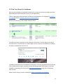
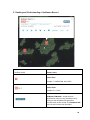
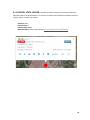
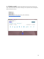
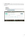
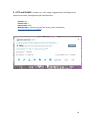
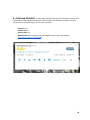
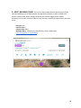
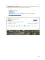
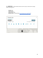
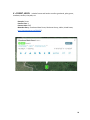
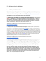
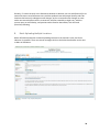
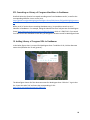
INSTRUCTIONS FOR ASSIGNING GEOSPATIAL METADATA USING GeoNames.org Developed by the Mountain West Digital Library Geospatial Discovery Task Force July 2015 1 This tutorial was developed as a result of work done by the Phase Three team members and committee co-chairs in the Mountain West Digital Library Geospatial Discovery Task Force, and relied heavily on work done by the member of the previous two phases. To see the documentation for previous work created by the task force, please see https://sites.google.com/site/mwdlgeospatial . For questions or comments, please contact one of the co-chairs listed below. Co-Chairs Kristen Jensen , Utah Department of Heritage and Arts, [email protected] Liz Woolcott , Utah State University, [email protected] Phase Three Team Members Anna Neatrour , Mountain West Digital Library Catherine McIntyre , Utah Valley University Library Greta Bahnemann , Minnesota Digital Library Jeremy Myntti , University of Utah Marriott Library Ken Rockwell , University of Utah Marriott Library Rachel Wittmann , Clemson University Library Ray Matthews , Utah State Library Sandra McIntyre , Mountain West Digital Library Scott Eldredge , Brigham Young University, Harold B. Lee Library Silvia Southwick , University of Nevada Las Vegas Libraries This work is licensed under the Creative Commons Attribution 3.0 United States License. It may be copied, distributed, transmitted, or adapted by others with proper attribution. To view a copy of this license, visit http://creativecommons.org/licenses/by/3.0/us/ or send a letter to Creative Commons, 171 Second Street, Suite 300, San Francisco, California, 94105, USA. 2 Table of Contents PART ONE - Specifications for Mountain West Digital Library I. Introduction ……………………………………………………………………………………………………………. .... 4 II. GeoNames Benefits ………..…………………………………………………………………………………..……... 4 III. Mountain West Digital Library Recommendations ……………...…………………………………..…. 4 A. Recommended Format ……………………………………………………………………………………..... 5 B. Additional Acceptable Formats …………………………………………………………………..……... 6 C. Non-recommended Formats ..…………………………………………………….…………………….….. 7 PART TWO - General Information about GeoNames IV. Find Your Record in GeoNames……………………………………………………………..……………....... 8 V. Reading and Understanding a GeoNames Record……………………………………………………... 9 VI. GeoNames Examples by Feature Classes and Codes ………………………..…………..………….. 12 VII. Instructions on Adding Locations to GeoNames …………………………..………………………..... 22 A. Adding Individual Locations .………………………………………………………………………………... B. Batch Uploading Multiple Locations …………………………………………………………………….. 22 23 3 VIII. Searching on Library of Congress Identifiers in GeoNames ………….…………………...…..… 24 IX. Adding Library of Congress URIs to GeoNames …………………………………..…...…………….... 24 I. Introduction The Mountain West Digital Library Geospatial Task Force has selected the GeoNames geographical database ( http://www.geonames.org/ ) as its preferred controlled vocabulary source of place names information after an extensive review process. Details about the work and decision making process of the Task Force and the final version of this document is available at https://sites.google.com/site/mwdlgeospatial . II. GeoNames Benefits Using GeoNames offers a number of advantages to the MWDL community: ● ● ● ● ● ● ● ● ● ● Linked Data ready Supports both current and historic place names Supports description of geographic features Supports geographic hierarchy for more granular descriptions Users with local geographic expertise can contribute place names to the database Place names are available in different languages International locations are included Includes built in links to additional information Disambiguates similar-sounding locations Includes inheritance of entities (can retrieve “parent”, “children” and “contains”) III. Mountain West Digital Library Recommendations When describing place names in your collection to be harvested by MWDL, we strongly recommend that your local place names field(s) be mapped to dcterms:spatial . Mapping to dcterms:spatial allows the geospatial information associated with your collection to be included in 4 MWDL and DPLA. For more information about mapping requirements please review the DPLA Metadata Application Profile and the MWDL Dublin Core Application Profile . This will also require that the metadata for your repository be provided via Open Archives Initiative Protocol for Metadata Harvesting (OAI-PMH) as qualified Dublin Core. If you are describing an item with multiple place names (for example, a letter mailed from one location to another) place a semicolon between the set of place names and/or URIs that apply to each individual location. This will ensure that distinct locations will be identified and represented accurately when MWDL provides data to DPLA. A. Recommended Format We strongly recommend the following format for best results for geospatial metadata in the harvested environment: Place names presented in a hierarchical structure from smallest to largest, separated by commas. Example: Phoenix, Maricopa County, Arizona, United States This is the minimal accepted format. We highly encourage the usage of URIs in addition to this place name hierarchy, using only commas to separate the hierarchy and the URI. The format for adding the URI to the place name information is to begin with the place name hierarchy, followed by a comma, and then add the URI at the end with a terminating slash. Example: Phoenix, Maricopa County, Arizona, United States, http://sws.geonames.org/5308655 / Please note that the URI should be given in the format of sws.geonames.org, which reflects the GeoNames RDF webservice, and is preferred over the general URL, which starts with www.geonames.org. For more detail, please see: https://geonames.wordpress.com/2006/10/21/semantic-web-concept-vs-document/ Including the GeoNames URI for the place provides a number of advantages for place names data moving forward: 1. DPLA will be able to generate more precise locations for your digital objects on its map interface at http://dp.la/map 2. Both MWDL and DPLA will have a foundation for future developments with Linked Data. MWDL prefers a hierarchy going in order from smallest to largest place. Example: Phoenix, Maricopa County, Arizona, United States, http://sws.geonames.org/5308655 / If you prefer to go in order from largest place to smallest place, that is also acceptable to DPLA: 5 Example: United States, Nevada, Mineral County, Aurora (historical), http://sws.geonames.org/5499519/ DO NOT enter semicolons to separate the parts of the place names hierarchy: Negative Example: United States; Nevada; Mineral County; Aurora (historical); http://sws.geonames.org/5499519/ While metadata entered in the format of this negative example may assist with faceting in a local CONTENTdm collection, it will prevent precise processing of the place names information in the harvested environment. Use semicolons only when separating the data for two or more distinct places, not within the data for a single place. B. Additional Acceptable Formats A GeoNames-derived place names hierarchy followed by a URI is the strongly recommended option. However, the metadata and geospatial needs of local collections may require different values. The following are alternate options for entering place names and geospatial information that are acceptable in situations dependent on the specific needs of a local collection. When creating your place names information remember: ● Use GeoNames as your controlled vocabulary. ● DO NOT place semicolons within a single string of a geospatial entity. ○ Negative example: Phoenix ; Maricopa County ; Arizona ; United States ; http://sws.geonames.org/5308655 / ○ Negative example: Phoenix, Maricopa County, Arizona, United States ; http://sws.geonames.org/5308655 / ● DO place semicolons between different geospatial entities in the same field: ○ Example: Phoenix, Maricopa County, Arizona, United States, http://sws.geonames.org/5308655 / ; Aurora (historical), Mineral County, Nevada, United States, http://sws.geonames.org/5499519/ ; ● If you include latitude and longitude, use decimal degrees. Place latitude first. Separate latitude and longitude with a comma. Do not use directional letters, e.g., “N”, “W”. ○ Example: 33.44838, 112.07404 Examples of alternate formats for place names information: 1. URI only: http://sws.geonames.org/5499519/ 2. Place names only: Aurora (historical), Mineral County, Nevada, United States 6 3. Latitude/longitude only: 38.28714, -118.9007 4. Latitude/longitude and place name: Aurora (historical), Mineral County, Nevada, United States, 38.28714, -118.9007, 5. All three (place name, URI, latitude, longitude) : Aurora (historical), Mineral County, Nevada, United States, http://sws.geonames.org/5499519/ , 38.28714, -118.9007, Choose a style for your place names metadata and be consistent within each collection. Consistency within a repository is highly desirable, but may not be practical given legacy data. C. Non-recommended formats Street Addresses GeoNames does not contain lookup information for individual street addresses. Currently DPLA has no way to ingest street address information. Therefore it is recommended that MWDL partners not include street address information in the dcterms:spatial field. MWDL partners can still include street address information in their metadata, but it is recommended that they leave it in an unmapped field. For partners who wish to record street address information, there are a number of options to consider: ● You may wish to look up the latitude and longitude for your street address and include that in your mapped metadata. ● You can include street addresses in an additional unmapped field in your collection for local use. ● Refer to the Historic Place record, as some of these records include the street address as part of the record (example: The White House). ● You might use the most specific available GeoNames record, even though it doesn’t get to the exact location of the street address: Salt Lake City, Salt Lake County, Utah, United States, http://sws.geonames.org/5780993 / If you have notable local locations with street addresses, consider updating GeoNames with information to reflect the places represented in your collection. For information on adding new content or editing existing GeoNames content, please see Section VIII: Instructions on Adding Locations to GeoNames in this document. 7 8 IV. Find Your Record in GeoNames Here are some examples of GeoNames vocabulary for a variety of scenarios you might encounter when adding descriptive metadata to items in your digital library. There is a great deal of documentation available on using GeoNames, for example the GeoNames User Manual and the GeoNames Web Services Documentation . Search for the location, in this example, Bisbee, Arizona: The third entry down is the town we are looking for. Click on the P icon (for place) to the left of the place name to view the place on a map and get a variety of options for Bisbee data, including the ability to download the rdf, kml, etc. The MWDL preferred format for GeoNames information is to list the geographic hierarchy in order from smallest place to largest. Include the unique identifying number for the place, in this case 5284905, by appending it to the base URL http://sws.geonames.org , along with a terminating slash, like this: Bisbee, Cochise County, Arizona, United States; http://sws.geonames.org/5284905/ 9 V. Reading and Understanding a GeoNames Record Snellman Island Feature name Feature Class Example: T = MOUNTAIN, HILL, ROCK Feature Code Example: ISL = Island GeoNames ID Number - unique numeric identification code for every GeoNames entry. Clicking on the ID Number will generate a permanent link to this record - the GeoNames URI. Note: the URI contains the ID number. 10 Example: http://www.geonames.org/5047733/snellman-isl and.html Geographic hierarchy (Country, State, County) Latitude, Longitude expressed in Decimal Degrees using the WGS 84 coordinate system Latitude, Longitude expressed in Degrees, Minutes, Seconds Adjust your location, move your cursor Update or edit the record Display the geographic administrative hierarchy, including Parents and Children Display the history of the record, including the date the record was last updated or edited Private tags Note: you must be logged in to add private tags to a record Delete Alternate names - lists any alternate names or name variations, with the names categorized as preferred, short, historical and colloquial 11 Display geotree hierarchy - displays the full range of named features within the context of feature class and code Google Earth expression of information about the feature Semantic web expression of information about the feature 12 VI. GeoNames Examples by Feature Classes and Codes All GeoNames features are categorized into one of nine Feature Classes. These nine Feature Classes describe different types of places. Each feature class is denoted by a single letter of the alphabet. In these instructions we have provided both definitions and examples of the 9 Feature Classes, as well as some representative examples of Feature Codes that correspond to each class. These examples illustrate a variety of scenarios that you may encounter when adding descriptive metadata to items in your digital library. 9 FEATURE CLASSES: A = COUNTRY, STATE, REGION H = STREAMS and LAKES L = PARKS and AREAS P = CITY and VILLAGE R = ROAD and RAILROAD S = SPOT, BUILDING, FARM T = MOUNTAIN, HILL, ROCK U = UNDERSEA V = FOREST, HEATH These 9 Feature Classes are further subcategorized into one of 645 Feature Codes. Feature Codes describe things at a more granular level. The Feature Code is expressed by a unique alpha/numeric 2-, 3- or 4-digit sequence. For a complete list of the 645 Feature Codes please refer to the following list: GeoNames Feature Codes - http://www.geonames.org/export/codes.html GeoNames User Manual - http://www.geonames.org/manual.html This is the user manual developed and maintained by GeoNames. The manual presents information using screenshots and covers the following topics : ● ● ● ● ● Information window E dit GeoNames - basic information M ove point E dit alternate names Add a new place name to the GeoNames database GeoNames Web Services Documentation - http://www.geonames.org/export/web-services.html 13 A = COUNTRY, STATE, REGION - includes the primary division of a country, such as an individual state in the United States or a province in Canada. Also includes leased areas, political entities, parish, territories and zones. Example: State Feature Class: A Feature Code: ADM1 Metadata Entry: Idaho, United States, http://sws.geonames.org/5596512/ 14 H = STREAMS and LAKES - includes water-bodies such as oceans, lakes, marshes, coral reefs, and streams as well as bays, banks, anchorages, canals, aqueducts, docks, docking basins, ditches, tidal creeks, reefs, etc. Example: Lake Feature Class: H Feature Code: LK Metadata Entry: Fish Lake, Sevier County, Utah, United States, http://sws.geonames.org/5539176/ 15 L = PARKS and AREAS - includes city and state parks, Native American reservations and tribal areas, nature reserves, wildlife reserves, historical regions, military bases and battlefields, arctic lands, etc. Example: Park Feature Class: L Feature Code: PRK Metadata Entry: Bear Lake National Wildlife Refuge, Bear Lake County, Idaho, United States, http://sws.geonames.org/5585007/ 16 P = CITY and VILLAGE - includes a city, town village or agglomeration of buildings where people live and work, including destroyed populated places. Example: City Feature Class: P Feature Code: PPLA Metadata Entry: Salt Lake City, Salt Lake County, Utah, United States, http://sws.geonames.org/5780993 / 17 R = ROAD and RAILROAD - includes both road and railroads (and associated rail terms such as railroad junctions, abandoned railroads, railroad yards). Also includes oil pipelines, tunnels, stock routes as well as portages, ancient roads, and trails. Example: Trail Feature Class: R Feature Code: TRL Metadata Entry: Echo Canyon Trail, Washington County, Utah, United States, http://sws.geonames.org/5538780 / 18 S = SPOT, BUILDING, FARM - This is one of the broadest feature classes and it includes individual buildings such as administrative and agricultural facilities as well as airfields and airports, athletic fields, banks, bridges, boatyards, bus stations, logging camps, castles, cemeteries, universities, museums, libraries, zoos, theaters, stadiums and post offices, and many more. Example: Arch Feature Class: S Feature Code: ARCH Metadata Entry: Delicate Arch, Grand County, Utah, United States, http://sws.geonames.org/5538068 / 19 T = MOUNTAIN, HILL, ROCK - includes natural features such as mountains and hills as well as beaches, canyons, islands, peninsulas, points, valleys, volcanoes, etc. Example: Valley [Canyon] Feature Class: T Feature Code: VAL Metadata Entry: Emigration Canyon, Salt Lake County, Utah, United States, http://sws.geonames.org/5774500/ 20 U = UNDERSEA - includes undersea features such as canyons, continental rises, ridges, fracture zones, gaps, etc. Example: Gap Feature Class: U Feature Code: GAPU Metadata Entry: Romanche Gap, http://sws.geonames.org/2522553 / 21 V = FOREST, HEATH - includes forests and heaths as well as grasslands, palm groves, meadows, tundras, vineyards, etc. Example: Forest Feature Class: V Feature Code: FRST Metadata Entry: Floodwood State Forest, Shoshone County, Idaho, United States, http://sws.geonames.org/5593277 / 22 VII. Adding Locations to GeoNames A. Adding Individual Locations There are two ways to add a single location to GeoNames.org. Below are instructions on how to add locations in both ways. Please note, you must be logged into GeoNames.org in order to add locations. As a shortcut, doing a ctrl + F function in the master list of location classes and codes can be quicker than using the dropdown menus in the user interface. 1. Adding a location record based on by finding the exact location on the map. Simply perform a ‘search’ on the location from the Geonames homepage. Then find the exact spot on the map of the location that you would like to add and right click on the map and select “Insert new name here.” The pop-up record will automatically fill in the latitude and longitude, the user then fills out the rest of the record: Name, class, code, elevation, timezone, etc. The following is a video tutorial on how to add a location in this manner. https://youtube/hl7vLyQNWZk 2. Adding a location record with the latitude and longitude. Perhaps you are unable to find an exact location on the GeoNames map interface due to ambiguous location data. Sometimes it is easier to find the exact latitude and longitude via Google Maps than to pinpoint the exact spot in GeoNames. In order to add a location to GeoNames with latitude and longitude, you will perform a search on GeoNames.org for the broad place name your location might be in. When performing this search click ‘show on map ’ in the main query box. From here you then select the icon to add a new location on the left pane, then click on the gps which will allow you to add latitude and longitude, and then proceed to fill out the remainder of the record. The following is a video tutorial on how to add a location in this manner: https://youtu.be/9ZGGUDFmdTo 3. Treatment of places that have changed their identity over time. Suppose a location, such as an urban building or landmark, has undergone a major change so that it has changed both its name and its feature type. An example is the building in downtown Salt Lake City opened as the Hotel Utah in 1911. It closed as a hotel in 1987 and was remodelled and repurposed as an office building for the Church of Jesus Christ of Latter-day Saints. It was renamed the Joseph Smith Memorial Building. One could create a record for the building under its modern name, with an Alternative name. The problem is that one cannot change the Class and Feature types. In this case, the class remains the same (S = spot, building, farm), but the current code is BLDO (office building), whereas it was previously a hotel (HTL). To get around this, one may create a separate location entry in Geonames for the same location, following its name with the word historical in parentheses. This separate record could then be used for resources that deal with the former identity, such as old photographs of the Hotel Utah. 23 Similarly, if a name currently in the Geonames database is obsolete, one can add (historical) to its name and create a new Geonames entry with the updated name and proper identity code. But locations that have only undergone name changes, such as a restaurant that changes its name under new ownership but remains a restaurant, could be treated by a single entry, with the current name as main identity, and previous names listed as alternatives, with the word (historical) following. B. Batch Uploading Multiple Locations While official documentation on batch uploading locations in the manual is scant, the forum indicates it is possible. There are several messages similar to the below that batches can be sent to Marc at GeoNames. 24 VIII. Searching on Library of Congress Identifiers in GeoNames Stanford University Libraries has started recording terms from GeoNames and LC, as well as the corresponding identifies into a csv file, here: https://github.com/geoblacklight/geoblacklight-schema/blob/master/lib/geoblacklight/gazetteer. csv While not all LC entries have a matching GeoNames entry, it is possible to search on an LC identifier in GeoNames. For example, taking the identifer for the LC subject term for Washington (State) http://id.loc.gov/authorities/names/n79027224.html , which is ‘n79027224’. If you search on n79027224 in the GeoNames search box, you will get the location record for Washington State. IX. Adding Library of Congress URIs to GeoNames In the below figure, there is a record for Washington State. To add the LC ID, click the Alternate names icon (between the 'X' and 'geotree'). The below figure shows all of the alternate names for Washington State. Click the '+' sign in that list, choose the code 'link' and insert the corresponding LC URI: http://id.loc.gov/authorities/names/n79027224 25 26