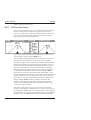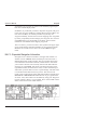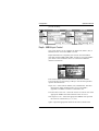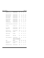
1
MX400 GPS Navigator
Operator’s
Manual
MADE TO MEASURE
Operator’s Manual
DGPS Navigator
Version 3.3
MX400 Series GPS
MX400
MX400B
MX412
MX412B
MX412BR
Product Information
The model and serial number of your instrument are given on
the instrument. Enter the model and serial number in the
spaces provided below. Always refer to this information
when you contact your dealer.
Receiver Serial No.:______________
Part No.: _______________
Document No. 10500MAN
Symbols Used In This Manual
!
Danger
Indicates an imminently hazardous situation which, if not avoided,
will result in death or serious injury.
Warning
!
Indicates a potentially hazardous situation which, if not avoided,
could result in death or serious injury.
Caution
!
Indicates a potentially hazardous situation which, if not avoided,
may result in minor or moderate injury and/or appreciable material,
financial and envirtonmental damage. This symbol is also used to
alert against unsafe practices.
Important paragraphs which must be adhered to in practice as they
enable the product to be used in a technically correct and efficient
manner.
!
This manual contains important safety directions as well as instructions for setting up the instrument and operating it. Read carefully
through the Operator’s Manual, Options Manual, and Installation
& Service Manual before you switch on the instrument.
Scope Of This Manual
This manual reflects the software capabilities in version 3.2
software.
We have attempted to take care and develop manuals which provide
in-depth information. Where possible, we have attempted not only
to describe what you see on the screen, but how to understand or
use it as well. Obviously, we can’t teach you how to navigate, but
we can help make your work more thorough and enjoyable.
Throughout the manual, you will find helpful hints about the
interaction of various functions. In a piece of equipment that has the
many capabilities of this receiver, important details can sometimes
become obscured in one or two lines of text. In our effort to ensure
you get the most out of this documentation, and protect against
important details becoming lost, don’t be surprised if you see the
same or similar information more than once.
This manual is organized by describing the special front panel
features first. The sections that follow detail each primary function
as it is presented on the front panel (i.e. NAV, RTE, WPT, PLOT,
...CFG). The appedixes describe important details about special
functions. Details of any product options that are available at an
additional modest price are provided in a separate Options Manual
(see Related Documents below).
We hope you find the manual enjoyable and informative reading.
As always, we welcome your comments on improving our products
or manuals. We wouldn’t mind if you wrote to tell us that we did
the job right the first time either. You can find a Reader Comment
Card at the back of the manual.
Related Documents
Installation & Service Manual (P/N 10501MAN)
How To Contact Us
For Installation, Service, & Technical Support:
Contact your local Leica dealer
For Sales of accessories:
Contact your local Leica dealer
For Hardware and Software Upgrades:
Contact your local Leica dealer
Unlike many other consumer electronics industries which only sell
consumer electronic devices, your marine dealer is often your best
advisor for installation and service of your new GPS receiver. Leica
strongly encourages you to utilize the knowledge and experience of
your sales and service dealer.
Should you need to contact us directly, we can be reached at the
following for new sales, upgrades, repair service, or technical
support:
International:
Leica Geosystems
GPS
23868 Hawthorne Blvd.
Torrance, California 90505
USA
+01-310-791-5350 Telephone (International)
1-800-97-LEICA (1-800-975-3422) Telephone (USA)
+01-310-791-6108 Fax
[email protected]
In Europe:
Leica Geosystems
A/S
Høkær12A
DK-2730 Herlev
Denmark
+45-44-54-03-00Telephone
+45-44-54-03-30 Sales Fax
Table of Contents
Operator’s Manual
Table of Contents
Product Information ........................................................................ i
Product Information ........................................................................ i
Symbols Used In This Manual ........................................................ii
Symbols Used In This Manual ........................................................ii
Scope Of This Manual ................................................................... iii
Related Documents ....................................................................... iii
Scope Of This Manual ................................................................... iii
Related Documents ....................................................................... iii
How To Contact Us ........................................................................iv
How To Contact Us ........................................................................iv
About GPS Navigation ................................................................ 1
Special Notes ................................................................................ 2
GPS ............................................................................................. 2
DGPS ........................................................................................... 2
Charts and Navigational Aids ....................................................... 3
Functional Description ................................................................ 4
Receiver Configurations .................................................................. 4
6 Channel GPS ............................................................................. 4
6 Channel GPS With Built-in Beacon ............................................ 4
12 Channel GPS ........................................................................... 4
12 Channel GPS With Built-in Beacon .......................................... 5
6 Channel Dual Control ................................................................. 5
12 Channel Dual Control ............................................................... 5
12 Channel Dual Control Integrity Monitor .................................... 6
DGPS Beacon System ............................................................... 8
Version 3.3
i
Operator’s Manual
Table of Contents
Keypad & Display Description................................................... 10
Differential GPS Traffic Light Operation: ..................................... 11
Red Flashing .............................................................................. 11
Red/Yellow Solid ........................................................................ 11
Red Solid ................................................................................... 11
Yellow/Green Solid ..................................................................... 11
Yellow Solid ................................................................................ 12
Green Solid ................................................................................ 12
GPS Traffic Light Operation: ....................................................... 12
Red Flashing .............................................................................. 12
Red/Yellow Solid ........................................................................ 13
Red Solid ................................................................................... 13
Yellow Solid ................................................................................ 13
Green Solid ................................................................................ 13
The Display: ................................................................................ 14
The Softkeys: ..................................................................... 14
The Function Keys: ..................................................................... 14
Mark Position .................................................................. 15
GOTO
O ............................................................................. 15
LIGHT ............................................................................. 15
POWER ON/OFF ............................................................ 16
MAN OVER BOARD (MOB) ........................................... 16
E
E (EDIT) .......................................................................... 17
C
C (CLEAR) ...................................................................... 18
CURSOR ........................................................................ 18
1
N AV
ABC
ii
FUNCTION ..................................................................... 18
Version 3.3
Table of Contents
Operator’s Manual
Navigate ................................................................................... 20
Dead Reckoning ............................................................................ 21
NAV1 - The Panorama Screen ...................................................... 22
NAV2 - Basic Steering Information ................................................ 24
NAV 3 - Expanded Navigation Information .................................... 26
NAV4 - Sensor Input Navigation .................................................... 27
Route ........................................................................................ 31
RTE1 - The Active Route ............................................................... 32
Creating A Route Using The GOTO Key: .................................... 33
Erasing An Existing Route ........................................................... 36
Creating A Multi-Waypoint Active Route ...................................... 37
Insert By Number ........................................................................ 38
Choose In Bank ........................................................................... 39
Insert New Waypoint ................................................................... 40
Insert Route ................................................................................. 41
Maneuvering Within The Route ................................................... 42
Scrolling ..................................................................................... 42
Skipping and Unpassing Waypoints ........................................... 42
Inserting Waypoints or Routes Into An Existing Route ............... 43
Reversing The Active Route ....................................................... 46
ETA Setup ..................................................................................... 47
SOG Based on Arrival Date & Time: ........................................... 48
ETA Based on Speed: ................................................................. 48
RTE2 - The Route Bank ................................................................ 49
Waypoint................................................................................... 51
Creating And Editing Waypoints .................................................... 52
Waypoint Lock/Unlock ................................................................. 57
To lock a waypoint ...................................................................... 58
To unlock a waypoint .................................................................. 58
To lock all waypoints .................................................................. 59
To unlock all waypoints .............................................................. 59
Version 3.3
iii
Operator’s Manual
Table of Contents
Removing Waypoints..................................................................... 60
Moving waypoints .......................................................................... 61
Downloading Waypoints & Routes To Other Devices .................... 63
Rnn - Routes: ............................................................................. 63
RTE - Active Route: .................................................................... 64
WPL - Waypoint Location - NMEA 0183 Standard: .................... 65
WPL - Waypoint With Symbols &
Description - NMEA 0183 Expanded: .................................. 65
Downloading Waypoints To A Personal Computer ...................... 66
Uploading Waypoints From Other Devices .................................... 68
Uploading Waypoints From A Personal Computer ...................... 69
Mark or Event .................................................................. 71
GOTO
O .............................................................................. 72
Plot ........................................................................................... 75
PLOT 1 - Relative To Boat ............................................................. 77
Modifying The Active Route Using The Plot Screen .................... 77
Customizing The Display ............................................................. 79
PLOT 2 - Relative To Marker ......................................................... 82
Plot Screen Use Examples ............................................................ 82
Station Keeping ........................................................................... 82
Grid Search ................................................................................. 83
Man Over Board ............................................................... 85
Remote MOB ................................................................................ 86
Tide .......................................................................................... 87
TIDE1 - Current Tide Display ........................................................ 87
TIDE2 - Tide Table Port List .......................................................... 88
Adding A Port ................................................................................ 90
iv
Version 3.3
Table of Contents
Operator’s Manual
Auxiliary .................................................................................... 92
AUX1 - Alarm Log ...................................................................... 92
AUX2 - Speed Graph .................................................................. 93
AUX3 - Fuel Information .............................................................. 93
AUX4 - Sun Almanac ................................................................... 94
AUX5 - Moon Phases .................................................................. 94
AUX6 - Batteries .......................................................................... 94
AUX7 -Unit Information ............................................................... 95
Position..................................................................................... 96
POS1 - Large Position Display ...................................................... 97
Loran-C ....................................................................................... 97
User Grid ..................................................................................... 98
UTM ............................................................................................. 98
Decca .......................................................................................... 99
POS2 - Position, Altitude, Magnetic Variation, & Time .................. 99
POS3 - Position & Log ................................................................ 100
GPS ........................................................................................ 102
GPS1 - Current Satellite Status ................................................... 102
For 6 Channel GPS Models ...................................................... 102
For 12 Channel GPS Models .................................................... 104
GPS2 - GPS Health (All Models) ................................................. 105
DGPS ..................................................................................... 109
DGPS1 - Current DGPS Correction Status ................................. 109
DGPS3 - DGPS Messages ......................................................... 112
Version 3.3
v
Operator’s Manual
Table of Contents
Configuration .......................................................................... 113
Alarms ......................................................................................... 113
Anchor - Anchor Watch Alarm ..................................................... 114
COG SOG - Course & Speed Filter Settings & Setup ................. 114
Compass - External Compass Input & Magnetic
Variation Table ...................................................................... 115
Datum - Current Position Calculation .......................................... 116
Depth - NMEA Input Control ........................................................ 117
DGPS - Differential Correction Input Control ............................... 118
DR - Dead Reckoning ................................................................. 121
Dual Contr. - Dual Station Control ............................................... 123
Fuel - Fuel Input Calibration & Control ........................................ 123
GPS - Elevation Mask & Antenna Offset Control ......................... 125
Init Pos - Initial Position Entry ...................................................... 126
Language - Foreign Language Setup .......................................... 127
Lighting - Display/Keyboard Light & Contrast Control ................. 128
Log - Speed Log Input (Pulse or NMEA 0183) ............................ 129
Log Pulses - GPS SOG Log Pulse Output .................................. 131
MX 480 - MX 480 PC Chart Interface Control ............................. 131
Navigation - Navigation Method & Waypoint Pass
Criterion Control .................................................................... 131
NMEA Out 1 thru 4 - NMEA 0183 Output Data Control ............... 135
Other Special Cases Affecting NMEA 0183 Records: ............... 140
Operation - General Setup And Control Settings......................... 141
Organizer - Automated Message Reminders .............................. 143
Position - Positioning Reference, Mode, & Alarm Control ........... 144
Printout 2 - Printer Output Control ............................................... 146
vi
Version 3.3
Table of Contents
Operator’s Manual
Security ....................................................................................... 149
Set & Drift .................................................................................... 149
SJB - Smart Junction Box Control ............................................... 150
Time - Mode And Format Control ................................................ 152
Wind ............................................................................................ 153
Wpt & Rte Input - Uploading Waypoints Into the receiver ........... 154
Appendix A - Datum List ......................................................... 155
Appendix B - Beacon List ....................................................... 162
Appendix C- Engineering Mode .............................................. 175
AUX7 - Unit Information & Self Test ............................................ 175
Receiver Cold Start - Clearing Memory To Factory Default ......... 177
GPS - GPS Receiver Troubleshooting ........................................ 178
GPS6 - Visible Satellite Information .......................................... 178
GPS7 - GPS Position Uncertainty ............................................... 179
GPS8 - Oscillator Offset Temperature Curve Fit .......................... 180
GPS9 - GPS Debug Screen ........................................................ 181
DGPS8 - Beacon Receiver Status .............................................. 183
Beacon Signal Scope .................................................................. 184
Appendix D - Dual Control Head Mode ................................... 186
Turning Master And Slave Units Off ............................................ 188
Appendix E - Demonstration Mode ......................................... 189
Appendix F - Software Updates .............................................. 191
Glossary ................................................................................. 196
Version 3.3
vii
Operator’s Manual
viii
Table of Contents
Version 3.3
About GPS Navigation
Operator’s Manual
About GPS Navigation
This GPS receiver is a precision navigation instrument utilizing the
latest technology available today to provide optimum performance
from the GPS satellite and Beacon land signals received. As with all
other forms of radio signals, the ultimate navigation result is
dependent upon the quality of these signals. Radio signals may, on
occasion, be distorted, jammed, or otherwise incorrect. As a result,
your position accuracy may occasionally be less than that which can
normally be expected.
!
The Navstar Global Positioning System, commonly referred to as
GPS, is a satellite navigation system developed by the U.S. Department of Defense to provide both military and civilian users with
highly accurate, worldwide, three dimensional navigation and time.
By receiving signals from orbiting GPS satellites, authorized users
are able to continuously navigate with an accuracy on the order of
16 meters or better, while civilian users are limited to accuracy’s of
approximately 100 meters 2D RMS.
A technique referred to as Differential GPS (DGPS), allows users to
obtain maximum accuracy from the GPS system. DGPS requires
the use of two GPS receivers. One receiver, known as the Reference
Station, is placed at a surveyed location, the coordinates of which
are precisely known. The purpose of the differential GPS system is
to use the reference station to measure the errors in the GPS signals
and to compute corrections to remove the errors. The corrections
are then communicated in real-time to the navigators, where they
are combined with the satellite signals received by the navigators,
thereby improving their navigation or positioning. This technique is
effective because many of the errors at the reference station and
navigators are common. The geographic validity of these corrections decreases with distance from the reference station, but the
corrections are valid for navigators hundreds of kilometers from the
reference station.
In order to set up a DGPS system, the user must have a GPS
reference station at a precisely known location, a DGPS navigator,
and a communication link to transmit the pseudorange corrections.
Leica has pioneered the development of the DGPS Beacon System.
This system allows the user to benefit from the accuracy of DGPS
without the need to purchase and maintain a complete DGPS
System (reference stations, transmitting equipment, as well as
Version 3.3
1
Operator’s Manual
About GPS Navigation
receiving equipment, and navigators).
Marine radio beacons operating in the 283.5 to 325.0 KHz frequency range are in widespread use for direction finding in coastal
navigation. Because the beacon system has been in place and
widely used for many years, it provides an effective means for the
transmission of DGPS signals. Depending on their local environment and power output, their signals may be usable to several
hundred miles. Marine beacons provide an economical means of
obtaining DGPS accuracy for coastal navigators. GPS receivers
with built-in beacon receivers are designed to provide low cost
reception of DGPS corrections broadcast (normally free of charge)
by coastal authorities.
Special Notes
GPS
!
Never rely solely on any single navigational aid. Always use
whatever information is available, and cross-check information
when possible. GPS expected position accuracy is better than 100
meters (95% of the time); but may be up to 300 meters occasionally. The derived speed and course readings may be hampered
accordingly. The GPS system was declared operational in 1994,
however, the system’s availability and accuracy are subject to
change at the discretion of the US Department of Defense.
DGPS
!
This GPS receiver’s position accuracy is improved to 5 meters or
better for 95% of the time, subject to the availability, accuracy, and
control of the DGPS correction transmission from the Beacon
Station, or other reference station connected at the time of usage.
The differential GPS position is that of the navigator GPS antenna,
and not that of the beacon antenna, if a separate beacon antenna is
in use. In addition, the beacon radio signal which carries the DGPS
corrections may be hampered by weather conditions such as heavy
rain, snow, and thunder storms. The beacon radio signal may also
be interrupted by powerful radio transmitters operating in long
2
Version 3.3
About GPS Navigation
Operator’s Manual
wave length bands.
Charts and Navigational Aids
!
Version 3.3
Positions obtained from charts are not always as accurate as your
navigator (due to environmental changes, the dates of charts, and
datum offsets if the datum differs from the one in use by the
navigator). The position of a floating aid can differ due to tide, set
and drift.
3
Operator’s Manual
Functional Description
Functional Description
Receiver Configurations
This GPS receiver is available in six basic configurations, identified
by product description and part number. Refer to the Auxiliary Unit
Information section of the manual to view sample screens to
identify your particular model.
6 Channel GPS
The basic 6 channel GPS navigator is capable of receiving DGPS
corrections in the RTCM SC-104 version 2 format via one of the
four input data ports. However, it does not have an internal marine
beacon DGPS receiver. This model is supplied with a GPS only
Volute, Discus, or Globe style antenna. Should you decide at a later
date to upgrade your receiver to a GPS with Built-in Beacon, the
display unit must be returned to the factory to install the appropriate
components and software. In addition, a separate whip, loop
(optional), or combined (optional) antenna is supplied with the
upgrade. This model can be upgraded to a 12 channel GPS model in
the field, by purchasing a 6 channel baseband daughter board (P/N
10502).
6 Channel GPS With Built-in Beacon
This is a standard 6 channel DGPS navigator with an integrated
internal beacon receiver. It is capable of receiving DGPS corrections in the RTCM SC-104 version 2 format via its internal marine
beacon DGPS receiver, or via one of the four input data ports. This
model is supplied with a GPS and Loop (H-Field) combined Discus
style antenna. A separate (optional) whip or loop antenna may be
used with this model; however, an additional internal cable must be
installed in this configuration. This model can be upgraded to a 12
channel GPS model in the field, by purchasing a 6 channel
baseband daughter board (P/N 10502).
12 Channel GPS
This is a 12 channel GPS upgraded version of the basic 6 channel
GPS navigator. It is capable of receiving DGPS corrections in the
RTCM SC-104 version 2 format via one of the four input data
4
Version 3.3
Functional Description
Operator’s Manual
ports. However, it does not have an internal marine beacon DGPS
receiver. This model is supplied with a GPS only Volute, Discus, or
Globe style antenna. Should you decide at a later date to upgrade
your 6 channel to a 12 channel receiver or your 12 channel receiver
to a 12 channel with built-in beacon, the display unit must be
returned to the factory to install the appropriate components and
software. In addition, a separate whip, loop (optional), or combined
(optional) antenna is supplied with this upgrade.
12 Channel GPS With Built-in Beacon
This is a 12 channel GPS upgraded version of the standard 6
channel with built-in beacon DGPS navigator. It is capable of
receiving DGPS corrections in the RTCM SC-104 version 2 format
via one of the four input data ports, or via its internal marine beacon
DGPS receiver. This model is supplied with a GPS and Loop (HField) combined Discus style antenna. A separate (optional) whip or
loop antenna may be used with this model, however, an additional
internal cable must be installed in this configuration.
6 Channel Dual Control
This is an enhanced 6 channel DGPS navigator. Two GPS receivers
are actually supplied, one 6 channel GPS (operating as a slave unit)
and one 6 channel with built-in beacon (operating as a master unit)
with one GPS and Loop (H-Field) combined Discus style antenna.
It is capable of receiving DGPS corrections in the RTCM SC-104
version 2 format via one of the four input data ports, or via its
internal marine beacon DGPS receiver. This configuration allows
data to be shared between two remotely separated stations (i.e.
navigator’s station and helmsman’s station), with independent
access to various information fields. The 6 channel GPS unit gets its
positioning information from the 6 channel GPS with built-in
beacon unit, but can be connected to the antenna independently and
calculate its own position as a back-up GPS receiver. This model
can be upgraded to a 12 channel GPS model in the field, by
purchasing a 6 channel baseband daughter board (P/N 10502).
12 Channel Dual Control
This is a 12 channel GPS upgrade to the enhanced 6 Channel Dual
Control configuration. It is a dual head DGPS system where two
GPS receivers are actually supplied, one 6 channel GPS (operating
Version 3.3
5
Operator’s Manual
Functional Description
as a slave unit) and one 12 channel with built-in beacon (operating
as a master unit) with one GPS and Loop (H-Field) combined
Discus style antenna. It is capable of receiving DGPS corrections in
the RTCM SC-104 version 2 format via one of the four input data
ports, or via its internal marine beacon DGPS receiver. This
configuration allows data to be shared between two remotely
separated stations (i.e. navigator’s station and helmsman’s station),
with independent access to various information fields. The 6
channel GPS gets its positioning information from the 12 channel
with the built-in beacon, but can be connected to the antenna
independently and calculate its own position as a back-up GPS
receiver.
12 Channel Dual Control Integrity Monitor
This is an enhanced to the 12 Channel Dual Control configuration.
It is a dual control DGPS system where two DGPS receivers are
supplied, one 12 channel with built-in beacon (operating as a slave
unit) and one 12 channel with built-in beacon (operating as a master
unit) with two GPS and Loop (H-Field) combined Discus style
antennas. It is capable of receiving DGPS corrections in the RTCM
SC-104 version 2 format via one of the four input data ports, or via
its internal marine beacon DGPS receiver. This configuration
allows data to be shared between two remotely separated stations
(i.e. navigator’s station and helmsman’s station), with independent
access to various information fields. The purpose of this configuration is for each receiver to calculate its own position, then to check
the operational status of the other GPS receiver. The GPS receiver
with the best overall operational status then provides the system
position. This provides a fully redundant system, with self-recovery
capabilities. The Integrity Monitor function can be set to Automatic
switchover, forced to the Master unit, or forced to the Slave unit for
position and navigation functions.
The Installation & Service Manual has more details on the parts
supplied with each configuration, and their associated part numbers.
Beyond the physical differences between these models, the operating software is exactly the same, except where the hardware
differences mentioned above come into play. Expect to find these
6
Version 3.3
Functional Description
Operator’s Manual
differences detailed in the GPS, DGPS, & CFG sections of the
manual.
Note: In general, this manual will refer to all versions
of this product line simply as the receiver,
navigator, or GPS. Where distinction between
models is necessary, the particular model type
will be called out.
Version 3.3
7
Operator’s Manual
Functional Description
DGPS Beacon System
As Maritime Safety Administrations, Navy, and Coast Guard
Organizations realize the limitations of standard GPS positioning,
many have begun installing DGPS Beacon Stations. While an
understanding of this system is not necessary for operating receivers with internal beacon receivers, you may want to read on to have
a better understanding of how your receiver is capable of achieving
the high levels of accuracy made possible by this network of
transmitters.
The DGPS Beacon System is comprised of three segments; the
reference station, Integrity Monitor (IM) equipment located at the
beacon site and the Navigator equipment located on board the
user’s boat or vehicle. The DGPS beacon system design is illustrated below.
Navigator Site
M X 9 400N
DGP S
Na vig at or
M X400 Professional DGPS Navigato r
RT E
NAV
WP T
P L O TT I D E
P O S
G P S
AUX
DGP S
E
C F G
C
MX 51R
Integrity Monitor Site
Surveyors / Commercial
Users
Professional / Commercial /
Personal Craft Users
Reference Station Site
M X 9 40 0 R
DGP S
R efe re nce
MX 50M
DG P S B e a c o n Mo d u l a t o r
5271-01C.500
8
Version 3.3
Keypad & Display Description
Operator’s Manual
Because of the limited range of the beacon transmitters, typically
150 to 400km, the corrections generated by the reference station are
always valid for users who can receive the correction signals and
maintain a 5 meter or better accuracy figure. Just like the satellite
segment which maintains in-orbit spare satellites, most beacon
stations operate two live running GPS reference stations. One
reference station normally broadcasts into the air for you to receive,
the other GPS receiver normally broadcasts into a dummy load,
through a secondary transmitter. That means there is always a backup or standby beacon transmitter and reference station ready to
transmit should the primary fail. Each reference station is normally
assigned a unique ID number (i.e. Pt. Loma, San Diego operates
IDs 262 and 263), so you can always tell if you are on the primary
or back-up system. In addition to the standby back-up system,
virtually all beacon stations are connected to an integrity monitor
receiver and computer. The integrity monitor is normally placed at
a remote location from the transmitter site to monitor the signal
strength of the transmitter, as well as the accuracy of the corrections
being transmitted. If the accuracy of the corrections falls outside a
predetermined radius (usually 5 meters), the computer automatically generates a warning message. The warning message is then
sent to the reference station, either by radio or landline, and the
warning message is broadcast to the user community. Some
agencies have opted to install the integrity monitor at the same
location as the transmitter. Some agencies have also created central
monitoring systems which monitor multiple beacon transmitter
stations to ensure network integrity. Operators maintaining the
beacon station equipment may also create their own unique messages to broadcast planned outages or other important information.
When a message is received, you will be notified with an alarm
indication. You can then view the received message in the DGPS3
screen.
Version 3.3
9
Operator’s Manual
Keypad & Display Description
Keypad & Display Description
Traffic
Lights
Display
Function Keys
N AV
RT E
WPT
PLOT
TID E
AUX
PO S
GP S
DGPS
E
CFG
C
6289-01A.400
Softkeys
Cursor Key
Refer to the illustration above. The Traffic Lights on the left side
of the display will tell you how your navigator is operating.
Note: You need to take care in reading the traffic light
indications, as there are overlapping possibilities between the GPS and DGPS modes. If you
are unsure of the current operating mode,
select the CFG function key and scroll down to
the DGPS selection. If the DGPS mode is
selected to anything other than Off, then follow
the Differential GPS Traffic Light Operation. If
the DGPS mode is selected to Off, then follow
the GPS Traffic Light Operation.
Differential GPS Traffic Light Operation:
10
Version 3.3
Keypad & Display Description
Operator’s Manual
Red Flashing
!
not tracking satellites (no position update). This is normally for the
first 2 minutes or so when turning the unit on. The very first time
you turn the unit on, or if the memory is reset or lost, this condition
is also normal. Allow the receiver to run for at least 30 minutes
under these circumstances. If it still does not change to Red Solid,
refer to the troubleshooting section of the Installation & Service
Manual. An icon similar to the one at left will be displayed in the
upper left corner of screen.
Red/Yellow Solid
!
Dead Reckoning . When normal GPS or DGPS operation is not
available, this LED sequence is provided to quickly identify the DR
navigation mode. A DR indicator is also displayed on all screens.
Red Solid
!
tracking one or more satellites (no position update). This is also
normal for the first 2 minutes or so when turning the unit on. The
very first time you turn the unit on, allow the receiver to run for at
least 20 minutes after changing to Red Solid to collect an almanac
from the satellites, regardless of whether a position update has been
calculated or not. This is also a normal indication if the HDOP is
greater than 10, if the receiver is tracking too few satellites, or other
reasons as well. Read the GPS and DGPS function screens for
more information.
Yellow/Green Solid
GPS position update; DGPS corrections are not being received.
You may see this from time to time during normal operation. It
usually occurs when the beacon signal is not available (either it is
being blocked by terrain or a local object or you are out of range of
the transmitter) and/or you are tracking 3, 4, or 5 satellites, and the
satellites have poor geometry relative to your position. If you are
patient, the condition will normally go back to Green Solid, when
you pick up another beacon station. The factory default level for
dropping DGPS corrections is 60 seconds. During this period, your
positioning information is less than optimal, and position accuracy
may be off by as much as 75 to 300 meters. Press the DGPS
function key and refer to the DGPS section in this manual for
guidance if this light condition occurs.
Yellow Solid
DGPS position update with poor HDOP value. You may see this
Version 3.3
11
Operator’s Manual
Keypad & Display Description
from time to time during normal operation. It usually occurs when
you are tracking 3, 4, or 5 satellites, and the satellites have poor
geometry relative to your position. If you are patient, the condition
will normally go back to Green Solid, when you pick up another
satellite, or the geometry of the existing satellites improves. The
factory default level for this indication is with an HDOP of 4 to 10.
During this period, your positioning information is less than
optimal, and position accuracy may be off by as much as 10 to 50
meters. You can press the GPS function key and refer to the GPS
section in this manual for guidance if this light condition occurs.
Green Solid
DGPS position update with HDOP value less than 4. This is the
normal operating condition. Position accuracy is normally better
than 5 meters. Keep in mind that position accuracy is always only
as good as the corrections received, their age, your distance from
the reference station, and the geometry of the satellites. This is the
normal operating condition and no icon will be displayed.
!
Note: If you or a crew member changes the
DGPS mode to Off in the CFG1 DGPS
screen, you will also not have an icon and
the LED will be green.
GPS Traffic Light Operation:
Red Flashing
!
not tracking satellites (no position update). This is normally for the
first 2 minutes or so when turning the unit on. The very first time
you turn the unit on, or if the memory is reset or lost, this condition
is also normal. Allow the receiver to run for at least 30 minutes
under these circumstances. If it still does not change to Red Solid,
refer to the troubleshooting section of the Installation And Service
Manual.An icon similar to the one at left will be displayed in the
upper left corner of screen.
Red/Yellow Solid
Dead Reckoning . When normal GPS or DGPS operation is not
12
Version 3.3
Keypad & Display Description
Operator’s Manual
available, this LED sequence is provided to quickly identify the DR
navigation mode. A DR indicator is also displayed on all screens in
the upper left hand corner of the display
Red Solid
!
tracking one or more satellites (no position update). This is also
normal for the first 2 minutes or so when turning the unit on. The
very first time you turn the unit on, allow the receiver to run for at
least 20 minutes after changing to Red Solid to collect an almanac
from the satellites, regardless of whether a position update has been
calculated or not. This is also a normal indication if the HDOP is
greater than 10. The HDOP value can be read in the GPS function
screens.
Yellow Solid
!
GPS position update has a poor HDOP value. You may see this
from time to time during normal operation. It usually occurs when
you are tracking 3, 4, or 5 satellites, and the satellites have poor
geometry relative to your position. If you are patient, the condition
will normally go back to Green Solid, when you pick up another
satellite, or the geometry of the existing satellites improves. The
factory default level for this indication is with an HDOP of 4 to 10.
During this period, your positioning information is less than
optimal, and position accuracy may be off by as much as 75 to 300
meters. You can press the GPS function key and refer to the GPS
section in this manual for guidance if this light condition occurs.
Green Solid
GPS position update with HDOP value less than 4. This is the
normal operating condition. Position accuracy is normally between
40 to 75 meters, but can be out as much as 100 meters. Keep in
mind that position accuracy is always only as good as the geometry
of the satellites and the navigation information provided by the
satellites.This is the normal operating condition and no icon will be
displayed.
!
Note: If you or a crew member changes the
DGPS mode to Off in the CFG1 DGPS
screen, will also have a LED which is
green.
The Display:
Version 3.3
13
Operator’s Manual
Keypad & Display Description
The receiver uses a Transflective LCD display screen. It provides
optimum viewing in virtually all lighting conditions. To change the
display contrast or backlight condition, select the CFG function key
and scroll down to the Lighting menu choice. Refer to the CFG
section of the manual for a complete description of menu options.
The function key ( ) just above the Power On/Off key allows you
to quickly change between day-time and night-time screen settings.
Information displayed on the screen is normally divided into
windows, similar to what you might see on a normal computer.
Each screen has a page number in the upper left hand corner
. These page numbers are there to help you quickly find the
information you need, and to help us guide you on the rare occasion
that you might request our assistance.
With the exception of a portion of the PLOT and MOB screens
which use two softkeys to change the view scale, all of the screens
require that you press the E (Edit Mode) function key before you
are allowed to change data on the screen. You can use the cursor
key (the big key with the arrows pointing in four directions) to
move between edit fields or menu choices on most screens when in
the edit mode. When you are not in the edit mode, you can use the
cursor to scroll between screens (i.e. NAV1, NAV2, NAV3, ...) or
to move up and down on screens (like the menu bar in the CFG
screen).
The Softkeys:
The five softkeys under the display are so named because their
purpose changes from one menu or screen to the next. With the
exception of a portion of the PLOT screens and the MOB screens,
all of the screens require that you press the E (Edit Mode) function
key before the softkeys can be accessed. Don’t forget to press the E
function key when you are finished editing a screen.
The Function Keys:
The Function Keys are the keys to the right of the display. There are
18 function keys in all. Eleven of the function keys access various
screen and editing displays. Three of these keys are used for editing
or moving within the screens. One key is used to mark your present
position, another is used strictly for Man Over Board alarms. One
switches between two display lighting options, and finally there is
14
Version 3.3
Keypad & Display Description
Operator’s Manual
the power on/off key.
The ten function keys with alpha abbreviations on them are
described in the ensuing chapters. The eight function keys with
symbols are described below.
The function keys are also used in the edit mode to enter alphanumeric information into screen data fields.
Mark Position
This function key stores your present position, date and time at the
next available waypoint location in the Waypoint Bank. A window
pops up on the screen to confirm your key depression, and to tell
you where the mark position is being stored. You can go into the
WPT menu and edit the coordinates or description later. The
receiver is also capable of performing this function from a remote
contact closure input via pins 6 and 11 on the 31 pin connector.
Refer to the Installation & Service Manual for interface instructions.
GOTO
O
This function key allows you to quickly create a route from your
present position to one other waypoint. This single waypoint route
can use an existing waypoint from the Waypoint Bank, or you can
quickly create one by either defining the appropriate coordinates or
specifying a range and bearing. This is a great asset when you are
trying to render aid to someone in distress and you don’t have time
to manipulate complicated menu structures.
Be careful when you use this selection, as it will erase your current
active route when it creates the new one. Read through the ROUTE
and PLOT sections of this manual to find other ways to use this key
within an active route.
LIGHT
This function key allows you to quickly switch between two
predetermined display lighting conditions. You can have two
daytime settings, two night time settings, or a daytime/night time
setting. Select the CFG function key and scroll down to the
Lighting menu choice to make the desired adjustments. Refer to the
Version 3.3
15
Operator’s Manual
Keypad & Display Description
Configuration section of the manual for a complete description of
the Lighting menu options.
POWER ON/OFF
This function key turns the unit on and off. When depressed while
the unit is on, you will be prompted to select a YES or NO softkey
to confirm your action. This is known as a software power off.
If the operating program should hang up for any reason, you can
also perform a hardware power off by continuing to depress the
power on/off function key for about 5 seconds. When the GPS is
turned off using this technique, you can not reapply power for 10
seconds.
Note:
There may come a time when you need to reset the
memory back to the factory default values. Doing
this will cause the receiver to lose all of your defined
settings, as well as all 2000 of your waypoints and
routes. If you hold down the fifth (right most) softkey
when power is applied (either by the front panel or
from the circuit breaker box) and hold it for about two
seconds, until you hear a key click, then the memory
will be reset.
MAN OVER BOARD (MOB)
This stand-alone function key is located at the bottom right hand
corner of the front panel. When depressed for a few seconds, it
activates a number of automatic functions:
16
Ø
Most obviously, it brings up a MOB 1 (plot) screen.
This
is an automatic scaling screen which selects the best zoom level
to display your present position and the MOB position. In
addition, the MOB position is displayed in the upper left
corner, so that you can quickly read the coordinates to others
who may be available to render assistance. This plot screen
also provides the vital bearing and distance back to the MOB
position, as well as your present course over ground.
Ø
The MOB position, date and time are stored in the Waypoint
Bank for future reference (i.e. log book entries).
Version 3.3
Keypad & Display Description
Operator’s Manual
Ø
Navigation data output on the NMEA ports (i.e. BWC and
BWR), are changed to reflect the current crisis situation. This
way, other interfaced equipment can also help guide you back
to the MOB position. When the MOB condition is canceled via
a MOB screen softkey, the NMEA sentences will automatically
revert to the active route information. Don’t forget to cancel
the MOB so your interfaced equipment will read the correct
data!
Ø
The MOB function key and remote MOB input are disabled
from subsequent activation, until MOB Cancel is selected from
the MOB screen softkeys.
Ø
Other functions such as Position and Navigate can still be
accessed; however, the screen will revert to the MOB Plot
screen after 30 seconds. Bearing and distance information in
these other screens relate to the MOB position, not the next
waypoint in the active route, until MOB is canceled.
To cancel a MOB condition, make sure you are in the MOB Plot
screen. Press the E function key, then select the Cancel MOB
softkey.
This GPS receiver is also capable of performing the MOB function
from a remote contact closure input via pins 6 and 11 on the 31 pin
connector, shared with the Mark input. If the contact closure is
made for less than 2 seconds, the input is registered as a Mark
Position. If the contact closure is made for more than 2 seconds, the
input is registered as a MOB Position. Refer to the Installation &
Service Manual for interface instructions.
E
E (EDIT)
This function key activates and deactivates the softkeys and edit
fields within any screen where editing is appropriate. You will
quickly learn that this is an important operating feature in the unit.
Most people have no problem remembering to press the E key
when they want to edit a screen; however, it seems to take some
effort to remember to press the E key when you are finished
editing. If after editing you press a function key and nothing seems
to happen, check to make sure you didn’t accidentally alter your
information and press the E key to end editing. By the way, most
edit screens will provide you with an Escape softkey. If you decide
Version 3.3
17
Operator’s Manual
Keypad & Display Description
for some reason that you don’t want to use the changes you have
made, and you can’t quite remember what the original information
was, pressing the Escape softkey will restore the original information. However, once you press the E key, all changes are accepted
and the original data is lost.
C
C (CLEAR)
This function key is probably the least used of all the function keys;
however, it can save you some otherwise frustrating editing time.
This key allows you to erase or clear one character at a time. If you
hold it down for longer than one quick key press, it will erase the
entire line that the cursor is currently on.
CURSOR
This function key is the most used of all the function keys. As its
name suggests, this key is used to move between edit fields. You
will also find that this key allows you to move between function
screen pages (by pressing left or right). In addition, many of the edit
fields allow you to use either the cursor key or the Change softkey
to scroll through or select from predetermined choices.
1
N AV
ABC
FUNCTION
You might have noticed that above and below each primary
function key, there are numbers and letters. These numbers and
letters are used when you are in the edit mode. You will find that
they are most often used in the RTE, WPT, and CFG screens, but
they are used in other screens as well. If you are trying to enter
text, simply locate the desired letter and press the appropriate key
repeatedly until the appropriate letter or number appears. If you
accidentally go past the desired letter, repeat pressing the key and
the letter will come up again. You can toggle between upper and
lower case characters by pressing the key for a long period.
You will also find that some screens allow you to input symbols
into the text fields. These symbols are selected through a softkey
selection where symbols are allowed. Don’t forget to press the E
function key to get out of the edit mode!
Another nice feature on this GPS receiver, is that successive
18
Version 3.3
Keypad & Display Description
Operator’s Manual
depressions on the function key (when not in the edit mode) allow
you to page through all of the screens available for that particular
function. You can accomplish the same thing by selecting a
function and using the left and right arrows on the cursor key
(which is sometimes faster). Whichever method you choose, it is
impossible to get lost between function screens. In addition, the
software remembers which screen you used last for each function.
Each time you reenter a function (i.e. you go from PLOT to NAV),
you will enter the last screen you viewed for that function. You can
change this setting in the CFG 1 Operation.
Use the associated function key to access the international character
desired (i.e. A for Æ). The international characters supported are:
ABC = Ä, Å, Æ, À, Ç
DEF = É, È
GHI = Í
MNO = Ñ, Ó, Ö
STU = Ú, Ü
Use the CFG key when in the edit mode to cycle through these
other optional characters.
‘ “ $ & ! ( ) ? / + - ° . , :
Version 3.3
19
Operator’s Manual
Navigate
Navigate
There are four basic NAV screens. NAV4 only provides data if
appropriate sensors (i.e. wind speed/direction logs, NMEA compass, etc.) are interfaced and activated on the receiver. The NAV
functions are highly interactive with the RTE1 screen, and a
number of CFG menu selections.
The RTE1 screen provides the active route for the NAV screens. It
also maintains a waypoint pass log for you. One other important
feature in the RTE1 screen that you need to be aware of, is that the
up and down arrow softkeys control which waypoints are skipped
(down arrow) and which are restored (up arrow) for your current
route. The ETA information is configured in the RTE 1 screen.
Refer to the Route section of the manual for a full description.
The following CFG menus directly impact the NAV functions:
Ø
COG SOG - sets the filtering time for the displayed values
Ø
Datum - sets the reference datum for your present position and
waypoints in the active route.
Ø
GPS Offset - sets an offset for calculating the GPS antenna
position if you can’t physically locate the antenna exactly
where you want it (i.e. over the centerline of the boat)
Ø
Navigation - sets a variety of important functions and alarms
ð Rhumb line or Great Circle navigation
ð Range units: nautical miles, nautical miles and meters
(when under 1000 meters), nautical miles and feet
(when under 1000 feet), statute miles, staute miles and
meters (when under 1000 meters), statute miles and
feet (when under 1000 feet), kilometers, or kilometers
and meters (when under 1000 meters)
ð Cross-track Error limit and alarm control
ð Waypoint pass criterion and distance: bisector line,
pependicular line, complex (combination of bisector
line and perpendicular line), distance to waypoint, or
manual
ð Waypoint Approach distance
ð Autopilot alarm control
20
Version 3.3
Navigate
Operator’s Manual
Ø
Position - sets 2D or 3D mode, antenna height, Lat/Lon, Loran
or Decca TDs, or UTM, and some alarm limits. There is an
optional software package available (on most models, refer to
the Options Manual) to setup a user grid as well. The option is
explained in the Position, and CFG Position sections of this
manual
Ø
Time - sets appropriate offsets, and 12 or 24 hour clock mode
Ø
Various NMEA input controls for sensors (i.e. speed log, wind
instruments, etc)
You have probably already figured out that you will need to pay
close attention to the configuration screens. The good news is that
you should only have to set things up one time. Keep in mind
though, that you may need to revisit these and other configuration
screens from time to time to get the receiver to do exactly what you
want it to.
With these details mentioned, let’s get into the real NAV screens
now.
Dead Reckoning
This GPS receiver is capable of Dead Reckoning (DR) when
appropriate compass/heading and speed log sensors are connected
and activated. Refer to the NAV4 and CFG sections of this document.
When the receiver is in the DR mode a DR icon is displayed in the
Version 3.3
21
Operator’s Manual
Navigate
upper left portion of the screen.
NAV1 - The Panorama Screen
This screen is designed to give you a unique 3 dimensional look at
the active route you are to follow. We typically refer to it as a
runway view, because you can see navigation markers, your course
line, the cross-track error lines, and waypoint flags as you pass
them. Take a look at the example below.
If you don’t see the information described below on your screen,
you will need to create a route in RTE1 first.
The somewhat triangular shape at the bottom center of the screen
represents the bow of the boat. Icons on the screen are always
related to this object. The two dash lines extending from the bottom
of the screen towards the center of the screen represent your crosstrack error limits. The dotted line extending from the bow of the
boat icon, represents your course line. The course line changes
direction at the flags, which represent your waypoints, and continues through to the end of the active route you entered in RTE1.
Notice that the cross-track error lines end at the first flag. As you
pass the flag and start the next leg of your course, these lines will be
redrawn to reflect the course change. Icons that you see left and
right of your course are navigation markers that you define in the
Waypoint Bank (WPT1) where a symbol is used as the first
character of the waypoint description. The Panorama and Plot
screens will automatically place these navigation markers on the
screen as you approach them.
The degree values that you see are your Course Over Ground
(COG), as calculated by the GPS receiver’s position fix to position
fix, and Bearing (BRG) from your present position to the waypoint.
The speed value is your Speed Over Ground (SOG) as calculated by
the GPS, not by the paddle wheel which provides speed through
22
Version 3.3
Navigate
Operator’s Manual
water (LOG). The distance value displayed as the Range (RNG) is
calculated from your present position to the waypoint. Time To Go
(TTG) is the calculated time it will take you to reach the waypoint,
based on your Waypoint Closure Velocity (see NAV4 description).
To keep the screen from jumping around when you are stopped, the
screen freezes the graphic representation when your speed is under
0.5 Kn in DGPS mode or 2.0 Kn in GPS mode. Once you get
underway, your course details will update appropriately.
You will see a RL or GC symbol in the upper right corner of the
display indicating whether you are navigating under Rhumb Line or
Great Circle. This is set in the CFG Navigate menu.
If you press the E key, the Panorama Display Option screen will
allow you to customize the information presented.
Version 3.3
View - allows you to adjust the display for a Close (zoomed in)
or a Far (zoomed out) representation of your route,
Show Waypoints - allows you to turn waypoints which are not
part of the active route on and off,
Show Active Route - allows you to turn the course line on or off
on the display (assuming a symbol is entered for the first
character of the waypoint name),
Show Off Track Limit - allows you to turn the cross-track error
limit lines on or off on the display,
Show Data Window - allows you to select between the two
display types depicted at the beginning of this section; where
the data is displayed in various parts of the graphic screen, or
the data is displayed in a separate window to the left of the
23
Operator’s Manual
Navigate
graphic screen.
If you drift outside of your cross-track error limit and you decide
not to return to your original course line, you can reset your course
line from your present position to the waypoint by selecting Reset
XTE from the display.
The Skip Waypoint softkey allows you to skip the waypoint you are
presently going to, and advance to the next waypoint. For example,
if you were under way and nearing waypoint 5 and you decide you
want to go on to waypoint 6 now, press Skip Waypoint. If you make
a mistake and you want to go back (unskip) to waypoint 5, you can
do this by:
1.
Go into the RTE1 screen.
2.
Press E in the RTE1 screen,
3.
Select the Route Control softkey,
4.
Press the up arrow softkey (fourth from the left) once.
5.
Press the E key again.
Refer to the Route section of this manual for more details about
skipping and unskipping waypoints.
NAV2 - Basic Steering Information
Navigate screen 2 provides the bearing (BRG) and range (RNG) to
the waypoint you are approaching in large easily viewed characters.
Below these, you will see your actual Course Over Ground (COG)
and Speed Over Ground (SOG). The bottom portion of the screen
provides cross-track error information. Again, if you don’t see the
information described here on your screen, you will need to create a
route in RTE1 first (refer to the Route section of the manual).
24
Version 3.3
Navigate
Operator’s Manual
In the bottom half of the window, the vertical line in the center
represents your course line. The checkered area on the left and right
side of this area represents the out of bounds or beyond the crosstrack error limit area. Whenever the boat is left or right of the
course line, the corresponding checkered area changes to solid
black, indicating the side of the course line that you are on. The
number next to the course line is your calculated cross-track error.
The numbers in the lower left and right hand corners indicate the
cross-track limit you set in the CFG1 menu under Navigation. You
will notice that the cross-track error limit lines are slanted, just as
they were in the Panorama screen. So if the boat is off to the right
of the course, and the bow is pointing straight up, you are actually
traveling away from the course line. Keep the bow pointed toward
the top of the course line, and you should be able to maintain your
course without a lot of drift. The BRG and COG values will
confirm this for you, when executed properly.
From time to time, you might drift off course, and decide not to
return to your original course line. If you drift outside of your crosstrack error limit, you can reset your course line from your present
position to the waypoint by pressing the E key and selecting Reset
XTE from the display. This will save your autopilot from having to
Version 3.3
25
Operator’s Manual
Navigate
work hard to get you back on course. Press the E key again to get
back into normal display mode.
In addition, if you decide you want to skip this waypoint, and go on
to the next one, Press the E key, and the Skip Waypoint softkey one
time. Press the E key to end this procedure. If you skip one
waypoint manually, and the receiver starts skipping more waypoints
by itself, you probably need to change your Waypoint Pass Criteria
in the CFG1 Navigate menu.Refer to the Route section of this
manual for more details about skipping waypoints.
Just as in NAV1, you will see a RL or GC symbol in the upper right
corner of the display indicating whether you are navigating under
Rhumb Line or Great Circle. This is set in the CFG1 Navigate
menu.
NAV 3 - Expanded Navigation Information
Navigate screen 3 has four windows. The upper left window is a
smaller version of NAV2. Please read the previous section for a
detailed description of this window. The two windows below this
one indicate the current date and time, and the ETA to the end of
your route for the time zone currently entered. The date and time
format is set in the CFG1 Time menu. The ETA and TTG (in the
right hand window) are filtered over time, so allow the filtering to
settle when you first make a course or speed change. The filter time
is controlled in the RTE1 ETA Setup screen. The Time-To-Go
(TTG) value on the bottom of the right hand window expands from
HH:MM:SS to HHHH:MM:SS when the time to go is greater than
99:59:59. Also, these values are calculated by using your Waypoint
Closure Velocity (WCV), not your SOG. WCV is described in short
detail in the NAV4 section which follows.
26
Version 3.3
Navigate
Operator’s Manual
You will find the right hand window to be a nice tool. In addition to
identifying the waypoint you are currently approaching, it identifies
the waypoint at the end of the next leg as well. But the really unique
feature of this screen is the graphical representation of your actual
course line approach angle relative to the next leg of your course.
This approach angle is continuously updated in real time and will
help you setup for course changes.
Reset XTE and Skip Waypoint, described at the end of NAV2, is
also available in NAV3.
NAV4 - Sensor Input Navigation
The NAV 4 screen applies the wind instruments, speed log, compass, and depth sounder inputs from external sensors to your active
route, as appropriate. You can set the sensors up in the CFG1
screen. The Installation & Service Manual will guide you through
the interfacing capabilities of the receiver.
Use the following CFG1 menus to set this screen up:
Compass - Sets the input port number, compass type (true or
magnetic), compass deviation table, and the input NMEA 0183
record to derive the compass information from. The NMEA
0183 record should be specified by the user, because several
NMEA 0183 records may contain compass information. This
provides you the capability of knowing exactly what the
compass source is. The receiver only accepts NMEA 0183
formatted data for the compass input. If you have a synchro or
stepper gyro compass, we offer a Smart Junction Box (SJB)
option to convert these signals to the NMEA 0183 format.
Details of the SJB are given in the Configuration section of this
manual, and in the Installation & Service Manual.
Depth - Sets the input port number, units of measure for depths and
Tide data, sensor offset, alarms, and the input NMEA 0183
record to derive the depth information from. The NMEA 0183
record should be specified by the user, because several NMEA
0183 records may contain depth information. This provides you
the capability of knowing exactly what the depth source is.
Version 3.3
27
Operator’s Manual
Navigate
Log - Sets the input port number, sensor type (pulse or NMEA
0183), sensor offset, alarms, and a correction factor (if needed).
Set & Drift - Sets the mode to manual or automatic (derived from
GPS). Sets the time-out before applying calculated values. GPS
calculated values are used prior to the time-out period.
SJB - Configures the Smart Junction Box (SJB), an optional analog
to digital gyro interface converter, for input of compass and
speed log data to the receiver. Refer to the Installation & Service
Manual for full details of the SJB.
Wind - Sets the input port number, units of measure, sensor offset,
alarms, and the input NMEA 0183 record to derive the wind
information from. The NMEA 0183 record should be specified
by the user, because several NMEA 0183 records may contain
wind information. This provides you the capability of knowing
exactly what the wind source is.
This screen is divided into four windows. The window on the top
left provides details relating to the True Wind Angle (TWA), True
Wind Speed (TWS) and True Wind Direction (TWD), which are
taken from the NMEA 0183 record of MWV or VWR. If the wind
information is given in relative terms, the receiver calculates true
values using available GPS course and speed information to make
the necessary adjustments. Refer to the Glossary for definitions on
Apparent/True Wind Angle/Speed/Direction. To the right of the
wind information is your Velocity Made Good (VMG) towards the
waypoint. The VMG data is filtered to show the average speed from
the last waypoint to your present position towards the next
waypoint. VMG is calculated from GPS data. The receiver will also
use the above data to calculate your speed parallel to wind and can
output the VPW NMEA 0183 data sentence to other on-board
instruments.
The window below the wind data provides information relating to
28
Version 3.3
Navigate
Operator’s Manual
your course and speed. You will find the Course Over Ground
(COG, which is calculated by GPS), Heading (HDG, which is your
NMEA 0183 compass input), and Heading To Steer (HTS) data on
the left side of the window. HTS data is calculated by considering
your Heading , minus COG and adding BRG to the waypoint. In
doing so, the software considers any Set to be included in the HDG
value. If there is no Set, your HDG should be equal to COG. Set
and Drift is calculated from GPS and your Speed Log (NMEA 0183
VHW record or Pulse input) and Compass (NMEA 0183 HDM,
HDT, or VHW) input or an operator manual input.
On the right side of the lower left window you will find the Speed
Over Ground (SOG, which is calculated by GPS), Speed Log (LOG,
which is your NMEA 0183 or pulse speed input), and your
Waypoint Closure Velocity (WCV). WCV reflects the real time
velocity from your present position and course towards the next
waypoint. The VMG and WCV are calculated from GPS data. Refer
to the diagram below to see a graphical representation between
VMG and WCV.
Version 3.3
29
Operator’s Manual
Navigate
Velocity Made Good:
Present
Position
SOG 13 Kn
Beginning
Waypoint
Line
Course
int
Actual
a
W ypo
wards
o
T
G
VM
10 Kn
Next
Waypoint
BRG
Distance to
Waypoint Travelled
Effect of
Set & Drift
Original Course Line
Waypoint Closure Velocity:
Beginning
Waypoint
Effect of Set & Drift
Original Course Line
6297_01B.100
Present
Position
SOG 13 Kn
WCV 9 Kn
Next
Waypoint
e
rse Lin
ed Cou
Extend
BRG &
RNG
WCV is based on
Extended Course
Line (COG), SOG,
BRG & RNG to WPT
HTS to
counter
Set & Drift
Below this information, you will find your Set and Drift data, which
is calculated using GPS and your compass and speed sensor inputs.
Reset XTE and Skip Waypoint, described at the end of NAV2, is
also available in NAV4.
The window on the right displays depth information which you
provide with the NMEA 0183 record of DPT, DBS, DBT, or DBK.
These are setup in the CFG1 Depth screen, refer to the Configuration section of the manual and the Installation & Service Manual
for full details on depth data.
Below the depth data you will find the next route leg vector, the
Range to the waypoint and and Time To Go data, explained in the
NAV3 section.
30
Version 3.3
Route
Operator’s Manual
Route
There are two RTE screens. The NAV functions are highly
interactive with the RTE1 screen. The RTE2 screen allows you to
create a pool of predetermined routes that you might use often, so
you need only create the route one time. Routes are created from
waypoints. All waypoints are stored in the Waypoint Bank, regardless of which function is used to create them. Waypoints are either
created in the Waypoint Bank (WPT1), created by the GOTO
function, selected from the PLOT screens in conjunction with the
GOTO function, or from New Waypoints that can be defined in the
Route Insert menu (and simultaneously stored in the route and the
Waypoint Bank).
We recognize the diverse needs of professional users. We have
designed the route features to be very flexible to meet a wide range
of users’ requirements by allowing up to 2000 waypoints to be
stored between all of the routes. You can create up to 100 routes,
with any number of waypoints, providing the maximum number of
2000 waypoints between all routes is not exceeded.
The Route (RTE) function serves two purposes:
1. The RTE1 screen provides all of the current, or active waypoint
navigation data to the Navigate and Plot screens and is referred
to as the Active Route. Therefore, whenever you begin a new trip
or voyage, you should erase the previous voyage’s waypoints in
this screen, then insert the new waypoints or routes (from RTE2)
for the new voyage. If you want to store the waypoints from the
previous active route for future use, you can copy these
waypoints in the order which they were entered to the Route
Bank in the RTE2 screen. This is described in the RTE2 - The
Route Bank section of this manual. If you do not clear the RTE1
screen (refer to Erasing An Existing Route section of this
manual), the RTE1 screen will grow each time you add new
waypoints to the route. The route function can hold a maximum
of 2000 waypoints between the routes stored in RTE1 and RTE2.
2. The RTE2 screen provides storage space for up to 100 user
defined routes. You can predefine routes, or copy new routes
from the RTE1 (active route) screen. Later you can choose
individual routes or link two or more routes in the RTE1 screen
Version 3.3
31
Operator’s Manual
Route
(refer to Creating a Multi-Waypoint Active Route section of this
manual). When you are finished using the copied route in RTE1,
you can erase the route from the RTE1 screen and the original
stored route will remain intact in the RTE2 screen.
The following CFG1 menus directly impact the RTE functions:
Ø
Navigation - sets a variety of important functions and alarms
ð Rhumb line or Great Circle navigation
ð Range units: nautical miles, nautical miles and meters
(when under 1000 meters), nautical miles and feet (when
under 1000 feet), statute miles, statute miles and meters
(when under 1000 meters), statute miles and feet (when
under 1000 feet), kilometers, or kilometers and meters
(when under 1000 meters)
ð Waypoint pass criterion and distance: bisector line,
pependicular line, complex (combination of bisector line
and perpendicular line), distance to waypoint, or manual.
ð Waypoint Approach distance
ð Autopilot alarm control
Ø
Position - sets 2D or 3D mode, antenna height, Lat/Lon, Loran
or Decca TDs, UTM, or User Grid (optional) and some alarm
limits
Ø
Time - sets time offsets, and 12 or 24 hour clock mode (for
ETA calculation, and waypoint passed time stamp)
RTE1 - The Active Route
The RTE1 screen provides the active route data for the NAV and
PLOT screens. It also maintains a waypoint pass log for you. One
other important feature in the RTE1 screen that you need to be
aware of, is that the up (é) and down (ê) arrow softkeys, displayed
when you are in the edit mode under the Route Control softkey,
control which waypoints are skipped (down arrow - ê) and which
are restored (up arrow - é) for your current route.
Note:
32
The receiver will recalculate the route when a
navigation mode, either Rhumb Line or Great Circle
is selected.
Version 3.3
Route
Operator’s Manual
You can enter waypoints using different datums into
the route
The RTE1 screen is where you are likely to do most of your trip
preparation. There are several methods you can use to create routes,
you are sure to find one or more methods which meet your needs in
the sections which follow.
Creating A Route Using The GOTO Key:
Using the GOTO function key is the fastest way to create a single
leg route. Using this method will cause the existing active route to
be erased and overwritten with the new position you define.
1.
From any screen, press the GOTO key.
2.
Press the E key.
3.
Select the waypoint determination method you want:
Waypoint Number - allows you to choose a waypoint stored
in the Waypoint Bank. This feature is nice to use if you
already know the waypoint number that you want to go to
and you don’t want to waste time scrolling through the
available waypoints. Enter the number of the waypoint,
verify that the coordinates are correct, and press the E key
to copy the waypoint to the active route.
Version 3.3
33
Operator’s Manual
Route
Choose In Bank - allows you to scroll through the Waypoint
Bank. Align the cursor with the desired waypoint and press
the E key. The waypoint is automatically inserted in to the
active route and the unit will revert to the NAV screens,
displaying bearing and distance to this waypoint.
Lat. Lon., Grid Point, Loran C TD’s, Decca LOP’s - allows
you to define a coordinate and description, which is also
stored at the next available waypoint location in the
Waypoint Bank. Once the coordinates are defined, press the
E key to copy the waypoint to the active route.
Bearing Range - allows you to define a coordinate by
specifying the bearing and range from your present position, which is also stored at the next available waypoint
location in the Waypoint Bank. After entering the desired
bearing and range, press the E key. The newly defined
waypoint is copied to the active route automatically.
34
Version 3.3
Route
Operator’s Manual
If you make a mistake, you can use the cursor key to position
the cursor over the mistake and over write the error.
Use the 9 key to insert a space in the description, if needed.
Use the 0 key to select a special character, if needed.
International characters are available by selecting the associated
function key. Refer to the Keypad & Display Description section
at the front of the manual.
If you decide you don’t want to continue with this function,
press the Escape softkey, then press the E key. Make another
function key selection (i.e. NAV) and your original route will
have been left intact.
3. Press the RTE function key. You will see two waypoints
defined in the center of the screen.
Waypoint 0, the first waypoint, is your Point of Departure, or the
position you were at when you created the route. Waypoint 0 is a
unique waypoint, in that the receiver internally constantly changes
the position of Waypoint 0 to your present position. However, the
receiver saves and displays the original coordinates entered when
you created the route.
Waypoint 0 is displayed in Inverse Video, that is, white characters
on a black background (when in the normal Daylight display mode;
see CFG1 Lighting). This indicates that you have already passed
this coordinate. The time stamp at the lower portion of the description window, indicates when the route was created. If you want to
adjust your point of departure position, you can edit Waypoint 0 in
the WPT function.
To the right of the coordinate window of Waypoint 0, is a bent
arrow. The bend in the arrow is adjacent to the range and bearing
between the waypoint you just passed and the waypoint you are
Version 3.3
35
Operator’s Manual
Route
approaching. Keep in mind that these are the fixed calculated values
between these two coordinates and not the real time changing
values that you will see in the navigate screens between your
present position and your next waypoint during normal navigation.
Below Waypoint 0 is the waypoint you defined in the GOTO
function. Notice that this information is in standard video, black
characters on a white background, and that an ETA time is displayed in the same position as the waypoint passed time in Waypoint 0. This indicates that the waypoint has not been passed yet.
Remember that the ETA time is filtered over time, so allow a few
minutes for the filter to settle when you first get underway or make
course and speed changes.
Erasing An Existing Route
To completely erase the active route:
36
1.
Select the RTE key until the RTE1 screen is displayed.
2.
Press the E key.
3.
Press the Remove softkey.
4.
Press the Erase Route softkey.
5.
Press the Yes (confirmation) softkey.
Version 3.3
Route
Operator’s Manual
The active route is now empty and ready for new input. If you want
to work in other areas of the receiver first, you will need to press
the E key to exit the edit mode.
Creating A Multi-Waypoint Active Route
There are four methods to create a multi-waypoint route:
Ø
Insert By Number - allows you to type in or scroll through
waypoints, in numerical order using the cursor key, which you
previously stored in the Waypoint Bank (see WPT later in this
manual);
Ø
Choose In Bank - allows you to sort and scroll through the
waypoints stored in the Waypoint Bank (WPT) by various
techniques (symbol, date, distance from present position,
numerical order, alphabetical order, or search by user defined
string). This is a great tool if you can’t remember where you
stored the waypoints you want to use;
Ø
Insert New Waypoint - allows you to define new waypoint
coordinates, define a waypoint by using Bearing and Distance
from an existing waypoint, and enter them into the route and
the Waypoint Bank at the same time;
Ø
Insert Route - allows you to copy a previously defined route in
the RTE2 screen to the active route. This choice is only
displayed when one or more routes are defined in the RTE2
screen.
Our experience has shown that you are likely to choose several of
these methods at any given time to create a route. You can mix any
of these routines to create routes, amend routes, or insert waypoints
in the middle of existing routes. The software is designed to be as
flexible as possible to meet your changing needs.
Be sure to take a few minutes to read through the Plotter section to
find out how you can modify the active route using the Plotter and
GOTO functions.
The following four sections are examples of how to use each of the
four basic functions outlined above. We encourage you to experiment using all of the methods available to find the one (or two, or
three) that best meets your needs. As long as you are working in the
RTE1 screen and sitting at the dock, you are not going to do any
Version 3.3
37
Operator’s Manual
Route
damage (i.e. erase waypoints in the Waypoint Bank, or routes in the
Route Bank), so have some fun and find out how helpful this GPS
receiver really is.
You might want to skip the examples which follow and jump ahead
to the Maneuvering Within The Route section later in this section to
understand some of the more advanced features of the software, if
you are already comfortable with setting up a basic route.
Insert By Number
The following example assumes RTE1 is empty. Follow the
directions in the Erasing An Existing Route section to start with an
empty route if you have waypoints in the RTE1 screen.
1.
Select the RTE key until the RTE1 screen is displayed.
2.
Press the E key to enter the edit mode.
3.
4.
5.
38
Select Insert from the display. Skip to the next step if RTE1
is empty.
Select Insert By Number from the display.
Use the keypad to type in the number you want or the
beginning number of a range you would like to select from, or
use the cursor key to scroll through the previously stored
waypoints in numerical order.
Version 3.3
Route
Operator’s Manual
6.
When you have found the waypoint you want, press the
Insert This WPT softkey.
7.
You can then choose to select another waypoint using the
same method, select Escape to go back one level and use
another method to enter waypoints, or select Done to go back to
the main menu.
8.
Don’t forget to press the E key to end your editing.
Choose In Bank
The following example assumes RTE1 is empty. Follow the
directions in the Erasing An Existing Route section to start with an
empty route if you have waypoints in the RTE1 screen.
1.
Select the RTE key until the RTE1 screen is displayed.
2. Press the E key to enter the edit mode.
3. Select Insert from the display. Skip to the next step if RTE1 is
empty.
4. Select Choose In Bank from the display.
5. Select a waypoint by either:
A. Press the Sort By softkey to arrange the waypoints by
number, name, type, distance, or age (refer to the Waypoint
section for a full description), then use the cursor key to
scroll through the previously stored waypoints in the
Waypoint Bank.
B. Press the Search For WPT softkey. When using this selection
you actually spell out the name and or symbols of the
waypoints you are looking for and the software will display
any waypoint containing that combination of characters or
symbols. Refer to the Waypoint section for a full description.
Version 3.3
39
Operator’s Manual
Route
6. When you have found the waypoint you want, press the Insert
This WPT softkey.
7. When you are finished, press the Done softkey to get back to the
main menu.
8. You can then choose to select another waypoint using the same
method, select Escape to go back one level and use another
method to enter waypoints, or select Done do go back to the
main menu.
9. Don’t forget to press the E key to end your editing.
Insert New Waypoint
The following example assumes RTE1 is empty. Follow the
directions in the Erasing An Existing Route section to start with an
empty route if you have waypoints in the RTE1 screen.
1. Select the RTE key until the RTE1 screen is displayed.
2. Press the E key to enter the edit mode.
3. Select Insert from the display. Skip to the next step if RTE1 is
empty.
4. Select Insert New Waypoint from the display.
40
Version 3.3
Route
Operator’s Manual
5. Choose either Bearing Distance or Lat/Lon (Grid Point, or TD if
you are using other coordinate systems). Use the keypad to type
in the range and bearing from the previous waypoint (or present
position in the case of the first waypoint) or the coordinates you
want and their appropriate description.
6. When the information is correct, press the Done softkey.
7. You can then choose to enter another waypoint using the same
method, select Escape to go back one level and use another
method to enter waypoints, or select Done to go back to the
main menu.
8. Don’t forget to press the E key to end your editing.
Insert Route
The following example assumes RTE1 is empty. Follow the
directions in the Erasing An Existing Route section to start with an
empty route if you have waypoints in the RTE1 screen.
To perform this function, you must also have defined a route in the
RTE2 screen. The RTE2 description follows later in the Route
section.
1. Select the RTE key until the RTE1 screen is displayed.
2. Press the E key to enter the edit mode.
3. Select Insert from the display. Skip to the next step if RTE1 is
empty.
4. Select Insert Route from the display.
Version 3.3
41
Operator’s Manual
Route
5. Use the cursor key to scroll through the available defined routes,
which are created in the RTE 2 screen, in numerical order.
6. When you have found the route you want, press the Insert Fwd
or the Insert Reverse softkey. Insert Fwd enters the route from
the top of the defined list into the active route. Insert Reverse
enters the route from the bottom of the defined list into the
active route, so that you can travel down the route in the reverse
direction.
7. You can then choose to select another route using the same
method, or select another method to enter waypoints.
8. Don’t forget to press the E key to end your editing.
Maneuvering Within The Route
Scrolling
You can use the cursor key to scroll up and down the active route.
You will probably want to do this when you update your log book
to indicate when you passed a given waypoint, or when you want to
know the ETA to a waypoint other than the one you are currently
traveling towards. It is also a good idea to set the cursor at the
correct waypoint before entering the edit mode to insert and delete
waypoints from the route.
Skipping and Unpassing Waypoints
You are likely to run into an occasional circumstance where you
accidentally skipped a waypoint (due to your waypoint pass criteria
selection in the CFG1 Navigation screen, or a manual skip in the
NAV screens), and you want to switch back to a previous waypoint
in the active route. You may also decide at some point that you
want to skip the current or subsequent waypoints in the route. The
software has a very simple design to accomplish both of these tasks.
42
Version 3.3
Route
Operator’s Manual
The easiest way to accomplish either of these tasks, is to scroll
through the route with the cursor key until the cursor arrow is at the
bottom of the last waypoint you want designated as passed (that is,
white characters on a black background), whether this waypoint
was passed several waypoints ago, or is yet to be passed.
Then press the E key.
Use the up (é) softkey to unpass or the down (ê) softkey to pass
waypoints in the route until the waypoint marked by the cursor is
displayed with white characters on a black background (Daylight
display, see CFG1 Lighting).
Press the E key to end editing.
If for some reason you can’t select the waypoint you want (the
screen keeps passing waypoints you unpassed), you are probably
too close to one of the waypoints. You will need to either change
your Waypoint Pass Criteria, change your Waypoint Pass Distance
(see CFG1 Navigation), or remove the waypoint from the route.
Inserting Waypoints or Routes Into An Existing Route
1. Select the RTE key until the RTE1 screen is displayed.
2. Scroll through the route with the cursor key until the cursor
arrow is at the bottom of the waypoint you want to insert the
new waypoint after.
Version 3.3
43
Operator’s Manual
3.
Route
Then press the E key.
4. Use one or more of the insert methods described in the Creating
A Multi-Waypoint Active Route section above.
This example shows Waypoint 7 inserted into the route, using the
Insert By Number method:
5.
Press the E key to end editing.
There is one special way to add a waypoint to the active route using
the Plotter display. This method adds the waypoint between your
present position and the next waypoint in your active route.
1.
Select either PLOT1 or PLOT2 display.
2. Use the zoom-in or zoom-out softkeys to display the waypoint
you want to insert. Press the E key. All waypoints in the
waypoint bank will be displayed if they are within the zoom
level of the display.
Note that the waypoint must have a symbol as the first character
of the waypoint name in order for it to be displayed on the Plot
screen when the edit mode is not active.
44
Version 3.3
Route
Operator’s Manual
3. Use the cursor key to move the magnifying glass icon over the
waypoint or marker that you want to go to.
Verify that the waypoint number and coordinates are correct in
the left hand window.
4.
Press the GOTO function key.
5.
Press the E key to exit the edit mode.
Note that RTE1 and PLOT1 are updated with your new waypoint.
Version 3.3
45
Operator’s Manual
Route
Reversing The Active Route
Once you get to your final destination, you might want to follow the
same route home. To quickly accomplish this, simply use the
Reverse Direct. softkey from the main RTE1 menu.
1. Select the RTE key until the RTE1 screen is displayed.
2. Press the E key.
3. Press the Route Control softkey.
4. Press the Reverse Direct. softkey.
5. Press the E key. It’s that simple!
Notice that you still keep the same orientation on the screen, in
other words, you always read from the top of the screen to the
bottom of the screen. The waypoints are rewritten in reverse order
for you.
46
Version 3.3
Route
Operator’s Manual
ETA Setup
If you choose to use this function, it is probably better to operate the
unit in UTC time mode if you are going to cross one or more time
zones. Note that the time entered uses the offset to UTC applied in
the CFG1 Time display.
The software calculates Estimated Time of Arrival based on how
you configure the unit. ETA settings are controlled from the RTE1
screen. To change the ETA settings:
1.
Select the RTE key until the RTE1 screen is displayed.
2.
Press the E key.
3.
Select the ETA/SOG Calc. softkey.
4.
Version 3.3
Use the Change softkey to select which value you want the
receiver to calculate, either ETA based on speed, or speed (SOG)
based on desired time and date of arrival.
47
Operator’s Manual
Route
SOG Based on Arrival Date & Time:
5.
6.
Enter the arrival time and date. Be sure to enter the date as
day, month, year, as indicated on the screen.
Press the Done softkey.
In this mode, the actual SOG is compared to the required SOG to
meet the specified arrival date and time. The result is given in a
percentage (%) value next to the displayed SOG in the NAV
screens. If the percentage is below 100, you will arrive late. If the
percentage is above 100, you will arrive early.
ETA Based on Speed:
5. Select a Speed Basis of either GPS SOG, which uses a long filter
time (in seconds) that you define; or Constant, which uses a
speed you intend to maintain (you define the speed).
6.
48
Press the Done softkey.
Version 3.3
Route
Operator’s Manual
RTE2 - The Route Bank
The Route Bank is a convenient place for you to preprogram
segments of a long voyage, or to program routes that you follow
over and over again. Creating routes for the Route Bank uses the
same methods as the Active Route with a few exceptions: you can’t
use the GOTO key, and you can’t use the Plotter screen. You can
use other routes as a subset to create a new route. Remember, you
can always tie routes together in the Active Route by inserting one
after another. You will find a Route Name softkey when you first
enter the edit mode. The Route Name selection allows you to
identify each route by name, number and symbol when you are
viewing the Route Bank from the main menu. To create a route:
1. Select the RTE key until the RTE2 screen is displayed.
2. Move the cursor to the route number you want to create or edit.
3. Press the E key.
4. Use the entry methods described in the Creating A MultiWaypoint Active Route section, following the exceptions noted
above.
If you have a route in RTE1 that is not stored in RTE2, you can
copy it into the Route Bank by selecting Insert then Insert
Route, either in the forward or reverse direction.
5. When you are finished selecting waypoints, press the Route
Name softkey.
You can enter any name, number or symbol you want this route
to be identified by.
Version 3.3
49
Operator’s Manual
Route
6.
Press the Done softkey when you are finished editing the
name.
Note:
7.
50
It is a good idea at this point to select Lock Route so
that way you won’t accidentally erase the route
sometime in the future.
Finally press the E key to exit the edit mode.
Version 3.3
Waypoint
Operator’s Manual
Waypoint
The Waypoint Bank (WPT) is a single list of up to 2000 waypoints
that you store for use in the routes you create. It also stores special
coordinates and time for you, through the use of the Mark or Event
function key or external input, or the MOB function key or external
input. You can also enter waypoints from other NMEA 0183
devices (see CFG1 WPT & RTE In), such as plotters. You can also
output waypoints and routes from the receiver to other NMEA 0183
devices (see CFG1 NMEA Out Rnn, RTE, and WPL).
You can input very accurate coordinates, down to 18cm in Lat/Lon,
0.1m in UTM or 0.1µs in TDs. You can select from more than 110
Datums to store your waypoints in. The CFG1 Position screen
controls which coordinate reference system is used by the receiver.
While entering waypoints in the list is pretty straight forward, the
software does provide some nice features that should be mentioned
before any examples are given.
There are six methods to view or sort waypoints by:
Ø
Sort By Number - displays the waypoints in waypoint numerical order, starting with waypoint 0,
Note: You can manually alter Waypoint 0 to a different
Point Of Departure if you don’t want to start your
route from your present position.
Version 3.3
Ø
Sort By Name - displays the waypoints by name in alphabetical
order,
Ø
Sort By Type - displays the waypoints by symbols, numbers,
then names,
Ø
Sort By Distance - displays the waypoints which are closest to
your present location first,
Ø
Sort By Age - displays the waypoints entered most recently,
first.
51
Operator’s Manual
Waypoint
Search For WPT - allows you to type a symbol, or name and
the screen displays all waypoints having the exact match of the
name you type. If you are unsure of the complete name, type a
few of the characters you know are in the name, and the
software will display all waypoints having the corresponding
characters.
For example, if you are looking for the LA HARBOR ENTRANCE and you enter HAR, the screen will display all
waypoints with these three characters in this exact order.
Creating And Editing Waypoints
When editing a waypoint, you are always prompted to select the
appropriate datum. You might occasionally see a prompt warning
you that the waypoint is used either in a stored route or the active
route. You ultimately have the final decision whether to continue
editing the waypoint, or exiting this waypoint by pressing the E key
again to exit the edit mode.
Creating and editing waypoints is real easy.
1. Select the WPT key until the WPT1 screen is displayed.
2. Press the E key.
3. Press the Make New WPT softkey or
align the cursor with the waypoint you want to modify and press
the Edit This WPT softkey.
52
Version 3.3
Waypoint
Operator’s Manual
3 Make New WPT
4a UseWGS-84 Datum
Select Lat/Lon (W84)
4b Use Datum Other
Than WGS-84
SelectLat/Lon Datum
Selectdesireddatum
from displayedlist.
PressSelect.
4c Createa new WPTBased
on a Range
& Bearing
from an existing WPT
SelectRange Bearing
Enterdesiredrange
and bearing.
Pressthe cursor
down arrow.
5 Enter Coordinates
Pressthe cursor
down arrow.
6 ModifyWPT Number
(Optional)
Pressthe cursor
down arrow.
7 ModifyWPTText
& Symbo
l (Optio
nal)
Pressthe Done softkey.
4a. Make New WPT - Select Lat/Lon (W84), Lat/Lon Datum, or
Range Bearing.
Version 3.3
53
Operator’s Manual
Waypoint
Lat/Lon (W84) - allows you to enter coordinates in the WGS 84
datum. This choice takes you directly into the coordinate
input screen. Go to step 5.
Lat/Lon Datum - allows you to choose a datum (see the list in
the screen sample above) from the more than 110 available
Datums. Highlight the desired datum and press the Select
softkey. Refer to Appendix A - Datum List, for a complete list
of datums and their WGS-84 offset. Go to step 5.
Range Bearing - allows you to define new waypoint coordinates
from an existing waypoint in the Waypoint Bank. When you
use this feature make sure you aligned the cursor next to the
from waypoint number before you pressed the Make New
WPT softkey.
Once you have entered the range and bearing, the receiver
calculates the coordinates. You can then enter a text
discription or modify the waypoint number as described in
step 6 below. Go to step 6.
4b.Edit This WPT - Select Accept to use the WGS 84 datum or
54
Version 3.3
Waypoint
Operator’s Manual
press Change to choose from the more than 110 available
Datums. Highlight the desired datum and press the Select
softkey. Refer to Appendix A - Datum List, for a complete list of
datums and their WGS-84 offset.
5. Enter the appropriate coordinates using the cursor key and
numeric keypad.
6. Move the cursor down, and modify the waypoint number, if you
wish. Otherwise the receiver assigns the next available number,
beginning at 1.
Range & Bearing
Lat/Lon
This feature allows you to create a range of waypoints within a
particular area. For example, you could put all of the waypoints
for fishing spots near Catalina Island in the range of 500 to 530,
all the waypoints for Cabo San Lucas in the range of 575 to 600,
etc.
7. Move the cursor down, and enter the symbol and name information (optional). Use the techniques described in the Keypad &
Display Description section at the front of this manual.
Version 3.3
55
Operator’s Manual
Waypoint
For your reference, the following symbols are available:
The following international characters are supported by cycling
through the standard letter function key:
ABC = Ä, Å, Æ, À, Ç
DEF = É, È
GHI = Í
MNO = Ñ, Ó, Ö
STU = Ú, Ü
Press the CFG key when in the edit mode to cycle through these
additional characters:
‘ “ $ & ! ( ) ? / + - ° . , :
About one second after you stop scrolling through the alpha
characters, the cursor will automatically advance to the next
space.
7. Press the Done softkey.
8. When you are finished, press the Lock This WPT softkey to
avoid accidentally erasing the waypoint in the future.
56
Version 3.3
Waypoint
Operator’s Manual
Note: Locked waypoints can not be over written by
waypoints downloaded from the NMEA port or
saved by the Mark or MOB functions.
9. Then press the E function key to end editing.
You can press the E key when you finish editing a waypoint,
this is treated the same as pressing the Done softkey. Pressing
Done allows you to continue editing and entering other
waypoints.
Waypoint Lock/Unlock
Locking a waypoint forces the user to consciously unlock the
waypoint before it can be modified, and prevents the waypoint from
being overwritten when waypoints are being input over the data
port. Note that when a waypoint received on the data port has the
same waypoint number as a locked waypoint already stored in the
receiver, the waypoint data received on the data port is disregarded
and lost. Waypoints are locked by one of three methods: 1) by
selecting Lock this WPT when in the waypoint bank edit mode for a
particular waypoint; 2) by selecting Lock this WPT when in the
waypoint bank edit mode; or 3) by incorporating a waypoint into a
route stored in RTE2 and then locking the route.
Waypoints that are locked from the waypoint bank are indicated by
a closed padlock in the display. Waypoints that are party to a locked
route will display a message indicating that waypoint can not be
modified.
Version 3.3
57
Operator’s Manual
Waypoint
To lock a waypoint
1. Select the WPT key until the WPT1 screen is displayed.
2. Move the cursor to the desired waypoint.
3. Press the E key.
4. Press the Lock this WPT softkey.
5. Press the E key.
To unlock a waypoint
1. Select the WPT key until the WPT1 screen is displayed.
2. Move the cursor to the desired waypoint.
3. Press the E key.
4. Press the Unlock this WPT softkey.
5. Press the E key.
If you simply want to modify the waypoint, Edit this WPT will
be displayed on the bottom left of the screen.
58
Version 3.3
Waypoint
Operator’s Manual
To lock all waypoints
1. Select the WPT key until the WPT1 screen is displayed.
2. Move the cursor to the desired waypoint.
3.
Press the E key.
4.
Press the More softkey.
5. Press the More softkey again.
6. Press the Lock all WPT softkey.
7. Press the E key.
To unlock all waypoints
1. Select the WPT key until the WPT1 screen is displayed.
2. Move the cursor to the desired waypoint.
3.
Press the E key.
4.
Press the More softkey.
5. Press the More softkey again.
6. Press the Unlock all WPT softkey.
7. Press the E key.
Version 3.3
59
Operator’s Manual
Waypoint
Removing Waypoints
Unlocked waypoints can be over written by waypoints received on
the NMEA port containing the same waypoint number, by the Mark
function or the MOB function. The Mark and MOB functions start
storing waypoints beginning at waypoint 1999 and work their way
backwards. When the Waypoint Bank is full, this process starts
again at 1999 and begins over writing each unlocked waypoint in
sequence, beginning at 1999. Waypoints that are contained within a
stored route can not be removed until they are removed from the
stored route in the RTE2 screen. If you try to remove a waypoint
stored in a route, a warning will be displayed indicating the first
route a waypoint is stored in.
If the waypoint you want remove is locked, refer to the Waypoint
Lock/Unlock section for a step by step procedure, return to this
section.
To remove a wayoint:
1. Select the WPT key until the WPT1 screen is displayed.
2. Move the cursor to the desired waypoint.
3. Press the E key.
4. Press the Remove softkey.
There are three methods to remove waypoint: Remove This WPT,
Remove Unused, and Remove Range:
5a. If you select Remove This WPT, the waypoint will immediately
be removed from the Waypoint bank.
5b.If you select Remove Unused, the receiver will delete all
waypoints that are not locked or stored in a route. You will be
prompted to comfirm the deletion:
60
Version 3.3
Waypoint
Operator’s Manual
5c If you select Remove Range, the receiver will delete all
unlocked waypoints that are not stored in a route between a
range of waypoint numbers that you enter. You will be
prompted to comfirm the deletion:
6. Press the E key.
Moving waypoints
This feature allows you to create a range of waypoints within a
particular area. For example, you could put all of the waypoints for
fishing spots near Catalina Island in the range of 500 to 530, all the
waypoints for Cabo San Lucas in the range of 575 to 600, etc.
To move a wayoint or range of waypoints:
1. Select the WPT key until the WPT1 screen is displayed.
2. Press the E key.
3. Press the More softkey.
4. Press the Move softkey.
Version 3.3
61
Operator’s Manual
Waypoint
5a. To move a single waypoint, enter the original waypoint number
on the First WPT Number and Last WPT Number.
5b.To move a range of waypoints, enter the first and last waypoint
numbers to move on the First WPT Number and Last WPT
Number. Keep in mind that the receiver will sort these
waypoints numerically and all waypoints between the entered
numbers will be moved to the new location.
6. Enter the waypoint number where you want the first waypoint
moved to in Destination WPT Number.
If the destination waypoint number is already being used, you
will be prompted to either overwrite the first waypoint (Yes; and
each subsequent waypoint that is to be overwritten, confirming
each waypoint one at a time), overwrite all the waypoints (Yes
To All), not overwrite any waypoints (No), or Escape back to
base softkey menu.
62
Version 3.3
Waypoint
Operator’s Manual
Downloading Waypoints & Routes To Other Devices
Refer to the Installation & Service Manual for hardware interfacing
guidelines.
The receiver can download all of your stored waypoints and routes,
and your active route to other NMEA 0183 devices which accept
the RTE, Rnn, and WPL data sentences. These sentences are
controlled in the CFG1 NMEA Out screens for the identifier given
below. The receiver outputs these sentences in the following
format:
Rnn - Routes:
Waypoint identifiers, listed in order with starting waypoint first, for
route number “nn”. The active route in the receiver is always route
zero, but in the Rnn sentence the route number can be transmitted
as either route 00 or 01.
Rnn is NMEA version 1.5. Use of GPRTE is recommended to
comply with NMEA version 2.1.
field#: 1 2
3
4
1 1 1
4 5 6
$GPRnn,cccc,cccc,cccc,.....,cccc,cccc*hh<CR><LF>
explanation / actual use:
³ ³ ³ ³
1:
nn = active route number, 00 or 01
can be set to 00 or 01 (default 00).
2 - 15: 14 field sequence of route waypoint IDs.
16:
Version 3.3
Checksum
63
Operator’s Manual
Waypoint
can be set on or off (default on).
RTE - Active Route:
Waypoint identifiers, listed in order with starting waypoint first, for
the identified route. Two modes of transmission are provided: ‘c’
indicates that the complete list of waypoints in the route are being
transmitted; ‘w’ indicates a working route (active) where the first
listed waypoint is always the last waypoint that has been reached
(FROM), while the second listed waypoint is always the waypoint
that you are currently heading toward (TO). The remaining list of
waypoints represents the remainder of the route.
RTE can be sent as version 2.1 and 2.0.
field#: 2 3 4 5
6
1 1 1
5 6 7
$GPRTE,x,x,a,cccc,cccc,.....,cccc,cccc*hh<CR><LF>
explanation / actual use:
³³³³ ³
2:
Total number of messages being transmitted (a single route
may require the transmission of multiple messages). A
maximum of 11 waypoints are transmitted in each messages.
3:
Message number.
4:
Message mode: c = complete route, all waypoints, w =
working , 1st listed waypoint is ‘FROM’, 2nd is ‘TO’ and
remaining are the rest. c/w
can be set to c or w (default w).
5:
Route identifier, always 00 (Active Route only).
6 - 16: Waypoint identifiers, (less than 11 waypoints may be in
the message).
The number of remaining waypoints can be set to 1, 2 or
‘all’ (default all) shortening the drawn track on the plotter.
64
Version 3.3
Waypoint
Operator’s Manual
17:
Checksum
can be set on or off (default on).
WPL - Waypoint Location - NMEA 0183 Standard:
Latitude and Longitude of specified waypoint. The content of this
sentence will normally be the position of the next waypoint in the
route.
The CFG1 NMEA out WPL has a special “Send All” option.
Selecting this feature will send all the waypoints in the Waypoint
Bank once, independent of the WPL sentence setup as ON or OFF.
This format conforms to the NMEA 0183 standard.
WPL can be sent as version 1.5, 2.0 or 2.1.
field#: 2
³
34
³³
56 7
³³ ³
$GPWPL,llll.ll,a,yyyyy.yy,a,cccc*hh <CR><LF>
explanation / actual use:
2 & 3:
Waypoint Latitude, North or South, N/S
number of decimals can be set to 2,3,4 or 5 (default 2).
4 & 5:
Waypoint longitude, East or West, E/W
number of decimals can be set to 2,3,4 or 5 (default 2).
6.
Waypoint identifier.
7:
Checksum
can be set on or off (default on).
The WPL record can also contain the description information when
Include Waypoint Names in the CFG1 NMEA, Details is selected.
WPL - Waypoint With Symbols & Description - NMEA 0183 Expanded:
Latitude and Longitude of specified waypoint. The content of this
sentence will normally be the position of the next waypoint in the
route.
The CFG1 NMEA out WPL has a special “Send All” option.
Selecting this feature will send all the waypoints in the Waypoint
Bank once independent of the WPL sentence setup as ON or OFF.
This format does not strictly conform to the NMEA 0183 standard,
Version 3.3
65
Operator’s Manual
Waypoint
and may not work with all equipment. It is provided for your use to
store data on a PC using normal ASCII text editors.
WPL can be sent as version 1.5, 2.0 or 2.1.
field#: 2
34
56
³
³³
³³
7
³ $GPWPL,llll.ll,a,yyyyy.yy,a,cccc
xxxxxxxxxxzzzzzzzzzz*hh <CR><LF>
explanation / actual use:
2 & 3:
Waypoint Latitude, North or South, N/S
number of decimals can be set to 2,3,4 or 5 (default 2).
4 & 5:
Waypoint longitude, East or West, E/W
number of decimals can be set to 2,3,4 or 5 (default 2).
6.
Waypoint identifier; 4 place numeric waypoint number,
followed by 1 space, followed by 10 characters for the top
line of the description, followed by 10 characters for the
bottom line of the description. When this field is output,
you may see spaces between the xxx and zzz. These are
“fill characters” and are necessary to fulfill the 10 character count to maintain character placement when read back
into the receiver.
7:
Checksum
can be set on or off (default on).
Downloading Waypoints To A Personal Computer
You can use any terminal or communications program to download
or upload waypoints and routes to or from the receiver and a PC.
Set the PC to:
4800 baud
8 bits
1 stop bit
no parity
no flow control
When sending data to the receiver, it must be sent in block form,
followed by (with an appended) CR (carriage return) and LF (line
feed). Normal communications programs, like the Windows 3.1 or
3.11 Terminal program are sufficient to get the job done. Unfortunately, Hyperterminal in Windows 95 doesn’t provide as simple a
66
Version 3.3
Waypoint
Operator’s Manual
terminal emulation program as Windows 3.11, and we have found it
is not a reliable interface. We suggest that a third party program be
used with Windows 95.
Using Windows Terminal, do the following (from the Program
Manager):
1. Connect the receiver’s port 2 RS-232 port to the PC’s communications port (Refer to the Installation & Service Manual)
2. On the receiver, press the CFG key until CFG1 screen is
displayed
3. Scroll down the menu to NMEA Out 2
4. Press the E key
5. If the port is already Active (Yes), write down which NMEA
sentences are set to Yes, then set all of the NMEA sentences to
No. You need to do this to record just the waypoint data.
If the port is not Active (No), change it to Yes
6. Scroll down to the WPL record and change it On
7. Select the Details softkey
8. Set Include Waypoint Names to either No or Yes. Refer to WPL Waypoint Location - NMEA Compliant and WPL - Waypoint
With Symbols & Description - NMEA 0183 Non-Compliant
sections in this manual to determine the correct format for your
purpose
9. Set Decimals In Position to 4
10.Press the Done softkey
11.Set the WPL record to Off(you will need to turn the data off
while setting up the computer)
12.On the computer, double click on the Accessories icon
13.Double click on the Terminal icon
14.Click on the Settings menu
15.Double click on the Communications menu item and make the
following settings:
4800 baud
8 data bits
Version 3.3
67
Operator’s Manual
16.
Waypoint
1 stop bit
Parity - none
Flow Control - none
Connector - Com1 (or Com2, depending where the external
interface is)
Parity Check - blank
Carrier Detect - blank
OK
Click on the Transfers menu
17.Double click on the Receiver Text File menu item and make the
following settings:
[give the file a name.txt]
[select a location (folder) to store the file]
OK
18.On the receiver, you should still be in edit mode on CFG1
NMEA Out 2 with the cursor flashing on Off at the WPL record.
Press the Send All softkey.
19.When all the waypoint sentences are sent, click on the Stop
button on the PC
20. Press the E key on the receiver to exit the edit mode
Uploading Waypoints From Other Devices
The receiver will accept waypoints from any device which follows
the WPL formats identified earlier in the Waypoint section. The first
two characters following the $ can be any NMEA defined talker ID.
You do not have to calculate and include the checksum; however,
you must end each data record with a carriage return and line feed.
If you do include the checksum at the end of the data record, the
receiver will verify the checksum. If the checksum is invalid, the
waypoint will be rejected.
Waypoints received on the data port will be stored to the waypoint
location specified in the WPL record. If the waypoint location
specified in the WPL record is already occupied, the receiver will
over write the existing waypoint (if it is unlocked). If the existing
waypoint is locked, the WPL record received on the input port will
be ignored and dropped.
The receiver will only recognize waypoints from one input port at
any given time. This port is defined in CFG1 WPT & RTE In.
68
Version 3.3
Waypoint
Operator’s Manual
Uploading Waypoints From A Personal Computer
You can use any terminal or communications program to download
or upload waypoints and routes to or from the receiver and a PC.
Set the PC to:
4800 baud
8 bits
1 stop bit
no parity
no flow control
When sending data to the receiver, it must be sent in block form,
followed by (with an appended) CR (carriage return) and LF (line
feed). Normal communications programs, like the Windows 3.1 or
3.11 Terminal program are sufficient to get the job done. Unfortunately Windows 95 doesn’t provide a basic terminal emulation
program, therefore, a third party program is required with Windows
95.
Using Windows Terminal, do the following (from the Program
Manager):
1. Connect the receiver’s port 2 RS-232 port to the PC’s communications port (Refer to the Installation & Service Manual)
2. On the receiver, press the CFG key until CFG1 screen is
displayed
3. Scroll down the menu to WPL Input
4. Press the E key
5. Set the Transducer Connected to Yes
6. Set the Data Input Port No. to 2
Version 3.3
69
Operator’s Manual
Waypoint
7. Press the E key
8. On the computer, double click on the Accessories icon
9. Double click on the Terminal icon
10.Click on the Settings menu
11.Double click on the Communications menu item and make the
following settings:
12.
4800 baud
8 data bits
1 stop bit
Parity - none
Flow Control - none
Connector - Com1 (or Com2, depending where the external
interface is)
Parity Check - blank
Carrier Detect - blank
OK
Click on the Transfers menu
13. Double click on the Send Text File menu item and make the
following settings:
[select the correct file name.txt]
[select the correct location (folder) for the file]
check the Append LF box
OK
14.When all the waypoint sentences are sent, press the WPT key
and scroll through the list to ensure all the waypoints transferred
properly
70
Version 3.3
Mark or Event
Operator’s Manual
Mark or Event
This function key stores your present position, date and time at the
next available waypoint location in the Waypoint Bank. A window
pops up on the screen to confirm your key depression, and to tell
you where the Mark position is being stored. You can go into the
WPT menu and edit the coordinates or description later. This key
function is disabled for 2 seconds after each depression.
The cross-hair (⊕) symbol to the left of the date in the Waypoint
Bank indicates that the Mark or Event key created this waypoint.
Note that you can also select the cross-hair (⊕) symbol from the
various symbols for other waypoints when editing waypoints.
The receiver is also capable of performing this function from a
remote contact closure input via pins 6 and 11 on the 31 pin
connector. Refer to the Installation &Service Manual for interface
instructions. Contact closure on the two input pins for less than 2
seconds causes a Mark position to be generated. Contact closure on
the two input pins for longer than 2 seconds causes a Man Over
Board condition to be generated.
Note: The marker stores the position of the
antenna location. Keep this in mind if you
are trying to pinpoint items such as buoys,
crab pots, etc. For some special applications such as these, you may need to
locate the antenna at the point on the boat
or ship where you need to make this exact
measurement. For example, you may need
to locate the antenna on the end of a boom
arm used to raise and lower these special
devices.
Version 3.3
71
Operator’s Manual
GOTO
GOTO
Using the GOTO function key is the fastest way to create a single
leg route. Using this method will cause the existing active route to
be erased and overwritten with the new position you define.
1.
From any screen, press the GOTO key.
2.
Press the E key.
3.
Select the waypoint determination method you want:
Waypoint Number - allows you to choose a waypoint stored in
the Waypoint Bank, where you enter the waypoint number
Choose in Bank - as used in the Route function (refer to Route Choose In Bank section of the manual), allows you to view
waypoints in the Waypoint Bank as a list.
Lat. Lon., Grid Point, Loran C TD’s, Decca TD’s - allows you
to define a coordinate and description, which is also stored at
the next available waypoint location in the Waypoint Bank,
Bearing Range - allows you to define a coordinate by specifying
the bearing and range from your present position, which is
also stored at the next available waypoint location in the
Waypoint Bank.
If you make a mistake, you can use the cursor key to position
the cursor over the mistake and over write the error.
Use the DGPS key or cursor key to insert a space in the description, if needed.
Use the CFG key to select a special character, if needed.
4. To activate the GOTO waypoint, press the E key. A warning is
briefly displayed indicating that the active route will be replaced
with the GOTO route.
72
Version 3.3
GOTO
Operator’s Manual
If you decide you don’t want to continue with this function,
press the Escape softkey, then select another function key (i.e.
NAV) and your original route will have been left intact.
Press the RTE function key. You will see two waypoints defined in
the center of the screen.
Waypoint 0, the first waypoint, is your Point of Departure, or the
position you were at when you created the route. The receiver saves
and displays the original coordinates, date and time when you
created the route in Waypoint 0.
Waypoint 0 is displayed in Inverse Video, that is, white characters
on a black background (when in the normal Daylight display mode;
see CFG Lighting). This indicates that you have already passed this
coordinate. The time stamp at the lower portion of the description
window, indicates when the route was created.
To the right of the coordinate window of Waypoint 0, is a bent
arrow. The bend in the arrow is adjacent to the range and bearing
between the waypoint you just passed and the waypoint you are
approaching. Keep in mind that these are the fixed calculated values
between these two coordinates and not the real time changing
values that you will see in the navigate screens between your
present position and your next waypoint during normal navigation.
Version 3.3
73
Operator’s Manual
GOTO
Below Waypoint 0 is the waypoint you defined in the GOTO
function. Notice that this information is in standard video, black
characters on a white background, and that an ETA time is displayed in the same position as the waypoint passed time in Waypoint 0. This indicates that the waypoint has not been passed yet.
Remember that the ETA time is filtered over time, so allow a few
minutes for the filter to settle when you first get underway or make
course and speed changes.
74
Version 3.3
Plot
Operator’s Manual
Plot
There are two PLOT screens. The RTE1 and WPT functions are
highly interactive with the PLOT screens. The primary difference
between the PLOT1 and PLOT2 screens is the point of reference.
The PLOT1 screen displays graphic information around the boat,
your present position. The boat always remains in the center of the
screen. The PLOT2 screen displays graphic information around a
marker. The marker always remains in the center of this screen. If
you define some of your navigation markers in the Waypoint Bank
with a symbol in the first character position, the navigation symbol
will show up in relation to your planned course on the plot screen,
just as it does in the NAV1 Panorama screen. In addition to the
graphic details provided by the receiver, the Plot screens provide
basic navigation information, zoom in/out capability and scaling
factors for the display from around 10 to 20 meters, depending on
your latitude, out to 128 nautical miles. You will find these screens
very helpful in many ways, and we will provide you with a couple
of ideas on how to make good use of the PLOT function after the
screen description which follows.
Note: The Plot screens do not show your route and
cross-track error lines when in Great Circle
Navigation mode.
The following CFG menus directly impact the PLOT functions:
Ø
Navigation - sets a variety of important functions and alarms
ð Rhumb Line or Great Circle navigation
ð Range units: nautical miles, nautical miles and meters
(when under 1000 meters), nautical miles and feet (when
under 1000 feet), statute miles, statute miles and meters
(when under 1000 meters), statute miles and feet (when
under 1000 feet), kilometers, or kilometers and meters
(when under 1000 meters)
ð Waypoint Pass Criterion and distance
ð Waypoint Approach distance
ð Autopilot alarm control
ð Cross-track Error Limits
Ø
Version 3.3
COG / SOG Filter Settings
75
Operator’s Manual
Plot
Take a quick look at both screens. They both have a graphical area
to the right, and a text data area to the left.
The bottom left softkey is the Zoom-In softkey; the second softkey
from the left is the Zoom-Out softkey. These two softkeys are active
without pressing the E key. Each time you depress one of these
softkeys, you scale by one-half or by double the graphical area. If
you look to the top of the screen, just right of the page number
(PLOT 1 or PLOT 2), you will see a number in a white square. This
is the scale of the graphic window based on the units selected in
CFG1 Navigation. Now look along the left and right edge of the
graphic window, you will see some vertical black and white dash
marks (these are harder to see at small scales like 1 and 2 or at large
values such as 64 or 128). Each solid dash mark represents 1
nautical mile. A broken dash mark indicates 1/100th of a nautical
mile when you are zoomed in at low scale. You will find your
bearing and range to the next waypoint (PLOT1) or marker
position (PLOT2) just below the page number. The PLOT2 screen
also provides the marker coordinates and the datum currently in use
(set in CFG1 Datum).
The CFG1 Navigation menu allows you to display fractions of the
major unit (nautical miles, statute miles, or kilometers) ranges less
than 1000 in alternate units of feet or meters.
76
Version 3.3
Plot
Operator’s Manual
PLOT 1 - Relative To Boat
The information in PLOT1 is always relative to your present
position. The boat always remains in the center of the screen and
the bearing and range is always from your present position to the
next waypoint identified in RTE1.
Modifying The Active Route Using The Plot Screen
Press the E key to modify the screen to your needs.
You will notice that a magnifying glass icon appears in the middle
of the screen. This icon is used to identify waypoints and symbols
which appear on the plot screen. Use the cursor key to move the
magnifying glass around. Zooming out allows you to move the
magnifying glass over long distances at a faster rate. When the icon
is on a symbol, it identifies the symbol in the text area under the
description of Watching:. This information includes the Waypoint
Bank storage location (WPT 25), the waypoint description which
you gave it, the waypoint coordinates and datum which it is stored
in and your present bearing and range to this location (as opposed
to the waypoint you are traveling towards in your active route).
If you want to alter your present course, you can do it very quickly
from here.
Version 3.3
77
Operator’s Manual
Plot
1. Move the magnifying glass to the new waypoint you want to go
to.
2. Press the GOTO function key.
3. Press the E key. You are done!
What the above routine actually does is insert two new waypoints
into your active route. Let’s say that you have an active route with 7
waypoints (21 through 27) in it. Some time after you pass the first 4
waypoints (WPT 24), you decide that you want to alter your course
to a waypoint in the Waypoint Bank, but you can’t recall the
waypoint number. So you go into the PLOT1 screen, locate WPT
35 with the magnifying glass and press the GOTO function key. At
this point, the active route (RTE1) is modified by placing a new
waypoint, your present position (i.e. WPT 1996), after WPT 24.
This new waypoint is shown in inverse video, indicating that you
have already passed the position. This is good for you because you
can indicate in your logs later on when and where you altered your
course by the time stamp and coordinates in WPT 1996. Next, you
will see WPT 35 in normal video, followed by waypoints 25, 26,
and 27.
78
Version 3.3
Plot
Operator’s Manual
RTE1 Was:
WPT 21
Waypoints Added
WPT 22
By GOTO Function:
WPT 23
WPT 24
WPT 1996
WPT25
WPT 35
WPT 26
WPT 27
RTE1 Is
Changed To
WPT 21
WPT 22
WPT 23
WPT 24
WPT 1996
WPT 35
WPT 25
WPT 26
WPT 27
Customizing The Display
There are a number of display options available, press the E key to
modify the screen to your needs.
Press the Display Options softkey.
The following choices are available:
Show Boat - Yes is the default condition, which places the boat
icon in the middle of the screen. No places the boat in a Compass Rose in the upper right corner of the screen (see the
diagram below), where your direction is indicated by the boat in
the Compass Rose. The boats position is then indicated by an X
in the center of the screen.
Show All Waypoints - Yes is the default condition, which
displays all waypoints, where the first character of the description is a symbol, in its proper location relative to the boats
position. No causes none of the waypoints to be displayed.
Show Active Route - Yes is the default condition, which causes
the active route (course lines) and its waypoint symbols to be
Version 3.3
79
Operator’s Manual
Plot
displayed. No causes the course lines not to be displayed. Note
that these lines can only be displayed in Rhumb Line navigation
mode (see CFG1 Navigation).
Ø Show Recorded Track - Yes is the default condition, which
causes the course you have already traveled to be displayed. No
causes the traveled course not to be displayed.
Ø Show Off Track Limit - Yes is the default condition, which
causes the active route cross-track error lines to be displayed.
These are only displayed for the leg of the course you are
presently on. If you reset your cross-track error, these lines are
redrawn to reflect the course change (see NAV2). No causes the
cross-track error lines not to be displayed. Note that these lines
can only be displayed in Rhumb Line navigation mode (see
CFG1 Navigation).
Ø Show Lat/Lon Grid - No is the default condition, which causes
the coordinate grid not to be displayed. Yes causes the Lat/Lon
grid to be displayed (regardless of positioning reference system
selection in CFG1 Position). Note that the grid is only displayed
at the 4Nm scale or lower.
80
Version 3.3
Plot
Operator’s Manual
Ø Automatic Zoom - No is the default condition, which causes the
displayed scale to be controlled by you. Yes causes the boat icon
to be placed along one edge of the screen and the next waypoint
flag to be placed along the opposite edge of the screen. As you
approach your waypoint, the screen will automatically zoom in
on your course, then expand back out after you pass the
waypoint and start the next leg of your course.
If you press the Return softkey, then the Track Plotter softkey, you
will access the recorded track options.
Selecting Erase Track allows you to clear your recorded track. You
can keep a portion, say the last mile or two, of your recorded track
if you like, by specifying the range after you press the Erase Track
softkey. Press Erase Now to confirm your action. Press Escape to
return the previous screen without erasing or E to abort this process.
Version 3.3
81
Operator’s Manual
Plot
Selecting Record Track allows you to define how your course is
saved. Choosing not to save your track may free the processor up to
run other functions a little bit faster; however, you are not likely to
notice any difference in performance unless the four data ports are
near their full throughput capacity. You also have three different
levels of track saving capability: Normal, Fine, and Detailed. The
software saves each calculated position coordinate to draw the lines
for the plot screen. There are a finite number of plot points which
can saved in memory, before the receiver begins overwriting the
first set of plot points. If you are traveling a long distance at a high
rate of speed (say over 10 knots) you probably will want to use the
Normal selection which only stores a plot point when your direction
changes. If you are doing some tight maneuvering or station
keeping tasks, you will probably want to use the Detailed selection
which stores a position every 0.5 meters. The Fine selection stores a
plot point every 7 meters.
PLOT 2 - Relative To Marker
The PLOT2 functions are the same as the PLOT1. Refer to the
previous section for customizing the display. One added feature to
the PLOT2 screen is the ability to place the marker at any coordinate that you want and the receiver will calculate a bearing and
distance to the marker.
82
Version 3.3
Plot
Operator’s Manual
If you want to relocate the marker, press E to enter the edit mode,
then press the Move Marker softkey. You can move the marker by:
defining a coordinate (see the flashing cursor over the coordinates
in the upper left window), moving the magnifying glass using the
cursor keys and pressing the To
softkey, or by pressing the To
softkey which moves the cursor to the boat’s present position. If
you choose to use the magnifying glass method, make sure you
move this icon before you select the Move Marker softkey. After
you press the Move Marker softkey, pressing on the cursor keys
only allows you to move within the coordinate fields.
Plot Screen Use Examples
Station Keeping
There may be a time when you want to maintain your position at a
given location in open water. Some applications for this need may
be:
Ø
Staying over a dive wreck
Ø
Staying over a fishing hole
Ø
Recovering an oceanographic survey point
You can easily accomplish this task by two methods: by placing the
marker in PLOT2 on the location you want to maintain; and
referring to the bearing and range in PLOT2 to maintain the
position. If you are placing and recovering crab pots along a course
line, you can enter your course in the RTE1 screen, then place the
marker at each crab pot in turn.
You can also select WPT Pass Criterion: Distance To WPT in the
CFG1 Navigation screen and set the WPT Pass Distance: 0.00; or
set the WPT Pass Criterion to Manual.
Version 3.3
83
Operator’s Manual
Plot
By doing this and putting the coordinate you want to maintain in
the RTE1 screen, you will always get the bearing and distance to
the waypoint in the PLOT1 and NAV screens, regardless of your
angle of approach. Note for the plot example above, we turned off
the cross-track error lines, the active route, and track saving to keep
the screen from getting cluttered as you drift.
Grid Search
If you are attempting to search a given area, you can use the
PLOT2 screen to define a known coordinate in your search pattern,
then use both the PLOT1 and PLOT2 screens to view your
progress and help maintain your proper separation. You can also
use the RTE1 screen’s Insert New WPT feature in conjunction with
the CFG1 Navigation, WPT Pass Criterion: Distance To WPT (set
the WPT Pass Distance: to the smallest acceptable value) to create
the search pattern you want to follow. In the RTE1 screen, press
Insert New WPT to define the coordinates of the first waypoint.
Then use the Insert New WPT softkey to define subsequent range
and bearing coordinates from your original position. This technique
84
Version 3.3
Man Over Board
Operator’s Manual
allows you to quickly define your search pattern, control the pattern
separation, and view your progress along the way. The receiver will
prompt you to turn at the predetermined waypoints you defined.
This allows you to pay more attention to the task at hand, rather
than having to keep a close eye on the GPS receiver.
Version 3.3
85
Operator’s Manual
Man Over Board
Man Over Board
The Man Over Board function key is located at the bottom right
hand corner of the receiver. When depressed for a few seconds, it
activates a number of automatic functions described below. You
can also active it by pressing E and selecting the Activate MOB
softkey.
Most obviously, it brings up a MOB PLOT screen. This is an
automatic scaling screen. The screen centers on half the distance
between your present position and the MOB position. In addition,
the MOB position is displayed in the upper left corner, so that you
can quickly read the coordinates to others who may be available to
render assistance. This plot screen also provides the vital bearing
and distance back to the MOB position, as well as your present
course over ground.
The MOB position, date and time are stored in the Waypoint Bank
for future reference (i.e. log book entries), beginning at WPT 1999
and filling in unlocked waypoints backwards (i.e. 1999, 1998, 1997,
etc.).
Note: The range and bearing in the PLOT, NAV, and MOB
86
Version 3.3
Tide
Operator’s Manual
screens all reflect your bearing and range back to
the MOB position, not the active route, until the
MOB is canceled.
NMEA 0183 sentences (i.e. BWC and BWR) and the printer output
are changed to reflect the current crisis situation by also indicating
the bearing and range back to the MOB position (until the MOB is
canceled). This way, other interfaced equipment can also help guide
you back to the MOB position. When the MOB condition is
canceled, the NMEA sentences will automatically revert to the
active route information. Don’t forget to cancel the MOB so your
interfaced equipment will read the correct data!
The MOB function key and remote MOB input are disabled from
subsequent activation, until MOB Cancel is selected.
Other functions such as Position and Navigate can still be accessed;
however, the screen will revert to the MOB Plot screen after 30
seconds.
To cancel a MOB condition, make sure you are in the MOB Plot
screen. Press the E function key, then select the Cancel MOB
softkey. Press E again to exit the edit mode.
Remote MOB
This receiver is also capable of performing the MOB function from
a remote contact closure input via pins 6 and 11 on the 31 pin
connector, shared with the Mark input. If the contact closure is
made for less than 2 seconds, the input is registered as a Mark
Position. If the contact closure is made for more than 2 seconds, the
input is registered as a MOB Position. Refer to the Installation &
Service manual for interface instructions.
Version 3.3
87
Operator’s Manual
Tide
Tide
There are two TIDE screens. The TIDE1 screen displays graphic
and digital information about the tide conditions at your present
position. This is based on tide table constants which you must enter
in the TIDE2 screen, then access through the TIDE1 screen. You
can store up to 100 tide tables in TIDE2.
The following CFG1 menus directly impact the TIDE functions:
Depth - sets the measurement units in meters, feet, or
fathoms
TIDE1 - Current Tide Display
This screen provides the current tide conditions for the tide constants indicated in the upper left hand corner. The number in the
upper left corner of the window is the identification number of this
table in the British Admiralty Tide Table and in the TIDE2 screen.
The name to the right of this number is the port name you entered
in the TIDE2 screen.
A graphical representation of the tide is given in the middle of the
screen. The tide peak references are given to the right of the High/
Low time on the right of the screen. High/Low tide times are given
to the right of the graph. The marker time (indicated by the clock
icon or + sign in the graphic area) and tide condition is given below
the High/Low tide information.
The tide marker automatically updates to the current time. When
the tide marker is in the automatic mode, the cross-hair indicator is
enclosed with a circle (like a clock). You can move the marker
forward or backward in time using the softkeys at the bottom of the
screen. Return the marker to the present time by simply pressing the
Marker To Now softkey. When you move the tide marker off of the
88
Version 3.3
Tide
Operator’s Manual
present time, the marker changes to a + sign. The marker will
remain at the manually positioned mark until you either press one
of the manual marker control softkeys, or until you press the
Marker to Now softkey - which returns the marker to automatic
mode (indicated by the clock marker).
The tide measurement units can be displayed in meters, feet, or
fathoms. Tide units are controlled along with depth units in the
CFG1 Depth screen.
To select another port’s tide table, press the E function key, and use
the Change softkey to scroll down the list or the Go Back softkey to
scroll up the list. You can also use the left and right cursor keys to
scroll through the tide tables available in TIDE2.
While in the edit mode, you can also move the cursor down to the
date and manually change it to any date you are interested in.
Once you have found the table you need, press the E key again, and
the table is loaded.
TIDE2 - Tide Table Port List
TIDE2 is where you store the constants for the port tide tables you
are interested in. You can store up to 100 tide tables. The constants
you need can be derived from Part III of:
Version 3.3
89
Operator’s Manual
Tide
Admiralty Tide Tables
and Tidal Stream Tables
Published By The Hydrographer Of The Navy,
United Kingdom
Hydrographic Office
Tauton, Somerset TA1 2DN
United Kingdom
+44-1823-337-900
+44-1823-323-753 Fax
46274 Telex
This is a three volume set of tide tables, divided as follows:
Volume 1
Volume 2
Volume 3
Volume 3
6322-01A.600
The display provides the required tide table document name and
section (Admiralty Tide Tables, Part III) under the Help softkey
when in the edit mode, as an added aid to help you identify the
proper reference material.
The Admiralty Tide Tables port lists are also available, free of
charge. Contact your dealer or us at the address, fax, e-mail, or
90
Version 3.3
Tide
Operator’s Manual
phone number provided at the back of this manual if you have not
received a copy of these tide table lists.
Adding A Port
To add a port to the list, first locate it in Part III of the tide table
book, then align the cursor with Add port to the Port List and press
E. The Zone in the upper left corner refers to the time zone offset to
UTC. Use the name given in the tide table for the name given in the
Place portion of the screen. To help you locate this port in the
printed volume later, use the table number given in the first column
of the manual as the tide number in the receiver.
Then simply follow along the table in the manual and enter the
appropriate offsets. The software is setup just like the manual. You
may encounter a table that requires seasonal offsets. Where these
Version 3.3
91
Operator’s Manual
Auxiliary
might apply, the receiver provides you the opportunity to input a
Fixed value or the seasonal Table values. Select the first softkey to
toggle between these two selections. Use the second softkey, Edit
Table, to make the necessary corrections. Press the Done softkey
when you finish the seasonal table, otherwise press the E key when
the necessary data is entered.
You can scroll through the entered tables with the up and down
cursor keys when you are not in the edit mode. You also always
have the option to modify or delete a port from the list.
Tide table information is mapped to an area of RAM which is saved
during future software upgrades. Software upgrades from previous
versions to version 3.0 will require that the receiver is cold started
and previously entered tide tables will be lost because they are not
mapped to the protected area of RAM. Refer to Appendix C Engineering Mode to cold start the receiver.
92
Version 3.3
Auxiliary
Operator’s Manual
Auxiliary
There are seven Auxiliary screens described in this section:
AUX1 - Alarm Log
AUX2 - Speed Graph
AUX3 - Fuel Information
AUX4 - Sun Almanac
AUX5 - Moon Phases
AUX6 - Batteries
AUX7 - Unit Information
AUX1 - Alarm Log
All alarms are registered in this screen whether or not they have
been corrected, until the log is erased or the log is full. When the
log is full, the oldest alarms are overwritten. Alarms with an
asterisk (*) next to the alarm number have not been corrected and
can not be reset until they are corrected.
Reset Log clears the alarm log entries, except for any alarm conditions which have not been corrected and any alarms which have
occured since the uncorrected alarm.
Version 3.3
93
Operator’s Manual
Auxiliary
AUX2 - Speed Graph
The graph scales automatically to the speed you are at. You can
zoom out to the last 56 minutes or in to the last 3.5 minutes. It is a
handy tool if you are trying to maintain a certain speed.
AUX3 - Fuel Information
When a calibrated fuel log is connected, you can enter the tank’s
content and refueling amounts and the receiver will keep track of
the consumed fuel. It will also calculate the maximum range based
on real life conditions. Refer to the Installation & Service Manual
for setup instructions for pins 14, 18, and 21. This function is
interactive with the CFG1 Fuel screen. The Fuel Supply window
will continue counting down through 0 (zero) to negative values
when the In Tank and Accumulated Usage volume values have been
exceeded by the Fuel Consumption.
94
Version 3.3
Auxiliary
Operator’s Manual
AUX4 - Sun Almanac
This almanac provides the sunrise and sunset times for a given day
and location. You can enter another date or location of interest by
pressing the E key, and editing the appropriate date and/or place.
AUX5 - Moon Phases
There are no edit functions available here. Moon phases are given
in approximately one week increments and include all dates for
new, half, and full moon. You change the year displayed, by
pressing the up and down cursor keys.
Version 3.3
95
Operator’s Manual
Position
AUX6 - Batteries
The supply voltage indicates the approximate power being applied
to the receiver. This screen is intended to give you a rough indication of the supply voltage. It is not a digital voltmeter and can be off
by 0.5 VDC or more. Use it like you would a car battery indicator.
The voltage should remain constant when the generators are on, and
drop off slowly when running on the boat’s batteries. This is also
where you reset the Lithium battery age. Press the E key and select
the Reset Age softkey after you replace the Lithium battery. Refer to
the Installation & Service Manual for instructions on replacing the
memory backup battery. This battery has a normal life of about 2
years.
AUX7 -Unit Information
This screen indicates the current software release version number,
the hardware configuration, and the printed circuit board (PCB)
96
Version 3.3
Position
Operator’s Manual
serial number of your receiver. If you are having problems with
your receiver, refer to this screen for information to provide to
customer service people.
A special softkey sequence displays sub-version levels, the actual
software build date and time, and allows access to a selftest
sequence. This information is useful to the technician and our Field
Engineers when troubleshooting, as it may indicate an interim
software release level to the cause of a receiver problem. To
activate the screen, press the left most softkey three (3) times.
Additional information in the Software window will be displayed.
This also activates several engineering screens (the same as turning
Engineering Display to Yes in CFG1 Operation). Refer to Appendix
C - Engineering Mode for more details.
Version 3.3
97
Operator’s Manual
Position
Position
There are three POS screens in the receiver. The POS functions are
highly interactive with a number of CFG1 menu selections.
The following CFG1 menus directly impact the POS functions:
Ø COG SOG - sets the filtering time for the displayed values
Ø Datum - sets the reference datum for your present position
Ø DGPS - sets the internal or external control for RTCM SC-104
corrections which affect your position accuracy
Ø GPS - sets an offset for calculating the GPS antenna position if
you can’t physically locate the antenna exactly where you want
it (i.e. over the centerline of the boat); sets the minimum
elevation angle to look for satellites; and in 6 channel models, it
also controls the satellite selection process
Ø Navigation - sets a variety of important functions and alarms
(used in other function screens), but only the Range units:
nautical miles, nautical miles and meters, nautical miles and
feet, statute miles, statute miles and meters, statute miles and
feet, kilometers, or kilometers and meters, affects the POS
screens
Ø Position - sets 2D or 3D mode, antenna height, Lat/Lon, Loran
or Decca TDs, or UTM, Grid (optional) and some alarm limits
Ø Time - sets appropriate offsets, and 12 or 24 hour clock mode
POS1 - Large Position Display
This single window display provides the largest presentation of the
98
Version 3.3
Position
Operator’s Manual
coordinate information from the receiver. In addition to the coordinates and datum in use, this screen displays the current course and
speed over ground. There are no edit functions available in this
screen, unless you are in Demonstration mode. Refer to Appedix E Demonstration Mode for a full description of this feature.
Loran-C
The POS1 screen expands to accommodate up to four (4) TD’s in
areas where a fourth TD might be available.
User Grid
User defined Grids are now available as an option in some receiver
models. You can set the receiver up to provide Easting and Northing position data based on a local grid. The grid function is set up in
the CFG1 Position screen.
Version 3.3
99
Operator’s Manual
Position
Contact your dealer or us at the address or number provided at the
back of this manual to learn how to upgrade your receiver to this
special feature.
UTM
When using the UTM reference system in the polar regions of the
Earth, the receiver displays position using the UPS coordinate
system instead of invalid UTM coordinates.
Decca
The receiver also converts position data to Decca coordinates.
POS2 - Position, Altitude, Magnetic Variation, & Time
This screen is divided into three windows. The upper left window
provides: your position coordinates, the antenna altitude (above
100
Version 3.3
Position
Operator’s Manual
Mean Sea Level - MSL), altitude mode (2D or 3D), the magnetic
variation (Variation) for your present position, and the present
datum in use for calculating your position.
The lower left window displays your course and speed over ground.
If the degree symbol has a small ‘c’ under it, this indicates the
magnetic variation and compass deviation table are being calculated
and displayed. Refer to the CFG1 Compass section for more details
on how to set this up.
The right hand window indicates today’s date and time. This setup
is in the CFG1 Time menu. It can be set for UTC time, Local 12
hour time, or Local 24 hour time. There is an added Summer/
Winter feature, to help you remember which direction to set the
clock for day light savings in the summer.
There are no editing capabilities in this screen.
POS3 - Position & Log
This screen is divided into three windows. The upper left window is
the same as POS2 and provides: your position coordinates, the
antenna altitude (above Mean Sea Level - MSL), altitude mode (2D
or 3D), the magnetic variation (Variation) for your present position,
and the present datum in use for calculating your position.
Version 3.3
101
Operator’s Manual
GPS
The lower left window is also the same as POS2 and displays your
course and speed over ground. If the degree symbol has a small c
under it, this indicates the magnetic variation and compass deviation table are being calculated and displayed. Refer to the CFG
Compass section for more details on how to set this up.
The right hand window indicates your accumulated mileage since
the receiver was first turned on. Note that this mileage will continually increase even when you are sitting still at the dock. This is due
to the method in which the mileage is calculated. Mileage is
calculated from one position fix to the next. So, if the unit is
operating in GPS mode with Selective Availability active, the
mileage will accumulate much faster than a receiver operating in
DGPS mode.
You will also find two Trip Reset softkeys if you press the E key.
Two trip logs are provided so that you can log the mileage for: a)
the current leg or day of your trip; and b) the entire trip. You will
also find a flashing cursor on the second line in the Trip Log. This is
provided so that you can label what type of mileage you are
logging. Edit this field the same way you would any of the description fields for the waypoints. You can also refer to the front of the
manual, Function Keys section, for guidance.
102
Version 3.3
GPS
Operator’s Manual
GPS
There are two GPS screens in the receiver. The GPS functions are
highly interactive with these CFG1 menu selections:
Ø DGPS - sets the internal or external control for RTCM SC-104
corrections which affects your position accuracy and number of
satellites used in the position calculation
Ø GPS - sets the lowest elevation at which a satellite will be
tracked and applies an offset for calculating the GPS antenna
position if you can’t physically locate the antenna exactly where
you want it (i.e. over the centerline of the boat)
GPS1 - Current Satellite Status
For 6 Channel GPS Models
There are two windows in this display, the left hand window is
divided into a graphical and digital display. The six graphic Power
Bars represent the six GPS receiver channels of the receiver. The
PRN (PseudoRandom Number) under each power bar represents the
satellite ID number assigned or being tracked on that channel. The
power bars indicate the valid receiver power range from 30 to 50.
Any portion of the power bar which is filled in, indicates that a
satellite is being tracked on that channel. If a power bar is empty,
but a PRN number is labeled under the power bar, then the identified satellite is not currently being tracked.
The text portion below the power bars provides some basic satellite
Version 3.3
103
Operator’s Manual
GPS
tracking performance information. The HDOP and VDOP values
indicate the current Horizontal and Vertical Dilution Of Precision.
In simple terms, these are scaled estimates of error in your position,
based on the number of satellites you are tracking and the geometry
of the satellites relative to your position. The lower the value, the
better (more accurate) the position fix. The VDOP value will
always be higher than the HDOP value. When HDOP value exceeds
10.0, the receiver will stop calculating a position fix. If you are
operating in Auto 2D/3D mode (see CFG1 Position), the receiver
will switch to 2D mode when the VDOP value exceeds 5. In a
normal marine environment, the receiver is operated in 2D only
mode when the receiver is in GPS. In this case,
the VDOP value will read 0.0. Good HDOP
values are those less than 4. The user entered
height for 2D mode is one of the major sources
for position error, so the receiver uses the Auto
2D/3D mode as the default when the receiver is
operated in DGPS mode.
The Used Sats value indicates the number of
satellites used in the navigation filter to calculate your position. It is
possible to see 6 sats tracked on the power bar, and 4 or 5 sats
indicated in the Used Sats. This can be due to a number of reasons.
You might have one or two satellites which are marginal in power
(i.e. they are jumping in and out of track). These are typically
satellites which are low on the horizon, or are being shaded or
blocked by superstructure or terrain. If you are operating in DGPS
mode, you may be operating in a fringe or high noise environment.
If this is the case, you may not be getting DGPS corrections for all
of the satellites you are tracking. You can check this by looking in
the DGPS1 screen. The receiver will make every attempt to provide
you with a DGPS solution. If the minimum number of satellite
corrections to operate in DGPS mode are not received, the receiver
will drop into GPS positioning mode (if DGPS Mode is set to ON
in CFG1 DGPS). Otherwise, the receiver will stop providing
position fixes, if DGPS Mode is set to DGPS Only in CFG1 DGPS.
The Visible Sats value indicates the number of satellites reported in
view and available by the GPS system. This information reflects
what is in the Almanac. This information is normally updated once
a day by the satellite system, but can change at any time at the
104
Version 3.3
GPS
Operator’s Manual
discretion of the US Department of Defense.
The receiver must have the satellite almanac to
determine the number of visible satellites, and
their azimuth and elevation relative to your
present position.
The Elevation Mask sets the lowest elevation at
which a satellite will be tracked. Satellites with
an elevation below this number will not be
tracked, even if they are otherwise available to track. You can set
the elevation limit to any value up to 45° in the CFG1 GPS screen.
For most marine applications, the default limit of 5° is appropriate.
However, some applications may require a higher elevation limit.
Although not a marine environment, an example would be trying to
get the best possible position from the receiver in an environment
which has significant foliage causing low elevation satellites to
“pop in and out”. You might choose to set the elevation limit to 15°
so that only satellites above the tree line are tracked.
The graphic on the right hand side of the screen indicates where the
satellites are relative to your present position. The outer ring
represents 0° elevation. The inner ring represents 45° elevation. The
+ sign represents 90° elevation and your present position. Under
normal conditions, the best satellites to track are usually between
15° and 75° in elevation.
For 12 Channel GPS Models
There are two windows in this display. The left window has twelve
graphic Power Bars representing the twelve GPS receiver channels
of the receiver. The PRN (PseudoRandom Number) under each
power bar represents the satellite ID number assigned or being
tracked on that channel. The power bars indicate the valid receiver
power range from 30 to 50. Any portion of the power bar which is
filled in, indicates that a satellite is being tracked on that channel. If
a power bar is empty, but a PRN number is labeled under the power
bar, then the identified satellite is not currently being tracked.
Version 3.3
105
Operator’s Manual
GPS
The graphic on the right hand side of the screen indicates where the
satellites are relative to your present position. The outer ring
represents 0° elevation. The inner ring represents 45° elevation. The
+ sign represents 90° elevation and your present position. Under
normal conditions, the best satellites to track are usually between
15° and 75° in elevation.
The text which is contained in this screen on the six channel
version, is given in GPS2 of the twelve channel version of the
receiver.
GPS2 - GPS Health (All Models)
There are two windows in this display, the top window is a table
indicating which satellites are reported Healthy or Unhealthy by the
satellite almanac. The PRN (PseudoRandom Number) ID table is
divided into columns and rows. The rows represent the 10’s digit of
the ID number and the columns represent the 1’s digit of the ID
number. The satellite system consists of up to 32 ID numbers. The
ID numbers are called PseudoRandom Numbers because each
satellite must have a unique ID number. Since satellites are expected to fail at some point in time, and replacement satellites will
be launched, it is conceivable that hundreds of ID numbers may be
needed over the life of the system. However, the ID portion of the
satellite navigation message has a fixed length. So the GPS system
has assigned ID numbers which do not always reflect the Satellite
Vehicle Number (SVN), which is a unique number assigned to each
satellite for performance and maintenance records purposes.
To find a particular satellite ID, for example PRN 24, go down the
left hand column and locate the 10’s digit (2- in this case). Then go
across the row until you intersect with the appropriate 1’s digit (in
this case 4).
106
Version 3.3
GPS
Operator’s Manual
6 Channel Screen
12 Channel Screen
The legend to the right of the table explains what each of the
satellite indicators represent.
H Healthy Satellite - This satellite is healthy and available for
navigation as reported by the US Department of Defense.
U Unhealthy Satellite - This satellite is unhealthy and is not
recommended for navigation as reported by the US Department
of Defense. However, there may be circumstances when using
an Unhealthy satellite is practical. For example, if you only have
four healthy satellites with bad geometry (high HDOP) and an
unhealthy satellite would allow you to get a position fix where a
fix with possible errors is better than no fix at all, you might
choose to force the Unhealthy satellite to Healthy.
+ Forced Healthy - This satellite is forced to be used in the receiver
navigation solution by the user, regardless of the DoD health
setting. This is accomplished by pressing the E key. Use the
cursor key to move the flashing cursor over the satellite ID you
want to change. Next, press the Force Healthy softkey. Press the
E key when finished. Read the Unhealthy Satellite description
above for an example of the use of this setting.
- Forced Unhealthy - This satellite is forced not to be used in the
Version 3.3
107
Operator’s Manual
GPS
receiver navigation solution by the user, regardless of the DoD
health setting. This is accomplished by pressing the E key. Use
the cursor key to move the flashing cursor over the satellite ID
you want to change. Next, press the Force Unhealthy softkey.
There may be circumstances when using a Healthy satellite
actually causes errors in the receiver. For example, a given
satellite might cause your position to have significant errors,
where dropping the satellite would actually improve your
positioning accuracy. In this case you might choose to force the
Healthy satellite to Unhealthy.
h Forced Healthy BY DGPS - This satellite is forced to be used in
the receiver navigation solution by the DGPS reference station
sending corrections to the receiver, regardless of the DoD health
setting. This may occur if the reference station detects that a
satellite marked unhealthy by the DoD is producing valid range
measurements, usable by the receiver.
* Status Unknown - This satellite has no almanac information
available. Normally, you will only see this indication when the
receiver is in Search The Sky mode (cold start condition). This
usually indicates that an almanac is not present. If you let the
receiver run for 30 minutes with the antenna connected and in a
suitable location, the almanac will be updated, and one of the
known conditions above will replace the asterisk (*).
If for some reason you have forced a satellite healthy or unhealthy,
you can set it back to its natural reported state (from the DoD) by
pressing the Set Natural softkey.
6 Channel Screen
12 Channel Screen
The bottom window provides some basic satellite tracking performance information. The HDOP and VDOP values indicate the
current Horizontal or Vertical Dilution Of Precision as described in
108
Version 3.3
DGPS
Operator’s Manual
the 6 Channel GPS section above.
The Used Sats value indicates the number of satellites used in the
navigation filter to calculate your position as described in the 6
Channel GPS section above. In the 12 channel receivers,this value
is often between 5 and 9, sometimes 10, rarely 11, and probably
never at 12.
The Elevation Mask sets the lowest elevation at which a satellite
will be tracked. Satellites with an elevation below this number will
not be tracked, even if they are otherwise available to track. You
can set the elevation limit to any value up to 45° in the CFG1 GPS
screen. For most marine applications, the default limit of 5° is
appropriate. However, some applications may require a higher
elevation limit. Although not a marine environment, an example
would be trying to get the best possible position from the receiver in
an environment which has significant foliage causing low elevation
satellites to “pop in and out”. You might choose to set the elevation
limit to 15° so that only satellites above the tree line are tracked.
Version 3.3
109
Operator’s Manual
DGPS
DGPS
There are two DGPS screens in the receiver. The DGPS functions
are highly interactive with two CFG1 menu selections.
Ø
DGPS - sets the internal or external control for RTCM SC104 corrections which affects your correction source either from
the internal beacon receiver (built-in beacon only models) or the
external data port (any model)
Ø
NMEA, Dual Control, WPT&RTE, Log, Fuel, Printer Ports,
etc. - these port settings can not conflict with the DGPS selection
of External. If you select External DGPS, you may need to
reconfigure these ports.
DGPS1 - Current DGPS Correction Status
There are five windows in this display, the four left hand windows
are divided into control and configuration windows. The right hand
window displays all the corrections which are being received.
Status will tell you whether the correction data is being decoded
error free or not. Normally, Status will indicate DGPS OK, Tracking or Searching. DGPS OK indicates that RTCM SC-104 DGPS
corrections are being received without errors within the Age Limit
set in CFG1 DGPS. These can originate in either the internal
beacon receiver or from a device connected to the external port.
Searching indicates that the internal beacon receiver (models with
built-in becaons only) is searching for the appropriate frequency
and/or modulation of the beacon transmitter. You might see the
label Tracking which indicates that a MSK beacon signal is present,
but DGPS corrections are being received. This is usually caused by
high noise on the beacon receiver or external device.
If you press the E key, you can select between Automatic beacon
search mode, Manual beacon tuning mode, or Off (models with
110
Version 3.3
DGPS
Operator’s Manual
built-in beacon only). When the receiver is in the Manual mode,
you can use the cursor key to scroll down into the large window
below Station Selection and edit the Reference Station name. The
name you enter will always be associated with the frequency you
programmed the receiver to. If you move to another region that uses
a frequency and name you previously entered, the receiver will
display the previously entered name. You can enter a new name for
any manually tuned frequency at any time.
Use the cursor key to move down the screen
again, and program the frequency you desire.
The receiver will automatically update the Beacon ID and establish
the correct Baud Rate. If the beacon station is transmitting its
location, the receiver will calculate the distance between the
reference station and the receiver. You can usually find current
beacon status, location, and operating information from the governing country’s Coast Guard or Maritime Safety Administration. You
will find a list of known beacon stations in Appendix B - Beacon
List at the end of this manual. This list may be incomplete at your
location, in which case we encourage you to contact the appropriate
governing agency.
Once you have entered the data for several beacon stations, you can
cycle between these stations by pressing the Next Station or
Version 3.3
111
Operator’s Manual
DGPS
Previous Station softkeys. These softkeys are only displayed if you
have entered a name for the reference station.
The bottom window of the display indicates the internal beacon
receiver Noise and Signal values. Typical performance values are
given below:
Noise Typical
Good
Marginal
Poor
Unusable
10 to 500
< 1000
1000 to 1500
1500 to 2000
> 2000
Signal
Typical 150 to 465
Good
> 150
Marginal 100 to 150
Poor
60 to 100
Unusable < 60
The window on the right side of the display indicates which satellite
ID’s are receiving corrections. When the PRN number is shown in
inverse video, this indicates that the receiver is using the correction
in the navigation solution. The Corr value is the actual satellite
range measurement correction, given in meters. This value is
typically between -100 and +100. The Age value indicates how long
it has been since the satellite range correction was generated, given
in seconds. The factory default limit is 60 seconds. If the age goes
beyond the limit set in CFG1 DGPS, then the receiver discontinues
applying the correction to the range measurement. In a 100 baud
beacon system, this value is typically between 8 and 12 seconds.
200 baud beacon systems typically have an age of 4 to 7 seconds.
The faster that corrections are received and applied to your receiver,
the more accurate your position. The fastest rate at which you can
apply corrections is once a second, via the external data port. In
order to achieve a once a second update rate, DGPS corrections
must be applied at a baud rate of at least 1200 bps.
DGPS3 - DGPS Messages
112
This screen has one window which displays multiple messages with
date and time tags. These messages are generated by personnel
operating the reference station equipment. They might indicate
system performance information, expected system down time
Version 3.3
information, warnings/advisories to system users, or any other
message up to 90 characters in length that the system operators wish
to broadcast. Use the cursor key to scroll through the list of displayed messages. Oldest messages are overwritten when the
message log of 25 is filled.
Configuration
Operator’s Manual
Configuration
There is one CFG screen in the receiver during normal operation.
Additional configuration screens can be activated for special
purposes, as described in the Engineering Mode section for example. The CFG screen includes setup and control of all of the
receiver’s primary functions. There are more than 20 separate
configuration items in this screen. The display is divided into two
windows. The left hand window identifies the primary configuration item. The right hand window displays the current settings. Use
the cursor key to select a configuration item of interest, then press
the E key to edit the actual settings. There are some settings which
can not be changed; however, these are displayed so that you have a
better understanding of exactly how the receiver is configured. The
Item list is arranged alphabetically based on the language chosen.
This section of the manual is arranged alphabetically for English.
You may choose to skip to only the items that interest you at first,
then read this complete section at a later time.
Note: This option lists is too long to display on one
page of the display. Be sure you have viewed
all of the configuration options, by scrolling
through to the bottom of each list with the
cursor key.
Alarms
This screen allows you to quickly see which alarm’s are active and
inactive. The list of available alarms is interactive with the remaining screens described in this section. Therefore, changing the state
of the alarm in a screen such as Anchor from Off to On will also
cause the anchor alarm in this screen to go from Off to On. Likewise, if you turn the anchor alarm from On to Off in this screen the
Anchor screen will also match this one.
Version 3.3
113
Operator’s Manual
Configuration
Anchor - Anchor Watch Alarm
This screen allows you to drop anchor, and set in a maximum drift
radius. When you actually drop the anchor, set the alarm to Yes and
set the maximum drift distance. The receiver will remember the
drop coordinates and provide an alarm if the antenna drifts beyond
the maximum distance you enter. If you are on a large commercial
ship, don’t forget that the anchor may be several hundred feet from
the receiver antenna. You will need to consider this when setting in
the distance.
COG SOG - Course & Speed Filter Settings & Setup
This screen controls the Speed Over Ground (SOG) units of
measure (Meters per second, Kilometers per hour, Miles per hour,
or Knots). You can also set a filter time to average your speed and
course over ground measurements. This helps to smooth these
measurements on the display and NMEA output, a particularly
useful tool for slow moving vessels and vehicles. The default filter
setting is 10 seconds.
114
Version 3.3
Configuration
Operator’s Manual
Compass - External Compass Input & Magnetic Variation Table
The receiver will accept a magnetic compass input using the NMEA
0183 data record of xxHDT, xxHDG, xxHDM, xxHCC, xxHCD,
xxVHW, or any of the above. “xx” refers to the Talker Identifier as
specified in the NMEA 0183 standard. The receiver will accept
these data records from any talker ID, and from any version (1.5 to
2.1) of the NMEA 0183 standard.
To implement this feature, change Transducer Connected to Yes.
Identify the appropriate input port that the compass connects to the
receiver using the Change softkey or cursor.
Select whether or not the receiver should give an alarm if data is not
received on the input port.
Select the compass type, either Magnetic or Gyro. Only the NMEA
0183 records identified above are accepted for the gyro input. To
connect a stepper/synchro output to the receiver, these signals must
be converted to a standard NMEA 0183 record of HDT, HDG,
HDM, HCC, HCD, or VHW.
Magnetic:
Select the magnetic deviation method: either In Compass - the
deviation is corrected before being sent to the receiver; or In
Navigator - the deviation is corrected by editing a deviation
table (Edit Table softkey) in the receiver.
Version 3.3
115
Operator’s Manual
Configuration
Gyro:
Leica offers a Smart Junction Box to convert analog gyro
signals to NMEA 0183 data sentences. Refer to the Configuration SJB secttion of this manual and the Installation & Service
Manual.
Set the constant Gyro Heading Offset (or bias) if any.
Specify the input NMEA 0183 record for the Input Sentence.
HDT, HDG, HDM, HCC, HCD, VHW, or Any.
Datum - Current Position Calculation
This screen controls which datum the receiver uses to display any
position. There are over 100 datums to choose from. Appendix A
provides a complete list of available datums. You can enter an
offset to WGS-84 if your specific datum is not provided for in the
receiver. Use the Previous or Next softkeys or the cursor key to
scroll through the list until you find the datum you need. Press
Escape to go back to the original datum displayed when you first
116
Version 3.3
Configuration
Operator’s Manual
pressed the E key.
Depth - NMEA Input Control
This screen allows you to configure the depth unit (meters, feet, or
fathoms) for the NAV 4 and TIDE 1 screens .
Depth information is accepted by the receiver from the NMEA
0183 data sentence DBK, DBS, DBT, or DPT on any input NMEA
port. Refer to the Installation & Service Manual for hardware
interface instructions.
Press the E softkey and move the cursor to the Echo Sounder
Connected line. Use the Change softkey to activate the input data
options described below:
Depth Unit - select between Meters, Feet, and Fathoms. This data
field sets the depth unit displayed in NAV 4 and TIDE 1,
regardless of whether a sensor is connected or not.
Echo Sounder Connected - causes the receiver to look for one of the
appropriate NMEA 0183 data sentences when set to Yes.
Data Input Port No. - Select the appropriate NMEA 0183 port that
the sensor is connected to (1, 2, 3, or 4).
Offset - Input the appropriate offset for the sensor, based on the
Version 3.3
117
Operator’s Manual
Configuration
measurement you are most interested in. If your boat draws
about the same amount of water each time you use it, you may
want to put in the difference between the sensor and the height
and the waterline height. If your boat’s draw changes from one
trip to another, as would be the case when the receiver is used on
a frieght ship, you may want to put in the difference between the
sensor and the lowest point of the ship’s hull.
Shallow Alarm Active - allows you to receive an alarm if the sensor
receives depth data lower than the limit you set in Alarm Limit
(below). The default setting is Yes.
Alarm Limit - allows you to specify at what depth you want a alarm
to activate. This alarm limit is enabled by the Shallow Alarm
Active selection of Yes.
Alarm If No Data - Allows you to receive an audible and visual
alarm if NMEA 0183 data is not being received on the data port
at regular intervals (typically every few seconds). The available
choices are Yes and No (default).
Input Sentence - Specifies the NMEA 0183 data sentence to read
the depth data from. The available choices are Any (default),
DPT, DBS, DBT, or DBK sentence. It is better to specify the
appropriate sentence, because more than one method of reporting depth may be available on the port.
The window in the lower protion of the screen allows you to see the
depth data that is received on the data port (Input:) and the data that
is actually displayed in NAV 4 (Used Value:).
DGPS - Differential Correction Input Control
This screen controls the implementation of DGPS corrections to the
receiver. All receiver’s can receive and apply DGPS corrections
from the external port. Only models which have internal beacon
receivers, can track beacon DGPS transmitters. Use the appropriate
settings for your configuration.
118
Version 3.3
Configuration
Operator’s Manual
Internal Beacon Settings
External Beacon Settings
DGPS Mode:
On - sets the receiver to automatic DGPS or GPS modes. This is
the default setting. If DGPS corrections are being received
and their age is less than the Max Age limit, the receiver will
operate in DGPS mode (assuming you are receiving
corrections for enough satellites to operate in DGPS mode).
Otherwise, the receiver operates in GPS positioning mode.
The traffic light will give a Green indication when you are
in DGPS mode.
When you drop to GPS mode, a DGPS symbol will be
displayed (indicating Non Differential GPS mode), and the
traffic light will change to Yellow/Green.
Use this mode when maximum navigation coverage is more
important than accuracy. Reverting to GPS mode will
degrade the overall navigation results, but it is better than
no navigation results at all in most circumstances.
DGPS Only - sets the receiver to only provide DGPS position
fixes. If corrections are being received, and their age is less
than the Max Age limit, the receiver will operate in DGPS
mode (assuming there are enough corrections to operate in
DGPS mode). Otherwise, the receiver will not provide any
position fix at all.
Use this mode when accuracy is more important than
maximum navigation coverage. When operating in this
mode, you should also set the Max Age to 30 seconds.
Off - sets the receiver to operate in GPS mode only.
Fast Decode:
Version 3.3
119
Operator’s Manual
Configuration
Apply DGPS corrections to the receiver immediately? The
default setting is Yes. Each DGPS correction message actually
contains DGPS corrections for multiple satellites. Selecting Yes
causes the receiver to apply the correction of each satellite as
soon as it is decoded from the correction message. Selecting No
causes the receiver to apply the correction only after decoding
the entire DGPS correction message.
Max Age:
Sets the maximum time limit that the last received DGPS
correction will be applied to the satellite range measurement in
the receiver. The default setting is 60 seconds. The receiver will
accept values from 10 to 999 seconds. While the receiver will
accept a longer period of correction aging than 60 seconds, we
highly recommend that 60 seconds be the highest value you use,
regardless of your application. Remember that DGPS’s purpose
is to provide you with a very accurate position fix in the
presence of US DoD imposed Selective Availability (S/A). S/A
is implemented by injecting errors in the satellites clock and
navigation message. These errors are injected in something of a
random fashion. Since these errors are constantly changing,
presumably at a rate of once per second, DGPS corrections
begin creating more errors in your position fix the longer they
age. The receiver expects to receive DGPS corrections every
few seconds. Although the beacon system is rated for 5 meter
accuracy, there is no guarantee that your receiver will always
maintain the 5 meter level of accuracy. Chances of maintaining
this level of accuracy are far less if you choose to use an age
limit longer than 60 seconds.
If you are attempting to use the receiver in an application where
accuracy is important, set the age limit to 30 seconds.
Message 16 Alarm:
Sets the alarm to on or off if a reference station text message is
received. The default setting is Yes. Operators of the reference
station can send text messages up to 90 characters in length to
provide system outage or advisory information to all users of the
system. These messages are known as RTCM SC-104 Type 16
messages and are displayed on the DGPS3 screen, regardless of
the alarm setting.
120
Version 3.3
Configuration
Operator’s Manual
Alarm For No Corrections:
Sets the alarm to on or off if DGPS corrections are not received
within the Max Age. The default setting is Yes. If the alarm is set
to Yes, you should notice that the receiver drops out of DGPS
mode and into the mode selected in DGPS Mode described
earlier in this section at the same time the alarm sounds.
Beacon Receiver:
Sets the DGPS correction input method for the receiver. The
default setting for models with internal beacon receivers is
Internal. The default setting for GPS only receivers is Off.
Internal - sets the DGPS control to the internal beacon receiver.
Refer to the DGPS section of this manual.
Transmit RTCM - allows you to retransmit the received
RTCM corrections from the internal beacon receiver to
your backup GPS receiver (e.g. MX 200)
Output Port - select the appropriate output port that the
backup GPS receiver is connected to.
Bit Rate - select the same bit rate used on the backup GPS.
The default rate is 9600, but you can select from 600,
1200, 2400, 4800, and 19200 rates as well.
External - sets the DGPS input to be input on one of the four
input data ports and adds two more menu choices:
Data Input Port No. - sets the data input port where the
receiver will accept DGPS corrections in the RTCM
SC-104 format. Ports 1, 3, and 4 operate following the
RS-422 electrical standard. Port 2 can be configured to
operate following either RS-232 or RS-422 electrical
standards. Refer to the Installation and Service Manual
for electrical interface information.
Baud Rate - sets the input data rate for the port you selected.
Available baud rates are 600, 1200, 2400, 4800, 9600,
and 19200. This baud rate must match the baud rate of
the device sending the corrections to the receiver.
Version 3.3
121
Operator’s Manual
Configuration
DR - Dead Reckoning
DR, or Dead Reckoning, is an added navigation capability the
receiver can use, should GPS become unavailable, when appropriate compass/heading and speed log sensors are connected and
activated. Set the following CFG menus along with the DR screen:
Compass - Sets the input port number, compass type (true or
magnetic), compass deviation table, and the input NMEA 0183
sentence to derive the compass information from. The NMEA
0183 sentence should be specified, because several NMEA 0183
sentences may contain compass information. This provides you
the capability of knowing exactly what the compass source is.
Log - Sets the input port number, sensor type (pulse or NMEA
0183), sensor correction factor, alarms, and a correction factor
(if needed).
Set & Drift - Sets the mode to manual or automatic (derived from
input sensors). Sets the time-out before applying calculated
values. GPS calculated values are used prior to the time-out
period.
SJB - Configures the Smart Junction Box (SJB), an optional analog
to digital gyro interface converter, for input of compass and
speed log data to the receiver.
DR mode is either set to Yes or No (default). You also determine
122
Version 3.3
Configuration
Operator’s Manual
whether Set & Drift are used in the DR mode in this screen (default
is No).
Dual Contr. - Dual Station Control
This screen sets the functional control between two receiver’s
interfaced together. The default setting is No. When this selection is
changed to Yes, one receiver is set to Master, the other receiver is
set to Slave. These two units will share a common data base and one
antenna. Refer to Appendix D for more detailed information about
the dual control setup and operation.
Fuel - Fuel Input Calibration & Control
This screen sets the calibration, measurement units, and control of
the Fuel input port. The default setting is No. Refer to the Installation and Service Manual for electrical interface information.
When the receiver is interfaced with a calibrated fuel sensor input,
the receiver can provide fuel consumption and range limits based
on real world conditions in the AUX3 screen. The calibrated input
of the receiver works with a number of fuel monitoring systems,
including the FloScan series of products manufactured by FloScan
Instrument Company, Inc. located in Seattle, Washington. Check
with your dealer to see which other fuel monitoring systems work
with the receiver.
You can provide a single pulse input which is calibrated for all
engines on board, or provide two calibrated inputs for two input
ports, and the receiver will automatically make the necessary
calculations. This second option is a great feature if you have two
gas engines. It allows you to interface each engine independently to
the receiver, without having to buy expensive calibration and
Version 3.3
123
Operator’s Manual
Configuration
monitoring systems. However, using both pulse input ports for the
fuel log eliminates the possibility to also connect a speed log to the
pulse input port. You can still get speed input to the receiver using
the VHW NMEA-0183 data record in this scenario.
The receiver can also calculate your fuel consumption based on a
user input estimate, if you don’t have any fuel sensors on board.
However, you do have to have some knowledge of what the normal
fuel consumption is. See the Fuel Mode below to implement this
feature.
Fuel Enabled:
Yes sets the receiver to look for data pulses on the Fuel input
port (refer to the Installation and Service Manual).
Fuel Unit:
Select between: Ton, Litre, US Gallon, or UK Gallon.
Low Fuel Alarm:
Select between Yes and No, the default is No. This choice works
in conjunction with Low Fuel Limit, below.
Low Fuel Limit:
Set to the low level (i.e. 1/4 of tank capacity, given in the proper
Fuel Units), the default is 0.0. This choice works in conjunction
with Low Fuel Alarm, above.
Fuel Mode:
Select between Constant and Flow Sensor, the default is
Constant.
Constant - allows you to program a continuous fuel flow, so you
can estimate your consumption if you do not have a real
time fuel flow sensor connected to the receiver.
124
Version 3.3
Configuration
Operator’s Manual
Consumption - is the value you program into the receiver to
estimate your actual usage upon.
Flow Sensor - is the calibrated input from a real time fuel sensor
connected to the Fuel input port.
Pulse Input Port No. - select between Pulse Input Port 1, Pulse
Input Port 2, or Pulse Input Port 1+2. You can provide a
single pulse input which is calibrated for all engines on
board, or provide two calibrated inputs for two input ports,
and the receiver will automatically make the necessary
calculations.
Pulse Input Port 1 is pin 18 of the 31 pin connector and
Pulse Input Port 2 in pin 21 of the 31 pin connector. Both
ports share pin 14 as a common ground. These are separate
from NMEA-0183 Input Ports 1 and 2.
Pulses/Ton (Port 1) - This is the calibrated pulses per fuel unit
value that you must get from the fuel monitoring system
manufacturer.
GPS - Elevation Mask & Antenna Offset Control
This screen controls the lowest elevation, or angle above the
horizon, that the receiver will attempt to track a satellite. Satellites
with an elevation below this number will be tracked if enough
channels are available, but will not be included in the position
solution. You can set the elevation limit to any value up to 45°. For
most marine applications, the default limit of 5° is appropriate.
However, there may be some applications where the receiver is
used where a higher elevation limit is desired. For example, if you
are trying to get the best possible position from the receiver and the
environment you are in has significant foliage which causes low
elevation satellites to “pop in and out”, you might choose to set the
elevation limit to 15° so that only satellites above the tree line are
Version 3.3
125
Operator’s Manual
Configuration
tracked.
The Signal Validation ???
The Antenna Offset allows you to virtually offset your antenna.
That is, if you are forced to place the antenna in a location other
than where you want your position fix calculated (due to superstructure or other high power antennas), you can place the antenna
in a practical location. Then enter the appropriate Antenna Offset,
and the receiver will calculate your position in the place where you
would have preferred to place the antenna. For example, if the
antenna is placed on the port wing of a container ship, and you want
to calculate the ship’s position based on the keel line and half the
length of the ship, you might enter an offset of 10 meters Starboard
and 53 meters Forward.
It is important to note that many applications where an antenna
offset is desirable, will also require very precise positioning at slow
speeds to locate crab pots, place buoys, etc. In applications where
the boat speed is very slow, the course over ground (COG) position
will begin jumping more and more as you approach a full stop. This
will cause position jumps and these jumps will be more severe the
farther the antenna offset projection is. Should you choose to use
this feature, it is required that you use a compass input to the
receiver, so that the proper orientation between the antenna, the
antenna offset, and the boat’s heading can be maintained.
Init Pos - Initial Position Entry
This screen is provided to help the receiver provide a faster first
position fix after a cold start (no almanac). While the receiver is
capable of computing position fixes without any user input, this
feature can cause a position fix to occur several minutes earlier in a
cold start condition. The only other time this feature is useful, is
126
Version 3.3
Configuration
Operator’s Manual
when the receiver has been moved over 300 miles from the last
location it was used while being turned off. Again, the receiver will
calculate a position fix without any user input in this circumstance.
However, moving the receiver to a new location and not inputting a
new initial position will cause the receiver to select a satellite
constellation consistent with the last known receiver coordinates. In
this event, the receiver may “get lucky” and find common satellites
between the old position and the new location, or it may take up to
30 minutes to go through all of the constellation possibilities. Note
that the receiver will stay on the original constellation for 15
minutes before attempting other constellation possibilities. We
assume the receiver will be turned on and off in the same general
area each time, and we provide the unit every opportunity to try and
track satellites at the last known coordinates.
The only other fast way to get the receiver to find a new location
quickly is to turn on Auto DGPS (DGPS mode ON) in CFG DGPS.
The receiver will automatically retune the GPS receiver to look for
satellites for which it is receiving DGPS corrections. If DGPS
corrections are received, the receiver will acquire enough satellites
to navigate with before the satellite almanac is collected.
Language - Foreign Language Setup
The receiver supports 9 languages: English, Dutch, French, Finnish,
German, Italian, Spanish, Swedish, Danish
Version 3.3
127
Operator’s Manual
Configuration
Press the E key. Use the cursor key to scroll down the list until you
find the desired language. Press the E key again. The CFG menu
list will resort the menu selections in alphabetical order based on
the language selected.
Lighting - Display/Keyboard Light & Contrast Control
There are two basic display setups. The light function key ( )
allows you to instantly switch between two predefined screens
(Daylight & Nightlight).
Basically, you can create one of two Daylight configurations:
and one of two Nightlight configurations:
Choose the two setups which you find most appealing as your
standard configuration.
128
Version 3.3
Configuration
Operator’s Manual
Log - Speed Log Input (Pulse or NMEA 0183)
This screen controls the input port (NMEA-0183 or Pulse) and
format of the speed log input to the receiver. The default condition
is that the speed log is not connected. NMEA 0183 speed is
accepted from the xxVHW data sentence originating in any of the
version 1.5, 2.0 or 2.1 formats, where xx is a valid talker ID as
specified in the NMEA 0183 standard. The receiver will also accept
speed log pulse input, with pulses up to 1.5 KHz. Refer to the
Installation And Service Manual for the hardware interface instructions.
NMEA 0183 (VHW) Input Screen
NMEA Input:
Pulse Input Screen
Data Input Port No. - Select the appropriate NMEA input port
as determined by the hardware interface. Refer to the
Installation And Service Manual for hardware connection
information.
Alarm If No Data - Causes an alarm to activate if data is not
received on the port you defined within 10 seconds when
Yes is selected (the default condition). To disable the alarm,
select No with the Change softkey.
Correction Factor - allows you to make minor adjustments to
observed or measured errors in your speed through water
calculation. The input value will be multiplied by this value
before it is used in the receiver. The default value is 1.00.
Pulse Input:
Pulse Input Port No. - select between Pulse Input Port 1, or
Pulse Input Port 2. A single pulse input which is calibrated
for log pulse rate and the receiver will automatically make
the necessary calculations.
Version 3.3
129
Operator’s Manual
Configuration
Pulse Input Port 1 is pin 18 of the 31 pin connector and
Pulse Input Port 2 in pin 21 of the 31 pin connector. Both
ports share pin 14 as a common ground. These are separate
from NMEA-0183 Input Ports 1 and 2.
Pulses Pr.Nm - This is the calibrated pulses per speed unit value
that you must get from the speed log manufacturer.
Alarm If No Data - Causes an alarm to activate if data is not
received on the port you defined when Yes is selected (the
default condition). To disable the alarm, select No with the
Change softkey.
Correction Factor - allows you to make minor adjustments to
observed or measured errors in your speed through water
calculation. The input value will be multiplied by this value
before it is used in the receiver. The default value is 1.00.
Both input types have a window in the lower portion of the display
which indicates the input value in real time. If you are receiving
input data at the time you set the configuration up, you should see
the raw input value in the Input value, and the corrected value that
the receiver will apply in the Used value. If you input a calibrated
pulse rate, you can check for the appropriate speed right here.
You will be able to view the speed log information in the NAV4
screen when it is implemented in future software.
130
Version 3.3
Configuration
Operator’s Manual
Log Pulses - GPS SOG Log Pulse Output
This screen controls the output port (Pulse) of the speed over
ground log output from the receiver at a userdefined pulse rate per
nautical mile. This output is normally used to feed GPS SOG to the
ARPA. The default state is that the speed log is not active, and set
to 200 pulses per nautical mile. Refer to the Installation & Service
Manual for the hardware interface from one of the NMEA output
ports.
Activate the output by selecting Yes to Emulation Enable, select the
appropriate hardware port, and set the pulse rate - based on the
device that you are connecting to.
MX 480 - MX 480 PC Chart Interface Control
The MX400 Series GPS receiver can be interfaced with MX 480
personal computer based electronic charting software program.
When the MX 480 mode is enabled, the chart program assumes the
following functions of the receiver: Active Route Creation,
Waypoint Library, and Tides. The personal computer must be
connected to the RS-232 port of Port 2 on the receiver (refer to the
Installation & Service Manual, Programming Cable diagram).
Version 3.3
131
Operator’s Manual
Configuration
Navigation - Navigation Method & Waypoint Pass Criterion
Control
This screen sets: the navigation mode Rhumb Line or Great Circle,
Cross-track Error limits and alarms, Waypoint Pass Criterion and
Waypoint Approach alarms. These settings have a direct affect on
your route calculation, and how data is displayed in the NAV and
PLOT screens.
Navigation:
Sets navigation to Rhumb Line (default) or Great Circle mode.
Note: When the navigation mode is set to Great
Circle, the PLOT screens will not show your
course or cross-track error lines.
Range Unit:
Sets the unit of measure for all range calculations. You can
choose between Nautical Mile (default), Nautical Mile &
Meters, Nautical Mile & Feet, Statute Mile, Statute Mile &
Meters, Statute Mile & Feet, Kilometers, and Kilometers &
Meters.
132
Version 3.3
Configuration
Operator’s Manual
Direction:
Sets all displays which indicate direction to True or Compass. If
you want the receiver to agree with your magnetic compass,
select Compass. The receiver will automatically add or subtract
the appropriate magnetic variation and deviation. Enter the
compass deviation table into the receiver in this screen. You can
differentiate between True and Compass settings by observing
the degree symbol on any bearing or heading display. True is
indicated by a degree symbol (°), Compass is indicated by a
degree symbol with a small c under the symbol ( c ).
XTE Limit:
Sets the distance left or right from the course line you consider
to be the maximum allowable off-track error (known as crosstrack error). The PLOT screens will display the scaled crosstrack error distance. The NAV screens will indicate the crosstrack error in numerical format and present the cross-track error
graphically scaled left or right of the course line.
XTE Alarm:
Causes an alarm to sound if your position exceeds the maximum
XTE Limit defined above when Yes is selected (the default
condition). To disable the alarm, select No with the Change
softkey.
WPT Pass Criterion:
Sets the waypoint passed determination method. There are five
methods available:
Complex:
Version 3.3
133
Operator’s Manual
Configuration
This is the default setting. Passing the waypoint is determined by
reaching an imaginary perpendicular line. Further, you can pass
the waypoint by crossing the bisector line of an acute angle
(providing you are within 0.2NM of the waypoint or an obtuse
angle between your present course line and the next leg of your
route.
Manual:
Passing the waypoint can only be accomplished by manually
skipping a waypoint. Refer to the Skipping and Unpassing
Waypoints in the Route section of this manual.
This is a great way to perform station keeping maneuvering.
Refer to the Plot Screen Use Examples in the Plot section for
further details on this application.
Distance:
Passing the waypoint is determined by reaching an imaginary
circle around the waypoint, the radius of which you can define
in WPT Pass Distance. The default value is 0.10 Nm.
If you set this distance to 0.00, you will never pass the waypoint.
This is a great way to perform station keeping maneuvering.
Refer to the Plot Screen Use Examples in the Plot section for
further details on this application.
Bisector Line:
Passing the waypoint is determined by reaching bisector line of
an acute or obtuse angle between your present course line and
the next leg of your route.
134
Version 3.3
Configuration
Operator’s Manual
Perpendicular Line:
Passing the waypoint is determined by reaching an imaginary
perpendicular line from your present course line.
Approach Alarm:
Causes an alarm to sound if your position is within the radius
defined in Approach Distance (below) when Yes is selected. To
disable the alarm, select No (the default condition) with the
Change softkey.
Approach Distance:
Sets the waypoint approach alarm distance (above) to sound if
your position is within the radius defined. The default setting is
0.30 Nm. This is a convenient tool for large boats and ships that
need to perform Transfer and Advance maneuvers prior to
reaching the waypoint.
Autopilot Alarm:
Causes an alarm when your position is outside the cross-track
error limit defined in XTE Limit (above) or when you change
course to a new leg in your route (manually or automatically
passing a waypoint) when Yes is selected. It also causes the
NMEA data records of APA, APB, and XTE to change their
reported status of Valid to Invalid when you reach the waypoint
of the current leg. This tells the autopilot not to use the data
from the receiver. When the alarm is canceled, which requires
your depression of the Cancel Alarm softkey (displayed during
the alarm condition), these data fields will revert to Valid data
and the autopilot will accept the receiver data again. This is
provided as a safety feature so that the boat does not turn
toward a new direction without your knowing of the impending
change. To disable the alarm, select No (the default condition)
with the Change softkey.
NMEA Out 1 thru 4 - NMEA 0183 Output Data Control
These screens set the specific NMEA 0183 output record parameters as well as the port control. The default setting is No. When this
Version 3.3
135
Operator’s Manual
Configuration
selection is changed to Yes, you can turn on individual data records
one by one. Refer to the installation manual of the device you
interfaced with the receiver to determine which output records are
required. Refer to Installation & Service Manual for receiver
hardware interface information.
Note: Preplan your interface requirements to ensure
all of your interfacing needs are met. When two
receiver’s are interfaced in a dual head
configuration, Port 4 is reserved for this
interface. Ports 1 and 2 are the only ports
where the Print function will operate. Ports 1, 3,
and 4 are all RS-422 electrically. Port 2 can be
configured as either RS-422 or RS-232
electrically and is the only port which should be
connected to a computer or other “single
ended” interface.
The default condition of each port is Off. When you want to output
data on a NMEA port, scroll down the Item menu to the appropriate
NMEA Out port number and change Port Active to Yes. In doing so,
the receiver will display all available NMEA 0183 output records.
Scroll down the list using the cursor key until you identify a NMEA
0183 records that you need. Use the Change softkey or right arrow
key on the cursor to select On.
Press the Details softkey to view the characteristics for the NMEA
record you select. If you notice that the top of some text is cut off
by the Capacity Needed window (as in the example above), this
indicates that there are more selections available than can fit in the
window. Use the cursor key to scroll down the list. Each record is
controlled separately. Generally speaking, the following controls
136
Version 3.3
Configuration
Operator’s Manual
are available to you for most or all of the records:
All:
Checksum On or Off;
NMEA 0183 version 2.1 requires that the checksum is
present. Versions 1.5 and 2.0 do not require the checksum.
The receiver provides you the option of turning the
checksum on or off to provide flexibility in interfacing. It
has been our experience that some of the equipment you
will interface with may not correctly decode the checksum,
or may require the checksum.
Output Rate maximum once per second, unless the Multi-Herz
option is installed. Refer to the Total Load Is section which
follows.
Note: All position information contained in any data
record is output in the local datum selected in
CFG Position; except GGA, which provides a
selection in the Details screen to output in
either WGS-84 or the datum selected in CFG
Position.
Most:
NMEA Version
Some of the NMEA 0183 records are no longer supported
by version 2.1. However, you may have an autopilot,
plotter, or other older model equipment which does not
support the newer version of the NMEA 0183 standard. The
receiver provides you the flexibility to interface using older
versions of the standard to support these devices. Likewise,
you may be outfitting your boat with all of the latest and
greatest equipment, for which the newer standards introduce
new data records which you will want to take advantage of.
Therefore, the receiver provides support of the latest NMEA
0183 version (2.1). Where a data record is available in more
than one version of the standard, the receiver allows you to
make the necessary choice.
Version 3.3
137
Operator’s Manual
Configuration
Decimals In Lat/Lon:
The software allows you to select from 2 to 5 decimal
places in records containing position or waypoint information. It has been our experience that other manufacturers
sometimes hard code these data records to 2 decimal places
(approximately 18 meters for each change in the hundreds
place value). The receiver provides you the flexibility to
match the expected input on these devices, even though it is
capable of outputting to the hundred thousands place
(approximately 18 millimeters for each change in this place
value). While the receiver can output to this level of
accuracy, don’t forget that the receiver is a 80 cm to 1.5 m
accurate DGPS receiver at best with DGPS corrections at
once per second intervals. In a normal marine environment,
your accuracy will be about 2 to 5 meters when receiving
DGPS corrections from a beacon transmitter.
Decimals In BRG or HDG:
The receiver allows you to select from 0 to 1 decimal places
in records containing bearing information.
138
Version 3.3
Configuration
Operator’s Manual
xxx Loads The Port By:
The NMEA 0183 standard limits the port baud rate to 4800
bits per second. It is impossible to turn on every NMEA
0183 data record on one port in the receiver at a once per
second output rate, due to the NMEA standard limitation.
xxx Loads The Port By tells you how much port throughput
capacity is required to send the selected data record out the
port (where xxx is the NMEA data sentence identifier). If
you change the Output Rate, xxx Loads The Port By value
will adjust to reflect the change after you move the cursor to
the next line. This is a very helpful tool to ensure that you
don’t loose data due to lack of throughput on the data port.
Total Load Is:
Due to the throughput limitation of the NMEA 0183
standard, you can not turn on all of the output records
available from the receiver at a once per second output rate
at one time. The Total Load Is will help you maximize the
port usage on the receiver. It monitors the total throughput
capability of all the output records that are currently turned
on. If you go over 100%, and you require all of the data
records that are currently turned on, try reducing the Output
Rate for one or more of the less critical data records.
Continue this process until the total load is 100.0% or less.
There are several special case screens which provide added support.
Rnn - Active Route Data Record:
The NMEA-0183 standard allows you to output the active
route with an ID sentence that begins either as GPR00 or
GPR01. Some of the equipment you might interface may
require this sentence to outputs R00 and other equipment
may require this data record as R01. The receiver allows
you to configure the ID either way (R00 is the default).
Version 3.3
139
Operator’s Manual
Configuration
WPL - Waypoint Location Data Record:
The receiver outputs all of the waypoints in the active route.
If you want to output the complete Waypoint Bank, simply
press the Send All softkey from the NMEA WPL screen.
The WPL record, as defined by the NMEA 0183 standard,
technically does not allow the output of waypoint descriptions when interfacing to other devices such as Chart
Plotters. However, Leica realizes that with 2000 waypoints,
you have spent a lot of time preparing your library of
waypoints with definitions and symbols. You probably will
want to record these to a PC, just in case the memory in the
receiver fails in the future. For this reason, we have provided you the option to Include Waypoint Names in the
WPL record to save your waypoints to a PC or to meet the
NMEA 0183 standard for interfacing to other marine
equipment. The definition of the differences between these
two formats is given in the WPT section of this manual and
in the NMEA 0183 format section of the Installation &
Service Manual.
Other Special Cases Affecting NMEA 0183 Records:
BWC, BWR, APA, APB, RMB, RMC, and Man Over Board (MOB):
140
Version 3.3
Configuration
Operator’s Manual
During the period when the Man Over Board function is
activated, NMEA 0183 records which contain bearing and range
data, such as those identified above (but not limited to these),
will reflect the bearing and range back to the MOB position until
the MOB function is canceled. Refer to the MOB section of this
manual.
APA, APB, XTE, and the Navigation Autopilot Alarm:
Refer to the CFG Navigation section. When the Autopilot Alarm
is set to No, the receiver always indicates an A, or valid data to
the autopilot, or other marine device which might be receiving
this data. If the Autopilot Alarm is set to Yes, then the receiver
changes the A to a V, indicating invalid data when you reach a
waypoint or exceed your cross-track error limit set in the CFG
Navigation XTE Limit field. When the alarm is canceled, which
requires your depression of the Cancel Alarm softkey (displayed
during the alarm condition), these data fields will revert to Valid
data and the autopilot will accept the receiver data again. This is
provided as a safety feature so that the boat does not turn
toward a new direction without your knowing of the impending
change.
Output Port Configuration Conflicts:
Because the Log Pulses, Printer Out, Dual Contr., and NMEA
out all use the same hardware, it is only possible to enable one
of these formats on any given port. If you have already defined a
given port for one format, and you attempt to define a different
format for the same port, the receiver will warn you of the port
conflict. The first format to be defined on a port maintains the
port. The second format will be ignored.
Operation - General Setup And Control Settings
Version 3.3
141
Operator’s Manual
Configuration
This screen controls a few very basic operating settings:
Remember Display: When set to Yes (default), the receiver
remembers the Page Number or screen you viewed the last
time you used a particular function. For example, if you
normally monitor the NAV3 display and you decided to look
at the PLOT1 screen, the next time you press the NAV
function, the receiver will automatically revert to the NAV3
screen immediately.
If you select No for Remember Display, the receiver will
always display the first page of a function when you press
the function key.
Edit Timeout: You can set the timeout limit between None
(default), or 1 to 10 minutes. If you enter the edit mode on
any screen and have a timeout period other than None, the
receiver will automatically exit the edit mode if no keys are
touched and the timeout period expires.
Preceding Zeroes: Places zeroes (0s) before directions less than
100° when Yes is selected. For example 079°. Otherwise
directions are shown without the leading zeros when No is
selected (default). For example 79°.
Beeper: If you attempt to perform a key function that is not
allowed, you normally hear an Error Tone. This is performed when the Beeper is set to On (default). If you don’t
want to hear the error or any other keyboard beep, set the
Beeper to Off.
Engineering Display: This enables an expanded series of display
screens in some of the functions. In general, these screens
are used by the technician during troubleshooting, or by
Leica engineers during development testing. Screens which
142
Version 3.3
Configuration
Operator’s Manual
are relevant for troubleshooting are described in Appendix C
of this manual. The default setting is No. If you should
enable these screens, the receiver will automatically turn
them off the next time power is cycled on the unit.
Demonstration Mode: This enables the receiver to function as
though you are under way, even though you are completely
stationary. The default setting is No. When set to Yes, all
three Traffic Lights will be illuminated, and a D symbol is
displayed in the upper left corner of every display. Generally speaking, this feature is used by Leica and your dealer
for show room or trade show demonstrations. However, you
can use it as a training tool until you become familiar with
the receiver. As a safety feature, you can not use it to output
NMEA 0183 records on the data ports to test and demonstrate other devices such as autopilots, chart plotters, and
radars. Refer to Appendix E of this manual for a full
description of the Demonstration Mode.
Organizer - Automated Message Reminders
This screen enables you to program the receiver with up to 25
different message reminders (up to 30 characters in length). You
can program it to alarm for shift changes, log entry intervals,
medication intervals, weather fax updates, etc.
Note: When the Organizer alarm is activated, the
voltage on the Alarm Output Port is also
activated. If you have other devices connected
to this port, you might need to consider what
other systems will be affected when the alarm
sounds. Leica offers an External Alarm controls
software option. Check with your dealer or
Version 3.3
143
Operator’s Manual
Configuration
Leica, or refer to the Options Manual for details
on this software package.
The setup is straight forward. Use the Change softkey to increment
forward through the available choices. Use the Go Back softkey to
increment backward through the available choices. You can also
use the left and right cursor keys to accomplish these same operations. Enter text the same as you do for the waypoints and routes.
Use the numeric key pad to enter the appropriate time. Don’t forget
to set Message Active to Yes when you are finished editing, to
enable the alarm.
Position - Positioning Reference, Mode, & Alarm Control
This configuration screen controls several important parameters
which determine your present position.
Position Mode:
Auto 2D/3D: This setting allows the receiver to automatically
switch between 2 dimensional (a horizontal position with
the antenna height you entered to make up the vertical
portion of your position fix), and 3 dimensional position
fixing. You need at least 3 satellites to get a 2D position fix,
and 4 satellites to get a 3D position fix. It may take more
144
Version 3.3
Configuration
Operator’s Manual
than these minimum number of satellites to provide a
position fix, based on their geometric relationship to your
actual position. The HDOP and VDOP values described in
the GPS section of this manual will give you a good clue as
to the satellite geometry. Auto 2D/3D is the default setting.
3D Only: This selection causes the receiver to provide a position
fix only when the HDOP and VDOP values or the number
of satellites allows a 3 dimensional position to be calculated.
2D: This selection causes the receiver to provide a position fix
only when the HDOP value or the number of satellites
allows a 2 dimensional position to be calculated. The
antenna height you entered is used for the vertical portion of
your position fix
Antenna Height Unit:
This selection determines the unit of measure for the antenna
height calculation. Available choices are either Meters (default)
or Feet.
Antenna Height:
This is the antenna height above Mean Sea Level (MSL) that
you enter for 2D mode positioning, 5.0 meters is the default
value. To achieve maximum position accuracy, it is important to
enter an accurate value. Any error you input in this value will
directly impact your position accuracy when operating in 2D
mode. You can verify your current positioning mode and
altitude in the POS POS2 and POS3 screens.
Reference System:
This setting controls the coordinate system used to display your
position. The available choices are Lat/Lon (default), UTM
(Universal Transverse Mercator), Decca, or Loran C. The
receiver will automatically convert any waypoint in the Route
Bank or Waypoint Bank when a different coordinate system is
entered. Note that when you select a coordinate system other
than Lat/Lon, data in the NMEA 0183 records will remain in the
Lat/Lon format, as defined in the NMEA 0183 standard.
When you select UTM, you can set the Zone yourself (Man), or
Version 3.3
145
Operator’s Manual
Configuration
let the receiver calculate the zone for you (Auto, default).
Likewise, when you select Loran C, you can set the Chain
yourself (Man), or let the receiver calculate the chain for you
(Auto, default).
Alarm For High HDOP:
This allows the receiver to create an alarm for HDOP values
which rise above a number that you determine. This indicates
that position accuracy is becoming bad, due to poor satellite
geometry relative to your position and/or the number of satellites currently under track. You may want to set the alarm to Yes
if position accuracy is critical to you. Otherwise this alarm is
normally set to No.
HDOP Alarm Limit:
Sets the HDOP value which will cause the alarm to sound. The
default value is 4. The valid range is from 1.0 to 9.9. The higher
your HDOP, value the more error you will have in your position
fix. Refer to the GPS1 Current Satellite Status section of this
manual for more information about the HDOP value.
Alarm If No Update:
This setting causes an alarm when you stop calculating a
position fix for a few seconds when set to Yes (default). A
setting of No disables the alarm when position fix can not be
obtained.
Printout 2 - Printer Output Control
This menu item controls the printer output sometimes required for
commercial shipping. The interface is accomplished on NMEA
Output port 2. It can be configured for either RS-232 (pins 4 and 2
of the Multiport connector) or RS-422 (pins 25 and 22 of the
Multiport connector). The printer output is simple ASCII text
designed to operate on any serial line printer, including narrow
column printers.
146
Version 3.3
Configuration
Operator’s Manual
The receiver has two formats to print data out: Full, or Brief.
A sample of the Full printer output format is given below:
(Model)
Navigator
====================================
20:42:41
UTC
08 Dec 1996
POS Mode : DGPS 3D
Datum:W84
Position : N 33 48.5056
W 118 21.0073
Altitude :
5.6 m
COG: 346 T SOG: 0.1 Kn
ROUTE: From WPT 0 To WPT 1
NAV Mode : RL
XTE: .108L Nm
BRG: 345 T Dist: 2.51 Nm
SATS Used: 6 HDOP 1.4 VDOP 1.6
DGPS Age : 9s Station ID: 262
SW Vrs. 2.00 GPS Vrs. 1.00J
-----------------------------------Route and DGPS information is only printed if these fuctions are
active.
Version 3.3
147
Operator’s Manual
Configuration
Here is a sample of the Brief format without an active route:
(Model)
Navigator
====================================
21:24:00
UTC
11 Aug 1997
POS Mode : DGPS 3D
Datum:W84
POS: N 33 48.5124 W 118 21.0213
COG: 152T SOG: 0.1 Kn
-----------------------------------Here is a sample of the Brief format with an active route or MOB
condition:
(Model)
Navigator
====================================
21:24:00
UTC
11 Aug 1997
POS Mode : DGPS 3D
Datum:W84
POS: N 33 48.5124 W 118 21.0213
COG: 152T SOG: 0.1 Kn
BRG: 239T Dist: 27.4 Nm XTE:0.14L Nm
RTE: RL From WPT 1234 To WPT 1357
-----------------------------------Sending: Causes the printer output to be turned On or Off (default).
Printer Interval (Sec): Allows you to control how often, in seconds,
the print out will be sent out of the printer port. The default
value is 60 seconds, and the valid range is from 1 to 9999
seconds.
Format: Allows you to choose either the Full or Brief formats
described above.
Baud Rate: This allows to control the port interface baud rate to
match the printer or computer you are interfacing with. The
available baud rates are: 600, 1200, 2400, 4800, 9600 (default),
or 19,200.
148
Version 3.3
Configuration
Operator’s Manual
Data Bits: This allows you to match the printer’s requirement of 7
or 8 (default) bit serial data.
Stop Bits: This allows you to match the printer’s requirement of 1
(default) or 2 stop bits.
Parity Check: This allows you to match the printer’s requirement of
No (default), Even or Odd parity.
Handshake: This allows you to match the printer’s requirement of
No (default), XON/XOFF or HW (Hardware; CTS, RTS requires pins 1, 3, and 5 of the of the Multiport interface
connector) handshaking.
Security
The Security screen allows you to lock out the edit function, to keep
crew members or visitors from changing settings that you have
made. When the security function is enabled, you will be prompted
to enter a 5 diget password. You will then be prompted to re-enter
the password. Once this feature is enabled, a press of the E key in
screen will require the correct password to gain access. The security
function is then disabled until you enter a new password through
the CFG1 Security screen again. Be sure to write your password in
a safe place. If you loose your password, you will need to call the
factory to reset the security feature.
Set & Drift
Set & Drift is obtained one of two ways:
GPS Positioning: Set & Drift is calculated using GPS position,
course and speed over ground, with compass and speed log
inputs to determine the speed and direction of the water (Set &
Drift), when navigating using GPS.
Version 3.3
149
Operator’s Manual
Configuration
Manual Input: You can enter your own Set & Drift values. Normally this would only be done when you are aware of what the
water speed and direction (Set & Drift) generally are (without
sensors). When Manual Input is set to Yes, the receiver applies
the users constant during DR navigation. If you have no idea
what the water speed and direction are (Set & Drift), is better to
set Manual Input to No, and the receiver will not apply any
correction.
Using Set & Drift for DR Positioning:
If GPS positioning is lost and the unit reverts to DR mode, the
receiver uses the derived Set and Drift as described above until the
user defined time out period expires. When the time out period
expires the receiver uses either a user entered Manual Set & Drift
(Manual Input set to Yes) or 0 (zero; Manual Input set to set to No).
The receiver begins applying manual input Set & Drift after the
time-out period you specify (default 10 minutes), based on the
conditions stated above.
SJB - Smart Junction Box Control
The Smart Junction Box (SJB) is a product previously used with the
older Leica MX 200 and MX 300 GPS navigators. The SJB’s
primary purpose is to provide an analog to digital conversion of
gyro inputs, but it also has other features, which are described in the
Installation & Service Manual.
This screen provides all of the alarm and configuration settings
needed to setup the SJB. The receiver will use this information, in
conjunction with the available GPS information to calculate Set and
Drift (when enabled; refer to Set & Drift on the previous page),
calculate Heading To Steer, and Dead Reckon your position, should
you lose GPS for any period.
150
Version 3.3
Configuration
Operator’s Manual
Data Input Port No.: When wired per Table 9 of the Installation &
Service Manual, select port 3. The SJB can be configured on any
of the receiver four interface ports. The input and output to and
from the SJB must be on the same port. Port 3 is suggested as
the default port because: port 4 is used for Dual Head configurations; port 2 is used for PC or RS-232 configurations; and this
leaves port 1 available from the five pin connector on the
receiver rear panel for equipment interfacing near the receiver.
Alarm If No Data: Select between Yes and No, the default is Yes.
An alarm is generated, and message displayed, if no control or
heading data is received on the port.
Alarm If Low Battery: Select between Yes and No, the default is
Yes. An alarm is generated, and message displayed, if the SJB
loses AC power and begins operating from the 30 minute
backup battery.
Gyro Heading: Input the Initial Gyro Heading. Move the cursor to
the Gyro Sector field and select the appropriate sector value.
When you slew the gyro, this heading will not change. However,
when you view the Gyro heading in the lower window, and slew
the gyro, the value displayed in this lower window should
change with the gyro.
Gyro Sector: Sets the gyro’s step ratio. Available choices are:
360:1, 180:1, 120:1, 90:1, 72:1, 60:1, 52:1, 45:1, 40:1, or 36:1
Gyro Bias: This input provides the ability for the user to enter a
constant correction value for the gyro. This input is used when
the gyro is known to be installed slightly off the boats centerline.
Log Input Pulses: This is the calibrated pulses per nautical mile that
Version 3.3
151
Operator’s Manual
Configuration
you must get from the speed log manufacturer. When the speed
log moves, you can view the Log speed in the lower window.
The value displayed in this lower window should change with
the speed log.
Log Input Filter: This input provides the ability for the user to enter
a constant filter or smoothing value in seconds. This value is
used when you don’t want to see the instantaneous changes in
speed, rather speed averaged over a period of time.
Log Input Bias: This input provides the ability for the user to enter
a constant correction value for the speed log.
Log Output Pulses: This is the calibrated pulses per nautical mile
that you want to output to other equipment such as radars and
ARPAs. This value is typically 200 pulse per nautical mile.
Lower Window: This window is provided so that you can see the
real time gyro and speed log inputs, as well as the real time
speed over ground output (to compare with on the ARPA).
Time - Mode And Format Control
This menu item sets the method in which time is displayed on the
receiver.
Time System: Sets the time to UTC (default) or Local. When Local
is selected, several parameters associated with local time are
displayed.
Time Format: Sets the time to either a 24 Hour (default) or 12 Hour
clock.
152
Version 3.3
Configuration
Operator’s Manual
Time Offset: Sets the local offset to UTC time. 0:00 is the default.
Summer Time: Sets the local clock ahead one hour in the summer
for daylight savings time when set to Yes, or to the Local Offset
time when set to No.
The adjusted time value is displayed in the lower window so you
can verify the current time without having to leave the screen.
Wind
The receiver will display wind information in the NAV4 screen
when connected to a NMEA 0183 sensor which can provide the
MWV, or VWR sentence.
Data Input Port: 1 (default), 2, 3, or 4
Wind Speed Unit: Miles Per Hour, meters/second, Knots, Kilometers Per Hour.
Alarm If No Data: Allows you to receive an audible and visual
alarm if NMEA 0183 data is not being received on the data port
at regular intervals (typically every few seconds). The available
Version 3.3
153
Operator’s Manual
Datum List
choices are Yes (default) and No.
AWA Offset: Allows you to input a constant angle correction value.
AWS Correction Factor: Allows you to input a wind speed correction factor.
Input Sentence: Specifies the NMEA 0183 data sentence to read the
depth data from. The available choices are Any (default), MWV,
or VWR sentence. It is better to specify the appropriate sentence,
because more than one method of reporting wind may be
available on the port.
Wpt & Rte Input - Uploading Waypoints Into the receiver
This screen enables the input data port to receive waypoints and
routes from a chart plotter, PC, or other device to the receiver. You
can receive this data through any of the 4 NMEA 0183 input data
ports. Load the WPL sentences first, then the RTE sentenes. Change
Transducer Connected from No (default) to Yes and select the
appropriate port. Refer to the Waypoints - Uploading Waypoints
From Other Devices section of this manual for more details on the
software interface. Refer to the Installation & Service Manual for
hardware interfaces.
154
Version 3.2
Datum List
Operator’s Manual
Appendix A - Datum List
The receiver supports more than 100 datums. Table A-1 provides
the names and abbreviations for these datums.
Table A-1. Datum Names And Abbreviations
WGS-84
WGS-84 + OFFSET
WGS-72
EUROPEAN 1950
NAD 27 (CONUS)
NORTH AMERICAN 1983
ADINDAN
AFGOOYE
AIN EL ABD 1970
ANNA 1 ASTRO 1965
ARC 1950
ARC 1960
ASCENSION ISL. 1958
ASTRO BEACON E
ASTRO B4 SOROL ATL
ASTRO DOS 71/4
ASTRONOMIC ST. 1952
AUSTRALIAN 1966
AUSTRALIAN 1984
BANGLADESH
BELLEVUE (IGN)
BERMUDA 1957
BOGOTA OBSERVATORY
CAMPO INCHAUSPE
CANTON ASTRO 1966
CAPE
CAPE CANAVERAL
CARTHAGE
CHATHAM 1971
CHUA ASTRO
CORREGO ALEGRE
DJAKARTA (BATAVIA)
DOS 1968
EASTER ISLAND 1967
EURO 1950 (Western)
EURO 1950 (Cyprus)
EURO 1950 (Egypt)
EURO 1950 (Iran)
EURO 1950 (Sicily)
EUROPEAN 1979
FINNISH - KKJ
GANDAJIKA BASE
GEODETIC DATUM 1949
GUAM 1963
GUX 1 ASTRO
Version 3.2
W84
wpo
W72
EUR
NAS
NAR
ADI
AFG
AIN
ANO
ARF
ARS
ASC
ATF
ast
SHB
ASQ
AUA
AUG
ban
IBE
BER
BOO
CAI
CAO
CAP
CAC
CGE
CHI
CHU
COA
BAT
GIZ
EAS
ewe
ecy
eeg
eir
esi
EUS
fin
gan
GEO
GUA
DOB
HJORSEY 1955
HONG KONG 1963
INDIAN (VIETNAM)
INDIAN (INDIA)
IRELAND 1965
ISTS 073 ASTRO 1969
JOHNSTON IS. 1961
KANDAWALA
KERGUELEN ISLAND
NAD 27 (CANADA)
NAD 27 (CANAL ZONE)
NAD 27 (CARIBBEAN)
NAD 27 (CENT. AMER)
NAD 27 (CUBA)
NAD 27 (GREENLAND)
NAD 27 (MEXICO)
OBERVATORIO 1966
OLD EGYPTIAN
OLD HAWAIIAN
OMAN
O.S.G.B 1936
PICO DE LAS NIEVES
PITCAIRN ASTRO 1967
PROV. S. CHILEAN 63
PROV. S. AMER. 1956
PUERTO RICO
QATAR NATIONAL
QORNOQ
REUNION
ROME 1940
RT 90 SWEDISH
SANTO (DOS)
SAO BRAZ
SAPPER HILL 1943
SCHWARZECK
SOUTH AMERICAN 1969
SOUTH ASIA
SOUTHEAST BASE
SOUTHWEST BASE
TIMBALAI 1948
TOKYO
TRISTAN ASTRO 1968
VITI LEVU 1916
WAKE-ENIWETOK 1960
ZANDRIJ
HJO
HKD
ivi
iin
IRL
IST
JOH
KAN
KEG
ncd
ncz
ncr
nca
ncu
ngl
nmx
nob
OEG
OHA
FAH
OGB
PLN
PIT
HIT
PRP
PUR
QAT
QOU
REU
MOD
swe
SAE
SOA
SAP
SCK
SAN
SOA
seb
swb
TIL
TOY
TDC
MVS
ENW
ZAN
155
Operator’s Manual
Datum List
A full datum shift has 9 terms: Ellipsoid Semi-Major Axis, Flattening, Scaling Factor, Delta X/Y/Z, Rotation X/Y/Z. The following
tables describe these terms:
Table A-2. Ellipsoid Semi-Major Axis
6378137
WGS84
6378135
WGS72
6378388
INTERNATIONAL
6378206.4
Clarke 1866
6378249.145
Clarke 1880
6377276.345
Everest
6377304.063
Modified Everest
6377397.155
Bessel
6378160
Australian National
6377563.396
Airy
6377340.189
Modified Airy
6378270
Hough
6378160
South American 1969
6378137
GRS 80
6378200
Helmert 1906
6378245
Krassovsky
6378155
Modified Fischer
Table A-3. 1/f Inverse Flattening
156
Version 3.2
Datum List
Operator’s Manual
298.2572236
WGS84
298.26
WGS72
297
INTERNATIONAL
294.9786982
Clarke 1866
293.465
Clarke 1880
300.8017
Everest
300.8017
Modified Everest
299.1528128
Bessel
298.25
Australian National
299.3249646
Airy
299.3249646
Modified Airy
297
Hough
298.25
South American 1969
298.2572221
GRS 80
298.3
Helmert 1906
298.3
Krassovsky
298.3
Modified Fischer
Table A-4. Exceptions
1) WGS-72
0.999999774
= scaling factor
0.0f 0.0f
-4.5f
0.0f 0.0f
(float)(-0.554f * SEC_TO_RAD)= rotation X,
rotation Y,
rotation Z
=DX, DY, DZ
2) ROT-90
1
424.3f
-80.5f
613.1f
(float)(-4.3965f * SEC_TO_RAD)
(float)( 1.9866f * SEC_TO_RAD)
(float)(-5.1846f * SEC_TO_RAD)
Table A-5 consists of all the pre-defined DATUMS and their
corresponding offset to WGS-84.
Version 3.2
157
Operator’s Manual
Datum List
Note: The element “Abbv” is primarily taken from:
International Hydrographic Organization
Special Publication No. 60
Appendix E.1
For datums not listed in that datum, new non-official abbreviations
have been made. The non-official ones can be recognized by the
first character being small (a through z) as oppose to official IHO
abbreviations starting with a capital letter (A through Z).
Table A-5. Datum Offsets
158
Name
Ellipsoid
Abbv
∆X
∆Y ∆Z
WGS-84
WGS_84
W84
0
0
0
WGS-84 + OFFSET
WGS_84
wpo
0
0
0
* WGS-72
WGS_72
W72
0
0
5
EUROPEAN 1950
INTERNATIONAL
EUR
-87
-98
-121
NAD 27 (CONUS)
CLARKE_1866
NAS
-8
160
176
NORTH AMERICAN 1983 GRS_80
NAR
0
0
0
ADINDAN
CLARKE_1880
ADI
-162
-12
206
AFGOOYE
KRASSOVSKY
AFG
-43
-163
45
AIN EL ABD 1970
INTERNATIONAL
AIN
-150
-251
-2
ANNA 1 ASTRO 1965
AUS_NATIONAL
ANO
-491
-22
435
ARC 1950
CLARKE_1880
ARF
-143
-90
-294
ARC 1960
CLARKE_1880
ARS
-160
-8
-300
Version 3.2
Datum List
Operator’s Manual
ASCENSION ISL. 1958
INTERNATIONAL
ASC
-207
107
52
ASTRO BEACON E
INTERNATIONAL
ATF
145
75
-272
ASTRO B4 SOROL ATL
INTERNATIONAL
ast
114
-116
-333
ASTRO DOS 71/4
INTERNATIONAL
SHB
-320
550
-494
ASTRONOMIC ST. 1952
INTERNATIONAL
ASQ
124
-234
-25
AUSTRALIAN 1966
AUS_NATIONAL
AUA
-133
-48
148
AUSTRALIAN 1984
AUS_NATIONAL
AUG
-134
-48
149
Table A-5. Datum Offsets
Version 3.2
Name
Ellipsoid
Abbv
∆X
∆Y ∆Z
BANGLADESH
EVEREST
ban
289
734
257
BELLEVUE (IGN)
INTERNATIONAL
IBE
-127
-769
472
BERMUDA 1957
CLARKE_1866
BER
-73
213
296
BOGOTA OBSERVATORY INTERNATIONAL
BOO
307
304
-318
CAMPO INCHAUSPE
INTERNATIONAL
CAI
-148
136
90
CANTON ASTRO 1966
INTERNATIONAL
CAO
298
-304
-375
CAPE
CLARKE_1880
CAP
-136
-108
-292
CAPE CANAVERAL
CLARKE_1866
CAC
-2
150
181
CARTHAGE
CLARKE_1880
CGE
-263
6
431
CHATHAM 1971
INTERNATIONAL
CHI
175
-38
113
CHUA ASTRO
INTERNATIONAL
CHU
-134
229
-29
CORREGO ALEGRE
INTERNATIONAL
COA
-206
172
-6
DJAKARTA (BATAVIA)
BESSEL
BAT
-377
681
-50
159
Operator’s Manual
Datum List
DOS 1968
INTERNATIONAL
GIZ
230
-199
-752
EASTER ISLAND 1967
INTERNATIONAL
EAS
211
147
111
EURO 1950 (Western)
INTERNATIONAL
ewe
-87
-96
-120
EURO 1950 (Cyprus)
INTERNATIONAL
ecy
-104
-101
-140
EURO 1950 (Egypt)
INTERNATIONAL
eeg
-130
-117
-151
EURO 1950 (Iran)
INTERNATIONAL
eir
-117
-132
-164
EURO 1950 (Sicily)
INTERNATIONAL
esi
-97
-88
-135
EUROPEAN 1979
INTERNATIONAL
EUS
-86
-98
-119
FINNISH - KKJ
INTERNATIONAL
fin
-86
-113
-104
GANDAJIKA BASE
INTERNATIONAL
gan
-133
-321
50
GEODETIC DATUM 1949 INTERNATIONAL
GEO
84
-22
209
GUAM 1963
CLARKE_1866
GUA
-100
-248
259
GUX 1 ASTRO
INTERNATIONAL
DOB
252
-209
-751
HJORSEY 1955
INTERNATIONAL
HJO
-73
46
-86
HONG KONG 1963
INTERNATIONAL
HKD
-156
-271
-189
INDIAN (VIETNAM)
EVEREST
ivi
214
836
303
INDIAN (INDIA)
EVEREST
iin
289
734
257
IRELAND 1965
MOD_AIRY
IRL
506
-122
611
ISTS 073 ASTRO 1969
INTERNATIONAL
IST
208
-435
-229
Table A-5. Datum Offsets
160
Name
Ellipsoid
Abbv
∆X
∆Y ∆Z
JOHNSTON IS. 1961
INTERNATIONAL
JOH
191
-77
-204
KANDAWALA
EVEREST
KAN
-97
787
86
KERGUELEN ISLAND
INTERNATIONAL
KEG
145
-187
103
Version 3.2
Datum List
Version 3.2
Operator’s Manual
KERTAU 1948
MOD_EVEREST
KEA
-11
851
5
L.C. 5 ASTRO
CLARKE_1866
LCF
42
124
147
LIBERIA 1964
CLARKE_1880
LIB
-90
40
88
LUZON
CLARKE_1866
LUZ
-133
-77
-51
LUZON (MINDANAO)
CLARKE_1866
lzm
-133
-79
-72
MAHE 1971
CLARKE_1880
MIK
41
-220
-134
MARCO ASTRO
INTERNATIONAL
maa
-289
-124
60
MASSAWA
BESSEL
MAS
639
405
60
MERCHICH
CLARKE_1880
MER
31
146
47
MIDWAY ASTRO 1961
INTERNATIONAL
MID
912
-58
1227
MINNA
CLARKE_1880
MIN
-92
-93
122
NAHRWAN (MASIRAH)
CLARKE_1880
nma
-247
-148
369
NAHRWAN (UAE)
CLARKE_1880
nua
-249
-156
381
NAHRWAN (SAUDI)
CLARKE_1880
nsa
-231
-196
482
NAPARIMA, BWI
INTERNATIONAL
NAP
-2
374
172
NAD 27 (ALASKA)
CLARKE_1866
nal
-5
135
176
NAD 27 (BAHAMAS)
CLARKE_1866
nba
-4
154
178
NAD 27 (S. SALVADOR)
CLARKE_1866
nss
1
140
165
NAD 27 (CANADA)
CLARKE_1866
ncd
-10
158
187
161
Operator’s Manual
Appendix G - 1 Pulse Per Second Output
NAD 27 (CANAL ZONE)
CLARKE_1866
ncz
0
125
201
NAD 27 (CARIBBEAN)
CLARKE_1866
ncr
-7
152
178
NAD 27 (CENT. AMER)
CLARKE_1866
nca
0
125
194
NAD 27 (CUBA)
CLARKE_1866
ncu
-9
152
178
NAD 27 (GREENLAND)
CLARKE_1866
ngl
11
114
195
NAD 27 (MEXICO)
CLARKE_1866
nmx
-12
130
190
OBERVATORIO 1966
INTERNATIONAL
nob
-425
-169
81
OLD EGYPTIAN
HELMERT
OEG
-130
110
-13
OLD HAWAIIAN
CLARKE_1866
OHA
61
-285
-181
∆X
∆Y ∆Z
Table A-5. Datum Offsets
Name
Ellipsoid
Abbv
OMAN
CLARKE_1880
FAH
-346
-1
224
O.S.G.B 1936
AIRY
OGB
375
-111
431
PICO DE LAS NIEVES
INTERNATIONAL
PLN
-307
-92
127
PITCAIRN ASTRO 1967
INTERNATIONAL
PIT
185
165
42
PROV. S. CHILEAN 63
INTERNATIONAL
HIT
16
196
93
PROV. S. AMER. 1956
INTERNATIONAL
PRP
-288
175
-376
PUERTO RICO
CLARKE_1866
PUR
11
75
-101
QATAR NATIONAL
INTERNATIONAL
QAT
-128
-283
21
QORNOQ
INTERNATIONAL
QOU
164
138
-189
REUNION
INTERNATIONAL
REU
94
-948
-1262
ROME 1940
INTERNATIONAL
MOD
-225
-65
9
* RT 90 SWEDISH
BESSEL
swe
424
-80
613
SANTO (DOS)
INTERNATIONAL
SAE
170
42
84
SAO BRAZ
INTERNATIONAL
SOA
-203
141
53
SAPPER HILL 1943
INTERNATIONAL
SAP
-355
16
74
SCHWARZECK
BESSEL
SCK
616
97
-251
SOUTH AMERICAN 1969 S_AMERICA_1969
SAN
-57
1
-41
SOUTH ASIA
MOD_FISCHER
SOA
7
-10
-26
SOUTHEAST BASE
INTERNATIONAL
seb
-499
-249
314
SOUTHWEST BASE
INTERNATIONAL
swb
-104
167
-38
TIMBALAI 1948
EVEREST
TIL
-689
691
-46
TOKYO
BESSEL
TOY
-128
481
664
TRISTAN ASTRO 1968
INTERNATIONAL
TDC
-632
438
-609
VITI LEVU 1916
CLARKE_1880
MVS
51
391
-36
WAKE-ENIWETOK 1960
HOUGH
ENW
101
52
-39
ZANDRIJ
INTERNATIONAL
ZAN
-265
120
-358
* Indicates exceptions listed in Table A-4
162
Version 3.3
Appendix G - 1 Pulse Per Second Output
ALGERIA
BERMUDA
RAX CAXINE LT.
ST. DAVIS HEAD
xxºxx’N.xxºxx’W
162.5 kHz
xxx baud
ID:
REF 1:
REF 2:
32º22’ N.64º39’W.
311.5 kHz
100 baud
ID:420
REF1: 640
REF2: 641
AUSTRALIA
BRAZIL
CAPE SCHANCK
PONTA DE SÀO
MARCOS
38º30’ N.144º53’E.
314.0 kHz
100 baud
ID:700
REF1:
REF2:
KARRATHA
20º45’ S.116º27’E.
304.0 kHz
100 baud
ID:701
REF1:
REF2:
HORN ISLAND
10º36’ S.142º18’E.
320.0 kHz
200 baud
ID:702
REF1:
REF2:
BELGIUM
OOSTENDEN
PHARE
51º14’N.02º55’E.
311.5 kHz
100 baud
ID:420
REF1: 640
REF2: 641
Version 3.3
02º29’ N.44º18’W.
300.5 kHz
300 baud
ID:
REF1:
CANADA
GREAT LAKES
POINT PETRIE
43º50’ N. 77º09’ W.
303.0 kHz
100 baud
ID:
REF1:
REF2:
PORT WELLER
43º15’ N. 79º13’W.
302.0 kHz
100 baud
ID:
REF1:
REF2:
SOMBRA
42º43’ N. 82º29’W.
306.0 kHz
100 baud
ID:
Operator’s Manual
REF1:
REF2:
TROIS RIVIERES
46º23’ N. 72º27’W.
321.0 kHz
100 baud
ID:928
REF1: 314
REF2: 315
LAUZON
46º48’ N. 71º09’W.
314.0 kHz
100 baud
ID:927
REF1: 316
REF2: 317
ST JEAN SUR
RICHELIEU
46º19’ N. 73º18’W.
308.0 kHz
100 baud
ID:929
REF1: 312
REF2: 313
WIARTON
44º42’ N.81º08’W.
TBA kHz
100 baud
ID:918
REF1: 310
REF2: 311
EAST COAST
Planned:
HALIFAX
44º40’ N. 63º36’W.
TBA kHz
200 baud
ID:938
REF1: 328
REF2: 329
163
Operator’s Manual
EAST POINT
46º27’ N. 61º58’W.
314.0 kHz
100 baud
ID:937
REF1: 330
REF2: 331
RIVIERE DU LOUP
47º45’ N. 69º36’W.
TBA kHz
100 baud
ID:926
REF1: 318
REF2: 319
MOISIE
50º12’ N. 66º07’W.
314.0 kHz
100 baud
ID:925
REF1: 320
REF2: 321
PT. ESCUMINIAC
47º40’ N. 64º47’W.
TBA kHz
200 baud
ID:936
REF1: 332
REF2: 333
CRANBERRY
ISLAND
45º19’ N. 60º55’W.
286.0 kHz
100 baud
ID:934
REF1: 336
REF2: 337
RIGOLET
54º15’ N. 58º30’W.
TBA kHz
100 baud
ID:947
164
Appendix B - Beacon List
REF1: 348
REF2: 349
CAP. DES
ROSIERS
48º51’ N.64º12’W.
TBA kHz
100 baud
ID:924
REF1: 322
REF2: 323
LA ROMAINE
50º12’ N.60º41’W.
TBA kHz
100 baud
ID:923
REF1: 324
REF2: 325
DEVIL’S HEAD
49º07’ N.58º24’W.
TBA kHz
100 baud
ID:943
REF1: 344
REF2: 345
CAPE BONAVISTA
48º42’ N.53º05’W.
TBA kHz
100 baud
ID:943
REF1: 346
REF2: 347
PARTRIDGE
ISLAND
45º14’ N.66º03’W.
311.0 kHz
100 baud
ID:939
REF1: 326
REF2: 327
WESTERN HEAD
43º59’ N.64º39’W.
296.0 kHz, 100 baud
ID:935
REF1: 334
REF2: 335
CAPE RACE
46º39’ N.53º04’W.
288.0 kHz
100 baud
ID:940
REF1: 338
REF2: 339
PORT AUX
BASQUES (NFLD)
47º34’ N.59º09’W.
290.0 kHz
100 baud
ID:941
REF1: 340
REF2: 341
PISTOLET BAY
51º29’ N.55º48’W.
317.0 kHz
100 baud
ID:944
REF1:
REF2:
WEST COAST
TRIPLE ISLAND
54º17’ N.130º52’W.
308.0 kHz
100 baud
ID:
REF1:
REF2:
POINT ATKINSON
49º19’ N.123º15’W.
320.0 kHz
100 baud
ID:902
REF1: 302
REF2: 303
Version 3.3
Appendix B - Beacon List
RACE ROCKS
48º18’ N.123º32’W.
309.9 kHz
100 baud
ID:
REF1:
REF2:
Operator’s Manual
200 baud
ID: QH
REF1: 606
REF2: 607
DA SAN SHAN
38º52’ N. 121º50’E.
301.5 kHz
200 baud
Planned:
ID: DS
ALERT BAY
REF1: 602
50º35’ N.125º55’W.
REF2: 603
309.9 kHz
WANG JIA MAI DAO
100 baud
36º04’ N.120º26’E
ID:909
313.5 kHz
REF1: 300
200 baud
REF2: 301
ID: MD
TOFINO
REF1: 614
48º18’ N.123º32’W.
REF2: 615
309.9 kHz
BAO HU
200 baud
20º00’ N.110º56’E
ID:908
310.5 kHz
REF1: 304
200 baud
REF2: 305
ID: BH
SANDSPIT
REF1: 652
53º14’ N.131º48’W.
REF2: 653
TBA kHz
SHANGHAI
100 baud
xxºxx’ N.xx ºxx’E
ID:906
XXX.X kHz
REF1: 305
100 baud
REF2: 306
ID:
CHINA
REF1:
REF2:
BEI TANG
39º06’ N.117º43’E. 16 Stations Planned
310.5 kHz
200 baud
ID: BT
REF1: 608
REF2: 609
DENMARK
HAMMERODDE
55º18’N. 14º46’E.
289.0 kHz
QING HUANG DAO 100 baud
ID:451
39º55’ N.119 º37’E.
REF1: 700
287.5 kHz
Version 3.3
REF2: 701
SKAGEN
57º45’N. 10º36’E.
298.0 kHz
100 baud
ID: 453
REF1:
REF2:
BLAAVANDS HUK
55º33’N. 08º05’E.
296.5 KHz
100 baud
ID:452
REF1:
REF2:
ESTONIA
RISTNA LT.
58º56’N.22º04’E.
307.0 kHz
100 baud
ID:530
840
REF 1:
REF 2:
FINLAND
PORKKALA
59º58’N.24º23’E
285.0 kHz
100 baud
ID:400
REF1:600
REF2:
MÄNTYLUOTO
61º36’n.21º28’E.
298.0 kHz
100 baud
ID:401
REF1: 601
REF2:
165
Operator’s Manual
OUTOKUMPU
62º41’N.26º01’E.
293.5 kHz
100 baud
ID:403
REF1: 603
REF2:
PUUMALA
61º24’N.28º14’E.
301.5 kHz
100 baud
ID:402
REF1: 602
REF2:
FRANCE
ATLANTIC COAST
Planned:
ECKMUHL
47º48,N. 04º23’W.
312.5 kHz
100 Baud
ID:
REF1:
REF2:
GATTEVILLE
49º42,N. 01º16’W.
297.5 kHz
100 Baud
ID:
REF1:
REF2:
LES BALEINES
46º15,N. 01º34’W.
299.5 kHz
100 Baud
ID:
REF1:
REF2:
CAPE FERRET
44º39,N. 01º15’W.
166
Appendix B - Beacon List
287.0 kHz
100 Baud
ID:
REF1: ID:
REF2: ID:
MEDITERRANEAN
Planned:
CAP BEAR
42º31,N. 03º08’E.
313.0 kHz, 100
Baud
ID:
REF1:
REF2:
REVELLATA
(Corsica)
42º35,N. 08º46’E.
294.5 kHz
100 Baud
ID:
REF1:
REF2:
GERMANY
WUSTROW
54º20,N. 12º23’E.
314.5 kHz
200 Baud
ID:491
REF1:
REF2:
HELGOLAND,
DÜNE
54º11,N. 07º54’E.
313.0 kHz
200 Baud
ID:492
REF1:
REF2:
ICELAND
REYKJANES
63º49,N. 22º42’E.
292.5 kHz
100 baud
ID:411
REF1:
REF2:
BJARGTANGAR
65º30,N. 24º31’W.
289.0 kHz
100 baud
ID:412
REF1:
REF2:
SKAGATA
66º07,N. 20º06’W..
304.5 kHz
100 baud
ID:413
REF1:
REF2:
RAUFARHÜFN
66º27,N. 15º27’W..
301.5 kHz
100 baud
ID:414
REF1:
REF2:
DJUPIVOGUR
64º39,N. 14º16’W..
295.5 kHz
100 baud
ID:415
REF1:
REF2:
SKARDSFJARA
63º31,N. 17º59’W..
313.0 kHz
100 baud
ID:416
REF1:
Version 3.3
Appendix B - Beacon List
REF2:
REF2:
40º00’ N.144º18’E.
IRELAND
309.0 kHz
100/200 baud
ENCRYPTED
ID:
SIGNALS
REF1:
MIZEN HEAD
REF2:
51º27,N. 09º48’E.
43º22’ N.140º28’E.
300.5 kHz
316.0 kHz
100 baud
100/200 baud
ID:430
ID:
REF1: 660
REF1:
REF2:
REF2:
42º58’ N.144º23’E.
TORY ISLAND
288.0 kHz
55º16,N. 08º15’E.
100/200 baud
313.5. kHz
ID:
100 baud
REF1:
ID:435
REF2:
REF1: 670
41º25’ N.140º05’E.
REF2:
309.0 kHz
JAPAN
100/200 baud
ID:
TURUGI-ZAKI
35º08’ N.139º40’E. REF1:
REF2:
309.0 kHz
41º26’ N.141º28’E.
100/200 baud
302.0 kHz
ID:
100/200 baud
REF1:
ID:
REF2:
REF1:
DAIOH-ZANI
REF2:
34º16’ N.136º54’E. 38º57’ N.139º50’E.
288.0 kHz
288.0 kHz
100/200 baud
100/200 baud
ID:
ID:
REF1:
REF1:
REF2:
REF2:
Names Unknown:
37º51’ N.136º55’E.
45º31’ N.141º56’E. 295.0 kHz
295.0 kHz
100/200 baud
100/200 baud
ID:
ID:
REF1:
REF1:
REF2:
Version 3.3
Operator’s Manual
30º16’ N.141º35’E.
316.0 kHz
100/200 baud
ID:
REF1:
REF2:
35º42’ N.140º52’E.
295.0 kHz
100/200 baud
ID:
REF1:
REF2:
34º53’ N.132º02’E.
305.0 kHz
100/200 baud
ID:
REF1:
REF2:
33º52’ N.129º41’E.
295.0 kHz
100/200 baud
ID:
REF1:
REF2:
33º05’ N.139º51’E.
302.0 kHz
100/200 baud
ID:
REF1:
REF2:
33º15’ N.134º11’E.
295.0 kHz
100/200 baud
ID:
REF1:
REF2:
31º59’ N.128º21’E.
302.0 kHz
100/200 baud
ID:
REF1:
REF2:
31º22’ N.131º20’E.
167
Operator’s Manual
309.0 kHz
100/200 baud
ID:
REF1:
REF2:
LATVIA
Planned:
VENTSPILS
57º22,N. 21º31’E.
308.5. kHz
100 baud
ID:
REF1:
REF2:
NETHERLANDS
AMELAND
53º27,N. 05º37’E.
299.5 kHz
100 Baud
ID:428
REF1: 655
REF2: 656
HOEK VAN
HOLLAND
51º59,N. 04º07’E.
287.5 kHz
100 baud
ID:425
REF1: 650
REF2: 651
NORWAY
FAERDER
50º01,N. 10º31’E.
288.0. kHz
100 baud
ID: 500
REF1: 780
REF2:
168
Appendix B - Beacon List
UTSIRA
REF2:
59º18,N. 04º52’E.
307.0. kHz,
100 baud
ID: 505
REF1: 785
REF2:
SKLINNA
UTVAER
61º02,N. 04º30’E.
300.0. kHz,
100 baud
ID: 507
REF1: 787
REF2:
SVINOEY
62º19,N. 05º16’E.
293.5 kHz
100 baud
ID: 508
REF1: 788
REF2:
HALTEN
64º10,N. 09º24’E.
313.5 kHz
100 baud
ID: 510
REF1: 790
REF2:
SKOMVAER
67º24,N.11º52’E.
300.0 kHz
100 baud
ID: 513
REF1: 793
REF2:
LISTA
58º06,N.06º34’E.
301.0 kHz
100 baud
ID: 503
REF1: 783
65º12,N.10º59’E.
288.5 kHz
100 baud
ID: 511
REF1:
REF2:
TORSVAAG
70º14,N.19º30’E.
291.5 kHz
100 baud
ID: 516
REF1:
REF2:
VARDOE
70º23,N.31º09’E.
307.0 kHz
100 baud
ID: 520
REF1:
REF2:
Planned:
TORUNGEN
58º23,N.08º48’E.
292.5 kHz
100 baud
ID: 501
REF1:
REF2:
HELNES
71º03,N.26º13’E.
288.5 kHz
100 baud
ID: 518
REF1:
REF2:
BELLSUND
77º23,N.13º57’E.
292.5 kHz
100 baud
Version 3.3
Appendix B - Beacon List
ID: 523
REF1:
REF2:
POLAND
DZIWNOW
54º01,N.14º44’E.
288.0 kHz
100 baud
ID: 481
REF1:
REF2:
ROZEWIE
54º49,N.18º20’E.
311.0 kHz
100 baud
ID: 482
REF1:
REF2:
RUSSIA
Planned:
BALTIYSK
54º41,N.19º59’E.
298.5 kHz
100 baud
ID:
REF1:
REF2:
SPAIN
Planned:
NORTH COAST
CABO
FINISTERRE
42º53,N. 09º16’E.
289.0 kHz
? baud
ID:
Version 3.3
Operator’s Manual
REF1:
REF2:
MEDITERRANEAN
CABO GATA
36º43’N. 02º11’W.
298.5 kHz
? baud
ID:
REF1:
REF2:
REF2:
HOBURG
56º55’N. 18º09’E.
302.0 kHz
100 baud
ID: 465
REF1:
REF2:
KULLEN
56º18’N. 12º27’E.
293.5 kHz
PUNTA DE CALA
100 baud
FIGUERA (Mallorca) ID: 466
REF1:
39º27’N. 02º31’E.
REF2:
286.0 kHz
? baud
Planned:
ID:
BJURÖKLUBB
REF1:
64º29’ N.21º35’E.
REF2:
298.0 kHz
SWEDEN
100 baud
ID: 461
SKAGS UDDE
REF1:
63º11’N. 19º01’E.
REF2:
306.5 kHz
HÅLLÖ
100 baud
58º20’ N. 11º13’E.
ID: 462
297.0 kHz
REF1:
200 baud
REF2:
ID: 467
ÖSKÄR
REF1:
60º32’N. 18º23’E.
REF2:
291.5 kHz
UNITED KINGDOM
? baud
ID: 463
ENCRYPTED
REF1:
SIGNALS
REF2:
ALMAGRUNDET
59º09’N. 19º08’E.
287.0 kHz
100 baud
ID: 464
REF1:
ST. CATHERINE’S
POINT
50º34’ N. 01º18’ W.
293.5 kHz
100 baud
ID: 440
169
Operator’s Manual
REF1: 680
REF2:
LIZARD
49º57’ N. 05º12’ W.
284.0 kHz
100 baud
ID: 441
REF1: 681
REF2:
POINT LYNAS
53º25’ N. 04º17’ W.
304.5 kHz
100 baud
ID: 442
REF1: 682
REF2:
RHINNS OF ISLAY
55º40’ N. 06º30 ‘W.
293.5 kHz
100 baud
ID: 443
REF1: 683
REF2:
BUTT OF LEWIS
58º31’ N. 06º16’ W.
289.5 kHz
100 baud
ID: 444
REF1: 684
SUMBURGH HEAD
59º52’ N. 01º16’ W.
304.5 kHz
100 baud
ID: 445
REF1: 685
REF2:
GIRDLE NESS
57º08’ N. 02º03’ W.
311.5 kHz
100 baud
ID: 446
170
Appendix B - Beacon List
REF1: 686
REF2:
GUSTAVUS, AK
58°25¢N.135°42¢ W
288 KHz
FLAMBOROUGH
100 baud
HEAD
ID: 892
54º07’ N. 00º04’ W. REF 1: 284
302.5 kHz
REF 2: 285
100 baud
Message: TYPE-9
ID: 447
KENAI, AK
REF1: 687
60°40¢N.151°21¢ W
REF2:
310 KHz
NORTH
100 baud
FORELAND
ID: 896
51º22’ N. 01º27’ E. REF 1: 292
310.5 kHz
REF 2: 293
100 baud
Message: TYPE-9
ID: 448
KODIAK, AK
REF1: 688
57°37¢N.152°12¢ W
REF2:
313 KHz
Planned: 16 Stations
UNITED STATES
ANNETTE ISLAND,
AK
55º04’N.131° 37¢
W
323 KHz
100 baud
ID: 889
REF 1: 278
REF 2: 279
Message: TYPE-9
COLD BAY, AK
55°11¢N.162°42¢
W
289 KHz
100 baud
ID: 838
REF 1: 296
REF 2: 297
Message: TYPE-9
100 baud
ID: 897
REF 1: 294
REF 2: 295
Message: TYPE-9
MILLER’S FERRY, AL
32°05¢N.087°24¢ W
320 KHz
200 baud
ID: 865
REF 1:
None
REF 2:
None
Message: TYPE-9
MOBILE POINT, AL
30°14¢N.088°01¢ W
300 KHz
100 baud
ID: 813
REF 1: 026
REF 2: 027
Message: TYPE-9
CAPE MENDOCINO,
Version 3.3
Appendix B - Beacon List
Operator’s Manual
CA
40°26¢N.124°24¢
W
292 KHz
100 baud
ID: 885
REF 1: 270
REF 2: 271
Message: TYPE-9
REF 2:
269
Message: TYPE-9
POINT LOMA, CA
32°40¢N.117°15¢ W
302 KHz
100 baud
ID: 881
REF 1:
262
REF 2:
263
PIGEON POINT,CA Message: TYPE-9
37°11¢N.122°23¢
CAPE HENLOPEN,
W
DE
287 KHz
38° 47¢N.075°05¢W
100 baud
298 KHz
ID: 883
200 baud
REF 1: 266
ID:.05
REF 2: 267
REF 1: 010
Message: TYPE-9 REF 2: 011
POINT ARGUELLO, Message: TYPE-9
CA
CAPE CANAVERAL,
34°34¢N.120°39¢
FL
W
321 KHz
100 baud
ID: 882
REF 1:
264
REF 2:
265
Message: TYPE-9
POINT BLUNT, CA
37°51¢N.122°25¢
W
310 KHz
200 baud
ID: 884
REF 1:
268
Version 3.3
28°28¢N.080°33¢W
289 KHz
100 baud
ID: .09
REF 1: 018
REF 2: 019
Message: TYPE-9
EGMONT KEY, FL
27°36¢N.082°46¢ W
312 KHz
200 baud
ID: 812
REF 1: 024
REF 2: 025
Message: TYPE-9
MIAMI, FL (Virginia
Key)
25°44¢N.080°10¢ W
322 KHz
100 baud
ID: 861
REF 1: 020
REF 2: 021
Message: TYPE-9
KOKOLE PT, HI
21°59¢N.159°45¢W
300 KHz
200 baud
ID: 880
REF 1: 260
REF 2: 261
Message: TYPE-9
UPOLU POINT, HI
20°15¢N.155°53¢ W
286 KHz
200 baud
ID: 879
REF 1:
258
REF 2:
259
Message: TYPE-9
ROCK ISLAND, IL
42°00¢N.090°14¢ W
311 KHz
200 baud
ID: 863
171
Operator’s Manual
Configuration
REF 1:
None
REF 2:
None
Message: TYPE-9
REF 1: 116
REF 2: 117
Message: TYPE-9
ENGLISH TURN, LA
NEEBISH ISLAND,
MI
29°53¢N.089°56¢ W
293 KHz
200 baud
ID: 814
REF 1: 028
REF 2: 029
Message: TYPE-9
CHATHAM, MA
41°40¢N.069°57¢ W
325 KHz
200 baud
ID: 802
REF 1: 004
REF 2: 005
Message: TYPE-9
Brunswick, ME
43°53¢N.069°57¢W
316 KHz
100 baud
ID:.00
REF 1: 000
REF 2: 001
Message: TYPE-9
CHEBOYGAN, MI
45°39¢N.084°28¢ W
292 KHz
200 baud
ID: 836
REF 1: 112
REF 2: 113
Message: TYPE-9
DETROIT, MI
42°18¢N.083°06¢ W
319 KHz
200 baud
ID: 838
46°19¢N.084°09¢
W
309 KHz
200 baud
ID: 835
REF 1: 110
REF 2:
111
Message: TYPE-9
SAGINAW BAY, MI
43°38¢N.083°50¢
W
301 KHz
100 baud
ID: 837
REF 1:
114
REF 2:
115
Message: TYPE-9
UPPER
KEWEENAW, MI
47°14¢N.088°37¢
W
298 KHz
100 baud
ID: 831
REF 1:
102
REF 2:
103
Message: TYPE-9
46°46¢N.084°57¢ W
318 KHz
100 baud
ID:834
REF 1: 108
REF 2:
109
Message: TYPE-9
ST LOUIS, MO
38°37¢N.089°45¢W
322 KHz
200 baud
ID: 862
REF 1:
154
REF 2:
155
Message: TYPE-9
VICKSBURG, MS
32°20¢N.090°55¢ W
313 KHz
200 baud
ID: 860
REF 1:
150
REF 2:
151
Message: TYPE-9
FT MACON, NC
34° 42¢ N 76° 41¢ W
294 KHz
100 baud
ID: 807
REF 1: 014
REF 2: 015
Message: TYPE-9
PORTSMOUTH
HARBOR, NH
43°04¢N.70°43¢ W
WHITEFISH POINT, 288 KHz
100 baud
MI
ID: 801
REF 1:
002
REF 2:
003
Message: TYPE-9
SANDY HOOK, NJ
172
Version 3.3
Configuration
Operator’s Manual
40°28¢N.074°00¢
W
286 KHz
200 baud
Site ID:
804
REF 1:
008
REF 2:
009
Message: TYPE-9
WILDWOOD, NJ
38°57¢N.074°51¢
W
301 KHz
200 baud
ID: 111
REF 1:
038
REF 2:
039
Message: TYPE-9
MONTAUK POINT,
NY
41°04¢N.071°52¢
W
293 KHz
100 baud
ID: 803
REF 1: 006
REF 2: 007
Message: TYPE-9
YOUNGSTON, NY
43°14¢N.078°58¢
W
322 KHz
100 baud
ID: 839
REF 1:
118
REF 2:
Version 3.3
119
Message: TYPE-9
Message: TYPE-9
SALLISAW, OK
ARANSAS PASS, TX
35°22¢N.094°49¢ W
299 KHz
200 baud
ID: 866
REF 1:
None
REF 2:
None
Message: TYPE-9
27 ° 50 ¢N 97°03¢W
304 KHz
100 baud
ID: 816
REF 1: 032
REF 2: 033
Message: TYPE-9
FT STEVENS, OR
GALVESTON, TX
46°12¢N.123° 57¢ W
287 KHz
100 baud
ID: 886
REF 1: 272
REF 2: 273
Message: TYPE-9
29°20¢N.094°44¢ W
296 KHz
100 baud
ID: 815
REF 1: 030
REF 2: 031
Message: TYPE-9
ISABELLA, PR
ALEXANDRIA, VA
18°28¢N.067° 04¢ W
295 KHz
100 baud
ID: 817
REF 1: 034
REF 2: 035
Message: TYPE-9
38º 45’ N.077º07’W
305 KHz
100 baud
ID: 820
REF 1:
40
REF 2:
41
Message: TYPE-9
CHARLESTON, SC
CAPE HENRY, VA
32°45¢N.079°51¢ W
298 KHz
100 baud
ID: 808
REF 1: 016
REF 2: 017
Message: TYPE-9
36°56¢N.076°00¢ W
289 KHz
100 baud
ID:.06
REF 1: 012
REF 2: 013
Message: TYPE-9
MEMPHIS, TN
APPLETON, WA
35°28¢N.090°12¢ W
310 KHz
200 baud
ID: 861
REF 1: 152
REF 2: 153
45°47¢N.121°19¢ W
300 KHz
100 baud
ID: 871
REF 1:
172
REF 2:
173
Message: TYPE-9
173
Operator’s Manual
ROBINSON PT,
WA
47°02¢N.122°22¢
W
323 KHz
200 baud
ID: 887
REF 1:
274
Appendix B - Beacon List
Message: TYPE-9
STURGEON BAY,
WI
REF 2:
275
Message: TYPE-9
44°48¢N.087°19¢
W
322 KHz
100 baud
ID: 832
REF 1:
104
REF 2:
105
Message: TYPE-9
WHIDBEY ISLAND, WA
WISCONSIN POINT,
WI
48°19¢N.122°42¢W
302 KHz
100 baud
ID: 888
REF 1:
276
46°42¢N.092°01¢
W
296 KHz
100 baud
ID: 830
REF 1:
100
REF 2:
101
Message: TYPE-9
REF 2:
277
Message: TYPE-9
ALMA, WI (St
PAUL)
44°18¢N.091°54¢
W
317 KHz
200 baud
ID: None
REF 1:
None
REF 2:
None
Message: TYPE-9
MILWAUKEE, WI
43°00¢N.0 87°53¢
W
297 KHz
100 baud
ID: 833
REF 1: 106
REF 2: 107
174
Version 3.3
Appendix C - Engineering Mode
Operator’s Manual
Appendix C- Engineering Mode
The Engineering Display, which is activated in CFG1 Operation,
enables an expanded series of display screens in some of the
functions. In general, these screens are used by the technician
during troubleshooting, or by Leica engineers during testing and
software debugging. This section describes what information is
relevant to you, or the information we need to help you troubleshoot your receiver.
Note: Information which is not described here is
Unsupported, which means Leica will not
expand or provide any more information than
what is provided in this manual.
If you should enable these screens, they will be automatically
turned off the next time power is cycled on the receiver.
AUX7 - Unit Information & Self Test
When the Engineering Display is active, the AUX7 screen adds one
line of detail to display the engineering level that is turned on:
In addition, you can press the E function key and run a complete
self test by pressing the Make Selftest softkey. The first display of
the self test is a keypad test. Press each function and softkey once.
When you have pressed each once the test will automatically
advance to the Traffic Light test. Observe that the three traffic lights
go from dim to bright. Press OK if they illuminate correctly or Fail
if they don’t.
Version 3.3
175
Operator’s Manual
Appendix C - Engineering Mode
The receiver will go on to conduct a Contrast test. Observe that the
display goes through its full range of contrast from white to black.
Press OK if it varies correctly or Fail if it doesn’t. Next, the receiver
will conduct a Backlight test. Observe that the display goes through
its full range of illumination. Press OK if it varies correctly or Fail
if it doesn’t.
Then, the receiver will conduct a Keylight test. You may need to
dim the lights in the room or shade the keyboard so that you can see
the backlights behind the function and softkeys. Observe that the
keypad backlights go through their full range of illumination. Press
OK if it varies correctly or Fail if it doesn’t.
Upon completion of the above tests, a Test Results screen will be
displayed. In addition to the visual tests which you witnessed, the
receiver also performs background tests on the digital GPS receiver
176
Version 3.3
Appendix C - Engineering Mode
Operator’s Manual
(Baseband), the program memory (FLASH ROM), the real-time
Clock, and the digital beacon receiver (Beacon). These tests check
about 90% of the receiver. The items which it does not check are:
the input and output ports, the analog GPS and Beacon receivers,
and the antenna preamplifiers.
If one of the background tests fail, you can try clearing the
receiver’s memory to see if the problem will clear. However, when
you clear the memory (also known as a Cold Start), you will erase
all of your waypoints and configuration settings. A cold start sets
the receiver back to factory default settings.
Otherwise, record the failure(s) and contact your dealer or Leica to
arrange for service or repairs. It is possible, but unlikely, that a cold
start will correct other failures noted during the selftest. Leica will
need the receiver serial number (from the rear panel), Software
Version number, and Beacon Rec. Rev. number to help you further.
Press the E key when you are finished viewing the results.
Receiver Cold Start - Clearing Memory To Factory Default
When you Cold Start the receiver, you will erase all of your
waypoints and configuration settings. A cold start sets the receiver
back to factory default settings. Perform this procedure if the
receiver becomes non-responsive, fails one of the self tests described above, or starts acting very unusual. An example of unusual
symptoms would be that you pressed the E function key in a screen
that you can normally edit (i.e. a screen in WPT). You observe the
softkeys to be activated with normal choices, and before you can
make your choice, the softkeys disappear. This might happen if the
Random Access Memory (RAM) had somehow become corrupted,
as might be the case when the memory backup battery starts to fail.
This portion of memory is not tested during the self test.
To perform the cold start:
Turn the receiver off. There are three methods you can use: 1)
press the On/Off function key and select the Yes softkey,
this causes a software shut down of the receiver; 2) press
and hold the On/Off function key for up to 5 seconds, this
causes a hardware shut down of the receiver; 3) turn power
off at the circuit breaker panel feed or power supply which
feeds the receiver.
Version 3.3
177
Operator’s Manual
Appendix C - Engineering Mode
Hold the right most softkey down while applying power to the
receiver; continue holding the softkey until you hear a
normal key click for the softkey.
Release the softkey.
Press the POS function key. If the position reads N 00° 00.0000,
W 000° 00.0000, then the receiver was properly reset. If it
does not read this, try the procedure again.
GPS - GPS Receiver Troubleshooting
GPS6 - Visible Satellite Information
This screen provides some basic information about the GPS
receiver performance, in that it is basically an extension of GPS1
and GPS2 screens. It tells you what satellites are available to track
at the moment under the PRN number. The signal strength of
satellites under track is in the second column labeled S/N. The
weakest signal strength that the receiver can track is 25. However,
any satellite with a signal strength under 32 is considered troubled,
and the receiver will not use that satellite in the navigation solution.
Troubled satellites tend to cause position jumps and greatly reduce
the accuracy of the receiver. If you see all of the satellites popping
in and out of track, and/or with weak signals, you might have
corrupted RAM and should perform a cold start as described above.
While on the subject of memory corruption, this condition can be
caused by a number of different means. For example, you could
have the receiver antenna(s) located too close to a high power
transmitter, such as a radar, or satcom. Even though you might not
completely block the GPS or beacon RF signals, these types of high
power devices normally transmit in a pulse fashion. The induced
voltage from successive transmissions can slowly overwrite
178
Version 3.3
Appendix C - Engineering Mode
Operator’s Manual
memory locations when the receiver is writing to memory. The end
result is a small piece of memory is corrupted. When that piece of
memory is used for another calculation, it causes another piece of
corrupted memory. While the receiver may appear to operate
correctly, over a long period of time (weeks or months) the receiver
will begin to operate unpredictably. Another source of possible
memory corruption is an aged Lithium memory back-up battery.
When the battery fails after a couple of years, there isn’t enough
power to maintain all of the memory circuits at first. The result is
that you could have some memory that is perfectly intact, and other
memory which is lost or garbled.
There are many other possibilities of noise sources in the normal
operating environment of the receiver. While Leica has designed
the receiver to handle most of these circumstances, there is a limit
to what we can do to protect the unit from high power and aging
components. If some of the symptoms described here are found
while operating the receiver, you should take a hard look at the
installation of the entire system to ensure you have followed proper
procedures for: cabling, power, and most importantly grounding
and antenna placement. The majority of these problems will be
resolved by equipment grounding and antenna location selection.
Regarding grounding, the water intake for the engine, or any other
electrical ground relying on the engine or generator for Earth
ground is not good for the GPS and especially the beacon receiver.
The EL, AZ, and STA values represent the satellite’s Elevation and
Azimuth, and Almanac Status respectively.
GPS7 - GPS Position Uncertainty
This screen presents a bar graph representing the HDOP for the past
23 hours. If you are trying to do precision work or navigation in the
same general area (within 100 miles) as the day before, you can
look at this screen to see when the best HDOP periods are. The GPS
constellation shifts back 4 minutes per day. That means you can
expect the GPS coverage to be virtually the same today as it was
yesterday.
Version 3.3
179
Operator’s Manual
Appendix C - Engineering Mode
The small 1 hour gap in the bar graph represents the 24th hour. The
gap is provided to ease the readability of the bar graph for the
present time. The dashed line extending horizontally from the 4
represents the current HDOP Limit Alarm, which is set in CFG
Position. The current HDOP and VDOP values are given in the
upper window.
GPS8 - Oscillator Offset Temperature Curve Fit
This screen is for Leica engineering use only. In general, it represents an oscillator temperature and frequency relationship for the
GPS receiver. This helps the GPS receiver select an appropriate
frequency offset to find satellites quickly. The values displayed
have no meaning or use to you, except that you should see a screen
displaying something representing a sine wave. It is possible that
future versions of software will use a different curve than the one
illustrated below. The X which marks the current frequency offset
is valid virtually anywhere on the screen.
What you should not see is a temperature curve that looks like a
scatter plot. A scatter plot contains discontinuous points “sprayed”
all over the screen. If you see something like this, then the receiver
is probably having difficulty picking up satellites. Try performing a
cold start to correct the problem. You can also try downloading the
180
Version 3.3
Appendix C - Engineering Mode
Operator’s Manual
software into the unit. If these actions do not correct the tracking
problem, the unit will have to be sent into the factory for repair.
Again, don’t worry about the meaning of the values displayed, and
only use this screen as a fault troubleshooting tool when you are
having problems tracking satellites. 99% of the time satellite
tracking problems will not be related to this screen.
GPS9 - GPS Debug Screen
This screen is useful during satellite acquisition. It can present some
important clues as to why the receiver is not working properly.
In the 6 channel version of the receiver, the above display is
presented. In the 12 channel version, the first 6 rows have 4 more
columns of data added representing the other 6 channels.
The first 6 rows of data represent GPS channel status. There are 4
columns of data for each channel:
Column 1 & 5: represents the PRN number assigned to a
specific receiver channel; a PRN number of 0 indicates
there are no satellites available to track on that channel.
Column 2 & 6: represents the current receiver channel status:
-1 or 1: the receiver channel unlocked and searching for a
satellite;
2: the receiver channel found a carrier signal and is attempting to Frame, or synchronize, on the ID pattern and
message frame boundaries of the satellite. It is not
unusual for this value to go from a 2 back to a 1,
because it is possible that the wrong carrier for the
identified satellite was found.
Version 3.3
181
Operator’s Manual
Appendix C - Engineering Mode
3: the receiver channel found the correct carrier for the
satellite identified, and is collecting the satellite
ephemeris. A new ephemeris is collected once a
satellite is first acquired and once an hour thereafter.
4: the receiver channel is decoding the navigation data from
the satellite.
Column 3 & 7:
Receiver status = -1 or 1: represents the amount of time the
receiver channel has been using a particular oscillator
offset, when a 2 digit value is displayed. After about 10
to 30 seconds, depending on the receiver mode, the
timer resets to 0, and another oscillator offset is used to
find a carrier. This procedure is followed until a GPS
carrier is found.
If the receiver was tracking satellites and has since
dropped one or all of them, the value displayed is the
channel time which is maintained by the receiver
processor. As more time passes between tracking the
satellites, more error is introduced into this time. It is
not unusual to see several seconds of separation
between channel times in this mode. This will be
corrected when a satellite is picked up, and the receiver
reverts to mode 3 or 4.
Receiver status = 2: The oscillator value begins adjusting to
the center frequency of the carrier, but the counter
continues to run.
Receiver status = 3 & 4: The displayed value changes to the
channel time of the receiver. All receiver channels with
a mode of 3 or 4 should have the same channel time.
The channel time is a clock that is recovered from the
satellite and used to make navigation range measurements.
Column 4 & 8: represents the current oscillator offset for the
given receiver channel. A wide range of values are possible
and normal. These values will also change as you and the
satellites move to maintain a lock on the center frequency of
the satellite carrier.
182
Version 3.3
Appendix C - Engineering Mode
Operator’s Manual
Core Version: represents the GPS receiver baseband firmware
version; this is not the same as the information given in AUX7,
which is the navigation firmware version.
Oscillator: represents the current oscillator offset value. This value
is present for Leica engineering use only. It has a wide range of
variation possibilities. Refer to the GPS8 - Oscillator Offset
Temperature Curve Fit section in this manual.
GPS Offset: is the reported difference in seconds between GPS time
and UTC time, as reported by the satellite. A positive time
indicates GPS time is ahead of UTC time.
GPS Week: is the reported GPS week from the satellite. You may
have heard about a possible GPS week rollover problem within
the GPS industry occuring on August 21, 1999 or on January 1,
2000. The
receiver software is designed to correctly adjust to
the GPS week rollover and millennium rollover.
Position: is the current calculated position in decimal degrees. A
positive Latitude is North. A positive Longitude is East. The
value on the far right is the Ellipsoidal Height. The ellipsoid
height normally varies quite a bit from Altitude, which is usually
expressed in reference to Mean Sea Level.
Pos Mode: is the current mode of your position solution.
DGPS8 - Beacon Receiver Status
This screen provides some useful information for field troubleshooting.
There are four columns in the display. The first column provides
data labels for the remaining columns of data. The data is divided
into three types: Search for carrier (P Values), Current or Last
Known beacon station (R Values), and Backup beacon station (C
Values).
Version 3.3
183
Operator’s Manual
Appendix C - Engineering Mode
Freq.: is the frequency in Hz.
RSSI: is the beacon relative signal strength indicator. Refer to
DGPS1 section of this manual.
Time: is the last time a carrier or modulated signal was received on
the given frequency.
Status: is the current demodulator status:
No Sig = no signal
CW = carrier wave
MSK 100 U = Minimum Shift Keying, 100 (or 200) baud modulation (normal DGPS beacon signal)
Unknown = a carrier and modulation of unrecognized format was
found
Noise: is the noise on the beacon signal. Refer to DGPS1 section of
this manual.
S Time: is used for engineering purposes.
Offset: is used for engineering purposes.
MSK Fail: is used for engineering purposes.
Reject: is used for engineering purposes.
Beacon Signal Scope
This screen is displayed by going to DGPS8 and pressing the right
cursor key.
This screen is used as a scope to get an idea of the beacon signal
quality. You can get much of the same feeling for the signal quality
by reading the signal and noise values on the DGPS1 screen, but
184
Version 3.3
Appendix D - Dual Control Head Mode
Operator’s Manual
this can also be useful in looking at subtle noise sources. Nice sharp
transitions, as are displayed on the fourth line in the example above,
indicate good decoding of beacon MSK signals. Squiggley transition lines indicate increased noise. Completely random lines, as are
displayed on the second line in the example above, indicate no
signal decoding. The text window above the display provides the
frequency, signal value (RSSI), and noise value. Refer to DGPS1
section of this manual. You can manually tune the frequency of the
beacon receiver in this screen by pressing the up and down arrows
on in the cursor key.
Version 3.3
185
Operator’s Manual
Appendix D - Dual Control Head Mode
Appendix D - Dual Control Head Mode
The Dual Control mode, which is enabled in the CFG Dual Contr.
screen, allows you to connect two receivers in a Master / Slave
configuration where a common data base is shared between the two
receiver control heads. This configuration also allows you to use
one antenna connected to the Master unit, for both receivers. The
three remaining data ports, the MOB / Event input port, and the
alarm output ports are still available on each unit for individual use
on each receiver.
The hardware interface is accomplished by connecting NMEA
Output 4 to NMEA Input 4 between the two units. Refer to the
Installation & Service Manual for the appropriate pinouts.
MX 400 Professional DGPS Navigator
MX 400 Professional DGPS Navigator
N A V
W P T
R T E
P L O T T I D E
P O S
E
G P S
C F
G
A U X
D G P S
C
R T E
Out
In
Port 4
In
Out
N A V
P L O T
P O S
W P T
T I D E
G P S
A U X
D G P S
E
C F
G
C
6345-02A.400
The interface between the two units takes place over a high speed
data link. The master unit must be connected to the antenna. The
master unit receives the satellite signals and beacon or external
RTCM SC-104 DGPS correction signals and performs the position
calculation function. The resulting position fix data is then transferred to the slave unit at a one second rate (the same as the position
calculation). Due to the high speed data link, there is virtually no
visible position delay between the two units.
When the two units are first configured as master and slave, the
master unit mirrors to the slave, and the Common Data Base (see
Table D-1) is downloaded from the master to the slave. This
function also takes place each time the units are powered up. If you
happen to have the CFG1 Dual Control screen active, the status bar
will indicate Mirroring during the database update period.
186
Version 3.3
Appendix D - Dual Control Head Mode
Operator’s Manual
Table D-1. Master / Slave Common Data Base
Data Base
Comments
Present Position
Update once per second
Time
Update once per second. Displayed in the
same mode on both units.
Date
Routes
Only one unit can make changes at any given
time.
Waypoints
Only one unit can make changes at any given
time.
Reset XTE
Only one unit can make changes at any given
time.
DGPS Setup
Only one unit can make changes at any given
time.
Dual Control Alarms
Man Over Board
Only one unit can make changes at any given
time.
The items detailed in Table D-2 are independently controlled at the
individual receiver control heads.
Table D-2. Independently Controlled Functions
Plotter Setup
Navigate Displays
GPS Engineering Display
Position Displays
Dual Control Setup
Auxiliary Displays
Lighting Setup
Tide Displays
DGPS Displays (slave reflects
the conditions in master)
GPS Displays (slave reflects the
conditions in master)
NMEA Out
Printer Out 2
Waypoint Sorting
Version 3.3
187
Operator’s Manual
Appendix E - Demonstration Mode
Turning Master And Slave Units Off
Before turning the power off to either the master or slave unit, make
sure you go to the CFG1 screen and disable the dual control
function. If the master unit is turned off while in dual control mode,
the slave unit will not be connected to the antenna nor display a
position. The unit that remains on, will alarm until the data link is
re-established, the unit is turned off, or Dual Control is turned off.
188
Version 3.3
Appendix E - Demonstration Mode
Operator’s Manual
Appendix E - Demonstration Mode
This enables the receiver to function as though you are under way,
even though you are completely stationary. The default setting is
No. When set to Yes, all three Traffic Lights will be illuminated,
and a D symbol is displayed in the upper left corner of every
display. Generally speaking, this feature is used by Leica and your
dealer for show room or trade show demonstrations. However, you
can use it as a training tool until you become familiar with the
receiver. You can also use it to output NMEA 0183 records on the
data ports to test and demonstrate other devices such as autopilots,
chart plotters, and radars.
In the CFG Operation screen activate the Demonstration Mode by
selecting Yes.
Follow:
Active Route: causes the receiver to use the route loaded in
RTE1 screen.
Rhumb Line: causes the receiver to follow the bearing you input
in this screen under Demonstration COG.
Demonstration SOG: causes the receiver to simulate a speed of up
to 99 knots. Slower speeds of 5 to 25 knots provide the best
demonstration results.
Demonstration COG: causes the receiver to simulate a course over
ground of up to 359.9 degrees when Follow is set to Rhumb
Line.
To setup your course, load the desired waypoints into RTE1. Notice
that the receiver loads your point of departure as N 00, W 000.
Version 3.3
189
Operator’s Manual
Appendix E - Demonstration Mode
Before you adjust your position, set your WPT Pass Criterion to
Distance in the CFG1 Navigation screen. To adjust your position,
pick a point near your first waypoint. A distance of 1 or 2 miles
from the first waypoint is good to start with. Go to the POS1 screen
and press E.
Next, press the NAV function key, then the E key. Press the Reset
XTE softkey. Press the E key. This resets your cross-track error and
updates the active route in RTE1 with the adjusted position.
Now just use the receiver as you normally would. You can output
NMEA 0183 data records to other devices. However, be careful,
other instruments will interpret the data as completely valid. So,
don’t run the Demonstration Mode while you are underway and
connected to devices that are being used in real time, like your
autopilot.
190
Version 3.3
Appendix H - Software Updates
Operator’s Manual
Appendix F - Software Updates
When you upgrade the receiver from version 3.0 to higher levels of
software which may be released in the future, the receiver will
maintain all of your Waypoint data, Route data, Tide tables,
Configuration menu and port settings. If you are upgrading from an
earlier version to version 3.0, you will need to perform a Cold Start
as described in Appendix C - Engineering Mode of the the manual
after the software upgrade is complete. You can download all of
your waypoints to a PC prior to performing the software upgrade
and reload them after performing the cold start. However, you will
lose all of your tide tables, routes, and configuration settings when
upgrading from earlier versions to 3.0.
To view the particular software of version your receiver, press the
AUX function key. Next, use the cursor key to scroll to the AUX7
screen.
Table H-1 provides the software release dates and a brief description of the software changes.
Table H-1. Software Releases To Version 3.2
Version
Release Date
Changes
2.0
November 14, 1996
Original production release
2.2
March 24, 1997
Dual Control mode turned off while software
enhancements were being made.
GOTO menu enhanced
Added NMEA output control for the APB
sentence Magnetic or True heading
Version 3.3
191
Operator’s Manual
Appendix H - Software Updates
Table H-1. Software Releases To Version 3.1 (continued)
Version
Release Date
Changes
2.2
March 24, 1997
Added filter control for the COG/SOG
Added a shortened output format (Brief
format) for the printer output
Added user input to allow Loran-C Station
Corrections
Enhanced log pulse output emulation
Added user GPS constellation selection of
either Best DOPs (best satellite geometry) or
Highest Elevation (satellites)
2.3
May 2, 1997
Added Dead Reckoning function (requires
external sensors for best accuracy)
Added NMEA Wind and Depth input functions
Added Set and Drift (automatic or manual)
function
Added Smart Junction Box (analog gyro
interface - similar to MX 200) interface
function
3.0
August 8, 1997
Enabled enhanced Dual Control mode
Added Raw Data output (requires special
software license; similar to MX 300)
Added User Grid coordinate system (requires
special software license; similar to MX 300)
Added automatic retention of CFG, Port, and
Tide functions during unit reprogramming
(previously only waypoints and routes were
saved)
Added dynamic units for distance calculations
(i.e. Nautical miles and meters)
Added Tokyo JMSA and Swiss-Granit datums
192
Version 3.3
Appendix H - Software Updates
Operator’s Manual
Table H-1. Software Releases To Version 3.1 (continued)
Version
3.0 (cont.)
Release Date
Changes
Updated Finnish KKJ datum
Implemented new symbols for waypoints
Added up to four Loran-C stations in the
POS1 screen
Expanded TTG from HH:MM:SS to
HHHH:MM:SS
Added a new traffic light combination for DR
mode (Red/Yellow)
Added automatic or manual tide marker
control
Multiple DGPS RTCM Type 16 message
alarms now only require one acknowledgment
RTCM corrections are not applied when the
Reference Station health is set to “not working”
Added 19200 baud rate for external RTCM
serial port input
Added proprietary Type 770 Beacon status to
Raw data
Expanded Fuel Tank (AUX3 screen) capacity
to consume into negative values
Improved WCV scaling
Modified UTM in polar regions to use UPS
instead of invalid UTM values
Corrected date display for the NMEA RMB
sentence at week rollover
Corrected NMEA GLL version 1.5 to output
null fields when GPS position fix is not
available
Table H-1. Software Releases To Version 3.1 (continued)
Version 3.3
193
Operator’s Manual
Appendix H - Software Updates
Version
Release Date
Changes
3.1(2)
December 9, 1997
Added ETA calculate features: required SOG
based on an entered arrival time; ETA based
on either an entered speed or GPS SOG.. ETA
is controlled in the RTE1 screen
Implement VPW NMEA 0183 sentence for
wind instruments.
Added a no GPS update warning icon which is
displayed when the MX400 is not navigating.
Added a Skip Waypoint softkey to the edit
mode for all NAV screens
When the unit is in demo mode:
Set quality flag in GGA NMEA sentence to
0.
Transmit all GPS and DGPS NMEA 0183
sentences (GRS, GSA, GST, GSV, MSK
and MSS) with empty fields
Transmit all navigation NMEA sentences
(BWR, BWC, WCV, XTE and ZTG) with
empty fields
Correct the inverted sign of local time offset in
ZDA NMEA sentence
Changed the default number of digits in the
integer part of the speed fields of the VTG
NMEA 0183 sentence to 2 (from 3) and
added more digits automatically if speed
exceeds 99.
Allow BWR and BWC NMEA 0183 messages
to be turned on and off independently.
Refresh the MOB display if the MX400 is
dead reckoning.
Correct error in water speed in VHW NMEA
0183 sentence when using the pulse input for
the speed log.
194
Version 3.3
Glossary
Operator’s Manual
Table H-1. Software Releases To Version 3.1 (continued)
Version
Release Date
Changes
3.1(2)
continued
Revise CFG2 screen so that all selected
options (including 'customer defined' options)
are visible.
Correct error in set and drift calculation when
using the pulse input for the speed log.
Added Scorpio decryption capability to allow
the MX400B to successfully receive the
Scorpio encrypted differential messages
transmitted in the U.K. (software license
option)
3.2
February 1998
Expanded waypoint editing, grouping,
moving, and removing features.
Added Alarms menu in CFG1.
Version 3.3
195
Operator’s Manual
Glossary
Glossary
ALARM
Message by which the navigator signals the occurrence of an
event. The alarm is indicated by an audible tone and/or a
message (or icon) on the display.
ALMANAC
Library of coarse satellite orbital characteristics used to calculate
satellite rise times, set times, angles of elevation, etc. Almanac
data is valid for 181 days.
ALTITUDE
The height of the antenna over mean sea level.
AMBIENT
Surrounding or encompassing environment.
ANTENNA HEIGHT
The height (over the waterline) in which the antenna is installed.
This value is used in 2D mode only.
ATMOSPHERIC PRESSURE
See BAROMETRIC PRESSURE.
APPARENT WIND ANGLE (AWA)
The angle of the wind as measured on the moving vessel relative
to the heading of the vessel. An AWA of 0° indicates a wind
from straight ahead, whereas 180° indicates a wind from straight
astern. An AWA of 90°St indicates a wind perpendicular to the
vessel from its starboard side.
APPARENT WIND SPEED (AWS)
The speed of the wind as measured on the moving vessel.
AZIMUTH
In satellite navigation, the angular distance measured on the
horizon circle in a clockwise direction from the north point in
the horizon to the satellite point in the horizon.
BAUD
196
Version 3.3
Glossary
Operator’s Manual
Transmission rate unit of measurement for binary coded data
(bit per second).
BEARING
The direction of one terrestrial point from another, expressed as
angular distance from North, clockwise through 360°.
BIT
Short form of Binary Digit. The smallest element of data in a
binary-coded value.
CENTRAL MERIDIAN
The meridian (see MERIDIAN) that passes through the center of
the referenced grid (Zero longitude).
CHARACTER STRING
Contiguous characters (other than spaces) in a message.
CHECKSUM
The value sent with a binary-coded message to be checked at the
receiving end to verify the integrity of the message.
CLICK (KEYBOARD)
The audible tone generated when a key is activated.
CLOCK
A precisely-spaced, stable train of pulses generated within an
electronic system to synchronize the timing of digital operations
within the system.
CLOCK OFFSET
The differences between the times at the receiver/ processor
tracking a satellite, the satellite itself, and GPS system time.
C/A CODE
See COARSE/ACQUISITION CODE
COARSE/ACQUISITION (C/A) CODE
The NAVSTAR satellite signal that may be accessed by
civilian members of the user community.
COEFFICIENT OF EARTH FLATTENING
Version 3.3
197
Operator’s Manual
Glossary
The value F that quantitatively describes by how much the
earth’s ellipsoid semimajor axis (A) is shorter than the semiminor axis (B). F = (A-B)/A.
COG
See COURSE OVER GROUND
COMPASS BIAS
Angle of misalignment between the steering compass and the
keel line of the vessel or long axis of the vehicle.
COMPASS DEVIATION
See DEVIATION.
COMPASS HEADING
Compass reading before correction for deviation and variation.
COMPASS MAGNETIC VARIATION
See MAGNETIC VARIATION.
COURSE
The horizontal direction in which a vessel is steered or intended
to be steered, expressed as angular distance from north clockwise through 360°. (Strictly the term applies to direction
through the water, not the direction intended to be made good
over the ground). The course is often designated as true,
magnetic, or compass as the reference direction is true, magnetic, or compass, respectively.
COURSE LINE
A line, as drawn on a chart, extending in the direction of a
course (Rhumb Line).
COURSE OVER GROUND
Course made good relative to the sea bed.
CROSS TRACK ERROR (XTE)
The perpendicular distance from the vessel to the actual course
line (track) as defined in the active route.
CURSOR
198
Version 3.3
Glossary
Operator’s Manual
A flashing rectangle superimposed on a character position in the
display window, indicating that a character may be entered in
that position, or that the existing character may be changed via
the keyboard.
DATUM
The framework on which the coordinates used to define position
on the earth’s surface are based. In the navigator, a datum is
defined by the following parameters:
A and I/F. Size and shape of a reference ellipsoid.
DX, DY, DZ. Position of the reference ellipsoid origin in
relation to the satellite datum ellipsoid origin.
DEAD RECKONING
The process of determining changes of position based on
measured speed and course over measured time periods.
DECCA LINES OF POSITION (LOPs)
The phantom Decca Lines of Position used in the navigator are
based on mathematical models. Local deviations in propagation
speed are not included. The calculated positions may therefore
differ from positions obtained by dedicated Decca receivers by
several hundred meters.
DEFAULT
A condition that the navigator assumes automatically if no other
condition is initiated by the operator.
DEVIATION (COMPASS)
Magnetic compass reading error due to local magnetic field
influences.
DGPS
See DIFFERENTIAL GPS.
DIFFERENTIAL GPS (DGPS)
A method of refining GPS position solution accuracy by
modifying the locally computed position solution with correction signals from an external reference GPS receiver (monitor).
DILUTION OF PRECISION (DOP)
Version 3.3
199
Operator’s Manual
Glossary
A figure of merit for the quality of GPS-derived position and
clock bias estimates, based on the geometry of the selected
satellite constellation. The smaller the DOP, the less the
magnification of the range measurement error into position and
clock bias errors. Generally, the more spread out the satellites,
the lower the DOP. The most common DOPs are as follows:
HDOP - Horizontal dilution of precision.
GDOP - Geometric dilution of precision.
PDOP - Position dilution of precision.
VDOP - Vertical dilution of precision.
EARTH FLATTENING COEFFICIENT
See COEFFICIENT OF EARTH FLATTENING.
EDIT
To modify existing display data via the keyboard.
EDIT MODE
The state in the navigator where it is possible to enter or change
data. EDIT MODE is accessed by pressing the E-key. Press the
E-key once more to ENTER the data into the memory and leave
EDIT MODE.
ELEVATION ANGLE
The angle made by the line-of-sight range to the satellite and the
horizontal plane of the navigator antenna. Thus, the elevation
angle is 90 degrees when the satellite is overhead and 0
degrees when it first appears on the horizon. Satellites whose
maximum elevation angle is less than 5 degrees are not good
candidates for providing an accurate position (latitude and
longitude) update.
ELLIPSOID
A spheroid whose north-south axis is shorter than the east-west
axis (oblate spheroid).
ENTER
To store data in the memory of the navigator.
EPHEMERIDES (Singular: EPHEMERIS)
200
Version 3.3
Glossary
Operator’s Manual
Tabulations of accurate data describing celestial position and
health of the satellites over a 24-hour period. The data is uploaded to the satellites every 12 hours.
ETA
Estimated Time of Arrival. Calculated on basis of the distance
to the destination and the current (or estimated) speed.
FILTER TIME
If the GPS signals are distorted by Selective Availability (S/A)
the COG and SOG readings will be unstable, especially at low
speeds. In order to smooth out the readings you can adjust the
COG/SOG filter time (CFG 1, COG SOG)
FLUX GATE COMPASS
A magnetic compass sensor without needle or card, whose twoor three-phase sinusoidal output is a heading reference. Interfaced to the navigator via the NMEA interface.
FORCE HEALTHY
A feature of the navigator that permits the user to override the
data flag in the almanac that tells the navigator that the quality
of the data from a satellite is inadequate for navigation. This
feature should be used only with the greatest care.
FORCE UNHEALTHY
A feature of the navigator that permits the operator to inhibit a
satellite position update even though the quality of the data from
that satellite apparently is acceptable.
FUNCTION
A specific operational capability of the navigator.
FUNCTION KEY
A key on the front panel of the navigator that selects a specific
function.
GEODETIC
Associated with the science of Geodesy, which includes the
means of determining absolute position with uniform accuracy
at all points on the earth’s surface.
Version 3.3
201
Operator’s Manual
Glossary
GEOGRAPHIC COORDINATES
Angular displacements along parallels of latitude and meridians
of longitude on an ellipsoidal surface. Ellipsoidal coordinates.
GEOID
The earth’s surface with all topographical undulations removed
(equipotential surface) so that all points on the surface approximate mean sea level.
GEOIDAL HEIGHT
Deviations of the geoid above and below the ellipsoid due to
non-uniformity of the earth’s mass. Geodal height is positive
when the deviation is outward from the central volume of the
ellipsoid, and negative when it is inward.
GDOP
An indicator of the accuracy in position (latitude, longitude,
altitude, and time). See DILUTION OF PRECISION.
GLOBAL POSITIONING SYSTEM (GPS)
The NAVSTAR Global Positioning System, which consists of
orbiting satellites, a network of ground control stations, and user
positioning and navigation equipment. The system has 24 plus 3
active spare satellites in six orbital planes about 20,200 kilometers above the earth.
GMT
Greenwich Mean Time. See also UNIVERSAL TIME COORDINATED.
GPS LOG
A feature of the navigator that measures the sailed distance
based on the GPS signals rather than a water distance sensor.
GPS SYSTEM TIME
Time corrected to Universal Time Coordinated (UTC) and used
as the time standard by the user segment of the GPS system.
GREAT CIRCLE NAVIGATION
202
Version 3.3
Glossary
Operator’s Manual
Navigation based on Great Circle. The advantage of Great
Circle navigation is that it brings you the shortest way through
the active route. The disadvantage is that a Great Circle track
may differ from the straight rhumb line that is easily drawn on a
Mercator projected chart. Great Circle navigation is recommended for ocean voyages only. The advantage increases by
higher latitude (north or south). It is biggest on an east/west
course and zero on a north/south course.
HDOP
An indicator of the two dimensional accuracy in position
(latitude and longitude). See DILUTION OF PRECISION.
HEADING
The direction in which the vessel is pointed, expressed as
angular distance from north clockwise through 360 degrees.
HEADING should not be confused with course. The HEADING is constantly changing as the vessel yaws back and forth
across the course due to the effects of sea, wind, and steering
error.
HEADING-TO-STEER
The angle of track required to steer the vessel or vehicle from its
present position to its planned destination point. This angle
differs from heading, which is its present angle of track with
respect to true north.
HEALTH
See SATELLITE HEALTH.
INCLINED PLANE
A geometric surface that is tilted with respect to another
arbitrary reference plane (for example, the earth’s equatorial
plane).
INITIALIZE
To enter constants into the navigator to enable it to start positioning and/or navigating accurately.
INTERFACE
Electronic circuits that permit the passage of data between
different types of devices; for example, the speed and heading
interface circuit permits data from a speed log and compass to
Version 3.3
203
Operator’s Manual
Glossary
pass to the navigator processor.
IONOSPHERE
A layer of ionized air about 80 kilometers (50 miles) above the
earth’s surface.
IONOSPHERIC INTERFERENCE
Distortion imparted to a broadcast radio signal as it passes
through the ionosphere.
KALMAN FILTER
A software routine that produces the navigation solution (see
NAVIGATION SOLUTION).
KEY LOCK
Disabling the E-key so that data entries cannot be inadvertently
made.
LAYLINE
The term is relevant for sailboats only. You are on a layline if
you by sailing close hauled on either tack will reach your next
waypoint. There is one starboard and one port layline. If your
actual position is somewhere between the laylines, you should
stay between or on the laylines in order to get faster to the
waypoint.
LEG
One of the stages in a route
LEEWAY
The leeward drift of the vessel from the true course due to wind.
LOCAL TIME ZONE
The time zone (see TIME ZONE) in which the navigator is
located.
LOCAL TIME ZONE OFFSET
The number of hours by which the local time zone differs from
Universal Time Coordinated.
LORAN-C TIME DIFFERENCES (TDs)
204
Version 3.3
Glossary
Operator’s Manual
The phantom Loran-C Time Differences used in the navigator
are based on mathematical models. Local deviations in propagation speed and Additional Secondary Factors (ASF) are not
included. The calculated positions may therefore differ from
positions obtained by dedicated Loran-C receivers by several
hundred meters.
MAGNETIC DEVIATION
The error introduced into the steering compass reading by
nearby ferrous metal mass distorting the earth magnetic flux
field surrounding the compass.
MAGNETIC HEADING
Direction, as sensed by the steering compass, in relation to
magnetic north.
MAGNETIC NORTH
Direction in the plane of the observer’s horizon toward the
earth’s north magnetic pole.
MAGNETIC VARIATION
The angle by which magnetic north varies from true north at any
given point on the earth’s surface. This value is automatically
added to the magnetic heading input to provide true heading for
calculation and display purposes.
MENU
A list of functions in the display.
Selection of a function from the list is accomplished with either
the toggle key or the soft keys.
MERCATOR CHART
A map developed by Mercator projection, wherein the curved
surface of the earth’s ellipsoid is projected onto a cylinder and
the cylinder is “unwrapped” to form a flat representation of the
ellipsoid.
MERIDIAN
The circumference line of a meridian plane. The meridians
define longitude. A special case meridian is the Greenwich
meridian, whose longitude is 0 degrees and to which all other
meridians are referenced.
Version 3.3
205
Operator’s Manual
Glossary
MOTION DYNAMICS
Characteristics of changes in attitude and location of a moving
object according to its application and/or environment. For
example, vessels at sea in rough waters may have low forward
velocity but high-rate, short-term changes in attitude due to yaw,
pitch and roll.
NAVIGATION SOLUTION
The mathematical derivation of navigation components (for
example, speed, heading, set, drift) from a series of satellite
position updates plotted over time.
NMEA
National Marine Electronics Association. The NMEA electronics interface specifications have been developed under the
auspices of the Association. The NMEA 0183 is an internationally recognized specification for interfacing marine electronics.
NMEA 0183 version 2.1 is identical to IEC 1162-1.
PARALLEL
The perimeter of a parallel plane in the earth’s ellipsoid. The
parallels define latitude. A special case parallel is the equator,
whose latitude is 0 degrees and to which all other parallels are
referenced.
PARITY BIT
A bit added to, or subtracted from, a binary coded message for
parity checking purposes.
PARITY CHECK
A simple statistical operation performed by the software that
monitors binary coded data being transmitted to verify that the
received message is the same as the transmitted message.
PARITY CONVENTION
In checking message parity (refer to PARITY CHECK), the
software may be designed to check either odd parity or even
parity. The choice is called parity convention: either odd or
even parity convention. Under odd parity convention rule, the
binary-coded message has the parity bit set to make up an odd
number of message bits. Under even parity convention rules,
206
Version 3.3
Glossary
Operator’s Manual
the binary-coded message has the parity bit set to make up an
even number of message bits.
P-CODE
A limited-access signal broadcast by the NAVSTAR satellites
currently available only to military users.
PDOP
An indicator of the accuracy in position (latitude , longitude, and
altitude). See DILUTION OF PRECISION.
PLANE PROJECTION
The technique of converting the curved surface of the earth to a
flat surface to represent a map.
POSITION UPDATE
The redefining of position by analysis of satellite orbital data as
referenced to time.
PRN
See PSEUDO-RANDOM NUMBER.
PROCESSOR
The processor circuit card in the console that controls system
operations and computes the positioning/ navigation solutions.
PROMPT
A message on the display instructing the operator to make a
keyboard entry.
PSEUDO-RANDOM NUMBER (PRN)
The identification number of a GPS satellite.
PSEUDO-RANGE
Range that includes errors due to clock offset.
PULSE SPEED SENSOR
Speed log whose speed output signal is defined by a pulse rate
output.
RANGE RESIDUAL
Version 3.3
207
Operator’s Manual
Glossary
The difference between the expected satellite range and the
measured satellite range for the last measurement taken from
each satellite in the constellation.
REFERENCE COMPASS
The compass against which the steering compass (see STEERING COMPASS) may be calibrated.
REFERENCE ELLIPSOID
A mathematical description of the earth’s ellipsoidal shape (see
ELLIPSOID), which is the reference frame for positioning
computation.
REFERENCE GPS MONITOR
A GPS receiver whose precise (surveyed) position is known. It
compares its own GPS position solution to the surveyed position
and generated correction values as a function of the position
coordinate differentials. The correction values are transmitted to
user GPS receivers for use as corrections to their own GPS
position solutions.
RESET
To return stored values to either the default value or zero in
memory.
RHUMB LINE
The course of a vessel that keeps a constant compass direction,
drawn as a line on a chart or globe and cutting across all
meridians at the same angle. A rhumb line is a straight line on a
mercator chart.
RHUMB LINE NAVIGATION
Navigation based on Rhumb Lines. See also GREAT CIRCLE
NAVIGATION.
RMS
See ROOT MEAN SQUARED.
ROOT MEAN SQUARED (RMS)
A statistical measure of probability, stating that an expected
208
Version 3.3
Glossary
Operator’s Manual
event will happen 68% of the time. In terms of position update
accuracy, 68 position updates out of 100 will be accurate to
within specified system accuracy.
ROUTE
A route is a sequential list of waypoints describing a planned
voyage. The active route is the route used for the actual
navigation of the vessel.
S/A
See SELECTIVE AVAILABILITY
SATELLITE HEALTH
Go or no-go message for each satellite included in the almanac
data. The message states whether or not the measurements from
those particular satellites can be relied upon for accurate results.
SATELLITE SIGNAL
Transmitted electromagnetic energy from a GPS satellite whose
time of arrival is measured by the navigator to calculate the
position of the navigator antenna.
SELECTIVE AVAILABILITY (S/A)
A system whereby the accuracy of GPS is reduced. S/A is
controlled by the U.S. Department of Defense.
SEMIMINOR AXIS
The distance from the center of the earth’s ellipse to the ellipse
surface as measured along the polar axis. It is identified
symbolically with the letter B, and it varies according to the
reference datum used for position coordinates.
SENSOR
A device that detects a change in a physical stimulus and turns it
into a signal which can be measured.
SET AND DRIFT
The direction and the speed of the water over ground (current).
SIGNAL-TO-NOISE RATIO (S/N)
Quantitative relationship between the useful and non-useful part
of the received satellite signal. A high S/N indicates a good
Version 3.3
209
Operator’s Manual
Glossary
receiving condition.
S/N
See SIGNAL-TO-NOISE RATIO
SOFTWARE
Values programmed and preloaded into memory. The values
represent a permanent set of instructions for running the
automatic functions (computations) of the navigator.
SOG
See SPEED OVER GROUND
SPACE SEGMENT
The orbiting satellite part of the Global Positioning System.
SPEED OVER GROUND
Speed in relation to the sea bed.
SPHEROID
See ELLIPSOID.
STEERING COMPASS
The compass used for navigation. It may be a direct- reading
compass from which heading may be entered into the navigator
via the keyboard; or, it may be an electronic heading sensor that
enters heading data to the navigator via an optional interface.
TIME OFFSET
The number of hours an minutes by which the TIME ZONE
differs from UTC (see below).
TIMEOUT
In the navigator, the automatic return to normal operation from
edit mode if left unattended. The timeout delay is set in CFG 1,
Operation.
TIME ZONE
210
Version 3.3
Glossary
Operator’s Manual
One of 24 longitudinal segments around the world, each
generally 15 degrees and 1 hour wide. Please check locally for
the exact time zone offset relative to UTC (see below).
TRACK
In routes: The course lines between the waypoints.
In the plotter: The line showing the past movements of the
vessel.
TRANSDUCER
A device that transfers power from one system to another in the
same or in different form. See also SENSOR.
TRIP LOG
In the navigator, an easy resetable sum log that accumulates the
distance sailed over ground based on the GPS signals. See also
GPS LOG
TRUE HEADING
Direction in relation to true north. True heading is compass
heading corrected for MAGNETIC DEVIATION and VARIATION. The true heading used by the navigator for navigation
calculations is a composite of magnetic heading input from the
NMEA compass, magnetic variation as calculated by the
navigator, the values entered into the compass deviation table.
TRUE NORTH
Direction along the meridian of the observer to the north pole.
TRUE WIND ANGLE (TWA)
Similar to APPARENT WIND ANGLE, but compensated for
the motion of the vessel. TWA and AWA are equal if the vessel
is not moving.
TRUE WIND DIRECTION (TWD)
The direction of the wind over ground, expressed as an angular
Version 3.3
211
Operator’s Manual
Glossary
distance from north clockwise through 360°.
TRUE WIND SPEED (TWS)
The wind speed relative to either ground or water rather than to
the moving vessel.
UNCERTAINTY
In the navigator, an indication of the expected accuracy expressed as the radius of a circle around the calculated (displayed) position. The uncertainty is expressed in meters or feet.
The calculation of uncertainty is based on the HDOP value.
UNIVERSAL TIME COORDINATED (UTC)
Greenwich mean time corrected for polar motion of the earth
and seasonal variation in the earth’s rotation.
UPDATE
See POSITION UPDATE.
UTC
See UNIVERSAL TIME COORDINATED.
UTM
See UNIVERSAL TRANSVERSE MERCATOR
UNIVERSAL TRANSVERSE MERCATOR
Alternative grid system used in harbor areas and for land
applications instead of latitude and longitude.
VDOP
An indicator of the accuracy in altitude. See DILUTION OF
POSITION.
VELOCITY MADE GOOD (VMG)
The speed by which the vessel is moving in the upwind direction. When tacking, the optimization should be based on VMG
(assuming that TWD is expected to be fairly constant). See also
WAYPOINT CLOSURE VELOCITY.
VISIBLE SATELLITE
A satellite whose orbit has placed it above the earth’s horizon
212
Version 3.3
(elevation angle >0°) from the location of the navigator and is,
therefore, available for acquisition. The navigator will not use
satellites with an elevation angle < 5°.
VMG
See VELOCITY MADE GOOD.
WAYPOINT
A point, usually along the track of the vessel or vehicle, whose
position coordinates may be stored in the navigator. The point
position is the basis for the heading, range, heading-to-steer,
estimated time of arrival, and steering display calculations.
WAYPOINT CLOSURE VELOCITY (WCV)
The speed the vessel is moving in the direction of the next
waypoint. WCV should be used for optimization in cases where
TWD is expected to vary drastically before the waypoint is
reached. See also VELOCITY MADE GOOD.
WAYPOINT PASS CRITERIA
The criterion by which the navigator determines the passing of
a waypoint. The criterion is selected in CFG 1, Navigation.
WCV
See WAYPOINT CLOSURE VELOCITY.
WORLD GEODETIC SYSTEM (WGS)
World-wide datums (WGS 72 and WGS 84) used for satellite
navigation systems. The main difference between WGS 72 and
WGS 84 is a small eastward shift. The resulting difference in
position will normally be 0.01 minute longitude, which will not
be noticeable on charts of scale 1:50 000 or smaller. You may
thus use the WGS 84 Plus Offset datum with charts marked with
a WGS 72 offset. All charts will eventually be converted to
WGS 84 datum.
X-TRACK ERROR (XTE)
See CROSS TRACK ERROR
How Are We Doing?
Please
Help Us To Help You And Our Other
Valued Customers By
sending us your evaluation of this manual. We need to know such
things as:
Ø Is the manual complete, or do you need more (or less) information?
Ø Can you find the information you need easily?
Ø Is the information easy to understand, or could we be clearer?
Ø Are there any errors and, if so, where and what are they?
Be sure to reference the title and identification number of this
manual:
Operator’s Manual
P/N 10500MAN, Jun 1998
and include your name, address and telephone number. We look
forward to finding out how we can improve our information
services.
All of your comments and suggestions become the property of
Leica. Please send them to:
Leica Geosystems, Inc.
23868 Hawthorne Blvd.
Torrance, CA 90505
United States of America
or write your comments on the Reader Comment Sheet on the next
page and mail it to us.
Reader Comment Sheet
Operator’s Manual
P/N 10500
Jun 1998, Rev C
Leica welcomes your evaluation of this manual. Please note errors, suggest
additions, or make general comments below. Use extra pages if you like. All
comments and suggestions become the property of Leica.
Do not use this form to request purchases, maintenance assistance, or
additional publications. Please contact your Leica marketing representative
for purchases or additional publications, and your nearest authorized service
representative for maintenance assistance.
Thank you.
_____________________________________________________________________
_____________________________________________________________________
_____________________________________________________________________
_____________________________________________________________________
_____________________________________________________________________
_____________________________________________________________________
______________________________________________________________________________
Your Name:___________________________________________
Address:_____________________________________________
__________________________________________________________
Phone: (
)__________________________________________
Fold on broken line as shown on other side of page and seal with tape.
Place
Stamp
Here
Leica Geosystems, Inc.
23868 Hawthorne Blvd.
Torrance, CA 90505,
USA
-----------------------------------------------------------------------------------------------------
LIMITED WARRANTY
Refer to the separate warranty information card supplied with your
unit.
REQUEST FOR SERVICE
Leica is represented by a worldwide network of service representatives who are available to service the complete range of Leica
marine and survey products.
Contact Leica for the location of your nearest authorized service
representative.
Leica Geosystems
23868 Hawthorne Blvd.
Torrance, CA 90505
USA
Attn: Field Service
Phone:(310) 791-5300
Fax: (310) 791-6108
E-Mail:
[email protected]
You will need to know your unit’s model, serial number, and
software version when contacting Leica for service. Record the
serial number, and software version below.
Model number: ____________________
Serial Number:_____________________
Software Version:___________________
Software Version:___________________ Updated on:
Software Version:___________________ Updated on:
Software Version:___________________ Updated on:
Software Version:___________________ Updated on:
Leica Geosystems, Inc.
23868 Hawthorne Blvd.
Torrance, CA 90505, U.S.A.
Phone +1 310 791 5300
Fax +1 310 791 6108
www.leica.com