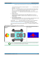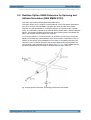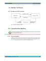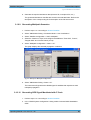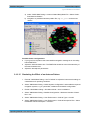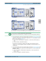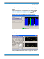
1
Satellite Navigation Digital Standards for R&S®SMBV and R&S®WinIQSIM2TM Operating Manual (;×>K<) Operating Manual Test & Measurement 1173.1427.12 ─ 08 This document describes the software options for satellite navigation: GPS, Assisted GPS, GPS P-Code, Galileo, Assisted Galileo, GLONASS, Assisted GLONASS, COMPASS/BeiDou, Enh. GNSS and GNSS Extensions, incl. Extension to 12 and 24 Satellites, Obscuration Simulation and Automatic Multipath, Antenna Pattern, Spinning and Attitude Simulation Described are the following software options: ● R&S®SMBV-K44/K244/K65/K266/K66/K67/K91/K92/K93/K94/K294/K95/K96/K101/K102/K103/K107 1415.8060.xx, 1415.8260.02, 1415.8560.xx, 1415.8590.02, 1415.8683.xx, 1419.2509.xx, 1415.8577.xx, 1415.8583.xx, 1415.8660.xx, 1415.8677.xx, 1415.8690.02, 1419.2521.xx, 1415.8790.xx, 1415.8802.xx, 1415.8819.xx, 1415.8825.xx, 1419.2709.xx ● R&S®AMU-K244/K266/K294 1402.7902.02, 1403.0976.02, 1403.0953.02 ● R&S®AFQ-K244/K266/K294 1401.6454.02, 1415.0330.02, 1415.0318.02 ● R&S®SMJ-K244/K266/K294 1409.0810.02, 1409.3502.02, 1409.3483.02 ● R&S®SMU-K244/K266/K294 1408.5818.02, 1408.8630.02, 1408.8617.02 ● R&S®SMW-K244/K266/K294 1413.4880.02, 1413.7015.02, 1413.7067.02 ● R&S®SFU-K244 2115.2250.02 © 2013 Rohde & Schwarz GmbH & Co. KG Mühldorfstr. 15, 81671 München, Germany Phone: +49 89 41 29 - 0 Fax: +49 89 41 29 12 164 E-mail: [email protected] Internet: www.rohde-schwarz.com Subject to change – Data without tolerance limits is not binding. R&S® is a registered trademark of Rohde & Schwarz GmbH & Co. KG. Trade names are trademarks of the owners. The following abbreviations are used throughout this manual: R&S®AMU200A is abbreviated as R&S AMU, R&S®SMATE200A is abbreviated as R&S SMATE, R&S®SMBV100A is abbreviated as R&S SMBV, R&S®SMJ100A is abbreviated as R&S SMJ, R&S®SMU200A is abbreviated as R&S SMU, R&S®SMW200A is abbreviated as R&S SMW, R&S®WinIQSIM2TM is abbreviated as R&S WinIQSIM2 Satellite Navigation Contents Contents 1 Preface.................................................................................................... 9 1.1 Documentation Overview............................................................................................. 9 1.2 Typographical Conventions....................................................................................... 10 2 General Description............................................................................. 11 2.1 Functional Overview of the Basic Realtime GNSS Options GPS, Galileo, GLONASS and BeiDou....................................................................................................... 13 2.1.1 Real-time generation.....................................................................................................13 2.1.2 Multi-satellite GNSS signal............................................................................................13 2.1.3 GNSS System Configurations.......................................................................................15 2.1.4 Multiple almanacs......................................................................................................... 15 2.1.5 On-the-fly configuration of the satellites constellation...................................................16 2.1.6 Signal generation with projection of the ephemeris navigation data............................. 16 2.1.7 Dynamic exchange of satellites.....................................................................................16 2.1.8 Flexible power configuration and automatic dynamic power control.............................17 2.1.9 Simulation of uninterrupted location fix......................................................................... 17 2.1.10 Real-Time S.P.O.T. display...........................................................................................18 2.2 Realtime Option GPS P-Code (R&S SMBV-K93)...................................................... 18 2.3 Enhancements of Realtime Assisted GNSS Options GPS, Galileo and GLONASS ...................................................................................................................................... 19 2.3.1 Support of RINEX files.................................................................................................. 19 2.3.2 Full Set of Pre-defined Test Scenarios as Basis for A-GPS/A-GLONASS/A-GNSS Protocol and Conformance Test Cases..............................................................................20 2.3.3 Custom build scenarios.................................................................................................22 2.3.4 Generation of assistance data...................................................................................... 22 2.4 Realtime Option Extension to 12 / 24 Satellites (R&S SMBV-K91/-K96)................ 23 2.4.1 Channel Budget............................................................................................................ 23 2.5 Functional Overview of Realtime Option GNSS Enhanced (R&S SMBV-K92)...... 26 2.5.1 Moving Scenarios..........................................................................................................26 2.5.2 Static Multipath Signal Generation................................................................................27 2.5.3 Configuration of the Atmospheric Parameters.............................................................. 27 2.5.4 Time Conversion Configuration.....................................................................................27 2.5.5 Leap Second Simulation............................................................................................... 28 Operating Manual 1173.1427.12 ─ 08 3 Satellite Navigation Contents 2.5.6 Internal Waypoint Resampling...................................................................................... 28 2.5.7 Motion Smoothening Using Vehicle Description File.................................................... 28 2.5.8 Hardware in the Loop (HIL)...........................................................................................29 2.6 Realtime Option GNSS Extension for Obscuration Simulation and Automatic Multipath (R&S SMBV-K101)............................................................................................ 30 2.7 Realtime Option GNSS Extension for Antenna Pattern (R&S SMBV-K102).......... 31 2.8 Realtime Option GNSS Extension for Spinning and Attitude Simulation (R&S SMBV-K103)....................................................................................................... 33 2.9 Realtime Test Setups ................................................................................................. 34 2.9.1 Example of A-GPS Test Setup......................................................................................34 2.10 Typical Realtime Workflow.........................................................................................34 2.10.1 General Workflow..........................................................................................................34 2.10.2 Generating GNSS Signal for Simple Receiver Tests (Static Mode)..............................36 2.10.3 Generating GNSS Signal with Automatic Dynamic Exchange of the Satellites (Auto Localization Mode)........................................................................................................ 36 2.10.4 Generating GNSS Signal with Manual Exchange of the Satellites (User Localization Mode)............................................................................................................................ 36 2.10.5 Generating A-GPS Custom Build Scenarios (User Localization Mode)........................37 2.10.6 Generating A-GPS Test Signal..................................................................................... 38 2.10.7 Generating A-GNSS Test Signal...................................................................................39 2.10.8 Generating GNSS Assistance Data.............................................................................. 39 2.10.9 Generating Multipath Scenarios....................................................................................40 2.10.10 Generating GPS Signal Modulated with P Code...........................................................40 2.10.11 Configuring the Navigation Parameters........................................................................ 41 2.10.12 Adjusting the Power Settings........................................................................................ 42 2.10.13 Handling NMEA Files.................................................................................................... 43 2.10.14 Creating GNSS Scenarios in a User Environment........................................................44 2.10.15 Simulating the Effect of an Antenna Pattern................................................................. 48 2.11 Generating GNSS Signal with Several Instruments.................................................51 2.12 Functional Overview of the Basic Offline GNSS ..................................................... 53 2.12.1 Single-satellite GNSS signal......................................................................................... 53 2.12.2 Typical Offline Workflow................................................................................................53 2.12.2.1 Generating an one-satellite static generic GNSS signal with R&S WinIQSIM2............ 53 2.12.2.2 Loading and Processing a GNSS Waveform in the ARB of the Rohde&Schwarz Signal Generator...................................................................................................................... 54 Operating Manual 1173.1427.12 ─ 08 4 Satellite Navigation Contents 3 User Interface....................................................................................... 55 3.1 GNSS Main Dialog....................................................................................................... 55 3.1.1 General Settings for GNSS Simulation......................................................................... 56 3.1.2 User Environment......................................................................................................... 62 3.1.3 Navigation Data.............................................................................................................65 3.1.4 Advanced Configuration................................................................................................68 3.2 Localization Data.........................................................................................................68 3.3 Obscuration and Auto Multipath Settings................................................................ 73 3.3.1 Common Settings..........................................................................................................73 3.3.2 Vertical Obstacles Settings........................................................................................... 76 3.3.3 Roadside Planes Settings............................................................................................. 79 3.3.4 Full Obscuration Settings.............................................................................................. 82 3.3.5 Ground/Sea Reflection..................................................................................................84 3.4 GNSS System/Almanac Configuration Settings...................................................... 86 3.5 Time Conversion Configuration................................................................................ 89 3.6 Satellite Configuration................................................................................................ 91 3.6.1 Power Configuration......................................................................................................92 3.6.2 General Satellites Settings..........................................................................................100 3.6.3 Configuration of the Satellite Constellation................................................................. 102 3.6.4 Individual Satellite Settings......................................................................................... 105 3.7 Global Signal Configuration.....................................................................................109 3.8 Atmospheric Configuration......................................................................................111 3.9 Satellites Power Tuning............................................................................................113 3.10 Navigation Message Configuration......................................................................... 116 3.11 Static Multipath Configuration................................................................................. 128 3.12 Assistance Data Generation.................................................................................... 130 3.13 Real-Time S.P.O.T..................................................................................................... 139 3.13.1 Display Type............................................................................................................... 142 3.13.2 Real-Time Information.................................................................................................142 3.13.3 Reference Location..................................................................................................... 143 3.13.4 Trajectory View Settings............................................................................................. 144 3.14 Trigger/Marker/Clock Settings................................................................................. 145 3.14.1 Trigger In.....................................................................................................................146 Operating Manual 1173.1427.12 ─ 08 5 Satellite Navigation Contents 3.14.2 Marker Mode............................................................................................................... 150 3.14.3 Marker Delay...............................................................................................................151 3.14.4 Clock Settings............................................................................................................. 152 3.14.5 Global Settings............................................................................................................153 4 Remote-Control Commands............................................................. 155 4.1 Programming Examples........................................................................................... 157 4.2 Primary Settings........................................................................................................157 4.3 User Environment, Antenna Pattern and Body Mask............................................ 165 4.4 Localization Data.......................................................................................................169 4.5 Navigation Data......................................................................................................... 175 4.6 Obscuration and Auto Multipath..............................................................................178 4.7 Hardware in the Loop (HIL)...................................................................................... 190 4.8 GNSS System Configuration....................................................................................192 4.9 Almanac/RINEX Configuration.................................................................................194 4.10 Time Conversion Configuration.............................................................................. 201 4.11 Static Multipath Configuration................................................................................. 206 4.12 Satellites Configuration and Satellites Signal Settings.........................................210 4.13 Global Signal Configuration.....................................................................................220 4.14 Power Tuning and Power Settings.......................................................................... 221 4.15 Navigation Message Configuration......................................................................... 227 4.16 Atmospheric Configuration......................................................................................250 4.17 Assistance Data Settings......................................................................................... 253 4.18 S.P.O.T Configuration and Real-Time Commands.................................................267 4.19 Trigger Settings.........................................................................................................282 4.20 Marker Settings......................................................................................................... 287 4.21 Clock Settings........................................................................................................... 290 A Annex.................................................................................................. 293 A.1 User Environment Files............................................................................................ 293 A.1.1 Movement or Motion Files...........................................................................................293 A.1.1.1 Waypoint File Format.................................................................................................. 293 A.1.1.2 Vector Trajectory File Format......................................................................................294 A.1.1.3 NMEA Files as Source for Movement Information...................................................... 296 A.1.1.4 Trajectory Description Files.........................................................................................296 Operating Manual 1173.1427.12 ─ 08 6 Satellite Navigation Contents A.1.2 Vehicle Description Files (Used for Smoothening)......................................................300 A.1.3 Antenna Pattern / Body Mask Files.............................................................................301 A.2 RINEX Files................................................................................................................ 303 A.2.1 RINEX Format Description..........................................................................................304 A.2.2 Example of a RINEX File............................................................................................ 305 A.3 NMEA Scenarios....................................................................................................... 306 A.4 Used Algorithms....................................................................................................... 307 A.4.1 Detailes on the Smoothening Algorithm......................................................................307 List of Commands..............................................................................309 Index....................................................................................................320 Operating Manual 1173.1427.12 ─ 08 7 Satellite Navigation Operating Manual 1173.1427.12 ─ 08 Contents 8 Satellite Navigation Preface Documentation Overview 1 Preface 1.1 Documentation Overview The user documentation for the R&S SMBV consists of the following parts: ● Online Help system on the instrument, ● "Quick Start Guide" printed manual, ● Documentation CD-ROM with: – Online help system (*.chm) as a standalone help, – Operating Manuals for base unit and options, – Service Manual, – Data sheet and specifications, – Links to useful sites on the R&S internet. Online Help The Online Help is embedded in the instrument's firmware. It offers quick, context-sensitive access to the complete information needed for operation and programming. The online help contains help on operating the R&S SMBV and all available options. Quick Start Guide The Quick Start Guide is delivered with the instrument in printed form and in PDF format on the Documentation CD-ROM. It provides the information needed to set up and start working with the instrument. Basic operations and an example of setup are described. The manual includes also general information, e.g., Safety Instructions. Operating Manuals The Operating Manuals are a supplement to the Quick Start Guide. Operating Manuals are provided for the base unit and each additional (software) option. These manuals are available in PDF format - in printable form - on the Documentation CD-ROM delivered with the instrument. In the Operating Manual for the base unit, all instrument functions are described in detail. Furthermore, it provides an introduction to remote control and a complete description of the remote control commands with programming examples. Information on maintenance, instrument interfaces and error messages is also given. In the individual option manuals, the specific instrument functions of the option are described in detail. For additional information on default settings and parameters, refer to the data sheets. Basic information on operating the R&S SMBV is not included in the option manuals. Operating Manual 1173.1427.12 ─ 08 9 Satellite Navigation Preface Typographical Conventions Service Manual The Service Manual is available in PDF format - in printable form - on the Documentation CD-ROM delivered with the instrument. It describes how to check compliance with rated specifications, on instrument function, repair, troubleshooting and fault elimination. It contains all information required for repairing the instrument by the replacement of modules. This manual can also be orderd in printed form (see ordering information in the data sheet). Release Notes The release notes describe new and modified functions, eliminated problems, and last minute changes to the documentation. The corresponding firmware version is indicated on the title page of the release notes. The current release notes are provided in the Internet. Web Helps Web helps are provided for the base unit and each additional (software) option. The content of the web helps correspond to the user manuals for the latest product versions. The web help is an additional file format that offers quick online access. They are not intended to be downloaded but rather to access the required information directly form the R&S website. Web helps are available at the R&S website, on the R&S SMBV product page at the "Downloads > Web Help" area. 1.2 Typographical Conventions The following text markers are used throughout this documentation: Convention Description "Graphical user interface elements" All names of graphical user interface elements on the screen, such as dialog boxes, menus, options, buttons, and softkeys are enclosed by quotation marks. KEYS Key names are written in capital letters. File names, commands, program code File names, commands, coding samples and screen output are distinguished by their font. Input Input to be entered by the user is displayed in italics. Links Links that you can click are displayed in blue font. "References" References to other parts of the documentation are enclosed by quotation marks. Operating Manual 1173.1427.12 ─ 08 10 Satellite Navigation General Description 2 General Description The global navigation satellite system (GNSS) employs the radio signals of several navigation standards, like GPS, Galileo, GLONASS, BeiDou etc. For several years, GPS used to be the only standard available for civilian navigation through its C/A civilian code. Nowadays, the GNSS signals and systems are undergoing fast development, some systems are getting modernized and some are completely new. In the foreseeable future, several more GNSS satellites utilizing more and new frequency will be available. Differences between the GNSS implementation in R&S SMBV and R&S WinIQSIM2 The GNSS implementation in the R&S SMBV provides you with the ability to generate the signal of up to 6, 12 or 24 GNSS satellites, depending on the installed options. Signal generation is done in real-time and thus it is not limited to a certain time period. The GNSS implementation in the R&S WinIQSIM2 allows you to generate waveform files that can be loaded to an Rohde&Schwarz vector signal generator, e.g. the R&S SMU200A. It provides you the ability to generate the signal of one GPS, Galileo or Glonass satellite on either an R&S SMU200A, R&S SMJ100A, R&S AMU200A, R&S AFQ100A, R&S SMW200A or R&S SMBV100A. Depending on the availability of the respective options, e.g. R&S SMU-K244/-K266/-K294 you can simulate one GPS, Galileo, GLONASS satellite respectively on the generator. As a major difference to the real-time solution, the satellite signal is limited to a certain time period depending on the ARB capacity of the vector signal generator and the user configurable sample rate of the satellite signal. This description follows the GNSS implementation in the R&S SMBV. For information on the GNSS implementation in the R&S WinIQSIM2, see chapter 2.12, "Functional Overview of the Basic Offline GNSS ", on page 53. Brief introduction to the GNSS standards ● GPS The Global Positioning System (GPS) consists of several satellites circling the earth in low orbits. The satellites transmit permanently information that can be used by the receivers to calculate their current position (ephemeris) and about the orbits of all satellites (almanac). The 3D position of a receiver on the earth can be determined by carrying out delay measurements of at least four signals emitted by different satellites. Being transmitted on a single carrier frequency, the signals of the individual satellites can be distinguished by means of correlation (Gold) codes. These ranging codes are used as spreading code for the navigation message which is transmitted at a rate of 50 baud. ● Galileo Operating Manual 1173.1427.12 ─ 08 11 Satellite Navigation General Description Galileo is the European global navigation satellite system that provides global positioning service under civilian control. It is planed to be inter-operable with GPS and GLONASS and other global satellite navigation systems. The fully deployed Galileo system consists of 30 satellites (27 operational and 3 spares). Three independent CDMA signals, named E5, E6 and E1, are permanently transmitted by all Galileo satellites. The E5 signal is further sub-divided into two signals denoted E5a and E5b (see figure 2-1). ● GLONASS Glonass is the russian global navigation satellite system. It is expected to be fully operational before the end of 2011 with 24 Modernized Glonass Satellites touring the globe. Together with GPS, up to 54 GNSS Satellites are provided, which will improve the availability and consequently the navigation performance in high urban areas. Fig. 2-1: GNSS frequency bands ● COMPASS/BeiDou The fully deployed BeiDou Navigation Satellite System (BDS) is a Chinese satellite navigation system. This navigation system is also know as BeiDou-2 and is expected in 2020. The BDS is a global satellite navigation systems that uses a constellation of 35 satellites to cover the globe. This constellation includes 5 geostationary orbit satellites (GEO) and 30 non-geostationary satellites; 27 in medium earth orbit (MEO) and 3 in inclined geosynchronous orbit (IGSO). The BDS uses frequency allocated in the E1, E2, E5B, and E6 bands. ● Assisted GNSS (A-GNSS) Assisted GNSS (A-GNSS) was introduced to different mobile communication standards to significantly reduce the Time To First Fix (TTFF) of a user equipment (UE) containing a GNSS receiver. This is achieved by transmitting information (assistance data) mainly about the satellites directly from a base station to the UE. For example, a stand-alone GPS receiver needs about 30-60 seconds for a first fix and up to 12.5 minutes to get all information (almanac). In A-GNSS "UE based mode", the base station assists the UE by providing the complete navigation message along with a list of visible satellites and ephemeris data. In addition to this information, the UE gets the location and the current time at Operating Manual 1173.1427.12 ─ 08 12 Satellite Navigation General Description Functional Overview of the Basic Realtime GNSS Options GPS, Galileo, GLONASS and BeiDou the Base Station and that speeds up both acquisition and navigation processes of the GPS receiver and hence reduces TTFF to a few seconds. In A-GNSS "UE assisted mode", the base station is even responsible for the calculation of the UE's exact location, i.e. the base station performs the navigation based on the raw measurements provided by the UE. Since the Acquisition Assistance Data provided by the Base Station already serves speeding up the acquisition process, the UE only has to track the code and carrier phase. 2.1 Functional Overview of the Basic Realtime GNSS Options GPS, Galileo, GLONASS and BeiDou This section gives an overview of the options GPS (R&S SMBV-K44), Galileo (R&S SMBV-K66), GLONASS (R&S SMBV-K94) and BeiDou (R&S SMBV-K107). Throughout this description, these options are denoted as basic GNSS options. 2.1.1 Real-time generation With the option R&S SMBV-K44, up to six GPS satellites transmitting L1 or L2 signals with C/A-code can be simulated in real-time. With the option R&S SMBV-K66, up to six Galileo satellites transmitting E1 signal can be simulated in real-time. With the option R&S SMBV-K94, up to six GLONASS satellites transmitting L1 or L2 signal can be simulated in real-time. With the option R&S SMBV-K107, up to six BeiDou satellites transmitting L1 or L2 signal can be simulated in real-time. 2.1.2 Multi-satellite GNSS signal The instrument calculates a multi-satellite GNSS signal in three different simulation modes, the static mode, the auto localization mode and the user localization mode. In "Static mode", static satellites with constant Doppler shifts are provided for simple receiver test, like receiver sensitivity, acquisition and tracking test, etc. production tests. Selection and configuration of any localization data, such as receiver location for instance, is not enabled. The generic workflow is described in chapter 2.10.2, "Generating GNSS Signal for Simple Receiver Tests (Static Mode)", on page 36. The superposition signal of up to 6 dynamic satellites at a specific receiver location is generated in one of the localization modes. The major difference to the static mode implies the possibility to specify the receiver's location. Although, both the localization Operating Manual 1173.1427.12 ─ 08 13 Satellite Navigation General Description Functional Overview of the Basic Realtime GNSS Options GPS, Galileo, GLONASS and BeiDou modes are provided for the generation of a realistic GNSS signal, there are some differences between them. ● The "Auto Localization" mode is provided for the generation of a GNSS signal with automatic exchange of satellite whenever needed to improve the position dilution of precision and to ensure satellite visibility at the simulated receiver location. This mode ensures an optimal satellite constellation, automatic dynamic calculation of the satellite power at any moment and ephemeris projection from the selected almanac. In this simulation mode, the connected GNSS receiver can be forced to obtain a 3D fix at a predefined or user-defined static geographical location. Instrument equipped with the option GNSS enhanced R&S SMBV-K92 can also simulate moving receivers (see chapter 2.5.1, "Moving Scenarios", on page 26). ● The "User Localization" mode provides flexible configuration of the satellite constellation, the power settings and the individual satellites parameters. For instruments equipped with assistance option R&S SMBV-K65, this mode also enables the extraction of the navigation message from RINEX files. Dynamic exchange of satellites can be performed by means of deactivation and activation of the individual satellites. The power settings are enabled for configuration but the automatic dynamic calculation function of the instrument may also be utilized. This mode is required for the generation of user defined assisted GPS test scenarios. The table 2-1 gives an overview of the supported functionality per simulation mode. Some functionality require additional options. Table 2-1: Cross-reference between the simulation mode, supported functionality and the required options Simulation Mode / Static Auto Localization User Localization Required Options Configuration of static receiver location no yes yes R&S SMBV-K44/K66/K94/ K107 GNSS System Configuration yes yes yes R&S SMBV-K44 and R&S SMBV-K66 and R&S SMBV-K94 and R&S SMBV-K107 Almanac/RINEX almanac almanac Almanac and RINEX file supported R&S SMBV-K44/K66/K94/ K107 Function R&S SMBV-K65/K67/K95/ K107 for RINEX files Projection of Navigation Message no yes yes R&S SMBV-K44/K66/K94/ K107 S.P.O.T. Display no yes yes R&S SMBV-K44/K66/K94/ K107 Assistance GNSS Data Generation no no yes R&S SMBV-K44/K66/K94/ K107 and R&S SMBV-K65/K67/K95 Configuration of Satellite Constellation yes Operating Manual 1173.1427.12 ─ 08 no yes R&S SMBV-K44/K66/K94/ K107 14 Satellite Navigation General Description Functional Overview of the Basic Realtime GNSS Options GPS, Galileo, GLONASS and BeiDou Simulation Mode / Static Auto Localization User Localization Required Options Power Mode User Auto Auto and User R&S SMBV-K44/K66/K94/ K107 Exchange of Satellites no automatic manual R&S SMBV-K44/K66/K94/ K107 Maximum Number of Satellites up to 12/24 up to 12/24 up to 12/24 R&S SMBV-K91/-K96 Motion Files no yes yes R&S SMBV-K92 Time Conversion Configuration yes no yes R&S SMBV-K92 Navigation Message Configuration configurable read-only configurable R&S SMBV-K92 Atmospheric Configuration yes yes yes R&S SMBV-K92 Static Multipath Configuration no no yes R&S SMBV-K92 Automatic Multipath&Osculation scenarios no yes yes R&S SMBV-K92 and R&S SMBV-K102 Antenna Pattern/Body mask entry no yes yes R&S SMBV-K102 Attitude/Body rotation angle files no yes yes R&S SMBV-K92 and R&S SMBV-K103 no yes yes R&S SMBV-K92 (motion only) Function Motion Smoothening Extract attitude from motion file User defined vehicle spinning Hardware in the loop (HIL) and R&S SMBV-K103 (motion and attitude) 2.1.3 GNSS System Configurations Instrument equipped with the GNSS basic options GPS, Galileo, GLONASS and BeiDou can be configured to generate the signal of hybrid GNSS satellite constellation with radio signals of all navigation standards. Mixed configurations are enabled only in the common or close-range frequency bands, e.g. L1/E1. GNSS system configurations can be also used to configure general purpose global parameters for the simulation. 2.1.4 Multiple almanacs The instrument supports the configuration of the almanac files used. One almanac file per GNSS navigation standard can be selected. The Galileo satellite constellation is not yet in orbit. Hence, no almanac files for Galileo are available. In this implementation, Galileo almanac files are provided for test purposes. The almanac files for GPS and Galileo use the same format. Operating Manual 1173.1427.12 ─ 08 15 Satellite Navigation General Description Functional Overview of the Basic Realtime GNSS Options GPS, Galileo, GLONASS and BeiDou Current GNSS almanac data can be downloaded via the Internet and stored on the hard disk of the instrument: ● U.S.Coast Guard Navigation Center GPS Homepage http:// www.navcen.uscg.gov/?pageName=gpsAlmanacs The almanac files are named xxx.alm (for YUMA files) or xxx.al3 (for SEM files) whereas xxx denotes the day of a year. ● http://www.celestrak.com/GPS/almanac/ The naming convention of the almanac file is: almanac.sem/ yuma.weekXXXX.YYYYYY.txt whereas xxxx denotes the GPS week and yyyyyy the time of almanac (TOA). ● ftp://ftp.glonass-iac.ru/MCC/ALMANAC/ The file extension of the Glonass almanac file is: xxx.agl For detailed information on the content and frame structure of navigation data, refer to the specifications. 2.1.5 On-the-fly configuration of the satellites constellation The simulation mode "User Localization" makes the satellite constellation user-definable. Not only the individual satellite parameters and the navigation message parameters are enabled for configuration, but active satellites can be turned off or the satellite constellation can be extended with new satellites at any time and on-the-fly, without causing an interruption of the currently running signal calculation. Changes in ephemeris of an active satellite and the power settings are performed without signal calculation restart, too. Hence, satellites ephemeris adjustment can be performed during the time the satellite is disabled and the updated parameters will be used from the moment this satellite is active again. This functionality can be used to perform manual exchange of satellite's at user defined moment of time. This on-the-fly re-configuration during signal generation is especially beneficial by time consuming measurements or test. 2.1.6 Signal generation with projection of the ephemeris navigation data The instrument employs a special algorithm for projecting the ephemeris navigation data that allows the generation of a navigation message without limitation in the simulation time. The ephemeris are updated and there is no limitation problem of maximum allowed time span of two hours (GPS) or half an hour (Glonass) between the simulation time and the reference time of the current satellite ephemeris page. 2.1.7 Dynamic exchange of satellites In this implementation, the exchange of satellites can be performed automatically or be configured and triggered by the user. ● To enable the instrument to perform automatic exchange of satellites, select the "Auto Localization" mode. Operating Manual 1173.1427.12 ─ 08 16 Satellite Navigation General Description Functional Overview of the Basic Realtime GNSS Options GPS, Galileo, GLONASS and BeiDou In this mode, the instrument constantly monitors and updates the simulated satellite's constellation based on two criteria, the optimal satellite constellation with minimum PDOP and the satellite's visibility respecting the Elevation Mask. While the PDOP is a constellation parameter that is calculated by the instrument and displayed in real-time, the satellite's visibility is a satellite parameter which indicates that the satellite elevation at a specific user location is above a configurable elevation mask. Depending on the current satellite's conditions and the used number of satellites, a sophisticated algorithm decides how often the PDOP and the satellite's visibility have to be proved and at which moment of time the satellite's constellation has to be changed. Satellites that do not fulfill the criteria for minimum PDOP and sufficient visibility are exchanged dynamically and on-the-fly. Information about the expected time of the next upcoming exchange is provided by the parameter Next Constellation Change. The generic workflow is described in chapter 2.10.3, "Generating GNSS Signal with Automatic Dynamic Exchange of the Satellites (Auto Localization Mode)", on page 36. ● In "User Localization" mode the exchange of the satellites is not performed automatically, but the satellite's constellation is fully configurable. Satellites can be turned off, reconfigured and turned on again, the existing satellite constellation can be extended with new satellites. Hence, an exchange of the satellites can be configured and performed at any moment of time, as defined by the user. The generic workflow is described in chapter 2.10.4, "Generating GNSS Signal with Manual Exchange of the Satellites (User Localization Mode)", on page 36. 2.1.8 Flexible power configuration and automatic dynamic power control The instrument employs a dynamic power control concept. To provide better flexibility, two power modes are provided, the "Auto" and the "User" power modes. ● "User" power mode is intended for dynamical configuration of the power of each satellite separately and manually. ● "Auto" power mode enables an internal dynamical automatic power control. The power is calculated automatically based on the satellite-to-receiver distance which varies with the time. Refer to chapter 3.6.1, "Power Configuration", on page 92 for examples and information about the power calculation. The generic workflow is described in chapter 2.10.12, "Adjusting the Power Settings", on page 42. 2.1.9 Simulation of uninterrupted location fix The simulation of uninterrupted location fix requires a GNSS signal that fulfills the following conditions: ● An optimal satellite's constellation is selected and monitored constantly, i.e. the exchange of the satellites is performed automatically Operating Manual 1173.1427.12 ─ 08 17 Satellite Navigation General Description Realtime Option GPS P-Code (R&S SMBV-K93) ● The power of the satellites is monitored and updated constantly depending on the satellite-to-receiver distance and some channel parameters, e.g. atmospheric effects. ● The age of the ephemeris (t - toe) is respected, for example the simulation time is always within the allowed time span of 2h around the GPS reference time of the current ephemeris page. For GLONASS, this time is usually 30 minutes. The table 2-2 gives an overview how these criteria are fulfilled by the provided localization modes. Table 2-2: Criteria for the generation of GNSS signal for simulation of uninterrupted location fix Criteria Simulation Mode "Auto Localization" Optimal Satellite's Constellation Power Monitoring and Update selected and updated automati- performed automatically cally Age of Ephemeris projection of the ephemeris from the almanac automatic dynamic exchange of the satellites "User Localization" initial optimal satellite's constellation manual user-defined exchange of the satellites performed automatically projection of the ephemeris or many ephemeris pages are made available Hence, both localization modes provide a realistic signal; the decision which localization mode will be used is a trade-off between the much better accuracy of the ephemeris retrieved from a RINEX file or a manual ephemeris configuration and the automatic selection of the optimal satellite's constellation with automatic exchange of the satellites. The generic workflow is described in chapter 2.10.3, "Generating GNSS Signal with Automatic Dynamic Exchange of the Satellites (Auto Localization Mode)", on page 36 and chapter 2.10.4, "Generating GNSS Signal with Manual Exchange of the Satellites (User Localization Mode)", on page 36. 2.1.10 Real-Time S.P.O.T. display The real-word situation of disappearance and re-appearance of satellites, as well as the dynamic display of several parameters like HDOP, PDOP, receiver's location, elapsed time and the trajectory of a moving receiver can be observed in real-time in the special "Real-Time S.P.O.T." (Satellites and Position Online Tracker) display. The Real-Time S.P.O.T. display is enabled for "Auto Localization" and "User Localization" modes. 2.2 Realtime Option GPS P-Code (R&S SMBV-K93) The option GPS P-Code (R&S SMBV-K93) is only available for instruments equipped with option GPS (R&S SMBV-K44). It enhances the option GPS with the functionality Operating Manual 1173.1427.12 ─ 08 18 Satellite Navigation General Description Enhancements of Realtime Assisted GNSS Options GPS, Galileo and GLONASS to generate a position accuracy (P-Code) signal and allows the configuration of P or C/A+P satellite signals in addition to the civilian C/A signal enabled by the basic GPS option (R&S SMBV-K44). P-Codes are one week long codes with a high chip rate 10.23 MHz. The higher chip rate significantly increases the performance compared to the civilian C/A codes used by commercial receivers, i.e. P-Code signal provide better Carrier to Noise sensitivity. Another difference compared to the C/A signals is that P-Code signals are only sensible to less than 30 m multipath delay whereas C/A signals are sensible to 300 m. The generic workflow is described in chapter 2.10.10, "Generating GPS Signal Modulated with P Code", on page 40. 2.3 Enhancements of Realtime Assisted GNSS Options GPS, Galileo and GLONASS This section gives an overview of the options Assisted GPS (R&S SMBV-K65), Assisted Galileo (R&S SMBV-K67) and Assisted GLONASS (R&S SMBV-K95). ● The option Assisted GPS (R&S SMBV-K65) is only available for instruments equipped with option GPS (R&S SMBV-K44). It enhances the basic option with functionality required for A-GPS/A-GNSS test scenarios for 3GPP FDD, GSM and EUTRA/ LTE. ● The option Assisted Galileo (R&S SMBV-K67) is only available for instruments equipped with option Galileo (R&S SMBV-K66). It enhances the basic option with functionality to generate user defined test scenarios. ● The option Assisted GLONASS (R&S SMBV-K95) is only available for instruments equipped with option GLONASS (R&S SMBV-K94). It enhances the basic option with functionality required for A-GLONASS/A-GNSS test scenarios for 3GPP FDD and EUTRA/LTE. 2.3.1 Support of RINEX files Additionally to the almanac files, a Receiver Independent Exchange Format RINEX files are supported. RINEX files are very well known and are standard formats generated by Control Stations (CS) and many commercial receivers. RINEX Navigation Files usually comprise the ephemeris sets for several satellites with different TOE and TOC. Hence, only one RINEX File is enough to describe satellite orbits for a period longer than 2 hours and sometimes up to 1 day. Current RINEX files can be downloaded via the Internet and stored on the hard disk of the instrument, e.g. http://cddis.gsfc.nasa.gov/gnss_datasum.html#brdc or ftp:// ftp.glonass-iac.ru/MCC/BRDC Operating Manual 1173.1427.12 ─ 08 19 Satellite Navigation General Description Enhancements of Realtime Assisted GNSS Options GPS, Galileo and GLONASS 2.3.2 Full Set of Pre-defined Test Scenarios as Basis for A-GPS/A-GLONASS/A-GNSS Protocol and Conformance Test Cases An instrument equipped with the assisted options supports test scenarios as basis for A-GPS/A-GLONASS/A-GNSS Protocol and Conformance Test cases. Some of the test cases may require additional options. Test scenario vs. test case An instrument equipped with the required options provides predefined test scenarios, not the standard conform test cases! The provided test scenarios are suitable basis for the test cases. However, to perform a particular test case as specified by the 3GPP test specification, you have to subsequently configure several settings. You may have to adjust the receiver location, the simulation time, active satellites in the pre-selected satellite constellation, power setting, etc. Refer to the corresponding 3GPP test specification for the required values. See also chapter 2.10.7, "Generating A-GNSS Test Signal", on page 39. The table 2-3 lists the currently supported predefined A-GPS test scenarios. Table 2-3: A-GPS test scenarios overview Test Scenario Required for Test Case Required SW Option GSM 3GPP TS 51.010: 10.9 Signaling 3GPP TS 51.010-1 v.7.7.0 10.9: A-GPS Signaling scenario R&S SMBV-K44/-K65 3GPP TS 51.010: 10.10 Performance 1 3GPP TS 51.010-1 v.7.7.0 10.10: A-GPS Performance Test Scenario 1 R&S SMBV-K44/-K65 3GPP TS 51.010: 10.10 Performance 2 3GPP TS 51.010-1 v.7.7.0 10.10: A-GPS Performance Test Scenario 2 R&S SMBV-K44/-K65 3GPP TS 51.010: 10.10 Performance 3 3GPP TS 51.010-1 v.7.7.0 10.10: A-GPS Performance Test Scenario 3 R&S SMBV-K44/-K65/-K92 3GPP FDD 3GPP TS 34.108: 10.7 Signaling 3GPP TS 34.108 v.8.0.0 10.7: A-GPS Signaling scenario R&S SMBV-K44/-K65 3GPP TS 34.108: 10.1.2 Performance 1 3GPP TS 34.108 v.8.0.0 10.1.2: A-GPS Performance scenario 1 R&S SMBV-K44/-K65 3GPP TS 34.108: 10.1.2 Performance 2 3GPP TS 34.108 v.8.0.0 10.1.2: A-GPS Performance scenario 2 R&S SMBV-K44/-K65 3GPP TS 34.108: 10.1.2 Performance 3 3GPP TS 34.108 v.8.0.0 10.1.2: A-GPS Performance scenario 3 R&S SMBV-K44/-K65/-K92 3GPP2 3GPP2 C.S0036: 2.1.1 Stationary 3GPP2 C.S0036-0 V1.0 2.1.1: A-GPS Stationary R&S SMBV-K44/-K65 3GPP2 C.S0036: 2.1.2 Moving 3GPP2 C.S0036-0 V1.0 2.1.2: A-GPS Moving R&S SMBV-K44/-K65/K91/-K92 Operating Manual 1173.1427.12 ─ 08 20 Satellite Navigation General Description Enhancements of Realtime Assisted GNSS Options GPS, Galileo and GLONASS Test Scenario Required for Test Case Required SW Option EUTRA/LTE 3GPP TS 37.571-2: S7 Signaling ST1 3GPP TS 37.571-2 v.10.0.0 subclause 7: A-GPS Signaling scenario, Subtest 1 R&S SMBV-K44/-K65 3GPP TS 37.571-1: S7 Performance 1 ST1 3GPP TS 37.571-1 v.10.0.0 subclause 7: A-GPS Performance scenario 1, Subtest 1 R&S SMBV-K44/-K65 3GPP TS 37.571-1: S7 Performance 2 ST1 3GPP TS 37.571-1 v.10.0.0 subclause 7: A-GPS Performance scenario 2, Subtest 1 R&S SMBV-K44/-K65 3GPP TS 37.571-1: S7 Performance 5 ST1 3GPP TS 37.571-1 v.10.0.0 subclause 7: A-GPS Performance scenario 5, Subtest 1 R&S SMBV-K44/-K65/-K92 The table 2-4 lists the currently supported predefined A-GLONASS test scenarios. Table 2-4: A-GLONASS test scenarios overview Test Scenario Required for Test Case Required SW Option 3GPP FDD 3GPP TS 37.571-2: S6 Signaling ST1 3GPP TS 37.571-2 v.10.0.0 subclause 6: A-Glonass Sig- R&S SMBV-K94/-K95 naling scenario, Subtest 1 3GPP TS 37.571-1: S6 Performance 1 3GPP TS 37.571-1 v.10.0.0 subclause 6: A-Glonass Performance scenario 1, Subtest 1 R&S SMBV-K94/-K95 3GPP TS 37.571-1: S6 Performance 2 3GPP TS 37.571-1 v.10.0.0 subclause 6: A-Glonass Performance scenario 2, Subtest 1 R&S SMBV-K94/-K95 3GPP TS 37.571-1: S6 Performance 5 3GPP TS 37.571-1 v.10.0.0 subclause 6: A-Glonass Performance scenario 5, Subtest 1 R&S SMBV-K94/-K95/-K92 EUTRA/LTE 3GPP TS 37.571-2: S7 Signaling ST2 3GPP TS 37.571-2 v.10.0.0 subclause 7: A-Glonass Sig- R&S SMBV-K44/-K95 naling scenario, Subtest 2 3GPP TS 37.571-1: S7 Performance 1 ST2 3GPP TS 37.571-1 v.10.0.0 subclause 7: A-Glonass Performance scenario 1, Subtest 2 R&S SMBV-K44/-K95 3GPP TS 37.571-1: S7 Performance 2 ST2 3GPP TS 37.571-1 v.10.0.0 subclause 7: A-Glonass Performance scenario 2, Subtest 2 R&S SMBV-K44/-K95 3GPP TS 37.571-1: S7 Performance 5 ST2 3GPP TS 37.571-1 v.10.0.0 subclause 7: A-Glonass Performance scenario 5, Subtest 2 R&S SMBV-K44/-K95/-K92 The table 2-5 lists the currently supported predefined A-GNSS test scenarios. Table 2-5: A-GNSS test scenarios overview Test Scenario Required for Test Case Required SW Option 3GPP FDD 3GPP TS 37.571-2: S6 Signaling ST4 3GPP TS 37.571-2 v.10.0.0 subclause 6: A-GNSS Signaling scenario, Subtest 4 R&S SMBV-K44/-K65/-K95 3GPP TS 37.571-1: S6 Performance 1 ST4 3GPP TS 37.571-1 v.10.0.0 subclause 6: A-GNSS Performance scenario 1, Subtest 4 R&S SMBV-K44/-K65/-K95 Operating Manual 1173.1427.12 ─ 08 21 Satellite Navigation General Description Enhancements of Realtime Assisted GNSS Options GPS, Galileo and GLONASS Test Scenario Required for Test Case Required SW Option 3GPP TS 37.571-1: S6 Performance 2 ST4 3GPP TS 37.571-1 v.10.0.0 subclause 6: A-GNSS Performance scenario 2, Subtest 4 R&S SMBV-K44/-K65/-K95 3GPP TS 37.571-1: S6 Performance 5 ST4 3GPP TS 37.571-1 v.10.0.0 subclause 6: A-GNSS Performance scenario 5, Subtest 4 R&S SMBV-K44/-K65/K92/-K95 EUTRA/LTE 3GPP TS 37.571-2: S7 Signaling ST4 3GPP TS 37.571-2 v.10.0.0 subclause 7: A-GNSS Signaling scenario, Subtest 4 R&S SMBV-K44/-K65/-K95 3GPP TS 37.571-1: S7 Performance 1 ST5 3GPP TS 37.571-1 v.10.0.0 subclause 7: A-GNSS Performance scenario 1, Subtest 5 R&S SMBV-K44/-K65/-K95 3GPP TS 37.571-1: S7 Performance 2 ST5 3GPP TS 37.571-1 v.10.0.0 subclause 7: A-GNSS Performance scenario 2, Subtest 5 R&S SMBV-K44/-K65/-K95 3GPP TS 37.571-1: S7 Performance 5 ST5 3GPP TS 37.571-1 v.10.0.0 subclause 7: A-GNSS Performance scenario 5, Subtest 5 R&S SMBV-K44/-K65/K92/-K95 The generic workflow is described in chapter 2.10.7, "Generating A-GNSS Test Signal", on page 39. 2.3.3 Custom build scenarios The assisted options (R&S SMBV-K65/-K67/-K95) and are not limited to be used for AGNSS testing exclusively. Despite the predefined scenarios, it is also possible to define any user-specific test scenario. For testing of stand-alone GNSS receivers, the assisted options offer full flexibility on the simulated satellites including definition of the complete navigation message. The simulation mode "User Localization" can be used to get an optimal satellite's constellation and to adjust the navigation message to the exact requirements. The basic BeiDou option (R&S SMBV-K107) is sufficient for this kind of tests. Additional assisted option is not required. The generic workflow is described in chapter 2.10.5, "Generating A-GPS Custom Build Scenarios (User Localization Mode)", on page 37. 2.3.4 Generation of assistance data Besides generating the satellite signals for predefined test scenario, the assisted options (R&S SMBV-K65/-K67/-K95) are also able to provide all kinds of assistance data in line with the simulated scenario which can be provided to the UE by a protocol tester. Certainly, this also applies to user-defined test scenarios. For the generation of A-BeiDou user-defined test signals, the basic BeiDou option (R&S SMBV-K107) is sufficient. Additional assisted option is not required. Operating Manual 1173.1427.12 ─ 08 22 Satellite Navigation General Description Realtime Option Extension to 12 / 24 Satellites (R&S SMBV-K91/-K96) Refer to chapter 2.9.1, "Example of A-GPS Test Setup", on page 34 for an example of the A-GPS setup. The generic workflow is described in chapter 2.10.8, "Generating GNSS Assistance Data", on page 39. 2.4 Realtime Option Extension to 12 / 24 Satellites (R&S SMBV-K91/-K96) These options extend the maximum number of simulated satellites. ● Instrument equipped with the option R&S SMBV-K91 is enabled to generate the signal of up to 12 configurable satellites. Any hybrid 12-satellite configuration is possible, for example a combination like 10 C/A GPS + 1 Galileo E1 + 1 GLONASS R-C/A. The available satellites depend on the availability of the basic options, respectively on the enabled standards in the "GNSS System Configurations" and the selected "RF Band" ● The R&S SMBV-K96 requires the option R&S SMBV-K91 and further extends the maximum number of simulated satellites. Instruments equipped with this combination are enabled to generate the signal of up to 24 GPS C/A, Galileo E1, Glonass R-C/A and BeiDou B1-C/A satellites if the respecitvely GNSS basic option or a combination there of is available. The option R&S SMBV-K96 does not enhance the number of P-code satellites/ taps. 2.4.1 Channel Budget There is a limitation of the maximum number of simulated satellites, depending on whether P code signal and BeiDou satellites are enabled in the GNSS system configuration or not. Without satellites using position accuracy (P-Code) signals The generation of up to 24-GPS C/A, Galileo E1 and/or GLONASS satellites hybrid signal is possible when no P-Code signals are activated. For the Use Position Accuracy (P-Code) GPS= Off case the following rules apply: ● The total number of available resource units depends on the "Activate GNSS Standards > BeidDou" state as follows: – 14a + 10 b, if "BeidDou = Off" – 24a, if "BeidDou = On" ● Any of the GPS C/A, Glonass R-C/A and BeiDou B-C/A satellite/multipath tap channel consumes 1a or 1b resource units ● A Galileo E1 satellite/multipath tap consumes 1a or 2b Operating Manual 1173.1427.12 ─ 08 23 Satellite Navigation General Description Realtime Option Extension to 12 / 24 Satellites (R&S SMBV-K91/-K96) Example: The table 2-6 lists some of the GNSS constellations with 24 satellites that can be achieved. Table 2-6: Possible GNSS hybrid configurations with 24 satellites GPS C/A signal Galileo E1 signal GLONASS R-C/A signal BeiDou B-C/A 24 0 0 0 12 0 12 0 8 8 8 0 12 0 0 12 0 0 0 24 8 0 8 8 5 2 5 10 etc. With activated P-code in the GNSS system configuration For enabled Use Position Accuracy (P-Code) GPS or Maximum Number of Satellites is less or equal to 24, only a subset of hybrid GNSS configurations are possible (see table 2-8). The table 2-7 describes the number of C/A and P-Code resource units needed per signal when both the C/A GPS and position accuracy P-Code GPS signals are activated in GNSS system configuration. Table 2-7: Number of resource units required per signal Standard GPS Required option R&S SMBV-K44 R&S SMBV-K44 and "Signal" c p C/A resource units P-code resource units 1 0 0 1 P 0 1 (C/A+P)Q 1 1 0 2 2 0 1 1 0 2 1 0 0 1 C/A R&S SMBV-K93 Galileo GLONASS R&S SMBV-K66 R&S SMBV-K94 Operating Manual 1173.1427.12 ─ 08 E1 R-C/A 24 Satellite Navigation General Description Realtime Option Extension to 12 / 24 Satellites (R&S SMBV-K91/-K96) Standard BeiDou Required option R&S SMBV-K107 "Signal" B-C/A c p C/A resource units P-code resource units 1 0 0 1 Example: According to the table, the GPS (C/A+P)Q signal requires 1c + 1p or 2p units. The total available budget when GPS and P-code signals are activated in a hybrid GNSS system configuration is 12c + 12p. Instruments equipped with R&S SMBV-K92 can generate multipath signal. The generation of multipath satellite signal with n taps requires n times more resource units. Example: The table 2-8 lists some of the GNSS constellations that can be achieved based on the table 2-7. Table 2-8: Possible GNSS hybrid configurations GPS (C/A +P)Q signal GPS P signal GPS C/A signal Galileo E1 signal GLONASS R-C/A signal 12 0 0 0 0 11 0 0 0 2 10 0 0 1 2 9 0 0 2 2 8 4 4 0 0 8 4 2 0 2 8 0 8 0 0 8 0 4 0 4 8 0 0 0 8 8 0 0 4 0 8 0 3 2 1 8 0 0 3 2 8 0 0 2 4 8 0 0 1 6 7 0 0 3 4 6 0 0 4 4 5 0 0 3 8 Operating Manual 1173.1427.12 ─ 08 25 Satellite Navigation General Description Functional Overview of Realtime Option GNSS Enhanced (R&S SMBV-K92) 2.5 Functional Overview of Realtime Option GNSS Enhanced (R&S SMBV-K92) This option enhances the basic options R&S SMBV-K44/K66/K94/K107 with the following functionality: ● support of motion files ● smoothening of the used defined trajectories ● real time motion vectors or hardware in the loop (HIL) ● modeling static multipath profiles ● configuration of atmospheric effects ● system time conversion ● leap second simulation parameters. For detailed description see: ● ● ● ● ● ● ● ● Moving Scenarios....................................................................................................26 Static Multipath Signal Generation..........................................................................27 Configuration of the Atmospheric Parameters........................................................ 27 Time Conversion Configuration...............................................................................27 Leap Second Simulation......................................................................................... 28 Internal Waypoint Resampling................................................................................ 28 Motion Smoothening Using Vehicle Description File.............................................. 28 Hardware in the Loop (HIL).....................................................................................29 2.5.1 Moving Scenarios The option GNSS enhanced (R&S SMBV-K92) enhances the basic GNSS options by user-definable moving scenarios. The following test scenario require moving scenario: ● A-GPS test scenarios for 3GPP FDD and GSM (Performance Test Scenario#3) ● CDMA test case "3GPP2 Moving Test Scenario" ● A-GNSS Scenario 5 for EUTRA/LTE Another application field of the moving scenarios is the testing of stand-alone GNSS receivers. In the R&S SMBV, a movement, i.e. a moving receiver is defined in one of the following ways: ● by a waypoint file that simulates a "moving" of the connected GNSS receiver A waypoint can be defined with: – the WGS 84 geodetic coordinates, see chapter A.1.1.1, "Waypoint File Format", on page 293 – ● the East-North-Upper (ENU) 2D vector trajectoryparameters (line, arc), see chapter A.1.1.2, "Vector Trajectory File Format", on page 294 by extracting of the the location data from the NMEA files, see chapter A.3, "NMEA Scenarios", on page 306 Operating Manual 1173.1427.12 ─ 08 26 Satellite Navigation General Description Functional Overview of Realtime Option GNSS Enhanced (R&S SMBV-K92) ● by configurable locations in Cartesian or geodetic coordinates with potentially defined velocity vector or velocity magnitude parameters in the *.xtd file, see chapter A.1.1.4, "Trajectory Description Files", on page 296 ● by the provided predefined waypoint files for the land, ship, aircraft and spacecraft vehicles ● by the KML file format of third-party software, like the Google Earth, Google Maps etc. For description of the file format, refer to the Google Earth documentation. Moving vs. motion All these file formats describe a moving receiver and are suitable for the simulation of a movement from one waypoint to the next. Howerver, only the more extensive file format *.xtd is suitable to describe a motion including high dynamics e.g. velocity and attitude. In instruments equipped with the R&S SMBV-K103 option, this file format simulates additionally a body rotation and attitude profile of the receiver’s vehicle. See also chapter 2.8, "Realtime Option GNSS Extension for Spinning and Attitude Simulation (R&S SMBV-K103)", on page 33. 2.5.2 Static Multipath Signal Generation The instrument provides the possibility to simulate the GNSS signal of one or more satellites that undergoes static multipath propagation effects. The generic workflow is described in chapter 2.10.9, "Generating Multipath Scenarios", on page 40. 2.5.3 Configuration of the Atmospheric Parameters In instruments equipped with the option GNSS enhanced (R&S SMBV-K92), the ionospheric navigation parameters and both ionospheric and tropospheric models of the installed GNSS standards are enabled for configuration. A possible application of the activation and deactivation of the ionospheric and tropospheric models is to simulate the variation in the pseudorange of the corresponding GNSS satellites. The ionospheric navigation parameters only define what the satellites are transmitting as ionospheric correction parameters whereas the model configuration describes the actual ionospheric and tropospheric models used in the satellite-receiver channel simulation. 2.5.4 Time Conversion Configuration The instrument supports an advanced function for transformation of the GNSS time to the universal time coordinate basis (UTC) and vice versa. The provided GNSS system time conversion parameters are zero-order and first order system clock drift parameters in addition to the current leap second. The leap second describes the difference between the GPS, Galileo, GLONASS or BeiDou system time and UTC system time. It Operating Manual 1173.1427.12 ─ 08 27 Satellite Navigation General Description Functional Overview of Realtime Option GNSS Enhanced (R&S SMBV-K92) is for example possible to simulate a system time drift between GPS and Galileo by configuring different time conversion sets for both UTC-GPS and UTC-Galileo conversion parameters. The time conversion parameters can be either manually configured or fetched from the RINEX header. It is recommenced to keep the default configurations without system time offset and/or drift. 2.5.5 Leap Second Simulation The instrument enables the simulation of leap second in a straightforward way. The simulation requires only the date and sign of the next leap second, further calculations are performed automatically. 2.5.6 Internal Waypoint Resampling For the simulation of motion and body rotation, the R&S SMBV uses a 100 Hz internal resolution. The motion files you load into the instrument may contain waypoint and/or attitude coordinates with a resolution that is either not constant or different than the internally used one. The R&S SMBV interpolates (resamples) externally supplied files and transform the user-defined rates to the internal resolution. The internal resampling algorithm is based on the great circle approximation. The instrument resamples the vehicle attitude (yaw/heading, pitch/elevation, roll/bank) parameters linearly in a common reference basis. Depending on the contents of the motion file, in particular on the way the velocity is defined, the resampling is performed accordingly. 2.5.7 Motion Smoothening Using Vehicle Description File The selected motion file (e.g. waypoint file) may contain a set of random waypoints, without knowledge about the realistic dynamic. Smoothening is a function that regenerates the motion file based on the specified maximum dynamics (speed, acceleration and jerk) and sampling rate, as they are defined in the vehicle description file *.xvd. This approach ensures smoothening of the abrupt changes in the direction or in the velocity of a moving object. Main characteristics of the smoothening algorithm: ● modified version of linear segment parabolic blend algorithm (LSPB) ● guaranteed continuity in acceleration (limited Jerk) between the waypoints The smoothening algorithm uses a user-defined proximity parameter to determine: ● the maximum deviation from the user’s input waypoints ● the number of inserted waypoints along the great circle With a proximity value of zero, the motion is formed entirely of straight segments. At any of the specified waypoints, each direction change causes a motion stop. Operating Manual 1173.1427.12 ─ 08 28 Satellite Navigation General Description Functional Overview of Realtime Option GNSS Enhanced (R&S SMBV-K92) For more information, refer to chapter A.4.1, "Detailes on the Smoothening Algorithm", on page 307. For description of the file formats, refer to chapter A.1.1, "Movement or Motion Files", on page 293 and chapter A.1.2, "Vehicle Description Files (Used for Smoothening)", on page 300. 2.5.8 Hardware in the Loop (HIL) The term Hardware in the Loop (HIL) describes the mode in which the R&S SMBV acts as a slave and is remotely controlled by master application software (see figure 2-2). The application software sends remote control commands in real time, possibly from a flight simulator. The R&S SMBV processes the received position, motion and attitude information and generates the required signal. The output GNSS signal is provided back to the application or to the flight simulator. Fig. 2-2: Example of HIL test setup To compensate for system latency, the R&S SMBV applies a prediction algorithm. The instrument uses the high order dynamics of the master application software and predicts the user’s position at the subsequent GNSS signal update time. The R&S SMBV accepts the real time HIL commands with a varying time resolution up to 100 Hz. If you enable the R&S SMBV to generate a 1PPS marker signal and synchronize the flight simulator to it, the flight simulator sends the real time commands right after 1PPS. This ensures a prediction latency of 10 ms. Operating Manual 1173.1427.12 ─ 08 29 Satellite Navigation General Description Realtime Option GNSS Extension for Obscuration Simulation and Automatic Multipath (R&S SMBV-K101) See also chapter 4.7, "Hardware in the Loop (HIL)", on page 190. 2.6 Realtime Option GNSS Extension for Obscuration Simulation and Automatic Multipath (R&S SMBVK101) This option requires one of the basic realtime GNSS options R&S SMBV-K44, R&S SMBV-K66, R&S SMBV-K94 or R&S SMBV-K107. The automatic multipath functionality additionally requires the option R&S SMBV-K92. In a real-word scenario, a static or a moving receiver may not always receive the signal of all theoretically visible satellites for its current position. In rural or suburban areas, in tunnels or in car parking places, some or more satellites may be partly or completely obscured by a wall or other vertical plane. Receivers experience additionally effects of signal reflection caused by a water surfaces (e.g. the sea) or the ground. This option enhances the basic GNSS options to automatically simulate different obscuration and multipath effects caused for example from surrounding buildings in static or moving scenarios, e.g. urban canyon. The figure 2-3 is an example of a receiver placed in a car driving on a street. The combination option R&S SMBV-K101/-K92, allows you to define any test scenario, including the particular moving behavior and surrounding buildings with their height and the distance to the receiver, as well as the material they are built from. Fig. 2-3: Example: Vertical obstacles for simulation of obscuration and multipath from surrounding buildings Approaches in the different simulation modes In "User Localization" mode, the simulated user's environment conditions and effects are applied on the user defined subset of satellites. Operating Manual 1173.1427.12 ─ 08 30 Satellite Navigation General Description Realtime Option GNSS Extension for Antenna Pattern (R&S SMBV-K102) In "Auto Localization" mode, the optimal satellites constellation is selected based on the enabled "Maximum Number of Satellites" and configured "Evaluation Mask". A lineof-sight propagation (LOS view) is assumed in the first stage and the satellites constellation is selected to minimize the HDOP/PDOP. Only now, the selected constellation is filtered by simulating the “user environment” model’s obscuration and multipath effects on the satellite constellation. The satellite constellation is constantly proved and a satellite handover is performed automatically, whenever a new satellite appears or because of the receiver's movement profile, a satellite is not any more obscured. To simulate a real-life scenario, it is recommended that you enable a hybrid GNSS simulation with 24 satellites. Refer to the corresponding description for an overview of all required options. Internal sampling rate The R&S SMBV samples the user's environment different, depending whether only obscuration or the combination of obscuration and automatic multipath is simulated. For example, the sampling rate of the model "Urban canyon" is 10 Hz if only obscuration is enabled and 5 Hz in the other case. Error Message: Cut in the scenario dynamics If a multipath scenario requires more than the maximum available channel budget, the instrument cuts the scenario dynamics. See also chapter 2.4.1, "Channel Budget", on page 23. 2.7 Realtime Option GNSS Extension for Antenna Pattern (R&S SMBV-K102) This option requires one of the basic realtime GNSS options R&S SMBV-K44, R&S SMBV-K66, R&S SMBV-K94 or R&S SMBV-K107. This option enhances the basic options with the definition of different antenna patterns, body masks and the simulation of real-life scenarios, like a GNSS antenna placed in a car (see table 2-9). The instrument provides an interface for loading user-defined antenna patterns. The antenna patterns have to be defined in files with predefined file format and file extension *.ant_pat (seechapter A.1.3, "Antenna Pattern / Body Mask Files", on page 301 ). Possible application fields This option enables you to automatically simulate satellite power and carrier phase depending on the antenna pattern and the attitude parameters. ● Automotive applications The provided attitude parameters can forced to the motion direction, i.e. they are automatically extracted from the user-defined motion vector. ● Body mask applications Operating Manual 1173.1427.12 ─ 08 31 Satellite Navigation General Description Realtime Option GNSS Extension for Antenna Pattern (R&S SMBV-K102) Two files describe an antenna, the antenna pattern *.ant_pat file and the phase response *.phase file. Both files must have the same file name and must be stored in the same directory. The *.ant_pat file describes the power response matrix of each antenna. The instrument retrieves the phase response matrix from the *.phase file. If the required *.phase file does not exist, the instrument sets the carrier phase matrix to zero. ● Outdoor scenarios If the instrument is equipped with both options R&S SMBV-K101/-K102, the antenna pattern is applied on reflections from the defined user environment, e.g roadside plane. ● Indoor absorption scenarios The provided antenna pattern can be used to simulate the signal absorption as well as the carrier phase bias from every angle around a GNSS receiver. The provided *.ant_pat file format enables you to define up to four antennas per vehicle and to perform antenna switching trough real time scheduling (see <subsystem>:APATtern:ANTenna:ID). The resolution of the antenna pattern power response and carrier phase offsets can go to 1° for both, the elevation and azimuth. Table 2-9: Example: Power response matrix due to a car's body mask Power and phase profile of an antenna Car body mask Power response matrix of the antenna (*.ant_pat file) You can also load antenna patterns measured by some over-the-air (OTA) measurements, e.g the R&S®DST200 RF Diagnostic Chamber. Operating Manual 1173.1427.12 ─ 08 32 Satellite Navigation General Description Realtime Option GNSS Extension for Spinning and Attitude Simulation (R&S SMBV-K103) 2.8 Realtime Option GNSS Extension for Spinning and Attitude Simulation (R&S SMBV-K103) This option requires the GNSS option R&S SMBV-K102. This option allows you to configure a vehicle attitude or the body rotation parameters yaw, pitch, and roll. The R&S SMBV calculates the power and the carrier phase response of a specific satellite or a multipath reflection at a specific angle of arrival (AoA). The calculation is based on the defined attitude profile and the selected antenna pattern. The firmware updates the powers and carrier phase offsets of all satellite signals in real time and with an update rate of 800 Hz. In a real-word scenario, a receiver placed in an airplane may not always receive the signal of all theoretically visible satellites at its current position. Depending on the orientation of the vehicle, several satellites may be partly or completely obscured. The orientation of the vehicle is described with the three flight dynamics parameters, the yaw (heading), pitch (elevation) and roll (bank), see figure 2-4. With enabled spinning, the instrument additionally simulates a constant rate of change of the roll. Fig. 2-4: Flight dynamics parameters: yaw/heading, pitch/elevation and roll/bank Operating Manual 1173.1427.12 ─ 08 33 Satellite Navigation General Description Realtime Test Setups 2.9 Realtime Test Setups 2.9.1 Example of A-GPS Test Setup Fig. 2-5: Example of A-GPS Test Setup 2.10 Typical Realtime Workflow The workflow examples provided in this section assume an instrument, fully equipped with all available GNSS options. 2.10.1 General Workflow This section introduces the general workflow for configuring the primary settings, that are common for almost all further configurations workflow. The block diagram on the figure 2-6 shows an overview of the common configuration steps. Operating Manual 1173.1427.12 ─ 08 34 Satellite Navigation General Description Typical Realtime Workflow Fig. 2-6: General workflow Operating Manual 1173.1427.12 ─ 08 35 Satellite Navigation General Description Typical Realtime Workflow 2.10.2 Generating GNSS Signal for Simple Receiver Tests (Static Mode) 1. Perform steps 1 to 3 according to General Workflow. 2. If required, select "GNSS System Configuration" and enable a hybrid GNSS satellite constellation. 3. Select "GNSS Main Dialog > Simulation Mode > Static". 4. Perform relevant steps 9 to 17 from General Workflow. 5. Select "GNSS Main Dialog > State > ON". The generated GNSS signal is calculated according to the satellite configuration settings, the selected almanac file and selected moment of time (date and time). 2.10.3 Generating GNSS Signal with Automatic Dynamic Exchange of the Satellites (Auto Localization Mode) 1. Perform steps 1 to 3 according to General Workflow. 2. Select "GNSS Main Dialog > Simulation Mode > Auto Localization". 3. Perform relevant steps 6 to 17 from General Workflow. 4. Select "GNSS Main Dialog > State > On". The instrument generates the GNSS signal for the selected satellites' constellation, calculated to fulfill the minimum PDOP and satellite visibility criteria. The selected satellites are dynamically and on-the-fly exchanged as soon as an exchange of satellites is necessary. The satellites parameters displayed in the "Satellite Configurations" dialog and the "Navigation Message" parameters are read-only. Open the Real-Time S.P.O.T. display to show the position of the active and inactive satellites. The current values of the parameters "PDOP/HDOP", "Receiver Location" and simulation "Time" are also displayed. If a moving receiver has been configured, the "Real-Time S.P.O.T. > Map View" displays the trajectory the receiver should have. 2.10.4 Generating GNSS Signal with Manual Exchange of the Satellites (User Localization Mode) 1. Perform steps 1 to 3 according to General Workflow. 2. Select "GNSS Main Dialog > Simulation Mode > User Localization". 3. Perform steps 6 to 18 from General Workflow. Operating Manual 1173.1427.12 ─ 08 36 Satellite Navigation General Description Typical Realtime Workflow a) To reproduce the exact satellite navigation message, it is recommended to select a RINEX file, if one exists. For more information, see chapter 2.10.11, "Configuring the Navigation Parameters", on page 41. b) If required, select "GNSS Main Dialog > Satellite Configuration > Atmospheric Configuration" and adjust the settings. c) If required, select "GNSS Main Dialog > Satellite Configuration > Time Conversion Configuration" and adjust the settings. d) Select "GNSS Main Dialog > Satellite Configuration > Power Mode > Auto" to enable the dynamic automatic calculation of the power level and adjust the required power settings. For more information, see chapter 2.10.12, "Adjusting the Power Settings", on page 42. 4. Select "GNSS Main Dialog > State > On". The instrument generates the GNSS signal for the selected satellites' constellation. The satellite parameters can be additionally reconfigured to simulate multipath effects for instance (see also chapter 2.10.9, "Generating Multipath Scenarios", on page 40). Open the Real-Time S.P.O.T. display to show the position of the active and inactive satellites. The current values of the parameters "PDOP/HDOP", "Receiver Location" and simulation "Time" are also displayed. If a moving receiver has been configured, the "Real-Time S.P.O.T. > Map View" displays the trajectory the receiver should have. 5. To trigger a manual satellite's exchange for Sat#3 for instance, select "GNSS Main Dialog > Satellite Configuration > Sat#3 > State > Off". 6. Select "Satellite Configuration > Sat#3 > Navigation Message" and adjust the parameters as required. 7. Enable the satellite again or add a new satellite to the satellite's constellation. The Real-Time S.P.O.T. displays the updated position of the active and inactive satellites. 2.10.5 Generating A-GPS Custom Build Scenarios (User Localization Mode) This description lists the steps necessary to configure an A-GPS custom build scenario and explains the configuration in principle. The required steps for the other assisted scenarios are analogical. 1. Perform steps 1 to 3 according to General Workflow. 2. Select "GNSS Main Dialog > Simulation Mode > User Localization". 3. Perform steps 6 to 19 from from General Workflow. Operating Manual 1173.1427.12 ─ 08 37 Satellite Navigation General Description Typical Realtime Workflow a) It is recommended to select a RINEX file, if one exists. For more information, see chapter 2.10.11, "Configuring the Navigation Parameters", on page 41. b) Select a start simulation time around to beginning of the ephemeris span. For GPS, the age of ephemeris is 2 hours and the selectd simulation time is aligned to the even hours of the day, for example, 00:00, 02:00, 04:00 etc. See also chapter 2.1.9, "Simulation of uninterrupted location fix", on page 17. c) Disable "Satellite Configuration > Global Ephemeris Real-Time Projection". d) Select "Satellite Configuration > Sat# > Navigation Message" and adjust the parameters as required. Note: The parameters "Satellite Configuration > Global Ephemeris Real-Time Projection" and "Satellite Configuration > Sat# > Navigation Message > RealTime Projection" must be disabled! e) Select "GNSS Main Dialog > Satellite Configuration > Power Mode > User" and adjust the required power settings. For more information, see chapter 2.10.12, "Adjusting the Power Settings", on page 42. 4. Select "GNSS Main Dialog > State > On". 5. Generate the required "Assistance Data" (see also chapter 2.10.8, "Generating GNSS Assistance Data", on page 39). The instrument generates an A-GPS signal according to the settings made. 2.10.6 Generating A-GPS Test Signal The generic workflow for generation of A-GPS test scenarios in conformance to A-GPS 2G/3G Protocol and Conformance Test Cases is as follow: 1. Execute "GPS Main Dialog > Set To Default" to adjust the instrument's settings to a standard set of operating conditions. 2. Select "GPS Main Dialog > Test Scenario > A-GNSS" and select a predefined GSM, 3GPP FDD, 3GPP2 (CDMA2000) or EUTRA/LTE test scenario. See also chapter 2.3.2, "Full Set of Pre-defined Test Scenarios as Basis for AGPS/A-GLONASS/A-GNSS Protocol and Conformance Test Cases", on page 20. 3. Select "GNSS Main Dialog > State > ON". The instrument generates an A-GPS signal according to the selected test scenario. Refer to the corresponding specification and customize the test scenario signal for the predefined specific test case, i.e. perform the necessary changes on the satellite constellation, receiver location, simulation time and power settings. Operating Manual 1173.1427.12 ─ 08 38 Satellite Navigation General Description Typical Realtime Workflow 2.10.7 Generating A-GNSS Test Signal The generic workflow for generation of A-GNSS test scenarios in conformance to Protocol and Conformance Test Cases is as follow: 1. Select "GNSS Main Dialog > Set To Default" to adjust the instrument's settings to a standard set of operating conditions. 2. Select "GNSS Main Dialog > Test Scenario > A-GNSS" and select a predefined 3GPP FDD or EUTRA/LTE test scenario, e.g. "3GPP TS 37.571-2: S7 Signaling ST4". 3. Select "GNSS Main Dialog > State > ON". The instrument generates an A-GNSS signal according to the selected test scenario. Refer to the corresponding specification and customize the test scenario signal for the predefined specific test case, i.e. perform the necessary changes on the satellite constellation, receiver location, simulation time and power settings. 2.10.8 Generating GNSS Assistance Data This step-by-step description explains the configuration in principle. In hybrid A-GNSS scenario, generate the assistance data of the GNSS standards separately in different files. 1. Select "GNSS Main Dialog > Simulation Mode > User Localization" and perform the required settings (see e.g. chapter 2.10.5, "Generating A-GPS Custom Build Scenarios (User Localization Mode)", on page 37). 2. Execute "GNSS Main Dialog > Assistance Data" and select the "Assistance Mode > A-GPS/A-Galileo/A-GLONASS". 3. Select "Synchronize All" to align the assistance data settings with the settings that have been already made for the satellites of the selected standard. 4. If required, reselect the space vehicles for which assistance data is to be generated. 5. Reconfigure the reference location (i.e. enter the coordinates of the BS location instead of receiver location). 6. Adjust the "Duration" and the "Resolution" of assistance data. 7. Select the "Assistance Data generation > Acquisition Data Format". Operating Manual 1173.1427.12 ─ 08 39 Satellite Navigation General Description Typical Realtime Workflow 8. Generate the required assistance data (almanac file, ionospheric file, etc.). The generated assistance data files are stored in the selected folder. Refer to the description of the corresponding file for description of the file format used. 2.10.9 Generating Multipath Scenarios 1. Perform steps 1 to 3 according to General Workflow. 2. Select "GNSS Main Dialog > Simulation Mode > User Localization". 3. Select "Satellite Configuration > Sat# > Multipath". 4. Select the "Number of Taps" and configure the additional "Time Shift", "Power", "Doppler Shift" and "Carrier Phase" per tap. 5. Select "Multipath Configuration > State > On". The graph displays the selected propagation conditions. Fig. 2-7: Example of "Multipath Configuration" 6. Select "GNSS Main Dialog > State > On". The instrument will generate the GNSS signal of satellites that experience static multipath propagation. 2.10.10 Generating GPS Signal Modulated with P Code 1. Perform steps 1 to 3 according to General Workflow. 2. In the "GNSS System Configuration" dialog enable "Activate GNSS Standards > GPS". Operating Manual 1173.1427.12 ─ 08 40 Satellite Navigation General Description Typical Realtime Workflow 3. Enable "GNSS System Configuration > Use Position Accuracy (P-Code)". 4. In "Simulation Mode > User Localization", select "Satellite Configurations > Sat# > Standard > GPS" and enable "Signals > P" or "C/A+P" for this GPS satellite as required. Tip: Not enough hardware resources. This warning message appears and the satellite is disabled if the available hardware resources are not enough to generate the desired signal. Hybrid GNSS constellations, multipath configurations, signals modulated by P code and activated satellites consume hardware resources. Refer to chapter 2.4.1, "Channel Budget", on page 23 for description on the how the available hardware resources are distributed. 5. In "Simulation Mode > Auto Localization", select "Satellite Configurations > Global Signal Config" and adjust the signals of the GPS satellites. 6. Perform relevant steps 5 to 19 from General Workflow. 7. Select "GNSS Main Dialog > State > ON". The instrument generates the GNSS signal for the selected satellites' constellation. 2.10.11 Configuring the Navigation Parameters Extracting the navigation message from the almanac file ► Select "GNSS Main Dialog > Almanac" and select an almanac file. The almanac file is used to extract all navigation parameters. These parameters are transmitted as part of the navigation message. Manual configuration of the navigation parameters 1. Select "GNSS Main Dialog > Simulation Mode > User Localization". 2. Select "GNSS Main Dialog > Satellite Configuration > Sat# > Navigation". 3. Adjust the "Navigation Message Configuration > Number of Pages" 4. Select "Navigation Message Configuration > Page Number" and configure the content of the selected ephemeris page(s). 5. Repeat steps 2 to 4 for all GNSS satellites Extracting the ephemeris, the satellite clock correction parameters and the GLONASS frequency numbers from RINEX file 1. Select "GNSS Main Dialog > Simulation Mode > User Localization". 2. Select "GNSS Main Dialog > RINEX" and select RINEX file. 3. Select "GNSS System Configuration > RINEX Configuration > Import RINEX Files". Operating Manual 1173.1427.12 ─ 08 41 Satellite Navigation General Description Typical Realtime Workflow 4. Enable "GNSS System Configuration > RINEX Configuration > Update Frequency Number (GLONASS) > On". 5. Select "GNSS System Configuration > RINEX Configuration > State On". The ephemeris and satellite clock correction part of the navigation message are extracted from the selected RINEX file for a GNSS system and used to simulate the position of the satellites of this particular GNSS system. If a GLONASS file is used, the frequency number allocations are also extracted. The ephemeris and the clock correction parameters and, for GLONASS satellites, the frequency number allocation of all satellites that are not available in the RINEX files or had not been configured manually are extracted from the selected almanac of the corresponding GNSS system. Extracting the ionospheric and time conversion parameters from RINEX file 1. Select "GNSS Main Dialog > Simulation Mode > User Localization". 2. Select "GNSS Main Dialog > RINEX" and select RINEX file. 3. Perform "GNSS System Configuration > RINEX Configuration > Import RINEX Files". 4. Enable "GNSS System Configuration > RINEX Configuration > Update UTC and Atmospheric Parameters". 5. Select "GNSS System Configuration > RINEX Configuration > State On". The ionospheric and time conversion parameters are extracted from the header of the selected RINEX file. If required, adjust the extracted ionospheric and time conversion parameters. 2.10.12 Adjusting the Power Settings Refer to chapter 3.6.1, "Power Configuration", on page 92 for explanation and example on the power level calculation. Power settings in "Auto" power mode We assume, that the reference power is specified by a reference satellite. 1. Select "GNSS Main Dialog > Satellite Configuration > Power Mode > Auto". 2. Set the "Satellite Configuration > Reference Power". 3. Set the "Satellite Configuration > Reference Satellite". 4. If a hybrid "GNSS System Configuration" is activated, select "Satellite Power Tuning > Inter-Standard Tuning > Set to Standard" to simulate the nominal power difference between the GNSS standard as defined in the standard. 5. For the satellites undergoing static multipath effects: Operating Manual 1173.1427.12 ─ 08 42 Satellite Navigation General Description Typical Realtime Workflow a) Select "Sat# > Multipath Configuration > Power" and adjust the power level of the corresponding fading tap. b) Enable "Multipath Configuration > State > On". 6. Set "GNSS Main Dialog > State > On". The power level of the generated GNSS signal is displayed with the parameter "Total Power". The power levels displayed in the "Satellite Configuration > Constellation Table" are the power level at the simulation's start moment. Select "Real-Time SPOT > Display Type > Power View" to display the current power levels. Power settings in "User" power mode This power mode is enabled in both "Auto Localization" and "User Localization" simulation modes. 1. Select "GNSS Main Dialog > Satellite Configuration > Power Mode > User". 2. Set the "Satellite Configuration > Reference Power". 3. Set the "Satellite Configuration > Constellation Table > Sat# > Power" level of the individual satellites. 4. For the satellites undergoing static multipath effects: a) Select "Sat# > Multipath Configuration > Power" and adjust the power level of the corresponding fading tap. b) Enable "Multipath Configuration > State > On". 5. If you work in "Auto Localization" mode, select "Satellite Configuration > Global Signal and Relative Power Configuration" and allocate the signals and the power values for the satellites that are not simulated yet. 6. If not already enabled, set "GNSS Main Dialog > State > On". The power level of the generated GNSS signal is displayed with the parameter "Total Power". 2.10.13 Handling NMEA Files 1. On your receiver, record the NMEA messages to a log file with an extension *.nmea. 2. Use an external hard disk, USB stick or a LAN connection and transfer this NMEA log file to a network directory or the instrument. 3. Select the "GNSS main dialog > Geographic Location > Waypoints". Operating Manual 1173.1427.12 ─ 08 43 Satellite Navigation General Description Typical Realtime Workflow 4. Select the "GNSS main dialog > Select Waypoint File", navigate to the directory the loaded NMEA file is stored and select the file. The instrument decodes the logged NMEA file (*.nmea) and automatically configures the user location to the values retrieved from the logged file. The information about possible receiver's moving is considered too. If required, re-configure the automatically applied settings. The instrument decodes the complete NMEA file but settings related to deactivated or not installed navigation standards are ignored. Refer to chapter A.3, "NMEA Scenarios", on page 306 for detailed description of the NMEA file format. 2.10.14 Creating GNSS Scenarios in a User Environment The R&S SMBV provides predefined files and settings to simplify the configuration of common scenarios. If you relay on the predefined files, it is recommended that you use the combinations listed in table 2-10. Table 2-10: Suitable configurations Scenario "Vehicle Type" Predefined Vehicle Description File Waypoint File "Obscuration&Auto Multipath > Type" "Antenna Pattern/Body Mask File" Urban Canyon Pedestrian Pedestrian1.xvd Car_Medium Land Vehicle1.xvd Scen_Urban_Canyon_1.txt Urban Canyon Land Vehicle Car_Medium_OpenRoof SUV VAN City Block Pedestrian Pedestrian1.xvd Land Vehicle Land Vehicle1.xvd Scen_City_Block.txt City Block Car_Medium Car_Medium_OpenRoof SUV VAN Suburban Pedestrian Pedestrian1.xvd Land Vehicle Land Vehicle1.xvd Scen_Circle_5km.txt Suburban Area Car_Medium Car_Medium_OpenRoof SUV VAN Highway/Cutting Land Vehicle Land Vehicle1.xvd Scen_Circle_5km.txt Highway Car_Medium Cutting Car_Medium_OpenRoof SUV VAN Operating Manual 1173.1427.12 ─ 08 44 Satellite Navigation General Description Typical Realtime Workflow Scenario "Vehicle Type" Predefined Vehicle Description File Waypoint File "Obscuration&Auto Multipath > Type" "Antenna Pattern/Body Mask File" Parking Land Vehicle Land Vehicle1.xvd Scen_Parking_1min.txt Parking - 1min Car_Medium Parking -10 min Car_Medium_OpenRoof Scen_Parking_10min.txt Parking -1 h SUV VAN Scen_Parking_1h.txt Bridge/Tunnels Land Vehicle Land Vehicle1.xvd Scen_Circle_5km.txt Bridge 1 Car_Medium Bridge 2 Car_Medium_OpenRoof Long Tunnel SUV Multiple Tunnels VAN To configure a city block scenario This step-by-step description is based on the scenario City Block (see table 2-10) and explains the configuration steps in principle. The main goal is to demonstrate the impact of enabled obstacles and multipath effects on the simulated signal. 1. Execute "GNSS Main Dialog > Set To Default" to adjust the instrument's settings to a standard set of operating conditions. 2. Select "GNSS Main Dialog > GNSS System Configuration" and enable the required navigation systems, e.g. a hybrid GPS, Galileo and GLONASS configuration. 3. Enable "GNSS Main Dialog > Simulation Mode > Auto Localization". 4. Select "GNSS Main Dialog > Satellite Configuration > Maximum Number of Satellites > 24". 5. Select "GNSS Main Dialog > User Environment > Vehicle Type > Land Vehicle" 6. Select "GNSS Main Dialog > User Environment > Vehicle Description File" and select LandVehicle1. 7. Select "GNSS Main Dialog > Localization Data" and select "Geographic Location/ Attitude > Waypoints" to enable a moving receiver. 8. In the "Localization Data" dialog: a) select "Waypoints File > Select Predefined Waypoints", navigate to a predefined moving scenario, e.g. Scen_City_Block.txt and execute "Select" b) select "Read Out Mode > Round Trip" Tip: In automotive applications and if the instrument is not equipped with option R&S SMBV-K103, force the attitude to the motion direction of the vehicle. The attitude parameters are extracted from the selected waypoint file. 9. Select "GNSS Main Dialog > State > On" to enable signal generation. 10. Select "GNSS Main Dialog > Real-Time S.P.O.T > Display Type > Sky View" to visualize the automatically selected satellite constellation. Operating Manual 1173.1427.12 ─ 08 45 Satellite Navigation General Description Typical Realtime Workflow The "Sky View" displays the satellite constellation with the active GNSS satellites. To observe the movement trajectory, use the "Display Type > Map View". 11. Select "GPS Main Dialog > Obscuration&Auto Multipath > Type > City Block" and enable "Physical Model > Obscuration Only". The instrument applies automatically the predefined "Obstacles File > City_Block" to simulate a real word environment conditions 12. In the "GPS Main Dialog > Real-Time S.P.O.T > Display Type > Sky View", compare the displayed satellite constellation. Operating Manual 1173.1427.12 ─ 08 46 Satellite Navigation General Description Typical Realtime Workflow Grey color = invisible satellites, i.e. satellites that are obscured for example by buildings For the current receiver's position in the selected environment, some of the satellites are not visible. 13. Select "GPS Main Dialog > Obscuration&Auto Multipath" and enable "Physical Model > Obscuration & Multipath". 14. In the "GPS Main Dialog > Real-Time S.P.O.T > Display Type > Sky View", compare the displayed satellite constellation. Blue border = satellites receiving an echo signal, for example from multipath For the current receiver's position in the selected environment, the receiver receives the reflected signal from several of the invisible satellites. 15. To observe how the signal received by a receiver placed for example in a car changes: Operating Manual 1173.1427.12 ─ 08 47 Satellite Navigation General Description Typical Realtime Workflow a) select "GNSS Main Dialog > Antenna Pattern/Body Mask File > Select Predefined Antenna Pattern" b) navigate to a predefined antenna pattern file, e.g. Car_Small and execute "Select" Green color = visible satellite with antenna power loss Possible further configurations ● If your goal is to reproduce the exact satellite navigation message as in the reality, load a RINEX file. ● Adjust the start simulation time. The RINEX file should be around the same day of the start simulation time. ● Adjust the atmospheric parameters 2.10.15 Simulating the Effect of an Antenna Pattern 1. Execute "GNSS Main Dialog > Set To Default" to adjust the instrument's settings to a standard set of operating conditions. 2. Select "GNSS Main Dialog > GNSS System Configuration" and enable the required navigation systems, e.g. a hybrid GPS, Galileo and GLONASS configuration. 3. Enable "GNSS Main Dialog > Simulation Mode > Auto Localization". 4. Select "GNSS Main Dialog > Satellite Configuration > Maximum Number of Satellites > 24". 5. Select "GNSS Main Dialog > User Environment > Vehicle Type > Aircraft" 6. Select "GNSS Main Dialog > User Environment > Vehicle Description File > Select Predefined Vehicle Description > Aircraft1". Operating Manual 1173.1427.12 ─ 08 48 Satellite Navigation General Description Typical Realtime Workflow 7. Select "GNSS Main Dialog > Localization Data" and select "Geographic Location/ Attitude > Waypoints" to enable a moving receiver. 8. In the "Localization Data" dialog: a) select "Waypoints File > Select Predefined Waypoints", navigate to a predefined moving scenario and execute "Select" b) select "Read Out Mode > Round Trip" c) set "Yaw/Pitch > From Motion > On" d) set "Roll > From Spinning > On" e) set "Spinning Rate > 0.25 Hz" 9. Select "GNSS Main Dialog > User Environment > Obscuration & Auto Multipath" and configure the settings as displayed on die figure. 10. Select "GNSS Main Dialog > User Environment > Antenna Pattern/Body Mask File > Predefined/User Defined Files" and navigate to the *.ant_pat file. In this example, we use an user defined antenna pattern file that describes an antenna with four sectors, see example "Antenna with four sectors" on page 302. 11. Select "GNSS Main Dialog > State > On" to enable signal generation. 12. Select "GPS Main Dialog > Real-Time S.P.O.T > Display Type > Sky View". Operating Manual 1173.1427.12 ─ 08 49 Satellite Navigation General Description Typical Realtime Workflow The display is updated in real time and you can observe how depending on the current GNSS receiver position, the spinning rate and the current active antenna sector the received GNSS signal changes. 13. Select "Display Type > Power View". The power levels of the space vehicles are updated in real time. Operating Manual 1173.1427.12 ─ 08 50 Satellite Navigation General Description Generating GNSS Signal with Several Instruments 2.11 Generating GNSS Signal with Several Instruments This section provides example on connection and configuration of two R&S SMBV instruments for generating common GNSS signal. Overview of required relevant options Instrument#1 ● option GPS (R&S SMBV-K44) ● GNSS global option R&S SMBV-K91 (Extension to 12 Satellites) ● generation of more than 12 satellites requires additionally GNSS global option R&S SMBV-K96 (Extension to 24 Satellites) ● option Phase Coherence (R&S SMBV-B90) Instrument#2 ● option GLONASS (R&S SMBV-K94) ● GNSS global option R&S SMBV-K91 (Extension to 12 Satellites) ● generation of more than 12 satellites requires additionally GNSS global option R&S SMBV-K96 (Extension to 24 Satellites) ● option Phase Coherence (R&S SMBV-B90) In this description, only the GNSS related settings are discussed. For detailed information on cabling and required configuration, refer to: ● R&S SMBV Operating Manual, section "Synchronous Signal Generation" ● Application Note 1GP67 "Phase Adjustment" ● Application Note 1GP84 "Time Synchronous Signals with Multiple R&S SMBV100A Vector Signal Generators " The figure 2-8 provides an example of test setup. The two instruments are connected to work in master-slave mode and the local oscillators (LO) are coupled. The first instrument provides the second one with its system clock, trigger, reference and LO signals. Operating Manual 1173.1427.12 ─ 08 51 Satellite Navigation General Description Generating GNSS Signal with Several Instruments Fig. 2-8: Example: Connecting two R&S SMBV to generate GNSS signal using common RF frequency The following lists only the required task related settings. We assume that the instruments are configured to ensure a carrier phase coherence. 1. In the Instrument#1, perform the required steps according to General Workflow and configure the instrument to generate GPS signal with 12 or more satellites and "RF Band > L1/E1" (see also figure 2-1). a) Select "GPS > GNSS System Configuration > Use Common RF Frequency > ON". b) Execute "GPS > Update RF Frequency". The value in the "Frequency" display in the header of the instrument is set to 1.58565 GHz. The GPS signal is however modulated on the GPS frequency L1 = 1.57542 GHz. 2. In the Instrument#2, perform the required steps according to General Workflow and configure the instrument to generate GLONASS signal with 12 more satellites and "RF Band > L1/E1". a) Select "GLONASS > GNSS System Configuration > Use Common RF Frequency > ON". b) Execute "GLONASS > Update RF Frequency". Operating Manual 1173.1427.12 ─ 08 52 Satellite Navigation General Description Functional Overview of the Basic Offline GNSS The value in the "Frequency" display in the header of the instrument is set to 1.58565 GHz. The GLONASS signal is however modulated on the GLONASS frequency L1 = 1.602 GHz. 3. In both instruments, in the "GNSS > Satellite Configuration" dialog, enable: a) "Reference Satellite > N.A." b) select the same "Reference Standard" c) set the same "Reference Power" 2.12 Functional Overview of the Basic Offline GNSS This section gives an overview of the basic offline options GPS (R&S SMx/AMU-K244), Galileo (R&S SMx/AMU-K266), GLONASS (R&S SMx/AMU-K294). 2.12.1 Single-satellite GNSS signal R&S WinIQSIM2 calculates a single satellite GNSS signal, where static satellites with constant Doppler shifts are provided for simple receiver test, like receiver sensitivity, acquisition and tracking test, etc. production tests. Selection and configuration of any localization data, such as receiver location for instance, is not enabled. A generic workflow is described in chapter 2.12.2.1, "Generating an one-satellite static generic GNSS signal with R&S WinIQSIM2", on page 53. 2.12.2 Typical Offline Workflow This section provides some examples of typical workflow by working with one of the baseic offline options. 2.12.2.1 Generating an one-satellite static generic GNSS signal with R&S WinIQSIM2 The generic workflow for generating a GNSS Satellite (GPS, Galileo, GLONASS or BeiDou) signal with R&S WinIQSIM2 and saving it as a waveform is as follow: 1. Execute "Set To Default" to adjust the instrument's settings to a standard set of operating conditions. 2. Select the required "RF Band". 3. Select an arbitrary data or "Real Navigation Data" as "Data Source". 4. When using "Real Navigation Data", use the "Almanac > Almanac File" function and choose an almanac file. The navigation message will be automatically formed to be conforming to this almanac file. Operating Manual 1173.1427.12 ─ 08 53 Satellite Navigation General Description Functional Overview of the Basic Offline GNSS 5. Adjust the "Oversampling" parameter to increase or decrease the sample rate used to generate the GNSS Satellite Signal 6. Adjust the "Duration of Satellites Simulation". 7. Adjust the date and the simulation time (GNSS Mean Time). 8. Select "Satellite Configurations" and configure the satellite as required, e.g. "Space Vehicle ID (SV-ID)" and "Doppler Shift". For disabled "Real Time Navigation Message", the "Initial Code Phase" and the "Frequency Number" of the GLONASS satellites can be configured. Tip: For Galileo satellites, enable "BOC(1,1)" modulation instead of "CBOC(6,1)" to reduce the sample rate required to simulate a certain period of time. 9. Set "State > ON" to enable the GNSS Satellite signal generation. 10. Select the "Generate Waveform File" to save the GNSS Satellite signal to a waveform file. 2.12.2.2 Loading and Processing a GNSS Waveform in the ARB of the Rohde&Schwarz Signal Generator To load and process a GNSS waveform proceed as follow: 1. Enable the R&S WinIQSIM2 to generate a one-satellite static generic GNSS signal with constant Doppler shift and generate a waveform file. 2. Connect the R&S WinIQSIM2 to the R&S SMBV. 3. Transfer the waveform file. For detailed description, refer to the R&S WinIQSIM2 Software Manual. 4. In the R&S SMBV, select "Baseband > ARB" and load the waveform. The instrument loads the waveform in the ARB generator and displays a message, that states the frequency used during signal generation ("Resulting Frequency"). Tip: Another possibility is to find out the carrier frequency is to use "ARB Waveform Info". Note: The carrier frequency of a R&S SMBV that processes a waveform generated with the R&S WinIQSIM2 has to match the value of the parameter "Resulting Frequency". 5. Select the FREQ key to set the frequency in the header of the instrument to the resulting frequency of the generated waveform. 6. Set the "ARB State > On" to enable signal processing. The R&S SMBV processes the GNSS signal generated by the R&S WinIQSIM2. Operating Manual 1173.1427.12 ─ 08 54 Satellite Navigation User Interface GNSS Main Dialog 3 User Interface ● The instrument may be equipped with different satellite navigation options. To access the available satellite standards, select "Baseband block > Satellite Navigation" and select the desired satellite standard, e.g. GPS. To simplify the description, the selected satellite standard is referred as an "entry standard". ● Since most of the parameters provided for configuration are similar and do not depend on the entry standard, this description uses the SW option GPS/A-GPS (R&S SMBV-K44/-K65) and the GNSS global options R&S SMBV-K91/-K92/-K96 (Extension to 12 and 24 Satellites/GNSS Enhancements) as a reference. Satellite standard dependent settings are described separately or the differences are explicitly stated. ● The GNSS implementation in the R&S WinIQSIM2 is a simplified offline version of the real-time one and provides the capability to generate an one-satellite generic signal. Therefore the relevant parameters are adjusted accordingly in R&S WinIQSIM2. You find the differences explicitly stated in the description. 3.1 GNSS Main Dialog To access the available satellite standards: ► Select "Baseband > Satellite Navigation" and select the desired satellite standard, e.g. GPS. The dialog is split into several sections. The upper section of the dialog is where you enbale the GNSS digital standard, call the default settings and select the simulation mode. In the real-time solution, the "User Environment" section comprises the settings of the satellite signals, the vehicle type and the obscurtion and enabled antenna. Operating Manual 1173.1427.12 ─ 08 55 Satellite Navigation User Interface GNSS Main Dialog The "Navigation Data" section comprises the navigation data source settings. Additionally, you can access settings for configuring the satellite signals, generating assistance data and displaying the "Real-Time S.P.O.T.". The screenshots provided in this description show parameter values that have been selected to illustrate as much as possible of the provided functions and possible interdependencies between them. These values are not necessarily representative of realistic test situations. The remote commands required to define these settings are described in chapter 4, "Remote-Control Commands", on page 155. 3.1.1 General Settings for GNSS Simulation To access this settings: ► Select "Baseband > Satellite Navigation > GPS". The provided settings enable you to perform general configurations, like to set the default settings or access further dialogs. State Enables/disables the GNSS signal simulation. Enabling this standard disables all the other digital standards and digital modulation modes. Operating Manual 1173.1427.12 ─ 08 56 Satellite Navigation User Interface GNSS Main Dialog For R&S SMBV instruments, a continuous GNSS signal is generated for up to 24 satellites in real time mode. The maximum number is determined by the parameter Maximum Number of Satellites and the maximum value depends on the installed SW options. For R&S WinIQSIM2, a time limited GNSS signal is generated for one satellite in offline mode. The time limited GNSS Signal is continuously played and repeated in the ARB of the vector signal generator. In this case, the "Restart" marker may be helpful to trigger a GNSS receiver module when simulating an offline generated GNSS Signal. Note: Enabling the standard sets automatically the "Frequency" and "Level" displayed in the header of the instrument according to the selected settings, e.g. "RF Band" and "Total Power" at the simulation start time! Remote command: <subsystem>:STATe on page 159 Set to default Calls the default settings. The following table gives an overview of the settings. Refer to the remote-control commands description for the preset value for each parameter. Note: Use Update RF Frequency function to preset the RF Frequency and level. Parameter Value State Not affected by Set to default RF Band L1/E1 Simulation Mode Static Almanac GPS_SEM678.txt/GAL_Yuma678.txt/GLO_678.agl/ Beidou_Yuma678.txt (R&S WinIQSIM2) (R&S WinIQSIM2) Oversampling 2 Duration of Satellite Simulation 1s Data Source PRBS9 System Time Time basis of the entry standard GNSS System Configuration GPS only, Galileo only, GLONASS only or BeiDou only (depending on the entry standard) Satellite configuration Maximum Number of Satellites 1 State satellite 1 On Standard GPS, Galileo, GLONASS or BeiDou (depending on the entry standard) Signal C/A, E1-DEF, R-C/A or B1-C/A (depending on the entry standard) Remote command: <subsystem>:PRESet on page 159 Operating Manual 1173.1427.12 ─ 08 57 Satellite Navigation User Interface GNSS Main Dialog Save/Recall Accesses the "Save/Recall" dialog, i.e. the standard instrument function for storing and recalling the complete dialog related settings in a file. The provided navigation possibilities in the dialog are self-explanatory. The file name and the directory it is stored in are user-definable; the file extension is however predefined. The follwoing file extension are used: *.gps, *.galileo, *.glonass respectively. Determines whether the instrument performs an absolute or a differential storing of the settings. Enable this function to accelerate the saving process by saving only the settings with values different to the default ones. Note: This function is not affected by the "Preset" function. Remote command: [:SOURce<hw>]:BB:GPS:SETTing:CATalog? on page 162 [:SOURce<hw>]:BB:GALileo:SETTing:CATalog? on page 162 <subsystem>:SETTing:STORe on page 162 <subsystem>:SETTing:STORe:FAST on page 163 <subsystem>:SETTing:LOAD on page 163 <subsystem>:SETTing:DELete on page 163 Data List Management Accesses the "Data List Management" dialog used to create and edit data lists. All data lists are stored as files with the predefined file extension *.dm_iqd. The file name and the directory they are stored in are user-definable. Note: All data lists are generated and edited by means of the SOURce:BB:DM subsystem commands. Files containing data lists usually end with *.dm_iqd. The data lists are selected as a data source for a specific function in the individual subsystems of the digital standard. Generate Waveform File (R&S WinIQSIM2 only) With enabled signal generation, triggers the instrument to store the current settings as an ARB signal in a waveform file. Waveform files can be further processed by the ARB and/or as a multi carrier or a multi segment signal. The file name and the directory it is stored in are user-definable; the predefined file extension for waveform files is *.wv. See also: ● chapter 2.12.2.1, "Generating an one-satellite static generic GNSS signal with R&S WinIQSIM2", on page 53 Operating Manual 1173.1427.12 ─ 08 58 Satellite Navigation User Interface GNSS Main Dialog ● chapter 2.12.2.2, "Loading and Processing a GNSS Waveform in the ARB of the Rohde&Schwarz Signal Generator", on page 54. Remote command: <subsystem>:WAVeform:CREate on page 164 Update RF Frequency (R&S SMBV only) Sets the "Status Bar > Frequency" display to the resulting frequency. The RF Frequency is calculated automatically depending on the selected RF Band, on the entry standard and on the enabled navigation standards. Note: RF Frequency vs RF Band. ● For navigation standards with overlapping carrier frequencies, e.g. GPS and Galileo in the L1/E1 upper RNSS band (see figure 2-1), the RF frequency is the carrier frequency L1 = E1 = 1.57542 GHz. ● For navigation standards with different RF Frequencies, e.g. GPS and GLONASS in the L1/E1 upper RNSS band, the resulting RF frequency is located between the GPS L1 and the GLONASS L1 frequency. Remote command: <subsystem>:PRFFrequency on page 160 RF Band Determines the RF band, i.e. the upper or lower RNSS band (see figure 2-1). The different satellites will be modulated on their corresponding standard carrier frequencies (see table 3-1). Table 3-1: Carrier frequencies Navigation Standard "RF Band" Carrier Frequency, GHz Required SW Option GPS L1 1.57542 R&S SMBV-K44/-K244 L2 1.2276 GALILEO E1 1.57542 R&S SMBV-K66/-K266 GLONASS L1 1.602 R&S SMBV-K94/-K294 L2 1.246 L1 1.561098 BeiDou R&S SMBV-K107 Remote command: <subsystem>:RFBand on page 159 Test Scenario (R&S SMBV only) Selects a predefined A-GPS/A-GLONASS/A-GNSS test scenario (see chapter 2.3.2, "Full Set of Pre-defined Test Scenarios as Basis for A-GPS/A-GLONASS/A-GNSS Protocol and Conformance Test Cases", on page 20 for an overview). The available test scenarios depend on the installed SW options. The A-GNSS test cases require hybrid GNSS configuration (see "Activate GNSS Standards" on page 86). Operating Manual 1173.1427.12 ─ 08 59 Satellite Navigation User Interface GNSS Main Dialog All parameters (simulated position, satellite configuration, Almanac, navigation data, etc.) will be set according to the selected test scenario. The selection "User Defined" enables the configuration of all parameters. Remote command: [:SOURce<hw>]:BB:GPS:ATSCenario on page 160 [:SOURce<hw>]:BB:GLONass:ATSCenario on page 161 Simulation Mode Sets the simulation mode. Note: Refer to table 2-1 for an overview of the supported functionality per simulation mode. Some functionality require additional options. "Static" The satellite signals are configured by the user. See also chapter 2.10.2, "Generating GNSS Signal for Simple Receiver Tests (Static Mode)", on page 36 for R&S SMBV instruments. For WinIQSIM2, see chapter 2.12.2.1, "Generating an one-satellite static generic GNSS signal with R&S WinIQSIM2", on page 53. "Auto Localization" (R&S SMBV only) The satellite signals are configured corresponding to a 'real' user defined location. Four satellites will be selected depending on the selected almanac. For instruments equipped with option R&S SMBV-K91/-K96, the number of configurable satellites is extended to 12 resp. 24. The number of configurable satellites is adjusted with the parameter Maximum Number of Satellites. In this localization mode, a new satellite will be exchanged in realtime with a current one as soon as the elevation of the latter is less than the selected Elevation Mask or a new satellite constellation with better PDOP is found. The ephemeris are extracted from the almanac and displayed in the Navigation Message Configuration dialog. The ephemeris data of all satellites are updated automatically and projected automatically to ensure that the age of the ephemeris is within the allowed time span. Whenever a new almanac is selected, the start time of the simulation will be set to the almanac's TOA (Time of Application). See also chapter 2.10.3, "Generating GNSS Signal with Automatic Dynamic Exchange of the Satellites (Auto Localization Mode)", on page 36. Operating Manual 1173.1427.12 ─ 08 60 Satellite Navigation User Interface GNSS Main Dialog "User Localization" (R&S SMBV only) User localization mode enables the configuration of the satellites constellation at the beginning of the simulation and editing it in real-time, i.e. satellites can be enabled or disabled in real-time and without interruption of the signal generation. For instruments equipped with assistance option (e.g. R&S SMBVK65/-K95/-K67), this mode additionally enables the configuration of all parameter of the Navigation Message, the generation of assistance data and the loading of RINEX files. This mode is useful for the generation of A-GNSS test signals different than the standardized ones (see chapter 2.10.5, "Generating AGPS Custom Build Scenarios (User Localization Mode)", on page 37). Remote command: <subsystem>:SMODe on page 160 Oversampling (R&S WinIQSIM2 only) Determines the upsampling factor. A higher upsampling factor improves the filtering but increases the waveform size proportionally. This leads to limitation for the maximum Duration Of Satellite Simulation. Remote command: <subsystem>:FILTer:OSAMpling on page 164 Duration Of Satellite Simulation (R&S WinIQSIM2 only) Determines the duration of the satellite simulation. The resulting duration of the simulation is calculated as follow: Duration of Simulation Duration of Satellite Simulation Doppler Shift 1 FCarrier where FCarrier is the frequency selected with the parameter "RF Band" on page 59. The maximum duration of satellite simulation depends on the "Oversampling" on page 61 and the ARB memory size of the connected instrument. Remote command: <subsystem>:DURation on page 163 GNSS System Configuration (R&S SMBV only) Opens the GNSS System/Almanac Configuration Settings dialog for defining the GNSS system configuration and selecting the almanac/RINEX files per navigation standards. If a hybrid GNSS configuration is enabled, the name of the selected GNSS navigation standard is displayed next to the button. Operating Manual 1173.1427.12 ─ 08 61 Satellite Navigation User Interface GNSS Main Dialog Trigger/Marker, Marker Calls the menu for selecting the trigger source, for setting the time delay of an external trigger signal and for configuring the marker signals (see chapter 3.14, "Trigger/Marker/ Clock Settings", on page 145). For R&S SMBV instruments, the currently selected trigger source is displayed to the right of the button. Note: The trigger and clock functions are available for R&S SMBV instruments only. Remote command: n.a. Arm (R&S SMBV only) Stops signal generation. This button appears only with "Running" signal generation in the "Armed_Auto" and "Armed_Retrigger" trigger modes. Signal generation can be restarted by a new trigger (internally with "Execute Trigger" or externally). Remote command: <subsystem>:TRIGger:ARM:EXECute on page 283 Execute Trigger (R&S SMBV only) Executes trigger manually. A manual trigger can be executed only when an internal trigger source and a trigger mode other than "Auto" have been selected. Remote command: <subsystem>:TRIGger:EXECute on page 284 Clock (R&S SMBV only) Calls the menu for selecting the clock source and for setting a delay (see chapter 3.14, "Trigger/Marker/Clock Settings", on page 145). Remote command: n.a. 3.1.2 User Environment The propagation channel between a GNSS satellite and an user is split into three environment characteristics: ● Satellite Configuration (orbit and satellite clock errors) ● Atmospheric Configuration (Ionosphere, troposphere) ● User Environment or near user environment (Environment model e.g. Urban canyon, vehicle type, vehicle’s aerodynamics, vehicle’s motion and attitude as well as antenna pattern) With the "User Environment" parameters you can configure the near field parameters. Operating Manual 1173.1427.12 ─ 08 62 Satellite Navigation User Interface GNSS Main Dialog To access this settings: 1. Select "Baseband > Satellite Navigation > GPS". 2. Select "Simulation Mode > Auto Localization/User Localization". 3. Navigate to "User Environment". Vehicle Type Sets the vehicle type, e.g "Pedestrian", "Land Vehicle", "Ship", "Aircraft", "Spacecraft", "HIL (Hardware in the Loop)". The selected vehicle type determines: ● the GNSS application e.g. automotive with "Pedestrian" and "Land Vehicle" ● the main elements of the vehicle as vehicle description file, localization data, Obscuration and Multipath models and antenna pattern/body mask. When changing the selected vehicle type, a corresponding predefined vehicle description files as well as motion files (if necessary) are selected in order to ensure that the simulated receiver motion maps to the vehicle type and the particular application, e.g. aeronautics with "Aircraft". "Aircraft/Spacecraft" A vehicle motion profile is pre-selected. Simulation with a static location simulation is not possible. "HIL (Hardware in the Loop)" There are no predefined files available. The instrument expects the vehicle’s motion and attitude coordinates in real time from for example an external application software (see figure 2-2). Smoothening is not possible. Remote command: <subsystem>:VEHicle:TYPE on page 166 Vehicle Description File Provides an access to the standard "File Select" dialog to select a user defined vehicle description file. The vehicle description files are files with extension *.xvd and predefined file format, see chapter A.1.2, "Vehicle Description Files (Used for Smoothening)", on page 300. The *.xvd files include the limits on the vehicle's dynamics. The firmware provides some predefined vehicle description files. These files are stored at a predefined system directory. If a file is selected, the name of the selected file is displayed. Remote command: <subsystem>:VEHicle:CATalog:USER? on page 166 <subsystem>:VEHicle:CATalog:PREDefined? on page 166 <subsystem>:VEHicle:FILE on page 166 Localization Data Access to the dialog with setting to configure a 'real' static or moving geographic location, see chapter 3.2, "Localization Data", on page 68. A summary information on the selected location is displayed. Operating Manual 1173.1427.12 ─ 08 63 Satellite Navigation User Interface GNSS Main Dialog (Start) Geographic Location Displays the coordinates of the static geographic location or the coordinates of the start geographic location as defined in the selected waypoint/attitude file. See also "Location Coordinates" on page 71 and "Waypoint/Attitude File …" on page 70. Obscuration and Auto Multipath Available in instruments equipped with option R&S SMBV-K101 and enabled "Auto Localization" or "User Localization" mode, provides an access to the dialog to define the near environmental model, see chapter 3.3, "Obscuration and Auto Multipath Settings", on page 73. A summary information on the enabled settings is displayed. Antenna Pattern/Body Mask File For instruments equipped with R&S SMBV-K102, provides an access to the standard "File Select" dialog to select a file, describing the antenna pattern or the body mask. Several predefined antenna patterns are provided. If a file is selected, the file name is displayed. Two files describe an antenna, the antenna pattern *.ant_pat file and the phase response *.phase file. Both files must have the same file name and must be stored in the same directory. The *.ant_pat file describes the power response matrix of each antenna. The instrument retrieves the phase response matrix from the *.phase file. If the required *.phase file does not exist, the instrument sets the carrier phase matrix to zero. With a selected antenna pattern, the instrument simulates the satellite power and carrier phase depending on the antenna pattern and attitude parameters. For automotive applications, enable the parameter "Localization Data > From Motion" to extract the attitude parameters from the waypoint file. Operating Manual 1173.1427.12 ─ 08 64 Satellite Navigation User Interface GNSS Main Dialog For more information, see chapter 2.7, "Realtime Option GNSS Extension for Antenna Pattern (R&S SMBV-K102)", on page 31 and chapter A.1.3, "Antenna Pattern / Body Mask Files", on page 301 Remote command: <subsystem>:APATtern:CATalog:PREDefined? on page 167 <subsystem>:APATtern:CATalog:USER? on page 167 <subsystem>:APATtern:FILE on page 167 see also: <subsystem>:APATtern:ANTenna:LIST? on page 167 <subsystem>:APATtern:ANTenna:ID on page 168 <subsystem>:RT:UPDate:ANTenna on page 168 3.1.3 Navigation Data ► To access this settings, select "main Dialog > Navigation Data" With the provided settings you can define the data source for navigation information. Data Source Selects data source for the navigation information. Navigation data plays an extremely important role, since they are essential for calculating the positions of the satellites. It also contains the information about the currently valid space vehicle IDs. Arbitrary data is supported only in "Static" mode. In "Auto Localization" and "User Localization" mode, "Real Navigation Data" is pre-selected and no other data source can be selected. "Real Navigation Data" "Real Navigation Data" (almanac/RINEX) can be downloaded from the internet and stored on the hard disk of the generator. If required, re-configure manually the downloaded files. Hence, neither almanac nor RINEX files for Galileo are available. In the R&S SMBV, some predicted almanacs and Rinexes are provided to simulate the movement of Galileo satellites on their designed orbits. Use the chapter 3.4, "GNSS System/Almanac Configuration Settings", on page 86 dialog to select the almanac file per navigation standard. Operating Manual 1173.1427.12 ─ 08 65 Satellite Navigation User Interface GNSS Main Dialog "PRBSxx/Data List/Pattern" Arbitrary data can be used for basic tests on the GNSS signals. Signals generated in this way can be recognized by a GPS receiver. However, since there is no real navigation data modulated with the GNSS spreading code, only the signal level of the simulated satellite(s) as carrier to noise ratio can be measured and displayed by the receiver (sensitivity test). A signal of this type is usually sufficient for performing simple function tests. The following standard data sources are available: ● "All 0, All 1" An internally generated sequence containing 0 data or 1 data. ● "PNxx" An internally generated pseudo-random noise sequence. ● "Pattern" An internally generated sequence according to a bit pattern. Use the "Pattern" box to define the bit pattern. ● "Data List/Select DList" A binary data from a data list, internally or externally generated. Select "Select DList" to access the standard "Select List" dialog. – Select the "Select Data List > navigate to the list file *.dm_iqd > Select" to select an existing data list. – Use the "New" and "Edit" functions to create internally new data list or to edit an existing one. – Use the standard "File Manager" function to transfer external data lists to the instrument. See also "Main Dialog > Data List Management". Remote command: <subsystem>:NAVigation:DATA on page 175 <subsystem>:NAVigation:DATA:DSELect on page 176 <subsystem>:NAVigation:DATA:PATTern on page 176 Almanac/RINEX Opens the GNSS System/Almanac Configuration Settings dialog. One almanac file and one RINEX file per navigation standard can be selected. The available navigation standards depend on the installed options. Selection of RINEX files is enabled for "User Localization" mode and requires installed assistance option of the navigation standard used as an entry standard. For description of the RINEX file format, see chapter A.2, "RINEX Files", on page 303. Time Conversion Configuration Opens the Time Conversion Configuration dialog. Operating Manual 1173.1427.12 ─ 08 66 Satellite Navigation User Interface GNSS Main Dialog System Time Determines the time basis used to enter the simulation start time. Per default, the time basis of the entry standard is used but the user may choose or switch to a different time basis at any time. The time is then automatically recalculated and displayed in the selected time format. Note: Use the Time Conversion Configuration dialog to configure the parameters, necessary for time conversion between the navigation's standard proprietary time and the UTC. Remote command: <subsystem>:NAVigation:SIMulation:TBASis on page 176 Date [dd.mm.yyyy] (enabled for "Data Source > Real Navigation Data" and "System Time > UTC/GLO") Enters the date for the simulation in DD.MM.YYYY format of the Gregorian calendar. The simulation time is not limited to the almanac week. In "Auto Localization" mode, the default value of this parameter depend on the selected almanac file. The retrieved value is the week day corresponding to the TOA of the entry standard. Remote command: <subsystem>:NAVigation:SIMulation:DATE on page 176 Time [hh:mm:ss:xxx] (enabled for "Data Source > Real Navigation Data" and "System Time > UTC/GLO") Enters the exact simulation start time in UTC time format. In "Auto Localization" mode, the default value of this parameter is equal to the TOA of the almanac that corresponds to the navigation standard used as an entry standard. Remote command: <subsystem>:NAVigation:SIMulation:TIME on page 177 Week Number (enabled for "System Time > GPS/GST/BDT") Enters the week number (WN) the navigation signal is generated for. The satellite clocks in the GPS and Galileo navigation systems are not synchronized to the UTC one but use a proprietary time, e.g. the GPS/Galileo System Time. The format used for these system time basis is week number and Time of Week (TOW). The weeks are numbered starting form a reference point of time (WN_REF=0), that depends on the navigation standard: ● GPS reference point: January 6, 1980 (00:00:00 UTC) ● GALILEO reference point: August 22, 1999 ● BeiDou reference point: Januar 01, 2006 The default value of this parameter is equal to the Week of the almanac that corresponds to the navigation standard used as an entry standard. The parameter is only available if data source "Real Navigation Data" is selected. Remote command: <subsystem>:NAVigation:SIMulation:WNUMber on page 177 Operating Manual 1173.1427.12 ─ 08 67 Satellite Navigation User Interface Localization Data Time of Week (TOW) (enabled for "System Time > GPS/GST/BDT") Define the simulation start time within the Week Number. The Time of Week (TOW) is expressed in number of seconds and covers an entire week. The value is reset to zero at the end of each week. Remote command: <subsystem>:NAVigation:SIMulation:TOWeek on page 178 3.1.4 Advanced Configuration Satellite Configurations Access the dialog for configuring the satellite data (see chapter 3.6, "Satellite Configuration", on page 91). Real-Time S.P.O.T. (enabled for "Localization" mode) Access the dialog for real-time display of the current PDOP and HDOP values, display of the satellites states and position, display of the receiver position and display of the received satellite power (see chapter 3.13, "Real-Time S.P.O.T.", on page 139). Assistance Data Generation (enabled for "User Localization" mode and requires the basic BeiDou option R&S SMBV-K107 or installed assisted option, e.g. Assisted GPS R&S SMBV-K65. Access the dialog Assistance Data Generation for generation of assistance data corresponding to the selected "Assistance Mode". 3.2 Localization Data (R&S SMBV only) To access this settings: 1. Select "Baseband > Satellite Navigation > GPS". 2. Select "Simulation Mode > Auto Localization/User Localization". 3. Select "User Environment > Localization Data". In the "Localization Data" dialog you can configure the satellites signal corresponding to a 'real' static or moving geographic location. Operating Manual 1173.1427.12 ─ 08 68 Satellite Navigation User Interface Localization Data Geographic Location/Attitude Selects the geographic location of the GNSS receiver. "User Defined" This mode enables the definition of the vehicle’s body rotation parameters of the GNSS receiver when a static location in the WGS84 coordinate system is defined: ● "Latitude", "Longitude" and "Altitude" ● in istrument equipped with R&S SMBV-K103, also the attitude (yaw, pitch and roll) The simulated altitude is the height above the ellipsoid (HAE) altitude. "Waypoints" (requires option GNSS Enhancements R&S SMBV-K92) Enables the selection of a moving scenario, i.e. the simulation of moving receiver. Predefined or user waypoint files can be loaded. The parameters "Latitude", "Longitude" and "Altitude" are set according to the first simulated position defined in the file describing the movement, i.e. the raw waypoint, NMEA, KML, *.xtd or trajectory description file. For more information, see chapter 2.5.1, "Moving Scenarios", on page 26 and chapter A.1, "User Environment Files", on page 293. For information about the current position of the receiver, open the Real-Time S.P.O.T. display and check the parameter "Receiver Location" or the displayed receiver trajectory ("Map View"). Option R&S SMBV-K103 is required to simulate the attitude information retieved from the waypoint/attitude file. Operating Manual 1173.1427.12 ─ 08 69 Satellite Navigation User Interface Localization Data "City" Selects one of the predefined fixed geographic locations (see table 3-2). The parameters "Latitude", "Longitude" and "Altitude" are set according to the selected position. Table 3-2: Coordinates of the Simulated Predefined Positions Continent City Latitude Longitude Altitude America New York 40.7142 -74.0064 1m San Francisco 37.8194388888 -122.4784944 35 m Beijing 39.905555555555 116.391388888888 60 m Seoul 37.5515 126.987794444444 265 m Singapore 1.3113111111111 103.826852777777 110 m Taipei 25.022344444444 121.514758333333 10 m Tokyo 35.683861111111 139.745058333333 45 m Australia Sydney -33.8833 151.2167 3m Europe London 51.500625 -0.1246222 22 m Moscow 55.752222 37.615556 200 m Munich 48,150 11,5833 508 m Paris 48.8584 2.29462777777777 66 m Asia Remote command: <subsystem>:LOCation:CATalog? on page 170 <subsystem>:LOCation[:SELect] on page 170 Waypoint/Attitude File … For selected "Geographic Location > Waypoints", access to the "Select Waypoint/Attitude File" dialog to select predefined waypoint files. A waypoint file is description of a moving scenario with possibly attitude coordinates that may have different forms, like for example a sequence of positions or vector arc movement. A waypoint file must have the extension *.txt, *.nmea, *.kml or *.xtd. See also chapter A.1.1, "Movement or Motion Files", on page 293 for detailed description of the file formats. Remote command: <subsystem>:LOCation:WAYPoints:FILE on page 170 Smooth Movement The location of the waypoints defined in the waypoints file may cause sharp changes in the movement direction. In instruments equipped with R&S SMBV-K92, this parameter uses an internal algorithm to smooth the trajectory to simulate more realistic movement. Remote command: <subsystem>:LOCation:SMOVement on page 174 Operating Manual 1173.1427.12 ─ 08 70 Satellite Navigation User Interface Localization Data Read Out Mode For selected "Geographic Location > Waypoints", defines the way the waypoint/attitude file is to be read. The receiver trajectory can be observed in the "Map View" on the Real-Time S.P.O.T. display. "Cyclic" The waypoint file is read out cyclic. Using this read out mode is only recommended for waypoint files that describe a circle moving scenario or moving scenario in which the start and the end point are close to each other. "One Way" The file is read out only once. By reaching the end of the file, the last described position is assumed to be a static one. "Round Trip" By reaching the end of the file, the file is read out backwards. Remote command: <subsystem>:LOCation:WAYPoints:ROMode on page 171 Location Coordinates In the ECEF WGS84 coordinate system, a geographic location is identified by three coordinates, the altitude, latitude and longitude. The last two can be displayed in decimal or DMS format. The display format is determined by the parameter "Position Format". Parameter Description "Position Format" Sets the format in which the Latitude and Longitude are displayed. "DEG:MIN:SEC" ● The display format is Degree:Minute:Second and Direction, i.e. XX°XX'XX.XX" Direction, where direction can be North/South and East/West. "Decimal Degree" ● The display format is decimal degree, i.e. +/-XX.XXXXX°, where "+" indicates North and East and "-" indicates South and West. "Altitude" Sets the geographic altitude of the reference location in meters above sea level. The simulated altitude is the height above the ellipsoid (HAE) altitude. "Latitude" Sets the latitude of the reference location. "Longitude" Sets the longitude of the reference location. The altitude, latitude and longitude are only configurable for user defined geographic locations. If a value other than "User Defined" is selected in the "Geographic Location" field, these fields are read only. Remote command: to enter the coordinates in Degree:Minute:Second format <subsystem>:LOCation:COORdinates:DMS on page 172 to enter the coordinates in decimal degree format <subsystem>:LOCation:COORdinates:DECimal on page 171 Operating Manual 1173.1427.12 ─ 08 71 Satellite Navigation User Interface Localization Data Yaw/Heading, Pitch/Elevation, Roll/Bank For instruments equipped with R&S SMBV-K103, sets the angles of rotation in the corresponding direction, i.e. the rotation around the respective yaw, pitch and roll axes. "Yaw/Heading, Pitch/Elevation, Roll/Bank" are defined relative to the local horizon. See also figure 2-4. Remote command: <subsystem>:LOCation:YAW on page 173 <subsystem>:LOCation:PITCh on page 173 <subsystem>:LOCation:ROLL on page 173 see also <subsystem>:RT:RATTitude? on page 280 From Motion/From Spinning Enable "From Motion/From Spinning" to extract the attitude parameters from the waypoint file. For scenarios with defined waypoints/attitude file this forces the attitude parameters to motion direction even if the Waypoint / Attitude has attitude information, like for example in a *.xtd file with <property waypointformat="position_attitude">. For specific applications like automotive, it is realistic to set the yaw and pitch to vehicle’s motion direction, because the usual body axes angles of a car are in the direction of the velocity vector. For other applications, however, like for example aeronautics with a landing plane, this parameter is not usefull (the nose of the plane is in an upward direction at the time when the plane is moving downwards). Tip: Enable the parameter "From Motion" if you simulate an automotive scenario with instrument without the option R&S SMBV-K103. Remote command: <subsystem>:LOCation:YAW:FMOTion on page 173 <subsystem>:LOCation:PITCh:FMOTion on page 173 <subsystem>:LOCation:ROLL:FSPinning on page 173 Spinning Rate For instruments equipped with R&S SMBV-K103, simulates a constant rate of change of the roll, defined with Vehicle Body Start Roll. Remote command: <subsystem>:LOCation:SPIN:RATE on page 174 Vehicle Body Start Roll For instruments equipped with R&S SMBV-K103, defines the start angles of rotation of the vehicle. Remote command: <subsystem>:LOCation:SPIN:SRoll on page 174 Operating Manual 1173.1427.12 ─ 08 72 Satellite Navigation User Interface Obscuration and Auto Multipath Settings 3.3 Obscuration and Auto Multipath Settings The "Obscuration and Auto Multipath" dialog is available for instrument equipped with the additional option R&S SMBV-K101. To access this settings: 1. Select "Baseband > Satellite Navigation > GPS". 2. Select "Simulation Mode > Auto Localization/User Localization". 3. Select "User Environment > Obscuration and Auto Multipath". The provided settings enables you to select a predefined near environmental model or to customize the model as required. Most oft the user defined models are created in table form, where each row corresponds to a object that causes obscuration, reflection of the signal and/or multipath effects. The configured objects are displayed on a graphical view with selectable orientation. Each object is identified on the graphical view with its row index. To simplify and accelerate the configuration, the instrument provides: ● a subset of predefined but customizable user environment models, like suburban area, urban canyon, tunnel, bridge, highway, etc. that can be used directly or as basis for further configurations. ● an interface for loading of generated files or storing current configurations into files (see "Obstacles File" on page 78 or "Planes File" on page 81). ● as well as setting for joint obstacle's configuration, like defining of a subset of obstacles and automatically repeating the configured subset (see "Repetition Window" on page 80). Visualizing the obscured satellites The defined user environment model is applied on the current satellite's constellation. For the current receiver's location, some satellites are not simulated, others are simulated but are obscured or not, have echos or with attenuated power due to antenna pattern response. To visualize the satellite's constellation state currently used by the receiver, use the "Sky View" in the Real-Time S.P.O.T. display. 3.3.1 Common Settings This section describes the parameters that are common for all near environmental models. Type Selects a predefined obscuration&auto multipath model or enables the configuration of the near environment and physical model. ● Customizable Type Operating Manual 1173.1427.12 ─ 08 73 Satellite Navigation User Interface Obscuration and Auto Multipath Settings – ● User Defined: the parameters "Near Environment" and "Physical Model" are configurable Predefined Types – City Block The model assumes: average building height 20m – Urban Canyon Correspond to an urban canyonas in commercial city places. The model assumes: street width 30m, average building height 30m, gap between the buildings along a street 10m, street length 1200m – Suburban Area The model assumes: relatively high distance between the GNSS receiver and the main reflecting obstacles – Cutting The model assumes: obscuration effects from side barriers on the left and right of a vehicle moving on a highway – Highway The model assumes: effects of the barriers as well as cars moving in the opposite lines and subsequently interrupting the GNSS signal for a short time in a periodic way – Bridge – Parking The model assumes: a full signal obscuration in a parking for 1 min, 10 min or 1 hour. This model is useful by measuring the time a GNSS receiver needs to reacquire the GNSS satellites after leaving the obscured area. – Tunnel To store a user-defined configuration, use the "Save As" function. User defined obscurations can be loaded at a latter time to repeat test with the same user environment. Remote command: <subsystem>:OBSCuration:TYPE on page 181 Near Environment Determines the kind and nature of the obstacles. Operating Manual 1173.1427.12 ─ 08 74 Satellite Navigation User Interface Obscuration and Auto Multipath Settings Table 3-3: Available customizable near environment models in depending on the vehicle type and the geographic location Near Environment Vehicle Type Moving location Static location Short Description Vertical Obstacles Pedestrian x x The model simulates the whole fix geometry of many objects (locations) to the left, right, front and back of the user's static location and is suitable for city block simulation Land Vehicle The objects are defined relative to the map orientation, i.e to the street orientation. The map is built on the OX and OY axes and any point on the map can be defined as a reference point. Each object is defined with its length and its distance to this reference point. The receiver's position is configurable and defined as an offset to the reference point. See chapter 3.3.2, "Vertical Obstacles Settings", on page 76. Roadside Planes Pedestrian x This model describes an environment where the user defined obstacles representing roadside planes or surfaces built from different materials are located to the left and/or to the right side of the receiver/ vehicle. In this mode the roadside planes are assumed parallel to the motion of the vehicle Land Vehicle The model is enabled in instrument equipped with option R&S SMBVK92. See chapter 3.3.3, "Roadside Planes Settings", on page 79. Full Obscuration Pedestrian x This model defines areas with configurable size in that the satellite signals are completely obscured. Land Vehicle The model is enabled in instrument equipped with option R&S SMBVK92. Ship See chapter 3.3.4, "Full Obscuration Settings", on page 82 Ground/Sea Reflection Ship x Aircraft x (Ship only) Spacecraft Simulated is ground/sea reflection as well as obscuration of satellites due to modeled canyon obstacles (left and right) with configurable distance to vehicle, height and surface type with different properties. Use this model to simulate flights over sea/lakes with surrounding canyon or for ships crossing sea straits. See chapter 3.3.5, "Ground/Sea Reflection", on page 84 Line of Sight (LOS) all x x No near field environment is defined The environment view displays the currently configured model. Remote command: <subsystem>:OBSCuration:ENVironment on page 181 Physical Model For "Near Environment" different than "LOS", the physical model determines whether the satellite signals are obscured and/or multipath echoes are simulated. The simulation of multipath effects in "Physical Model > Obscuration&Multipath" requires additionally the option R&S SMBV-K92. Remote command: <subsystem>:OBSCuration:PMODel on page 181 Operating Manual 1173.1427.12 ─ 08 75 Satellite Navigation User Interface Obscuration and Auto Multipath Settings Viewport from/to, Zoom Out Zooms in the displayed model to the selected range. To display the full model again, use the"Zoom Out" function. 3.3.2 Vertical Obstacles Settings This section comprises the parameters, necessary to configure a "near environmental" model for simulation of obscurations and multipath effects expected in a city environment. The vertical obstacles are defined in a static (OX, OY) coordinate system and are either parallel to OX or OY axis following axis direction. Examples of predefined environment based on the vertical obstacles are "City Block" and "Urban Canyon". Fig. 3-1: Vertical obstacles settings on the basis of a predefined city block Operating Manual 1173.1427.12 ─ 08 76 Satellite Navigation User Interface Obscuration and Auto Multipath Settings Fig. 3-2: Vertical obstacles settings on the basis of a predefined urban canyon Receiver Offset Determines the start position of a receiver/vehicle in terms of height and left/front offset relative to the reference point (i.e. the (0,0,0) coordinate). The reference point is the reference for the definition of the vertical obstacles. Tip: Use this parameters to redefine the receiver's start location relative to the configured obstacles geometry without changing the obstacles definition in the table (Obstacles Configuration Table). Note: Simulation of vehicle. If a vehicle is simulated, the position describes a vehicle geometric reference. The offset between antenna and the vehicle’s reference is described in the antenna pattern (*.ant_pat). The simulated GNSS signal refers to the antenna and not the vehicle geometric reference. "Start Receiver X Offset" X offset of the first simulated receiver location in the (OX, OY) coordinate system "Start Receiver Y Offset" Y offset of the first simulated receiver location in the (OX, OY) coordinate system Operating Manual 1173.1427.12 ─ 08 77 Satellite Navigation User Interface Obscuration and Auto Multipath Settings "Start Receiver Height Offset" Height offset Remote command: <subsystem>:OBSCuration:VOBS:ROFFset:X on page 182 <subsystem>:OBSCuration:VOBS:ROFFset:Y on page 182 <subsystem>:OBSCuration:VOBS:ROFFset:HEIGht on page 182 Map Orientation The map is aligned to the points of the compass. The value represents the angle between East direction and 0X axis. A value of 0° means that OX axis is to the east and OY to North; a value of 90° corresponds to OX orientation to the north and OY to West. A compass sign shows the current direction to the north. Remote command: <subsystem>:OBSCuration:VOBS:ROFFset:MORientation on page 182 Obstacles File Provides an access to the standard "File Select" dialog to select a user defined obstacles description file (*.rs_obst). Remote command: <subsystem>:OBSCuration:VOBS:CATalog:PREDefined? on page 183 <subsystem>:OBSCuration:VOBS:CATalog:USER? on page 183 <subsystem>:OBSCuration:VOBS:FILE on page 183 View Type Change the display orientation of the model. The available view types depend on the current near environmental model. Table 3-4: Graphical representation of the urban canyon "Side View (OX)" "Side View (OY)" Obstacles Configuration Table Each vertical obstacle is defined in one table row. The row index indicates the obstacle on the display view. Operating Manual 1173.1427.12 ─ 08 78 Satellite Navigation User Interface Obscuration and Auto Multipath Settings Direction axis ← Obstacles Configuration Table Determines the alignment of the vertical obstacle, parallel to OX or to the OY axis. First Edge X/Y Coordinates, m ← Obstacles Configuration Table For vertical obstacles, sets the coordinate of the start point (first edge) of the obstacle in meters. First edge has the lowest coordinate value on its direction axis. The coordinate is interpreted on the OX or OY axis. Length/Height ← Obstacles Configuration Table Defines the obstacles' length and height in meters. The obstacle is parallel to the Direction axis Material ← Obstacles Configuration Table Defines the material the obstacle is build from. Available are "Glass", "Concrete", "Wood", "Gypsum", "Formica", "Marble", "Dry Wall", "Brick". Permittivity/Power Loss ← Obstacles Configuration Table Displays/defines the material property, permittivity or power loss, for the selected material. This value is a measure for the reflection caused by the obstacle. Alignment Filter ← Obstacles Configuration Table Filters the display of all obstacles for that the selected criteria is fulfilled. Material Property ← Obstacles Configuration Table Define whether the material is defined by its permittivity/conductivity or power loss characteristic. Insert Left/Right, Delete, Undo All, Save ← Obstacles Configuration Table Standard functions for adding/appending and removing table rows, undo and save changes. 3.3.3 Roadside Planes Settings This model is enabled in instrument equipped with option R&S SMBV-K92. This section comprises the parameters, necessary to configure a near environmental model for simulation of obscurations and multipath effects that a moving receiver experiences while moving on a road surrounded by buildings or other objects. Operating Manual 1173.1427.12 ─ 08 79 Satellite Navigation User Interface Obscuration and Auto Multipath Settings The vertical roadside planes are defined alongside the road and parallel to the motion direction of the moving receiver. A maximum of two vertical planes at max (left and right) are considered based on current user mileage. Examples of predefined environment based on roadside planes are "Suburban Area", "Highway" and "Cutting". Fig. 3-3: Roadside planes settings on the basis of a predefined suburban area Receiver Height Offset Determines the start position of a receiver in terms of height offset relative to the reference point used to define the roadside planes. Tip: Use this parameters to redefine thethe vehicle's height relative to the configured obstacles geometry without changing the obstacles definition in the table (Obstacles Configuration Table). Remote command: <subsystem>:OBSCuration:RPL:ROFFset:HEIGht on page 184 Repetition Window Enables the repetition of the defined objects and determines the repeating period (in km). Remote command: <subsystem>:OBSCuration:RPL:RWINdow:STATe on page 184 <subsystem>:OBSCuration:RPL:RWINdow on page 184 Set Length to Infinite If enabled, assumes planes with infinite width. Enable this parameter if a cutting scenario is simulated. Remote command: <subsystem>:OBSCuration:RPL:ILENgth on page 184 Operating Manual 1173.1427.12 ─ 08 80 Satellite Navigation User Interface Obscuration and Auto Multipath Settings Planes File Provides an access to the standard "File Select" dialog to select a user defined description file (*.rs_buil). Remote command: <subsystem>:OBSCuration:RPL:CATalog:PREDefined? on page 183 <subsystem>:OBSCuration:RPL:CATalog:USER? on page 183 <subsystem>:OBSCuration:RPL:FILE on page 183 View Type Change the display orientation of the model. The available view types depend on the current near environmental model. Table 3-5: Graphical representation of a highway model "View Type = Distance vs. Position" "View Type = Height vs. Position" Obstacles Configuration Table Each roadside plane is defined in one table row. The row index indicates the obstacle on the display view. The left and right planes are color-coded. Alignment ← Obstacles Configuration Table For roadsides planes, determines according to which axis (left or right) the location is aligned. The available values depend on the selected Alignment Filter. Reference Receiver Position ← Obstacles Configuration Table Distance (mileage) starting from which the corresponding roadside plane is considered for user obscuration and multipath simulation. Operating Manual 1173.1427.12 ─ 08 81 Satellite Navigation User Interface Obscuration and Auto Multipath Settings Distance ← Obstacles Configuration Table Defines the distance of the vertical obstacle to the OX or OY axis. The distance is expressed in meters. Height ← Obstacles Configuration Table Defines the obstacles' height in meters. Material ← Obstacles Configuration Table Defines the material the obstacle is build from. Available are "Glass", "Concrete", "Wood", "Gypsum", "Formica", "Marble", "Dry Wall", "Brick". Permittivity/Power Loss ← Obstacles Configuration Table Displays/defines the material property, permittivity or power loss, for the selected material. This value is a measure for the reflection caused by the obstacle. Material Property ← Obstacles Configuration Table Define whether the material is defined by its permittivity/conductivity or power loss characteristic. Alignment Filter ← Obstacles Configuration Table Filters the display of all obstacles for that the selected criteria is fulfilled. Insert Left/Right, Delete, Undo All, Save ← Obstacles Configuration Table Standard functions for adding/appending and removing table rows, undo and save changes. 3.3.4 Full Obscuration Settings This model is enabled in instrument equipped with option R&S SMBV-K92. This section comprises the parameters, necessary to configure areas in that the satellite signal is fully obscured, like in tunnels. Examples of predefined environments based on full obscuration are "Bridge", "Parking" and "Tunnel". Operating Manual 1173.1427.12 ─ 08 82 Satellite Navigation User Interface Obscuration and Auto Multipath Settings Reference Scale Defines whether the obstacles' positions are defined as distance (in km) or as time (in s). Note: Changing between the two scale without saving the configuration leads to data loss. Remote command: <subsystem>:OBSCuration:FULL:SCALe on page 185 Repetition Window Enables the repetition of the defined objects and determines the repetition period (in km). Remote command: <subsystem>:OBSCuration:FULL:RWINdow:STATe on page 185 <subsystem>:OBSCuration:FULL:RWINdow on page 185 Full Obscuration Configuration Table Defines the full obscured areas as a sequence of zones at defined position and with defined "Width". Each zone is defined in one table row. Tip: To enable an area pattern, define the subset of areas and enable a "Repetition Window" with suitable repetition period. Adjust the displayed window size (Viewport from/to, Zoom Out), to visualize all configured full obscuration areas. "Reference" Defines the reference starting position or time stamp at which a specific obscured zone is applied. Remote command: <subsystem>:OBSCuration:FULL:AREA<ch>:REFerence on page 186 Operating Manual 1173.1427.12 ─ 08 83 Satellite Navigation User Interface Obscuration and Auto Multipath Settings "Length" Length of the obscured zone, defined in km or sec. Remote command: <subsystem>:OBSCuration:FULL:AREA<ch>:LENGth on page 187 Remote command: <subsystem>:OBSCuration:FULL:AREA:COUNt? on page 186 <subsystem>:OBSCuration:FULL:AREA:APPend on page 186 <subsystem>:OBSCuration:FULL:AREA<ch>:INSert on page 186 <subsystem>:OBSCuration:FULL:AREA<ch>:DELete on page 186 3.3.5 Ground/Sea Reflection This section comprises the parameters, necessary to configure a near environmental model for simulation of obscurations and multipath effects caused by ground and sea reflections. The ground/sea reflections model is available for ship, aircraft and spacecraft vehicles and describes canyon vertical obstacles parallel to the motion direction of the user (direction axis). Material Property Define whether the material is defined by its permittivity/conductivity or power loss characteristic. The material properties depend on the selected surface type. Remote command: <subsystem>:OBSCuration:GSR:MPRoperty on page 187 Operating Manual 1173.1427.12 ─ 08 84 Satellite Navigation User Interface Obscuration and Auto Multipath Settings Surface Type Describes the surface. Available are "Dry Ground", "Medium Dry Ground", "Wet Ground", "Fresh Water" and "Sea Water". The different surfaces feature different reflection characteristics. Remote command: <subsystem>:OBSCuration:GSR:STYPe on page 187 Ground Permittivity/Conductivity, Power Loss Displays/defines the surface property, permittivity, conductivity or power loss, for the selected surface type. This value is a measure for the reflection caused by the surface. Remote command: <subsystem>:OBSCuration:GSR:PERMittivity on page 187 <subsystem>:OBSCuration:GSR:CONDuctivity on page 188 <subsystem>:OBSCuration:GSR:PLOSs on page 188 h1/h2, d1/d2 Determines the height of the right/left obstacle and the distance between the receiver and the obstacles. Remote command: <subsystem>:OBSCuration:GSR:O1Distance on page 188 <subsystem>:OBSCuration:GSR:O2Distance on page 188 <subsystem>:OBSCuration:GSR:O1Height on page 189 <subsystem>:OBSCuration:GSR:O2Height on page 189 Ground Altitude Sets the altitude of the ground level relative to the WGS84 ellipsoid, i.e. the terrain ground level is set relative to WGS84 zero level or sea level. Remote command: <subsystem>:OBSCuration:GSR:GALTitude on page 189 Obstacle Orientation For "Geographic Location/Attitude" different than waypoint and "Vehicle Type = Aircraft/Ship/Spacecraft", defines the direction of the obstacles. If the vehicle is moving, the obstacles are assumed to be parallel to the motion. The value zero means that the obstacles are parallel to the east direction. Remote command: <subsystem>:OBSCuration:GSR:OORientation on page 189 Operating Manual 1173.1427.12 ─ 08 85 Satellite Navigation User Interface GNSS System/Almanac Configuration Settings 3.4 GNSS System/Almanac Configuration Settings ► To access this dialog, select "Main Dialog > GNSS System Configuration" The dialog comprises the general settings for GNSS system configuration, such as selecting the GNSS standards, and configuring the almanac and RINEX files. Activate GNSS Standards Defines the navigation standards that will be part of the GNSS system configuration. Only the satellites of an enabled standard are configurable in the Satellite Configuration dialog. The navigation standard of the entry point is always enabled. The further available navigation standards depend on the installed options. Note: Throughout this description, the term hybrid cinfiguration denotes a GNSS system configuration comprising the satellites of two or more navigation standards. Remote command: <subsystem>:HYBRid:<GNSS>[:STATe] on page 193 Use Common RF Frequency Enable this parameter if several R&S SMBV instruments are connected to generate GNSS signal in the same GNSS band (see figure 2-1) and phase coherent signal is required, e.g. two instruments generating respectively up to 24 GPS, 24 GLONASS and 24 BeiDou satellites in the L1/E1 RF band. Operating Manual 1173.1427.12 ─ 08 86 Satellite Navigation User Interface GNSS System/Almanac Configuration Settings This feature triggers the instruments to shift the baseband signal in the frequency domain so that both instruments can use the same RF frequency. The effect is comparable with enabled hybrid GNSS configuration. With correct configured settings, instruments equipped with hardware option R&S SMBV-B90 generate phase coherent RF signals. For more information on the required options, connection and configuration steps, refer to chapter 2.11, "Generating GNSS Signal with Several Instruments", on page 51. Remote command: <subsystem>:UCRF on page 193 Use Position Accuracy (P-Code) GPS The generation of GPS signal modulated by P-code requires the additional software option R&S SMBV-K93. This parameter is enabled only if GPS standard is activated in the GNSS system configuration. Activate "Use Position Accuracy" to enable the selection of P and C/A+P signals in the Satellite Configuration dialog. Remote command: <subsystem>:UMGPs on page 193 GPS Anti-Spoofing Enables Anti Spoofing flag in the GPS navigation message. Remote command: <subsystem>:SATellite:ASPoofing on page 193 Almanac Configuration Displays the settings of the selected almanac files per navigation standard. One almanac file can be selected per navigation standard. Predefined or user almanac files can be loaded. The following almanac files are supported: ● GPS and Galileo – SEM-files with data extension xxx.al3 – YUMA almanac files with data extension xxx.alm ● These files describe GPS and Galileo almanacs, whereas xxx denotes the day of a year. Note: Current GPS almanac data can be downloaded via the Internet and stored on the hard disk of the instrument: U.S.Coast Guard Navigation Center GPS Homepage http:// www.navcen.uscg.gov/?pageName=gpsAlmanacs Glonass Almanac files with data extension xxx.agl Refer also to the download ftp site for Glonass almanacs: ftp://ftp.glonassiac.ru/MCC/ALMANAC/ When an almanac file is selected, the time information of the file (Week, SEM and TOA) is indicated in the table. If RINEX file is not enabled, the satellite specific information (ephemeris) is also taken from the almanac. The SEM and TOA are indicated in Greenwich Mean Time. Operating Manual 1173.1427.12 ─ 08 87 Satellite Navigation User Interface GNSS System/Almanac Configuration Settings Parameter SCPI command "Almanac File" <subsystem>:NAVigation:ALManac:<GNSS>:FILE on page 195 <subsystem>:SVID:<GNSS>:LIST on page 200 "Week Number"1) <subsystem>:NAVigation:ALManac:<GNSS>:WNUMber on page 199 "Week Span"1) <subsystem>:NAVigation:ALManac:<GNSS>:DATE:BEGIn on page 196 <subsystem>:NAVigation:ALManac:<GNSS>:DATE:END on page 196 "Time of Applicability (TOA)"2) <subsystem>:NAVigation:ALManac:<GNSS>:TOAPplicability: TOWeek on page 198 <subsystem>:NAVigation:ALManac:<GNSS>:TOAPplicability: WNUMber on page 198 "Time of Applicability (TOA)" <subsystem>:NAVigation:ALManac:GLONass:TOAPplicability: DATE? on page 197 <subsystem>:NAVigation:ALManac:GLONass:TOAPplicability: TIME? on page 197 1) "Week Number" and "Week Span": no SCPI command for Glonass 2) TOA format for GPS: (WN, TOW) WN_REF (6 Jan 1980 00:00:00 UTC) TOA format for Galileo: (WN, TOW) WN_REF (22 August 1999 00:00:00 UTC) RINEX Configuration Selects and activates one "RINEX File" per navigation standard. Predefined or user RINEX files can be loaded. Perform "Import RINEX Files" to upload the selected file. The ephemeris and satellite clock parameters of the SV IDs included in the selected RINEX file are retrieved from this file. However, the parameters of SV IDs that are not included in the RINEX file are retrieved from the almanac of the corresponding GNSS. Enable the "Update UTC and Atmospheric Parameters" to synchronize the time conversion parameters and the atmospheric parameters to the corresponding values retrieved from the RINEX file. Enable the "Update Frequency Number (GLONASS)" to extract the frequency number allocations from the RINEX file. See also ● chapter A.2, "RINEX Files", on page 303 for description of the RINEX file format ● chapter 2.10.11, "Configuring the Navigation Parameters", on page 41 Remote command: <subsystem>:NAVigation:RINex:GPS:FILE on page 199 <subsystem>:NAVigation:RINex:GPS:STATe on page 200 <subsystem>:NAVigation:RINex:IMPort on page 200 <subsystem>:NAVigation:RINex:UUAState on page 200 <subsystem>:NAVigation:RINex:UFNState on page 200 Operating Manual 1173.1427.12 ─ 08 88 Satellite Navigation User Interface Time Conversion Configuration 3.5 Time Conversion Configuration To access this settings: 1. Select "Baseband > Satellite Navigation > GPS". 2. Select "Localization Data > Time Convertion Configuration". This dialog provides the settings necessary to configure the time conversion from a navigation standard (GPS, Galileo, GLONASS or BeiDou) to UTC. The conversion settings are necessary for switching from one time basis to another. The time conversion is performed according to the following formula: tUTC = (tE - delta_tUTC) modulo 86400, where delta_tUTC and tE are as follows: delta_tUTC = delta_tLS+A0+A1 (tE-Tot+604800(WN-WNot)) and tE = tGPS or tGalileo The GNSS implementation in the R&S WinIQSIM2 is a simplified offline version of the real-time one and provides the capability to generate an one-satellite generic signal. Therefore the time conversion parameters table is adjusted accordingly to one satellite in R&S WinIQSIM2. You find the differences explicitly stated in the description. Operating Manual 1173.1427.12 ─ 08 89 Satellite Navigation User Interface Time Conversion Configuration Time Conversion Parameters Configuration of the time conversion parameters require software option R&S SMBVK92. The time conversion parameters are enabled only in "User Localization" and "Static" modes. The basis for the time conversion is the UTC. The parameters of each of the navigation standards are set as an offset to the UTC. To retrieve the time configuration parameters from an imported RINEX file, enable the parameter Update UTC and Atmospheric Parameters. For better readability, the values of the time correction parameters are input as integer in the same way as they are included in the satellite's navigation message but the corresponding "Scale Factor" and the "Scaled Value" are displayed too. Parameter Description SCPI Command "A_0" Constant term of polynomial, A0 <subsystem>:NAVigation:TCONversion: GPS:AZERo on page 202 "A_1" 1st order term of polynomial, A1 <subsystem>:NAVigation:TCONversion: GPS:AONE on page 202 "t_ot" UTC data reference Time of Week, tot <subsystem>:NAVigation:TCONversion: GPS:TOT on page 203 "WN_t" UTC data reference Week Number, WNt <subsystem>:NAVigation:TCONversion: GPS:WNOT on page 203 Leap Second Configuration The GPS time is not corrected to match the Earth's rotation and does not consider time corrections that are typical for the UTC, such as the leap second for instance. The UTC time corrections are performed periodically, the date of the next expected correction is determined by the parameter "Next Leap Second Date". As of June 30, 2012, the value of the "Current Leap Second", is 16 seconds. Parameter Description SCPI Command "Synchronize" Synchronizes the leap second according to the simulation time. <subsystem>:NAVigation:TCONversion: LEAP:SYNC on page 206 "Current Leap Seconds (Ref. 1980)" Displays the currently used leap second. <subsystem>:NAVigation:TCONversion: LEAP:SEConds on page 205 "Simulate Leap Second Transition" Enables/disables the simulation of the leap second transition. <subsystem>:NAVigation:TCONversion: LEAP:SLSTransition[:STATe] on page 205 (R&S SMBV only) Operating Manual 1173.1427.12 ─ 08 90 Satellite Navigation User Interface Satellite Configuration Parameter Description SCPI Command "Next Leap Second Date" Determines the date of the next UTC time correction. <subsystem>:NAVigation:TCONversion: LEAP:DATE on page 205 The time correction is performed in steps of one second. One second may be added to or subtracted from the current leap second value. <subsystem>:NAVigation:TCONversion: LEAP:SIGN on page 205 (R&S SMBV only) "Leap Sign" (R&S SMBV only) UTC-UTC(SU) (for GLONASS satellites) The Universal Time Coordinate (UTC) as used for GPS and Galileo can have a phase shift and a frequency drift compared to the Russian UTC basis (UTC(SU)). These settings are provided for configuration of the UTC differences UTC - UTC(SU) as transmitted by GLONASS satellites. Parameter Description SCPI Command "UTC(SU) Reference Date" Indicates the UTC-UTC (SU) time conversion reference date. <subsystem>:NAVigation:TCONversion: UTCSu:DATE? on page 204 "A_0" Constant term of polynomial A0 (virtual) <subsystem>:NAVigation:TCONversion: UTCSu:AZERo on page 204 "A_1" 1st order term of polynomial, A1 (virtual) <subsystem>:NAVigation:TCONversion: UTCSu:AONE on page 204 The Glonass satellites transmit the offset between GPS and GLONASS system time as part of their navigation message. They assume only a delay and no frequency drift. The time offset is calculated as following: GPS – GLONASS = "GPS – UTC" + "UTC – UTC(SU)" – "GLONASS (UTC(SU) + 3h)" – 3h For hybrid GNSS configuration with activated GLONASS satellites, this GPS – GLONASS time offset is maintained constant by automatically adjusting the "GPS-UTC" drift parameters ("A_1","T_ot" and "WN_ot") while changing the "UTC – UTC(SU)" parameters. 3.6 Satellite Configuration To access this settings: 1. Select "Baseband > Satellite Navigation > GPS". Operating Manual 1173.1427.12 ─ 08 91 Satellite Navigation User Interface Satellite Configuration 2. Select "Satellite Configuration". In the "Satellite Configuration" dialog, you can activate and confuigure the signal simulation of up to 24 satellites. The maximum number of the configurable satellites depends on the installed options. The GNSS implementation in R&S WinIQSIM2 is a simplified offline version of the realtime option. The offline version provides the possibility to generate an one-satellite generic signal, i.e. only 1 satellite can be activated and configured. In the following description, the relevant parameters are adjusted accordingly in R&S WinIQSIM2. You find the differences explicitly stated in the description. 3.6.1 Power Configuration The power settings in the upper part of the dialog are relevant only for R&S SMBV instruments. Section "Satellites" applies also to WinIWQSIM, however, only one satellite can be configured. This section comprises the power settings. The dynamic power control concept is based on two power modes, the "Auto" and the "User" mode. Use the auto mode if a dynamic automatic power calculation is preferred. For flexible real time configuration of the power settings per satellite, enable the user mode. The table 3-6 gives an overview of the parameters that are considered by the calculation of the satellites' power levels. Operating Manual 1173.1427.12 ─ 08 92 Satellite Navigation User Interface Satellite Configuration Table 3-6: Overview of the parameters affecting the power level of the GNSS signal Power Mode Reference Power Reference Satellite Pseudorange Inter-Standard Tuning Additional Power per Tap Relative/Displayed Power of the individual satellites signal component Auto yes yes yes yes yes displays the power level at the simulation start time User yes - - - yes yes The table 3-7 shows how the power levels are calculated depending on the "Simulation Mode", the "Power Mode" and whether a signal component undergoes static multipath or not. Table 3-7: Calculating the power levels of the satellite as a function of the "Power Mode" and the "Simulation Mode". Power Mode/ Auto User "Static" - Absolute PowerSat#_Signal = Ref. Power + Relative PowerSat#_Signal "Auto Localization" Absolute PowerSat#_Signal = Ref. Power + Power*Sat#_Signal1) Absolute PowerSat#_Signal,Tap# = Ref. Power + PowerSat#_Signal + Additional Powertap# "User Localization" Absolute PowerSat#_Signal,Tap# = Ref. Power + Power*Sat#_Signal1) + Additional Powertap# Simulation Mode 1) For a satellite in the satellite list with pseudorange at time t = Pseudoranget and "Ref. Standard = Std" Power*Sat#_Signal_t = 20log10(Ref. Orbital Dist/NDRef.Std) + 20log10(NDStd/Pseudoranget) +Inter-Standard PowerSat#_Ref.Signal, where ND is the nominal orbital distance (see Reference Signal/ Reference Orbital Distance). Example: Calculation of the Power* if "Ref. Sattellite" is different than N.A. Power*Sat#_Signal_t = 20log10(PseudorangeRef.Sat_t0/PseudorangeSat#Signal_t) + Inter-Standard PowerSat#_Ref.Sat, where t0 represents the start moment of the simulation. If "Ref. Satellite" different than N.A. , the power level displayed in the user inerface (Power) represents the power level at the start moment of the simulation (t0) and is calculated as follow: Displayed PowerSat#_Signal_t0 = 20log10(PseudorangeRef.Sat_t0/PseudorangeSat#Signal_t0) + Inter-Standard PowerSat#_Ref.Sat The total power of the generated GNSS signal is displayed with the parameter Total Power. Operating Manual 1173.1427.12 ─ 08 93 Satellite Navigation User Interface Satellite Configuration Example: Power calculation in "User" power mode for GNSS signal undergoing static multipath propagation Power calculation for the power settings and satellite constellation as shown on figure 3-4. Fig. 3-4: Example: Power Configuration in User Power Mode ● Number of Satellites = 4 ● Sat#1: PowerSat#1_C/A = -1 dB; static Multipath = Off ● Sat#2: PowerSat#2_C/A = 0 dB; static Multipath = Off ● Sat#3: PowerSat#3_E1-DEF = -5 dB; static Multipath = On (Additional PowerTap#1 = -5 dB, Additional PowerTap#2 = -3 dB) ● Sat#4: PowerSat#4_E1-DEF = -10 dB; static Multipath = Off ● Reference Power = -115 dBm Calculation of the absolute power levels ● Absolute PowerSat#1_C/A = Ref. Power + PowerSat#1_C/A + Additional Powertap# = -115 dBm + -1 dB = -116 dBm ● Absolute PowerSat#2_C/A = Ref. Power + PowerSat#2_E1-DEF + Additional Powertap# = -115 dBm + 0 dB = -115 dBm ● Absolute PowerSat#3_E1-DEF,Tap#1 = Ref. Power + PowerSat#3_E1-DEF + Additional PowerTap#1 = -115 dBm + -5 dB + -5 dB = -125 dBm Absolute PowerSat#3_E1-DEF,Tap#2 = Ref. Power + PowerSat#3_E1-DEF + Additional PowerTap#2 = -115 dBm + -5 dB + -3 dB = -123 dBm ● Absolute PowerSat#4_E1-DEF = Ref. Power + PowerSat#4_C/A + Additional Powertap# = -115 dBm + -10 dB = -125 dBm Operating Manual 1173.1427.12 ─ 08 94 Satellite Navigation User Interface Satellite Configuration Open the "Real-Time SPOT" dialog, set the "Display Type" to "Power View" and compare the displayed power levels. The power level are displayed sorted per navigation standard and in ascending order of the SV-ID. Example: Power calculation in "Auto" power mode Power calculation for the power settings and satellite constellation at the simulation start time as shown on figure 3-5. Fig. 3-5: Example: Power Configuration in Auto Power Mode Note: The power values displayed in "Auto" power mode correspond to the start of the simulation (t0). The power levels change automatically as function of the satellitereceiver distance but the display is not updated. Operating Manual 1173.1427.12 ─ 08 95 Satellite Navigation User Interface Satellite Configuration Tip: Select "GNSS General Settings > Real-Time SPOT" and select "Display Type > Power View". The displayed power levels are updated in real-time. Power levels at the beginning of the simulation (t=t0): ● Reference Power = -115 dBm The reference power is the nominal power of the reference satellite at the start time and location; the power of all other satellites are simulated as relative power to the power of the reference one. ● Reference Satellite = Sat#4 ● Number of Satellites = 4 ● for all satellites static Multipath = Off ● Sat#1: Displayed PowerSat#1_C/A = 1.58 dB ● Sat#2: Displayed PowerSat#2_E1-DEF = 1.46 dB ● Sat#3: Displayed PowerSat#2_E1-DEF = 1.49 dB ● Sat#4: Displayed PowerSat#4_C/A = 0 dB ● Inter-Standard Power TuningGPS C/A-GAL E1-DEF = -1.5 dB , i.e. the displayed power levels of the Galileo satellites are internally boosted with 1.5 dB. Calculation of the absolute power levels at the beginning of the simulation (t=t0): ● Absolute PowerSat#1_C/A = Ref. Power + Displayed PowerSat#1_C/A = -115 dBm + 1.58 dB = -113.42 dBm ● Absolute PowerSat#2_E1-DEF = Ref. Power + Displayed PowerSat#2_E1-DEF = -115 dB + 1.46 dB = -113.54 dB ● Absolute PowerSat#3_E1-DEF = Ref. Power + Displayed PowerSat#3_E1-DEF = -115 dBm + 1.49 dB = -113.51 dB ● Absolute PowerSat#4_C/A = Ref. Power = -115 dBm Operating Manual 1173.1427.12 ─ 08 96 Satellite Navigation User Interface Satellite Configuration Select "GNSS General Settings > Real-Time SPOT" and select "Display Type > Power View" and compare the displayed power levels. Fig. 3-6: Example: Power levels at the beginning of the simulation Another way to query the current power levels is by using the corresponding SCPI command, e.g. see <subsystem>:RT:<GNSS>:SVID<ch>:TAP<us>:POWer: ABSolute on page 272. The total power of the generated GNSS signal is displayed with the parameter "Total Power". Example: Power calculation for mixed signals Power calculation for the power settings and satellite constellation at the simulation start time as shown on figure 3-7. Fig. 3-7: Example: Power Configuration with Mixed Signal This example focus only on the power calculation of the mixed signal. ● Power Mode = User Number of Satellites = 4 for all satellites Multipath = Off Operating Manual 1173.1427.12 ─ 08 97 Satellite Navigation User Interface Satellite Configuration ● Sat#1: PowerSat#1_C/A+P = -1.31 dB; Power Reference = C/A; Intra-Standard PowerSat#_PowRef = 3 dB, i.e the C/A signal is boosted with 3 dB compared to the Pcode signal. ● Sat#2: PowerSat#2_E1-DEF = 0 dB; PseudorangeRef.Sat_t0 = 23384433.474 m ● Sat#3: PowerSat#3_R-C/A = -5.39 dB; ● Sat#4: PowerSat#4_C/A = -2.14 dB; ● Reference Power = -115 dBm Calculation of the absolute power levels ● Absolute PowerSat#1_C/A = Ref. Power + PowerSat#1_C/A+P + Additional Powertap# = -115 dBm + -1.31 dB = -116.31 dBm Absolute PowerSat#1_P = Ref. Power + PowerSat#1_C/A+P + Additional Powertap# + Intra-Standard PowerSat#_PowRef = -115 dBm + -1.31 dB + -3 dB = -119.31 dBm ● Absolute PowerSat#2_E1-DEF = Ref. Power + PowerSat#2_E1-DEF + Additional Powertap# = -115 dBm + 0 dB = -115 dBm ● Absolute PowerSat#3_R-C/A = Ref. Power + PowerSat#3_R-C/A + Additional Powertap# = -115 dBm + -5.39 dB = -120.39 dBm ● Absolute PowerSat#4_C/A = Ref. Power + PowerSat#4_C/A + Additional Powertap# = -115 dBm + -2.14 dB = -117.14 dBm Open the "Real-Time SPOT" dialog, set the "Display Type" to "Power View" and compare the displayed power levels. The power level are displayed sorted per navigation standard and in ascending order of the SV-ID. Power Mode Determines whether the power is calculated automatically or is based on user defined settings. Operating Manual 1173.1427.12 ─ 08 98 Satellite Navigation User Interface Satellite Configuration ● ● "User" power mode is intended for dynamical configuration of the power of each satellite separately and manually. "Auto" power mode enables an internal dynamical automatic power control. The power of all satellites is calculated automatically based on the satellite-to-receiver distance and relative to the relative power of the reference satellite. The Reference Satellite is simulated as relative 0 dB at the start reference receiver location and at the simulation start time. The "Auto" power mode is enabled in "Auto Localization" and "User Localization" modes. Remote command: <subsystem>:POWer:MODE on page 222 Reference Power Sets the power level that is used as a reference for the calculation of the power level of the satellites. ● In "Auto" power mode, the "Reference Power" is the power level of the reference signal component Reference Satellite at the reference orbital distance. Example: "Ref. Orbital Dist" = 20300 km "Ref. Standard" = GPS "Ref. Signal" = C/A ● The "Inter-Standard Power Tuning" settings are applied automatically. The power levels of all satellites are calculated automatically based on this reference power level for each moment of time depending on the ratio of their dynamic satellitereceiver distance. In "User" power mode, the "Reference Power" represents the power level based on which all initial satellite power levels are calculated. Remote command: <subsystem>:POWer:REFerence[:POWer] on page 222 Reference Satellite Determines the satellite used as a reference for the calculation of the power levels of the satellites in "Power Mode > Auto". ● For "Reference Satellite" different than "N.A." The values of Reference Standard and Reference Signal/ Reference Orbital Distance are updated for the selected "Reference Satellite" and the satellite to user distance at the start simulation time. ● For "Reference Satellite = N.A." "Reference Standard" is configurable and "Ref. Distance" is set to the nominal orbital distance ND of the selected "Reference Standard". See also Reference Signal/ Reference Orbital Distance. Remote command: <subsystem>:POWer:REFerence:SATellite on page 223 Operating Manual 1173.1427.12 ─ 08 99 Satellite Navigation User Interface Satellite Configuration Total Power By enabled signal generation, displays the total power of the generated GNSS signal at a moment of time. The total power is a real time parameter that follows the real time changes in the absolute power levels of all active satellites. Remote command: <subsystem>:POWer:TOTal? on page 225 Reference Standard In "Power Mode > Auto", determines the reference standard. Note: In a test setup involving two instruments, in both instruments, set the "Reference Satellite > N.A." and enable equal "Reference Power" and the same "Reference Standard". Remote command: <subsystem>:POWer:REFerence:STANdard on page 223 Reference Signal/ Reference Orbital Distance ("Power Mode > Auto" only) ● ● For "Reference Satellite" different than "N.A." displays the signal component of the current reference satellite used as reference for the power calculation and the pseudorange of the reference satellite at the beginning of the simulation (t=t0). For "Reference Satellite = N.A.", the following nominal orbit distances (ND) are used: – NDGPS = 20300 km – NDGLONASS = 19100 km – NDGalileo= 23222 km – NDBeiDou_MEO = 21528 km and NDBeiDou_IGSO/GEO = 35786 km Remote command: <subsystem>:POWer:REFerence:SIGNal? on page 223 <subsystem>:POWer:REFerence:DISTance? on page 224 3.6.2 General Satellites Settings Use Spreading (enabled in "Static" mode only) Activates/deactivates spreading. When spreading is deactivated the pure navigation data is modulated onto the RF carrier. Remote command: <subsystem>:SPReading[:STATe] on page 212 Galileo Sat. Modulation (Galileo in WinIQSIM2 only) Selects the modulation mode used for modulating the Galileo carrier signal. Operating Manual 1173.1427.12 ─ 08 100 Satellite Navigation User Interface Satellite Configuration Tip: Select BOC(1,1) modulation to reduce the sample rate required to simulate a certain period of time. Remote command: <subsystem>:GALModulation on page 213 Elevation Mask (R&S SMBV instruments only) (enabled for "Auto Localization" and "User Localization"mode) Sets the satellite's elevation mask, i.e. determines the elevation filter applied during the "Get Optimal Constellation" process or, while using the Auto Localization mode, used to filter all low-elevation satellites which are closer to the horizon and may witness in reality more unwanted multipath effects. When the elevation decreases below the selected elevation mask, the GPS satellite is considered as invisible by the receiver and hence the GPS receiver can not use this satellite for determining its position. The GPS receiver has to search for another satellite with better visibility. Automatic dynamic exchange of the satellites is performed in "Auto Localization" only. The expected time of the next upcoming satellites handover is displayed in the "RealTime S.P.O.T." view with the parameter Next Constellation Change. While analyzing the generated signal, make sure that the "Satellite Elevation Mask" used by the signal generation is set to the elevation mask of the GNSS receiver. Remote command: <subsystem>:SEMask on page 212 Initial HDOP/PDOP (R&S SMBV only) Displays the HDOP (Horizontal Dilution of Precision) / PDOP (Position Dilution of Precision) of the selected satellite constellation at the beginning of the simulation. The displayed HDOP/PDOP value is not updated. The dynamic "HDOP" and "PDOP" calculated on the current satellite constellation is displayed in the Real-Time S.P.O.T. dialog. The HDOP can be used as an indication of 2D positioning quality; the PDOP is an indication of 3D positioning quality. The general rule here is that the smaller the HDOP/ PDOP the better the precision of the position fix will be. At least four different satellites have to be configured to get a reasonable value; otherwise -1 will be displayed. This parameter is enabled only for "Auto Localization" and "User Localization"mode. Remote command: <subsystem>:HDOP? on page 213 <subsystem>:PDOP? on page 213 Atmospheric Configuration (R&S SMBV only) Access the Atmospheric Configuration dialog for configuring: ● the ionospheric tropospheric models used for the satellite channel’s simulation Operating Manual 1173.1427.12 ─ 08 101 Satellite Navigation User Interface Satellite Configuration ● the atmospheric parameters as transmitted in the corresponding GNSS navigation message. Get Optimal Constellation (R&S SMBV only) In "User Localization" mode, the satellites are fully configurable. Use this function prior to and as basis for further configurations and retrieve an optimal satellites constellation for the selected Almanac/RINEX file, Elevation Mask and the selected Maximum Number of Satellites. Note: The retrieved satellite's constellation includes satellites with "State Off", if the number of satellites with elevation higher than the selected "Elevation Mask" is less than the selected "Maximum Number of Satellites". Remote command: <subsystem>:GOConstellation on page 213 <subsystem>:RT:OCONstellation? on page 279 Satellites Power Tuning (R&S SMBV only) Opens the Satellites Power Tuning dialog for setting the power relation between the signals of different GNSS standards. Global Signal (and Relative Power) Configuration Enabled in "Auto Localization" mode. "Relative Power Configuration" is enabled in "Power Mode > User". Opens the Global Signal Configuration dialog to determine: ● the type of signal a SV ID will use in the moment the corresponding satellite becomes visible ● in "Power Mode > User", the relative power per SV ID. 3.6.3 Configuration of the Satellite Constellation This section comprises the setting of the satellites constellation and the individual settings of each enabled satellite. The satellite constellation is enabled for configuration in "Static" and "User Localization" mode. Global Ephemeris Real-Time Projection (R&S SMBV only) Forces ephemeris projection for all satellites, i.e. enables the parameter "Sat# > Navigation Message Configuration > Real-Time Projection" for all satellites. Note: "Global Ephemeris Real-Time Projection" has to be disabled, if assistance data will be generated. Remote command: <subsystem>:SATellite:GRTProjection on page 214 Operating Manual 1173.1427.12 ─ 08 102 Satellite Navigation User Interface Satellite Configuration Maximum Number of Satellites Determines the maximum number of satellites that can be simulated. The minimum allowed values depends on the selected Simulation Mode. Configurations with one satellite are allowed only in "Static" mode; "Auto Localization" and "User Localization" modes require four satellites or more. Generating the navigation signal with more than 6 satellites is enabled only for instruments, equipped with option R&S SMBV-K91/-K96. The maximum number of satellites is additionaly limitted by the available hardware resources of the instrument, espessialy if P-Code modulated signals are enabled in the GNSS system configuration. Refer to chapter 2.4.1, "Channel Budget", on page 23 for detailed description. The GNSS implementation in the R&S WinIQSIM2 provides one satellite signal. The number of satellites selected determines the number of rows in the Constellation Table. Remote command: <subsystem>:SATellite:COUNt on page 214 Constellation Table Comprises the setting of the satellites constellation. These settings are enabled for configuration in "Static" and "User Localization" mode. Satellite State ← Constellation Table Activates/deactivates the satellite. Note: In "User Localization" mode, changing the satellites state is performed on-the-fly and without interruption of the signal generation, unless: ● "Obscuration & Auto Multipath > Near Environment" is different than LOS or ● "Antenna Pattern / Body Mask File" is different than "Isotropic" Note: Not enough hardware resources. This error message appears and the satellite is disabled if the available hardware resources are not enough to generate the desired signal. Hybrid GNSS configurations, multipath configurations, signals modulated by P code and activated satellites consume hardware resources. Refer to chapter 2.4.1, "Channel Budget", on page 23 for description on how the available hardware resources are distributed. Remote command: <subsystem>:SATellite<st>:STATe on page 219 Standard ← Constellation Table Selects the navigation standard the corresponding satellite belongs to. The available GNSS standards depend on the entry standard, the selected GNSS System/Almanac Configuration Settings and the installed options. Remote command: <subsystem>:SATellite<st>:STANdard on page 218 Signal(s) ← Constellation Table Selects the type of signal the corresponding satellite is using. Operating Manual 1173.1427.12 ─ 08 103 Satellite Navigation User Interface Satellite Configuration According to the GPS specifications, the C/A code (f_ca = 1.023 MHz) is provided for civilian purposes. They are used as spreading codes for the navigation data which is transmitted at a rate of 50 baud. The carrier L1 or L2 signal can be modulated by C/A code only, P code only or by both (C/A+P). The modulation used is displayed with the parameter Modulation. Note: The generation of GPS signal modulated by P code requires the additional software option R&S SMBV-K93. The configuration of "P" and "C/A+P" signals is enabled only in a hybrid GNSS configuration with GPS navigation standard and enabled parametr "GNSS System Configuration > Use Position Accuracy (P-Code) > On". Table 3-8: Overview of the supported signals Band Entry Point Standard Signal minimum Required Option L1/E1 GPS GPS C/A R&S SMBV-K44, R&S SMx/ AMU-K244 P (C/A+P)Q1) R&S SMBV-K93 (C/A+P)I1) L2 Galileo Galileo E1-DEF R&S SMBV-K66, R&S SMx/ AMU-K266 GLONASS GLONASS R-C/A R&S SMBV-K94, R&S SMx/ AMU-K294 BeiDou BeiDou B1-C/A R&S SMBV-K107 GPS GPS C/A R&S SMBV-K44, R&S SMBV-K244 P (C/A+P)Q1) R&S SMBV-K93 (C/A+P)I1) GLONASS GLONASS R-C/A R&S SMBV-K94, R&S SMBV-K294 1)(C/A + P)Q is the standard transmitted signal on L1 and P is the standard transmitted signal on L2; old generation IIA satellites did not transmit P on L2. The standard mentions some cases where C/A and P are in-phase on L2 and hence the availability of the configuration (C/A+P)I. Note: Not enough hardware resources. This error message appears and the satellite is disabled if the available hardware resources are not enough to generate the desired signal. Hybrid GNSS configurations, multipath configurations, signals modulated by P code and activated satellites consume hardware resources. Refer to chapter 2.4.1, "Channel Budget", on page 23 for description on the how the available hardware resources are distributed. Remote command: <subsystem>:SATellite<st>:SIGNal on page 218 SV-ID ← Constellation Table Enters the Space Vehicle ID of the satellite to be simulated. This value is used to generate the corresponding spreading code. Operating Manual 1173.1427.12 ─ 08 104 Satellite Navigation User Interface Satellite Configuration Note: The SV ID of the GLONASS satellites are with 64 smaller than their PRN number, e.g to GLONASS satellite R5 corresponds PRN=69. If "Real Navigation Data" is used, only the valid IDs which are listed in the almanac are selectable; for arbitrary data, any ID can be selected. SV ID set to "N.A." indicates a not assigned satellite. The SV-ID field is highlighted in dark blue color if a static multipath is activated. Remote command: <subsystem>:SATellite<st>:SVID on page 219 Power ← Constellation Table (R&S SMBV instruments only) The meaning of this parameter depends on the selected "Power Mode": ● In "User" power mode, this parameters sets the power offset of the satellite in dB. The offset determines the power ratio of the activated satellites. Configuration of satellites power is performed on-the-fly and without interruption of the signal generation, unless: – "Obscuration & Auto Multipath > Near Environment" is different than LOS or – "Antenna Pattern / Body Mask File" is different than "Isotropic" ● In "Auto" power mode, the displayed value is the power level of the satellite at the start of the simulation (t0). A configured Inter-Standard Tuning is automatically applied. The power level changes automatically as function of the satellite-receiver distance (Pseudorange) but the display is not updated. Refer to chapter 3.6.1, "Power Configuration", on page 92 for detailed information about the power calculation. Remote command: <subsystem>:SATellite<st>:POWer on page 224 <subsystem>:RT:<GNSS>:SVID<ch>:TAP<us>:POWer:ABSolute on page 272 3.6.4 Individual Satellite Settings Comprises the settings of the selected satellite. The values displayed in this section are the initial values of the parameters at the beginning of the simulation or at the time the specific satellite is activated. These values will be updated internally to implement moving satellites and receivers. However the displayed values are not updated. Standard Chip Rate Displays the chip rate. Remote command: <subsystem>:SATellite<st>:SCRate? on page 218 Frequency Number (enabled for GLONASS satellites only) Frequency number indicates the sub-carrier used to modulate the GLONASS satellite. Operating Manual 1173.1427.12 ─ 08 105 Satellite Navigation User Interface Satellite Configuration Depending on the selected Data Source, "Frequency Number" is either configurable or read only. If the frequency number is read directly from the Almanac or the RINEX file, i.e. if you use "Real Navigation Data" as data source, frequency number is read only. With "Pattern", "PRBS" or "Data List", you can set the value. Remote command: <subsystem>:SATellite<st>:FNUMber on page 215 Orbit Type (R&S SMBV only) (enabled for BeiDou satellites only) Indicates the orbit type the BeiDou satellite is using. The BeidDu global satellite navigation systems uses a constellation of 35 satellites with following orbits: "GEO" 5 geostationary orbit satellites with "SV-ID = 1.. 5" "MEO" 27 middle earth orbits global satellites "IGSO" 3 Inclined Geosynchronous Satellite Orbit regional satellites, visible only in China and Australia Remote command: <subsystem>:SATellite<st>:ORBit on page 217 Modulation Displays the modulation used for modulating the carrier signal. Remote command: <subsystem>:SATellite<st>:MODulation on page 217 Power Reference For mixed Signal(s) like "C/A+P", displays the signal used as a reference by power calculation. The power reference is fixed to "C/A" for mixed signals. For signals modulated only with the P code, the power reference is "P". Remote command: <subsystem>:SATellite<st>:POWer:RSIGnal? on page 224 Navigation... Opens the chapter 3.10, "Navigation Message Configuration", on page 116 dialog for configuring the parameters of the navigation message. Multipath... (requires option R&S SMBV-K92) Opens the Static Multipath Configuration dialog for configuring the static multipath propagation per satellite. Duration (Elev. > 2.5/5/7.5/10°) (R&S SMBV only) This parameter is enabled only for "Localization" mode. Operating Manual 1173.1427.12 ─ 08 106 Satellite Navigation User Interface Satellite Configuration Displays the time the satellite's elevation will be higher than 2.5, 5, 7.5 or 10° starting at the first simulation moment of the satellite of interest, as selected with the parameter Elevation Mask. This parameter can be used to get an impression of how long the connected GNSS receiver may use this certain satellite for its position fix. The value is displayed in format hh:mm:ss. The displayed value is not updated but the elevation of each satellite is constantly monitored. Decreasing the satellite's elevation below the selected elevation mask value is one of the reasons for the automatic dynamic exchange of satellites. Thus, a change of the satellite constellation can occur before the initially calculated time elapses. In "Auto Localization" mode, the expected time of each upcoming exchange is displayed in the "Real-Time S.P.O.T." view by the parameter Next Constellation Change. Remote command: <subsystem>:SATellite<st>:DURation? on page 215 Initial Code Phase (enabled only in "Static" mode and for arbitary navigation data source) Sets the initial code phase. In R&S WinIQSIM2, the actual simulated resolution for initial code phase depends on the sample rate. The selected Initial Carrier Phase is internally rounded to a sample. To increase hte sample rate, use the Oversampling function. Remote command: <subsystem>:SATellite<st>:CPHase on page 216 Pseudorange Displays the propagation delay from satellite to receiver in meters and is calculated as follow: Pseudorange = Time Shift * c / Standard Chip Rate, where c is the speed of light. In "Auto" power mode, this parameter affects the calculation of the displayed power level of the corresponding satellite. The parameter is enabled for configuration in "Simulation Mode > Static". In R&S WinIQSIM2, this parameter is fixed to 0. Remote command: <subsystem>:SATellite<st>:PRANge on page 217 Pseudorange Bias (R&S SMBV instruments only) Sets a bias to the Pseudorange. The parameter is updated on -the-fly and can be used to bias the pseudorange of a satellite. The parameter is enabled for configuration in "Auto/User Localization" modes. Remote command: <subsystem>:SATellite<st>:PRBias on page 218 Operating Manual 1173.1427.12 ─ 08 107 Satellite Navigation User Interface Satellite Configuration Time Shift/ chips The parameter is enabled for configuration in "Static" mode. In R&S WinIQSIM2, it is fixed to 0. Displays the propagation delay from satellite to receiver. The time shift is displayed in chips. In "Localization" mode, this parameter is not configurable and is set automatically depending on the simulated Geographic Location/Attitude and on the satellite's orbit. Remote command: <subsystem>:SATellite<st>:TSHift on page 219 Doppler Shift The parameter is enabled for configuration in "Static" mode. Enters the Doppler shift of the simulated signal of the satellite. The simulation of Doppler-shifted signals can be used to check the receiver characteristics under more realistic conditions than with zero Doppler. In "Localization" mode, this parameter is not configurable and is set automatically depending on the simulated "Geographic Location" and on the satellite's orbit. The relevant change to the chip rate of the code is carried out automatically. The currently valid values for Doppler-shifted carrier frequency and chip rate are displayed under: ● Resulting Start Frequency ● Resulting Start Chip Rate ● Resulting P-Code Chip Rate Remote command: <subsystem>:SATellite<st>:DSHift on page 215 Initial Carrier Phase The parameter is enabled for configuration in "Simulation Mode > Static". Sets the initial carrier phase. The parameter is updated automatically in "Auto/User Localization" modes. In R&S WinIQSIM2, it is forced to 0. Remote command: <subsystem>:SATellite<st>:ICPHase on page 216 Resulting Start Frequency Indicates the currently valid values for Doppler-shifted carrier frequency. The resulting frequency is calculated according to the following: ● GPS, Galileo, BeiDou fresulting = fband + fDoppler, where fband is set with parameter RF Band. ● Glonass fband_L1 = 1602 MHz, fband_L2 = 1247 MHz k = frequency number fGlo_L1_resulting, MHz = 1602 + ( k * 0.5625) + fDoppler Operating Manual 1173.1427.12 ─ 08 108 Satellite Navigation User Interface Global Signal Configuration fGlo_L2_resulting, MHz = 1247 + ( k * 0.4375) + fDoppler Remote command: <subsystem>:SATellite<st>:FREQuency? on page 216 Resulting Start Chip Rate Indicates the currently valid values for the chip rate. The relevant change to the chip rate is carried out automatically if the Doppler shift is changed. The resulting chip rate is calculated according to the following: ● GPS, Galileo, BeiDou fresulting = fcode * {1 + fDoppler / fband}, where fband is set with parameter RF Band, fcode_GPS/Galileo = 1.023 MHz and fcode_BeiDou = 2.046 MHz ● Glonass on L1/E1 band fresulting = fcode * {1 + fDoppler / [fband+ k * 562500 (Hz)]} ● Glonass on L2 band fresulting = fcode * {1 + fDoppler /[ fband+ k * 437500 (Hz)]}, Remote command: <subsystem>:SATellite<st>:CACRate? on page 214 Resulting P-Code Chip Rate (R&S SMBV only) Indicates the currently valid values for the chip rate of the P-code. The relevant change to the chip rate of the P-code is carried out automatically if the Doppler shift is changed. The resulting P-chip rate is calculated according to the following: fP-resulting = fP * {1 + fDoppler / fband} where fband is as set with parameter RF Band and fP is fixed to 10.230 MHz. Remote command: <subsystem>:SATellite<st>:PCRate? on page 216 3.7 Global Signal Configuration To access this settings: 1. Select "Baseband > Satellite Navigation > GPS". 2. Select "Simulation Mode > Auto Localization". 3. Select "Satellite Configuration > Global Signal Configuration". Use the provided settings to determine the type of signal a SV ID will use in the moment the corresponding satellite becomes visible. Operating Manual 1173.1427.12 ─ 08 109 Satellite Navigation User Interface Global Signal Configuration The dialog displays all available SV ID of each of the enabled GNSS standards according to the selected almanac. For each available SV ID a signal can be assigned. Refer to table 3-8 for an overview of the supported signals pre GNSS standard. SV ID Signal Coupling For quick configuration, enables the configuration of all SV IDs simultaneously, i.e. the value set for the first available SV ID is used for all other. Current settings are overwritten. Remote command: <subsystem>:SVID:SIGNal:COUPling on page 220 GPS/Galileo/GLONASS/BeiDou Signals and Power In "Auto Localization" mode, determine the type of signal and the power a SV ID will use in the moment the corresponding satellite becomes visible. Remote command: <subsystem>:SVID<ch>:<GNSS>:SIGNal on page 220 <subsystem>:SVID<ch>:<GNSS>:POWer on page 220 Operating Manual 1173.1427.12 ─ 08 110 Satellite Navigation User Interface Atmospheric Configuration 3.8 Atmospheric Configuration To access this dialog, 1. Select "Main Dialog > Satellite Configuration" 2. Select "Atmospheric Configuration". Operating Manual 1173.1427.12 ─ 08 111 Satellite Navigation User Interface Atmospheric Configuration The atmospheric configuration comprises the parameters for adjusting the ionospheric and tropospheric models of the simulation as well as the corresponding atmospheric navigation parameters transmitted by each GNSS if available. GPS and Galileo assume specific ionospheric models and hence transmit different atmospheric navigation parameters; the one for GLONASS is not yet specified by the time this firmware had been developed and hence Glonass satellites transmit no data on the atmosphere. The ionospheric navigation parameters only define what the satellites are transmitting as ionospheric correction parameters whereas the model configuration describes the actual ionospheric and tropospheric models used in the satellite-receiver channel simulation. The parameters in this dialog are enabled for configuration only for instruments equipped with the option GNSS Enhanced (R&S SMBV-K92). Tropospheric Model Determines whether a STANAG tropospheric model is applied or not. Remote command: <subsystem>:ATMospheric:TROPospheric:MODel on page 250 Ionospheric Model Determines whether a Klobuchar ionospheric model is applied or the ionospheric effects are not simulated. Remote command: <subsystem>:ATMospheric:IONospheric:MODel on page 251 Klobuchar Parameters Defines the ionospheric model used by the channel simulation. The ionospheric model applies for all satellites, irrespectively to the navigation standards they belong to. Parameter Description SCPI Command "alpha_0 .. alpha_3" Sets the parameter alpha_0 .. alpha_3 of the satellite's navigation message. <subsystem>:ATMospheric: IONospheric:KLOBuchar: ALPHa<ch0> on page 251 "beta_0 .. beta_3" Sets the parameter beta_0 .. beta_3 of the satellite's navigation message. <subsystem>:ATMospheric: IONospheric:KLOBuchar: BETA<ch0> on page 251 GPS/BeiDou Ionospheric Parameters Changing the ionospheric model has an impact on the satellite's parameters "Time Shift", "Doppler Shift" and "Duration (Elevation>2.5/5/7.5/10°)". Operating Manual 1173.1427.12 ─ 08 112 Satellite Navigation User Interface Satellites Power Tuning Parameter Description SCPI Command "alpha_0 .. alpha_3" Displays the parameter alpha_0 .. alpha_3 of the satellite's navigation message. <subsystem>:ATMospheric:GPS: IONospheric:ALPHa<ch0> on page 251 <subsystem>:ATMospheric: BEIDou:IONospheric:ALPHa<ch0> on page 252 "beta_0 .. beta_3" Displays the parameter beta_0 .. beta_3 of the satellite's navigation message. <subsystem>:ATMospheric:GPS: IONospheric:BETA<ch0> on page 252 <subsystem>:ATMospheric: BEIDou:IONospheric:BETA<ch0> on page 252 GALILEO Ionospheric Parameters The GALILEO ionospheric model includes the broadcast coefficients ai0, ai1 and ai2 used to compute the Effective Ionization Level Az and the "Ionospheric Disturbance Flag", given for five different regions. Changing the ionospheric model has an impact on the satellite's parameters "Time Shift", "Doppler Shift" and "Duration (Elevation>2.5/5/7.5/10°)". Parameter Description SCPI Command "a_i0 .. a_i2" Displays the parameters effective Ionization level 1st .. 3rd order of the satellite's navigation message. <subsystem>:ATMospheric: GALileo:IONospheric:AI<ch0> on page 252 "SF_1 .. SF_5" Displays the parameters ionospheric disturbance flag for region 1 to 5 of the satellite's navigation message. <subsystem>:ATMospheric: GALileo:IONospheric:SF<ch> on page 253 3.9 Satellites Power Tuning The parameters of "Power Tuning" are only configurable for R&S SMBV instruments. To access this dialog: 1. Select "Baseband > Satellite Navigation > GPS". Operating Manual 1173.1427.12 ─ 08 113 Satellite Navigation User Interface Satellites Power Tuning 2. Select "Satellite Configuration > Satellites Power Tuning". The "Satellite Power Tuning" dialog comprises the setting for inter-standard power relations and the power relation between the signals of a specific GNSS standard. The inter-standard parameters are required for the configuration of the nominal power difference between the different navigation standards. These parameters are considered only in "Auto Power Mode". See chapter 3.6.1, "Power Configuration", on page 92 for information about the power calculation. Intra-Standard Tuning Intra-Standard power settings are provided for GPS mixed signals. The C/A signal is allways used as "Power Reference". Set to 0 ← Intra-Standard Tuning Sets the power relations between the signal components to 0 dB. Remote command: <subsystem>:POWer:INTRa:GPS:PZERo on page 226 Set to Standard ← Intra-Standard Tuning Sets the power relation between the signals belonging to the same navigation standard according to the relation determined in the specifications. Table 3-9: Intra-Standard Tuning Parameter Value C/A - P 3 dB Remote command: <subsystem>:POWer:INTRa:GPS:PSTandard on page 226 C/A-P ← Intra-Standard Tuning Sets the power relation between the signals belonging to the same navigation standard. Use the Set to Standard function to preset the values. Remote command: <subsystem>:POWer:INTRa:GPS:CAP on page 226 Operating Manual 1173.1427.12 ─ 08 114 Satellite Navigation User Interface Satellites Power Tuning Inter-Standard Tuning The inter-standard calculation is performed based on the GPS standard. Set to 0 ← Inter-Standard Tuning Sets the Inter-Standard Power relations to 0 dB. Remote command: <subsystem>:POWer:INTer:PZERo on page 225 Set to Standard ← Inter-Standard Tuning Sets the power relation between the signals belonging to the different navigation standard according to the relation determined in the specifications. Table 3-10: Inter-Standard Tuning Parameter Value GPS C/A - CALILEO E1-DEF -1.25 dB GPS C/A - GLONASS R-C/A 3.03 dB GPS C/A - BeiDou (GEO) B-C/A 4.5 dB GPS C/A - BeiDou (MEO) B-C/A 4.5 dB GPS C/A - BeiDou (IGSO) B-C/A 4.5 dB Remote command: <subsystem>:POWer:INTer:PSTandard on page 225 GPS C/A-GALILEO E1-DEF, GPS C/A-GLONASS R-C/A, GPS C/A-BeiDou (GEO/MEO/IGSO) B-C/A ← Inter-Standard Tuning Sets the power relation between the signals belonging to the different navigation standards. Use the Set to Standard function to preset the values. The power level of the GPS signal C/A is used as reference. Remote command: <subsystem>:POWer:INTer:CAE1Def on page 225 <subsystem>:POWer:INTer:CARCA on page 225 <subsystem>:POWer:INTer:CABCAGeo on page 225 <subsystem>:POWer:INTer:CABCAIgso on page 225 <subsystem>:POWer:INTer:CABCAMeo on page 225 Operating Manual 1173.1427.12 ─ 08 115 Satellite Navigation User Interface Navigation Message Configuration 3.10 Navigation Message Configuration The parameters of the Navigation Message are only configurable for R&S SMBV instruments equipped with one of the assisted options, e.g. Assisted GPS (R&S SMBV-K65). The parameters of the "Navigation Message Configuration" dialog are enabled for configuration only in "User Localization" and "Static Mode" mode on the R&S SMBV; in "Auto Localization" and R&S WinIQSIM2 "Static" modes, the parameters of the navigation message of each satellite are read only. To access this dialog: 1. Select "Baseband > Satellite Navigation > GPS". 2. Select "Simulation Mode > User Localization". 3. Select "Satellite Configuration > Navigation Message Configuration". Although the navigation messages are fully configurable, it is recommended to use the almanac's parameter as basis for further configurations (see "Set To Almanac" on page 119). For better readability of the parameters in the "Navigation Message Configuration" dialog, the corresponding values are input as integer in the same way as they are included in the satellite's navigation message, but the scaled values and the scaling factors are also displayed. Different scaling factors may apply for the same parameters in the different GNSS standards. (R&S SMBV instruments only) Operating Manual 1173.1427.12 ─ 08 116 Satellite Navigation User Interface Navigation Message Configuration GPS Satellite Galileo Satellite BeiDou Satellite GLONASS Satellite GPS Satellite GLONASS Satellite Operating Manual 1173.1427.12 ─ 08 BeiDou Satellite 117 Satellite Navigation User Interface Navigation Message Configuration Galileo Satellite Galileo Satellite SV-ID / Standard Displays the SV ID and the navigation standard the navigation message is related to. Remote command: n.a. Number of Navigation Pages (Requires installed assistance option, e.g. Assistance GPS R&S SMBV-K65) Several navigation pages are available per satellite. If RINEX file is used, the value of this parameter is retrieved from the file. A RINEX file may contains ephemeris information for up to 24h. Since the ephemeris are update every two hours, the RINEX file contains a maximum number of 12 navigation pages. Remote command: <subsystem>:SVID<ch>:<GNSS>:NMESsage:PAGE:COUNt on page 230 Current Page Index (Requires installed assistance option, e.g. Assistance GPS R&S SMBV-K65) Select a specific page from all available navigation pages (Number of Navigation Pages) and enables the set of ephemeris parameters of this page for configuration. Remote command: n.a. Real-Time Projection (enabled in "User Localization" mode and disabled "Satellite Configuration > Global Ephemeris Real-Time Projection") Enables the instrument to internally perform a projection of the navigation message whenever this message is approaching its validity limit. When using RINEX file containing information for up to 24 hours, the navigation page to be used is selected in the way, that the simulation start time is within the time span from TOE to TOE+2h, i.e. TOE <= Current Simulation Time <= TOE+2h. It may however happen, that the required consecutive navigation page is missing in the RINEX file. The enabled "Real-Time Projection" assures the automatic projection of the navigation message, i.e. the ephemeris set will contain valid data again. Note: "Real-Time Projection" have to be disabled, if assistance data will be generated. Remote command: <subsystem>:SVID<ch>:<GNSS>:NMESsage:RTPRojection on page 231 Operating Manual 1173.1427.12 ─ 08 118 Satellite Navigation User Interface Navigation Message Configuration Set To Almanac (enabled only in "User Localization" mode) The navigation message's parameters will be calculated according to the selected almanac. Using this option as basis for further reconfiguration is recommended. Remote command: <subsystem>:SVID<ch>:<GNSS>:NMESsage:PRESet on page 230 Project Navigation Message (enabled only in "User Localization" mode) Triggers the projection of the parameters of the navigation message. The values of the TOE and TOC are calculated according to the selected current simulation time (for "System Time UTC", as selected with the parameters Date [dd.mm.yyyy] and Time [hh:mm:ss:xxx]). The updated values of the ephemeris and clock correction are displayed. Note: Use this function prior to the generation of assistance data, if RINEX files are not used. The projection affects the parameters of the signal at the exact moment the satelilite is activated. Thus, if projection is required, trigger the projection at the beginning of the satellite signal generation. Remote command: <subsystem>:SVID<ch>:<GNSS>:NMESsage:PROJect on page 230 GPS, Galileo and BeiDou Common Ephemeris Parameters The ephemeris parameters correspond to the SV ID and navigation standard displayed with the parameter SV-ID / Standard and to the navigation page determined by the Current Page Index. Table 3-11: Common Ephemeris Parameters Parameter Description SCPI command M_0 Mean Anomaly at Reference Time (1) <subsystem>:SVID<ch>:<GNSS>: NMESsage[:PAGE<us>]:EPHemeris: MZERo on page 238 Delta_N Mean Motion Difference From Computed Value (1) <subsystem>:SVID<ch>:<GNSS>: NMESsage[:PAGE<us>]:EPHemeris: NDELta on page 238 e Eccentricity (1) <subsystem>:SVID<ch>:<GNSS>: NMESsage[:PAGE<us>]:EPHemeris: ECCentricity on page 235 1) As this parameter affects the satellite's orbit, the value selected here also has an impact on the satellite's parameters "Time Shift", "Doppler Shift" and "Duration (Elevation>2.5/5/7.5/10°)". The value of these parameters will be updated automatically. Operating Manual 1173.1427.12 ─ 08 119 Satellite Navigation User Interface Navigation Message Configuration Parameter Description SCPI command SQRT(A) Square Root of the Semi-Major Axis (1) <subsystem>:SVID<ch>:<GNSS>: NMESsage[:PAGE<us>]:EPHemeris: SQRA on page 240 OMEGA_0 Longitude of Ascending Node of Orbit Plane at Weekly Epoch (1) <subsystem>:SVID<ch>:<GNSS>: NMESsage[:PAGE<us>]:EPHemeris: OZERo on page 239 i_0 Inclination Angle at Reference Time (1) <subsystem>:SVID<ch>:<GNSS>: NMESsage[:PAGE<us>]:EPHemeris: IZERo on page 237 Omega Argument of Perigee (1) <subsystem>:SVID<ch>:<GNSS>: NMESsage[:PAGE<us>]:EPHemeris: OMEGa on page 239 OMEGA_DOT Rate of Right Ascension (1) <subsystem>:SVID<ch>:<GNSS>: NMESsage[:PAGE<us>]:EPHemeris: ODOT on page 238 IDOT Rate of Inclination Angle (1) <subsystem>:SVID<ch>:<GNSS>: NMESsage[:PAGE<us>]:EPHemeris: IDOT on page 236 C_uc Amplitude of the Cosine Harmonic Correction Term to the Argument of Latitude (1) <subsystem>:SVID<ch>:<GNSS>: NMESsage[:PAGE<us>]:EPHemeris: CUC on page 234 C_us Amplitude of the Sine Harmonic Correction Term to the Argument of Latitude (1) <subsystem>:SVID<ch>:<GNSS>: NMESsage[:PAGE<us>]:EPHemeris: CUS on page 235 C_rc Amplitude of the Cosine Harmonic Correction Term to the Orbit Radius (1) <subsystem>:SVID<ch>:<GNSS>: NMESsage[:PAGE<us>]:EPHemeris: CRC on page 234 C_rs Amplitude of the Sine Harmonic Correction Term to the Orbit Radius (1) <subsystem>:SVID<ch>:<GNSS>: NMESsage[:PAGE<us>]:EPHemeris: CRS on page 234 C_ic Amplitude of the Cosine Harmonic Correction Term to the Angle of Inclination (1) <subsystem>:SVID<ch>:<GNSS>: NMESsage[:PAGE<us>]:EPHemeris: CIC on page 233 C_is Amplitude of the Sine Harmonic Correction Term to the Angle of Inclination (1) <subsystem>:SVID<ch>:<GNSS>: NMESsage[:PAGE<us>]:EPHemeris: CIS on page 233 TOE Time Of Ephemeris (1) <subsystem>:SVID<ch>:<GNSS>: NMESsage[:PAGE<us>]:EPHemeris: TOE on page 241 1) As this parameter affects the satellite's orbit, the value selected here also has an impact on the satellite's parameters "Time Shift", "Doppler Shift" and "Duration (Elevation>2.5/5/7.5/10°)". The value of these parameters will be updated automatically. Operating Manual 1173.1427.12 ─ 08 120 Satellite Navigation User Interface Navigation Message Configuration GPS and BeiDou Ephemeris Parameters The ephemeris parameters correspond to the SV ID and navigation standard displayed with the parameter SV-ID / Standard and to the navigation page determined by the Current Page Index. Table 3-12: GPS and BeiDou Ephemeris Parameters Parameter Description SV accuracy / URA Index SCPI command <subsystem>:SVID<ch>:<GNSS>: NMESsage[:PAGE<us>]:EPHemeris: URA on page 241 SV Health This value does not have an impact on the actual health status of the generated satellite. <subsystem>:SVID<ch>:<GNSS>: NMESsage[:PAGE<us>]:EPHemeris: HEALth on page 236 IODC Issue of Data, Clock <subsystem>:SVID<ch>:<GNSS>: NMESsage[:PAGE<us>]:EPHemeris: IDOC on page 236 IODE Issue of Data, Ephemeris <subsystem>:SVID<ch>:<GNSS>: NMESsage[:PAGE<us>]:EPHemeris: IDOE on page 237 1) As this parameter affects the satellite's orbit, the value selected here also has an impact on the satellite's parameters "Time Shift", "Doppler Shift" and "Duration (Elevation>2.5/5/7.5/10°)". The value of these parameters will be updated automatically. GPS Ephemeris Parameters The ephemeris parameters correspond to the SV ID and navigation standard displayed with the parameter SV-ID / Standard and to the navigation page determined by the Current Page Index. Operating Manual 1173.1427.12 ─ 08 121 Satellite Navigation User Interface Navigation Message Configuration Table 3-13: GPS Ephemeris Parameters Parameter Description SCPI command Code on L2 Type of code for L2; This value does not have any impact on the actual used ranging code of the generated satellite. <subsystem>:SVID<ch>:GPS: NMESsage[:PAGE<us>]:EPHemeris: CLTMode on page 233 The used "Ranging Code" is set in the "Satellite Configuration" menu. "Reserved" ● Reserved for future use. "P Code ON" ● Carrier L2 (f_L2= 1.2276 GHz) is modulated by P-code (BPSK). "C/A Code ON" ● Carrier L2 (f_L2= 1.2276 GHz) is modulated by C/A-code (BPSK). L2 P Data Flag Use of carrier L2 P data flag Fit Interval Flag Indicates the curve-fit interval used by the CS (Control Segment) in determining the ephemeris parameters This value does not have an impact on whether really data is transmitted on the satellite's carrier L2 or not. SF1 Reserved 1/2/3/4 AODO <subsystem>:SVID<ch>:GPS: NMESsage[:PAGE<us>]:EPHemeris: FIFLag on page 235 <subsystem>:SVID<ch>:GPS: NMESsage[:PAGE<us>]:EPHemeris: SF1Reserved<gr> on page 239 Age of Data Offset SV Configurations 1) <subsystem>:SVID<ch>:GPS: NMESsage[:PAGE<us>]:EPHemeris: LTPData on page 238 <subsystem>:SVID<ch>:GPS: NMESsage[:PAGE<us>]:EPHemeris: AODO on page 233 <subsystem>:SVID<ch>:GPS: NMESsage[:PAGE<us>]:EPHemeris: SVConfig on page 240 As this parameter affects the satellite's orbit, the value selected here also has an impact on the satellite's parameters "Time Shift", "Doppler Shift" and "Duration (Elevation>2.5/5/7.5/10°)". The value of these parameters will be updated automatically. Galileo Ephemeris Parameters Comprises the Galileo specific ephemeris parameters. Operating Manual 1173.1427.12 ─ 08 122 Satellite Navigation User Interface Navigation Message Configuration Table 3-14: Galileo Specific Ephemeris Parameters Parameter Description SCPI command SISA Signal In Space Accuracy <subsystem>:SVID<ch>:GALileo: NMESsage[:PAGE<us>]:EPHemeris: SISA on page 240 IODnav Issue Of Data (Ephemeris and Clock correction) <subsystem>:SVID<ch>:GALileo: NMESsage[:PAGE<us>]:EPHemeris: IODNav on page 237 IODa Issue Of Data (Almanacs) <subsystem>:SVID<ch>:GALileo: NMESsage[:PAGE<us>]:EPHemeris: IODA on page 236 GPS and BeiDou Clock Correction Parameters The ephemeris parameters correspond to the SV ID and navigation standard displayed with the parameter SV-ID / Standard and to the navigation page determined by the Current Page Index. Table 3-15: GPS and BeiDou Clock Correction Parameters Parameter Description SCPI command T_GD L1-L2 Correction Term (1) <subsystem>:SVID<ch>:<GNSS>: NMESsage[:PAGE<us>]:CCORection: TGD on page 232 t_OC Clock Correction Parameter (1) <subsystem>:SVID<ch>:<GNSS>: NMESsage[:PAGE<us>]:CCORection: TOC on page 232 a_f2 a_f1 <subsystem>:SVID<ch>:<GNSS>: NMESsage[:PAGE<us>]:CCORection: AF<gr0> on page 231 a_f0 1: As this parameter affects the satellite's orbit, the value selected here also has an impact on the satellite's parameters "Time Shift", "Doppler Shift" and "Duration (Elevation>2.5/5/7.5/10°)". The value of these parameters will be updated automatically. GLONASS Ephemeris Parameters Comprises the GLONASS specific ephemeris parameters. Table 3-16: GLONASS Specific Ephemeris Parameters Parameter Description SCPI command Satellite Ephemeris Type (M) Satellite ephemeris types GLONASS, GLONASS-M <subsystem>:SVID<ch>:GLONass: NMESsage[:PAGE<us>]:EPHemeris: SEType on page 247 SV accuracy / URA Index (F_T) Provides the predicted satellite user range accuracy (URA). <subsystem>:SVID<ch>:GLONass: NMESsage[:PAGE<us>]:EPHemeris: URA on page 249 Operating Manual 1173.1427.12 ─ 08 123 Satellite Navigation User Interface Navigation Message Configuration Parameter Description SCPI command SV Health (B_n,1_n) A health value. The user navigation equipment analyzes only the MSB of this word. B_n[3] = 1_n = 1 ● Satellite not healthy B_n[3] = 1_n = 0 ● Satellite is healthy <subsystem>:SVID<ch>:GLONass: NMESsage[:PAGE<us>]:EPHemeris: HEALth on page 246 Age of Ephemeris Page (P1) Time interval between 2 adjacent values of TOE. It defines hence the age of the current Glonass Ephemeris page. This parameter maps to the P1 parameter in the navigation message as follows: 01 ● Age of Ephemeris = 30 min 10 ● Age of Ephemeris = 45 min 11 ● Age of Ephemeris = 60 min <subsystem>:SVID<ch>:GLONass: NMESsage[:PAGE<us>]:EPHemeris: AOEP on page 246 Note: Tb-Interval and TOE displays depend on this value. Tb-Index Index of the Tb-time interval. Time of Ephemeris (TOE) corresponds to this value multiplied by 15 minutes. This value is actually a scaled TOE value with a unit of 15 minutes. <subsystem>:SVID<ch>:GLONass: NMESsage[:PAGE<us>]:EPHemeris: TINDex on page 248 Note: Tb-Interval and TOE displays depend on this value. Condition to be always met: (Tb-Index – 1) ● should be an integer multiple of (Age of Ephemeris[min]/15) Case 1: ● Age of Ephemeris = 30 min Tb-Index = 1, 3, 5... 95 Case 2: ● Age of Ephemeris=45 min Tb-Index = 1, 4, 7... 94 Case 3: ● Age of Ephemeris = 60 min Tb-Index = 1, 5, 9... 93 Tb-Alignment (P2) Configures TOE to be aligned to an even or odd scale of 15 min for "Age of Ephemeris" = 30 or 60 min. <subsystem>:SVID<ch>:GLONass: NMESsage[:PAGE<us>]:EPHemeris: TALignment on page 247 Forced to "1", hence odd in case of Age of Ephemeris = 45 min Note: All Ephemeris pages of an SVID have the same Tb alignment (P2). The Tb-Interval and TOE parameters depend on this value. Operating Manual 1173.1427.12 ─ 08 124 Satellite Navigation User Interface Navigation Message Configuration Parameter Description SCPI command Tb-Interval Displays the Tb-Interval in the current day where the Ephemeris set page is valid. <subsystem>:SVID<ch>:GLONass: NMESsage[:PAGE<us>]:EPHemeris: TINTerval? on page 248 Tb-Interval = [((Tb - 1 + P2) * 15 * 60) -AgeOfEphemeris / 2 Examples: tb = 45, P2 = 1 and Age of Eph = 30 ● Tb-Interval = [11:00:00 11:30:00] tb = 45, P2 = 1 and Age of Eph = 45 ● Tb-Interval = [10:52:30 11:37:30] tb = 45, P2 = 0 and Age of Eph = 60 ● Tb-Interval=[10:30:00 11:30:00] TOE (tb) Displays the time of Ephemeris in the current day. Also referred to in the standard as the middle of the Tb-Interval or tb. This parameter is equivalent to DayTime[(Tb - 1 + P2) * 15 * 60 seconds] and independent of "Age of Ephemeris". Examples: tb = 45, P2 = 1 ● tb = 45, P2 = 1 ● tb = 45, P2 = 0 ● TOE = 11:00:00 <subsystem>:SVID<ch>:GLONass: NMESsage[:PAGE<us>]:EPHemeris: TOE? on page 248 p Reliability measure of system time conversion parameters. 00 ● TAU_C and TAU_GPS relayed from control segment. 01 ● TAU_C from control segment; TAU_GPS calculated on board GLONASS-M satellite. 10 ● TAU_C on board Glonass-M satellite and TAU_GPS relayed from CS. 11 ● TAU_C and TAU_GPS calculated on board Glonass-M satellites. <subsystem>:SVID<ch>:GLONass: NMESsage[:PAGE<us>]:EPHemeris:P on page 247 X_n The OX position coordinate of the current satellite at TOE(tb), i.e. the middle of the TbInterval(1). <subsystem>:SVID<ch>:GLONass: NMESsage[:PAGE<us>]:EPHemeris: XN on page 249 Y_n The OY position coordinate of the current satellite at TOE(tb), i.e. the middle of TbInterval(1). <subsystem>:SVID<ch>:GLONass: NMESsage[:PAGE<us>]:EPHemeris: YN on page 249 Z-n The OZ position coordinate of the current satellite at TOE(tb), i.e. the middle of TbInterval(1). <subsystem>:SVID<ch>:GLONass: NMESsage[:PAGE<us>]:EPHemeris: ZN on page 249 XDOT_n The OX velocity coordinate of the current satellite at TOE(tb), i.e. the middle of TbInterval(1). <subsystem>:SVID<ch>:GLONass: NMESsage[:PAGE<us>]:EPHemeris: XDN on page 250 YDOT_n The OY velocity coordinate of the current satellite at TOE(tb), i.e. the middle of TbInterval(1). <subsystem>:SVID<ch>:GLONass: NMESsage[:PAGE<us>]:EPHemeris: YDN on page 250 Operating Manual 1173.1427.12 ─ 08 125 Satellite Navigation User Interface Navigation Message Configuration Parameter Description SCPI command ZDOT_n The OZ velocity coordinate of the current satellite at TOE(tb), i.e. the middle of TbInterval(1). <subsystem>:SVID<ch>:GLONass: NMESsage[:PAGE<us>]:EPHemeris: ZDN on page 250 XDDOT_n The OX acceleration coordinate of the current satellite due to solar and lunar gravitational effects at TOE(tb), i.e. the middle of Tb-Interval(1). <subsystem>:SVID<ch>:GLONass: NMESsage[:PAGE<us>]:EPHemeris: XDDN on page 249 YDDOT_n The OY acceleration coordinate of the current satellite due to solar and lunar gravitational effects at TOE(tb), i.e. the middle of Tb-Interval(1). <subsystem>:SVID<ch>:GLONass: NMESsage[:PAGE<us>]:EPHemeris: YDDN on page 249 ZDDOT_n The OZ acceleration coordinate of the current satellite due to solar and lunar gravitational effects at TOE(tb), i.e. the middle of Tb-Interval(1). <subsystem>:SVID<ch>:GLONass: NMESsage[:PAGE<us>]:EPHemeris: ZDDN on page 249 1: The coordinates correspond to the PZ-90 coordinate system. GLONASS Clock Correction Parameters Comprises the GLONASS specific parameters for clock correction. Table 3-17: GLONASS Clock Correction Parameters Parameter Description SCPI command TAU_n (-a_f0) SV Clock bias correction coefficient <subsystem>:SVID<ch>:GLONass: NMESsage[:PAGE<us>]: CCORrection:TAUN on page 246 GAMMA_n (a_f1) SV Clock drift correction coefficient <subsystem>:SVID<ch>:GLONass: NMESsage[:PAGE<us>]: CCORrection:GAMN on page 245 Delta_TAU_n Time difference between navigation RF signal transmitted in L2 and navigation RF signal transmitted in L1 band <subsystem>:SVID<ch>:GLONass: NMESsage[:PAGE<us>]: CCORrection:DTAU on page 245 E_n Age of operation information <subsystem>:SVID<ch>:GLONass: NMESsage[:PAGE<us>]: CCORrection:EN on page 245 Galileo INAV Parameters Comprises the parameters of the Integrity navigation message I/NAV, provided by E5b and E1-B signals and supporting Safety of Life Service. The I/NAV message carries extended system integrity information. Operating Manual 1173.1427.12 ─ 08 126 Satellite Navigation User Interface Navigation Message Configuration Table 3-18: INAV Parameters Parameter Description SCPI command B_GD (E1E5B) E1-E5b Broadcast Group Delay BGD(E1,E5b) <subsystem>:SVID<ch>:GALileo: NMESsage[:PAGE<us>]:INAV:BGD on page 243 T_OC (E1E5B) Clock correction data reference Time of Week toC(E1,E5b) <subsystem>:SVID<ch>:GALileo: NMESsage[:PAGE<us>]:INAV:TOC on page 245 a_f2 (E1-E5B) SV clock drift rate correction coefficient af2(E1,E5b) <subsystem>:SVID<ch>:GALileo: NMESsage[:PAGE<us>]:INAV: AF<gr0> on page 243 a_f1 (E1-E5B) SV clock drift correction coefficient af1(E1,E5b) a_f0 (E1-E5B) SV clock bias correction coefficient afo(E1,E5b) E1B_DVS Data Validity Satellite Status, transmitted on E1-B (E1-BDVS) <subsystem>:SVID<ch>:GALileo: NMESsage[:PAGE<us>]:INAV:E1BDVS on page 243 E5B_DVS Data Validity Satellite Status, transmitted on E5b (E5bDVS) <subsystem>:SVID<ch>:GALileo: NMESsage[:PAGE<us>]:INAV:E5BDVS on page 244 E1B_HS Signal Health Status for E1 (E1-BHS) <subsystem>:SVID<ch>:GALileo: NMESsage[:PAGE<us>]:INAV:E1BHS on page 244 E5B_HS Signal Health Status for E5b (E5bHS) <subsystem>:SVID<ch>:GALileo: NMESsage[:PAGE<us>]:INAV:E5BHS on page 244 Galileo FNAV Parameters Comprises the parameters of the freely accessible navigation message F/NAV, provided by the E5a signal for Open Service. Table 3-19: FNAV Parameters Parameter Description SCPI command B_GD (E1E5A) E1-E5a Broadcast Group Delay BGD(E1,E5a) <subsystem>:SVID<ch>:GALileo: NMESsage[:PAGE<us>]:FNAV:BGD on page 241 T_OC (E1E5A) Clock correction data reference Time of Week toC(E1,E5a) <subsystem>:SVID<ch>:GALileo: NMESsage[:PAGE<us>]:FNAV:TOC on page 243 a_f2 (E1-E5A) SV clock drift rate correction coeffi cient af2(E1,E5a) <subsystem>:SVID<ch>:GALileo: NMESsage[:PAGE<us>]:FNAV: AF<gr0> on page 241 a_f1 (E1-E5A) SV clock drift correction coeffi cient af1(E1,E5a) Operating Manual 1173.1427.12 ─ 08 127 Satellite Navigation User Interface Static Multipath Configuration Parameter Description SCPI command a_f0 (E1-E5A) SV clock bias correction coeffi cient afo(E1,E5a) E5A_DVS Data Validity Satellite Status, transmitted on E5a (E5aDVS) <subsystem>:SVID<ch>:GALileo: NMESsage[:PAGE<us>]:FNAV:E5ADVS on page 242 E5A_HS Signal Health Status for E5a (E5aHS) <subsystem>:SVID<ch>:GALileo: NMESsage[:PAGE<us>]:FNAV:E5AHS on page 242 K F-NAV Almanac Scheduling start index <subsystem>:SVID<ch>:GALileo: NMESsage[:PAGE<us>]:FNAV:K on page 242 3.11 Static Multipath Configuration The parameters of the "Multipath Configuration" are only configurable for instruments with equipped assisted option (R&S SMBV-K92). To access this settings: 1. Select "Baseband > Satellite Navigation > GPS". 2. Select "Simulation Mode > User Localization". 3. Select "Satellite Configuration > Multipath". The "Multipath Configuration" dialog enables you to configure the signal parameters of the selected satellite, so that a signal undergoing multipath propagation is simulated. The provided settings enable configuration of the number of fading taps and individual configuration of the time and Doppler shift, power and carrier phase per tap. The resulting propagation is displayed in the graph on the right side of the dialog. Operating Manual 1173.1427.12 ─ 08 128 Satellite Navigation User Interface Static Multipath Configuration State Enables/disables the generation of multipath signal for the satellite with the displayed SV ID belonging to the displayed GNSS standard. Settings made in the dialog are considered only if the multipath configuration is enabled. Remote command: <subsystem>:SVID<ch>:<GNSS>:MPATh:STATe on page 207 SV ID / Standard Displays the SV ID and the GNSS standard the satellite is belonging to. Remote command: n.a. Number of Taps Sets the paths number. The value determines the number of rows available for configuration. The maximum value for this parameter is calculated dynamically, see chapter 2.4.1, "Channel Budget", on page 23. Remote command: <subsystem>:SVID<ch>:<GNSS>:MPATh:TAP:COUNt on page 208 Multipath Taps Table Comprises the settings of the taps. The number of taps, i.e. the table rows is determined by the parameter Number of Taps. Time Shift / Chips ← Multipath Taps Table Sets an additional delay of the selected satellite, used to simulate multipath conditions. Remote command: <subsystem>:SVID<ch>:<GNSS>:MPATh:TAP<us>:TSHift on page 209 Power ← Multipath Taps Table Sets the additional power of the satellite in dB, used to simulate multipath conditions. Operating Manual 1173.1427.12 ─ 08 129 Satellite Navigation User Interface Assistance Data Generation See chapter 3.6.1, "Power Configuration", on page 92 for information about the power calculation. Remote command: <subsystem>:SVID<ch>:<GNSS>:MPATh:TAP<us>:POWer on page 209 Doppler Shift /Hz ← Multipath Taps Table Enters the additional Doppler shift of the simulated signal of the satellite, used to simulate multipath conditions. Remote command: <subsystem>:SVID<ch>:<GNSS>:MPATh:TAP<us>:DSHift on page 208 Carrier Phase /rad ← Multipath Taps Table Sets the carrier phase, used in case of multipath simulation. Remote command: <subsystem>:SVID<ch>:<GNSS>:MPATh:TAP<us>:CPHase on page 208 3.12 Assistance Data Generation The "Assistance Data Generation" dialog is available for instrument equipped with the basic BeiDou option (R&S SMBV-K107) or one of options for assisted satellite navigation, e.g. A-GPS (R&S SMBV-K65). To access the "Assistance Data Generation" dialog: 1. Select "Main Dialog > Simulation Mode > User Localization" 2. Select "Assistance Data Generation". The "Assistance Data Generation" dialog is used to generate assistance data files for Assisted-GNSS testing. These files can be formatted into mobile communication's message formats and passed by the protocol tester to the DUT in order to speed up Time To First Fix (TTFF). See also chapter 2.10.8, "Generating GNSS Assistance Data", on page 39. Operating Manual 1173.1427.12 ─ 08 130 Satellite Navigation User Interface Assistance Data Generation The upper part of the "Assistance Data Generation" dialog is where the "Assistance Mode" and the "Space Vehicle Selection" are set. The middle part of the dialog comprises the parameters of the "Reference Location" and "Time Configuration". The lower part of the dialog offers assistance in the generation of the "Almanac", "Ionospheric", "Navigation", "UTC" and "Acquisition" files. The R&S SMBV provides a two-level synchronization concept. The "Synchronize All" function enables you to perform a fast reload of all parameters in the dialog. Selective settings alignment is enabled by means of the "Synchronize" functions in each of the individual parameter groups. Although the selection of the satellite, the configuration of the reference location and the time configuration parameters are fully user-definable, it is recommended to use the synchronisation function to retrieve the values for the relevant parameters from the GNSS main dialog as basis for further configuration. Operating Manual 1173.1427.12 ─ 08 131 Satellite Navigation User Interface Assistance Data Generation Assistance Mode Defines the type of assistance data to be loaded. Value Required Option A-GPS R&S SMBV-K65 A-GALILEO R&S SMBV-K67 A-GLONASS R&S SMBV-K95 A-BeiDou R&S SMBV-K107 Remote command: <subsystem>:ADGeneration:MODE on page 259 Synchronize All/Synchronize Parameter Description SCPI command "Synchronize All" Synchronizes the parameters of the satellites configuration and of the reference location configuration blocks as well as the time configuration parameters with the settings made in the "Satellite Configuration" dialog and in the "GNSS Main Dialog". <subsystem>:ADGeneration:GPS: SYNChronize on page 259 Note: Synchronized are only the satellites of the corresponding entry standard; all other satellites, are disregarded. "Synchronize" Synchronizes the settings of the corresponding parameter group. <subsystem>:ADGeneration:GPS:SVID: SYNChronize on page 259 <subsystem>:ADGeneration:GPS: LOCation:SYNChronize on page 259 <subsystem>:ADGeneration:GPS: TOAData:SYNChronize on page 259 Space Vehicle State Enables/disables a space vehicle with the selected SV ID for generation of assistance data. Use the "Synchronize" function to retrieve the SV ID belonging to the selected navigation standard (Assistance Mode), as configured in the "Satellite Configuration" dialog. Remote command: <subsystem>:ADGeneration:GPS:SVID<ch>:STATe on page 259 Reference Location The reference location section provides access to the parameters for setting the coordinates of the reference location. Operating Manual 1173.1427.12 ─ 08 132 Satellite Navigation User Interface Assistance Data Generation Parameter Description "Position Format" Sets the format in which the Latitude and Longitude are displayed. "DEG:MIN:SEC" ● The display format is Degree:Minute:Second and Direction, i.e. XX°XX'XX.XX" Direction, where direction can be North/South and East/West. "Decimal Degree" ● The display format is decimal degree, i.e. +/-XX.XXXXX°, where "+" indicates North and East and "-" indicates South and West. "Altitude" Sets the geographic altitude of the reference location in meters above sea level. "Latitude" Sets the latitude of the reference location. "Longitude" Sets the longitude of the reference location. "Uncertainty Radius" Sets the maximum radius of the area within which the two dimensional location of the UE is bounded. The uncertainty radius determines the required sensitivity of the DUT. Remote command: <subsystem>:ADGeneration:GPS:LOCation:URADius on page 262 to enter the coordinates in Degree:Minute:Second format <subsystem>:ADGeneration:GPS:LOCation:COORdinates:DMS on page 261 to enter the coordinates in decimal degree format <subsystem>:ADGeneration:GPS:LOCation:COORdinates:DECimal on page 260 Uncertainty Radius Sets the Uncertainty Radius, i.e. sets the maximum radius of the area within which the two dimensional location of the UE is bounded. The uncertainty radius determines the required sensitivity of the DUT. Remote command: <subsystem>:ADGeneration:GPS:LOCation:URADius on page 262 Time Basis Determines the time basis used to enter the time of assistance data parameters. Remote command: <subsystem>:ADGeneration:GPS:TOAData:TBASis on page 262 Date [dd.mm.yyyy] (enabled for "Time Basis" set to UTC or GLONASS) Enters the date for the assistance data in DD.MM.YYYY format of the Gregorian calendar. Remote command: <subsystem>:ADGeneration:GPS:TOAData:DATE on page 263 Time [hh:mm:ss] (enabled for "Time Basis" set to UTC or GLONASS) Operating Manual 1173.1427.12 ─ 08 133 Satellite Navigation User Interface Assistance Data Generation Enters the exact start time for the assistance data in UTC time format. Remote command: <subsystem>:ADGeneration:GPS:TOAData:TIME on page 263 Week Number (enabled for "Time Basis" set to GPS, GALILEO or BDT) Enters week number (WN) the assistance data is generated for. Remote command: <subsystem>:ADGeneration:GPS:TOAData:WNUMber on page 265 Time of Week (enabled for "Time Basis" set to GPS, GALILEO or BDT) Determines the Time of Week (TOW) the assistance data is generated for. Remote command: <subsystem>:ADGeneration:GPS:TOAData:TOWeek on page 264 Duration Sets the duration (in ms) of the assistance data. Remote command: <subsystem>:ADGeneration:GPS:TOAData:DURation on page 264 Resolution Sets the resolution (in ms) of the assistance data. Remote command: <subsystem>:ADGeneration:GPS:TOAData:RESolution on page 264 Data Format In "Assistance Mode > A-GPS", determines the data format, "GPS" or "GNSS", of the generated acquisition files. Affected are the Almanac file, the Navigation file and the acquisition file. Remote command: <subsystem>:ADGeneration[:ACQuisition]:DFORmat on page 265 Generate Almanac File … Access the "Generate Almanac File" dialog for saving the generated almanac file. The file name is user definable; the data format is defined with the parameter Data Format. The almanac file is generated in one of the listed file formats: ● in a comma separated file format .rs_al (see table 3-20) ● as standard Yuma formatted file .rs_yuma – This file format is not supported for A-GLONASS. – In case of GPS, Galileo and BeiDou the .rs_yuma, the almanac file can be used as the main almanac source for the specific GNSS standard. Operating Manual 1173.1427.12 ─ 08 134 Satellite Navigation User Interface Assistance Data Generation Table 3-20: Contents of the generated almanac file (GPS) Parameter Unit SatID - e dimensionless toa sec delta_i semi-circles OMEGADOT semi-circles/sec SV Health boolean SQRT(A) meters OMEGA0 semi-circles M0 semi-circles w semi-circles af0 seconds af1 sec/sec The generated almanac file is conformant to the format appended to standards 3GPP 34.108 v.8.0.0, 3GPP TS 51.010-1v.7.7.0 and 37.571 v10.0. The file lists all possible satellites, available from the source almanac file. See chapter 2.10.8, "Generating GNSS Assistance Data", on page 39 for description of the workflow for generation of assistance data. Remote command: <subsystem>:ADGeneration:ALManac:CREate on page 266 Generate Ionospheric File … Access the "Select Ionospheric File" dialog for storing the generated ionospheric model. The generated ionospheric file is file with extension .rs_ion and specified file name. The parameters listed in this file (see the example in table 3-21) are according to the parameters used for describing the near satellite ionospheric model. ● With GPS Klobuchar parameters are exported ● With Galileo, Galileo Ionosphere parameters are exported ● With GLONASS, file is empty since GLONASS satellites do not transmit any information about the ionosphere Table 3-21: Contents of the generated ionospheric file (GPS) Parameter Unit alpha_0 seconds alpha_1 sec/semi-circles alpha_2 sec/(semi-circles)2 alpha_3 sec/(semi-circles)3 beta_0 seconds Operating Manual 1173.1427.12 ─ 08 135 Satellite Navigation User Interface Assistance Data Generation Parameter Unit beta_1 sec/semi-circles beta_2 sec/(semi-circles)2 beta_3 sec/(semi-circles)3 See chapter 2.10.8, "Generating GNSS Assistance Data", on page 39 for description of the workflow for generation of assistance data. Remote command: <subsystem>:ADGeneration:IONospheric:CREate on page 267 Generate Navigation File … Access the "Select Navigation File" dialog for saving the generated navigation model (ephemeris). The generated navigation file is a file with extension .rs_nav, the selected file name and data format as defined with the parameter Data Format. Additionally, RINEX file can be also generated to export the ephemeris assistance data. The reference for the generating of the ephemeris page of each satellite is the "Time of Assistance Data". The generated RINEX file is a file with extension .<XX>n for GPS and Galileo and .<XX>g for GLONASS, where <XX> stands for the year of the recording, e.g. .12n for GPS ephemeris recording in 2012. The generated RINEX file is conformed to the standard RINEX file format, as described in chapter A.2.1, "RINEX Format Description", on page 304. The generated navigation file comprises the GNSS standard ephemeris and clock correction parameters of the navigation model (see table 3-22). Table 3-22: Contents of the generated navigation file (GPS) Parameter Unit SatID - Sat Status - C/A or P on L2 boolean URA Index boolean SV Health boolean IODC - L2 P Data Flag boolean SF 1 Reserved - TGD sec toc sec af2 sec/sec2 af1 sec/sec af0 sec Crs meters Operating Manual 1173.1427.12 ─ 08 136 Satellite Navigation User Interface Assistance Data Generation Parameter Unit delta_n semi-circles/sec M0 semi-circles CUC radians e - CUS radians (A)1/2 meters1/2 Toe sec Fit Interval Flag boolean AODO sec CIs radians I0 semi-circles Crc meters omega semi-circles OMEGAdot semi-circles/sec Idot semi-circles/sec The generated .rs_nav comma separated format is conformant to the format appended to standards 3GPP 34.108 v.8.0.0, 3GPP TS 51.010-1v.7.7.0 and and 37.571v10.0. The file contains one row per satellite. See section chapter 2.10.8, "Generating GNSS Assistance Data", on page 39 for description of the workflow for generation of assistance data. Remote command: <subsystem>:ADGeneration:NAVigation:CREate on page 266 Generate UTC File … Access the "Select UTC File" dialog for saving the generated UTC file. The generated UTC file is a file with extension .rs_utc and the selected file name. The file contains all standard UTC parameters (SatID, A_0, A_1, delta_t_LS, t_ot, WN_t, WN_LSF, DN, and Delta_t_LSF) that are necessary to transform GNSS time to the normal UTC time. The generated UTC file contains one entry per standard. See chapter 2.10.8, "Generating GNSS Assistance Data", on page 39 for description of the workflow for generation of assistance data. Remote command: <subsystem>:ADGeneration:UTC:CREate on page 266 Operating Manual 1173.1427.12 ─ 08 137 Satellite Navigation User Interface Assistance Data Generation Generate Acquisition File … Access the "Select Acquisition File" dilaog for saving the generated acquisition file. The generated Acquisition file is a file with extension .rs_acq, the selected file name and data format as defined with the parameter Data Format. This file consists of: ● one or more rows, each corresponding to – the Receiver Referenced GNSS Time of Week (GNSS TOW) for GPS, Galileo and BeiDou satellites – elapsed time, relative to GLONASS Time of Assistance data (Time of Validity(ms)) for GLONASS satellites. ● The number of generated rows is calculated as follow: Number Of Generated Rows = "Duration Of Assistance Data" / "Resolution of Assistance Data" one or more sequential acquisition blocks per row, where each block comprises the parameters listed in table 3-23. The number of the acquisition blocks depends on the number of enabled space vehicles. The generated acquisition file is conformed to the format appended to standards 3GPP 34.108 v.8.0.0, 3GPP TS 51.010-1v.7.7.0 and 37.571v10.0. Table 3-23: Contents of the generated acquisition file (one acquisition block) Parameter Description Unit Unit (GPS, BeiDou) (GLOANSS, Galileo) SVID/PRNID Satellite ID that corresponds to the record - - Doppler (0th order term) Zero Order Doppler Term Hz Hz Doppler (1st order term) 1st order Doppler Term Hz/sec Hz/sec Doppler Uncertainty Uncertainty Doppler Hz m/s Code Phase Code Phase chips ms - ms or half-Chip index at epoch Time of Transmission (GPS Sat Time) Integer Code Phase Integer Code Phase GPS Bit Number Corresponding Bit number (modulo 4) at epoch Time of Transmission (GPS Sat Time) - NA Code Phase Search Window Correlator Code phase Search Radius chips ms or ms unit index at epoch Time of Transmission (GPS Sat Time) Operating Manual 1173.1427.12 ─ 08 138 Satellite Navigation User Interface Real-Time S.P.O.T. Parameter Description Unit Unit (GPS, BeiDou) (GLOANSS, Galileo) Azimuth Azimuth Angle of the Satellite in ENU orthonormal coordinate System centered at reference point deg deg Elevation Elevation Angle of the Satellite in ENU orthonormal coordinate System centered at reference point deg deg See chapter 2.10.8, "Generating GNSS Assistance Data", on page 39 for description of the workflow for generation of assistance data. Remote command: <subsystem>:ADGeneration:ACQuisition:CREate on page 265 3.13 Real-Time S.P.O.T. The parameters of the "Real-Time S.P.O.T." are only configurable for R&S SMBV instruments. To access this settings: 1. Select "Baseband > Satellite Navigation > GPS". 2. Select "Simulation Mode > Auto Localization/User Localization". The "Real-Time S.P.O.T." (Satellites and Position Online Tracker) view is a dynamic display of the current satellite's constellation, receiver position, power levels of the active satellites. The "Real-Time S.P.O.T." view provides dynamic real-time information about several parameters like HDOP, PDOP, receiver's location and current simulation time. The displayed settings are grouped into different views, the "Sky View", the "Map View", the "Power View", and the "Trajectory View". ● The "Sky View" displays the current position and state (active or inactive) of the satellites in the current satellites constellation. Enable "Simulation Mode > Auto Localization" to observe the situation of disappearance and re-appearance of satellites. For instruments equipped with option R&S SMBV-K101, the "Sky View" indicates also the obscured satellites, the satellites with echoes, etc. For example, the satellites which signal is not visible from the current receivers position because there is a obstacle between the receiver and the satellite, are displayed in grey color. Operating Manual 1173.1427.12 ─ 08 139 Satellite Navigation User Interface Real-Time S.P.O.T. LOS LOS (A.P. loss) LOS + Echoes LOS + Echoes (A. P. loss) Echoes Obscured Inactive = = = = = = = Line of Sight; visible satellite Visible satellite with antenna pattern loss Visible satellite with echoes Visible satellite with antenna pattern loss and echoes Obscured satellite, only echoes available for example due to buildings Obscured satellite, for example due to buildings Satellite is not simulated To query the satellite's constellation for the selected time, use the SCPI command: <subsystem>:RT:SCONstellation? on page 277 ● The "Map View" display the trajectory of moving receiver or the position of a static one. If GNSS receiver software is used to analyze the generated GNSS signal, a slight difference between the receiver position displayed on the "Map View" and the posi- Operating Manual 1173.1427.12 ─ 08 140 Satellite Navigation User Interface Real-Time S.P.O.T. tion displayed on the receiver software may be noticed at the beginning of a simulation. This accuracy of the "Map View" display is progressively increasing with the time elapsed and after the first satellite handover the deviation should completely disappear. To query the receiver location for the selected time, use the SCPI commands: <subsystem>:RT:RLOCation:COORdinates:DECimal? on page 274 <subsystem>:RT:RLOCation:COORdinates:DMS? on page 275 ● The "Power View" displays the current power levels of of the signals of the active satellites and their echos. The displayed values are updated in real time. To query the satellite's absolute power for the selected time, use the SCPI command: <subsystem>:RT:<GNSS>:SVID<ch>:TAP<us>:POWer:ABSolute on page 272 ● The "Trajectory View" displays the time variation of the azimuth and the satellite's elevation in the selected time window. To query the satellite's position for the selected time, use the SCPI commands: <subsystem>:RT:<GNSS>:SVID<ch>:AZIMuth on page 269 Operating Manual 1173.1427.12 ─ 08 141 Satellite Navigation User Interface Real-Time S.P.O.T. <subsystem>:RT:<GNSS>:SVID<ch>:ELEVation on page 271 Example: The figures in this section show the "Real-Time S.P.O.T. > Sky View" display of the same custom build GPS, Galileo and GLONASS hybrid GNSS scenario with automatic exchange of the satellites but the second one is made around 15 min later (compare the value of the parameter "Time" in both figures). Sky View (Start moment) Sky View (15 min later) The current position and state of the satellites is displayed on the "Sky View". This is a hybrid GNSS scenario with 12 satellites. Compare the satellite constellations, the position and number of active and inactive satellites; some satellites had disappeared behind the horizon. 3.13.1 Display Type Display Type Switches between the available views. See chapter 3.13, "Real-Time S.P.O.T.", on page 139. Remote command: n.a 3.13.2 Real-Time Information The "Real-Time Information" section is common for all views and provides dynamic real-time information about several parameters like "HDOP", "PDOP", "Receiver Location", "Elapsed Time" and "Time of Simulation". Time (UTC) Displays the current date and time of the simulation. The value is displayed in format DD.MM.YYY HH:MM:SS and is updated every 5 sec. Remote command: n.a Operating Manual 1173.1427.12 ─ 08 142 Satellite Navigation User Interface Real-Time S.P.O.T. Receiver Location Displays the current location of the receiver in decimal format. For static Geographic Location/Attitude, the "Receiver Location" is as selected in the "Localization Data" dialog. For moving receivers however, the receiver position specified in the "Localization Data" section of the main dialog is the initial location of the receiver. The current receiver location is retrieved from the waypoints file as function of the simulation "Time" and displayed in the "Real-Time S.P.O.T. > Map View" display. Remote command: n.a Receiver Attitude Displays the current receiver attitude parameters yaw/heading, pitch/elevation, roll/ bank in degrees. The initial receiver attitude parameters are selected in the "Localization Data" dialog. Remote command: <subsystem>:RT:RATTitude? on page 280 HDOP / PDOP Displays the current HDOP and PDOP value of the selected satellite constellation. The HDOP (Horizontal Dilution of Precision) can be used as an indication of 2D positioning quality. The PDOP (Position Dilution of Precision) can be used as an indication of 3D positioning quality. The general rule here is that the smaller the HDOP and PDOP are, the better the precision of the position fix will be. Remote command: n.a. Next Constellation Change (enabled for "Auto Localization" mode) Displays the expected date and time of the upcoming satellites handover. Remote command: <subsystem>:SPOT:NHOTime? on page 269 3.13.3 Reference Location The "Reference Location" section is enabled in "Map View" display and provides the settings for configuration of the reference location. Reference Location Coordinates The reference location is identified by a latitude and a longitude. The values can be displayed in decimal or DMS format. The display format is determined by the parameter "Position Format". Operating Manual 1173.1427.12 ─ 08 143 Satellite Navigation User Interface Real-Time S.P.O.T. For static receivers, the initial values of the latitude and longitude are automatically set to the values of the Geographic Location/Attitude selected in the Localization Data section of the main dialog. When simulating moving receivers, the initial values are derived from the waypoints file and set to the coordinates of the first receiver position. Parameter Description "Position Format" Sets the format in which the Latitude and Longitude are displayed. "DEG:MIN:SEC" ● The display format is Degree:Minute:Second and Direction, i.e. XX°XX'XX.XX" Direction, where direction can be North/South and East/West. "Decimal Degree" ● The display format is decimal degree, i.e. +/-XX.XXXXX°, where "+" indicates North and East and "-" indicates South and West. The Position Format selected heir changes the format the Receiver Location is displayed. "Latitude" Sets the latitude of the reference location. "Longitude" Sets the longitude of the reference location. Remote command: n.a Deviation Sets the deviation in terms of meters from the Reference Location and determines the radius of the "Map View" display. Remote command: n.a. 3.13.4 Trajectory View Settings This settings section is available in the "Trajectory View" display and comprises the settings for customization of the displayed Azimuth and Elevation trajectories. Satellite Standard Determines the navigation standard the Satellite SV-ID is belonging to. Remote command: determined by the <GNSS> block of the SCPI command Satellite SV-ID Determines the SV-ID of the satellite for that the Azimuth and Elevation trajectories are displayed. Remote command: determined by the suffix in the SVID<ch> block of the SCPI command Time Offset Determines the time offset as number of days and number of hours. Remote command: n.a. Operating Manual 1173.1427.12 ─ 08 144 Satellite Navigation User Interface Trigger/Marker/Clock Settings Time Window Sets the time window the trajectories are displayed in, i.e. determines the resolution of the x-axis of the Trajectory View. Remote command: n.a. 3.14 Trigger/Marker/Clock Settings To access this dialog, select "Main Dialog > Trigger/Marker". The trigger and clock functions are available for R&S SMBV instruments only. The "Trigger In" section is where the trigger for the signal is set. Various parameters will be provided for the settings, depending on which trigger source - internal or external - is selected. The current status of signal generation ("Running" or "Stopped") is indicated for all trigger modes. The "Marker Mode" section is where the marker signals at the MARKER output connectors are configured. The "Marker Delay" section is where a marker signal delay can be defined, either without restriction or restricted to the dynamic section, i.e., the section in which it is possible to make settings without restarting signal and marker generation. Operating Manual 1173.1427.12 ─ 08 145 Satellite Navigation User Interface Trigger/Marker/Clock Settings The "Clock Settings" section is where the clock source is selected and - in the case of an external source - the clock type. The buttons in the last section lead to the submenu for general trigger, clock and mapping settings. 3.14.1 Trigger In The "Trigger In" section is where the trigger for the signal is set. Various parameters will be provided for the settings, depending on which trigger source - internal or external - is selected. The current status of signal generation ("Running" or "Stopped") is indicated for all trigger modes. Trigger Mode Selects trigger mode. The trigger mode determines the effect of a trigger on the signal generation. "Auto" The signal is generated continuously. "Retrigger" The signal is generated continuously. A trigger event (internal or external) causes a restart. Operating Manual 1173.1427.12 ─ 08 146 Satellite Navigation User Interface Trigger/Marker/Clock Settings "Armed_Auto" The signal is generated only when a trigger event occurs. Then the signal is generated continuously. Button "Arm" stops signal generation. A subsequent trigger event (internal with "Execute Trigger" or external) causes a restart. "Armed_Retrigger" The signal is generated only when a trigger event occurs. Then the signal is generated continuously. Every subsequent trigger event causes a restart. Button "Arm" stops signal generation. A subsequent trigger event (internal with "Execute Trigger" or external) causes a restart. "Single" The signal is generated only when a trigger event occurs. Then the signal is generated once to the length specified at "Signal Duration". Every subsequent trigger event (internal with "Execute Trigger" or external) causes a restart. Remote command: <subsystem>[:TRIGger]:SEQuence on page 282 Signal Duration Defines the length of the signal sequence to be output in the "Single" trigger mode. It is possible to output deliberately just part of the signal, an exact sequence of the signal, or a defined number of repetitions of the signal. Remote command: <subsystem>:TRIGger:SLENgth on page 282 Running/Stopped Displays the status of signal generation for all trigger modes. This display appears only when signal generation is enabled ("State" On). "Running" The modulation signal is generated; a trigger was (internally or externally) initiated in triggered mode. If "Armed_Auto" and "Armed_Retrigger" have been selected, generation of signals can be stopped with the "Arm" button. A new trigger (internally with "Execute Trigger" or externally) causes a restart. "Stopped" The signal is not generated, and the instrument waits for a trigger event (internal or external). Remote command: <subsystem>:TRIGger:RMODe? on page 283 Arm (R&S SMBV only) Stops signal generation. This button appears only with "Running" signal generation in the "Armed_Auto" and "Armed_Retrigger" trigger modes. Signal generation can be restarted by a new trigger (internally with "Execute Trigger" or externally). Remote command: <subsystem>:TRIGger:ARM:EXECute on page 283 Operating Manual 1173.1427.12 ─ 08 147 Satellite Navigation User Interface Trigger/Marker/Clock Settings Execute Trigger (R&S SMBV only) Executes trigger manually. A manual trigger can be executed only when an internal trigger source and a trigger mode other than "Auto" have been selected. Remote command: <subsystem>:TRIGger:EXECute on page 284 Trigger Source Selects trigger source. This setting is effective only when a trigger mode other than "Auto" has been selected. "Internal" The trigger event is executed by "Execute Trigger". "External" The trigger event is executed with the aid of the active edge of an external trigger signal. The trigger signal is supplied via the TRIGGER connector. The polarity, the trigger threshold and the input impedance of the TRIGGER input can be set in the "Global Trigger/Clock Settings" dialog. Remote command: <subsystem>:TRIGger:SOURce on page 284 Sync. Output to External Trigger (enabled for Trigger Source External) Enables/disables output of the signal synchronous to the external trigger event. For or two or more R&S SMBVs configured to work in a master-slave mode for synchronous signal generation, configure this parameter depending on the provided system trigger event and the properties of the output signal. See the table below for an overview of the required settings. Table 3-24: Typical Applications System Trigger Application "Sync. Output to External Trigger" Common External Trigger event for the master and the slave instruments All instruments are synchronous to the external trigger event ON All instruments are synchronous among themselves but starting the signal from first symbol is more important than synchronicity with external trigger event OFF Internal trigger signal of the master R&S SMBV for the slave instruments All instruments are synchronous among themselves OFF Operating Manual 1173.1427.12 ─ 08 148 Satellite Navigation User Interface Trigger/Marker/Clock Settings "On" Corresponds to the default state of this parameter. The signal calculation starts simultaneously with the external trigger event but because of the instrument’s processing time the first samples are cut off and no signal is outputted. After elapsing of the internal processing time, the output signal is synchronous to the trigger event. "Off" The signal output begins after elapsing of the processing time and starts with sample 0, i.e. the complete signal is outputted. This mode is recommended for triggering of short signal sequences with signal duration comparable with the processing time of the instrument. Remote command: <subsystem>:TRIGger:EXTernal:SYNChronize:OUTPut on page 284 External Delay Sets the trigger signal delay in chips on external triggering. This enables the instrument to be synchronized with the device under test or other external devices. Remote command: <subsystem>:TRIGger[:EXTernal<ch>]:DELay on page 286 External Inhibit Sets the duration for inhibiting a new trigger event subsequent to triggering. The input is to be expressed in chips. Operating Manual 1173.1427.12 ─ 08 149 Satellite Navigation User Interface Trigger/Marker/Clock Settings In the "Retrigger" mode, every trigger signal causes signal generation to restart. This restart is inhibited for the specified number of chips. Remote command: <subsystem>:TRIGger[:EXTernal<ch>]:INHibit on page 286 3.14.2 Marker Mode The marker output signal for synchronizing external instruments is configured in the marker settings section "Marker Mode". Marker Mode Selects a marker signal for the associated "MARKER" output. Note: One marker signal. In instruments equipped with option R&S SMBV-K96, disabled parameter Use Position Accuracy (P-Code) GPS and enabled satellites constellation with more than 12 satellites, only one marker signal is available! "Restart" (R&S WinIQSIM2 only) A marker signal is generated continuously. A trigger event causes a restart. This marker marks one repetition of the ARB and hence depends on "Duration Of Satellite Simulation". "1PPS" A marker signal is generated for every start of second. The used time basis is displayed rigth to the field. The "Pulse Width" is set in the corresponding field. The input is expressed as a number of chips. "10PPS" A marker signal is generated ten times per second hence once every 100 ms. "1PP2S" A marker signal is generated for every second start of second. The used time basis is displayed rigth to the field. The "Pulse Width" is set in the corresponding field. The input is expressed as a number of chips. Remote command: <subsystem>:TRIGger:OUTPut<ch>:PULSe:WIDTh on page 289 "Pulse" A regular marker signal is generated. The clock frequency is defined by entering a divider. The frequency is derived by dividing the chip rate by the divider. The input box for the divider opens when "Pulse" is selected, and the resulting pulse frequency is displayed. Remote command: <subsystem>:TRIGger:OUTPut<ch>:PULSe:DIVider on page 288 <subsystem>:TRIGger:OUTPut<ch>:PULSe:FREQuency? on page 289 "Pattern" A marker signal that is defined by a bit pattern is generated. The pattern has a maximum length of 32 bits and is defined in an input field which opens when pattern is selected. Remote command: <subsystem>:TRIGger:OUTPut<ch>:PATTern on page 288 Operating Manual 1173.1427.12 ─ 08 150 Satellite Navigation User Interface Trigger/Marker/Clock Settings "ON/OFF Ratio" A regular marker signal that is defined by an ON/OFF ratio is generated. A period lasts one ON and OFF cycle. The "ON Time" and "OFF Time" are each expressed as a number of samples and are set in an input field which opens when ON/OFF ratio is selected. Remote command: <subsystem>:TRIGger:OUTPut<ch>:ONTime on page 288 <subsystem>:TRIGger:OUTPut<ch>:OFFTime on page 288 "Trigger" A marker signal is generated only when a trigger event occurs. Then the signal is generated continuously. Every subsequent trigger event causes a restart. Remote command: <subsystem>:TRIGger:OUTPut<ch>:MODE on page 287 3.14.3 Marker Delay The delay of the signals on the MARKER outputs is set in the"Marker Delay" section. Marker x Delay Enters the delay between the marker signal at the marker outputs and the start of the frame or slot. The input is expressed as a number of chips. If the setting "Fix marker delay to dynamic range" is enabled, the setting range is restricted to the dynamic range. In this range the delay of the marker signals can be set without restarting the marker and signal. Remote command: <subsystem>:TRIGger:OUTPut<ch>:DELay on page 285 Current Range without Recalculation Displays the dynamic range within which the delay of the marker signals can be set without restarting the marker and signal. The delay can be defined by moving the setting mark. Remote command: <subsystem>:TRIGger:OUTPut<ch>:DELay:MINimum? on page 285 <subsystem>:TRIGger:OUTPut<ch>:DELay:MAXimum? on page 285 Fix marker delay to current range Restricts the marker delay setting range to the dynamic range. In this range the delay can be set without restarting the marker and signal. Remote command: <subsystem>:TRIGger:OUTPut:DELay:FIXed on page 286 Operating Manual 1173.1427.12 ─ 08 151 Satellite Navigation User Interface Trigger/Marker/Clock Settings 3.14.4 Clock Settings The Clock Settings is used to set the clock source and a delay if required. Sync. Mode Selects the synchronization mode. This parameter is used to enable generation of very precise synchronous signal of several connected R&S SMBVs. Note: If several instruments are connected, the connecting cables from the master instrument to the slave one and between each two consecutive slave instruments must have the same length and type. Avoid unnecessary cable length and branching points. "None" The instrument is working in stand-alone mode. "Sync. Master" The instrument provides all connected instrument with its synchronisation (including the trigger signal) and reference clock signal. "Sync. Slave" The instrument receives the synchronisation and reference clock signal from another instrument working in a master mode. Remote command: <subsystem>:CLOCk:SYNChronization:MODE on page 291 Set Synchronization Settings Performs automatically adjustment of the instrument's settings required for the synchronization mode, selected with the parameter "Synchronization Mode". Remote command: <subsystem>:CLOCk:SYNChronization:EXECute on page 291 Clock Source Selects the clock source. "Internal" The internal clock reference is used to generate the symbol clock. "External" The external clock reference is fed in as the symbol clock or multiple thereof via the CLOCK connector. The symbol rate must be correctly set to an accuracy of +/-2 % (see data sheet). The polarity of the clock input can be changed with the aid of "Global Trigger/Clock Settings". Remote command: <subsystem>:CLOCk:SOURce on page 290 Clock Mode Enters the type of externally supplied clock. "Chip" A chip clock is supplied via the CLOCK connector. Operating Manual 1173.1427.12 ─ 08 152 Satellite Navigation User Interface Trigger/Marker/Clock Settings "Multichip" A multiple of the chip clock is supplied via the CLOCK connector; the sample clock is derived internally from this. The "Multiplier" window provided allows the multiplication factor to be entered. Remote command: <subsystem>:CLOCk:MODE on page 290 Clock Multiplier Enters the multiplication factor for clock type "Multiple". Remote command: <subsystem>:CLOCk:MULTiplier on page 290 Measured External Clock Provided for permanent monitoring of the enabled and externally supplied clock signal. Remote command: CLOCk:INPut:FREQuency? 3.14.5 Global Settings The buttons in this section lead to submenu for general trigger, clock and mapping settings. Global Trigger/Clock Settings Calls the "Global Trigger/Clock/Input Settings" dialog. This dialog is used among other things for setting the trigger threshold, the input impedance and the polarity of the clock and trigger inputs. The parameters in this menu affect all digital modulations and standards, and are described in chapter "Global Trigger/Clock/Input Settings" in the Operating Manual. Operating Manual 1173.1427.12 ─ 08 153 Satellite Navigation User Interface Trigger/Marker/Clock Settings Operating Manual 1173.1427.12 ─ 08 154 Satellite Navigation Remote-Control Commands 4 Remote-Control Commands The following commands are required to perform signal generation with the satellite navigation options in a remote environment. We assume that the R&S SMBV has already been set up for remote operation in a network as described in the R&S SMBV documentation. A knowlage about the remote control operation and the SCPI command syntax are assumed. Conventions used in SCPI command descriptions For a description of the conventions used in the remote command descriptions, see section "Remote Control Commands" in the R&S SMBV operating manual. The SOURce:BB:GPS|GALileo|GLONass|BEIDou subsystem contains commands for configuring hte GNSS standards. Placeholder <Subsystem> To simplify the description of the remote control commands, the placeholder <Subsystem> is introduced. Depending on the navigation standard used as an entry standard, replace this placeholder <Subsystem> with SOURce:BB:GPS, SOURce:BB:GALileo (for Galileo), SOURce:BB:GLONass (for GLONASS) or SOURce:BB:BEIDou (for BeiDou). The replacement of the place holder <Subsystem> is mandatory, i.e. remote control commands containing this placeholder are not recognized and accepted by the instrument. Example: SCPI command: <subsystem>:STATe ● Entry Standard = GPS SOUR:BB:GPS:STAT ● Entry Standard = Galileo SOUR:BB:GAL:STAT ● Entry Standard = GLONASS SOUR:BB:GLON:STAT ● Entry Standard = BeiDou SOUR:BB:BEID:STAT ● invalid command <Subsystem>:STAT Placeholder <GNSS> The placeholder <GNSS> is introduced to simplify the description of group of commands with similar syntax. Depending on the navigation standard to be controlled, replace this placeholder <GNSS> with GPS, GALileo, GLONass or BEIDou. Operating Manual 1173.1427.12 ─ 08 155 Satellite Navigation Remote-Control Commands Example: SCPI command: <subsystem>:HYBRid:<GNSS>[:STATe] ● Entry Standard = GPS replace the placeholder<subsystem> with SOUR:BB:GPS ● In a hybrid GNSS configuration, the navigation standard of the entry point (GPS) is always enabled. To enable the Galileo satellites, replace the placeholder <GNSS> with GALileo SOUR:BB:GPS:HYBR:GAL:STAT ● invalid commands <Subsystem>:HYBR:GAL:STAT SOUR:BB:GPS:HYBR:<GNSS>:STAT Common Suffixes The following common suffixes are used in remote commands: Suffix Value range Description SOURce<hw> [1] available baseband signals OUTPut<ch> 1 .. 4 available markers 1 .. 2 R&S SMBV supports two markers EXTernal<ch> 1 .. 2 external trigger connectors SVID<ch> 1 .. 37 for GPS satellites distinguishes between the SV IDs Note: The SV ID must correspond to a healthy satellie! 1 .. 50 for Galileo satellite TAP<us> 1 .. 10 taps in the multipath configuration Satellite<st> 1 .. 24 distinguishes between the satellites PAGE<us> 1 .. 12 navigation page Tasks (in manual or remote operation) that are also performed in the base unit in the same way are not described here. In particular, this includes: ● Managing settings and data lists, i.e. storing and loading settings, creating and accessing data lists, accessing files in a particular directory, etc. ● Information on regular trigger, marker and clock signals as well as filter settings, if appropriate. ● General instrument configuration, such as configuring networks and remote operation ● Using the common status registers For a description of such tasks, see the R&S SMBV operating manual. The following commands specific to the satellite standards are described here: Operating Manual 1173.1427.12 ─ 08 156 Satellite Navigation Remote-Control Commands Programming Examples ● ● ● ● ● ● ● ● ● ● ● ● ● ● ● ● ● ● ● ● ● Programming Examples........................................................................................157 Primary Settings....................................................................................................157 User Environment, Antenna Pattern and Body Mask............................................165 Localization Data...................................................................................................169 Navigation Data.....................................................................................................175 Obscuration and Auto Multipath............................................................................178 Hardware in the Loop (HIL)...................................................................................190 GNSS System Configuration.................................................................................192 Almanac/RINEX Configuration..............................................................................194 Time Conversion Configuration.............................................................................201 Static Multipath Configuration............................................................................... 206 Satellites Configuration and Satellites Signal Settings......................................... 210 Global Signal Configuration.................................................................................. 220 Power Tuning and Power Settings........................................................................221 Navigation Message Configuration....................................................................... 227 Atmospheric Configuration....................................................................................250 Assistance Data Settings...................................................................................... 253 S.P.O.T Configuration and Real-Time Commands............................................... 267 Trigger Settings.....................................................................................................282 Marker Settings..................................................................................................... 287 Clock Settings....................................................................................................... 290 4.1 Programming Examples The following sections provide simple programming examples for the R&S SMBV. The purpose of the examples is to present all commands for a given task. In real applications, one would rather reduce the examples to an appropriate subset of commands. The programming examples have been tested with a software tool which provides an environment for the development and execution of remote tests. To keep the examples as simple as possible, only the "clean" SCPI syntax elements are reported. Non-executable command lines (e.g. comments) start with two // characters. At the beginning of the most remote control program, an instrument (p)reset is recommended to set the R&S SMBV to a definite state. The commands *RST and SYSTem:PRESet are equivalent for this purpose. *CLS also resets the status registers and clears the output buffer. In all of the examples we assume that a remote PC is connected to the instrument, the remote PC and the instrument are switched on and a connection between them is established. 4.2 Primary Settings The following examples use GPS entry standard. Operating Manual 1173.1427.12 ─ 08 157 Satellite Navigation Remote-Control Commands Primary Settings Example: Save/Recall Files with user settings This example shows how to query and load settings files, stored with the save/recall function. ******************************************** SOURce1:BB:GPS:SETTings:CATalog? '/var/user/settings' // Response: gps_settings,settings SOURce1:BB:GLONass:SETTings:CATalog? '/var/user/settings' // Response: glo_settings,settings SOURce1:BB:GALileo:SETTings:CATalog? '/var/user/settings' // Response: gal_settings // There are five files in the /var/user/settings directory: // gps_settings.gps, settings.gps, glo_settings.glonass, // settings.glonass and gal_settings.galileo SOURce1:BB:GPS:SETTings:STORe '/var/user/settings/gps_settings_new' SOURce1:BB:GPS:SETTings:LOADe '/var/user/settings/gps_settings' SOURce1:BB:GPS:SETTings:DELete '/var/user/settings/settings' // Deletes the file settings.gps SOURce1:BB:GPS:SETTings:CATalog? '/var/user/settings' // Response: gps_settings,gps_settings_new SOURce1:BB:GLONass:SETTings:CATalog? '/var/user/settings' // Response: glo_settings,settings Example: Selecting a predefined test scenario This example shows how to enable an A-GPS test scenario. The A-GNSS test scenarios require a GPS/GLONASS hybrid GNSS configuration. ********************************** // select and enable the predefined A-GNSS test scenario // 3GPP FDD Performance Test Scenario 2 // **************************************** SOURce1:BB:GPS:PRESet SOURce1:BB:GPS:ATSCenario W3GPER2 SOURce1:BB:GPS:STATe ON <subsystem>:PRESet.....................................................................................................159 <subsystem>:STATe...................................................................................................... 159 <subsystem>:RFBand.................................................................................................... 159 <subsystem>:PRFFrequency.......................................................................................... 160 <subsystem>:SMODe.....................................................................................................160 [:SOURce<hw>]:BB:GPS:ATSCenario............................................................................. 160 [:SOURce<hw>]:BB:GLONass:ATSCenario...................................................................... 161 <subsystem>:SETTing:CATalog...................................................................................... 162 [:SOURce<hw>]:BB:BEIDou:SETTing:CATalog?...............................................................162 [:SOURce<hw>]:BB:GALileo:SETTing:CATalog?.............................................................. 162 [:SOURce<hw>]:BB:GLONass:SETTing:CATalog?............................................................162 [:SOURce<hw>]:BB:GPS:SETTing:CATalog?................................................................... 162 <subsystem>:SETTing:STORe........................................................................................162 <subsystem>:SETTing:STORe:FAST...............................................................................163 <subsystem>:SETTing:LOAD..........................................................................................163 Operating Manual 1173.1427.12 ─ 08 158 Satellite Navigation Remote-Control Commands Primary Settings <subsystem>:SETTing:DELete........................................................................................163 <subsystem>:DURation.................................................................................................. 163 <subsystem>:FILTer:OSAMpling..................................................................................... 164 <subsystem>:WAVeform:CREate.................................................................................... 164 <subsystem>:PRESet Restores the default settings. The default values correspond to the *RST values in the descriptions of the SCPI commands. Example: See example "Selecting a predefined test scenario" on page 158. Usage: Event Manual operation: See "Set to default" on page 57 <subsystem>:STATe <State> Enables/disables the GNSS signal simulation. Enabling this standard disables all the other digital standards and digital modulation modes. A continuous GNSS signal is generated for up to 24 satellites in real time mode. The number is determined by the command <subsystem>:SATellite:COUNt and the maximum value depends on the installed SW options. Parameters: <State> 0 | 1 | OFF | ON *RST: 0 Example: See example "Selecting a predefined test scenario" on page 158. Manual operation: See "State" on page 56 <subsystem>:RFBand <RfBand> Selects the center carrier frequency of the instrument. Parameters: <RfBand> L1 | L2 Available values depend on selected standard. *RST: L1 Example: SOURce1:BB:GPS:RFBand L1 SOURce1:BB:GPS:PRFLevel sets the RF level to 1.575420 GHz Example: SOURce1:BB:GALileo:RFBand L1 selects the Galileo E1 RF band SOURce1:BB:GALileo:PRFLevel sets the RF level to 1.575420 GHz Operating Manual 1173.1427.12 ─ 08 159 Satellite Navigation Remote-Control Commands Primary Settings Manual operation: See "RF Band" on page 59 <subsystem>:PRFFrequency Sets the RF frequency in the "Frequency" display in the header of the instrument to the carrier frequency. Tip: The carrier frequency is calculated automaticaly and for hybrid signals may deviate from the frequency set with the command <subsystem>:RFBand. Example: BB:GPS:RFB L1 BB:GPS:PRFL sets the RF level to 1.575420 GHz Usage: Event Manual operation: See "Update RF Frequency" on page 59 <subsystem>:SMODe <SMode> Sets the simulation mode. Parameters: <SMode> STATic | AUTO | USER Refer to "Simulation Mode" on page 60 for description of hte simulation modes. *RST: Manual operation: STATic See "Simulation Mode" on page 60 [:SOURce<hw>]:BB:GPS:ATSCenario <Scenario> Selects the file with the predefined A-GPS/A-GNSS test scenario. Table 4-1: A-GPS test scenarios Test Scenario SCPI 3GPP TS 51.010: 10.9 Signaling GSMSIG 3GPP TS 51.010: 10.10 Performance 1/2/3 GSMPER1|GSMPER2|GSMPER3 3GPP TS 34.108: 10.7 Signaling W3GSIG 3GPP TS 34.108: 10.1.2 Performance 1/2/3 W3GPER1|W3GPER2|W3GPER3 3GPP2 C.S0036: 2.1.1 Stationary W3G2M 3GPP2 C.S0036: 2.1.2 Moving W3G2S 3GPP TS 37.571-2: S7 Signaling ST1 LTESIGST1 3GPP TS 37.571-1: S7 Performance 1/2/5 ST1 LTEPER1ST1|LTEPER2ST1|LTEPER5ST1 Operating Manual 1173.1427.12 ─ 08 160 Satellite Navigation Remote-Control Commands Primary Settings Table 4-2: A-GNSS test scenarios Test Scenario SCPI 3GPP TS 37.571-2: S6 Signaling ST4 W3GSIGST4 3GPP TS 37.571-1: S6 Performance 1/2/5 ST4 W3GPER1ST4|W3GPER2ST4|W3GPER5ST4 3GPP TS 37.571-2: S7 Signaling ST4 LTESIGST4 3GPP TS 37.571-1: S7 Performance 1/2/5 ST5 LTEPER1ST5|LTEPER2ST5|LTEPER5ST5 Parameters: <Scenario> USER | GSMSIG | GSMPER1 | GSMPER2 | GSMPER3 | W3GSIG | W3GPER1 | W3GPER2 | W3GPER3 | W3G2S | W3G2M | W3GSIGST4 | W3GPER1ST4 | W3GPER2ST4 | W3GPER5ST4 | LTESIGST1 | LTESIGST4 | LTEPER1ST1 | LTEPER1ST5 | LTEPER2ST1 | LTEPER2ST5 | LTEPER5ST1 | LTEPER5ST5 User No predefined test scenario is selected. *RST: USER Example: See example "Selecting a predefined test scenario" on page 158. Manual operation: See "Test Scenario" on page 59 [:SOURce<hw>]:BB:GLONass:ATSCenario <Scenario> Selects the file with the predefined A-GLONASS/A-GNSS test scenario. Table 4-3: A-GLONASS test scenarios Test Scenario SCPI 3GPP TS 37.571-2: S6 Signaling ST1 W3GSIGST1 3GPP TS 37.571-1: S6 Performance 1/2/5 W3GPER1ST1|W3GPER2ST1W3GPER5ST1 3GPP TS 37.571-2: S7 Signaling ST2 LTESIGST2 3GPP TS 37.571-1: S7 Performance 1/2/5 ST2 LTEPER1ST2|LTEPER2ST2|LTEPER5ST2 Table 4-4: A-GNSS test scenarios Test Scenario SCPI 3GPP TS 37.571-2: S6 Signaling ST4 W3GSIGST4 3GPP TS 37.571-1: S6 Performance 1/2/5 ST4 W3GPER1ST4|W3GPER2ST4|W3GPER5ST4 3GPP TS 37.571-2: S7 Signaling ST4 LTESIGST4 3GPP TS 37.571-1: S7 Performance 1/2/5 ST5 LTEPER1ST5|LTEPER2ST5|LTEPER5ST5 Operating Manual 1173.1427.12 ─ 08 161 Satellite Navigation Remote-Control Commands Primary Settings Parameters: <Scenario> USER | W3GSIGST1 | W3GSIGST4 | W3GPER1ST1 | W3GPER5ST4 | W3GPER5ST1 | W3GPER2ST4 | W3GPER2ST1 | W3GPER1ST4 | LTESIGST2 | LTESIGST4 | LTEPER1ST2 | LTEPER1ST5 | LTEPER2ST2 | LTEPER2ST5 | LTEPER5ST2 | LTEPER5ST5 User No predefined test scenario is selected. *RST: Manual operation: USER See "Test Scenario" on page 59 <subsystem>:SETTing:CATalog [:SOURce<hw>]:BB:BEIDou:SETTing:CATalog? [:SOURce<hw>]:BB:GALileo:SETTing:CATalog? [:SOURce<hw>]:BB:GLONass:SETTing:CATalog? [:SOURce<hw>]:BB:GPS:SETTing:CATalog? Reads out the files with GPS/Galileo/GLONASS settings in the default directory. The default directory is set using command MMEM:CDIRectory. Only files with the file extension .gps, .galileo or respectively .glonass are listed. Return values: <Catalog> string Example: See example "Save/Recall Files with user settings" on page 158. Usage: Query only Manual operation: See "Save/Recall" on page 57 <subsystem>:SETTing:STORe <Filename> Stores the current settings of the specified GNSS standard into the selected file. The directory is set using command MMEM:CDIRectory. A path can also be specified, in which case the files in the specified directory are read. Only the file name has to be entered. Configurations are stored with the predefined file extension *.gps (for GPS settings) or *.galileo (for Galileo settings). Setting parameters: <Filename> string Example: See example "Save/Recall Files with user settings" on page 158. Usage: Setting only Manual operation: See "Save/Recall" on page 57 Operating Manual 1173.1427.12 ─ 08 162 Satellite Navigation Remote-Control Commands Primary Settings <subsystem>:SETTing:STORe:FAST <Fast> Determines whether the instrument performs an absolute or a differential storing of the settings. Enable this function to accelerate the saving process by saving only the settings with values different to the default ones. Note: This function is not affected by the "Preset" function. Parameters: <Fast> 0 | 1 | OFF | ON *RST: Manual operation: 1 See "Save/Recall" on page 57 <subsystem>:SETTing:LOAD <Filename> Loads the selected file with GPS/Galileo/GLONASS settings. The directory is set using command MMEM:CDIRectory. A path can also be specified, in which case files in the specified directory are read. Only files with the file extension *.gps, *.galileo or *.glonass can be loaded. Setting parameters: <Filename> string Example: See example "Save/Recall Files with user settings" on page 158. Usage: Setting only Manual operation: See "Save/Recall" on page 57 <subsystem>:SETTing:DELete <Filename> Deletes the selected file with GPS or Galileo settings. The directory is set using command MMEM:CDIRectory. A path can also be specified, in which case files in the specified directory are deleted. Only files with the file extension .gps or .galileo are deleted. Setting parameters: <Filename> string Example: See example "Save/Recall Files with user settings" on page 158. Usage: Setting only Manual operation: See "Save/Recall" on page 57 <subsystem>:DURation <Duration> Determines the duration of the satellite simulation. Operating Manual 1173.1427.12 ─ 08 163 Satellite Navigation Remote-Control Commands Primary Settings The resulting duration of the simulation is calculated as follow: Duration of Simulation Duration of Satellite Simulation Doppler Shift 1 FCarrier where FCarrier is the frequency selected with the parameter RF Band. The maximum duration of satellite simulation depends on the Oversampling factor and the ARB memory size of the connected instrument. Parameters: <Duration> float Range: 20.0e-3 to 64 Increment: 20.0e-3 *RST: 20.0e-3 Example: SOUR:BB:GPS:DUR 20 sets 20 ms for the satellite simulation. Manual operation: See "Duration Of Satellite Simulation" on page 61 <subsystem>:FILTer:OSAMpling <OSampling> Determines the upsampling factor. A higher upsampling factor improves the filtering but increases the waveform size proportionally. This leads to limitation for the maximum "Duration Of Satellite Simulation". Parameters: <OSampling> integer Range: *RST: Manual operation: 2 to 32 2 See "Oversampling" on page 61 <subsystem>:WAVeform:CREate <Filename> (For R&S WinIQSIM2 only) This command creates a waveform using the current settings of the GNSS dialog. The file is stored with the predefined file extension *.wv. The file name and the directory it is stored in are user-definable. Setting parameters: <Filename> string Example: MMEM:CDIR 'D:\user\waveform sets the default directory. BB:GPS:WAV:CRE 'gnss_1' creates the waveform file gnss_1.wv in the default directory. Usage: Setting only Operating Manual 1173.1427.12 ─ 08 164 Satellite Navigation Remote-Control Commands User Environment, Antenna Pattern and Body Mask Manual operation: See "Generate Waveform File" on page 58 4.3 User Environment, Antenna Pattern and Body Mask Example: Defining the vehicle type and selectg a *.xvd file The following example uses the GPS entry standard. //Query the available vehicle description files and load one of them SOURce1:BB:GPS:SMODe AUTO SOURce1:BB:GPS:VEHicle:TYPE PEDestrian SOURce1:BB:GPS:VEHicle:CATalog:PREDefined? // Response: Aircraft,Ship,Pedestrian,... MMEM:CDIR "/var/user/myXVDFiles" SOURce1:BB:GPS:VEHicle:CATalog:USER? // Response: xvd_pedestrian SOURce1:BB:GPS:VEHicle:FILE "/var/user/myXVDFiles/my_pedestrian" Example: Selecting an antenna file The following example uses the GPS entry standard. A user defined antenna pattern file exist. The file contents are described in chapter A.1.3, "Antenna Pattern / Body Mask Files", on page 301. //Query the available antenna pattern files and loads one of them SOURce1:BB:GPS:SMODe AUTO SOURce1:BB:GPS:APATtern:CATalog:PREDefined? // Response: Bus,Car_Small,Isotropic,... MMEM:CDIR "/var/user/antenna_patterns" SOURce1:BB:GPS:APATtern:CATalog:USER? // Response: ant_pat_3ant SOURce1:BB:GPS:APATtern:FILE "/var/user/antenna_patterns/ant_pat_3ant" SOURce1:BB:GPS:APATtern:LIST? // Response: 1,2,3 // three antennas with antenna IDs 1, 2 and 3 are defined // select the antenna with antenna ID=2 SOURce1:BB:GPS:APATtern:ID 2 // switch the antenna in real time after elapsing the specified time SOURce1:BB:GPS:RT:UPDate:ANTenna 12500,1 <subsystem>:VEHicle:CATalog:PREDefined?...................................................................166 <subsystem>:VEHicle:CATalog:USER?........................................................................... 166 <subsystem>:VEHicle:FILE.............................................................................................166 <subsystem>:VEHicle:TYPE........................................................................................... 166 <subsystem>:APATtern:CATalog:PREDefined?................................................................ 167 <subsystem>:APATtern:CATalog:USER?.........................................................................167 <subsystem>:APATtern:FILE.......................................................................................... 167 Operating Manual 1173.1427.12 ─ 08 165 Satellite Navigation Remote-Control Commands User Environment, Antenna Pattern and Body Mask <subsystem>:APATtern:ANTenna:LIST?.......................................................................... 167 <subsystem>:APATtern:ANTenna:ID............................................................................... 168 <subsystem>:RT:UPDate:ANTenna................................................................................. 168 <subsystem>:VEHicle:CATalog:PREDefined? Queries the names of the predefined vehicle description files in the system directory. Only files with the file extension *.xvd are listed. Example: see example "Defining the vehicle type and selectg a *.xvd file" on page 165 Usage: Query only Manual operation: See "Vehicle Description File" on page 63 <subsystem>:VEHicle:CATalog:USER? Queries the names of the user-defined vehicle description files in the default directory. The default directory is set using command MMEM:CDIRectory. Only files with the file extension *.xvd are listed. Example: see example "Defining the vehicle type and selectg a *.xvd file" on page 165 Usage: Query only Manual operation: See "Vehicle Description File" on page 63 <subsystem>:VEHicle:FILE <Filename> Loads the selected vehicle description file. Use the command MMEM:CDIRectory to define the directory. Only files with the file extension *.xvd are loaded. Parameters: <Filename> string Example: see example "Defining the vehicle type and selectg a *.xvd file" on page 165 Manual operation: See "Vehicle Description File" on page 63 <subsystem>:VEHicle:TYPE <Type> Sets the vehicle type. Parameters: <Type> HIL | SPACecraft | AIRCraft | SHIP | LVEHicle | PEDestrian HIL, Spacecraft, Aircraft, Ship, Land Vehicle, Pedestrian Example: see example "Defining the vehicle type and selectg a *.xvd file" on page 165 Manual operation: See "Vehicle Type" on page 63 Operating Manual 1173.1427.12 ─ 08 166 Satellite Navigation Remote-Control Commands User Environment, Antenna Pattern and Body Mask <subsystem>:APATtern:CATalog:PREDefined? Queries the names of the predefined antenna pattern files in the system directory. Only files with the file extension *.ant_pat are listed. Example: see example "Selecting an antenna file" on page 165 Usage: Query only Options: R&S SMBV-K102 Manual operation: See "Antenna Pattern/Body Mask File" on page 64 <subsystem>:APATtern:CATalog:USER? Queries the names of the user-defined antenna pattern files in the default directory. The default directory is set using command MMEM:CDIRectory. Only files with the file extension *.ant_pat are listed. Example: see example "Selecting an antenna file" on page 165 Usage: Query only Options: R&S SMBV-K102 Manual operation: See "Antenna Pattern/Body Mask File" on page 64 <subsystem>:APATtern:FILE <Filename> Loads the selected antenna pattern file. Only files with the file extension *.ant_pat are loaded, see chapter A.1.3, "Antenna Pattern / Body Mask Files", on page 301. Parameters: <Filename> string Example: see example "Selecting an antenna file" on page 165 Options: R&S SMBV-K102 Manual operation: See "Antenna Pattern/Body Mask File" on page 64 <subsystem>:APATtern:ANTenna:LIST? Queries the antenna identifiers <antenna id> specified in the selected *.ant_pat file. Return values: <List> <antenna id#1>,<antenna id#2>,<antenna id#2>,<antenna id#4> Returns a comma separated list of the used antenna identifiers (ID). A maximum of four antennas ca nbe specifed in one file, i.e. the list contains maximum of four <antenna id>. Example: Operating Manual 1173.1427.12 ─ 08 see example "Selecting an antenna file" on page 165 167 Satellite Navigation Remote-Control Commands User Environment, Antenna Pattern and Body Mask Usage: Query only Options: R&S SMBV-K102 Manual operation: See "Antenna Pattern/Body Mask File" on page 64 <subsystem>:APATtern:ANTenna:ID <AntennaId> Selects one particular antenna by its antenna ID. To query the list of all antenna IDs, use the <subsystem>:APATtern:ANTenna:LIST?. Parameters: <AntennaId> integer Range: *RST: 0 to INT_MAX 0 Example: see example "Selecting an antenna file" on page 165 Options: R&S SMBV-K102 Manual operation: See "Antenna Pattern/Body Mask File" on page 64 <subsystem>:RT:UPDate:ANTenna Triggers the software to schedule a real time switch of the used antenna at a specific future time, as specified in the antenna pattern (*.ant_pat) file. For description of the file format, refer to chapter A.1.3, "Antenna Pattern / Body Mask Files", on page 301. The switching is scheduled only if the following rules are respected: ● the selected <AntennaId> is specified in the selected antenna pattern file ● the SCPI command is sent at least 5 seconds ahead of the execution time specified with the parameter <ElapsedTime> ● the execution of last successfully scheduled SCPI command <subsystem>:RT:UPDate:ANTenna is completed ● the selected <AntennaId> is different than the currently active antenna: – different from <AntennaId> specified in the last executed SCPI command – different from the initially selected <AntennaId>, if this is the first command Note: The listed prerequisites for correct real time antenna switching are mandatory. If the SCPI command fails to abide by those rules, it will be ignored. Parameters: <ElapsedTime> float Elapsed time from the simulation start time at which a switch to the defined <AntennaId> is performed. Range: 0 to 99999999 Increment: 0.01 Default unit: s Operating Manual 1173.1427.12 ─ 08 168 Satellite Navigation Remote-Control Commands Localization Data <AntennaId> integer Use the command <subsystem>:APATtern:ANTenna: LIST? to query the antenna IDs defined in the currently selected antenna pattern file. Range: 1 to 100 Increment: 1 Example: see example "Selecting an antenna file" on page 165 Usage: Event Options: R&S SMBV-K102 Manual operation: See "Antenna Pattern/Body Mask File" on page 64 4.4 Localization Data Example: Selecting a waypoint file The following example uses GPS entry standard. SOURce1:BB:GPS:LOCation:CATalog? // Response: User Defined,Waypoints,New York,San Francisco,Beijing,Seoul,... SOURce1:BB:GPS:LOCation:SELect "Waypoints" SOURce1:MMEM:CAT?'/var/user/Lists/Gnss/Waypoints' // Response: 583768,52428800000,".,DIR,0","..,DIR,0","3gpp2.txt,ASC,233703", // "Melbourne.txt,ASC,238949","Melbourne_Movement.txt,ASC,2104 SOURce1:BB:GPS:LOCation:WAYPoints:FILE '/var/user/Lists/Gnss/Waypoints/Melbourne.txt' SOURce1:BB:GPS:LOCation:WAYPoints:ROMode CYCLic SOURce1:BB:GPS:LOCation:COORdinates:DECimal? // Response: 144.966658,-37.816663,100 // Coordinates of the first simulation position defined in the selected file SOURce1:BB:GPS:LOCation:COORdinates:DMS? // Response: 44,57,59.970,EAST,37,48,59.987,SOUT,100 <subsystem>:LOCation:CATalog?................................................................................... 170 <subsystem>:LOCation[:SELect]..................................................................................... 170 <subsystem>:LOCation:WAYPoints:FILE......................................................................... 170 <subsystem>:LOCation:WAYPoints:ROMode................................................................... 171 <subsystem>:LOCation:COORdinates:DECimal................................................................171 <subsystem>:LOCation:COORdinates:DMS..................................................................... 172 <subsystem>:LOCation:YAW.......................................................................................... 173 <subsystem>:LOCation:PITCh........................................................................................ 173 <subsystem>:LOCation:ROLL......................................................................................... 173 <subsystem>:LOCation:YAW:FMOTion............................................................................173 <subsystem>:LOCation:PITCh:FMOTion.......................................................................... 173 <subsystem>:LOCation:ROLL:FSPinning......................................................................... 173 Operating Manual 1173.1427.12 ─ 08 169 Satellite Navigation Remote-Control Commands Localization Data <subsystem>:LOCation:SPIN:RATE................................................................................ 174 <subsystem>:LOCation:SPIN:SRoll................................................................................. 174 <subsystem>:LOCation:SMOVement............................................................................... 174 <subsystem>:LOCation:CATalog? Queries the names of the predefined geographic locations. Example: See example "Selecting a waypoint file" on page 169. Usage: Query only Manual operation: See "Geographic Location/Attitude" on page 69 <subsystem>:LOCation[:SELect] <Location> Selects the geographic location of the GNSS receiver. Parameters: <Location> "User Defined" | "New York" | "San Francisco" | "Beijing" | "Seoul" | "Singapore" | "Taipei" | "Tokyo" | "Sydney" | "London" | "Moscow" | "Munich" | "Paris" | "Waypoints" User Defined Enables the definition of the "Latitude", "Longitude" and "Altitude" of the GNSS receiver with fixed position in the ECEF WGS84 coordinate system. Waypoints (requires option GNSS Enhancements R&S SMBV-K92) Enables defining a moving scenario, i.e. the simulation of a moving receiver. "New York" | "San Francisco" | "Beijing" | "Seoul" | "Singapore" | "Taipei" | "Tokyo" | "Sydney" | "London" | "Moscow" | "Munich" | "Paris" Selects one of the predefined fixed geographic locations. The parameters "Latitude", "Longitude" and "Altitude" are set according to the selected position. Example: See example "Selecting a waypoint file" on page 169. Manual operation: See "Geographic Location/Attitude" on page 69 <subsystem>:LOCation:WAYPoints:FILE <WayPoints> Selects a predefind waypoint file. A waypoint file must have the extension .txt, .nmea or .xtd. This setting is only available if <subsystem>:LOCation[:SELect] is set to Waypoints. Parameters: <WayPoints> Operating Manual 1173.1427.12 ─ 08 string 170 Satellite Navigation Remote-Control Commands Localization Data Example: See example "Selecting a waypoint file" on page 169. Options: R&S SMBV-K92 Manual operation: See "Waypoint/Attitude File …" on page 70 <subsystem>:LOCation:WAYPoints:ROMode <RoMode> Defines the way the waypoint file is to be read. This setting is only available if <subsystem>:LOCation[:SELect] is set to Waypoints. Parameters: <RoMode> CYCLic | RTRip | OWAY CYCLic The waypoint file is read out cyclic. Using this read out mode is only recommended for waypoint files that describe a circle moving scenario or moving scenario in which the start and the end point are close to each other. OWAY (One Way) The file is read out only once. When the end of the file is reached, the last described position is assumed to be a static one. RTRip (Round Trip) When the end of the file is reached, the file is read out backwards. *RST: OWAY Example: See example "Selecting a waypoint file" on page 169. Options: R&S SMBV-K92 Manual operation: See "Read Out Mode" on page 71 <subsystem>:LOCation:COORdinates:DECimal <Longitude>, <Latitude>, <Altitude> Defines the coordinates of the geographic location of the GNSS receiver in decimal format. Parameters: <Longitude> float Range: -180 to 180 Increment: 1E-6 *RST: 0 <Latitude> float Range: -90 to 90 Increment: 1E-6 *RST: 0 Operating Manual 1173.1427.12 ─ 08 171 Satellite Navigation Remote-Control Commands Localization Data <Altitude> float Altitude in meters above sea level. Range: -10000 to 1600000 Increment: 0.1 *RST: 0 Example: See example "Selecting a waypoint file" on page 169. Manual operation: See "Location Coordinates" on page 71 <subsystem>:LOCation:COORdinates:DMS <LongitudeDeg>, <LongitudeMin>, <LongitudeSec>, <LongitudeDir>, <LatitudeDeg>, <LatitudeMin>, <LatitudeSec>, <LatitudeDir>, <Altitude> Defines the coordinates of the geographic location of the GNSS receiver in degrees, minutes and seconds. Parameters: <LongitudeDeg> integer Defines the longitude degrees. Range: 0 to 180 Increment: 1 *RST: 0 <LongitudeMin> integer Defines the longitude minutes. Range: 0 to 59 Increment: 1 *RST: 0 <LongitudeSec> float Defines the longitude seconds. Range: 0 to 59.999 Increment: 0.001 *RST: 0 <LongitudeDir> EAST | WEST Defines the longitude direction. *RST: <LatitudeDeg> EAST integer Defines the latitude degrees. Range: 0 to 90 Increment: 1 *RST: 0 Operating Manual 1173.1427.12 ─ 08 172 Satellite Navigation Remote-Control Commands Localization Data <LatitudeMin> integer Defines the latitude minutes. Range: 0 to 59 Increment: 1 *RST: 0 <LatitudeSec> float Defines the latitude seconds. Range: 0 to 59.999 Increment: 0.001 *RST: 0 <LatitudeDir> NORTh | SOUTh Defines the latitude direction. *RST: <Altitude> NORT float Defines the altitude in meters above sea level. Range: -10000 to 1600000 Increment: 0.1 *RST: 0 Example: See example "Selecting a waypoint file" on page 169. Manual operation: See "Location Coordinates" on page 71 <subsystem>:LOCation:YAW <Yaw> <subsystem>:LOCation:PITCh <Pitch> <subsystem>:LOCation:ROLL <Roll> Sets the attitude parameters relative to the local horizon. Parameters: <Roll> float Range: -180 to 180 Increment: 0.001 *RST: 0 Options: R&S SMBV-K103 Manual operation: See "Yaw/Heading, Pitch/Elevation, Roll/Bank" on page 72 <subsystem>:LOCation:YAW:FMOTion <State> <subsystem>:LOCation:PITCh:FMOTion <State> <subsystem>:LOCation:ROLL:FSPinning <FromSpinning> Force the attitude parameters to motion direction. Usefull in automotive applications. Parameters: <FromSpinning> 0 | 1 | OFF | ON *RST: Operating Manual 1173.1427.12 ─ 08 OFF 173 Satellite Navigation Remote-Control Commands Localization Data Options: R&S SMBV-K103 for <subsystem>:LOCation:ROLL:FSPinning Manual operation: See "From Motion/From Spinning" on page 72 <subsystem>:LOCation:SPIN:RATE <Rate> Simulates a constant rate of change of the roll. Parameters: <Rate> float Range: -500 to 500 Increment: 0.01 *RST: 0 Options: R&S SMBV-K103 Manual operation: See "Spinning Rate" on page 72 <subsystem>:LOCation:SPIN:SRoll <StartRollAngle> Defines the start angles of rotation of the vehicle. Parameters: <StartRollAngle> float Range: -180 to 180 Increment: 0.001 *RST: 0 Example: SOURce1:BB:GPS:LOCation:ROLL:FSPinning ON SOURce1:BB:GPS:LOCation:SPIN:RATE 0.25 SOURce1:BB:GPS:LOCation:SPIN:SRoll 90 Options: R&S SMBV-K103 Manual operation: See "Vehicle Body Start Roll" on page 72 <subsystem>:LOCation:SMOVement <SmoothMovement> Enables an internal algorithm to smooth the trajectory, see also chapter 2.5.7, "Motion Smoothening Using Vehicle Description File", on page 28. Parameters: <SmoothMovement> 0 | 1 | OFF | ON *RST: OFF Example: SOURce1:BB:GPS:LOCation:SMOVement Options: R&S SMBV-K92 Manual operation: See "Smooth Movement" on page 70 Operating Manual 1173.1427.12 ─ 08 174 Satellite Navigation Remote-Control Commands Navigation Data 4.5 Navigation Data Example: Selecting Real Navigation Data The following example uses GPS entry standard. SOURce1:BB:GPS:NAVigation:DATA RND SOURce1:BB:GPS:NAVigation:ALManac:GPS:FILE "GPS_SEM585.txt" SOURce1:BB:GPS:NAVigation:SIMulation:TBASis UTC SOURce1:BB:GPS:NAVigation:SIMulation:DATE? //Response: 2008,7,13 SOURce1:BB:GPS:NAVigation:SIMulation:TIME? //Response: 17,4,0 SOURce1:BB:GPS:NAVigation:SIMulation:TBASis GPS SOURce1:BB:GPS:NAVigation:SIMulation:WNUMber? //Response: 1488 SOURce1:BB:GPS:NAVigation:SIMulation:TOWeek? //Response: 61455 <subsystem>:NAVigation:DATA...................................................................................... 175 <subsystem>:NAVigation:DATA:DSELect.........................................................................176 <subsystem>:NAVigation:DATA:PATTern........................................................................ 176 <subsystem>:NAVigation:SIMulation:TBASis.................................................................... 176 <subsystem>:NAVigation:SIMulation:DATE...................................................................... 176 <subsystem>:NAVigation:SIMulation:TIME....................................................................... 177 <subsystem>:NAVigation:SIMulation:WNUMber................................................................177 <subsystem>:NAVigation:SIMulation:TOWeek.................................................................. 178 <subsystem>:NAVigation:DATA <Data> Determines the data source for the navigation information. Parameters: <Data> ZERO | ONE | PATTern | PN9 | PN11 | PN15 | PN16 | PN20 | PN21 | PN23 | DLISt | RNData RNData Real navigation data provided by an almanac file. Use the command <subsystem>:NAVigation:ALManac: <GNSS>:FILE to select the almanac file. ZERO | ONE| PATTern | PNxx | DLISt Standard data sources (a sequence of 0 or 1, a pseudo-random sequence with different lenght, a pattern or a data list) *RST: RNData Example: See example "Selecting Real Navigation Data" on page 175. Manual operation: See "Data Source" on page 65 Operating Manual 1173.1427.12 ─ 08 175 Satellite Navigation Remote-Control Commands Navigation Data <subsystem>:NAVigation:DATA:DSELect <DSelect> Selects a data list as data source. Data lists are files with file extensions *.dm_iqd that are stored in a directory of the user's choice. To set the default directory, use the command MMEMory:CDIR. To access the files in this directory, you only have to give the file name, without the path and the file extension. Parameters: <DSelect> string Example: SOURce1:BB:GPS:NAVigation:DATA DLIS SOURce1:BB:GPS:NAVigation:DATA:DLISt "/var/user/temp/GNSS_list1" selects file "GNSS_list1" as the data source. This file must be in the directory /var/user/temp/ and have the file extension *.dm_iqd. Manual operation: See "Data Source" on page 65 <subsystem>:NAVigation:DATA:PATTern <Pattern> Determines the bit pattern for <subsystem>:NAVigation:DATA PATTern. Parameters: <Pattern> 64 bit pattern Example: SOURce1:BB:GPS:NAVigation:DATA PATTern SOURce1:BB:GPS:NAVigation:DATA:PATTern #H3F,8 Manual operation: See "Data Source" on page 65 <subsystem>:NAVigation:SIMulation:TBASis <SystemTime> Determines the time basis used to enter the simulation start time. Parameters: <SystemTime> UTC | GPS | GST | GLO | BDT *RST: UTC Example: See example "Selecting Real Navigation Data" on page 175. Manual operation: See "System Time" on page 67 <subsystem>:NAVigation:SIMulation:DATE <Year>, <Month>, <Day> Defines the date for the simulation in DD.MM.YYYY format of the Gregorian calendar. This setting is only available for <subsystem>:NAVigation:DATA set to RNData and <subsystem>:NAVigation:SIMulation:TBASis set to UTC. Operating Manual 1173.1427.12 ─ 08 176 Satellite Navigation Remote-Control Commands Navigation Data Parameters: <Year> integer Range: 1980 to 9999 Increment: 1 <Month> integer Range: 1 to 12 Increment: 1 <Day> integer Range: 1 to 31 Increment: 1 Example: See example "Selecting Real Navigation Data" on page 175. Manual operation: See "Date [dd.mm.yyyy]" on page 67 <subsystem>:NAVigation:SIMulation:TIME <Hour>, <Minute>, <Second> Defines the exact simulation start time in UTC time format. This setting is only available for <subsystem>:NAVigation:DATA set to RNData and <subsystem>:NAVigation:SIMulation:TBASis set to UTC. Parameters: <Hour> integer Range: 0 to 23 Increment: 1 <Minute> integer Range: 0 to 59 Increment: 1 <Second> float Range: 0 to 59.999 Increment: 0.001 Example: See example "Selecting Real Navigation Data" on page 175. Manual operation: See "Time [hh:mm:ss:xxx]" on page 67 <subsystem>:NAVigation:SIMulation:WNUMber <Week> Enters the week number (WN) the navigation signal is generated for. This setting is only available for <subsystem>:NAVigation:SIMulation:TBASis set to GPS or GST and <subsystem>:NAVigation:DATA set to RNData. Operating Manual 1173.1427.12 ─ 08 177 Satellite Navigation Remote-Control Commands Obscuration and Auto Multipath Parameters: <Week> integer The weeks are numbered starting from a reference point of time (WN_REF=0), that depends on the navigation standard. Range: 0 to 9999.0*53 Increment: 1 *RST: 0 Example: See example "Selecting Real Navigation Data" on page 175. Manual operation: See "Week Number" on page 67 <subsystem>:NAVigation:SIMulation:TOWeek <TOW> Defines the simulation start time within the defined week (see <subsystem>: NAVigation:SIMulation:WNUMber). This setting is only available for <subsystem>:NAVigation:SIMulation:TBASis set to GPS or GST. Parameters: <TOW> float number of seconds since the beginning of the week Range: 0 to 604799.999 Increment: 0.001 *RST: 0 Example: See example "Selecting Real Navigation Data" on page 175. Manual operation: See "Time of Week (TOW)" on page 68 4.6 Obscuration and Auto Multipath Example: Defining a full obscuration environment The following example uses GPS entry standard. // Selecting and enabling a full obscuration user defined environment SOURce1:BB:GPS:OBSCuration:ENVironment FULL SOURce1:BB:GPS:OBSCuration:TYPE USER SOURce1:BB:GPS:OBSCuration:OBSCuration // Defining a full obscuration area as a sequence of obscured zones SOURce1:BB:GPS:OBSCuration:FULL:SCALe DISTance SOURce1:BB:GPS:OBSCuration:FULL:AREA:COUNt 2 SOURce1:BB:GPS:OBSCuration:FULL:AREA1:REFerence 0.5 SOURce1:BB:GPS:OBSCuration:FULL:AREA1:LENGth 0.1 SOURce1:BB:GPS:OBSCuration:FULL:AREA2:REFerence 2.5 SOURce1:BB:GPS:OBSCuration:FULL:AREA2:LENGth 1 Operating Manual 1173.1427.12 ─ 08 178 Satellite Navigation Remote-Control Commands Obscuration and Auto Multipath SOURce1:BB:GPS:OBSCuration:FULL:AREA:APPend SOURce1:BB:GPS:OBSCuration:FULL:AREA:COUNt? // Response: 3 SOURce1:BB:GPS:OBSCuration:FULL:AREA3:DELete SOURce1:BB:GPS:OBSCuration:FULL:AREA:COUNt? // Response: 2 SOURce1:BB:GPS:OBSCuration:FULL:AREA1:INSert SOURce1:BB:GPS:OBSCuration:FULL:AREA2:REFerence 1.5 SOURce1:BB:GPS:OBSCuration:FULL:AREA2:LENGth 0.5 SOURce1:BB:GPS:OBSCuration:FULL:AREA:COUNt? Response: 3 // Defining a full obscuration area as a zone pattern SOURce1:BB:GPS:OBSCuration:FULL:SCALe TIME SOURce1:BB:GPS:OBSCuration:FULL:RWINdow 1000 SOURce1:BB:GPS:OBSCuration:FULL:RWINdow:STATe ON // the defined objects are repeated eacht 1000 s Example: Selectng a vertical obscuration environment The following example uses GPS entry standard. SOURce1:BB:GPS:SMODe AUTO // Selecting and enabling a vertical obscuration environment SOURce1:BB:GPS:OBSCuration:ENVironment VOBS SOURce1:BB:GPS:OBSCuration:TYPE URB1 SOURce1:BB:GPS:OBSCuration:OMPath // Query the available obstacles files and loads one of them SOURce1:BB:GPS:OBSCuration:VOBS:CATalog:PREDefined? // Response: Urban_Canyon_1 MMEM:CDIR "/var/user/my_vobs" SOURce1:BB:GPS:OBSCuration:VOBS:CATalog:USER? // Response: canyon_2 SOURce1:BB:GPS:OBSCuration:VOBS:FILE "/var/user/my_vobs/canyon_2" // defining the receiver position SOURce1:BB:GPS:OBSCuration:VOBS:ROFFset:X 15 SOURce1:BB:GPS:OBSCuration:VOBS:ROFFset:Y 2 SOURce1:BB:GPS:OBSCuration:VOBS:ROFFset:HEIGht 0 Example: Defining a user defined ground and sea reflection The following example uses GPS entry standard. SOURce1:BB:GPS:SMODe AUTO SOURce1:BB:GPS:VEHicle:TYPE AIRCraft // Selecting and enabling a ground and sea reflection environment SOURce1:BB:GPS:OBSCuration:ENVironment GSR SOURce1:BB:GPS:OBSCuration:TYPE USER SOURce1:BB:GPS:OBSCuration:OMPath // Defining the material property parameters SOURce1:BB:GPS:OBSCuration:GSP:STYPe USER SOURce1:BB:GPS:OBSCuration:GSP:MPRoperty PERM Operating Manual 1173.1427.12 ─ 08 179 Satellite Navigation Remote-Control Commands Obscuration and Auto Multipath SOURce1:BB:GPS:OBSCuration:GSP:PERMittivity 10 SOURce1:BB:GPS:OBSCuration:GSP:CONDuctivity 1 // Defining the obstacles and the distance to them and to ground SOURce1:BB:GPS:OBSCuration:GSP:GALTitude 0 SOURce1:BB:GPS:OBSCuration:GSP:O1Height 500 SOURce1:BB:GPS:OBSCuration:GSP:O2Height 1000 SOURce1:BB:GPS:OBSCuration:GSP:O1Distance 1000 SOURce1:BB:GPS:OBSCuration:GSP:O2Distance 1000 <subsystem>:OBSCuration:TYPE....................................................................................181 <subsystem>:OBSCuration:ENVironment.........................................................................181 <subsystem>:OBSCuration:PMODel................................................................................181 <subsystem>:OBSCuration:VOBS:ROFFset:X.................................................................. 182 <subsystem>:OBSCuration:VOBS:ROFFset:Y.................................................................. 182 <subsystem>:OBSCuration:VOBS:ROFFset:HEIGht..........................................................182 <subsystem>:OBSCuration:VOBS:ROFFset:MORientation................................................ 182 <subsystem>:OBSCuration:VOBS:CATalog:PREDefined?................................................. 183 <subsystem>:OBSCuration:RPL:CATalog:PREDefined?....................................................183 <subsystem>:OBSCuration:VOBS:CATalog:USER?..........................................................183 <subsystem>:OBSCuration:RPL:CATalog:USER?.............................................................183 <subsystem>:OBSCuration:VOBS:FILE........................................................................... 183 <subsystem>:OBSCuration:RPL:FILE.............................................................................. 183 <subsystem>:OBSCuration:RPL:ROFFset:HEIGht............................................................ 184 <subsystem>:OBSCuration:RPL:RWINdow...................................................................... 184 <subsystem>:OBSCuration:RPL:RWINdow:STATe........................................................... 184 <subsystem>:OBSCuration:RPL:ILENgth......................................................................... 184 <subsystem>:OBSCuration:FULL:SCALe......................................................................... 185 <subsystem>:OBSCuration:FULL:RWINdow.....................................................................185 <subsystem>:OBSCuration:FULL:RWINdow:STATe..........................................................185 <subsystem>:OBSCuration:FULL:AREA:COUNt?............................................................. 186 <subsystem>:OBSCuration:FULL:AREA:APPend..............................................................186 <subsystem>:OBSCuration:FULL:AREA<ch>:INSert......................................................... 186 <subsystem>:OBSCuration:FULL:AREA<ch>:DELete........................................................186 <subsystem>:OBSCuration:FULL:AREA<ch>:REFerence.................................................. 186 <subsystem>:OBSCuration:FULL:AREA<ch>:LENGth.......................................................187 <subsystem>:OBSCuration:GSR:MPRoperty.................................................................... 187 <subsystem>:OBSCuration:GSR:STYPe.......................................................................... 187 <subsystem>:OBSCuration:GSR:PERMittivity...................................................................187 <subsystem>:OBSCuration:GSR:CONDuctivity.................................................................188 <subsystem>:OBSCuration:GSR:PLOSs.......................................................................... 188 <subsystem>:OBSCuration:GSR:O1Distance................................................................... 188 <subsystem>:OBSCuration:GSR:O2Distance................................................................... 188 <subsystem>:OBSCuration:GSR:O1Height...................................................................... 189 <subsystem>:OBSCuration:GSR:O2Height...................................................................... 189 <subsystem>:OBSCuration:GSR:GALTitude.....................................................................189 <subsystem>:OBSCuration:GSR:OORientation.................................................................189 Operating Manual 1173.1427.12 ─ 08 180 Satellite Navigation Remote-Control Commands Obscuration and Auto Multipath <subsystem>:OBSCuration:TYPE <Type> Selects a predefined obscuration model or enables the configuration of the near environment and physical model. Parameters: <Type> USER | CITY | SUB1 | URB1 | LTUNnel | MTUNnel | BR1 | BR2 | P1M | P10M | P1H | HIGHway | CUTTing USER = User defined CITY = City block SUB1 = Suburban area URB1 = Urban canyon LTUNnel|MTUNnel = Long tunnel | Multiple tunnel BR1|BR2 = Bridge 1/2 P1M|P10M|P1H = Parking 1min/10min/1h HIGHway = Highway CUTTing = Cutting *RST: USER Example: see example "Defining a full obscuration environment" on page 178 Options: R&S SMBV-K101 Manual operation: See "Type" on page 73 <subsystem>:OBSCuration:ENVironment <Environment> Selects a near environment model for obscuration & auto multipath. Parameters: <Environment> LOS | VOBS | RPL | FULL | GSR LOS = Line of Sight (LOS) VOBS = Vertical Obstacles RPL = Roadside Planes FULL = Full Obscuration GSR = Ground/Sea Reflection *RST: LOS Example: see example "Defining a full obscuration environment" on page 178 Options: R&S SMBV-K101 Manual operation: See "Near Environment" on page 74 <subsystem>:OBSCuration:PMODel <PhysicalModel> Selects the physical effects to be simulated on the GNSS signal, i.e. obscuration only (OBSCuration) or obscuration and multipath propagation (OMPath). Operating Manual 1173.1427.12 ─ 08 181 Satellite Navigation Remote-Control Commands Obscuration and Auto Multipath Parameters: <PhysicalModel> OBSCuration | OMPath *RST: OMP Example: see example "Defining a full obscuration environment" on page 178 Options: R&S SMBV-K101, OMPath requires R&S SMBV-K92 Manual operation: See "Physical Model" on page 75 <subsystem>:OBSCuration:VOBS:ROFFset:X <XOffset> <subsystem>:OBSCuration:VOBS:ROFFset:Y <YOffset> <subsystem>:OBSCuration:VOBS:ROFFset:HEIGht <HeightOffset> Determines the start position of a receiver in terms of height and X/Y offset. Parameters: <XOffset> float Range: -1500 to 1500 Increment: 0.1 *RST: 0 <YOffset> float Range: -1500 to 1500 Increment: 0.1 *RST: 0 <HeightOffset> float Range: 0 to 500 Increment: 0.1 *RST: 0 Example: see example "Selectng a vertical obscuration environment" on page 179 Options: R&S SMBV-K101 Manual operation: See "Receiver Offset" on page 77 <subsystem>:OBSCuration:VOBS:ROFFset:MORientation <MapOrientation> Represents the map orientation. Parameters: <MapOrientation> float Range: 0 to 359.99 Increment: 0.01 *RST: 0 Example: Operating Manual 1173.1427.12 ─ 08 SOURce1:BB:GPS:OBSCuration:VOBS:ROFFset: MORientation 90 OX orientation to the north 182 Satellite Navigation Remote-Control Commands Obscuration and Auto Multipath Options: R&S SMBV-K101 Manual operation: See "Map Orientation" on page 78 <subsystem>:OBSCuration:VOBS:CATalog:PREDefined? <subsystem>:OBSCuration:RPL:CATalog:PREDefined? Queries the names of the predefined files in the system directory. Listed are only predefined obstacles description files (*.rs_obst) respectively roadside buildings description files (*.rs_buil). Example: see example "Selectng a vertical obscuration environment" on page 179 Usage: Query only Options: R&S SMBV-K101 Manual operation: See "Planes File" on page 81 <subsystem>:OBSCuration:VOBS:CATalog:USER? <subsystem>:OBSCuration:RPL:CATalog:USER? Queries the names of the user-defined files in the default directory. The default directory is set using command MMEM:CDIRectory Listed are only obstacles description files (*.rs_obst) respectively roadside buildings description files (*.rs_buil). Example: see example "Selectng a vertical obscuration environment" on page 179 Usage: Query only Options: R&S SMBV-K101 Manual operation: See "Planes File" on page 81 <subsystem>:OBSCuration:VOBS:FILE <Filename> <subsystem>:OBSCuration:RPL:FILE <Filename> Loads the selected file. Loaded are only obstacles description files (*.rs_obst) respectively roadside buildings description files (*.rs_buil). Parameters: <Filename> string Example: see example "Selectng a vertical obscuration environment" on page 179 Options: R&S SMBV-K101 Manual operation: See "Planes File" on page 81 Operating Manual 1173.1427.12 ─ 08 183 Satellite Navigation Remote-Control Commands Obscuration and Auto Multipath <subsystem>:OBSCuration:RPL:ROFFset:HEIGht <Heigth> Sets the receiver height offset, i.e. the antenna altitude relative to the ground. Parameters: <Heigth> float Range: 0 to 500 Increment: 0.1 *RST: 0 Example: SOURce1:BB:GPS:OBSCuration:RPL:ROFFset:HEIGht 20 SOURce1:BB:GPS:OBSCuration:RPL:ILENgth ON Options: R&S SMBV-K101 Manual operation: See "Receiver Height Offset" on page 80 <subsystem>:OBSCuration:RPL:RWINdow <RepWindow> Sets the repeating period (in km) of repeating objects. Parameters: <RepWindow> float Range: 1E to 1E6 Increment: 1E *RST: 10E3 Options: R&S SMBV-K101 Manual operation: See "Repetition Window" on page 80 <subsystem>:OBSCuration:RPL:RWINdow:STATe <State> Enables the repetition of the defined objects. Parameters: <State> 0 | 1 | OFF | ON *RST: OFF Example: SOURce1:BB:GPS:OBSCuration:RPL:RWINdow 10E3 SOURce1:BB:GPS:OBSCuration:RPL:RWINdow:STATe ON The defined objects are repeated eacht 10km Options: R&S SMBV-K101 Manual operation: See "Repetition Window" on page 80 <subsystem>:OBSCuration:RPL:ILENgth <State> If enabled, assumes roadside planes with infinite width. Operating Manual 1173.1427.12 ─ 08 184 Satellite Navigation Remote-Control Commands Obscuration and Auto Multipath Parameters: <State> 0 | 1 | OFF | ON *RST: ON Options: R&S SMBV-K101 Manual operation: See "Set Length to Infinite" on page 80 <subsystem>:OBSCuration:FULL:SCALe <ReferenceScale> Defines whether the obstacles' positions are defined as distance (in km) or as time (in s). Parameters: <ReferenceScale> TIME | DISTance *RST: DIST Example: see example "Defining a full obscuration environment" on page 178 Options: R&S SMBV-K101 Manual operation: See "Reference Scale" on page 83 <subsystem>:OBSCuration:FULL:RWINdow <RepWindow> Sets the repeating period (in km or s) of repeating objects. Parameters: <RepWindow> integer Range: *RST: 0 to 1000 10 Example: see example "Defining a full obscuration environment" on page 178 Options: R&S SMBV-K101 Manual operation: See "Repetition Window" on page 83 <subsystem>:OBSCuration:FULL:RWINdow:STATe <State> Enables the repetition of the defined objects. Parameters: <State> 0 | 1 | OFF | ON *RST: OFF Example: see example "Defining a full obscuration environment" on page 178 Options: R&S SMBV-K101 Manual operation: See "Repetition Window" on page 83 Operating Manual 1173.1427.12 ─ 08 185 Satellite Navigation Remote-Control Commands Obscuration and Auto Multipath <subsystem>:OBSCuration:FULL:AREA:COUNt? Sets the number of the obscured area/zones. Return values: <AreasCount> integer Range: 0 to 50 Increment: 1 *RST: 0 Example: see example "Defining a full obscuration environment" on page 178 Usage: Query only Options: R&S SMBV-K101 Manual operation: See "Full Obscuration Configuration Table" on page 83 <subsystem>:OBSCuration:FULL:AREA:APPend <subsystem>:OBSCuration:FULL:AREA<ch>:INSert <subsystem>:OBSCuration:FULL:AREA<ch>:DELete Appends/inserts or deletes an obscured zone. Example: see example "Defining a full obscuration environment" on page 178 Usage: Event Options: R&S SMBV-K101 Manual operation: See "Full Obscuration Configuration Table" on page 83 <subsystem>:OBSCuration:FULL:AREA<ch>:REFerence <Reference> Defines the reference starting position (in km) or time stamp (in s) of a specific obscured zone. Suffix: <ch> Parameters: <Reference> . 1 to 50 Use the command <subsystem>:OBSCuration:FULL: AREA:COUNt? to define the number of the obsured zones. float Range: 0 to 1E4 Increment: 1E-3 *RST: 0 Example: see example "Defining a full obscuration environment" on page 178 Options: R&S SMBV-K101 Operating Manual 1173.1427.12 ─ 08 186 Satellite Navigation Remote-Control Commands Obscuration and Auto Multipath Manual operation: See "Full Obscuration Configuration Table" on page 83 <subsystem>:OBSCuration:FULL:AREA<ch>:LENGth <Length> Length of the obscuring zone, defined in km or sec. Parameters: <Length> float Range: 1E-3 to 50 Increment: 1E-3 *RST: 0.1 Example: see example "Defining a full obscuration environment" on page 178 Options: R&S SMBV-K101 Manual operation: See "Full Obscuration Configuration Table" on page 83 <subsystem>:OBSCuration:GSR:MPRoperty <MaterialPropert> Define whether the material is defined by its permittivity or power loss characteristic. Parameters: <MaterialPropert> PLOSS | PERM *RST: PERM Example: see example "Defining a user defined ground and sea reflection" on page 179 Options: R&S SMBV-K101 Manual operation: See "Material Property" on page 84 <subsystem>:OBSCuration:GSR:STYPe <SurfaceType> Describes the surface. Parameters: <SurfaceType> SEA | WATER | WET | MDRY | DRY | USER *RST: USER Example: see example "Defining a user defined ground and sea reflection" on page 179 Options: R&S SMBV-K101 Manual operation: See "Surface Type" on page 85 <subsystem>:OBSCuration:GSR:PERMittivity <Permittyvity> Sets the surface permittivity. Operating Manual 1173.1427.12 ─ 08 187 Satellite Navigation Remote-Control Commands Obscuration and Auto Multipath Parameters: <Permittyvity> float Range: 1 to 100 Increment: 0.1 *RST: 10 Example: see example "Defining a user defined ground and sea reflection" on page 179 Options: R&S SMBV-K101 Manual operation: See "Ground Permittivity/Conductivity, Power Loss" on page 85 <subsystem>:OBSCuration:GSR:CONDuctivity <Conductivity> Sets the surface conductivity. Parameters: <Conductivity> float Range: 1E-6 to 20 Increment: 1E-6 *RST: 1 Example: see example "Defining a user defined ground and sea reflection" on page 179 Options: R&S SMBV-K101 Manual operation: See "Ground Permittivity/Conductivity, Power Loss" on page 85 <subsystem>:OBSCuration:GSR:PLOSs <PowerLoss> Sets the surface power loss. Parameters: <PowerLoss> integer Range: *RST: 0 to 20 5 Example: see example "Defining a user defined ground and sea reflection" on page 179 Options: R&S SMBV-K101 Manual operation: See "Ground Permittivity/Conductivity, Power Loss" on page 85 <subsystem>:OBSCuration:GSR:O1Distance <Distance> <subsystem>:OBSCuration:GSR:O2Distance <Distance> Sets the distance between the receiver and the obstacles. Operating Manual 1173.1427.12 ─ 08 188 Satellite Navigation Remote-Control Commands Obscuration and Auto Multipath Parameters: <Distance> float Range: 0 to 1000 Increment: 0.1 *RST: 150 Example: see example "Defining a user defined ground and sea reflection" on page 179 Options: R&S SMBV-K101 Manual operation: See "h1/h2, d1/d2" on page 85 <subsystem>:OBSCuration:GSR:O1Height <Height> <subsystem>:OBSCuration:GSR:O2Height <Height> Determines the height of the left/right obstacle. Parameters: <Height> float Range: 0 to 10000 Increment: 0.1 *RST: 100 Example: see example "Defining a user defined ground and sea reflection" on page 179 Options: R&S SMBV-K101 Manual operation: See "h1/h2, d1/d2" on page 85 <subsystem>:OBSCuration:GSR:GALTitude <GroundAltitude> Sets the altitude of the receiver according to the WGS84 geodetic system. Parameters: <GroundAltitude> float Range: 0 to 10000 Increment: 0.1 *RST: 0 Example: see example "Defining a user defined ground and sea reflection" on page 179 Options: R&S SMBV-K101 Manual operation: See "Ground Altitude" on page 85 <subsystem>:OBSCuration:GSR:OORientation <Orientation> Sets the obstacle orientation. Operating Manual 1173.1427.12 ─ 08 189 Satellite Navigation Remote-Control Commands Hardware in the Loop (HIL) Parameters: <Orientation> float Range: 0 to 359.99 Increment: 0.01 *RST: 0 Options: R&S SMBV-K101 Manual operation: See "Obstacle Orientation" on page 85 4.7 Hardware in the Loop (HIL) <subsystem>:RT:HILPosition:MODE:A.............................................................................190 <subsystem>:RT:HILPosition:MODE:B.............................................................................191 <subsystem>:RT:HILPosition:LATency?...........................................................................192 <subsystem>:RT:HILPosition:MODE:A <ElapsedTime>, <X>, <Y>, <Z>, <XDot>, <YDot>, <ZDot>, <XDotDot>, <YDotDot>, <ZDotDot>, <XDotDotDot>, <YDotDotDot>, <ZDotDotDot>, <Yaw>, <Pitch>, <Roll>, <YawDot>, <PitchDot>, <RollDot>, <YawDotDot>, <PitchDotDot>, <RollDotDot>, <YawDotDotDot>, <PitchDotDotDot>, <RollDotDotDot> Sets hardware in loop position of third order ECEF dynamics and attitude. The yaw/heading, pitch/elevation, roll/bank rotation angles and their derivatives are obtained by rotating the body (XYZ) frame starting from an aligned state with the local NED frame by a sequence of three consecutive Euler rotations about z axis then y axis and then x axis. The attitude parameters Yaw, Pitch, Roll, RDot etc. are optional Table 4-5: Parameter description Parameter Description Default unit <X>,<Y>,<Z> coordinate in the Earth Fixed Earth Centered (ECEF) coordinate system m <XDot>,<YDot>,<ZDot> (equivalently Vx, Vy,Vz ) Velocity vector in ECEF meter/ second <XDotDot>,<YDotDot>, <ZDotDot> (equivalently Ax, Ay,Az ) Acceleration vector in ECEF meter/ second^2 <XDotDotDot>, <YDotDotDot>, <ZDotDotDot> (equivalently Jx, Jy,Jz ) Jerk vector in ECEF meters/ second^3 [<Roll>,<Pitch>, <Yaw>] attitude angles (yaw/heading, pitch/elevation, roll/bank) radians [<RDot>,<PDot>, <YDot>] attitude angular rate of change Operating Manual 1173.1427.12 ─ 08 unlimited value range to simulate more that one cycle rotation between two updates rad/sec 190 Satellite Navigation Remote-Control Commands Hardware in the Loop (HIL) Parameter Description Default unit [<RDotDot>,<PDotDot>, <YDotDot>] attitude angular second order derivative rad/sec^2 [<RDotDotDot>, <PDotDotDot>, <YDotDotDot>] attitude angular third order derivative rad/sec^3 See also chapter 2.5.8, "Hardware in the Loop (HIL)", on page 29. Parameters: <ElapsedTime> float Elapsed time from the simulation start For description of the other parameters, see table 4-5. Range: 0 to 99999999 Usage: Setting only Options: R&S SMBV-K92 (motion only), R&S SMBV-K92/-K103 (motion +attitude) <subsystem>:RT:HILPosition:MODE:B <ElapsedTime>, <Latitude>, <Longitude>, <Altitude>, <NDot>, <EDot>, <DDot>, <NDotDot>, <EDotDot>, <DDotDot>, <NDotDotDot>, <EDotDotDot>, <DDotDotDot>, <Yaw>, <Pitch>, <Roll>, <YawDot>, <PitchDot>, <RollDot>, <YawDotDot>, <PitchDotDot>, <RollDotDot>, <YawDotDotDot>, <PitchDotDotDot>, <RollDotDotDot> Sets hardware in loop position of third order GEOD/NED dynamics and attitude. The yaw/heading, pitch/elevation, roll/bank rotation angles and their derivatives are obtained by rotating the body (XYZ) frame starting from an aligned state with the local NED frame by a sequence of three consecutive Euler rotations about z axis then y axis and then x axis. The attitude parameters Yaw, Pitch, Roll, RDot etc. are optional. Table 4-6: Parameter description Parameter Description Default unit <Latitude>, <Longitude>, <Altitude> Geodetic location degrees <NDot>,<EDot>,<DDot> (equivalently Vn, Ve,Vd ) Velocity vector in the North East Down (NED) coordinate system meters/ second <NDotDot>,<EDotDot>, <DDotDot> (equivalently An, Ae,Ad ) Acceleration vector in NED meters/ second^2 <NDotDotDot>, <EDotDotDot>, <DDotDotDot> (equivalently Jn, Je,Jd ) Jerk vector in NED meters/ second^3 [<Roll>,<Pitch>, <Yaw>] attitude angles (yaw/heading, pitch/elevation, roll/bank) radians Operating Manual 1173.1427.12 ─ 08 unlimited value range to simulate more that one cycle rotation between two updates 191 Satellite Navigation Remote-Control Commands GNSS System Configuration Parameter Description Default unit [<RDot>,<PDot>, <YDot>] attitude angular rate of change rad/sec [<RDotDot>,<PDotDot>, <YDotDot>] attitude angular second order derivative rad/sec^2 [<RDotDotDot>, <PDotDotDot>, <YDotDotDot>] attitude angular third order derivative rad/sec^3 See also chapter 2.5.8, "Hardware in the Loop (HIL)", on page 29. Parameters: <ElapsedTime> float Elapsed time from the simulation start For description of the other parameters, see table 4-6. Range: 0 to 99999999 Usage: Setting only Options: R&S SMBV-K92 (motion only), R&S SMBV-K92/-K103 (motion +attitude) <subsystem>:RT:HILPosition:LATency? Queries the time delay (or prediction latency) between the time specified with the parameter <ElapsedTime> in a HIL command (<subsystem>:RT:HILPosition: MODE:A or <subsystem>:RT:HILPosition:MODE:B) and the time this command is actually executed in the R&S SMBV. You can use the determined value for latency calibration. See also chapter 2.5.8, "Hardware in the Loop (HIL)", on page 29. Return values: <Latency> float Range: min to max Increment: 0.001 *RST: 0 Example: SOURce1:BB:GPS:RT:HILPosition:LATency? Usage: Query only 4.8 GNSS System Configuration <subsystem>:HYBRid:<GNSS>[:STATe].......................................................................... 193 <subsystem>:HYBRid:BEIDou[:STATe]............................................................................193 <subsystem>:HYBRid:GALileo[:STATe]........................................................................... 193 <subsystem>:HYBRid:GLONass[:STATe].........................................................................193 <subsystem>:HYBRid:GPS[:STATe]................................................................................ 193 Operating Manual 1173.1427.12 ─ 08 192 Satellite Navigation Remote-Control Commands GNSS System Configuration <subsystem>:UCRF....................................................................................................... 193 <subsystem>:UMGPs.....................................................................................................193 <subsystem>:SATellite:ASPoofing................................................................................... 193 <subsystem>:HYBRid:<GNSS>[:STATe] <subsystem>:HYBRid:BEIDou[:STATe] <State> <subsystem>:HYBRid:GALileo[:STATe] <State> <subsystem>:HYBRid:GLONass[:STATe] <State> <subsystem>:HYBRid:GPS[:STATe] <State> Defines the navigation standards that will be part of the hybrid configuration. Only the satellites of an enabled standard are configurable (see chapter 4.12, "Satellites Configuration and Satellites Signal Settings", on page 210). Parameters: <State> 0 | 1 | OFF | ON *RST: Options: 0 R&S SMBV-K44/K66/K94/K107 <subsystem>:UCRF <UseCentral_RF> Use this command if several R&S SMBV instruments are connected to generate GNSS signal in the same GNSS band. Parameters: <UseCentral_RF> 0 | 1 | OFF | ON *RST: Manual operation: 0 See "Use Common RF Frequency" on page 86 <subsystem>:UMGPs <State> Enables the configuration of GPS signals modulates with P code, see <subsystem>: SATellite<st>:SIGNal. Parameters: <State> 0 | 1 | OFF | ON *RST: 0 Options: R&S SMBV-K93 Manual operation: See "Use Position Accuracy (P-Code) GPS" on page 87 <subsystem>:SATellite:ASPoofing <State> Activates anti spoofing flag in the GPS navigation message. Parameters: <State> 0 | 1 | OFF | ON *RST: Operating Manual 1173.1427.12 ─ 08 0 193 Satellite Navigation Remote-Control Commands Almanac/RINEX Configuration Example: SOURce1:BB:GPS:SATellite:ASPoofing ON Manual operation: See "GPS Anti-Spoofing" on page 87 4.9 Almanac/RINEX Configuration Example: Selecting an Almanac file The following examples use GPS entry standard. It is assumed, that a RF Band common for the GNSS standards is selected. SOURce1:BB:GPS:HYBRid:GALileo:STATe ON SOURce1:BB:GPS:NAVigation:ALManac:GPS:FILE 'GPS_SEM585.txt' SOURce1:BB:GPS:NAVigation:ALManac:GALileo:FILE 'GAL_Yuma585.txt' SOURce1:BB:GPS:NAVigation:ALManac:GLONass:FILE 'GLO_585.agl' SOURce1:BB:GPS:SVID:GPS:LIST? //Response:2,3,4,5,6,7,8,9,10,11,12,13,14,15,16,17,18,19,20,21,22,23,24,25,26,27, // 28,29,30,31,32 SOURce1:BB:GPS:SVID:GALileo:LIST? //Response:1,2,3,4,5,6,7,8,9,10,11,12,13,14,15,16,17,18,19,20,21,22,23,24,25,26,27, // 28,29,30 SOURce1:BB:GPS:SVID:GLONass:LIST? //Response:1,2,5,8,9,10,11,12,13,15,16,17,18,19,20,21,22,23,24 Example: Configuring a RINEX file The following examples use GPS entry standard. SOURce1:BB:GPS:NAVigation:RINex:GPS:FILE '/var/user/Lists/GNSS/GPS/Rinex/GPS_Week585_Day0.10n' SOURce1:BB:GPS:NAVigation:RINex:GPS:IMPort SOURce1:BB:GPS:NAVigation:RINex:GPS:UUAState SOURce1:BB:GPS:NAVigation:RINex:GPS:STATe ON Some commands of the following description do not apply to the GLONASS satellites. If so, it is explicitly pointed out. <subsystem>:NAVigation:ALManac:<GNSS>:FILE............................................................195 <subsystem>:NAVigation:ALManac:BEIDou:FILE............................................................. 195 <subsystem>:NAVigation:ALManac:GALileo:FILE............................................................. 195 <subsystem>:NAVigation:ALManac:GLONass:FILE.......................................................... 195 <subsystem>:NAVigation:ALManac:GPS:FILE..................................................................195 <subsystem>:NAVigation:ALManac:<GNSS>:DATE:BEGIn............................................... 196 <subsystem>:NAVigation:ALManac:BEIDou:DATE:BEGin?................................................196 <subsystem>:NAVigation:ALManac:GALileo:DATE:BEGin?............................................... 196 <subsystem>:NAVigation:ALManac:GPS:DATE:BEGin?.................................................... 196 <subsystem>:NAVigation:ALManac:<GNSS>:DATE:END.................................................. 196 Operating Manual 1173.1427.12 ─ 08 194 Satellite Navigation Remote-Control Commands Almanac/RINEX Configuration <subsystem>:NAVigation:ALManac:BEIDou:DATE:END?.................................................. 196 <subsystem>:NAVigation:ALManac:GALileo:DATE:END?..................................................196 <subsystem>:NAVigation:ALManac:GPS:DATE:END?...................................................... 196 <subsystem>:NAVigation:ALManac:GLONass:TOAPplicability:DATE?................................ 197 <subsystem>:NAVigation:ALManac:GLONass:TOAPplicability:TIME?.................................197 <subsystem>:NAVigation:ALManac:<GNSS>:TOAPplicability:TOWeek............................... 198 <subsystem>:NAVigation:ALManac:BEIDou:TOAPplicability:TOWeek?............................... 198 <subsystem>:NAVigation:ALManac:GALileo:TOAPplicability:TOWeek?...............................198 <subsystem>:NAVigation:ALManac:GPS:TOAPplicability:TOWeek?................................... 198 <subsystem>:NAVigation:ALManac:<GNSS>:TOAPplicability:WNUMber.............................198 <subsystem>:NAVigation:ALManac:BEIDou:TOAPplicability:WNUMber?.............................198 <subsystem>:NAVigation:ALManac:GALileo:TOAPplicability:WNUMber?............................ 198 <subsystem>:NAVigation:ALManac:GPS:TOAPplicability:WNUMber?.................................198 <subsystem>:NAVigation:ALManac:<GNSS>:WNUMber................................................... 199 <subsystem>:NAVigation:ALManac:BEIDou:WNUMber?................................................... 199 <subsystem>:NAVigation:ALManac:GALileo:WNUMber?................................................... 199 <subsystem>:NAVigation:ALManac:GPS:WNUMber?........................................................199 <subsystem>:NAVigation:RINex:<GNSS>:FILE................................................................ 199 <subsystem>:NAVigation:RINex:BEIDou:FILE.................................................................. 199 <subsystem>:NAVigation:RINex:GALileo:FILE..................................................................199 <subsystem>:NAVigation:RINex:GLONass:FILE............................................................... 199 <subsystem>:NAVigation:RINex:GPS:FILE...................................................................... 199 <subsystem>:NAVigation:RINex:<GNSS>:STATe............................................................. 199 <subsystem>:NAVigation:RINex:BEIDou:STATe............................................................... 199 <subsystem>:NAVigation:RINex:GALileo:STATe...............................................................199 <subsystem>:NAVigation:RINex:GLONass:STATe............................................................200 <subsystem>:NAVigation:RINex:GPS:STATe................................................................... 200 <subsystem>:NAVigation:RINex:IMPort............................................................................200 <subsystem>:NAVigation:RINex:UUAState.......................................................................200 <subsystem>:NAVigation:RINex:UFNState.......................................................................200 <subsystem>:SVID:<GNSS>:LIST................................................................................... 200 <subsystem>:SVID<ch>:BEIDou:LIST?............................................................................200 <subsystem>:SVID<ch>:GALileo:LIST?........................................................................... 201 <subsystem>:SVID<ch>:GLONass:LIST?.........................................................................201 <subsystem>:SVID<ch>:GPS:LIST?................................................................................ 201 <subsystem>:NAVigation:ALManac:<GNSS>:FILE <subsystem>:NAVigation:ALManac:BEIDou:FILE <Almanac> <subsystem>:NAVigation:ALManac:GALileo:FILE <Almanac> <subsystem>:NAVigation:ALManac:GLONass:FILE <Almanac> <subsystem>:NAVigation:ALManac:GPS:FILE <Almanac> Defines the almanac file for the navigation standard. For details see "Almanac Configuration" on page 87. Operating Manual 1173.1427.12 ─ 08 195 Satellite Navigation Remote-Control Commands Almanac/RINEX Configuration Parameters: <Almanac> string The file name is sufficient to select a predefined almanac file or almanacs in the default directory. The complete file path with file name and extension is required to select almanac files stored elsewhere Example: See example "Selecting an Almanac file" on page 194. <subsystem>:NAVigation:ALManac:<GNSS>:DATE:BEGIn <subsystem>:NAVigation:ALManac:BEIDou:DATE:BEGin? <subsystem>:NAVigation:ALManac:GALileo:DATE:BEGin? <subsystem>:NAVigation:ALManac:GPS:DATE:BEGin? This setting is ony available for GPS and Galileo satellites. Queries the start date of the week span of the selected almanac file for the navigation standard. The file is selected using <subsystem>:NAVigation:ALManac:<GNSS>: FILE. Return values: <Year> integer Range: 1980 to 9999 Increment: 1 <Month> integer Range: 1 to 12 Increment: 1 <Day> integer Range: 1 to 31 Increment: 1 Example: BB:GPS:NAV:ALM:GAL:DATE:BEG? Response: 2010,11,07 Usage: Query only <subsystem>:NAVigation:ALManac:<GNSS>:DATE:END <subsystem>:NAVigation:ALManac:BEIDou:DATE:END? <subsystem>:NAVigation:ALManac:GALileo:DATE:END? <subsystem>:NAVigation:ALManac:GPS:DATE:END? This setting is ony available for GPS and Galileo satellites. Queries the end date of the week span of the selected almanac file for the navigation standard. The file is selected using <subsystem>:NAVigation:ALManac:<GNSS>: FILE. Operating Manual 1173.1427.12 ─ 08 196 Satellite Navigation Remote-Control Commands Almanac/RINEX Configuration Return values: <Year> integer Range: 1980 to 9999 Increment: 1 <Month> integer Range: 1 to 12 Increment: 1 <Day> integer Range: 1 to 31 Increment: 1 Example: BB:GPS:NAV:ALM:GAL:DATE:END? Response: 2010,11,14 Usage: Query only <subsystem>:NAVigation:ALManac:GLONass:TOAPplicability:DATE? Queries the date of applicability of the selected almanac file for the navigation standard. Note: This setting is available for Glonass. It is no longer supported for GPS and Galileo satellites. To get the applicability data of GPS and Galileo satellites, refer to the commands <subsystem>:NAVigation:ALManac:<GNSS>:TOAPplicability: TOWeek on page 198 and <subsystem>:NAVigation:ALManac:<GNSS>: TOAPplicability:WNUMber on page 198. Return values: <Year> integer Range: 1996 to 9999 Increment: 1 <Month> integer Range: 1 to 12 Increment: 1 <Day> integer Range: 1 to 31 Increment: 1 Example: BB:GPS:NAV:ALM:GLON:TOAP:DATE? Response: 2010,11,07 Usage: Query only Manual operation: See "Almanac Configuration" on page 87 <subsystem>:NAVigation:ALManac:GLONass:TOAPplicability:TIME? Queries the start time of applicability of the selected almanac file for the navigation standard. Operating Manual 1173.1427.12 ─ 08 197 Satellite Navigation Remote-Control Commands Almanac/RINEX Configuration Note: This setting is available for Glonass. It is no longer supported for GPS and Galileo satellites. To get the applicability data of GPS and Galileo satellites, refer to the commands <subsystem>:NAVigation:ALManac:<GNSS>:TOAPplicability: TOWeek on page 198 and <subsystem>:NAVigation:ALManac:<GNSS>: TOAPplicability:WNUMber on page 198. Return values: <Hour> integer Range: 0 to 23 Increment: 1 <Minute> integer Range: 0 to 59 Increment: 1 <Second> float Range: 0 to 59.999 Increment: 0.001 Example: BB:GPS:NAV:ALM:GLON:TOAP:TIME? Response: 17,0,0 Usage: Query only Manual operation: See "Almanac Configuration" on page 87 <subsystem>:NAVigation:ALManac:<GNSS>:TOAPplicability:TOWeek <subsystem>:NAVigation:ALManac:BEIDou:TOAPplicability:TOWeek? <subsystem>:NAVigation:ALManac:GALileo:TOAPplicability:TOWeek? <subsystem>:NAVigation:ALManac:GPS:TOAPplicability:TOWeek? Determines the Time of Week (TOW) the selected almanac is used for (time of applicability). Return values: <Tow> float Range: 0 to 604799.999 Increment: 0.001 *RST: 0 Usage: Query only <subsystem>:NAVigation:ALManac:<GNSS>:TOAPplicability:WNUMber <subsystem>:NAVigation:ALManac:BEIDou:TOAPplicability:WNUMber? <subsystem>:NAVigation:ALManac:GALileo:TOAPplicability:WNUMber? <subsystem>:NAVigation:ALManac:GPS:TOAPplicability:WNUMber? This setting is only available for Galileo and GPS satellites. Determines the Week Number for which the selected almanac is used for (time of applicability). Operating Manual 1173.1427.12 ─ 08 198 Satellite Navigation Remote-Control Commands Almanac/RINEX Configuration Return values: <WN> integer Range: 0 to 9999.0*53 Increment: 1 *RST: 1488 Usage: Query only <subsystem>:NAVigation:ALManac:<GNSS>:WNUMber <subsystem>:NAVigation:ALManac:BEIDou:WNUMber? <subsystem>:NAVigation:ALManac:GALileo:WNUMber? <subsystem>:NAVigation:ALManac:GPS:WNUMber? This setting is ony available for GPS and Galileo satellites. Queries the week number of the selected almanac file for the navigation standard. The file is selected using <subsystem>:NAVigation:ALManac:<GNSS>:FILE. Return values: <WeekNumber> integer Range: *RST: 0 to 529947 1488 Example: BB:GPS:NAV:ALM:GPS:WNUM? Response: 585 Usage: Query only <subsystem>:NAVigation:RINex:<GNSS>:FILE <subsystem>:NAVigation:RINex:BEIDou:FILE <Filename> <subsystem>:NAVigation:RINex:GALileo:FILE <Filename> <subsystem>:NAVigation:RINex:GLONass:FILE <Filename> <subsystem>:NAVigation:RINex:GPS:FILE <Filename> Selects and activates one RINEX file per navigation standard. Perform <subsystem>:NAVigation:RINex:IMPort to upload the selected file. Parameters: <Filename> string Example: See example "Configuring a RINEX file" on page 194. Manual operation: See "RINEX Configuration" on page 88 <subsystem>:NAVigation:RINex:<GNSS>:STATe <subsystem>:NAVigation:RINex:BEIDou:STATe <State> <subsystem>:NAVigation:RINex:GALileo:STATe <State> Operating Manual 1173.1427.12 ─ 08 199 Satellite Navigation Remote-Control Commands Almanac/RINEX Configuration <subsystem>:NAVigation:RINex:GLONass:STATe <State> <subsystem>:NAVigation:RINex:GPS:STATe <State> Activates a RINEX configuration file previously selected (see <subsystem>: NAVigation:RINex:GPS:FILE) and imported (see <subsystem>:NAVigation: RINex:IMPort). Parameters: <State> 0 | 1 | OFF | ON *RST: 0 Example: See example "Configuring a RINEX file" on page 194. Manual operation: See "RINEX Configuration" on page 88 <subsystem>:NAVigation:RINex:IMPort Uploads the RINEX file selected by <subsystem>:NAVigation:RINex:GPS:FILE. Example: See example "Configuring a RINEX file" on page 194. Usage: Event Manual operation: See "RINEX Configuration" on page 88 <subsystem>:NAVigation:RINex:UUAState <State> Synchronizes the time conversion and the atmospheric parameters to the corresponding values retrieved from the RINEX file. Parameters: <State> 0 | 1 | OFF | ON *RST: 0 Example: See example "Configuring a RINEX file" on page 194. Manual operation: See "RINEX Configuration" on page 88 <subsystem>:NAVigation:RINex:UFNState <State> Updates the frequency number for Glonass satellites automatically at import of a RINEX File. Parameters: <State> 0 | 1 | OFF | ON *RST: 0 Example: BB:GPS:NAV:RIN:UFNS 1 Manual operation: See "RINEX Configuration" on page 88 <subsystem>:SVID:<GNSS>:LIST <subsystem>:SVID<ch>:BEIDou:LIST? Operating Manual 1173.1427.12 ─ 08 200 Satellite Navigation Remote-Control Commands Time Conversion Configuration <subsystem>:SVID<ch>:GALileo:LIST? <subsystem>:SVID<ch>:GLONass:LIST? <subsystem>:SVID<ch>:GPS:LIST? Queries the list of valid satellites (SV IDs) of the selected almanac file for the navigation standard. To select the file, use the command <subsystem>:NAVigation:ALManac: <GNSS>:FILE. Example: See example "Selecting an Almanac file" on page 194. Usage: Query only 4.10 Time Conversion Configuration Example: Configuring the time conversion and leap seconds settings The following example uses GPS entry standard. SOURce1:BB:GPS:PRESet SOURce1:BB:GPS:SMOD USER SOURce1:BB:GPS:NAVigation:TCONversion:GPS:AZERo? //Response: 0 SOURce1:BB:GPS:NAVigation:TCONversion:GPS:AONE? //Response: 0 SOURce1:BB:GPS:NAVigation:TCONversion:GPS:TOT? //Response: 0 SOURce1:BB:GPS:NAVigation:TCONversion:GPS:WNOT? //Response: 0 SOURce1:BB:GPS:NAVigation:TCONversion:LEAP:SYNC SOURce1:BB:GPS:NAVigation:TCONversion:LEAP:SLSTransition:STATe ON SOURce1:BB:GPS:NAVigation:TCONversion:LEAP:SEConds? //Response:15 SOURce1:BB:GPS:NAVigation:TCONversion:LEAP:DATE? //Response: 2010,11,8 SOURce1:BB:GPS:NAVigation:TCONversion:LEAP:SIGN? //Response: PLUS <subsystem>:NAVigation:TCONversion:<GNSS>:AONE................................................... 202 <subsystem>:NAVigation:TCONversion:BEIDou:AONE..................................................... 202 <subsystem>:NAVigation:TCONversion:GALileo:AONE.....................................................202 <subsystem>:NAVigation:TCONversion:GLONass:AONE.................................................. 202 <subsystem>:NAVigation:TCONversion:GPS:AONE..........................................................202 <subsystem>:NAVigation:TCONversion:<GNSS>:AZERo.................................................. 202 <subsystem>:NAVigation:TCONversion:BEIDou:AZERo.................................................... 202 <subsystem>:NAVigation:TCONversion:GALileo:AZERo....................................................202 <subsystem>:NAVigation:TCONversion:GLONass:AZERo................................................. 202 <subsystem>:NAVigation:TCONversion:GPS:AZERo........................................................ 202 <subsystem>:NAVigation:TCONversion:<GNSS>:TOT...................................................... 203 Operating Manual 1173.1427.12 ─ 08 201 Satellite Navigation Remote-Control Commands Time Conversion Configuration <subsystem>:NAVigation:TCONversion:BEIDou:TOT........................................................ 203 <subsystem>:NAVigation:TCONversion:GALileo:TOT........................................................203 <subsystem>:NAVigation:TCONversion:GLONass:TOT.....................................................203 <subsystem>:NAVigation:TCONversion:GPS:TOT............................................................ 203 <subsystem>:NAVigation:TCONversion:<GNSS>:WNOT...................................................203 <subsystem>:NAVigation:TCONversion:BEIDou:WNOT.....................................................203 <subsystem>:NAVigation:TCONversion:GALileo:WNOT.................................................... 203 <subsystem>:NAVigation:TCONversion:GLONass:WNOT................................................. 203 <subsystem>:NAVigation:TCONversion:GPS:WNOT.........................................................203 <subsystem>:NAVigation:TCONversion:UTCSu:AONE......................................................204 <subsystem>:NAVigation:TCONversion:UTCSu:AZERo.................................................... 204 <subsystem>:NAVigation:TCONversion:UTCSu:DATE?.................................................... 204 <subsystem>:NAVigation:TCONversion:LEAP:SLSTransition[:STATe]................................ 205 <subsystem>:NAVigation:TCONversion:LEAP:DATE.........................................................205 <subsystem>:NAVigation:TCONversion:LEAP:SEConds....................................................205 <subsystem>:NAVigation:TCONversion:LEAP:SIGN......................................................... 205 <subsystem>:NAVigation:TCONversion:LEAP:SYNC........................................................ 206 <subsystem>:NAVigation:TCONversion:<GNSS>:AONE <subsystem>:NAVigation:TCONversion:BEIDou:AONE <AOne> <subsystem>:NAVigation:TCONversion:GALileo:AONE <AOne> <subsystem>:NAVigation:TCONversion:GLONass:AONE <AOne> <subsystem>:NAVigation:TCONversion:GPS:AONE <AOne> For <subsystem>:SMODe STATic or USER, defines the 1st order term of polynomial, A1. Parameters: <AOne> integer Range: -8388608 to 8388607 Increment: 1 *RST: 0 Example: See example "Configuring the time conversion and leap seconds settings" on page 201. Manual operation: See "Time Conversion Parameters" on page 90 <subsystem>:NAVigation:TCONversion:<GNSS>:AZERo <subsystem>:NAVigation:TCONversion:BEIDou:AZERo <AZero> <subsystem>:NAVigation:TCONversion:GALileo:AZERo <AZero> <subsystem>:NAVigation:TCONversion:GLONass:AZERo <AZero> <subsystem>:NAVigation:TCONversion:GPS:AZERo <AZero> For <subsystem>:SMODe STATic or USER, defines the constant term of polynomial, A0. Operating Manual 1173.1427.12 ─ 08 202 Satellite Navigation Remote-Control Commands Time Conversion Configuration Parameters: <AZero> integer Range: -2147483648 to 2147483647 Increment: 1 *RST: 0 Example: See example "Configuring the time conversion and leap seconds settings" on page 201. Manual operation: See "Time Conversion Parameters" on page 90 <subsystem>:NAVigation:TCONversion:<GNSS>:TOT <subsystem>:NAVigation:TCONversion:BEIDou:TOT <Tot> <subsystem>:NAVigation:TCONversion:GALileo:TOT <Tot> <subsystem>:NAVigation:TCONversion:GLONass:TOT <Tot> <subsystem>:NAVigation:TCONversion:GPS:TOT <Tot> For <subsystem>:SMODe STATic or USER, defines the UTC data reference time of week, tot. Parameters: <Tot> integer Range: 0 to 255 Increment: 1 *RST: 0 Example: See example "Configuring the time conversion and leap seconds settings" on page 201. Manual operation: See "Time Conversion Parameters" on page 90 <subsystem>:NAVigation:TCONversion:<GNSS>:WNOT <subsystem>:NAVigation:TCONversion:BEIDou:WNOT <Wnot> <subsystem>:NAVigation:TCONversion:GALileo:WNOT <Wnot> <subsystem>:NAVigation:TCONversion:GLONass:WNOT <Wnot> <subsystem>:NAVigation:TCONversion:GPS:WNOT <Wnot> For <subsystem>:SMODe STATic or USER, defines the UTC data reference week number, WNt. Parameters: <Wnot> integer Range: 0 to 255 Increment: 1 *RST: 0 Example: See example "Configuring the time conversion and leap seconds settings" on page 201. Manual operation: See "Time Conversion Parameters" on page 90 Operating Manual 1173.1427.12 ─ 08 203 Satellite Navigation Remote-Control Commands Time Conversion Configuration <subsystem>:NAVigation:TCONversion:UTCSu:AONE <A_1> Defines the 1st order term of polynomial, A1. Parameters: <A_1> integer Range: -512 to 511 Increment: 1 *RST: 0 Options: R&S SMx/AMU-K294 R&S SMBV-K94 Manual operation: See "UTC-UTC(SU)" on page 91 <subsystem>:NAVigation:TCONversion:UTCSu:AZERo <A_0> Defines the constant term of polynomial, A0. Parameters: <A_0> integer Range: -1024 to 1023 Increment: 1 *RST: 0 Options: R&S SMx/AMU-K294 R&S SMBV-K94 Manual operation: See "UTC-UTC(SU)" on page 91 <subsystem>:NAVigation:TCONversion:UTCSu:DATE? Enters the date for the UTC-UTC(SU) data in DMS format. Return values: <Year> integer Range: 1996 to 9999 Increment: 1 <Month> integer Range: 1 to 12 Increment: 1 <Day> integer Range: 1 to 31 Increment: 1 Usage: Query only Options: R&S SMx/AMU-K294 R&S SMBV-K94 Manual operation: See "UTC-UTC(SU)" on page 91 Operating Manual 1173.1427.12 ─ 08 204 Satellite Navigation Remote-Control Commands Time Conversion Configuration <subsystem>:NAVigation:TCONversion:LEAP:SLSTransition[:STATe] <State> Enables/disables the simulation of the leap second transition. Parameters: <State> 0 | 1 | OFF | ON *RST: Manual operation: Off See "Leap Second Configuration" on page 90 <subsystem>:NAVigation:TCONversion:LEAP:DATE <Year>, <Month>, <Day> Defines the date of the next UTC time correction. Parameters: <Year> integer Range: 1980 to 9999 Increment: 1 <Month> integer Range: 1 to 12 Increment: 1 <Day> integer Range: 1 to 31 Increment: 1 Example: See example "Configuring the time conversion and leap seconds settings" on page 201. Options: R&S SMBV-K92 Manual operation: See "Leap Second Configuration" on page 90 <subsystem>:NAVigation:TCONversion:LEAP:SEConds <Seconds> Defines the currently used leap second. Parameters: <Seconds> float Range: 0 to 50 Increment: 1 *RST: 15 Example: See example "Configuring the time conversion and leap seconds settings" on page 201. Manual operation: See "Leap Second Configuration" on page 90 <subsystem>:NAVigation:TCONversion:LEAP:SIGN <Sign> Defines whether one second is added to or subtracted from the current leap second value during synchronization. Operating Manual 1173.1427.12 ─ 08 205 Satellite Navigation Remote-Control Commands Static Multipath Configuration Parameters: <Sign> PLUS | MINus *RST: PLUS Example: See example "Configuring the time conversion and leap seconds settings" on page 201. Options: R&S SMBV-K92 Manual operation: See "Leap Second Configuration" on page 90 <subsystem>:NAVigation:TCONversion:LEAP:SYNC Synchronizes the leap second according to the simulation time. Example: See example "Configuring the time conversion and leap seconds settings" on page 201. Usage: Event Manual operation: See "Leap Second Configuration" on page 90 4.11 Static Multipath Configuration The multipath settings are enabled for instrument equipped with option GNSS Enhanced (R&S SMBV-K92). Example: Configuring the multipath settings for SV ID#20 The following example uses GPS entry standard. SOURce1:BB:GPS:PRESet SOURce1:BB:GPS:SMOD USER SOURce1:BB:GPS:SATellite:COUNt? //Response: 8 SOURce1:BB:GPS:SATellite2:SVID? //Response: 20 SOURce1:BB:GPS:SAT2:STAN? //Response: GALileo SOURce1:BB:GPS:SVID20:GALileoMPATh:TAP:COUNt 2 SOURce1:BB:GPS:SVID20:GALileoMPATh:TAP1:POWer -3 SOURce1:BB:GPS:SVID20:GALileoMPATh:TAP1:DSHift 100 SOURce1:BB:GPS:SVID20:GALileoMPATh:TAP1:CPHase 3.14 SOURce1:BB:GPS:SVID20:GALileoMPATh:TAP2:TSHift 1 SOURce1:BB:GPS:SVID20:GALileo:MPATh:TAP2:POWer -5 SOURce1:BB:GPS:SVID20:GALileo:MPATh:STATe ON Operating Manual 1173.1427.12 ─ 08 206 Satellite Navigation Remote-Control Commands Static Multipath Configuration <subsystem>:SVID<ch>:<GNSS>:MPATh:STATe.............................................................207 <subsystem>:SVID<ch>:BEIDou:MPATh:STATe...............................................................207 <subsystem>:SVID<ch>:GALileo:MPATh:STATe.............................................................. 207 <subsystem>:SVID<ch>:GLONass:MPATh:STATe............................................................207 <subsystem>:SVID<ch>:GPS:MPATh:STATe...................................................................207 <subsystem>:SVID<ch>:<GNSS>:MPATh:TAP:COUNt..................................................... 208 <subsystem>:SVID<ch>:BEIDou:MPATh:TAP:COUNt....................................................... 208 <subsystem>:SVID<ch>:GALileo:MPATh:TAP:COUNt.......................................................208 <subsystem>:SVID<ch>:GLONass:MPATh:TAP:COUNt.................................................... 208 <subsystem>:SVID<ch>:GPS:MPATh:TAP:COUNt........................................................... 208 <subsystem>:SVID<ch>:<GNSS>:MPATh:TAP<us>:CPHase............................................ 208 <subsystem>:SVID<ch>:BEIDou:MPATh:TAP<us>:CPHase.............................................. 208 <subsystem>:SVID<ch>:GALileo:MPATh:TAP<us>:CPHase..............................................208 <subsystem>:SVID<ch>:GLONass:MPATh:TAP<us>:CPHase........................................... 208 <subsystem>:SVID<ch>:GPS:MPATh:TAP<us>:CPHase...................................................208 <subsystem>:SVID<ch>:<GNSS>:MPATh:TAP<us>:DSHift............................................... 208 <subsystem>:SVID<ch>:BEIDou:MPATh:TAP<us>:DSHift................................................. 208 <subsystem>:SVID<ch>:GALileo:MPATh:TAP<us>:DSHift.................................................208 <subsystem>:SVID<ch>:GLONass:MPATh:TAP<us>:DSHift..............................................208 <subsystem>:SVID<ch>:GPS:MPATh:TAP<us>:DSHift..................................................... 208 <subsystem>:SVID<ch>:<GNSS>:MPATh:TAP<us>:POWer..............................................209 <subsystem>:SVID<ch>:BEIDou:MPATh:TAP<us>:POWer................................................209 <subsystem>:SVID<ch>:GALileo:MPATh:TAP<us>:POWer............................................... 209 <subsystem>:SVID<ch>:GLONass:MPATh:TAP<us>:POWer.............................................209 <subsystem>:SVID<ch>:GPS:MPATh:TAP<us>:POWer.................................................... 209 <subsystem>:SVID<ch>:<GNSS>:MPATh:TAP<us>:TSHift............................................... 209 <subsystem>:SVID<ch>:BEIDou:MPATh:TAP<us>:TSHift................................................. 209 <subsystem>:SVID<ch>:GALileo:MPATh:TAP<us>:TSHift................................................. 209 <subsystem>:SVID<ch>:GLONass:MPATh:TAP<us>:TSHift.............................................. 209 <subsystem>:SVID<ch>:GPS:MPATh:TAP<us>:TSHift......................................................209 <subsystem>:SVID<ch>:<GNSS>:MPATh:STATe <subsystem>:SVID<ch>:BEIDou:MPATh:STATe <State> <subsystem>:SVID<ch>:GALileo:MPATh:STATe <State> <subsystem>:SVID<ch>:GLONass:MPATh:STATe <State> <subsystem>:SVID<ch>:GPS:MPATh:STATe <State> Enables/disables the generation of multipath signals for the satellite with the specified SV ID belonging to the specified GNSS standard. Settings made with the subsequent <subsystem>:SVID<ch>:<GNSS>:MPATh commands are considered only if the multipath configuration is enabled. Parameters: <State> 0 | 1 | OFF | ON *RST: 0 Example: See example "Configuring the multipath settings for SV ID#20" on page 206. Options: R&S SMBV-K92 Operating Manual 1173.1427.12 ─ 08 207 Satellite Navigation Remote-Control Commands Static Multipath Configuration <subsystem>:SVID<ch>:<GNSS>:MPATh:TAP:COUNt <subsystem>:SVID<ch>:BEIDou:MPATh:TAP:COUNt <Taps> <subsystem>:SVID<ch>:GALileo:MPATh:TAP:COUNt <Taps> <subsystem>:SVID<ch>:GLONass:MPATh:TAP:COUNt <Taps> <subsystem>:SVID<ch>:GPS:MPATh:TAP:COUNt <Taps> Sets the paths number. The value determines the number of rows available for configuration. For details see "Number of Taps" on page 129. Parameters: <Taps> float Range: 1 to 10 Increment: 1 *RST: 1 Example: See example "Configuring the multipath settings for SV ID#20" on page 206. Options: R&S SMBV-K92 <subsystem>:SVID<ch>:<GNSS>:MPATh:TAP<us>:CPHase <subsystem>:SVID<ch>:BEIDou:MPATh:TAP<us>:CPHase <Phase> <subsystem>:SVID<ch>:GALileo:MPATh:TAP<us>:CPHase <Phase> <subsystem>:SVID<ch>:GLONass:MPATh:TAP<us>:CPHase <Phase> <subsystem>:SVID<ch>:GPS:MPATh:TAP<us>:CPHase <Phase> Sets the carrier phase, used in case of multipath simulation. Suffix: <us> . 1..10 Parameters: <Phase> float Range: Increment: *RST: Default unit: 0 to 6.28 0.01 0 rad Example: See example "Configuring the multipath settings for SV ID#20" on page 206. Options: R&S SMBV-K92 <subsystem>:SVID<ch>:<GNSS>:MPATh:TAP<us>:DSHift <subsystem>:SVID<ch>:BEIDou:MPATh:TAP<us>:DSHift <DopplerShift> <subsystem>:SVID<ch>:GALileo:MPATh:TAP<us>:DSHift <DopplerShift> <subsystem>:SVID<ch>:GLONass:MPATh:TAP<us>:DSHift <DopplerShift> <subsystem>:SVID<ch>:GPS:MPATh:TAP<us>:DSHift <DopplerShift> Defines the additional Doppler shift of the simulated signal of the satellite, used to simulate multipath conditions. Operating Manual 1173.1427.12 ─ 08 208 Satellite Navigation Remote-Control Commands Static Multipath Configuration Suffix: <us> . 1..10 Parameters: <DopplerShift> float Range: Increment: *RST: Default unit: -10.0E3 to 10.0E3 0.01 0 Hz Example: See example "Configuring the multipath settings for SV ID#20" on page 206. Options: R&S SMBV-K92 <subsystem>:SVID<ch>:<GNSS>:MPATh:TAP<us>:POWer <subsystem>:SVID<ch>:BEIDou:MPATh:TAP<us>:POWer <Power> <subsystem>:SVID<ch>:GALileo:MPATh:TAP<us>:POWer <Power> <subsystem>:SVID<ch>:GLONass:MPATh:TAP<us>:POWer <Power> <subsystem>:SVID<ch>:GPS:MPATh:TAP<us>:POWer <Power> Sets the additional power of the satellite in dB, used to simulate multipath conditions. See chapter 3.6.1, "Power Configuration", on page 92 for information about the power calculation. Suffix: <us> . 1..10 Parameters: <Power> float Range: Increment: *RST: Default unit: -10 to 0 0.01 0 dB Example: See example "Configuring the multipath settings for SV ID#20" on page 206 and example "Configuring the power settings " on page 221. Options: R&S SMBV-K92 <subsystem>:SVID<ch>:<GNSS>:MPATh:TAP<us>:TSHift <subsystem>:SVID<ch>:BEIDou:MPATh:TAP<us>:TSHift <TimeShift> <subsystem>:SVID<ch>:GALileo:MPATh:TAP<us>:TSHift <TimeShift> <subsystem>:SVID<ch>:GLONass:MPATh:TAP<us>:TSHift <TimeShift> <subsystem>:SVID<ch>:GPS:MPATh:TAP<us>:TSHift <TimeShift> Sets an additional delay of the selected satellite, used to simulate multipath conditions. Suffix: <us> Operating Manual 1173.1427.12 ─ 08 . 1..10 209 Satellite Navigation Remote-Control Commands Satellites Configuration and Satellites Signal Settings Parameters: <TimeShift> float Range: Increment: *RST: Default unit: 0 to 9.99999 0.00001 0 Chips Example: See example "Configuring the multipath settings for SV ID#20" on page 206. Options: R&S SMBV-K92 4.12 Satellites Configuration and Satellites Signal Settings Configurations with more than 6 satellites require option R&S SMBV-K91, more than 12 satelites require option R&S SMBV-K96. Example: Configuring the satellite's constellation The following example uses GPS entry standard. SOURce1:BB:GPS:PRESet SOURce1:BB:GPS:SMODe USER // enable hybrid GNSS configuration SOURce1:BB:GPS:HYBRid:GPS:STATe ON SOURce1:BB:GPS:HYBRid:GALileo:STATe ON SOURce1:BB:GPS:HYBRid:GLONass:STATe ON SOURce1:BB:GPS:HYBRid:BEIDou:STATe ON SOURce1:BB:GPS:PRFL SOURce1:BB:GPS:SEMask 7.5 SOURce1:BB:GPS:SATellite:COUNt 8 SOURce1:BB:GPS:SATellite:GRTP ON SOURce1:BB:GPS:SATellite1:STANdard? //Response: GPS SOURce1:BB:GPS:SATellite1:SIGNal? //Response: CAC SOURce1:BB:GPS:SATellite1:SVID? //Response: 30 SOURce1:BB:GPS:SATellite1:SCRate? //Response: 1023000 SOURce1:BB:GPS:SATellite1:MODulation? //Response: BPSK SOURce1:BB:GPS:SATellite1:DURation? //Response: 13329 SOURce1:BB:GPS:SATellite1:PRANge? Operating Manual 1173.1427.12 ─ 08 210 Satellite Navigation Remote-Control Commands Satellites Configuration and Satellites Signal Settings //Response: 20531267.5147461 SOURce1:BB:GPS:SATellite1:PRBias 0 SOURce1:BB:GPS:SATellite1:TSHift? //Response: 70060.0902627953 SOURce1:BB:GPS:SATellite1:DSHift? //Response: 1146.05037064872 SOURce1:BB:GPS:SATellite1:ICPHase? //Response: 6.25362425028864 SOURce1:BB:GPS:SATellite1:FREQuency? //Response: 1575421146.05037 SOURce1:BB:GPS:SATellite1:CACRate? //Response: 1023000.74418801 SOURce1:BB:GPS:SVID19:GPS:MPAT:STATe? //Response: 0 SOURce1:BB:GPS:SATellite1:STATe? //Response: 1 SOURce1:BB:GPS:SATellite5:STANdard? //Response: BEID SOURce1:BB:GPS:SATellite5:SIGNal? //Response: B1C SOURce1:BB:GPS:SATellite5:SVID? //Response: 33 SOURce1:BB:GPS:SATellite5:ORBit? //Response: MEO SOURce1:BB:GPS:SATellite7:STANdard? //Response: GLON SOURce1:BB:GPS:SATellite7:SIGNal? //Response: RCA SOURce1:BB:GPS:SATellite7:SVID? //Response: 14 SOURce1:BB:GPS:SATellite7:FNUMber? //Response: -7 SOURce1:BB:GPS:SATellite7:SCRate? //Response: 511000 SOURce1:BB:GPS:STATe ON SOURce1:BB:GPS:HDOP? //Response: 1.12895407129922 SOURce1:BB:GPS:PDOP? //Response: 2.15878433755758 <subsystem>:SPReading[:STATe]................................................................................... 212 <subsystem>:SEMask.................................................................................................... 212 <subsystem>:HDOP?..................................................................................................... 213 <subsystem>:PDOP?..................................................................................................... 213 <subsystem>:GALModulation..........................................................................................213 <subsystem>:GOConstellation........................................................................................ 213 <subsystem>:SATellite:GRTProjection............................................................................. 214 Operating Manual 1173.1427.12 ─ 08 211 Satellite Navigation Remote-Control Commands Satellites Configuration and Satellites Signal Settings <subsystem>:SATellite:COUNt........................................................................................214 <subsystem>:SATellite<st>:CACRate?............................................................................ 214 <subsystem>:SATellite<st>:DSHift...................................................................................215 <subsystem>:SATellite<st>:DURation?............................................................................ 215 <subsystem>:SATellite<st>:FNUMber..............................................................................215 <subsystem>:SATellite<st>:FREQuency?........................................................................ 216 <subsystem>:SATellite<st>:CPHase................................................................................216 <subsystem>:SATellite<st>:ICPHase............................................................................... 216 <subsystem>:SATellite<st>:PCRate?...............................................................................216 <subsystem>:SATellite<st>:MODulation...........................................................................217 <subsystem>:SATellite<st>:ORBit................................................................................... 217 <subsystem>:SATellite<st>:PRANge............................................................................... 217 <subsystem>:SATellite<st>:PRBias................................................................................. 218 <subsystem>:SATellite<st>:SCRate?...............................................................................218 <subsystem>:SATellite<st>:SIGNal................................................................................. 218 <subsystem>:SATellite<st>:STANdard.............................................................................218 <subsystem>:SATellite<st>:STATe..................................................................................219 <subsystem>:SATellite<st>:SVID.................................................................................... 219 <subsystem>:SATellite<st>:TSHift................................................................................... 219 <subsystem>:SPReading[:STATe] <State> Activates/deactivates spreading. When spreading is deactivated the pure navigation data is modulated onto the RF carrier. This setting is only available for <subsystem>:SMODeSTATic. Parameters: <State> 0 | 1 | OFF | ON *RST: 1 Example: BB:GPS:SMOD STAT BB:GPS:SPR:STAT ON Manual operation: See "Use Spreading" on page 100 <subsystem>:SEMask <SEMask> For <subsystem>:SMODe AUTO or USER, sets the satellite's elevation mask. Parameters: <SEMask> float Range: *RST: 2.5 to 10.0 5 Example: See example "Configuring the satellite's constellation" on page 210. Manual operation: See "Elevation Mask" on page 101 Operating Manual 1173.1427.12 ─ 08 212 Satellite Navigation Remote-Control Commands Satellites Configuration and Satellites Signal Settings <subsystem>:HDOP? For <subsystem>:SMODe AUTO or USER, queries the HDOP (Horizontal Dilution of Precision) of the selected satellite constellation at the beginning of the simulation. Return values: <Hdop> float Increment: 0.01 Example: See example "Configuring the satellite's constellation" on page 210. Usage: Query only Manual operation: See "Initial HDOP/PDOP" on page 101 <subsystem>:PDOP? For <subsystem>:SMODe AUTO or USER, queries the PDOP (Position Dilution of Precision) of the selected satellite constellation at the beginning of the simulation. Return values: <PDop> float Increment: 0.01 *RST: 0 Example: See example "Configuring the satellite's constellation" on page 210. Usage: Query only Manual operation: See "Initial HDOP/PDOP" on page 101 <subsystem>:GALModulation <Modulation> Defines the modulation mode used for modulating the galileo carrier signal. BOC(1,1) modulation can be set with Galileo instead of CBOC(6,1) to reduce the sample rate required to simulate a certain period of time. Parameters: <Modulation> BOC | CBOC *RST: Manual operation: CBOC See "Galileo Sat. Modulation" on page 100 <subsystem>:GOConstellation Retrieves an optimal satellite constellation for the selected Almanac/RINEX file, elevation mask and the enabled maximum number of satellites. Usage: Event Manual operation: See "Get Optimal Constellation" on page 102 Operating Manual 1173.1427.12 ─ 08 213 Satellite Navigation Remote-Control Commands Satellites Configuration and Satellites Signal Settings <subsystem>:SATellite:GRTProjection <Glb_RT_proj> Forces ephemeris projection for all satellites, i.e. performs the same action as the command <subsystem>:SVID<ch>:<GNSS>:NMESsage:RTPRojection. Parameters: <Glb_RT_proj> 0 | 1 | OFF | ON *RST: 0 Example: See example "Configuring the satellite's constellation" on page 210. Manual operation: See "Global Ephemeris Real-Time Projection" on page 102 <subsystem>:SATellite:COUNt <SatCount> Defines the maximum number of satellites that can be simulated. The minimum allowed number depends on the selected simulation mode (see <subsystem>:SMODe on page 160) . Configurations with one satellite are allowed only for <subsystem>:SMODeSTATic. For <subsystem>:SMODeAUTO or USER, four satellites or more are required. Note: Generating the navigation signal with more than 6 satellites is enabled only for instruments equipped with option R&S SMBV-K91; more than 12 satellites require option R&S SMBV-K96. The number of satellites determines the value range of the suffix for <subsystem>:SATellite<st> commands. Parameters: <SatCount> integer Range: 1 to 24 Increment: 1 *RST: 1 Example: See example "Configuring the satellite's constellation" on page 210. Options: R&S SMBV-K91 (more than 6 satellites) R&S SMBV-K96 (more than 12 satellites) Manual operation: See "Maximum Number of Satellites" on page 103 <subsystem>:SATellite<st>:CACRate? Queries the currently valid values for the chip rate. Return values: <CACRate> float Default unit: Hz Example: Operating Manual 1173.1427.12 ─ 08 See example "Configuring the satellite's constellation" on page 210. 214 Satellite Navigation Remote-Control Commands Satellites Configuration and Satellites Signal Settings Usage: Query only Manual operation: See "Resulting Start Chip Rate" on page 109 <subsystem>:SATellite<st>:DSHift <DopplerShift> Defines the Doppler shift of the simulated signal of the satellite. Parameters: <DopplerShift> float Range: Increment: *RST: Default unit: -100.0e3 to 100.0e3 0.01 0 Hz Example: See example "Configuring the satellite's constellation" on page 210. Manual operation: See "Doppler Shift" on page 108 <subsystem>:SATellite<st>:DURation? Queries the time the satellite's elevation is higher than 2.5, 5, 7.5 or 10° starting at the first simulation moment of the satellite of interest, as selected with the command <subsystem>:SEMask. Return values: <Duration> float Default unit: s Example: See example "Configuring the satellite's constellation" on page 210. Usage: Query only Manual operation: See "Duration (Elev. > 2.5/5/7.5/10°)" on page 106 <subsystem>:SATellite<st>:FNUMber <FrequencyNumber> The command sets or queries the frequency number, depending on the used data source. The parameter corresponds to the sub-carrier used to modulate the GLONASS satellite. Parameters: <FrequencyNumber> integer Range: -7 to 24 Increment: 1 *RST: 0 Manual operation: Operating Manual 1173.1427.12 ─ 08 See "Frequency Number" on page 105 215 Satellite Navigation Remote-Control Commands Satellites Configuration and Satellites Signal Settings <subsystem>:SATellite<st>:FREQuency? Queries the currently valid values for Doppler-shifted carrier frequency. Return values: <Frequency> float Default unit: Hz Example: See example "Configuring the satellite's constellation" on page 210. Usage: Query only Manual operation: See "Resulting Start Frequency" on page 108 <subsystem>:SATellite<st>:CPHase <Code> Sets the initial code phase in chips while working in static simulation mode and using arbitary navigation data source. Parameters: <Code> float Range: 0 to 20459.99 Increment: 0.01 *RST: 0 Manual operation: See "Initial Code Phase" on page 107 <subsystem>:SATellite<st>:ICPHase <ICPhase> Sets the initial carrier phase. This setting is only available for <subsystem>:SMODeSTATic. The parameter is updated automatically for USER and AUTO. Parameters: <ICPhase> float Range: 0 to 6.28 Increment: 0.01 *RST: 0 Example: See example "Configuring the satellite's constellation" on page 210. Manual operation: See "Initial Carrier Phase " on page 108 <subsystem>:SATellite<st>:PCRate? Queries the currently valid values for the chip rate of the P-code. Return values: <PCRate> float Usage: Query only Operating Manual 1173.1427.12 ─ 08 216 Satellite Navigation Remote-Control Commands Satellites Configuration and Satellites Signal Settings Options: R&S SMBV-K93 Manual operation: See "Resulting P-Code Chip Rate" on page 109 <subsystem>:SATellite<st>:MODulation <Modulation> Defines the modulation used for modulating the carrier signal. Parameters: <Modulation> BPSK | CBOC *RST: BPSK Example: See example "Configuring the satellite's constellation" on page 210. Manual operation: See "Modulation" on page 106 <subsystem>:SATellite<st>:ORBit <OrbitType> (enabled for BeiDou satellites only) For BeiDou satellites, querries the orbit type the corresponding satellite is using. Parameters: <OrbitType> MEO | IGSO | GEO *RST: GEO Example: See example "Configuring the satellite's constellation" on page 210. Manual operation: See "Orbit Type" on page 106 <subsystem>:SATellite<st>:PRANge <Pseudorange> For <subsystem>:SMODe STATic, defines the propagation delay from satellite to receiver in meters. Parameters: <Pseudorange> float Range: Increment: *RST: Default unit: 0 to (2.499E6)/1.023E6*SPEED_OF_LIGHT 0.001 0 m Example: See example "Configuring the satellite's constellation" on page 210. Manual operation: See "Pseudorange" on page 107 Operating Manual 1173.1427.12 ─ 08 217 Satellite Navigation Remote-Control Commands Satellites Configuration and Satellites Signal Settings <subsystem>:SATellite<st>:PRBias <PseudorangeBias> Sets a bias to the pseudorange of a satellite (see also <subsystem>: SATellite<st>:PRANge on page 217). This setting is only available for <subsystem>:SMODeAUTO or USER. Parameters: <PseudorangeBias> float Range: Increment: *RST: Default unit: -1000 to 1000 0.001 0 m Example: See example "Configuring the satellite's constellation" on page 210. Manual operation: See "Pseudorange Bias" on page 107 <subsystem>:SATellite<st>:SCRate? Queries the standard chip rate. Return values: <ChipRate> float Default unit: Hz Example: See example "Configuring the satellite's constellation" on page 210. Usage: Query only Manual operation: See "Standard Chip Rate" on page 105 <subsystem>:SATellite<st>:SIGNal <Signal> Selects the type of signal the corresponding satellite is using. Enabled <subsystem>:UMGPs is prerequisites for using P codes. Parameters: <Signal> CACode | PCODe | CAPQ | CAPI | E1Def | RCA | B1CA *RST: CACode Example: See example "Configuring the satellite's constellation" on page 210. Manual operation: See "Signal(s)" on page 103 <subsystem>:SATellite<st>:STANdard <Standard> Selects the navigation standard the corresponding satellite belongs to. Operating Manual 1173.1427.12 ─ 08 218 Satellite Navigation Remote-Control Commands Satellites Configuration and Satellites Signal Settings The available GNSS standards depend on the selected hybrid GNSS configuration and the installed options. Parameters: <Standard> GPS | GALileo | GLONass | BEIDou *RST: GPS Example: See example "Configuring the satellite's constellation" on page 210. Manual operation: See "Standard" on page 103 <subsystem>:SATellite<st>:STATe <State> Activates/deactivates the satellite. Parameters: <State> 0 | 1 | OFF | ON *RST: 0 Example: See example "Configuring the satellite's constellation" on page 210. Manual operation: See "Satellite State" on page 103 <subsystem>:SATellite<st>:SVID <Svid> Defines the Space Vehicle ID of the satellite to be simulated. This value is used to generate the corresponding spreading code. For <subsystem>:NAVigation:DATARNData, only the valid IDs which are listed in the almanac are selectable; for arbitrary data, any ID can be selected. SV ID set to -1 corresponds to the manual selection "N.A. (not assigned)". It is not allowed to assign the same SV ID to more than one satellite of one GNSS standard. Hence, the selection N.A. can be used to exchange the assigned SV ID to different satellites belonging to the same standard. Parameters: <Svid> integer Range: 1 to 40 Increment: 1 *RST: 1 Example: See example "Configuring the satellite's constellation" on page 210. Manual operation: See "SV-ID" on page 104 <subsystem>:SATellite<st>:TSHift <TimeShift> Defines the propagation delay from satellite to receiver. Operating Manual 1173.1427.12 ─ 08 219 Satellite Navigation Remote-Control Commands Global Signal Configuration Parameters: <TimeShift> float time shift in chips Range: 0 to 2499999.999 Increment: 0.001 *RST: 0 Example: See example "Configuring the satellite's constellation" on page 210. Manual operation: See "Time Shift/ chips" on page 108 4.13 Global Signal Configuration <subsystem>:SVID:SIGNal:COUPling <State> Enables the configuration of all SV IDs simultaneously. Current settings are overwritten. Parameters: <State> 0 | 1 | OFF | ON *RST: Manual operation: 1 See "SV ID Signal Coupling" on page 110 <subsystem>:SVID<ch>:<GNSS>:SIGNal <subsystem>:SVID<ch>:BEIDou:SIGNal <Signal> <subsystem>:SVID<ch>:GALileo:SIGNal <Signal> <subsystem>:SVID<ch>:GLONass:SIGNal <Signal> <subsystem>:SVID<ch>:GPS:SIGNal <Signal> Sets the type of signal a SV ID will use in the moment the corresponding satellite becomes visible. Parameters: <Signal> CACode | PCODe | CAPQ | CAPI | E1Def | RCA | B1CA GPS signals: CACode|PCODe|CAPQ|CAPI Galileo signals: E1Def GLONASS signals: RCA BeiDou signals: B1CA *RST: Options: CACode R&S SMBV-K93 <subsystem>:SVID<ch>:<GNSS>:POWer <subsystem>:SVID<ch>:BEIDou:POWer <Power> <subsystem>:SVID<ch>:GALileo:POWer <Power> Operating Manual 1173.1427.12 ─ 08 220 Satellite Navigation Remote-Control Commands Power Tuning and Power Settings <subsystem>:SVID<ch>:GLONass:POWer <Power> <subsystem>:SVID<ch>:GPS:POWer <Power> Sets the power a SV ID will use the moment the corresponding satellite becomes visible and is simulated. Parameters: <Power> float Range: -21 to 0 Increment: 0.01 *RST: 0 Options: R&S SMBV-K93 4.14 Power Tuning and Power Settings Example: Configuring the power settings The following example uses GPS entry standard and specifies a reference satellite. SOURce1:BB:GPS:PRESet SOURce1:BB:GPS:SMODe USER SOURce1:BB:GPS:HYBRid:GALileo:STATe ON SOURce1:BB:GPS:SATellite:COUNt 8 SOURce1:BB:GPS:GOConstellation SOURce1:BB:GPS:SATellite2:STANdard? //Response: GALileo SOURce1:BB:GPS:SATellite2:SVID? //Response: 23 SOURce1:BB:GPS:SVID23:GALileo:MPATh:TAP:COUNt 2 SOURce1:BB:GPS:SVID23:GALileo:MPATh:TAP1:POWer -3 SOURce1:BB:GPS:SVID23:GALileo:MPATh:TAP2:POWer -5 SOURce1:BB:GPS:SVID23:GALileo:MPATh:STATe ON SOURce1:BB:GPS:SATellite2:STATe ON SOURce1:BB:GPS:POWer:MODE AUTO SOURce1:BB:GPS:POWer:REFerence:SAT 1 SOURce1:BB:GPS:POWer:REFerence:STANdard? //Response: GPS SOURce1:BB:GPS:POWer:REFerence:SIGNal? //Response: CACode SOURce1:BB:GPS:POWer:REFerence:DIStance? //Response: 20720 SOURce1:BB:GPS:POWer:REFerence:POWer -115 SOURce1:BB:GPS:POWer:INTer:PZERo SOURce1:BB:GPS:STATe ON SOURce1:BB:GPS:SATellite2:POWer? SOURce1:BB:GPS:POWer:INTer:PSTandard SOURce1:BB:GPS:POWer:INTer:CAE1Def? Operating Manual 1173.1427.12 ─ 08 221 Satellite Navigation Remote-Control Commands Power Tuning and Power Settings //Response: -1.25 SOURce1:BB:GPS:SATellite2:POWer? SOURce1:BB:GPS:POWer -110 SOURce1:BB:GPS:POWer:TOTal? <subsystem>:POWer:MODE...........................................................................................222 <subsystem>:POWer:REFerence[:POWer].......................................................................222 <subsystem>:POWer:REFerence:SATellite...................................................................... 223 <subsystem>:POWer:REFerence:STANdard.................................................................... 223 <subsystem>:POWer:REFerence:SIGNal?....................................................................... 223 <subsystem>:POWer:REFerence:DISTance?................................................................... 224 <subsystem>:SATellite<st>:POWer................................................................................. 224 <subsystem>:SATellite<st>:POWer:RSIGnal?.................................................................. 224 <subsystem>:POWer:TOTal?..........................................................................................225 <subsystem>:POWer:INTer:PZERo................................................................................. 225 <subsystem>:POWer:INTer:PSTandard........................................................................... 225 <subsystem>:POWer:INTer:CABCAGeo.......................................................................... 225 <subsystem>:POWer:INTer:CABCAIgso.......................................................................... 225 <subsystem>:POWer:INTer:CABCAMeo.......................................................................... 225 <subsystem>:POWer:INTer:CAE1Def.............................................................................. 225 <subsystem>:POWer:INTer:CARCA................................................................................ 225 <subsystem>:POWer:INTRa:GPS:PZERo........................................................................ 226 <subsystem>:POWer:INTRa:GPS:PSTandard.................................................................. 226 <subsystem>:POWer:INTRa:GPS:CAP............................................................................226 <subsystem>:POWer:MODE <Mode> Determines whether the power is calculated automatically or is based on user defined settings. Parameters: <Mode> USER | AUTO USER Manual power configuration per satellite AUTO Automatic power calculation, based on the satellite-to-receiver distance and relative to the relative power of the reference satellite (<subsystem>:POWer:REFerence:SATellite). *RST: USER Example: See example "Configuring the power settings " on page 221. Manual operation: See "Power Mode" on page 98 <subsystem>:POWer:REFerence[:POWer] <ReferencePower> Sets the power level that is used as a reference for the calculation of the power level of the satellites. Operating Manual 1173.1427.12 ─ 08 222 Satellite Navigation Remote-Control Commands Power Tuning and Power Settings Parameters: <ReferencePower> float Range: Increment: *RST: Default unit: -145 to 20 0.01 -30 dBm Example: See example "Configuring the power settings " on page 221. Manual operation: See "Reference Power" on page 99 <subsystem>:POWer:REFerence:SATellite <Sat> Sets the satellite used as a reference for the calculation of the power levels of the satellites in auto power mode. Value -1 corresponds to N.A. Parameters: <Sat> integer Range: 1 to 24 Increment: 1 *RST: 1 Example: See example "Configuring the power settings " on page 221. Manual operation: See "Reference Satellite" on page 99 <subsystem>:POWer:REFerence:STANdard <Standard> Queries/sets the reference standard. Parameters: <Standard> GPS | GALileo | GLONass | BEIDou *RST: GPS Example: See example "Configuring the power settings " on page 221. Manual operation: See "Reference Standard" on page 100 <subsystem>:POWer:REFerence:SIGNal? Queries the signal component of the current reference satellite used as reference for the power calculation. Return values: <SignalType> CACode | PCODe | CAPQ | CAPI | E1Def | RCA | B1CA *RST: CACode Example: See example "Configuring the power settings " on page 221. Usage: Query only Operating Manual 1173.1427.12 ─ 08 223 Satellite Navigation Remote-Control Commands Power Tuning and Power Settings Manual operation: See "Reference Signal/ Reference Orbital Distance" on page 100 <subsystem>:POWer:REFerence:DISTance? Queries the pseudorange of the reference satellite at the beginning of the simulation (t=t0). Return values: <Distance> float Range: 0 to (0.2*SPEED_OF_LIGHT) Increment: 1E3 *RST: 0 Example: See example "Configuring the power settings " on page 221. Usage: Query only Manual operation: See "Reference Signal/ Reference Orbital Distance" on page 100 <subsystem>:SATellite<st>:POWer <Power> Sets/queries the power offset of the satellite in dB. The offset determines the power ratio of the activated satellites. This setting command is only available for <subsystem>:SMODeUSER. See chapter 3.6.1, "Power Configuration", on page 92 for information about the power calculation. Parameters: <Power> float Range: -20 to 20 dB (for the query command) / 0 dB (for the settings command) Increment: 0.01 *RST: 0 Example: See example "Configuring the power settings " on page 221. Manual operation: See "Power" on page 105 <subsystem>:SATellite<st>:POWer:RSIGnal? <RefSignal> For mixed signals like "C/A+P", queries the signal used as a reference by power calculation. The power reference is fixed to "C/A" for mixed signals. For signals modulated only with the P code, the power reference is "P". Parameters: <RefSignal> CA | P *RST: Operating Manual 1173.1427.12 ─ 08 CA 224 Satellite Navigation Remote-Control Commands Power Tuning and Power Settings Usage: Query only Options: R&S SMBV-K93 Manual operation: See "Power Reference" on page 106 <subsystem>:POWer:TOTal? Queries the total power of the GNSS signal. Return values: <Power> float Range: Increment: *RST: Default unit: -145 to 30 0.01 0 dBm Example: See example "Configuring the power settings " on page 221. Usage: Query only Manual operation: See "Total Power" on page 100 <subsystem>:POWer:INTer:PZERo Sets the Inter-Standard Power relations to 0 dB. Example: See example "Configuring the power settings " on page 221. Usage: Event Manual operation: See "Set to 0" on page 115 <subsystem>:POWer:INTer:PSTandard Sets the power relation between the signals belonging to the different navigation standard according to the relation determined in the specifications. Example: See example "Configuring the power settings " on page 221. Usage: Event Manual operation: See "Set to Standard" on page 115 <subsystem>:POWer:INTer:CABCAGeo <CaToGeo> <subsystem>:POWer:INTer:CABCAIgso <CaToIgso> <subsystem>:POWer:INTer:CABCAMeo <CaToBdsMeo> <subsystem>:POWer:INTer:CAE1Def <CaToE1def> <subsystem>:POWer:INTer:CARCA <CaToRca> Sets the power relation between the signals belonging to the different navigation standards. The power level of the GPS signal C/A is used as reference. Operating Manual 1173.1427.12 ─ 08 225 Satellite Navigation Remote-Control Commands Power Tuning and Power Settings Parameters: <CaToRca> float Range: Increment: *RST: Default unit: <CaToE1def> 0 to 6 0.01 3.03 dB float Range: Increment: *RST: Default unit: -6 to 0 0.01 -1.5 dB <CaToGeo>, <CaToIgso>, <CaToBdsMeo> float Example: See example "Configuring the power settings " on page 221. Manual operation: See "GPS C/A-GALILEO E1-DEF, GPS C/A-GLONASS R-C/A, GPS C/A-BeiDou (GEO/MEO/IGSO) B-C/A" on page 115 Range: Increment: *RST: Default unit: 0 to 6 0.01 4.5 dB <subsystem>:POWer:INTRa:GPS:PZERo Sets the power relations between the signal components to 0 dB. Usage: Event Options: R&S SMBV-K93 Manual operation: See "Set to 0" on page 114 <subsystem>:POWer:INTRa:GPS:PSTandard Sets the power relation between the signals belonging to the same navigation standard according to the relation determined in the specifications. Usage: Event Options: R&S SMBV-K93 Manual operation: See "Set to Standard" on page 114 <subsystem>:POWer:INTRa:GPS:CAP <CA_P> Sets the power relation between the signals belonging to the same navigation standard. Operating Manual 1173.1427.12 ─ 08 226 Satellite Navigation Remote-Control Commands Navigation Message Configuration Parameters: <CA_P> float Range: 0 to 6 Increment: 0.01 *RST: 3 Manual operation: See "C/A-P" on page 114 4.15 Navigation Message Configuration <subsystem>:SVID<ch>:<GNSS>:NMESsage:PAGE:COUNt............................................. 230 <subsystem>:SVID<ch>:BEIDou:NMESsage:PAGE:COUNt...............................................230 <subsystem>:SVID<ch>:GALileo:NMESsage:PAGE:COUNt.............................................. 230 <subsystem>:SVID<ch>:GLONass:NMESsage:PAGE:COUNt............................................230 <subsystem>:SVID<ch>:GPS:NMESsage:PAGE:COUNt................................................... 230 <subsystem>:SVID<ch>:<GNSS>:NMESsage:PRESet......................................................230 <subsystem>:SVID<ch>:BEIDou:NMESsage:PRESet........................................................230 <subsystem>:SVID<ch>:GALileo:NMESsage:PRESet....................................................... 230 <subsystem>:SVID<ch>:GLONass:NMESsage:PRESet.................................................... 230 <subsystem>:SVID<ch>:GPS:NMESsage:PRESet............................................................230 <subsystem>:SVID<ch>:<GNSS>:NMESsage:PROJect.................................................... 230 <subsystem>:SVID<ch>:BEIDou:NMESsage:PROJect...................................................... 230 <subsystem>:SVID<ch>:GALileo:NMESsage:PROJect......................................................230 <subsystem>:SVID<ch>:GLONass:NMESsage:PROJect................................................... 231 <subsystem>:SVID<ch>:GPS:NMESsage:PROJect.......................................................... 231 <subsystem>:SVID<ch>:<GNSS>:NMESsage:RTPRojection............................................. 231 <subsystem>:SVID<ch>:BEIDou:NMESsage:RTPRojection............................................... 231 <subsystem>:SVID<ch>:GALileo:NMESsage:RTPRojection...............................................231 <subsystem>:SVID<ch>:GLONass:NMESsage:RTPRojection............................................ 231 <subsystem>:SVID<ch>:GPS:NMESsage:RTPRojection................................................... 231 <subsystem>:SVID<ch>:<GNSS>:NMESsage[:PAGE<us>]:CCORection:AF<gr0>...............231 <subsystem>:SVID<ch>:BEIDou:NMESsage[:PAGE<us>]:CCORrection:AF<gr0>............... 231 <subsystem>:SVID<ch>:GPS:NMESsage[:PAGE<us>]:CCORrection:AF<gr0>....................231 <subsystem>:SVID<ch>:<GNSS>:NMESsage[:PAGE<us>]:CCORection:TGD.................... 232 <subsystem>:SVID<ch>:BEIDou:NMESsage[:PAGE<us>]:CCORrection:TGD..................... 232 <subsystem>:SVID<ch>:GPS:NMESsage[:PAGE<us>]:CCORrection:TGD......................... 232 <subsystem>:SVID<ch>:<GNSS>:NMESsage[:PAGE<us>]:CCORection:TOC.................... 232 <subsystem>:SVID<ch>:BEIDou:NMESsage[:PAGE<us>]:CCORrection:TOC..................... 232 <subsystem>:SVID<ch>:GPS:NMESsage[:PAGE<us>]:CCORrection:TOC......................... 232 <subsystem>:SVID<ch>:GPS:NMESsage[:PAGE<us>]:EPHemeris:AODO..........................233 <subsystem>:SVID<ch>:<GNSS>:NMESsage[:PAGE<us>]:EPHemeris:CIC........................233 <subsystem>:SVID<ch>:BEIDou:NMESsage[:PAGE<us>]:EPHemeris:CIC......................... 233 <subsystem>:SVID<ch>:GALileo:NMESsage[:PAGE<us>]:EPHemeris:CIC......................... 233 <subsystem>:SVID<ch>:GPS:NMESsage[:PAGE<us>]:EPHemeris:CIC..............................233 <subsystem>:SVID<ch>:<GNSS>:NMESsage[:PAGE<us>]:EPHemeris:CIS........................233 <subsystem>:SVID<ch>:BEIDou:NMESsage[:PAGE<us>]:EPHemeris:CIS......................... 233 <subsystem>:SVID<ch>:GALileo:NMESsage[:PAGE<us>]:EPHemeris:CIS......................... 233 <subsystem>:SVID<ch>:GPS:NMESsage[:PAGE<us>]:EPHemeris:CIS..............................233 Operating Manual 1173.1427.12 ─ 08 227 Satellite Navigation Remote-Control Commands Navigation Message Configuration <subsystem>:SVID<ch>:GPS:NMESsage[:PAGE<us>]:EPHemeris:CLTMode..................... 233 <subsystem>:SVID<ch>:<GNSS>:NMESsage[:PAGE<us>]:EPHemeris:CRC...................... 234 <subsystem>:SVID<ch>:BEIDou:NMESsage[:PAGE<us>]:EPHemeris:CRC........................234 <subsystem>:SVID<ch>:GALileo:NMESsage[:PAGE<us>]:EPHemeris:CRC........................234 <subsystem>:SVID<ch>:GPS:NMESsage[:PAGE<us>]:EPHemeris:CRC............................ 234 <subsystem>:SVID<ch>:<GNSS>:NMESsage[:PAGE<us>]:EPHemeris:CRS...................... 234 <subsystem>:SVID<ch>:BEIDou:NMESsage[:PAGE<us>]:EPHemeris:CRS........................ 234 <subsystem>:SVID<ch>:GALileo:NMESsage[:PAGE<us>]:EPHemeris:CRS........................234 <subsystem>:SVID<ch>:GPS:NMESsage[:PAGE<us>]:EPHemeris:CRS............................ 234 <subsystem>:SVID<ch>:<GNSS>:NMESsage[:PAGE<us>]:EPHemeris:CUC...................... 234 <subsystem>:SVID<ch>:BEIDou:NMESsage[:PAGE<us>]:EPHemeris:CUC........................234 <subsystem>:SVID<ch>:GALileo:NMESsage[:PAGE<us>]:EPHemeris:CUC........................234 <subsystem>:SVID<ch>:GPS:NMESsage[:PAGE<us>]:EPHemeris:CUC............................ 234 <subsystem>:SVID<ch>:<GNSS>:NMESsage[:PAGE<us>]:EPHemeris:CUS...................... 235 <subsystem>:SVID<ch>:BEIDou:NMESsage[:PAGE<us>]:EPHemeris:CUS........................ 235 <subsystem>:SVID<ch>:GALileo:NMESsage[:PAGE<us>]:EPHemeris:CUS........................235 <subsystem>:SVID<ch>:GPS:NMESsage[:PAGE<us>]:EPHemeris:CUS............................ 235 <subsystem>:SVID<ch>:<GNSS>:NMESsage[:PAGE<us>]:EPHemeris:ECCentricity........... 235 <subsystem>:SVID<ch>:BEIDou:NMESsage[:PAGE<us>]:EPHemeris:ECCentricity............. 235 <subsystem>:SVID<ch>:GALileo:NMESsage[:PAGE<us>]:EPHemeris:ECCentricity.............235 <subsystem>:SVID<ch>:GPS:NMESsage[:PAGE<us>]:EPHemeris:ECCentricity................. 235 <subsystem>:SVID<ch>:GPS:NMESsage[:PAGE<us>]:EPHemeris:FIFLag......................... 235 <subsystem>:SVID<ch>:<GNSS>:NMESsage[:PAGE<us>]:EPHemeris:HEALth.................. 236 <subsystem>:SVID<ch>:BEIDou:NMESsage[:PAGE<us>]:EPHemeris:HEALth....................236 <subsystem>:SVID<ch>:GPS:NMESsage[:PAGE<us>]:EPHemeris:HEALth........................ 236 <subsystem>:SVID<ch>:<GNSS>:NMESsage[:PAGE<us>]:EPHemeris:IDOT..................... 236 <subsystem>:SVID<ch>:BEIDou:NMESsage[:PAGE<us>]:EPHemeris:IDOT....................... 236 <subsystem>:SVID<ch>:GALileo:NMESsage[:PAGE<us>]:EPHemeris:IDOT.......................236 <subsystem>:SVID<ch>:GPS:NMESsage[:PAGE<us>]:EPHemeris:IDOT........................... 236 <subsystem>:SVID<ch>:GALileo:NMESsage[:PAGE<us>]:EPHemeris:IODA.......................236 <subsystem>:SVID<ch>:<GNSS>:NMESsage[:PAGE<us>]:EPHemeris:IDOC..................... 236 <subsystem>:SVID<ch>:BEIDou:NMESsage[:PAGE<us>]:EPHemeris:IODC.......................236 <subsystem>:SVID<ch>:GPS:NMESsage[:PAGE<us>]:EPHemeris:IODC........................... 236 <subsystem>:SVID<ch>:<GNSS>:NMESsage[:PAGE<us>]:EPHemeris:IDOE..................... 237 <subsystem>:SVID<ch>:BEIDou:NMESsage[:PAGE<us>]:EPHemeris:IODE....................... 237 <subsystem>:SVID<ch>:GPS:NMESsage[:PAGE<us>]:EPHemeris:IODE........................... 237 <subsystem>:SVID<ch>:GALileo:NMESsage[:PAGE<us>]:EPHemeris:IODNav................... 237 <subsystem>:SVID<ch>:<GNSS>:NMESsage[:PAGE<us>]:EPHemeris:IZERo.................... 237 <subsystem>:SVID<ch>:BEIDou:NMESsage[:PAGE<us>]:EPHemeris:IZERo......................237 <subsystem>:SVID<ch>:GALileo:NMESsage[:PAGE<us>]:EPHemeris:IZERo..................... 237 <subsystem>:SVID<ch>:GPS:NMESsage[:PAGE<us>]:EPHemeris:IZERo.......................... 237 <subsystem>:SVID<ch>:GPS:NMESsage[:PAGE<us>]:EPHemeris:LTPData...................... 238 <subsystem>:SVID<ch>:<GNSS>:NMESsage[:PAGE<us>]:EPHemeris:MZERo.................. 238 <subsystem>:SVID<ch>:BEIDou:NMESsage[:PAGE<us>]:EPHemeris:MZERo.................... 238 <subsystem>:SVID<ch>:GALileo:NMESsage[:PAGE<us>]:EPHemeris:MZERo....................238 <subsystem>:SVID<ch>:GPS:NMESsage[:PAGE<us>]:EPHemeris:MZERo........................ 238 <subsystem>:SVID<ch>:<GNSS>:NMESsage[:PAGE<us>]:EPHemeris:NDELta..................238 <subsystem>:SVID<ch>:BEIDou:NMESsage[:PAGE<us>]:EPHemeris:NDELta....................238 <subsystem>:SVID<ch>:GALileo:NMESsage[:PAGE<us>]:EPHemeris:NDELta................... 238 <subsystem>:SVID<ch>:GPS:NMESsage[:PAGE<us>]:EPHemeris:NDELta........................238 Operating Manual 1173.1427.12 ─ 08 228 Satellite Navigation Remote-Control Commands Navigation Message Configuration <subsystem>:SVID<ch>:<GNSS>:NMESsage[:PAGE<us>]:EPHemeris:ODOT....................238 <subsystem>:SVID<ch>:BEIDou:NMESsage[:PAGE<us>]:EPHemeris:ODOT......................238 <subsystem>:SVID<ch>:GALileo:NMESsage[:PAGE<us>]:EPHemeris:ODOT..................... 239 <subsystem>:SVID<ch>:GPS:NMESsage[:PAGE<us>]:EPHemeris:ODOT..........................239 <subsystem>:SVID<ch>:<GNSS>:NMESsage[:PAGE<us>]:EPHemeris:OMEGa................. 239 <subsystem>:SVID<ch>:BEIDou:NMESsage[:PAGE<us>]:EPHemeris:OMEGa................... 239 <subsystem>:SVID<ch>:GALileo:NMESsage[:PAGE<us>]:EPHemeris:OMEGa...................239 <subsystem>:SVID<ch>:GPS:NMESsage[:PAGE<us>]:EPHemeris:OMEGa........................239 <subsystem>:SVID<ch>:<GNSS>:NMESsage[:PAGE<us>]:EPHemeris:OZERo.................. 239 <subsystem>:SVID<ch>:BEIDou:NMESsage[:PAGE<us>]:EPHemeris:OZERo.................... 239 <subsystem>:SVID<ch>:GALileo:NMESsage[:PAGE<us>]:EPHemeris:OZERo....................239 <subsystem>:SVID<ch>:GPS:NMESsage[:PAGE<us>]:EPHemeris:OZERo........................ 239 <subsystem>:SVID<ch>:GPS:NMESsage[:PAGE<us>]:EPHemeris:SF1Reserved<gr>.........239 <subsystem>:SVID<ch>:GALileo:NMESsage[:PAGE<us>]:EPHemeris:SISA....................... 240 <subsystem>:SVID<ch>:<GNSS>:NMESsage[:PAGE<us>]:EPHemeris:SQRA.................... 240 <subsystem>:SVID<ch>:BEIDou:NMESsage[:PAGE<us>]:EPHemeris:SQRA......................240 <subsystem>:SVID<ch>:GALileo:NMESsage[:PAGE<us>]:EPHemeris:SQRA..................... 240 <subsystem>:SVID<ch>:GPS:NMESsage[:PAGE<us>]:EPHemeris:SQRA.......................... 240 <subsystem>:SVID<ch>:GPS:NMESsage[:PAGE<us>]:EPHemeris:SVConfig......................240 <subsystem>:SVID<ch>:<GNSS>:NMESsage[:PAGE<us>]:EPHemeris:TOE...................... 241 <subsystem>:SVID<ch>:BEIDou:NMESsage[:PAGE<us>]:EPHemeris:TOE........................ 241 <subsystem>:SVID<ch>:GALileo:NMESsage[:PAGE<us>]:EPHemeris:TOE........................241 <subsystem>:SVID<ch>:GPS:NMESsage[:PAGE<us>]:EPHemeris:TOE.............................241 <subsystem>:SVID<ch>:<GNSS>:NMESsage[:PAGE<us>]:EPHemeris:URA...................... 241 <subsystem>:SVID<ch>:BEIDou:NMESsage[:PAGE<us>]:EPHemeris:URA........................ 241 <subsystem>:SVID<ch>:GPS:NMESsage[:PAGE<us>]:EPHemeris:URA............................ 241 <subsystem>:SVID<ch>:GALileo:NMESsage[:PAGE<us>]:FNAV:AF<gr0>..........................241 <subsystem>:SVID<ch>:GALileo:NMESsage[:PAGE<us>]:FNAV:BGD............................... 241 <subsystem>:SVID<ch>:GALileo:NMESsage[:PAGE<us>]:FNAV:E5ADVS......................... 242 <subsystem>:SVID<ch>:GALileo:NMESsage[:PAGE<us>]:FNAV:E5AHS............................242 <subsystem>:SVID<ch>:GALileo:NMESsage[:PAGE<us>]:FNAV:K.................................... 242 <subsystem>:SVID<ch>:GALileo:NMESsage[:PAGE<us>]:FNAV:TOC............................... 243 <subsystem>:SVID<ch>:GALileo:NMESsage[:PAGE<us>]:INAV:AF<gr0>...........................243 <subsystem>:SVID<ch>:GALileo:NMESsage[:PAGE<us>]:INAV:BGD................................ 243 <subsystem>:SVID<ch>:GALileo:NMESsage[:PAGE<us>]:INAV:E1BDVS...........................243 <subsystem>:SVID<ch>:GALileo:NMESsage[:PAGE<us>]:INAV:E1BHS.............................244 <subsystem>:SVID<ch>:GALileo:NMESsage[:PAGE<us>]:INAV:E5BDVS...........................244 <subsystem>:SVID<ch>:GALileo:NMESsage[:PAGE<us>]:INAV:E5BHS.............................244 <subsystem>:SVID<ch>:GALileo:NMESsage[:PAGE<us>]:INAV:TOC.................................245 <subsystem>:SVID<ch>:GLONass:NMESsage[:PAGE<us>]:CCORrection:DTAU................ 245 <subsystem>:SVID<ch>:GLONass:NMESsage[:PAGE<us>]:CCORrection:EN.................... 245 <subsystem>:SVID<ch>:GLONass:NMESsage[:PAGE<us>]:CCORrection:GAMN............... 245 <subsystem>:SVID<ch>:GLONass:NMESsage[:PAGE<us>]:CCORrection:TAUN................ 246 <subsystem>:SVID<ch>:GLONass:NMESsage[:PAGE<us>]:EPHemeris:AOEP...................246 <subsystem>:SVID<ch>:GLONass:NMESsage[:PAGE<us>]:EPHemeris:HEALth.................246 <subsystem>:SVID<ch>:GLONass:NMESsage[:PAGE<us>]:EPHemeris:P..........................247 <subsystem>:SVID<ch>:GLONass:NMESsage[:PAGE<us>]:EPHemeris:SEType................ 247 <subsystem>:SVID<ch>:GLONass:NMESsage[:PAGE<us>]:EPHemeris:TALignment.......... 247 <subsystem>:SVID<ch>:GLONass:NMESsage[:PAGE<us>]:EPHemeris:TINDex.................248 <subsystem>:SVID<ch>:GLONass:NMESsage[:PAGE<us>]:EPHemeris:TINTerval?............248 Operating Manual 1173.1427.12 ─ 08 229 Satellite Navigation Remote-Control Commands Navigation Message Configuration <subsystem>:SVID<ch>:GLONass:NMESsage[:PAGE<us>]:EPHemeris:TOE?................... 248 <subsystem>:SVID<ch>:GLONass:NMESsage[:PAGE<us>]:EPHemeris:URA..................... 249 <subsystem>:SVID<ch>:GLONass:NMESsage[:PAGE<us>]:EPHemeris:XN....................... 249 <subsystem>:SVID<ch>:GLONass:NMESsage[:PAGE<us>]:EPHemeris:YN....................... 249 <subsystem>:SVID<ch>:GLONass:NMESsage[:PAGE<us>]:EPHemeris:ZN........................249 <subsystem>:SVID<ch>:GLONass:NMESsage[:PAGE<us>]:EPHemeris:XDDN...................249 <subsystem>:SVID<ch>:GLONass:NMESsage[:PAGE<us>]:EPHemeris:YDDN...................249 <subsystem>:SVID<ch>:GLONass:NMESsage[:PAGE<us>]:EPHemeris:ZDDN...................249 <subsystem>:SVID<ch>:GLONass:NMESsage[:PAGE<us>]:EPHemeris:XDN..................... 250 <subsystem>:SVID<ch>:GLONass:NMESsage[:PAGE<us>]:EPHemeris:YDN..................... 250 <subsystem>:SVID<ch>:GLONass:NMESsage[:PAGE<us>]:EPHemeris:ZDN..................... 250 <subsystem>:SVID<ch>:<GNSS>:NMESsage:PAGE:COUNt <subsystem>:SVID<ch>:BEIDou:NMESsage:PAGE:COUNt <NumberOfPages> <subsystem>:SVID<ch>:GALileo:NMESsage:PAGE:COUNt <NumberOfPages> <subsystem>:SVID<ch>:GLONass:NMESsage:PAGE:COUNt <NumberOfPages> <subsystem>:SVID<ch>:GPS:NMESsage:PAGE:COUNt <NumberOfPages> Number of navigation pages. Several navigation pages are available per satellite. If a RINEX file is used, the value of this parameter is retrieved from the file. A RINEX file may contain ephemeris information for up to 24 hours. Since the ephemeris are updated every two hours, the RINEX file contains a maximum number of 12 navigation pages. This setting is only available for <subsystem>:SMODeUSER. Parameters: <NumberOfPages> float Range: 1 to 12 Increment: 1 *RST: 1 Options: R&S SMBV-K65 <subsystem>:SVID<ch>:<GNSS>:NMESsage:PRESet <subsystem>:SVID<ch>:BEIDou:NMESsage:PRESet <subsystem>:SVID<ch>:GALileo:NMESsage:PRESet <subsystem>:SVID<ch>:GLONass:NMESsage:PRESet <subsystem>:SVID<ch>:GPS:NMESsage:PRESet The navigation message's parameters are calculated according to the selected almanac. This setting is only available for <subsystem>:SMODeUSER. Usage: Event <subsystem>:SVID<ch>:<GNSS>:NMESsage:PROJect <subsystem>:SVID<ch>:BEIDou:NMESsage:PROJect <subsystem>:SVID<ch>:GALileo:NMESsage:PROJect Operating Manual 1173.1427.12 ─ 08 230 Satellite Navigation Remote-Control Commands Navigation Message Configuration <subsystem>:SVID<ch>:GLONass:NMESsage:PROJect <subsystem>:SVID<ch>:GPS:NMESsage:PROJect Triggers the projection of the parameters of the navigation message. The values of the TOE and TOC are calculated according to the selected current simulation time (for "System Time > UTC"). For details see "Project Navigation Message" on page 119 This setting is only available for <subsystem>:SMODeUSER. Usage: Event <subsystem>:SVID<ch>:<GNSS>:NMESsage:RTPRojection <subsystem>:SVID<ch>:BEIDou:NMESsage:RTPRojection <State> <subsystem>:SVID<ch>:GALileo:NMESsage:RTPRojection <State> <subsystem>:SVID<ch>:GLONass:NMESsage:RTPRojection <State> <subsystem>:SVID<ch>:GPS:NMESsage:RTPRojection <State> Enables the instrument to internally perform a projection of the navigation message whenever this message is approaching its validity limit. For details see "Real-Time Projection" on page 118. This setting is only available for <subsystem>:SMODe USER and <subsystem>: SATellite:GRTProjection OFF. Parameters: <State> 0 | 1 | OFF | ON *RST: Options: 0 R&S SMBV-K65 <subsystem>:SVID<ch>:<GNSS>:NMESsage[:PAGE<us>]:CCORection:AF<gr0> <subsystem>:SVID<ch>:BEIDou:NMESsage[:PAGE<us>]:CCORrection:AF<gr0> <Af> <subsystem>:SVID<ch>:GPS:NMESsage[:PAGE<us>]:CCORrection:AF<gr0> <Af> Defines the clock correction parameters a_f2, a_f1, a_f0. Suffix: <gr0> . 0|1|2 Parameters: <Af> integer Value range (GPS parameters): a_f2 = -27 to 27-1; a_f1 = -215 to 215-1; a_f0 = -221 to 221-1 Value range (BeiDou parameters): a_f2 = -210 to 210-1; a_f1 = -221 to 221-1; a_f0 = -223 to 223-1 Increment: 1 *RST: 0 Operating Manual 1173.1427.12 ─ 08 231 Satellite Navigation Remote-Control Commands Navigation Message Configuration <subsystem>:SVID<ch>:<GNSS>:NMESsage[:PAGE<us>]:CCORection:TGD <subsystem>:SVID<ch>:BEIDou:NMESsage[:PAGE<us>]:CCORrection:TGD <Tgd> <subsystem>:SVID<ch>:GPS:NMESsage[:PAGE<us>]:CCORrection:TGD <Tgd> Defines the L1-L2 correction term. Parameters: <Tgd> integer GPS parameter Range: -128 to 127 Increment: 1 *RST: 0 <Tgd> integer BeiDou parameter Range: -512 to 511 Increment: 1 *RST: 0 Example: SOURce1:BB:GPS:SVID1:GPS:NMESsage:PAGE1: CCORrection:TGD 10 <subsystem>:SVID<ch>:<GNSS>:NMESsage[:PAGE<us>]:CCORection:TOC <subsystem>:SVID<ch>:BEIDou:NMESsage[:PAGE<us>]:CCORrection:TOC <Toc> <subsystem>:SVID<ch>:GPS:NMESsage[:PAGE<us>]:CCORrection:TOC <Toc> Defines the Clock Correction Parameter. As this parameter affects the satellite's orbit, the value selected here also has an impact on the satellite's parameters "Time Shift", "Doppler Shift" and "Duration (Elevation>2.5/5/7.5/10°)" (see <subsystem>: SATellite<st>:TSHift on page 219, <subsystem>:SATellite<st>:DSHift on page 215, <subsystem>:SATellite<st>:DURation? on page 215). This setting is only available for <subsystem>:SMODeUSER. Parameters: <Toc> integer GPS parameter Range: 0 to 65535 Increment: 1 *RST: 0 <Toc> integer BeiDou parameter Range: 0 to 131071 Increment: 1 *RST: 0 Options: Operating Manual 1173.1427.12 ─ 08 R&S SMBV-K65 232 Satellite Navigation Remote-Control Commands Navigation Message Configuration <subsystem>:SVID<ch>:GPS:NMESsage[:PAGE<us>]:EPHemeris:AODO <Aodo> Age of Data Offset Parameters: <Aodo> integer Range: 0 to 31 Increment: 1 *RST: 0 Manual operation: See "GPS Ephemeris Parameters" on page 121 <subsystem>:SVID<ch>:<GNSS>:NMESsage[:PAGE<us>]:EPHemeris:CIC <subsystem>:SVID<ch>:BEIDou:NMESsage[:PAGE<us>]:EPHemeris:CIC <Cic> <subsystem>:SVID<ch>:GALileo:NMESsage[:PAGE<us>]:EPHemeris:CIC <Cic> <subsystem>:SVID<ch>:GPS:NMESsage[:PAGE<us>]:EPHemeris:CIC <Cic> Amplitude of the Cosine Harmonic Correction Term to the Angle of Inclination Parameters: <Cic> integer Range: -32768 to 32767 Increment: 1 *RST: 0 <subsystem>:SVID<ch>:<GNSS>:NMESsage[:PAGE<us>]:EPHemeris:CIS <subsystem>:SVID<ch>:BEIDou:NMESsage[:PAGE<us>]:EPHemeris:CIS <Cis> <subsystem>:SVID<ch>:GALileo:NMESsage[:PAGE<us>]:EPHemeris:CIS <Cis> <subsystem>:SVID<ch>:GPS:NMESsage[:PAGE<us>]:EPHemeris:CIS <Cis> Amplitude of the Sine Harmonic Correction Term to the Angle of Inclination Parameters: <Cis> integer Range: -32768 to 32767 Increment: 1 *RST: 0 <subsystem>:SVID<ch>:GPS:NMESsage[:PAGE<us>]:EPHemeris:CLTMode <CltMode> Type of code for L2; This value does not have any impact on the actual used ranging code of the generated satellite. Operating Manual 1173.1427.12 ─ 08 233 Satellite Navigation Remote-Control Commands Navigation Message Configuration Parameters: <CltMode> REServed | PCODe | CACode REServed Reserved for future use. PCODe Carrier L2 (f_L2= 1.2276 GHz) is modulated by P-code (BPSK). CACode Carrier L2 (f_L2= 1.2276 GHz) is modulated by C/A-code (BPSK). *RST: Manual operation: PCODe See "GPS Ephemeris Parameters" on page 121 <subsystem>:SVID<ch>:<GNSS>:NMESsage[:PAGE<us>]:EPHemeris:CRC <subsystem>:SVID<ch>:BEIDou:NMESsage[:PAGE<us>]:EPHemeris:CRC <Crc> <subsystem>:SVID<ch>:GALileo:NMESsage[:PAGE<us>]:EPHemeris:CRC <Crc> <subsystem>:SVID<ch>:GPS:NMESsage[:PAGE<us>]:EPHemeris:CRC <Crc> Amplitude of the Cosine Harmonic Correction Term to the Orbit Radius Parameters: <Crc> integer Range: -32768 to 32767 Increment: 1 *RST: 0 <subsystem>:SVID<ch>:<GNSS>:NMESsage[:PAGE<us>]:EPHemeris:CRS <subsystem>:SVID<ch>:BEIDou:NMESsage[:PAGE<us>]:EPHemeris:CRS <Crs> <subsystem>:SVID<ch>:GALileo:NMESsage[:PAGE<us>]:EPHemeris:CRS <Crs> <subsystem>:SVID<ch>:GPS:NMESsage[:PAGE<us>]:EPHemeris:CRS <Crs> Amplitude of the Sine Harmonic Correction Term to the Orbit Radius Parameters: <Crs> integer Range: -32768 to 32767 Increment: 1 *RST: 0 <subsystem>:SVID<ch>:<GNSS>:NMESsage[:PAGE<us>]:EPHemeris:CUC <subsystem>:SVID<ch>:BEIDou:NMESsage[:PAGE<us>]:EPHemeris:CUC <Cuc> <subsystem>:SVID<ch>:GALileo:NMESsage[:PAGE<us>]:EPHemeris:CUC <Cuc> <subsystem>:SVID<ch>:GPS:NMESsage[:PAGE<us>]:EPHemeris:CUC <Cuc> Amplitude of the Cosine Harmonic Correction Term to the Argument of Latitude Operating Manual 1173.1427.12 ─ 08 234 Satellite Navigation Remote-Control Commands Navigation Message Configuration Parameters: <Cuc> integer Range: -32768 to 32767 Increment: 1 *RST: 0 <subsystem>:SVID<ch>:<GNSS>:NMESsage[:PAGE<us>]:EPHemeris:CUS <subsystem>:SVID<ch>:BEIDou:NMESsage[:PAGE<us>]:EPHemeris:CUS <Cus> <subsystem>:SVID<ch>:GALileo:NMESsage[:PAGE<us>]:EPHemeris:CUS <Cus> <subsystem>:SVID<ch>:GPS:NMESsage[:PAGE<us>]:EPHemeris:CUS <Cus> Amplitude of the Sine Harmonic Correction Term to the Argument of Latitude Parameters: <Cus> integer Range: -32768 to 32767 Increment: 1 *RST: 0 <subsystem>:SVID<ch>:<GNSS>:NMESsage[:PAGE<us>]:EPHemeris: ECCentricity <subsystem>:SVID<ch>:BEIDou:NMESsage[:PAGE<us>]:EPHemeris: ECCentricity <Eccentricity> <subsystem>:SVID<ch>:GALileo:NMESsage[:PAGE<us>]:EPHemeris: ECCentricity <Eccentricity> <subsystem>:SVID<ch>:GPS:NMESsage[:PAGE<us>]:EPHemeris:ECCentricity <Eccentricity> Eccentricity Parameters: <Eccentricity> integer Range: 0 to 4294967295 Increment: 1 *RST: 0 <subsystem>:SVID<ch>:GPS:NMESsage[:PAGE<us>]:EPHemeris:FIFLag <FiFlag> Indicates the curve-fit interval used by the CS (Control Segment) in determining the ephemeris parameters Parameters: <FiFlag> 0 | 1 | OFF | ON *RST: Manual operation: Operating Manual 1173.1427.12 ─ 08 0 See "GPS Ephemeris Parameters" on page 121 235 Satellite Navigation Remote-Control Commands Navigation Message Configuration <subsystem>:SVID<ch>:<GNSS>:NMESsage[:PAGE<us>]:EPHemeris:HEALth <subsystem>:SVID<ch>:BEIDou:NMESsage[:PAGE<us>]:EPHemeris:HEALth <Health> <subsystem>:SVID<ch>:GPS:NMESsage[:PAGE<us>]:EPHemeris:HEALth <Health> This value does not have an impact on the actual health status of the generated satellite. Parameters: <Health> integer Range: 0 to 31 (for GPS), 1 (for BeiDou) Increment: 1 *RST: 0 <subsystem>:SVID<ch>:<GNSS>:NMESsage[:PAGE<us>]:EPHemeris:IDOT <subsystem>:SVID<ch>:BEIDou:NMESsage[:PAGE<us>]:EPHemeris:IDOT <Idot> <subsystem>:SVID<ch>:GALileo:NMESsage[:PAGE<us>]:EPHemeris:IDOT <Idot> <subsystem>:SVID<ch>:GPS:NMESsage[:PAGE<us>]:EPHemeris:IDOT <Idot> Rate of Inclination Angle Parameters: <Idot> integer Range: -8192 to 8191 Increment: 1 *RST: 0 <subsystem>:SVID<ch>:GALileo:NMESsage[:PAGE<us>]:EPHemeris:IODA <Ioda> Issue Of Data (Almanacs) Parameters: <Ioda> integer Range: 0 to 15 Increment: 1 *RST: 0 Manual operation: See "Galileo Ephemeris Parameters" on page 122 <subsystem>:SVID<ch>:<GNSS>:NMESsage[:PAGE<us>]:EPHemeris:IDOC <subsystem>:SVID<ch>:BEIDou:NMESsage[:PAGE<us>]:EPHemeris:IODC <Iodc> <subsystem>:SVID<ch>:GPS:NMESsage[:PAGE<us>]:EPHemeris:IODC <Iodc> Issue of Data, Clock Operating Manual 1173.1427.12 ─ 08 236 Satellite Navigation Remote-Control Commands Navigation Message Configuration Parameters: <Iodc> integer Range: 0 to 1023 (for GPS), 31 (for BeiDou) Increment: 1 *RST: 0 <subsystem>:SVID<ch>:<GNSS>:NMESsage[:PAGE<us>]:EPHemeris:IDOE <subsystem>:SVID<ch>:BEIDou:NMESsage[:PAGE<us>]:EPHemeris:IODE <Iode> <subsystem>:SVID<ch>:GPS:NMESsage[:PAGE<us>]:EPHemeris:IODE <Iode> Issue of Data, Ephemeris Parameters: <Iode> integer Range: 0 to 255 (for GPS), 31 (for BeiDou) Increment: 1 *RST: 0 <subsystem>:SVID<ch>:GALileo:NMESsage[:PAGE<us>]:EPHemeris:IODNav <Iodnav> Issue Of Data (Ephemeris and Clock correction) Parameters: <Iodnav> integer Range: 0 to 1023 Increment: 1 *RST: 0 Manual operation: See "Galileo Ephemeris Parameters" on page 122 <subsystem>:SVID<ch>:<GNSS>:NMESsage[:PAGE<us>]:EPHemeris:IZERo <subsystem>:SVID<ch>:BEIDou:NMESsage[:PAGE<us>]:EPHemeris:IZERo <Izero> <subsystem>:SVID<ch>:GALileo:NMESsage[:PAGE<us>]:EPHemeris:IZERo <Izero> <subsystem>:SVID<ch>:GPS:NMESsage[:PAGE<us>]:EPHemeris:IZERo <Izero> Inclination Angle at Reference Time Parameters: <Izero> integer Range: -2147483648 to 2147483647 Increment: 1 *RST: 0 Operating Manual 1173.1427.12 ─ 08 237 Satellite Navigation Remote-Control Commands Navigation Message Configuration <subsystem>:SVID<ch>:GPS:NMESsage[:PAGE<us>]:EPHemeris:LTPData <LtpData> Use of carrier L2 P data flag This value does not have an impact on whether data is really transmitted on the satellite's carrier L2 or not. Parameters: <LtpData> 0 | 1 | OFF | ON *RST: Manual operation: 0 See "GPS Ephemeris Parameters" on page 121 <subsystem>:SVID<ch>:<GNSS>:NMESsage[:PAGE<us>]:EPHemeris:MZERo <subsystem>:SVID<ch>:BEIDou:NMESsage[:PAGE<us>]:EPHemeris:MZERo <MZero> <subsystem>:SVID<ch>:GALileo:NMESsage[:PAGE<us>]:EPHemeris:MZERo <MZero> <subsystem>:SVID<ch>:GPS:NMESsage[:PAGE<us>]:EPHemeris:MZERo <MZero> Mean Anomaly at Reference Time Parameters: <MZero> integer Range: -2147483648 to 2147483647 Increment: 1 *RST: 0 <subsystem>:SVID<ch>:<GNSS>:NMESsage[:PAGE<us>]:EPHemeris:NDELta <subsystem>:SVID<ch>:BEIDou:NMESsage[:PAGE<us>]:EPHemeris:NDELta <NDelta> <subsystem>:SVID<ch>:GALileo:NMESsage[:PAGE<us>]:EPHemeris:NDELta <NDelta> <subsystem>:SVID<ch>:GPS:NMESsage[:PAGE<us>]:EPHemeris:NDELta <NDelta> Mean Motion Difference From Computed Value Parameters: <NDelta> integer Range: -32768 to 32767 Increment: 1 *RST: 0 <subsystem>:SVID<ch>:<GNSS>:NMESsage[:PAGE<us>]:EPHemeris:ODOT <subsystem>:SVID<ch>:BEIDou:NMESsage[:PAGE<us>]:EPHemeris:ODOT <ODot> Operating Manual 1173.1427.12 ─ 08 238 Satellite Navigation Remote-Control Commands Navigation Message Configuration <subsystem>:SVID<ch>:GALileo:NMESsage[:PAGE<us>]:EPHemeris:ODOT <ODot> <subsystem>:SVID<ch>:GPS:NMESsage[:PAGE<us>]:EPHemeris:ODOT <ODot> Rate of Right Ascension Parameters: <ODot> integer Range: -8388608 to 8388607 Increment: 1 *RST: 0 <subsystem>:SVID<ch>:<GNSS>:NMESsage[:PAGE<us>]:EPHemeris:OMEGa <subsystem>:SVID<ch>:BEIDou:NMESsage[:PAGE<us>]:EPHemeris:OMEGa <Omega> <subsystem>:SVID<ch>:GALileo:NMESsage[:PAGE<us>]:EPHemeris:OMEGa <Omega> <subsystem>:SVID<ch>:GPS:NMESsage[:PAGE<us>]:EPHemeris:OMEGa <Omega> Argument of Perigee Parameters: <Omega> integer Range: -2147483648 to 2147483647 Increment: 1 *RST: 0 <subsystem>:SVID<ch>:<GNSS>:NMESsage[:PAGE<us>]:EPHemeris:OZERo <subsystem>:SVID<ch>:BEIDou:NMESsage[:PAGE<us>]:EPHemeris:OZERo <OZero> <subsystem>:SVID<ch>:GALileo:NMESsage[:PAGE<us>]:EPHemeris:OZERo <OZero> <subsystem>:SVID<ch>:GPS:NMESsage[:PAGE<us>]:EPHemeris:OZERo <OZero> Longitude of Ascending Node of Orbit Plane at Weekly Epoch Parameters: <OZero> integer Range: -2147483648 to 2147483647 Increment: 1 *RST: 0 <subsystem>:SVID<ch>:GPS:NMESsage[:PAGE<us>]:EPHemeris: SF1Reserved<gr> <Reserved> SF1 Reserved 1/2/3/4 Suffix: <gr> Operating Manual 1173.1427.12 ─ 08 . 1|2|3|4 239 Satellite Navigation Remote-Control Commands Navigation Message Configuration Parameters: <Reserved> integer Range: 0 to 67108864 Increment: 1 *RST: 0 Manual operation: See "GPS Ephemeris Parameters" on page 121 <subsystem>:SVID<ch>:GALileo:NMESsage[:PAGE<us>]:EPHemeris:SISA <Sisa> Signal In Space Accuracy Parameters: <Sisa> integer Range: 0 to 255 Increment: 1 *RST: 0 Manual operation: See "Galileo Ephemeris Parameters" on page 122 <subsystem>:SVID<ch>:<GNSS>:NMESsage[:PAGE<us>]:EPHemeris:SQRA <subsystem>:SVID<ch>:BEIDou:NMESsage[:PAGE<us>]:EPHemeris:SQRA <SqrA> <subsystem>:SVID<ch>:GALileo:NMESsage[:PAGE<us>]:EPHemeris:SQRA <SqrA> <subsystem>:SVID<ch>:GPS:NMESsage[:PAGE<us>]:EPHemeris:SQRA <SqrA> Square Root of the Semi-Major Axis Parameters: <SqrA> integer Range: 100000 to 4294967295 Increment: 1 *RST: 100000 <subsystem>:SVID<ch>:GPS:NMESsage[:PAGE<us>]:EPHemeris:SVConfig <SvConfig> SV Configurations Parameters: <SvConfig> integer Range: 0 to 15 Increment: 1 *RST: 0 Manual operation: Operating Manual 1173.1427.12 ─ 08 See "GPS Ephemeris Parameters" on page 121 240 Satellite Navigation Remote-Control Commands Navigation Message Configuration <subsystem>:SVID<ch>:<GNSS>:NMESsage[:PAGE<us>]:EPHemeris:TOE <subsystem>:SVID<ch>:BEIDou:NMESsage[:PAGE<us>]:EPHemeris:TOE <ToE> <subsystem>:SVID<ch>:GALileo:NMESsage[:PAGE<us>]:EPHemeris:TOE <ToE> <subsystem>:SVID<ch>:GPS:NMESsage[:PAGE<us>]:EPHemeris:TOE <ToE> Time Of Ephemeris Parameters: <ToE> integer Range: 0 to 65535 Increment: 1 *RST: 0 <subsystem>:SVID<ch>:<GNSS>:NMESsage[:PAGE<us>]:EPHemeris:URA <subsystem>:SVID<ch>:BEIDou:NMESsage[:PAGE<us>]:EPHemeris:URA <Ura> <subsystem>:SVID<ch>:GPS:NMESsage[:PAGE<us>]:EPHemeris:URA <Ura> SV accuracy / URA Index Parameters: <Ura> integer Range: 0 to 15 Increment: 1 *RST: 0 <subsystem>:SVID<ch>:GALileo:NMESsage[:PAGE<us>]:FNAV:AF<gr0> <Af> Defines the SV clock drift rate correction coefficients af0, af1, af2(E1,E5a) of the freely accessible navigation message F/NAV, provided by the E5a signal for Open Service. Suffix: <gr0> . 0|1|2 Parameters: <Af> integer Value range: af2 = -2^5 ... 2^5-1 af1 = -2^20 ... 2^20-1 af0 = -2^30 ... 2^30-1 Increment: 1 *RST: 0 Manual operation: See "Galileo FNAV Parameters" on page 127 <subsystem>:SVID<ch>:GALileo:NMESsage[:PAGE<us>]:FNAV:BGD <B_GD> Defines the E1-E5a Broadcast Group Delay parameters "BGD(E1,E5a)" of the freely accessible navigation message F/NAV, provided by the E5a signal for Open Service. Operating Manual 1173.1427.12 ─ 08 241 Satellite Navigation Remote-Control Commands Navigation Message Configuration Parameters: <B_GD> integer Range: -512 to 511 Increment: 1 *RST: 0 Manual operation: See "Galileo FNAV Parameters" on page 127 <subsystem>:SVID<ch>:GALileo:NMESsage[:PAGE<us>]:FNAV:E5ADVS <Dvs> Defines the Data Validity Satellite Status, transmitted on E5a (E5aDVS) of the freely accessible navigation message F/NAV. Parameters: <Dvs> integer Range: 0 to 1 Increment: 1 *RST: 0 Manual operation: See "Galileo FNAV Parameters" on page 127 <subsystem>:SVID<ch>:GALileo:NMESsage[:PAGE<us>]:FNAV:E5AHS <Hs> Defines the Signal Health Status for E5a (E5aHS) of the freely accessible navigation message F/NAV, provided by the E5a signal for Open Service. Parameters: <Hs> integer Range: 0 to 3 Increment: 1 *RST: 0 Manual operation: See "Galileo FNAV Parameters" on page 127 <subsystem>:SVID<ch>:GALileo:NMESsage[:PAGE<us>]:FNAV:K <K> Defines the F-NAV Almanac Scheduling start index of the freely accessible navigation message F/NAV, provided by the E5a signal for Open Service. Parameters: <K> integer Range: 0 to 3 Increment: 1 *RST: 0 Manual operation: Operating Manual 1173.1427.12 ─ 08 See "Galileo FNAV Parameters" on page 127 242 Satellite Navigation Remote-Control Commands Navigation Message Configuration <subsystem>:SVID<ch>:GALileo:NMESsage[:PAGE<us>]:FNAV:TOC <Toc> Defines the Clock correction data reference Time of Week "toC(E1,E5a)" of the freely accessible navigation message F/NAV, provided by the E5a signal for Open Service. Parameters: <Toc> integer Range: 0 to 16383 Increment: 1 *RST: 0 Manual operation: See "Galileo FNAV Parameters" on page 127 <subsystem>:SVID<ch>:GALileo:NMESsage[:PAGE<us>]:INAV:AF<gr0> <Af> Defines the SV clock drift rate correction coefficients af0, af1, af2(E1,E5b) of the Integrity navigation message INAV. Suffix: <gr0> . 0|1|2 Parameters: <Af> integer Value range: af2 = -2^5 ... 2^5-1 af1 = -2^20 ... 2^20-1 af0 = -2^30 ... 2^30-1 Increment: 1 *RST: 0 Manual operation: See "Galileo INAV Parameters" on page 126 <subsystem>:SVID<ch>:GALileo:NMESsage[:PAGE<us>]:INAV:BGD <B_GD> Defines the E1-E5b Broadcast Group Delay "BGD (E1,E5b)" parameter of the Integrity navigation message INAV. Parameters: <B_GD> integer Range: -512 to 511 Increment: 1 *RST: 0 Manual operation: See "Galileo INAV Parameters" on page 126 <subsystem>:SVID<ch>:GALileo:NMESsage[:PAGE<us>]:INAV:E1BDVS <Dvs> Defines the Data Validity Satellite Status, transmitted on E1-B ("E1-BDVS") of the Integrity navigation message I/NAV provided by E5b and E1-B signals. Operating Manual 1173.1427.12 ─ 08 243 Satellite Navigation Remote-Control Commands Navigation Message Configuration Parameters: <Dvs> integer Range: 0 to 1 Increment: 1 *RST: 0 Manual operation: See "Galileo INAV Parameters" on page 126 <subsystem>:SVID<ch>:GALileo:NMESsage[:PAGE<us>]:INAV:E1BHS <HS> Defines the Signal Health Status for E1 ("E1-BHS") of the Integrity navigation message I/NAV provided by E5b and E1-B signals. Parameters: <HS> integer Range: 0 to 3 Increment: 1 *RST: 0 Manual operation: See "Galileo INAV Parameters" on page 126 <subsystem>:SVID<ch>:GALileo:NMESsage[:PAGE<us>]:INAV:E5BDVS <Dvs> Defines the Data Validity Satellite Status, transmitted on E5b ("E5bDVS") of the Integrity navigation message I/NAV. Parameters: <Dvs> integer Range: 0 to 1 Increment: 1 *RST: 0 Manual operation: See "Galileo INAV Parameters" on page 126 <subsystem>:SVID<ch>:GALileo:NMESsage[:PAGE<us>]:INAV:E5BHS <Hs> Defines the Signal Health Status for E5b ("E5bHS") of the Integrity navigation message I/NAV provided by E5b and E1-B signals. Parameters: <Hs> integer Range: 0 to 3 Increment: 1 *RST: 0 Manual operation: Operating Manual 1173.1427.12 ─ 08 See "Galileo INAV Parameters" on page 126 244 Satellite Navigation Remote-Control Commands Navigation Message Configuration <subsystem>:SVID<ch>:GALileo:NMESsage[:PAGE<us>]:INAV:TOC <Toc> Defines the Clock correction data reference Time of Week "toC(E1,E5b)" parameter of the Integrity navigation message INAV. Parameters: <Toc> integer Range: 0 to 16383 Increment: 1 *RST: 0 Manual operation: See "Galileo INAV Parameters" on page 126 <subsystem>:SVID<ch>:GLONass:NMESsage[:PAGE<us>]:CCORrection:DTAU <Delta_TAU_n> Defines the time difference between navigation RF signal transmitted in L2 and navigation RF signal transmitted in L1 band. Parameters: <Delta_TAU_n> integer Range: -16 to 15 Increment: 1 *RST: 0 Manual operation: See "GLONASS Clock Correction Parameters" on page 126 <subsystem>:SVID<ch>:GLONass:NMESsage[:PAGE<us>]:CCORrection:EN <E_n> Sets the age of operation information. Parameters: <E_n> integer Range: 0 to 31 Increment: 1 *RST: 0 Manual operation: See "GLONASS Clock Correction Parameters" on page 126 <subsystem>:SVID<ch>:GLONass:NMESsage[:PAGE<us>]:CCORrection:GAMN <GAMMA_n> Defines the SV Clock drift correction coefficient. Parameters: <GAMMA_n> integer Range: -1024 to 1023 Increment: 1 *RST: 0 Operating Manual 1173.1427.12 ─ 08 245 Satellite Navigation Remote-Control Commands Navigation Message Configuration Manual operation: See "GLONASS Clock Correction Parameters" on page 126 <subsystem>:SVID<ch>:GLONass:NMESsage[:PAGE<us>]:CCORrection:TAUN <TAU_n> Defines the SV Clock bias correction coefficient. Parameters: <TAU_n> integer Range: -2097152 to 2097151 Increment: 1 *RST: 0 Manual operation: See "GLONASS Clock Correction Parameters" on page 126 <subsystem>:SVID<ch>:GLONass:NMESsage[:PAGE<us>]:EPHemeris:AOEP <AgeOfEph> Sets the time interval between 2 adjacent values of TOE. It defines hence the age of the current GLONASS Ephemeris page. Parameters: <AgeOfEph> A30M | A45M | A60M A30M age of Ephemeris = 30 min A45M age of Ephemeris = 45 min A60M age of Ephemeris = 60 min *RST: Manual operation: A30M See "GLONASS Ephemeris Parameters" on page 123 <subsystem>:SVID<ch>:GLONass:NMESsage[:PAGE<us>]:EPHemeris:HEALth <Health> A health value. The user navigation equipment analyzes only the MSB of this word. Parameters: <Health> integer B_n[3] = 1_n = 1 Satellite is not healthy B_n[3] = 1_n = 0 Satellite is healthy Range: 0 to 7 Increment: 1 *RST: 0 Manual operation: Operating Manual 1173.1427.12 ─ 08 See "GLONASS Ephemeris Parameters" on page 123 246 Satellite Navigation Remote-Control Commands Navigation Message Configuration <subsystem>:SVID<ch>:GLONass:NMESsage[:PAGE<us>]:EPHemeris:P <P> Reliability measure of system time conversion parameters. Parameters: <P> integer 00 TAU_C and TAU_GPS relayed from control segment. 01 TAU_C from control segment; TAU_GPS calculated on board GLONASS-M satellite. 10 TAU_C on board Glonass-M satellite and TAU_GPS relayed from CS. 11 TAU_C and TAU_GPS calculated on board Glonass-M satellites. Range: 0 to 3 Increment: 1 *RST: 0 Manual operation: See "GLONASS Ephemeris Parameters" on page 123 <subsystem>:SVID<ch>:GLONass:NMESsage[:PAGE<us>]:EPHemeris:SEType <Type> Selects the satellite ephemeris type. Parameters: <Type> GLO | GLOM *RST: Manual operation: GLOM See "GLONASS Ephemeris Parameters" on page 123 <subsystem>:SVID<ch>:GLONass:NMESsage[:PAGE<us>]:EPHemeris: TALignment <TbAlign> Sets TOE to be aligned to an even or odd scale of 15 min for Age of Ephemeris = 30 or 60 min. The parameters Tb-Interval (<subsystem>:SVID<ch>:GLONass:NMESsage[: PAGE<us>]:EPHemeris:TINTerval?) and TOE (<subsystem>:SVID<ch>: GLONass:NMESsage[:PAGE<us>]:EPHemeris:TOE?) depend on this value. Note: All Ephemeris pages of an SVID have the same Tb alignment (P2). Parameters: <TbAlign> EVEN | ODD *RST: Example: Operating Manual 1173.1427.12 ─ 08 ODD SUR:BB:GLON:SVID:GLON:NMES:EPH:TAL EVEN 247 Satellite Navigation Remote-Control Commands Navigation Message Configuration Manual operation: See "GLONASS Ephemeris Parameters" on page 123 <subsystem>:SVID<ch>:GLONass:NMESsage[:PAGE<us>]:EPHemeris:TINDex <TbIndex> Defines the index of the Tb-time interval. To define the duration of the Tb-time interval, use the command <subsystem>: SVID<ch>:GLONass:NMESsage[:PAGE<us>]:EPHemeris:AOEP. Parameters: <TbIndex> integer Range: 1 to 95 Increment: 1 *RST: 1 Manual operation: See "GLONASS Ephemeris Parameters" on page 123 <subsystem>:SVID<ch>:GLONass:NMESsage[:PAGE<us>]:EPHemeris: TINTerval? Queries the Tb-Interval in the current day where the Ephemeris set page is valid. Return values: <TbInterval> string Example: SUR:BB:GLON:SVID:GLON:NMES:EPH:TIND 0 set Tb_index to 0. SOUR:BB:GLON:SVID:GLON:NMES:EPH:AOEP 30 set age of Ephemeris to 30 min. SOUR:BB:GLON:SVID:GLON:NMES:EPH:TINT? Response: Tb-Interval is the interval between 00:00:00 and 00:30:00 in the current day. Usage: Query only Manual operation: See "GLONASS Ephemeris Parameters" on page 123 <subsystem>:SVID<ch>:GLONass:NMESsage[:PAGE<us>]:EPHemeris:TOE? Queries the time of Ephemeris in the current day. Return values: <Hour> integer Range: 0 to 23 Increment: 1 <Minute> integer Range: 0 to 59 Increment: 1 Operating Manual 1173.1427.12 ─ 08 248 Satellite Navigation Remote-Control Commands Navigation Message Configuration <Second> float Range: 0 to 59 Increment: 1 Usage: Query only Manual operation: See "GLONASS Ephemeris Parameters" on page 123 <subsystem>:SVID<ch>:GLONass:NMESsage[:PAGE<us>]:EPHemeris:URA <SvAcc> Provides the predicted satellite user range accuracy (URA). Parameters: <SvAcc> integer Range: 0 to 15 Increment: 1 *RST: 0 Manual operation: See "GLONASS Ephemeris Parameters" on page 123 <subsystem>:SVID<ch>:GLONass:NMESsage[:PAGE<us>]:EPHemeris:XN <X_n> <subsystem>:SVID<ch>:GLONass:NMESsage[:PAGE<us>]:EPHemeris:YN <Y_n> <subsystem>:SVID<ch>:GLONass:NMESsage[:PAGE<us>]:EPHemeris:ZN <Z_n> Sets the OX | OY | OZ position coordinates of the current satellite at TOE(tb), i.e. the middle of Tb-Interval. The coordinates correspond to the PZ-90 coordinate system. Parameters: <Z_n> integer Range: -67108864 to 67108863 Increment: 1 *RST: 0 Manual operation: See "GLONASS Ephemeris Parameters" on page 123 <subsystem>:SVID<ch>:GLONass:NMESsage[:PAGE<us>]:EPHemeris:XDDN <XDDOT_n> <subsystem>:SVID<ch>:GLONass:NMESsage[:PAGE<us>]:EPHemeris:YDDN <YDDOT_N> <subsystem>:SVID<ch>:GLONass:NMESsage[:PAGE<us>]:EPHemeris:ZDDN <ZDDOT_n> The OZ acceleration coordinate of the current satellite due to solar and lunar gravitational effects at TOE(tb), i.e. the middle of Tb-Interval. The coordinates correspond to the PZ-90 coordinate system. Operating Manual 1173.1427.12 ─ 08 249 Satellite Navigation Remote-Control Commands Atmospheric Configuration Parameters: <ZDDOT_n> integer Range: -16 to 15 Increment: 1 *RST: 0 Manual operation: See "GLONASS Ephemeris Parameters" on page 123 <subsystem>:SVID<ch>:GLONass:NMESsage[:PAGE<us>]:EPHemeris:XDN <XDOT_n> <subsystem>:SVID<ch>:GLONass:NMESsage[:PAGE<us>]:EPHemeris:YDN <YDOT_n> <subsystem>:SVID<ch>:GLONass:NMESsage[:PAGE<us>]:EPHemeris:ZDN <ZDOT_n> Sets the OX | OY | OZ velocity coordinate of the current satellite at TOE(tb), i.e. the middle of Tb-Interval(1). The coordinates correspond to the PZ-90 coordinate system. Parameters: <ZDOT_n> integer Range: -8388608 to 8388607 Increment: 1 *RST: 0 Manual operation: See "GLONASS Ephemeris Parameters" on page 123 4.16 Atmospheric Configuration <subsystem>:ATMospheric:TROPospheric:MODel............................................................250 <subsystem>:ATMospheric:IONospheric:MODel............................................................... 251 <subsystem>:ATMospheric:IONospheric:KLOBuchar:ALPHa<ch0>.................................... 251 <subsystem>:ATMospheric:IONospheric:KLOBuchar:BETA<ch0>...................................... 251 <subsystem>:ATMospheric:GPS:IONospheric:ALPHa<ch0>.............................................. 251 <subsystem>:ATMospheric:GPS:IONospheric:BETA<ch0>................................................ 252 <subsystem>:ATMospheric:BEIDou:IONospheric:ALPHa<ch0>..........................................252 <subsystem>:ATMospheric:BEIDou:IONospheric:BETA<ch0>............................................252 <subsystem>:ATMospheric:GALileo:IONospheric:AI<ch0>.................................................252 <subsystem>:ATMospheric:GALileo:IONospheric:SF<ch>................................................. 253 <subsystem>:ATMospheric:TROPospheric:MODel <Model> Determines the tropospheric model. Parameters: <Model> NONE | STANag *RST: Manual operation: Operating Manual 1173.1427.12 ─ 08 NONE See "Tropospheric Model" on page 112 250 Satellite Navigation Remote-Control Commands Atmospheric Configuration <subsystem>:ATMospheric:IONospheric:MODel <Model> Determines the applied ionospheric model. Parameters: <Model> NONE | KLOBuchar *RST: Manual operation: NONE See "Ionospheric Model" on page 112 <subsystem>:ATMospheric:IONospheric:KLOBuchar:ALPHa<ch0> <Alpha> Sets the parameter alpha_0 .. alpha_3 of the satellite's navigation message. Suffix: <ch0> . 0 .. 3 Parameters: <Alpha> integer Range: *RST: Manual operation: -128 to 127 0 See "Klobuchar Parameters" on page 112 <subsystem>:ATMospheric:IONospheric:KLOBuchar:BETA<ch0> <Beta> Sets the parameter beta_0 .. beta_3 of the satellite's navigation message. Suffix: <ch0> . 0 .. 3 Parameters: <Beta> integer Range: *RST: Manual operation: -128 to 127 0 See "Klobuchar Parameters" on page 112 <subsystem>:ATMospheric:GPS:IONospheric:ALPHa<ch0> <Alpha> Sets the parameter alpha_0 .. alpha_3 of the satellite's navigation message. Suffix: <ch0> . 0 .. 3 Parameters: <Alpha> float Range: -128 to 127 Increment: 1 *RST: 0 Manual operation: Operating Manual 1173.1427.12 ─ 08 See "GPS/BeiDou Ionospheric Parameters" on page 112 251 Satellite Navigation Remote-Control Commands Atmospheric Configuration <subsystem>:ATMospheric:GPS:IONospheric:BETA<ch0> <Beta> Sets the parameter beta_0 .. beta_3 of the satellite's navigation message. Suffix: <ch0> . 0 .. 3 Parameters: <Beta> float Range: -128 to 127 Increment: 1 *RST: 0 Manual operation: See "GPS/BeiDou Ionospheric Parameters" on page 112 <subsystem>:ATMospheric:BEIDou:IONospheric:ALPHa<ch0> <Alpha> Sets the parameter alpha_0 .. alpha_3 of the satellite's navigation message. Suffix: <ch0> . 0 .. 3 Parameters: <Alpha> integer Range: *RST: Manual operation: -128 to 127 0 See "GPS/BeiDou Ionospheric Parameters" on page 112 <subsystem>:ATMospheric:BEIDou:IONospheric:BETA<ch0> <Beta> Sets the parameter beta_0 .. beta_3 of the satellite's navigation message. Suffix: <ch0> . 0 .. 3 Parameters: <Beta> integer Range: *RST: Manual operation: -128 to 127 0 See "GPS/BeiDou Ionospheric Parameters" on page 112 <subsystem>:ATMospheric:GALileo:IONospheric:AI<ch0> <A_i> Sets the parameters effective Ionization level 1st .. 3rd order of the satellite's navigation message. Operating Manual 1173.1427.12 ─ 08 252 Satellite Navigation Remote-Control Commands Assistance Data Settings Parameters: <A_i> float Range: a_i0 (0..2047), a_i1 (-1024..1023), a_i2 (-8192..8191) Increment: 1 *RST: 0 Manual operation: See "GALILEO Ionospheric Parameters" on page 113 <subsystem>:ATMospheric:GALileo:IONospheric:SF<ch> <SF> Sets the parameters ionospheric disturbance flag for region 1 to 5 of the satellite's navigation message. Suffix: <ch> . 1 .. 5 Parameters: <SF> float Range: 0 to 1 Increment: 1 *RST: 0 Manual operation: See "GALILEO Ionospheric Parameters" on page 113 4.17 Assistance Data Settings The Assistance Data Settings are only configurable for instrument equipped with assistance option (R&S SMBV-K65/K67/K95) or the basic option R&S SMBV-K107 and in "User Localization" mode. Example: Generating of GPS assistance data The following example uses GPS entry standard. SOURce1:BB:GPS:SMODe USER SOURce1:BB:GPS:ADGeneration:MODE GPS SOURce1:BB:GPS:ADGeneration:GPS:SYNchronize SOURce1:BB:GPS:ADGeneration:GPS:SVID15:STATe? //Response:1 SOURce1:BB:GPS:ADGeneration:GPS:LOCation:COORdinates:DMS? //Response:144,57,59.97,EAST,37,48,59.987,SOUT,100 SOURce1:BB:GPS:ADGeneration:GPS:LOCation:COORdinates:DECimal? //Response:144.966658,-37.816663,100 SOURce1:BB:GPS:ADGeneration:GPS:LOCation:URADius 2500 SOURce1:BB:GPS:ADGeneration:GPS:TOAData:TBASis UTC SOURce1:BB:GPS:ADGeneration:GPS:TOAData:DATE? //Response:2010,11,7 Operating Manual 1173.1427.12 ─ 08 253 Satellite Navigation Remote-Control Commands Assistance Data Settings SOURce1:BB:GPS:ADGeneration:GPS:TOAData:TIME? //Response:17,4,0 SOURce1:BB:GPS:ADGeneration:GPS:TOAData:TBASis GPS SOURce1:BB:GPS:ADGeneration:GPS:TOAData:WNUMber? //Response:1609 SOURce1:BB:GPS:ADGeneration:GPS:TOAData:TOWeek? //Response:61455 SOURce1:BB:GPS:ADGeneration:GPS:TOAD:DURation 10 SOURce1:BB:GPS:ADGeneration:GPS:TOAD:RES 0.001 SOURce1:BB:GPS:ADGeneration:ACQuisition:DFORmat GPS SOURce1:BB:GPS:ADGeneration:ACQ:CREate '/var/user/ADG/acquisition' SOURce1:BB:GPS:ADGeneration:ALManac:CREate '/var/user/ADG/almanac.rs_al' SOURce1:BB:GPS:ADGeneration:ALManac:CREate '/var/user/ADG/almanac.rs_yuma' SOURce1:BB:GPS:ADGeneration:UTC:CREate '/var/user/ADG/UTC' SOURce1:BB:GPS:ADGeneration:NAVigation:CREate '/var/user/ADG/navigation' SOURce1:BB:GPS:ADGeneration:NAVigation:CREate '/var/user/ADG/RINEX.110n' SOURce1:BB:GPS:ADGeneration:IONigation:CREate '/var/user/ADG/ionospheric' SOURce1:MMEM:CAT? '/var/user/ADG' //Response: 25301,43275001856,".,DIR,0","..,DIR,0","acquisition.rs_acq,BIN,525", // "almanac.rs_al,BIN,5518","almanac.rs_yuma,BIN,18344","ion.rs_ion,BIN,70", // "navigation.rs_nav,BIN,245","RINEX.10n,BIN,525","UTC.rs_utc,BIN,74" <subsystem>:ADGeneration:BEIDou:SVID<ch>:ACQuisition:BLOCk?.................................256 <subsystem>:ADGeneration:GPS:SVID<ch>:ACQuisition:BLOCk?..................................... 256 <subsystem>:ADGeneration:GALileo:SVID<ch>:ACQuisition:BLOCk?................................ 257 <subsystem>:ADGeneration:GLONass:SVID<ch>:ACQuisition:BLOCk?..............................257 <subsystem>:ADGeneration:BEIDou:SVID<ch>:SAData?.................................................. 257 <subsystem>:ADGeneration:GALileo:SVID<ch>:SAData?..................................................257 <subsystem>:ADGeneration:GLONass:SVID<ch>:SAData?............................................... 258 <subsystem>:ADGeneration:GPS:SVID<ch>:SAData?...................................................... 258 <subsystem>:ADGeneration:<GNSS>:SYNChronize......................................................... 259 <subsystem>:ADGeneration:BEIDou:SVID:SYNChronize...................................................259 <subsystem>:ADGeneration:BEIDou:LOCation:SYNChronize............................................ 259 <subsystem>:ADGeneration:BEIDou:TOAData:SYNChronize.............................................259 <subsystem>:ADGeneration:BEIDou:SYNChronize........................................................... 259 <subsystem>:ADGeneration:GLONass:SVID:SYNChronize............................................... 259 <subsystem>:ADGeneration:GLONass:LOCation:SYNChronize......................................... 259 <subsystem>:ADGeneration:GLONass:TOAData:SYNChronize..........................................259 <subsystem>:ADGeneration:GLONass:SYNChronize........................................................ 259 <subsystem>:ADGeneration:GALileo:SVID:SYNChronize.................................................. 259 <subsystem>:ADGeneration:GALileo:LOCation:SYNChronize............................................ 259 <subsystem>:ADGeneration:GALileo:TOAData:SYNChronize............................................ 259 <subsystem>:ADGeneration:GALileo:SYNChronize...........................................................259 <subsystem>:ADGeneration:GPS:SVID:SYNChronize.......................................................259 <subsystem>:ADGeneration:GPS:LOCation:SYNChronize.................................................259 <subsystem>:ADGeneration:GPS:TOAData:SYNChronize................................................. 259 <subsystem>:ADGeneration:GPS:SYNChronize............................................................... 259 <subsystem>:ADGeneration:MODE................................................................................. 259 <subsystem>:ADGeneration:BEIDou:SVID<ch>:STATe.....................................................259 <subsystem>:ADGeneration:GALileo:SVID<ch>:STATe.................................................... 259 Operating Manual 1173.1427.12 ─ 08 254 Satellite Navigation Remote-Control Commands Assistance Data Settings <subsystem>:ADGeneration:GLONass:SVID<ch>:STATe..................................................259 <subsystem>:ADGeneration:GPS:SVID<ch>:STATe......................................................... 259 <subsystem>:ADGeneration:BEIDou:LOCation:COORdinates:DECimal.............................. 260 <subsystem>:ADGeneration:GALileo:LOCation:COORdinates:DECimal..............................260 <subsystem>:ADGeneration:GLONass:LOCation:COORdinates:DECimal........................... 260 <subsystem>:ADGeneration:GPS:LOCation:COORdinates:DECimal.................................. 260 <subsystem>:ADGeneration:BEIDou:LOCation:COORdinates:DMS....................................260 <subsystem>:ADGeneration:GALileo:LOCation:COORdinates:DMS................................... 260 <subsystem>:ADGeneration:GLONass:LOCation:COORdinates:DMS.................................261 <subsystem>:ADGeneration:GPS:LOCation:COORdinates:DMS........................................ 261 <subsystem>:ADGeneration:BEIDou:LOCation:URADius...................................................262 <subsystem>:ADGeneration:GALileo:LOCation:URADius.................................................. 262 <subsystem>:ADGeneration:GLONass:LOCation:URADius................................................262 <subsystem>:ADGeneration:GPS:LOCation:URADius....................................................... 262 <subsystem>:ADGeneration:BEIDou:TOAData:TBASis..................................................... 262 <subsystem>:ADGeneration:GALileo:TOAData:TBASis..................................................... 262 <subsystem>:ADGeneration:GLONass:TOAData:TBASis.................................................. 262 <subsystem>:ADGeneration:GPS:TOAData:TBASis..........................................................262 <subsystem>:ADGeneration:BEIDou:TOAData:DATE........................................................262 <subsystem>:ADGeneration:GALileo:TOAData:DATE....................................................... 262 <subsystem>:ADGeneration:GLONass:TOAData:DATE.................................................... 263 <subsystem>:ADGeneration:GPS:TOAData:DATE............................................................263 <subsystem>:ADGeneration:BEIDou:TOAData:TIME........................................................ 263 <subsystem>:ADGeneration:GALileo:TOAData:TIME........................................................ 263 <subsystem>:ADGeneration:GLONass:TOAData:TIME..................................................... 263 <subsystem>:ADGeneration:GPS:TOAData:TIME.............................................................263 <subsystem>:ADGeneration:BEIDou:TOAData:DURation.................................................. 264 <subsystem>:ADGeneration:GALileo:TOAData:DURation..................................................264 <subsystem>:ADGeneration:GLONass:TOAData:DURation............................................... 264 <subsystem>:ADGeneration:GPS:TOAData:DURation...................................................... 264 <subsystem>:ADGeneration:BEIDou:TOAData:RESolution................................................ 264 <subsystem>:ADGeneration:GALileo:TOAData:RESolution................................................264 <subsystem>:ADGeneration:GLONass:TOAData:RESolution............................................. 264 <subsystem>:ADGeneration:GPS:TOAData:RESolution.................................................... 264 <subsystem>:ADGeneration:BEIDou:TOAData:TOWeek................................................... 264 <subsystem>:ADGeneration:GALileo:TOAData:TOWeek................................................... 264 <subsystem>:ADGeneration:GLONass:TOAData:TOWeek................................................ 264 <subsystem>:ADGeneration:GPS:TOAData:TOWeek........................................................264 <subsystem>:ADGeneration:BEIDou:TOAData:WNUMber................................................. 265 <subsystem>:ADGeneration:GALileo:TOAData:WNUMber.................................................265 <subsystem>:ADGeneration:GLONass:TOAData:WNUMber.............................................. 265 <subsystem>:ADGeneration:GPS:TOAData:WNUMber..................................................... 265 <subsystem>:ADGeneration[:ACQuisition]:DFORmat........................................................ 265 <subsystem>:ADGeneration:ACQuisition:CREate............................................................. 265 <subsystem>:ADGeneration:ALManac:CREate.................................................................266 <subsystem>:ADGeneration:UTC:CREate........................................................................266 <subsystem>:ADGeneration:NAVigation:CREate.............................................................. 266 <subsystem>:ADGeneration:IONospheric:CREate............................................................ 267 Operating Manual 1173.1427.12 ─ 08 255 Satellite Navigation Remote-Control Commands Assistance Data Settings <subsystem>:ADGeneration:BEIDou:SVID<ch>:ACQuisition:BLOCk? <TimeOffset> <subsystem>:ADGeneration:GPS:SVID<ch>:ACQuisition:BLOCk? <TimeOffset> Queries part of the current assistance data settings. Query parameters: <TimeOffset> Int Sets the offset of time to the beginning of the acquisition data generation set with the command <subsystem>: ADGeneration:GPS:TOAData:TIME or the command <subsystem>:ADGeneration:GPS:TOAData:TOWeek. Return values: <Block> <Rx Time of Week>,<Satellite ID that corresponds to the record>,<Zero Order Doppler Term>,<1st order Doppler Term>,<Uncertainty Doppler>,<Code Phase (or half-Chip index at epoch Time of Transmission (GPS Sat Time))>,<Integer Code Phase (or ms unit index at epoch Time of Transmission (GPS Sat Time))>,<Corresponding Bit number (modulo 4) at epoch Time of Transmission (GPS Sat Time)>,<Correlator Code phase Search Radius>,<Azimuth Angle of the Satellite in ENU orthonormal coordinate System centered at reference point>,<Elevation Angle of the Satellite in ENU orthonormal coordinate System centered at reference point> The returned value is exactly one row of the acquisition assistance data file (2G, 3G) that can be generated by the command <subsystem>:ADGeneration:ACQuisition:CREate. Example: SOURce1:BB:GPS:ADGeneration:GPS:TOAData:TBASis UTC SOURce1:BB:GPS:ADGeneration:GPS:TOAData:TIME 17,04,00.000 sets the time of assistance data. SOURce1:BB:GPS:ADGeneration:GPS:SVID2: ACQuisition:BLOCk? 0.1 queries the acquisition data for SV ID 2 and time offset of 0.1s, i.e. at UTC Time 17:04:00 + 0.1 s. Response: 589925,5,3733.3371910282908,0,0,599,18,1,11, 225.32801752395233,11.17712126071662 Usage: Query only Options: R&S SMBV-K65/K107 Operating Manual 1173.1427.12 ─ 08 256 Satellite Navigation Remote-Control Commands Assistance Data Settings <subsystem>:ADGeneration:GALileo:SVID<ch>:ACQuisition:BLOCk? <TimeOffset> <subsystem>:ADGeneration:GLONass:SVID<ch>:ACQuisition:BLOCk? <TimeOffset> Queries part of the current assistance data settings. Query parameters: <TimeOffset> Int Sets the offset of time to the beginning of the acquisition data generation set with the command <subsystem>: ADGeneration:GLONass:TOAData:TIME or the command <subsystem>:ADGeneration:GLONass:TOAData:TOWeek. Return values: <Block> <Rx Time of Week>,<Satellite ID that corresponds to the record>,<Zero Order Doppler Term>,<1st order Doppler Term>,<Uncertainty Doppler (m/s)>,<Code Phase (ms)>,<Integer Code Phase (ms)>,<Correlator Code phase Search Radius (ms)>,<Azimuth Angle of the Satellite in ENU orthonormal coordinate System centered at reference point>,<Elevation Angle of the Satellite in ENU orthonormal coordinate System centered at reference point> The returned value is exactly one row of the acquisition assistance data file (2G, 3G) that can be generated by the command <subsystem>:ADGeneration:ACQuisition:CREate. Example: SOURce1:BB:GPS:ADGeneration:GLONass:TOAData: TBASis GLO SOURce1:BB:GPS:ADGeneration:GLONass:TOAData: DATE 2012,8,20 SOURce1:BB:GPS:ADGeneration:GLONass:TOAData: TIME 19,00,00.000 sets the time of assistance data. SOURce1:BB:GPS:ADGeneration:GLONass:SVID2: ACQuisition:BLOCk? 0.1 queries the acquisition data for SV ID 2 and time offset of 0.1s, i.e. at Glonass time 19:00:00 + 0.1 s. Response: 154800.1,2,431.205775308508,0,0,0.987,68, 0.00764343745397626,151.707854408733, 55.6703598896116,0 Usage: Query only Options: R&S SMBV-K67/K95 <subsystem>:ADGeneration:BEIDou:SVID<ch>:SAData? <TimeOffset>, <NumberOfSymbols> <subsystem>:ADGeneration:GALileo:SVID<ch>:SAData? <TimeOffset>, <NumberOfSymbols> Operating Manual 1173.1427.12 ─ 08 257 Satellite Navigation Remote-Control Commands Assistance Data Settings <subsystem>:ADGeneration:GLONass:SVID<ch>:SAData? <TimeOffset>, <NumberOfSymbols> <subsystem>:ADGeneration:GPS:SVID<ch>:SAData? <TimeOffset>, <NumberOfSymbols> Queries selected number of symbols from the sensitivity assistance message for a specific satellite (SV ID) and at given specific time. Query parameters: <TimeOffset> float Sets the offset of time to the beginning of the acquisition data generation set with the command <subsystem>: ADGeneration:GPS:TOAData:TIME or the command <subsystem>:ADGeneration:GPS:TOAData:TOWeek. <NumberOfSymbols> Default unit: bits Determines the length of the sensitivity assistance data to be generated. The maximum length of the generated sensitivity assistance data is then 125 subframes, i.e. 25 pages or one complete navigation message. Return values: <Data> list of floats The R&S SMBV generates a sensitivity assistance message as a binary stream. The returned value of this query for a healthy satellite is a sequence of integer values. The first integer is the size of the message in bits to be returned. The remaining, each of which is a 32 bits long block, represents the expected data bits of the navigation message. The query returns 0, in case an unhealthy satellite has been selected. An error will only be reported if an out of range value for any of the arguments has been selected. Example: Operating Manual 1173.1427.12 ─ 08 SOURce1:BB:GPS:ADGeneration:GPS:TOAData:TBASis UTC SOURce1:BB:GPS:ADGeneration:GPS:TOAData:TIME 17,04,00.000 SOURce1:BB:GPS:ADGeneration:GPS:SVID1:SAData? 1,300 queries the sensitivity assistance data for SV ID 1. Response: 0 The selected satellite is unhealthy. SOURce1:BB:GPS:ADGeneration:GPS:SVID2:SAData? 2,300 queries the sensitivity assistance data for SV ID 2. Response: 300,-1962933360,78782016,68160383,-10752,43007, -172032,681727,-1009778689,-1 The first bits of the sensitivity assistance message are 1000 1011 … 258 Satellite Navigation Remote-Control Commands Assistance Data Settings Usage: Query only <subsystem>:ADGeneration:<GNSS>:SYNChronize <subsystem>:ADGeneration:BEIDou:SVID:SYNChronize <subsystem>:ADGeneration:BEIDou:LOCation:SYNChronize <subsystem>:ADGeneration:BEIDou:TOAData:SYNChronize <subsystem>:ADGeneration:BEIDou:SYNChronize <subsystem>:ADGeneration:GLONass:SVID:SYNChronize <subsystem>:ADGeneration:GLONass:LOCation:SYNChronize <subsystem>:ADGeneration:GLONass:TOAData:SYNChronize <subsystem>:ADGeneration:GLONass:SYNChronize <subsystem>:ADGeneration:GALileo:SVID:SYNChronize <subsystem>:ADGeneration:GALileo:LOCation:SYNChronize <subsystem>:ADGeneration:GALileo:TOAData:SYNChronize <subsystem>:ADGeneration:GALileo:SYNChronize <subsystem>:ADGeneration:GPS:SVID:SYNChronize <subsystem>:ADGeneration:GPS:LOCation:SYNChronize <subsystem>:ADGeneration:GPS:TOAData:SYNChronize <subsystem>:ADGeneration:GPS:SYNChronize Synchronizes the affected parameters. Example: See example "Generating of GPS assistance data" on page 253. Usage: Event Manual operation: See "Synchronize All/Synchronize" on page 132 <subsystem>:ADGeneration:MODE <Mode> Defines the type of assistance data to be loaded. Parameters: <Mode> GPS | GALileo | GLONass | BEIDou *RST: GPS Example: See example "Generating of GPS assistance data" on page 253. Options: R&S SMBV-K65/K67/K95/K107 Manual operation: See "Assistance Mode" on page 132 <subsystem>:ADGeneration:BEIDou:SVID<ch>:STATe <State> <subsystem>:ADGeneration:GALileo:SVID<ch>:STATe <State> <subsystem>:ADGeneration:GLONass:SVID<ch>:STATe <State> <subsystem>:ADGeneration:GPS:SVID<ch>:STATe <State> Enables/disables a space vehicle with the selected SV ID for generation of assistance data. Operating Manual 1173.1427.12 ─ 08 259 Satellite Navigation Remote-Control Commands Assistance Data Settings Parameters: <State> 0 | 1 | OFF | ON *RST: OFF Example: See example "Generating of GPS assistance data" on page 253. Manual operation: See "Space Vehicle State" on page 132 <subsystem>:ADGeneration:BEIDou:LOCation:COORdinates:DECimal <Longitude>, <Latitude>, <Altitude> <subsystem>:ADGeneration:GALileo:LOCation:COORdinates:DECimal <Longitude>, <Latitude>, <Altitude> <subsystem>:ADGeneration:GLONass:LOCation:COORdinates:DECimal <Longitude>, <Latitude>, <Altitude> <subsystem>:ADGeneration:GPS:LOCation:COORdinates:DECimal <Longitude>, <Latitude>, <Altitude> Sets the geographic reference location in decimal format. Parameters: <Longitude> float Range: -180 to 180 Increment: 1E-6 *RST: 0 <Latitude> float Range: -90 to 90 Increment: 1E-6 *RST: 0 <Altitude> float Defines the altitude in meters above sea level. Range: -10000 to 1600000 Increment: 0.1 *RST: 0 Example: See example "Generating of GPS assistance data" on page 253. Manual operation: See "Reference Location" on page 132 <subsystem>:ADGeneration:BEIDou:LOCation:COORdinates:DMS <LongitudeDeg>, <LongitudeMin>, <LongitudeSec>, <LongitudeDir>, <LatitudeDeg>, <LatitudeMin>, <LatitudeSec>, <LatitudeDir>, <Altitude> <subsystem>:ADGeneration:GALileo:LOCation:COORdinates:DMS <LongitudeDeg>, <LongitudeMin>, <LongitudeSec>, <LongitudeDir>, <LatitudeDeg>, <LatitudeMin>, <LatitudeSec>, <LatitudeDir>, <Altitude> Operating Manual 1173.1427.12 ─ 08 260 Satellite Navigation Remote-Control Commands Assistance Data Settings <subsystem>:ADGeneration:GLONass:LOCation:COORdinates:DMS <LongitudeDeg>, <LongitudeMin>, <LongitudeSec>, <LongitudeDir>, <LatitudeDeg>, <LatitudeMin>, <LatitudeSec>, <LatitudeDir>, <Altitude> <subsystem>:ADGeneration:GPS:LOCation:COORdinates:DMS <LongitudeDeg>, <LongitudeMin>, <LongitudeSec>, <LongitudeDir>, <LatitudeDeg>, <LatitudeMin>, <LatitudeSec>, <LatitudeDir>, <Altitude> Sets the geographic reference location in degrees, minutes and seconds. Parameters: <LongitudeDeg> integer Defines the longitude degrees. Range: 0 to 180 Increment: 1 *RST: 0 <LongitudeMin> integer Defines the longitude minutes. Range: 0 to 59 Increment: 1 *RST: 0 <LongitudeSec> float Defines the longitude seconds. Range: 0 to 59.999 Increment: 0.001 *RST: 0 <LongitudeDir> EAST | WEST Defines the longitude direction. *RST: <LatitudeDeg> EAST integer Defines the latitude degrees. Range: 0 to 90 Increment: 1 *RST: 0 <LatitudeMin> integer Defines the latitude minutes. Range: 0 to 59 Increment: 1 *RST: 0 <LatitudeSec> float Defines the latitude seconds. Range: 0 to 59.999 Increment: 0.001 *RST: 0 Operating Manual 1173.1427.12 ─ 08 261 Satellite Navigation Remote-Control Commands Assistance Data Settings <LatitudeDir> NORTh | SOUTh Defines the latitude direction. *RST: <Altitude> NORT float Defines the altitude in meters above sea level. Range: -10000 to 1600000 Increment: 0.1 *RST: 0 Example: See example "Generating of GPS assistance data" on page 253. Manual operation: See "Reference Location" on page 132 <subsystem>:ADGeneration:BEIDou:LOCation:URADius <Radius> <subsystem>:ADGeneration:GALileo:LOCation:URADius <Radius> <subsystem>:ADGeneration:GLONass:LOCation:URADius <Radius> <subsystem>:ADGeneration:GPS:LOCation:URADius <Radius> Sets the Uncertainty Radius, i.e. sets the maximum radius of the area within which the two dimensional location of the UE is bounded. Parameters: <Radius> integer Range: 0 to 1.E6 Increment: 1 *RST: 3.E3 Example: See example "Generating of GPS assistance data" on page 253. Manual operation: See "Reference Location" on page 132 <subsystem>:ADGeneration:BEIDou:TOAData:TBASis <TimeBasis> <subsystem>:ADGeneration:GALileo:TOAData:TBASis <TimeBasis> <subsystem>:ADGeneration:GLONass:TOAData:TBASis <TimeBasis> <subsystem>:ADGeneration:GPS:TOAData:TBASis <TimeBasis> Determines the time basis used to enter the time of assistance data parameters. Parameters: <TimeBasis> UTC | GPS | GST | GLO | BDT *RST: UTC Example: See example "Generating of GPS assistance data" on page 253. Manual operation: See "Time Basis" on page 133 <subsystem>:ADGeneration:BEIDou:TOAData:DATE <Year>, <Month>, <Day> <subsystem>:ADGeneration:GALileo:TOAData:DATE <Year>, <Month>, <Day> Operating Manual 1173.1427.12 ─ 08 262 Satellite Navigation Remote-Control Commands Assistance Data Settings <subsystem>:ADGeneration:GLONass:TOAData:DATE <Year>, <Month>, <Day> <subsystem>:ADGeneration:GPS:TOAData:DATE <Year>, <Month>, <Day> Enabled for UTC or GLONASS time basis (<subsystem>:ADGeneration:GPS: TOAData:TBASis). Enters the date for the assistance data in DMS format of the Gregorian calendar. Parameters: <Year> integer Range: 1980 to 9999 Increment: 1 <Month> integer Range: 1 to 12 Increment: 1 <Day> integer Range: 1 to 31 Increment: 1 Example: See example "Generating of GPS assistance data" on page 253. Manual operation: See "Date [dd.mm.yyyy]" on page 133 <subsystem>:ADGeneration:BEIDou:TOAData:TIME <Hour>, <Minute>, <Second> <subsystem>:ADGeneration:GALileo:TOAData:TIME <Hour>, <Minute>, <Second> <subsystem>:ADGeneration:GLONass:TOAData:TIME <Hour>, <Minute>, <Second> <subsystem>:ADGeneration:GPS:TOAData:TIME <Hour>, <Minute>, <Second> Enabled for UTC or GLONASS time basis (<subsystem>:ADGeneration:GPS: TOAData:TBASis). Enters the exact start time for the assistance data in UTC time format. Parameters: <Hour> integer Range: 0 to 23 Increment: 1 <Minute> integer Range: 0 to 59 Increment: 1 <Second> float Range: 0 to 59.999 Increment: 0.001 Example: See example "Generating of GPS assistance data" on page 253. Manual operation: See "Time [hh:mm:ss]" on page 133 Operating Manual 1173.1427.12 ─ 08 263 Satellite Navigation Remote-Control Commands Assistance Data Settings <subsystem>:ADGeneration:BEIDou:TOAData:DURation <Duration> <subsystem>:ADGeneration:GALileo:TOAData:DURation <Duration> <subsystem>:ADGeneration:GLONass:TOAData:DURation <Duration> <subsystem>:ADGeneration:GPS:TOAData:DURation <Duration> Sets the duration of the assistance data. Parameters: <Duration> float Range: Increment: *RST: Default unit: 1E-3 to 5E3 1E-3 1E-3 s Example: See example "Generating of GPS assistance data" on page 253. Manual operation: See "Duration" on page 134 <subsystem>:ADGeneration:BEIDou:TOAData:RESolution <Resolution> <subsystem>:ADGeneration:GALileo:TOAData:RESolution <Resolution> <subsystem>:ADGeneration:GLONass:TOAData:RESolution <Resolution> <subsystem>:ADGeneration:GPS:TOAData:RESolution <Resolution> Sets the resolution of the assistance data. Parameters: <Resolution> float Range: Increment: *RST: Default unit: 1.0E-3 to 5 1.0E-3 1.0E-3 s Example: See example "Generating of GPS assistance data" on page 253. Manual operation: See "Resolution" on page 134 <subsystem>:ADGeneration:BEIDou:TOAData:TOWeek <TOW> <subsystem>:ADGeneration:GALileo:TOAData:TOWeek <TOW> <subsystem>:ADGeneration:GLONass:TOAData:TOWeek <TOW> <subsystem>:ADGeneration:GPS:TOAData:TOWeek <TOW> Enabled for GPS time basis (<subsystem>:ADGeneration:GPS:TOAData: TBASis). Determines the Time of Week (TOW) the assistance data is generated for. Parameters: <TOW> integer Range: -604800 to 604800 Increment: 1 *RST: 0 Example: Operating Manual 1173.1427.12 ─ 08 See example "Generating of GPS assistance data" on page 253. 264 Satellite Navigation Remote-Control Commands Assistance Data Settings Manual operation: See "Time of Week" on page 134 <subsystem>:ADGeneration:BEIDou:TOAData:WNUMber <WeekNumber> <subsystem>:ADGeneration:GALileo:TOAData:WNUMber <WeekNumber> <subsystem>:ADGeneration:GLONass:TOAData:WNUMber <WeekNumber> <subsystem>:ADGeneration:GPS:TOAData:WNUMber <WeekNumber> Enabled for GPS time basis (<subsystem>:ADGeneration:GPS:TOAData: TBASis). Sets the week number (WN) the assistance data is generated for. Parameters: <WeekNumber> integer Range: 0 to 9999.0*53 Increment: 1 *RST: 0 Example: See example "Generating of GPS assistance data" on page 253. Manual operation: See "Week Number" on page 134 <subsystem>:ADGeneration[:ACQuisition]:DFORmat <DataFormat> Sets the format, GPS or GNSS, of the generated acquisition files. Parameters: <DataFormat> GNSS | GPS *RST: GNSS Example: See example "Generating of GPS assistance data" on page 253. Manual operation: See "Data Format" on page 134 <subsystem>:ADGeneration:ACQuisition:CREate <Create> Stores the current assistance data settings into the selected acquisition file. The directory is set using command MMEM:CDIRectory. A path can also be specified, in which case the files in the specified directory are read. Only the file name has to be entered. Assistance data settings are stored as acquisition file with the specific file extensions *.rs_acq. Parameters: <Create> string Example: See example "Generating of GPS assistance data" on page 253. Options: R&S SMBV-K65/K67/K95/K107 Manual operation: See "Generate Acquisition File …" on page 138 Operating Manual 1173.1427.12 ─ 08 265 Satellite Navigation Remote-Control Commands Assistance Data Settings <subsystem>:ADGeneration:ALManac:CREate <Filename> Stores the current assistance data settings into the selected almanac file. The directory is set using command MMEM:CDIRectory. A path can also be specified, in which case the files in the specified directory are read. Only the file name has to be entered. Assistance data settings are stored as almanac file with the specific file extensions *.rs_al or *.rs_yuma. The default extension is *.rs_al and can be omitted in the file name. To save an almanac file as file with extension *.rs_yuma, however, this extension has to be specified in the file name. Parameters: <Filename> string Example: See example "Generating of GPS assistance data" on page 253. Options: R&S SMBV-K65/K67/K95 Manual operation: See "Generate Almanac File …" on page 134 <subsystem>:ADGeneration:UTC:CREate <Filename> Stores the current assistance data settings into the selected UTC file. The directory is set using command MMEM:CDIRectory. A path can also be specified, in which case the files in the specified directory are read. Only the file name has to be entered. Assistance data settings are stored as UTC file with the specific file extensions *.rs_utc. Parameters: <Filename> string Example: See example "Generating of GPS assistance data" on page 253. Manual operation: See "Generate UTC File …" on page 137 <subsystem>:ADGeneration:NAVigation:CREate <Filename> Stores the current assistance data settings into the selected navigation file. The directory is set using command MMEM:CDIRectory. A path can also be specified, in which case the files in the specified directory are read. Only the file name has to be entered. Assistance data settings are stored as navigation file with the specific file extensions *.rs_nav or into RINEX files with extension .10n. Parameters: <Filename> string Example: See example "Generating of GPS assistance data" on page 253. Manual operation: See "Generate Navigation File …" on page 136 Operating Manual 1173.1427.12 ─ 08 266 Satellite Navigation Remote-Control Commands S.P.O.T Configuration and Real-Time Commands <subsystem>:ADGeneration:IONospheric:CREate <Filename> Stores the current assistance data settings into the selected ionospheric file. The directory is set using command MMEM:CDIRectory. A path can also be specified, in which case the files in the specified directory are read. Only the file name has to be entered. Assistance data settings are stored as ionospheric file with the specific file extensions *.rs_ion. Parameters: <Filename> string Example: See example "Generating of GPS assistance data" on page 253. Manual operation: See "Generate Ionospheric File …" on page 135 4.18 S.P.O.T Configuration and Real-Time Commands Example: Retrieving real-time settings The following example uses GPS entry standard. *RST SOURce1:BB:GPS:SMODe AUTO SOURce1:BB:GPS:HYBRid:GALileo:STATe 1 SOURce1:BB:GPS:HYBRid:GLONass:STATe 1 SOURce1:BB:GPS:HYBRid:BEIDou:STATe 1 SOURce1:BB:GPS:SATellite:COUNt? // Response: 12 // constalation with 12 satellites SOURce1:BB:GPS:VEHicle:TYPE? // LVEH SOURce1:BB:GPS:LOCation:SELect "Waypoints" SOURce1:BB:GPS:LOCation:WAYPoints:FILE "Melbourne_Car_Motion.xtd" SOURce1:BB:GPS:NAVigation:ALManac:GPS:FILE? // ".../Lists/Gnss/Gps/Almanac/GPS_SEM678.txt" SOURce1:BB:GPS:NAVigation:SIMulation:WNUMber? // 1702 SOURce1:BB:GPS:NAVigation:SIMulation:TOWeek? // 144016 SOURce1:BB:GPS:NAVigation:SIMulation:TBASis UTC SOURce1:BB:GPS:NAVigation:SIMulation:DATE? // 2012,8,20 SOURce1:BB:GPS:NAVigation:SIMulation:TIME? // 16,0,0 SOURce1:BB:GPS:STATe 1 Operating Manual 1173.1427.12 ─ 08 267 Satellite Navigation Remote-Control Commands S.P.O.T Configuration and Real-Time Commands SOURce1:BB:GPS:SPOT:UPDate OFF SOURce1:BB:GPS:RT:HWTime? // Response: 36.16 sec // elapsed time since simulation start SOURce1:BB:GPS:SPOT:NHOTime? // Response: 750 s // 750 sec = 12 min 30 sec // hence the next handover is expected at 12:30 min after 16:00:00 on 20.08.2012, // that is, the Next Handover Time is 16:12:30 SOURce1:BB:GPS:RT:SCONstellation? GPS,1702,144050 //Response: 12,G2,G4,G9,G27,E15,E16,E26,E27,R12,R22,B25,B34,716 // constalation with 12 satellites SOURce1:BB:GPS:RT:OCONstellation? GPS,1609,65455 //Response: 12,G9,E16,R12,E27,B25,R22,G2,G4,E26,G27,B34,E15 SOURce1:BB:GPS:RT:RLOCation:COORdinates:DMS? GPS,1702,144050 //Response: 144,57,59.195,EAST,37,48,37.615,SOUT,100.037 SOURce1:BB:GPS:RT:RLOCation:COORdinates:DECimal? GPS,1702,144050 //Response: 144.966443,-37.810449,100.037 SOURce1:BB:GPS:RT:RATTitude? // Response: 0,0,-1.54474 SOURce1:BB:GPS:RT:GALileo:SVID27:TAP1:POWer:ABSolute? GST,1702,144100 //Response: -118.836975193809 SOURce1:BB:GPS:RT:GALileo:SVID27:AZIMuth? GST,1702,144100 //Response: 37.5699690788219 SOURce1:BB:GPS:RT:GALileo:SVID10:ELEVation? GST,1702,144100 //Response: 72.6122965557601 <subsystem>:SPOT:NHOTime?...................................................................................... 269 <subsystem>:RT:HWTime?............................................................................................ 269 <subsystem>:RT:<GNSS>:SVID<ch>:AZIMuth................................................................. 269 <subsystem>:RT:BEIDou:SVID<ch>:AZIMuth?................................................................. 269 <subsystem>:RT:GALileo:SVID<ch>:AZIMuth?.................................................................269 <subsystem>:RT:GLONass:SVID<ch>:AZIMuth?.............................................................. 270 <subsystem>:RT:GPS:SVID<ch>:AZIMuth?..................................................................... 270 <subsystem>:RT:<GNSS>:SVID<ch>:ELEVation.............................................................. 271 <subsystem>:RT:BEIDou:SVID<ch>:ELEVation?.............................................................. 271 <subsystem>:RT:GALileo:SVID<ch>:ELEVation?..............................................................271 <subsystem>:RT:GLONass:SVID<ch>:ELEVation?........................................................... 271 <subsystem>:RT:GPS:SVID<ch>:ELEVation?.................................................................. 271 <subsystem>:RT:<GNSS>:SVID<ch>:TAP<us>:POWer:ABSolute...................................... 272 <subsystem>:RT:BEIDou:SVID<ch>:TAP<us>:POWer:ABSolute?...................................... 272 <subsystem>:RT:GALileo:SVID<ch>:TAP<us>:POWer:ABSolute?......................................272 <subsystem>:RT:GLONass:SVID<ch>:TAP<us>:POWer:ABSolute?...................................272 <subsystem>:RT:GPS:SVID<ch>:TAP<us>:POWer:ABSolute?.......................................... 272 <subsystem>:RT:RLOCation:COORdinates:DECimal?...................................................... 274 <subsystem>:RT:RLOCation:COORdinates:DMS?............................................................275 Operating Manual 1173.1427.12 ─ 08 268 Satellite Navigation Remote-Control Commands S.P.O.T Configuration and Real-Time Commands <subsystem>:RT:SCONstellation?................................................................................... 277 <subsystem>:RT:OCONstellation?...................................................................................279 <subsystem>:RT:RATTitude?..........................................................................................280 <subsystem>:SPOT:NHOTime? In <subsystem>:SMOD AUTO, queries the time period that will pass from the simulation start before the next handover will be executed. The time of the upcoming handover is calculated as: "Next Handover Time" = simulation start "Time" + <NHoTime>. Return values: <NHoTime> integer Default unit: seconds Example: See example "Retrieving real-time settings" on page 267. Example: SOURce1:BB:GPS:NAVigation:SIMulation:DATE? Response: 2012,8,20 SOURce1:BB:GPS:NAVigation:SIMulation:TIME? Response: 16,0,0 SOURce1:BB:GPS:SPOT:NHOTime? Response: 750 s 750 sec = 12 min 30 sec. Hence the next handover is expected at 12:30 min after 16:00:00 on 20.08.2012, that is, the Next Handover Time is 16:12:30 Usage: Query only Manual operation: See "Next Constellation Change" on page 143 <subsystem>:RT:HWTime? Queries the time elapsed since the simulation start. Return values: <ElapsedTime> float Range: 0 to INT_MAX Increment: 0.001 *RST: 0 Example: See example "Retrieving real-time settings" on page 267 Usage: Query only <subsystem>:RT:<GNSS>:SVID<ch>:AZIMuth <subsystem>:RT:BEIDou:SVID<ch>:AZIMuth? <TimeBasis>, <Year>, <Month>, <Day>, <Hour>, <Minutes>, <Seconds>, <WeekNumber>, <TimeOfWeek> <subsystem>:RT:GALileo:SVID<ch>:AZIMuth? <TimeBasis>, <Year>, <Month>, <Day>, <Hour>, <Minutes>, <Seconds>, <WeekNumber>, <TimeOfWeek> Operating Manual 1173.1427.12 ─ 08 269 Satellite Navigation Remote-Control Commands S.P.O.T Configuration and Real-Time Commands <subsystem>:RT:GLONass:SVID<ch>:AZIMuth? <TimeBasis>, <Year>, <Month>, <Day>, <Hour>, <Minutes>, <Seconds>, <WeekNumber>, <TimeOfWeek> <subsystem>:RT:GPS:SVID<ch>:AZIMuth? <TimeBasis>, <Year>, <Month>, <Day>, <Hour>, <Minutes>, <Seconds>, <WeekNumber>, <TimeOfWeek> Queries the satellite azimuth in the selected moment of time. The required query parameters, depend on the selected time basis. Query parameters: <TimeBasis> UTC | GPS | GST | GLO | BDT *RST: <Year> UTC integer required for TimeBasis = UTC Range: 1980 to 9999 Increment: 1 <Month> integer required for TimeBasis = UTC Range: 1 to 12 Increment: 1 <Day> integer required for TimeBasis = UTC Range: 1 to 31 Increment: 1 <Hour> integer required for TimeBasis = UTC Range: 0 to 23 Increment: 1 <Minutes> integer required for TimeBasis = UTC Range: 0 to 59 Increment: 1 <Seconds> float required for TimeBasis = UTC Range: 0 to 59.999 Increment: 0.001 <WeekNumber> integer required for TimeBasis = GPS|GST|BDT Range: 0 to 529947 Increment: 1 Operating Manual 1173.1427.12 ─ 08 270 Satellite Navigation Remote-Control Commands S.P.O.T Configuration and Real-Time Commands <TimeOfWeek> float required for TimeBasis = GPS|GST|BDT Range: 0 to 604799.999 Increment: 0.001 Return values: <Azimuth> float Example: See example "Retrieving real-time settings" on page 267. Usage: Query only <subsystem>:RT:<GNSS>:SVID<ch>:ELEVation <subsystem>:RT:BEIDou:SVID<ch>:ELEVation? <TimeBasis>, <Year>, <Month>, <Day>, <Hour>, <Minutes>, <Seconds>, <WeekNumber>, <TimeOfWeek> <subsystem>:RT:GALileo:SVID<ch>:ELEVation? <TimeBasis>, <Year>, <Month>, <Day>, <Hour>, <Minutes>, <Seconds>, <WeekNumber>, <TimeOfWeek> <subsystem>:RT:GLONass:SVID<ch>:ELEVation? <TimeBasis>, <Year>, <Month>, <Day>, <Hour>, <Minutes>, <Seconds>, <WeekNumber>, <TimeOfWeek> <subsystem>:RT:GPS:SVID<ch>:ELEVation? <TimeBasis>, <Year>, <Month>, <Day>, <Hour>, <Minutes>, <Seconds>, <WeekNumber>, <TimeOfWeek> Queries the satellite's elevation in the selected moment of time. The required query parameters, depend on the selected time basis. Query parameters: <TimeBasis> UTC | GPS | GST | GLO | BDT *RST: <Year> UTC integer required for TimeBasis = UTC Range: 1980 to 9999 Increment: 1 <Month> integer required for TimeBasis = UTC Range: 1 to 12 Increment: 1 <Day> integer required for TimeBasis = UTC Range: 1 to 31 Increment: 1 <Hour> integer required for TimeBasis = UTC Range: 0 to 23 Increment: 1 Operating Manual 1173.1427.12 ─ 08 271 Satellite Navigation Remote-Control Commands S.P.O.T Configuration and Real-Time Commands <Minutes> integer required for TimeBasis = UTC Range: 0 to 59 Increment: 1 <Seconds> float required for TimeBasis = UTC Range: 0 to 59.999 Increment: 0.001 <WeekNumber> integer required for TimeBasis = GPS|GST|BDT Range: 0 to 529947 Increment: 1 <TimeOfWeek> float required for TimeBasis = GPS|GST|BDT Range: 0 to 604799.999 Increment: 0.001 Return values: <Elevation> float Example: See example "Retrieving real-time settings" on page 267. Usage: Query only <subsystem>:RT:<GNSS>:SVID<ch>:TAP<us>:POWer:ABSolute <subsystem>:RT:BEIDou:SVID<ch>:TAP<us>:POWer:ABSolute? <TimeBasis>, <Year>, <Month>, <Day>, <Hour>, <Minutes>, <Seconds>, <WeekNumber>, <TimeOfWeek> <subsystem>:RT:GALileo:SVID<ch>:TAP<us>:POWer:ABSolute? <TimeBasis>, <Year>, <Month>, <Day>, <Hour>, <Minutes>, <Seconds>, <WeekNumber>, <TimeOfWeek> <subsystem>:RT:GLONass:SVID<ch>:TAP<us>:POWer:ABSolute? <TimeBasis>, <Year>, <Month>, <Day>, <Hour>, <Minutes>, <Seconds>, <WeekNumber>, <TimeOfWeek> <subsystem>:RT:GPS:SVID<ch>:TAP<us>:POWer:ABSolute? <TimeBasis>, <Year>, <Month>, <Day>, <Hour>, <Minutes>, <Seconds>, <WeekNumber>, <TimeOfWeek> Queries the absolute power of a specified Tap of a specific satellite at a selected moment of time. Note: The power refers to the reference signal component in case of many signals simulated with this specific satellite e.g. C/A when simulating a satellite with signals (C/A + P)Q. Operating Manual 1173.1427.12 ─ 08 272 Satellite Navigation Remote-Control Commands S.P.O.T Configuration and Real-Time Commands Suffix: <us> Query parameters: <TimeBasis> . 1..10 Determines the tap number. The number of taps is set with the command <subsystem>:SVID<ch>:GALileo:MPATh:TAP: COUNt. UTC | GPS | GST | GLO | BDT *RST: <Year> UTC integer required for UTC time basis only Range: 1980 to 9999 Increment: 1 <Month> integer required for TimeBasis = UTC Range: 1 to 12 Increment: 1 <Day> integer required for TimeBasis = UTC Range: 1 to 31 Increment: 1 <Hour> integer required for TimeBasis = UTC Range: 0 to 23 Increment: 1 <Minutes> integer required for TimeBasis = UTC Range: 0 to 59 Increment: 1 <Seconds> float required for TimeBasis = UTC Range: 0 to 59.999 Increment: 0.001 <WeekNumber> integer required for TimeBasis = GPS|GST|BDT Range: 0 to 529947 Increment: 1 <TimeOfWeek> float required for TimeBasis = GPS|GST|BDT Range: 0 to 604799.999 Increment: 0.001 Operating Manual 1173.1427.12 ─ 08 273 Satellite Navigation Remote-Control Commands S.P.O.T Configuration and Real-Time Commands Return values: <Power> float Example: See example "Retrieving real-time settings" on page 267. Usage: Query only <subsystem>:RT:RLOCation:COORdinates:DECimal? <TimeBasis>, <Year>, <Month>, <Day>, <Hour>, <Minutes>, <Seconds>, <WeekNumber>, <TimeOfWeek> Queries the coordinates of the receiver location in decimal format for the selected moment of time. The required query parameters depend on the selected time basis. Query parameters: <TimeBasis> UTC | GPS | GST | GLO | BDT *RST: <Year> UTC integer required for TimeBasis = UTC Range: 1980 to 9999 Increment: 1 <Month> integer required for TimeBasis = UTC Range: 1 to 12 Increment: 1 <Day> integer required for TimeBasis = UTC Range: 1 to 31 Increment: 1 <Hour> integer required for TimeBasis = UTC Range: 0 to 23 Increment: 1 <Minutes> integer required for TimeBasis = UTC Range: 0 to 59 Increment: 1 <Seconds> float required for TimeBasis = UTC Range: 0 to 59.999 Increment: 0.001 Operating Manual 1173.1427.12 ─ 08 274 Satellite Navigation Remote-Control Commands S.P.O.T Configuration and Real-Time Commands <WeekNumber> integer required for TimeBasis = GPS|GST|BDT Range: 0 to 529947 Increment: 1 <TimeOfWeek> float required for TimeBasis = GPS|GST|BDT Range: 0 to 604799.999 Increment: 0.001 Return values: <Longitude> float Range: -180 to 180 Increment: 1E-6 *RST: 0 <Latitude> float Range: -90 to 90 Increment: 1E-6 *RST: 0 <Altitude> float Range: -10000 to 1600000 Increment: 0.1 *RST: 0 Example: See example "Retrieving real-time settings" on page 267. Usage: Query only <subsystem>:RT:RLOCation:COORdinates:DMS? <TimeBasis>, <Year>, <Month>, <Day>, <Hour>, <Minutes>, <Seconds>, <WeekNumber>, <TimeOfWeek> Queries the coordinates of the receiver location in DMS format for the selected moment of time. The required query parameters depend on the selected time basis. Query parameters: <TimeBasis> UTC | GPS | GST | GLO | BDT *RST: <Year> UTC integer required for TimeBasis = UTC Range: 1980 to 9999 Increment: 1 <Month> integer required for TimeBasis = UTC Range: 1 to 12 Increment: 1 Operating Manual 1173.1427.12 ─ 08 275 Satellite Navigation Remote-Control Commands S.P.O.T Configuration and Real-Time Commands <Day> integer required for TimeBasis = UTC Range: 1 to 31 Increment: 1 <Hour> integer required for TimeBasis = UTC Range: 0 to 23 Increment: 1 <Minutes> integer required for TimeBasis = UTC Range: 0 to 59 Increment: 1 <Seconds> float required for TimeBasis = UTC Range: 0 to 59.999 Increment: 0.001 <WeekNumber> integer required for TimeBasis = GPS|GST|BDT Range: 0 to 529947 Increment: 1 <TimeOfWeek> float required for TimeBasis = GPS|GST|BDT Range: 0 to 604799.999 Increment: 0.001 Return values: <LongitudeDeg> integer Range: 0 to 180 Increment: 1 *RST: 0 <LongitudeMin> integer Range: 0 to 59 Increment: 1 *RST: 0 <LongitudeSec> float Range: 0 to 59.999 Increment: 0.001 *RST: 0 <LongitudeDir> EAST | WEST *RST: Operating Manual 1173.1427.12 ─ 08 EAST 276 Satellite Navigation Remote-Control Commands S.P.O.T Configuration and Real-Time Commands <LatitudeDeg> integer Range: 0 to 90 Increment: 1 *RST: 0 <LatitudeMin> integer Range: 0 to 59 Increment: 1 *RST: 0 <LatitudeSec> float Range: 0 to 59.999 Increment: 0.001 *RST: 0 <LatitudeDir> NORT | SOUT *RST: <Altitude> NORT float Range: -10000 to 1600000 Increment: 0.1 *RST: 0 Example: See example "Retrieving real-time settings" on page 267. Usage: Query only <subsystem>:RT:SCONstellation? <TimeBasis>, <Year>, <Month>, <Day>, <Hour>, <Minutes>, <Seconds>, <WeekNumber>, <TimeOfWeek> Queries the constellation of the active satellites for the selected moment of time. Query parameters: <TimeBasis> UTC | GPS | GST | GLO | BDT *RST: <Year> UTC integer required for TimeBasis = UTC Range: 1980 to 9999 Increment: 1 <Month> integer required for TimeBasis = UTC Range: 1 to 12 Increment: 1 <Day> integer required for TimeBasis = UTC Range: 1 to 31 Increment: 1 Operating Manual 1173.1427.12 ─ 08 277 Satellite Navigation Remote-Control Commands S.P.O.T Configuration and Real-Time Commands <Hour> integer required for TimeBasis = UTC Range: 0 to 23 Increment: 1 <Minutes> integer required for TimeBasis = UTC Range: 0 to 59 Increment: 1 <Seconds> float required for TimeBasis = UTC Range: 0 to 59.999 Increment: 0.001 <WeekNumber> integer required for TimeBasis = GPS|GST|BDT Range: 0 to 529947 Increment: 1 <TimeOfWeek> float required for TimeBasis = GPS|GST|BDT Range: 0 to 604799.999 Increment: 0.001 Return values: <Constellation> <Number of Sats>,<STD/SV ID of Sat1>,<STD/SV ID of Sat2>,...,<Remaining Time> The query returns a string composed of the number of simulated satellites at the selected moment of time, standard/SV-ID of all the satellites in the active constellation and if applicable the remaining time to the next exchange of satellites in seconds. The <Remaining Time> is returned as a valid positive integer in seconds only when working in a mode where exchange of stellites is predefined or made automatic at the beginning of the simulation, e.g while working in the auto localization mode (<subsystem>:SMODe); otherwise -1 is returned. Example: BB:GPS:SMOD AUTO BB:GPS:RT:SCON? GPS,1609,61455 Response: 6,G24,G10,G32,E11,E25,E14,1525 The 6 active satellites G24,G10,G32,E11,E25,E14 build the satellite constellation. An exchange of satellites will be performed in 1525s. Example: See also example "Retrieving real-time settings" on page 267. Usage: Query only Operating Manual 1173.1427.12 ─ 08 278 Satellite Navigation Remote-Control Commands S.P.O.T Configuration and Real-Time Commands <subsystem>:RT:OCONstellation? <TimeBasis>, <Year>, <Month>, <Day>, <Hour>, <Minutes>, <Seconds>, <WeekNumber>, <TimeOfWeek> Queries the optimal constellation for the selected moment of time. Query parameters: <TimeBasis> UTC | GPS | GST | GLO | BDT *RST: <Year> UTC integer required for TimeBasis = UTC Range: 1980 to 9999 Increment: 1 <Month> integer required for TimeBasis = UTC Range: 1 to 12 Increment: 1 <Day> integer required for TimeBasis = UTC Range: 1 to 31 Increment: 1 <Hour> integer required for TimeBasis = UTC Range: 0 to 23 Increment: 1 <Minutes> integer required for TimeBasis = UTC Range: 0 to 59 Increment: 1 <Seconds> float required for TimeBasis = UTC Range: 0 to 59.999 Increment: 0.001 <WeekNumber> integer required for TimeBasis = GPS|GST|BDT Range: 0 to 529947 Increment: 1 <TimeOfWeek> float required for TimeBasis = GPS|GST|BDT Range: 0 to 604799.999 Increment: 0.001 Operating Manual 1173.1427.12 ─ 08 279 Satellite Navigation Remote-Control Commands S.P.O.T Configuration and Real-Time Commands Return values: <Constellation> <Number of Sats>,<STD/SV ID of Sat1>,<STD/SV ID of Sat2>,... The query returns a string composed of the number of satellites in the optimal constellation and the standard/SV-ID of the satellites. Use this information as a basis for manually performed exchange of satellites. Example: BB:GPS:SMOD USER BB:GPS:NAV:SIM:TBAS GPS BB:GPS:NAV:SIM:WNUM 1609 BB:GPS:NAV:SIM:TOW 61455 BB:GPS:GOC BB:GPS:RT:SCON? GPS,1609,61455 Response: 6,G11,E11,E19,E28,G19,G14,-1 The 6 active satellites G11,E11,E19,E28,G19,G14 build the satellite constellation. BB:GPS:RT:OCON? GPS,1609,65455 Response: 6,G20,E20,E23,G4,G24,E31 The optimal constellation for the selected moment of time consists of 6 satellites G20,E20,E23,G4,G24,E31. Example: See also example "Retrieving real-time settings" on page 267. Usage: Query only Manual operation: See "Get Optimal Constellation" on page 102 <subsystem>:RT:RATTitude? <TimeBasis>, <Year>, <Month>, <Day>, <Hour>, <Minutes>, <Seconds>, <WeekNumber>, <TimeOfWeek> Queries the receiver attitude parameters yaw, pitch, roll in degrees for the selected moment of time. Query parameters: <TimeBasis> UTC | GPS | GST | GLO | BDT *RST: <Year> UTC integer required for TimeBasis = UTC Range: 1980 to 9999 Increment: 1 <Month> integer required for TimeBasis = UTC Range: 1 to 12 Increment: 1 Operating Manual 1173.1427.12 ─ 08 280 Satellite Navigation Remote-Control Commands S.P.O.T Configuration and Real-Time Commands <Day> integer required for TimeBasis = UTC Range: 1 to 31 Increment: 1 <Hour> integer required for TimeBasis = UTC Range: 0 to 23 Increment: 1 <Minutes> integer required for TimeBasis = UTC Range: 0 to 59 Increment: 1 <Seconds> float required for TimeBasis = UTC Range: 0 to 59.999 Increment: 0.001 <WeekNumber> integer required for TimeBasis = GPS|GST|BDT Range: 0 to 529947 Increment: 1 <TimeOfWeek> float required for TimeBasis = GPS|GST|BDT Range: 0 to 604799.999 Increment: 0.001 Return values: <Yaw> float Range: -3.14 to 3.14 Increment: 0.01 *RST: 0 <Pitch> float Range: -3.14 to 3.14 Increment: 0.01 *RST: 0 <Roll> float Range: -3.14 to 3.14 Increment: 0.01 *RST: 0 Operating Manual 1173.1427.12 ─ 08 281 Satellite Navigation Remote-Control Commands Trigger Settings Example: SOURce1:BB:GPS:SMODe AUTO SOURce1:BB:GPS:RATTitude? GPS,1609,61455 Response: 0.10,0.00,1.00 The current receiver attitude parameters yaw (Y) = 0.1, pitch (P) = 0 and roll (R) = 1.0 Usage: Query only Manual operation: See "Yaw/Heading, Pitch/Elevation, Roll/Bank" on page 72 4.19 Trigger Settings <subsystem>[:TRIGger]:SEQuence................................................................................. 282 <subsystem>:TRIGger:SLENgth......................................................................................282 <subsystem>:TRIGger:RMODe?..................................................................................... 283 <subsystem>:TRIGger:ARM:EXECute............................................................................. 283 <subsystem>:TRIGger:EXECute..................................................................................... 284 <subsystem>:TRIGger:SOURce...................................................................................... 284 <subsystem>:TRIGger:EXTernal:SYNChronize:OUTPut.................................................... 284 <subsystem>:TRIGger:OUTPut<ch>:DELay..................................................................... 285 <subsystem>:TRIGger:OUTPut<ch>:DELay:MINimum?.....................................................285 <subsystem>:TRIGger:OUTPut<ch>:DELay:MAXimum?....................................................285 <subsystem>:TRIGger:OUTPut:DELay:FIXed...................................................................286 <subsystem>:TRIGger[:EXTernal<ch>]:DELay..................................................................286 <subsystem>:TRIGger[:EXTernal<ch>]:INHibit..................................................................286 <subsystem>[:TRIGger]:SEQuence <Sequence> Selects the trigger mode. Parameters: <Sequence> AUTO | RETRigger | AAUTo | ARETrigger | SINGle *RST: AUTO Example: BB:GPS:SEQ AAUT sets the "Armed_auto" trigger mode; the device waits for the first trigger (e.g. with *TRG) and then generates the signal continuously. Manual operation: See "Trigger Mode" on page 146 <subsystem>:TRIGger:SLENgth <SLength> Defines the length of the signal sequence to be output in the "Single" trigger mode (SOUR:BB:GPS:SEQ SING). The unit of the entry is defined under "Signal Duration Unit". The maximum value for the sequence length depends on the selected unit. It is possible to output deliberately just part of the signal, an exact sequence of the signal, or a defined number of repetitions of the signal. Operating Manual 1173.1427.12 ─ 08 282 Satellite Navigation Remote-Control Commands Trigger Settings Parameters: <SLength> integer Range: 1 to 4294967295 Increment: 1 *RST: 1023 Example: BB:GPS:SEQ SING sets trigger mode Single. BB:GPS:TRIG:SLEN 200 sets a sequence length of 200 chips. The first 200 chips of the current frame will be output after the next trigger event. Manual operation: See "Signal Duration" on page 147 <subsystem>:TRIGger:RMODe? Queries the current status of signal generation for all trigger modes with GPS modulation on. Return values: <RMode> STOP | RUN *RST: STOP Example: BB:GPS:TRIG:MODE ARET selects the "Armed_Retrigger" mode. BB:GPS:TRIG:SOUR EXT sets external triggering via the TRIGGER 1 connector. BB:GPS:TRIG:RMOD? queries the current status of signal generation. Response: RUN the signal is generated, an external trigger was executed. Usage: Query only Manual operation: See "Running/Stopped" on page 147 <subsystem>:TRIGger:ARM:EXECute Stops signal generation for trigger modes "Armed_Auto" and "Armed_Retrigger". A subsequent internal or external trigger event restarts signal generation. Example: Operating Manual 1173.1427.12 ─ 08 BB:GPS:TRIG:SOUR INT sets internal triggering. BB:GPS:TRIG:SEQ ARET sets Armed_Retrigger mode, i.e. every trigger event causes signal generation to restart. BB:GPS:TRIG:EXEC executes a trigger, signal generation is started. BB:GPS:TRIG:ARM:EXEC signal generation is stopped. BB:GPS:TRIG:EXEC executes a trigger, signal generation is started again. 283 Satellite Navigation Remote-Control Commands Trigger Settings Usage: Event Manual operation: See "Arm" on page 62 <subsystem>:TRIGger:EXECute Executes a trigger. The internal trigger source must be selected using the command <subsystem>:TRIG:SOUR INT and a trigger mode other than AUTO must be selected using the command <subsystem>:TRIG:SEQ. Example: BB:GPS:TRIG:SOUR INT sets internal triggering. BB:GPS:TRIG:SEQ ARET sets "Armed_Retrigger" mode, i.e. every trigger event causes signal generation to restart. BB:GPS:TRIG:EXEC executes a trigger, signal generation is started. BB:GPS:TRIG:ARM:EXEC signal generation is stopped. BB:GPS:TRIG:EXEC executes a trigger, signal generation is started again. Usage: Event Manual operation: See "Execute Trigger" on page 62 <subsystem>:TRIGger:SOURce <Source> Selects the trigger source. Parameters: <Source> INTernal | EXTernal Example: BB:GPS:TRIG:SING selects a trigger mode that requires a trigger. BB:GPS:TRIG:SOUR EXT sets external triggering via the TRIGGER connector. Manual operation: See "Trigger Source" on page 148 <subsystem>:TRIGger:EXTernal:SYNChronize:OUTPut <Output> (enabled for "Trigger Source" External) Enables/disables output of the signal synchronous to the external trigger event. Parameters: <Output> 0 | 1 | OFF | ON *RST: Operating Manual 1173.1427.12 ─ 08 1 284 Satellite Navigation Remote-Control Commands Trigger Settings Example: BB:GPS:TRIG:SOUR EXT sets external triggering. BB:GPS:TRIG:EXT:SYNC:OUTP ON enables synchrounous output to external trigger. Manual operation: See "Sync. Output to External Trigger" on page 148 <subsystem>:TRIGger:OUTPut<ch>:DELay <Delay> Defines the delay between the signal on the marker outputs and the start of the signal, expressed in terms of chips. Command :BB:GPS:TRIGger:OUTPut:DELay:FIXed can be used to restrict the range of values to the dynamic range, i.e. the range within which a delay of the marker signals can be set without restarting the marker and signal. Parameters: <Delay> float Range: 0 to 2^32 - 1 chips Increment: 1 chip *RST: 0 Example: BB:GPS:TRIG:OUTP2:DEL 1600 sets a delay of 1600 chips for the signal on connector MARKER 2. Manual operation: See "Marker x Delay" on page 151 <subsystem>:TRIGger:OUTPut<ch>:DELay:MINimum? <subsystem>:TRIGger:OUTPut<ch>:DELay:MAXimum? Queries the maximum marker delay for setting <subsystem>:TRIG:OUTP:DEL:FIX ON. Return values: <Maximum> float Range: 0 to max Example: BB:GPS:TRIG:OUTP:DEL:FIX ON restricts the marker signal delay setting range to the dynamic range. BB:GPS:TRIG:OUTP:DEL:MAX? queries the maximum of the dynamic range. Response: 2000 the maximum for the marker delay setting is 2000 chips. Usage: Query only Manual operation: See "Current Range without Recalculation" on page 151 Operating Manual 1173.1427.12 ─ 08 285 Satellite Navigation Remote-Control Commands Trigger Settings <subsystem>:TRIGger:OUTPut:DELay:FIXed <Fixed> Restricts the marker delay setting range to the dynamic range. In this range the delay can be set without restarting the marker and signal. If a delay is entered in setting ON but is outside this range, the maximum possible delay is set and an error message is generated. Parameters: <Fixed> 0 | 1 | OFF | ON *RST: 0 Example: BB:GPS:TRIG:OUTP:DEL:FIX ON restricts the marker signal delay setting range to the dynamic range. Manual operation: See "Fix marker delay to current range" on page 151 <subsystem>:TRIGger[:EXTernal<ch>]:DELay <Delay> Specifies the trigger delay (expressed as a number of chips) for external triggering. Parameters: <Delay> float Range: 0 to 65535 Increment: 0.01 chip *RST: 0.0 chips Example: BB:GPS:TRIG:SOUR EXT sets an external trigger via the TRIGGER 1 connector. BB:GPS:TRIG:DEL 50 sets a delay of 50 chips for the trigger. Manual operation: See "External Delay" on page 149 <subsystem>:TRIGger[:EXTernal<ch>]:INHibit <Inhibit> Specifies the number of chips by which a restart is to be inhibited following a trigger event. Applies only in the case of external triggering. Parameters: <Inhibit> integer Range: 0 to 67108863 Increment: 1 chip *RST: 0 Example: BB:GPS:TRIG:SOUR EXT selects an external trigger via the TRIGGER 1 connector. BB:GPS:TRIG:INH 200 sets a restart inhibit for 200 chips following a trigger event. Manual operation: See "External Inhibit" on page 149 Operating Manual 1173.1427.12 ─ 08 286 Satellite Navigation Remote-Control Commands Marker Settings 4.20 Marker Settings <subsystem>:TRIGger:OUTPut<ch>:MODE..................................................................... 287 <subsystem>:TRIGger:OUTPut<ch>:ONTime................................................................... 288 <subsystem>:TRIGger:OUTPut<ch>:OFFTime................................................................. 288 <subsystem>:TRIGger:OUTPut<ch>:PATTern.................................................................. 288 <subsystem>:TRIGger:OUTPut<ch>:PULSe:DIVider......................................................... 288 <subsystem>:TRIGger:OUTPut<ch>:PULSe:FREQuency?................................................ 289 <subsystem>:TRIGger:OUTPut<ch>:PULSe:WIDTh..........................................................289 <subsystem>:TRIGger:OUTPut<ch>:MODE <Mode> Defines the signal for the selected marker output. Note: In instruments equipped with option R&S SMBV-K96, disabled <subsystem>: UMGPs and enabled satellites constellation with more than 12 satellites, only one marker signal is available. Parameters: <Mode> PULSe | PATTern | RATio | PPS | PP2S | TRIGger | DISabled | PPS10 | | RESTart PULSe|PATTern|RATio Reqular marker signals PPS | PP2S | PPS10 A marker signal is generated for every start of second, every second second or respectivelly every tenth second (GPS time). The pulse width is defined with the <subsystem>:TRIG:OUTP:PULSe:WIDTh command TRIGger A marker signal is generated only when a trigger event occurs. DISabled Generation of a marker signal is deactivated. Restart (R&S WinIQSIM2 only) The signal is generated continuously. A trigger event causes a restart. *RST: PPS Example: BB:GPS:TRIG:OUTP2:PATT #B000000011111111,15 sets a bit pattern. BB:GPS:TRIG:OUTP1:MODE PATT activates the marker signal according to a bit pattern on output MARKER 1. Manual operation: See "Marker Mode" on page 150 Operating Manual 1173.1427.12 ─ 08 287 Satellite Navigation Remote-Control Commands Marker Settings <subsystem>:TRIGger:OUTPut<ch>:ONTime <OnTime> <subsystem>:TRIGger:OUTPut<ch>:OFFTime <OffTime> Sets the number of chips in a period (ON time + OFF time) during which the marker signal in setting <subsystem>:TRIGger:OUTPut:MODE RATio on the marker outputs is OFF. Parameters: <OffTime> integer Range: 1 to 2^24 - 1 chips Increment: 1 chip *RST: 1 Example: BB:GPS:TRIG:OUTP2:OFFT 200 sets an OFF time of 200 chips for marker signal 2. Manual operation: See "Marker Mode" on page 150 <subsystem>:TRIGger:OUTPut<ch>:PATTern <Pattern> Defines the bit pattern used to generate the marker signal in the setting <subsystem>:TRIGger:OUTPut:MODE PATTern. 0 is marker off, 1 is marker on. Parameters: <Pattern> 64 bit pattern Range: *RST: #B0,1 to #B111...1,64 #B0,1 Example: BB:GPS:TRIG:OUTP2:PATT #B000000011111111,15 sets a bit pattern. BB:GPS:TRIG:OUTP2:MODE PATT activates the marker signal according to a bit pattern on output MARKER 2. Manual operation: See "Marker Mode" on page 150 <subsystem>:TRIGger:OUTPut<ch>:PULSe:DIVider <Divider> Sets the divider for Pulse marker mode (<subsystem>:TRIG:OUTP:MODE PULSe). The resulting pulse frequency is derived by dividing the chip rate (1.023 MHz) by the divider. Parameters: <Divider> integer Range: 2 to 1024 Increment: 1 *RST: 2 Operating Manual 1173.1427.12 ─ 08 288 Satellite Navigation Remote-Control Commands Marker Settings Example: BB:GPS:TRIG:OUTP2:PULS:DIV 2 sets the divider to 2 for the marker signal on output MARKER 2. BB:GPS:TRIG:OUTP2:FREQ? queries the resulting pulse frequency of the marker signal. Response: 511511.038 the resulting pulse frequency is 511.511 kHz. Manual operation: See "Marker Mode" on page 150 <subsystem>:TRIGger:OUTPut<ch>:PULSe:FREQuency? Queries the pulse frequency of the pulsed marker signal in the setting <subsystem>:TRIGger:OUTPut:MODE PULSe. The pulse frequency is derived by dividing the symbol rate by the divider. Return values: <Frequency> float Example: BB:GPS:TRIG:OUTP2:PULS:DIV 2 sets the divider for the marker signal on output MARKER 2 to the value 2. BB:GPS:TRIG:OUTP2:MODE PULS enables the pulsed marker signal. BB:GPS:TRIG:OUTP2:PULS:FREQ? queries the pulse frequency of the marker signal. Response: 511511.038 the resulting pulse frequency is 511.511 kHz. Usage: Query only Manual operation: See "Marker Mode" on page 150 <subsystem>:TRIGger:OUTPut<ch>:PULSe:WIDTh <Width> Sets the Pulse Width for 1PPS and 1PP2S marker mode (<subsystem>:TRIG:OUTP:MODE PPS | PP2S). Parameters: <Width> integer Range: *RST: 1 to 800 1 Example: BB:GPS:TRIG:OUTP2:MODE PPS enables the 1PPS marker signal. BB:GPS:TRIG:OUTP1:PULS:WIDT 2 sets the pulse width for the marker signal on output MARKER 2 to the value 2. Manual operation: See "Marker Mode" on page 150 Operating Manual 1173.1427.12 ─ 08 289 Satellite Navigation Remote-Control Commands Clock Settings 4.21 Clock Settings <subsystem>:CLOCk:MODE...........................................................................................290 <subsystem>:CLOCk:MULTiplier.....................................................................................290 <subsystem>:CLOCk:SOURce........................................................................................290 <subsystem>:CLOCk:SYNChronization:EXECute............................................................. 291 <subsystem>:CLOCk:SYNChronization:MODE................................................................. 291 <subsystem>:CLOCk:MODE <Mode> Enters the type of externally supplied clock (<subsystem>:CLOCk:SOURce EXTernal). When MCHip is used, a multiple of the chip clock is supplied via the CLOCK connector and the chip clock is derived internally from this. The multiplier is entered with the command <subsystem>:CLOCk:MULTiplier. Parameters: <Mode> CHIP | MCHip *RST: CHIP Example: BB:GPS:CLOC:MODE CHIP selects clock type "Chip", i.e. the supplied clock is a chip clock. Manual operation: See "Clock Mode" on page 152 <subsystem>:CLOCk:MULTiplier <Multiplier> Specifies the multiplier for clock type "Multiplied" (<subsystem>:CLOCk:MODE MCHip) in the case of an external clock source. Parameters: <Multiplier> integer Range: 1 to 64 Increment: 1 *RST: 4 Example: BB:GPS:CLOC:SOUR EXT selects the external clock source. The clock is supplied via the CLOCK connector. BB:GPS:CLOC:MODE MCH selects clock type "Multiplied", i.e. the supplied clock has a rate which is a multiple of the chip rate. BB:GPS:CLOC:MULT 12 the multiplier for the external clock rate is 12. Manual operation: See "Clock Multiplier" on page 153 <subsystem>:CLOCk:SOURce <Source> Selects the clock source. Operating Manual 1173.1427.12 ─ 08 290 Satellite Navigation Remote-Control Commands Clock Settings For two-path instruments, selecting EXTernal is only possible for path A, since the external clock source is permanently allocated to path A. Parameters: <Source> INTernal | EXTernal | AINTernal INTernal The internal clock reference is used to generate the chip clock (1.023 MHz). EXTernal The external clock reference is supplied to the CLOCK connector. *RST: INTernal Example: BB:GPS:CLOC:SOUR EXT selects an external clock reference. The clock is supplied via the CLOCK connector. BB:GPS:CLOC:MODE CHIP specifies that a chip clock is supplied via the CLOCK connector. Manual operation: See "Clock Source" on page 152 <subsystem>:CLOCk:SYNChronization:EXECute Performs automatically adjustment of the instrument's settings required for the selected synchronization mode. Usage: Event Manual operation: See "Set Synchronization Settings" on page 152 <subsystem>:CLOCk:SYNChronization:MODE <Mode> Selects the synchronization mode. This parameter is used to enable generation of very precise synchronous signals from several connected R&S SMBVs. Note: If several instruments are connected, the connecting cables from the master instrument to the slave and between each two consecutive slave instruments must have the same length and type. Avoid unnecessary cable length and branching points. Operating Manual 1173.1427.12 ─ 08 291 Satellite Navigation Remote-Control Commands Clock Settings Parameters: <Mode> NONE | MASTer | SLAVe NONE The instrument is working in stand-alone mode. MASTer The instrument synchronizes all connected instruments, including the trigger and reference clock signals. SLAVe The instrument receives the synchronisation and reference clock signal from another instrument working in a master mode. *RST: NONE Example: BB:GPS:CLOC:SYNC:MODE MAST Defines the current instrument as the master for synchronization of the connected instruments Manual operation: See "Sync. Mode" on page 152 Operating Manual 1173.1427.12 ─ 08 292 Satellite Navigation Annex User Environment Files A Annex A.1 User Environment Files The R&S SMBV supports different file formats that describe a moving receiver. This section focus on: ● ● ● Movement or Motion Files.....................................................................................293 Vehicle Description Files (Used for Smoothening)................................................300 Antenna Pattern / Body Mask Files.......................................................................301 A.1.1 Movement or Motion Files A.1.1.1 Waypoint File Format This file format is a list of coordinates (longitude, latitude, altitude) and a respective resolution in milliseconds (see example "3GPP Performance Test Scenario#3 "Melbourne" (WGS84 geodetic coordinates)" on page 293). Example: 3GPP Performance Test Scenario#3 "Melbourne" (WGS84 geodetic coordinates) The resolution command at the beginning of the format specifies the sampling interval to be used for the WGS84 geodetic coordinates list. The resolution gives the time (in ms) between two consecutive waypoints. RESOLUTION: 50 144.966666334601,-37.8166633061788,100.000000009313 144.966662392613,-37.8166632247233,100.000000039116 144.966658453002,-37.8166630889914,100.00000008475 144.966654516955,-37.8166628990241,100.000000149943 144.966650585658,-37.8166626548785,100.000000235625 144.966646660296,-37.8166623566284,100.000000339001 144.966642742053,-37.8166620043635,100.000000461936 144.966638832109,-37.81666159819,100.000000603497 144.966634931642,-37.8166611382304,100.000000762753 144.96663104183,-37.8166606246233,100.000000941567 144.966627163843,-37.8166600575235,100.000001138076 144.96662329885,-37.8166594371019,100.000001354143 144.966619448018,-37.8166587635456,100.000001588836 144.966615612505,-37.8166580370574,100.000001840293 144.966611793469,-37.8166572578565,100.00000211224 144.96660799206,-37.8166564261776,100.00000240095 144.966574759635,-37.8166466260761,100.00000580959 etc. Operating Manual 1173.1427.12 ─ 08 293 Satellite Navigation Annex User Environment Files A.1.1.2 Vector Trajectory File Format This file format uses a script containing the commands defined in the following table: Command Description REFERENCE: lon, Lat, alt Specifies the Cartesian Reference of the ENU coordinates system. Given as a geodetic WGS84 point (longitude, Latitude, Altitude). START: E ,N, U, Velocity Start location i.e., initial "current location" in the ENU Cartesian coordinate of center "REFERENCE". East, North and UP (ENU) coordinates are then provided (m). The last argument is the start velocity in (m/s). ARC: E, N, Angle Specifies a 2-Dimensional ARC (East, North) with the first two arguments representing the center of the ARC (m) in the Cartesian basis. The last argument specifies the angle in degrees (°) of the Arc Starting the "current location". Angle sign is significant since it indicates positive direction (against clock movement) or negative direction (same as clock movement). The end edge of the arc represents the new "current location". Velocity doesn't change when using an ARC command. LINE: ∆E, ∆N, Acceleration Specifies a 2-Dimensional Line starting the "current location" as the first edge and (Current loc E + ∆E, Current loc N + ∆N) as the second edge (m). Constant acceleration/deceleration can be specified in the last argument e.g., (0 means constant velocity). Unit for acceleration is (m/s2). The second edge is again used as the "current location" for the next command. The speed at this second edge is also used as the start speed for the next command. STAY: Time Stay at the current location for Time period (ms). Example: Example of Waypoint File This example explains a waypoint file in the second format for the case of 3GPP Performance Test Scenario#3 "Melbourne", as described in 3GPP 34.108 v.8.0.0, 3GPP 34.171 v.7.0.1. The GPS signals simulate the GPS-receiver moving on a rectangular trajectory of 940m by 1 440m with rounded corners defined in table 1-1 and figure 1-1. The initial reference is first defined followed by acceleration to final speed of 100 km/h in 250 m. The UE then maintains the speed for 400 m. This is followed by deceleration to final speed of 25 km/h in 250 m. The UE then turn 90 degrees with turning radius of 20 m at 25 km/h. This is followed by acceleration to final speed of 100 km/h in 250 m. The sequence is repeated to complete the rectangle. Table 1-1: Trajectory Parameters for Moving Scenario and Periodic Update Performance test case Parameter Distance (m) Speed (km/h) l11, l15, l21, l25 20 25 l12, l14, l22, l24 250 25 to 100 and 100 to 25 l13 400 100 l23 900 100 Operating Manual 1173.1427.12 ─ 08 294 Satellite Navigation Annex User Environment Files Fig. 1-1: Moving Scenario The following is the content of the waypoint file. The start tag MOVEMENT FILE is a mandatory element for each movement description. If this tag is omitted, the instrument interprets the coordinates described in the waypoint file as static one. ****************************** MOVEMENT FILE ****************************** %%!! All empty lines or statements starting with %% will be ignored %% This file format is used to load a continuous movement File into the signal generator %% Enter the WGS-84 Reference Point's Coordinates S REFERENCE: 144.96667027777777777777777777777777,-7.81666333333333333333333333333,100 %%From here on, we work in an ENU (EAST-NORTH-UPPER) basis centered around the ENU reference point S. %%And more specifically the movement description will start from "START" %%"START", "EAST COORDINATE E0 relative to S", "NORTH COORDINATE N0 relative to S", "UPPER COORDINATE N0 relative to S", "SPEED in (m/s)" START: 0, 0, 0, 6.94444444444444444 %%Each movement segment is described in one line command in the file and the segments %% are to be read sequentially. %%It can be either a line description or an arc description... for a line, %% we start by the syntax: "LINE" and for an arc %%we start with the syntax "ARC" %%In the current version, we will provide only EAST-NORTH Movement segments %%"ARC", "Center EAST Coordinate", "Center NORTH Coordinate", "ARC in degrees (pos or neg is necessary for orientation)" ARC: 0, 20, -90 %%"LINE", "Second Edge EAST Coordinate, first edge is the current point %% or last point of previous segment", "Second Edge NORTH Coordinate", "Acceleration/Deceleration" %%Acceleration is to be taken as the projection following the movement segment LINE: 0, 250, 1.44675925925925925926 LINE: 0, 400, 0 Operating Manual 1173.1427.12 ─ 08 295 Satellite Navigation Annex User Environment Files LINE: 0, 250, -1.44675925925925925926 ARC: 0, 920, -90 LINE: 250, 0, 1.44675925925925925926 LINE: 900, 0, 0 LINE: 250, 0, -1.44675925925925925926 ARC: 1400, 920, -90 LINE: 0, -250, 1.44675925925925925926 LINE: 0, -400, 0 LINE: 0, -250, -1.44675925925925925926 ARC: 1400, 20, -90 LINE: -250, 0, 1.44675925925925925926 LINE: -900, 0, 0 LINE: -250, 0, -1.44675925925925925926 %%End of Trajectory description A.1.1.3 NMEA Files as Source for Movement Information The NMEA movement information (receiver-fix location) extracted from a standard NMEA file can be used as a source for the generation of the movement file of interest. Refer to chapter A.3, "NMEA Scenarios", on page 306 for detailed description of the NMEA file format. A.1.1.4 Trajectory Description Files The trajectory description files are supported by instruments equipped with option R&S SMBV-K92. For some of the file contents (including attitude information), the option R&S SMBV-K103 is additionally required. The trajectory description files use the file extension *.xtd. See example "Trajectory description files in <positiononly> waypoint format" on page 298 for a simple example of the file format. The table 1-2 describes the used tags and parameters. Table 1-2: Format of *.xtd file Container Tag name Parameter Description <info> <name> Name of the trajectory <general> Operating Manual 1173.1427.12 ─ 08 296 Satellite Navigation Annex User Environment Files Container Tag name Parameter Description <property> <waypointformat> Defines the format of the waypoint data. The possible values are: ● ● ● ● ● ● "positiononly" only waypoint data "position_attitude" waypoint and attitude data "position_velocitymagnitude" waypoints and velocity magnitude information per point "position_velocitymagnitude_attitude" waypoints, velocity magnitude and attitude data "position_velocityvector" waypoints and velocity vector per location "position_velocityvector_attitude" waypoints, velocity vector and attitude per point The three <property waypointformat="*_attitude"> formats require the option R&S SMBV-K103. An instrument not equipped with this option discards files containing these formats and displays an error message. Smoothening is only possible with <property waypointformat="positiononly"> as well as NMEA, waypoints and *.kml. The description of the waypoints has to follow the selected format, e.g. <waypointvector data="0.05,144.966662392613,-37.8166632247233, 100.000000039116"/> with <property waypointformat="positiononly"/> and <datavectorhastimestamp="yes">. <datavectorhastimestamp> Determines the way the time stamp (elapsed time starting start simulation time) is defined. With <datavectorhastimestamp="yes"> ● the time stamp of a waypoint is retrieved from the <waypointvector data>, as the first data vector parameter. With <datavectorhastimestamp="no"> ● the time stamp is internally calculated based on the follwoing rule: – The time stamp of first waypoint is T1 = 0 the time stamp of the waypointN is TN = (N– 1)*<timeresolution> <coordsystem> Defines the coordinate system ("enu", "cart ecef" or "geod wgs84") used by the definition of the <waypointvector data>. <timeresolution> If <datavectorhastimestamp="no">, applies implicitly time stamps to waypoints. Otherwise, the time stamp is retrieved automatically, see <datavectorhastimestamp>. <enurefpoint> Coordinates of the reference waypoint in ENU format <endbehaviour> Determines the behavior of the moving object at the end of the trajectory. The possible values are: "jump", "return", "stop" <attitudeunit> Defines the unit ("rad" or "deg") the attitude is expressed in <noofwaypoints> Number of the used waypoints vectors. Operating Manual 1173.1427.12 ─ 08 Use the parameter to minimize the size of the waypoint without actually deleting the waypoints 297 Satellite Navigation Annex User Environment Files Container Tag name Parameter Description <attitudecontinu- If <attitudecontinuous="no">, the attitude angles to be read are ous> bounded by 2*PI. The <attitudecontinuous="yes"> means that they are not bounded. <waypoints> Description of the trajectory as a list of waypoint vectors. <waypointvector> <data> Coordinates of the waypoint in the format selected by <coordsystem> ● ● ● [time,]longitude,latitude,altitude (geod wgs84) [time,]X,Y,Z (cart ecef) [time,]EAST,NORTH,UPPER (enu) Depending on the <datavectorhastimestamp>, 3 or 4 values are evaluated with <property waypointformat="positiononly"/> Depending on the <property waypointformat>, more information can be provided. The following is a list of the information appended to the coordinates of the waypoint mentioned above. ● ● ● ● ● ● <property waypointformat="positiononly"> no additional information <property waypointformat="position_attitude"> yaw/heading,pitch/elevation,roll/bank, e.g. [time,]longitude,latitude,altitude,yaw,pitch,roll The vehicle attitude (yaw, pitch and roll) parameters are configured relative to the local horizon <property waypointformat="position_velocitymagnitude"> vel, e.g. [time,]X,Y,Z,vel <property waypointformat="position_velocitymagnitude_attitude"> vel,yaw/heading,pitch/elevation,roll/bank, e.g. [time,]EAST,NORTH,UPPER,vel,yaw,pitch,roll <property waypointformat="position_velocityvector"> velocity vector Vx,Vy,Vz, e.g. [time,]X,Y,Z,Vx,Vy,Vz <property waypointformat="position_velocityvector_attitude"> yaw/heading,pitch/elevation,roll/bank,Vx,Vy,Vz, e.g. [time,]longitude,latitude,altitude,yaw,pitch,roll, Vx,Vy,Vz. Note: If the waypoints are in geod wgs84, velocity vector is assumed in Cartesian ECEF coordinate system. Example: Trajectory description files in <positiononly> waypoint format The following are two examples in <property waypointformat="positiononly"> format. The examples emphasize on the different formats and explain the used time stamp principle. ● The <waypointvector data> parameters in the following example are vectors with size of 3, because of the tag <property datavectorhastimestamp="no">. Even if a fourth value have been defined, it would have been ignored. The time stamp is defined with the tag <property timeresolution="0.05">: T1 = 0, T2 = (2-1)*0.05 = 0.05, etc. T12 = (12-1)*0.05 = 0.55 <trajectory> <general> <info name=”position only and user defined time stamp”/> Operating Manual 1173.1427.12 ─ 08 298 Satellite Navigation Annex User Environment Files <property waypointformat="positiononly"/> <property datavectorhastimestamp="no" /> <property coordsystem="enu" /> <property timeresolution="0.05" /> <property enurefpoint="54.0,10.0,12"/> <property endbehaviour="return"/> <property noofwaypoints="12"/> </general> <waypoints> <waypointvector data="0,0,0"/> <waypointvector data="0,1,0"/> <waypointvector data="0,2,0"/> <waypointvector data="0,3,0"/> <waypointvector data="0,4,0"/> <waypointvector data="0,5,0"/> <waypointvector data="0,6,0"/> <waypointvector data="0,7,0"/> <waypointvector data="0,8,0"/> <waypointvector data="0,9,0"/> <waypointvector data="0,10,0"/> <waypointvector data="0,11,0"/> </waypoints> </trajectory> ● In the following example the tag <property datavectorhastimestamp="yes"> and all four value in the <waypointvector data> parameters are evaluated. The time stamp is retrieved automatically; the time stamp of a waypoint is the first value in the corresponding <waypointvector data> parameter: T1 = 0, T2 = 0.05, etc. T12 = 0.55. <trajectory> <general> <info name=”position only with time stamp”/> <property waypointformat="positiononly"/> <property datavectorhastimestamp="yes"/> <property coordsystem="geod wgs84" /> <property endbehaviour="return"/> <property duration="2.0"/> </general> <waypoints> <waypointvector data="0,144.966666334601,-37.8166633061788,100.000000009313"/> <waypointvector data="0.05,144.966662392613,-37.8166632247233,100.000000039116"/> <waypointvector data="0.10,144.966658453002,-37.8166630889914,100.00000008475"/> <waypointvector data="0.15,144.966654516955,-37.8166628990241,100.000000149943"/> <waypointvector data="0.20,144.966650585658,-37.8166626548785,100.000000235625"/> <waypointvector data="0.25,144.966646660296,-37.8166623566284,100.000000339001"/> <waypointvector data="0.30,144.966642742053,-37.8166620043635,100.000000461936"/> <waypointvector data="0.35,144.966638832109,-37.81666159819,100.000000603497"/> <waypointvector data="0.40,144.966634931642,-37.8166611382304,100.000000762753"/> Operating Manual 1173.1427.12 ─ 08 299 Satellite Navigation Annex User Environment Files <waypointvector data="0.45,144.96663104183,-37.8166606246233,100.000000941567"/> <waypointvector data="0.50,144.966627163843,-37.8166600575235,100.000001138076"/> <waypointvector data="0.55,144.96662329885,-37.8166594371019,100.000001354143"/> </waypoints> </trajectory> A.1.2 Vehicle Description Files (Used for Smoothening) The vehicle description files use the file extension *.xvd. The following is a simple example of the file format. <vehicle> <info name="Car"/> <limits> <property maxspeed="100.0"/> <property maxg="0.6"/> <property maxg_lateral="0.6"/> <property maxjerk="15"/> <property maxjerk_lateral="15"/> <property maxyawrate="0"/> <property maxyawacceleration="0"/> <property maxyawjerk="0"/> <property maxpitchangle="0"/> <property maxpitchrate="0"/> <property maxpitchacceleration="0"/> <property maxpitchjerk="0"/> <property maxrollangle="0"/> <property maxrollrate="0"/> <property maxrollacceleration="0"/> <property maxrolljerk="0"/> <property proximity="0"/> </limits> </vehicle> The table 1-3 describes the used tags and parameters. Table 1-3: Format of *.xvd file Container Tag name Parameter Description <info> <name> Vehicle name <limits> <property> <maxspeed> Maximal Speed (m/s) <maxg> Maximum tangential acceleration in g unit <maxg_lateral> Maximum radial acceleration (due to centrifugal force) in g unit <maxjerk> Maximum tangential Jerk in m/s2 <maxjerk_lateral> Maximum radial Jerk in m/s2 Operating Manual 1173.1427.12 ─ 08 300 Satellite Navigation Annex User Environment Files Container Tag name Parameter Description <maxyawrate> Maximum rate of change of the yaw/heading (rad/s) <maxyawacceleration> Maximum second rate of change (acceleration) of the yaw/heading (rad/s2) <maxyawjerk> Maximum third rate of change (jerk) of the yaw/heading (rad/s3) <maxpitchangle> Maximum pitch/elevation angle (rad) <maxpitchrate> Maximum rate of change of the pitch/elevation (rad/s) <maxpitchacceleration> Maximum second rate of change (acceleration) of the pitch/ elevation (rad/s2) <maxpitchjerk> Maximum third rate of change (jerk) of the pitch/elevation (rad/s3) <maxrollangle> Maximum roll/bank angle (rad) <maxrollrate> Maximum rate of change of the roll/bank (rad/s) <maxrollacceleration> Maximum second rate of change (acceleration) of the roll/bank (rad/s2) <maxrolljerk> Maximum third rate of change (jerk) of the roll/bank (rad/s3) <proximity> Specifies the maximum allowed deviation from the waypoints specified by the user (m) A.1.3 Antenna Pattern / Body Mask Files The antenna patterns files are supported by instruments equipped with option R&S SMBV-K102/103. Some parameters additionally require option R&S SMBV-K92. Two files describe an antenna, the antenna pattern *.ant_pat file and the phase response *.phase file. Both files must have the same file name and must be stored in the same directory. The *.ant_pat file describes the power response matrix of each antenna. The instrument retrieves the phase response matrix from the *.phase file. If the required *.phase file does not exist, a zero phase response is assumed. Both file *.ant_pat and *.phase should have the same content but different data section <data> (see table 1-4) The following are two examples of the file format: an extract of the description of an antenna pattern with three antennas and description of an antenna with four sectors. Example: Anntena pattern with three antennas The follwoing is an extract of the description. <?xml version="1.0" encoding="ISO-8859-1"?> <antenna_pattern> <antenna_descr count="3" use_same_pattern="no"> <antenna id="1" YawAxis_Z_offset="-5.5" PitchAxis_Y_offset="0" Operating Manual 1173.1427.12 ─ 08 301 Satellite Navigation Annex User Environment Files RollAxis_X_offset="-11.0" Yaw_offset="0" Pitch_offset="0" Roll_offset="0" /> <antenna id="2" YawAxis_Z_offset="5.5" PitchAxis_Y_offset="-4" RollAxis_X_offset="-11.0" Yaw_offset="0" Pitch_offset="0" Roll_offset="120" /> <antenna id="3" YawAxis_Z_offset="5.0" PitchAxis_Y_offset="4" RollAxis_X_offset="-11.0" Yaw_offset="0" Pitch_offset="0" Roll_offset="240" /> </antenna_descr> <az_res> 1.00000000e+000 </az_res> <elev_res> 1.00000000e+000 </elev_res> <data> -179.5,-178.5,-177.5,-176.5,-175.5,-174.5,-173.5,-172.5,-171.5,-170.5,-169.5,-168.5, -167.5,-166.5,-165.5,-164.5,-163.5,-162.5,-161.5,-160.5,-159.5,-158.5,-157.5,-156.5, -155.5,-154.5,-153.5,-152.5,-151.5,-150.5,-149.5,-148.5,-147.5,-146.5,-145.5,-144.5, -143.5,-142.5,-141.5,-140.5,-139.5,-138.5,-137.5,-136.5,-135.5,-134.5,-133.5,-132.5, ... </data> </antenna_pattern> Example: Antenna with four sectors The follwoing is a file decribing an antenna with four sectors. <?xml version="1.0" encoding="ISO-8859-1"?> <antenna_pattern> <antenna_descr count="1" use_same_pattern="no"> <antenna id="1" YawAxis_Z_offset="0" PitchAxis_Y_offset="0" RollAxis_X_offset="0" Yaw_offset="0" Pitch_offset="90" Roll_offset="0" /> </antenna_descr> <az_res> 90.00000000e+000 </az_res> <elev_res> 90.00000000e+000 </elev_res> <data> -135.0,-45.0,45.0,135,45.0,0.0,3.0,6.0,9.0,-45.0,0.0,3.0,6.0,9.0 </data> </antenna_pattern> The table 1-4 describes the used tags and parameters. Table 1-4: Format of *.ant_pat and *.phase file Container Tag name Parameter Description <antenna_pattern> Defines antenna pattern File <antenna_descr> Contains the descriptions of the antennas <count> Number of antenna patterns. Value range = 1 to 4. <use_same_pattern> Specify whether the same data section is used for all the antennas or not. ● ● Operating Manual 1173.1427.12 ─ 08 "yes": the data section will be used for all antennas "no": the data section has to be augmented with the data of all antennas consecutively 302 Satellite Navigation Annex RINEX Files Container Tag name Parameter <antenna> Description Descriptions of the individual antenna <id> Antenna identification number <YawAxis_Z_offset> Position shift of the antenna along the X/Y/Z axis with respect to the center of gravity of the body <PitchAxis_Y_offset> Value in meters <RollAxis_X_offset> <Yaw_offset> <Pitch_offset> Angular shift of the antenna along the X/Y/Z axis of the to the body <Roll_offset> Value in degrees <az_res> Resolution of the columns in the data section value in degrees integer divider of 360 <elev_res> Resolution of the raws in the data section value in degrees integer divider of 180 The file has to contain for every pattern: <data> ● ● [1 + 360/<az_res>] columns [1 + 180/<elev_res>] rows Title column and row are disregarded If the <use_same_pattern=”yes”> only one pattern is sufficient, otherwise the other patterns must be appended after each others inside this section If the data represents the power response of the antenna (*.ant_pat file), the power loss values are in dB (between 0 and 40) If the data represents the phase response of the antenna (*.phase file), the phase values are in degrees A.2 RINEX Files The RINEX file format consists of three ASCII file types: observation data file, navigation message file and meteorological data file. The navigation RINEX files comprises the Ephemeris information of all visible satellites at a control station or a commercial receiver. Each file type consists of a header section and a data section. The header section contains global information for the entire file and is placed at the beginning of the file. The format of the data records of the RINEX navigation message files may contain navigation messages of more than one satellite system (GPS, GLONASS, Galileo, etc.). See RINEX Format Description for description of the RINEX file format. RINEX Navigation Files can be downloaded from http://cddis.gsfc.nasa.gov/gnss_datasum.html#brdc. Operating Manual 1173.1427.12 ─ 08 303 Satellite Navigation Annex RINEX Files A.2.1 RINEX Format Description Records marked with * are optional Table 1-5: Navigation message file - header section description HEADER LABEL (Columns 61-80) DESCRIPTION FORMAT RINEX VERSION / TYPE ● ● Format version (2) File type ('N' for Navigation data) I6,14X, A1,19X PGM / RUN BY / DATE ● Name of program creating current file Name of agency creating current file Date of file creation A20, A20 A20 ● ● * COMMENT Comment line(s) A60 * ION ALPHA Ionosphere parameters A0-A3 of almanac (page 18 of subframe 4) 2X,4D12.4 * ION BETA Ionosphere parameters B0-B3 of almanac 2X,4D12.4 * DELTA-UTC: A0,A1,T,W Almanac parameters to compute time in UTC (page 18 of subframe 4) 3X,2D19.12, 2I9 A0,A1: terms of polynomial T : reference time for UTC data W : UTC reference week number. Continuous number, not mod(1024)! * LEAP SECONDS Delta time due to leap seconds I6 END OF HEADER Last record in the header section. 60X Table 1-6: Navigation message file - data record description HEADER LABEL (Columns 61-80 ) DESCRIPTION FORMAT PRN / EPOCH / SV CLK ● ● I2, 5I3, F5.1, ● ● ● Satellite PRN number Epoch: Toc - Time of Clock – year (2 digits) – month – day – hour – minute – second SV clock bias (seconds) SV clock drift (sec/sec) SV clock drift rate (sec/sec2) BROADCAST ORBIT - 1 ● ● ● ● IODE Issue of Data, Ephemeris Crs (meters) Delta n (radians/sec) M0 (radians) 3X,4D19.12 BROADCAST ORBIT - 2 ● Cuc (radians) e Eccentricity Cus (radians) sqrt(A) (sqrt(m)) 3X,4D19.12 Operating Manual 1173.1427.12 ─ 08 3D19.12 304 Satellite Navigation Annex RINEX Files HEADER LABEL (Columns 61-80 ) DESCRIPTION FORMAT BROADCAST ORBIT - 3 ● 3X,4D19.12 ● ● ● Toe Time of Ephemeris (sec of GPS week) Cic (radians) OMEGA (radians) CIS (radians) BROADCAST ORBIT - 4 ● ● ● ● i0 (radians) Crc (meters) omega (radians) OMEGA DOT (radians/sec) 3X,4D19.12 BROADCAST ORBIT - 5 ● ● ● 3X,4D19.12 ● IDOT (radians/sec) Codes on L2 channel GPS Week # (to go with TOE) Continuous number, not mod(1024)! L2 P data flag BROADCAST ORBIT - 6 ● ● ● ● SV accuracy (meters) SV health (MSB only) TGD (seconds) IODC Issue of Data, Clock 3X,4D19.12 BROADCAST ORBIT - 7 ● Transmission time of message (sec of GPS week, derived e.g. from Zcount in Hand Over Word (HOW) spare spare spare 3X,4D19.12 ● ● ● A.2.2 Example of a RINEX File The following part of a script has the ephemeris info of satellites 4 and 9 at toc = toe = 352800. 2.10 N: GPS NAV DATA teqc 2002Mar14 Lisa McCormick RINEX VERSION / TYPE 20090501 01:40:41UTCPGM / RUN BY / DATE Solaris 2.7|Ultra 2|cc SC5.0|=+-|*Sparc rnw COMMENT Dataflow Processing 04/30/2009 00:00:21 COMMENT END OF HEADER 4 09 4 30 2 0 0.0-7.157493382690D-05-1.523403625470D-11 0.000000000000D+00 5.100000000000D+01 9.125000000000D+00 5.024495004670D-09-3.085066632770D+00 3.930181264880D-07 8.587007410820D-03 7.828697562220D-06 5.153723627090D+03 3.528000000000D+05 3.725290298460D-09 1.098217239560D-01-1.024454832080D-07 9.410577584670D-01 2.186875000000D+02 4.847291251310D-01-8.071407635100D-09 -3.571577341960D-10 1.000000000000D+00 1.529000000000D+03 0.000000000000D+00 2.400000000000D+00 0.000000000000D+00-6.053596735000D-09 5.100000000000D+01 3.456060000000D+05 4.000000000000D+00 9 09 4 30 2 0 0.0 5.332380533220D-05 1.932676241270D-12 0.000000000000D+00 1.070000000000D+02-7.959375000000D+01 4.243748197720D-09-2.353512095310D+00 -4.012137651440D-06 2.042865683320D-02 3.149732947350D-06 5.153640602110D+03 3.528000000000D+05 2.738088369370D-07-3.071164751940D+00 9.499490261080D-08 9.762633443270D-01 3.201250000000D+02 1.469759572200D+00-7.773895242510D-09 Operating Manual 1173.1427.12 ─ 08 305 Satellite Navigation Annex NMEA Scenarios 1.046472161190D-10 1.000000000000D+00 1.529000000000D+03 0.000000000000D+00 2.400000000000D+00 0.000000000000D+00-5.587935447690D-09 1.070000000000D+02 3.456060000000D+05 4.000000000000D+00 A.3 NMEA Scenarios The National Marine Electronic Association (NMEA) is a broadcasting standard supported by all navigation receivers. The NMEA files comprise information about common parameters related to the satellite constellation, navigation parameters, time, receiver location and dynamics. The table 1-7 defines the starting acronym for a NMEA command of a specific navigation standard. In the moment this firmware is released, the Galileo NMEA acronym has not been defined yet. Table 1-7: Overview of the starting acronyms for the NMEA command ID Meaning AG Autopilot - General AP Autopilot - Magnetic CC Computer - Programmed Calculator (outdated) CD Communications - Digital Selective Calling (DSC) CM Computer - Memory Data (outdated) CS Communications - Satellite CT Communications - Radio-Telephone (MF/HF) CV Communications - Radio-Telephone (VHF) CX Communications - Scanning Receiver DE DECCA Navigation DF Direction Finder EP Emergency Position Indicating Beacon (EPIRB) ER Engine Room Monitoring Systems GP Global Positioning System (GPS) GL GLONASS HC Heading - Magnetic Compass HE Heading - North Seeking Gyro HN Heading - Non North Seeking Gyro II Integrated Instrumentation IN Integrated Navigation LA Loran A LC Loran C Operating Manual 1173.1427.12 ─ 08 306 Satellite Navigation Annex Used Algorithms ID Meaning MP Microwave Positioning System (outdated) OM OMEGA Navigation System Example of NMEA File $GPVTG,,T,,M,0.000,N,0.000,K,A*23 $GPGGA,215810.00,3540.00066,N,13944.99611,E,1,04,1.61,6.8,M,39.4,M,,*5E $GPGSA,A,3,06,09,04,10,,,,,,,,,2.47,1.61,1.87*01 $GPGSV,4,1,14,29,48,312,,26,47,312,,06,35,302,47,09,18,238,47*71 $GPGSV,4,2,14,27,47,312,,13,50,118,,04,72,181,47,30,48,312,*76 $GPGSV,4,3,14,14,39,070,,10,12,050,47,31,48,312,,07,64,349,*72 $GPGSV,4,4,14,25,47,312,,28,48,312,*7E $GPGLL,3540.00066,N,13944.99611,E,215810.00,A,A*69 $GPZDA,215810.00,28,04,2023,00,00*64 $GPRMC,215811.00,A,3540.00066,N,13944.99611,E,0.000,,280423,,,A*7E A.4 Used Algorithms This section provides reference information on the algorithms applied by the generation of the GNSS signal. A.4.1 Detailes on the Smoothening Algorithm An important parameter in the smoothening application is the proximity parameter which specifies the maximum deviation from the user’s input waypoints. This parameter also specifies the number of inserted waypoints along the great circle in case the user’s input waypoints are far away from each other. This is done to ensure that the smoothened trajectory will not transverse the earth’s surface. The smoothening is based on a modified version of linear segment parabolic blend algorithm (LSPB) to specify the motion dynamics between two waypoints and geometric blend to change the direction of motion. LSPB provides continuity in velocity (limited acceleration) but suffers from infinite Jerk. The modified LSPB guarantees the continuity in acceleration (limited Jerk) between waypoints. Control points are inserted between each two waypoints and the motion is planned between these control points using fifth order polynomial regression which guarantees the continuity of the velocity and acceleration at the control points. The acceleration at the starting and the reached waypoint is zero; this will guarantee the continuity when entering a blend to change the direction of motion since the blend is represented by a sixth order polynomial with zero initial and final acceleration. The blend is symmetric with respect to the axis bisecting the angle formed by three waypoints. Operating Manual 1173.1427.12 ─ 08 307 Satellite Navigation Annex Used Algorithms The starting and the exit waypoint coordinates of the blend in addition to the blend’s sixth order polynomial coefficients and velocity are determined by the proximity parameter mentioned before. Once the starting and exit waypoints coordinates for the blends of all the user’s input waypoints are determined, these waypoints can later be connected using the modified (LSPB) mentioned before to form the entire motion trajectory. In case the user specifies zero proximity value then the motion is formed entirely of straight segments with no blends, since the starting and the exit waypoints are the user’s input waypoints, in such a case the simulated motion will stop at every waypoint in order to change direction of motion. Operating Manual 1173.1427.12 ─ 08 308 Satellite Navigation List of Commands List of Commands [:SOURce<hw>]:BB:BEIDou:SETTing:CATalog?..........................................................................................162 [:SOURce<hw>]:BB:GALileo:SETTing:CATalog?......................................................................................... 162 [:SOURce<hw>]:BB:GLONass:ATSCenario..................................................................................................161 [:SOURce<hw>]:BB:GLONass:SETTing:CATalog?...................................................................................... 162 [:SOURce<hw>]:BB:GPS:ATSCenario.......................................................................................................... 160 [:SOURce<hw>]:BB:GPS:SETTing:CATalog?...............................................................................................162 <subsystem>:ADGeneration:<GNSS>:SYNChronize....................................................................................259 <subsystem>:ADGeneration:ACQuisition:CREate........................................................................................ 265 <subsystem>:ADGeneration:ALManac:CREate............................................................................................ 266 <subsystem>:ADGeneration:BEIDou:LOCation:COORdinates:DECimal......................................................260 <subsystem>:ADGeneration:BEIDou:LOCation:COORdinates:DMS............................................................260 <subsystem>:ADGeneration:BEIDou:LOCation:SYNChronize..................................................................... 259 <subsystem>:ADGeneration:BEIDou:LOCation:URADius............................................................................ 262 <subsystem>:ADGeneration:BEIDou:SVID:SYNChronize............................................................................ 259 <subsystem>:ADGeneration:BEIDou:SVID<ch>:ACQuisition:BLOCk?........................................................ 256 <subsystem>:ADGeneration:BEIDou:SVID<ch>:SAData?............................................................................257 <subsystem>:ADGeneration:BEIDou:SVID<ch>:STATe...............................................................................259 <subsystem>:ADGeneration:BEIDou:SYNChronize......................................................................................259 <subsystem>:ADGeneration:BEIDou:TOAData:DATE..................................................................................262 <subsystem>:ADGeneration:BEIDou:TOAData:DURation............................................................................264 <subsystem>:ADGeneration:BEIDou:TOAData:RESolution......................................................................... 264 <subsystem>:ADGeneration:BEIDou:TOAData:SYNChronize......................................................................259 <subsystem>:ADGeneration:BEIDou:TOAData:TBASis............................................................................... 262 <subsystem>:ADGeneration:BEIDou:TOAData:TIME...................................................................................263 <subsystem>:ADGeneration:BEIDou:TOAData:TOWeek............................................................................. 264 <subsystem>:ADGeneration:BEIDou:TOAData:WNUMber...........................................................................265 <subsystem>:ADGeneration:GALileo:LOCation:COORdinates:DECimal..................................................... 260 <subsystem>:ADGeneration:GALileo:LOCation:COORdinates:DMS........................................................... 260 <subsystem>:ADGeneration:GALileo:LOCation:SYNChronize..................................................................... 259 <subsystem>:ADGeneration:GALileo:LOCation:URADius............................................................................ 262 <subsystem>:ADGeneration:GALileo:SVID:SYNChronize............................................................................259 <subsystem>:ADGeneration:GALileo:SVID<ch>:ACQuisition:BLOCk?........................................................ 257 <subsystem>:ADGeneration:GALileo:SVID<ch>:SAData?........................................................................... 257 <subsystem>:ADGeneration:GALileo:SVID<ch>:STATe.............................................................................. 259 <subsystem>:ADGeneration:GALileo:SYNChronize..................................................................................... 259 <subsystem>:ADGeneration:GALileo:TOAData:DATE................................................................................. 262 <subsystem>:ADGeneration:GALileo:TOAData:DURation........................................................................... 264 <subsystem>:ADGeneration:GALileo:TOAData:RESolution......................................................................... 264 <subsystem>:ADGeneration:GALileo:TOAData:SYNChronize..................................................................... 259 <subsystem>:ADGeneration:GALileo:TOAData:TBASis............................................................................... 262 <subsystem>:ADGeneration:GALileo:TOAData:TIME.................................................................................. 263 <subsystem>:ADGeneration:GALileo:TOAData:TOWeek.............................................................................264 <subsystem>:ADGeneration:GALileo:TOAData:WNUMber.......................................................................... 265 <subsystem>:ADGeneration:GLONass:LOCation:COORdinates:DECimal.................................................. 260 <subsystem>:ADGeneration:GLONass:LOCation:COORdinates:DMS........................................................ 261 <subsystem>:ADGeneration:GLONass:LOCation:SYNChronize.................................................................. 259 <subsystem>:ADGeneration:GLONass:LOCation:URADius......................................................................... 262 Operating Manual 1173.1427.12 ─ 08 309 Satellite Navigation List of Commands <subsystem>:ADGeneration:GLONass:SVID:SYNChronize.........................................................................259 <subsystem>:ADGeneration:GLONass:SVID<ch>:ACQuisition:BLOCk?..................................................... 257 <subsystem>:ADGeneration:GLONass:SVID<ch>:SAData?........................................................................ 258 <subsystem>:ADGeneration:GLONass:SVID<ch>:STATe........................................................................... 259 <subsystem>:ADGeneration:GLONass:SYNChronize.................................................................................. 259 <subsystem>:ADGeneration:GLONass:TOAData:DATE.............................................................................. 263 <subsystem>:ADGeneration:GLONass:TOAData:DURation........................................................................ 264 <subsystem>:ADGeneration:GLONass:TOAData:RESolution...................................................................... 264 <subsystem>:ADGeneration:GLONass:TOAData:SYNChronize.................................................................. 259 <subsystem>:ADGeneration:GLONass:TOAData:TBASis............................................................................ 262 <subsystem>:ADGeneration:GLONass:TOAData:TIME............................................................................... 263 <subsystem>:ADGeneration:GLONass:TOAData:TOWeek..........................................................................264 <subsystem>:ADGeneration:GLONass:TOAData:WNUMber....................................................................... 265 <subsystem>:ADGeneration:GPS:LOCation:COORdinates:DECimal.......................................................... 260 <subsystem>:ADGeneration:GPS:LOCation:COORdinates:DMS.................................................................261 <subsystem>:ADGeneration:GPS:LOCation:SYNChronize.......................................................................... 259 <subsystem>:ADGeneration:GPS:LOCation:URADius................................................................................. 262 <subsystem>:ADGeneration:GPS:SVID:SYNChronize................................................................................. 259 <subsystem>:ADGeneration:GPS:SVID<ch>:ACQuisition:BLOCk?............................................................. 256 <subsystem>:ADGeneration:GPS:SVID<ch>:SAData?................................................................................ 258 <subsystem>:ADGeneration:GPS:SVID<ch>:STATe....................................................................................259 <subsystem>:ADGeneration:GPS:SYNChronize.......................................................................................... 259 <subsystem>:ADGeneration:GPS:TOAData:DATE.......................................................................................263 <subsystem>:ADGeneration:GPS:TOAData:DURation.................................................................................264 <subsystem>:ADGeneration:GPS:TOAData:RESolution.............................................................................. 264 <subsystem>:ADGeneration:GPS:TOAData:SYNChronize.......................................................................... 259 <subsystem>:ADGeneration:GPS:TOAData:TBASis.................................................................................... 262 <subsystem>:ADGeneration:GPS:TOAData:TIME........................................................................................263 <subsystem>:ADGeneration:GPS:TOAData:TOWeek.................................................................................. 264 <subsystem>:ADGeneration:GPS:TOAData:WNUMber............................................................................... 265 <subsystem>:ADGeneration:IONospheric:CREate....................................................................................... 267 <subsystem>:ADGeneration:MODE.............................................................................................................. 259 <subsystem>:ADGeneration:NAVigation:CREate......................................................................................... 266 <subsystem>:ADGeneration:UTC:CREate....................................................................................................266 <subsystem>:ADGeneration[:ACQuisition]:DFORmat...................................................................................265 <subsystem>:APATtern:ANTenna:ID............................................................................................................ 168 <subsystem>:APATtern:ANTenna:LIST?...................................................................................................... 167 <subsystem>:APATtern:CATalog:PREDefined?........................................................................................... 167 <subsystem>:APATtern:CATalog:USER?..................................................................................................... 167 <subsystem>:APATtern:FILE........................................................................................................................ 167 <subsystem>:ATMospheric:BEIDou:IONospheric:ALPHa<ch0>...................................................................252 <subsystem>:ATMospheric:BEIDou:IONospheric:BETA<ch0>.....................................................................252 <subsystem>:ATMospheric:GALileo:IONospheric:AI<ch0>.......................................................................... 252 <subsystem>:ATMospheric:GALileo:IONospheric:SF<ch>........................................................................... 253 <subsystem>:ATMospheric:GPS:IONospheric:ALPHa<ch0>....................................................................... 251 <subsystem>:ATMospheric:GPS:IONospheric:BETA<ch0>......................................................................... 252 <subsystem>:ATMospheric:IONospheric:KLOBuchar:ALPHa<ch0>............................................................ 251 <subsystem>:ATMospheric:IONospheric:KLOBuchar:BETA<ch0>.............................................................. 251 <subsystem>:ATMospheric:IONospheric:MODel.......................................................................................... 251 <subsystem>:ATMospheric:TROPospheric:MODel.......................................................................................250 Operating Manual 1173.1427.12 ─ 08 310 Satellite Navigation List of Commands <subsystem>:CLOCk:MODE......................................................................................................................... 290 <subsystem>:CLOCk:MULTiplier.................................................................................................................. 290 <subsystem>:CLOCk:SOURce......................................................................................................................290 <subsystem>:CLOCk:SYNChronization:EXECute........................................................................................ 291 <subsystem>:CLOCk:SYNChronization:MODE............................................................................................ 291 <subsystem>:DURation.................................................................................................................................163 <subsystem>:FILTer:OSAMpling...................................................................................................................164 <subsystem>:GALModulation........................................................................................................................213 <subsystem>:GOConstellation...................................................................................................................... 213 <subsystem>:HDOP?.................................................................................................................................... 213 <subsystem>:HYBRid:<GNSS>[:STATe]...................................................................................................... 193 <subsystem>:HYBRid:BEIDou[:STATe]........................................................................................................ 193 <subsystem>:HYBRid:GALileo[:STATe]........................................................................................................193 <subsystem>:HYBRid:GLONass[:STATe].....................................................................................................193 <subsystem>:HYBRid:GPS[:STATe]............................................................................................................. 193 <subsystem>:LOCation:CATalog?................................................................................................................ 170 <subsystem>:LOCation:COORdinates:DECimal...........................................................................................171 <subsystem>:LOCation:COORdinates:DMS................................................................................................. 172 <subsystem>:LOCation:PITCh...................................................................................................................... 173 <subsystem>:LOCation:PITCh:FMOTion...................................................................................................... 173 <subsystem>:LOCation:ROLL.......................................................................................................................173 <subsystem>:LOCation:ROLL:FSPinning..................................................................................................... 173 <subsystem>:LOCation:SMOVement............................................................................................................174 <subsystem>:LOCation:SPIN:RATE............................................................................................................. 174 <subsystem>:LOCation:SPIN:SRoll.............................................................................................................. 174 <subsystem>:LOCation:WAYPoints:FILE......................................................................................................170 <subsystem>:LOCation:WAYPoints:ROMode...............................................................................................171 <subsystem>:LOCation:YAW........................................................................................................................ 173 <subsystem>:LOCation:YAW:FMOTion........................................................................................................ 173 <subsystem>:LOCation[:SELect]...................................................................................................................170 <subsystem>:NAVigation:ALManac:<GNSS>:DATE:BEGIn.........................................................................196 <subsystem>:NAVigation:ALManac:<GNSS>:DATE:END............................................................................196 <subsystem>:NAVigation:ALManac:<GNSS>:FILE...................................................................................... 195 <subsystem>:NAVigation:ALManac:<GNSS>:TOAPplicability:TOWeek...................................................... 198 <subsystem>:NAVigation:ALManac:<GNSS>:TOAPplicability:WNUMber....................................................198 <subsystem>:NAVigation:ALManac:<GNSS>:WNUMber............................................................................. 199 <subsystem>:NAVigation:ALManac:BEIDou:DATE:BEGin?......................................................................... 196 <subsystem>:NAVigation:ALManac:BEIDou:DATE:END?............................................................................196 <subsystem>:NAVigation:ALManac:BEIDou:FILE........................................................................................ 195 <subsystem>:NAVigation:ALManac:BEIDou:TOAPplicability:TOWeek?...................................................... 198 <subsystem>:NAVigation:ALManac:BEIDou:TOAPplicability:WNUMber?....................................................198 <subsystem>:NAVigation:ALManac:BEIDou:WNUMber?............................................................................. 199 <subsystem>:NAVigation:ALManac:GALileo:DATE:BEGin?.........................................................................196 <subsystem>:NAVigation:ALManac:GALileo:DATE:END?........................................................................... 196 <subsystem>:NAVigation:ALManac:GALileo:FILE........................................................................................ 195 <subsystem>:NAVigation:ALManac:GALileo:TOAPplicability:TOWeek?...................................................... 198 <subsystem>:NAVigation:ALManac:GALileo:TOAPplicability:WNUMber?................................................... 198 <subsystem>:NAVigation:ALManac:GALileo:WNUMber?.............................................................................199 <subsystem>:NAVigation:ALManac:GLONass:FILE..................................................................................... 195 <subsystem>:NAVigation:ALManac:GLONass:TOAPplicability:DATE?........................................................197 Operating Manual 1173.1427.12 ─ 08 311 Satellite Navigation List of Commands <subsystem>:NAVigation:ALManac:GLONass:TOAPplicability:TIME?.........................................................197 <subsystem>:NAVigation:ALManac:GPS:DATE:BEGin?..............................................................................196 <subsystem>:NAVigation:ALManac:GPS:DATE:END?.................................................................................196 <subsystem>:NAVigation:ALManac:GPS:FILE............................................................................................. 195 <subsystem>:NAVigation:ALManac:GPS:TOAPplicability:TOWeek?........................................................... 198 <subsystem>:NAVigation:ALManac:GPS:TOAPplicability:WNUMber?.........................................................198 <subsystem>:NAVigation:ALManac:GPS:WNUMber?.................................................................................. 199 <subsystem>:NAVigation:DATA....................................................................................................................175 <subsystem>:NAVigation:DATA:DSELect.....................................................................................................176 <subsystem>:NAVigation:DATA:PATTern.....................................................................................................176 <subsystem>:NAVigation:RINex:<GNSS>:FILE............................................................................................199 <subsystem>:NAVigation:RINex:<GNSS>:STATe........................................................................................ 199 <subsystem>:NAVigation:RINex:BEIDou:FILE..............................................................................................199 <subsystem>:NAVigation:RINex:BEIDou:STATe.......................................................................................... 199 <subsystem>:NAVigation:RINex:GALileo:FILE............................................................................................. 199 <subsystem>:NAVigation:RINex:GALileo:STATe..........................................................................................199 <subsystem>:NAVigation:RINex:GLONass:FILE.......................................................................................... 199 <subsystem>:NAVigation:RINex:GLONass:STATe.......................................................................................200 <subsystem>:NAVigation:RINex:GPS:FILE.................................................................................................. 199 <subsystem>:NAVigation:RINex:GPS:STATe...............................................................................................200 <subsystem>:NAVigation:RINex:IMPort........................................................................................................ 200 <subsystem>:NAVigation:RINex:UFNState...................................................................................................200 <subsystem>:NAVigation:RINex:UUAState...................................................................................................200 <subsystem>:NAVigation:SIMulation:DATE.................................................................................................. 176 <subsystem>:NAVigation:SIMulation:TBASis................................................................................................176 <subsystem>:NAVigation:SIMulation:TIME................................................................................................... 177 <subsystem>:NAVigation:SIMulation:TOWeek............................................................................................. 178 <subsystem>:NAVigation:SIMulation:WNUMber...........................................................................................177 <subsystem>:NAVigation:TCONversion:<GNSS>:AONE............................................................................. 202 <subsystem>:NAVigation:TCONversion:<GNSS>:AZERo............................................................................202 <subsystem>:NAVigation:TCONversion:<GNSS>:TOT................................................................................ 203 <subsystem>:NAVigation:TCONversion:<GNSS>:WNOT............................................................................ 203 <subsystem>:NAVigation:TCONversion:BEIDou:AONE............................................................................... 202 <subsystem>:NAVigation:TCONversion:BEIDou:AZERo..............................................................................202 <subsystem>:NAVigation:TCONversion:BEIDou:TOT.................................................................................. 203 <subsystem>:NAVigation:TCONversion:BEIDou:WNOT.............................................................................. 203 <subsystem>:NAVigation:TCONversion:GALileo:AONE...............................................................................202 <subsystem>:NAVigation:TCONversion:GALileo:AZERo............................................................................. 202 <subsystem>:NAVigation:TCONversion:GALileo:TOT..................................................................................203 <subsystem>:NAVigation:TCONversion:GALileo:WNOT.............................................................................. 203 <subsystem>:NAVigation:TCONversion:GLONass:AONE............................................................................202 <subsystem>:NAVigation:TCONversion:GLONass:AZERo.......................................................................... 202 <subsystem>:NAVigation:TCONversion:GLONass:TOT...............................................................................203 <subsystem>:NAVigation:TCONversion:GLONass:WNOT........................................................................... 203 <subsystem>:NAVigation:TCONversion:GPS:AONE.................................................................................... 202 <subsystem>:NAVigation:TCONversion:GPS:AZERo...................................................................................202 <subsystem>:NAVigation:TCONversion:GPS:TOT....................................................................................... 203 <subsystem>:NAVigation:TCONversion:GPS:WNOT................................................................................... 203 <subsystem>:NAVigation:TCONversion:LEAP:DATE................................................................................... 205 <subsystem>:NAVigation:TCONversion:LEAP:SEConds............................................................................. 205 Operating Manual 1173.1427.12 ─ 08 312 Satellite Navigation List of Commands <subsystem>:NAVigation:TCONversion:LEAP:SIGN....................................................................................205 <subsystem>:NAVigation:TCONversion:LEAP:SLSTransition[:STATe]........................................................205 <subsystem>:NAVigation:TCONversion:LEAP:SYNC...................................................................................206 <subsystem>:NAVigation:TCONversion:UTCSu:AONE................................................................................204 <subsystem>:NAVigation:TCONversion:UTCSu:AZERo.............................................................................. 204 <subsystem>:NAVigation:TCONversion:UTCSu:DATE?.............................................................................. 204 <subsystem>:OBSCuration:ENVironment..................................................................................................... 181 <subsystem>:OBSCuration:FULL:AREA:APPend.........................................................................................186 <subsystem>:OBSCuration:FULL:AREA:COUNt?........................................................................................ 186 <subsystem>:OBSCuration:FULL:AREA<ch>:DELete..................................................................................186 <subsystem>:OBSCuration:FULL:AREA<ch>:INSert....................................................................................186 <subsystem>:OBSCuration:FULL:AREA<ch>:LENGth................................................................................. 187 <subsystem>:OBSCuration:FULL:AREA<ch>:REFerence............................................................................186 <subsystem>:OBSCuration:FULL:RWINdow................................................................................................ 185 <subsystem>:OBSCuration:FULL:RWINdow:STATe.................................................................................... 185 <subsystem>:OBSCuration:FULL:SCALe..................................................................................................... 185 <subsystem>:OBSCuration:GSR:CONDuctivity............................................................................................ 188 <subsystem>:OBSCuration:GSR:GALTitude................................................................................................ 189 <subsystem>:OBSCuration:GSR:MPRoperty................................................................................................187 <subsystem>:OBSCuration:GSR:O1Distance...............................................................................................188 <subsystem>:OBSCuration:GSR:O1Height.................................................................................................. 189 <subsystem>:OBSCuration:GSR:O2Distance...............................................................................................188 <subsystem>:OBSCuration:GSR:O2Height.................................................................................................. 189 <subsystem>:OBSCuration:GSR:OORientation............................................................................................189 <subsystem>:OBSCuration:GSR:PERMittivity.............................................................................................. 187 <subsystem>:OBSCuration:GSR:PLOSs...................................................................................................... 188 <subsystem>:OBSCuration:GSR:STYPe...................................................................................................... 187 <subsystem>:OBSCuration:PMODel.............................................................................................................181 <subsystem>:OBSCuration:RPL:CATalog:PREDefined?..............................................................................183 <subsystem>:OBSCuration:RPL:CATalog:USER?....................................................................................... 183 <subsystem>:OBSCuration:RPL:FILE...........................................................................................................183 <subsystem>:OBSCuration:RPL:ILENgth..................................................................................................... 184 <subsystem>:OBSCuration:RPL:ROFFset:HEIGht....................................................................................... 184 <subsystem>:OBSCuration:RPL:RWINdow.................................................................................................. 184 <subsystem>:OBSCuration:RPL:RWINdow:STATe...................................................................................... 184 <subsystem>:OBSCuration:TYPE.................................................................................................................181 <subsystem>:OBSCuration:VOBS:CATalog:PREDefined?...........................................................................183 <subsystem>:OBSCuration:VOBS:CATalog:USER?.................................................................................... 183 <subsystem>:OBSCuration:VOBS:FILE........................................................................................................183 <subsystem>:OBSCuration:VOBS:ROFFset:HEIGht.................................................................................... 182 <subsystem>:OBSCuration:VOBS:ROFFset:MORientation..........................................................................182 <subsystem>:OBSCuration:VOBS:ROFFset:X............................................................................................. 182 <subsystem>:OBSCuration:VOBS:ROFFset:Y............................................................................................. 182 <subsystem>:PDOP?.................................................................................................................................... 213 <subsystem>:POWer:INTer:CABCAGeo.......................................................................................................225 <subsystem>:POWer:INTer:CABCAIgso.......................................................................................................225 <subsystem>:POWer:INTer:CABCAMeo...................................................................................................... 225 <subsystem>:POWer:INTer:CAE1Def...........................................................................................................225 <subsystem>:POWer:INTer:CARCA............................................................................................................. 225 <subsystem>:POWer:INTer:PSTandard........................................................................................................225 Operating Manual 1173.1427.12 ─ 08 313 Satellite Navigation List of Commands <subsystem>:POWer:INTer:PZERo.............................................................................................................. 225 <subsystem>:POWer:INTRa:GPS:CAP........................................................................................................ 226 <subsystem>:POWer:INTRa:GPS:PSTandard..............................................................................................226 <subsystem>:POWer:INTRa:GPS:PZERo.................................................................................................... 226 <subsystem>:POWer:MODE......................................................................................................................... 222 <subsystem>:POWer:REFerence:DISTance?...............................................................................................224 <subsystem>:POWer:REFerence:SATellite.................................................................................................. 223 <subsystem>:POWer:REFerence:SIGNal?................................................................................................... 223 <subsystem>:POWer:REFerence:STANdard................................................................................................223 <subsystem>:POWer:REFerence[:POWer]...................................................................................................222 <subsystem>:POWer:TOTal?........................................................................................................................225 <subsystem>:PRESet....................................................................................................................................159 <subsystem>:PRFFrequency........................................................................................................................ 160 <subsystem>:RFBand................................................................................................................................... 159 <subsystem>:RT:<GNSS>:SVID<ch>:AZIMuth............................................................................................ 269 <subsystem>:RT:<GNSS>:SVID<ch>:ELEVation......................................................................................... 271 <subsystem>:RT:<GNSS>:SVID<ch>:TAP<us>:POWer:ABSolute.............................................................. 272 <subsystem>:RT:BEIDou:SVID<ch>:AZIMuth?............................................................................................ 269 <subsystem>:RT:BEIDou:SVID<ch>:ELEVation?......................................................................................... 271 <subsystem>:RT:BEIDou:SVID<ch>:TAP<us>:POWer:ABSolute?.............................................................. 272 <subsystem>:RT:GALileo:SVID<ch>:AZIMuth?............................................................................................ 269 <subsystem>:RT:GALileo:SVID<ch>:ELEVation?.........................................................................................271 <subsystem>:RT:GALileo:SVID<ch>:TAP<us>:POWer:ABSolute?..............................................................272 <subsystem>:RT:GLONass:SVID<ch>:AZIMuth?......................................................................................... 270 <subsystem>:RT:GLONass:SVID<ch>:ELEVation?......................................................................................271 <subsystem>:RT:GLONass:SVID<ch>:TAP<us>:POWer:ABSolute?...........................................................272 <subsystem>:RT:GPS:SVID<ch>:AZIMuth?................................................................................................. 270 <subsystem>:RT:GPS:SVID<ch>:ELEVation?..............................................................................................271 <subsystem>:RT:GPS:SVID<ch>:TAP<us>:POWer:ABSolute?................................................................... 272 <subsystem>:RT:HILPosition:LATency?....................................................................................................... 192 <subsystem>:RT:HILPosition:MODE:A......................................................................................................... 190 <subsystem>:RT:HILPosition:MODE:B......................................................................................................... 191 <subsystem>:RT:HWTime?...........................................................................................................................269 <subsystem>:RT:OCONstellation?................................................................................................................279 <subsystem>:RT:RATTitude?........................................................................................................................280 <subsystem>:RT:RLOCation:COORdinates:DECimal?................................................................................ 274 <subsystem>:RT:RLOCation:COORdinates:DMS?.......................................................................................275 <subsystem>:RT:SCONstellation?................................................................................................................ 277 <subsystem>:RT:UPDate:ANTenna.............................................................................................................. 168 <subsystem>:SATellite:ASPoofing................................................................................................................ 193 <subsystem>:SATellite:COUNt......................................................................................................................214 <subsystem>:SATellite:GRTProjection..........................................................................................................214 <subsystem>:SATellite<st>:CACRate?......................................................................................................... 214 <subsystem>:SATellite<st>:CPHase.............................................................................................................216 <subsystem>:SATellite<st>:DSHift................................................................................................................215 <subsystem>:SATellite<st>:DURation?.........................................................................................................215 <subsystem>:SATellite<st>:FNUMber...........................................................................................................215 <subsystem>:SATellite<st>:FREQuency?.....................................................................................................216 <subsystem>:SATellite<st>:ICPHase............................................................................................................216 <subsystem>:SATellite<st>:MODulation....................................................................................................... 217 Operating Manual 1173.1427.12 ─ 08 314 Satellite Navigation List of Commands <subsystem>:SATellite<st>:ORBit.................................................................................................................217 <subsystem>:SATellite<st>:PCRate?............................................................................................................216 <subsystem>:SATellite<st>:POWer.............................................................................................................. 224 <subsystem>:SATellite<st>:POWer:RSIGnal?..............................................................................................224 <subsystem>:SATellite<st>:PRANge............................................................................................................ 217 <subsystem>:SATellite<st>:PRBias.............................................................................................................. 218 <subsystem>:SATellite<st>:SCRate?............................................................................................................218 <subsystem>:SATellite<st>:SIGNal...............................................................................................................218 <subsystem>:SATellite<st>:STANdard......................................................................................................... 218 <subsystem>:SATellite<st>:STATe............................................................................................................... 219 <subsystem>:SATellite<st>:SVID..................................................................................................................219 <subsystem>:SATellite<st>:TSHift................................................................................................................ 219 <subsystem>:SEMask................................................................................................................................... 212 <subsystem>:SETTing:CATalog....................................................................................................................162 <subsystem>:SETTing:DELete......................................................................................................................163 <subsystem>:SETTing:LOAD........................................................................................................................163 <subsystem>:SETTing:STORe......................................................................................................................162 <subsystem>:SETTing:STORe:FAST........................................................................................................... 163 <subsystem>:SMODe....................................................................................................................................160 <subsystem>:SPOT:NHOTime?....................................................................................................................269 <subsystem>:SPReading[:STATe]................................................................................................................ 212 <subsystem>:STATe..................................................................................................................................... 159 <subsystem>:SVID:<GNSS>:LIST................................................................................................................ 200 <subsystem>:SVID:SIGNal:COUPling...........................................................................................................220 <subsystem>:SVID<ch>:<GNSS>:MPATh:STATe........................................................................................207 <subsystem>:SVID<ch>:<GNSS>:MPATh:TAP:COUNt............................................................................... 208 <subsystem>:SVID<ch>:<GNSS>:MPATh:TAP<us>:CPHase..................................................................... 208 <subsystem>:SVID<ch>:<GNSS>:MPATh:TAP<us>:DSHift........................................................................ 208 <subsystem>:SVID<ch>:<GNSS>:MPATh:TAP<us>:POWer....................................................................... 209 <subsystem>:SVID<ch>:<GNSS>:MPATh:TAP<us>:TSHift.........................................................................209 <subsystem>:SVID<ch>:<GNSS>:NMESsage:PAGE:COUNt...................................................................... 230 <subsystem>:SVID<ch>:<GNSS>:NMESsage:PRESet................................................................................230 <subsystem>:SVID<ch>:<GNSS>:NMESsage:PROJect.............................................................................. 230 <subsystem>:SVID<ch>:<GNSS>:NMESsage:RTPRojection...................................................................... 231 <subsystem>:SVID<ch>:<GNSS>:NMESsage[:PAGE<us>]:CCORection:AF<gr0>.................................... 231 <subsystem>:SVID<ch>:<GNSS>:NMESsage[:PAGE<us>]:CCORection:TGD...........................................232 <subsystem>:SVID<ch>:<GNSS>:NMESsage[:PAGE<us>]:CCORection:TOC...........................................232 <subsystem>:SVID<ch>:<GNSS>:NMESsage[:PAGE<us>]:EPHemeris:CIC.............................................. 233 <subsystem>:SVID<ch>:<GNSS>:NMESsage[:PAGE<us>]:EPHemeris:CIS.............................................. 233 <subsystem>:SVID<ch>:<GNSS>:NMESsage[:PAGE<us>]:EPHemeris:CRC.............................................234 <subsystem>:SVID<ch>:<GNSS>:NMESsage[:PAGE<us>]:EPHemeris:CRS.............................................234 <subsystem>:SVID<ch>:<GNSS>:NMESsage[:PAGE<us>]:EPHemeris:CUC.............................................234 <subsystem>:SVID<ch>:<GNSS>:NMESsage[:PAGE<us>]:EPHemeris:CUS.............................................235 <subsystem>:SVID<ch>:<GNSS>:NMESsage[:PAGE<us>]:EPHemeris:ECCentricity................................ 235 <subsystem>:SVID<ch>:<GNSS>:NMESsage[:PAGE<us>]:EPHemeris:HEALth........................................ 236 <subsystem>:SVID<ch>:<GNSS>:NMESsage[:PAGE<us>]:EPHemeris:IDOC........................................... 236 <subsystem>:SVID<ch>:<GNSS>:NMESsage[:PAGE<us>]:EPHemeris:IDOE............................................237 <subsystem>:SVID<ch>:<GNSS>:NMESsage[:PAGE<us>]:EPHemeris:IDOT............................................236 <subsystem>:SVID<ch>:<GNSS>:NMESsage[:PAGE<us>]:EPHemeris:IZERo.......................................... 237 <subsystem>:SVID<ch>:<GNSS>:NMESsage[:PAGE<us>]:EPHemeris:MZERo........................................ 238 Operating Manual 1173.1427.12 ─ 08 315 Satellite Navigation List of Commands <subsystem>:SVID<ch>:<GNSS>:NMESsage[:PAGE<us>]:EPHemeris:NDELta........................................238 <subsystem>:SVID<ch>:<GNSS>:NMESsage[:PAGE<us>]:EPHemeris:ODOT.......................................... 238 <subsystem>:SVID<ch>:<GNSS>:NMESsage[:PAGE<us>]:EPHemeris:OMEGa....................................... 239 <subsystem>:SVID<ch>:<GNSS>:NMESsage[:PAGE<us>]:EPHemeris:OZERo........................................ 239 <subsystem>:SVID<ch>:<GNSS>:NMESsage[:PAGE<us>]:EPHemeris:SQRA.......................................... 240 <subsystem>:SVID<ch>:<GNSS>:NMESsage[:PAGE<us>]:EPHemeris:TOE............................................. 241 <subsystem>:SVID<ch>:<GNSS>:NMESsage[:PAGE<us>]:EPHemeris:URA.............................................241 <subsystem>:SVID<ch>:<GNSS>:POWer.................................................................................................... 220 <subsystem>:SVID<ch>:<GNSS>:SIGNal.................................................................................................... 220 <subsystem>:SVID<ch>:BEIDou:LIST?........................................................................................................ 200 <subsystem>:SVID<ch>:BEIDou:MPATh:STATe..........................................................................................207 <subsystem>:SVID<ch>:BEIDou:MPATh:TAP:COUNt................................................................................. 208 <subsystem>:SVID<ch>:BEIDou:MPATh:TAP<us>:CPHase....................................................................... 208 <subsystem>:SVID<ch>:BEIDou:MPATh:TAP<us>:DSHift.......................................................................... 208 <subsystem>:SVID<ch>:BEIDou:MPATh:TAP<us>:POWer......................................................................... 209 <subsystem>:SVID<ch>:BEIDou:MPATh:TAP<us>:TSHift...........................................................................209 <subsystem>:SVID<ch>:BEIDou:NMESsage:PAGE:COUNt........................................................................ 230 <subsystem>:SVID<ch>:BEIDou:NMESsage:PRESet..................................................................................230 <subsystem>:SVID<ch>:BEIDou:NMESsage:PROJect................................................................................ 230 <subsystem>:SVID<ch>:BEIDou:NMESsage:RTPRojection........................................................................ 231 <subsystem>:SVID<ch>:BEIDou:NMESsage[:PAGE<us>]:CCORrection:AF<gr0>..................................... 231 <subsystem>:SVID<ch>:BEIDou:NMESsage[:PAGE<us>]:CCORrection:TGD............................................232 <subsystem>:SVID<ch>:BEIDou:NMESsage[:PAGE<us>]:CCORrection:TOC............................................232 <subsystem>:SVID<ch>:BEIDou:NMESsage[:PAGE<us>]:EPHemeris:CIC................................................ 233 <subsystem>:SVID<ch>:BEIDou:NMESsage[:PAGE<us>]:EPHemeris:CIS................................................ 233 <subsystem>:SVID<ch>:BEIDou:NMESsage[:PAGE<us>]:EPHemeris:CRC...............................................234 <subsystem>:SVID<ch>:BEIDou:NMESsage[:PAGE<us>]:EPHemeris:CRS...............................................234 <subsystem>:SVID<ch>:BEIDou:NMESsage[:PAGE<us>]:EPHemeris:CUC...............................................234 <subsystem>:SVID<ch>:BEIDou:NMESsage[:PAGE<us>]:EPHemeris:CUS...............................................235 <subsystem>:SVID<ch>:BEIDou:NMESsage[:PAGE<us>]:EPHemeris:ECCentricity.................................. 235 <subsystem>:SVID<ch>:BEIDou:NMESsage[:PAGE<us>]:EPHemeris:HEALth.......................................... 236 <subsystem>:SVID<ch>:BEIDou:NMESsage[:PAGE<us>]:EPHemeris:IDOT..............................................236 <subsystem>:SVID<ch>:BEIDou:NMESsage[:PAGE<us>]:EPHemeris:IODC............................................. 236 <subsystem>:SVID<ch>:BEIDou:NMESsage[:PAGE<us>]:EPHemeris:IODE..............................................237 <subsystem>:SVID<ch>:BEIDou:NMESsage[:PAGE<us>]:EPHemeris:IZERo............................................ 237 <subsystem>:SVID<ch>:BEIDou:NMESsage[:PAGE<us>]:EPHemeris:MZERo.......................................... 238 <subsystem>:SVID<ch>:BEIDou:NMESsage[:PAGE<us>]:EPHemeris:NDELta..........................................238 <subsystem>:SVID<ch>:BEIDou:NMESsage[:PAGE<us>]:EPHemeris:ODOT............................................ 238 <subsystem>:SVID<ch>:BEIDou:NMESsage[:PAGE<us>]:EPHemeris:OMEGa......................................... 239 <subsystem>:SVID<ch>:BEIDou:NMESsage[:PAGE<us>]:EPHemeris:OZERo.......................................... 239 <subsystem>:SVID<ch>:BEIDou:NMESsage[:PAGE<us>]:EPHemeris:SQRA............................................ 240 <subsystem>:SVID<ch>:BEIDou:NMESsage[:PAGE<us>]:EPHemeris:TOE............................................... 241 <subsystem>:SVID<ch>:BEIDou:NMESsage[:PAGE<us>]:EPHemeris:URA...............................................241 <subsystem>:SVID<ch>:BEIDou:POWer...................................................................................................... 220 <subsystem>:SVID<ch>:BEIDou:SIGNal...................................................................................................... 220 <subsystem>:SVID<ch>:GALileo:LIST?........................................................................................................201 <subsystem>:SVID<ch>:GALileo:MPATh:STATe......................................................................................... 207 <subsystem>:SVID<ch>:GALileo:MPATh:TAP:COUNt.................................................................................208 <subsystem>:SVID<ch>:GALileo:MPATh:TAP<us>:CPHase....................................................................... 208 <subsystem>:SVID<ch>:GALileo:MPATh:TAP<us>:DSHift.......................................................................... 208 Operating Manual 1173.1427.12 ─ 08 316 Satellite Navigation List of Commands <subsystem>:SVID<ch>:GALileo:MPATh:TAP<us>:POWer.........................................................................209 <subsystem>:SVID<ch>:GALileo:MPATh:TAP<us>:TSHift.......................................................................... 209 <subsystem>:SVID<ch>:GALileo:NMESsage:PAGE:COUNt........................................................................230 <subsystem>:SVID<ch>:GALileo:NMESsage:PRESet................................................................................. 230 <subsystem>:SVID<ch>:GALileo:NMESsage:PROJect................................................................................230 <subsystem>:SVID<ch>:GALileo:NMESsage:RTPRojection........................................................................ 231 <subsystem>:SVID<ch>:GALileo:NMESsage[:PAGE<us>]:EPHemeris:CIC................................................233 <subsystem>:SVID<ch>:GALileo:NMESsage[:PAGE<us>]:EPHemeris:CIS................................................ 233 <subsystem>:SVID<ch>:GALileo:NMESsage[:PAGE<us>]:EPHemeris:CRC.............................................. 234 <subsystem>:SVID<ch>:GALileo:NMESsage[:PAGE<us>]:EPHemeris:CRS.............................................. 234 <subsystem>:SVID<ch>:GALileo:NMESsage[:PAGE<us>]:EPHemeris:CUC.............................................. 234 <subsystem>:SVID<ch>:GALileo:NMESsage[:PAGE<us>]:EPHemeris:CUS.............................................. 235 <subsystem>:SVID<ch>:GALileo:NMESsage[:PAGE<us>]:EPHemeris:ECCentricity.................................. 235 <subsystem>:SVID<ch>:GALileo:NMESsage[:PAGE<us>]:EPHemeris:IDOT............................................. 236 <subsystem>:SVID<ch>:GALileo:NMESsage[:PAGE<us>]:EPHemeris:IODA............................................. 236 <subsystem>:SVID<ch>:GALileo:NMESsage[:PAGE<us>]:EPHemeris:IODNav......................................... 237 <subsystem>:SVID<ch>:GALileo:NMESsage[:PAGE<us>]:EPHemeris:IZERo............................................237 <subsystem>:SVID<ch>:GALileo:NMESsage[:PAGE<us>]:EPHemeris:MZERo..........................................238 <subsystem>:SVID<ch>:GALileo:NMESsage[:PAGE<us>]:EPHemeris:NDELta......................................... 238 <subsystem>:SVID<ch>:GALileo:NMESsage[:PAGE<us>]:EPHemeris:ODOT............................................239 <subsystem>:SVID<ch>:GALileo:NMESsage[:PAGE<us>]:EPHemeris:OMEGa......................................... 239 <subsystem>:SVID<ch>:GALileo:NMESsage[:PAGE<us>]:EPHemeris:OZERo.......................................... 239 <subsystem>:SVID<ch>:GALileo:NMESsage[:PAGE<us>]:EPHemeris:SISA..............................................240 <subsystem>:SVID<ch>:GALileo:NMESsage[:PAGE<us>]:EPHemeris:SQRA............................................240 <subsystem>:SVID<ch>:GALileo:NMESsage[:PAGE<us>]:EPHemeris:TOE...............................................241 <subsystem>:SVID<ch>:GALileo:NMESsage[:PAGE<us>]:FNAV:AF<gr0>.................................................241 <subsystem>:SVID<ch>:GALileo:NMESsage[:PAGE<us>]:FNAV:BGD.......................................................241 <subsystem>:SVID<ch>:GALileo:NMESsage[:PAGE<us>]:FNAV:E5ADVS................................................ 242 <subsystem>:SVID<ch>:GALileo:NMESsage[:PAGE<us>]:FNAV:E5AHS...................................................242 <subsystem>:SVID<ch>:GALileo:NMESsage[:PAGE<us>]:FNAV:K............................................................ 242 <subsystem>:SVID<ch>:GALileo:NMESsage[:PAGE<us>]:FNAV:TOC....................................................... 243 <subsystem>:SVID<ch>:GALileo:NMESsage[:PAGE<us>]:INAV:AF<gr0>..................................................243 <subsystem>:SVID<ch>:GALileo:NMESsage[:PAGE<us>]:INAV:BGD........................................................ 243 <subsystem>:SVID<ch>:GALileo:NMESsage[:PAGE<us>]:INAV:E1BDVS..................................................243 <subsystem>:SVID<ch>:GALileo:NMESsage[:PAGE<us>]:INAV:E1BHS.................................................... 244 <subsystem>:SVID<ch>:GALileo:NMESsage[:PAGE<us>]:INAV:E5BDVS..................................................244 <subsystem>:SVID<ch>:GALileo:NMESsage[:PAGE<us>]:INAV:E5BHS.................................................... 244 <subsystem>:SVID<ch>:GALileo:NMESsage[:PAGE<us>]:INAV:TOC........................................................ 245 <subsystem>:SVID<ch>:GALileo:POWer......................................................................................................220 <subsystem>:SVID<ch>:GALileo:SIGNal......................................................................................................220 <subsystem>:SVID<ch>:GLONass:LIST?.....................................................................................................201 <subsystem>:SVID<ch>:GLONass:MPATh:STATe...................................................................................... 207 <subsystem>:SVID<ch>:GLONass:MPATh:TAP:COUNt..............................................................................208 <subsystem>:SVID<ch>:GLONass:MPATh:TAP<us>:CPHase.................................................................... 208 <subsystem>:SVID<ch>:GLONass:MPATh:TAP<us>:DSHift....................................................................... 208 <subsystem>:SVID<ch>:GLONass:MPATh:TAP<us>:POWer......................................................................209 <subsystem>:SVID<ch>:GLONass:MPATh:TAP<us>:TSHift....................................................................... 209 <subsystem>:SVID<ch>:GLONass:NMESsage:PAGE:COUNt.....................................................................230 <subsystem>:SVID<ch>:GLONass:NMESsage:PRESet.............................................................................. 230 <subsystem>:SVID<ch>:GLONass:NMESsage:PROJect.............................................................................231 Operating Manual 1173.1427.12 ─ 08 317 Satellite Navigation List of Commands <subsystem>:SVID<ch>:GLONass:NMESsage:RTPRojection..................................................................... 231 <subsystem>:SVID<ch>:GLONass:NMESsage[:PAGE<us>]:CCORrection:DTAU...................................... 245 <subsystem>:SVID<ch>:GLONass:NMESsage[:PAGE<us>]:CCORrection:EN...........................................245 <subsystem>:SVID<ch>:GLONass:NMESsage[:PAGE<us>]:CCORrection:GAMN..................................... 245 <subsystem>:SVID<ch>:GLONass:NMESsage[:PAGE<us>]:CCORrection:TAUN...................................... 246 <subsystem>:SVID<ch>:GLONass:NMESsage[:PAGE<us>]:EPHemeris:AOEP......................................... 246 <subsystem>:SVID<ch>:GLONass:NMESsage[:PAGE<us>]:EPHemeris:HEALth.......................................246 <subsystem>:SVID<ch>:GLONass:NMESsage[:PAGE<us>]:EPHemeris:P.................................................247 <subsystem>:SVID<ch>:GLONass:NMESsage[:PAGE<us>]:EPHemeris:SEType...................................... 247 <subsystem>:SVID<ch>:GLONass:NMESsage[:PAGE<us>]:EPHemeris:TALignment................................247 <subsystem>:SVID<ch>:GLONass:NMESsage[:PAGE<us>]:EPHemeris:TINDex.......................................248 <subsystem>:SVID<ch>:GLONass:NMESsage[:PAGE<us>]:EPHemeris:TINTerval?................................. 248 <subsystem>:SVID<ch>:GLONass:NMESsage[:PAGE<us>]:EPHemeris:TOE?..........................................248 <subsystem>:SVID<ch>:GLONass:NMESsage[:PAGE<us>]:EPHemeris:URA........................................... 249 <subsystem>:SVID<ch>:GLONass:NMESsage[:PAGE<us>]:EPHemeris:XDDN.........................................249 <subsystem>:SVID<ch>:GLONass:NMESsage[:PAGE<us>]:EPHemeris:XDN........................................... 250 <subsystem>:SVID<ch>:GLONass:NMESsage[:PAGE<us>]:EPHemeris:XN.............................................. 249 <subsystem>:SVID<ch>:GLONass:NMESsage[:PAGE<us>]:EPHemeris:YDDN.........................................249 <subsystem>:SVID<ch>:GLONass:NMESsage[:PAGE<us>]:EPHemeris:YDN........................................... 250 <subsystem>:SVID<ch>:GLONass:NMESsage[:PAGE<us>]:EPHemeris:YN.............................................. 249 <subsystem>:SVID<ch>:GLONass:NMESsage[:PAGE<us>]:EPHemeris:ZDDN......................................... 249 <subsystem>:SVID<ch>:GLONass:NMESsage[:PAGE<us>]:EPHemeris:ZDN............................................250 <subsystem>:SVID<ch>:GLONass:NMESsage[:PAGE<us>]:EPHemeris:ZN.............................................. 249 <subsystem>:SVID<ch>:GLONass:POWer...................................................................................................221 <subsystem>:SVID<ch>:GLONass:SIGNal...................................................................................................220 <subsystem>:SVID<ch>:GPS:LIST?.............................................................................................................201 <subsystem>:SVID<ch>:GPS:MPATh:STATe.............................................................................................. 207 <subsystem>:SVID<ch>:GPS:MPATh:TAP:COUNt...................................................................................... 208 <subsystem>:SVID<ch>:GPS:MPATh:TAP<us>:CPHase............................................................................ 208 <subsystem>:SVID<ch>:GPS:MPATh:TAP<us>:DSHift............................................................................... 208 <subsystem>:SVID<ch>:GPS:MPATh:TAP<us>:POWer..............................................................................209 <subsystem>:SVID<ch>:GPS:MPATh:TAP<us>:TSHift................................................................................209 <subsystem>:SVID<ch>:GPS:NMESsage:PAGE:COUNt.............................................................................230 <subsystem>:SVID<ch>:GPS:NMESsage:PRESet.......................................................................................230 <subsystem>:SVID<ch>:GPS:NMESsage:PROJect..................................................................................... 231 <subsystem>:SVID<ch>:GPS:NMESsage:RTPRojection............................................................................. 231 <subsystem>:SVID<ch>:GPS:NMESsage[:PAGE<us>]:CCORrection:AF<gr0>.......................................... 231 <subsystem>:SVID<ch>:GPS:NMESsage[:PAGE<us>]:CCORrection:TGD................................................ 232 <subsystem>:SVID<ch>:GPS:NMESsage[:PAGE<us>]:CCORrection:TOC................................................ 232 <subsystem>:SVID<ch>:GPS:NMESsage[:PAGE<us>]:EPHemeris:AODO.................................................233 <subsystem>:SVID<ch>:GPS:NMESsage[:PAGE<us>]:EPHemeris:CIC..................................................... 233 <subsystem>:SVID<ch>:GPS:NMESsage[:PAGE<us>]:EPHemeris:CIS..................................................... 233 <subsystem>:SVID<ch>:GPS:NMESsage[:PAGE<us>]:EPHemeris:CLTMode........................................... 233 <subsystem>:SVID<ch>:GPS:NMESsage[:PAGE<us>]:EPHemeris:CRC................................................... 234 <subsystem>:SVID<ch>:GPS:NMESsage[:PAGE<us>]:EPHemeris:CRS....................................................234 <subsystem>:SVID<ch>:GPS:NMESsage[:PAGE<us>]:EPHemeris:CUC................................................... 234 <subsystem>:SVID<ch>:GPS:NMESsage[:PAGE<us>]:EPHemeris:CUS....................................................235 <subsystem>:SVID<ch>:GPS:NMESsage[:PAGE<us>]:EPHemeris:ECCentricity....................................... 235 <subsystem>:SVID<ch>:GPS:NMESsage[:PAGE<us>]:EPHemeris:FIFLag................................................235 <subsystem>:SVID<ch>:GPS:NMESsage[:PAGE<us>]:EPHemeris:HEALth...............................................236 Operating Manual 1173.1427.12 ─ 08 318 Satellite Navigation List of Commands <subsystem>:SVID<ch>:GPS:NMESsage[:PAGE<us>]:EPHemeris:IDOT...................................................236 <subsystem>:SVID<ch>:GPS:NMESsage[:PAGE<us>]:EPHemeris:IODC.................................................. 236 <subsystem>:SVID<ch>:GPS:NMESsage[:PAGE<us>]:EPHemeris:IODE.................................................. 237 <subsystem>:SVID<ch>:GPS:NMESsage[:PAGE<us>]:EPHemeris:IZERo................................................. 237 <subsystem>:SVID<ch>:GPS:NMESsage[:PAGE<us>]:EPHemeris:LTPData............................................. 238 <subsystem>:SVID<ch>:GPS:NMESsage[:PAGE<us>]:EPHemeris:MZERo............................................... 238 <subsystem>:SVID<ch>:GPS:NMESsage[:PAGE<us>]:EPHemeris:NDELta...............................................238 <subsystem>:SVID<ch>:GPS:NMESsage[:PAGE<us>]:EPHemeris:ODOT.................................................239 <subsystem>:SVID<ch>:GPS:NMESsage[:PAGE<us>]:EPHemeris:OMEGa.............................................. 239 <subsystem>:SVID<ch>:GPS:NMESsage[:PAGE<us>]:EPHemeris:OZERo............................................... 239 <subsystem>:SVID<ch>:GPS:NMESsage[:PAGE<us>]:EPHemeris:SF1Reserved<gr>..............................239 <subsystem>:SVID<ch>:GPS:NMESsage[:PAGE<us>]:EPHemeris:SQRA................................................. 240 <subsystem>:SVID<ch>:GPS:NMESsage[:PAGE<us>]:EPHemeris:SVConfig............................................ 240 <subsystem>:SVID<ch>:GPS:NMESsage[:PAGE<us>]:EPHemeris:TOE....................................................241 <subsystem>:SVID<ch>:GPS:NMESsage[:PAGE<us>]:EPHemeris:URA....................................................241 <subsystem>:SVID<ch>:GPS:POWer...........................................................................................................221 <subsystem>:SVID<ch>:GPS:SIGNal........................................................................................................... 220 <subsystem>:TRIGger:ARM:EXECute.......................................................................................................... 283 <subsystem>:TRIGger:EXECute...................................................................................................................284 <subsystem>:TRIGger:EXTernal:SYNChronize:OUTPut.............................................................................. 284 <subsystem>:TRIGger:OUTPut:DELay:FIXed.............................................................................................. 286 <subsystem>:TRIGger:OUTPut<ch>:DELay................................................................................................. 285 <subsystem>:TRIGger:OUTPut<ch>:DELay:MAXimum?............................................................................. 285 <subsystem>:TRIGger:OUTPut<ch>:DELay:MINimum?...............................................................................285 <subsystem>:TRIGger:OUTPut<ch>:MODE................................................................................................. 287 <subsystem>:TRIGger:OUTPut<ch>:OFFTime.............................................................................................288 <subsystem>:TRIGger:OUTPut<ch>:ONTime.............................................................................................. 288 <subsystem>:TRIGger:OUTPut<ch>:PATTern............................................................................................. 288 <subsystem>:TRIGger:OUTPut<ch>:PULSe:DIVider................................................................................... 288 <subsystem>:TRIGger:OUTPut<ch>:PULSe:FREQuency?..........................................................................289 <subsystem>:TRIGger:OUTPut<ch>:PULSe:WIDTh.................................................................................... 289 <subsystem>:TRIGger:RMODe?...................................................................................................................283 <subsystem>:TRIGger:SLENgth................................................................................................................... 282 <subsystem>:TRIGger:SOURce....................................................................................................................284 <subsystem>:TRIGger[:EXTernal<ch>]:DELay............................................................................................. 286 <subsystem>:TRIGger[:EXTernal<ch>]:INHibit............................................................................................. 286 <subsystem>:UCRF.......................................................................................................................................193 <subsystem>:UMGPs....................................................................................................................................193 <subsystem>:VEHicle:CATalog:PREDefined?.............................................................................................. 166 <subsystem>:VEHicle:CATalog:USER?........................................................................................................166 <subsystem>:VEHicle:FILE........................................................................................................................... 166 <subsystem>:VEHicle:TYPE......................................................................................................................... 166 <subsystem>:WAVeform:CREate..................................................................................................................164 <subsystem>[:TRIGger]:SEQuence.............................................................................................................. 282 Operating Manual 1173.1427.12 ─ 08 319 Satellite Navigation Index Index Symbols *.xtd ................................................................................. 296 *.xvd ................................................................................ 300 A a_f0 ................................................................................. 123 a_f1 ................................................................................. 123 a_f2 ................................................................................. 123 a_i0 .. a_i2 .......................................................................113 a_i2 ................................................................................. 113 A-GLONASS Test scenarios ............................................................ 21 A-GNSS Data Format .............................................................. 134 Test scenarios ............................................................ 21 A-GPS Test scenarios ............................................................ 20 A-GPS 2G/3G protocol and conformance test cases ........ 20 Acquisition file Format A-GNSS or A-GPS ....................................... 134 Activate anti-spoofing flag ................................................. 87 Additional Doppler Shift ................................................... 130 Additional Power ............................................................. 129 Additional Time Shift (Chips) ........................................... 129 Age of Ephemeris Page (P1) .................................. 123, 246 Algorithm Handover .................................................................... 16 LSPB ........................................................................... 28 Prediction .................................................................... 29 Projection .................................................................... 16 Resampling ................................................................. 28 Smoothening ............................................................... 28 Alignment Filter ...................................................................... 79, 82 Almanac/RINEX ................................................................ 66 alpha_0 .. alpha_3 ...........................................................112 Altitude ........................................................................ 71, 85 Amplitude of the Cosine Harmonic Correction Term to the Angle of Inclination .......................................................... 119 Amplitude of the Cosine Harmonic Correction Term to the Argument of Latitude ....................................................... 119 Amplitude of the Cosine Harmonic Correction Term to the Orbit Radius .................................................................... 119 Amplitude of the Sine Harmonic Correction Term to the Angle of Inclination .......................................................... 119 Amplitude of the Sine Harmonic Correction Term to the Argument of Latitude ....................................................... 119 Amplitude of the Sine Harmonic Correction Term to the Orbit Radius .................................................................... 119 Antenna pattern File select .................................................................... 64 Loading ....................................................................... 32 OTA measurements .................................................... 32 Antenna profile see antenna pattern .................................................... 32 Anti-Spoofing Enabling ...................................................................... 87 Argument of Perigee ....................................................... 119 Arm ........................................................................... 62, 147 Assistance data Data Format .............................................................. 134 Operating Manual 1173.1427.12 ─ 08 Assistance Data Altitude ...................................................................... 132 Date .......................................................................... 133 Duration .................................................................... 134 Latitude ..................................................................... 132 Longitude .................................................................. 132 Position Format ......................................................... 132 Reference Location ................................................... 132 Resolution ................................................................. 134 Space Vehicle State ................................................. 132 Synchronize .............................................................. 132 Time .......................................................................... 133 Time Basis ................................................................ 133 Time of Week ............................................................ 134 Uncertainty Radius ........................................... 132, 133 Week Number ........................................................... 134 Assistance Data Generation ............................................. 68 Assistance Mode ............................................................. 132 Attitude .............................................................................. 69 From motion ................................................................ 72 From spinning ............................................................. 72 B Bank .................................................................................. 72 beta_0 .. beta_3 .............................................................. 112 Body mask File select .................................................................... 64 Bridge How to simulate .......................................................... 44 C C_ic ................................................................................. 119 C_is ................................................................................. 119 C_rc .................................................................................119 C_rs .................................................................................119 C_uc ................................................................................ 119 C_us ................................................................................ 119 Carrier frequencies ............................................................ 59 Carrier Phase .................................................................. 130 City block How to simulate .......................................................... 44 Clock Correction Galileo ....................................................................... 123 GLONASS ................................................................ 126 GPS .......................................................................... 123 Clock Mode ..................................................................... 152 Clock Multiplier ................................................................ 153 Clock parameters .............................................................. 62 Clock Source .................................................................. 152 Common RF frequency ..................................................... 86 Constellation Table ......................................................... 103 Conventions SCPI commands ....................................................... 155 Coordinate Definition in a *.xtd file .............................................. 296 First edge .................................................................... 79 Current Range without Recalculation .............................. 151 Custom build scenarios ..................................................... 22 Cutting How to simulate .......................................................... 44 320 Satellite Navigation D Data format Assistance data ........................................................ 134 Data source ....................................................................... 65 Date ...................................................................................67 Default settings ................................................................. 57 Delete GPS settings .......................................................... 57 delta_N ............................................................................ 119 Delta_TAU_n ........................................................... 126, 245 Deviation ......................................................................... 144 Direction axis ..................................................................... 79 Display Type ................................................................... 142 Distance Reference satellite .................................................... 100 Documentation Overview .................................................... 9 Doppler Shift ................................................................... 108 Duration of Simulation ....................................... 61, 163, 164 E e ...................................................................................... 119 E_n .......................................................................... 126, 245 Eccentricity ...................................................................... 119 Elevation ........................................................................... 72 Exchange of satellites ....................................................... 16 Execute Trigger ......................................................... 62, 148 F File Antenna pattern .......................................................... 64 Body mask .................................................................. 64 Roadside Planes ......................................................... 81 Vertical obstacles ........................................................ 78 Fix marker delay to current range .................................. 151 Frequency number GLONASS satellite ................................................... 105 Full obscuration Reference ................................................................... 83 Width ........................................................................... 83 G Galileo Sat. Modulation ................................................... 100 GAMMA_n (a_f1) .................................................... 126, 245 Generate Acquisition File ................................................ 138 Generate Almanac File ................................................... 134 Generate Ionospheric File ............................................... 135 Generate Navigation File ................................................ 136 Generate UTC File .......................................................... 137 Generate Waveform File ................................................... 58 Generation of assistance data .......................................... 22 Geographic location .......................................................... 69 Get next handover time see Next constellation change .................................. 143 Global Trigger/Clock Settings ......................................... 153 GLONASS specific ephemeris parameters ..................... 123 Greenwich Mean Time ...................................................... 67 H HDOP .............................................................................. 143 Heading ............................................................................. 72 Highway How to simulate .......................................................... 44 Operating Manual 1173.1427.12 ─ 08 Index Hybrid configuration see GNSS system configuration ........................... 15, 86 I i_0 ................................................................................... 119 IDOT ................................................................................119 Inclination Angle at reference Time ................................. 119 Infinite width ...................................................................... 80 Initial Carrier Phase ......................................................... 108 Initial HDOP .................................................................... 101 IODa ................................................................................ 122 IODC ............................................................................... 121 IODE ............................................................................... 121 IODnav ............................................................................ 122 Ionospheric model ........................................................... 112 Overview ..................................................................... 27 L Latitude ..................................................................... 71, 143 Leap second simulation Overview ..................................................................... 28 Load GPS settings ............................................................ 57 Localization data ............................................................... 68 Longitude .................................................................. 71, 143 Longitude of Ascending Node of Orbit Plane at Weekly Epoch .............................................................................. 119 LSPB Modified .................................................................... 307 M M_0 ................................................................................. 119 Map ................................................................................... 74 Alignment .................................................................... 78 Map View ........................................................................ 139 Marker Mode ................................................................... 150 Marker Period .................................................................. 150 Marker x Delay ................................................................ 151 Master-slave mode ............................................................ 51 Material Permittivity ............................................................ 79, 82 Power loss ............................................................ 79, 82 Property .......................................................... 79, 82, 84 Maximum Number of Satellites ....................................... 103 Mean Anomaly at Reference Time .................................. 119 Mean Motion difference From Computed Value ............. 119 Measured external clock ................................................. 153 Model Environmental ............................................................. 74 Physical ...................................................................... 75 Motion Simulation ................................................................... 33 Motion file Selecting ..................................................................... 70 Movement Simulation ................................................................... 26 Moving scenario Required for ................................................................ 26 Selecting waypoint file ................................................ 70 Multi-satellite GNSS signal ................................................ 13 Multipath signal Static ........................................................................... 27 321 Satellite Navigation N Next constellation change ............................................... 143 Next handover time ......................................................... 143 O Obscuration Distance to receiver .................................................... 85 Height ......................................................................... 85 Obscuration and auto multipath Settings ....................................................................... 73 Obstacle File .............................................................................. 78 Height ................................................................... 79, 82 Length ......................................................................... 79 Material ................................................................. 79, 82 Obstacle orientation .......................................................... 85 omega ............................................................................. 119 OMEGA_0 ....................................................................... 119 OMEGA_DOT ................................................................. 119 ON/OFF Ratio Marker ..................................................... 150 One-satellite GNSS signal Generating waveform file ............................................ 53 Processing in an ARB ................................................. 54 Orbit type BeiDou satellite ......................................................... 106 Orientation Map ............................................................................. 78 P P .............................................................................. 123, 247 P code Enabling ...................................................................... 87 Parking How to simulate .......................................................... 44 PDOP .............................................................................. 143 Pitch .................................................................................. 72 Planes File .............................................................................. 81 Position Reference receiver ..................................................... 81 Position Accuracy Enabling ...................................................................... 87 Position Format ......................................................... 71, 143 Power Automatic power control ............................................. 98 Mode ........................................................................... 98 Total .......................................................................... 100 Power View ..................................................................... 139 Power/dB ......................................................................... 105 Prediction algorithm .......................................................... 29 Projection .......................................................................... 16 Property Permittivity ................................................ 79, 82, 84, 85 Power loss ................................................ 79, 82, 84, 85 Protocol and conformance test cases A-GLONASS ............................................................... 20 A-GNSS ...................................................................... 20 A-GPS ......................................................................... 20 R Rate of Inclination Angle ................................................. 119 Rate of Right Ascension .................................................. 119 Read Out Mode ................................................................. 71 Operating Manual 1173.1427.12 ─ 08 Index Real-time generation ......................................................... 13 Real-Time projection ....................................................... 102 Real-Time S.P.O.T. display ............................................... 18 Recall GPS settings .......................................................... 57 Receiver Attitude ...................................................................... 143 Ground altitude ........................................................... 85 Location .................................................................... 143 Receiver position ............................................................... 80 Offset to reference point ............................................. 77 Reference Power .......................................................................... 99 Satellite ....................................................................... 99 Signal ........................................................................ 100 Standard ................................................................... 100 Reference Location ......................................................... 132 Reference scale ................................................................ 83 Remote control programming examples ............................................ 157 Repetition Value ..................................................................... 80, 83 Resulting Frequency ....................................................... 108 Resulting P Chip Rate ..................................................... 109 Resulting Start Chip Rate ................................................ 109 RF band ............................................................................ 59 RINEX files ........................................................................ 19 Roadsides planes Alignment .................................................................... 81 Distance ...................................................................... 82 Roll .................................................................................... 72 Running ........................................................................... 147 S Satellite Elevation Mask .................................................. 101 Satellite Ephemeris Type (M) .................................. 123, 247 Satellite signal ................................................................. 103 Satellite Standard .................................................... 103, 144 Satellite State .................................................................. 103 Satellite SV-ID ................................................................. 144 Satellites Constellation .................................................... 103 Satellites' exchange .......................................................... 16 Save GPS settings ............................................................ 57 Save/Recall ....................................................................... 57 Scale Units ............................................................................ 83 Select Waypoint file ............................................................... 70 Set Synchronization Settings ......................................... 152 Set to Almanac ................................................................ 119 Set to default ..................................................................... 57 SF1 Reserved 1 .. 4 ........................................................ 121 Signal Duration ................................................................147 Simulation Mode ............................................................... 60 Simulation of Motion ......................................................................... 33 Moving receiver .......................................................... 26 SISA ................................................................................ 122 Sky View ......................................................................... 139 Smoothening Algorithm description ................................................ 307 LSPB algorithm ........................................................... 28 Used algorithm ............................................................ 28 Spinning Rate ............................................................................ 72 Start Roll ..................................................................... 72 SQRT(A) ......................................................................... 119 322 Satellite Navigation Square Root of the Semi-Major Axis ............................... 119 Standard settings .............................................................. 57 State GNSS .......................................................................... 56 Stopped ........................................................................... 147 Street orientation ............................................................... 74 Suburban How to simulate .......................................................... 44 Supported signals ........................................................... 103 Surface Conductivity ................................................................ 85 Permittivity .................................................................. 85 Power loss .................................................................. 85 Property ...................................................................... 85 SV Accuracy .................................................................... 121 SV accuracy / URA Index (F_T) .............................. 123, 249 SV Health ........................................................................ 121 SV Health (B_n,1_n) ............................................... 123, 246 SV ID Signal Coupling ..................................................... 110 Sync. Output to External Trigger ..................................... 148 Synchronization mode ..................................................... 152 Synchronize Assistance Data ......................................... 132 Synchronizing Flight simulator ........................................................... 29 Synchronous signal generation ......................................... 51 System latency Reducing ..................................................................... 29 System Time ..................................................................... 67 T T_GD ............................................................................... 123 t_OC ................................................................................ 123 Tag waypointvector .......................................................... 296 TAU_n (-a_f0) ......................................................... 126, 246 Tb-Index .......................................................................... 123 Tb-Interval ....................................................................... 123 Test scenarios A-GLONASS ............................................................... 21 A-GNSS ...................................................................... 21 A-GPS ......................................................................... 20 Time conversion Overview ..................................................................... 27 Time of Ephemeris .......................................................... 119 Time of Simulation .......................................................... 142 Time of Week (TOW) ........................................................ 68 Time Offset ...................................................................... 144 Time Shift (Chips) ........................................................... 108 Time Window .................................................................. 145 TOE ................................................................................. 119 TOE (tb) .......................................................................... 123 Total power ..................................................................... 100 Trajectory description ...................................................... 296 Trajectory View ............................................................... 139 Trigger Delay ................................................................... 149 Trigger Inhibit .................................................................. 149 Trigger Mode ................................................................... 146 Armed ....................................................................... 146 Auto .......................................................................... 146 Retrigger ................................................................... 146 Single ........................................................................ 146 Trigger parameters ............................................................ 62 Trigger Source ................................................................ 148 Tropospheric model ........................................................ 112 Tunnels How to simulate .......................................................... 44 Operating Manual 1173.1427.12 ─ 08 Index Type Obscuration ................................................................ 73 U Uninterrupted location fix .................................................. 17 Update RF Frequency ....................................................... 59 URA Index ....................................................................... 121 Urban canyon How to simulate .......................................................... 44 Use spreading ................................................................. 100 User Period ..................................................................... 150 V Vehicle Description .................................................................. 63 File .............................................................................. 63 Start Roll ..................................................................... 72 Type ............................................................................ 63 Vehicle description .......................................................... 300 Vehicle description file Smoothening algorithm ............................................... 28 Velocity Component description ............................................. 296 Velocity magnitude Definition in a *.xtd file .............................................. 296 Vertical obstacles City block .................................................................... 76 Cutting ........................................................................ 79 Highway ...................................................................... 79 Suburban area ............................................................ 79 Urban canyon ............................................................. 76 View Port ............................................................................. 76 Type ...................................................................... 78, 81 W Waypoint Smooth movement ...................................................... 70 Waypoint format Parameter definition in a *.xtd file (waypointformat) . 296 Week Number ................................................................... 67 WGS84 ..............................................................................85 X X_n .......................................................................... 123, 249 XDDOT_n ................................................................ 123, 249 XDOT_n .................................................................. 123, 250 xtd file datavectorhastimestamp ........................................... 296 Parameter and tags .................................................. 296 timeresolution ........................................................... 296 veloc ......................................................................... 296 waypointformat ......................................................... 296 Y Y_n .......................................................................... 123, 249 Yaw ................................................................................... 72 YDDOT_n ................................................................ 123, 249 YDOT_n .................................................................. 123, 250 Z Z_n .......................................................................... 123, 249 323 Satellite Navigation Index ZDDOT_n ................................................................ 123, 249 ZDOT_n .................................................................. 123, 250 Operating Manual 1173.1427.12 ─ 08 324