1
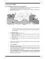
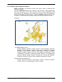
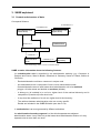
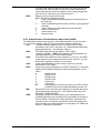
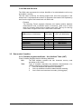
SABE Seamless Administrative Boundaries of Europe User Guide Refers to SABE 2004 version 1.0 Contents 1. Introduction..................................................................................................................... 3 1.1 1.2 1.3 1.4 1.5 1.6 1.7 2. Overview of SABE .......................................................................................................... 5 2.1 2.2 2.3 2.4 2.5 2.6 2.7 2.8 3. Pan-European Administrative Boundary data ........................................................... 5 Seamless and consistent dataset.............................................................................. 6 Supply options ........................................................................................................... 7 Spatial Reference ...................................................................................................... 7 Status (time referencing) ........................................................................................... 7 Update ....................................................................................................................... 7 Quality ....................................................................................................................... 7 SABE applications ..................................................................................................... 7 SABE explained .............................................................................................................. 8 3.1 3.2 3.3 3.4 3.5 4. Contact details........................................................................................................... 3 Product performance ................................................................................................. 3 Liability....................................................................................................................... 3 Delivery of SABE ....................................................................................................... 4 Data copyright ........................................................................................................... 4 User Guide copyright................................................................................................. 4 Trade marks .............................................................................................................. 4 Content and structure of data .................................................................................... 8 Transfer format ........................................................................................................ 10 Data Model: Concepts ............................................................................................. 11 Data model: Administrative features ....................................................................... 12 Data model: Coastline............................................................................................. 15 Using SABE................................................................................................................... 16 4.1 4.2 4.3 4.4 4.5 What you need to use SABE ................................................................................... 16 Using SABE with Arc/Info ........................................................................................ 16 Using SABE with ArcView....................................................................................... 17 Using SABE with other GIS software ...................................................................... 17 Addresses of National Mapping and Statistics Organisations ................................. 17 Annex A : Product performance report ............................................................................. 19 Annex B : European National Mapping and Statistics Organisations ............................ 20 Annex C : Copyright statements ........................................................................................ 28 Annex D : SABE product types and transfer files ............................................................ 29 Annex E : Description of source data ................................................................................ 31 Annex F : Diacritical characters and number of administrative units ........................... 32 Annex G : Overview of the SHN structure ......................................................................... 34 1. Introduction This User Guide has been designed to provide you with all the information needed to use the SABE dataset. The Guide is arranged into the following sections: • "Overview of SABE" provides an introduction to SABE • "SABE explained" is a more detailed description of the structure and the content of the SABE dataset • "Using SABE" contains some instructions on how to use the dataset with your GIS software We have checked this Guide before issuing it, and every effort has been made to ensure that the contents are accurate. If you find an error, omission, or have a suggestion about how it can be improved, please contact EuroGeographics at the address shown below, under contact details. 1.1 Contact details If you have problems using SABE or any questions related to the dataset or its use please contact EuroGeographics or the distributor from which you purchased the data. EuroGeographics’s address is: EuroGeographics 6-8 Ave Blaise Pascal Cité Descartes Champs-sur-Marne 77455 Marne-la-Vallée Cedex 2 France Telephone: Facsimile: e-mail: WWW: +33 (0) 1 64 15 32 73 +33 (0) 1 64 15 32 19 [email protected] http://www.EuroGeographics.org The addresses of national mapping agencies are listed in Annex B "European National Mapping and Statistics Organisations". 1.2 Product performance If you have any problems or identify any errors in the data, please complete the product performance report provided in Annex A. 1.3 Liability A full description of the terms and conditions of supply and use of SABE is included in the End User Licence signed by your organisation. EuroGeographics and the national mapping agencies contributing to SABE have made every effort to ensure that data supplied are free from errors and omissions. We will remedy, as soon as reasonably practicable, errors and omissions notified to EuroGeographics or national mapping agencies in writing. It is the Customer’s responsibility to ensure that the data ordered are suitable for the intended purpose. Neither EuroGeographics nor the national mapping agencies will be liable to the customer or any other party for any loss, damage, inconvenience or expense resulting from the use of, or reliance upon, the data. User Guide, SABE 2004 version 1.0 Page 3 1.4 Delivery of SABE You are advised to make a back-up copy of the data delivered. Written notification of any deficiency in the SABE data or damage to the goods must be given to EuroGeographics or the distributor from which you bought the data. 1.5 Data copyright SABE data are copyright of EuroGeographics and the contributing national mapping agencies. As standard, SABE data may be used for internal business use only. It may not be used for Internet applications unless this has been explicitly agreed within a schedule addition to the licence. Your licence agreement specifies the number of concurrent users which may use the data. Additionally, any printed output which is based on SABE data must bear an appropriate copyright acknowledgement. 1.6 User Guide copyright This User Guide is copyright of EuroGeographics. No part of this document may be reproduced or transmitted in any form or by any means, electronic or mechanical, for any purpose, without the express written permission of EuroGeographics. 1.7 Trade marks Trade marks in this Guide are the property of their respective owners. ArcView is a trade mark and ARC/INFO is a registered trade mark of Environmental Systems Research Institute, Inc. INFO is a trade mark of Henco Software, Inc. User Guide, SABE 2004 version 1.0 Page 4 2. Overview of SABE 2.1 Pan-European Administrative Boundary data SABE is a pan-European dataset which contains the geometry and semantics of the administrative hierarchies of 36 European countries. Each country has its own specific administrative hierarchy, composed of a different number of levels. Great Britain, Hungary, Iceland, Spain, Sweden, Switzerland. Ireland, Northern Ireland, Norway, Portugal, Slovakia, Slovenia, The above example shows the administrative divisions in an area covered by four European countries. The thickness of the line represents the level of the boundary. The dataset includes: • boundaries of administrative units; • names of different levels in national administrative hierarchies and the relations between them; • names and codes of administrative units on the basis of the national nomenclature; • location of residences of authorities of the units for the countries where the information exists SABE contains all levels of national administrative hierarchies from the highest (country) to the lowest. 2.1.1 Coastline The definition of administrative boundaries with regards to sea and inland waters differs from country to country. In some countries, the coastal administrative areas extend into the sea. In some cases, the sea boundary is not defined or is defined to a different precision to the other administrative boundaries. For certain applications (e.g. population statistics) it is useful to link the statistical data to the land areas only. The SABE dataset is therefore provided with coastline information for the countries where the physical and administrative boundaries do not coincide. User Guide, SABE 2004 version 1.0 Page 5 2.2 Seamless and consistent dataset SABE is delivered as individual country files which create a seamless and consistent dataset. The term consistent refers to the contents, to the structure, to geo-referencing, and time referencing of the data, although with so many independent data sources there are variations in the currency of the data. These are indicated in Annex E “Description of source data”. The term seamless means that there are no gaps or overlaps between polygons initially derived from different sources. Coverage The SABE dataset covers : Austria, Belgium, Bulgaria, Croatia, Cyprus, Czech Republic, Denmark, Estonia, Faeroe Islands, Finland, France (incl. Guadeloupe, Guyana, Martinique, and Reunion), Germany, Great Britain, Greece, Greenland, Hungary, Iceland, Ireland, Italy (incl. San Marino and Vatican), Latvia, Liechtenstein, Lithuania, Luxembourg, Malta, Moldova, The Netherlands, Northern Ireland, Norway, Poland, Portugal (incl. Azores and Madeira), Romania, Slovakia, Slovenia, Spain, Sweden, Switzerland, Ukraine Coastline files are available for: Croatia, Finland, Germany, Great Britain, Ireland, Lithuania, Northern Ireland, Norway, The Netherlands, Poland, Sweden. User Guide, SABE 2004 version 1.0 Page 6 2.3 Supply options 2.3.1 Resolution The product is available filtered to two different geometric resolutions: ~ 30 metres for applications approximately at 1: 100 000 scale ~200 metres for applications approximately at 1: 1 000 000 scale With regard to the SABE97 Relaunch version the parameters for generalization have been changed to meet the requirements of the users in a better way. Both products contain the same attributes. 2.3.2 Supply units As standard, SABE is supplied on a country-by-country basis, but customised supply is also possible. 2.3.3 Product types SABE is supplied in different product types (see Annex D “SABE product types and transfer files”). 2.4 Spatial Reference Coordinates are two-dimensional, geographicals in degrees (longitude, latitude) with decimal fraction. The spatial reference system is ETRS89 with ellipsoid GRS 80. No map projection is applied. To be able to use SABE effectively with other datasets, you will need to ensure that the data have the same spatial reference. 2.5 Status (time referencing) For the SABE 2004 version 1.0 the data generally refers to the national administrative situation as it was in July 2003 for the former EU members and May 2004 for the 10 new EU countries and all other SABE countries. Details are provided in Annex E “Description of source data” 2.6 Update Five versions of the SABE product exist. The first one refers to 1991, the second to 1995, the third to 1997, the fourth to 2001/census date and the current version to July 2003/May 2004. If you require updates as they become available, you should complete the optional update agreement. 2.7 Quality The SABE dataset is compiled from national administrative boundary datasets provided by National Mapping Agencies. The source data are of the best available semantic quality. The contributions have been transformed into a uniform structure, have been line-filtered to a uniform resolution, are edge matched at international boundaries and finally the quality has been checked with regard to the defined SABE specification. 2.8 SABE applications SABE enables you to geo-reference statistical data, and can also be used as a background to geo-referenced datasets. The most typical applications of the data are: • population analysis • political analysis • economic analysis • asset management • geo-referencing cross-border data User Guide, SABE 2004 version 1.0 Page 7 3. SABE explained 3.1 Content and structure of data Conceptual Schema is included in 0:1 is included in 0:1 Administrative Unit (lowest level) has residence in 1:1 Administrative Unit (higher level) consists of 0:m Condominium consists of 1:1 Mainland Exclave / Island consists of 1:1 Administrative Area* is limited by 1:m Administrative Boundary * the terminology refers to its use in this document SABE contains information about the following features: An administrative unit is controlled by an administrative authority (e.g. Commune in Belgium and France, Ward in Britain, Gemeinde in Germany, Kunta in Finland, Občina in Slovenia). - Each administrative unit has a name and a unique code. - An administrative unit is composed of one or more administrative areas. One administrative area of each lowest level administrative unit is its mainland polygon. All other areas are labelled as exclaves (islands). - It belongs to (is included in) a unit at a higher level of the national hierarchy and is composed of (consists of) lower level units. - It may host the residence of a unit at a higher level in the hierarchy. - The relations between administrative units are country specific. Details are included in the SABE.ISN table (see also 3.4.4). A condominium is an area governed by different authorities. An administrative boundary segment is a line which separates two adjacent administrative areas. It may exist only at the lowest level administrative division or it may separate units at more than one level. User Guide, SABE 2004 version 1.0 Page 8 The following example shows the administrative division at the lowest (commune) level with the outlines and the codes of the units. This example demonstrates the difference between administrative unit and administrative area: commune labelled 02111 is one administrative unit composed of two administrative areas: one mainland polygon and one exclave. mainland polygon exclave User Guide, SABE 2004 version 1.0 Page 9 3.2 Transfer format SABE is provided as single precision coverages in Arc/Info Export format1. Administrative boundaries are provided as one file per country Coastline a separate file with the coastline is supplied for each country where the coastline does not coincide with the administrative boundaries Centroids a separate ASCII file including the code of the main area, the longitude and latitude of the label point and the name of the main area Hierarchy details a single file SABE.ISN contains the hierarchy details of all countries 1 Other data formats (as for instance Shape or MapInfo) could be available via EuroGeographics on-line ordering and delivery system or from Value Added Resellers. User Guide, SABE 2004 version 1.0 Page 10 3.3 Data Model: Concepts 3.3.1 Geometry 3.3.1.1 Geometric primitives SABE contains linear (one dimensional) and areal (two dimensional) elements: In this text, the term line means a linear segment defined by two or more points. A node in SABE is a point where two or more lines meet. The exception is a node representing the start and the end points of the same line (e.g. a line bounding an island). Lines in SABE represent linear features, such as administrative boundaries and the coastline. A line starts and ends with a node. Polygons represent areal features i.e. administrative areas. A polygon is defined by one or more bounding lines. Each polygon contains a label point - i.e. an isolated point which serves as a location point for displaying or plotting the attributes attached to the area. 3.3.1.2 Line and polygon topology SABE is structured as an Arc/Info coverage with full polygon-arc topology. This means that each boundary segment and polygon can be individually addressed, selected or linked to external attribute information. The Arc Attribute Table (AAT) contains the topological information for line features. The Polygon Attribute Table (PAT) contains the topological information of polygon features. Both tables are essential parts of the Arc/Info data model. If you require more detailed information about the Arc/Info topological model, see the documentation provided with Arc/Info. 3.3.2 Attributes An attribute is a descriptive characteristic of a feature (administrative unit’s name and code). User Guide, SABE 2004 version 1.0 Page 11 3.4 Data model: Administrative features The following discussion of PAT and AAT attributes explains the SABE-specific contents, and does not mention the geometry-related internal Arc/Info attributes. All the other attributes are listed and explained. 3.4.1 Administrative Boundary Segment Attributes – Arc Attribute Table (AAT) Each Administrative Boundary Segment has the following attributes: ICC: The ICC attribute contains the two character country code according to ISO 3166 (e.g. "DE" for Germany). For the datasets that do not cover the whole country the code does not comply with ISO standard. Exceptions are for instance France, where the FX dataset (in contrast to FR) does not contain the information from DOM (over-seas departments) and United Kingdom for which the data are provided as one dataset for Great Britain (GB) and the other for Northern Ireland (NI). USE: Level of the boundary in the administrative hierarchy: 1 1st order ("national level") 2 2nd order 3 3rd order 4 4th order 5 5th order 6 6th order EUR: Level of the boundary as defined by new NUTS (= Nomenclature of territorial units for statistics) regulation : 0 National level 1 NUTS1 level 2 NUTS2 level 3 NUTS3 level 4 LAU1 level (local administrative unit, former NUTS4) 5 LAU2 level (local administrative unit, former NUTS5) 997 Boundary does not belong to an EU country, or is not defined according to the new NUTS regulation MOL: Meaning (i.e. origin or source) of the line: 1 provided by NMA 8 disputed 3.4.2 Administrative Area Attributes - Polygon Attribute Table (PAT) Each Administrative Area (a polygon which is not composed of smaller polygons) has the following attributes: ICC: The ICC attribute contains the two character country code according to ISO 3166 (see also 3.4.1 Administrative Boundary Segment Attributes – Arc Attribute Table). SHN: The SHN code (e.g. '1236NRFJ') corresponds to the administrative unit’s national code. The SHN attribute indicates the administrative unit to which the area belongs and is a strictly hierarchical built identifier (according to the number of levels of the administrative hierarchy of the country) for all administrative units. If the delivered codes are not consistent with the SABE specification (e.g. if they do not have a hierarchical structure) the SABE team had to derive new codes from these codes. Together, the ICC + SHN codes provide an identifier which is unique for each administrative unit of Europe. User Guide, SABE 2004 version 1.0 Page 12 MOC: To extract the codes of higher level units you need to know the SHN structure (see Section 3.4.4 and for further explanations concerning the structure of the SHN in each country please see also Annex G “Overview of the SHN structure”) Meaning of the centroid of the area. MOC can take the following values: 1 Area is mainland and the label points to the residence of the authority 2 Area is mainland and label does not have a geo-graphical meaning 3 Area is exclave or island apart from the mainland 4 Area is condominium 7 Area is water only 9 Unknown area 3.4.3 Administrative Unit Attributes: Name table (NAM) The NAM table contains one record for each administrative unit (on all levels e.g. Commune, Canton, Grand Duchy) and has the following attributes: ICC: The ICC attribute contains the two character country code according to ISO 3166 (see also 3.4.1 Administrative Boundary Segment Attributes – Arc Attribute Table). ). SHN: The SHN code (see the description of PAT table). Together, the ICC + SHN codes provide a unique identifier for each administrative unit of the SABE product. RAU: the SHN of the residence of the authority of a unit (i.e. the SHN of the lowest level unit which hosts this unit’s "council", e.g. the SHN of the capital of a district or a province) USE: Level of administration in the country’s hierarchy (see the description of AAT table). EUR: Level of the unit as defined by new NUTS regulation. This is only applied to EU Member States (see also the description of AAT table) 0 National level 1 NUTS1 level 2 NUTS2 level 3 NUTS3 level 4 LAU1 level 5 LAU2 level 997 Administrative unit does not belong to an EU country, no NUTS/LAU level is defined/available for this unit ISN: Structure ID of the unit from the Catalogue of Internal Structures and Designations (see Section 3.4.4 Administrative Structure Attributes : SABE.ISN table) GEN: Geographical Name (official name) of the administrative unit. (Special characters are encoded as far as possible according to the ISO 8859-1 character set. Other diacritical characters are encoded by two consecutive characters where the leading one does not exist as a valid character in a language. For details see Annex F “Diacritical characters”) User Guide, SABE 2004 version 1.0 Page 13 3.4.4 Administrative Structure Attributes: SABE.ISN table The SABE.ISN table contains the relations between the hierarchical levels. There is just one ISN file for all SABE countries which contains all names of all levels of national administrative hierarchies. This table is used to derive the unique codes for the corresponding higher level administrative units from the SHN code of the lowest level administrative unit. The table contains information on all levels of a country’s administrative hierarchy for all countries in the dataset, and has the following attributes: ISN: Structure Identifier which identifies a level in the hierarchy and allows a link by ISN to the NAM table ISS: Substructure Identifier which points to the ISN attribute of another record in this table identifying the hierarchy level immediately below the current. If no further substructure exists, this pointer is set to 9997 SHI: Number of figures which must be removed from the right of the SHN code and replaced with zeros (see 3.4.2 Administrative Area Attributes – Polygon Attribute Table) to identify all the units belonging to the structure DES: Name of the hierarchy level in the national language (e.g. 'Province'). 3.4.5 Relations between tables PAT table lowest level polygon higher level polygon ... SHN MOC ICC NAM table ... ICC SHN RAU USE EUR ISN PAT table of higher level polygons (not included in the standard exchange structure) The NAM table is related to the PAT table via the SHN attribute. The ISN table is related to the NAM table via the ISN attribute. User Guide, SABE 2004 version 1.0 ISN table ... ISN ISS SHI DES Page 14 3.4.6 SHN and SHI code The SHN code represents the unique identifier of an administrative unit at any level within a country. The SHI code is the key for deriving higher level units from polygons of the lowest level. It represents the number of characters that need to be replaced by zero from the right of the lowest level unit SHN code. Example The following French example illustrates the implicit relation between administrative units of different levels of hierarchy. SHN code of lower level unit contains SHN codes of higher level units. The key for deriving SHN codes of higher level units is SHI code in ISN table. Name (GEN attribute in NAM table) Commune Canton de rattachement Arrondissement Département Région République SHI (ISN table) example of SHN (PAT and NAM table) 0 3 5 6 8 10 4157705356 4157705000 4157700000 4157000000 4100000000 0000000000 3.5 Data model: Coastline 3.5.1 Coastline segment attributes - Arc Attribute Table (AAT) Each Coastline Segment has the following attributes: ICC: The ICC attribute contains the two character country code according to ISO 3166. TOC: Type of coastline describes the particular characteristics of a coastline segment in relation to a boundary segment. 1 line is a coastline and identical to boundary 2 line is a coastline but without administrative meaning 3 line is fictive and used as a boundary (closing gaps) User Guide, SABE 2004 version 1.0 Page 15 4. Using SABE 4.1 What you need to use SABE 4.1.1 Hardware SABE can be used with any computer platform from a PC to a mainframe. The hardware requirements are generally the same as for managing any other vector geographic dataset. 4.1.2 Software SABE is a dataset and is delivered without a user interface for displaying or analysing it. Whatever you want to do with the data, you need to have appropriate software. SABE can be used directly with ESRI’s Arc/Info or ArcGIS system and may also be imported into other software packages. 4.2 Using SABE with Arc/Info This section provides some basic commands to help you to start using SABE in Arc/Info. For more details of Arc/Info commands, see the documents provided with the software. 4.2.1 Loading the data 4.2.1.1 Loading the administrative structure information [ARC>] IMPORT INFO sabeisn sabe.isn SABE.ISN contains information for all the countries in SABE. It needs to be imported only once. 4.2.1.2 Loading the administrative boundaries Administrative boundary data are provided in separate files, one file per country. [ARC>] IMPORT COVER <interchange file> <coverage_name> Example: IMPORT COVER de30 de30 Important: to enable the relations between tables to be restored, the coverage names should be the same as the export file names (without the extension) [ARC>] RELATE RESTORE <INFO file> Example: RELATE RESTORE de30.rel The relations between PAT, NAM and SABE.ISN tables have been restored. 4.2.1.3 Loading the coastline Coastline is provided in separate files for the countries where the coastline does not coincide with administrative boundaries. Coverages need to be imported independently: [ARC>] IMPORT COVER <interchange file> <coverage name Example: IMPORT COVER SCDE30 SCDE30 User Guide, SABE 2004 version 1.0 Page 16 4.3 Using SABE with ArcView The following instructions have been tested with ArcView 3.2 1. Import the SABE country coverages: (IMPORT window) <interchange file> <coverage_name> Example (IMPORT window): z:\nl30.e00 c:\sabe\nl30 IMPORT is an independent program delivered with ArcView. If you do not specify the directory, the data will be restored to your default ArcView data directory. 2. Import the administrative structure table: (IMPORT) sabeisn.e00 sabe.isn 3. Start the ArcView session and create a new project 4. Add the SABE data to the project If you add three themes for each SABE country: polygon, line and labels you will have the best possibilities for data display. Select the polygon theme to make it active. 5. Add the name table (*.NAM) 6. Relate the name table to the feature table (use the ‘Join’ command via SHN field) 7. Add the SABE.ISN table 8. Relate the SABE.ISN table to the polygon feature table (via ISN field) 4.4 Using SABE with other GIS software The SABE dataset is supplied in Arc/Info Export as standard. Some other GIS systems are provided with translators which will allow the data to be imported. If you require SABE in a different format, please contact EuroGeographics or a distributor to discuss the possibility of format customisation. 4.5 Addresses of National Mapping and Statistics Organisations SABE is most useful when combined with other data. As a user of administrative boundaries data you are probably interested in different statistical data. Annex B “European National Mapping and Statistics Organisations” provides contact addresses for the National Mapping and Statistical Agencies responsible for the area covered by SABE. User Guide, SABE 2004 version 1.0 Page 17 Annexes User Guide, SABE 2004 version 1.0 Page 18 Annex A : Product performance report Please complete and send to: EuroGeographics Product Manager EuroGeographics 6-8 Ave Blaise Pascal Cité Descartes Champs-sur-Marne 77455 Marne la Vallé Cedex 2 France Fax: +33 (0) 1.64.15.32.19 e-mail: [email protected] Description of problem encountered / suggestion: Version of data: (from CD-ROM) Your name: Company: Address: Telephone: Facsimile: e-mail : User Guide, SABE 2004 version 1.0 Page 19 Annex B : European National Mapping and Statistics Organisations This list of contacts is provided to help you to find the map and statistical information which you need. The left column contains the contact address for mapping data, the right column contains the contacts for statistical information. Europe Product Manager EuroGeographics 6-8 Ave Blaise Pascal Cité Descartes Champs-sur-Marne 77455 Marne la Vallé Cedex 2 France Eurostat/GISCO Statistical Office of the European Communities Jean Monnet Building Rue Alcide De Gasperi L-2920 Luxembourg-Kirchberg Tel: Fax: e-mail: WWW: Tel: +352 4301 33088 Fax: +352 4301 34029 e-mail: [email protected] WWW: http://europa.eu.int/comm/eurostat/ +33 (0) 1 64 15 32 73 +33 (0) 1 64 15 32 19 [email protected] http://www.EuroGeographics.org Austria Sales Department Kartographische Daten Bundesamt für Eich und Vermessungswesen Krotenhallergasse 3 1080 Wien Austria Statistik Österreich Hintere Zollamtsstraβe 2b Postfach 9000 1033 Wien Austria Tel: Fax: e-mail: WWW: Tel: Fax: e-mail: WWW: +43 1 40 146 +43 1 406 9992 [email protected] http://www.bev.gv.at/ +43 1 71128/ 7654 - 7656 +43 1 715 68 28 [email protected] http://www.oestat.gv.at Belgium Sales Department Institut Géographique National Abbaye de la Cambre 13 1000 Bruxelles Belgium Info Service Institut National de Statistique 44, rue de Louvain 1000 Bruxelles Belgium Tel: +32 2 629 82 82 Fax: +32 2 629 82 83 e-mail: [email protected] WWW: http://www.ngi.be/ Tel: +32 2 548 6211 Fax: +32 2 548 6262 e-mail: WWW: Bulgaria Mr. Tveten Boev Ministry of Regional Development and Public Works, Cadastre Agency 1618 Sofia 1 Musala str No information available Tel.: +359 2 955 4540 Fax: +395 2 955 5333 e-mail: [email protected] WWW: http://www.cadastre.bg User Guide, SABE 2004 version 1.0 Page 20 Croatia Mr. Željko Bačić Državna Geodetska Uprava Gruška 20 10000 Zagreb Croatia Sales department Central Bureau of Statistics Ilica 3 PO Box 671 10000 Zagreb Croatia Tel: +385 1 36 57 394 Fax: +385 1 61 57 389 e-mail: [email protected] WWW: http://www.dgu.hr Tel: Fax: e-mail: WWW: +385 1 455 4422 +385 1 429 413 [email protected] http://www.dzs.hr Cyprus Cyprus Department of Lands and Surveys H/Q 29 Michalakopoulou Street CY-1455 Nicosia Cyprus No information available Tel: +357 (22) 304 900 Fax: +357 (22) 767001 e-mail: [email protected] WWW: Czech Republic Ceský úrad zememerický a katastrální Pod sidlistem 9 CZ – 182 00 Praha 8 Czech Republic Informacniho Servisu Ceský statisticky úrad Sokolovská 142 186 04 Praha 8 Czech Republic Tel: +420 2 8404 1209 Fax: +420 2 8404 1204 e-mail: [email protected] WWW: http://www.cuzk.cz Tel: +420 2 6604 2451, +420 2 6604 2555 Fax: +420 2 6631 0429, +420 2 826 489 e-mail: WWW: http://infox.eunet.cz/csu/csu_e.html Denmark Customer Service Kort & Matrikelstyrelsen Rentemestervej 8 2400 København NV Denmark General Enquiries Danmarks Statistik Sejrøgade 11 2100 København Denmark Tel: Fax: e-mail: WWW: Tel: Fax: e-mail: WWW: +45 35 87 50 44 +45 35 87 50 53 [email protected] http://www.kms.dk + 45 39 17 39 17 + 45 31 18 48 01 [email protected] http://www.dst.dk Estonia Mr. Kristian Teiter Estonian National Land Board Mustamäe tee 51 Box 1635 EE-10602 Tallinn Estonia Tel: + 372 66-50-652 Fax: +372 66-50-604 e-mail: [email protected] WWW: http://www.maaamet.ee Statistical Office of Estonia Endla 15 EE-0100 Tallinn Estonia Tel: +372 6 259202 Fax:+372 2 453923 e-mail: WWW: User Guide, SABE 2004 version 1.0 Page 21 Finland Marketing and Sales Services Maanmittauslaitos Opastinsilta 12 C 00521 Helsinki Finland General Enquiries Statistics Finland Työpajakatu 13 00022 Helsinki Finland Tel: Fax: e-mail: WWW: Tel: Fax: e-mail: WWW: +358 205 41 5516 +358 205 41 5598 [email protected] http://www.nls.fi +358 9 1734 2220 +358 9 1734 2279 [email protected] http://www.stat.fi France Département Grands Clients Institut Géographique National 2, Avenue Pasteur 94165 St.-Mandé CEDEX France INSEE Info Service 195, rue de Bercy - Tour Gamma A 75582 Paris Cedex 12 France Tel: Fax: e-mail: WWW: Tel: +33 1 41 17 66 11 Fax: +33 1 53 17 88 09 e-mail: WWW: http://www.insee.fr +33 1 43 98 80 20 +33 1 43 98 80 31 [email protected] http://www.ign.fr Germany Dipl - Geogr Reiner Retzek Bundesamt für Kartographie und Geodäsie Richard-Strauss Allee 11 60598 Frankfurt-am-Main Germany Allgemeiner Auskunfts- und Besucherdienst Statistisches Bundesamt Stresemann-Ring 11 65180 Wiesbaden Germany Tel: Fax: e-mail: WWW: Tel: +49 611 752405 Fax: +49 611 753330 e-mail: WWW: http://www.Statistik-bund.de +49 69 6333 349 +49 69 6333 441 [email protected] http://www.bkg.bund.de Hungary Mrs Eniko Kovács Földmérési és Távérzékelési Intézet PO Box 546 H-1373 Budapest Hungary Marketing Department Központi Statisztikai Hivatal H-1525 Budapest Pf. 51 Hungary Tel: +36 1 222 5101 Fax: +36 1 222 5106 e-mail: [email protected] WWW: http://www.fomi.hu/ Tel: Fax: +361 212 4673 e-mail: [email protected] WWW: http://www.ksh.hu Iceland Sales Department Landmælingar Íslands Stillholt 16-18 IS-300 Akranes Iceland Information Services Statistics Iceland Skuggasund 3 150 Reykjavik Iceland Tel: Fax: e-mail: WWW: Tel: Fax: e-mail: WWW: +354 430 9000 +354 430 9090 [email protected] http://www.lmi.is User Guide, SABE 2004 version 1.0 +354 560 9880 +354 562 3312 [email protected] http://www.stjr.is/statice Page 22 Ireland Digital Sales Ordnance Survey - Ireland Phoenix Park Dublin 8 Ireland Information Section Central Statistics Office Skehard Road Cork Ireland Tel: Fax: e-mail: WWW: Tel: Fax: e-mail: WWW: +353 1 820 6100 +353 1 820 4156 [email protected] http://www.irlgov.ie/osi/ +353 21 359000 +353 21 359090 [email protected] http://www.cso.ie Italy Direzione Amministrativa Sezione Vendite Istituto Geografico Militare Italiano Via Cesare Battisti 10-12 1-50100 Firenze Italy I Centri di informazione statistica Istituto Nazionale di Statistica Via Cesare Balbo, 16 I - 00100 Roma Italy Tel: Fax: e-mail: WWW: Tel: Fax: e-mail: WWW: +39 0552 7322 +39-055-2 82172 [email protected] http://www.nettuno.it/fiera/igmi +39 6 46733105 +39 6 46733107 [email protected] http://www.istat.it Latvia Mr Valdis Vanags Latvijas Republikas Valst zemes dienest 11, Novembra krastmala 31 LV-1484 Riga Latvia Information, Publishing and External Relations Department Latvijas Republikas Valsts statistikas komiteja Tel: +371 7 038521 Fax: +371 7 038514 e-mail: [email protected] WWW: http://www.lzkc.org.lv/ Tel: Fax: e-mail: WWW: +371 7 33 13 63 +371 7 83 01 37 [email protected] http://www.latnet.lv/ligumi/csbl Lithuania Nacionalinė Žemės tarnyba Ukmerges 41 LT-2600 Vilnius Lithuania VĮ „GIS-Centras“ Sėlių 66 LT-2004 Vilnius Lithuania Tel : +370 5 239 84 46 Fax : +370 5 239 84 37 e-mail : [email protected] WWW : http://www.zum.lt/nzt/ Tel: +370 (52) 724741 Fax: +370 (52) 727 723 e-mail: [email protected] WWW: http://www.gis-centras.lt Luxembourg Mr Dipl-Ing André Majerus Administration du Cadastre et de la Topographie 54 Avenue Gaston Diderich L-1017 Luxembourg Information and Sales Statec B.P. 304 L-2013 Luxembourg Tel: Fax: e-mail: WWW: Tel: Fax: e-mail: WWW: +352 44901 272 +352 44901 288 [email protected] http://www.etat.lu/ACT User Guide, SABE 2004 version 1.0 +352 478 4268, +352 478 4221 +352 46 42 89 [email protected] http://statec.gouvernement.lu Page 23 Malta No information available Malta Environment & Planning Authority P.O. Box 200 Valletta CMR 01 Malta Tel: +356 21 240 976 Fax: +356 21 224 846 e-mail: [email protected] WWW: http://www.mepa.org.mt Moldova No information available Mr. Nicolae Svet State Agency for Land Relations and Cadastre of the Republic of Moldova 2005, or. Chişinău, str. Puşkin, 47 Tel: (+373 2) 21-22-44 Fax: (+373 2) 22-63-73 e-mail: [email protected] Netherlands Sales Department Topografische Dienst Kadaster Bendienplein 5 Postbus 115 NL-7800 AC Emmen The Netherlands Centraal Bureau voor de Statistiek Afdeling Verkoop Kamer J116 Postbus 4481 6401 CZ Heerlen The Netherlands Tel: +31 591 69 69 11 Fax: +31 591 69 68 11 e-mail: [email protected] WWW: www.kadaster.nl/topografischedienst Tel: Fax: e-mail: WWW: +31 (45) 570 79 70 +31 (45) 570 62 68 [email protected] http://www.cbs.nl Norway Sales department Statens Kartverk Kartverksveien 21 N-3504 Hønefoss Norway Library Statistics Norway Kongsgata 6 N-0033 Oslo 1 Norway Tel: Fax: e-mail: WWW: Tel: Fax: e-mail: WWW: +47 32 11 81 00 +47 32 11 81 01 [email protected] http://www.statkart.no +47 22 86 46 42/43 +47 22 86 45 04 [email protected] http://www.ssb.no Poland Główny Urzad Geodezji i Kartografii Ul Wspólna 2 PL-00926 Warsawa Poland Tel: Fax: e-mail: WWW: No information available + 48 22 661 8453 +48 22 661 8118 [email protected] http://www.gugik.gov.pl/str_glowna.htm User Guide, SABE 2004 version 1.0 Page 24 Portugal Sales department Instituto Português de Cartografia e Cadastro Rua Artilharia 1, m°107 1070 Lisboa Portugal Serviço de Informaçã Instituto Nacional de Estatística Avenida António José de Almeida, 5 1078 Lisboa Codex Portugal Tel: Fax: e-mail: WWW: Tel: Fax: e-mail: WWW: +351 1 381 9600 +351 1 381 9699 [email protected] http://www.igeo.pt +351 1 847 00 50 +351 1 847 39 64 [email protected] http://www.ine.pt Romania The National Office for Cadastre, Geodesy and Cartography (N.O.C.G.C.) 202 A Splaiul Independentei Bucharest, ROMANIA No information available Tel: 00 40 1 222 29 00 Fax: 00 40 1 222 52 24 E-mail: [email protected] WWW: Slovak Republic Urad geodezie, kartografie a katastra Slovenskej republiky Stromova 1 SK-83786 Bratislava Slovak Republic Tel: Fax: E-mail: WWW: Štatistický úrad Slovenskej republiky Miletičova 3 824 67 Bratislava Slovak Republic Tel: +421 7 5556 1774 Fax: +421 7 5556 1361 +421 7 59 374 431 +421 7 54 774 753 [email protected] http://www.geodesy.gov.sk/ Slovenia Geodetska uprava Republike Slovenij Zemljemerska ul. 12 SI-1000 Ljubljana Slovenia Tel: Fax: e-mail: WWW: +386 61 17 84 903 +386 61 17 84 909 [email protected] http://www.sigov.si/gu Sales department Statisticni Urad Republike Slovenije Vozarski pot 12 1000 Ljubljana Slovenia Tel: +386 61 125 53 22 Fax: +386 61 216 932 e-mail: [email protected] Spain Sales department Centro Nacional de Información Geográfica General Ibáñez de Ibero 3 28071 Madrid Spain Servicio de Información Instituto Nacional de Estadistica Paseo de la Castellana, 183 28046 Madrid Spain Tel: Fax: e-mail: WWW: Tel: Fax: e-mail: WWW: +34 91 5979648 +34 91 5979764 [email protected] http://www.mfom.es/ign User Guide, SABE 2004 version 1.0 +34 1 572 07 93 +34 1 583 91 58 [email protected] http://www.ine.es Page 25 Sweden KartCentrum Lantmäteriverket Lantmäterigatan 2 80182 Gävle Sweden Tel: Fax: e-mail: WWW: +46 26 63 30 00 +46 26 68 75 94 [email protected] http://www.lm.se Information service Statistiska centralbyrån Box 24 300 Karlavägen 100 10451 Stockholm Sweden Tel: +46 8 783 40 00 Fax: +46 8 661 52 61 e-mail: [email protected] WWW: http://www.scb.se Switzerland Sales department Bundesamt für Landestopographie Seftigenstrasse 264 3084 Wabern Switzerland Informationsdienst Federal Statistical Office of Switzerland Schwarztorstrasse 96 3003 Berne Switzerland Tel: Fax: e-mail: WWW: Tel: Fax: e-mail: WWW: +41 31 963 2111 +41 31 963 2459 [email protected] http://www.swisstopo.ch +41 31 323 60 11 +41 31 323 60 12 [email protected] http://www.admin.ch/bfs Ukraine Derzavna Sluzba Geodezii, kartografii ta kadastru 54 Popudrenka Str 02094 Kyiv Ukraine No information available Tel: +380 (44) 559 7389 Fax: +380 (44) 573 4213 E-mail: [email protected] WWW: http://www.geomatica.kiev.ua/ukrgeo User Guide, SABE 2004 version 1.0 Page 26 United Kingdom Great Britain Customer Services - Sales Desk Ordnance Survey Romsey Road Southampton SO16 4GU Great Britain Tel: Fax: e-mail: WWW: +44 1703 792773 +44 1703 792324 [email protected] http://www.ordsvy.gov.uk/ Sales Desk Office for National Statistics 1 Drummond Gate London SW1V 2QQ United Kingdom Tel: +44 171 533 5678 Fax: e-mail: [email protected] WWW: http://www.ons.gov.uk/ Northern Ireland Digital Data Sales Ordnance Survey of Northern Ireland Colby House Stranmillis Court Belfast BT9 5BJ Northern Ireland Tel: Fax: e-mail: WWW: +44 (0)28 90255785 +44 (0) 28 90255700 [email protected] http://www.osni.gov.uk/ User Guide, SABE 2004 version 1.0 Page 27 Annex C : Copyright statements SABE data copyright is held by European National Mapping Agencies: Austria © Bundesamt für Eich- und Vermessungswesen Belgium © Institut Géographique National - Belgique Bulgaria © Ministry of Regional Development and Public Works, Cadastre Agency Croatia © Drzavna Geodetska Uprava Cyprus © Ministry of the Interior, Department of Lands and Surveys Czech Republic © Ceský úrad zememerický a katastrální Denmark © Kort og Matrikelstyrelsen Estonia © Maa-amet Finland © Maanmittauslaitos France © Institut Géographique National - France Germany © Bundesamt für Kartographie und Geodäsie Great Britain © Ordnance Survey Greece © Hellenic Mapping and Cadastral Organisation Hungary © Földmüvelésügyi és Vidékfejlesztési Minisztérium Iceland © Landmælingar Íslands Ireland © Ordnance Survey of Ireland Italy © Istituto Geografico Militare Italiano Latvia © Latvijas Republikas Valst zemes dienests Lithuania © National Land Service Luxembourg © Administration du Cadastre et de la Topographie Malta © The Malta Environment and Planning Authority Moldova © State Agency for Land Relations and Cadastre of the Republic of Moldova Netherlands © Topografische Dienst Kadaster Northern Ireland © Ordnance Survey of Northern Ireland Norway © Statens Kartverk Poland © Glówny Urzad Geodezji i Kartografii Portugal © Portuguese Geographical Institute Romania © The National Office for Cadastre, Geodesy and Cartography Slovakia © Úrad geodézie, kartografie a katastra Slovenskej republiky Slovenia © Geodetska Uprava Republike Slovenije Spain © Instituto Geográfico Nacional Sweden © Lantmäteriet Switzerland © Bundesamt für Landestopographie Ukraine © Derzavna Sluzba Geodezii, kartografii ta kadastru SABE product is owned by all National Mapping Agencies above and collectively represented by © EuroGeographics. For publications the following partial copyright statement applies: This product includes data licensed from European National Mapping and Cadaster Agencies EuroGeographics. The way in which branding, copyright and trademarks should be dealt with is described in the License agreement. User Guide, SABE 2001 version 1.1 Page 28 Annex D : SABE product types and transfer files This user guide is applicable for the SABE2004 Version 1.0 which is available in the following product types and formats Standard (for each country the geometry of the lowest USE level is provided, higher levels have to be derived) 1 : 100 000 scale product 1 : 1 000 000 scale product ArcInfo Export (E00) ArcInfo Export (E00) Centroids (Label points of administrative units with attributes) ASCII text file Regions (for each country the geometry of all single USE levels are provided 1:100 000 scale product ArcInfo Export format (E00) SABE2004 version 1.0 is delivered on CD-ROM/DVD. Files are in ARC/INFO Export uncompressed format (e00 files), containing single precision coverages . The following abbreviations are used in the explanations of file names: xx country id SSS scale / resolution factor (30 or 200) nam file type NAM sc file type coastline r file type region ri file type region (single USE level i) The Standard product type consists of the following files for each country: administrative boundaries xxSSS.e00 and for some countries (see 2.3) a coastline file scxxSSS.e00 is provided, too. The Centroids product type consists of the following text file for each country label points of administrative units: xx30cen.txt It contains the label points of administrative units, i.e. the attributes are ID, ICC, SHN, USE, longitude, latitude, GEN and DES. The Regions product type consists of the following files for each country containing the attributes ICC, SHN, MOC, HL1,HL2,…where HLi represents the SHNs of administrative units on the corresponding upper administrative levels: xxSSSr.e00 and/or xxSSSri.e00 On CD-ROM you will find also the following files : content04.doc description04.doc meta04.zip status04.doc list of included countries (reference date of data) a short product description of SABE 2004 v1.0 meta data files delivered by NMAs latest information about national specifics User Guide, SABE 2004 version 1.0 Page 29 Administrative boundaries in ARC/INFO Export format files : High resolution Low resolution Coverages of Status of country AT30.E00 BE30.E00 BG30.E00 CH30.E00 CY30.E00 CZ30.E00 DE30.E00 DK30.E00 EE30.E00 ES30.E00 FI30.E00 FO30.E00 FR30.E00 FX30.E00 GB30.E00 GL30.E00 GR30.E00 HR30.E00 HU30.E00 IE30.E00 IS30.E00 IT30.E00 LI30.E00 LT30.E00 LU30.E00 LV30.E00 MD30.E00 MT30.E00 NI30.E00 NL30.E00 NO30.E00 PL30.E00 PT30.E00 RO30.E00 SE30.E00 SI30.E00 SK30.E00 UA30.E00 AT200.E00 BE200.E00 BE200.E00 CH200.E00 CY200.E00 CZ200.E00 DE200.E00 DK200.E00 EE200.E00 ES200.E00 FI200.E00 FO200.E00 FR200.E00 FX200.E00 GB200.E00 GL200.E00 GR200.E00 HR200.E00 HU200.E00 IE200.E00 IS200.E00 IT200.E00 LI200.E00 LT200.E00 LU200.E00 LV200.E00 MD200.E00 MT200.E00 NI200.E00 NL200.E00 NO200.E00 PL200.E00 PT200.E00 RO200.E00 SE200.E00 SI200.E00 SK200.E00 UA200.E00 Austria Belgium Bulgaria Switzerland Cyprus Czech Republic Germany Denmark Estonia Spain Finland Faeroe Islands France (overseas) France (without overseas) Great Britain Greenland Greece Croatia Hungary Ireland Iceland Italy Liechtenstein Lithuania Luxembourg Latvia Moldova Malta Northern Ireland The Netherlands Norway Poland Portugal Romania Sweden Slovenia Slovakia Ukraine EU EU CEEC EFTA EU (5/2004) EU (5/2004) EU EU EU (5/2004) EU EU EU (belongs to Denmark)) EU EU EU EU (belongs to Denmark) EU CEEC EU (5/2004) EU EFTA EU EFTA EU (5/2004) EU EU (5/2004) CEEC EU (5/2004) EU EU EFTA EU (5/2004) EU CEEC EU EU (5/2004) EU (5/2004) CEEC Germany Finland Great Britain Ireland Lithuania Northern Ireland The Netherlands Norway Poland Sweden EU EU EU EU EU (5/2004) EU EU EFTA EU (5/2004) EU and coastline files : SCDE30.E00 SCFI30.E00 SCGB30.E00 SCIE30.E00 SCLT30.E00 SCNI30.E00 SCNL30.E00 SCNO30.E00 SCPL30.E00 SCSE30.E00 SCDE200.E00 SCFI200.E00 SCGB200.E00 SCIE200.E00 SCLT200.E00 SCNI200.E00 SCNL200.E00 SCNO200.E00 SCPL200.E00 SCSE200.E00 User Guide, SABE 2004 version 1.0 Page 30 Annex E : Description of source data SABE 2004 Country AT BE BG CH CY CZ DE DK (FO,GL) EE ES FI FR/FX GB GR HR HU IE IS IT LI LT LU LV MD MT NI NL NO PL PT RO SE SI SK UA Reference date of administrative data End of May 2003 11 July 2003 1 May 2004 1 January 2004 1 May 2004 1 January 2003 1 January 2003 11 July 2003 May 2004 July 2003 11 July 2003 July 2003 11 July 2003 11 July 2003 May 2004 May 2004 July 2003 February 2004 July 2003 1 January 2004 1 May 2004 11 July 2003 21 May 2004 1999-2000 1 May 2004 11 July 2003 January 2003 January 2005 May 2004 11 July 2003 2002 11 July 2003 1 May 2004 1 May 2004 2000 Lowest administrative level term(s) Politische Gemeinde Commune/Gemeente/Gemeinde ЗЕМЛИЩЕ Gemeinde Chorío Obec Gemeinde Kommune Linn, Vald Término Municipal Kunta Commune Ward OTA Grad, Općina Település Ward Hreppur Comune Gemeinde Seniunija Commune Pagasts Comune Kunsilli Locali Ward Gemeente Kommune Gmina Freguesia Municipiu Kommun Naselje Obce Район User Guide, SABE 2004 version 1.0 Page 31 Annex F : Diacritical characters and number of administrative units The ISO 8859-1 character set (Latin 1) has been used to represent names. This ensures the representation of characters found in every languages within the dataset, except for GR, LV, LT, MD, PL and SI. Neither ArcInfo nor ArcGIS is able to import unicode files without any problems. Therefore additional unicoded format files have been provided for those countries that contain their national characters allowing the customer to use the data without any substitution for further processing (Excel, ACCESS) if necessary. Number of administrative units level by level ICC USE2 USE3 USE4 USE5 USE6 total AT BE BG CH CY CZ DE DK EE ES FI FO FR FX GB GL GR HR HU IE IS IT LI LT LU LV MD MT NI NL NO PL PT RO SE SI SK 9 3 28 26 6 14 16 16 19 17 6 7 4 22 1 19 13 21 7 26 26 20 11 10 12 33 37 68 1 12 19 16 3 42 21 193 8 99 10 263 159 613 76 29 270 241 50 20 50 4 96 3 55 550 20 3440 108 103 60 118 529 972 489 433 380 29 2944 290 5997 79 2359 44 4618 2862 6249 437 8188 446 13 329 203 1034 168 8124 553 2488 308 2927 589 1641 98 3706 239 3167 26 4261 - 13264 114 36586 10092 582 - 2468 647 4910 3048 620 6340 15388 287 261 8256 473 58 234 40740 10539 20 1103 572 3363 3467 135 8250 12 624 131 563 1010 69 610 502 453 2885 4602 2987 312 6191 3015 UA 26 495 - - - 522 User Guide, SABE 2004 version 1.0 Page 32 User Guide, SABE 2004 version 1.0 Page 33 Annex G : Overview of the SHN structure Republic of Austria AT Use2 Use3 Use1 Republik Bundesland Bezirkshauptmannschaft politische Gemeinde Federal state of Belgium BE Use2 Use3 Use4 Use5 État Fédéral Région Province Arrondissement Commune Bulgaria BG Use2 Use3 Use4 ДЪРЖАВА (Republic) ОБЛАСТ (District) ОБЩИНА (Municipality) ЗЕМЛИЩЕ (Settlement) Swiss Confederation CH Use2 Use3 Use4 Land Kanton Bezirk Kommunanz, Gemeinde, See Republic of Cyprus CY ΧΩΡΑ (Dimokratía) Czech Republic CZ Use2 Use3 Use4 Republika Kraj Okres Obec Use2 Use3 ΕΠΑΡΧΙΑ (Eparchía) ∆ΗΜΟΣ/ΚΟΙΝΟΤΗΤΑ (Chorío) Federal Republic of Germany DE Use2 Use3 Use4 Use5 Use6 Bundesrepublik Bundesland Regierungsbezirk Region, Landkreis Gemeindeverband Gemeinde, Stadt, verbandsangehörige Gemeinde verbandsangehörige Stadt gemeindefreies Gebiet Kingdom of Denmark DK State User Guide, SABE 2004 version 1.0 Page 34 Use2 Use3 Amt Umatrikuleret Jord Kommune Republic of Estonia EE Use2 Use3 Vabariik Maakond Linn, Vald, Lake Kingdom of Spain ES Use2 Use3 Use4 Reino Comunidad autónoma Provincia Término municipal, Condominio Republic of Finland FI Use2 Use3 Use4 Tasavalta Lääni Maakunta Kunta Faeroe Islands FO Use2 Use3 belongs to DK Sysler Kommuner French Republic FR/FX Use2 Use3 Use4 Use5 Use6 République Région Département Arrondissement Canton de rattachement Commune Water United Kingdom Great Britain / Northern Ireland GB / NI Great Britain / Province Use2 Use3 Use4 Use5 Use6 Great Britain Province Country Unitary Authority Metropolitan District County County / District District Local government district Ward Electoral Division Greenland GL Use2 belongs to DK Kommuner Hellenic Republic GR Use2 Use3 Use4 ΧΩΡΑ ΠΕΡΙΦΕΠΕΙΑ (Perifereia) ΝΟΜΟΣ (Nomos) ΟΤΑ (Commune) User Guide, SABE 2004 version 1.0 Page 35 Republic of Croatia HR Use2 Use3 Država Županija Općina, Grad Republic of Hungary HU Use2 Use3 Use4 Use5 Ország Régió Megye Kistérség Település Ireland IE Republic Use2 Use3 County County Borough District Electoral Division (DED) Ward Republic of Iceland IS Use2 Use3 Lýðveldi Umdaemi Hreppur Italian Republic IT Use2 Use3 Use4 Repubblica Regione Provincia Comune Principality of Liechtenstein LI Use2 Fürstentum Gemeinde Republic of Lithuania LT Use2 Use3 Use4 Lietuvos Respublica Apskritis Rajono savivaldybë Miesto savivaldybë Savivaldybë Seniunija Seniunija (m.sav.) Luxembourg LU Use2 Use3 Grand-Duché Canton Commune Republic of Latvia LV Valsts User Guide, SABE 2004 version 1.0 Page 36 Use2 Use3 Republikas Pilsetas Rajoni Pagasti, Novads Rajonu Pilsetas RajonuPilsetas ar lauku teritorijam Moldova MD Use2 Use3 Raion Comune, Municipii Republic The Republic of Malta MT Use2 Repubblika Kunsilli Locali The Netherlands NL Use2 Use3 Rijksgrens Provincie Gemeente Kingdom of Norway NO Use2 Use3 Kongerige Fylke Kommune Republic Poland Use2 Use3 Województwo PL Rzeczpospolita Portuguese Republic PT República Romania RO Tara Use4 Municipal poviat City gmina Poviat Rural gmina Municipal gmina Use2 Use3 Use4 Use5 Continente/ Região Autónoma Distrito Ilha Concelho Freguesia Area not belonging to any commune Use2 Use3 Judet Municipiul Bucureşti Oraş, Comunǎ, Municipiu, Sector Kingdom of Sweden SE Use2 Use3 Kungarike Län Kommun Republic of Slovenia SI Use2 Use3 Država Občina Naselje User Guide, SABE 2004 version 1.0 Page 37 Slovak Republic SK Use2 Use3 Republika Kraje Okresy Obce Ukraine UA Use2 Use3 КРАЇНА Област (Oblast) Район (Rayon) User Guide, SABE 2004 version 1.0 Use4 Page 38