1
MODIS Snow Products
User Guide to
Collection 5
George A. Riggs
Dorothy K. Hall
Vincent V. Salomonson
November 2006
Introduction
The Snow User Guide to Collection 5 of the MODIS snow products has
been infused and expanded with information regarding characteristics and quality
of snow products at each level. A user should find information on characteristics
and quality that affect interpretation and use of the products. In content this
guide includes information and explanations that should enlighten a user’s
understanding of the products. Each product section of the guide has been
expanded to include descriptions and explanations of characteristics and quality
of the product and the online guide has links (or future links) to imagery and
graphics exemplifying those characteristics.
The MODIS snow product suite is created as a sequence of products
beginning with a swath (scene) and progressing, through spatial and temporal
transformations, to a monthly global snow product. Each snow product in the
sequence after the swath product assimilates accuracy and error from the
preceding product. A user must understand how the accuracy and quality of that
daily snow product is affected by the previous level(s) of input products.
Distribution statistics from the DAAC reveal that the daily tile snow product is the
most frequently distributed of the snow products. Review of the literature also
shows that the daily and eight-day products are the most utilized products from
the sequence of products. Therefore, understanding the assimilation of accuracy
and error between levels and through higher levels is necessary to make optimal
use of the products. Description of assimilated error and how it affects the
accuracy of the product is included in each product section. A user may want to
study the preceding product(s) description to enhance their understanding of the
product accuracy.
MODIS Terra and MODIS Aqua versions of the snow products are
generated. This user guide applies to products generated from both sensors but
is written based primarily on the Terra products. Bias to Terra is because the
snow detection algorithm is based on use of near infrared data at 1.6 µm. A
primary key to snow detection is the characteristic of snow to have high visible
reflectance and low reflectance in the near infrared, MODIS band 6. MODIS
band 6 (1.6 µm) on Terra is fully functional however, MODIS band 6 on Aqua is
only about 30% functional; 70% of the band 6 detectors non-functional. That
situation on Aqua caused a switch to band 7 (2.1 µm) for snow mapping in the
swath level algorithm. The bias to Terra is also because of the greater
understanding of the MODIS Terra sensor, pre-launch algorithm development,
1 of 80
longer data record of Terra and greater amount of testing the Terra algorithms in
preparation for Collection 5 processing. Discussion of reasons for the different
bands and the effect on snow mapping are beyond the scope of this user guide
but are discussed in the MODIS snow ATBD (modis-snow-ice.gsfc.nasa.gov/).
Despite the different band usage, the snow map algorithms are very similar and
the quality of snow mapping is very similar though subtle differences exist
between the products. The higher level (Level-3) product algorithms are the
same for Terra and Aqua. Similarities and differences between Terra and Aqua
are presented in the appropriate product section.
The guide is organized into overview sections and data product sections.
Overview sections cover commonalities in the data products or describe external
sources of information relevant to the products. Data product sections are
composed of a succinct algorithm description, data content description and
explanations of error and characteristics that should enlighten a user’s
understanding of each snow product.
New in Collection 5
Collection 5 reprocessing began in September 2006 starting the first day of
MODIS science data acquisition, 24 February 2000. Collection 4 data will be
available for at least six months after the date that data was reprocessed for
Collection 5.
MOD10_L2
Fractional snow cover area has been added as a data array in the swath product
for both Terra and Aqua.
The snow cover map with reduced cloud approach has been deleted from the
data product.
MOD10A1
A fractional snow cover data array has been added to the product. Fractional
snow cover data is input from the MOD10_L2 product.
MOD10CM
Monthly, global snow extent data product has been added to the sequence of
MODIS snow products for both Terra and Aqua.
General
The bit encoded spatial quality assessment data has been replaced with an
integer spatial quality assessment data value.
A local attribute named “Key” has been included with all SDSs. This is the key to
meaning of data values in the data array.
2 of 80
A naming convention for the SDS was implemented so there is greater naming
consistency through the data products. Some SDS names are different in
Collection 5.
New in Collection 5 is the use of HDF internal compression in the level-3 and
higher products to reduce the volume of the data files in the archive and the
amount of network resources required to transport the data files. The internal
compression should be invisible to users and software packages that can read
the HDF, HDF-EOS format. For the advanced user the internal compression
does create Vgroup and Vdata within the product. The level-2 swath products
are compressed using the NCSA HDF hrepack command line compression tool
instead of internal compression coding which may or may not be invisible
depending on software used to access the data products. It may be necessary to
uncompress the data using hrepack. See
http://hdf.ncsa.uiuc.edu/tools/hrepack/hrepack.html for information and usage.
Sequence of Snow Products
Snow data products are produced as a series of seven products. The
sequence begins as a swath (scene) at a nominal pixel spatial resolution of 500
m with nominal swath coverage of 2330 km (across track) by 2030 km (along
track, five minutes of MODIS scans). A summarized listing of the sequence of
products is given in Table 1. Products in EOSDIS are labeled as Earth Science
Data Type (ESDT), the ESDT label ShortName is used to identify the snow data
products. The EOSDIS ShortName also indicates what spatial and temporal
processing has been applied to the data product. Data product levels briefly
described: Level 1B (L1B) is a swath (scene) of MODIS data geolocated to
latitude and longitude centers of 1 km resolution pixels. A level 2 (L2) product is a
geophysical product that remains in latitude and longitude orientation of L1B. A
level 2 gridded (L2G) product is in a gridded format of a map projection. At L2G
the data products are referred to as tiles, each tile being a piece, e.g. 10° x 10°
area, of a map projection. L2 data products are gridded into L2G tiles by mapping
the L2 pixels into cells of a tile in the map projection grid. The L2G algorithm
creates a gridded product necessary for the level 3 products. A level 3 (L3)
product is a geophysical product that has been temporally and or spatially
manipulated, and is in a gridded map projection format and comes as a tile of the
global grid. The MODIS L3 snow products are in the sinusoidal projection or
geographic projection. Projections are defined using the USGS GCTP
parameters.
Brief descriptions of the snow data products are given here to give
perspective to the sequence. Expanded descriptions of the snow products are
given in following sections.
The first product, MOD10_L2, has snow cover maps (snow extent and
fractional snow maps) at 500 m spatial resolution for a swath. The snow maps
are the result of the algorithm identifying snow and other features in the scene.
Geolocation data (latitude and longitude) at 5 km resolution are stored in the
product. The second product, MOD10L2G, is a multidimensional data product
3 of 80
created by mapping the pixels from the MOD10_L2 granules for a day to the
appropriate Earth locations on the sinusoidal map projection, thus multiple
observations, i.e. pixels, covering a geographic location (cell) in the tile are
"stacked" on one another; all snow maps are included. Information on the pixels
mapped into a cell is stored in pointer and geolocation products associated with
the L2G product. The third product, MOD10A1, is a tile of daily snow cover maps
at 500 m spatial resolution. The daily observation that is selected from multiple
observations in a MOD10L2G cell is selected using a scoring algorithm to select
the observation nearest local noon and closest to nadir. The fourth product,
MOD10C1, is a daily global snow cover map in a geographic map projection. It is
created by assembling MOD10A1 daily tiles and binning the 500 m cell
observations to the 0.05° spatial resolution of the Climate Modeling Grid (CMG)
cells. The eight day snow cover product, MOD10A2, is an eight-day composite of
MOD10A1 to show maximum snow extent. The global eight-day snow cover
product, MOD10C2, is created by assembling MOD10A2 daily tiles and binning
the 500 m cell observations to the 0.05° spatial resolution of the CMG. The
monthly snow cover product MOD10CM is a composite of the daily MOD10C1
maps for a month to map the maximum monthly snow cover.
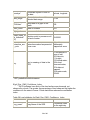
Table 1. Summary of the MODIS snow data products.
Nominal Data
Earth
Product
Array
Science Data
Level
Dimensions
Type (ESDT)
L2
1354 km by
2000 km
MOD10L2G
Spatial
Temporal
Map Projection
Resolution Resolution
500m
swath
(scene)
None. (lat, lon
referenced)
L2G
1200km by
1200km
500m
day of
multiple
coincident
swaths
Sinusoidal
MOD10A1
L3
1200km by
1200km
500m
day
Sinusoidal
MOD10A2
L3
1200km by
1200km
500m
eight days
Sinusoidal
MOD10C1
L3
360° by 180°
(global)
0.05° by
0.05°
day
Geographic
MOD10C2
L3
360° by 180°
(global)
0.05° by
0.05°
eight days
Geographic
MOD10CM
L3
360° by 180°
(global)
0.05° by
0.05°
month
Geographic
MOD10_L2
4 of 80
File Format of Snow Products
The MODIS snow products are archived in Hierarchical Data Format Earth Observing System (HDF-EOS) format files. HDF, developed by the
National Center for Supercomputing Applications (NCSA), is the standard archive
format for EOS Data Information System (EOSDIS) products. The snow product
files contain global attributes (metadata) and scientific data sets (SDSs) i.e. data
arrays with local attributes. Unique in HDF-EOS data files is the use of HDF
features to create point, swath, and grid structures to support geolocation of data.
The geolocation information and relationships between data in a SDS and
geographic coordinates (latitude and longitude or map projections) to support
mapping the data supporting mapping stored as Vgroup and Vdata in the file.
The SDSs are attached as data fields to the HDF-EOS swath or grid structure.
The geolocation data can only be accessed from the StructMetadata.0 attribute.
In order to geolocate the data the StructMetadata.0 must be accessed to get
geographic information and the data fields, i.e. SDSs attached to it for mapping.
It is possible to access the SDSs without having to access the StructMetadata.0
but the geolocation information will not be attached to the SDS. Users unfamiliar
with HDF and HDF-EOS formats may wish to consult web sites listed in the
Related Web Sites section for more information.
Snow data product files contain three EOS Data Information System
(EOSDIS) Core System (ECS) global attributes also referred to as metadata by
ECS. These ECS global attributes; CoreMetadata.0, ArchiveMetadata.0 and
StructMetadata.0 contain information relevant to production, archiving, user
services, geolocation and analysis of data. The ECS global attributes are written
in parameter value language (PVL) and are stored as a character string.
Metadata and values are stored as objects within the PVL string. Products may
also contain product specific attributes (PSAs) defined by the product developers
as part of the ECS CoreMetadata.0 attribute. Geolocation and gridding
relationships between HDF-EOS point, swath, and grid structures and the data
are contained in the ECS global attribute, StructuralMetadata.0. Other
information about mapping, algorithm version, processing and structure may be
stored in the ArchiveMetadata.0 also in PVL or as separate global attributes.
Other information about the product may be stored in global attributes separate
from the ECS global attributes.
Stored with each SDS is a local attribute that is a key to the data values in
the SDS. There may also be other local attributes with information about the
data. Detailed descriptions of the SDSs are given for each snow product in
following sections.
A separate file containing metadata will accompany data products ordered
from a DAAC. That metadata file will have an ".xml" extension and is written in
Extendable Markup Language. The .xml file contains some of the same metadata
as in the product file but also has other information regarding archiving and user
support services as well as some post production quality assessment (QA)
information relevant to the granule ordered. The post production QA metadata
may or may not be present depending on whether or not the data granule has
been investigated. The ".xml" file should be examined to determine if
5 of 80
postproduction QA has been applied to the granule. (The Quality Assessment
sections of this guide provide information on postproduction QA.)
The data products were generated in the ECS science data production system
using the HDF-EOS Version 5.2.9 , Science Data Processing (SDP) Toolkit, HDF
API and the C programming language. Various software packages, commercial
and public domain, are capable of accessing the HDF-EOS files.
MOD10_L2
The swath product is generated using the MODIS calibrated radiance data
products (MOD02HKM and MOD021KM), the geolocation product (MOD03), and
the cloud mask product (MOD35_L2) as inputs. The MODIS snow cover
algorithm output product, MOD10_L2, contains two SDS of snow cover, a quality
assessment (QA) SDS, latitude and longitude SDSs, local attributes and global
attributes. The snow cover algorithm identifies snow-covered land, snow-covered
ice on inland water and computes fractional snow cover. There are approximately
288 swaths of Terra orbits acquired in daylight so there are approximately 288
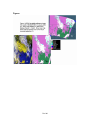
MOD10_L2 snow products per day. An example of the MOD10_L2 product snow
cover map is exhibited in Figure 1a-c in both un-projected and projected formats.
Algorithm Description
A sketch of the snow algorithm is given here for the purpose of aiding a
user in understanding and interpreting the data product. The snow algorithm is
described in detail in the Algorithm Theoretical Basis Document (ATBD).
Analysis for snow in a MODIS swath is done on pixels of land or of inland
water that have nominal L1B radiance data, are in daylight and the cloud mask is
applied. A snow decision is also screened for temperature and difference of a
band ratio to reduce the occurrence of erroneous snow in some situations. Data
inputs to the snow algorithm are listed in Table 2.
Land and inland waters are masked with the 1 km resolution land/water
mask, contained in the MODIS geolocation product (MOD03). In Collection 5 the
land/water mask made by the Boston University (BU) team based on EOS data is
used. During Collection 4 the BU land/water mask replaced the EOS land/water
mask that had been used. (More information is given on the land/water mask in
QA sections below.) The 1 km data of the land/water mask is applied to the four
corresponding 500 m pixels in the snow algorithm. Ocean waters are not
analyzed for snow. Inland waters, lakes and rivers, are analyzed for snowcovered ice conditions.
The MODIS L1B is screened for missing data and for unusable data.
Unusable data results from the processing at L1B when the sensor radiance data
fails to meet acceptable criteria. MODIS data may be unusable for several
reasons. Specifics of L1B processing and criteria can be found at the MODIS
Calibration Support Team (MCST) web page and in supporting documentation. If
missing data is encountered those pixels are identified as missing data in
MOD10_L2. If unusable data is encountered then a no decision result is written
6 of 80
for those pixels. Usable L1B calibrated radiance data is converted to at-satellite
reflectance for use in the snow algorithm.
Snow covered area is determined through the use of two groups of
grouped criteria tests for snow reflectance characteristics in the visible and nearinfrared regions and screening of snow decisions. Global criteria for snow is; a
normalized snow difference index (NDSI), ((band 4-band 6) / (band 4 + band 6))
greater than 0.4 and near-infrared reflectance (band 2) greater than 0.11 and
band 4 reflectance greater than 0.10. If a pixel passes that group of criteria tests
it is identified as snow. The minimum reflectance tests screen low reflectance
surfaces, e.g. water that may have a high NDSI value from being erroneously
detected as snow. To enable detection of snow in dense vegetation a criteria
test using NDSI and the normalized difference vegetation index (NDVI) of ((band
2-band 1) / (band 2+band 1)) is applied to pixels that have an NDSI value in the
range of 0.1 to 0.4. In this criteria test a pixel with NDSI and NDVI values in a
defined polygon of a scatter plot of the two indices and that has near-infrared
reflectance in band 2 greater than 0.11 and band 1 reflectance greater than 0.1,
is determined to be snow. This latter criteria test is applied without regard to the
ecosystem. Snow-covered ice on inland water is determined by applying the
global criteria for snow detection to pixels mapped as inland water by the landwater mask. Another screen is applied to the snow decision of all the above
criteria tests to reduce erroneous snow detections. A surface temperature
screen of 283 K is applied to prevent bright warm surfaces from being
erroneously detected as snow. The screen functions to reduce the occurrence of
erroneous snow detection in some situations and is described in subsections of
the Quality Assessment section.
Intermediate checks for theoretical bounding of reflectance data and the
NDSI ratio are made in the algorithm. In theory, reflectance values should lie
within the 0-100% range and the NDSI ratio should lie within the -1.0 to +1.0
range. Summary statistics are kept within the algorithm for pixels that exceed
these theoretical limits; however, the test for snow is done regardless of
violations of these limits. These violations suggest that error or other anomalies
may have crept into the input data and indicate that further investigation may be
warranted to uncover the causes.
Fractional snow cover is computed for all land and inland water body
pixels in a swath. Fractional snow cover is calculated using the regression
equation of Salomonson and Appel (2004 and in press). The fractional snow
cover calculation is applied to the full range of NDSI values 0.0 -1.0. Fractional
snow is constrained to upper limit of 100%. The fractional snow cover map and
the snow cover map may be different. Fractional snow cover may have greater
areal extent because its calculation is not restricted to the same NDSI range as is
the snow cover area calculation. The fractional snow cover result is screened
with the same screens as the snow cover area algorithm.
Clouds are masked using data from the MODIS Cloud Mask data product
(MOD35_L2). The MOD35_L2 data is checked to determine if the cloud mask
algorithm was applied to a pixel. If it was applied then results of the cloud mask
algorithm are used. If it was not applied then the cloud mask is not used and the
7 of 80
snow algorithm will process for snow assuming that the pixel is unobstructed by
cloud. Only the summary cloud result, the unobstructed field-of-view flag, from
MOD35_L2 is used to mask clouds in the snow algorithm. The day/night flag
from the MOD35_L2 is also used to mask pixels that lie in night. Night is
determined where the solar zenith angle is equal to or greater than 85º.
The snow cover map (Snow Cover Reduced Cloud SDS) made with
selected cloud spectral tests from the cloud mask in Collection 4 is omitted in
Collection 5. Though it was possible to reduce cloud obscuration in some
situations or reduce cloud commission errors in others those advantages were
outweighed by the disadvantage in situations where clouds where not mapped as
clouds and thus as land by the snow algorithm, though it was actually snow
covered land beneath the clouds. It is possible to make selective use of the
cloud mask spectral tests and other data for snow mapping however, refinement
of that approach was not pursued for Collection 5.
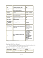
Table 2. MODIS data product inputs to the MODIS snow algorithm.
ESDT
Long Name
Data Used
MOD02HKM
MODIS Level 1B Calibrated and
Geolocated Radiances
Reflectance for MODIS
bands:
1 (0.645 µm)
2 (0.865 µm)
4 (0.555 µm)
6 (1.640 µm)
MOD021KM
MODIS Level 1B Calibrated and
Geolocated Radiances
31 (11.28 µm)
32 (12.27 µm)
MODIS Geolocation
Land/Water Mask
Solar Zenith Angles
Sensor Zenith Angles
Latitude
Longitude
MODIS Cloud Mask
Cloud Mask Flag
Unobstructed Field of
View Flag
Day/Night Flag
MOD03
MOD35_L2
Scientific Data Sets
Snow_Cover
Results of the snow cover mapping algorithm are stored as coded integers
in the Snow_Cover SDS. The snow cover algorithm identifies pixels as snow,
snow-covered water body (typically lakes or rivers) land, water, cloud or other
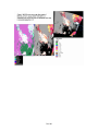
condition. A color-coded image of a snow map is shown in Figure 1b, a winter
image of the northern US plains and south central Canada, alongside a false-
8 of 80
color reflectance image of the swath Fig. 1a. Images in Fig 1a, b are unprojected; Fig. 1c is the snow map in sinusoidal projection. HDF predefined and
custom local attributes are stored. The HDF predefined attributes may be used
by some software packages. The custom local attributes are specific to the data
in the SDS. Local attributes are listed in Table 3.
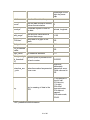
Table 3. Local attributes with Snow_Cover SDS.
Attribute name
Definition
Value
long_name*
Long Name of the SDS
Snow covered
land
units*
SI units of the data, if any
none
format*
How the data should be viewed,
I3
Fortran format notation
coordsys*
Coordinate system to use for
the data
cartesian
valid_range*
Max and min values within a
selected data range
0-254
_FillValue*
Data used to fill gaps in the
swath
255
Key:
Key to meaning of data in the
SDS
0=missing data,
1=no decision,
11=night, 25=no
snow, 37=lake,
39=ocean,
50=cloud,
100=lake ice,
200=snow,
254=detector
saturated, 255=fill
Nadir_data_res
olution
Nominal pixel resolution at nadir 500 m
Valid EV Obs
Band 1 (%)
The percentage of valid
observations from Level 1B in
0.0 - 100.0
Band 1 in the swath. (0.0-100.0)
Valid EV Obs
Band 2 (%)
The percentage of valid
observations from Level 1B in
0.0 - 100.0
Band 2 in the swath. (0.0-100.0)
Valid EV Obs
Band 4 (%)
The percentage of valid
observations from Level 1B in
9 of 80
0.0 - 100.0
Band 4 in the swath. (0.0-100.0)
Valid EV Obs
Band 6 (%)
The percentage of valid
observations from Level 1B in
0.0 - 100.0
Band 6 in the swath. (0.0-100.0)
The percentage of saturated
Saturated EV
observations from Level 1B in
0.0 - 100.0
Obs Band 1 (%)
Band 1 in the swath. (0.0-100.0)
The percentage of Saturated
Saturated EV
observations from Level 1B in
0.0 - 100.0
Obs Band 2 (%)
Band 2 in the swath. (0.0-100.0)
The percentage of saturated
Saturated EV
observations from Level 1B in
0.0 - 100.0
Obs Band 4 (%)
Band 4 in the swath. (0.0-100.0)
The percentage of saturated
Saturated EV
observations from Level 1B in
0.0 - 100.0
Obs Band 6 (%)
Band 6 in the swath. (0.0-100.0)
* HDF predefined attribute names.
Fractional_Snow_Cover
Results of the fractional snow cover algorithm are stored as coded
integers in the Fractional_Snow_Cover SDS. The fractional snow algorithm
calculates fractional snow in the 0 – 100% range, including inland water bodies.
Pixels that are not identified as snow are labeled as water, cloud or other
condition. A fractional snow map is shown in Figure 2. HDF predefined and
custom local attributes are stored. The HDF predefined attributes may be used
by some software packages. The custom local attributes are specific to the data
in the SDS. Local attributes are listed in Table 4.
Table 4. Local attributes with Fractional_Snow_Cover SDS.
Attribute name
Definition
Value
long_name*
Long Name of the SDS
Fractional snow
cover, 500m
units*
SI units of the data, if any
none
format*
How the data should be viewed,
I3
Fortran format notation
coordsys*
Coordinate system to use for
the data
cartesian
valid_range*
Max and min values within a
selected data range
0-254
10 of 80
Data used to fill gaps in the
swath
255
Key:
Key to meaning of data in the
SDS
0-100=fractional
snow,
200=missing data,
201=no decision,
211=night,
225=land,
237=inland water,
239=ocean,
250=cloud,
254=detector
saturated, 255=fill
Nadir_data_res
olution
Nominal pixel resolution at nadir 500 m
_FillValue*
* HDF predefined attribute names.
Latitude and Longitude
Coarse resolution (5 km) latitude and longitude data for geolocating the
snow data are located in the Latitude and Longitude SDSs. The latitude and
longitude data correspond to a center pixel of a 5 km by 5 km block of pixels in
the snow SDSs. The mapping relationship of geolocation data to the snow data is
specified in the global attribute StructMetadata.0. Mapping relationship was
created by the HDF-EOS SDPTK toolkit during production. Geolocation data is
mapped to the snow data with an offset = 5 and increment = 10. The first element
(1,1) in the geolocation SDSs corresponds to element (5,5) in Snow_Cover SDS;
the algorithm then increments by 10 in the cross-track or along-track direction to
map geolocation data to the Snow_Cover SDS elements. Local attributes are
listed in Table 5 and Table 6.
Table 5. Local attributes with Latitude SDS.
Attribute name
Definition
Value
long_name*
Long Name of the SDS
Coarse 5 km
resolution latitude
units*
SI units of the data, if any
degrees
valid_range*
Max and min values within a
selected data range
-90.00, 90.00
_FillValue*
Data used to fill gaps in the
swath
-999.000
source
Source of data
MOD03
geolocation
11 of 80
product; data read
from center pixel in
5 km box
* HDF predefined attribute names.
Table 6. Local attributes with Longitude SDS.
Attribute name
Definition
Value
long_name*
Long Name of the SDS
Coarse 5 km
resolution
longitude
units*
SI units of the data, if any
degrees
valid_range*
Max and min values within a
selected data range
-180.00, 180.00
_FillValue*
Data used to fill gaps in the
swath
-999.000
Source of data
MOD03
geolocation
product; data read
from center pixel in
5 km box
source
* HDF predefined attribute names.
Quality Assessment
A revised approach to quality assessment (QA) was used in Collection 5.
Instead of the spatial QA data being bit encoded flags, as was done in Collection
4 and prior collections, integer numbers are coded to convey the QA information.
The QA data should be easier to use and gives a general indicator of good or
other quality for the data. Data quality is determined by making the same
checks as in Collection 4 but the result is an integer value stored in the QA SDS.
The purpose of the spatial QA is to provide information each pixel that can
be viewed in the same spatial context as the snow maps. The QA data may be
used to help determine the usefulness of the snow cover and fractional snow
data. The single QA SDS applies to both the snow cover area and fractional
snow cover SDSs.
Snow_Cover_Pixel_QA
The quality assessment data provides an indication of the quality of the
input data for the snow and fractional snow algorithms. Data for a pixel are
determined to be of good quality, other quality or may be set to a thematic value
for certain conditions. Unless the input data is unusable or missing the data
12 of 80
quality will usually be set to good. An example of the snow cover pixel QA is
shown in Figure 3. Local attributes are listed in Table 7.
Table 7. Local attributes with Snow_Cover_Pixel_QA SDS.
Attribute name
Definition
Value
long_name*
Long Name of the SDS
Snow cover per
pixel thematic QA
units*
SI units of the data, if any
none
format*
How the data should be viewed,
I3
Fortran format notation
coordsys*
Coordinate system to use for
the data
Cartesian
valid_range*
Max and min values within a
selected data range
0-254
_FillValue*
Data used to fill gaps in the
swath
255
Key to meaning of data in the
SDS
0=good quality,
1=other quality,
252=Antarctica
mask, 253=land
mask, 254=ocean
mask saturated,
255=fill
Key:
* HDF predefined attribute names.
Indicators of quality are also given in metadata objects in the
CoreMetadata.0 global attribute generated during production, or in post-product
scientific and quality checks of the data product. Of the few quality metadata
objects in the CoreMetadata.0 global attribute only the
ScienceQualityFlagExplanation is relevant as a pointer to website for science
quality status. No automatic quality assessment is done in the algorithm
production nor is science quality checked during production.
Snow Accuracy and Errors
Under ideal conditions of illumination, clear skies and several centimeters
of snow on a smooth surface the snow algorithm is about 93-100% accurate at
mapping snow (Hall and Riggs, submitted). Ideal conditions are usually not the
norm so the snow algorithm was designed to identify snow globally in nearly any
situation. The NDSI has proved to be a robust indicator of snow around the
globe. The NDSI is a reliable indicator of snow when snow is present. Patchy
snow or thin snow cover on vegetated surfaces may be missed by the NDSI.
13 of 80
Experience and analysis of MODIS snow products over three collections
of data have revealed strengths and weaknesses in the snow mapping
technique. Originally the snow algorithm was designed to map snow globally and
was unrestricted in global application. Robustness of the snow mapping
algorithm is exhibited in the relatively rare errors of missing snow when snow is
present. That approach maximized ability to detect snow and had the
consequence of also increasing errors of commission, identifying non-snow
features as snow, in the snow cover algorithm. Mapping features as snow,
erroneous snow is a persistent problem with the snow algorithm affecting a
relatively small percentage of the data. Analysis of erroneous snow—the
mapping of features not snow as snow--has revealed causes for erroneous
snow. Causes, corrections and solutions to alleviate erroneous snow mapping
are presented in the following subsections.
Warm Bright Surface Features
In the first processing of MODIS data it was discovered that some surface
features, e.g. salt pans or sandy beaches, were being mapped as snow because
they had reflectance characteristics similar to snow, specifically the NDSI value
of those features was similar to snow. Mismatch of the land/water mask used in
processing to the geolocated MODIS data was and still is a problem. The
majority of that erroneous snow occurred in climatically warm regions of the
world where snow was not likely to occur in any season. The solution to this type
of snow error was to apply a thermal screen to remove the error.
The surface temperature algorithm was taken from the sea ice algorithm,
integrated into the snow algorithm and used as a screen to prevent very warm
snow like pixels from being mapped. Any pixel identified as snow but that has an
estimated temperature >283 K is changed to land. This screening is a rough
estimate of surface temperature as the surface temperature is calculated as
though the pixel is snow covered sea ice. That temperature screening was
successful at greatly reducing the occurrence of erroneous snow in warm regions
of the world and along warm coastal regions especially those with wide, sandy
beaches.
Coastline Differences
The land/water mask in the MODIS geolocation product (MOD03) is used
to control processing path in the snow algorithm. In Collection 5 the land/water
mask stored in the geolocation product was developed by the MODIS science
team at Boston University. That land/water mask contains many improvements
over the previously used MODIS land/water mask. Accuracy of coastlines and
location of water bodies is improved. Yet misalignment of coastlines with the
geolocated MODIS swath data still exists. That misalignment causes erroneous
snow mapping to occur along coastlines in several regions around the world.
This problem is readily apparent in the Canadian Arctic Islands in the summer
when the islands may have a snowy coastline. During the summer the
Canadian Arctic islands appear to have snowy coastlines in places, obviously in
error. During the transition seasons no snow error is apparent because snow
14 of 80
cover is expected in those seasons. During boreal winter darkness no error is
seen. The snow error appears seasonal but is year-round because of the
land/water mask to image misalignment of coastlines.
Snow error on coastlines in warm regions is usually removed by the
temperature screen but not always. The mixed signal of ocean, beach and
coastline misalignment remains as a minor problem.
Inland Water Bodies as Snow or Lake Ice
In the new BU land/water mask, some, but not all, inland water bodies,
rivers, lakes, etc. are included in the land/water mask. The BU group provides
these insights to the land/water mask: A great amount of interpretation was
involved in the mapping of these water bodies. Though it would seem a distinctly
easy task to make a distinction between water and land it was very difficult.
Difficulties were encountered gauging the size of water bodies due to turbidity
conditions, amount of vegetation in water bodies and in boreal regions confusion
between snow and ice and lack of frequent clear sky views for mapping. The
end result is that water bodies exceeding 1 km in dimension are included. Water
bodies less than 1 km in size were not included in the mask. Also water bodies
of isolated single pixels in extent were excluded. As a result many inland rivers
are discontinuous or absent. Features on the land/water mask toward the polar
regions may be distorted and coastlines may display shearing due to the way the
land/water mask was generated and projected. Missing water bodies are likely to
have an effect on reflectance in the pixel(s) in which they occur.
The snow algorithm uses the land/water mask to direct the processing
path to land or inland water body. For small water bodies differences between
the land/water mask and what is imaged can lead to errors in the snow map in
both classes of snow and ice-covered lakes. Errors at shores of larger water
bodies may also occur as a result of misalignment of the mask and imagery.
Snow mapping and lake ice mapping errors do occur in many situations. These
errors are a very low amount commonly in the <= 0.001 percentage range of total
pixels processed in a swath.
Misidentification of rivers or lakes, either mapped or un-mapped in the
land/water mask, as snow or lake ice may also occur if the water has high
turbidity or if it is shallow with a bright bottom. Those conditions may have an
NDSI value in the snow range and have characteristics, e.g. visible reflectance
amount, similar to snow that are not blocked by the screens in the algorithm.
Partially cloud obscured water bodies that are identified as probably clear can
also sometimes be erroneously identified as ice-covered for similar reasons.
The code was revised so that the screen for surface temperature is also
applied to water body pixels identified as snow-covered. Application of that
screen in those situations has decreased significantly the snow errors associated
with water bodies especially during the warm seasons.
Low illumination snow errors
Under low solar illumination conditions when an acquisition is hours away
from the local solar noon, e.g. during boreal summer, or an acquisition is near or
15 of 80
includes the day/night terminator snow errors can occur. Algorithm processing
takes the day/night flag from the cloud mask (MOD35_L2) which defines daylight
as an observation with solar zenith angle < 85 degrees. Low solar illumination
conditions are processed for snow without consideration of the amount of
radiation reaching the surface. That was originally by design -- not limiting
processing for certain conditions. Analysis has revealed that low illumination of
some surface features, notably boreal vegetation types, results in reflectance
amounts and features that may be confused with that of snow. Those same
features under high illumination conditions, near solar noon, do not exhibit
reflectance features similar to snow and are not mapped as snow. The low
amount of radiation on the surface and consequently lower reflection from the
features can cause them to have an NDSI in the snow range so are erroneously
identified as snow. Because the low reflectance across the spectrum combined
with the nature of a ratio can result in relatively small differences between the
band 6 and band 4 to have a large NDSI ratio that may look like snow to the
algorithm. In the swath product erroneous snow mapping caused by low
illumination conditions may contribute up to around 5% error based on count of
land pixels analyzed for snow in a swath.
Erroneous snow caused by low illumination conditions was carried forward
into the daily snow product MOD10A1 and consequently the MOD10C1 snow
product in V004 prior to 13 September 2004. That decreased the quality of the
MOD10A1 and MOD10C1 snow maps. A reason that those erroneous snow
observations were mapped into MOD10A1 was that the algorithm did not use
solar zenith as a factor in scoring the observations. A new scoring algorithm that
included solar zenith as a factor in scoring the observations was implemented in
V004 on 13 September 2004. That new algorithm effectively chose observations
from near local solar noon thus eliminating the problem of erroneous snow
caused by low illumination from the MOD10A1, thus increasing its quality and in
turn quality of the MOD10C1 snow map. However the erroneous snow problem
remained in the MOD10_L2 product.
Snow and Cloud Confusion
Snow and cloud discrimination problems persist in the algorithm that result
in typically very small amounts of erroneous snow mapped in some cloud
situations. This error is associated with parts of ice clouds which appear yellow
in a MODIS band 1, 4, 6 color display. The error occurs on parts of the clouds
that lie in the shadow of other parts of the cloud or on parts that have a middling
amount of reflectance. This problem is associated with these types of clouds and
can occur in any season in about any location. Analysis has been focused on
North America. The problem exhibits greatest impact on quality in summer when
these cloud types/situations are more frequent and result in erroneous snow
mapping. The amount of snow error attributable to these snow cloud situations is
usually very small in terms of pixel counts, in the 0.001 to 0.1% range but may
range up to about 3% depending on extent, type and pattern of clouds.
The source of error lies with those clouds not being mapped as certain
cloud by the cloud mask because the clouds do not dominate the reflectance of
16 of 80
the 1 km resolution cloud mask. When those missed clouds are processed in
the snow algorithm they appear to have spectral features, particularly the NDSI
that are more like snow than a not snow feature. The snow algorithm processes
those pixels as not cloud and the NDSI signal being similar to snow causes the
pixels to be identified as snow.
Snow and cloud confusion errors of this type have been noticeably
reduced in Collection 5 due to improvement of the cloud mask algorithm which
currently detects these types of clouds more often thus classifying them correctly
as cloud, and preventing them from being analyzed erroneously as snow.
However great the improvement, there still remains albeit a very small amount of
shaded yellow cloud that is not identified as cloud and is then mapped as snow in
the snow algorithm.
Snow as Cloud
At the edges of snow cover, in the mountains or on plains, the edge of the
snow is frequently identified as cloud by the cloud mask algorithm. This problem
is sometimes very obvious extending over several kilometers of sparse or thin
snow at edge of a snow cover. Sometimes the problem is not so obvious
occurring as only a pixel or two in width in the mountains. If there is a sharp
boundary between ‘deep’ snow and snow free land the problem may not occur.
This problem appears to be related to a cloud spectral visible reflectance
test in the cloud mask algorithm that gives a fairly confident result of cloud so the
pixel is mapped as cloud. Investigation of the problem has been sporadic as it is
a low priority compare to other snow problems and a possible solution to the
problem has not been formulated though investigation done suggests that
individual cloud spectral test(s) and processing path flags may need to be read to
better understand and possibly solve the problem specific to snow mapping.
Global Attributes
There are 11 global attributes in the MOD10_L2 product---three are ECS
defined (CoreMetadata.0, ArchiveMetadata.0, and StructMetadata.0) and the
others are specific to the product. These global attributes serve different
purposes, such as search and order of products, mapping, product version
tracking and evaluating a product. The ECS defined attributes are written as
very long character strings in parameter value language (PVL) format.
Descriptions of the global attributes are given in the following tables.
CoreMetadata.0 and ArchiveMetadata.0 are global attributes in which
information compiled about the product during product generation is archived.
StructMetadata.0 contains information about the swath or grid mapping relevant
to the product. A user wanting detailed explanations of the global attributes and
related information should query the EOSDIS related web sites.
Table 8. Listing of objects in the global attribute CoreMetadata.0 in MOD10_L2.
Object Name
Sample Value
Comment
LocalGranuleID
“MOD10_L2.A2003198.1945.005.200603615004
Filename of product. Format is;
17 of 80
3.hdf”
EDST.Ayyyyddd.hhmm.vvv.yyyydddhh
mmss.hdf
Ayyyyddd.hhmm – acquisition date and
time in UTC.
ProductionDateTime
“2002-07-16T05:52:31.000Z”
Date and time the file was produced.
Format is; yyyy-mm-ddThh:mm:ss.sssZ
DayNightFlag
"Day"
Day means entire swath in daylight.
Both means that part of swath lies in
darkness.
ReprocessingActual
"reprocessed"
Reprocessed means data has been
processed before. Processed once
means this is the first processing of the
data.
LocalVersionID
"SCF V5.0.4"
Version of algorithm delivered from the
SCF.
ReprocessingPlanned
"further update is anticipated"
Expect that the product will be
reprocessed again with an improved
algorithm.
ScienceQualityFlag
"Not being investigated"
This is meaningless information.
Original plan was for this metadata to
be set/updated by investigator after
evaluation/validation however that plan
was dropped and this metadata is not
set/updated. See
ScienceQualityFlagExplanation for
current information.
AutomaticQualityFlagExplanation
"No automatic quality assessment done in the
PGE"
No automated QA checks made during
execution of the algorithm.
AutomaticQualityFlag
"Passed"
Default setting because no automated
QA checks are done.
ScienceQualityFlagExplanation
"See http://landweb.nascom.nasa.gov/cgibin/QA_WWW/qaFlagPage.cgi?sat=terra for the
product Science Quality status"
URL where updated information on
science QA should be posted.
QAPercentMissingData
0
Amount of L1B data missing from the
swath.
QAPercentCloudCover
43
Amount of land in the swath obscured
by clouds.
ParameterName
"Snow Cover"
QA parameters given apply to the snow
cover data.
EquatorCrossingDate
"2001-07-12"
Orbital parameter. Format; yyyy-mmdd
EquatorCrossingTime
"17:43:04.827021"
Orbital parameter. Format;
hh:mm:ss:ssssss
OrbitNumber
8335
Orbital parameter.
EquatorCrossingLongitude
-106.330685
Orbital parameter. Decimal degrees
format.
VersionID
5
Indicates the EOSDIS Collection
ShortName
"MOD10_L2"
ESDT name of product.
InputPointer
("MOD02HKM.A2003198.1945.005.20060360528
19.hdf",
"MOD021KM.A2003198.1945.005.200603605281
Names of MODIS data input files.
18 of 80
9.hdf",
"MOD35_L2.A2003198.1945.005.200603607011
1.hdf",
"MOD03.A2003198.1945.005.2006035112242.hd
f")
GringPointLongitude
(179.723429933497, -58.904669279034, 98.7631668325766, -148.238329720687)
GringPointLatitude
(85.7478368977756, 71.0425700239505,
61.3503524579205, 68.2733742122195)
GringPointSequenceNo
[1,2,3,4]
ExclusionGRingFlag
"N"
RangeBeginningDate
"2003-07-17”
RangeBeginningTime
"19:45:00.000000"
RangeEndingDate
"2003-07-17”
RangeEndingTime
"19:50:00.000000"
PGEVersion
"5.0.4"
Version of production generation
executable (PGE).
AncillaryInputPointer
"MOD03.A2003198.1945.005.2006035112242.hd
f"
Name of the geolocation file
AncillaryInputType
"Geolocation"
Type of ancillary data referenced by
pointer.
AssociatedSensorShortName
"MODIS"
Sensor name.
AssociatedPlatformShortName
"Terra"
Platform name.
AssociatedInstrumentShortName
"MODIS"
Instrument and sensor name are the
same.
These latitude and longitude pairs of
points when connected in a clockwise
series form a polygon of the swath
coverage. Always represents the outer
ring of coverage.
Beginning and ending times of the first
and last scan line in the swath. Formats
are; yyyy-mm-dd, hh:mm:ss.ssssss
Product Specific Attributes (PSA)
QAPERCENTGOODQUALITY
100
QAPERCENTOTHERQUALIT
Y
0
GRANULENUMBER
239
Unique granule identifier.
SNOWCOVERPERCENT
03
Summary percentage of snow-covered
land.
Summary quality of data range checks
done in the algorithm.
The ArchiveMetadata.0 global attribute contains information relevant to version of
the algorithm, production environment and geographic location of the data
product. Contents are described in Table 9.
Table 9. Listing of objects in ArchiveMetadata.0 the global attribute in
MOD10_L2.
Object Name
Typical Value
AlgorithmPackageAcceptanceDate
"05 2006"
AlgorithmPackageMaturityCode
"Normal"
AlgorithmPackageName
"MOD_PR10"
AlgorithmPackageVersion
"5"
Comment
Algorithm version
information. Format is mmyyyy.
19 of 80
LongName
"MODS/Terra Snow Cover 5-Min L2 Swath 500m"
Descriptive name of the
product. May be displayed
as the product name in the
EOS Data Gateway or
other dataset search tools.
InstrumentName
"Moderate-Resolution Imaging SpectroRadiometer"
Long name of MODIS
LocalInputGranuleID
("MOD02HKM.A2003198.1945.005.2006036052819.hdf",
"MOD021KM.A2003198.1945.005.2006036052819.hdf",
"MOD35_L2.A2003198.1945.005.2006036070111.hdf",
"MOD03.A2003198.1945.005.2006035112242.hdf")
Names of MODIS input
files.
Processing Center
"MODAPS"
MODIS Adaptive
Processing System
ProcessingDateTime
""2006-02-05T15:01:35.000Z"
Date of processing. Format
is; yyyy-mmddThh:mm:ss.sssZ
SPSOParameters
"none"
Archaic and meaningless.
EastBoundingCoordinate
-58.9066026791133
WestBoundingCoordinate
-176.825688181697
NorthBoundingCoordinate
86.7594955695887
SouthBoundingCoordinate
61.6178586242137
Processing Environment
"Linux minion5009 2.6.8.1-24mdksmp #1 SMP Thu Jan
13 23:11:43 MST 2005 i686 Intel(R) Xeon(TM) CPU
2.40GHz unknown GNU/Linux”
Processing done in either
UNIX or Linux environment.
DESCRRevision
"5.0"
Descriptor file associated
with the PGE.
Eastern, western, northern,
and southern most points of
the swath. Format is
decimal degrees.
The StructMetadata.0 global attribute is created by the HDF-EOS toolkit to
specify the mapping relationships between the geolocation data and the snow
cover data (SDSs) referred to as data fields in the structural metadata. Mapping
relationships are unique in HDF-EOS and are stored in the product using HDF
structures. Description of the mapping relationships is not given here. Use of
HDF-EOS toolkit, other EOSDIS supplied toolkits, DAAC tools or other software
packages may be used to geolocate the data or to transform it to other
projections and/or data file formats.
Listing of objects in the global attribute StructMetadata.0 in MOD10_L2.
StructMetadata.0
GROUP=SwathStructure
GROUP=SWATH_1
SwathName="MOD_Swath_Snow"
GROUP=Dimension
OBJECT=Dimension_1
DimensionName="Along_swath_lines_500m"
Size=4060
END_OBJECT=Dimension_1
OBJECT=Dimension_2
DimensionName="Cross_swath_pixels_500m"
20 of 80
Size=2708
END_OBJECT=Dimension_2
OBJECT=Dimension_3
DimensionName="Coarse_swath_lines_5km"
Size=406
END_OBJECT=Dimension_3
OBJECT=Dimension_4
DimensionName="Coarse_swath_pixels_5km"
Size=271
END_OBJECT=Dimension_4
END_GROUP=Dimension
GROUP=DimensionMap
OBJECT=DimensionMap_1
GeoDimension="Coarse_swath_pixels_5km"
DataDimension="Cross_swath_pixels_500m"
Offset=5
Increment=10
END_OBJECT=DimensionMap_1
OBJECT=DimensionMap_2
GeoDimension="Coarse_swath_lines_5km"
DataDimension="Along_swath_lines_500m"
Offset=5
Increment=10
END_OBJECT=DimensionMap_2
END_GROUP=DimensionMap
GROUP=IndexDimensionMap
END_GROUP=IndexDimensionMap
GROUP=GeoField
OBJECT=GeoField_1
GeoFieldName="Latitude"
DataType=DFNT_FLOAT32
DimList=("Coarse_swath_lines_5km","Coarse_swath_pixels_5km")
END_OBJECT=GeoField_1
OBJECT=GeoField_2
GeoFieldName="Longitude"
DataType=DFNT_FLOAT32
DimList=("Coarse_swath_lines_5km","Coarse_swath_pixels_5km")
END_OBJECT=GeoField_2
END_GROUP=GeoField
GROUP=DataField
OBJECT=DataField_1
DataFieldName="Snow_Cover"
DataType=DFNT_UINT8
21 of 80
DimList=("Along_swath_lines_500m","Cross_swath_pixels_500m")
END_OBJECT=DataField_1
OBJECT=DataField_2
DataFieldName="Snow_Cover_Pixel_QA"
DataType=DFNT_UINT8
DimList=("Along_swath_lines_500m","Cross_swath_pixels_500m")
END_OBJECT=DataField_2
OBJECT=DataField_3
DataFieldName="Fractional_Snow_Cover"
DataType=DFNT_UINT8
DimList=("Along_swath_lines_500m","Cross_swath_pixels_500m")
END_OBJECT=DataField_3
END_GROUP=DataField
GROUP=MergedFields
END_GROUP=MergedFields
END_GROUP=SWATH_1
END_GROUP=SwathStructure
GROUP=GridStructure
END_GROUP=GridStructure
GROUP=PointStructure
END_GROUP=PointStructure
END
The other global attributes in the product are listed in Table 10.
Table 10 Other global attributes in MOD10_L2.
Attribute Name
Sample Value
Comment
HDFEOSVersion
HDFEOS_V2.9
Version of HDF_EOS
toolkit used in PGE.
L1BcalibrationQuality
marginal
L1BmissionPhase
EXECUTION
L1BnadirPointing
Y
L1BversionID
2003-07-17
Version of the L1B
processing algorithm.
SCF Algorithm Version
$Id:
MOD_PR10_AA…
Internal SCF version
of the code modules.
Surface_Temperature_Screen_Threshold
283.0
Temperature (K)
setting for this
screen.
HDFEOS_FractionalOffset_Along_swath_lines_500m_MOD_Swath_Snow
0.500000
Offset for better
geolocation of data.
HDFEOS_FractionalOffset_Cross_swath_pixels_500m_MOD_Swath_Snow
0.000000
Offset for better
22 of 80
Quality indicators of
MOD02HKM data.
geolocation of data.
MOD10_L2G Snow Product
The L2G product is the result of mapping all the MOD10_L2 swaths
acquired during a day to grid cells of the Sinusoidal map projection. The Earth is
divided into an array of 36 x 18, longitude by latitude, tiles, about 10°x10° in size
in the Sinusoidal projection. The MODL2G algorithm was created as a generic
gridding algorithm for many of the MODIS data products in the land discipline
group, and was customized to each MODIS data product as necessary. See
Wolfe et al. (1999) for a description of the gridding technique and product
contents. The L2G algorithm maps pixels from the MOD10_L2 SDSs into cells of
the projection. No calculations or analysis of snow is done at L2G. The
MOD10_L2G and other L2G products are necessary intermediate products used
as input to the daily snow cover algorithm generating the MOD10A1 product. The
MOD10_L2G is not archived at the DAAC thus is not available for order through
ECS. The other L2G products are archived at a DAAC and can be ordered.
MOD10A1
The daily snow product is a tile of data gridded in the sinusoidal projection.
Tiles are approximately 1200 x 1200 km (10°x10°) in area. Snow data arrays are
produced by selecting the most favorable observation (pixel) from the multiple
observations mapped to a cell of the MOD10_L2G gridded product from the
MOD10_L2 swath product. In addition to the snow data arrays mapped in from
the MOD10_L2G, snow albedo is calculated. There are four SDSs (or data
fields) of snow data; snow cover map, fractional snow cover, snow albedo and
QA in the data product file.
Algorithm Description
The daily snow cover map is constructed by examining the many
observations acquired for a day mapped to cells of the grid by the L2G algorithm.
A scoring algorithm is used to select an observation for the day. The scoring
algorithm is based on location of pixel and solar elevation. Observations are
scored based on distance from nadir, area of coverage in a grid cell and solar
elevation. The object of the scoring is to select the observation closest to local
noon time (highest solar elevation angle), nearest to nadir with greatest coverage
that was mapped into the grid cell. Form of the scoring algorithm is;
score = 0.5 * (solar elevation) + 0.3 * (distance from nadir) + 0.2 * (observation coverage)
Results of the snow cover algorithm, a daily snow map of the region covered by
the tile, are stored in the Snow_Cover_Day_Tile and per cell QA data for that
snow map is stored in the Snow_Spatial_QA SDS. The snow cover data are
23 of 80
stored as coded integer values, with values being the same as assigned in
MOD10_L2.
Daily fractional snow cover is determined from the many observations of
fractional snow cover in the L2G product using the same observation scoring
algorithm as used for the daily snow cover map. The fractional snow map for the
day is stored in the Fractional_Snow_Cover SDS.
Snow albedo is calculated for the visible and near infra-red bands using
the MODIS land-surface reflectance product as input (Table 11 lists the inputs for
the snow albedo algorithm). An anisotropic response function is used to correct
for anisotropic scattering effects of snow in non-forested areas. Snow-covered
forests are assumed to be Lambertian reflectors. Land cover type is read from
the MODIS land cover product. Slope and aspect data for the correction is
derived from the Global 30 Arcsecond (GTOPO30) digital elevation model (DEM)
are stored for each tile as ancillary data files. The narrow band albedos are then
converted to a broadband albedo for snow. Description of the snow albedo
algorithm is given in Klein and Stroeve (2002). Snow albedo is calculated only
for the cells that correspond to snow cover in the Snow_Cover_Day_Tile. Snow
albedo is stored in the Snow_Albedo_Daily_Tile SDS.
Table 11. MODIS data product inputs to the MODIS daily snow algorithm.
ESDT
Long Name
Data Used
MOD10L2G
MODIS/Terra Snow Cover Daily L2G
Global 500m SIN Grid
Snow cover, fractional
snow and snow spatial
QA.
MODMGGAD
MODIS/Terra Geolocation Angles
Daily L2G Global 1km SIN Grid Day
Solar and sensor
geometry.
MODPTHKM
MODIS/Terra Observation Pointers
Daily L2G Global 500m SIN Grid
Number of
observations,
coverage, observation
swath and location.
MOD09GHK
MODIS/Terra Surface Reflectance
Daily L2G Global 500m SIN Grid
Surface reflectance
bands 1-5 and 7.
MOD12Q1
MODIS/Terra Land Cover Type Yearly
L3 Global 1km SIN Grid
Land cover type
Scientific Data Sets
Snow_Cover_Day_Tile
The snow cover map is the result of selecting the most favorable
observation of all the swath level observations mapped into a grid cell for the
day. Mapped is snow, snow-covered water bodies (typically lakes or rivers) land,
water, cloud or other condition. A color-coded image of a snow map is shown in
Figure 6a. HDF predefined and custom local attributes are stored. The HDF
predefined attributes may be used by some software packages. The custom
24 of 80
local attributes are specific to the data in the SDS. Local attributes are listed in
Table 14.
Table 14 Local attributes for Snow_Cover_Day_Tile
Attribute name
Definition
Value
long_name*
Long Name of the SDS
Snow cover extent
by best
observation of the
day
units*
SI units of the data, if any
none
format*
How the data should be viewed,
I3
Fortran format notation
coordsys*
Coordinate system to use for
the data
cartesian
valid_range*
Max and min values within a
selected data range
0-254
_FillValue*
Data used to fill gaps in the
swath
255
Key to meaning of data in the
SDS
0=missing data,
1=no decision,
11=night, 25=no
snow, 37=lake,
39=ocean,
50=cloud,
100=lake ice,
200=snow,
254=detector
saturated, 255=fill
Key:
* HDF predefined attribute names.
Fractional_Snow_Cover
The fractional snow cover map is the result of selecting the most favorable
observation of all the swath level observations mapped into a grid cell for the day
using the scoring algorithm. Fractional snow is reported in the 0 – 100% range,
including inland water bodies. Pixels that are not snow are labeled as water,
cloud or other condition. A color-coded image of a fractional snow map is shown
in Figure 6b. HDF predefined and custom local attributes are stored. The HDF
predefined attributes may be used by some software packages. The custom
local attributes are specific to the data in the SDS. Local attributes are listed in
Table 15.
25 of 80
Table 15. Local attributes with Fractional_Snow_Cover SDS.
Attribute name
Definition
Value
long_name*
Long Name of the SDS
Fractional snow
covered land for
the tile
units*
SI units of the data, if any
none
format*
How the data should be viewed,
I3
Fortran format notation
coordsys*
Coordinate system to use for
the data
cartesian
valid_range*
Max and min values within a
selected data range
0-254
_FillValue*
Data used to fill gaps in the
swath
255
Key to meaning of data in the
SDS
0-100=fractional
snow,
200=missing data,
201=no decision,
211=night,
225=land,
237=inland water,
239=ocean,
250=cloud,
254=detector
saturated, 255=fill
Key:
* HDF predefined attribute names.
Snow_Albedo_Daily_Tile
The snow albedo algorithm result is stored as a map of the snow albebo
for the tile. The snow albedo map corresponds to snow mapped in the snow
cover map in Snow_Cover_Day_Tile SDS. Snow albedo is reported in the 0 –
100 range and non-snow features are also mapped using different data values.
A color-coded image of a snow albedo map is shown in Figure 6c. HDF
predefined and custom local attributes are stored. The HDF predefined attributes
may be used by some software packages. The custom local attributes are
specific to the data in the SDS. Local attributes are listed in Table 16.
Table 16. Local attributes with Snow_Albedo_Daily_Tile SDS.
Attribute name
Definition
Value
long_name*
Long Name of the SDS
Snow albedo of
26 of 80
the corresponding
snow cover
observation
units*
SI units of the data, if any
format*
How the data should be viewed,
I3
Fortran format notation
coordsys*
Coordinate system to use for
the data
cartesian
valid_range*
Max and min values within a
selected data range
0-100
_FillValue*
Data used to fill gaps in the
swath
255
missing_value
Value for missing data
250
Key to meaning of data in the
SDS
0-100=snow
albedo,
101=no_decision,
111=night,
125=land,
137=inland water,
139=ocean,
150=cloud,
250=missing,
251=self_shadowi
ng, 252=landmask
mismatch,
253=BRDF_failure
, 254=nonproduction_mask
Key:
none
* HDF predefined attribute names.
Quality Assessment
Spatial QA data corresponding to the snow cover observation selected for
the daily snow cover map is also selected and mapped into the
Snow_Spatial_QA SDS.
Table 17. Local attributes with Snow_Spatial _QA SDS.
Attribute name
Definition
Value
long_name*
Long Name of the SDS
Spatial QA of the
observation
27 of 80
units*
SI units of the data, if any
format*
How the data should be viewed,
I3
Fortran format notation
coordsys*
Coordinate system to use for
the data
cartesian
valid_range*
Max and min values within a
selected data range
0-254
_FillValue*
Data used to fill gaps in the
swath
255
Key to meaning of data in the
SDS
0=good quality,
1=other quality,
252=Antarctica
mask, 253=land
mask, 254=ocean
mask saturated,
255=fill
Key:
none
* HDF predefined attribute names.
Snow albedo specific QA is not reported in Collection 5 because ways of
expressing the QA of the snow albedo result are being investigated. (Refer to
the snow project website for validation information.) It is anticipated that future
evaluation and validation of snow albedo will lead to the definition and setting of
QA data. Fractional snow specific QA data is also not reported because
evaluation and validation of the product has not been completed (refer to the
snow project website for validation information).
Snow Evaluation and Errors
The daily snow product (snow cover map and fractional snow cover)
inherits snow errors associated with the observation selected from the
MOD10_L2 swath product. In this version of the algorithm no attempt was made
to screen or correct snow errors in the input data. Efforts were focused on
reducing the snow errors in the MOD10_L2 algorithm which would then result in
reduction of snow errors in the MOD10A1 product. That approach has resulted
in a reduction of snow errors being passed into the MOD10A1 snow cover map.
The mapping of the pixel observations from MOD10_L2 into the grid cells
in the L2G process may result in a pixel being mapped into more that one grid
cell. If that is the situation with an erroneous snow observation then it is possible
that a single erroneous snow observation will be mapped into and selected for
one or more cells in the MOD10A1 snow map. In that situation the extent of
erroneous snow is seen to increase. These snow errors are problematic to users
28 of 80
being readily apparent in some regions and seasons but not in others. Apparent
errors may be screened by users by use of screens of their own design.
A prominent feature along coast lines in some areas, e.g. Arctic regions
during the summer season is a coating of snow. The snowy coastline is a result
of swath image and land/water mask misalignment originating in the MOD10_L2
product. Until the misalignment situation is resolved these errors will exist. In
warm regions or warm seasons in temperate regions of the world the coastal
snow errors that might be caused by land/water mask misalignment are usually
corrected by the thermal screen in MOD10_L2 thus do not appear or may have a
seasonal appearance depending on the region.
Though the MOD10A1 product is generated for Antarctica it is considered
of very poor quality on the continent because of the great difficulty in identifying
cloud cover and discriminating between cloud and snow there. A very obvious
problem occurs when cloud is present but not identified as cloud by the cloud
mask algorithm. In that situation the snow algorithm assumes a cloud free view
and either identifies the surface as not snow covered or identifies the cloud as
snow. In either case the result is wrong. Such confusion occurs fairly frequently,
especially in coastal regions and is exhibited as patches of snow-free Antarctica
surface. In MOD10A1 algorithm no action is taken to resolve the problem thus
the problem is available for investigation. In the higher level snow products, e.g.
MOD10C1, Antarctica is masked as 100% snow cover to eliminate the snow
errors and generate a good visual product there but one that is not useful for
scientific study.
Validation and evaluation of the snow albedo data is ongoing. Snow
albedo is estimated to be within 10% of surface measured snow albedo based on
studies in the literature (Klein and Stroeve, 2002, Tekeli et al., 2006) and
unpublished evaluations. That estimate is based on best conditions for the
algorithm however, in conditions difficult to calculate snow albedo, e.g., steep
mountain terrain the snow albedo error is likely to be very large. Updates to
snow albedo evaluation and validation will be posted on the snow project
website.
Global Attributes
There are 11 global attributes in the MOD10A1 product, three are ECS
defined (CoreMetadata.0, ArchiveMetadata.0, and StructMetadata.0) and the
others are specific to the product. These global attributes serve different
purposes, such as search and order of products, mapping, and product version
tracking and evaluating a product. The ECS defined attributes are written as
very long character strings in parameter value language (PVL) format.
Descriptions of the global attributes are given in the following tables.
CoreMetadata.0 and ArchiveMetadata.0 are global attributes in which information
compiled about the product during product generation is archived.
StructMetadata.0 contains information about the swath or grid mapping relevant
29 of 80
to the product. A user wanting detailed explanations of the global attributes and
related information should query the EOSDIS related web sites.
Table 18. Listing of objects in the global attribute CoreMetadata.0 in MOD10A1.
Object Name
Sample Value
Comment
LocalGranuleID
“MOD10A1.A2003201.h09v04.005.2006043034028.hdf”
Filename of product.
Format is;
EDST.Ayyyyddd.hnnvnn.v
vv.yyyydddhhmmss.hdf
Ayyyyddd.hhmm –
acquisition date and time
in UTC.
hnnvnn – horizontal and
vertical tile number
vvv – collection version
yyyydddhhmmss – date
and time of production
hdf – HDF file extension
ProductionDateTime
“2006-02-12T03:41:45.000Z”
Date and time the file was
produced. Format is; yyyymm-ddThh:mm:ss.sssZ
DayNightFlag
"Day"
Day means entire swath in
daylight. Both means that
part of swath lies in
darkness.
ReprocessingActual
"reprocessed"
Reprocessed means
data has been processed
before. Processed once
means this is the first
processing of the data.
LocalVersionID
"SCF V5.0.5"
Version of algorithm
delivered from the SCF.
"further update is anticipated"
Expect that the product
will be reprocessed again
with an improved
algorithm.
ScienceQualityFlag
"Not investigated"
This is meaningless
information. Original plan
was for this metadata to
be set/updated by
investigator after
evaluation/validation
however that plan was
dropped and this
metadata is not
set/updated. See
ScienceQualityFlagExplan
ation for current
information.
AutomaticQualityFlagExplanation
"No automatic quality assessment done in the PGE"
No automated QA checks
made during execution of
the algorithm.
AutomaticQualityFlag
"Passed"
Default setting because no
automated QA checks are
done.
ScienceQualityFlagExplanation
"See http://landweb.nascom/nasa.gov/cgibin/QA_WWW/qaFlagPage.cgi?sat=terra the product
Science Quality status."
URL where updated
information on science QA
should be posted.
ReprocessingPlanned
30 of 80
QAPercentMissingData
0
Amount of L1B data
missing from the swath.
QAPercentCloudCover
18
Amount of land in the
swath obscured by clouds.
ParameterName
"Snow_Cover_Daily_Tile ", "Snow_Albedo_Daily_Tile"
QA parameters given
apply to the snow cover
data.
EquatorCrossingDate
"2003-07-"
EquatorCrossingTime
"17:21:47.571376"
OrbitNumber
19082
EquatorCrossingLongitude
-103.091848200135
VersionID
5
Indicates the EOSDIS
Collection
ShortName
"MOD10A1"
ESDT name of product.
InputPointer
("MOD10L2G.A2003201.h09v04.005.2006043032816.hdf,
MODMGGAD.A2003201.h09v04.005.2006043030423.hdf,
MODPTHKM.A2003201.h09v04.005.2006043030339.hdf,
MOD09GHK.A2003201.h09v04.005.2006043031930.hdf,
MOD12Q1.A2001001.h09v04.004.2004358134052.hdf")
Names of MODIS data
input files.
GringPointLongitude
(-117.746445975456, -140.795234672207, 124.615349244084, -104.235445821904)
GringPointLatitude
(39.7342308150748, 49.9394187999602,
50.1159178280076, 39.8623890159424)
GringPointSequenceNo
[1,2,3,4]
ExclusionGRingFlag
"N"
RangeBeginningDate
"2003-07-20”
RangeBeginningTime
"17:10:00.000000"
RangeEndingDate
"2003-07-20”
RangeEndingTime
"20:30:00.000000"
PGEVersion
"5.0.6"
Version of production
generation executable
(PGE).
AssociatedSensorShortName
"MODIS"
Sensor name.
AssociatedPlatformShortName
"Terra"
Platform name.
AssociatedInstrumentShortName
"MODIS"
Instrument and sensor
name are the same.
Orbital parameters
Format; yyyy-mm-dd,
Format; hh:mm:ss:ssssss,
Decimal degrees format.
Data given for each swath
input.
These latitude and
longitude pairs of points
when connected in a
clockwise series form a
polygon of the swath
coverage. Always
represents the outer ring
of coverage.
Beginning and ending
times of the first and last
scan line in the swath.
Formats are; yyyy-mm-dd,
hh:mm:ss.ssssss
Product Specific Attributes (PSA)
“QAPERCENTGOODQUALITY”
100
“QAPERCENTOTHERQUALITY
”
0
"HORIZONTALTILENUMBER"
"09"
In longitude direction (035)
"VERTICALTILENUMBER"
"04"
In latitude direction (0-17)
Summary quality of data
range checks done in the
algorithm.
31 of 80
"TileID"
"51009004"
Format is;pshhhvvv
p – projection code
s – size (1 is full size)
hhh – horizontal tile
number
vvv – vertical tile number
“SNOWCOVERPERCENT”
06
Summary percentage of
snow-covered land.
The ArchiveMetadata.0 global attribute contains information relevant to
version of the algorithm, production environment and geographic location of the
data product. Contents are described in Table 19.
Table 19. Listing of objects in ArchiveMetadata.0 the global attribute in
MOD10A1.
Object Name
Typical Value
Comment
CHARACTERISTICBINANGULARSIZE
15.0
CHARACTERISTICBINSIZE
463.312716527778
GEOANYABNORMAL
"False"
GEOESTMAXRMSERROR
50.0
Estimated maximum
error in geolocation of
the data in meters
DATACOLUMNS
2400
Columns in tile
DATAROWS
2400
Rows in tile
GLOBALGRIDCOLUMNS
86400
Columns across global
grid
GLOBALGRIDROWS
43200
Rows across global
grid
AlgorithmPackageAcceptanceDate
"05 2006"
AlgorithmPackageMaturityCode
"Normal"
AlgorithmPackageName
"MOD_PR10A1"
AlgorithmPackageVersion
"5"
Algorithm version
information. Format is
mm yyyy.
LongName
“MODIS/Terra Snow Cover Daily L3 Global 500m SIN
Grid"
Descriptive name of
the product. May be
displayed as the
product name in the
EOS Data Gateway or
other dataset search
tools.
InstrumentName
"Moderate-Resolution Imaging SpectroRadiometer"
Long name of MODIS
LocalInputGranuleID
("MOD10L2G.A2003201.h09v04.005.2006043032816.hdf,
MODMGGAD.A2003201.h09v04.005.2006043030423.hdf,
MODPTHKM.A2003201.h09v04.005.2006043030339.hdf,
MOD09GHK.A2003201.h09v04.005.2006043031930.hdf,
MOD12Q1.A2001001.h09v04.004.2004358134052.hdf")
Names of MODIS
input files.
Processing Center
"MODAPS"
MODIS Adaptive
Processing System
32 of 80
ProcessingDateTime
"2006-02-12T03:40:28.000Z"
Date of processing.
Format is; yyyy-mmddThh:mm:ss.sssZ
SPSOParameters
"none"
Archaic and
meaningless.
NorthBoundingCoordinate
49.9999999955098
SouthBoundingCoordinate
39.9999999964079
EastBoundingCoordinate
-104.421704737634
WestBoundingCoordinate
-140.015144391787
Processing Environment
"Linux minion5024 2.6.8.1-24mdksmp #1 SMP Thu Jan 13
23:11:43 MST 2005 i686"
Processing done in
either UNIX or Linux
environment.
DESCRRevision
"5.2"
Descriptor file
associated with the
PGE.
Eastern, western,
northern, and southern
most points of the
swath. Format is
decimal degrees.
The StructMetadata.0 global attribute is created by the HDF-EOS toolkit to
specify the mapping relationships between the map projection and the snow
cover data (SDSs). Mapping relationships are unique in HDF-EOS and are
stored in the product using HDF structures. Description of the mapping
relationships is not given here. Use of HDF-EOS toolkit, other EOSDIS supplied
toolkits, DAAC tools or other software packages may be used to geolocate the
data or to transform it to other projections. Map projection parameters are from
the GCTP.
Listing of the global attribute StructMetadata.0 in MOD10A1.StructMetadata.0
GROUP=SwathStructure
END_GROUP=SwathStructure
GROUP=GridStructure
GROUP=GRID_1
GridName="MOD_Grid_Snow_500m"
XDim=2400
YDim=2400
UpperLeftPointMtrs=(-10007554.677000,5559752.598333)
LowerRightMtrs=(-8895604.157333,4447802.078667)
Projection=GCTP_SNSOID
ProjParams=(6371007.181000,0,0,0,0,0,0,0,0,0,0,0,0)
SphereCode=-1
GridOrigin=HDFE_GD_UL
GROUP=Dimension
END_GROUP=Dimension
GROUP=DataField
OBJECT=DataField_1
DataFieldName="Snow_Cover_Daily_Tile"
DataType=DFNT_UINT8
DimList=("YDim","XDim")
CompressionType=HDFE_COMP_DEFLATE
33 of 80
DeflateLevel=9
END_OBJECT=DataField_1
OBJECT=DataField_2
DataFieldName="Snow_Spatial_QA"
DataType=DFNT_UINT8
DimList=("YDim","XDim")
CompressionType=HDFE_COMP_DEFLATE
DeflateLevel=9
END_OBJECT=DataField_2
OBJECT=DataField_3
DataFieldName="Snow_Albedo_Daily_Tile"
DataType=DFNT_UINT8
DimList=("YDim","XDim")
CompressionType=HDFE_COMP_DEFLATE
DeflateLevel=9
END_OBJECT=DataField_3
OBJECT=DataField_4
DataFieldName="Fractional_Snow_Cover"
DataType=DFNT_UINT8
DimList=("YDim","XDim")
CompressionType=HDFE_COMP_DEFLATE
DeflateLevel=9
END_OBJECT=DataField_4
END_GROUP=DataField
GROUP=MergedFields
END_GROUP=MergedFields
END_GROUP=GRID_1
END_GROUP=GridStructure
GROUP=PointStructure
END_GROUP=PointStructure
END
The other global attributes in the product are listed in Table 20.
Table 20 Other global attributes in MOD10A1.
Attribute Name
Sample Value
Comment
HDFEOSVersion
HDFEOS_V2.9
Version of HDF_EOS toolkit
used in PGE.
L2GAutomaticQualityFlag
Passed
L2GAutomaticQualityFlagExplanation
Output file is created and good
L2GCoverageCalculationMethod
volume
Method of calculating pixel
coverage in a grid cell
L2GNumberOfOverlapGranules
4
Number of swaths covering
some part of the tile.
L2GFirstLayerSelectionCriteria
order of input pointer
How the inputs were staged,
in time order from 00:00 to
L2G Quality indicators
34 of 80
23:59
MOD10InputGranuleNames
MOD10_L2.A2003201.1710.005.2006036191945.hdf,
MOD10_L2.A2003201.1845.005.2006036194834.hdf,
MOD10_L2.A2003201.2020.005.2006036192728.hdf,
MOD10_L2.A2003201.2025.005.2006036192626.hdf
List of MOD10_L2 swaths
mapped into the tile
SCF Algorithm Version
$Id: MOD_PR10_AA…
Internal SCF version of the
code modules.
MOD10C1
The daily global climate modeling grid (CMG), a geographic projection,
snow product gives a global view of snow cover at 0.05° resolution (Fig. 7). Snow
cover extent is mapped by processing the MOD10A1 products, approximately
320 tiles of land data, for a day into the CMG. Snow cover extent is expressed as
a percentage of snow observed in a grid cell of the CMG at 0.05° resolution
based on the MOD10A1 cells at 500 m mapped into a grid cell. A corresponding
map of cloud cover percentage is also generated and stored. The snow and
cloud percentage arrays can be used together to get a comprehensive view of
snow and cloud extents for a day. Since the cells of the CMG may contain mixed
features an expression of confidence in the extent of snow is determined and
stored along with other QA data.
Algorithm Description
A binning algorithm is used to calculate, snow cover, cloud cover,
confidence index and quality assessment in a 0.05° CMG cell based on the 500
m MOD10A1 input data (Table 21). The binning algorithm generates the snow
and cloud cover maps based the total number of observations of a class, e.g.
snow, cloud, snow-free land, etc. and total number of land observations mapped
into a cell of the CMG. Observations from all the input cells of the MOD10A1
corresponding to a CMG cell, approximately 3600 per CMG cell at the equator,
are put in observation bins. Calculated snow maps are stored as SDSs in the
MOD10C1 product. The objective of the algorithm and resulting product is to
provide the user an estimate of snow cover extent that was observed in a CMG
cell along with an estimate of how much of the land surface was obscured by
clouds and an index that estimates the confidence in the estimates.
Table 21 MODIS data product inputs to the MOD10C1 snow algorithm.
ESDT
Long Name
Data Used
MOD10A1
“MODIS/Terra Snow Cover Daily L3
Global 500m SIN Grid"
Snow cover
The binning algorithm places the different classes of observations, e.g.
snow, lake, cloud, etc into bins for each class. A land bin is used in MOD10C1
algorithm to sum all observations made of land, e.g. snow, snow-free land, cloud
35 of 80
over land, etc. That sum of land counts is the basis for expressing the
percentage of snow, cloud and the confidence index for each CMG cell. A CMG
specific land base mask was made for use with the binning algorithm. The 0.05°
land mask was derived from the University of Maryland 1km global land cover
data set (http://glcf.umiacs.umd.edu/data/landcover/index.shtml). If a CMG cell
contains 12% or greater land then it is considered land and analyzed; if less than
12% it is considered ocean. That threshold was selected as a balance that
minimized snow errors along coasts yet was sensitive to mapping snow along
coasts.
The percentage of snow given in cells of the "Day_CMG_Snow_Cover"
SDS is calculated using the 500m data totals of the number of snow observations
and count of other land observations in that cell for the day. Percentage of snow
is then calculated as: percentage snow = 100 * count of snow observations/count
of land observations.
Cloud percentage of a CMG cell is calculated in the same way as the
percentage of snow except that count of cloud observations is used. The same
calculation is used because only land cells, same as those for snow calculation,
are included in the calculation. Cloud percentage is stored in the
"Day_CMG_Cloud_Obscured" SDS.
The confidence index was developed to provide users with an estimate of
confidence in the snow value reported for a cell. Confidence index (CI) values
are stored in the "Day_CMG_Confidence_Index" SDS. This index indicates how
confident the algorithm is that the snow percentage in a cell is a good estimate
based on data (snow, snow-free land, cloud, other) binned into the grid cell. A
high CI is indicative of cloudless conditions and good data values and that the
snow percentage reported is a very good estimate. A low CI is indicative of a lot
of cloud cover and that snow percentage may not be a good estimate because of
the cloud cover obscuring all or parts of a cell. A simplified example will be used
to demonstrate the calculations for percent snow, percent cloud, and confidence
index.
A 5 km (0.05°) CMG grid cell has 50 500m observations, distributed as follows:
snow observations: 20
snow-free land observations: 15
cloud obscured observations: 10
other, but not water, observations: 5
The percent snow is computed as:
Snow% = 100 * (Number of snow observations) / (number of cloudless land
and other land observations)
Snow% = 100 * 20 / (20 + 15 + 10 + 5)
Snow% = 40
The percent cloud is computed as:
Cloud% = 100 * (Number of cloud observations) / (number of cloudless land
and other land observations)
Cloud% = 100 * 10 / (20 + 15 + 10 + 5)
36 of 80
Cloud% = 20
The confidence index (CI) is computed as:
CI = 100 * (Number of clear land observations) / (number of cloudless land
and other land observations)
CI = 100 * (20 + 15) / (20 + 15 + 10 + 5)
CI = 70
A number of possible snow, cloud and land combinations and the CI
calculated for them are listed in Table 22. The highest CI is always associated
with clear view conditions at any percentage of snow cover. When clouds
completely obscure the surface the CI is 0 because the surface is not seen. In
situations where there are only snow and cloud observations in a cell the CI will
be the same as the percent snow thus low values are indicative of extensive
cloud cover and high values are indicative of low cloud cover. In situations
where there is a mix of snow, cloud and land the CI is indicative of level of
confidence that the reported snow percentage estimates the snow in the cell
despite the cloud cover. In those situations CI has higher values with low cloud
amounts at any snow amount but the CI decreases as cloud cover increased
indicating decreased confidence in the estimated snow percentage.
Table 22 Example of how CI relates to percent snow cover in a CMG cell. In this
example there are a total of 50 input observations (cells) to the CMG cell. All
observations are binned as snow, snow free land or cloud.
Snow count Cloud
Land count % snow
% cloud
CI
count
0
0
50
0
0
100
25
0
25
50
0
100
50
0
0
100
0
100
0
25
25
0
50
50
0
50
0
0
100
0
25
25
0
50
50
50
10
40
0
20
80
20
40
10
0
80
20
80
25
10
15
25
10
80
10
25
15
20
50
50
40
5
5
80
5
90
5
5
40
5
5
90
5
35
10
5
70
30
Polar darkness, a night condition, is handled by determining the latitude of
the CMG cell nearest the equator that is full of night observations. All CMG cells
poleward from that latitude are filled as night. Polar darkness is handled this way
so that a neat demarcation of night and day is shown in the CMG.
Antarctica has been masked as perennially snow covered. The masking
was done to improve the visual quality of data display. During the summer
37 of 80
season some coastal regions, mainly the Antarctic Peninsula, may be snow free
for a brief period of time. Study of such areas should use the MOD10_L2 or
MOD10A1 products.
A mask of where occurrence of snow is extremely unlikely, e.g. the
Amazon, the Sahara, Great Sandy Desert, is applied at the end of the algorithm
to eliminate erroneous snow occurrence. Source of erroneous snow in those
regions is the MOD10_L2 product where erroneous snow detection occurs and is
carried forward through the processing levels to the CMG. At the CMG level the
use of this extremely unlikely snow mask eliminates erroneous snow from the
masked regions but will allow it in regions where snow may be a rare event.
Scientific Data Sets
Day_CMG_Snow_Cover
The percentage of snow-covered land observed in the CMG cell is given
in the "Day_CMG_Snow_Cover" SDS (Fig. 7a). Snow cover percentage is the
fraction of snow covered land observed based on the entire amount of land
mapped in the CMG grid cell. No attempt was made to interpret snow cover
possibly obscured by cloud. Percentage of snow is reported in the range of 0100%.
Table 23 Local attributes for Day_CMG_Snow_Cover
Attribute name
Definition
Value
long_name*
Long Name of the SDS
Daily snow extent,
global at 5km
units*
SI units of the data, if any
none
format*
How the data should be viewed,
I3
Fortran format notation
coordsys*
Coordinate system to use for
the data
latitude, longitude
valid_range*
Max and min values within a
selected data range
0-100
_FillValue*
Data used to fill gaps in the
swath
255
Mask_value
Used for oceans
254
Night_value
For seasonal darkness
111
Cell_resolution
Nominal grid cell resolution
0.05 deg
Water_mask_la
Decision point to process a cell
nd_threshold
as land or water
(%)
38 of 80
12.00000
Antarctica_sno
w_note
Key
Antarctica masked as perennial
snow cover
Key to meaning of data in the
SDS
Antarctica
deliberately
mapped as snow
0-100=percent of
snow in cell,
107=lake ice,
111=night,
250=cloud
obscured water,
253=data not
mapped,
254=water mask,
255=fill
* HDF predefined attribute names.
Day_CMG_Cloud _Obscured
The percentage cloud obscuration for a cell is given in the
"Day_CMG_Cloud _Obscured" SDS (Fig. 7b). The percentage of cloud is the
count of cloud observations for the day based on the total number of land cells in
the grid cell. That is the same basis as used to calculate the percentage of snow.
A cell may range from clear, 0% cloud to completely cloud obscured, 100%
cloud.
Table 24 Local attributes for Day_CMG_Cloud _Obscured
Attribute name
Definition
Value
long_name*
Long Name of the SDS
Daily cloud
obscuration
percentage
units*
SI units of the data, if any
none
format*
How the data should be viewed,
I3
Fortran format notation
coordsys*
Coordinate system to use for
the data
latitude, longitude
valid_range*
Max and min values within a
selected data range
0-100
_FillValue*
Data used to fill gaps in the
swath
255
Mask_value
Used for oceans
254
39 of 80
Not_processed
_value
252
Night_value
For seasonal darkness
111
Cell_resolution
Nominal grid cell resolution
0.05 deg
Water_mask_la
Decision point to process a cell
nd_threshold
as land or water
(%)
Antarctica_clou
d _note
Key
Antarctica masked as perennial
snow cover
Key to meaning of data in the
SDS
12.00000
Antarctica
deliberately
mapped as snow.
Cloud value set to
252
0-100=percent of
cloud in cell,
107=lake ice,
111=night,
250=cloud
obscured water,
253=data not
mapped,
254=water mask,
255=fill
* HDF predefined attribute names.
Day_CMG_Confidence_Index
An index of the confidence in the snow observation being a good or poor
estimate of snow cover in a cell is stored in this SDS. The CI ranges from 0 100%.
Table 25 Local attributes for Day_CMG_Confidence _Index
Attribute name
Definition
Value
long_name*
Long Name of the SDS
Confidence index
for the daily snow
map
units*
SI units of the data, if any
none
format*
How the data should be viewed,
I3
Fortran format notation
40 of 80
coordsys*
Coordinate system to use for
the data
latitude, longitude
valid_range*
Max and min values within a
selected data range
0-100
_FillValue*
Data used to fill gaps in the
swath
255
Mask_value
Used for oceans
254
Cell_resolution
Nominal grid cell resolution
0.05 deg
Water_mask_la
Decision point to process a cell
nd_threshold
as land or water
(%)
12.00000
Antarctica_confi
Antarctica masked as perennial
dence_index_n
snow cover
ote
Antarctica
deliberately
mapped as snow.
Confidence index
set to 100.
Key
Key to meaning of data in the
SDS
0-100=confidence
index value,
107=lake ice,
111=night,
250=cloud
obscured water,
253=data not
mapped,
254=water mask,
255=fill
* HDF predefined attribute names.
Snow Evaluation and Errors
An indicator of quality of the MOD10A1 observations that were mapped
into a CMG cell is reported in the Snow_Spatial_QA SDS. This indicator is a
summary representative of the quality of the MOD10A1 observations that were
mapped into the CMG cell.
Table 26 Local attributes for Snow_Spatial_QA SDS
Attribute name
Definition
Value
long_name*
Long Name of the SDS
Snow cover per
cell QA
units*
SI units of the data, if any
none
41 of 80
format*
How the data should be viewed,
I3
Fortran format notation
coordsys*
Coordinate system to use for
the data
latitude, longitude
valid_range*
Max and min values within a
selected data range
0-100
_FillValue*
Data used to fill gaps in the
swath
255
Mask_value
Used for oceans
254
Cell_resolution
Nominal grid cell resolution
0.05 deg
Water_mask_la
Decision point to process a cell
nd_threshold
as land or water
(%)
12.00000
Antarctica_QA_ Antarctica masked as perennial
note
snow cover
Antarctica
deliberately
mapped as snow.
QA value set to
252.
Key
Key to meaning of data in the
SDS
0=good quality,
1=other quality,
252=Antarctica
mask, 253=data
not mapped,
254=ocean mask,
255=fill
* HDF predefined attribute names.
Primary sources of snow errors in MOD10C1 are the result of snow errors
being propagated from the MOD10_L2 through the MOD10A1 product into the
MOD10C1 product. Snow errors are typically manifest as lower fractions, 1-25%
range, of fractional snow in the map. These snow errors are generally scattered
around the globe but may be more frequent in temporal and spatial extent in
some regions. Pattern of the snow errors on any day may have an appearance
related to cloud cover for the day if the source of the error is snow/cloud
confusion or cloud shadowed land. A user may want to mask all or part of this
range, 1-25%, of fractional snow from use depending on application and
interpretation by the user.
Errors originating from causes described above are most obvious in
temperate and subtropical climates in the summer months. During the summer
months the errors may be screened from use by various methods that remove
the erroneous snow but leave actual snow, e.g. snow-covered mountains,
42 of 80
unaffected or minimally so. In transition seasons and winter erroneous snow is
likely to be more difficult to screen because snow is expected in those seasons,
however there is indication errors like this occur less during the winter season.
Analysis into possible seasonality affected occurrence of erroneous snow has not
been undertaken.
Data from the snow cover and cloud obscured SDSs and CI could be used
together to better understand the reported fractional snow observation. For
example, if a completely snow-covered region was viewed and no clouds
obstructed the view on that day then percentage of snow cover would be 100%.
If that snow-covered region was viewed but there was 30% cloud obscuration
that day then percentage of snow cover would be 70%. A user could use the
cloud obscured data for the cell to determine that there was 30% cloud
obscuration for that day and could use the CI to make an interpretation that only
clouds and snow were observed in the cell. From that information it would be
possible to make an interpretation, if desired, about snow cover existing or not
under the cloud cover In situations of partially snow-covered and snow free land
with partial cloud cover the snow, cloud and CI could be used to make an
interpretation of snow cover on the ground despite the partial cloud cover. A
user is encouraged to make best use of combinations of the data for
interpretation relevant to their application
Because of the poor quality of the snow products over Antarctica the
continent is masked as perennial snow cover in the daily snow CMG product.
That poor quality originates in the MOD10_L2 algorithm and is caused by the
great difficulty in discriminating between clouds and snow over Antarctica.
Masking was done to increase visual quality of the image but excludes Antarctica
from scientific analysis.
To reduce erroneous snow mapping in regions of the world that
climatologically should never have snow, a snow not possible mask was created
and applied in the algorithm. The effect has been to eliminate erroneous snow in
many parts of the world. Those erroneous snow errors were caused by either
deeply shadowed surfaces or snow/cloud confusion errors on some types of
clouds. The mask is spatial all seasonal climatology, so snow would not be
possible in these areas during any season. Along some coasts some snow may
appear as the snow impossible map and the product map are not perfectly
aligned. Those errors originate with land/water mask misalignments from
MOD10_L2 and passed forward to this level.
Global Attributes
There are 11 global attributes in the MOD10A1 product, three are ECS
defined (CoreMetadata.0, ArchiveMetadata.0, and StructMetadata.0) and the
others are specific to the product. These global attributes serve different
purposes, such as search and order of products, mapping, and product version
tracking and evaluating a product. The ECS defined attributes are written as
very long character strings in parameter value language (PVL) format.
Descriptions of the global attributes are given in the following tables.
43 of 80
CoreMetadata.0 and ArchiveMetadata.0 are global attributes in which
information compiled about the product during product generation is archived.
StructMetadata.0 contains information about the swath or grid mapping relevant
to the product. A user wanting detailed explanations of the global attributes and
related information should query the EOSDIS related web sites.
Table 27. Listing of objects in the global attribute CoreMetadata.0 in MOD10C1.
Object Name
Sample Value
Comment
LocalGranuleID
"MOD10C1.A2003200.005.2006053045454.hdf"
Filename of product.
Format is; EDST.Ayyyyddd.
vvv.yyyydddhhmmss.hdf
Ayyyyddd.hhmm –
acquisition date and time in
UTC.
hnnvnn – horizontal and
vertical tile number
vvv – collection version
yyyydddhhmmss – date and
time of production
hdf – HDF file extension
ProductionDateTime
"2006-02-22T04:54:54.000Z"
Date and time the file was
produced. Format is; yyyymm-ddThh:mm:ss.sssZ
DayNightFlag
"Both"
Day means entire swath in
daylight. Both means that
part of swath lies in
darkness.
ReprocessingActual
"reprocessed"
Reprocessed means data
has been processed before.
Processed once means this
is the first processing of the
data.
LocalVersionID
"SCF V5.0.0"
Version of algorithm
delivered from the SCF.
ReprocessingPlanned
"further update is anticipated"
Expect that the product will
be reprocessed again with
an improved algorithm.
ScienceQualityFlag
"Not investigated"
This is meaningless
information. Original plan
was for this metadata to be
set/updated by investigator
after evaluation/validation
however that plan was
dropped and this metadata
is not set/updated. See
ScienceQualityFlagExplanat
ion for current information.
AutomaticQualityFlagExplanation
"No automatic quality assessment done in the PGE"
No automated QA checks
made during execution of
the algorithm.
AutomaticQualityFlag
"Passed"
Default setting because no
automated QA checks are
done.
ScienceQualityFlagExplanation
"See http://landweb.nascom/nasa.gov/cgibin/QA_WWW/qaFlagPage.cgi?sat=terra the product
Science Quality status."
URL where updated
information on science QA
should be posted.
44 of 80
QAPercentMissingData
0
Amount of data missing
from the swath.
QAPercentCloudCover
26
Amount of land in the swath
obscured by clouds.
ParameterName
"Global Snow Cover"
QA parameters given apply
to the snow cover data.
VersionID
5
Indicates the EOSDIS
Collection
ShortName
"MOD10C1"
ESDT name of product.
InputPointer
("/MODAPSops3/PGE/AM1M/coeff/PGE67/MOD_PR10C2
/cmgTL5km_global_anc.hdf",
"MOD10A1.A2003200.h16v00.005.2006043003813.hdf",
"MOD10A1.A2003200.h17v00.005.2006043004036.hdf",
"MOD10A1.A2003200.h23v15.005.2006043000237.hdf",
“MOD10A1.A2003200.h24v15.005.2006043001423.hdf")
Names of MODIS data input
files.
EASTBOUNDINGCOORDINATE
180.0
WESTBOUNDINGCOORDINATE
-180.0
SOUTHBOUNDINGCOORDINATE
-90.0
NORTHBOUNDINGCOORDINATE
90.0
ZONEIDENTIFIER
"Other Grid System"
LOCALITYVALUE
"Global"
RangeEndingDate
"2003-07-19"
RangeEndingTime
"23:59:59"
RangeBeginningDate
"2003-07-19"
RangeBeginningTime
"00:00:00"
PGEVersion
"5.0.5"
Version of production
generation executable
(PGE).
AssociatedSensorShortName
"MODIS"
Sensor name.
AssociatedPlatformShortName
"Terra"
Platform name.
AssociatedInstrumentShortName
"MODIS"
Instrument and sensor
name are the same.
Coverage of entire globe
Beginning and ending times
for the day. Formats are;
yyyy-mm-dd, hh:mm:ss.
Product Specific Attributes (PSA)
“QAPERCENTGOODQUALITY”
100
“QAPERCENTOTHERQUALITY”
0
“SNOWCOVERPERCENT”
31
Summary quality of data
range checks done in the
algorithm.
Summary percentage of
snow-covered land.
45 of 80
Table 28. Listing of objects in ArchiveMetadata.0 the global attribute in
MOD10C1.
Object Name
Typical Value
Comment
AlgorithmPackageAcceptanceDate
"05 2006"
AlgorithmPackageMaturityCode
"Normal"
AlgorithmPackageName
"MOD_PR10A1"
AlgorithmPackageVersion
"5"
LongName
"MODIS/Terra Snow Cover Daily
L3 Global 0.05Deg CMG"
Algorithm version information. Format is mm yyyy.
Descriptive name of the product. May be
displayed as the product name in the EOS Data
Gateway or other dataset search tools.
InstrumentName
"Moderate-Resolution Imaging
SpectroRadiometer"
PLATFORMSHORTNAME
"Terra"
GLOBALGRIDCOLUMNS
7200
GLOBALGRIDROWS
3600
Processing Center
"MODAPS"
MODIS Adaptive Processing System
ProcessingDateTime
"2006-02-21T23:54:33.000000Z"
Date of processing. Format is; yyyy-mmddThh:mm:ss.sssZ
SPSOParameters
"none"
Archaic and meaningless.
DESCRRevision
"5.0"
Descriptor file associated with the PGE.
Processing Environment
"IRIX64 mtvs3 6.5 10070055 IP35"
Processing done in either UNIX or Linux
environment.
DESCRRevision
"5.2"
Descriptor file associated with the PGE.
Long name of MODIS
The StructMetadata.0 global attribute is created by the HDF-EOS toolkit to
specify the mapping relationships between the map projection and the snow
cover data (SDSs). Mapping relationships are unique in HDF-EOS and are
stored in the product using HDF structures. Description of the mapping
relationships is not given here. Use of HDF-EOS toolkit, other EOSDIS supplied
toolkits, DAAC tools or other software packages may be used to geolocate the
data or to transform it to other projections. Map projection parameters are from
the GCTP.
Listing of the global attribute StructMetadata.0 in MOD10A1.StructMetadata.0
StructMetadata.0
GROUP=SwathStructure
END_GROUP=SwathStructure
GROUP=GridStructure
GROUP=GRID_1
GridName="MOD_CMG_Snow_5km"
XDim=7200
YDim=3600
UpperLeftPointMtrs=(-180000000.000000,90000000.000000)
LowerRightMtrs=(180000000.000000,-90000000.000000)
46 of 80
Projection=GCTP_GEO
GridOrigin=HDFE_GD_UL
GROUP=Dimension
END_GROUP=Dimension
GROUP=DataField
OBJECT=DataField_1
DataFieldName="Day_CMG_Snow_Cover"
DataType=DFNT_UINT8
DimList=("YDim","XDim")
CompressionType=HDFE_COMP_DEFLATE
DeflateLevel=9
END_OBJECT=DataField_1
OBJECT=DataField_2
DataFieldName="Day_CMG_Confidence_Index"
DataType=DFNT_UINT8
DimList=("YDim","XDim")
CompressionType=HDFE_COMP_DEFLATE
DeflateLevel=9
END_OBJECT=DataField_2
OBJECT=DataField_3
DataFieldName="Day_CMG_Cloud_Obscured"
DataType=DFNT_UINT8
DimList=("YDim","XDim")
CompressionType=HDFE_COMP_DEFLATE
DeflateLevel=9
END_OBJECT=DataField_3
OBJECT=DataField_4
DataFieldName="Snow_Spatial_QA"
DataType=DFNT_UINT8
DimList=("YDim","XDim")
CompressionType=HDFE_COMP_DEFLATE
DeflateLevel=9
END_OBJECT=DataField_4
END_GROUP=DataField
GROUP=MergedFields
END_GROUP=MergedFields
END_GROUP=GRID_1
END_GROUP=GridStructure
GROUP=PointStructure
END_GROUP=PointStructure
END
The other global attributes in the product are listed in Table 29.
47 of 80
Table 29 Other global attributes in MOD10C1.
Attribute Name
Sample Value
Comment
HDFEOSVersion
HDFEOS_V2.9
Version of HDF_EOS toolkit used in PGE.
MOD10A2
Snow cover over eight days is mapped as maximum snow extent (Fig. 8)
and as a chronology of snow observations in the two SDS in this product. Eightday periods (Table 30) begin on the first day of the year and extend into the next
year. An eight-day compositing period was chosen because that is the ground
track repeat period of the Terra platform. The last eight-day period of a year
extends into first few days of the next year. The product can be produced with
two to eight days of input. There may not always be eight days of input, because
of various reasons, so the user should check the attributes to determine what
days observations were obtained or were missing in a period.
Table 30: Eight-Day Periods
Period No. Year Days
1
1-8
2
9-16
3
17-24
4
25-32
5
33-40
6
41-48
7
49-56
8
57-64
9
65-72
10
73-80
11
81-88
12
89-96
13
97-104
14
105-112
15
113-120
16
121-128
17
129-136
18
137-144
19
145-152
48 of 80
20
153-160
21
161-168
22
169-176
23
177-184
24
185-192
25
193-200
26
201-208
27
209-216
28
217-224
29
225-232
30
233-240
31
241-248
32
249-256
33
257-264
34
265-272
35
273-280
36
281-288
37
289-296
38
297-304
39
305-312
40
313-320
41
321-328
42
329-336
43
337-344
44
345-352
45
353-360
46
361-368*
*Includes 2 or 3 days
from next year,
depending on leap year
Algorithm Description
The algorithm composites eight-days of input, MOD10A1, to generate a
maximum snow extent for the period and tracks the chronology of snow
observations. The multiple days of observations for a cell are examined. If snow
cover is found for any day in the period then the cell in the
49 of 80
"Maximum_Snow_Extent" SDS is labeled as snow. If no snow is found, but there
is one value that occurs more than once, that value is placed in the cell (e.g.
water on five days, cloud on one, land on one, and night on one, would be
labeled water). Otherwise, if mixed observations occur, e.g. land and cloud over
multiple days, the algorithm is biased to clear views in the period and will label a
cell with what was observable. The logic minimizes cloud cover extent in that a
cell would need to be cloud obscured for all days of observation to be labeled as
cloud. If all the observations for a cell are analyzed but a result is not reached
then that cell is labeled as no decision. A chronology of snow occurrence is
recorded in the "Eight_Day_Snow_Cover" SDS. On days that snow is found the
bit corresponding to that day, eight-days across the byte from right to left, is set
to on. The input days are ordered from first to last day including placing any
missing days in the order.
Table 31 MODIS data product inputs to the MOD10A2 snow algorithm.
ESDT
Long Name
Data Used
MOD10A1
“MODIS/Terra Snow Cover Daily L3
Global 500m SIN Grid"
Snow cover
The algorithm will generate a product if there are two or more days of input
available. If there is only a single day of input the eight-day period the product
will not be produced. All eight days of input may sometimes not be available due
to data acquisition or production problems. The algorithm was designed to run
will with fewer than eight days so that the data acquired could be processed even
if one to six days of data is unavailable. Days used as input are identified in the
global attributes.
Scientific Data Sets
Maximum_Snow_Extent
The maximum snow extent for the period depicts where snow was
observed on one or more days in the period (Fig. 8). HDF predefined and
custom local attributes are stored. The HDF predefined attributes may be used
by some software packages. The custom local attributes are specific to the data
in the SDS. Local attributes are listed in Table 32.
Table 32 Local Attributes for the "Maximum_Snow_Extent" SDS
Attribute name
Definition
Value
long_name*
Long Name of the SDS
Maximum snow
extent over the 8day period
units*
SI units of the data, if any
none
format*
How the data should be viewed,
I3
Fortran format notation
50 of 80
coordsys*
Coordinate system to use for
the data
cartesian
valid_range*
Max and min values within a
selected data range
0-254
_FillValue*
Data used to fill gaps in the
swath
255
Cell_area
(km^2)
Nominal area of cell
0.2146587
Max_snow_are
a (km^2)
Estimated area of all cells
mapped as snow
2002.551
Key:
Key to meaning of data in the
SDS
0=missing data,
1=no decision,
11=night, 25=no
snow, 37=lake,
39=ocean,
50=cloud,
100=lake ice,
200=snow,
254=detector
saturated, 255=fill
* HDF predefined attribute names.
Eight_Day_Snow_Cover
Input files are ordered chronologically in the algorithm and for days on
which snow was observed a bit in the byte is set to on. Across a byte the days
are ordered from right to left, bit 0 corresponds to day 1 of the eight-day period,
bit 1 corresponds to day 2 of the eight-day period...bit 7 corresponds to day 8 of
the eight-day period. A bit setting of off could mean that data for that day was
missing or that cloud was observed or that snow was not observed.
HDF predefined and custom local attributes are stored. The HDF predefined
attributes may be used by some software packages. The custom local attributes
are specific to the data in the SDS. Local attributes are listed in Table 33.
Table 33 Local Attributes for Eight_Day_Snow_Cover SDS
Attribute name
Definition
Value
long_name*
Long Name of the SDS
Eight day snow
cover chronobyte
51 of 80
units*
SI units of the data, if any
format*
How the data should be viewed,
I3
Fortran format notation
coordsys*
Coordinate system to use for
the data
cartesian
valid_range*
Max and min values within a
selected data range
0-255
_FillValue*
Data used to fill gaps in the
swath
0
Key
Key to meaning of data in the
SDS
bit
Snow occurrence
in chronological
order. Day in
period ordered as
87654321
corresponds to bit
order of 76543210.
Bit value of 1
means snow was
observed. Bit
value of 0 means
snow was not
observed.
* HDF predefined attribute names.
Global Attributes
ECS global attributes of CoreMetadata.0, ArchiveMetadata.0 and
StructMetadata.0 are listed in Tables 34 and 35 and by listing. Other global
attributes are given in Table 36.
Table 34. Listing of objects in the global attribute CoreMetadata.0 in MOD10A2.
Object Name
Sample Value
Comment
LocalGranuleID
"MOD10A2.A2003201.h11v05.005.2005071232605.hdf"
Filename of product. Format
is;
EDST.Ayyyyddd.hnnvnn.vvv.y
yyydddhhmmss.hdf
Ayyyyddd.hhmm – acquisition
date and time in UTC.
hnnvnn – horizontal and
vertical tile number
vvv – collection version
yyyydddhhmmss – date and
time of production
hdf – HDF file extension
ProductionDateTime
"2005-03-12T23:26:10.000Z"
Date and time the file was
produced. Format is; yyyy-
52 of 80
mm-ddThh:mm:ss.sssZ
"Day"
Day means entire swath in
daylight. Both means that
part of swath lies in darkness.
ReprocessingActual
"reprocessed"
Reprocessed means data
has been processed before.
Processed once means this is
the first processing of the
data.
LocalVersionID
"SCF V5.0.0"
Version of algorithm delivered
from the SCF.
ReprocessingPlanned
"further update is anticipated"
Expect that the product will be
reprocessed again with an
improved algorithm.
ScienceQualityFlag
"Not investigated"
This is meaningless
information. Original plan was
for this metadata to be
set/updated by investigator
after evaluation/validation
however that plan was
dropped and this metadata is
not set/updated. See
ScienceQualityFlagExplanatio
n for current information.
AutomaticQualityFlagExplanatio
n
"No automatic quality assessment done in the PGE"
No automated QA checks
made during execution of the
algorithm.
AutomaticQualityFlag
"Passed"
Default setting because no
automated QA checks are
done.
ScienceQualityFlagExplanation
"See http://landweb.nascom/nasa.gov/cgibin/QA_WWW/qaFlagPage.cgi?sat=terra the product
Science Quality status."
URL where updated
information on science QA
should be posted.
QAPercentMissingData
0
Amount of data missing from
the input file.
QAPercentCloudCover
0
Amount of land in the swath
obscured by clouds.
ParameterName
"Maximum Snow Extent”
QA parameters given apply to
the snow cover data.
VersionID
5
Indicates the EOSDIS
Collection
ShortName
"MOD10A2"
ESDT name of product.
InputPointer
("MOD10A1.A2003201.h11v05.005.2005070055251.hdf"
,
"MOD10A1.A2003202.h11v05.005.2005070125403.hdf",
"MOD10A1.A2003203.h11v05.005.2005070195037.hdf",
"MOD10A1.A2003204.h11v05.005.2005071010128.hdf",
"MOD10A1.A2003205.h11v05.005.2005071045059.hdf",
"MOD10A1.A2003206.h11v05.005.2005071082446.hdf",
"MOD10A1.A2003207.h11v05.005.2005071122905.hdf",
"MOD10A1.A2003208.h11v05.005.2005071161501.hdf")
Names of MODIS data input
files.
GringPointLongitude
(-80.765781, -91.37851, -78.110572, -69.036814)
GringPointLatitude
(29.845932, 40.0, 40.053954, 29.891994)
GringPointSequenceNo
[1,2,3,4]
DayNightFlag
53 of 80
These latitude and longitude
pairs of points when
connected in a clockwise
series form a polygon of the
swath coverage. Always
represents the outer ring of
coverage.
ExclusionGRingFlag
"N"
RangeEndingDate
"2003-07-27"
RangeEndingTime
23:59:59"
RangeBeginningDate
"2003-07-27”
RangeBeginningTime
"00:10:00"
PGEVersion
"5.0.1"
Version of production
generation executable (PGE).
AssociatedSensorShortName
"MODIS"
Sensor name.
AssociatedPlatformShortName
"Terra"
Platform name.
AssociatedInstrumentShortName
"MODIS"
Instrument and sensor name
are the same.
Beginning and ending times of
the first and last scan line in
the swath. Formats are; yyyymm-dd, hh:mm:ss
Product Specific Attributes (PSA)
“QAPERCENTGOODQUALITY”
100
“QAPERCENTOTHERQUALITY”
0
Summary quality of data
range checks done in the
algorithm.
"HORIZONTALTILENUMBER"
"11"
In longitude direction (0-35)
"VERTICALTILENUMBER"
"05"
In latitude direction (0-17)
"TileID"
"51011005"
Format is;pshhhvvv
p – projection code
s – size (1 is full size)
hhh – horizontal tile number
vvv – vertical tile number
“SNOWCOVERPERCENT”
0
Summary percentage of
snow-covered land.
The ArchiveMetadata.0 global attribute contains information relevant to version of
the algorithm, production environment and geographic location of the data
product. Contents are described in Table 35.
Table 35 Listing of objects in ArchiveMetadata.0 the global attribute in
MOD10A2.
Object Name
Typical Value
Comment
CHARACTERISTICBINANGULARSIZE
15.0
CHARACTERISTICBINSIZE
463.312716527778
DATACOLUMNS
2400
Columns in tile
DATAROWS
2400
Rows in tile
GLOBALGRIDCOLUMNS
86400
Columns across global grid
GLOBALGRIDROWS
43200
Rows across global grid
54 of 80
AlgorithmPackageAcceptanceDate
"01 2005"
AlgorithmPackageMaturityCode
"Normal"
AlgorithmPackageName
"MOD_PR10A2"
AlgorithmPackageVersion
"5"
LongName
"MODIS/Terra Snow Cover 8-Day L3 Global 500m SIN
Grid"
InstrumentName
"Moderate-Resolution Imaging SpectroRadiometer"
LocalInputGranuleID
Algorithm version
information. Format is mm
yyyy.
("MOD10A1.A2003201.h11v05.005.2005070055251.hdf",
"MOD10A1.A2003202.h11v05.005.2005070125403.hdf",
"MOD10A1.A2003203.h11v05.005.2005070195037.hdf",
"MOD10A1.A2003204.h11v05.005.2005071010128.hdf",
"MOD10A1.A2003205.h11v05.005.2005071045059.hdf",
"MOD10A1.A2003206.h11v05.005.2005071082446.hdf",
"MOD10A1.A2003207.h11v05.005.2005071122905.hdf",
"MOD10A1.A2003208.h11v05.005.2005071161501.hdf")
Descriptive name of the
product. May be displayed
as the product name in the
EOS Data Gateway or
other dataset search tools.
Long name of MODIS
Names of MODIS input
files.
Processing Center
"MODAPS"
MODIS Adaptive
Processing System
ProcessingDateTime
"2005-03-12T23:26:05.000Z"
Date of processing. Format
is; yyyy-mmddThh:mm:ss.sssZ
SPSOParameters
"none"
Archaic and meaningless.
NorthBoundingCoordinate
40.0
SouthBoundingCoordinate
30.0
EastBoundingCoordinate
-69.27241
WestBoundingCoordinate
-91.37851
Processing Environment
DESCRRevision
Eastern, western, northern,
and southern most points of
the swath. Format is
decimal degrees.
"IRIX64 mtvs3 6.5 10070055 IP35"
Processing done in either
UNIX or Linux environment.
Descriptor file associated
with the PGE.
"5.0"
The StructMetadata.0 global attribute is used by the HDF-EOS toolkit to create
the mapping relationships between the defined grid and data (SDSs).
Parameters of the projection are stored in StructMetadata.0.
Listing of StructMetadata.0 for MOD10A2:
StructMetadata.0
GROUP=SwathStructure
END_GROUP=SwathStructure
GROUP=GridStructure
GROUP=GRID_1
GridName="MOD_Grid_Snow_500m"
XDim=2400
55 of 80
YDim=2400
UpperLeftPointMtrs=(-7783653.637667,4447802.078667)
LowerRightMtrs=(-6671703.118000,3335851.559000)
Projection=GCTP_SNSOID
ProjParams=(6371007.181000,0,0,0,0,0,0,0,0,0,0,0,0)
SphereCode=-1
GridOrigin=HDFE_GD_UL
GROUP=Dimension
END_GROUP=Dimension
GROUP=DataField
OBJECT=DataField_1
DataFieldName="Maximum_Snow_Extent"
DataType=DFNT_UINT8
DimList=("YDim","XDim")
CompressionType=HDFE_COMP_DEFLATE
DeflateLevel=9
END_OBJECT=DataField_1
OBJECT=DataField_2
DataFieldName="Eight_Day_Snow_Cover"
DataType=DFNT_UINT8
DimList=("YDim","XDim")
CompressionType=HDFE_COMP_DEFLATE
DeflateLevel=9
END_OBJECT=DataField_2
END_GROUP=DataField
GROUP=MergedFields
END_GROUP=MergedFields
END_GROUP=GRID_1
END_GROUP=GridStructure
GROUP=PointStructure
END_GROUP=PointStructure
END
Other global attributes in the product are listed in Table 36.
Table 36 Other global attributes in MOD10A2.
Attribute Name
Sample Value
Comment
HDFEOSVersion
HDFEOS_V2.9
Version of HDF_EOS toolkit used in PGE.
Number of input days
8
Days input
2003-201, 2003-202, 2003-203, 2003-204, 2003-205,
2003-206, 2003-207, 2003-208
Eight day period
2003-201, 2003-208
SCF Algorithm Version
$Id: MOD_PR10_AA…
Internal SCF version of the code modules.
56 of 80
Quality Assessment
No quality assessment (QA) data are stored in the product. The rationale
for QA of the eight day composite product is being discussed. Automated QA is
not done in the algorithm and the value of passing along the QA data for
everyday of input was not a reasonable approach as little was to be gained from
that data for the volume that would be used to store it.
Evaluation and Errors
Snow errors from the MOD10A1 inputs are propagated into the eight-day
product. The origin of the errors is snow/cloud confusion from the MOD10_L2
product. Snow errors of commission are typically manifest as snow in locations
and seasons where snow is impossible or very unlikely. As the algorithm was
designed to map maximum snow cover with no filtering for snow errors the error
present is the maximum error in snow extent for the period. Errors from every
day, which probably occur in different locations on different days, are mapped
which increases the spatial extent of error in the snow map.
Screening of snow errors is possible in some situations by using the
maximum snow cover data and eight day snow cover data together. Typically,
the snow errors associated with cloud shadows and snow/cloud confusion occur
in different places on different days, typically they do not persist in the same
location over an eight day period. If the assumption that snow errors exist on
single days and that snow exists on two or more days is made. Single day snow
errors may be screened by removing snow that was observed on only a single
day in the period. A single day occurrence in the eight day snow cover data is
indicated when the value is equal to two of a power 0 – 7. That type of screen
may work in the summer but pose problems in transition seasons or winter when
single day snow cover may actually exist. Other options may be to limit analysis
to certain geographic regions of interest in a tile, which may allow better logic for
screening snow errors or to find persistent snow cover during the period.
Reduction of snow errors will occur as a result of reducing the snow errors in the
MOD10_L2 product.
MOD10C2
The eight-day climate-modeling grid (CMG) snow-cover data product is
generated by merging all the MOD10A2 products (tiles) for an eight-day period
(Table 22) and binning that 500 m data to 0.05°, or about 5.6 km resolution to
create a global CMG map of maximum snow extent (Fig. 9). Snow extent, cloud
cover, confidence index and quality assessment data are included in the product.
Algorithm Description
The MOD10A2 500 m resolution data are mapped into the corresponding
cell of the CMG. Approximately 120 observations go into each CMG cell. Input
values are binned into categories of snow, cloud, night, etc. The percentages of
57 of 80
snow, percentage of cloud, QA and confidence index are computed, based on
the binning results for each cell of the CMG, and written into the appropriate
SDSs. The basis for the percentage calculations is the amount of land in that cell
determined from the base land extent map. A land base map used in binning the
MOD10A2 data was created from the University of Maryland 1 km global land
cover mask (http://glcf.umiacs.umd.edu/data/landcover/index.shtml ). The base
land extent map indicates the amount of land in a CMG cell and is used to
determine if the cell is processed for snow and is used in the calculation of the
confidence index. A land percentage of 12% in a CMG cell is used as the
threshold to determine that a cell is considered as land.
Antarctica is arbitrarily mapped as perennial snow cover because
Antarctica is 99% or greater snow covered. During the summer up to 1% may be
snow-free mostly on the Antarctic Peninsula. Mapping Antarctica as always
snow-covered was done to eliminate the errors of snow detection or snow/cloud
discrimination that occur in the MOD10_L2 algorithm from being passed into the
CMG product.
A night condition, polar darkness, is handled by determining the latitude of
the CMG cell nearest the equator that is full of night observations. All CMG cells
poleward from that latitude are mapped as night. Night was handled that way so
that a neat demarcation of night and day is shown in the CMG.
A mask of where occurrence of snow is extremely unlikely, e.g. the
Amazon, the Sahara, Great Sandy Desert, is applied at the end of the algorithm
to eliminate erroneous snow occurrences. Source of erroneous snow is the
MOD10_L2 product where false snow detection occurs and is carried forward
through the processing levels. At the CMG level the use of this extremely unlikely
snow mask eliminates erroneous snow from selected regions but will allow for
snow detection in regions where snow may be a rare event.
There are four SDSs with local attributes and four global attributes written
in the CMG product.
Scientific Data Sets
Eight_Day_CMG_Snow_Cover
This SDS is the global map of maximum snow cover extent for the eight
day period. Extent of snow cover observed, expressed as percentage of land in
the CMG cell, is given. The valid range of snow cover extent is 0-100%.
Table 37 Local attributes for Eight_Day_CMG_Snow_Cover
Attribute name
Definition
Value
long_name*
Long Name of the SDS
Eight day snow
extent, 5km
units*
SI units of the data, if any
none
format*
How the data should be viewed,
I3
Fortran format notation
58 of 80
coordsys*
Coordinate system to use for
the data
latitude, longitude
valid_range*
Max and min values within a
selected data range
0-100
_FillValue*
Data used to fill gaps in the
swath
255
Mask_value
Used for oceans
254
Night_value
For seasonal darkness
111
Water_mask_la
Decision point to process a cell
nd_threshold
as land or water
(%)
Antarctica_sno
w_note
Key
Antarctica masked as perennial
snow cover
Key to meaning of data in the
SDS
12.00000
Antarctica
deliberately
mapped as snow
0-100=percent of
snow in cell,
107=lake ice,
111=night,
237=inland water,
250=cloud
obscured water,
253=data not
mapped,
254=water mask,
255=fill
* HDF predefined attribute names.
Eight_Day_CMG_Confidence_Index
The CI indicates how much of the land surface was observed, not
obscured by clouds. The greater the percentage of land observed the higher the
confidence in the extent of snow. Cloud obstruction reduces the confidence
index.
Table 38 Local attributes for Eight_Day_CMG_Confidence _Index
Attribute name
Definition
Value
long_name*
Long Name of the SDS
Confidence index
for the eight day
59 of 80
snow map
units*
SI units of the data, if any
none
format*
How the data should be viewed,
I3
Fortran format notation
coordsys*
Coordinate system to use for
the data
latitude, longitude
valid_range*
Max and min values within a
selected data range
0-100
_FillValue*
Data used to fill gaps in the
swath
255
Mask_value
Used for oceans
254
Water_mask_la
Decision point to process a cell
nd_threshold
as land or water
(%)
12.00000
Antarctica_confi
Antarctica masked as perennial
dence_index_n
snow cover
ote
Antarctica
deliberately
mapped as snow.
Confidence index
set to 100.
Key
Key to meaning of data in the
SDS
0-100=confidence
index value,
107=lake ice,
111=night,
250=cloud
obscured water,
253=data not
mapped,
254=water mask,
255=fill
* HDF predefined attribute names.
Eight_Day_CMG_Cloud_Obscured
The cloud obscured data indicates how much of the land surface in the
cell was persistently obscured during the eight-day period.
Table 39 Local attributes for Eight_Day_CMG_Cloud _Obscured
Attribute name
Definition
Value
long_name*
Long Name of the SDS
Dloud obscuration
60 of 80
percentage for the
eight day snow
map
units*
SI units of the data, if any
format*
How the data should be viewed,
I3
Fortran format notation
coordsys*
Coordinate system to use for
the data
latitude, longitude
valid_range*
Max and min values within a
selected data range
0-100
_FillValue*
Data used to fill gaps in the
swath
255
Mask_value
Used for oceans
254
Not_processed
_value
Night_value
252
For seasonal darkness
Water_mask_la
Decision point to process a cell
nd_threshold
as land or water
(%)
Antarctica_sno
w_note
Key
none
Antarctica masked as perennial
snow cover
Key to meaning of data in the
SDS
* HDF predefined attribute names.
61 of 80
111
12.00000
Antarctica
deliberately
mapped as snow.
Cloud value set to
252
0-100=percent of
cloud in cell,
107=lake ice,
111=night,
250=cloud
obscured water,
253=data not
mapped,
254=water mask,
255=fill
Quality Assessment
Snow_Spatial_QA
The QA data is indicative of the overall quality of data in the CMG cell. In
Collection 5 the QA is not fully utilized. The QA value is set to good quality by
default and is not changed unless the input data are unusable data. The logic for
determining setting the QA of the eight-day product is being discussed.
Table 40 Local attributes for Snow_Spatial_QA SDS
Attribute name
Definition
Value
long_name*
Long Name of the SDS
Snow cover per
cell QA
units*
SI units of the data, if any
none
format*
How the data should be viewed,
I3
Fortran format notation
coordsys*
Coordinate system to use for
the data
latitude, longitude
valid_range*
Max and min values within a
selected data range
0-100
_FillValue*
Data used to fill gaps in the
swath
255
Mask_value
Used for oceans
254
Water_mask_la
Decision point to process a cell
nd_threshold
as land or water
(%)
12.00000
Antarctica_QA_ Antarctica masked as perennial
note
snow cover
Antarctica
deliberately
mapped as snow.
QA value set to 1.
Key
Key to meaning of data in the
SDS
* HDF predefined attribute names.
62 of 80
0=good quality,
1=other quality,
252=Antarctica
mask, 253=data
not mapped,
254=ocean mask,
255=fill
Snow Map Accuracy and Errors
Snow errors from the MOD10A2 inputs are propagated into the eight-day
CMG product. Origin of the errors is the MOD10_L2 product and they have been
maximized in extent in the MOD10A2 product. An unintended consequence of
mapping maximum snow extent was to also maximize the extent of snow errors.
Since no screens for snow errors were placed in the algorithm the errors
propagate between product levels. At the eight day CMG level the errors pose a
difficulty to using the entire range of snow percentage in all situations. However,
a user may apply screens or filters to reduce the extent of snow errors in the
snow cover extent map. The maximum snow cover extent map is generally
reasonable if limited to 80% or greater snow percentage levels and occurrence of
persistent cloud is accounted for. Snow errors of commission probably dominate
the lower, e.g. less than 20% snow cover level in many situations.
Global Attributes
There are four global attributes in the MOD10C2 product, three are ECS
defined (CoreMetadata.0, ArchiveMetadata.0, and StructMetadata.0) and the
others are product defined. These global attributes serve different purposes,
such as search and order of products, mapping, and product version tracking and
evaluating a product. The ECS defined attributes are written as very long
character strings in parameter value language (PVL) format. Descriptions of the
global attributes are given in the following tables.
CoreMetadata.0 and ArchiveMetadata.0 are global attributes in which
information compiled about the product during product generation is archived.
StructMetadata.0 contains information about the grid mapping relevant to the
product. A user wanting detailed explanations of the global attributes and related
information should query the EOSDIS related web sites.
Table 41. Listing of objects in the global attribute CoreMetadata.0 in MOD10C2.
Object Name
LocalGranuleID
ProductionDateTime
DayNightFlag
ReprocessingActual
Sample Value
Comment
"MOD10C2.A2003201.005.2005072123100.hdf
Filename of product.
Format is; EDST.Ayyyyddd.
vvv.yyyydddhhmmss.hdf
Ayyyyddd – acquisition date.
vvv – collection version
yyyydddhhmmss – date and
time of production
hdf – HDF file extension
"2005-03-13T12:31:00.000Z"
Date and time the file was
produced. Format is; yyyymm-ddThh:mm:ss.sssZ
"Both"
Day means entire swath in
daylight. Both means that
part of swath lies in
darkness.
"reprocessed"
Reprocessed means data
has been processed before.
Processed once means this
is the first processing of the
data.
63 of 80
LocalVersionID
"SCF V5.0.0"
Version of algorithm
delivered from the SCF.
ReprocessingPlanned
"further update is anticipated"
Expect that the product will
be reprocessed again with
an improved algorithm.
ScienceQualityFlag
"Not investigated"
This is meaningless
information. Original plan
was for this metadata to be
set/updated by investigator
after evaluation/validation
however that plan was
dropped and this metadata
is not set/updated. See
ScienceQualityFlagExplanati
on for current information.
AutomaticQualityFlagExplanation
"No automatic quality assessment done in the PGE"
No automated QA checks
made during execution of
the algorithm.
AutomaticQualityFlag
"Passed"
Default setting because no
automated QA checks are
done.
ScienceQualityFlagExplanation
"See http://landweb.nascom/nasa.gov/cgibin/QA_WWW/qaFlagPage.cgi?sat=terra the product
Science Quality status."
URL where updated
information on science QA
should be posted.
QAPercentMissingData
0
Amount of data missing from
the swath.
QAPercentCloudCover
4
Amount of land in the swath
obscured by clouds.
ParameterName
"Eight Day Global Snow Cover”
QA parameters given apply
to the snow cover data.
VersionID
5
Indicates the EOSDIS
Collection
ShortName
"MOD10C2"
ESDT name of product.
InputPointer
("/MODAPSops3/PGE/AM1M/coeff/PGE67/MOD_PR10C2
/cmgTL5km_global_anc.hdf",
"MOD10A2.A2003201.h16v00.005.2005072085912.hdf",
"MOD10A2.A2003201.h17v00.005.2005072085941.hdf",
"MOD10A2.A2003201.h18v00.005.2005072090017.hdf",
"MOD10A2.A2003201.h22v15.005.2005072092707.hdf",
"MOD10A2.A2003201.h23v15.005.2005072092707.hdf",
"MOD10A2.A2003201.h24v15.005.2005072092707.hdf")
EASTBOUNDINGCOORDINATE
180.0
WESTBOUNDINGCOORDINATE
-180.0
SOUTHBOUNDINGCOORDINATE
-90.0
NORTHBOUNDINGCOORDINATE
90.0
ZONEIDENTIFIER
"Other Grid System"
LOCALITYVALUE
"Global"
RangeEndingDate
RangeEndingTime
Names of MODIS data input
files.
Coverage of entire globe
"2003-07-27"
"23:59:59"
64 of 80
Beginning and ending times
for the day. Formats are;
yyyy-mm-dd, hh:mm:ss.
RangeBeginningDate
"2003-07-20"
RangeBeginningTime
"00:00:00"
PGEVersion
"5.0.2"
Version of production
generation executable
(PGE).
AssociatedSensorShortName
"MODIS"
Sensor name.
AssociatedPlatformShortName
"Terra"
Platform name.
AssociatedInstrumentShortName
"MODIS"
Instrument and sensor
name are the same.
Product Specific Attributes (PSA)
“QAPERCENTGOODQUALITY”
100
“QAPERCENTOTHERQUALITY”
0
“SNOWCOVERPERCENT”
11
Summary quality of data
range checks done in the
algorithm.
Summary percentage of
snow-covered land.
Table 42. Listing of objects in ArchiveMetadata.0 the global attribute in
MOD10C2.
Object Name
Typical Value
Comment
AlgorithmPackageAcceptanceDate
"01 2005"
AlgorithmPackageMaturityCode
"Normal"
AlgorithmPackageName
"MOD_PR10A1"
AlgorithmPackageVersion
"5"
LongName
"MODIS/Terra Snow Cover 8-Day L3
Global 0.05Deg CMG"
Algorithm version information. Format is
mm yyyy.
Descriptive name of the product. May be
displayed as the product name in the EOS
Data Gateway or other dataset search
tools.
InstrumentName
"Moderate-Resolution Imaging
SpectroRadiometer"
PLATFORMSHORTNAME
"Terra"
GLOBALGRIDCOLUMNS
7200
GLOBALGRIDROWS
3600
Processing Center
"MODAPS"
MODIS Adaptive Processing System
"2005-03-13T07:30:05.000000Z"
Date of processing. Format is; yyyy-mmddThh:mm:ss.sssZ
SPSOParameters
"none"
Archaic and meaningless.
DESCRRevision
"5.0"
Descriptor file associated with the PGE.
Processing Environment
"IRIX64 mtvs3 6.5 10070055 IP35"
Processing done in either UNIX or Linux
environment.
DESCRRevision
"5.2"
Descriptor file associated with the PGE.
ProcessingDateTime
Long name of MODIS
The StructMetadata.0 global attribute is created by the HDF-EOS toolkit to
specify the mapping relationships between the geolocation data and the snow
65 of 80
cover data (SDSs). Mapping relationships are unique in HDF-EOS and are
stored in the product using HDF structures. Description of the mapping
relationships is not given here. Use of HDF-EOS toolkit, other EOSDIS supplied
toolkits, DAAC tools or other software packages may be used to geolocate the
data or to transform it to other projections. Map projection parameters are from
the GCTP.
Listing of the global attribute StructMetadata.0 in MOD10C2.StructMetadata.0
StructMetadata.0
GROUP=SwathStructure
END_GROUP=SwathStructure
GROUP=GridStructure
GROUP=GRID_1
GridName="MOD_CMG_Snow_5km"
XDim=7200
YDim=3600
UpperLeftPointMtrs=(-180000000.000000,90000000.000000)
LowerRightMtrs=(180000000.000000,-90000000.000000)
Projection=GCTP_GEO
GridOrigin=HDFE_GD_UL
GROUP=Dimension
END_GROUP=Dimension
GROUP=DataField
OBJECT=DataField_1
DataFieldName="Eight_Day_CMG_Snow_Cover"
DataType=DFNT_UINT8
DimList=("YDim","XDim")
CompressionType=HDFE_COMP_DEFLATE
DeflateLevel=9
END_OBJECT=DataField_1
OBJECT=DataField_2
DataFieldName="Eight_Day_CMG_Confidence_Index"
DataType=DFNT_UINT8
DimList=("YDim","XDim")
CompressionType=HDFE_COMP_DEFLATE
DeflateLevel=9
END_OBJECT=DataField_2
OBJECT=DataField_3
DataFieldName="Eight_Day_CMG_Cloud_Obscured"
DataType=DFNT_UINT8
DimList=("YDim","XDim")
CompressionType=HDFE_COMP_DEFLATE
DeflateLevel=9
END_OBJECT=DataField_3
OBJECT=DataField_4
66 of 80
DataFieldName="Snow_Spatial_QA"
DataType=DFNT_UINT8
DimList=("YDim","XDim")
CompressionType=HDFE_COMP_DEFLATE
DeflateLevel=9
END_OBJECT=DataField_4
END_GROUP=DataField
GROUP=MergedFields
END_GROUP=MergedFields
END_GROUP=GRID_1
END_GROUP=GridStructure
GROUP=PointStructure
END_GROUP=PointStructure
END
The other global attributes in the product are listed in Table 43.
Table 43 Other global attributes in MOD10C2.
Attribute Name
Sample Value
Comment
HDFEOSVersion
HDFEOS_V2.9
Version of HDF_EOS toolkit used in PGE.
MOD10CM
This product is a global, 0.05° resolution monthly mean fractional snow
cover extent derived from MODIS daily snow cover extent CMG (MOD10C1)
products for a month (Fig. 10). The monthly mean fractional snow cover is
generated using all the days of a month.
Algorithm Description
The algorithm computes the average fractional snow cover for each cell in
the CMG using the 28 – 31 days of MOD10C1 for the month. Data is filtered so
that the most relevant days of snow cover are used to calculate the average and
to filter out data that is of low magnitude i.e. low occurrence of snow during the
month. The later filter works to remove some occurrences of erroneous snow
from the monthly snow average.
The daily snow data is used to compute the monthly average snow cover.
A daily cell must have a Confidence Index (CI) of > 70% to be included in the
average. That filter is applied so that only the clearest of the daily observations
are included in the average. (See the MOD10C1 section for description of the
CI.) A daily observation contributes to the monthly average for a cell as follows;
Daily contribution to monthly mean = 100 * snow%/CI
For daily observations that are cloud free the snow contribution to the
mean is the observed snow fraction. For daily observations of mixed snow and
cloud fractions with a high CI it is assumed that there is some fraction of snow
cover obscured by cloud. In that case the daily snow observation is increased in
67 of 80
that equation so that the contribution to the monthly mean will be greater than the
daily snow observation. For example, a cell has 25% snow cover and the CI =
75 then the cell is determined to have (25%/75 * 100) = 33% fractional snow
cover. Daily observations with a CI <= 70 are assigned either as 100% cloudy,
night, missing or no decision.
There must be at least one day in the month for each cell with the CI > 70
in order for the mean snow cover to be computed for that cell of the monthly
CMG. If that restriction is not met then the cell is reported as no decision.
A second filter is applied to the calculated mean fractional snow cover of
each cell to filter out those cells in which the magnitude of snow cover is less
than 10%. Cells failing the filter are assigned 0% snow for the month. Cells with
a low magnitude are considered suspect of being erroneous snow originating in
the MOD10_L2 algorithm and being propagated through the sequence of snow
products. The magnitude of snow is calculated as an average snow for all days
with snow passing the first filter of CI > 70. For example; cell A has 20 days with
CI = 100, 10 days have 100% snow and 10 days have 0% snow, the mean
monthly snow = (10 * 100 + 10 * 0)/20 = 50%. The second filter would be
calculated as (days of snow * CI)/days of snow, (10 * 100)/10 = 100%. That
average is retained because the average snow magnitude was > 10. Cell B also
has 20 days with CI = 100 however, the 10 days of snow are all 5%. In this case
the snow magnitude is (5 * 10)/10 = 5 thus the cell is filtered out and the monthly
snow average is set to 0%.
Minimal QA is applied to the data. By default the QA is set to good quality
and is changed only if all the input data is bad or if a masked class, e.g. ocean is
applied.
Table 44 MODIS data product inputs to the MOD10CM snow algorithm.
ESDT
Long Name
Data Used
MOD10C1
"MODIS/Terra Snow Cover Daily L3
Global 0.05Deg CMG"
Snow cover, cloud cover,
CI
Scientific Data Sets
Snow_Cover_Monthly_CMG
The mean monthly fractional snow cover data is stored in this SDS. Mean
monthly fractional snow is reported in the range 0-100% (Fig. 10). Other features
are mapped with specific values, e.g. water feature = 254.
Table 45 Local attributes for Snow_Cover_Monthly_CMG
Attribute name
Definition
Value
long_name*
Long Name of the SDS
Monthly snow
cover extent, 5km
units*
SI units of the data, if any
none
68 of 80
format*
How the data should be viewed,
I3
Fortran format notation
coordsys*
Coordinate system to use for
the data
latitude, longitude
valid_range*
Max and min values within a
selected data range
0-100
_FillValue*
Data used to fill gaps in the
swath
255
Mask_value
Used for oceans
254
Night_value
For seasonal darkness
211
Cell_resolution
Nominal grid cell resolution
0.05 deg
Antarctica_sno
w_note
Antarctica masked as perennial
snow cover
Antarctica
deliberately
mapped as snow
Key
Key to meaning of data in the
SDS
0-100=percent of
snow in cell,
211=night,
250=cloud,
253=no decision,
254=water mask,
255=fill
* HDF predefined attribute names.
Quality Assessment
Minimal QA is applied to the data during processing. By default the
thematic QA is set to good quality and is changed only if all the input data is bad
or if a masked class, e.g. ocean is applied.
Snow_Spatial_QA
Minimal QA for each cell of the grid is written in this SDS.
Table 46 Local attributes for Snow_Spatial_QA
Attribute name
Definition
Value
long_name*
Long Name of the SDS
units*
SI units of the data, if any
69 of 80
Thematic QA map
of the monthly
snow
none
format*
How the data should be viewed,
I3
Fortran format notation
coordsys*
Coordinate system to use for
the data
latitude, longitude
valid_range*
Max and min values within a
selected data range
0-1
_FillValue*
Data used to fill gaps in the
swath
255
Cell_resolution
Nominal grid cell resolution
0.05 deg
Antarctica_sno
w_note
Antarctica masked as perennial
snow cover
Antarctica
deliberately
mapped as snow
Key
Key to meaning of data in the
SDS
0=other quality,
1=good quality,
252=Antarctica
mask, 254=water
mask, 255=fill
* HDF predefined attribute names.
Snow Map Accuracy and Errors
Analysis of the quality of the MOD10CM has been limited to visual and
qualitative comparative analysis of the monthly fractional snow maps. Prior to
Collection 5 processing the MOD10CM generated in Collection 4 processing was
available only by request from the PI. Few if any reports regarding analysis or
evaluation of the MOD10CM appear in the literature to the present.
Overall the MOD10CM appears to be a reasonable estimate of the mean
monthly fractional snow cover when compared to other sources of global or
regional snow maps. Validation status is Stage 1 but may change as evaluation
and validation analysis is done on the product.
Global Attributes
There are five global attributes in the MOD10CM product, three are ECS
defined (CoreMetadata.0, ArchiveMetadata.0, and StructMetadata.0) and the
others are product defined. These global attributes serve different purposes,
such as search and order of products, mapping, and product version tracking and
evaluating a product. The ECS defined attributes are written as very long
character strings in parameter value language (PVL) format. Descriptions of the
global attributes are given in the following tables.
CoreMetadata.0 and ArchiveMetadata.0 are global attributes in which
information compiled about the product during product generation is archived.
70 of 80
StructMetadata.0 contains information about the swath or grid mapping relevant
to the product. A user wanting detailed explanations of the global attributes and
related information should query the EOSDIS related web sites.
Table 47. Listing of objects in the global attribute CoreMetadata.0 in MOD10CM.
Object Name
Sample Value
Comment
LocalGranuleID
"MOD10CM.A2005244.005.2005283201645.hdf"
Filename of product. Format is;
EDST.Ayyyyddd.
vvv.yyyydddhhmmss.hdf
Ayyyyddd.hhmm – acquisition date
and time in UTC.
vvv – collection version
yyyydddhhmmss – date and time of
production
hdf – HDF file extension
ProductionDateTime
"2005-10-10T20:16:45.000Z"
Date and time the file was produced.
Format is; yyyy-mmddThh:mm:ss.sssZ
DayNightFlag
"Day"
Day means all data in daylight. Both
means that daylight and darkness
were included.
ReprocessingActual
"reprocessed"
Reprocessed means data has been
processed before. Processed once
means this is the first processing of
the data.
LocalVersionID
"SCF V5.0.0"
Version of algorithm delivered from
the SCF.
ReprocessingPlanned
"further update is anticipated"
Expect that the product will be
reprocessed again with an improved
algorithm.
ScienceQualityFlag
"Not investigated"
This is meaningless information.
Original plan was for this metadata
to be set/updated by investigator
after evaluation/validation however
that plan was dropped and this
metadata is not set/updated. See
ScienceQualityFlagExplanation for
current information.
AutomaticQualityFlagExplanation
"No automatic quality assessment done in the
PGE"
No automated QA checks made
during execution of the algorithm.
AutomaticQualityFlag
"Passed"
Default setting because no
automated QA checks are done.
ScienceQualityFlagExplanation
"See http://landweb.nascom/nasa.gov/cgibin/QA_WWW/qaFlagPage.cgi?sat=terra the
product Science Quality status."
URL where updated information on
science QA should be posted.
QAPercentMissingData
0
Amount of data missing from the
swath.
QAPercentCloudCover
1
Amount of land in the swath
obscured by clouds.
ParameterName
"Monthly Global Snow Cover"
QA parameters given apply to the
snow cover data.
VersionID
5
Indicates the EOSDIS Collection
ShortName
"MOD10CM"
ESDT name of product.
71 of 80
InputPointer
("MOD10C1.A2005244.004.2005247012647.hdf",
"MOD10C1.A2005246.004.2005249111746.hdf",
"MOD10C1.A2005247.004.2005250144859.hdf",
"MOD10C1.A2005271.004.2005275163947.hdf",
"MOD10C1.A2005272.004.2005276113514.hdf",
"MOD10C1.A2005273.004.2005276193514.hdf")
EASTBOUNDINGCOORDINATE
180.0
WESTBOUNDINGCOORDINATE
-180.0
SOUTHBOUNDINGCOORDINATE
-90.0
NORTHBOUNDINGCOORDINATE
90.0
ZONEIDENTIFIER
"Other Grid System"
LOCALITYVALUE
"Global"
RangeEndingDate
"2005-09-30"
RangeEndingTime
"23:59:59"
RangeBeginningDate
"2005-09-01"
RangeBeginningTime
"00:00:00"
PGEVersion
"5.0.1"
Version of production generation
executable (PGE).
AssociatedSensorShortName
"MODIS"
Sensor name.
AssociatedPlatformShortName
"Terra"
Platform name.
AssociatedInstrumentShortName
"MODIS"
Instrument and sensor name are
the same.
Names of MODIS data input files.
Coverage of entire globe
Beginning and ending times for the
day. Formats are; yyyy-mm-dd,
hh:mm:ss.
Product Specific Attributes (PSA)
“QAPERCENTGOODQUALITY”
99
“QAPERCENTOTHERQUALITY”
1
“SNOWCOVERPERCENT”
17
Summary quality of data range
checks done in the algorithm.
Summary percentage of snowcovered land.
Table 48. Listing of objects in ArchiveMetadata.0 the global attribute in
MOD10CM.
Object Name
Typical Value
Comment
AlgorithmPackageAcceptanceDate
"05 2006"
AlgorithmPackageMaturityCode
"Normal"
AlgorithmPackageName
"MOD_PR10A1"
AlgorithmPackageVersion
"5"
LongName
"MODIS/Terra Snow Cover Monthly
L3 Global 0.05Deg CMG"
Descriptive name of the product. May be
displayed as the product name in the EOS Data
Gateway or other dataset search tools.
InstrumentName
"Moderate-Resolution Imaging
SpectroRadiometer"
Long name of MODIS
PLATFORMSHORTNAME
"Terra"
Algorithm version information. Format is mm
yyyy.
72 of 80
GLOBALGRIDCOLUMNS
7200
GLOBALGRIDROWS
3600
Processing Center
"MODAPS"
MODIS Adaptive Processing System
ProcessingDateTime
"2005-10-10T16:16:33.000000Z"
Date of processing. Format is; yyyy-mmddThh:mm:ss.sssZ
SPSOParameters
"none"
Archaic and meaningless.
DESCRRevision
"5.0"
Descriptor file associated with the PGE.
"IRIX64 mtvs1 6.5 10070055 IP35"
Processing done in either UNIX or Linux
environment.
"5.0"
Descriptor file associated with the PGE.
Processing Environment
DESCRRevision
The StructMetadata.0 global attribute is created by the HDF-EOS toolkit to
specify the mapping relationships between the map projection data and the snow
cover data (SDSs). Mapping relationships are unique in HDF-EOS and are
stored in the product using HDF structures. Description of the mapping
relationships is not given here. Use of HDF-EOS toolkit, other EOSDIS supplied
toolkits, DAAC tools or other software packages may be used to map the data or
to transform it to other projections. Map projection parameters are from the
GCTP.
Listing of the global attribute StructMetadata.0 in MOD10CM StructMetadata.0
StructMetadata.0
GROUP=SwathStructure
END_GROUP=SwathStructure
GROUP=GridStructure
GROUP=GRID_1
GridName="MOD_CMG_Snow_5km"
XDim=7200
YDim=3600
UpperLeftPointMtrs=(-180000000.000000,90000000.000000)
LowerRightMtrs=(180000000.000000,-90000000.000000)
Projection=GCTP_GEO
GridOrigin=HDFE_GD_UL
GROUP=Dimension
END_GROUP=Dimension
GROUP=DataField
OBJECT=DataField_1
DataFieldName="Snow_Cover_Monthly_CMG"
DataType=DFNT_UINT8
DimList=("YDim","XDim")
CompressionType=HDFE_COMP_DEFLATE
DeflateLevel=9
END_OBJECT=DataField_1
OBJECT=DataField_2
DataFieldName="Snow_Spatial_QA"
73 of 80
DataType=DFNT_UINT8
DimList=("YDim","XDim")
CompressionType=HDFE_COMP_DEFLATE
DeflateLevel=9
END_OBJECT=DataField_2
END_GROUP=DataField
GROUP=MergedFields
END_GROUP=MergedFields
END_GROUP=GRID_1
END_GROUP=GridStructure
GROUP=PointStructure
END_GROUP=PointStructure
END
The other global attributes in the product are listed in Table 49.
Table 49 Other global attributes in MOD10CM.
Attribute Name
Sample Value
Comment
HDFEOSVersion
HDFEOS_V2.9
Version of HDF_EOS toolkit
used in PGE.
InputFileNames
MOD10C1.A2005244.004.2005247012647.hdf,
MOD10C1.A2005246.004.2005249111746.hdf,
MOD10C1.A2005247.004.2005250144859.hdf,
Listing of the MOD10C1 input
…,
files.
MOD10C1.A2005271.004.2005275163947.hdf,
MOD10C1.A2005272.004.2005276113514.hdf,
MOD10C1.A2005273.004.2005276193514.hdf
74 of 80
Figures
75 of 80
76 of 80
77 of 80
78 of 80
References
Hall, D.K. and G.A. Riggs, 2006: submitted: Assessment of errors in the MODIS
suite of snow-cover products, Hydrological Processes.
Klein, A.G. and Stroeve, J., 2002:"Development and validation of a snow albedo
algorithm for the MODIS instrument," Annals of Glaciology, vol. 34, pp. 45-52.
Salomonson, V.V. and I. Appel, 2004: "Estimating the fractional snow covering
using the normalized difference snow index," Remote Sensing of Environment,
89(3):351-360.
Salomonson and Appel (2006
Tekeli, A.E., Sensoy, A., Sorman, A., Akyürek, Z. and Sorman, Ü., 2006:
Accuracy assessment of MODIS daily snow albedo retrievals with in situ
measurements in Karasu basin, Turkey, Hydrol. Process. 20, 705–721.
Wolfe, R.E., D.P. Roy, E. Vermote, 1999:"MODIS land data storage, gridding and
compositing methodology: level 2 grid," IEEE TGARS, July 1999, 36:4 pp13241338
http://modis-snow-ice.gsfc.nasa.gov/atbd.html
79 of 80
Related Web Sites
EOS
1. Terra Website: http://terra.nasa.gov
Aqua Website: http://aqua.nasa.gov
2. ECS: http://ecsinfo.gsfc.nasa.gov
3. National Snow and Ice Data Center: http://nsidc.org
MODIS
4. MODIS Snow/Ice Global Mapping Project:
http://modis-snow-ice.gsfc.nasa.gov
5. MODIS Project: http://modis.gsfc.nasa.gov
6. MODIS Land Discipline: http://modis-land.gsfc.nasa.gov
7. Cloud Mask (MOD35):
http://cimss.ssec.wisc.edu/modis1/pdf/CMUSERSGUIDE.PDF
8. MODIS Characterization Support Team:
http://www.mcst.ssai.biz/mcstweb/
9. MODIS Atmosphere Discipline: http://modis-atmos.gsfc.nasa.gov/
10. MODAPS Services http://modaps.nascom.nasa.gov/services/
HDF-EOS Information and Tools
11. EOSDIS: http://spsosun.gsfc.nasa.gov/ESDIShome.html
12. HDF: http://www.hdfgroup.org
13. HDF-EOS: http://hdfeos.gsfc.nasa.gov Note: Samples of HDF-EOS files
can be obtained from this site.
14. ECS Data Handling System: http://edhs1.gsfc.nasa.gov/
15. MODIS Data Support:
http://daac.gsfc.nasa.gov/MODIS/software.shtml#other
16. HEG Tool, HDF-EOS to GIS format conversion tool:
http://eosweb.larc.nasa.gov/PRODOCS/misr/tools/geotiff_tool.html
Earth Science
17. GSFC Earth Sciences Portal: http://earthsciencesportal.gsfc.nasa.gov
80 of 80