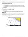
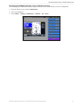
1
XM WX Satellite Weather and XM Satellite Radio ® supplement ® © 2010 Garmin Ltd. or its subsidiaries All rights reserved. Except as expressly provided herein, no part of this manual may be reproduced, copied, transmitted, disseminated, downloaded or stored in any storage medium, for any purpose without the express prior written consent of Garmin. Garmin hereby grants permission to download a single copy of this manual onto a hard drive or other electronic storage medium to be viewed and to print one copy of this manual or of any revision hereto, provided that such electronic or printed copy of this manual must contain the complete text of this copyright notice and provided further that any unauthorized commercial distribution of this manual or any revision hereto is strictly prohibited. Information in this document is subject to change without notice. Garmin reserves the right to change or improve its products and to make changes in the content without obligation to notify any person or organization of such changes or improvements. Visit the Garmin Web site (www.garmin. com) for current updates and supplemental information concerning the use and operation of this and other Garmin products. Garmin®, the Gamin logo, GPSMAP®, BlueChart®, and g2 Vision® are trademarks of Garmin Ltd. or its subsidiaries, registered in the USA and other countries. These trademarks may not be used without the express permission of Garmin. DAFIF™ is a trademark of the National GeospatialIntelligence Agency. XM® and XM WX Satellite Weather® are registered trademarks of XM Satellite Radio Inc. Introduction Introduction WARNING See the Important Safety and Product Information guide in the product box for product warnings and other important information. The weather information provided through this product is subject to service interruptions and may contain errors, inaccuracies or outdated information, and consequently should not be relied upon exclusively. Always use common sense while driving or navigating, and check alternate weather information sources prior to making safety-related decisions. You acknowledge and agree that you shall be solely responsible for use of the weather information and all decisions taken with respect to driving or navigating in weather. Garmin will not be responsible for any consequences of using the weather data. Equipment Requirements: XM To use XM WX Satellite Weather®, you must have a Garmin XM® satellite weather receiver. To use XM Satellite Radio, you must have a Garmin XM satellite radio receiver. Visit www.garmin.com/xm for more information. To connect the XM antenna and receiver and for subscription instructions, refer to the owner’s manual for your XM equipment. Simulator Mode Simulator mode provides live weather data if your chartplotter is connected to the required equipment described above and you have a paid XM subscription. Otherwise, simulator mode provides simulated weather. Contact Garmin Contact Garmin Product Support if you have any questions while using your chartplotter. In the USA, go to www.garmin.com/support, or contact Garmin USA by phone at (913) 397.8200 or (800) 800.1020. In the UK, contact Garmin (Europe) Ltd. by phone at 0808 2380000. In Europe, go to www.garmin.com/support and click Contact Support for in-country support information, or contact Garmin (Europe) Ltd. by phone at +44 (0) 870.8501241. XM WX Satellite Weather® and XM® Satellite Radio Supplement i Introduction Table of Contents Introduction................................................i Contact Garmin..................................................i XM WX Satellite Weather and XM Satellite Radio...........................................1 XM WX Satellite Weather..................................1 Viewing XM WX Satellite Weather Subscription Information.................................................... 11 XM Satellite Radio........................................... 11 Appendix.................................................14 Weather Data Warranty...................................14 Software License Agreement..........................15 XM Satellite Radio Service Agreement...........15 Index........................................................16 ii XM WX Satellite Weather® and XM® Satellite Radio Supplement XM WX Satellite Weather and XM Satellite Radio Using XM WX Satellite Weather and Audio To use XM WX Satellite Weather on your chartplotter, you must connect a compatible Garmin XM antenna and activate an XM WX weather subscription. To use XM Radio, you must connect a compatible Garmin XM antenna and activate an XM WX Radio subscription. Notes: • XM service is available only in the lower 48 United States and southern Canada. • You must purchase and activate your XM service before you can use the XM features. XM WX Satellite Weather A Garmin XM satellite weather receiver and antenna receives XM WX Satellite Weather data and shows it on the chartplotter. The weather data for each feature comes from reputable weather data centers such as the National Weather Service and the Hydrometerological Prediction Center. For more information, see the XM WX Satellite Weather Web site at www.xmwxweather.com. Weather Data Broadcasts Satellite Weather data is broadcast at set intervals. For example, XM weather radar data is broadcast at fiveminute intervals. When the Garmin receiver is turned on, or when a new feature is selected, the receiver has to receive new data before it can be shown. You might experience a delay before weather data or a new feature appears on the chart. Note: Any weather feature can change in appearance or interpretation if the source that provides the information changes. Viewing Precipitation Information The precipitation screen shows NEXRAD radar, storm cells, lighting strikes, and hurricane warnings. Precipitation is indicated ranging from very light rain and snow, up to strong thunderstorms, in varying shades and colors. The time stamp in the upper-left corner of the screen indicates the elapsed time since the weather data provider last updated the information. Precipitation is shown either independently or with a variety of other weather information. From the Home screen, select Weather > Precipitation. Showing an Animated Radar Loop You can view precipitation information as an image of the latest update or as an animated loop of the latest updates. From the Home screen, select Weather > Precipitation > Menu > NEXRAD Loop > On. Showing Cloud Cover From the Home screen, select Weather > Precipitation > Menu > Cloud Cover > Show. XM WX Satellite Weather® and XM® Satellite Radio Supplement 1 XM WX Satellite Weather and XM Satellite Radio Changing from One Weather Chart to a Different Weather Chart 1. From the Home screen, select Weather. 2. Select a weather chart. 3. Select Menu > Change Weather. 4. Select a different weather chart. Storm Cell and Lightning Information Storm cell icons ➊ on the precipitation screen indicate both the present position of a storm and the projected path of that storm in the immediate future. Red cones appear with a storm cell icon, and the widest part of each cone points in the direction of the projected path of the storm cell. The red lines in each cone indicate where the storm will most likely be in the near future. Each line represents 15 minutes. Lightning strikes are represented by lightning bolt icons ➋. Lightning appears on the precipitation screen if strikes were detected within the last seven minutes. The ground-based lightning detection network detects cloud-to-ground lightning only. ➋ ➊ Hurricane Information The precipitation screen can show the present position of a hurricane ➊, a tropical storm, or a tropical depression. A red line stemming from a hurricane icon indicates the projected path ➋ of the hurricane. Darkened dots on the red line indicate the projected location of the hurricane in 12-hour intervals, as received from the weather data provider. ➋ 2 ➊ XM WX Satellite Weather® and XM® Satellite Radio Supplement XM WX Satellite Weather and XM Satellite Radio Weather Warnings and Weather Bulletins When a marine weather warning is issued, shading ➊ indicates the area to which the warning applies. To view information about the warning, select the shaded area. The cyan lines ➋ on the chart indicate the boundaries of marine weather warning zones. ➋ ➊ County Warnings When the National Weather Service issues a weather warning for a county, the county is highlighted with the color corresponding to the warning type. To view information about the warning, select the highlighted county. Color Sky Blue Description Flood Orange Flash Flood Light Blue Marine Purple Miscellaneous Light Green Severe Storm Light Yellow Tornado Pink Wind/Visibility Turquoise Winter Forecast Information The forecast screen shows weather conditions, including fronts, pressure centers, sea surface pressure, and city forecasts. Viewing Present Forecast Information From the Home screen, select Weather > Forecast. Viewing Forecast Information for Another Time Period 1. From the Home screen, select Weather > Forecast. 2. Complete an action: • Select Next Forecast to view the forecast weather for the next 12 hours, and select Next Forecast again to view forecasts for the next 24, 36, and 48 hours, in 12-hour increments. • Select Previous Forecast to view the forecast weather for the previous 12 hours, and select Previous Forecast again to view forecasts for the previous 24, 36, and 48 hours, in 12-hour increments. XM WX Satellite Weather® and XM® Satellite Radio Supplement 3 XM WX Satellite Weather and XM Satellite Radio Viewing a Coastal Forecast or an Offshore Forecast 1. From the Home screen, select Weather > Forecast. 2. Pan the map to an offshore location, and select Local Weather. 3. Complete an action for the selected location: • Select Current Cond. to display the current weather conditions. • Select Forecast to display the forecast. • Select Sea Surface to displace the sea surface condition at the selected location. Weather Fronts and Pressure Centers: Surface Analysis Weather Maps Weather fronts appear as lines that indicate the leading edge of an air mass. Front Symbol Description Cold front Warm front Stationary front Occluded front Trough Pressure-center symbols often appear near weather fronts. Pressure Center Symbol Description Indicates a low-pressure center. A low-pressure center is an area where the measured pressure is lowest relative to the surrounding area. Moving away from a low-pressure center in any horizontal direction results in increased pressure. Winds flow counterclockwise around low-pressure centers in the northern hemisphere. Indicates a high-pressure center. A high-pressure center is an area where the measured pressure is highest relative to the surrounding area. Moving away from a high-pressure center in any horizontal direction results in decreased pressure. Winds flow clockwise around high-pressure centers in the northern hemisphere. City Forecasts City forecasts appear as weather symbols ➊ as defined by the Weather Symbol Table (page 5). The forecast is viewed in 12-hour increments for the next 48 hours. ➊ 4 XM WX Satellite Weather® and XM® Satellite Radio Supplement XM WX Satellite Weather and XM Satellite Radio Weather Symbols Symbol Weather Symbol Weather Fair (sunny, hot, clear) Rain (drizzle, sleet, showers) Partly Cloudy Cloudy Thunderstorms Snow (snow showers, flurries, blizzard, blowing snow, sleet, freezing rain, freezing drizzle) Foggy Smoke (dusty, hazy) Windy Viewing Sea Conditions The sea conditions screen shows information about surface conditions, including winds, wave height, wave period, and wave direction. From the Home screen, select Weather > Sea Conditions. Surface Winds Surface wind vectors appear on the Sea Conditions screen using wind barbs that indicate the direction from which the wind is blowing. A wind barb is a circle with a tail. The line or flag attached to the tail of the wind barb indicates the wind speed. A short line represents 5 knots, a long line represents 10 knots, and triangle represents 50 knots. Wind Barb Wind Speed Calm Wind Direction Wind Barb Wind Speed 20 knots 5 knots 50 knots 10 knots 65 knots Wind Direction 15 knots XM WX Satellite Weather® and XM® Satellite Radio Supplement 5 XM WX Satellite Weather and XM Satellite Radio Wave Height, Wave Period, and Wave Direction Wave heights for an area appear as variations in color. Different colors indicate different wave heights ➊, as shown in the legend ➋ on the left of the screen. The wave period indicates the time (in seconds) between successive waves. Wave period lines ➌ indicate areas that have the same wave period. Wave directions appear on the chart using red arrows ➍. The direction of each arrow pointer indicates the direction in which a wave is moving. ➋ ➊ ➌ ➍ Viewing Forecast Sea Conditions Information for Another Time Period 1. From the Home screen, select Weather > Sea Conditions. 2. Complete an action: • Select Next Forecast to view the forecast visibility for the next 12 hours, and select Next Forecast again to view forecasts for the next 24 and 36 hours, in 12-hour increments. • Select Previous Forecast to view the forecast visibility for the previous 12 hours, and select Previous Forecast again to view forecasts for the previous 24 and 36 hours, in 12-hour increments. 6 XM WX Satellite Weather® and XM® Satellite Radio Supplement XM WX Satellite Weather and XM Satellite Radio Viewing Fishing Information The fishing screen shows present water temperature, present surface pressure conditions, and fishing forecasts. From the Home screen, select Weather > Fishing. Surface Pressure and Water Temperature Data Surface-pressure information appears using pressure isobars and pressure centers. Isobars ➊ connect points of equal pressure. Pressure readings can help to determine weather and wind conditions. High-pressure areas are generally associated with fair weather. Low-pressure areas are generally associated with clouds and the chance of precipitation. Isobars packed closely together show a strong pressure gradient. Strong pressure gradients are associated with areas of stronger winds. ➌ ➊ ➋ Pressure units are shown in millibars (mb), inches of Mercury (inHg), and hectopascals (hPa). Colored shading ➋, as defined by the legend ➌ in the upper-left corner of the display, indicates the surface temperature of the water. Forecasting Fish Location You can show areas ➊ that contain optimal weather conditions for specific species of fish. 1. From the Home screen, select Weather > Fishing > Menu > Fish Species. 2. Select a species of fish. 3. Select Mode > On. Shaded areas indicate optimal fishing areas. 4. Repeat steps 2 and 3 to show areas with optimal weather conditions for additional species of fish. ➊ XM WX Satellite Weather® and XM® Satellite Radio Supplement 7 XM WX Satellite Weather and XM Satellite Radio Visibility Information Visibility is the forecast maximum horizontal distance that can be seen at the surface, as shown in the legend ➊ on the left of the screen. Variations in the visibility shading ➋ show the forecast change in surface visibility. ➊ ➋ Viewing Visibility Information From the Home screen, select Weather > Visibility. Viewing Forecast Visibility Information for Another Time Period 1. From the Home screen, select Weather > Visibility. 2. Complete an action: • Select Next Forecast to view the forecast visibility for the next 12 hours. Select Next Forecast again to view forecasts for the next 24 and 36 hours, in 12-hour increments. • Select Previous Forecast to view the forecast visibility for the previous 12 hours. Select Next Forecast again to view forecasts for the previous 24 and 36 hours, in 12-hour increments. Viewing Buoy Reports Report readings are taken from buoys ➊ and coastal observation stations. These readings are used to determine air temperature, dew point, water temperature, tide, wave height and period, wind direction and speed, visibility, and barometric pressure. 1. From the Home screen, select Weather > Forecast. 2. Select a buoy ( ). 3. Select Buoy. ➊ 8 XM WX Satellite Weather® and XM® Satellite Radio Supplement XM WX Satellite Weather and XM Satellite Radio Viewing Local Weather Information Forecast information appears when an area near a buoy is selected. 1. From the Home screen, select Weather > Forecast. 2. Complete an action: • Select a location on the chart. • Pan to a new location, and select a location on the chart. 3. Select Local Weather. 4. Complete an action: • Select Current Cond. to view present weather conditions from a local weather service. • Select Forecast to view a local weather forecast. • Select Sea Surface to view surface wind and barometric pressure information. • Select Marine Bulletin to view wind and wave information. Creating a Waypoint on the Forecast Screen 1. From the Home screen, select Weather > Forecast. 2. Complete an action: • Select a location on the chart. • Pan to a new location, and select a location on the chart. 3. Select Create Waypoint. 4. If you want to name the waypoint or provide information about it, select the waypoint on the right side of the screen and select Edit. • Select Name, enter the name, and select Done. • Select Symbol, and enter a symbol. • Select Depth, enter the depth, and select Done. • Select Water Temp, enter the water temperature, and select Done. • Select Comment, enter the comment, and select Done. About the Weather Overlay The Weather Overlay superimposes weather and weather-related information on the Navigation chart, the Fishing chart, and the Perspective 3D chart. The Navigation chart and the Fishing chart can show WX radar, cloud cover, lightning, WX buoys, county warnings, and hurricane warnings. The Perspective 3D chart can show WX radar. Weather Overlay settings configured for use on one chart are not applied to another chart. The Weather Overlay settings for each chart must be configured separately. Note: Fishing charts are available if you use a BlueChart g2 Vision SD card, a BlueChart g2 SD card, or if your built-in map supports Fishing charts. Turning On the Weather Overlay on a Chart 1. 2. 3. 4. From the Home screen, select Charts. Select Navigation Chart, Fishing Chart, or Perspective 3D. Select Menu. Complete an action: • For the Navigation Chart and Fishing Chart, select Chart Setup > Weather > Weather > On. • For the Perspective 3D chart, select Weather Radar > On. XM WX Satellite Weather® and XM® Satellite Radio Supplement 9 XM WX Satellite Weather and XM Satellite Radio Showing NEXRAD Precipitation Data on a Chart NEXRAD shows very light rain and snow up to strong thunderstorms in varying shades and colors. Before you can show NEXRAD information on a chart, you must turn on the weather overlay (page 9). 1. From the Home screen, select Charts. 2. Select Navigation Chart or Fishing Chart. 3. Select Menu > Chart Setup > Weather > NEXRAD > On. Showing Weather Buoys on a Chart Before you can show weather buoys on a chart, you must turn on the Weather Overlay (page 9). 1. From the Home screen, select Charts. 2. Select Navigation Chart or Fishing Chart. 3. Select Menu > Chart Setup > Weather > WX Buoys > On. Showing a Weather Legend on a Chart Before you can show a weather legend on a chart, you must turn on the Weather Overlay (page 9). 1. From the Home screen, select Charts. 2. Select Navigation Chart or Fishing Chart. 3. Select Menu > Chart Setup > Weather > Legend > Show. Showing Cloud Cover Data on the Navigation Chart Before you can show cloud cover data on the Navigation chart, you must turn on the Weather Overlay (page 9). From the Home screen, select Charts > Navigation Chart > Menu > Chart Setup > Weather > Cloud Cover > On. Showing Visibility Data on the Navigation Chart Visibility is the forecast maximum horizontal distance that can be seen at the surface. Before you can show visibility data on the Navigation chart, you must turn on the Weather Overlay (page 9). From the Home screen, select Charts > Navigation Chart > Menu > Chart Setup > Weather > Visibility > On. Showing Sea Temperature Data on the Fishing Chart Before you can show sea temperature data on the Fishing chart, you must turn on the Weather Overlay (page 9). From the Home screen, select Charts > Fishing Chart > Menu > Chart Setup > Weather > Sea Temp > On. Showing Fish Forecasting Data on the Fishing Chart Before you can show fish forecasting data on the Fishing chart, you must turn on the Weather Overlay (page 9). You can show areas that contain optimal weather conditions for specific species of fish. 1. From the Home screen, select Charts > Fishing Chart > Menu > Chart Setup > Weather > Fish Species > On. 2. Select a species of fish. 3. Select Mode > On. Shaded areas indicate optimal fishing areas. 4. Repeat steps 2 and 3 to show areas with optimal weather conditions for additional species of fish. 10 XM WX Satellite Weather® and XM® Satellite Radio Supplement XM WX Satellite Weather and XM Satellite Radio Weather Alarms Setting Weather Alarms You can set an alarm to sound when certain weather conditions occur. 1. From the Home screen, select Configure > Alarms > Weather. 2. Complete one or more actions: • Select Marine > On. • Select Tornado > On. • Select Severe Storm > On. • Select Flood > On. • Select Flash Flood > On. Viewing XM WX Satellite Weather Subscription Information If you have an active XM WX Radio subscription and are connected to a compatible Garmin XM antenna, you can view information about the weather services you have subscribed to and how many minutes have passed since the data for each service was updated. From the Home screen, select Weather > Weather Subscription. Using XM Audio When you connect a compatible Garmin XM antenna to your chartplotter, and you connect the chartplotter to the audio input of your boat, you can listen to XM Audio channels. Note: To use XM Satellite Radio features, you must have a subscription to XM Satellite Radio. Selecting an XM Radio Channel 1. From the Home screen, select Configure > XM Audio. 2. Complete an action: • Select Channel Guide to select a specific XM channel within the selected category. Select a channel. Select Back. • Select Channel Entry to enter an XM channel number manually. Enter a channel number. Select Done. Customizing the Channel Guide XM Radio channels are grouped in categories. You can select the category of channels that appear in the channel guide. 1. From the Home screen, select Configure > XM Audio > Category. 2. Select a category. XM WX Satellite Weather® and XM® Satellite Radio Supplement 11 XM WX Satellite Weather and XM Satellite Radio XM Presets The XM presets list is a customizable channel category. You can save your favorite channels to the presets list. Saving an XM Channel to the Presets List 1. From the Home screen, select Configure > XM Audio. 2. Complete an action: • Select Channel Guide to select a specific XM channel within the selected category. Select a channel. Select Back. • Select Channel Entry to enter an XM channel number manually. Enter a channel number. Select Done. 3. Select Save Preset. Adjusting XM Radio Volume This option not available for all Garmin XM antennas. 1. From the Home screen, select Configure > XM Audio. 2. Complete an action: • Select Mute to turn the volume off or on. • Select Volume to adjust the volume level manually. Select and hold Up or Down. Select Done. XM Radio Bar Displaying the XM Radio Data Bar on a Chart The XM Radio data bar ➊ is available on all charts. On a chartplotter, a data bar configured to appear on one chart does not appear on another chart. The XM Radio data bar for each chart must be configured separately. 1. From the Home screen, select Charts. 2. Select a chart. 3. Select Menu > Data Bars > XM Audio > On. ➊ 12 XM WX Satellite Weather® and XM® Satellite Radio Supplement XM WX Satellite Weather and XM Satellite Radio Displaying the XM Radio Data Bar on the Combination Screen You can display the XM Radio data bar along the bottom of the Combinations screen on a chartplotter. 1. From the Home screen, select Combinations. 2. Select a combination. 3. Select Menu > Change Combination > XM Bar > On > Done. XM WX Satellite Weather® and XM® Satellite Radio Supplement 13 Appendix Appendix Weather Data Warranty THE WEATHER DATA SOFTWARE PRODUCT IS PROVIDED “AS IS.” ALL OTHER WARRANTIES, EXPRESSED OR IMPLIED, INCLUDING ANY WARRANTY OF MERCHANTABILITY OR FITNESS FOR A PARTICULAR PURPOSE OR OF NON-INFRINGEMENT ARE HEREBY EXCLUDED. USER SAFETY If you use XM Services it is your responsibility to exercise prudent discretion and observe all safety measures required by law and your own common sense. You assume the entire risk related to your use of the Services. XM and Garmin assume no responsibility for accidents resulting from or associated with use of the Services. Your Radio Service includes traffic and weather information, and you acknowledge that such information is not for “safety for life”, but is merely supplemental and advisory in nature, and therefore cannot be relied upon as safety-critical in connection with any aircraft, sea craft or automobile usage. This information is provided “as is” and XM and Garmin disclaim any and all warranties, express and implied, with respect thereto or the transmission or reception thereof. XM and Garmin further do not warrant the accuracy, reliability, completeness or timeliness of the traffic and weather information disclosed on the Radio Service. In no event will XM and Garmin, their data suppliers, service providers, marketing/distribution, software or Internet partners or hardware manufacturers be liable to you or to any third party for any direct, indirect, incidental, consequential, special, exemplary or punitive damages or lost profits resulting from use of or interruptions in the transmission or reception of the Services. LIMITS ON OUR RESPONSIBILITY a) DISCLAIMERS. EXCEPT AS EXPRESSLY PROVIDED HEREIN, WE MAKE NO WARRANTY OR REPRESENTATION, EITHER EXPRESS OR IMPLIED, REGARDING THE RADIO SERVICE. YOUR USE OF THE SERVICE IS AT YOUR SOLE RISK. THE CONTENT AND FUNCTIONALITY OF THE SERVICE IS PROVIDED “AS IS” WITHOUT ANY WARRANTY OF ANY KIND, EXPRESS OR IMPLIED. ALL SUCH WARRANTIES OR REPRESENTATIONS (INCLUDING, WITHOUT LIMITATION, THE IMPLIED WARRANTIES OF MERCHANTABILITY, FITNESS FOR A PARTICULAR PURPOSE, TITLE AND NON-INFRINGEMENT) ARE HEREBY DISCLAIMED. b) LIMITATIONS OF LIABILITY. WE ARE NOT RESPONSIBLE FOR ANY SPECIAL, INCIDENTAL, OR CONSEQUENTIAL DAMAGES OR LOSSES RELATING TO THE USE OF THE RADIO SERVICE, WHETHER BASED ON NEGLIGENCE OR OTHERWISE. OUR TOTAL LIABILITY TO YOU AND ANY OTHER PERSONS RECEIVING OUR SERVICES, REGARDLESS OF THE CAUSE, WILL IN NO EVENT EXCEED THE AMOUNTS THAT YOU HAVE PAID TO US FOR THE SERVICE THAT YOU RECEIVED DURING THE SIX (6) MONTH PERIOD IMMEDIATELY PRIOR TO THE SPECIFIC EVENT THAT GAVE RISE TO THE APPLICABLE DAMAGE OR LOSS. THIS ALLOCATION OF RISK IS REFLECTED IN OUR PRICES. YOU MAY HAVE GREATER RIGHTS THAN DESCRIBED ABOVE UNDER YOUR STATE’S LAWS. This product was developed using DAFIF™, a product of the National Geospatial-Intelligence Agency. This product has not been endorsed or otherwise approved by the National Geospatial-Intelligence Agency, or the United States Department of Defense (10 U.S.C. 425). a. Under 10 U.S.C. 456, no civil action may be brought against the United States on the basis of the content of a navigational aid prepared or disseminated by either the former Defense Mapping Agency (DMA), National Imagery and Mapping Agency (NIMA), or the National Geospatial-Intelligence Agency (NGA). b. The DAFIF™ product is provided “as is,” and no warranty, express or implied, including, but not limited to the implied warranties of merchantability and fitness for particular purpose or arising by statute or otherwise in law or from a course of dealing or usage in trade, is made by NGA as to the accuracy and functioning of the product. c. Neither NGA nor its personnel will be liable for any claims, losses, or damages arising from or connected with the use of this product. The user agrees to hold harmless the United States National Geospatial14 XM WX Satellite Weather® and XM® Satellite Radio Supplement Appendix Intelligence Agency. The user’s sole and exclusive remedy is to stop using the DAFIF product. This product was developed using DAFIF, a product of the National Geospatial-Intelligence Agency. Software License Agreement BY USING THE CHARTPLOTTER, YOU AGREE TO BE BOUND BY THE TERMS AND CONDITIONS OF THE FOLLOWING SOFTWARE LICENSE AGREEMENT. PLEASE READ THIS AGREEMENT CAREFULLY. Garmin Ltd. and its subsidiaries (“Garmin”) grant you a limited license to use the software embedded in this device (the “Software”) in binary executable form in the normal operation of the product. Title, ownership rights, and intellectual property rights in and to the Software remain in Garmin and/or its third-party providers. You acknowledge that the Software is the property of Garmin and/or its third-party providers and is protected under the United States of America copyright laws and international copyright treaties. You further acknowledge that the structure, organization, and code of the Software, for which source code is not provided, are valuable trade secrets of Garmin and/or its third-party providers and that the Software in source code form remains a valuable trade secret of Garmin and/or its third-party providers. You agree not to decompile, disassemble, modify, reverse assemble, reverse engineer, or reduce to human readable form the Software or any part thereof or create any derivative works based on the Software. You agree not to export or re-export the Software to any country in violation of the export control laws of the United States of America or the export control laws of any other applicable country. XM Satellite Radio Service Agreement XM Satellite Radio Inc. Hardware and required monthly subscription sold separately. Subscription fee is consumer only. Other fees and taxes, including a one-time activation fee apply. All programming fees and weather data subject to change. XM WX weather data displays and individual product availability vary by hardware equipment. Reception of the XM signal may vary depending on location. Subscriptions subject to Customer Agreement included with the XM Welcome Kit and available at xmradio.com. XM Radio U.S. Satellite Services available only to those at least 18 years of age in the 48 contiguous United States and D.C. XM WX is a trademark of XM Satellite Radio Inc. XM WX Satellite Weather® and XM® Satellite Radio Supplement 15 Index Index A alarms flash flood 10 flood 10 marine 10 severe storm 10 tornado 10 animated NEXRAD loop 1 B buoy reports 8 C channel guide 11 cloud cover 1 county warnings 3 W warnings county 3 marine 3 water temperature 6 wave direction 5 height 5 period 5 weather alarms 10 weather fronts 4 X XM Satellite Radio i, 11 XM Satellite Radio bar 12 XM WX Satellite Weather 1 F fish location 6 forecasts 3 city 4 future 3 marine 4 offshore 4 past 3 present 3 weather 3 H hurricane 2 L lightning 2 M marine warnings 3 N National Weather Service 1 NEXRAD precipitation 1 P presets 12 pressure centers 4 R radio receiver i S storm cells 2 subscription XM WX Satellite Weather i, 11 surface pressure 6 surface winds 5 V visibility 7 volume 12 16 XM WX Satellite Weather® and XM® Satellite Radio Supplement For the latest free software updates (excluding map data) throughout the life of your Garmin products, visit the Garmin Web site at www.garmin.com. © 2010 Garmin Ltd. or its subsidiaries Garmin International, Inc. 1200 East 151st Street, Olathe, Kansas 66062, USA Garmin (Europe) Ltd. Liberty House, Hounsdown Business Park, Southampton, Hampshire, SO40 9LR UK Garmin Corporation No. 68, Jangshu 2nd Road, Sijhih, Taipei County, Taiwan www.garmin.com November 2010 Part Number 190-00854-10 Rev. A Printed in Taiwan