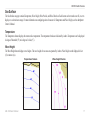
1
GDL 30A
™
owner’s manual
© 2008 Garmin Ltd. or its subsidiaries
Garmin International, Inc.
1200 East 151st Street,
Olathe, Kansas 66062, USA
Tel. (913) 397.8200 or (800) 800.1020
Fax (913) 397.8282
Garmin (Europe) Ltd.
Liberty House
Hounsdown Business Park,
Southampton, Hampshire, SO40 9RB UK
Tel. +44 (0) 870.8501241 (outside the UK)
0808 2380000 (within the UK)
Fax +44 (0) 870.8501251
Garmin Corporation
No. 68, Jangshu 2nd Road,
Shijr, Taipei County, Taiwan
Tel. 886/2.2642.9199
Fax 886/2.2642.9099
All rights reserved. Except as expressly provided herein, no part of this manual may be reproduced, copied, transmitted, disseminated, downloaded or stored in any storage
medium, for any purpose without the express prior written consent of Garmin. Garmin hereby grants permission to download a single copy of this manual onto a hard drive or
other electronic storage medium to be viewed and to print one copy of this manual or of any revision hereto, provided that such electronic or printed copy of this manual must
contain the complete text of this copyright notice and provided further that any unauthorized commercial distribution of this manual or any revision hereto is strictly prohibited.
Information in this document is subject to change without notice. Garmin reserves the right to change or improve its products and to make changes in the content without
obligation to notify any person or organization of such changes or improvements. Visit the Garmin Web site (www.garmin.com) for current updates and supplemental
information concerning the use and operation of this and other Garmin products.
Garmin® and GPSMAP® are trademarks of Garmin Ltd. or its subsidiaries, registered in the USA and other countries. GDL™ and myGarmin™ are trademarks of Garmin Ltd.
or its subsidiaries. These trademarks may not be used without the express permission of Garmin.
XM WX Weather and XM Radio are trademarks of XM Satellite Radio, Inc.
March 2008
Part Number 190-00930-00 Rev. A
Printed in Taiwan
Introduction
Introduction
The GDL™ 30A Marine Weather/Audio Satellite Receiver provides
graphical and textual marine XM WX Weather™ information to
your Garmin® Marine Network chartplotters as well as XM music,
news, and talk programming. Operation of the GDL 30A requires a
subscription to either the XM WX Satellite Weather service, the XM
Radio service, or both.
This manual covers the XM weather and audio features of the
GDL 30A when viewed on a GPSMAP® 3000 Series Garmin Marine
Network chartplotter. To understand the XM weather and audio
features of the GDL 30A when viewed on a GPSMAP 4000 or 5000
series chartplotter, see the GPSMAP 4000 or 5000 series Owner's
Manual.
Product Registration
Help us better support you by completing our online registration
today! Connect to our Web site at http://my.garmin.com. Keep the
original sales receipt, or a photocopy, in a safe place.
(913) 397-8200 or (800) 800-1020, or go to www.garmin.com/
support.
Contact XM
To set up your XM account call (800) 800-9200. For XM weather
information, visit www.xmwxweather.com.
Important Numbers
For future reference, write down the important numbers associated
with your GDL 30A.
Serial Number (located on the bottom of the unit)
Unique XM IDs are associated with your GDL 30A. XM Satellite
Radio uses these ID numbers to activate and deactivate your XM
weather and XM audio. To locate the ID numbers on your unit,
see page 25.
XM WX Weather ID
Contact Garmin
Contact Garmin if you have any questions while using your
GDL 30A. In the USA, contact Garmin Product Support by phone:
GDL 30A Owner’s Manual
XM Radio ID
Introduction
Introduction...........................................................................1
Product Registration................................................................... 1
Contact Garmin.......................................................................... 1
Contact XM................................................................................. 1
Important Numbers..................................................................... 1
Unit Overview.......................................................................3
Packing List and Accessories..................................................... 3
Installing and Activating the GDL 30A................................4
Using XM WX Weather.........................................................5
Preset Weather Displays............................................................ 5
XM WX Weather Features....................................................7
Main Menu...........................................................................19
Weather Tab............................................................................. 19
XM Tab..................................................................................... 24
Appendix.............................................................................26
Blink Codes.............................................................................. 26
Weather-Related Broadcast Rates........................................... 26
GDL 30A Specifications............................................................ 27
Weather and Sea Surface Information..................................... 28
XM Satellite Radio Service Agreement.................................... 28
Software License Agreement................................................... 30
Index....................................................................................31
Precipitation................................................................................ 7
Atmosphere.............................................................................. 12
Sea Surface.............................................................................. 17
GDL 30A Owner’s Manual
Unit Overview
Unit Overview
Power/Data
Connector
Packing List and Accessories
Before installing your unit, please check to see that your package
includes the following items. If any parts are missing, contact your
Garmin dealer immediately.
LED Status
Indicator
Weather Cap
Network Port
Standard Package
Mounting
Holes
Antenna
Connector
Audio Connector
• GDL 30A unit
• 7-pin power cable
• Garmin Marine Network cable
(6 ft.)
• GA 32 Antenna with cable
• Audio cable
• Grommet
• Installation Instructions
• Owner’s Manual
Optional Accessories
• GMS 10 Network Port
Expander
• Garmin Marine Network
cables (20 ft. and 40 ft.)
See the Important Safety and Product Information guide in the
product box for product warnings and other important information.
GDL 30A Owner’s Manual
Unit Overview
Installing and Activating the GDL 30A
Step 1: Install the unit
Use the GDL 30A Installation Instructions to complete the
appropriate wiring connections.
Step 2: Set up the XM account
Ensure that your XM Weather ID and your XM Radio ID are readily
available. Contact XM Satellite Radio by phone at (800) 9859200. After receiving the required information from you, the XM
representative activates the account and sends out an XM signal
to activate the GDL 30A.
To answer other XM questions, call the above number or visit
www.xmwxweather.com.
Step 3: Confirm all components of your service package
XM WX Weather: Ensure that the Garmin Marine Network is
turned on so you receive the XM signal. When the components of
the selected service package appear in the Weather Products list,
the XM signal is working correctly. To see the Weather Products
list on a 3000 Series chartplotter, open the Main Menu, scroll to
the XM tab, and then highlight the Information sub tab. Do not turn
the chartplotter off until the name of the selected service package
appears in the Service Level field (see page 25).
Note: On a GPSMAP 4000 Series or a GPSMAP 5000 Series
chartplotter, your service package appears on the system information
screen (Configure > System > System Information > Weather
Subscription)
XM Radio: From the XM tab, highlight the Audio sub tab and
verify that channels 7, 9, 47, and 122 appear (see page 24).
This indicates that all channels on the XM basic radio service
are working correctly. If the XM WX Weather and the XM Radio
service have not activated within an hour, call XM customer care
at (800) 985-9200 and ask an XM representative to refresh the
signal.
Step 4: Save the service package
After the service package name appears, turn the entire Garmin
Marine Network off.
Step 5: Use your new XM services
When you turn the Garmin Marine Network on after completing
Step 4, you are able to view weather features on the chartplotter
and to customize the new radio stations.
GDL 30A Owner’s Manual
Using XM WX Weather
Using XM WX Weather
This manual describes the use of XM WX Weather and XM Audio functions on a GPSMAP 3000 Series chartplotter. If you have a
GPSMAP 4000 Series or a GPSMAP 5000 Series chartplotter, please use your chartplotter Owner's Manual for instructions on using XM WX
Weather and XM Audio.
WARNING: The XM Weather Radio data is merely supplemental and advisory in nature and is not intended to be relied up on as safety-critical information. You should
always exercise caution and common sense when confronted with severe weather conditions.
Preset Weather Displays
Use presets to quickly view different types of weather information. There are three preset weather displays: General, Sea State, and Storms. The
name of the selected preset appears in the lower-left corner of the screen.
To select a preset weather display:
1. Press the Wthr Options soft key.
2. Press the Next Preset soft key to cycle through the three presets.
General
GDL 30A Owner’s Manual
Sea State
Storms
Using XM WX Weather
Customizing the Preset Weather Displays
You can customize the weather displays. Each preset has three subcategories: Precipitation, Atmosphere, and Sea Surface. Each category
contains display settings for that topic. You can also change the name of the presets and customize any of the weather features. For detailed
information on customizing the preset weather displays, please see the chartplotter Owner’s Manual.
Precipitation
Atmosphere
Sea Surface
GDL 30A Owner’s Manual
XM WX Weather Features
XM WX Weather Features
Following is a brief description of each weather feature. The weather features are divided into three subcategories: Precipitation, Atmosphere,
and Sea State.
Precipitation
The Precipitation category provides NEXRAD/Cloud Top, Storm
Cell, Lightning, and Hurricane data. Each feature can be turned on
or off, or set to display at a selected zoom range.
NEXRAD
NEXRAD
NEXRAD is an acronym for NEXt Generation Weather RADar. The
NEXRAD feature displays precipitation, from very light rain and snow
up to strong thunderstorms, in varying shades and colors. A legend
showing the colors for Rain, Mix, and Snow can be displayed by
pressing the ADJ key and selecting Weather Legend. NEXRAD
can be displayed independently or with Cloud Tops.
NEXRAD Legend
GDL 30A Owner’s Manual
XM WX Weather Features
Cloud Tops
Cloud Tops are shown in shades of gray. Cloud Tops can be displayed independently or with NEXRAD information.
Cloud Tops Legend
Cloud Tops
Cloud Tops with NEXRAD
GDL 30A Owner’s Manual
XM WX Weather Features
Storm Cells
The Storm Cells feature displays storm cells and the projected path of storms in the immediate future. The direction the red cone is pointing
(from the narrow end to the wide end) indicates the projected path of the storm cell. The red bars that span the cone indicate the projected area
of the storm. Each bar represents 15 minutes.
The storm icon
indicates the current
location of the storm cell. The red bars that
span the cone in this storm indicate where
the storm will be at 15-minute intervals in the
next hour.
GDL 30A Owner’s Manual
XM WX Weather Features
Lightning
Lightning strikes are represented by lightning-bolt icons, as shown in the images below. Lightning strikes appear on the map if they have been
detected within the last seven minutes. The ground-based detection network only detects cloud-to-ground lightning.
Cloud Tops
10
Cloud Tops with NEXRAD
GDL 30A Owner’s Manual
XM WX Weather Features
Hurricanes
The Hurricanes feature shows the current position of a hurricane, tropical storm, or tropical depression, as well as its projected path (indicated
by a red line). The darkened squares that appear along the red line indicate the projected locations received from the National Hurricane Center.
The Center provides four forecasts at 12-hour intervals and a fifth forecast at a 24-hour interval. Each forecast indicates the projected location
of the hurricane at different points along its projected path. Forecasted hurricane conditions at each projected location are also provided.
In this example, this hurricane is projected
to travel west-southwest before moving in
a northwesterly direction.
This example shows the projected path of
Hurricane Charley through Florida in August,
2004. Wind and storm cells are also visible.
In this example of Hurricane Charley in August, 2004, NEXRAD data,
wave height, and wind are shown.
GDL 30A Owner’s Manual11
XM WX Weather Features
Atmosphere
The Atmosphere category provides Wind, Pressure, Visibility, Front, and City Condition data. Each feature can be turned on or off, or set to
appear at a selected zoom range.
Wind
The Wind feature displays wind speed and wind direction. Wind direction is indicated by a circle with a wind barb. The circle points in the
direction of the wind with the barb as a tail. Wind speed is indicated by different flags attached to the barb.
Wind Direction
Calm
5 knots
10 knots
15 knots
20 knots
50 knots
20-knot winds blowing to the southwest.
12
GDL 30A Owner’s Manual
XM WX Weather Features
Pressure
The pressure feature displays pressure isobars and pressure centers on the map. The isobars connect points of equal pressure. Pressure readings
can help determine weather and wind conditions in an area. High-pressure areas are generally associated with fair weather. Low-pressure areas
are generally associated with clouds and the chance of precipitation. Isobars that are packed closely together show a strong pressure gradient.
Strong pressure gradients are associated with areas of stronger winds.
Pressure units can be displayed in millibars (mbar), inches of mercury (in Hg), and hectopascals (hPa). See the chartplotter Owner’s Manual for
more information on configuring units of measure.
Pressure Isobars
Strong Pressure Gradient
GDL 30A Owner’s Manual13
XM WX Weather Features
Visibility
Visibility is the maximum horizontal distance that can be seen. Isobars on the Visibility feature show a change in visibility. Distance can be
displayed in nautical miles (nm), miles (mi.), or kilometers (km). See the chartplotter’s Owner’s Manual for more information on configuring
units of measure. In the example below, visibility ranges from 0.5 nautical miles to 3 nautical miles.
This image shows NEXRAD, Cloud Tops, and Visibility.
Displaying multiple features may help to provide a clearer
picture of the weather conditions in the area.
14
GDL 30A Owner’s Manual
XM WX Weather Features
Fronts
The Fronts feature displays the lines indicating the leading edge of an air mass that is replacing an existing air mass. This feature also displays
pressure centers. Pressure centers are represented by a large red “L” for low-pressure centers or a large blue “H” for high-pressure centers.
Pressure centers represent an area where pressure is measured to be either the highest or the lowest pressure relative to the surrounding area.
Cold Front
Warm Front
Stationary
Front
Occluded
Front
Dry Line
Indicates a low-pressure center. A low-pressure center
is an area where the measured pressure is lowest
relative to the surrounding area. Moving away from a
low-pressure center in any horizontal direction results
in increased pressure. Winds flow counterclockwise
around low-pressure centers in North America.
Indicates a high-pressure center. Similar to a lowpressure center, a high-pressure center is an area
where the measured pressure is highest relative to the
surrounding area. Moving away from a high-pressure
center in any horizontal direction results in decreased
pressure. Winds flow clockwise around high-pressure
centers in North America.
GDL 30A Owner’s Manual15
XM WX Weather Features
City Conditions
This feature displays the current weather conditions at selected cities throughout North America. The current weather condition for an area is
depicted by an icon.
City Condition Icons
Sunny
City Conditions
Partly Cloudy
Cloudy
Thunderstorms
Rain
Snow
Windy
Smoke
Foggy
16
GDL 30A Owner’s Manual
XM WX Weather Features
Sea Surface
The Sea Surface category contains Temperature, Wave Height, Wave Period, and Wave Direction. Each feature can be turned on or off, or set to
display at a selected zoom range. For more information on configuring units of measure for Temperature and Wave Height, see the chartplotter
Owner’s Manual.
Temperature
The Temperature feature displays the water surface temperature. The temperature breaks are indicated by isobars. Temperature can be displayed
in degrees Fahrenheit (°F) or in degrees Celcius (°C).
Wave Height
The Wave Height feature displays wave heights. The wave heights for an area are separated by isobars. Wave Height can be displayed in feet
(ft.) or meters (m).
Temperature Feature
Wave Height Feature
GDL 30A Owner’s Manual17
XM WX Weather Features
Wave Period
The Wave Period feature provides the time (in seconds) between successive waves.
Wave Direction
The Wave Direction feature shows the direction in which waves are moving, as indicated by the direction of the red arrows.
Wave Period Feature
18
Wave Direction Feature
GDL 30A Owner’s Manual
Main Menu
Main Menu
The Main Menu allows you to customize the weather data that appears on your GPSMAP 3000 Series chartplotter. For information on
configuring weather on a GPSMAP 4000 Series or a GPSMAP 5000 Series chartplotter, consult your GPSMAP 4000 Series or GPSMAP 5000
Series chartplotter Owner’s Manual.
Weather Tab
The GDL 30A provides current weather conditions, forecast information, and sea-surface information from the weather center nearest to your
present location, or from a location selected using the Find Weather Information page. To display the Weather tab, press and hold the ADJ/
MENU key to display the Menu Menu. Using the ROCKER, highlight the Weather tab. Five sub tabs are available: Current, Forecast, Sea
Surface, Forecast Map, and Setup.
Current (Weather)
The Current (weather) sub tab displays current weather conditions observed at the weather data location closest to your current position or at a
location selected using the Find Information page.
If a condition field is empty, data for that
field is not available at this time.
To search for data at a location other than your current location, highlight Current Position and press ENTER.
With the Find Weather Information page displayed, highlight a search option and press ENTER. With a new
location selected, all information shown in the sub tab categories relates to the selected location.
GDL 30A Owner’s Manual19
Main Menu
Forecast
The Forecast sub tab includes two panels that display forecast information for the location selected in the Current sub tab. The top panel
displays the high/low temperature, chance of precipitation, and weather condition (cloudy, sunny, thunderstorms). The number of days that
appear in this panel depend on the data available from the responding weather service center. If more than four days of forecasts are provided,
use the ROCKER to move down the list.
The bottom panel on the Forecast sub tab features a detailed 24-hour forecast for winds, wind gust, and visibility. To see all of this information,
use the ROCKER to move down the list. If a condition field is empty, data for that field is not currently available.
The scroll bars indicate that additional information is available. To
scroll through the information, highlight the list and press up or
down on the ROCKER.
20
GDL 30A Owner’s Manual
Main Menu
Sea Surface
The Sea Surface sub tab provides weather data of specific importance to mariners. This data comes from a variety of data sources that are
nearest to your current or selected location. If a condition field is empty, data for that condition is not currently available.
GDL 30A Owner’s Manual21
Main Menu
Forecast Map
The Forecast Map sub tab displays Fronts, High-Pressure and Low-Pressure Centers, and City Conditions. The map zoom range can be changed
using the Range keys. The three buttons at the top of the map are used to control the display of the forecast conditions for the next 48 hours.
Backup
22
Play/Pause
Forward
GDL 30A Owner’s Manual
Main Menu
Setup
The Setup sub tab provides access to the three preset weather displays: General, Sea State, and Storms. The preset weather displays can be
customized from this tab. The Setup tab contains a map that displays any changes that are made. Legends for all weather conditions are also
shown. For detailed information on customizing the preset weather displays, see the chartplotter Owner’s Manual.
GDL 30A Owner’s Manual23
Main Menu
XM Tab
To display the XM tab, press and hold the ADJ/MENU key to display the Menu Menu. Using the ROCKER, scroll through the tabs and
highlight the XM tab. The XM tab contains two sub tabs, Audio and Information. The Audio sub tab is used to tune and customize the XM
Radio feature. The Information sub tab contains the Radio ID numbers and information about the XM service being received.
Audio
The Audio sub tab provides access to the XM Radio feature. From this tab, stations can be scanned, selected, and added to a Favorites list.
Also, the Audio Output can be turned on and off. If the GDL 30A is properly connected, the Audio Output should be set to On. If CHECK
ANTENNA appears in the radio tuning field, double-check to ensure that the GA 32 antenna is properly installed and that the audio cable
is securely connected to your GDL 30A and to your stereo receiver. For more information on using the XM Radio feature, refer to the
chartplotter Owner’s Manual.
If your GDL 30A is properly connected, you
will see “On” in the Audio Output box and “XM
Preview” in the radio tuning field.
24
Audio Tab
GDL 30A Owner’s Manual
Main Menu
Information
The Information sub tab contains the Weather Radio ID and Audio Radio ID numbers that are needed to subscribe to XM Service. Your XM
Weather Service Level and a list of Weather Products that are being received appear here as well. These weather products determine and display
the weather information on the chartplotter.
The Radio ID numbers are required
when setting up the XM service.
Copy these numbers and have them
available before contacting XM.
Note: To obtain the XM Weather and Radio IDs from a GPSMAP 4000 Series or a GPSMAP 5000 Series chartplotter, select Configure > System >
System Information.
GDL 30A Owner’s Manual25
Appendix
Appendix
Weather-Related Broadcast Rates
Blink Codes
The GDL 30A powers on and off with the Garmin Marine Network.
The two-color (Green/Red) Status LED on the GDL 30A indicates the
operational status of the module. The codes represent:
Green blinking, on for 1 second, off for 1/2 second (slow
blink)
Status: GDL 30A is on and is receiving an XM signal.
Red blinking, on for 1/10 second, off for 1/10 second (very
fast blink)
Status: System alarm. The display device gives a message
indicating the type of failure.
Solid Red (no blink)
Status: Software failure - Call Garmin Product Support.
NETWORK
S TAT U S
Status Indicator
LED
26
ANTENNA
AUDIO
Feature
Broadcast Rate
(minutes)
NEXRAD
5
Cloud Tops
15
Storm Cells
1.25
Lightning
5
Wind
12
Pressure
12
Hurricanes
12
Visibility
12
Fronts
12
Sea-Surface Temperature
12
Wave Height
12
Wave Period
12
Wave Direction
12
Current Conditions
12
Forecasts
12
Sea-Surface Conditions
12
GDL 30A Owner’s Manual
Appendix
GDL 30A Specifications
Physical
Size: 43/4 in. W × 2.00 in. H × 63/4 in. D
(121 mm × 51 mm × 172 mm)
Weight:
1.5 lb. (0.68 kg)
Case:Fully gasketed, high-impact plastic and
aluminum alloy, waterproof to IEC 60529
IPX7
Temp Range:
From 5°F to 158°F (From -15°C to 70°C)
Power
Source:
Usage:
Fuse:
10–35 Vdc
18 W max
AGC/3AG - 2.0 A
Data Output
Source:
Proprietary Garmin data format
Note: When using the Chartplotter and GDL 30A on battery power
only (engines off) for extended periods of time, be sure there is enough
available amperage to run the units for the time period. Running other
onboard devices at the same time may lower the available amperage,
causing the Chartplotter and/or GDL 30A to shut off. Check with your
local marine dealer/installer if problems persist.
GA 32 Antenna Specifications
Dimensions:3 19/32 in. (91.6 mm) Diameter ×
1 15/16 in. (49.5 mm) High
Weight:
7.1 oz. (201 g)
Case Material:Fully gasketed, high-impact plastic alloy,
waterproof to IEC 529 IPX7 standards
Operating Range: From -40°F to 176°F (from -40°C to 80°C)
Cable:
Foil-shielded center conductor 18 AWG
Dynamics:
999 knots, 40g
Audio
Output Level:
300 mV rms into 47 kohm
Frequency Response: 10–20,000 Hz, ± 1 dB
Harmonic Distortion: <0.5%
GDL 30A Owner’s Manual27
Appendix
Weather and Sea Surface Information
The GDL 30A receives XM Weather Radio data and shows it on your
chartplotter. The weather data for each feature comes from reputable
weather data centers such as the National Weather Service and the
Hydrometerological Prediction Center. (See the XM WX Satellite
Weather Web site at http://weather.xmradio.com/weather for more
information.) Any weather feature can change in appearance or
interpretation if the source that provides the information changes.
XM Weather Radio data is broadcast at set rates (see page 26 for
all weather-related broadcast rates). For example, NEXRAD Radar
data is broadcast at five minute intervals. When the marine network
is turned on or when a new feature is selected, the GDL 30A has to
receive new data before it can be displayed. For this reason you may
experience a delay before weather data or a new feature appears on
the map.
WARNING: The XM Weather Radio data is merely supplemental and advisory
in nature and is not intended to be relied up on as safety-critical information. You
should always exercise caution and common sense when confronted with severe
weather conditions.
XM Satellite Radio Service Agreement
XM Satellite Radio Inc.
Hardware and required monthly subscription sold separately.
Subscription fee is consumer only. Other fees and taxes, including a
one-time activation fee may apply. All programming fees and weather
data subject to change. XM WX weather data displays and individual
product availability vary by hardware equipment. Reception of the
XM signal may vary depending on location. Subscriptions subject
to Customer Agreement included with the XM Welcome Kit and
available at xmradio.com. Available only in the 48 contiguous United
States. XM WX is a trademark of XM Satellite Radio Inc.
Weather Data Warranty
THE SOFTWARE PRODUCT IS PROVIDED “AS IS.” ALL
OTHER WARRANTIES, EXPRESSED OR IMPLIED, INCLUDING
ANY WARRANTY OF MERCHANTABILITY OR FITNESS FOR
A PARTICULAR PURPOSE OR OF NON-INFRINGEMENT ARE
HEREBY EXCLUDED.
USER SAFETY
If you use XM Services it is your responsibility to exercise prudent
discretion and observe all safety measures required by law and
your own common sense. You assume the entire risk related to your
use of the Services. XM and Garmin assume no responsibility for
28
GDL 30A Owner’s Manual
Appendix
accidents resulting from or associated with use of the Services. Your
Radio Service includes traffic and weather information, and you
acknowledge that such information is not for “safety for life”, but is
merely supplemental and advisory in nature, and therefore cannot be
relied upon as safety-critical in connection with any aircraft, sea craft
or automobile usage. This information is provided “as is” and XM
and Garmin disclaim any and all warranties, express and implied,
with respect thereto or the transmission or reception thereof. XM and
Garmin further do not warrant the accuracy, reliability, completeness
or timeliness of the traffic and weather information disclosed on
the Radio Service. In no event will XM and Garmin, their data
suppliers, service providers, marketing/distribution, software or
Internet partners or hardware manufacturers be liable to you or to any
third party for any direct, indirect, incidental, consequential, special,
exemplary or punitive damages or lost profits resulting from use of or
interruptions in the transmission or reception of the Services.
LIMITS ON OUR RESPONSIBILITY
a) DISCLAIMERS.
EXCEPT AS EXPRESSLY PROVIDED HEREIN, WE MAKE NO
WARRANTY OR REPRESENTATION, EITHER EXPRESS OR
IMPLIED, REGARDING THE RADIO SERVICE. YOUR USE OF
THE SERVICE IS AT YOUR SOLE RISK. THE CONTENT AND
FUNCTIONALITY OF THE SERVICE IS PROVIDED “AS IS”
WITHOUT ANY WARRANTY OF ANY KIND, EXPRESS OR
IMPLIED. ALL SUCH WARRANTIES OR REPRESENTATIONS
(INCLUDING, WITHOUT LIMITATION, THE IMPLIED
WARRANTIES OF MERCHANTABILITY, FITNESS FOR A
PARTICULAR PURPOSE, TITLE AND NON-INFRINGEMENT)
ARE HEREBY DISCLAIMED.
b) LIMITATIONS OF LIABILITY.
WE ARE NOT RESPONSIBLE FOR ANY SPECIAL,
INCIDENTAL, OR CONSEQUENTIAL DAMAGES OR LOSSES
RELATING TO THE USE OF THE RADIO SERVICE, WHETHER
BASED ON NEGLIGENCE OR OTHERWISE. OUR TOTAL
LIABILITY TO YOU AND ANY OTHER PERSONS RECEIVING
OUR SERVICES, REGARDLESS OF THE CAUSE, WILL IN
NO EVENT EXCEED THE AMOUNTS THAT YOU HAVE PAID
TO US FOR THE SERVICE THAT YOU RECEIVED DURING
THE SIX (6) MONTH PERIOD IMMEDIATELY PRIOR TO THE
SPECIFIC EVENT THAT GAVE RISE TO THE APPLICABLE
DAMAGE OR LOSS. THIS ALLOCATION OF RISK IS
REFLECTED IN OUR PRICES. YOU MAY HAVE GREATER
RIGHTS THAN DESCRIBED ABOVE UNDER YOUR STATE’S
LAWS.
a. Under 10 U.S.C. 456, no civil action may be brought against
the United States on the basis of the content of a navigational aid
GDL 30A Owner’s Manual29
Appendix
prepared or disseminated by either the former Defense Mapping
Agency (DMA), National Imagery and Mapping Agency (NIMA), or
the National Geospatial-Intelligence Agency (NGA).
b. The DAFIF™ product is provided “as is,” and no warranty, express
or implied, including, but not limited to the implied warranties of
merchantability and fitness for particular purpose or arising by statute
or otherwise in law or from a course of dealing or usage in trade, is
made by NGA as to the accuracy and functioning of the product.
c. Neither NGA nor its personnel will be liable for any claims,
losses, or damages arising from or connected with the use of this
product. The user agrees to hold harmless the United States National
Geospatial-Intelligence Agency. The user’s sole and exclusive remedy
is to stop using the DAFIF™ product. This product was developed
using DAFIF, a product of the National Geospatial-Intelligence
Agency.
30
Software License Agreement
BY USING THE GDL 30A, YOU AGREE TO BE BOUND BY THE
TERMS AND CONDITIONS OF THE FOLLOWING SOFTWARE
LICENSE AGREEMENT. PLEASE READ THIS AGREEMENT
CAREFULLY.
Garmin grants you a limited license to use the software embedded in
this device (the “Software”) in binary executable form in the normal
operation of the product. Title, ownership rights, and intellectual
property rights in and to the Software remain in Garmin.
You acknowledge that the Software is the property of Garmin and
is protected under the United States of America copyright laws and
international copyright treaties. You further acknowledge that the
structure, organization, and code of the Software are valuable trade
secrets of Garmin and that the Software in source code form remains
a valuable trade secret of Garmin. You agree not to decompile,
disassemble, modify, reverse assemble, reverse engineer, or reduce
to human readable form the Software or any part thereof or create
any derivative works based on the Software. You agree not to export
or re-export the Software to any country in violation of the export
control laws of the United States of America.
GDL 30A Owner’s Manual
Index
Index
A
atmosphere 12
audio 24
audio radio ID number 25
B
broadcast rates (weather-related) 26
C
check antenna 24
city conditions 16
cloud tops 8
contact XM satellite radio 4
current submenu tab 22
current weather 19
current weather conditions 16
F
forecast map 22
forecast submenu tab 20
fronts (weather) 15
H
high-pressure center 15
hurricanes 11
I
isobars 13, 14, 17
GDL 30A Owner’s Manual
L
LED blink codes 26
legend 23
lightning 10
low-pressure center 15
N
NEXRAD 7
P
precipitation 7
preset weather displays
customizing 23
selecting 5
pressure centers 15
pressure gradient 13
R
radio ID number 25
S
sea surface map
temperature 17
wave direction 18
wave height 17
wave period 18
sea surface submenu tab 21
service level 25
specifications
GA 32 antenna 27
GDL 30A receiver 27
storm cells 9
V
visibility 14
W
wave direction 18
wave height 17
wave period 18
weather features 7
weather ID number 25
weather products 25
weather tab 19
wind 12
wind speed 12
X
XM
800 number 4
setting up an account 4
weather radio ID number 25
weather service level 25
XM radio
about 24
radio ID number 25
31
For the latest free software updates (excluding map data) throughout the life of your
Garmin products, visit the Garmin Web site at www.garmin.com.
© 2008 Garmin Ltd. or its subsidiaries
Garmin International, Inc.
1200 East 151st Street, Olathe, Kansas 66062, USA
Garmin (Europe) Ltd.
Liberty House, Hounsdown Business Park, Southampton, Hampshire, SO40 9RB UK
Garmin Corporation
No. 68, Jangshu 2nd Road, Shijr, Taipei County, Taiwan
www.garmin.com
Part Number 190-00930-00 Rev. A