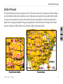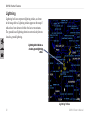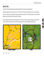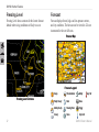
1
owner’s manual
GXM 40
XM ® Radio Smart Antenna
© 2008 Garmin Ltd. or its subsidiaries
Garmin International, Inc.
1200 East 151st Street,
Olathe, Kansas 66062, USA
Tel. (913) 397.8200 or (800) 800.1020
Fax (913) 397.8282
Garmin (Europe) Ltd.
Liberty House
Hounsdown Business Park,
Southampton, Hampshire, SO40 9RB UK
Tel. +44 (0) 870.8501241 (outside the UK)
0808 2380000 (within the UK)
Fax +44 (0) 870.8501251
Garmin Corporation
No. 68, Jangshu 2nd Road,
Shijr, Taipei County, Taiwan
Tel. 886/2.2642.9199
Fax 886/2.2642.9099
All rights reserved. Except as expressly provided herein, no part of this manual may be reproduced, copied, transmitted, disseminated, downloaded or
stored in any storage medium, for any purpose without the express prior written consent of Garmin. Garmin hereby grants permission to download a
single copy of this manual onto a hard drive or other electronic storage medium to be viewed and to print one copy of this manual or of any revision
hereto, provided that such electronic or printed copy of this manual must contain the complete text of this copyright notice and provided further that any
unauthorized commercial distribution of this manual or any revision hereto is strictly prohibited.
Information in this document is subject to change without notice. Garmin reserves the right to change or improve its products and to make changes in
the content without obligation to notify any person or organization of such changes or improvements. Visit the Garmin Web site (www.garmin.com) for
current updates and supplemental information concerning the use and operation of this and other Garmin products.
Garmin® is a registered trademarks of Garmin Ltd. or its subsidiaries, registered in the USA and other countries, and may not be used without the
express permission of Garmin. XM® and XM WX® are a registered trademarks of XM Satellite Radio Inc.
July 2008
Part Number 190-00942-00 Rev. A
Printed in Taiwan
Introduction
Introduction
The GXM 40 XM Radio Smart Antenna provides marine
and aviation XM WX® Weather information for viewing
on your Garmin® unit. Operating the GXM 40 requires a
subscription to the XM WX Satellite Weather service. The
GXM 40 also offers music, news, and talk programming
with a subscription to the XM Radio service. XM
subscriptions are sold separately.
This manual covers the XM WX Weather and XM Radio
features of the GXM 40 when viewed on a Garmin unit.
To get the most out of your new system, take the time to
go through this manual and the Owner’s Manual for your
unit. This manual discusses how to connect the GXM 40
and how to subscribe to XM WX Weather and XM Radio
services, and provides detailed information about weather
and audio features. Operational procedures are found in the
Owner’s Manual for your unit.
GXM 40 Owner’s Manual
Manual Conventions
• This manual refers to the GXM 40 XM Radio Smart
Antenna as the GXM 40.
• All Garmin products that are compatible with the
GXM 40 are referred to as “Garmin unit” throughout this
manual.
• The gray tabs on the edge of each page indicate the types
of Garmin units for which each XM product is available:
for aviation units,
for marine units, and
for automotive units.
Product Registration
Help us better support you by completing our online
registration today! Connect to our Web site at
http://my.garmin.com. Keep the original sales receipt,
or a photocopy, in a safe place.
Introduction
Serial Number for the GXM 40
Use the line below to record the serial number in case it is
lost, is stolen, or needs service. The serial number is located
on the bottom of your unit. Keep your original sales receipt
in a safe place or attach a photocopy inside the manual.
WARNING: When Navigating in an aircraft, use the GXM
40 only as an aid for VFR navigation.
WARNING: Use the GXM 40 only as a navigational
aid. Do not attempt to use the GXM 40 for any purpose
requiring precise measurement of direction, distance,
location, or topography. This product should not be used to
determine ground proximity for aircraft navigation.
WARNING: This unit provides the ability to receive
weather information through XM data. Use weather data
only as an aid to situational awareness. Such weather
information is merely supplemental and advisory in nature
and is not intended to be relied upon as safety-critical
information in connection with any aviation, vehicle, or
marine usage. The user should always exercise caution
and common sense when confronted with severe weather
conditions.
WARNING: XM WX Weather should not be used for
hazardous weather penetration. Weather information is
approved only for weather avoidance, not penetration.
Serial Number:
Warnings
Warning: When installing the GXM 40 in a vehicle,
place the unit securely so that it does not interfere with
vehicle operating controls or obstruct the driver’s view
(see diagram).
Do not mount where
driver’s field of vision
is blocked.
Do not place
unsecured on the
vehicle dashboard.
Do not mount in front of an
airbag field of deployment.
GXM 40 Owner’s Manual
Introduction
Warning: This product, its packaging, and its
components contain chemicals known to the State of
California to cause cancer, birth defects, or reproductive
harm. This Notice is provided in accordance with
California’s Proposition 65. See www.garmin.com/prop65
for more information.
GXM 40 Owner’s Manual
Introduction
Table of Contents
Introduction.................................................................1
Manual Conventions........................................................ 1
Product Registration........................................................ 1
Warnings......................................................................... 2
Getting Started............................................................5
Connecting the GXM 40 to a Garmin Unit....................... 6
Subscribing to XM Services............................................ 7
XM WX Weather Features..........................................8
Displaying Weather Information...................................... 8
METAR............................................................................ 9
AIRMET......................................................................... 10
SIGMET..........................................................................11
TFR............................................................................... 12
TAF................................................................................ 13
Winds............................................................................ 14
NEXRAD Radar............................................................. 16
Satellite Mosaic............................................................. 17
Echo Tops...................................................................... 18
Surface Pressure........................................................... 19
Lightning........................................................................ 20
Storm Cells.................................................................... 21
Freezing Level............................................................... 22
Forecast........................................................................ 22
Fronts............................................................................ 23
Hurricanes..................................................................... 24
County Warnings........................................................... 25
XM Radio....................................................................... 26
Visibility......................................................................... 27
Water Temperature........................................................ 28
Wave Period.................................................................. 28
Wave Direction.............................................................. 29
Wave Height.................................................................. 29
Marine Warnings........................................................... 30
Buoy Reports................................................................. 31
Appendix...................................................................32
GXM 40 Specifications.................................................. 32
Feature Broadcast Rates.............................................. 33
NEXRAD Overview....................................................... 34
FCC Compliance........................................................... 36
Limited Warranty........................................................... 36
Software License Agreement........................................ 39
XM Satellite Radio Service Agreement......................... 39
TFR Data....................................................................... 42
Index..........................................................................43
GXM 40 Owner’s Manual
Getting Started
Getting Started
Unit Care
Cleaning – The case for the unit is constructed of high-quality material
and does not require user maintenance other than cleaning. Clean the
unit housing using a lightly-dampened cloth with a mild detergent
solution and then wipe it dry. Avoid chemical cleaners and solvents that
may damage plastic components. Do not apply cleaner to the electrical
contacts on the front of the unit.
GXM 40 Radio Smart Antenna
USB Connector
Storage – Do not store the GXM 40 where exposure to extreme
temperatures may occur, as permanent damage may result.
Servicing Your Unit
The Garmin GXM 40 has no user-serviceable parts. Should you ever
encounter a problem with your unit, take it to an authorized Garmin
dealer for repairs, or contact Garmin Product Support at 1-800-800-1020.
Mounting Holes
The GXM 40 is fastened shut with screws. Any attempt to open the case
to change or modify the unit in any way voids your warranty and may
result in permanent damage to the equipment.
GXM 40 Owner’s Manual
Getting Started
Connecting the GXM 40 to a Garmin Unit
Position the GXM 40 where it has a clear view of the sky, for example, on the outside of the vehicle or behind the
windshield of the vehicle. Connect the GXM 40 to the USB port on the Garmin unit.
GXM 40 Owner’s Manual
Getting Started
Subscribing to XM Services
With the GXM 40 connected to your Garmin unit, contact
XM Satellite Radio to activate your XM WX Weather
service, your XM Radio service, or both.
Step 1: Check the system setup
Ensure that the GXM 40 is connected to your Garmin
unit.
Step 2: Turn on your system
Place the GXM 40 where it has a clear view of the sky
and turn on your Garmin unit. This automatically turns on
the GXM 40.
Step 3: Set up the XM account
Ensure that your XM WX Weather ID and your XM Radio
ID are readily available. Contact XM Satellite Radio by
phone at (800) 985-9200. After receiving the required
information from you, the XM representative activates
the account and sends out an XM signal to activate the
GXM 40. You can also activate your account by visiting
https://xmro-secure.xmradio.com/listenercare/login2.xm.
For answers to other XM questions, call the above
number or visit www.xmwxweather.com.
GXM 40 Owner’s Manual
Step 4: Confirm all components of your service
package
XM WX Weather: Keep your Garmin unit turned on to
ensure that you receive the XM signal. The XM signal
is being received when the components of the selected
service package are displayed in the Weather Products
list. Do not turn off the Garmin unit until the name of the
selected service package is displayed in the Service
Level field.
XM Radio: Verify that channels 7, 9, 47, and 122 are
being received. This indicates that all channels of the
XM basic radio service are being received. If the XM
WX Weather or the XM Radio service has not activated
within an hour, call XM WX customer care at (800) 9859200 to verify the activation of your XM services. The
customer-care representative can refresh the activation
signal or you can do this yourself at www.xmradio.com
/refresh by entering your radio ID where requested.
Step 5: Save the service package
After the service package name appears in the Service
Level field, turn off the Garmin unit.
XM WX Weather Features
XM WX Weather Features
Displaying Weather Information
The GXM 40 receives XM WX Weather data and shows
it on the Map and Weather pages of the Garmin unit. The
weather data for each feature comes from reputable weather
data centers such as the National Weather Service and the
Hydrometerological Prediction Center. (See the XM WX
Satellite Weather Web site at http://weather.xmradio
.com/weather for more information.) Any weather feature
can change in appearance or interpretation if the source that
provides the information changes. XM WX Weather data
is broadcast at set rates (see page 33 for all weather-related
broadcast rates). For example, NEXRAD Radar data is
broadcast at five-minute intervals. When the Garmin unit
is turned on or when a new feature is selected, the GXM
40 has to receive new data before it can be displayed. You
can experience a delay before weather data or a new feature
appears on the map.
GXM 40 Owner’s Manual
XM WX Weather Features
METAR
A METAR or METeorological Aeronautical Report is an international code used for reporting weather observations. If
METAR data is available for an airport, a color-coded flag is shown next to the airport. To view the METAR data, select the
flag with the map pointer.
VFR (ceiling greater than 3000 ft. AGL and
visibility greater than five miles)
Marginal VFR (ceiling 1000–3000 ft. AGL
and/or visibility three to five miles)
IFR (ceiling 500 to below 1000 ft. AGL and/or
visibility one mile to less than three miles)
Low IFR (ceiling below 500 ft. AGL or visibility
less than one mile)
METAR Selected With Map Pointer
Undetermined
GXM 40 Owner’s Manual
METAR Detailed Information
XM WX Weather Features
AIRMET
An AIRMET or AIRman’s METeorological Information can potentially affect all aircraft. This data can be especially
helpful for pilots of light aircraft that have limited flight capability or instrumentation. An AIRMET must affect or be
forecast to affect an area of at least 3,000 square miles at any one time. AIRMETs are routinely issued for six-hour periods
and are amended as necessary due to changing weather conditions or the issuance or cancellation of a SIGMET (SIGnificant
METeorological Forecast). AIRMETs are displayed as an colored, dashed line.
• AIRMET Sierra (IFR) (purple): Ceilings less than 1,000 feet and/or visibility less than three miles affecting over 50% of
the area at one time. Extensive mountain obscuration.
• AIRMET Tango
(Turbulence) (orange):
Moderate turbulence.
Sustained surface winds
of 30 knots or more at the
surface.
• AIRMET Zulu (Icing)
(blue): Moderate icing.
AIRMET Selected
AIRMET Detailed Information
Freezing levels.
With Map Pointer
10
GXM 40 Owner’s Manual
XM WX Weather Features
SIGMET
A SIGMET (SIGnificant METeorological Forecast) advises
of weather that is potentially hazardous to all aircraft. In the
contiguous United States, the following items are covered:
severe icing, severe or extreme turbulence, volcanic ash,
dust storms, and sandstorms that lower visibility to less than
three statute miles.
A Convective SIGMET is issued for the following
conditions: thunderstorms, isolated severe thunderstorms,
embedded thunderstorms, hail at the surface, and tornadoes.
A SIGMET is widespread and must affect or be forecast to
affect an area of at least 3,000 square miles. SIGMETs are
displayed as a yellow-dashed line. To view SIGMET data,
select the SIGMET using the map pointer.
SIGMET Selected With Map Pointer
SIGMET Detailed Information
GXM 40 Owner’s Manual11
XM WX Weather Features
TFR
A Temporary Flight Restriction (TFR) temporarily restricts all aircraft from entering the selected airspace unless a waiver
has been issued. TFRs are routinely issued for occurrences such as sporting events, dignitary visits, military depots and
forest fires. TFRs are represented as an area highlighted by red (active) or yellow (not yet active). To view information about
the TFR, select it with the map pointer.
TFR Selected With Map Pointer
12
TFR Detailed Information
GXM 40 Owner’s Manual
XM WX Weather Features
TAF
Terminal Aerodrome Forecasts are issued by the National
Weather Service for pilots. They include 24-hour forecasts
on wind, visibility, expected weather conditions, and wind
shear.
Terminal Aerodrome Forecast
GXM 40 Owner’s Manual13
XM WX Weather Features
Winds
Winds Aloft
Aviation units display winds using wind barbs or a wind streamline depending on the zoom range of the map. Similar to
marine and automotive units, the wind barbs indicate wind speed and direction. Arrows indicate the direction of the wind
streamline.
Wind Barbs
14
Wind Streamline
GXM 40 Owner’s Manual
XM WX Weather Features
Surface Winds
Marine and automotive units show surface winds. The barb attached to the circle points in the direction of the wind. Wind
speed is indicated by different flags attached to the barb.
Wind Direction
Calm
5 knots
10 knots
15 knots
20 knots
50 knots
Surface Winds
GXM 40 Owner’s Manual15
XM WX Weather Features
NEXRAD Radar
NEXRAD or NEXt Generation Weather RADar displays precipitation, from very light rain and snow to strong
thunderstorms, in varying shades and colors. The time stamp in the lower-left corner of the screen displays the elapsed time
since the National Weather Service provided the information being displayed. NEXRAD can be displayed independently
or with a variety of other weather information. For information on NEXRAD abnormalities, limitations, and intensity, see
pages 34–35.
NEXRAD Legend
NEXRAD
16
GXM 40 Owner’s Manual
XM WX Weather Features
Satellite Mosaic
The Satellite Mosaic feature displays infrared composite
images of cloud cover taken by geostationary weather
satellites, providing up to seven levels of cloud cover.
Cloud Tops Legend
Satellite Mosaic
GXM 40 Owner’s Manual17
XM WX Weather Features
Echo Tops
Echo Tops are derived from NEXRAD radar and indicate the highest altitude at which precipitation is falling. Echo Tops
at or above the altitude you select are displayed in 5,000 foot increments up to 70,000 feet. Echo Tops can be helpful in
determining the severity of thunderstorms, where higher altitudes equate to more intense thunderstorms.
Echo Tops for All Altitudes
Echo Tops at 15,000 Ft.
Echo Tops at 20,000 Ft.
18
GXM 40 Owner’s Manual
XM WX Weather Features
Surface Pressure
This feature displays pressure isobars and pressure centers. The isobars connect points of equal pressure. Pressure readings
can help determine weather and wind conditions in an area. High-pressure areas generally are associated with fair weather.
Low-pressure areas generally are associated with clouds and the chance of precipitation. Isobars that are packed closely
together show a strong pressure gradient. Strong pressure gradients are associated with areas of stronger winds. Pressure
units can be displayed in millibars (mbar), inches of mercury (inHg), and hectopascals (hPa).
Strong Pressure Gradient
Pressure Isobars
GXM 40 Owner’s Manual19
XM WX Weather Features
Lightning
Lightning bolt icons represent lightning strikes, as shown
in the image below. Lightning strikes appear on the map if
strikes have been detected within the last seven minutes.
The ground-based lightning detection network only detects
cloud-to-ground lightning.
Lightning bolts indicate a
cloud-to-ground lightning
strike.
Lightning Strikes
20
GXM 40 Owner’s Manual
XM WX Weather Features
Storm Cells
The Storm Cells feature displays storms and the projected path of storms in the immediate future.
Marine and automotive units also show the size of the storm cell. The direction in which the red cone is pointing (from
the narrow end to the wide end) indicates the projected path of the storm cell. The red bars that span the cone indicate the
projected area of the storm. Each bar represents 15 minutes.
Aviation units show the direction of the storm with an arrow. The tip of the arrow indicates the projected location of the
storm in 15 minutes. Select the storm cell with the map pointer to view critical information about the storm.
Automotive and Marine
Aviation
GXM 40 Owner’s Manual21
XM WX Weather Features
Freezing Level
Freezing Level shows contours for the lowest forecast
altitude where icing conditions are likely to occur.
Forecast
Forecast displays fronts, high- and low-pressure centers,
and city conditions. The forecast can be viewed in 12-hour
increments for the next 48 hours.
Forecast Map
Forecast Legend
Freezing Level Contours
22
Sunny
Thunderstorms
Windy
Partly Cloudy
Rain
Haze
Mostly Cloudy
Freezing Rain
Foggy
Cloudy
Snow
Very Cold
Very Hot
GXM 40 Owner’s Manual
XM WX Weather Features
Fronts
The Fronts feature displays the lines indicating the leading edge of an air mass that is replacing an existing air mass. This
feature also displays pressure centers. Pressure centers are represented by a large red “L” for low-pressure centers or a large
blue “H” for high-pressure centers. Pressure centers represent an area where pressure is measured to be either the highest or
the lowest relative to the surrounding area.
Indicates a low-pressure center. A low-pressure
center is an area where the measured pressure is
lowest relative to the surrounding area. Moving
away from a low-pressure center in any horizontal
direction results in increased pressure. Winds flow
counterclockwise around low-pressure centers in
North America.
Indicates a high-pressure center. Similar to a lowpressure center, a high-pressure center is an area
where the measured pressure is highest relative to
the surrounding area. Moving away from a highpressure center in any horizontal direction results
in decreased pressure. Winds flow clockwise
around high-pressure centers in North America.
Cold front
Warm front
Stationary front
Occluded front
Trough
GXM 40 Owner’s Manual23
XM WX Weather Features
Hurricanes
The Hurricanes feature shows the current position of a hurricane, a tropical storm, or a tropical depression, as well as its
projected path (indicated by a red line). The darkened squares that appear along the red line indicate the projected locations
received from the National Hurricane Center. The Center provides four forecasts at 12-hour intervals and a fifth forecast at
a 24-hour interval. Each forecast indicates the projected location of the hurricane at different points along its projected path.
Forecasted hurricane conditions at each projected location are also provided.
Hurricane track
Hurricanes
24
GXM 40 Owner’s Manual
XM WX Weather Features
County Warnings
When the National Weather Service issues a weather warning for a county, the county is highlighted with the color
corresponding to the warning. To view information about the warning, select the county with the map pointer.
Tornado warning
Severe thunderstorm warning
Flood warning
Flash flood warning
Severe Thunderstorm Warning
GXM 40 Owner’s Manual25
XM WX Weather Features
XM Radio
The XM Audio feature requires a subscription to XM Radio.
(See page 7 for more information about subscribing to XM
services.) You can scan channels by category and save them
to a favorites list. You can turn the XM audio output on and
off.
Category
Channel list
Current song
26
GXM 40 Owner’s Manual
XM WX Weather Features
Visibility
Visibility is the forecasted maximum horizontal distance that can be seen at the surface. Contour lines on the Visibility
display show the forecasted change in surface visibility. In the example below, visibility ranges from 1 mile to 4.5 miles.
Visibility Contour Lines
This image displays NEXRAD Radar,
Satellite Mosaic, and Visibility.
Displaying multiple features may help to
provide a clearer picture of the weather
conditions in the area.
GXM 40 Owner’s Manual27
XM WX Weather Features
Water Temperature
The Water Temperature feature displays the surface
temperature of the water. Isotherm lines indicate the
temperature breaks.
Water Temperature
28
Wave Period
The Wave Period feature provides the time (in seconds)
between successive waves.
Wave Period
GXM 40 Owner’s Manual
XM WX Weather Features
Wave Direction
The Wave Direction feature shows the direction in which
waves are moving, as indicated by the direction of the red
arrow.
Wave Direction
Wave Height
The Wave Height feature displays wave heights. The wave
heights for an area are separated by contour lines.
Wave Height
GXM 40 Owner’s Manual29
XM WX Weather Features
Marine Warnings
When a Marine Warning is issued, the area of the warning is highlighted in red. To view information about the warning,
select the warning area with the map pointer.
Marine Warnings
30
Marine Warning Detailed Information
GXM 40 Owner’s Manual
XM WX Weather Features
Buoy Reports
Report readings are taken from buoys and coastal observation stations. These readings are used to determine air temperature,
dew point, water temperature, tide, wave height and period, wind direction and speed, visibility, and barometric pressure.
Buoy Selected With Map Pointer
Buoy Report Detail
GXM 40 Owner’s Manual31
Appendix
Appendix
GXM 40 Specifications
Physical Specifications
Size (W × H): 3.189 × 0.768 in. (81 × 19.5 mm)
Weight: 4.2 oz. (120 g)
Temperature Range: from -40˚F to 185˚F (from -40˚C to 85˚C)
Case: Fully-sealed, high-impact plastic
Waterproof: IEC 60529 IPX7 standard; 3.28 ft. (1 m) submersion for 30 minutes
Mount Thread Size: M3 × 0.5
Cable: Braided shield, 5 conductor, 28 AWG (0.081 mm2), right-angle male mini-B connector
Power
Source: 4.5–5.5 Vdc
Usage: 1.25 W max
Performance
Dynamics: 999 knots, 6 g
32
GXM 40 Owner’s Manual
Appendix
Feature Broadcast Rates
Data Broadcast
Frequency
Feature
NEXRAD Radar
Data Broadcast
Frequency
Feature
5 min.
Buoy Reports
12 min.
Satellite Mosaic
15 min.
City Forecast
12 min.
Storm Cells
1.25 min.
County Warnings
5 min.
Lightning
5 min.
Marine Warnings
20 min.
Surface Winds
12 min.
METAR
12 min.
Surface Pressure
12 min.
AIRMET
12 min.
Hurricane Track
12 min.
SIGMET
12 min.
Visibility Forecast
12 min.
Echo Tops
7.5 min.
Fronts
12 min.
Winds Aloft
12 min.
Water Temperature
12 min.
TFR
12 min.
Wave Height
12 min.
TAF
12 min.
Wave Period
12 min.
Freezing Level
12 min.
Wave Direction
12 min.
GXM 40 Owner’s Manual33
Appendix
NEXRAD Overview
NEXRAD Description
NEXRAD Radar is a Doppler radar system that has greatly
improved the detection of meteorological events such as
thunderstorms, tornadoes, and hurricanes. An extensive
network of NEXRAD stations provides almost complete
radar coverage of the continental United States, Alaska,
and Hawaii, and the majority of Canada. The range of each
NEXRAD is 124 nautical miles.
NEXRAD Abnormalities
There are possible abnormalities regarding displayed
NEXRAD images. Some, but not all, of those include the
following circumstances:
• Ground clutter
• Strobes and spurious radar data
• Sun strobes, when the radar antenna points directly at the
sun
• Military aircraft deployment of metallic dust (chaff),
which can cause alterations in radar scans
34
• Interference from buildings or mountains, which may
cause shadows
NEXRAD Limitations
Certain limitations exist regarding the NEXRAD radar
displays. Some, but not all, are listed here for your
awareness:
• NEXRAD base reflectivity does not provide sufficient
information to determine cloud layers or precipitation
characteristics (for example, determining between hail
and rain).
• NEXRAD base reflectivity is sampled at the minimum
antenna elevation angle. An individual NEXRAD site
cannot depict high altitude storms at close ranges, and
has no information about storms directly over the site.
GXM 40 Owner’s Manual
Appendix
NEXRAD Intensity
Colors are used to identify the different
NEXRAD echo intensities (reflectivity) measured
in dBZ (decibels of Z). Reflectivity (designated
by the letter Z) is the amount of transmitted
power returned to the radar receiver. The dBZ
values increase as returned-signal strength
increases. Precipitation intensity is displayed
using colors represented by the dBZ values listed
in the dBZ Values/Precipitation Table.
Display
Rain
Display
Snow
dBZ
Rain
(inches per
hour)
Snow
(inches per
hour)
Remarks
Rain
Snow
≤ -10
0.00 in.
0.00 in.
-5
0.00 in.
trace
0
0.00 in.
trace–0.05 in.
5
0.00 in.
trace–0.10 in.
10
0.00 in.–trace
0.01 in.
Light
Light
15
0.01 in.
0.1–0.2 in.
Light
Light
20
0.02 in.
0.2–0.3 in.
Light
Light
25
0.05 in.
0.3–0.5 in.
Light
Light–Moderate
30
0.09 in.
0.5–0.7 in.
Light–Moderate
Moderate
35
0.24 in.
0.7–1.0 in.
Moderate
Heavy
40
0.48 in.
1 in.+ or sleet
Heavy
Heavy
45
1.25 in.
1 in.+ or sleet
Heavy
Heavy
50
2.5 in.
sleet
Intense
55
5.7 in.
sleet
Extreme
55+
12.7 in.
Very Light
Light
Extreme
dBZ Values/Precipitation Table
GXM 40 Owner’s Manual35
Appendix
FCC Compliance
This device complies with part 15 of the FCC Rules.
Operation is subject to the following two conditions: (1)
this device may not cause harmful interference, and (2) this
device must accept any interference received, including
interference that may cause undesired operation.
This equipment has been tested and found to comply with
the limits for a Class B digital device, pursuant to part 15
of the FCC rules. These limits are designed to provide
reasonable protection against harmful interference in a
residential installation. This equipment generates, uses, and
can radiate radio frequency energy and may cause harmful
interference to radio communications if not installed
and used in accordance with the instructions. However,
there is no guarantee that interference will not occur in a
particular installation. If this equipment does cause harmful
interference to radio or television reception, which can be
determined by turning the equipment off and on, the user is
encouraged to try to correct the interference by one of the
following measures:
36
• Reorient or relocate the receiving antenna.
• Increase the separation between the equipment and the
receiver.
• Connect the equipment into an outlet that is on a
different circuit from the GPS unit.
• Consult the dealer or an experienced radio/TV technician
for help.
This product does not contain any user-serviceable parts.
Repairs should only be made by an authorized Garmin
service center. Unauthorized repairs or modifications could
result in permanent damage to the equipment, and void your
warranty and your authority to operate this device under
Part 15 regulations.
Limited Warranty
This Garmin product is warranted to be free from defects
in materials or workmanship for one year from the date of
purchase. Within this period, Garmin will, at its sole option,
repair or replace any components that fail in normal use.
Such repairs or replacement will be made at no charge to the
GXM 40 Owner’s Manual
Appendix
customer for parts or labor, provided that the customer shall
be responsible for any transportation cost. This warranty
does not cover failures due to abuse, misuse, accident, or
unauthorized alteration or repairs.
This product is intended to be used only as a travel aid
and must not be used for any purpose requiring precise
measurement of direction, distance, location, or topography.
Garmin makes no warranty as to the accuracy or
completeness of map data in this product.
THE WARRANTIES AND REMEDIES CONTAINED
HEREIN ARE EXCLUSIVE AND IN LIEU OF ALL
OTHER WARRANTIES EXPRESS, IMPLIED, OR
STATUTORY, INCLUDING ANY LIABILITY ARISING
UNDER ANY WARRANTY OF MERCHANTABILITY
OR FITNESS FOR A PARTICULAR PURPOSE,
STATUTORY OR OTHERWISE. THIS WARRANTY
GIVES YOU SPECIFIC LEGAL RIGHTS, WHICH MAY
VARY FROM STATE TO STATE.
IN NO EVENT SHALL GARMIN BE LIABLE
FOR ANY INCIDENTAL, SPECIAL, INDIRECT,
OR CONSEQUENTIAL DAMAGES, WHETHER
RESULTING FROM THE USE, MISUSE, OR INABILITY
TO USE THIS PRODUCT OR FROM DEFECTS IN THE
PRODUCT. Some states do not allow the
exclusion of incidental or consequential
damages, so the above limitations may not
apply to you.
Garmin retains the exclusive right to repair or replace the
unit or software or offer a full refund of the purchase price
at its sole discretion. SUCH REMEDY SHALL BE YOUR
SOLE AND EXCLUSIVE REMEDY FOR ANY BREACH
OF WARRANTY.
To obtain warranty service, contact your local Garmin
authorized dealer or call Garmin Product Support for
shipping instructions and an RMA tracking number.
Securely pack the unit and a copy of the original sales
receipt, which is required as the proof of purchase for
warranty repairs. Write the tracking number clearly on
the outside of the package. Send the unit, freight charges
prepaid, to any Garmin warranty service station.
GXM 40 Owner’s Manual37
Appendix
Online Auction Purchases: Products sold through online
auctions are not eligible for rebates or other special offers
from Garmin. Online auction confirmations are not accepted
for warranty verification. To obtain warranty service, an
original or copy of the sales receipt from the original retailer
is required. Garmin will not replace missing components
from any package purchased through an online auction.
International Purchases: A separate warranty is provided
by international distributors for units purchased outside the
United States. This warranty is provided by the local incountry distributor and this distributor provides local service
for your unit. Distributor warranties are only valid in the
area of intended distribution. Units purchased in the United
States or Canada must be returned to the Garmin service
center in the United Kingdom, the United States, Canada, or
Taiwan for service.
38
Garmin International, Inc.
1200 East 151st Street,
Olathe, Kansas 66062, USA
Tel. (913) 397-8200 or (800) 800-1020
Fax (913) 397-8282
Garmin (Europe) Ltd.
Liberty House,
Hounsdown Business Park,
Southampton, Hampshire, SO40 9RB UK
Tel. +44 (0) 870.8501241 (outside the UK)
0808.2380000 (within the UK)
Fax +44 (0) 870.8501251
Garmin Corporation
No. 68, Jangshu 2nd Road,
Shijr, Taipei County, Taiwan
Tel. 886/2.2642.9199
Fax 886/2.2642.9099
GXM 40 Owner’s Manual
Appendix
Software License Agreement
BY USING THE GXM 40, YOU AGREE TO BE
BOUND BY THE TERMS AND CONDITIONS OF THE
FOLLOWING SOFTWARE LICENSE AGREEMENT.
PLEASE READ THIS AGREEMENT CAREFULLY.
Garmin grants you a limited license to use the software
embedded in this device (the “Software”) in binary
executable form in the normal operation of the product.
Title, ownership rights, and intellectual property rights in
and to the Software remain in Garmin.
You acknowledge that the Software is the property of
Garmin and is protected under the United States of America
copyright laws and international copyright treaties. You
further acknowledge that the structure, organization,
and code of the Software are valuable trade secrets of
Garmin and that the Software in source code form remains
a valuable trade secret of Garmin. You agree not to
decompile, disassemble, modify, reverse assemble, reverse
engineer, or reduce to human readable form the Software or
any part thereof or create any derivative works based on the
Software. You agree not to export or re-export the Software
to any country in violation of the export control laws of the
United States of America.
XM Satellite Radio Service Agreement
XM Satellite Radio Inc.
Hardware and required monthly subscription sold
separately. Subscription fee is consumer only. Other fees
and taxes, including a one-time activation fee may apply.
All programming fees and weather data subject to change.
XM WX weather data displays and individual product
availability vary by hardware equipment. Reception of the
XM signal may vary depending on location. Subscriptions
subject to Customer Agreement included with the XM
Welcome Kit and available at www.xmradio.com. Available
only in the 48 contiguous United States. XM WX is a
trademark of XM Satellite Radio Inc.
GXM 40 Owner’s Manual39
Appendix
Weather Data Warranty
THE SOFTWARE PRODUCT IS PROVIDED “AS
IS.” ALL OTHER WARRANTIES, EXPRESSED
OR IMPLIED, INCLUDING ANY WARRANTY
OF MERCHANTABILITY OR FITNESS FOR A
PARTICULAR PURPOSE OR OF NON-INFRINGEMENT
ARE HEREBY EXCLUDED.
User Safety
If you use XM Services it is your responsibility to exercise
prudent discretion and observe all safety measures required
by law and your own common sense. You assume the
entire risk related to your use of the Services. XM and
Garmin assume no responsibility for accidents resulting
from or associated with use of the Services. Your Radio
Service includes traffic and weather information, and you
acknowledge that such information is not for “safety for
life”, but is merely supplemental and advisory in nature,
and therefore cannot be relied upon as safety-critical in
connection with any aircraft, sea craft or automobile usage.
This information is provided “as is” and XM and Garmin
40
disclaim any and all warranties, express and implied, with
respect thereto or the transmission or reception thereof. XM
and Garmin further do not warrant the accuracy, reliability,
completeness or timeliness of the traffic and weather
information disclosed on the Radio Service. In no event will
XM and Garmin, their data suppliers, service providers,
marketing/distribution, software or Internet partners or
hardware manufacturers be liable to you or to any third
party for any direct, indirect, incidental, consequential,
special, exemplary or punitive damages or lost profits
resulting from use of or interruptions in the transmission or
reception of the Services.
Limits On Our Responsibility
a) DISCLAIMERS.
EXCEPT AS EXPRESSLY PROVIDED HEREIN, WE
MAKE NO WARRANTY OR REPRESENTATION,
EITHER EXPRESS OR IMPLIED, REGARDING THE
RADIO SERVICE. YOUR USE OF THE SERVICE
IS AT YOUR SOLE RISK. THE CONTENT AND
FUNCTIONALITY OF THE SERVICE IS PROVIDED
GXM 40 Owner’s Manual
Appendix
“AS IS” WITHOUT ANY WARRANTY OF ANY KIND,
EXPRESS OR IMPLIED. ALL SUCH WARRANTIES
OR REPRESENTATIONS (INCLUDING, WITHOUT
LIMITATION, THE IMPLIED WARRANTIES OF
MERCHANTABILITY, FITNESS FOR A PARTICULAR
PURPOSE, TITLE AND NON-INFRINGEMENT) ARE
HEREBY DISCLAIMED.
b) LIMITATIONS OF LIABILITY.
WE ARE NOT RESPONSIBLE FOR ANY SPECIAL,
INCIDENTAL, OR CONSEQUENTIAL DAMAGES OR
LOSSES RELATING TO THE USE OF THE RADIO
SERVICE, WHETHER BASED ON NEGLIGENCE OR
OTHERWISE. OUR TOTAL LIABILITY TO YOU AND
ANY OTHER PERSONS RECEIVING OUR SERVICES,
REGARDLESS OF THE CAUSE, WILL IN NO EVENT
EXCEED THE AMOUNTS THAT YOU HAVE PAID
TO US FOR THE SERVICE THAT YOU RECEIVED
DURING THE SIX (6) MONTH PERIOD IMMEDIATELY
PRIOR TO THE SPECIFIC EVENT THAT GAVE RISE
TO THE APPLICABLE DAMAGE OR LOSS. THIS
GXM 40 Owner’s Manual
ALLOCATION OF RISK IS REFLECTED IN OUR
PRICES. YOU MAY HAVE GREATER RIGHTS THAN
DESCRIBED ABOVE UNDER YOUR STATE’S LAWS.
a. Under 10 U.S.C. 456, no civil action may be brought
against the United States on the basis of the content of a
navigational aid prepared or disseminated by either the
former Defense Mapping Agency (DMA), National Imagery
and Mapping Agency (NIMA), or the National GeospatialIntelligence Agency (NGA).
b. The DAFIF™ product is provided “as is,” and no
warranty, express or implied, including, but not limited to
the implied warranties of merchantability and fitness for
particular purpose or arising by statute or otherwise in law
or from a course of dealing or usage in trade, is made by
NGA as to the accuracy and functioning of the product.
c. Neither NGA nor its personnel will be liable for any
claims, losses, or damages arising from or connected with
the use of this product. The user agrees to hold harmless
the United States National Geospatial-Intelligence Agency.
The user’s sole and exclusive remedy is to stop using the
41
Appendix
DAFIF product. This product was developed using DAFIF,
a product of the National Geospatial-Intelligence Agency.
TFR Data
Temporary Flight Restriction (TFR) data is provided by the
FAA and may not be updated outside of normal business
hours. Confirm data currency though alternate sources and
contact your local FSS for interpretation of TFR data. This
product has not been endorsed or otherwise approved by
the National Geospatial-Intelligence Agency, or the United
States Department of Defense (10 U.S.C. 425).
42
GXM 40 Owner’s Manual
Appendix
Index
A
AIRMET 10
C
cleaning the unit 5
cloud cover 17
coastal observation stations 31
cold front 23
connecting the GXM 40 6
D
displaying weather information 8
F
favorites list 26
FCC Compliance 36
flash flood warning 25
flood warning 25
forecast 22
freezing Level 22
fronts 23
G
ground clutter 34
H
high-pressure center 22, 23
GXM 40 Owner’s Manual
hurricanes 24
I
icing 22
IFR 9
interference 34
introduction 1
isobars 19
L
limited warranty 36
low-pressure center 22, 23
M
METAR 9
mounting holes 5
N
National Weather Service 25
NEXRAD
abnormalities 34
colors 35
intensity 35
legend 16
limitations 34
O
occluded front 23
P
physical specifications 32
pressure gradient 19
pressure isobars 19
S
saving the service package 7
serial number 2
set up the XM account 7
severe thunderstorm warning 25
SIGMET 11
software license agreement 39
specifications 32
stationary front 23
storage 5
strobes 34
strong pressure gradient 19
sun strobes 34
T
TAF 13
temporary flight restriction 12
terminal aerodrome forecast 13
tropical depression 24
tropical storm 24
trough 23
U
USB
connector 5
port 6
V
VFR 9
visibility 27
W
warm front 23
warranty 36
waves
height 29
period 28
weather data 8
winds
aloft 14
speed 15
streamline 14
surface 15
X
XM
audio 26
radio 7
WX Weather 7
unit care 5
43
For the latest free software updates (excluding map data) throughout the life of your
Garmin products, visit the Garmin Web site at www.garmin.com.
© 2008 Garmin Ltd. or its subsidiaries
Garmin International, Inc.
1200 East 151st Street, Olathe, Kansas 66062, USA
Garmin (Europe) Ltd.
Liberty House, Hounsdown Business Park, Southampton, Hampshire, SO40 9RB UK
Garmin Corporation
No. 68, Jangshu 2nd Road, Shijr, Taipei County, Taiwan
www.garmin.com
Part Number 190-00942- 00 Rev. A