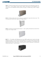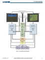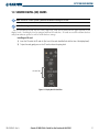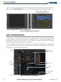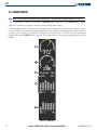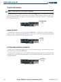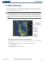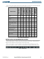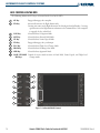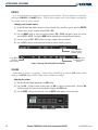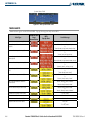
1
Beechcraft A36/G36
Copyright © 2006 Garmin Ltd. or its subsidiaries. All rights reserved.
This manual reflects the operation of System Software version 0464.05 or later. Some differences in operation may be observed when
comparing the information in this manual to earlier or later software versions.
Garmin International, Inc., 1200 East 151st Street, Olathe, Kansas 66062, U.S.A.
Tel: 913/397.8200
Fax: 913/397.8282
Garmin AT, Inc., 2345 Turner Road SE, Salem, OR 97302, U.S.A.
Tel: 503/391.3411
Fax: 503/364.2138
Garmin (Europe) Ltd., Unit 5, The Quadrangle, Abbey Park Industrial Estate, Romsey, Hampshire S051 9DL, U.K
Tel: 44/1794.519944
Fax: 44/0870.8501251
Garmin Corporation, No. 68, Jangshu 2nd Road, Shijr, Taipei County, Taiwan
Tel: 886/02.2642.9199
Fax: 886/02.2642.9099
Website Address: www.garmin.com
Except as expressly provided herein, no part of this manual may be reproduced, copied, transmitted, disseminated, downloaded or stored
in any storage medium, for any purpose without the express written permission of Garmin. Garmin hereby grants permission to download
a single copy of this manual and of any revision to this manual onto a hard drive or other electronic storage medium to be viewed for
personal use, provided that such electronic or printed copy of this manual or revision must contain the complete text of this copyright notice
and provided further that any unauthorized commercial distribution of this manual or any revision hereto is strictly prohibited.
Garmin® is a registered trademark of Garmin Ltd. or its subsidiaries, and G1000® is a trademark of Garmin Ltd. or its subsidiaries. These
trademarks may not be used without the express permission of Garmin.
NavData® is a registered trademark of Jeppesen, Inc.; Stormscope® is a registered trademark of L-3 Communications; Ryan® is a registered
trademark of Avidyne Corporation, and XM® is a registered trademark of XM Satellite Radio, Inc.
October 2006
Printed in the U.S.A
Garmin G1000 Pilot’s Guide for the Beechcraft A36/G36
190-00595-00 Rev. A
LIMITED WARRANTY
LIMITED WARRANTY
This Garmin product is warranted to be free from defects in materials or workmanship for two years from the date of purchase. Within this
period, Garmin will, at its sole option, repair or replace any components that fail in normal use. Such repairs or replacement will be made
at no charge to the customer for parts and labor, provided that the customer shall be responsible for any transportation cost. This warranty
does not cover failures due to abuse, misuse, accident, or unauthorized alterations or repairs.
THE WARRANTIES AND REMEDIES CONTAINED HEREIN ARE EXCLUSIVE AND IN LIEU OF ALL OTHER WARRANTIES EXPRESS OR IMPLIED
OR STATUTORY, INCLUDING ANY LIABILITY ARISING UNDER ANY WARRANTY OF MERCHANTABILITY OR FITNESS FOR A PARTICULAR
PURPOSE, STATUTORY OR OTHERWISE. THIS WARRANTY GIVES YOU SPECIFIC LEGAL RIGHTS, WHICH MAY VARY FROM STATE TO
STATE.
IN NO EVENT SHALL GARMIN BE LIABLE FOR ANY INCIDENTAL, SPECIAL, INDIRECT OR CONSEQUENTIAL DAMAGES, WHETHER
RESULTING FROM THE USE, MISUSE, OR INABILITY TO USE THIS PRODUCT OR FROM DEFECTS IN THE PRODUCT. Some states do not
allow the exclusion of incidental or consequential damages, so the above limitations may not apply to you.
Garmin retains the exclusive right to repair or replace the unit or software, or to offer a full refund of the purchase price, at its sole
discretion. SUCH REMEDY SHALL BE YOUR SOLE AND EXCLUSIVE REMEDY FOR ANY BREACH OF WARRANTY.
To obtain warranty service, contact your local Garmin Authorized Service Center. For assistance in locating a Service Center near you, visit
the Garmin Web site at “http://www.garmin.com” or contact Garmin Customer Service at 800-800-1020.
190-00595-00 Rev. A
Garmin G1000 Pilot’s Guide for the Beechcraft A36/G36
i
WARNINGS, CAUTIONS, AND NOTES
WARNING: Navigation and terrain separation must NOT be predicated upon the use of the terrain function.
The G1000 Terrain Proximity feature is NOT intended to be used as a primary reference for terrain avoidance
and does not relieve the pilot from the responsibility of being aware of surroundings during flight. The
Terrain Proximity feature is only to be used as an aid for terrain avoidance and is not certified for use
in applications requiring a certified terrain awareness system. Terrain data is obtained from third party
sources. Garmin is not able to independently verify the accuracy of the terrain data.
WARNING: The displayed minimum safe altitudes (MSAs) are only advisory in nature and should not be
relied upon as the sole source of obstacle and terrain avoidance information. Always refer to current
aeronautical charts for appropriate minimum clearance altitudes.
WARNING: The Garmin G1000, as installed in the Beechcraft A36/G36, has a very high degree of functional
integrity. However, the pilot must recognize that providing monitoring and/or self-test capability for all
conceivable system failures is not practical. Although unlikely, it may be possible for erroneous operation
to occur without a fault indication shown by the G1000. It is thus the responsibility of the pilot to detect
such an occurrence by means of cross-checking with all redundant or correlated information available in the
cockpit.
WARNING: For safety reasons, G1000 operational procedures must be learned on the ground.
WARNING: The altitude calculated by G1000 GPS receivers is geometric height above Mean Sea Level and
could vary significantly from the altitude displayed by pressure altimeters, such as the GDC 74A Air Data
Computer, or other altimeters in aircraft. GPS altitude should never be used for vertical navigation. Always
use pressure altitude displayed by the G1000 PFD or other pressure altimeters in aircraft.
WARNING: The Jeppesen database used in the G1000 system must be updated regularly in order to ensure
that its information remains current. Updates are released every 28 days. A database information packet is
included in the G1000 package. Pilots using an outdated database do so entirely at their own risk.
WARNING: The basemap (land and water data) must not be used for navigation, but rather only for non-
navigational situational awareness. Any basemap indication should be compared with other navigation
sources.
CAUTION: The illustrations in this guide are only examples. Never use the G1000 to attempt to penetrate
a thunderstorm. Both the FAA Advisory Circular, Subject: Thunderstorms, and the Airman’s Information
Manual (AIM) recommend avoiding “by at least 20 miles any thunderstorm identified as severe or giving an
intense radar echo.”
ii
Garmin G1000 Pilot’s Guide for the Beechcraft A36/G36
190-00595-00 Rev. A
WARNINGS, CAUTIONS, AND NOTES
CAUTION: The United States government operates the Global Positioning System and is solely responsible
for its accuracy and maintenance. The GPS system is subject to changes which could affect the accuracy
and performance of all GPS equipment. Portions of the Garmin G1000 utilize GPS as a precision electronic
NAVigation AID (NAVAID). Therefore, as with all NAVAIDs, information presented by the G1000 can be
misused or misinterpreted and, therefore, become unsafe.
CAUTION: To reduce the risk of unsafe operation, carefully review and understand all aspects of the
G1000 Pilot’s Guide documentation. Thoroughly practice basic operation prior to actual use. During flight
operations, carefully compare indications from the G1000 to all available navigation sources, including
the information from other NAVAIDs, visual sightings, charts, etc. For safety purposes, always resolve any
discrepancies before continuing navigation.
CAUTION: The Garmin G1000 does not contain any user-serviceable parts. Repairs should only be made by
an authorized Garmin service center. Unauthorized repairs or modifications could void both the warranty
and the pilot’s authority to operate this device under FAA/FCC regulations.
CAUTION: The GDU 1040 PFD and MFD displays use a lens coated with a special anti-reflective coating that
is very sensitive to skin oils, waxes, and abrasive cleaners. CLEANERS CONTAINING AMMONIA WILL HARM
THE ANTI-REFLECTIVE COATING. It is very important to clean the lens using a clean, lint-free cloth and an
eyeglass lens cleaner that is specified as safe for anti-reflective coatings.
NOTE: All visual depictions contained within this document, including screen images of the G1000 panel
and displays, are subject to change and may not reflect the most current G1000 system. Depictions of
equipment may differ slightly from the actual equipment.
NOTE: This device complies with part 15 of the FCC Rules. Operation is subject to the following two conditions:
(1) this device may not cause harmful interference, and (2) this device must accept any interference received,
including interference that may cause undesired operation.
NOTE: There are several atmospheric phenomena in addition to nearby thunderstorms that can cause
isolated discharge points in the strike display mode. However, clusters of two or more discharge points in
the strike display mode do indicate thunderstorm activity if these points reappear after the screen has been
cleared. Avoid the clusters to avoid the thunderstorms. In the cell display mode, even a single discharge
point may represent thunderstorm activity and should therefore be avoided.
190-00595-00 Rev. A
Garmin G1000 Pilot’s Guide for the Beechcraft A36/G36
iii
REVISION INFORMATION
Record of Revisions
Part Number
190-00595-00
iv
Revision
A
Date
10/16/06
Page Range
ALL
Initial release
Description
Garmin G1000 Pilot’s Guide for the Beechcraft A36/G36
190-00595-00 Rev. A
TABLE OF CONTENTS
1.1
1.2
1.3
1.4
1.5
1.6
1.7
1.8
2.1
2.2
2.3
2.4
SECTION 1 SYSTEM OVERVIEW
System Description ..............................................1-1
Line Replaceable Units ........................................1-2
Secure Digital (SD) Cards ....................................1-7
System Power-up ..................................................1-8
System Operation.................................................1-9
Normal Display Operation ..........................................1-9
Reversionary Display Operation ..................................1-9
G1000 System Annunciations ...................................1-10
AHRS Operation ......................................................1-11
G1000 Controls...................................................1-12
PFD/MFD Controls ...................................................1-12
Softkey Function ......................................................1-14
Accessing G1000 Functionality ........................1-19
Menus ....................................................................1-19
Data Entry ..............................................................1-19
Page Groups ...........................................................1-20
System Setup and Status ..........................................1-24
Electronic Checklists (Optional) .................................1-33
Display Backlighting ..........................................1-35
SECTION 2 FLIGHT INSTRUMENTS
Introduction ..........................................................2-1
Flight Instruments ................................................2-4
Airspeed Indicator .....................................................2-4
Attitude Indicator ......................................................2-6
Altimeter ..................................................................2-7
Vertical Deviation/Glideslope Indicator ........................2-9
Vertical Speed Indicator (VSI) ......................................2-9
Horizontal Situation Indicator (HSI) ...........................2-10
Supplemental Flight Data .................................2-18
Timer/References Window ........................................2-18
Outside Air Temperature ...........................................2-19
System Time ............................................................2-20
PFD Annunciations and Alerting Functions .....2-21
Softkey Annunciations ..............................................2-21
Alerts Window.........................................................2-22
Annunciation Window ..............................................2-22
Altitude Alerting ......................................................2-23
Marker Beacon Annunciations ..................................2-23
Traffic Annunciation .................................................2-24
190-00595-00 Rev. A
TAWS Annunciations ................................................2-24
Barometric Minimum Descent Altitude.......................2-25
SECTION 3 ENGINE INDICATION SYSTEM (EIS)
3.1 Introduction ..........................................................3-1
3.2 Engine Display ......................................................3-2
3.3 Lean Display ..........................................................3-4
3.4 System Display .....................................................3-6
4.1
4.2
4.3
4.4
4.5
SECTION 4 AUDIO PANEL AND CNS
Overview ...............................................................4-1
PFD/MFD Controls and Frequency Display ....................4-2
Audio Panel Controls .................................................4-4
COM Operation .....................................................4-6
COM Transceiver Selection and Activation ....................4-6
Stuck Microphone......................................................4-7
COM Transceiver Manual Tuning .................................4-8
COM Tuning Failure....................................................4-8
Quick-Tuning and Activating 121.500 MHz...................4-9
Auto-Tuning the COM Frequency...............................4-10
Frequency Spacing ...................................................4-14
Automatic Squelch...................................................4-15
NAV Operation ....................................................4-16
NAV Radio Selection and Activation ..........................4-16
NAV Receiver Manual Tuning ....................................4-17
Auto-Tuning the NAV Frequency................................4-19
Marker Beacon Receiver ...........................................4-24
DME Tuning (Optional) .............................................4-25
GTX 33 Mode S Transponder .............................4-26
Transponder Softkey Controls ...................................4-26
Transponder Mode Selection .....................................4-27
Flight ID Reporting ..................................................4-31
Additional Audio Panel Functions ....................4-32
Power-Up and Fail-safe Operation .............................4-32
Mono/Stereo Headsets .............................................4-32
Speaker ..................................................................4-32
Intercom .................................................................4-33
Passenger Address (PA) System .................................4-34
Clearance Recorder and Player..................................4-35
Split COM ...............................................................4-35
Entertainment Inputs ...............................................4-36
Reversionary Mode ..................................................4-37
Garmin G1000 Pilot’s Guide for the Beechcraft A36/G36
v
TABLE OF CONTENTS
4.6 Preflight Procedure for the GMA 1347............4-38
5.1
5.2
5.3
5.4
5.5
5.6
5.7
5.8
5.9
5.10
5.11
5.12
5.13
5.14
5.15
5.16
5.17
5.18
5.19
5.20
5.21
5.22
SECTION 5 GPS NAVIGATION
Introduction ..........................................................5-1
Navigation Map (MFD) ........................................5-2
Navigation Map Page.................................................5-2
PFD Inset Map and Windows ............................5-24
Inset Map ...............................................................5-24
PFD Windows ..........................................................5-25
Direct-to-Navigation (MFD) .............................5-27
Selecting a Direct-to Waypoint ..................................5-27
Direct-to Navigation Shortcuts using the FMS Knob ....5-32
Direct-to-Navigation (PFD) ..............................5-34
Operations ..............................................................5-34
Airport Information (MFD) ................................5-37
Intersection Information (MFD)........................5-42
NDB Information (MFD) .....................................5-43
VOR Information (MFD) .....................................5-44
User Waypoint Information (MFD) ...................5-45
Nearest Airports (MFD).....................................5-49
Nearest Intersections (MFD) .............................5-52
Nearest NDB (MFD) ............................................5-53
Nearest VOR (MFD) ............................................5-54
Nearest User Waypoint (MFD) ..........................5-56
Nearest Frequencies (MFD) ...............................5-58
Nearest Airspaces (MFD) ...................................5-61
Nearest Airports (PFD) .......................................5-65
Operations ..............................................................5-65
Flight Planning (MFD) .......................................5-67
Flight Planning Operations .......................................5-67
Vertical Navigation ..................................................5-76
Flight Planning (PFD) ........................................5-79
Operations ..............................................................5-79
Procedures (MFD) ...............................................5-83
Departures, Arrivals, and Approaches .........................5-83
Procedures (PFD) ................................................5-91
Operations ..............................................................5-91
SECTION 6 HAZARD AVOIDANCE
6.1 XM WX Satellite Weather ....................................6-1
Activating XM Weather and Radio Services ..................6-1
vi
Using XM WX Satellite Weather Products .....................6-3
Weather Softkeys on the Weather Data Link Page .........6-5
Setting Up the Weather Data Link Page .....................6-23
Setting Up XM Weather on the Navigation Map .........6-27
6.2 Stormscope (WX-500) ..........................................6-29
Setting Up Stormscope on the Navigation Map ..........6-29
Selecting the Stormscope Page .................................6-33
6.3 Terrain Proximity....................................................6-36
Requirements ..........................................................6-36
GPS Position and GPS-MSL Altitude ...........................6-36
Displaying Terrain Proximity Data ..............................6-37
Terrain Proximity Page..............................................6-39
Navigation Map Page...............................................6-41
6.4 TAWS ......................................................................6-43
Requirements ..........................................................6-43
TAWS Alerting Using GPS Position/GPS MSL Altitude...6-43
Using TAWS ............................................................6-44
TAWS Symbols ........................................................6-48
TAWS Alerts ............................................................6-48
6.5 Traffic Information Service (TIS) ..........................6-55
TIS Symbology .........................................................6-55
TIS Power-Up Test ...................................................6-59
Operating Modes.....................................................6-60
6.6 L-3 SKYWATCH (SKY497) ..................................6-62
User-Initiated Test ....................................................6-62
SKYWATCH TAS Symbology ......................................6-63
SECTION 7 AUTOMATIC FLIGHT CONTROL SYSTEM
7.1 AFCS Overview .....................................................7-1
AFCS Controls on the MFD .........................................7-2
Additional AFCS Controls ...........................................7-3
7.2 Flight Director Operation ....................................7-4
Activating the Flight Director ......................................7-4
Command Bars..........................................................7-4
AFCS Status Box ........................................................7-5
7.3 Flight Director Modes ..........................................7-6
Pitch Modes ..............................................................7-7
Roll Modes..............................................................7-14
7.4 Autopilot Operation...........................................7-19
Flight Control ..........................................................7-19
Engaging the Autopilot and Yaw Damper ...................7-20
Control Wheel Steering ............................................7-20
Garmin G1000 Pilot’s Guide for the Beechcraft A36/G36
190-00595-00 Rev. A
TABLE OF CONTENTS
Disengaging the Autopilot and Yaw Damper...............7-21
7.5 Example Procedures...........................................7-22
7.6 AFCS Annunciations and Alerts ........................7-30
AFCS Status Alerts ...................................................7-30
Overspeed Protection ...............................................7-31
SECTION 8 ADDITIONAL FEATURES
8.1 GDL 69A Data Link Receiver – XM Digital Audio
Entertainment (Optional) ..............................................8-1
XM Satellite Radio Service ..........................................8-1
XM Information Page .................................................8-2
XM Radio Page..........................................................8-3
APPENDICES
Annunciations and Alerts ..............................................A-1
Alert Level Definitions ................................................A-2
A36/G36 Aircraft Annunciations & Alerts......................A-3
AFCS Alerts ...............................................................A-5
TAWS ALERTS ............................................................A-6
TAWS System Status Annunciations .............................A-7
Traffic Voice Alerts .....................................................A-7
G1000 System Annunciations .....................................A-7
G1000 System Alert Messages ..................................A-10
SD Card Use ....................................................................B-1
Glossary...........................................................................C-1
Frequently Asked Questions .........................................D-1
G1000 Map Datums ....................................................... E-1
General TIS Information ................................................ F-1
Map Symbols ................................................................. G-1
INDEX
Index .................................................................................I-1
190-00595-00 Rev. A
Garmin G1000 Pilot’s Guide for the Beechcraft A36/G36
vii
TABLE OF CONTENTS
BLANK PAGE
viii
Garmin G1000 Pilot’s Guide for the Beechcraft A36/G36
190-00595-00 Rev. A
SYSTEM OVERVIEW
SECTION 1 SYSTEM OVERVIEW
1.1 SYSTEM DESCRIPTION
NOTE: Refer to Section 7 for a description of the GFC 700 AFCS.
The G1000 is an integrated flight deck system that presents flight instrumentation, position, navigation,
communication, and identification information to the pilot using flat-panel color displays. The system consists of
the following Line Replaceable Units (LRUs):
• GDU 1040 Primary Flight Display (PFD)
• GTX 33 Mode S Transponder
• GDU 1042 Multi Function Display (MFD)
• GRS 77 Attitude and Heading Reference System
(AHRS)
• GMA 1347 Audio Panel with Integrated Marker
Beacon Receiver
• GMU 44 Magnetometer
• GIA 63 Integrated Avionics Units (IAU)
• GDL 69/69A Data Link Receiver
• GDC 74 Air Data Computer (ADC)
• GSA 81 AFCS Servos
• GEA 71 Engine/Airframe Unit
• GSM 85 Servo Mounts
Figure 1-1 shows interactions between the LRUs. Additional/optional equipment are shown in Figure 1-2.
The Beechcraft A36/G36 is equipped with a GFC 700 Automated Flight Control System (AFCS), providing
flight director (FD), autopilot (AP), and manual electric trim (MET) operation.
190-00595-00 Rev. A
Garmin G1000 Pilot’s Guide for the Beechcraft A36/G36
1-1
SYSTEM OVERVIEW
1.2 LINE REPLACEABLE UNITS
• GDU 1040/1042 (2) – A GDU 1040 is configured as the Primary Flight Display (PFD) and a GDU 1040 or
1042 (for airframes equipped with the GFC 700) as a Multi Function Display (MFD). Both displays feature
10.4-inch LCD screens with 1024 x 768 resolution. The displays communicate with each other through a
High-speed Data Bus (HSDB) Ethernet connection. Each display is also paired with an Ethernet connection to
an IAU.
• GMA 1347 – The Audio Panel integrates navigation/communication radio (NAV/COM) digital audio, intercom,
and marker beacon controls, and is installed between the displays. This unit also provides manual control of
display Reversionary Mode (red DISPLAY BACKUP button; see Section 1.5, System Operation) and communicates
with both IAUs using an RS-232 digital interface.
• GIA 63 (2) – The Integrated Avionics Units (IAU) function as the main communications hub, linking all LRUs
with the PFD. Each IAU contains very high frequency (VHF) communication/navigation/glideslope (COM/
NAV/GS) receivers and system integration microprocessors and is paired with the on-side display via an HSDB
connection. The IAUs are not paired together and do not communicate with each other directly.
1-2
Garmin G1000 Pilot’s Guide for the Beechcraft A36/G36
190-00595-00 Rev. A
SYSTEM OVERVIEW
GDC 74 – The Air Data Computer (ADC) processes data from the pitot/static system and outside air temperature
(OAT) sensor. The ADC provides pressure altitude, airspeed, vertical speed, and OAT information to the
G1000 System, and it communicates with the primary IAU, displays, and AHRS using an ARINC 429 digital
interface.
• GEA 71 – The Engine Airframe Unit receives and processes signals from the engine and airframe sensors. This
unit communicates with both IAUs using an RS-485 digital interface.
• GTX 33 – The solid-state Transponder provides Modes A, C, and S capability and communicates with both IAUs
through an RS-232 digital interface.
• GRS 77 (2) – The Attitude and Heading Reference System (AHRS) provides aircraft attitude and heading
information via ARINC 429 to both the PFD and the primary IAU. The AHRS contains advanced sensors
(including accelerometers and rate sensors) and interfaces with the Magnetometer to obtain magnetic field
information, with the ADC to obtain air data, and with both IAUs to obtain GPS information. AHRS operation
is discussed in Section 1.5, System Operation.
190-00595-00 Rev. A
Garmin G1000 Pilot’s Guide for the Beechcraft A36/G36
1-3
SYSTEM OVERVIEW
• GMU 44 – The Magnetometer measures local magnetic field and sends data to the AHRS for processing to
determine aircraft magnetic heading. This unit receives power directly from the AHRS and communicates with
it via an RS-485 digital interface.
• GDL 69A – The Data Link Satellite Radio Receiver provides real-time weather information to MFD maps and the
PFD Inset Map, as well as digital audio entertainment. The Data Link Receiver communicates with the MFD
via an HSDB connection. A subscription to XM Satellite Radio Service is required to enable Data Link Receiver
capability.
• GSA 81 and GSM 85 – The GSA 81 servos are used for automatic control of pitch, pitch trim, and roll. These
units interface with each IAU.
The GSM 85 servo mounts are responsible for transferring the output torque of the servo actuators to the
mechanical flight-control surface linkages.
1-4
Garmin G1000 Pilot’s Guide for the Beechcraft A36/G36
190-00595-00 Rev. A
SYSTEM OVERVIEW
������������������������������
��������
�����������
��������������
�������������������
������������
�������
������������
�������
�������
��������
��������
���
��������
��������
��������������
������������
������������������������
����������������������������
��������������
�������
�����������
���
����������
����������������������������������
����������
������������
������������������������
�����������������������������
��������������
�������
�����������
���
����������
������
����
��������
������������
���������
����������
������
������������
�������
������
�����������
������
���������������
����
������
�����������
����������������������
����������
������
����������
����������������������
����������
������
����������������
����������������������
����������
Figure 1-1 Basic G1000 System Block Diagram
190-00595-00 Rev. A
Garmin G1000 Pilot’s Guide for the Beechcraft A36/G36
1-5
SYSTEM OVERVIEW
������������������������������
�������������
������������������������
�������
�����������������������������
��������������
�������
�����������
���
����������
��
����������
������
���������
���������������������
���������������������������
����������������������������
��
��������
���
Figure 1-2 G1000 System Block Diagram With Options
NOTE: For information on additional equipment shown in Figure 1-2, consult the applicable optional interface
user’s guide. This document assumes that the reader is already familiar with the operation of this additional
equipment.
1-6
Garmin G1000 Pilot’s Guide for the Beechcraft A36/G36
190-00595-00 Rev. A
SYSTEM OVERVIEW
1.3 SECURE DIGITAL (SD) CARDS
NOTE: Ensure the G1000 System is powered off before inserting an SD card.
NOTE: Refer to Appendix B for instructions on updating the aviation database.
The PFD and MFD data card slots use Secure Digital (SD) cards and are located on the upper right side of the
display bezels. Each display bezel is equipped with two SD card slots. SD cards are used for aviation database
and system software updates as well as terrain database storage.
Installing an SD card:
1) Insert the SD card in the SD card slot (the front of the card should be flush with the face of the display bezel).
2) To eject the card, gently press on the SD card to release the spring latch.
SD Card Slots
Figure 1-3 Display Bezel SD Card Slots
190-00595-00 Rev. A
Garmin G1000 Pilot’s Guide for the Beechcraft A36/G36
1-7
SYSTEM OVERVIEW
1.4 SYSTEM POWER-UP
NOTE: See the Aircraft Flight Manual (AFM) for specific procedures concerning avionics power application
and emergency power supply operation.
NOTE: Refer to Appendix A for system-specific annunciations and alerts.
The G1000 System is integrated with the aircraft electrical system and receives power directly from electrical
busses. The PFD, MFD, and supporting sub-systems include both power-on and continuous built-in test features
that exercise the processor, RAM, ROM, external inputs, and outputs to provide safe operation.
During system initialization, test annunciations are displayed, as shown in Figure 1-4. All system annunciations
should disappear typically within the first minute of power-up. Upon power-up, key annunciator lights also
become momentarily illuminated on the Audio Panel and the display bezels.
On the PFD, the AHRS begins to initialize and displays “AHRS ALIGN: Keep Wings Level”. The AHRS should
display valid attitude and heading fields typically within the first minute of power-up. The AHRS can align itself
both while taxiing and during level flight.
When the MFD powers up, the splash screen (Figure 1-5) displays the following information:
• System version
• Obstacle database name and version
• Copyright
• Terrain database name and version
• Land database name and version
• Aviation database name, version, and effective dates
Current database information includes valid operating dates, cycle number, and database type. When this
information has been reviewed for currency (to ensure that no databases have expired), the pilot is prompted to
continue.
Pressing the ENT Key (or right-most softkey) acknowledges this information, and the Navigation Map Page is
displayed upon pressing the key a second time. When the system has acquired a sufficient number of satellites to
determine a position, the aircraft’s current position is shown on the Navigation Map Page.
Figure 1-4 PFD Initialization
1-8
Figure 1-5 MFD Power-Up Splash Screen
Garmin G1000 Pilot’s Guide for the Beechcraft A36/G36
190-00595-00 Rev. A
SYSTEM OVERVIEW
1.5 SYSTEM OPERATION
The displays are connected together via a single Ethernet bus for high-speed communication. As shown in
Figure 1-1, each IAU is connected to the on-side display. Normal and reversionary G1000 display operation, as
well as the various AHRS modes and G1000 System Annunciations are discussed here.
NORMAL DISPLAY OPERATION
In normal operating mode, the PFD presents graphical flight instrumentation (attitude, heading, airspeed,
altitude, vertical speed), replacing the traditional flight instrument cluster (see the Flight Instruments Section
for more information). The MFD normally displays a full-color moving map with navigation information (see
the GPS Navigation Section), while the left portion of the MFD is dedicated to the Engine Indication System
(EIS; see the EIS Section). Both displays offer control for COM and NAV frequency selection.
Figure 1-6 G1000 Normal Operation
REVERSIONARY DISPLAY OPERATION
NOTE: The G1000 System alerts the pilot when backup paths are utilized by the LRUs. Refer to Appendix A
for further information regarding system-specific alerts.
NOTE: In normal operating mode, backlighting can only be adjusted from the PFD. In Reversionary Mode, it
can be adjusted from the remaining display.
In the event of a display failure, the G1000 System automatically switches to reversionary (backup) mode. In
Reversionary Mode, all important flight information is presented on the remaining display in the same format
as in normal operating mode.
If a display fails, the appropriate IAU-display Ethernet interface is cut off. Thus, the IAU can no longer
communicate with the remaining display (refer to Figure 1-1), and the NAV and COM functions provided to
the failed display by the IAU are flagged as invalid on the remaining display. The system reverts to backup
paths for the AHRS, ADC, Engine/Airframe Unit, and Transponder, as required. The change to backup paths is
completely automated for all LRUs and no pilot action is required.
190-00595-00 Rev. A
Garmin G1000 Pilot’s Guide for the Beechcraft A36/G36
1-9
SYSTEM OVERVIEW
If the system fails to detect a display problem, Reversionary Mode may be manually activated by pressing the
Audio Panel’s red DISPLAY BACKUP button. Pressing this button again deactivates Reversionary Mode.
NAV1 and COM1 (provided by the
failed PFD) are flagged as invalid.
Pressing the DISPLAY BACKUP Button also
activates/deactivates Reversionary Mode.
Figure 1-7 G1000 Reversionary Mode (Failed PFD)
G1000 SYSTEM ANNUNCIATIONS
When an LRU or an LRU function fails, a large red ‘X’ is typically displayed over the instrument experiencing
failed data (Figure 1-8 displays all possible flags and responsible LRUs). For a detailed description of all
annunciations and alerts, refer to Appendix A. Refer to the Aircraft Flight Manual (AFM) for additional
information regarding pilot responses to these annunciations.
Upon G1000 power-up, certain instruments remain invalid as equipment begins to initialize. All instruments
should be operational within one minute of power-up. If any instrument remains flagged, the G1000 should
be serviced by a Garmin-authorized repair facility.
GIA 63
GIA 63
GRS 77 or GMU 44
GEA 71
or
GIA 63
GDC 74
GIA 63
GTX 33 or GIA 63
GIA 63
GDC 74
1-10
Figure 1-8 G1000 System Failure Annunciations
Garmin G1000 Pilot’s Guide for the Beechcraft A36/G36
190-00595-00 Rev. A
SYSTEM OVERVIEW
AHRS OPERATION
NOTE: Aggressive maneuvering while AHRS is not operating normally may degrade AHRS accuracy.
The Attitude and Heading Reference System (AHRS) performs attitude, heading, and vertical acceleration
calculations for the G1000 System, utilizing GPS, magnetometer, and air data in addition to information
from its internal sensors. Attitude and heading information are updated on the PFD while the AHRS receives
appropriate combinations of information from the external sensor inputs.
Loss of GPS, magnetometer, or air data inputs is communicated to the pilot by message advisory alerts (refer
to Appendix A for specific AHRS alert information). Any failure of the internal AHRS inertial sensors results in
loss of attitude and heading information (indicated by red ‘X’ flags over the corresponding flight instruments).
GPS INPUT FAILURE
Two GPS inputs are provided to the AHRS. If GPS information from one of the inputs fails, the AHRS uses
the remaining GPS input and an alert message is issued to inform the pilot. If both GPS inputs fail, the AHRS
can continue to provide attitude and heading information to the PFD as long as magnetometer and airspeed
data are available and valid.
MAGNETOMETER FAILURE
If the magnetometer input fails, the AHRS continues to output valid attitude information; however, the
heading output on the PFD is flagged as invalid with a red ‘X’.
AIR DATA INPUT FAILURE
Failure of the air data input has no effect on the AHRS output while AHRS is receiving valid GPS
information. Invalid/unavailable airspeed data in addition to GPS failure results in loss of all attitude and
heading information.
���������
���������
�����������
Magnetometer
AHRS no- AHRS no-Mag/
Mag Mode
no-Air Mode
Heading Invalid
���������
�����������
���������
Airspeed Data
AHRS Normal
Operation
�����������
���������
�����������
GPS
AHRS
no-GPS
Mode
��
��
���
��
��
Attitude/Heading Invalid
Figure 1-9 AHRS Operation
190-00595-00 Rev. A
Garmin G1000 Pilot’s Guide for the Beechcraft A36/G36
1-11
SYSTEM OVERVIEW
1.6 G1000 CONTROLS
The G1000 controls have been designed to simplify operation of the system and minimize workload and the
time required to access sophisticated functionality. Controls are located on the PFD and MFD bezels and Audio
Panel. PFD and MFD controls and softkeys are discussed in this section. See the Audio Panel and CNS Section
for more information about Audio Panel and NAV/COM controls. AFCS controls (on the bezel of the MFD) are
described in the AFCS section.
PFD/MFD CONTROLS
1
2
3
4
5
6
7
8
9
10
13
11
14
12
15
16
18
17
Figure 1-10 PFD/MFD Controls
1
NAV VOL/ID Knob Turn to control NAV audio volume (shown in the NAV Frequency Box as a
percentage)
2
NAV Frequency
Transfer Key
3 NAV Knob
4
5
Press to toggle Morse code identifier audio on/off
Transfers the standby and active NAV frequencies
Turn to tune NAV receiver standby frequencies (large knob for MHz; small for kHz)
Heading Knob
Press to toggle light blue tuning box between NAV1 and NAV2
Turn to manually select a heading
Joystick
Press to display a digital heading momentarily to the left of the Horizontal Situation
Indicator (HSI) and synchronize the Selected Heading to the and current heading
Turn to change map range
Press to activate Map Pointer and move in desired direction to pan map
1-12
Garmin G1000 Pilot’s Guide for the Beechcraft A36/G36
190-00595-00 Rev. A
SYSTEM OVERVIEW
6
CRS/BARO Knob
Turn large knob for altimeter barometric pressure setting
Turn small knob to adjust course (only when HSI is in VOR or OBS Mode)
7
COM Knob
Press to re-center the CDI and return course pointer directly TO bearing of active
waypoint/station
Turn to tune COM transceiver standby frequencies (large knob for MHz; small for
kHz)
Press to toggle light blue tuning box between COM1 and COM2
8
COM Frequency
Transfer Key
(EMERG)
The selected COM (green) is controlled with the COM MIC Key (Audio Panel).
Transfers the standby and active COM frequencies
Press and hold two seconds to tune the emergency frequency (121.5 MHz)
automatically into the active frequency field
9 COM VOL/SQ Knob Turn to control COM audio volume level (shown as a percentage in the COM
Frequency Box)
10
Direct-to Key (
11
FPL Key
12
CLR Key
(DFLT MAP)
Press to turn the COM automatic squelch on/off
) Activates the direct-to function and allows the user to enter a destination waypoint
and establish a direct course to the selected destination (specified by identifier,
chosen from the active route)
Displays flight plan information
Erases information, cancels entries, or removes menus
13
MENU Key
14
PROC Key
15
ENT Key
Press and hold to display the MFD Navigation Map Page (MFD only).
Displays a context-sensitive list of options for accessing additional features or making
setting changes
Gives access to IFR departure procedures (DPs), arrival procedures (STARs), and
approach procedures (IAPs) for a flight plan or selected airport
Validates/confirms selection or data entry
16
FMS Knob
Press to turn the selection cursor on/off
(Flight Management Data Entry: With cursor on, turn to enter data in the highlighted field (large
knob moves cursor location; small knob selects character for highlighted cursor
System Knob)
location)
Scrolling: When a list of information is too long for the window/box, a scroll bar
appears, indicating more items to view. With cursor on, turn large knob to scroll
through the list.
17
Softkey Selection
Keys
18 ALT Knob
190-00595-00 Rev. A
Page Selection: Turn knob on MFD to select the page to view (large knob selects a
page group; small knob selects a specific page from the group)
Press to select softkey shown above the bezel key on the PFD/MFD display
Sets the Selected Altitude, shown above the Altimeter (the large knob selects the
thousands, the small knob selects the hundreds)
Garmin G1000 Pilot’s Guide for the Beechcraft A36/G36
1-13
SYSTEM OVERVIEW
The NAV, CRS/BARO, COM, FMS, and ALT knobs are concentric dual knobs, each having small (inner)
and large (outer) control portion. When a portion of the knob is not specified in the text, either may be used.
Large (Outer)
Knob
Small (Inner)
Knob
Figure 1-11 Dual Concentric Knob
SOFTKEY FUNCTION
The softkeys are located along the bottoms of the displays. The softkeys shown depend on the softkey level
or page being displayed. The bezel keys below the softkeys can be used to select the appropriate softkey. When
a softkey is selected, its color changes to black text on gray background and remains this way until it is turned
off, at which time it reverts to white text on black background.
In the following descriptions, top level softkeys are denoted with bullets.
Softkey
On
Softkey Selection
Box (Light Blue)
Softkey Names
(Displayed)
Bezel-Mounted
Softkeys (Press)
Figure 1-12 Softkeys (Second-Level PFD Configuration)
PFD SOFTKEYS
The CDI, IDENT, TMR/REF, NRST, and ALERTS softkeys undergo a momentary change to black text on
gray background and automatically switch back to white text on black background when selected.
The PFD softkeys provide control over flight management functions, including GPS, NAV, terrain, traffic,
and lightning (optional). Each softkey sublevel has a BACK Softkey which can be selected to return to the
previous level. The ALERTS Softkey is visible at all softkey levels (label changes if messages are issued).
INSET
PFD
OBS
CDI
(optional)
ADF/DME
IDENT
XPDR
TMR/REF
NRST
ALERTS
Press the CDI Softkey to cycle through
navigation sources:
- GPS
- NAV1 (VOR/LOC)
- NAV2 (VOR/LOC)
INSET
Figure 1-13 Top-level PFD Softkeys
(optional) (optional)
OFF
1-14
DCLTR
DCLTR-1
DCLTR-2
TRAFFIC
TOPO
TERRAIN
NEXRAD XM LTNG
BACK
ALERTS
Press the OFF or BACK Softkey to
Garmin G1000 Pilot’s Guide for the Beechcraft
A36/G36
return to the top-level softkeys.
190-00595-00 Rev. A
SYSTEM OVERVIEW
Displays Inset Map in PFD lower left corner
• INSET
Removes Inset Map
OFF
DCLTR (3) Selects desired amount of map detail; cycles through declutter levels:
DCLTR (No Declutter): All map features visible
DCLTR-1: Removes land data
DCLTR-2: Removes land and SUA data
DCLTR-3: Removes everything except active flight plan
on Inset Map
TRAFFIC Displays/removes traffic information (optional)
ADF/DME
CDI
PFD
OBS
ALERTS
NRST
IDENT TMR/REF
XPDR
INSET
Displays/removes topographical data (e.g., coastlines, terrain, rivers, lakes) on Inset Map
TOPO
TERRAIN Displays/removes terrain information on Inset Map
Press the CDI Softkey to cycle through
Displays/removes NEXRAD weather and coverage navigation
information
on Inset Map (optional)
NEXRAD
sources:
- GPS
XM LTNG Displays/removes XM lightning information on Inset Map
- NAV1(optional)
(VOR/LOC)
- NAV2 (VOR/LOC)
INSET
(optional) (optional)
OFF
TRAFFIC
DCLTR
TOPO
NEXRAD XM LTNG
TERRAIN
BACK
ALERTS
Press the OFF or BACK Softkey to
return to the top-level softkeys.
DCLTR-1
DCLTR-2
DCLTR-3
PFD
• PFD
METRIC
DFLTS
DME
BRG1
METRIC
360 HSI
ARC HSI
Displays second-level softkeys for additional PFD configuration
Displays Selected and current altitudes additionally in meters and changes barometric
(optional)
settingDFLTS
to hectopascals
(hPa)360from
inches ofBRG
mercury
(inSTD
Hg)
2
HSI ARC HSI
DME
ALERTS
BACK
BARO
BRG1
Resets PFD to default settings, including changing units to standard
Displays/removes DME Information Window (optional)
Press the BRG1/BRG2 softkeys to display/
remove the Bearing Information windows
Cycles the Bearing 1 Information Window through:
and cycle through bearing sources:
- NAV1/NAV2
NAV1: Waypoint frequency/identifier and DME information
- GPS
- ADF
GPS: Waypoint identifier and GPS distance information
ADF: Waypoint frequency
Press the STD BARO or BACK Softkey
to return to the top-level softkeys.
Off: Removes window
Displays the HSI as a 360° compass rose
XPDR
Displays the HSI as a 140° viewable arc (Bearing Information Windows unavailable)
STBY
190-00595-00 Rev. A
Figure 1-14 INSET Softkeys
ON
ALT
VFR
CODE
IDENT
BACK
ALERTS
Press the BACK Softkey to return
to the top-level softkeys.
Garmin G1000 Pilot’s Guide for the Beechcraft A36/G36
1-15
PFD
INSET
OBS
CDI
ADF/DME
XPDR
SYSTEM OVERVIEW
IDENT
TMR/REF
NRST
ALERTS
Press the CDI Softkey to cycle through
navigation sources:
- GPS
- NAV1 (VOR/LOC)
- NAV2 (VOR/LOC)
Cycles the Bearing 2 Information Window through:
INSET
NAV2: Waypoint frequency/identifier and DME information
GPS: Waypoint identifier and GPS distance information
ADF: Waypoint frequency
(optional) (optional)
Off: Removes window
TRAFFIC
NEXRAD XM LTNG
OFF
ALERTS
TERRAIN
TOPO
DCLTR
BACK
STD BARO Sets barometric pressure to 29.92 in Hg (1013 hPa if METRIC Softkey is selected)
Selects OBS Mode on the CDI when navigating by GPS (only available with active leg)
• OBS
Press the OFF or BACK Softkey to
DCLTR-1
Cycles CDI through GPS, NAV1 (VOR/LOC), and return
NAV2
(VOR/LOC)
navigation sources
• CDI
to the
top-level softkeys.
DCLTR-2
• ADF/DME Displays/removes ADF/DME Radio Tuning Window (optional; may appear as ADF, DME, or
ADF/DME depending on installation)
DCLTR-3
BRG2
PFD
(optional)
METRIC
DFLTS
DME
BRG1
360 HSI
ARC HSI
BRG2
STD BARO
BACK
ALERTS
Press the BRG1/BRG2 softkeys to display/
remove the Bearing Information windows
and cycle through bearing sources:
- NAV1/NAV2
- GPS
- ADF
Press the STD BARO or BACK Softkey
to return to the top-level softkeys.
Figure 1-15 PFD Configuration Softkeys
XPDR
• XPDR
STBY
ON
ALT
VFR
CODE
0—7
BKSP
• IDENT
0
• TMR/REF
• NRST
• ALERTS
1-16
Displays transponder mode selection softkeys:
Selects standby mode (Transponder does not reply to any interrogations)
Selects Mode A (Transponder replies to interrogations)
CODE
ALERTS
BACK
IDENT
VFR
ALT
ON
STBY
Selects Mode C – altitude reporting mode (Transponder replies to identification and altitude
interrogations)
Press the BACK Softkey to return
Automatically enters the VFR code (1200 in U.S.A.to only)
the top-level softkeys.
Displays transponder code selection softkeys 0-7
BKSP
7
6
5
4
3
2
BACK
ALERTS
IDENT
Use1 numbers
to enter
code
Removes numbers entered, one at a time
the IDENT
or BACK
Softkeyidentifying the
Activates the Special Position Identification (SPI)Press
pulse
for 18
seconds,
to return to the top-level softkeys.
transponder return on the ATC screen
Displays/removes Timer/References Window
Displays/removes Nearest Airports Window
Displays/removes Alerts Window
Garmin G1000 Pilot’s Guide for the Beechcraft A36/G36
190-00595-00 Rev. A
and cycle through bearing sources:
- NAV1/NAV2
- GPS
- ADF
SYSTEM OVERVIEW
Press the STD BARO or BACK Softkey
to return to the top-level softkeys.
XPDR
STBY
ON
VFR
ALT
CODE
BACK
IDENT
ALERTS
Press the BACK Softkey to return
to the top-level softkeys.
0
1
2
3
4
5
6
7
IDENT
BKSP
BACK
ALERTS
Press the IDENT or BACK Softkey
to return to the top-level softkeys.
Figure 1-16 XPDR Softkeys
MFD SOFTKEYS
MFD softkeys vary depending on the page selected. EIS and Navigation Map Page (default MFD page)
softkeys are described here.
ENGINE
DCLTR
MAP
CHKLIST
DCLTR-1
DCLTR-2
DCLTR-3
Figure 1-17 Navigation Map Page Softkeys
ENGINE
Displays second-level engine softkeys (Figure 1-18; see the EIS Section for more
information)
Displays the EIS Lean Display (softkeys for engine leaning assist are shown when selected)
LEAN
CYLDisplay
SLCT ASSIST
BACK
LEAN
ENGINE Displays
SYSTEM
the EIS System
(softkeys for fuel calculations are shown
when selected)
SYSTEM
Enables second-level Navigation Map Page softkeys
• MAP
TRAFFIC Displays/removes traffic information on Navigation Map Page
BACK
DEC FUEL INC FUEL RST FUEL
LEAN
SYSTEM
topographical
data (e.g., coastlines, terrain, rivers,
lakes) on Navigation
TOPO ENGINE Displays/removes
Map Page
Map
TERRAIN Displays/removes terrain information on Navigation
Press
the Page
BACK Softkey to
return to the top-level softkeys.
NEXRAD Displays/removes NEXRAD weather and coverage information on Navigation Map Page
(optional)
MAP
XM lightning information on Navigation Map Page (optional)
XM LTNG Displays/removes
Returns to top-level softkeys
BACK
• ENGINE
(optional)
TRAFFIC
190-00595-00 Rev. A
TOPO
TERRAIN
(optional)
NEXRAD XM LTNG
BACK
Press the BACK Softkey to
Garmin G1000 Pilot’s Guide for the Beechcraft
A36/G36
return to the top-level softkeys.
1-17
SYSTEM OVERVIEW
amount of map detail; cycles through declutter
levels: CHKLIST
• DCLTR ENGINE
(3) Selects desired
DCLTR
MAP
DCLTR (No Declutter): All map features visible
DCLTR
CHKLIST
ENGINE
MAP
DCLTR
CHKLIST
ENGINE
MAP Removes land data
DCLTR-1:
DCLTR-1
DCLTR-2: Removes land and SUA data
DCLTR-1
DCLTR-2
DCLTR-3: Removes everything except the active flight plan
DCLTR-1
DCLTR-2
DCLTR-3
• CHKLIST Displays the Checklist Page; press the EXIT Softkey to return
to the top-level softkeys
DCLTR-2
DCLTR-3
DCLTR-3
ENGINE
ENGINE
ENGINE
ENGINE
LEAN
SYSTEM
CYL SLCT
ASSIST
BACK
ENGINE
ENGINE
LEAN
LEAN
SYSTEM
SYSTEM
CYL SLCT
CYL SLCT
ASSIST
ASSIST
BACK
BACK
ENGINE
LEAN
SYSTEM
DEC FUEL INC FUEL RST FUEL
BACK
ENGINE
ENGINE
LEAN
LEAN
SYSTEM
SYSTEM
DEC FUEL INC FUEL RST FUEL
DEC FUEL INC FUEL RST FUEL
BACK
BACK
Figure 1-18 ENGINE Softkeys
MAP
Press the BACK Softkey to
return to the top-level softkeys.
Press the BACK Softkey to
Press
BACK
Softkey
to
return the
to the
top-level
softkeys.
return to the top-level softkeys.
MAP
MAP
(optional)
TRAFFIC
TRAFFIC
TRAFFIC
TOPO
TOPO
TOPO
(optional)
TERRAIN
NEXRAD XM LTNG
BACK
TERRAIN
TERRAIN
(optional) (optional)
(optional)
(optional)
LTNG
NEXRAD XM
NEXRAD XM LTNG
BACK
BACK
Press the BACK Softkey to
return to the top-level softkeys.
Press the BACK Softkey to
Press
BACK
Softkey
to
return the
to the
top-level
softkeys.
return to the top-level softkeys.
Figure 1-19 MAP Softkeys
CHKLIST
CHKLIST
CHKLIST
ENGINE
DONE
EXIT
EMERGCY
ENGINE
ENGINE
DONE
DONE
EXIT
EXIT
EMERGCY
EMERGCY
The DONE Softkey label changes to UNDO
when the checklist item is already checked.
The DONE Softkey label changes to UNDO
The
Softkeyitem
labelischanges
to UNDO
whenDONE
the checklist
already checked.
when the checklist item is already checked.
CHKLIST
CHKLIST
CHKLIST
Figure 1-20 Checklist Softkeys
1-18
Garmin G1000 Pilot’s Guide for the Beechcraft A36/G36
190-00595-00 Rev. A
SYSTEM OVERVIEW
1.7 ACCESSING G1000 FUNCTIONALITY
MENUS
NOTE: No other window can be displayed on the PFD while the PFD Setup Menu is displayed. Pressing the
MENU Key while any other PFD window is displayed does not display the PFD Setup Menu.
The G1000 has a dedicated MENU Key that when pressed displays a context-sensitive list of options. This
options list allows the user to access additional features or make settings changes which specifically relate to
the currently displayed window/page. There is no all-encompassing menu. Some menus provide access to
additional submenus that are used to view, edit, select, and review options. Menus display ‘No Options’ when
there are no additional features or settings for the window/page selected.
Navigating a menu:
1) Press the MENU Key to display the menu.
2) Turn the FMS Knob to scroll through a list of available options (a scroll bar always appears to the right of the
window/box when the option list is longer than the window/box).
3) Press the ENT Key to select the desired option.
4) Press the CLR Key or FMS Knob to remove the menu and cancel the operation.
No Options for
NRST Window
Options for FPL Window
Figure 1-21 Page Menu Examples
DATA ENTRY
The FMS Knob can be used for directly entering alphanumeric data (e.g., Flight ID, waypoint identifiers,
barometric minimum descent altitude) into the G1000 In some instances, such as when entering an identifier,
the G1000 will try to predict the desired identifier based on the characters being entered. In this case, if the
desired identifier appears, use the ENT Key to confirm the entry without entering the rest of the identifier
manually. This can save the pilot from having to enter all the characters of the identifier.
Using the FMS Knob to enter data:
1) If needed, press the FMS Knob to activate the cursor.
2) Use the large FMS Knob to highlight the desired field.
3) Begin entering data by turning the small FMS Knob to select a character for the first placeholder.
190-00595-00 Rev. A
Garmin G1000 Pilot’s Guide for the Beechcraft A36/G36
1-19
SYSTEM OVERVIEW
Turning the knob to the right scrolls through the alphabet (where appropriate) toward the letter Z, starting in
the middle at K, and the digits zero through nine. Turning the knob to the left scrolls in the opposite direction.
4) Use the large FMS Knob to move the cursor to the next placeholder in the field.
5) Repeat, using the small FMS Knob to select a character and the large FMS Knob to move the cursor, until the
field is complete.
6) Press the ENT Key to confirm entry.
7) Press the FMS Knob or CLR Key to cancel data entry (the field reverts back to its previous information).
PAGE GROUPS
NOTE: Refer to other supporting sections in this Pilot’s Guide for details on specific pages.
Information on the MFD is presented on pages which are grouped according to function. The page group
and active page title are displayed in the upper center of the screen in light blue. In the bottom right corner of
the screen, the current page group, number of pages available in the group, and placement of the current page
within the group are indicated by icons. For some of these pages (Airport/Procedure/Weather Information, XM,
Procedure Loading), the title of the page changes while the page icon remains the same.
Page Group
Page Groups
Active Page Title
Pages in Current Group
Selected Page
MFD
Figure 1-22 Page Title and Page Group Icons
There are four main page groups, navigated using the FMS Knob; specific pages within each group can vary
depending on the configuration of optional equipment.
Selecting a page using the FMS Knob:
1) Turn the large FMS Knob until the desired page group is selected.
2) Turn the small FMS Knob until the desired page is selected.
1-20
Garmin G1000 Pilot’s Guide for the Beechcraft A36/G36
190-00595-00 Rev. A
SYSTEM OVERVIEW
• Map Page Group (MAP)
Navigation Map
Traffic Map
Weather Data Link (optional)
Terrain Proximity
Figure 1-23 Map Pages
• Waypoint Page Group (WPT)
Airport/Procedures/Weather Information Pages
- Airport Information
(INFO Softkey)
- Departure Information
(DP Softkey)
- Arrival Information
(STAR Softkey)
- Approach Information
(APR Softkey)
- Weather Information (optional)
(WX Softkey)
Intersection Information
NDB Information
Airport/Procedures/
Weather Information
Pages
VOR Information
User Waypoint Information
190-00595-00 Rev. A
Figure 1-24 Waypoint Pages
Garmin G1000 Pilot’s Guide for the Beechcraft A36/G36
1-21
SYSTEM OVERVIEW
• Auxiliary Page Group (AUX)
Trip Planning
Utility
GPS Status
System Setup
XM Satellite screens (optional)
- XM Information
(INFO Softkey)
- XM Radio
(RADIO Softkey)
XM
Pages
System Status
Figure 1-25 Auxiliary Pages
• Nearest Page Group (NRST)
Nearest Airports
Nearest Intersections
Nearest NDB
Nearest VOR
Nearest User Waypoints
Nearest Frequencies
Nearest Airspaces
Figure 1-26 Nearest Pages
There are also several pages (Airport/Procedures/Weather Information and XM pages) which are selected first
from within a main page group with the FMS Knob, then with the appropriate softkey at the bottom of the
page. In this case, the page remains set to the selected page until a different page softkey is pressed, even if a
different page group is selected.
1-22
Garmin G1000 Pilot’s Guide for the Beechcraft A36/G36
190-00595-00 Rev. A
SYSTEM OVERVIEW
In addition to the main page groups accessed exclusively using the FMS Knob, there are pages for flight
planning (FPL) and loading procedures (PROC) which are accessed by key. In some instances, softkeys may be
used to access the Procedure Loading pages.
The Flight Plan pages are accessed using the FPL Key on the MFD. Main pages within this group are selected
by turning the small FMS Knob.
• Flight Plan Page Group (FPL)
Active Flight Plan
Flight Plan Catalog
- Stored Flight Plan
(NEW Softkey)
Vertical Navigation
Figure 1-27 Flight Plan Pages
The Procedure Loading pages may be accessed at any time on the MFD by pressing the PROC Key. A menu
is initialized, and when a departure, approach, or arrival is selected, the appropriate Procedure Loading page is
opened. These pages can also be accessed from the Active and Stored Flight Plan pages using the LD softkeys.
Turning the FMS Knob does not scroll through the Procedure Loading pages (note the single page icon in the
lower right corner).
• Procedure Loading Page Group (PROC)
Departure Loading
Arrival Loading
Approach Loading
Figure 1-28 Procedure Loading Pages
Information on optional electronic checklist pages is offered later in this section. Checklist pages may be
accessed from any page on the MFD using the CHKLIST Softkey.
190-00595-00 Rev. A
Garmin G1000 Pilot’s Guide for the Beechcraft A36/G36
1-23
SYSTEM OVERVIEW
SYSTEM SETUP AND STATUS
In the Auxiliary (AUX) Page Group, there are two system pages: System Setup and System Status. The System
Setup Page allows management of various system parameters, while the System Status Page displays the status
of all G1000 System LRUs.
AUX - SYSTEM SETUP PAGE
The System Setup Page allows management of the following system parameters:
• Time display format (local or UTC )
• Audio alert voice
• Displayed measurement units
• MFD Data Bar (Navigation Status Box) fields
• Map datum
• GPS Course Deviation Indicator (CDI) settings
• Airspace alerts
• COM transceiver channel spacing
• Arrival alert
• Displayed nearest airports
Figure 1-29 System Setup Page
1-24
Garmin G1000 Pilot’s Guide for the Beechcraft A36/G36
190-00595-00 Rev. A
SYSTEM OVERVIEW
PILOT PROFILES
System settings configured on the System Setup Page may be saved under a pilot profile. The G1000 can
store up to 25 profiles; the currently active profile, the amount of memory used, and the amount of memory
available are shown at the top of the System Setup Page in the box labeled ‘Pilot Profile’. From here, pilot
profiles may be created, selected, renamed, or deleted.
Creating a profile:
1) Use the FMS Knob to select the System Setup Page.
2) Press the FMS Knob momentarily to activate the flashing cursor.
3) Turn the large FMS Knob to highlight ‘CREATE’ in the Pilot Profile Box.
4) Press the ENT Key. A ‘Create Profile’ window is displayed.
5) Enter a profile name up to 16 characters long and press the ENT Key. Pilot profile names cannot begin with a
blank as the first letter.
6) In the next field, use the small FMS Knob to select the desired settings upon which to base the new profile.
Profiles can be created based on Garmin factory defaults, default profile settings (initially based on Garmin
factory defaults unless edited by the pilot), or current system settings.
7) Press the ENT Key.
8) With ‘CREATE’ highlighted, press the ENT Key to create the profile
OR:
Use the large FMS Knob to select ‘CREATE and ACTIVATE’ and press the ENT Key to activate the new profile.
9) To cancel the process, select ‘CANCEL’ with the large FMS Knob and press the ENT Key.
Selecting an active profile:
1) Use the FMS Knob to select the System Setup Page.
2) Press the FMS Knob momentarily to activate the flashing cursor.
3) Turn the large FMS Knob to highlight the active profile field in the Pilot Profile Box.
4) Turn the small FMS Knob to display the pilot profile list and highlight the desired profile.
5) Press the ENT Key. The G1000 loads and displays the system settings for the selected profile.
Renaming a profile:
1) Use the FMS Knob to select the System Setup Page.
2) Press the FMS Knob momentarily to activate the flashing cursor.
3) Turn the large FMS Knob to highlight ‘RENAME’ in the Pilot Profile Box.
4) Press the ENT Key.
5) In the ‘Rename Profile’ window, turn the FMS Knob to select the profile to rename.
6) Press the ENT Key.
190-00595-00 Rev. A
Garmin G1000 Pilot’s Guide for the Beechcraft A36/G36
1-25
SYSTEM OVERVIEW
7) Enter a new profile name up to 16 characters long and press the ENT Key.
8) With ‘RENAME’ highlighted, press the ENT Key.
9) To cancel the process, use the large FMS Knob to select ‘CANCEL’ and press the ENT Key.
Deleting a profile:
1) Use the FMS Knob to select the System Setup Page.
2) Press the FMS Knob momentarily to activate the flashing cursor.
3) Turn the large FMS Knob to highlight ‘DELETE’ in the Pilot Profile Box.
4) Press the ENT Key.
5) In the ‘Delete Profile’ window, turn the FMS Knob to select the profile to delete.
6) Press the ENT Key.
7) With ‘DELETE’ highlighted, press the ENT Key.
8) To cancel the process, use the large FMS Knob to select ‘CANCEL’ and press the ENT Key.
DATE/TIME
The System Setup page displays the current date and time and allows the pilot to set the time format
(local 12-hr, local 24-hr, or UTC) and offset in the box labeled ‘Date/Time’. The time offset is used to define
current local time. Universal Coordinated Time (UTC; also called Greenwich Mean Time (GMT) or Zulu)
date and time are calculated directly from the GPS satellites signals and cannot be changed. When using a
local time format, designate the offset by adding or subtracting the desired number of hours from UTC.
Setting the system time format:
1) Use the FMS Knob to select the System Setup Page.
2) Press the FMS Knob momentarily to activate the flashing cursor.
3) Turn the large FMS Knob to highlight the time format field in the Date/Time Box.
4) Turn the small FMS Knob to select the desired system time format (local 12hr, local 24hr, UTC).
5) Press the ENT Key.
Setting the current time offset:
1) Use the FMS Knob to select the System Setup Page.
2) Press the FMS Knob momentarily to activate the flashing cursor.
3) Turn the large FMS Knob to highlight the time offset field in the Date/Time Box.
4) Enter the time offset and press the ENT Key.
1-26
Garmin G1000 Pilot’s Guide for the Beechcraft A36/G36
190-00595-00 Rev. A
SYSTEM OVERVIEW
DISPLAY UNITS
The Display Units Box on the System Setup Page allows configuration of the measurement units used for
the following displayed data:
• Navigation angle (auto, true)
• Air temperature (Celsius, Fahrenheit)
• Distance and speed (metric, nautical)
• Altitude and vertical speed (feet, meters)
• Fuel and fuel flow (gallons, imperial gallons,
kilograms, liters, pounds)
• Barometric pressure (inches of mercury,
hectopascals)
• Position (HDDD°MM.MM’, HDDD°MM’SS.S”,
MGRS, UTM/UPS)
For the navigation angle, if ‘Auto’ is selected, all track, course, and heading information is corrected to the
computed magnetic variation (MAG VAR) shown in the Display Units Box . The ‘True’ setting references
all information to true north.
Units of display for the flight instruments are unaffected when the display units for distance, speed,
altitude, and vertical speed are changed. Displayed engine parameter temperatures and pressures also
remain unaffected when display units for temperature or pressure are changed. Changing the fuel and fuel
flow units affects the display of parameters only on the AUX - Trip Planning Page.
Changing a display units setting:
1) Use the FMS Knob to select the System Setup Page.
2) Press the FMS Knob momentarily to activate the flashing cursor.
3) Turn the large FMS Knob to highlight the desired field in the Display Units Box.
4) Turn the small FMS Knob to select from a list of measurement units.
5) Press the ENT Key when the desired unit is highlighted.
6) To cancel the process without changing the units, press the CLR Key.
MAP DATUM
The Map Datum Box on the System Setup Page allows selection of the map datum to be used by the
G1000 from a list of datums available in the current aviation database. The aviation database contains over
100 map datums to adjust position reading to conform to specific paper charts (see Appendix E for a list of
available map datums.). The default datum setting is WSG 84. Per TSO C129a, the WSG 84 map datum
should be used in the United States.
For use outside the U.S., select the geodetic datum required by that country. If charts based on another
datum are being used, the G1000 should be set to use the same datum. Using a map datum that does not
match the paper charts can result in significant differences in position information. If paper charts are being
used for reference only, the G1000 still provides correct navigation guidance to the waypoints contained in
the database, regardless of the datum selected.
Changing the map datum:
1) Use the FMS Knob to select the System Setup Page.
2) Press the FMS Knob momentarily to activate the flashing cursor.
190-00595-00 Rev. A
Garmin G1000 Pilot’s Guide for the Beechcraft A36/G36
1-27
SYSTEM OVERVIEW
3) Turn the large FMS Knob to highlight the datum in the Map Datum Box.
4) Turn the small FMS Knob to display and scroll through the list of available map datums.
5) Press the ENT Key when the desired datum is highlighted.
AIRSPACE ALERTS
The Airspace Alerts Box allows the pilot to turn the controlled/special-use airspace message alerts on or
off. This does not affect the alerts listed on the Nearest Airspaces Page or the airspace boundaries depicted
on the Navigation Map Page. It simply turns on/off the warning provided when the aircraft is approaching
or near an airspace. Alerts for the following airspaces can be turned on/off in the Airspace Alerts Box:
• Class B/TMA
• Restricted
• Class C/TCA
• MOA (Military)
• Class D
• Other airspaces
An altitude buffer is also provided which “expands” the vertical range above or below an airspace. For
example, if the buffer is set at 500 feet, and the aircraft is more than 500 feet above/below an airspace, an
alert message will not be generated, but if the aircraft is less than 500 feet above/below an airspace and
projected to enter it, the pilot is notified with an alert message. The default setting for the altitude buffer
is 200 feet.
Changing the altitude buffer distance setting:
1) Use the FMS Knob to select the System Setup Page.
2) Press the FMS Knob momentarily to activate the flashing cursor.
3) Turn the large FMS Knob to highlight the altitude buffer field in the Airspace Alerts Box.
4) Enter an altitude buffer value and press the ENT Key.
Turning an airspace alert on or off:
1) Use the FMS Knob to select the System Setup Page.
2) Press the FMS Knob momentarily to activate the flashing cursor.
3) Turn the large FMS Knob to highlight the desired field in the Airspace Alerts Box.
4) Turn the small FMS Knob clockwise to turn the airspace alert ON or counterclockwise to turn the alert OFF.
ARRIVAL ALERTS
The Arrival Alert Box on the System Setup Page allows arrival alerts to be turned on/off and the alert
trigger distance set. An arrival alert can be set to notify the pilot with a message upon reaching a userspecified distance from the final destination (the direct-to waypoint or the last waypoint in a flight plan).
Once the set distance (up to 99.9 units) has been reached, an “Arrival at [waypoint]” message is displayed
in the PFD Navigation Status Box.
1-28
Garmin G1000 Pilot’s Guide for the Beechcraft A36/G36
190-00595-00 Rev. A
SYSTEM OVERVIEW
Enabling/disabling an arrival alert:
1) Use the FMS Knob to select the System Setup Page.
2) Press the FMS Knob momentarily to activate the flashing cursor.
3) Turn the large FMS Knob to select the ON/OFF field in the Arrival Alert Box.
4) Turn the small FMS Knob clockwise to turn the airspace alert ON or counterclockwise to turn the alert OFF.
Changing the arrival alert trigger distance:
1) Use the FMS Knob to select the System Setup Page.
2) Press the FMS Knob momentarily to activate the flashing cursor.
3) Turn the large FMS Knob to highlight the distance field in the Arrival Alert Box.
4) Enter a trigger distance and press the ENT Key.
AUDIO ALERTS
The Audio Alert Box on the System Setup Page allows the audio alert voice to be set to male or female.
Changing the audio alert voice:
1) Use the FMS Knob to select the System Setup Page.
2) Press the FMS Knob momentarily to activate the flashing cursor.
3) Turn the large FMS Knob to highlight the voice in the Audio Alert Box.
4) Turn the small FMS Knob to display and highlight the desired voice.
5) Press the ENT Key.
MFD DATA BAR FIELDS
The MFD Data Bar Fields Box on the System Setup Page can be used to change the configuration of
the data fields in the Navigation Status Box on the MFD. By default, the Navigation Status Box is set to
display ground speed (GS), distance to next waypoint (DIS), estimated time enroute (ETE), and enroute
safe altitude (ESA). The Navigation Status Box on the PFD is not affected.
The following data may be selected for display in the four fields of the MFD Navigation Status Box.
• Bearing (BRG)
• Ground Speed (GS)
• Distance (DIS)
• Minimum Safe Altitude (MSA)
• Desired Track (DTK)
• Track Angle Error (TKE)
• Enroute Safe Altitude (ESA)
• Track (TRK)
• Estimated Time of Arrival (ETA)
• Vertical Speed Required (VSR)
• Estimated Time Enroute (ETE)
• Crosstrack Error (XTK)
190-00595-00 Rev. A
Garmin G1000 Pilot’s Guide for the Beechcraft A36/G36
1-29
SYSTEM OVERVIEW
Changing the information shown in an MFD Navigation Status Box field:
1) Use the FMS Knob to select the System Setup Page.
2) Press the FMS Knob momentarily to activate the flashing cursor.
3) Turn the large FMS Knob to highlight the desired field number in the MFD Data Bar Fields Box.
4) Turn the small FMS Knob to highlight the desired selection from the data options list.
5) Press the ENT Key.
GPS CDI
The GPS CDI Box on the System Setup Page allows the pilot to define the range for the on-screen Course
Deviation Indicator (CDI). The range values represent full range deflection for the CDI to either side. The
default setting is ‘AUTO’. At this setting, leaving the departure airport the CDI range is set to 1.0 nm and
gradually ramps up to 5 nm beyond 30 nm from the departure airport. The CDI range is set to 5.0 nautical
miles during the enroute phase of flight. Within 30 nm of the destination airport, the CDI range gradually
ramps down to 1.0 nm (terminal area). During approach operations, the CDI range ramps down even
further to 0.3 nm. This transition normally occurs within 2.0 nm of the final approach fix (FAF).
If a lower CDI range setting is selected (i.e., 1.0 or 0.3 nm), the higher range settings are not selected
during any phase of flight. For example, if 1.0 nm is selected, the G1000 uses this for enroute and terminal
phases and ramps down to 0.3 nm during an approach. Note that the Receiver Autonomous Integrity
Monitoring (RAIM) protection limits follow the selected CDI range and corresponding flight phases.
The GPS CDI Box on the System Setup Page displays the following:
• Selected CDI range (AUTO, 5 nm, 1 nm, 0.3 nm)
• Current system CDI range (5 nm, 1 nm, 0.3 nm)
• ILS CDI capture mode setting (AUTO, MANUAL)
Changing the CDI range:
1) Use the FMS Knob to select the System Setup Page.
2) Press the FMS Knob momentarily to activate the flashing cursor.
3) Turn the large FMS Knob to highlight the selected field in the GPS CDI Box.
4) Turn the small FMS Knob to highlight the desired selection from the range list.
5) Press the ENT Key.
Changing the ILS CDI capture setting:
1) Use the FMS Knob to select the System Setup Page.
2) Press the FMS Knob momentarily to activate the flashing cursor.
3) Turn the large FMS Knob to highlight the ILS CDI capture field in the GPS CDI Box.
4) Turn the small FMS Knob to select the desired mode.
5) Press the ENT Key.
1-30
Garmin G1000 Pilot’s Guide for the Beechcraft A36/G36
190-00595-00 Rev. A
SYSTEM OVERVIEW
COM CONFIGURATION
The COM Configuration Box on the System Setup Page allows the pilot to select 8.33 kHz or 25.0 kHz
COM frequency channel spacing.
Changing COM channel spacing:
1) Use the FMS Knob to select the System Setup Page.
2) Press the FMS Knob momentarily to activate the flashing cursor.
3) Turn the large FMS Knob to highlight the channel spacing field in the COM Configuration Box.
4) Turn the small FMS Knob to select the desired spacing.
5) Press the ENT Key.
NEAREST AIRPORTS
The Nearest Airports Box on the System Setup Page defines the minimum runway length and surface type
used when determining the nine nearest airports to display on the MFD Nearest Airports Page. A minimum
runway length and/or surface type can be entered to prevent airports with small runways or runways that
are not of appropriate surface from being displayed. Default settings are 0 feet (or meters) for runway
length and “any” for runway surface type.
Selecting nearest airport surface matching criteria (any, hard only, hard/soft, water):
1) Use the FMS Knob to select the System Setup Page.
2) Press the FMS Knob momentarily to activate the flashing cursor.
3) Turn the large FMS Knob to highlight the runway surface field in the Nearest Airports Box.
4) Turn the small FMS Knob to select the desired runway option (any, hard only, hard/soft, water).
5) Press the ENT Key.
Selecting nearest airport minimum runway length matching criteria:
1) Use the FMS Knob to select the System Setup Page.
2) Press the FMS Knob momentarily to activate the flashing cursor.
3) Turn the large FMS Knob to highlight the minimum length field in the Nearest Airport Box.
4) Enter the minimum runway length (zero to 99,999 feet) and press the ENT Key.
190-00595-00 Rev. A
Garmin G1000 Pilot’s Guide for the Beechcraft A36/G36
1-31
SYSTEM OVERVIEW
AUX - SYSTEM STATUS PAGE
The System Status Page displays the status and software version numbers for all detected system LRUs.
Pertinent information on all system databases is also displayed. Active LRUs are indicated by green check
marks and failed LRUs are indicated by red ‘X’s. Failed LRUs should be noted and a Diamond service center
or Garmin-authorized dealer informed.
Figure 1-30 Example System Status Page
The LRU, ARFRM, and DBASE softkeys on the System Status Page select the box (LRU Info, Airframe,
or Database) through which the FMS Knob can be used to scroll if all the information cannot appear on the
screen. The cursor can also be placed in the desired box using the System Status Page Menu.
The ANN TEST Softkey, when depressed, causes an annunciation test tone to be played.
1-32
Garmin G1000 Pilot’s Guide for the Beechcraft A36/G36
190-00595-00 Rev. A
SYSTEM OVERVIEW
ELECTRONIC CHECKLISTS (OPTIONAL)
NOTE: The checklists presented in this section are for example only and may not reflect checklists actually
available for the Beechcraft A36/G36. The information described in this section is not intended to replace
the checklist information described in the AFM or the Pilot Safety and Warning Supplements document.
NOTE: Garmin is not responsible for the content of the checklists. User-defined checklists are created by
the aircraft manufacturer. Modifications or updates to the checklists are coordinated through the aircraft
manufacturer. The user cannot edit the checklists.
The MFD is able to display electronic checklists customized for the Beechcraft A36/G36. The G1000 accesses
the checklists from an SD card inserted into the bezel slot (see Figure 1-3). Selecting the CHKLIST Softkey
allows access to all checklists. Selecting the EXIT Softkey or momentarily holding down the CLR Key exits the
Checklist Page and returns to the page last viewed.
If the SD card contains a valid checklist file, the power-up splash screen displays both the aircraft make and
model to which the checklist applies and copyright information. If the SD card contains an invalid checklist file
or no checklist, the Checklist Page displays ‘INVALID CHECKLIST’ or ‘CHECKLIST NOT PRESENT’ and the
CHKLIST Softkey is greyed out. Selecting the EMERGCY Softkey accesses the emergency procedures.
Figure 1-31 Checklist Page Example
190-00595-00 Rev. A
Garmin G1000 Pilot’s Guide for the Beechcraft A36/G36
1-33
SYSTEM OVERVIEW
The Checklist Page displays the following:
• Selected checklist text:
• Selected procedure group
(number of procedure groups
– Plain text
depends on airframe)
– Notes, Cautions, and
• Selected checklist title
Warnings
– Challenge/Response pairs
– Challenges with no responses
– Check state of items
– Checklist complete indicator
Navigating a checklist:
1) From any page, select the CHKLIST Softkey.
2) Turn the large FMS Knob to select the ‘GROUP’ field.
3) Turn the small FMS Knob to select the desired procedure.
4) Press the ENT Key.
5) Turn the large FMS Knob to select the ‘Checklist’ field.
6) Turn the FMS Knob to select the desired checklist.
7) Press the ENT Key.
8) With the desired checklist displayed, turn the FMS Knob to move up and down the checklist and highlight an
item with a hollow white rectangle. The default color for non-selected checklist items is blue; once an item is
highlighted, it turns white.
Press the CLR Key to remove a check mark from an item.
9) Once the last item in a checklist is selected, ‘GO TO THE NEXT CHECKLIST?’ is highlighted. Press the ENT Key
to advance to the next checklist displayed.
10) To select a checklist item that is highlighted, press the ENT Key or DONE Softkey. Selected items turn green and
checkmarks are placed in the boxes next to the item. After an item is selected, the next item is automatically
highlighted for selection.
Figure 1-32 Sample Checklist
1-34
Garmin G1000 Pilot’s Guide for the Beechcraft A36/G36
190-00595-00 Rev. A
SYSTEM OVERVIEW
1.8 DISPLAY BACKLIGHTING
The backlighting of the PFD and MFD displays and bezel and Audio Panel keys can be adjusted automatically or
manually. The default setting (automatic backlighting adjustment) uses photocell technology to automatically adjust
for ambient lighting conditions. Photocell calibration curves are pre-configured to optimize display appearance
through a broad range of cockpit lighting conditions. Manual backlighting adjustment can be accomplished using
the existing instrument panel dimmer bus or the following procedures. In normal operating mode, backlighting
can only be adjusted from the PFD. In Reversionary Mode, it can be adjusted from the remaining display.
Adjusting display backlighting:
1) Press the PFD MENU Key to display the PFD Setup Menu. ‘AUTO’ is now highlighted next to ‘PFD DSPL’.
2) Turn the small FMS Knob to select ‘MANUAL’.
3) Press the ENT Key.
4) With the intensity value now highlighted, enter the desired backlighting then press the ENT Key.
5) Turn the large FMS Knob to highlight ‘AUTO’ next to ‘MFD DSPL’ and repeat steps 2-4.
6) To remove the menu, press the CLR or MENU Key.
Adjusting key backlighting:
1) Press the PFD MENU Key to display the PFD Setup Menu. ‘AUTO’ is now highlighted next to ‘PFD DSPL’.
2) Turn the large FMS Knob to highlight ‘PFD DSPL’.
3) Turn the small FMS Knob in the direction of the green arrowhead to display ‘PFD KEY’.
4) Turn the large FMS Knob to highlight ‘AUTO’.
5) Turn the small FMS Knob to select ‘MANUAL’.
6) Press the ENT Key.
7) With the intensity value now highlighted, enter the desired backlighting and press the ENT Key.
8) Turn the large FMS Knob to highlight ‘MFD DSPL’.
9) Turn the small FMS Knob in the direction of the green arrowhead to display ‘MFD KEY’ and repeat steps 4-7.
10) To remove the menu, press the CLR or MENU Key.
PFD
190-00595-00 Rev. A
Figure 1-33 PFD Setup Menu
Garmin G1000 Pilot’s Guide for the Beechcraft A36/G36
1-35
SYSTEM OVERVIEW
BLANK PAGE
1-36
Garmin G1000 Pilot’s Guide for the Beechcraft A36/G36
190-00595-00 Rev. A
FLIGHT INSTRUMENTS
SECTION 2 FLIGHT INSTRUMENTS
2.1 INTRODUCTION
WARNING: In the event that the airspeed, attitude, altitude, or heading indications become unusable, refer
to the backup instruments.
NOTE: The Automatic Flight Control System (AFCS) provides additional readouts and bugs on selected flight
instruments. Refer to the AFCS Section for details on these bugs and readouts, as they appear on the display
during certain AFCS modes.
The G1000 System controls were designed so that regardless of which seat the pilot is flying from, the aircraft
can be flown with one hand and the controls manipulated with the other hand. Increased situational awareness
is provided by replacing the traditional instrument “six-pack” on the instrument panel with an easy-to-scan
display that provides a large horizon, airspeed, attitude, altitude, vertical speed, and course deviation information.
In addition to the flight instruments, navigation, communication, annunciations, terrain, traffic, and weather
information are also presented on the PFD and explained in other sections of this Pilot’s Guide
The following flight instruments and supplemental flight data are displayed on the PFD:
• Outside air temperature (OAT)
– True airspeed
• Vertical Deviation/Glideslope
Indicator
– Airspeed awareness ranges
• Vertical Speed Indicator (VSI)
– Trend vector
• Horizontal Situation Indicator,
showing
• Timer/References Window,
showing
• Airspeed Indicator, showing
– Reference flags
• Attitude Indicator with slip/skid
indication
• Altimeter, showing
– Trend vector
– Barometric setting
– Selected Altitude
• System time
– Generic timer
– Heading and course indications
– Vspeed values and flags
– Turn Rate Indicator
– Barometric minimum descent
altitude (MDA, DH)
– Navigation source
– Course Deviation Indicator
(CDI)
– Bearing pointers and
information windows
– DME Information Window
The PFD also displays various alerts and annunciations.
190-00595-00 Rev. A
Garmin G1000 Pilot’s Guide for the Beechcraft A36/G36
2-1
FLIGHT INSTRUMENTS
21
20
19
18
17
1
16
15
2
14
13
3
12
11
4
10
5
9
6
8
7
1
NAV Frequency Box
12 Altimeter Barometric Setting
2
Airspeed Indicator
13 Vertical Speed Indicator (VSI)
3
True Airspeed
14 Selected Altitude Bug
4
Current Heading
15 Altimeter
5
Horizontal Situation Indicator ( HSI)
16 Selected Altitude
6
Outside Air Temperature (OAT)
17 COM Frequency Box
7
Softkeys
18 AFCS Status Box
8
System Time
19 Navigation Status Box
9
Transponder Data Box
20 Slip/Skid Indicator
10 Selected Heading Bug
21 Attitude Indicator
11 Turn Rate Indicator
Figure 2-1 Primary Flight Display (Default)
2-2
Garmin G1000 Pilot’s Guide for the Beechcraft A36/G36
190-00595-00 Rev. A
FLIGHT INSTRUMENTS
12
11
1
10
9
2
8
3
7
4
5
6
1
Traffic Annunciation
7
Alerts Window
2
Selected Heading
8
Barometric Minimum Descent Altitude
3
Inset Map
9
Annunciation Window
4
DME Information Window
10 Vertical Deviation/Glideslope Indicator
5
Bearing Information Windows
11 Marker Beacon Annunciation
6
Selected Course
12 AFCS Status Annunciation
Figure 2-2 Additional PFD Information
190-00595-00 Rev. A
Garmin G1000 Pilot’s Guide for the Beechcraft A36/G36
2-3
FLIGHT INSTRUMENTS
2.2 FLIGHT INSTRUMENTS
AIRSPEED INDICATOR
NOTE: Refer to the Aircraft Flight Manual (AFM) for speed criteria.
The Airspeed Indicator displays airspeed on a rolling number gauge using a moving tape. The true airspeed
is displayed in knots below the Airspeed Indicator.
The numeric labels and major tick marks on the moving tape are marked at intervals of 10 knots, while minor
tick marks on the moving tape are indicated at intervals of 5 knots. Speed indication starts at 20 knots, with 60
knots of airspeed viewable at any time. The actual airspeed is displayed inside the black pointer. The pointer
remains black until reaching never-exceed speed (VNE), at which point it turns red.
VFE/VLE
Airspeed
Trend Vector
Actual
Airspeed
Speed
Ranges
Vspeed
References
True
Airspeed
Figure 2-4 Red Pointer at VNE
Figure 2-3 Airspeed Indicator
SPEED AWARENESS RANGES
A color-coded (white, green, yellow, and red) speed range strip is located on the moving tape. The colors
denote flaps operating range, normal operating range, caution range, and never-exceed speed (VNE). A red
range is also present for low speed awareness.
AIRSPEED TREND VECTOR
The Airspeed Trend Vector is a vertical, magenta line, extending up or down on the airspeed scale, shown
to the right of the color-coded speed range strip. The end of the trend vector corresponds to the predicted
airspeed in 6 seconds if the current rate of acceleration is maintained. If the trend vector crosses VNE, the text
of the actual airspeed readout changes to yellow. The trend vector is absent if the speed remains constant or
if any data needed to calculate airspeed is not available due to a system failure.
2-4
Garmin G1000 Pilot’s Guide for the Beechcraft A36/G36
190-00595-00 Rev. A
FLIGHT INSTRUMENTS
VSPEED REFERENCES
NOTE: Refer to the AFM for Vspeed values.
Vspeeds (Glide, VR, VX, and VY) can be changed and their flags turned on/off from the Timer/References
Window. When active (on), the Vspeeds are displayed at their respective locations to the right of the airspeed
scale. By default, all Vspeed values are reset and all flags turned off when power is cycled.
Changing Vspeeds and turning Vspeed flags on/off:
1) Press the TMR/REF Softkey.
2) Turn the large FMS Knob to highlight the field of the desired Vspeed to be changed.
3) Use the FMS Knob to enter the desired speed and press the ENT Key (when a speed has been changed from a
default value, an asterisk appears next to the speed).
4) With the flag ON/OFF field highlighted, turn the small FMS Knob clockwise to ON or counterclockwise to OFF.
5) To remove the window, press the CLR Key or the TMR/REF Softkey.
Figure 2-5 Timer/References Window
Figure 2-6 Timer/References Menu
Turning all Vspeed flags on/off:
1) Press the TMR/REF Softkey.
2) Press the MENU Key.
3) To activate all Vspeed flags, press the ENT Key with ‘All References On’ highlighted.
4) To remove all Vspeed flags, turn the FMS Knob to highlight ‘All References Off’ and press the ENT Key.
Restoring all Vspeed defaults:
1) Press the TMR/REF Softkey.
2) Press the MENU Key.
3) Turn the FMS Knob to highlight ‘Restore Defaults’ and press the ENT Key.
190-00595-00 Rev. A
Garmin G1000 Pilot’s Guide for the Beechcraft A36/G36
2-5
FLIGHT INSTRUMENTS
ATTITUDE INDICATOR
NOTE: Some supplemental PFD information disappears when pitch exceeds +30˚/-20˚ or bank exceeds 65˚.
Attitude information is displayed over a virtual blue sky and brown ground with a white horizon line. The
Attitude Indicator displays the pitch, roll, and slip/skid information.
9
8
1
7
2
6
3
4
5
1
Roll Pointer
2
Roll Scale
3
Horizon Line
4
Aircraft Symbol
5
Land Representation
6
Pitch Scale
7
Slip/Skid Indicator
8
Sky Representation
9
Roll Scale Zero
Figure 2-7 Attitude Indicator
PITCH INDICATION
The horizon line is part of the pitch scale. Above and below the horizon line, major pitch marks and numeric
labels are shown for every 10˚, up to 80˚. Minor pitch marks are shown for intervening 5˚ increments, up
to 25˚ below and 45˚ above the horizon line. Between 20˚ below to 20˚ above the horizon line, minor pitch
marks occur every 2.5˚.
Red extreme pitch warning chevrons pointing toward the horizon are displayed, starting at 50˚ above and
30˚ below the horizon line.
Nose High
Nose Low
Figure 2-8 Pitch Attitude Warnings
2-6
Garmin G1000 Pilot’s Guide for the Beechcraft A36/G36
190-00595-00 Rev. A
FLIGHT INSTRUMENTS
ROLL AND SLIP/SKID INDICATION
The inverted white triangle indicates zero on the roll scale. Major tick marks at 30˚ and 60˚ and minor
tick marks at 10˚, 20˚, and 45˚ are shown to the left and right of the zero. Angle of bank is indicated by the
position of the pointer on the roll scale.
The Slip/Skid Indicator is the bar beneath the roll pointer. The indicator moves with the roll pointer and
moves laterally away from the pointer to indicate lateral acceleration. Slip/skid is indicated by the location
of the bar relative to the pointer. One bar displacement is equal to one ball displacement on a traditional
slip/skid indicator.
Figure 2-9 Slip/Skid Indication
ALTIMETER
The Altimeter displays 600 feet of barometric altitude values at a time on a rolling number gauge using a
moving tape. Numeric labels and major tick marks are shown at intervals of 100 feet. Minor tick marks are at
intervals of 20 feet. The current altitude is displayed in the black pointer.
Selected
Altitude
Selected
Altitude Bug
Altitude
Trend
Vector
Current
Altitude
Selected
Altitude
(Meters)
Current
Altitude
(Meters)
Barometric
Setting
(Hectopascals)
Barometric
Setting
Figure 2-10 Altimeter
Figure 2-11 Altimeter (Metric)
ALTITUDE TREND VECTOR
A magenta Altitude Trend Vector extends up or down the left of the altitude tape, the end resting at the
approximate altitude to be reached in 6 seconds at the current vertical speed. The trend vector is not shown
if altitude remains constant or if data needed for calculation is not available due to a system failure.
190-00595-00 Rev. A
Garmin G1000 Pilot’s Guide for the Beechcraft A36/G36
2-7
FLIGHT INSTRUMENTS
ALTIMETER BAROMETRIC SETTING
The Altimeter barometric pressure setting is displayed below the Altimeter in inches of mercury (in Hg) or
hectopascals (hPa) when the METRIC Softkey is selected.
Selecting the barometric Altimeter setting:
Turn the BARO (outer) Knob to select the desired setting.
Selecting standard barometric pressure (29.92 in Hg):
1) Press the PFD Softkey.
2) Press the STD BARO Softkey.
SELECTED ALTITUDE
NOTE: See the AFCS Section for more information about how the G1000 uses the Selected Altitude.
The Selected Altitude is displayed above the Altimeter in the box indicated by a selection bug symbol. A
bug corresponding to this altitude is shown on the tape; if the Selected Altitude exceeds the range shown on
the tape, the bug appears at the corresponding edge of the tape. The metric value, when selected, is displayed
in a separate box above the Selected Altitude.
Setting the Selected Altitude:
Turn the ALT Knob to set the Selected Altitude (large knob for 1000-ft increments, small for 100-ft
increments).
METRIC DISPLAY
Selected and current altitudes can be displayed in meters (readouts displayed above the normal readouts in
feet) and the Altimeter barometric setting in hectopascals (see Figure 2-11). Note that the altitude tape does
not change scale.
Displaying altitude and the Altimeter barometric setting in metric units:
1) Press the PFD Softkey to display the second-level softkeys.
2) Press the METRIC Softkey to display altitudes in meters and the barometric pressure setting in hectopascals.
3) Press the BACK Softkey to return to the top-level softkeys.
2-8
Garmin G1000 Pilot’s Guide for the Beechcraft A36/G36
190-00595-00 Rev. A
FLIGHT INSTRUMENTS
VERTICAL DEVIATION/GLIDESLOPE INDICATOR
The Vertical Deviation/Glideslope Indicator (Figure 2-12) appears to the left of the Altimeter when an ILS
is tuned in the active NAV field (and selected on the Audio Panel). A green diamond appears and acts as the
Vertical Deviation Indicator, like a glideslope needle on a conventional indicator.
VERTICAL SPEED INDICATOR (VSI)
NOTE: Digits appear in the pointer when the climb or descent rate is greater than 100 fpm.
The Vertical Speed Indicator (VSI; Figure 2-13) displays the aircraft’s vertical speed with numeric labels and
tick marks at 1000 and 2000 fpm in each direction on the non-moving tape. Minor tick marks are at intervals
of 500 fpm.
The current vertical speed is displayed in the pointer, which also points to that speed on the non-moving tape.
If the rate of ascent/descent exceeds 2000 fpm, the pointer appears at the corresponding edge of the tape and
the rate appears inside the pointer.
Marker
Beacon
Annunciation
Vertical
Speed
Pointer
Vertical
Deviation/
Glideslope
Indicator
Figure 2-12 Vertical Deviation/Glideslope Indicator
190-00595-00 Rev. A
Figure 2-13 Vertical Speed Indicator
Garmin G1000 Pilot’s Guide for the Beechcraft A36/G36
2-9
FLIGHT INSTRUMENTS
HORIZONTAL SITUATION INDICATOR (HSI)
The Horizontal Situation Indicator (HSI) displays a rotating compass card in a heading-up orientation. Letters
indicate the cardinal points and numeric labels occur every 30˚. Major tick marks are at 10˚ intervals and minor
tick marks at 5˚ intervals. The HSI presents heading, turn rate, course deviation, bearing, and navigation source
information and is available in two formats (360˚ compass rose and 140˚ arc).
Changing the HSI display format:
1) Press the PFD Softkey
2) Press the 360 HSI or ARC HSI Softkey.
The 360˚ HSI (Figure 2-14) contains a Course Deviation Indicator (CDI), with a Course Pointer, To/From
Indicator, and a sliding deviation bar and scale. The course pointer is a single line arrow (GPS, VOR1, and
LOC1) or a double line arrow (VOR2 and LOC2) which points in the direction of the set course. The To/From
arrow rotates with the course pointer and is displayed when the active NAVAID is received.
14
13
1
12
2
11
3
10
4
9
8
5
7
1
Turn Rate Indicator
8
To/From Indicator
2
Lateral Deviation Scale
9
Heading Bug
3
Navigation Source
10 Course Pointer
4
Aircraft Symbol
11 Flight Phase
5
12 Turn Rate and Heading
6
Course Deviation Indicator
(CDI)
Rotating Compass Card
7
OBS Mode Active
Trend Vector
13 Current Heading
14 Lubber Line
6
Figure 2-14 Horizontal Situation Indicator (360˚ HSI)
The Arc HSI (Figure 2-15) is a 140˚ expanded section of the compass rose. The Arc HSI contains a Course
Pointer, To/From Indicator, a sliding deviation indicator (the To/From and deviation indicators are combined),
and a deviation scale. Upon station passage, the To/From Indicator flips and points to the tail of the aircraft,
just like a conventional To/From flag. Depending on the navigation source, the CDI on the Arc HSI can appear
in two different ways: an arrowhead (GPS, VOR, OBS) or a diamond (LOC).
Course Pointer
Navigation Source
Flight Phase
Annunciation
Course Deviation and
To/From Indicator
Lateral Deviation Scale
Figure 2-15 Arc HSI
2-10
Garmin G1000 Pilot’s Guide for the Beechcraft A36/G36
190-00595-00 Rev. A
FLIGHT INSTRUMENTS
HEADING AND COURSE INDICATIONS
NOTE: See the AFCS Section for more information on Selected Heading functions.
A digital reading of the current magnetic heading appears on top of the HSI. The heading displayed on the
HSI is always magnetic, even if the Navigation Angle (NAV ANGLE) is set to ‘True’ on the AUX - System Setup
Page on the MFD (see the System Overview for details).
When the pilot selects a course by rotating the CRS Knob, a digital reading appears for 3 seconds in a box
to the right of the lubber line, next to the HSI. While the HSI is displayed as an arc, the Selected Course
is displayed whenever the Course Pointer is not within the 140˚ currently shown Pressing the CRS Knob
displays the digital reading, re-centers the CDI, and returns the course pointer pointing to the bearing of the
active waypoint or navigation station (see OBS Mode for information on adjusting a GPS course).
When the pilot selects a heading by rotating the HDG Knob, a digital reading appears for 3 seconds in a
box to the left of the lubber line, next to the HSI. A rotatable heading bug marks the desired heading on the
HSI. While the HSI is displayed as an arc, if the Selected Heading Bug is adjusted off the shown portion of
the compass rose, the digital reading displayed. This Selected Heading Bug and the current aircraft heading
can be synchronized by pressing the HDG Knob, which moves the bug to the current heading.
Selected
Heading
Current
Heading
Selected
Selected
Heading Bug Course
Figure 2-16 Heading and Course Indications
TURN RATE INDICATOR
The Turn Rate Indicator is located directly above the rotating compass card. Tick marks to the left and right
of the lubber line denote half-standard and standard turn rates. A magenta Turn Rate Trend Vector shows the
current turn rate. The end of the trend vector gives the heading predicted in 6 seconds, based on the present
turn rate. At rates greater than 4 deg/sec, an arrowhead appears at the end of the magenta trend vector and
the prediction is no longer valid (Figure 2-17).
A standard-rate turn is shown on the indicator by the trend vector stopping at the standard turn rate tick
mark, corresponding to a predicted heading of 18˚ from the current heading (Figure 2-18).
Half-std Turn Rate
Std Turn Rate
Figure 2-17 Turn Rate Indicator and Trend Vector
190-00595-00 Rev. A
Turn Rate
Trend Vector
Arrow Shown
for Turn Rate >
4 deg/sec
Figure 2-18 Standard-Rate Turn Indication
Garmin G1000 Pilot’s Guide for the Beechcraft A36/G36
2-11
FLIGHT INSTRUMENTS
NAVIGATION SOURCE
The HSI can display two sources of navigation: GPS or NAV (VOR, localizer, and glideslope). The CDI
Softkey cycles through the navigation sources. Color indicates the current navigation source: magenta (for
GPS) or green (for VOR and LOC).
Figure 2-19 Navigation Sources with Example HSI Annunciations
Changing navigation sources:
1) Press the CDI Softkey to change from GPS to VOR1 or LOC1. The light blue tuning box is placed over the NAV1
standby frequency in the upper left corner of the PFD.
2) Press the CDI Softkey again to change from VOR1 or LOC1 to VOR2 or LOC2. The light blue tuning box is placed
over the NAV2 standby frequency.
3) Press the CDI Softkey a third time to return to GPS.
NAV1 Selected for Tuning
GPS
Selected
LOC1
Selected
NAV2 Selected for Tuning
VOR2
Selected
Pressing the CDI Softkey Cycles
through Navigation Sources
Figure 2-20 Selecting a Navigation Source
2-12
Garmin G1000 Pilot’s Guide for the Beechcraft A36/G36
190-00595-00 Rev. A
FLIGHT INSTRUMENTS
The following annunciations appear in yellow on the HSI to indicate abnormal GPS conditions:
• ‘INTEG’: Loss of Integrity–GPS integrity is insufficient for the current phase of flight
• ‘WARN’: GPS position error
AUTOMATIC NAVIGATION SOURCE SWITCHING
On the AUX - System Setup Page, ‘ILS CDI Capture’ may be changed to ‘Manual’. In ‘Auto’ (default)
setting, the system automatically switches from GPS to LOC navigation source and changes the CDI scaling
accordingly when:
• A localizer or ILS approach has been loaded into the active flight plan
• The final approach fix (FAF) is the active leg, the FAF is less than 15 nm away, and the aircraft is moving
toward the FAF
• A valid localizer frequency has been tuned
• The GPS CDI deviation is less than 1.2 times full-scale deflection
GPS steering guidance is still provided after the HSI automatically switches to LOC until LOC capture, up
to the Final Approach Fix (FAF) for an ILS approach, or until GPS information becomes invalid. Activating
Vector-to-Final (see the GPS Navigation Section) also causes the HSI to switch to LOC navigation source,
although the change is not considered automatic to the system and GPS steering guidance is not provided
after this switch.
Changing the ILS CDI Capture setting:
1) Use the FMS Knob to select the AUX - System Setup Page on the MFD.
2) Press the FMS Knob to activate the cursor.
3) Turn the large FMS Knob to highlight the ‘ILS CDI Capture’ field in the ‘GPS CDI’ Box (Figure 2-21).
4) Turn the small FMS Knob to highlight the desired setting and press the ENT Key.
Figure 2-21 System Setup Page,
ILS CDI Capture Setting
190-00595-00 Rev. A
Garmin G1000 Pilot’s Guide for the Beechcraft A36/G36
2-13
FLIGHT INSTRUMENTS
OBS MODE
Enabling Omni-bearing Selector (OBS) Mode (with the OBS Softkey) suspends the automatic sequencing
of waypoints in a GPS flight plan (GPS must be the selected navigation source), but retains the current
“active-to” waypoint as the navigation reference even after passing the waypoint. ‘OBS’ is annunciated to
the lower right of the aircraft symbol when OBS Mode is selected (see Figure 2-22). When OBS is disabled
(the OBS Softkey is pressed again), the GPS returns to normal operation, with automatic sequencing of
waypoints. OBS mode also allows a desired course to/from a waypoint to be set (with a CRS Knob);
pressing the CRS Knob re-centers the CDI and returns the course pointer to the waypoint bearing.
Enabling/disabling OBS Mode while navigating with GPS:
1) Press the OBS Softkey to select OBS Mode.
2) Turn the CRS Knob to select the desired course to/from the waypoint.
3) Press the OBS Softkey again to return to normal operation.
GPS
Selected
Extended
Course Line
Pressing the OBS Softkey
Enables OBS Mode
OBS Mode
Enabled
Pressing the OBS Softkey Again
Returns to Normal Operation
Figure 2-22 Omni-bearing Selector (OBS) Mode
As the aircraft crosses the missed approach point (MAP), automatic approach waypoint sequencing is
suspended. ‘SUSP’ appears on the HSI (to the lower right of the aircraft symbol) in place of ‘OBS’ and
the OBS Softkey label changes to SUSP. Selecting the SUSP Softkey resumes automatic of approach
waypoints.
SUSP
Annunciation
Pressing the SUSP Softkey Suspends
Automatic Waypoint Sequencing
Figure 2-23 Suspending Automatic Waypoint Sequencing
2-14
Garmin G1000 Pilot’s Guide for the Beechcraft A36/G36
190-00595-00 Rev. A
FLIGHT INSTRUMENTS
COURSE DEVIATION INDICATOR
NOTE: If the pilot makes a heading change greater than 105˚ with respect to the course, the CDI on the Arc
HSI switches to the opposite side of the deviation scale and displays reverse sensing.
The Course Deviation Indicator (CDI) moves left or right from the course pointer along a lateral deviation
scale to display aircraft position relative to the course.
360º HSI
Arc HSI
CDI
CDI
Figure 2-24 Course Deviation Indicator
The CDI has the same angular limits as a mechanical CDI when coupled to a VOR or LOC. When coupled
to GPS, the full scale limits for the CDI are defined by a GPS-derived distance (5.0, 1.0, or 0.3 nm). The
current GPS CDI scale setting is displayed as ‘System CDI’ on the AUX - System Setup Page, and the scale
setting may also be changed (5.0 nm, 1.0 nm, 0.3 nm, or Auto) from this page (Figure 2-25). When set to
‘Auto’ (default), the CDI scale automatically adjusts to the desired limits based upon the current phase of
flight:
• Leaving the departure airport the CDI scale is set to 1.0 nm and gradually ramps up to 5.0 nm beyond 30
nm from the departure airport
• The CDI scale is set to 5.0 nm during the enroute phase of flight
• Within 30 nm of the destination airport, the CDI scale gradually ramps down to 1.0 nm (terminal area)
• During approach operations, the CDI scale ramps down even further to 0.3 nm. This transition normally
occurs within 2.0 nm of the final approach fix (FAF).
If a lower CDI scale setting is selected (1.0 or 0.3 nm), the higher scale settings are not selected during any
phase of flight and the selected setting is displayed instead of the flight phase annunciation. For example, if
1.0 nm is selected, the G1000 uses this for enroute and terminal phases and ramps down to 0.3 nm during
an approach. Receiver Autonomous Integrity Monitoring (RAIM) protection limits follow the selected CDI
scale and corresponding flight phases.
190-00595-00 Rev. A
Garmin G1000 Pilot’s Guide for the Beechcraft A36/G36
2-15
FLIGHT INSTRUMENTS
Changing the GPS CDI settings:
1) Use the FMS Knob to select the AUX - System Setup Page on the MFD.
2) Press the FMS Knob to activate the cursor.
3) Turn the large FMS Knob to highlight the ‘Selected’ field in the ‘GPS CDI’ box.
4) Turn the small FMS Knob to highlight the desired setting and press the ENT Key.
Figure 2-25 System Setup Page,
GPS CDI Settings
BEARING POINTERS AND INFORMATION WINDOWS
NOTE: When the Arc HSI is displayed, the Bearing Information windows and pointers are disabled.
NOTE: Refer to the Audio Panel and CNS Section for information on tuning the radios.
Two bearing pointers and associated information (Figure 2-22) can be displayed on the HSI for NAV,
GPS, and ADF sources. The pointers are light blue and are single- (BRG1) or double-lined (BRG2); an icon
is shown in the respective information window to indicate the pointer type. The bearing pointers never
override the CDI and are visually separated from the CDI by a white ring (shown even when bearing pointers
are selected but not necessarily visible due to data unavailability).
When a bearing pointer is displayed, its associated information window is also displayed. The Bearing
Information windows (Figure 2-26) are displayed to the lower sides of the HSI and show:
• Bearing source (NAV, GPS, ADF)
• Pointer icon (single line for BRG1, double line for BRG2)
• Frequency (NAV, ADF)
• Station/waypoint identifier (NAV, GPS)
• GPS-derived great circle distance to bearing source
If the NAV radio is the selected bearing source and is tuned to an ILS frequency, the bearing pointer is
removed from the HSI and the frequency is replaced with “ILS”. If the NAV radio is not receiving the tuned
VOR station, the bearing pointer is removed from the HSI and the frequency displayed in the information
window is replaced with “NO DATA”. When NAV1 or NAV2 is the selected bearing source, the frequency is
replaced by the station identifier when the station is within range.
2-16
Garmin G1000 Pilot’s Guide for the Beechcraft A36/G36
190-00595-00 Rev. A
FLIGHT INSTRUMENTS
If GPS is the selected bearing source, the active waypoint identifier is displayed in lieu of a frequency. If an
active waypoint is not selected, the bearing pointer is removed from the HSI and “NO DATA” is displayed in
the information window.
Selecting bearing display and changing sources:
1) Press the PFD Softkey.
2) Press a BRG Softkey to display the desired bearing pointer and information window with a NAV source.
3) Press the BRG Softkey again to change the bearing source to GPS.
4) Press the BRG Softkey a third time to change the bearing source to ADF (note: ADF radio installation is
optional).
5) To remove the bearing pointer and information window, press the BRG Softkey again.
DME INFORMATION WINDOW
NOTE: Refer to the Audio Panel and CNS Section for information on tuning the radios.
NOTE: DME radio installation is optional.
The DME Information Window is displayed above the BRG1 Information Window and shows the DME
label, tuning mode (NAV1, NAV2, or HOLD), frequency, and distance. When a signal is invalid, the distance
is replaced by “–.– – NM”.
Displaying the DME Information Window:
1) Press the PFD Softkey.
2) Press the DME Softkey to display the DME Information Window above the BRG1 Information Window.
3) To remove the DME Information Window, press the DME Softkey again.
DME Label
Tuning Mode
DME
Information
Window
Bearing 1
Pointer
Bearing 2
Pointer
Frequency
Distance
Distance to
Bearing Source
Bearing
Source
No
Waypoint
Selected
Station
Identifier
Pointer
Icon
Bearing 1
Information
Window
Bearing 2
Information
Window
Pointer
Icon
Bearing
Source
Figure 2-26 HSI with Bearing and DME Information
190-00595-00 Rev. A
Garmin G1000 Pilot’s Guide for the Beechcraft A36/G36
2-17
FLIGHT INSTRUMENTS
2.3 SUPPLEMENTAL FLIGHT DATA
NOTE: Pressing the DFLTS Softkey (a second-level PFD softkey) turns off metric Altimeter display and the
Inset Map. Pressing this softkey does not restore display units to the default settings.
Some displayed information disappears when pitch exceeds +30˚/-20˚ or bank exceeds 65˚. The Altimeter and
Airspeed, Attitude, Vertical Speed, and Horizontal Situation indicators remain on the display and the Bearing
Information and Annunciation windows can be displayed during such situations.
The following information is removed from the PFD (and corresponding softkeys are disabled) when the aircraft
experiences unusual attitudes:
• Traffic Annunciations
• System Time
• AFCS Annunciations
• PFD Setup Menu
• Flight director Command Bars
• Windows displayed in the lower right corner
• Inset Map
• Barometric Minimum Descent Altitude Box
• Outside Air Temperature
• Vertical Deviation/Glideslope Indicator
• DME Information Window
• Altimeter Barometric Setting
• Transponder Data Box
• Selected Altitude
TIMER/REFERENCES WINDOW
NOTE: Refer to Section 2.2 under the Airspeed Indicator discussion for information on Vspeeds and Section
2.4 for information on the barometric minimum descent altitude.
The Timer/References Window is enabled/disabled in the lower right corner of the PFD by pressing the TMR/
REF Softkey. This window provides access to the following settings:
• Generic Timer
• Vspeed values and flags
• Barometric minimum descent altitude (MDA, DH)
Figure 2-27 Timer/References Window
2-18
Garmin G1000 Pilot’s Guide for the Beechcraft A36/G36
190-00595-00 Rev. A
FLIGHT INSTRUMENTS
GENERIC TIMER
The PFD generic timer can be set to count up or down from a specified time (HH:MM:SS). When the
countdown on the timer reaches zero, the digits begin to count up from zero. If the timer is reset before
reaching zero on a countdown, the digits are reset to the initial value. If the timer is counting up when reset,
the digits are zeroed.
Setting the generic timer:
1) Press the TMR/REF Softkey.
2) Turn the large FMS Knob to select the time field (hh/mm/ss).
3) Use the FMS Knob to enter the desired time and press the ENT Key.
4) With the UP/DN field highlighted, turn the small FMS Knob to select the timer counting direction.
5) Press the ENT Key.
6) With ‘START?’ highlighted, press the ENT Key to start the timer. The field changes to ‘STOP?’.
7) To stop the timer, press the ENT Key with ‘STOP?’ highlighted. The field changes to ‘RESET?’.
8) To reset the timer, press the ENT Key with ‘RESET?’ highlighted. The field changes back to ‘START?’ and the
digits are reset.
9) To remove the window, press the CLR Key or the TMR/REF Softkey.
OUTSIDE AIR TEMPERATURE
The outside air temperature (OAT) is displayed in degrees Celsius (°C) by default in the lower left of the PFD
under normal display conditions, or below the true airspeed in reversionary mode.
Normal Display
Reversionary Mode
Figure 2-28 Outside Air Temperature
Changing temperature display units:
1) Select the AUX - System Setup Page using the FMS Knob.
2) Press the FMS Knob to activate the cursor.
3) Turn the large FMS Knob to highlight the ‘Temp’ field (Figure 2-30).
4) Turn the small FMS Knob to select the desired unit.
5) Press the ENT Key to confirm selection.
190-00595-00 Rev. A
Garmin G1000 Pilot’s Guide for the Beechcraft A36/G36
2-19
FLIGHT INSTRUMENTS
SYSTEM TIME
The system time is displayed in the lower right corner of the PFD. Three display formats are available, local
12-hr, local 24-hr, and Coordinated Universal Time (UTC). Time and date are obtained from the GPS satellites
and cannot be changed, although a time offset may be entered (±HH:MM) for local times.
Figure 2-29 System Time
Configuring the system time:
1) Select the AUX - System Setup Page using the FMS Knob.
2) Press the FMS Knob to activate the cursor.
3) Turn the large FMS Knob to highlight the ‘Time Format’ field (Figure 2-31).
4) Turn the small FMS Knob to select the desired format and press the ENT Key to confirm selection. The ‘Time
Offset’ field is highlighted.
5) Use the FMS Knob to enter the desired time offset (±HH:MM) and press the ENT Key to confirm selection.
Figure 2-30 System Setup Page,
Display Units Settings
2-20
Figure 2-31 System Setup Page,
Date/Time Settings
Garmin G1000 Pilot’s Guide for the Beechcraft A36/G36
190-00595-00 Rev. A
FLIGHT INSTRUMENTS
2.4 PFD ANNUNCIATIONS AND ALERTING FUNCTIONS
NOTE: For a detailed description of annunciations and alerts, refer to Appendix A.
SOFTKEY ANNUNCIATIONS
The ALERTS Softkey label changes to display the appropriate annunciation when an alert is issued. The
annunciation flashes and the appropriate aural alert sounds until acknowledged by pressing the softkey. The
softkey then reverts to the ALERTS label, and when pressed again opens the Alerts Window to display a
descriptive message of the alert.
Warnings are time-critical and require immediate pilot attention. A flashing WARNING Softkey annunciation
and aural tone (single chime every two seconds) are used to alert the pilot of any warnings. The aural tone
and flashing WARNING annunciator continue until acknowledged by the pilot (by pressing the WARNING
Softkey).
Caution indicates the existence of abnormal conditions on the aircraft that may require pilot intervention. A
flashing CAUTION Softkey annunciation and single aural tone (one chime) are used to alert the pilot of any
cautions. The flashing CAUTION annunciator continues to flash until acknowledged by the pilot (by pressing
the CAUTION Softkey).
An advisory provides general information to the pilot that may not need immediate attention. A flashing
ADVISORY Softkey annunciation (no aural tone) is used to alert the pilot of any message advisories. The
flashing ADVISORY annunciator continues to flash until acknowledged by the pilot (by pressing the ADVISORY
Softkey).
Figure 2-32 Softkey Annunciation (ALERTS Softkey labels)
190-00595-00 Rev. A
Garmin G1000 Pilot’s Guide for the Beechcraft A36/G36
2-21
FLIGHT INSTRUMENTS
ALERTS WINDOW
Messages appear in the Alerts Window (in the lower right corner of the PFD; Figure 2-33) when a warning,
caution, advisory alert, or G1000 message advisory occurs. System alert messages are provided to make the
pilot aware of G1000 system problems or status and may not require pilot action. The Alerts Window allows
system alerts to be displayed simultaneously. The FMS Knob can be used to scroll through the alert messages.
The Alerts Window is enabled/disabled by pressing the ALERTS Softkey. If the window is already open when a
new message is generated, pressing the ALERTS Softkey to acknowledge the message causes it to turn gray.
ANNUNCIATION WINDOW
The Annunciation Window appears to the right of the Vertical Speed Indicator and displays abbreviated
annunciation text for aircraft alerts. Text color is based on alert level: warnings appear in red, cautions in
yellow, advisory alerts in white. New alerts, regardless of priority, are displayed at the top of the Annunciation
Window, separated by a white line from acknowledged alerts. Once acknowledged, they are sequenced based
on priority.
Annunciation
Window
Alerts
Window
Softkey
Annunciation
Figure 2-33 G1000 Alerting System
2-22
Garmin G1000 Pilot’s Guide for the Beechcraft A36/G36
190-00595-00 Rev. A
FLIGHT INSTRUMENTS
ALTITUDE ALERTING
The Altitude Alerting function provides the pilot with a visual alert when approaching the Selected Altitude.
Whenever the Selected Altitude is changed, the Altitude Alerter is reset. The Altitude Alerter is independent of
the GFC 700 AFCS. The following occurs when approach the Selected Altitude:
• Upon passing through 1000 feet of the Selected Altitude, the Selected Altitude (shown above the Altimeter)
changes to black text on a light blue background and flashes for five seconds.
• When the aircraft passes within 200 feet of the Selected Altitude, the Selected Altitude changes to light blue
text on a black background, flashes for five seconds, and an aural tone is generated.
• After reaching the Selected Altitude, if the pilot flies outside the deviation band (±200 feet of the Selected
Altitude), the Selected Altitude changes to yellow text on a black background, flashes for five seconds, and an
aural tone is generated.
Within 1000 ft
Within 200 ft
Deviation of ±200 ft
Figure 2-34 Altitude Alerting Visual Annunciations
MARKER BEACON ANNUNCIATIONS
Marker Beacon Annunciations are displayed on the PFD to the left of the Selected Altitude. Outer marker
reception is indicated in blue, middle in yellow, and inner in white. Refer to the Audio Panel and CNS Section
for more information on Marker Beacon Annunciations.
Outer Marker
Middle Marker
Inner Marker
Altimeter
Figure 2-35 Marker Beacon Annunciations
190-00595-00 Rev. A
Garmin G1000 Pilot’s Guide for the Beechcraft A36/G36
2-23
FLIGHT INSTRUMENTS
TRAFFIC ANNUNCIATION
The G1000 System displays traffic symbolically on the Inset Map (PFD), the Navigation Map Page (MFD), and
various other MFD page maps. Refer to the Hazard Avoidance Section and Appendix E for more details about
the Traffic Information Service (TIS) and optional Traffic Advisory Systems (TAS). When a traffic advisory (TA)
is detected, the following automatically occurs:
• The PFD Inset Map is enabled and displays traffic
• A flashing black-on-yellow ‘TRAFFIC’ annunciation (Figure 2-39) appears to the top left of the Attitude
Indicator for five seconds and remains displayed until no TAs are detected in the area
• A single “TRAFFIC” aural alert is generated, unless an optional Traffic Advisory System (TAS) is installed
(refer to the applicable TAS documentation for alerts generated by TAS equipment)
If additional TAs appear, new aural and visual alerts are generated.
TAWS ANNUNCIATIONS
Terrain Awareness and Warning System (TAWS) annunciations appear on the PFD to the upper left of the
Altimeter (also where the Marker Beacon Annunciations appear). Refer to the Hazard Avoidance Section and
Appendix A for information on TAWS alerts and annunciations.
Figure 2-36 Traffic and Example TAWS Annunciations
2-24
Garmin G1000 Pilot’s Guide for the Beechcraft A36/G36
190-00595-00 Rev. A
FLIGHT INSTRUMENTS
BAROMETRIC MINIMUM DESCENT ALTITUDE
For altitude awareness, a barometric minimum descent altitude (MDA, or decision height, DH) can be set
in the Timer/References Window. When active, the MDA is displayed in a window labeled ‘BARO MIN’ to the
lower left of the Altimeter and on the altitude tape with a bug (once the altitude is within the range of the tape).
This altitude can be adjusted in the ‘Baro Min’ field in the Timer/References Window (Figure 2-37) from zero to
16,000 feet (in 10-ft increments with the small FMS Knob). The MDA is reset any time the power is cycled.
Setting the barometric minimum descent altitude and bug:
1) Press the TMR/REF Softkey.
2) Turn the large FMS Knob to highlight the ‘Baro Min’ field (Figure 2-37).
3) Use the small FMS Knob to enter the desired altitude (in 10-ft increments from zero to 16,000 feet) and press
the ENT Key.
4) In the highlighted ON/OFF field, turn the small FMS Knob clockwise to ON or counterclockwise to OFF.
5) To remove the window, press the CLR Key or the TMR/REF Softkey.
Figure 2-37 Barometric Minimum Descent Altitude
Visual annunciations alert the pilot when approaching the MDA (Figure 2-38):
• When the aircraft altitude descends to within 2500 feet of the MDA setting, the ‘BARO MIN’ Window appears
with the altitude in light blue text. Once in range, the bug appears on the tape in light blue.
• When the aircraft passes through 100 feet of the MDA, the bug and text turn white.
• Once the aircraft descends past the MDA, the bug and text turn yellow and the aural alert, “Minimums
Minimums”, is generated.
Alerting is inhibited while the aircraft is on the ground and until the aircraft reaches 150 feet above the MDA.
If the aircraft proceeds to climb after having reached the MDA, once it reaches 50 feet above the MDA, alerting
is disabled.
Within 2500 ft
Within 100 ft
Altitude Reached
Barometric
Minimum Bug
Barometric
Minimum Box
Figure 2-38 Barometric Minimum Descent Altitude Alerting Visual Annunciations
190-00595-00 Rev. A
Garmin G1000 Pilot’s Guide for the Beechcraft A36/G36
2-25
FLIGHT INSTRUMENTS
BLANK PAGE
2-26
Garmin G1000 Pilot’s Guide for the Beechcraft A36/G36
190-00595-00 Rev. A
EIS
SECTION 3 ENGINE INDICATION SYSTEM (EIS)
3.1 INTRODUCTION
NOTE: Refer to the Pilot’s Operating Handbook (POH) for limitations.
The G1000 Engine Indication System (EIS) for the Beechcraft A36/G36 displays critical engine, electrical, fuel,
and other system parameters on the left side of the Multi Function Display (MFD) during normal operations. In
Reversionary Mode, the display unit is re-configured to present Primary Flight Display (PFD) symbology together
with the EIS (refer to the System Overview for information about Reversionary Mode).
EIS
Figure 3-1 Multi Function Display
EIS information is presented in three displays, accessed using the ENGINE Softkey on the MFD:
• Engine Display – Default display, shows all critical engine, fuel, and electrical indicators
• Lean Display – Provides engine leaning information
• System Display – Shows numeric readouts of critical engine, fuel, and electrical indications
The Engine Manifold Pressure Gauge and Tachometer are present at the top of all three displays.
The EIS instrument types include gauges, horizontal bar indicators, bar graphs, and numeric readouts. Green
bands indicate normal ranges of operation; yellow and red bands indicate caution and warning, respectively.
Pointers, bars, and readouts appear in white to indicate normal operation and change to yellow or red when
parameters are in caution or warning ranges. If sensory data to an instrument becomes invalid or unavailable,
a red “X” is shown across the instrument. The EIS automatically switches to the default Engine Display when
certain parameters are exceeded while showing one of the other EIS displays.
190-00595-00 Rev. A
Garmin G1000 Pilot’s Guide for Beechcraft A36/G36
3-1
EIS
3.2 ENGINE DISPLAY
NOTE: Refer to the POH for limitations regarding fuel quantity.
The Engine Display is the default EIS display and can be selected by pressing the ENGINE or BACK Softkey
when another EIS display is currently shown. Beneath the dial gauges are horizontal bar indicators for fuel flow,
cylinder head temperature, oil temperature and pressure, alternator load, bus voltage, and fuel quantity.
1
2
3
Fuel Flow Leaning Pointer
4
5
6
7
8
9
Figure 3-2 Engine Display
3-2
Garmin G1000 Pilot’s Guide for Beechcraft A36/G36
190-00595-00 Rev. A
EIS
1
2
3
4
5
6
7
8
9
Engine Manifold Pressure
Gauge (MAN IN HG)
Tachometer
(RPM)
Fuel Flow Indicator
(FFLOW GPH)
Cylinder Head Temperature
Indicator (CHT)
Oil Temperature Indicator
(OIL TEMP)
Oil Pressure Indicator
(OIL PRES)
Ammeter
(ALT LOAD)
Voltmeter
(BUS VOLTS)
Fuel Quantity Indicator
(FUEL QTY GAL)
190-00595-00 Rev. A
Displays engine power in inches of Mercury (in Hg)
Shows propeller speed in revolutions per minute (rpm); the red area
indicates propeller overspeed
Displays current fuel flow in gallons per hour (gph)
Normally-aspirated aircraft only: A Fuel Flow Leaning Pointer provides
a leaning reference for the pilot during a cruise or max power climb
(MPC). The pointer is displayed below the Fuel Flow Indicator if the
propeller speed exceeds 2530 rpm or fuel flow exceeds a specified
value based on altitude during a cruise climb or MPC.
The pointer, displaying the cylinder number, shows the highest Cylinder
Head Temperature (CHT) along a horizontal bar indicator
Oil temperature is shown along a horizontal bar indicator
Oil pressure is displayed along a horizontal bar indicator
Displays current loads for alternators 1 and 2
Displays the primary bus voltages for buses 1 and 2
Displays the amount of fuel in gallons (gal) for each tank (L and R)
Garmin G1000 Pilot’s Guide for Beechcraft A36/G36
3-3
EIS
3.3 LEAN DISPLAY
NOTE: The pilot should follow the engine manufacturer’s recommended leaning procedures in the POH.
The Lean Display is accessed by pressing the ENGINE Softkey followed by the LEAN Softkey. Engine
temperature parameters are shown to provide assistance during engine leaning.
Bars for cylinders whose exhaust gas and head temperatures are within the normal range are shown in white.
On the CHT Bar Graph, caution or warning conditions for each cylinder are indicated by color change of the bar
to yellow or red, respectively. By default, the cylinder with the hottest EGT and CHT is selected (bar indicated
in light blue) when the LEAN Softkey is pressed. The readouts below the bar graphs correspond to the selected
cylinder.
1
2
3
4
5
Figure 3-3 Lean Display
3-4
Garmin G1000 Pilot’s Guide for Beechcraft A36/G36
190-00595-00 Rev. A
EIS
1
2
3
4
5
Engine Manifold Pressure
Gauge (MAN IN HG)
Tachometer
(RPM)
Fuel Flow
(FFLOW GPH)
Exhaust Gas Temperature Bar
Graph (EGT °F)
Cylinder Head Temperature
Bar Graph (CHT °F)
Displays engine power in inches of Mercury (in Hg)
Shows propeller speed in revolutions per minute (rpm); the red area
indicates propeller overspeed
Displays current fuel flow in gallons per hour (gph)
The number of the cylinder with the highest Exhaust Gas Temperature
(EGT) is highlighted in light blue and its readout given below the
bar graph in degrees Celsius (°C).
A light blue mark appears to represent the peak EGT for the selected
cylinder when the ASSIST Softkey is pressed
The number of the cylinder with the highest head temperature is
highlighted in light blue and its readout given below the bar graph
in degrees Celsius (°C).
A caution or warning condition is denoted by color change of a
cylinder’s bar to yellow or red, respectively.
While the EIS Lean Display is selected, the CYL SLCT Softkey can be pressed to obtain information about a
particular cylinder on both the EGT and CHT graphs. The selected cylinder is highlighted in light blue. The CYL
SLCT Softkey is disabled during warning or caution conditions or when the ASSIST Softkey is pressed.
The ASSIST Softkey may be used to assist in the leaning process by identifying the EGT peak (shown as a
light blue bar) of the selected cylinder. Pressing this softkey causes the EGT deviation from peak (∆ PEAK) to be
displayed under the fuel flow readout. The system automatically switches to the first peak obtained.
Accessing the EIS Lean Display:
1) Press the ENGINE Softkey.
2) Press the LEAN Softkey.
3) To return to the default Engine Display, press the ENGINE or BACK Softkey.
Monitoring the desired cylinder’s EGT and CHT:
From the Lean Display, press the CYL SLCT Softkey to cycle through each cylinder and view its EGT and CHT.
The selected cylinder is shown in light blue.
Selecting the Engine Leaning Assist function:
From the Lean Display, press the ASSIST Softkey to identify the peak. The peak temperature for the selected
cylinder is indicated with a hollow block on the EGT Bar Graph and the temperature deviation from peak is
shown underneath the EGT Bar Graph.
190-00595-00 Rev. A
Garmin G1000 Pilot’s Guide for Beechcraft A36/G36
3-5
EIS
3.4 SYSTEM DISPLAY
NOTE: Fuel calculations do not use the aircraft Fuel Quantity Indicator and are calculated from the last time
the fuel was reset.
NOTE: Refer to the POH for limitations.
The System Display is accessed by pressing the ENGINE Softkey followed by the SYSTEM Softkey. Readouts
below the Engine Manifold Pressure Gauge and Tachometer are grouped into three categories: System (Oil), Fuel
Calculations, and Electrical.
1
2
3
4
5
6
7
8
9
10
11
Figure 3-4 System Display
3-6
Garmin G1000 Pilot’s Guide for Beechcraft A36/G36
190-00595-00 Rev. A
EIS
1
2
3
4
5
6
7
8
9
10
11
Engine Manifold Pressure
Gauge (MAN IN)
Tachometer
(RPM)
Oil Temperature
(OIL °C)
Oil Pressure
(OIL PSI)
Fuel Flow
(FFLOW GPH)
Calculated Fuel Remaining
(GAL REM)
Calculated Fuel Used
(GAL USED)
Calculated Endurance
(ENDUR)
Calculated Range
(RANGE NM)
Ammeter
(ALT LOAD)
Voltmeter
(BUS VOLTS)
Displays engine power in inches of Mercury (in Hg)
Shows propeller speed in revolutions per minute (rpm); the red area
indicates propeller overspeed
Oil temperature is shown in degrees Celsius (°C)
Oil pressure is displayed in pounds per square inch (psi)
Displays fuel flow in gallons per hour (gph)
Shows the totalizer-based fuel remaining in gallons, adjusted by the
pilot using the FUEL softkeys
Shows the fuel used in gallons, based on fuel flow
Shows the calculated endurance in hours:minutes (HH:MM)
Shows the calculated range in nautical miles (nm)
Displays loads for alternators 1 and 2 in amperes
Displays the primary bus voltages for buses 1 and 2
Fuel calculations are based on the fuel flow totalizer and the displayed fuel remaining (GAL REM), adjusted by
the pilot using the following softkeys:
• DEC FUEL – Decreases totalizer-based fuel remaining in one-gallon increments
• INC FUEL – Increases totalizer-based fuel remaining in one-gallon increments
• RST FUEL – Resets totalizer-based fuel remaining to the aircraft’s fuel capacity
Accessing the EIS System Display:
1) Press the ENGINE Softkey.
2) Press the SYSTEM Softkey.
3) To return to the default Engine Display, press the ENGINE or BACK Softkey.
Adjusting the fuel totalizer quantity:
From the System Display, press the DEC FUEL or INC FUEL Softkey to obtain the desired number of gallons
remaining (GAL REM).
Resetting the fuel totalizer:
From the System Display, press the RST FUEL Softkey. This also resets the displayed fuel remaining (GAL REM)
to zero.
190-00595-00 Rev. A
Garmin G1000 Pilot’s Guide for Beechcraft A36/G36
3-7
EIS
BLANK PAGE
3-8
Garmin G1000 Pilot’s Guide for Beechcraft A36/G36
190-00595-00 Rev. A
AUDIO PANEL AND CNS
SECTION 4 AUDIO PANEL AND CNS
4.1 OVERVIEW
The Communication/Navigation/Surveillance (CNS) system includes the Audio Panel, communication radios,
navigation radios, and Mode S transponder. The System Overview section provides a block diagram description
of the Audio Panel and CNS system interconnection.
CNS operation in Beechcraft A36/G36 aircraft is performed by the following Line Replaceable Units (LRUs):
• GDU 1040 Primary Flight Display (PFD) and • GMA 1347 Audio Panel
GDU 1042 Multi Function Display (MFD)
• GTX 33 Mode S Transponder
• GIA 63 Integrated Avionics Units (2)
The PFD/MFD controls are used to tune the communication transceivers and navigation radios.
The Audio Panel provides the traditional audio selector functions of microphone and receiver audio selection.
The Audio Panel includes an intercom system (ICS) between the pilot, copilot, and passengers, a marker beacon
receiver, and a COM clearance recorder. Ambient noise from the aircraft radios is reduced by a feature called
Master Avionics Squelch (MASQ). When no audio is detected, MASQ processing further reduces the amount of
background noise from the radios.
The Mode S transponder is controlled with softkeys located on the Primary Flight Display (PFD) at the lower
portion of the screen. The Transponder Data Box is located to the left of the System Time Box. The data box
displays a four-digit code field, a mode field, and a reply status indicator (Figure 4-1).
190-00595-00 Rev A
Garmin G1000 Pilot’s Guide for the Beechcraft A36/G36
4-1
AUDIO PANEL AND CNS
PFD/MFD CONTROLS AND FREQUENCY DISPLAY
1
2
3
4
5
6
7
8
9
10
11
12
Figure 4-1 PFD/MFD Controls, COM/NAV Frequency Tuning Boxes, and DME Tuning Window (PFD Shown)
4-2
Garmin G1000 Pilot’s Guide for the Beechcraft A36/G36
190-00595-00 Rev. A
AUDIO PANEL AND CNS
1
NAV VOL/ID Knob – Controls NAV audio volume level. Press to turn the Morse code identifier audio on
and off. Volume level is shown in the NAV frequency field as a percentage.
2
NAV Frequency Transfer Key – Transfers the standby and active NAV frequencies.
3
NAV Knob – Tunes the standby frequencies for the NAV receiver (large knob for MHz; small knob for kHz).
Press to move the tuning box (light blue box) and Frequency Transfer Arrow between NAV1 and NAV2.
4
NAV Frequency Box – Displays NAV standby and active frequency fields, volume, and station ID. The
frequency of the NAV radio selected for navigation is displayed in green.
5
COM Frequency Box – Displays COM standby and active frequency fields and volume. The selected COM
transceiver frequency is displayed in green.
6
COM Knob – Tunes the standby frequencies for the COM transceiver (large knob for MHz; small knob for
kHz). Press to move the tuning box (light blue box) and Frequency Transfer Arrow between COM1 and
COM2.
7
COM Frequency Transfer Key – Transfers the standby and active COM frequencies. Press and hold this key
for two seconds to tune the emergency frequency (121.500 MHz) automatically into the active frequency
field.
8
COM VOL/SQ Knob – Controls COM audio volume level. Press to turn the COM automatic squelch on
and off. Volume level is shown in the COM frequency field as a percentage.
9
DME Tuning Window – Displays DME frequency pairing mode. Display by pressing DME Softkey.
10
ENT Key – Validates or confirms DME pairing mode and Auto-tune selection.
11
FMS Knob – Flight Management System Knob, used to select DME modes and Auto-tune entries when
DME Tuning Window or NRST Window is present. Press the FMS Knob to turn the selection cursor on
and off. The large knob moves the cursor in the window. The small knob selects individual characters for
the highlighted cursor location.
12
Transponder Data Box – Indicates the selected transponder code, operating mode, reply, and ident status
for the transponder.
190-00595-00 Rev A
Garmin G1000 Pilot’s Guide for the Beechcraft A36/G36
4-3
AUDIO PANEL AND CNS
AUDIO PANEL CONTROLS
1
2
3
4
5
6
7
8
9
10
11
12
13
14
15
16
17
18
19
20
21
22
23
24
Figure 4-2 Audio Panel Controls (GMA 1347)
NOTE: When a key is selected, a triangular annunciator above the key is illuminated.
4-4
1
COM1 MIC – Selects the #1 transmitter for transmitting. COM1 receive is simultaneously selected when
this key is pressed allowing received audio from the #1 COM receiver to be heard. COM2 receive can be
added by pressing the COM2 Key.
2
COM1 – When selected, audio from the #1 COM receiver can be heard.
3
COM2 MIC – Selects the #2 transmitter for transmitting. COM2 receive is simultaneously selected when
this key is pressed allowing received audio from the #2 COM receiver to be heard. COM1 receive can be
added by pressing the COM1 Key.
4
COM2 – When selected, audio from the #2 COM receiver can be heard.
5
COM3 MIC – Not used in A36/G36 aircraft.
Garmin G1000 Pilot’s Guide for the Beechcraft A36/G36
190-00595-00 Rev. A
AUDIO PANEL AND CNS
6
COM3 – Not used in A36/G36 aircraft.
7
COM 1/2 – Split COM Key. Allows simultaneous transmission on COM1 and COM2 by the pilot and copilot.
8
TEL – Not used in A36/G36 aircraft.
9
PA – Selects the passenger address system. The selected COM transmitter is deselected when the PA Key
is pressed.
10
SPKR – Pressing this key selects and deselects the cabin speaker. COM and NAV receiver audio can be
heard on the speaker.
11
MKR/MUTE – Selects Marker Beacon Receiver audio. Mutes the currently received Marker Beacon Receiver
audio. Un-mutes automatically when new marker beacon audio is received. Also, stops play of recorded
COM audio.
12
HI SENS – Press to increase Marker Beacon Receiver sensitivity. Press again to return to low sensitivity.
13
DME – Pressing turns the optional DME audio on or off.
14
NAV1 – When selected, audio from the #1 NAV receiver can be heard.
15
ADF – Not used in A36/G36 aircraft.
16
NAV2 – When selected, audio from the #2 NAV receiver can be heard.
17
AUX – Not used in A36/G36 aircraft.
18
MAN SQ – Press to enable manual squelch for the intercom. When active, press the PILOT Knob to
illuminate ‘SQ’. Turn the PILOT/PASS Knobs to adjust squelch.
19
PLAY – Press once to play the last recorded COM audio. Press again while audio is playing and the
previous block of recorded audio will be played. Each subsequent press plays each previously recorded
block. Pressing the MKR/MUTE Key during play of a memory block stops play.
20
PILOT – Pressing selects the pilot intercom isolation. Press again to deselect pilot isolation.
21
COPLT – Pressing selects the copilot intercom isolation. Press again to deselect copilot isolation.
22
PILOT Knob – Press to switch between volume and squelch control as indicated by the ‘VOL’ or ‘SQ’ being
illuminated. Turn to adjust intercom volume or squelch. The MAN SQ Key must be selected to allow
squelch adjustment.
23
PASS Knob – Turn to adjust Copilot/Passenger intercom volume or squelch. The MAN SQ Key must be
selected to allow squelch adjustment.
24
Reversionary Mode Button – Pressing manually selects Reversionary Mode.
190-00595-00 Rev A
Garmin G1000 Pilot’s Guide for the Beechcraft A36/G36
4-5
AUDIO PANEL AND CNS
4.2 COM OPERATION
COM TRANSCEIVER SELECTION AND ACTIVATION
NOTE: During PA Mode, the COM MIC annunciator is extinguished and the COM active frequency color is
white, indicating that the COM transmitter is inactive.
NOTE: When turning on the G1000 for use, the system remembers the last frequencies used and the active
COM transceiver state prior to shutdown.
The COM Frequency Box is composed of four fields; the two active frequencies are on the left side and the
two standby frequencies are on the right.
The COM transceiver is selected for transmitting by pressing the COM MIC Keys on the Audio Panel. A
selected COM frequency displayed in green indicates that the COM transceiver is selected on the Audio Panel
(COM1 MIC or COM2 MIC Keys). Both active COM Frequencies appearing in white indicate that no COM
radio is selected for transmitting (PA Key is selected on the Audio Panel).
Frequencies in the standby field are displayed in either white or gray. The standby frequency in the tuning
box is white. The other standby frequency is gray.
During reception of audio from the COM radio selected for transmission, audio from the other COM radio
is muted.
Active
Fields
Standby
Fields
Top Section of
the Audio Panel
Tuning Box
COM2 Radio is Selected
on the Audio Panel
Figure 4-3 Selecting a COM Radio for Transmit
4-6
Garmin G1000 Pilot’s Guide for the Beechcraft A36/G36
190-00595-00 Rev. A
AUDIO PANEL AND CNS
TRANSMIT/RECEIVE INDICATIONS
During COM transmission, a white ‘TX’ appears by the active COM frequency replacing the Frequency
Transfer Arrow. On the Audio Panel, when the active COM is transmitting, the active transceiver COM MIC
Key Annunciator flashes approximately once per second.
During COM signal reception, a white ‘RX’ appears by the active COM frequency replacing the Frequency
Transfer Arrow.
Annunciator
Flashes During
Transmission
Transmit and
Receive Indicators
Figure 4-4 COM Radio Transmit and Receive Indications
STUCK MICROPHONE
If the push-to-talk (PTT) Key becomes stuck, the COM transmitter stops transmitting after 35 seconds of
continuous operation. An alert appears on the PFD to advise the crew of a stuck microphone.
The COM1 MIC or COM2 MIC Key Annunciator on the Audio Panel continues to flash as long as the PTT
Key remains stuck.
Figure 4-5 Stuck Microphone Alert
190-00595-00 Rev A
Garmin G1000 Pilot’s Guide for the Beechcraft A36/G36
4-7
AUDIO PANEL AND CNS
COM TRANSCEIVER MANUAL TUNING
The COM frequency controls and frequency boxes are on the right side of the PFD and MFD.
Manually tuning a COM frequency:
1) Turn the COM Knob to tune the desired frequency in the COM Tuning Box.
2) Press the Frequency Transfer Key to transfer the frequency to the active field.
3) Adjust the volume level with the COM VOL/SQ Knob.
4) Press the COM VOL/SQ Knob to turn automatic squelch on and off.
Turn VOL/SQ Knob to adjust
volume. Press Knob to Turn
Automatic Squelch On or Off
Press the Frequency Transfer
Key to Transfer COM
Frequencies Between Active
and Standby Frequency Boxes
Turn the COM Knob to
Tune the Frequency in
the Tuning Box
Figure 4-6 COM Frequency Tuning
SELECTING THE RADIO TO BE TUNED
Pressing the small COM Knob transfers the frequency tuning box and the Frequency Transfer Arrow
between the upper and lower radio frequency fields.
Press the COM Knob to
Switch the Tuning Box From
One COM Radio to the Other
Figure 4-7 Switching COM Tuning Boxes
4-8
Garmin G1000 Pilot’s Guide for the Beechcraft A36/G36
190-00595-00 Rev. A
AUDIO PANEL AND CNS
COM TUNING FAILURE
In case of a COM system tuning failure, the emergency frequency (121.500 MHz) is automatically tuned in
the radio in which the tuning failure occurred.
Emergency Channel
Loaded Automatically
Figure 4-8 COM Tuning Failure
QUICK-TUNING AND ACTIVATING 121.500 MHZ
Pressing and holding the COM Frequency Transfer Key for two seconds automatically loads the emergency
COM frequency (121.500 MHz) in the active field of the COM radio selected for tuning (the one with the
transfer arrow). In the example shown, pressing the Audio Panel COM2 MIC Key activates the transceiver.
Press for Two Seconds
to Load 121.500 MHz
Figure 4-9 Quickly Tuning 121.500 MHz
190-00595-00 Rev A
Garmin G1000 Pilot’s Guide for the Beechcraft A36/G36
4-9
AUDIO PANEL AND CNS
AUTO-TUNING THE COM FREQUENCY
COM frequencies can be automatically tuned from the following:
• NRST – Nearest (ARTCC, FSS, WX) Frequencies
• Nearest Airports Window (PFD)
Page
• WPT – Airport Information Page
• NRST – Nearest Airspaces Page
• NRST – Nearest Airports Page
AUTO-TUNING FROM THE PFD
COM frequencies for the nearest airports can be automatically tuned from the Nearest Airports Window on
the PFD. When the desired frequency is entered, it becomes a standby frequency. Pressing the Frequency
Transfer Key places this frequency into the COM Active Frequency Field.
Auto-tuning a COM frequency for a nearby airport from the PFD:
1) Press the NRST Softkey on the PFD to open the Nearest Airports Window. A list of 25 nearest airport identifiers
and COM frequencies is displayed.
2) Turn the FMS Knob to scroll through the list and highlight the desired COM frequency.
3) Press the ENT Key to load the COM frequency into the COM Standby Tuning Box.
4) Press the Frequency Transfer Key to transfer the frequency to the COM Active Frequency Field.
Figure 4-10 Nearest Airports Window (PFD)
4-10
Garmin G1000 Pilot’s Guide for the Beechcraft A36/G36
Press the NRST
Softkey to Open
the Nearest
Airports Window
190-00595-00 Rev. A
AUDIO PANEL AND CNS
AUTO-TUNING FROM THE MFD
Frequencies can be automatically loaded into the COM Frequency Box from pages in the NRST or WPT
page group by highlighting the frequency and pressing the ENT Key (Figures 4-11, 4-12, and 4-13).
Auto-tuning a COM frequency from the MFD:
1) From any page that the COM frequency can be auto-tuned, activate the cursor by pressing the FMS Knob or the
appropriate softkey.
2) Turn the FMS Knob to place the cursor on the desired COM frequency (Figure 4-13).
3) Press the ENT Key to load the COM frequency into the standby field of the selected COM radio.
4) Press the Frequency Transfer Key to transfer the frequency to the COM Active Frequency Field.
Turn the FMS
Knob to Scroll
Through a List
of Frequencies
Press the ENT Key to
Load a Highlighted
Frequency into
the COM Standby
Frequency Box
Figure 4-11 Frequency Auto-Tuning from the MFD
OR:
5) Press the MENU Key to display the PAGE MENU (Figure 4-12).
6) Turn the large FMS Knob to scroll through the OPTIONS Menu.
7) Press the ENT Key to place the cursor on the desired selection.
8) Scroll through the frequency selections with the FMS Knob or the ENT Key.
9) Press the ENT Key to load the COM frequency into the standby field of the selected COM radio.
10) Press the Frequency Transfer Key to transfer the frequency to the COM Active Frequency Field.
Figure 4-12 Nearest Pages PAGE MENU
190-00595-00 Rev A
Garmin G1000 Pilot’s Guide for the Beechcraft A36/G36
4-11
AUDIO PANEL AND CNS
On the WPT - Airport Information page, the cursor can be placed on the frequency field from the PAGE
MENU or by pressing the FMS Knob. The FMS Knob is used to scroll through the list. The frequency is
transferred to the COM Standby Field with the ENT Key.
Press Frequency
Transfer Key to Load
Frequency into COM
Active Tuning Box
Selected Airport
Identifier and
Information
Runway
Information
Press ENT Key to Load
Frequency into COM
Standby Field. Cursor
then Advances to
Next Frequency.
Figure 4-13 WPT – Airport Information Page
4-12
Garmin G1000 Pilot’s Guide for the Beechcraft A36/G36
Press INFO Softkey for
AIRPORT, RUNWAYS,
and FREQUENCIES
Windows
190-00595-00 Rev. A
AUDIO PANEL AND CNS
COM frequencies can also be auto-tuned from the NRST – Nearest Airspaces, NRST – Nearest Frequencies,
and NRST – Nearest Airports Pages on the MFD in a similar manner using the appropriate softkeys or MENU
Key and the FMS Knob.
Figure 4-14 NRST – Nearest Airspaces, NRST – Nearest Airports, and NRST – Nearest Frequencies Pages
190-00595-00 Rev A
Garmin G1000 Pilot’s Guide for the Beechcraft A36/G36
4-13
AUDIO PANEL AND CNS
FREQUENCY SPACING
The G1000 COM radios can tune either 25 kHz spacing (118.000 to 136.975 MHz) or 8.33 kHz spacing
(118.000 to 136.990 MHz) for 760-channel or 3040-channel configuration. When 8.33 kHz channel spacing
is selected, all of the 25 kHz channel spacing frequencies are also available in the complete 3040 channel list.
COM channel spacing is set from the MFD on the System Setup Page of the AUX Page Group.
8.33 kHz Channel
Spacing
25 kHz Channel
Spacing
Figure 4-15 COM Channel Spacing
Changing COM frequency channel spacing:
1) Select the AUX – System Setup Page.
2) Press the FMS Knob to activate the flashing cursor.
3) Turn the large FMS Knob to highlight the Channel Spacing Field in the COM Configuration Box.
4) Turn the small FMS Knob to select the desired channel spacing.
5) Press the ENT Key to complete the channel spacing selection.
Select 8.33 kHz
or 25.0 kHz
COM Frequency
Channel Spacing
Figure 4-16 AUX – System Setup Page
4-14
Garmin G1000 Pilot’s Guide for the Beechcraft A36/G36
190-00595-00 Rev. A
AUDIO PANEL AND CNS
AUTOMATIC SQUELCH
Automatic Squelch quiets unwanted static noise when no audio signal is received, while still providing good
sensitivity to weak COM signals. To disable Automatic Squelch, press the VOL/SQ Knob. When Automatic
Squelch is disabled, COM audio reception is always on. Continuous static noise is heard over the headsets and
speaker, if selected. Pressing the VOL/SQ Knob again enables Automatic Squelch.
Press the COM VOL/
SQ Knob to turn off
Automatic Squelch.
Press again to restore
Automatic Squelch.
Figure 4-17 Overriding Automatic Squelch
VOLUME
COM radio volume level can be adjusted from 0 to 100% using the VOL/SQ Knob. Turning the knob
clockwise increases volume, turning the knob counterclockwise decreases volume. When adjusting volume,
the level is displayed in place of the standby frequencies. Volume level indication remains for two seconds
after the change.
Figure 4-18 COM Volume Level
190-00595-00 Rev A
COM Volume
Level Remains for
Two Seconds
Garmin G1000 Pilot’s Guide for the Beechcraft A36/G36
4-15
AUDIO PANEL AND CNS
4.3 NAV OPERATION
NAV RADIO SELECTION AND ACTIVATION
The NAV Frequency Box is composed of four fields consisting of two standby fields and two active fields.
In the NAV Frequency Box, the active frequencies are on the right side and the standby frequencies are on the
left.
A NAV radio is selected for navigation by pressing the CDI Softkey located on the PFD The active NAV
frequency selected for navigation is displayed in green. Pressing the CDI Softkey once selects NAV1 as the
navigation radio. Pressing the CDI Softkey twice selects NAV2 as the navigation radio. Pressing the CDI
Softkey a third time activates GPS mode. Pressing the CDI Softkey again cycles back to NAV1.
While cycling through the CDI Softkey selections, the NAV Tuning Box and the Frequency Transfer Arrow are
placed in the active NAV Frequency Field and the active NAV frequency color changes to green.
The three navigation modes that can be cycled through are:
• VOR1 (or LOC1) – If NAV1 is selected, a green single line arrow (not shown) labeled either ‘VOR1’ or ‘LOC1’
is displayed on the HSI and the active NAV1 frequency is displayed in green.
• VOR2 (or LOC2) – If NAV2 is selected, a green double line arrow (shown) labeled either ‘VOR2’ or ‘LOC2’
is displayed on the HSI and the active NAV2 frequency is displayed in green.
• GPS – If GPS Mode is selected, a magenta single line arrow (not shown) appears on the HSI and neither NAV
radio is selected. Both active NAV frequencies are then displayed in white.
Standby
Fields
Active
Fields
Tuning Box
The NAV Radio is
Selected by Pressing
the CDI Softkey
Figure 4-19 Selecting a NAV Radio for Navigation
See the Flight Instruments Section for selecting the bearing information windows (VOR) and using VOR as
the source for the bearing pointer.
4-16
Garmin G1000 Pilot’s Guide for the Beechcraft A36/G36
190-00595-00 Rev. A
AUDIO PANEL AND CNS
The NAV radio is selected for listening by pressing the corresponding key on the Audio Panel. Pressing the
NAV1, NAV2, or DME Key selects and deselects the navigation radio source. Selected audio can be heard over the
headset and the speakers (if selected). All radios can be selected individually or simultaneously.
Figure 4-20 Selecting a NAV Radio Receiver
NAV RECEIVER MANUAL TUNING
The NAV frequency controls and frequency boxes are on the left side of the PFD and MFD.
Manually tuning a NAV frequency:
1) Turn the NAV Knob to tune the desired frequency in the NAV Tuning Box.
2) Press the Frequency Transfer Key to transfer the frequency to the NAV Active Frequency Field.
3) Adjust the volume level with the NAV VOL/ID Knob.
4) Press the NAV VOL/ID Knob to turn the Morse code identifier audio on and off.
Turn VOL/ID Knob to adjust
volume. Press Knob to Turn
Morse Code On or Off
Press the Frequency Transfer Key to
Transfer NAV Frequencies Between
Active and Standby Frequency Fields
Turn the NAV Knob to
Tune the Frequency in
the Tuning Box
Figure 4-21 NAV Frequency Tuning
190-00595-00 Rev A
Garmin G1000 Pilot’s Guide for the Beechcraft A36/G36
4-17
AUDIO PANEL AND CNS
SELECTING THE RADIO TO BE TUNED
Pressing the small NAV Knob transfers the frequency tuning box and the Frequency Transfer Arrow between
the upper and lower radio frequency fields.
Press the NAV Knob to Switch
the Tuning Box From One
NAV Radio to the Other
Figure 4-22 Switching NAV Tuning Boxes
VOR/LOC ID
When the Morse code Identifier audio is on for a NAV radio, a white ‘ID’ appears to the left of the active
NAV frequency.
In the example shown, in order to listen to either station identifier, press the NAV1 or NAV2 Key on the
Audio Panel. Pressing the VOL/ID Knob turns off the Morse code audio only in the radio with the NAV
Tuning Box. To turn off both NAV IDs, transfer the NAV Tuning Box between NAV1 and NAV2 with the small
NAV Knob and press the VOL/ID Knob again to turn the Morse code off in the other radio.
The Morse Code Identifier
for the GHM VOR is On
Station
Identifier
Figure 4-23 NAV Radio ID Indication
VOLUME
NAV Radio volume level can be adjusted from 0 to 100% using the VOL/ID Knob. Turning the knob
clockwise increases volume, counterclockwise decreases volume.
When adjusting, the level is displayed in place of the standby frequencies. Volume level indication remains
for two seconds after the change.
NAV Volume
Level Remains for
Two Seconds
4-18
Figure 4-24 NAV Volume Levels
Garmin G1000 Pilot’s Guide for the Beechcraft A36/G36
190-00595-00 Rev. A
AUDIO PANEL AND CNS
AUTO-TUNING THE NAV FREQUENCY
NAV frequencies can be selected and loaded from the following MFD pages:
• NRST – Nearest VOR
• WPT – Airport Information
• WPT – VOR Information
• NRST – Nearest (WX, VOR) Frequencies
• NRST – Nearest Airports
• NRST – Nearest Airspaces
The MFD provides auto-tuning of NAV frequencies from waypoint and nearest pages. During enroute
navigation, the NAV frequency is entered automatically into the NAV standby frequency field. During approach
activation the NAV frequency is entered automatically into the NAV active frequency field.
Frequencies can be automatically loaded into the NAV Frequency Boxes by highlighting the frequency and
pressing the ENT Key (Figures 4-25, 4-26, and 4-27).
Auto-tuning from the MFD:
1) From any page that the NAV frequency can be auto-tuned, activate the cursor by pressing the FMS Knob or the
appropriate softkey.
2) Turn the FMS Knob to place the cursor on the desired NAV identifier.
3) Press the FREQ Softkey to place the cursor on the NAV frequency (Figure 4-27).
4) Press the ENT Key to load the NAV frequency into the standby field of the selected NAV radio.
5) Press the Frequency Transfer Key to transfer the frequency to the NAV Active Frequency Field.
Turn the FMS
Knob to Scroll
Through a List
of Frequencies
Press the ENT
Key to Load
a Highlighted
Frequency into
the NAV Standby
Frequency Box
Figure 4-25 NAV Frequency Auto-Tuning from the MFD
190-00595-00 Rev A
Garmin G1000 Pilot’s Guide for the Beechcraft A36/G36
4-19
AUDIO PANEL AND CNS
OR:
6) Press the MENU Key to display the PAGE MENU (Figure 4-26).
7) Turn the large FMS Knob to scroll through the OPTIONS Menu.
8) Press the ENT Key to place the cursor on the desired selection.
9) Scroll through the frequency selections with the FMS Knob or the ENT Key.
10) Press the ENT Key to load the COM frequency into the standby field of the selected COM radio.
11) Press the Frequency Transfer Key to transfer the frequency to the COM Active Frequency Field.
Figure 4-26 Nearest Pages PAGE MENU
4-20
Garmin G1000 Pilot’s Guide for the Beechcraft A36/G36
190-00595-00 Rev. A
AUDIO PANEL AND CNS
In the example shown, the VOR list is selected with the VOR Softkey or from the PAGE MENU. The FMS
Knob or ENT Key is used to scroll through the list. The cursor is placed on the frequency with the FREQ
Softkey and loaded into the NAV Tuning Box with the ENT Key.
Press the ENT
Key to Load
the Frequency
into the NAV
Standby Field.
Press the VOR
Softkey to Place
the Cursor on the
VOR Identifier
Press the FREQ
Softkey to Place
the Cursor on the
VOR Frequency
Figure 4-27 NRST – Nearest VOR Page
190-00595-00 Rev A
Garmin G1000 Pilot’s Guide for the Beechcraft A36/G36
4-21
AUDIO PANEL AND CNS
While enroute, NAV frequencies can also be auto-tuned from the NRST – Nearest Airports,
WPT – Airport Information, WPT – VOR Information, and NRST – Nearest Frequencies Pages on the MFD in
a similar manner using the appropriate softkeys or MENU Key, the FMS Knob, and the ENT Key.
Figure 4-28 NRST – Nearest Frequencies, WPT – VOR Information, WPT – Airport Information, and
NRST – Nearest Airports Pages
4-22
Garmin G1000 Pilot’s Guide for the Beechcraft A36/G36
190-00595-00 Rev. A
AUDIO PANEL AND CNS
AUTO-TUNING NAV FREQUENCIES ON APPROACH ACTIVATION
NOTE: The primary NAV frequency is auto-tuned upon loading a VOR or ILS/Localizer approach.
NOTE: When an ILS/LOC approach has been activated in GPS Mode, the system switches to NAV Mode
as the final approach course is intercepted (within 15 nm of the FAF). See the GPS Navigation section for
details.
NAV frequencies are automatically loaded into the NAV Frequency Box on approach activation.
When loading or activating a VOR or ILS/LOC approach, the approach frequency is automatically transferred
to a NAV frequency field as follows:
• If the current CDI source is GPS, the approach frequency is transferred to the NAV1 active frequency field.
The frequency that was previously in the NAV1 active frequency field is transferred to standby.
• If the current CDI source is GPS, and if the approach frequency is already loaded into the NAV1 standby
frequency field, the standby frequency is transferred to active.
• If the current CDI source is NAV1 or NAV2, the approach frequency is transferred to the standby frequency
fields of the selected CDI NAV radio.
190-00595-00 Rev A
Garmin G1000 Pilot’s Guide for the Beechcraft A36/G36
4-23
AUDIO PANEL AND CNS
MARKER BEACON RECEIVER
NOTE: The marker beacon indicators operate independently of the marker beacon audio and cannot be
turned off.
The Marker Beacon Receiver is used as part of the ILS. The Marker Beacon Receiver is always on and detects
any marker beacon signals within the reception range of the aircraft.
The receiver detects the three marker tones, outer, middle, and inner, and illuminates the marker beacon
annunciations. The marker beacon annunciations are located to the left of the altimeter on the PFD.
Outer Marker
Indication
Middle Marker
Indication
Inner Marker
Indication
Figure 4-29 Marker Beacon Signal Annunciations on the PFD
Figure 4-30 Marker Beacon Keys
The Audio Panel provides three different states of marker beacon operation; On, Muted, and Deselected.
Pressing the MKR/MUTE Key selects and deselects the marker beacon audio. The key annunciator indicates
when marker beacon audio is selected.
During marker beacon audio reception, pressing the MKR/MUTE Key mutes the audio but does not affect the
marker annunciations (Figure 4-29). The marker tone is silenced, then waits for the next marker tone. The
MKR/MUTE Key annunciator is illuminated, indicating audio muting. The audio returns when the next marker
beacon signal is received. If the MKR/MUTE Key is pressed during signal reception (O, M, I indication) while
marker beacon audio is muted, the audio is deselected and the MKR/MUTE Key annunciator is extinguished.
Pressing the HI SENS Key switches between increased and decreased marker beacon signal sensitivity. The
HI SENS function (annunciator illuminated) is used to receive an earlier indication when nearing a marker
during an approach. The LO SENS function (annunciator extinguished) results in a narrower marker dwell
while over a station.
4-24
Garmin G1000 Pilot’s Guide for the Beechcraft A36/G36
190-00595-00 Rev. A
AUDIO PANEL AND CNS
DME TUNING (OPTIONAL)
NOTE: When another window is turned on, the DME Tuning Window is replaced on the PFD.
NOTE: When turning on the G1000 for use, the system remembers the last frequency used for DME tuning
and the NAV1, NAV2, or HOLD state prior to shutdown.
The G1000 System tunes the optional DME transceiver. The UHF DME frequency is tuned by pairing with a
VHF NAV frequency. DME frequency pairing is automatic and only the VHF NAV frequency is shown.
The DME Tuning Window is located to the right of the HSI in the lower right corner of the PFD. The DME
transceiver is tuned by selecting NAV1, NAV2, or HOLD in the DME Tuning Window. Pressing the DME
Softkey switches the DME Tuning Window on and off.
DME
Modes
Figure 4-31 DME Tuning Window
The following DME transceiver pairing can be selected:
• NAV1 – Pairs the DME frequency from the selected NAV1 frequency.
• NAV2 – Pairs the DME frequency from the selected NAV2 frequency.
• HOLD – When in the HOLD position, the DME frequency remains paired with the last selected NAV
frequency.
Selecting DME transceiver pairing:
1) Press the DME Softkey to display the DME Tuning Window.
2) Turn the small FMS Knob to select the DME tuning mode.
3) Press the ENT Key to complete the selection.
Pressing the CLR Key or FMS Knob while in the process of DME pairing cancels the data entry and reverts
back to the previously selected DME tuning state. Pressing the FMS Knob activates/deactivates the cursor in
the DME Tuning Window.
See the Flight Instruments Section for displaying the DME information window.
190-00595-00 Rev A
Garmin G1000 Pilot’s Guide for the Beechcraft A36/G36
4-25
AUDIO PANEL AND CNS
4.4 GTX 33 MODE S TRANSPONDER
The GTX 33 Mode S Transponder provides Mode A, Mode C, and Mode S interrogation and reply capabilities.
Selective addressing or Mode Select (Mode S) capability includes the following features:
• Level-2 reply data link capability (used to exchange information between aircraft and ATC facilities)
• Surveillance identifier capability
• Flight ID reporting – The Mode S Transponder reports aircraft identification as either the aircraft registration or
a unique Flight ID (Flight Identification).
• Altitude reporting
• Airborne status determination
• Transponder capability reporting
• Mode S Enhanced Surveillance (EHS) requirements
• Acquisition squitter – Acquisition squitter, or short squitter, is the transponder 24-bit identification address.
The transmission is sent periodically, regardless of the presence of interrogations. The purpose of acquisition
squitter is to enable Mode S ground stations and aircraft equipped with a Traffic Avoidance System (TAS) to
recognize the presence of Mode S-equipped aircraft for selective interrogation.
The Hazard Avoidance section provides more details on traffic avoidance systems.
TRANSPONDER SOFTKEY CONTROLS
Transponder function is displayed on three levels of softkeys on the PFD: Top-level, Mode Selection, and
Code Selection.
When the top-level XPDR Softkey is pressed, the Mode Selection softkeys appear: STBY, ON, ALT, VFR,
CODE, IDENT, BACK.
When the CODE Softkey is pressed, the number softkeys appear: 0, 1, 2, 3, 4, 5, 6, 7, IDENT, BKSP,
BACK. The digits 8 and 9 are not used for code entry. Pressing the numbered softkeys in sequence enters
the transponder code. If an error is made, pressing the BKSP Softkey moves the code selection cursor to the
previous digit. Pressing the BKSP Softkey again moves the cursor to the next previous digit.
Pressing the BACK Softkey during code selection reverts to the Mode Selection Softkeys. Pressing the BACK
Softkey during mode selection reverts to the top-level softkeys.
Pressing the IDENT Softkey while in Mode or Code Selection initiates the ident function and reverts to the
top-level softkeys.
After 45 seconds of transponder softkey inactivity, the system reverts back to the top-level softkeys.
4-26
Garmin G1000 Pilot’s Guide for the Beechcraft A36/G36
190-00595-00 Rev. A
AUDIO PANEL AND CNS
����
����
��
���
���
����
�����
����
������
Press the BACK Softkey to return
to the top-level softkeys.
�
�
�
�
�
�
�
�����
�
����
����
������
Press the IDENT or BACK Softkey to return
to the top-level softkeys.
Figure 4-32 Transponder Softkeys
TRANSPONDER MODE SELECTION
Mode selection can be automatic (Ground and Altitude Modes) or manual (Standby, ON, and Altitude Modes).
The STBY, ON, and ALT Softkeys can be accessed by pressing the XPDR Softkey.
Selecting a transponder mode:
1) Press the XPDR Softkey to display the Transponder Mode Selection Softkeys.
2) Press the desired softkey to activate the transponder mode.
GROUND MODE
Ground Mode is normally selected automatically when the aircraft is on the ground. The transponder
powers up in the last mode it was in when shut down. Ground Mode can be overridden by pressing any one
of the Mode Selection Softkeys. A green ‘GND’ indication and transponder code appear in the mode field of
the Transponder Data Box. In Ground Mode, the transponder does not allow Mode A and Mode C replies,
but it does permit acquisition squitter and replies to discretely addressed Mode S interrogations.
GND
Mode
Figure 4-33 Ground Mode
190-00595-00 Rev A
Garmin G1000 Pilot’s Guide for the Beechcraft A36/G36
4-27
AUDIO PANEL AND CNS
STANDBY MODE (MANUAL)
NOTE: In Standby Mode, the IDENT function is inoperative.
Standby Mode can be selected at any time by pressing the STBY Softkey. In Standby, the transponder
does not reply to interrogations, but new codes can be entered. When Standby is selected, a white ‘STBY’
indication and transponder code appear in the mode field of the Transponder Data Box. In all other modes,
these fields appear in green.
STBY Mode (White
Code Number and
Mode)
Figure 4-34 Standby Mode
MANUAL ON MODE
ON Mode can be selected at any time by pressing the ON Softkey. ON Mode generates Mode A and Mode S
replies, but Mode C altitude reporting is inhibited. In ON Mode, a green ‘ON’ indication and transponder
code appear in the mode field of the Transponder Data Box.
ON Mode
(No Altitude
Reporting)
Figure 4-35 ON Mode
ALTITUDE MODE (AUTOMATIC OR MANUAL)
Altitude Mode is automatically selected when the aircraft becomes airborne. Altitude Mode may also be
selected manually by pressing the ALT Softkey.
If Altitude Mode is selected, a green ‘ALT’ indication and transponder code appear in the mode field of the
Transponder Data Box, and all transponder replies requesting altitude information are provided with pressure
altitude information.
ALT Mode
(Mode C Altitude
Reporting)
Figure 4-36 Altitude Mode
4-28
Garmin G1000 Pilot’s Guide for the Beechcraft A36/G36
190-00595-00 Rev. A
AUDIO PANEL AND CNS
REPLY STATUS
When the transponder sends replies to interrogations, a white ‘R’ indication appears momentarily in the
reply status field of the Transponder Data Box.
Reply to
Interrogation
Figure 4-37 Reply Indication
ENTERING A TRANSPONDER CODE
NOTE: When entering a code, pressing the BKSP Softkey moves the code selection cursor to the previous
digit.
A total of 4096 discrete identification codes can be selected with the Code Selection Softkeys.
Entering a transponder code:
1) Press the XPDR Softkey to display the Transponder Mode Selection Softkeys.
2) Press the CODE Softkey to display the Transponder Code Selection Softkeys, for digit entry.
3) Press the digit softkeys to enter the code in the code field. When entering the code, the next softkey in sequence
must be pressed within 10 seconds, or the entry is cancelled and restored to the previous code. Five seconds
after the fourth digit has been entered, the transponder code becomes active.
Entering
a Code
Figure 4-38 Entering a Code
NOTE: The pre-programmed VFR Code is set at the factory to 1200.
The VFR code can be entered either manually, each digit at a time, or by pressing the XPDR Softkey, then
the VFR Softkey. When the VFR Softkey is pressed, the pre-programmed VFR code is automatically displayed
in the code field of the Transponder Data Box.
Pressing the VFR Softkey again restores the previous identification code.
190-00595-00 Rev A
Garmin G1000 Pilot’s Guide for the Beechcraft A36/G36
4-29
AUDIO PANEL AND CNS
IDENT FUNCTION
NOTE: In Standby Mode, the IDENT Softkey is inoperative.
Pressing the IDENT Softkey sends an ID indication to Air Traffic Control (ATC). The ID return distinguishes
one transponder from all the others on the air traffic controller’s radar screen.
The IDENT Softkey appears in all levels of transponder softkeys. When the IDENT Softkey is pressed,
a green ‘IDENT’ indication is displayed in the mode field of the Transponder Data Box for a duration of 18
seconds.
When the IDENT Softkey is pressed while in Mode or Code Selection, the system reverts to the top-level
softkeys.
IDNT
Indication
Figure 4-39 IDENT Indication
4-30
Garmin G1000 Pilot’s Guide for the Beechcraft A36/G36
190-00595-00 Rev. A
AUDIO PANEL AND CNS
FLIGHT ID REPORTING
NOTE: If the Flight ID is required but the system is not configured for it, contact a Garmin-authorized service
center for configuration.
When the flight crew must enter the Flight ID before flight operation, the number is entered in the Timer/
References Window. The Flight ID is not to exceed seven characters. No space is needed when entering Flight
ID. When a Flight ID contains a space, the system automatically removes it upon completion of Flight ID
entry.
Entering a Flight ID:
1) Press the TMR/REF Softkey to display the Timer/References Window.
2) Press the FMS Knob to activate the selection cursor.
3) Turn the FMS Knob to enter the desired Flight ID.
4) Press the ENT Key to complete Flight ID entry.
If an error is made during Flight ID entry, pressing the CLR Key moves the cursor back one space for each
press of the key. If an incorrect Flight ID is discovered after the unit begins operation, reenter the correct Flight
ID using the same procedure.
Flight ID
PFD Entry
Figure 4-40 Timer/References Window, Entering Flight ID
190-00595-00 Rev A
Garmin G1000 Pilot’s Guide for the Beechcraft A36/G36
4-31
AUDIO PANEL AND CNS
4.5 ADDITIONAL AUDIO PANEL FUNCTIONS
POWER-UP AND FAIL-SAFE OPERATION
POWER-UP
The Audio Panel performs a self-test during power-up. During the self-test all Audio Panel annunciator
lights illuminate for approximately two seconds. Once the self-test is completed, most of the settings are
restored to those in use before the unit was last turned off.
FAIL-SAFE OPERATION
If there is a failure of the Audio Panel, a fail-safe circuit connects the pilot’s headset and microphone directly
to the COM1 transceiver. Audio is not available on the speaker.
MONO/STEREO HEADSETS
Stereo headsets are recommended for use with the G1000.
Using a monaural headset in a stereo jack shorts the right headset channel output to ground. While this does
not damage the Audio Panel, a person listening on a monaural headset hears only the left channel in both ears.
If a monaural headset is used at one of the passenger positions, any other passenger using a stereo headset hears
audio in the left ear only.
SPEAKER
All of the radios can be heard over the cabin speaker. Pressing the SPKR Key selects and deselects the cabin
speaker. Speaker audio is muted when the PTT is pressed. Certain aural alerts and warnings (autopilot, traffic,
altitude) are always heard on the speaker, even when the speaker is not selected.
The speaker volume is adjustable within a nominal range. Contact a Garmin-authorized service center for
volume adjustment.
Figure 4-41 Passenger Address and Speaker Keys
4-32
Garmin G1000 Pilot’s Guide for the Beechcraft A36/G36
190-00595-00 Rev. A
AUDIO PANEL AND CNS
INTERCOM
The Audio Panel includes a six-position intercom system (ICS) and two stereo music inputs for the pilot,
copilot and up to four passengers. The intercom provides Pilot and Copilot isolation from the passengers and
aircraft radios.
Figure 4-42 Intercom Controls
PILOT KEY
Annunciator
COPLT KEY
Annunciator
Pilot Hears
Copilot Hears
Passenger Hears
OFF
OFF
Selected radios, aural
alerts, pilot, copilot,
passengers, MUSIC 1
Selected radios, aural
alerts, pilot, copilot,
passengers, MUSIC 1
Selected radios, aural alerts,
pilot, copilot, passengers,
MUSIC 2
OFF
Selected radios, aural
alerts, pilot
Copilot,
passengers,
MUSIC 1
Copilot,
passengers,
MUSIC 2
OFF
ON
Selected radios,
aural alerts, pilot;
passengers, MUSIC 1
Copilot
Selected radios, aural alerts,
pilot, passengers,
MUSIC 2
ON
ON
Selected radios, aural
alerts, pilot, copilot
Selected radios, aural
alerts, pilot, copilot
Passengers;
MUSIC 2
ON
Table 4-1 ICS Isolation Modes
Pilot isolation is selected when the PILOT Annunciator is illuminated. During Pilot isolation, the pilot can
hear the selected radios and aural alerts and warnings. The copilot and passengers can communicate with each
other. The copilot is isolated from aural alerts and warnings.
Copilot isolation is selected when the COPLT Annunciator is illuminated. The copilot is isolated from the
selected radios, aural alerts and warnings, and everyone else. The pilot and passengers can hear the selected
radios and communicate with each other.
When both the PILOT and COPLT Annunciators are illuminated, the pilot and copilot can hear the selected
radios and communicate with each other. The passengers are isolated from the pilot and copilot but can
communicate with each other.
When both the PILOT and the COPLT Annunciators are extinguished, everyone hears the selected radios and
is able to communicate with everyone else.
190-00595-00 Rev A
Garmin G1000 Pilot’s Guide for the Beechcraft A36/G36
4-33
AUDIO PANEL AND CNS
INTERCOM VOLUME AND SQUELCH
The PILOT/PASS Knob controls volume or manual squelch adjustment for the pilot and copilot/passenger.
The small knob controls the pilot volume and squelch. The large knob controls the copilot/passenger volume
and squelch. The VOL and SQ annunciations at the bottom of the unit indicate which function the knob is
controlling. Pressing the PILOT/PASS Knob switches between volume and squelch control as indicated by
the VOL or SQ annunciation being illuminated.
The MAN SQ Key allows either automatic or manual control of the squelch setting. When the MAN SQ
Annunciator is extinguished (Automatic-Squelch is on), the PILOT/PASS Knob controls only the volume
(pressing the PILOT/PASS Knob has no effect on the VOL/SQ selection).
When the MAN SQ Annunciator is illuminated (Manual Squelch), the PILOT/PASS Knob controls both
volume and squelch.
Manual Squelch Annunciator;
Off for Automatic Squelch, On
for Manual Squelch
Automatic/Manual Squelch
Pilot Volume or Manual
Squelch. Press to switch
between VOL and SQ. Turn
to adjust Squelch when SQ
Annunciation is lit, Volume
when VOL Annunciation is lit.
Copilot/Passenger
Volume or
Manual Squelch
Volume Annunciation
Squelch Annunciation
Figure 4-43 Volume/Squelch Control
PASSENGER ADDRESS (PA) SYSTEM
A passenger address system is provided by pressing the PA Key for delivering voice messages over the cabin
speaker. A Push-to-Talk (PTT) must be pressed to deliver PA announcements.
When PA is selected on the Audio Panel, the COM MIC Annunciator is extinguished, and the active COM
frequency changes to white, indicating that there is no COM selected. The PA Annunciator flashes about once
per second while the PTT is depressed.
4-34
Garmin G1000 Pilot’s Guide for the Beechcraft A36/G36
190-00595-00 Rev. A
AUDIO PANEL AND CNS
CLEARANCE RECORDER AND PLAYER
The Audio Panel contains a digital clearance recorder that plays up to 2.5 minutes of COM signal recording
from the selected COM radio. Recorded COM audio is stored in separate memory blocks. Once the 2.5
minutes of recording time have been reached, the recorder begins recording over the stored memory blocks,
starting from the oldest block.
The PLAY Key controls the play function. The PLAY Annunciator flashes, indicating when play is in progress.
The PLAY Annunciator turns off after the present memory block has finished playing.
Pressing the PLAY Key once plays the latest recorded memory block and then returns to normal operation.
Pressing the MKR/MUTE Key during play of a memory block stops play. If a COM input signal is detected
during play of a recorded memory block, play is halted.
Pressing the PLAY Key while audio is playing begins playing the previously recorded memory block. Each
subsequent press of the PLAY Key selects the previously recorded memory block.
Powering off the unit automatically clears all recorded blocks.
Figure 4-44 Play Key
SPLIT COM
NOTE: Split COM performance is affected by the distance between the COM antennas and the separation
of the tuned frequencies. If the selected COM1 and COM2 frequencies are too close together, interference
may be heard during transmission on the other radio.
During Split COM Operation, both the pilot and the copilot can transmit simultaneously over separate radios.
The pilot can still monitor NAV1, NAV2, DME, and MKR Audio as selected, but the copilot is only able to
monitor COM2.
Pressing the COM 1/2 Key selects Split COM Operation. The COM 1/2 Annunciator is illuminated indicating
Split COM Operation. Split COM Operation is cancelled by pressing the COM 1/2 Key again, at which time
the annunciator is extinguished.
When Split COM Operation is selected, COM1 is used by the pilot and COM2 is used by the copilot. The
COM1 MIC Annunciator flashes when the pilot’s microphone PTT is pressed. The COM2 MIC Annunciator
flashes when the copilot’s microphone PTT is pressed.
190-00595-00 Rev A
Garmin G1000 Pilot’s Guide for the Beechcraft A36/G36
4-35
AUDIO PANEL AND CNS
ENTERTAINMENT INPUTS
NOTE: MUSIC 1 and MUSIC 2 inputs cannot be completely turned off. Audio level for MUSIC 1 and MUSIC 2
can be adjusted by a Garmin-authorized service center.
The Audio Panel provides two stereo auxiliary entertainment inputs: MUSIC 1 and MUSIC 2. These inputs
are compatible with popular portable entertainment devices such as MP3 and CD players. Two 3.5 mm
stereo phone jacks are installed in convenient locations for audio connection. The headphone outputs of the
entertainment devices are plugged into the MUSIC 1 or MUSIC 2 jacks.
The current ICS state of isolation affects the distribution of the entertainment input MUSIC 1. (See
Table 4-1).
MUSIC 1
MUSIC 1 can be heard by the pilot and copilot when both the PILOT and the COPLT Annunciators are
extinguished. MUSIC 1 can also be heard by the pilot when the COPLT Annunciator is illuminated and by
the copilot when the PILOT Annunciator is illuminated.
MUSIC 1 MUTING
MUSIC 1 muting occurs when aircraft radio or marker beacon activity is heard. MUSIC 1 is always soft
muted when an interruption occurs from an aircraft radio. Soft muting is the gradual return of MUSIC 1 to
its original volume level. The time required for MUSIC 1 volume to return to normal is between one-half
and four seconds.
MUSIC 1 MUTING ENABLE/DISABLE
Pressing and holding the MKR/MUTE Key for three seconds switches MUSIC 1 muting on and off. When
switching, either one or two beeps are heard; one beep indicates that music muting is enabled, two beeps
indicate music muting is disabled. MUSIC 1 muting is reset (enabled) during power up.
MUSIC 2
MUSIC 2 can be heard only by the passengers and is never muted.
DATA LINK RECEIVER XM RADIO SYSTEM
XM Radio Audio from the Data Link Receiver may be heard by the pilot and passengers simultaneously
(optional: requires subscription to XM Audio Service). Refer to the Additional Features Section for more
details on the Data Link Receiver.
Connecting a stereo input to either MUSIC 1 or MUSIC 2 jacks removes the Data Link Receiver Audio from
that input. For example, if passengers prefer their own music while the pilot listens to the Data Link Receiver,
the entertainment audio should be connected to the MUSIC 2 jack.
4-36
Garmin G1000 Pilot’s Guide for the Beechcraft A36/G36
190-00595-00 Rev. A
AUDIO PANEL AND CNS
REVERSIONARY MODE
The red DISPLAY BACKUP button selects reversionary mode for both displays. Reversionary mode operation
displays flight and engine information on both the PFD and MFD, in case of display failure.
See the System Overview Section for more information.
Figure 4-45 Reversionary Mode Button
190-00595-00 Rev A
Garmin G1000 Pilot’s Guide for the Beechcraft A36/G36
4-37
AUDIO PANEL AND CNS
4.6 PREFLIGHT PROCEDURE FOR THE GMA 1347 AUDIO PANEL
NOTE: If the pilot and/or copilot are using headsets that have a high/low switch or volume control knob,
verify that the switch is in the high position and the volume control on the headsets are at max volume
setting. On single pilot flights verify that all other headsets are not connected to avoid excess noise in the
audio system.
NOTE: When the MAN SQ Key is pressed the ICS squelch can be set manually by the pilot and copilot. If
manual squelch is set to full open (SQ annunciated and the knobs turned counterclockwise) background
noise is heard in the ICS system as well as during COM transmissions.
After powering up the G1000 System, the following steps will aid in maximizing the use of the Audio Panel as
well as prevent pilot and copilot induced issues. These preflight procedures should be performed each time a
pilot boards the aircraft to insure awareness of all audio levels in the Audio Panel and radios.
Automatic/Manual
Squelch
Pilot and
Copilot ICS
Isolation Keys
Pilot Volume
or Manual
Squelch
Copilot/Passenger
Volume or
Manual Squelch
Volume
Annunciation
Squelch
Annunciation
Figure 4-46 Audio Panel Controls
Setting the Audio Panel during preflight:
1) Verify that the PILOT and COPLT Annunciators are extinguished.
2) Verify that the MAN SQ Annunciator is extinguished.
3) Turn the PILOT/PASS Knobs clockwise two full turns. This will set the headset audio level to max volume (least
amount of attenuation).
4) Adjust radio volume levels (COM, NAV, etc.) to a suitable level.
5) Adjust the PILOT/PASS Knob volume to the desired intercom level.
Once this procedure has been completed, the pilot and copilot can change settings to their liking, keeping in
mind the notes above.
4-38
Garmin G1000 Pilot’s Guide for the Beechcraft A36/G36
190-00595-00 Rev. A
GPS NAVIGATION
SECTION 5 GPS NAVIGATION
5.1 INTRODUCTION
This section of the Pilot’s Guide provides GPS navigation operating procedures for the G1000 installed in the
Beechcraft A36/G36 aircraft. Some prior knowledge of the other sections of the G1000 Pilot’s Guide, especially
the “how-to” of entering data and MFD Page Groups is necessary in order to fully and properly use the information
found in this section. All screenshots are for reference only and are subject to change. This section is organized
as follows:
• MFD Navigation Map
• VOR Information
• Nearest Frequencies
• PFD Inset Map and Windows
• User Waypoint Information
• Nearest Airspaces
• Direct to Navigation
• Nearest Airports
• Nearest User Waypoints
• Airport Information
• Nearest Intersections
• Flight Planning
• Intersection Information
• Nearest NDBs
• Procedures
• NDB Information
• Nearest VORs
190-00595-00 Rev. A
Garmin G1000 Pilot’s Guide for the Beechcraft A36/G36
5-1
GPS NAVIGATION
5.2 NAVIGATION MAP (MFD)
WARNING: The Navigation Map (land and water data) must not be used for navigation, rather only for
situational awareness. Any display indication should be compared with other navigation sources.
NAVIGATION MAP PAGE
Figure 5-1 Navigation Map Page
(not all map display items shown)
NOTE: The Navigation Map can be quickly displayed from any page in the G1000 by pressing and momentarily
holding the CLR key.
The Navigation Map Page (Figure 5-3) is the first page in the Map Page Group and provides the following
GPS Navigation display capability:
•Map display showing airports, NAVAIDS, airspaces, land data (highways, cities, lakes, rivers, borders, etc.)
with names
• Map pointer information (distance and bearing to pointer, location of pointer, name and other pertinent
information)
• Map zoom range legend
• Wind direction and speed
• Heading indication
• Aircraft icon representing present position
• Icons for enabled map features
5-2
Garmin G1000 Pilot’s Guide for the Beechcraft A36/G36
190-00595-00 Rev. A
GPS NAVIGATION
• Track vector
• Topography scale
• Fuel range ring
• Topography data
NOTE: Navigation Map operations involving the display of traffic, terrain, and weather data are
described in the Hazard Awareness Section of the Pilot’s Guide.
NAVIGATION MAP SETUP
This section describes the Navigation Map setup which in most cases will be a “one-time” operation since the
setup can be customized to accommodate the individual needs of the pilot and flight plan.
Selecting the Navigation Map Page:
1) Select the Map Page Group.
2) Select the Navigation Map Page. The page group name and page title are displayed below the Navigation
Status Box: MAP – NAVIGATION MAP. In addition to turning the FMS Knobs, the Navigation Map Page can be
selected from any page by selecting and momentarily holding the CLR (DFLT MAP) Key.
The map can be customized using the map setup groups listed in the Navigation Map Page Menu (Figure
5-2). To display the menu, select the MENU Key (with the Navigation Map Page displayed).
Navigation Map
Page Menu
Map Setup
Option
Figure 5-2 Navigation Map Page Menu
Within the Map Setup Option there are five setup groups (Figure 5-3):
• Map
• Weather (refer to the Hazard Awareness Section)
• Traffic (refer to the Hazard Awareness Section)
• Aviation
• Land
190-00595-00 Rev. A
Garmin G1000 Pilot’s Guide for the Beechcraft A36/G36
5-3
GPS NAVIGATION
Map Setup
Options
Figure 5-3 Map Setup Options
NOTE: Refer to the appendices for a full description and interpretation of aviation map data.
MAP GROUP
Figure 5-4 Map Group
Orientation
There are four map orientation selections: North up, Track up, DTK up, and HDG up. The orientation
default setting is ‘North Up’.
• North up fixes the top of the map to a north heading.
• Track up adjusts the top of the map display to the current ground track.
• Desired Track Up (DTK up) fixes the top of the map display to the desired course.
• Heading Up (HDG up) fixes the top of the map display to the current aircraft heading.
5-4
Garmin G1000 Pilot’s Guide for the Beechcraft A36/G36
190-00595-00 Rev. A
GPS NAVIGATION
Changing the map orientation:
1) With the Navigation Map Page displayed, press the MENU Key. The cursor flashes on the ‘Map Setup’ option.
2) Press the ENT Key. The Map Setup Menu is displayed.
3) Select the ‘ORIENTATION’ field. Select the desired orientation and press the ENT Key.
4) Press the FMS Knob to return to the Navigation Map Page.
Auto Zoom
The automatic zoom feature automatically adjusts the map range from 2000 nm through each lower
range, stopping at 1.5 nm as the aircraft approaches the destination waypoint.
Enabling/disabling automatic zoom:
1) Press the MENU Key with the Navigation Map Page displayed. The cursor flashes on the ‘Map Setup’ option.
2) Press the ENT Key. The Map Setup Menu is displayed.
3) Select the ‘Map’ group
4) Press the ENT Key.
5) Highlight the ‘AUTO ZOOM’ field.
6) Select ‘On’ or ‘Off’.
7) Press the FMS Knob to return to the Navigation Map Page.
Land Data
The Navigation Map can display background land data (roads, lakes, borders, etc). The background
land data can also be removed from the display (turned off).
Enabling/disabling land data:
1) Press the MENU Key with the Navigation Map Page displayed. The cursor flashes on the ‘Map Setup’ option.
2) Press the ENT Key. The Map Setup Menu is displayed.
3) Select the ‘Map’ group.
4) Press the ENT Key.
4) Highlight the ‘LAND DATA’ field.
5) Select ‘On’ or ‘Off.’.
6) Press the FMS Knob to return to the Navigation Map Page.
190-00595-00 Rev. A
Garmin G1000 Pilot’s Guide for the Beechcraft A36/G36
5-5
GPS NAVIGATION
Track Vector
Track Vector
Figure 5-5 Track Vector
The track vector as a dashed light blue line segment with an arrowhead attached to the end, extended to
a predicted location in 60 seconds along the current aircraft track (Figure 5-5). The track vector is useful
in minimizing track angle error.
Enabling/disabling the track vector:
1) Press the MENU Key with the Navigation Map Page displayed. The cursor flashes on the ‘Map Setup’ option.
2) Press the ENT Key. The Map Setup Menu is displayed.
3) Select the ‘Map’ group.
4) Press the ENT Key.
5) Highlight the ‘TRACK VECTOR’ field.
6) Select ‘On’ or ‘Off’.
7) Press the FMS Knob to return to the Navigation Map Page.
5-6
Garmin G1000 Pilot’s Guide for the Beechcraft A36/G36
190-00595-00 Rev. A
GPS NAVIGATION
Wind Vector
The wind vector is displayed in the upper right corner of the map and displays wind direction and
speed (in knots). Wind direction is indicated by an arrow.
Enabling/disabling the wind vector:
1) Press the MENU Key with the Navigation Map Page displayed. The cursor flashes on the ‘Map Setup’ option.
2) Press the ENT Key. The Map Setup Menu is displayed.
3) Select the ‘Map’ group.
4) Press the ENT Key.
5) Highlight the ‘WIND VECTOR’ field.
6) Select ‘On’ or ‘Off’.
7) Press the FMS Knob to return to the Navigation Map Page.
Nav Range Ring
Nav Range Ring
Figure 5-6 Nav Range Ring
The Nav Range Ring (Figure 5-6) shows the direction of travel (ground track) on a rotating compass
card. The range of the Nav Ring is determined by the map range: 125 feet (500 feet map range) to 500
nm (2000 nm map range).
190-00595-00 Rev. A
Garmin G1000 Pilot’s Guide for the Beechcraft A36/G36
5-7
GPS NAVIGATION
Enabling/disabling the Nav Range Ring:
1) Press the MENU Key with the Navigation Map Page displayed. The cursor flashes on the ‘Map Setup’ option.
2) Press the ENT Key. The Map Setup Menu is displayed.
3) Select the ‘Map’ group.
4) Press the ENT Key.
5) Highlight the ‘NAV RANGE RING’ field.
6) Select ‘On’ or ‘Off’.
7) Press the FMS Knob to return to the Navigation Map Page.
Topo Data
Topographic data can be enabled or disabled on the Navigation Map using the ‘TOPO DATA’ setting.
The topo data range is the maximum map range on which topo data is displayed.
Enabling/disabling topo data and select a topo data range:
1) Press the MENU Key with the Navigation Map Page displayed. The cursor flashes on the ‘Map Setup’ option.
2) Press the ENT Key. The Map Setup Menu is displayed.
3) Select the ‘Map’ group.
4) Press the ENT Key.
3) Highlight the ‘TOPO DATA’ field.
4) Select ‘On’ or ‘Off’.
5) Highlight the range field. TOPO ranges are from Off to 2000 nm.
6) To change the TOPO range setting, turn the small FMS Knob to display the range list.
7) Select the desired range.
8) Press the ENT Key.
5-8
Garmin G1000 Pilot’s Guide for the Beechcraft A36/G36
190-00595-00 Rev. A
GPS NAVIGATION
Topo Scale
The topo scale setting enables or disables the topography range box located in the lower right corner
of the Navigation Map. More information on the display of TOPO data is given later in this section of the
Pilot’s Guide.
Enabling/disabling the topo range box:
1) Press the MENU Key with the Navigation Map Page displayed. The cursor flashes on the ‘Map Setup’ option.
2) Press the ENT Key. The Map Setup Menu is displayed.
3) Select the ‘Map’ group and press the ENT Key.
4) Highlight the ‘TOPO Range’ field.
5) Select ‘On’ or ‘Off’.
6) Press the FMS Knob to return to the Navigation Map Page.
Terrain Proximity Data
Refer to the Hazard Awareness Section for a complete description of terrain proximity including how to
display it on the Navigation Map Page.
Obstacle Data
Obstacles
Figure 5-7 Obstacle Data
Refer to the Hazard Awareness Section for a complete description of obstacle data including how to
display it on the Navigation Map Page.
190-00595-00 Rev. A
Garmin G1000 Pilot’s Guide for the Beechcraft A36/G36
5-9
GPS NAVIGATION
Fuel Range Ring (Fuel RNG) (RSV)
The map can display a fuel range ring which shows the flight distance that the aircraft has remaining. A
dashed green circle indicates the transition range to reserve fuel. A solid green circle indicates the range
of all fuel, including the reserve fuel. If only reserve fuel remains, the range is indicated by a solid yellow
circle.
Enabling/disabling the fuel range ring and select a fuel range time:
1) Press the MENU Key with the Navigation Map Page displayed. The cursor flashes on the ‘Map Setup’ option.
2) Press the ENT Key. The Map Setup Menu is displayed.
3) Select the ‘Map’ group.
4) Press the ENT Key.
5) Highlight the ‘FUEL RNG (RSV)’ field.
6) Select ‘On’ or ‘Off’.
7) Highlight the fuel reserve time field. The time indicated is the time the aircraft can fly with remaining fuel on
board.
8) To change the reserve fuel time, enter a time (00:00 to 23:59; hours:minutes). The default setting is 00:45
minutes.
9) Press the ENT Key.
10) Press the FMS Knob to return to the Navigation Map Page.
WEATHER GROUP
Refer to the Hazard Awareness Section for information pertaining to the setup and display of the Weather
group options.
TRAFFIC GROUP
Refer to the Hazard Awareness Section for information pertaining to the setup and display of the Traffic
group options.
5-10
Garmin G1000 Pilot’s Guide for the Beechcraft A36/G36
190-00595-00 Rev. A
GPS NAVIGATION
AVIATION GROUP
Figure 5-8 Aviation Group
• Active Flight Plan (ACTIVE FPL)- The active flight plan zoom range sets the maximum range at which the
active flight plan magenta line is shown on the display (off - 2000 nm).
• Active Flight Plan Waypoint (ACTIVE FPL WPT)- The active flight plan waypoint label size sets the size
at which the active flight plan names appear on the display (none, small, medium, and large). The zoom
range sets the maximum range at which active flight plan waypoints appear on the display (off - 2000
nm).
• Large, Medium, and Small Airports (LARGE APT, MEDIUM APT, SMALL APT) - The airport label size sets
the size at which the large, medium, or small airport names size appear on the display. The zoom range
sets the maximum range at which the airports appear on the display:
• Large: off - 500 nm
• Medium: off - 300 nm
• Small: off - 100 nm
• Runway Extension (RWY EXTENSION) - The zoom range sets the maximum range at which runway
extensions appear on the display:
• Off - 100 nm
190-00595-00 Rev. A
Garmin G1000 Pilot’s Guide for the Beechcraft A36/G36
5-11
GPS NAVIGATION
• Intersection, Non-Directional Beacon, and VOR Waypoints (INT WAYPOINT, NDB WAYPOINT, VOR
WAYPOINT) - The INT, NDB, and VOR label size sets the maximum range at which the NAVAIDS names
appear on the display. The zoom range sets the maximum range at which the NAVAIDS appear on the
display:
• INT: off - 30 nm
• NDB: off - 30 nm
• VOR: off - 300 nm
• Airspace Boundaries (CLASS B/TMA, CLASS C/TCA, and CLASS D) - The airspace zoom range sets the
maximum range at which the three classes of airspace appear on the display. The zoom range sets the
maximum range at which the airspace boundaries appear on the display:
• CLASS B: off - 500 nm
• CLASS C: off - 500 nm
• CLASS D: off - 300 nm
• “Other” Airspace Boundaries (RESTRICTED, MOA (Military), OTHER AIRSPACE, and TFR (temporary
flight restrictions). The other airspace boundary zoom range sets the maximum range at which restricted,
MOA, and other (training, caution, danger, warning, and alert areas) airspace boundaries are displayed
• RESTRICTED: off - 500 nm
• MOA (MILITARY): off - 500 nm
• OTHER AIRSPACE: off - 500 nm
• TFR: (only present when GDL 69 is installed): off - 2000 nm
Selecting an aviation group item text size:
1) Press the MENU Key with the Navigation Map Page displayed. The cursor flashes on the ‘Map Setup’ option.
2) Press the ENT Key. The Map Setup Menu is displayed.
3) Select the ‘Aviation’ group.
4) Press the ENT Key. The cursor flashes on the ‘ACTIVE FPL’ field.
5) Select the desired aviation option.
6) Select the desired text size.
7) Press the ENT Key to accept the selected text size.
8) Press the FMS Knob to return to the Navigation Map Page.
5-12
Garmin G1000 Pilot’s Guide for the Beechcraft A36/G36
190-00595-00 Rev. A
GPS NAVIGATION
Selecting an aviation group item range:
1) Press the MENU Key with the Navigation Map Page displayed. The cursor flashes on the ‘Map Setup’ option.
2) Press the ENT Key. The Map Setup Menu is displayed.
3) Select the ‘Aviation’ group.
4) Press the ENT Key. The cursor flashes on the ‘ACTIVE FPL’ field.
5) Select the desired aviation option.
6) Select the desired range (RNG).
7) Press the ENT Key to accept the selected option.
8) Press the FMS Knob to return to the Navigation Map Page.
190-00595-00 Rev. A
Garmin G1000 Pilot’s Guide for the Beechcraft A36/G36
5-13
GPS NAVIGATION
LAND GROUP
Figure 5-9 Land Group
• Latitude/Longitude (LAT/LON) - The LAT/LON label size sets the size at which latitude/longitude labels
appear on the display (none, small, medium, and large). The zoom range sets the maximum range at
which LAT/LON waypoints appear on the display (off - 2000 nm).
• Highways, Roads, and Railroads (FREEWAY, LOCAL HWY, LOCAL ROAD, RAILROAD) - The highway
and road zoom range sets the maximum range at which highways, roads, and railroads appear on the
display:
• FREEWAY: off - 800 nm
• NATIONAL HWY: off - 80 nm
• LOCAL HWY: off - 30 nm
• LOCAL ROAD: off - 15 nm
• RAILROAD: off - 30 nm
• Cities and Towns (LARGE CITY, MEDIUM CITY, SMALL CITY) - The cities and town label size sets the
maximum range at which city and town names appear on the display. The zoom range sets the maximum
range at which cities and towns appear on the display:
• LARGE CITY (approximate populations greater than 200,000): off - 1500 nm
• MEDIUM CITY (approximate populations greater than 50,000): off - 200 nm
• SMALL CITY (approximate populations greater than 5,000): off - 50 nm
5-14
Garmin G1000 Pilot’s Guide for the Beechcraft A36/G36
190-00595-00 Rev. A
GPS NAVIGATION
• States and Provinces, Rivers and Lakes, and User Waypoints (STATE/PROV, RIVER/LAKE, USER
WAYPOINT) - the label range sets the maximum range at which the three categories appear on the
display. The zoom range sets the maximum range at which the three categories appear on the display:
• STATE/PROV: off - 1500 nm
• RIVER/LAKE off - 500 nm
• USER WAYPOINT: off - 300 nm
Selecting a land group item text size:
1) Press the MENU Key with the Navigation Map Page displayed. The cursor flashes on the ‘Map Setup’ option.
2) Press the ENT Key. The Map Setup Menu is displayed.
3) Select the ‘Land’ group.
4) Press the ENT Key. The cursor flashes on the ‘LAT/LON’ field.
5) Select the desired land option.
6) Select the desired text size.
7) Press the ENT Key to accept the selected option.
8) Press the FMS Knob to return to the Navigation Map Page.
Selecting a land group item range:
1) Press the MENU Key with the Navigation Map Page displayed. The cursor flashes on the ‘Map Setup’ option.
2) Press the ENT Key. The Map Setup Menu is displayed.
3) Select the ‘Land’ group.
4) Press the ENT Key. The cursor flashes on the ‘LAT/LON’ field.
5) Select the desired land option.
6) Select the desired range.
7) Press the ENT Key to accept the selected option.
8) Press the FMS Knob to return to the Navigation Map Page.
190-00595-00 Rev. A
Garmin G1000 Pilot’s Guide for the Beechcraft A36/G36
5-15
GPS NAVIGATION
NAVIGATION MAP OPERATIONS
SELECTING A MAP RANGE
Map Range
Indicator
Figure 5-10 Map Range Indicator
The Navigation Map can be set to 28 different range settings from 500 feet to 2000 nautical miles. The
current range is indicated in the lower right corner of the Navigation Map Page and represents the top-tobottom distance covered by the map. To change the map range turn the JOYSTICK counter-clockwise to
zoom in, or clockwise to zoom out.
5-16
Garmin G1000 Pilot’s Guide for the Beechcraft A36/G36
190-00595-00 Rev. A
GPS NAVIGATION
DECLUTTERING THE MAP
The Navigation Map can be quickly “decluttered” by repeatedly pressing the DCLTR Softkey until the
desired detail is displayed. The declutter level is displayed in the DCLTR Softkey and next to the Menu
Option. Note that during an instrument approach, automatic decluttering takes place. Table 5-1 lists the
features that are turned off at each declutter level. Note that some of the map features are automatically
removed at certain zoom ranges due to the map setup configuration for each map item. “SUA” listed in the
following table stands for Special Use Airspace. These are controlled airspaces, military zones, etc.
Map Features Always
Displayed
Flight Plan Route Lines
Flight Plan Route
Waypoints
Rivers/Lakes
Topography Data
Terrain Proximity Data
Map Borders
Bearing Line
Lightning Strike Data
(when Stormscope
installed)
Nexrad Data
Traffic Symbols
Traffic Labels
No Declutter
Declutter (-1)
Declutter (-2)
Declutter (-3)
All Map features
visible
River/Lakes Names Only
User Waypoints
Large Airports
Land/Country Text
Latitude/Longitude Grid
Medium Airports
Large City
Medium City
Small City
Not Affected
Freeways
National Highways
VORs
NDBs
Intersections
SUA Group 0
SUA Group 1
SUA Group 2
Small Airports
SUA Group 3
SUA Group 4
Runway Labels
Local Highways
Local Roads
Local Road Labels
Railroads
Major Political
Boundaries
SUA Group 5
SUA Group 6
SUA Group 7
Obstacles
Table 5-1 Map Declutter Levels
190-00595-00 Rev. A
Garmin G1000 Pilot’s Guide for the Beechcraft A36/G36
5-17
GPS NAVIGATION
MAP PANNING
Data Fields
Map Arrow
Figure 5-11 Map Panning
Map panning (Figure 5-11) moves the map beyond its current limits without adjusting the map range.
When the panning function is selected by pushing in the JOYSTICK, a map arrow flashes on the map
display. A window also appears at the top of the map display showing the latitude/longitude position of
the arrow, the bearing and distance to the pointer from the aircraft’s present position and the elevation of
the land at the position of the arrow. When the map arrow crosses an airspace boundary, the boundary is
highlighted and airspace information is shown at the top of the display. The information includes the name
and class of airspace, the ceiling in feet expressed in Mean Seal Level (MSL), and the floor in feet MSL.
Panning the map:
1) Push in the JOYSTICK to display the map arrow.
2) Move the JOYSTICK in the general direction of the desired destination to place the arrow at the destination
location. When the arrow is placed on an object, the name of the object is highlighted (even if the name was
not originally displayed on the map). This feature applies to everything displayed on the map except route lines.
When any map feature or object is selected on the map display, features or objects are displayed in the box located
at the top of the display. From here, the pilot can designate the waypoint as the direct-to destination. When the
arrow crosses an airspace boundary, the boundary is highlighted and airspace information is displayed at the
top of the display.
3) Push in the JOYSTICK to remove the arrow and return to the present position.
5-18
Garmin G1000 Pilot’s Guide for the Beechcraft A36/G36
190-00595-00 Rev. A
GPS NAVIGATION
Creating user waypoints from the Navigation Map Page:
1) With the Navigation Map Page displayed, push the JOYSTICK to activate the panning function. The map arrow
is displayed at the present aircraft position.
2) After placing the map arrow at the desired position, press the ENT Key. The User Waypoint Information Page is
displayed with the captured position.
3) Enter a waypoint name.
4) Press the ENT Key to accept the selected name. The first reference waypoint field is highlighted.
5) If desired, enter the identifier of the reference waypoint and the radial and distance to the reference waypoint.
6) Press the ENT Key to accept.
7) Press the FMS Knob to remove the flashing cursor.
190-00595-00 Rev. A
Garmin G1000 Pilot’s Guide for the Beechcraft A36/G36
5-19
GPS NAVIGATION
DISPLAYING TOPOGRAPHIC DATA ON THE MAP
Maximum
elevation of topography
presently displayed onscreen
Minimum
elevation of topography
presently displayed onscreen
Aircraft altitude
Range of
topography
elevation presently
displayed on-screen
Ground elevation
at present aircraft
position
Figure 5-12 Topography Scale
The Navigation Map displays various shades of topography land colors representing the rise and fall
of land elevation similar to aviation sectional charts (Figure 5-12). The Navigation Map can display a
topographic range representing various Key points of terrain elevation colors with their associated elevation
value labeled.
Displaying topographic data on the Navigation Map:
1) Press the MAP Softkey.
2) Press the TOPO Softkey. Topo data can also be displayed on the Navigation Map by using the ‘On/Off’ topo
data map setup feature. See the navigation map page setup menu section for more information.
3) Press the TOPO Softkey again to remove topo data from the Navigation Map. When topo data is removed from
the page, the Jeppesen Nav data is presented on a black background.
5-20
Garmin G1000 Pilot’s Guide for the Beechcraft A36/G36
190-00595-00 Rev. A
GPS NAVIGATION
GPS NAVIGATION STATUS BOX
NOTE: The coloration of primary, GPS-derived data is yellow when in dead reckoning mode. These primary
fields include the NAV Status Box fields except Active Leg, TAS, and DTK.
Table 5-13 GPS Navigation Status Box
The GPS Navigation Status Box (Figure 5-13) is displayed in the top center of the MFD and PFD. It
displays four, user-configurable fields which can display the information listed below. Instructions on
changing a data field are given in the System Overview section.
• Bearing to next waypoint (BRG)
• Distance to next waypoint (DIS)
• Desired track to next waypoint (DTK)
• Enroute safe altitude (ESA)
• Estimated Time of Arrival (ETA)
• Estimated Time Enroute (ETE)
• Ground Speed (GS)
• Maximum Safe Altitude (MSA)
• True Airspeed (TAS)
• Track angle error (TKE)
• Track angle (TRK)
• Vertical speed required (VSR)
• Cross track error (XTK)
• Currently selected MFD page title
190-00595-00 Rev. A
Garmin G1000 Pilot’s Guide for the Beechcraft A36/G36
5-21
GPS NAVIGATION
MEASURING BEARING AND DISTANCE
Data Fields
Reference Point
Figure 5-14 Measuring Bearing and Distance on the MFD Navigation Map
The second map setup option is ‘Measure Bearing/Distance’ (Figure 5-14), which provides a quick and
easy method for determining the bearing and distance between any two points on the Navigation Map.
Pressing the ENT Key at any location with the ‘Measure’ option enabled allows bearing and distance from
the newly selected position to be acquired.
5-22
Garmin G1000 Pilot’s Guide for the Beechcraft A36/G36
190-00595-00 Rev. A
GPS NAVIGATION
Navigation Map
Page Menu
Measure
Bearing/Distance
Option
Figure 5-15 Measure Bearing/Distance Option
Measuring bearing and distance between two points:
1) Press the MENU Key (with the Navigation Map Page displayed).
2) Highlight the ‘Measure Bearing/Distance’ field.
3) Press the ENT Key. An on-screen reference pointer is displayed on the map display at the aircraft’s present
position.
4) Move the joystick to place the reference pointer at the desired location. The bearing and distance is displayed
at the top of the map display. Elevation at the current position is also displayed. Pressing the ENT Key changes
the starting point for measuring.
5) To exit the Measure Bearing/Distance option, push in the joystick or select ‘Stop Measuring’ from the page
menu.
6) Press the ENT Key.
190-00595-00 Rev. A
Garmin G1000 Pilot’s Guide for the Beechcraft A36/G36
5-23
GPS NAVIGATION
5.3 PFD INSET MAP AND WINDOWS
GPS navigation operations on the Primary Flight Display centers around the use of the Inset Map and Display
Windows (Figures 5-16 and 5-17).
INSET MAP
Wind Direction
and Speed
Map Orientation
Active
Navigation
Route
Map Scale
Figure 5-16 PFD Inset Map
The Inset Map is a smaller version of the MFD Navigation Map and is optionally displayed in the lower left
corner of the PFD when the system is not in reversionary mode. The Inset Map is displayed by pressing the INSET
Softkey. Inset Map features are enabled on the MFD (refer to the Navigation Map Setup section for details).
NOTE: The Inset Map is removed from the PFD any time aircraft pitch is greater than +30° or less than
–20°, or when a 65° bank angle is reached.
NOTE: Inset Map operations involving the display of traffic, terrain, and weather data are discussed in the
Hazard Awareness section.
The Map Inset Pop-up window can display the following information:
• Moving map
• Zoom scale legend
• Orientation
• Aircraft icon
• TOPO data
• Traffic data
• Weather data
• Terrain data
• Indication of which map features are enabled
• Active navigation flight plan
5-24
Garmin G1000 Pilot’s Guide for the Beechcraft A36/G36
190-00595-00 Rev. A
GPS NAVIGATION
• Track vector
• Wind direction/speed
• Latitude/longitude lines
• NAV range ring
• Fuel range ring (reserve; the fuel reserve rings are enabled and disabled from the MFD only)
• Obstacles data
• Potential terrain/obstacle impact data (TAWS/TERRAIN units)
PFD WINDOWS
PFD windows are displayed in the lower right corner of the PFD. PFD windows can display different types
of information, the discussion in this section of the pilot’s guide is limited to the following windows that pertain
to GPS navigation:
• Nearest Airports
• Direct-to
• Flight Plan
• Procedures
PFD
Window
Location
Figure 5-17 PFD Window Location
190-00595-00 Rev. A
Garmin G1000 Pilot’s Guide for the Beechcraft A36/G36
5-25
GPS NAVIGATION
OPERATIONS
The following Inset Map operations can be performed (operations are performed independently of the
MFD):
• Changing the zoom range
• Changing the declutter level
• Map panning
• Topo
• Traffic
• Terrain
• Stormscope
• NEXRAD
• Lightning
To change the Inset Map zoom range, turn the joystick clockwise to increase or counterclockwise to decrease
the range. Zoom ranges from 500 feet to 2,000 nautical miles. To change the declutter level, press the INSET
Softkey. Press the DCLTR Softkey to remove background map details until the desired amount of detail is
displayed. The declutter level appears in the Softkey (i.e., DCLTR-1).
Panning the map:
1) Push in the JOYSTICK to display the map pointer. The map can now move beyond its current limits without
adjusting the range.
2) Move the JOYSTICK to pan the map in the general direction of the desired location. When the pointer is
placed on an object, the name of the object is highlighted for approximately 4 seconds (even if the name was
not originally displayed on the map). This feature applies to everything displayed on the map except for route
lines.
3) Push in the JOYSTICK to cancel the panning function and return to the present position on the map.
5-26
Garmin G1000 Pilot’s Guide for the Beechcraft A36/G36
190-00595-00 Rev. A
GPS NAVIGATION
5.4 DIRECT-TO-NAVIGATION (MFD)
The “direct-to” navigation feature provides a quick method of setting a GPS course to a destination waypoint.
Once a direct-to is activated, the G1000 establishes a point-to-point course line from the present position to
the selected direct-to destination. Course guidance is provided until the direct-to is cancelled or replaced by a
new destination.
Direct-To Waypoint
Identifier, Facility,
Symbol, City
Flight Plan/Nearest
Waypoints
Inset Map Showing
Direct-To Waypoint
Location
Direct-To Waypoint
Location
Bearing to Waypoint
from Present Position
Direct-To Waypoint
Position
Distance to Waypoint
from Present Position
Activate Annunciation
Figure 5-18 MFD Direct to Window
NOTE: The Direct-to Window Inset Map (Figure 5-18) range is adjustable. To change the map range, turn the
joystick to the left to select a lower range, turn it to the right to select a higher range.
SELECTING A DIRECT-TO WAYPOINT
A direct-to waypoint can be selected in the following ways:
• By identifier, facility, or the name of a city
• From the active flight plan or nearest airports list
• From a waypoint field, waypoint page, or highlight shortcut
190-00595-00 Rev. A
Garmin G1000 Pilot’s Guide for the Beechcraft A36/G36
5-27
GPS NAVIGATION
Selecting and activating a direct-to destination by entering an identifier:
1) Press the Direct-to (
) Key.
2) Enter the destination waypoint identifier (Figure 5-19).
Figure 5-19 Entering an Identifier
3) Press the ENT Key to confirm the identifier. The ‘Activate?’ field is highlighted (Figure 5-20).
Activate Field
Figure 5-20 Activate Field
4) Press the ENT Key to activate.
In addition to selecting a destination by an identifier, the Direct-to Window also allows the selection of
airports, VORs and NDBs by facility or city name (Figure 5-21).
Figure 5-21 Entering a Facility Name
Selecting a direct-to destination by facility or the name of a city:
1) Press the Direct-to Key. The Direct-to Window is displayed with the waypoint identifier field highlighted.
2) Highlight the facility or city name field.
3) Enter the facility or city location of the desired waypoint. If duplicate entries exist for the entered facility or city
name, additional entries can be viewed by turning the small FMS Knob during the selection process.
5-28
Garmin G1000 Pilot’s Guide for the Beechcraft A36/G36
190-00595-00 Rev. A
GPS NAVIGATION
4) Press the ENT Key to confirm the selected waypoint.
5) Press the ENT Key to activate a direct-to.
Any waypoint contained in the flight plan can be selected as a direct-to destination from the Direct-to
Waypoint Window when navigating an active flight plan.
SPECIFYING A COURSE TO A WAYPOINT
When navigating a direct-to, the G1000 sets a direct great circle course to the selected destination. The
course to a destination can also be manually selected using the course field (‘COURSE’) on the Direct-to
Waypoint Window.
Figure 5-22 Entering a Direct-to Course
Manually selecting a direct-to course:
1) Press the Direct-to Key. The Direct-to Window is displayed with the destination field highlighted.
2) Highlight the course field.
3) Enter the desired course (Figure 5-22).
4) Press the ENT Key twice to begin navigation using the selected destination and course.
5) To reselect a direct course from the present position (or select a new manually defined course) press the Directto Key. Press the ENT Key twice.
190-00595-00 Rev. A
Garmin G1000 Pilot’s Guide for the Beechcraft A36/G36
5-29
GPS NAVIGATION
CANCELING DIRECT-TO NAVIGATION
Once a direct-to is activated, the G1000 provides navigation guidance to the selected destination until the
direct-to is either replaced with a new direct-to or flight plan, cancelled, or when the G1000 is powered off.
Figure 5-23 Cancel Direct-to Option
Cancelling a direct-to:
1) Press the Direct-to Key to display the Direct-to Window.
2) Press the MENU Key.
3) With ‘Cancel Direct-To NAV’ highlighted (Figure 5-23), press the ENT Key. If a flight plan is still active, the
G1000 resumes navigating the flight plan along the closest leg.
5-30
Garmin G1000 Pilot’s Guide for the Beechcraft A36/G36
190-00595-00 Rev. A
GPS NAVIGATION
DIRECT-TO NAVIGATION SHORTCUTS
A direct-to can be performed from any page displaying a single waypoint identifier (such as the Waypoint
pages for airports and NAVAIDS) by simply pressing the Direct-to Key and the ENT Key. For pages that
display a list of waypoints (e.g., the Nearest Airport Page), the desired waypoint must be highlighted with the
cursor before pressing the Direct-to Key.
Direct-to destinations may also be selected from the Navigation Map Page by panning to the desired
destination location, pressing the Direct-to Key, and then the ENT Key twice. If no airport, NAVAID or user
waypoint exists at the desired location, a temporary waypoint named ‘MAPWPT’ is automatically created at
the location of the map pointer.
Bearing and
Distance to
Map Waypoint
(MAPWPT)
Direct-to
Identifier
Direct-to Course
Line
MAPWPT displayed
on the Navigation
Map
Figure 5-24 Direct-to Navigation Using Map Panning
Selecting a direct-to destination from the Navigation Map Page:
1) From the Navigation Map Page, press the JOYSTICK to display the map pointer.
2) Move the JOYSTICK to place the map pointer at the desired destination location.
3) If the map pointer is placed on an existing airport, NAVAID, or user waypoint, the waypoint name is highlighted.
Press the Direct-to Key.
4) Press the ENT Key twice to navigate to the waypoint.
5) If the map pointer is placed on an open location, press the Direct-to Key.
6) Press the ENT Key twice to create a ‘MAPWPT’ waypoint and then navigate to it (Figure 5-24).
190-00595-00 Rev. A
Garmin G1000 Pilot’s Guide for the Beechcraft A36/G36
5-31
GPS NAVIGATION
DIRECT-TO NAVIGATION SHORTCUTS USING THE FMS KNOB
Selecting a Direct-to Destination to a Flight Plan Waypoint:
1) While navigating an active flight plan, press the Direct-to (
) Key.
2) Turn the small FMS Knob to the left to display a list of flight plan waypoints as shown in Figure 5-25.
Figure 5-25 Flight Plan Waypoint List (MFD)
3) Turn the large FMS Knob to select the desired waypoint.
4) Press the ENT Key. The cursor is now displayed on ‘ACTIVATE?’.
5) Press ENT again to activate a Direct-to.
Selecting a Direct-to Destination to a Nearest Airport:
1) Press the Direct-to (
) Key.
2) Turn the small FMS Knob to the left. Initially, a flight plan waypoint list is displayed as in Figure 5-26. The list
is populated only when navigating a flight plan.
Figure 5-26 Nearest Airport List (MFD)
3) Turn the small FMS Knob to the right to display the ‘NRST’ airports to the aircraft’s current position as shown in
Figure 5-26.
4) Turn the large FMS Knob to select the desired airport.
5) Press the ENT Key. The cursor is now displayed on ‘ACTIVATE?’.
6) Press ENT again to activate a Direct-to.
5-32
Garmin G1000 Pilot’s Guide for the Beechcraft A36/G36
190-00595-00 Rev. A
GPS NAVIGATION
Selecting a Direct-to Destination to a Recently Entered Identifier:
1) Press the Direct-to (
) Key.
2) Turn the small FMS Knob to the left. Initially, a flight plan waypoint list is displayed as in Figure 5-27. The list
is populated only when navigating a flight plan.
Figure 5-27 Recently Entered Waypoints List (MFD)
3) Turn the small FMS Knob to the right to display the ‘RECENT’ waypoints as shown in Figure 5-27.
4) Turn the large FMS Knob to select the desired airport.
5) Press the ENT Key. The cursor is now displayed on ‘ACTIVATE?’.
6) Press ENT again to activate a Direct-to.
190-00595-00 Rev. A
Garmin G1000 Pilot’s Guide for the Beechcraft A36/G36
5-33
GPS NAVIGATION
5.5 DIRECT-TO-NAVIGATION (PFD)
NOTE: Section 5.3 describes the PFD Inset Map and PFD Windows. It is recommended that the user read this
section before beginning GPS navigation operations on the PFD.
Waypoint Symbol
Identifier
City, State
Facility Name
Nearest Airport
List
Flight Plan
Waypoint List
Bearing From
Waypoint
Waypoint
Position
Distance to Waypoint
Course to
Selected Waypoint
Figure 5-28 PFD Direct-to Window
OPERATIONS
A direct-to waypoint can be selected in the following ways:
• By identifier, waypoint location or facility name
• From a list of waypoints in the active flight plan
• From a list of 25 nearest airports
The PFD Direct-to window is enabled and disabled by pressing the Direct-to Key (
selected waypoint displays the information shown in Figure 5-28.
). The currently
Direct-to Navigation from the PFD
1) Press the Direct-to Key (
).
2) Turn the large FMS Knob to place the cursor in the desired selection field.
3) Turn the small FMS Knob to begin selecting the desired identifier, location, etc.
4) Press the ENT Key.
5) The cursor is now flashing on ‘ACTIVATE?’. If no altitude constraint or course is desired, press the ENT Key to
activate.
5-34
Garmin G1000 Pilot’s Guide for the Beechcraft A36/G36
190-00595-00 Rev. A
GPS NAVIGATION
11) Turn the small FMS Knob to enter the desired target altitude offset from the selected Direct-to.
12) Press the ENT Key to highlight ‘Activate?’ or turn the large FMS Knob to highlight the ‘COURSE’ field.
13) Turn the small FMS Knob to enter the desired course to the waypoint.
14) Press the ENT Key to highlight ‘ACTIVATE?’.
15) Press the ENT Key again to activate the Direct-to.
Selecting a direct-to by city or facility name:
1) Press the Direct-to Key.
2) Highlight the city field (to the right of the identifier) or facility field (directly below the identifier) field.
3) Enter the city (to the right of the identifier field) or the facility (directly below the identifier field).
4) Once the desired city or facility name is displayed, press the ENT Key to confirm the selection.
5) Press the ENT Key to activate the direct-to.
Selecting a direct-to from a list of waypoints in an active flight plan:
1) Press the Direct-to Key.
2) Highlight the FPL field.
3) Turn the small FMS Knob to display a selection window showing all waypoints in the active flight plan.
4) Scroll through the list and highlight the desired waypoint.
5) Press the ENT Key twice to activate the direct-to.
190-00595-00 Rev. A
Garmin G1000 Pilot’s Guide for the Beechcraft A36/G36
5-35
GPS NAVIGATION
Selecting a direct-to from the nearest airports list:
1) Press the Direct-to Key.
2) Highlight the NRST field.
3) Turn the small FMS Knob to display a selection window showing the 25 nearest airports.
4) Scroll through the list and highlight the desired airport.
5) Press the ENT Key twice to activate the direct-to.
Selecting a specific course to a waypoint:
1) Press the Direct-to Key.
2) Enter the desired destination waypoint
3) Press the ENT Key.
4) Highlight the ‘CRS’ field.
5) Enter the desired course.
6) Press the ENT Key twice to activate the direct-to using the selected course to the destination.
Cancelling a direct-to:
1) Press the Direct-to Key.
2) Press the MENU Key to display the Direct-to Menu.
3) Press the ENT Key to cancel direct-to navigation. If a flight plan is still active, the G1000 resumes navigating
the flight plan along the closest leg of flight.
5-36
Garmin G1000 Pilot’s Guide for the Beechcraft A36/G36
190-00595-00 Rev. A
GPS NAVIGATION
5.6 AIRPORT INFORMATION (MFD)
Identifier
Facility Name
Elevation
Fuel Type
Available
Location
Region
Position
Runway
Information
UTC Time Zone
Information
Communication
and Navigation
Frequencies
Airport Diagram
Figure 5-29 Airport Information Page
OPERATIONS
Selecting the Airport Information Page (Figure 5-29):
1) Select the ‘WPT’ page group.
2) Select the first rectangular page icon.
Selecting an airport by identifier, facility name, or city location:
1) With the Airport Information Page displayed, press the FMS Knob to activate the cursor.
2) Select the identifier, facility name or city location field.
3) Enter the desired identifier, facility name, or city location.
4) Press the ENT Key.
5) To remove the flashing cursor, press the FMS Knob.
190-00595-00 Rev. A
Garmin G1000 Pilot’s Guide for the Beechcraft A36/G36
5-37
GPS NAVIGATION
DUPLICATE WAYPOINTS
As an identifier, facility name or location is entered, the G1000’s Spell’N’Find™ feature scrolls through
the database, displaying those waypoints matching the characters which have been entered to that point. If
duplicate entries exist for the entered facility name or location, additional entries may be viewed by continuing
to turn the small FMS Knob during the selection process. If duplicate entries exist for an entered identifier, a
duplicate waypoint appears once you select the identifier (Figure 5-30).
Figure 5-30 Duplicate Waypoints
Loading a frequency in the standby COM or NAV window:
1) With the Airport Information Page displayed, press the FMS Knob to activate the cursor.
2) Move the cursor to the Frequencies Box.
3) Turn the FMS Knob to scroll through the list, placing the cursor on the desired frequency. If a listed frequency
has additional information for the pilot to view, the frequency is preceded by an info (‘i’) designation. Press the
ENT Key to view the information. The following may be displayed with the frequency:
• ‘TX’ – transmit only
• ‘RX’ – receive only
• ‘PT’ – part time frequency
• ‘i’ – additional information exists, press the ENT Key
4) Press the ENT Key to place the selected frequency in the standby field of the COM or NAV window.
5) Press the FMS Knob to remove the cursor.
5-38
Garmin G1000 Pilot’s Guide for the Beechcraft A36/G36
190-00595-00 Rev. A
GPS NAVIGATION
The Airport Frequencies field uses the descriptions and abbreviations listed in Table 5-2:
Communication
Frequencies Which
May Include Additional
Information
Approach
Arrival
Class B
Class C
CTA
Departure
TMA
Terminal
TRSA
Communication Frequencies
Without Additional
Information
Navigation
Frequencies
ATIS
ASOS
AWOS
Center
Clearance
Gate
Control
Ground
Helicopter
Multicom
Pre-Taxi
Radar
Ramp
Other
Tower
Unicom
ILS
LOC
Table 5-2 Frequency Descriptions and Abbreviations
190-00595-00 Rev. A
Garmin G1000 Pilot’s Guide for the Beechcraft A36/G36
5-39
GPS NAVIGATION
Figure 5-31 Viewing a Restriction
Loading a pilot control lighting frequency into selected COM standby frequency:
1) With the Airport Information Page displayed, press the FMS Knob to activate the cursor.
2) Move the cursor to the ‘PCL FREQ’ field in the Runways Window.
3) Press the ENT Key to place the PCL frequency in the standby field of the COM window.
4) Press the FMS Knob to remove the cursor.
ADDITIONAL AIRPORT RUNWAY INFORMATION
Runway Designation
Runway Size
Runway Surface
Runway Lighting
Figure 5-32 Runway Information Box
The airport runway information field (Figure 5-32) displays runway designations, length, surface type and
lighting for the selected airport. A map image of the runway layout and surrounding area is also displayed on
the Airport Information Window. The map image range is displayed in the lower left corner and is adjustable
using the joystick. For airports with multiple runways, information for each runway is available.
5-40
Garmin G1000 Pilot’s Guide for the Beechcraft A36/G36
190-00595-00 Rev. A
GPS NAVIGATION
Displaying information for each additional runway:
1) Press the FMS Knob to activate the cursor.
2) Place the cursor on the runway designation field.
3) Turn the small FMS Knob to display the next runways for the selected airport.
4) Select the desired runway.
5) Press the FMS Knob to remove the flashing cursor.
6) Turn the JOYSTICK counterclockwise to select a lower range and rotate it clockwise to select a higher range.
The following descriptions and abbreviations are used on the airport runway information box:
• Type – Usage type: Public, Military, or Private
• Surface – Runway surface types include: Hard, Turf, Sealed, Gravel, Dirt, Soft, Unknown, or Water
• Lighting – Runway lighting types include: No Lights, Part Time, Full Time, Unknown, or Frequency (for
pilot-controlled lighting)
Selecting a Runway:
1) With the Airport Information Page displayed, press the FMS Knob to activate the cursor.
2) Place the cursor on the ‘RUNWAYS’ identifier field.
3) Turn the small FMS Knob to display the next runway for the selected airport. Continue turning the small FMS
Knob to select the desired runway.
4) To remove the flashing cursor, press the FMS Knob.
Creating user waypoints via the Airport Information Page Map:
1) With the Airport Information Page displayed, push the JOYSTICK to activate the panning function. The target
pointer is displayed at the center of the map.
2) After placing the pointer at the desired position, press the ENT Key. The User Waypoint Information Page is now
displayed with the captured position.
3) Enter a waypoint name.
4) Press the ENT Key to accept the selected name. The first reference waypoint field is highlighted.
5) If desired, enter the identifier of the reference waypoint and the radial and distance to the reference waypoint.
6) Press the ENT Key to accept.
7) Press the FMS Knob to remove the flashing cursor.
190-00595-00 Rev. A
Garmin G1000 Pilot’s Guide for the Beechcraft A36/G36
5-41
GPS NAVIGATION
5.7 INTERSECTION INFORMATION (MFD)
NOTE: The VOR displayed on the Intersection Information Page is the nearest VOR, not necessarily the VOR
used to define the intersection.
OPERATIONS
Selecting the Intersection Information Page:
1) Select the WPT page group.
2) Select the second rectangular page icon. To change the map range, turn the joystick to the left to select a lower
range, turn it to the right to select a higher range. Intersections can only be selected by identifier.
INT Name
INT Symbol
General Location
Nearest VOR
INT Displayed
on Map
Figure 5-33 Intersection Information Page
Selecting an intersection:
1) With the Intersection Information Page displayed, press the FMS Knob to activate the cursor.
2) Enter a name for the identifier.
3) Press the ENT Key.
4) Press the FMS Knob to remove the flashing cursor.
5-42
Garmin G1000 Pilot’s Guide for the Beechcraft A36/G36
190-00595-00 Rev. A
GPS NAVIGATION
5.8 NDB INFORMATION (MFD)
OPERATIONS
Selecting the NDB Information Page:
1) Select the WPT page group.
2) Select the third rectangular page icon.
NOTE: Compass locator (LOM): a low power, low or
medium frequency radio beacon installed in conjunction
with the instrument landing system. When LOM is used,
the locator is at the Outer Marker; when LMM is used,
the locator is at the Middle Marker.
NDB Name
NDB Symbol
NDB
Location
See Note
NDB Position
General
Location
NDB Frequency
Nearest Airport;
identifier, symbol,
bearing, distance
Figure 5-34 NDB Information Page
Selecting a specific NDB:
1) With the NDB Information Page displayed, press the FMS Knob to activate the cursor.
2) Highlight the desired selection field (identifier, name or closest city).
3) Enter an identifier, name or city.
4) Press the ENT Key.
5) Press the FMS Knob to remove the flashing cursor.
190-00595-00 Rev. A
Garmin G1000 Pilot’s Guide for the Beechcraft A36/G36
5-43
GPS NAVIGATION
If duplicate identifiers occur, a Duplicate Waypoints Menu pops up, from which the desired waypoint can
be selected. When scrolling through the closest cites list to select an NDB, a city may appear more than once,
depending on the number of NDBs near it.
5.9 VOR INFORMATION (MFD)
OPERATIONS
Selecting the VOR Information Page (Figure 5-35):
1) Select the WPT page group.
2) Select the fourth rectangular page icon.
VOR Name
VOR Symbol
VOR
Location
VOR Type
VOR Position
General
Location
VOR Frequency
Nearest Airport;
identifier, symbol,
bearing, distance
Figure 5-35 VOR Information Page
Selecting a VOR:
1) With the VOR Information Page displayed, press the FMS Knob to activate the cursor.
2) Highlight the desired selection field (identifier, name or closest city).
3) Enter an identifier, name or city.
4) Press the ENT Key.
5) Press the FMS Knob to remove the flashing cursor.
5-44
Garmin G1000 Pilot’s Guide for the Beechcraft A36/G36
190-00595-00 Rev. A
GPS NAVIGATION
5.10 USER WAYPOINT INFORMATION (MFD)
OPERATIONS
Selecting the User WPT Information Page (Figure 5-36):
1) Select the NRST page group.
2) Select the fifth rectangular page icon.
User Waypoint
Name and Symbol
Comment
Information
Reference Waypoints
Map of Surrounding
Area/User Waypoint
Location and Symbol
User Waypoint List
Number of
Waypoint Slots
Used/Avaialble
Figure 5-36 User WPT Information Page
CREATING USER WAYPOINTS
User waypoints may be created from the User Waypoint Information Page or the Navigation Map Page.
To create a new user waypoint from the User Waypoint Information Page, enter the name (identifier) and
position, or reference another waypoint by radial and distance.
Creating a new user waypoint:
1) With the User Waypoint Information Page displayed, press the FMS Knob to activate the cursor.
2) Enter a name for the new waypoint.
3) Press the ENT Key. The message ‘Are you sure you want to create the new user waypoint’ is displayed.
4) With ‘YES’ highlighted, press the ENT Key.
5) Highlight the latitude/longitude field or the Reference Waypoints field, depending on how the waypoint is to be
defined.
6) Enter the position coordinates or the radial and distance from the reference waypoint.
190-00595-00 Rev. A
Garmin G1000 Pilot’s Guide for the Beechcraft A36/G36
5-45
GPS NAVIGATION
7) Press the ENT Key to accept the new waypoint.
8) Press the FMS Knob to remove the flashing cursor.
Creating user waypoints from the Navigation Map Page:
1) With the Navigation Map Page displayed, push the JOYSTICK to activate the panning function. The map arrow
is displayed at the present aircraft position.
2) After placing the pointer at the desired position, press the ENT Key. The User Waypoint Information Page is now
displayed with the captured position.
3) Enter a waypoint name.
4) Press the ENT Key to accept the selected name. The first reference waypoint field is highlighted.
5) If desired, enter the identifier of the reference waypoint and the radial and distance to the reference waypoint.
6) Press the ENT Key to accept.
7) Press the FMS Knob to remove the flashing cursor.
Modifying a user waypoint:
1) With the User Waypoint Information Page displayed, press the FMS Knob to activate the cursor.
2) Move the cursor to the desired field.
3) Turn the small FMS Knob to make changes.
4) Press the ENT Key to accept the changes.
5) Press the FMS Knob to remove the flashing cursor.
5-46
Garmin G1000 Pilot’s Guide for the Beechcraft A36/G36
190-00595-00 Rev. A
GPS NAVIGATION
Deleting a user waypoint:
1) Select the User Waypoint Information Page.
2) Press the MENU key to display the User Waypoint Information Page options or press the DELETE Softkey.
3) Select ‘Delete User Waypoint’.
4) Press the ENT Key. The message ‘Would you like to delete the user waypoint’ is displayed.
5) With ‘YES’ highlighted, press the ENT key.
Deleting all user waypoints:
1) Select the User Waypoint Information Page.
2) Press the MENU Key.
3) Select ‘Delete All User Waypoints’
4) Press the ENT key. A confirmation windows is displayed.
5) Press the ENT Key to accept ‘YES’ or highlight ‘NO’.
6) Press the ENT Key.
‘Present Position’ when selected will move the currently selected user waypoint to the present position of
the aircraft. The user waypoint is set to the airplane’s position at the time when the option was selected.
Moving the currently selected user waypoint to the present position of the aircraft:
1) Select the User Waypoint Information Page and press the MENU Key.
2) Ensure waypoint is selected.
3) Select ‘Use Present Position’.
4) Press the ENT Key.
5) Highlight the position and press the ENT Key.
190-00595-00 Rev. A
Garmin G1000 Pilot’s Guide for the Beechcraft A36/G36
5-47
GPS NAVIGATION
‘Auto Comment’, when selected, will overwrite the currently selected user waypoint comment with an
automatically generated comment. Auto comments are in the same format as comments that are generated
for user waypoints that have not specified unique user waypoint comments. The auto comment can be one
of three styles:
• REF1BRG1 / DIS1 - if the user waypoint position is defined by a reference 1 waypoint radial and distance
(this is generally the default case, but the default case could also be the blank case if there are no reference
waypoints near the user waypoints position.
• REF1BRG1 / REF2BRG2 - if the user waypoint position is defined by a reference 1 waypoint radial and a
reference 2 waypoint radial
• BLANK - if no reference waypoints are near the user waypoints position
Overwriting the currently selected user waypoint’s comment with an automatically generated
comment:
1) Select the desired waypoint on the User Waypoint Information Page.
2) Press the MENU Key. Select ‘Auto Comment’.
3) Press the ENT Key.
‘Rename User Waypoint’ renames a user waypoint.
Renaming a user waypoint:
1) Select the User Waypoint Information Page.
2) Press the MENU Key (select ‘Rename User Waypoint’ and press the ENT Key) or press the RENAME Softkey.
3) The user waypoint field is highlighted. Rename the user waypoint.
4) Press the ENT Key.
5) The message ‘Would you like to rename the user waypoint’ is displayed. Select ‘YES’ to rename the new user
waypoint.
5-48
Garmin G1000 Pilot’s Guide for the Beechcraft A36/G36
190-00595-00 Rev. A
GPS NAVIGATION
5.11 NEAREST AIRPORTS (MFD)
OPERATIONS
Selecting the Nearest Airports Page (Figure 5-37):
1) Select the ‘NRST’ page group.
2) Select the first rectangular page icon.
NOTE: If there are no Nearest Airports
available, a text “NONE WITHIN
200NM” is displayed.
Airport Identifier, Symbol, Bearing to
the Airport from Current Position, and
Distance (up to 25 airports within 200
nm of the current position)
Airport Name,
Closest City, Elevation
Length of Longest
Hard Surface
Runway (or soft
surface, if no hard
surface runway
exists)
Primary
Communications
Frequency and Type
Nearest Airport Displayed
on Map
Most Precise Approaches
Available
Figure 5-37 Nearest Airports Page
190-00595-00 Rev. A
Garmin G1000 Pilot’s Guide for the Beechcraft A36/G36
5-49
GPS NAVIGATION
Selecting a nearest airport:
1) With the Nearest Airport Page displayed, press the FMS Knob to activate the cursor.
2) Turn the FMS Knob to select the desired nearest airport.
Accessing information for a specific airport:
1) With the Nearest Airports Page displayed, press the APT Softkey or press the FMS Knob to place the cursor in
the ‘NEAREST AIRPORTS’ field. The first airport in the nearest airports list is highlighted.
2) Press the FMS Knob.
3) Highlight the desired airport.
4) Press the FMS Knob to remove the flashing cursor.
OR:
1) With the Nearest Airports Page displayed, press the MENU Key (Figure 5-47).
2) Select the option ‘Select Airport Window’ and press the ENT Key. The cursor is placed in the ‘NEAREST AIRPORTS’
field.
3) Highlight the desired airport.
4) Press the FMS Knob to remove the flashing cursor.
Accessing runway information for the selected airport:
1) With the Nearest Airports Page displayed, press the RNWY Softkey to place the cursor in the ‘RUNWAYS’ field.
2) Select the desired runway.
3) Press the FMS Knob to remove the flashing cursor.
OR:
1) With the Nearest Airports Page displayed, press the MENU Key.
2) Select the option ‘Select Runway Window’ and press the ENT Key. The cursor is placed in the ‘RUNWAYS’
field.
3) Select the desired runway.
4) Press the FMS Knob to remove the flashing cursor.
Quickly tuning the COM transceiver to a nearby airport frequency:
1) With the Nearest Airports Page displayed, press the FREQ Softkey to place the cursor in the ‘FREQUENCIES’
field.
2) Turn either FMS Knob to select the desired frequency.
3) Press the ENT Key. The selected frequency is placed in the COM standby frequency tuning box.
4) Press the FREQUENCY TRANSFER Key to place the frequency in the active field.
5) Press the FMS Knob to remove the flashing cursor.
5-50
Garmin G1000 Pilot’s Guide for the Beechcraft A36/G36
190-00595-00 Rev. A
GPS NAVIGATION
OR:
Quickly tuning the COM transceiver to a nearby airport frequency:
1) With the Nearest Airports Page displayed, press the MENU Key.
2) Select the option ‘Select Frequency Window’ and press the ENT Key. The cursor is placed in the ‘FREQUENCIES’
field
3) Turn the FMS Knob to select the desired frequency.
4) Press the ENT Key. The selected frequency is placed in the COM standby frequency tuning box.
5) Press the FREQUENCY TRANSFER Key to place the frequency in the active field.
6) Press the FMS Knob to remove the flashing cursor.
Figure 5-38 Nearest Airport Page Menu
190-00595-00 Rev. A
Garmin G1000 Pilot’s Guide for the Beechcraft A36/G36
5-51
GPS NAVIGATION
5.12 NEAREST INTERSECTIONS (MFD)
OPERATIONS
Selecting the Nearest Intersections Page (Figure 5-39):
1) Select the NRST page group. ‘NRST’ is displayed in the page group icon located in the lower right corner of the
display.
2) Select the Nearest Intersections Page, the second page in the group.
Intersection
Identifier, Symbol,
Bearing, Distance
(within 200 nm of
current position)
Map of
Surrounding Area
Latitude and
Longitude
Nearest
Intersection
Symbol
Figure 5-39 Nearest Intersections Page
Reference VOR
Name,
Symbol, Frequency,
Bearing, Distance
Selecting a nearest intersection from the Nearest Intersections Page:
1) Press the FMS Knob to activate the cursor.
2) Select the desired intersection. The information on the Nearest intersection Page pertains to the selected
intersection.
5-52
Garmin G1000 Pilot’s Guide for the Beechcraft A36/G36
190-00595-00 Rev. A
GPS NAVIGATION
5.13 NEAREST NDB (MFD)
OPERATIONS
Selecting the Nearest NDB Page (Figure 5-40):
1) Select the NRST page group. ‘NRST’ is displayed in the page group icon located in the lower right corner of the
display.
2) Select the Nearest NDB Page, the third page in the group.
NDB Identifier,
Symbol, Bearing,
Distance (within
200 nm of current
position)
Map of
Surrounding Area
NDB Information
Nearest
NDB
Symbol
Figure 5-40 Nearest NDB Page
Reference VOR
Name,
Symbol, Frequency,
Bearing, Distance
Selecting an NDB from the Nearest NDB Page:
1) Press the FMS Knob to activate the cursor.
2) Select the desired NDB. The information on the Nearest NDB Page pertains to the selected NDB.
190-00595-00 Rev. A
Garmin G1000 Pilot’s Guide for the Beechcraft A36/G36
5-53
GPS NAVIGATION
5.14 NEAREST VOR (MFD)
OPERATIONS
Selecting the Nearest VOR Page (Figure 5-41):
1) Select the ‘NRST’ page group.
2) Select the fourth rectangular page icon.
VOR Identifier,
Symbol, Bearing,
Distance (within
200 nm of current
position)
Map of
Surrounding Area
Reference VOR
Name,
Closest City, Type,
Mag Variation,
Position
Selected
VOR
Symbol
Figure 5-41 Nearest VOR Page
Selected VOR
Frequency
Selecting a nearest VOR:
1) With the Nearest VOR Page displayed, press the FMS Knob to activate the cursor.
2) Turn the FMS Knob to select the desired nearest VOR.
OR:
1) With the Nearest VOR Page displayed, press the VOR Softkey to place the cursor in the ‘NEAREST VOR’
window.
2)
Turn the FMS Knob to select a VOR.
3) Press the FMS Knob to remove the flashing cursor.
5-54
Garmin G1000 Pilot’s Guide for the Beechcraft A36/G36
190-00595-00 Rev. A
GPS NAVIGATION
Selecting and loading a VOR frequency:
1) With the Nearest VOR Page displayed, press the FREQ Softkey to highlight the VOR frequency in the ‘FREQUENCY’
field.
2) Press the ENT Key. The selected VOR frequency is placed in the NAV standby frequency box.
3) Press the FMS Knob to remove the flashing cursor.
Accessing information for a specific VOR:
1) With the Nearest VOR Page displayed, press the MENU Key (Figure 5-42).
2) Select the option ‘Select VOR Window’ and press the ENT Key. The cursor is placed in the ‘NEAREST VOR’
field.
3) Highlight the desired VOR.
4) Press the FMS Knob to remove the flashing cursor.
Figure 5-42 Nearest VOR Page Menu
OR:
1) With the Nearest VOR Page displayed, press the MENU Key.
2) Select the option ‘Select Frequency Window’ and press the ENT Key. The cursor is placed in the ‘FREQUENCY’
field.
3) Select the desired frequency.
4) Press the FMS Knob to remove the flashing cursor.
190-00595-00 Rev. A
Garmin G1000 Pilot’s Guide for the Beechcraft A36/G36
5-55
GPS NAVIGATION
5.15 NEAREST USER WAYPOINT (MFD)
OPERATIONS
Selecting the Nearest User Waypoint Page (Figure 5-43):
1) Select the ‘NRST’ page group.
2) Select the fifth rectangular page icon.
Nearest User
Waypoint
Name, Symbol,
Bearing,
Distance
User Waypoint
Information
Reference
Waypoints
User Waypoint
Displayed on Map
Figure 5-43 Nearest User Waypoint Page
The User Waypoint Page (Figure 5-43 ) displays a list of up to the 25 nearest user waypoints that are within 200
nm of the aircraft’s present position. Each list item includes the identifier, icon, bearing and distance to the user
waypoint from the current position. An arrow before the identifier indicates the selected user waypoint. Up to
eleven user waypoints are visible at a time. If more than eleven are available, there is ascroll bar that is availble.
If less than eleven, the unused area matches the background color and the scroll bar is not be visible. If there are
no user waypoints in the list, text indicating that there are no nearest user waypoints is displayed.
Information about the selected user waypoint includes the user comment and location (latitude and longitude).
If there are no user waypoints, the user comment is blank and the position data is dashed. Reference Waypoints
for the selected user waypoint are those specified when the user waypoint was created. If there is only one valid
reference waypoint, the bearing and distance from the reference waypoint is stated and the second reference
waypoint information is dashed. If there are no user waypoints or no valid reference waypoints, the reference
waypoint fields are dashed. If there are two valid reference waypoints, the bearings from the reference waypoints
are stated and the first reference waypoint’s distance field is dashed.
A map of the currently selected user waypoint and surrounding data is displayed which at a minimum shows
the selected user waypoint and the current aircraft position. A line is drawn between the current position and the
selected user waypoint.
5-56
Garmin G1000 Pilot’s Guide for the Beechcraft A36/G36
190-00595-00 Rev. A
GPS NAVIGATION
Selecting a nearest user waypoint:
1) With the Nearest User Waypoint Page displayed, press the FMS Knob to activate the cursor. If any previously
entered User Waypoints are within 200 nm, these will be displayed with the closest waypoint listed first.
2) Turn the FMS Knob to select the desired waypoint. The remaining information on the Nearest User Waypoint
Page pertains to the selected Nearest User Waypoint.
3) Press the FMS Knob to remove the flashing cursor.
190-00595-00 Rev. A
Garmin G1000 Pilot’s Guide for the Beechcraft A36/G36
5-57
GPS NAVIGATION
5.16 NEAREST FREQUENCIES (MFD)
OPERATIONS
Selecting the Nearest Frequencies Page (Figure 5-44):
1) Select the ‘NRST’ page group.
2) Select the sixth rectangular page icon.
Nearest
ARTCC
Nearest FSS
Frequencies
Nearest WX
Frequencies
Figure 5-44 Nearest Frequencies Page
The Nearest Frequencies Page (Figure 5-52) displays a list of nearest ARTCCs. Only one ARTCC in the list
is viewable at any given time and the user is able to change the currently viewed ARTCC. For each ARTCC the
bearing, distance, and relevant frequencies are displayed. If there are more than two frequencies for any ARTCC
then they are displayed inside of a scrollable list box with only two visible at any given time.
A list of nearest FSSs is displayed with only one FSS in the list viewable at any given time and the user is able
to change the currently viewed FSS. For each FSS the bearing, distance, and relevant frequencies are displayed.
If there is a NAV frequency for the given FSS then it is displayed in the list with its corresponding identifier so
as to differentiate it from COM frequencies. If there are more than two frequencies of any type for a certain FSS
then they are displayed inside of a scrollable list box with only two visible at any given time.
A list of nearest weather stations is displayed in a scrollable list box with a maximum of eight stations viewable
at any time. Each line displays the call letters, type, and frequency of the given weather station.
A map of the currently selected item (ARTCC, FSS or weather station) and surrounding data, is displayed with
a line between it and the current position. If there is no database loaded or if there are no stations in range, then
any or all of the lists may be empty with the display indicating as such.
5-58
Garmin G1000 Pilot’s Guide for the Beechcraft A36/G36
190-00595-00 Rev. A
GPS NAVIGATION
Selecting a nearest ARTCC and frequency:
1) With the Nearest Frequencies Page displayed, press the FMS Knob to activate the cursor.
2) Turn the small FMS Knob to select the desired nearest ARTCC.
3) Turn the large FMS Knob to select the desired ARTCC frequency.
4) Press the ENT Key to load the frequency into the COM frequency standby field.
OR:
1) With the Nearest ARTCC Page displayed, press the ARTCC Softkey to place the cursor in the ‘NEAREST ARTCC’
window.
2) Turn the small FMS Knob to select the desired nearest ARTCC.
3) Turn the large FMS Knob to select the desired ARTCC frequency.
4) Press the ENT Key to load the frequency into the COM frequency standby field.
OR:
1) With the Nearest Frequencies Page displayed, press the MENU Key (Figure 5-45).
2) Select the option ‘Select ARTCC Window’ and press the ENT Key. The cursor is placed in the ‘NEAREST ARTCC’
field.
3) Turn the small FMS Knob to select the desired nearest ARTCC.
4) Turn the large FMS Knob to select the desired ARTCC frequency.
5) Press the ENT Key to load the frequency into the COM frequency standby field.
Figure 5-45 Nearest Frequencies Page Menu
190-00595-00 Rev. A
Garmin G1000 Pilot’s Guide for the Beechcraft A36/G36
5-59
GPS NAVIGATION
Selecting a nearest FSS and frequency:
1) With the Nearest ARTCC Page displayed, press the FSS Softkey to place the cursor in the ‘NEAREST FSS’
window.
2) Turn the small FMS Knob to select the desired nearest FSS.
3) Turn the large FMS Knob to select the desired FSS frequency.
4) Press the ENT Key to load the frequency into the COM frequency standby field.
OR:
1) With the Nearest ARTCC Page displayed, press the MENU Key.
2) Select the option ‘Select FSS Window’ and press the ENT Key. The cursor is placed in the ‘NEAREST FSS
window.
3) Turn the small FMS Knob to select the desired nearest FSS.
4) Turn the large FMS Knob to select the desired FSS frequency.
5) Press the ENT Key to load the FSS frequency into the COM frequency standby field.
Selecting a nearest weather frequency:
1) With the Nearest Frequencies Page displayed, press the WX Softkey to highlight the frequency in the ‘WX
FREQUENCY’ field.
2) Turn the FMS Knob to select the desired weather frequency.
3) Press the ENT Key. The selected weather frequency is placed in the COM standby frequency box.
4) Press the FMS Knob to remove the flashing cursor.
OR:
1) With the Nearest ARTCC Page displayed, press the MENU Key.
2) Select the option ‘Select WX Window’ and press the ENT Key. The cursor is placed in the ‘NEAREST WX
window.
3) Turn the FMS Knob to select the desired nearest WX frequency.
4) Press the ENT Key to load the WX frequency into the COM frequency standby field.
5) Press the FMS Knob to remove the flashing cursor.
5-60
Garmin G1000 Pilot’s Guide for the Beechcraft A36/G36
190-00595-00 Rev. A
GPS NAVIGATION
5.17 NEAREST AIRSPACES (MFD)
The G1000 alerts the pilot to as many as nine controlled or special use airspaces (three at the most at one
time) near or in the flight path. The airspace name, class, controlling agency, vertical limits and associated
frequencies are displayed for the selected airspace.
NOTE: Softkeys and page menu options are the method for the user to switch between the airspace alerts
box and the frequencies box, with the airspace alerts box being the default. The selection of these options
are mutually exclusive and only one list is actively selectable at any given time. The ALERTS softkey is always
displayed. If the ALERTS softkey is pressed then the airspace alerts box becomes active and open to user
selection.
Airspace Alerts
Note: At most, three
airspace alerts are
shown at any given time
Airspace Type
and Controlling
Agency
The Ceiling and
Floor Altitudes
(vertical limits)
Figure 5-46 Nearest Airspaces Page
Associated
Frequencies for
the currently
selected Airspace
Alert
Selecting and viewing an Airspace Alert with its associated information:
1) Select the Nearest Airspace Page by selecting the ‘NRST;’ page group and then select the seventh page in the
group.
2) Press the ALERTS Softkey to place the cursor in the ‘AIRSPACE ALERTS’ box (Figure 5-46).
3) Select the desired airspace.
4) Press the FMS Knob to remove the flashing cursor.
190-00595-00 Rev. A
Garmin G1000 Pilot’s Guide for the Beechcraft A36/G36
5-61
GPS NAVIGATION
OR:
1) With the Nearest Airspace Page displayed, press the MENU Key.
2) Highlight ‘Select Alerts Window’.
3) Press the ENT Key. The cursor is placed in the ‘AIRSPACE ALERTS’ Box.
4) Select the desired airspace.
5) Press the FMS Knob to remove the flashing cursor.
OR:
1) With the Nearest Airspace Page displayed, press the FMS Knob. The cursor is placed in the ‘AIRSPACE ALERTS’
Box.
2) Select the desired airspace.
3) Press the FMS Knob to remove the flashing cursor.
GENERAL NOTES ON AIRSPACE ALERTS
Once an airspace alert has been selected, associated information concerning the specific airspace is
provided. The information includes Airspace Name, Status, and Time to Entry. The status and time to entry
(if applicable) are based on the following conditions:
• If the projected course will take the aircraft inside an airspace within the next ten minutes, the status field
shows the airspace as ‘Ahead’.
• If the aircraft is within two nautical miles of an airspace and the current course will take the aircraft inside,
the status field shows the airspace as ‘Ahead < 2 nm’.
• If the aircraft is within two nautical miles of an airspace and the current course will not take the aircraft
inside, the status field shows ‘Within 2 nm’.
• If the aircraft has entered an airspace, the status field shows ‘Inside’.
The airspace alerts are based on three-dimensional data (latitude, longitude, and altitude) to avoid nuisance
alerts. The alert boundaries for controlled airspace are also sectored to provide complete information on any
nearby airspace. Once the described conditions exists, the status and time of entry is shown if the airspace alert
messages are enabled on the System Setup Page (Auxiliary Page Group; see the System Overview Section).
At most three airspace alerts are displayed at any given time. The user can change the airspace alerts that
are currently visible. For each airspace alert the name of the airspace, the proximity status (Inside, Ahead <
2nm, Ahead, Within 2nm), and the time until the current path of the aircraft will intercept the airspace (only
when the airspace is Ahead, or Ahead < 2nm, otherwise “__:__:__” is used) is displayed. If there are more
than three airspace alerts they are displayed in a scrollable list box with only three visible at one time.
5-62
Garmin G1000 Pilot’s Guide for the Beechcraft A36/G36
190-00595-00 Rev. A
GPS NAVIGATION
AIRSPACE TYPE AND CONTROLLING AGENCY
The Airspace Agency section of the Nearest Airports Window (Figure 5-60) displays the following
information for the selected airspace alert:
• ICAO control area
• Class B (FAA TCA)
• Mode C tower area
• Alert area
• Caution area
• Danger area
• Prohibited area
• Restricted area
• Training area
• Unknown area
• Warning area
• Class C, ICAO terminal control area, Terminal radar service area (TRSA), Mode C area, and Military
operations area (MOA)
• Class C, ICAO control area, ICAO terminal control area, Class B (FAA TCA), Terminal radar service area,
and Mode C area
• Mode C tower area
• Military operations area (MOA), Warning area, Alert area, Caution area, Danger area, Prohibited area,
Restricted area, Training area, and Unknown area
• Class B airspaces
• Class C airspaces
• Class D airspaces
• MOA airspaces
NOTE: All airspace alerts, except for prohibited areas, may be turned on or off from the System Setup Page.
An altitude buffer is also provided on the System Setup Page to provide an extra margin of safety above or
below the published limits. See the System Overview Section for additional details.
190-00595-00 Rev. A
Garmin G1000 Pilot’s Guide for the Beechcraft A36/G36
5-63
GPS NAVIGATION
The Vertical Limits Box section displays the floor and ceiling limits of the airspace alert. The following are
examples of what may appear as vertical limits for an airspace:
• 5,000 ft MSL (5,000 feet mean sea level)
• 5,000 ft AGL (5,000 feet above ground level)
• MSL (at mean sea level)
• Notam (see Notice to Airmen)
• Unknown
• Unlimited
• See Chart
• Surface
Selecting and quickly tuning an associated frequency for the currently selected airspace alert:
1) Select the Nearest Airspaces Page.
2) Press the FREQ Softkey.
3) Select the desired frequency.
4) Press the ENT Key to load the frequency into the COM frequency standby field.
5) Press the FMS Knob to remove the flashing cursor.
OR:
1) Select the Nearest Airspaces Page.
2) Press the MENU Key.
3) Highlight ‘Select Frequency Window’.
4) Press the ENT Key.
5) Select the desired frequency.
6) Press the ENT Key to load the frequency into the COM frequency standby field.
7) Press the FMS Knob to remove the flashing cursor.
GENERAL NOTES ON ASSOCIATED FREQUENCIES
For each frequency the frequency type (ATIS, Ground, Tower, ILS, etc.) and the frequency are displayed
on the same list row. For a frequency which has a “frequency information page”, an “i” symbol is displayed
on the list row between the frequency type and the frequency. If there are more than three frequencies for an
airport waypoint index then they are displayed in a scrollable list box with only three visible at a time.
5-64
Garmin G1000 Pilot’s Guide for the Beechcraft A36/G36
190-00595-00 Rev. A
GPS NAVIGATION
5.18 NEAREST AIRPORTS (PFD)
The Nearest Airports window on the PFD displays the 25 nearest airports along with the information shown in
Figure 5-47:
Airport Symbol
Distance From
Nearest Airport
Identifier
Best Approach
Available
Primary Com
Frequency
Bearing
To Nearest
Airport
Figure 5-47 Nearest Airports Window
Length of Longest Hard
Surface Runway
(or soft surface if no hard
runway exists)
OPERATIONS
The Nearest Airports Window is enabled and disabled by pressing the NRST Softkey. From the Nearest Airports
Window, information for a selected airport can be viewed, the active primary communications frequency can be
selected, and direct-to navigation can be activated.
Airport Identifier
Airport Symbol
Facility Name
City, State
Airport Usage Type (e.g.
public, private, military,
heliport)
Elevation
Region
Fuel Types Available (AV
Gas, Jet)
Position Field
UTC Time
Figure 5-48 Airport Information Window
190-00595-00 Rev. A
Garmin G1000 Pilot’s Guide for the Beechcraft A36/G36
5-65
GPS NAVIGATION
Viewing information about an airport:
1) Press the NRST Softkey to display a list of the nearest airports.
2) Select the desired airport.
3) Press the ENT Key.
4) The airport information is displayed with ‘BACK’ highlighted at the bottom of the window (Figure 5-49).
5) When finished viewing the airport information, press the ENT Key to return to the nearest airports list.
Activating a direct-to:
From the Nearest Airports Window, highlight the desired airport, then press the Direct-to Key. The Direct-to Window
appears. Press the ENT Key twice to activate.
Airport Identifier
Airport Symbol
Facility Name
City, State
Flight Plan Waypoint
List
Along Track Offset
Bearing to
Direct-to
Waypoint
Waypoint Position
Distance to
Direct-to
Waypoint
Course Field
Figure 5-49 Airport Information Window
Selecting a COM frequency:
From the Nearest Airports Window, highlight the desired frequency, then press the ENT Key. The frequency is placed
in the standby COM frequency field in the COM Tuning Box.
COM Frequency
`
5-66
Figure 5-50 COM Frequency
Garmin G1000 Pilot’s Guide for the Beechcraft A36/G36
190-00595-00 Rev. A
GPS NAVIGATION
5.19 FLIGHT PLANNING (MFD)
FLIGHT PLANNING OPERATIONS
Creating a new flight plan:
1) From the Flight Plan catalog page, press the NEW Softkey. The Stored Flight Plan Page is displayed with a blank
field for the first empty storage location.
2) Enter the identifier, facility, or city name of the departure waypoint (Figure 5-51).
3) Press the ENT Key.
4) Enter the identifier for each additional flight plan waypoint.
5) Once all waypoints have been entered, press the FMS Knob to store the flight plan and return to the Flight Plan
Catalog Window.
OR:
1) Press the FPL Key.
2) Turn the small FMS Knob to display the Flight Plan Catalog Window.
3) Press the MENU Key.
4) Highlight ‘Create New Flight Plan’.
5) Press the ENT Key. The Stored Flight Plan Page is displayed. A blank flight plan page is displayed for the first
empty storage location. Enter the identifier, facility, or city name of the departure waypoint and press the ENT
Key.
6) Enter the identifier for each additional flight plan waypoint.
7) Once all waypoints have been entered, press the FMS Knob to store the flight plan and return to the Flight Plan
Catalog Window.
190-00595-00 Rev. A
Garmin G1000 Pilot’s Guide for the Beechcraft A36/G36
5-67
GPS NAVIGATION
Stored Flight Plan
Page
Entering an
Identifier
Figure 5-51 Creating a Flight Plan
Viewing flight plan information:
1) Select the Flight Plan Catalog Page.
2) Highlight the desired flight plan from the list.
3) The Flight Plan Information is displayed showing departure, destination, total distance, and enroute safe altitude
information for the selected Flight Plan (Figure 5-52).
Direct-To Waypoint
Identifier, Facility,
Symbol, City
Departure Waypoint
Destination Waypoint
Total Flight Plan Distance
Enroute Safe Altitude
Figure 5-52 Flight Plan Information
5-68
Garmin G1000 Pilot’s Guide for the Beechcraft A36/G36
190-00595-00 Rev. A
GPS NAVIGATION
Adding a waypoint to a stored flight plan:
1) From the Flight Plan Catalog Window, press the FMS Knob to activate the cursor.
2) Highlight the desired flight plan.
3) Press the EDIT Softkey.
4) To add a waypoint to the flight plan, select the point in the plan where the new waypoint is to be added. If an
existing waypoint is highlighted, the new waypoint is placed directly in front of this waypoint.
5) Enter the identifier, facility, or city of the new waypoint.
6) Press the ENT Key. The new waypoint now exists in the flight plan.
OR:
1) From the Flight Plan Catalog Window, press the FMS Knob to activate the cursor.
2) Highlight the desired flight plan.
3) Press the ENT Key.
4) To add a waypoint to the flight plan, select the point in the plan where the new waypoint is to be added. If an
existing waypoint is highlighted, the new waypoint is placed directly in front of this waypoint.
5) Enter the identifier, facility, or city of the new waypoint.
6) Press the ENT Key. The new waypoint now exists in the flight plan.
Removing individual waypoints from the flight plan, except waypoints in the final approach
segment:
1) From the Active Flight Plan Window, select the waypoint that is to be deleted.
2) Press the CLR Key. A confirmation window is displayed listing the waypoint.
3) With ‘OK’ highlighted, press the ENT Key. To cancel the removal request, highlight ‘CANCEL’ and press the ENT
Key.
Figure 5-53 Confirmation Window
Changing the flight plan title:
1) Press the FMS Knob from the Active Flight Plan Page.
2) Highlight the Flight Plan Title Field.
3) Turn the FMS Knobs to change/edit the title (Figure 54).
190-00595-00 Rev. A
Garmin G1000 Pilot’s Guide for the Beechcraft A36/G36
5-69
GPS NAVIGATION
4) Press the ENT Key. Note that title only changes on the Active Flight Planning Window, not the Flight Planning
Catalog Window.
Comment Field
Figure 5-54 Flight Plan Title/Comment Field
‘Activate Leg’ selects the highlighted leg as the “active leg” (the flight plan leg which is currently used for
navigation guidance).
Activating a Flight Plan Leg:
1) From the Active Flight Plan Page, highlight the desired destination waypoint.
2) Press the ACT LEG Softkey. An ‘Activate’ window is displayed (Figure 5-55).
3) With ‘Activate’ highlighted, press the ENT Key. To cancel the operation, select ‘CANCEL’ and press the ENT
Key.
Figure 5-55 Activate Window
OR:
1) From the Active Flight Plan Page, highlight the desired destination waypoint.
2) Press the MENU Key.
3) Select ‘Activate Leg’ (Figure 5-56).
4) Press the ENT Key. An ‘Activate’ window is displayed.
5) With ‘Activate’ highlighted, press the ENT Key.
5-70
Garmin G1000 Pilot’s Guide for the Beechcraft A36/G36
190-00595-00 Rev. A
GPS NAVIGATION
Figure 5-56 Activate Leg Menu Option
Whenever an approach, departure, or arrival is loaded into the active flight plan, a set of approach,
departure or arrival waypoints is inserted into the flight plan along with a header line describing the
instrument procedure the pilot selected. The original enroute portion of the flight plan remains active (unless
an instrument procedure is activated) when the procedure is loaded.
Flight plans can also be stored with an approach, departure, or arrival. The active flight plan is erased
when the system is turned off and overwritten when another flight plan is activated. When storing flight
plans with an approach, departure or arrival, the G1000 uses the waypoint information from the current
database to define the waypoints. If the database is changed or updated, the G1000 automatically updates
the information if the procedure has not been modified. If an approach, departure or arrival procedure is no
longer available, the procedure is deleted from the flight plan and an alert is displayed.
Storing an active flight plan from the Active Flight Plan Window:
1) Press the MENU Key.
2) Highlight ‘Store Flight Plan’.
3) Press the ENT Key.
4) With ‘OK’ highlighted, press the ENT Key. The flight plan is stored in the next available position in the flight
plan list on the Flight Plan Catalog Window.
Figure 5-57 Store Confirmation Window
After navigating along a flight plan, the route can be reversed for navigation guidance back to the original
departure waypoint.
190-00595-00 Rev. A
Garmin G1000 Pilot’s Guide for the Beechcraft A36/G36
5-71
GPS NAVIGATION
Inverting and activating a stored flight plan:
1) Highlight desired flight plan.
2) Press the INVERT Softkey from the Flight Plan Catalog Page. The ‘Invert and activate stored flight plan?’
Window is displayed.
3) With ‘OK’ highlighted, press the ENT Key. To cancel the operation, highlight ‘CANCEL’ and press the ENT Key.
OR:
1) Press the FPL Key.
2) Turn the small FMS Knob to display the Flight Plan Catalog Page.
3) Press the FMS Knob to activate the cursor.
4) Highlight the desired flight plan.
5) Press the MENU Key.
6) Highlight ‘Invert & Activate FPL’.
7) Press the ENT Key. The ‘Invert and activate stored flight plan?’ Window is displayed.
8) With ‘OK’ highlighted, press the ENT Key. To cancel the operation, highlight ‘CANCEL’ and press the ENT Key.
‘Closest Point of FPL’ calculates the bearing and closest distance at which a flight plan passes from a reference
waypoint. It can also be used to create a new user waypoint along the flight plan at the location closest to a
chosen reference waypoint.
Determining the closest point along the active flight plan to a selected waypoint:
1) From the Active Flight Plan Window, press the MENU.
2) Select ‘Closest Point of FPL’.
3) Press the ENT Key. A window is displayed with the reference waypoint field highlighted.
4) Enter the identifier of the reference waypoint.
5) Press the ENT Key.
6) The G1000 displays the location, lat/lon, bearing (BRG), and distance (DIST) to the closest point along the flight
plan from the selected reference waypoint. To create a user waypoint at this location and add it to the flight
plan, highlight ‘LOAD’ and press the ENT Key. The name for the new user waypoint is derived from the identifier
of the reference waypoint.
Copying a stored flight plan into another storage slot:
1) From the Flight Plan Catalog Window, press the FMS Knob to activate the cursor.
2) Highlight the desired flight plan.
3) Press the MENU Key.
4) Highlight ‘Copy Flight Plan’.
5) Press the ENT Key. A ‘Copy to flight plan?’ confirmation window is displayed.
5-72
Garmin G1000 Pilot’s Guide for the Beechcraft A36/G36
190-00595-00 Rev. A
GPS NAVIGATION
6) With ‘OK’ highlighted, press the ENT Key to copy the flight plan. To cancel, highlight ‘CANCEL’ and press the
ENT Key.
OR:
1) From the Flight Catalog Window, press the FMS Knob to activate the cursor.
2) Highlight the desired flight plan.
3) Press the COPY Key. A ‘Copy to flight plan?’ confirmation window is displayed.
4) With ‘OK’ highlighted, press the ENT Key to copy the flight plan. To cancel, highlight ‘CANCEL’ and press the
ENT Key.
Figure 5-58 Copy a Flight Plan
190-00595-00 Rev. A
Garmin G1000 Pilot’s Guide for the Beechcraft A36/G36
5-73
GPS NAVIGATION
The ‘Sort by Comment’ menu option sorts flight plans alphanumerically based upon the comment assigned
to each flight plan. Procedures on how to enter a comment (flight plan name) are described in the Active
Flight Plan Window section.
Sorting by comment (flight plan name):
1) From the Flight Plan Catalog Window, press the MENU Key.
2) Highlight ‘Sort By Comment’ and press the ENT Key. A confirmation window is displayed.
3) With OK highlighted, press the ENT Key to change flight plan ordering. To cancel, highlight ‘CANCEL’ and press
the ENT Key.
Deleting a flight plan (stop navigating):
1) From the Flight Plan Catalog Page, press the FMS Knob to activate the cursor.
2) Highlight the flight plan to delete.
2) Press the MENU Key.
3) Highlight ‘Delete Flight Plan’.
4) Press the ENT Key. A ‘Delete flight plan?’ confirmation window is displayed.
5) With ‘OK’ highlighted, press the ENT Key to delete the flight plan. To cancel, highlight ‘CANCEL’ and press the
ENT Key:
OR:
1) Highlight the desired destination waypoint.
2) Press the DELETE Softkey from the Flight Plan Catalog Page. A confirmation window is displayed.
3) With ‘Activate’ highlighted, press the ENT Key. To cancel the operation, select ‘CANCEL’ and press the ENT
Key.
OR:
1) From the Active Flight Plan Page, press the MENU Key.
3) Highlight ‘Delete Flight Plan’.
4) Press the ENT Key. A ‘Delete flight plan?’ confirmation window is displayed.
5) With ‘OK’ highlighted, press the ENT Key to delete the flight plan. To cancel, highlight ‘CANCEL’ and press the
ENT Key:
Deleting all stored flight plans:
1) From the Flight Plan Catalog Window, press the MENU Key.
2) Highlight ‘Delete All’ and press the ENT Key. A ‘Delete all flight plans?’ confirmation window is displayed.
3) With ‘OK’ highlighted, press the ENT Key to delete all flight plans. To cancel, highlight ‘CANCEL’ and press the
ENT Key.
5-74
Garmin G1000 Pilot’s Guide for the Beechcraft A36/G36
190-00595-00 Rev. A
GPS NAVIGATION
Creating user waypoints using the Active Flight Plan Window Map:
1) With the Active Flight Plan Window displayed, push the JOYSTICK to activate the panning function. The target
pointer is displayed at the present aircraft position.
2) After placing the pointer at the desired position, press the ENT Key. The User Waypoint Information Window
is displayed with the captured position. At this point, the User Waypoint is added to the flight plan list. If a
waypoint in the list is highlighted, the new user waypoint is placed before that waypoint, if there is no highlight,
the new user waypoint is placed at the end of the list.
3) Enter a waypoint name.
4) Press the ENT Key to accept the selected name. The first reference waypoint field is highlighted.
5) If desired, enter the identifier of the reference waypoint and the radial and distance to the reference waypoint.
6) Press the ENT Key to accept.
7) Press the FMS Knob to remove the flashing cursor.
190-00595-00 Rev. A
Garmin G1000 Pilot’s Guide for the Beechcraft A36/G36
5-75
GPS NAVIGATION
VERTICAL NAVIGATION
NOTE: An active flight plan or direct-to must be entered in order to utilize the VNAV feature.
Target Distance (from
reference)
Target
Reference
Target Altitude
Waypoint
Target Altitude
Reference (above
WPT or MSL)
Descent Rate
Target Altitude
Target
Vertical Speed
Required
Map Legend
Time to Begin
Descent or
Climb
Figure 5-59 Vertical Navigation Page
The Vertical Navigation feature allows the creation of a three-dimensional profile which gives guidance from
the present position and altitude to a final (target) altitude at a specified location. This is helpful when the pilot
wants to descend to a certain altitude near an airport or climb to an altitude before reaching a route or directto waypoint. Once the profile is defined, message alerts and additional data on the PFD informs the pilot of
progress. The Vertical Navigation Page displays the information shown in Figure 5-59.
NOTE: The Vertical Navigation Page Map orientation is always ‘Desired Track Up’.
Creating a vertical navigation profile:
1) Press the FPL Key.
2) Select the Vertical Navigation Page (third page icon).
3) Press the FMS Knob to activate the cursor.
4) With the ‘TARGET POSITION’ distance field highlighted, select the desired distance for Top Of Climb or Bottom
Of Descent from the VNAV profile endpoint. The default distance is 4 nm.
5) Press the ENT Key. The cursor is now positioned over the ‘Before’ and ‘After’ field.
6) Select whether the previously set distance is ‘Before’ or ‘After’ the endpoint.
7) Press the ENT Key. The cursor is now placed over the VNAV profile endpoint field.
5-76
Garmin G1000 Pilot’s Guide for the Beechcraft A36/G36
190-00595-00 Rev. A
GPS NAVIGATION
8) Turn the small FMS Knob to display a list possible VNAV profile endpoints. When using a flight plan, the target
reference waypoint itself can be specified from the waypoints contained in the flight plan. By default, the last
waypoint in the flight plan is selected. Highlight the desired waypoint.
9) Press the ENT Key.
10) With the ‘TARGET ALTITUDE’ field highlighted, select the target altitude. If the selected altitude is above the
current aircraft altitude, a profiled climb is created. If the selected altitude is below the current aircraft altitude,
a profiled descent will be created.
11) Press the ENT Key. The cursor is now placed in the ‘TARGET VERTICAL SPEED’ field. The default profile utilizes
a 400 foot-per-minute descent rate.
12) To change the vertical speed, enter the desired vertical speed.
13) Press the ENT Key when finished.
With the profile set, the vertical speed required (VSR) and ‘Begin Climb In’ or ‘Begin Descent In’ time is
displayed. Expect the following to occur when using the vertical navigation feature:
At one minute prior to reaching the Bottom Of Climb or Top Of Descent point (gray arc), the message
‘APPR VPROF - Approaching VNAV Profile’ is displayed as a PFD alert (Figure 5-60). The descent (or climb)
angle also locks to prevent changes in speed from altering the profile. If selected, the vertical speed required
(VSR) readout on the default NAV and map pages shows the desired vertical speed to maintain the proper
descent (or climb) angle. At 500 feet above (or below, for a climb) the target altitude (white arc), an ‘APPR TRG
ALT’ - Approaching Target Altitude (Figure 5-82) message is provided. The VSR readout on the Navigation Map
Page is blanked out at this point.
Figure 5-60 Approaching VNAV Profile Message (PFD)
Figure 5-61 Approaching Target Altitude Message (PFD)
NOTE: The VNAV mesages (Figures 5-60 and 5-61) will only be displayed if the VNAV messages are enabled.
Press the MENU key on the VNAV Page to enable or disable the messages.
190-00595-00 Rev. A
Garmin G1000 Pilot’s Guide for the Beechcraft A36/G36
5-77
GPS NAVIGATION
The VNAV messages are not enabled until the ‘VNAV Messages On?’ option is enabled from the VNAV Page
MENU (Figure 5-62). To display the page MENU, press the MENU Key (with the VNAV Page displayed). The
VNAV Page Options MENU also allows the pilot to restore VNAV page defaults.
Figure 5-62 Vertical Navigation Page Menu
To view the vertical speed required on any MFD Page, a field in the Navigation Status Bar must be configured
to display VSR (Figure 5-63, see the System Setup Page Instructions for details).
Figure 5-63 Vertical Navigation Page Menu
5-78
Garmin G1000 Pilot’s Guide for the Beechcraft A36/G36
190-00595-00 Rev. A
GPS NAVIGATION
5.20 FLIGHT PLANNING (PFD)
Flight planning on the PFD centers around the Flight Plan Window (Figure 5-64) where flight plans can be
created, edited, and activated. The Flight Plan Window is enabled and disabled by pressing the FPL Key.
Flight Plan Title
Desired Track
Leg Distance
Active Leg
Next Available
Memory Position
Figure 5-64 Flight Plan Window
OPERATIONS
The following operations can be performed using the Flight Plan Window Menu (Figure 5-65).
• Activate leg
• Store, invert, or delete flight plan
• Load or remove departure, arrival, or approach
• Closest Point of FPL
• Restore defaults
• Parallel track
Figure 5-65 Flight Plan Page Menu
190-00595-00 Rev. A
Garmin G1000 Pilot’s Guide for the Beechcraft A36/G36
5-79
GPS NAVIGATION
CREATE NEW FLIGHT PLAN
Up to 99 flight plans with up to 31 waypoints in each flight plan can be created and stored in memory.
Creating a new flight plan:
1) Press the FPL Key.
2) Press the FMS Knob to activate the cursor. The waypoint field is highlighted.
3) Enter the identifier, city/state, or facility name of the airport/waypoint.
4) Press the ENT Key. The cursor flashes on the next empty waypoint field.
5) Enter the identifier for each additional waypoint.
6) Press the FPL Key to remove the window.
ACTIVATE LEG
‘Activate Leg’ selects the highlighted leg as the “active leg” (the flight plan leg which is currently used for
navigation guidance).
Activating a flight plan along a specific leg:
1) From the Flight Plan Window, press the FMS Knob to activate the cursor.
2) Highlight the desired destination waypoint.
3) Press the MENU Key.
4) Highlight ‘Activate Leg’.
5) Press the ENT Key. A confirmation window is displayed with ‘ACTIVATE’ highlighted.
6) Press the ENT Key.
5-80
Garmin G1000 Pilot’s Guide for the Beechcraft A36/G36
190-00595-00 Rev. A
GPS NAVIGATION
STORE FLIGHT PLAN
The active flight plan is erased when the G1000 is powered off or when another flight plan is activated.
When storing flight plans with an approach, departure or arrival, the G1000 uses the waypoint information
from the current database to define the waypoints in the flight plan. If the navigation database is changed
or updated, the G1000 automatically updates the information if the procedure has not been modified. If an
approach, departure or arrival procedure is no longer available, the flight plan becomes “locked” until the
procedure is deleted from the flight plan or until the correct navigation database is installed.
Storing a flight plan:
1) From the Flight Plan Window (once all of the waypoints have been entered), press the MENU Key to display the
page menu.
2) Select ‘Store Flight Plan’.
3) Press the ENT Key. The Store Flight Plan Window is displayed with ‘OK’ highlighted.
4) Press the ENT Key to store the flight plan in the next available memory slot.
5) Press the ENT Key.
INVERT FLIGHT PLAN
‘Invert Flight Plan’ reverses the active flight plan. After traveling along a flight plan, the pilot may wish to
reverse the route for navigation back to the original departure point.
Activating an existing flight plan in reverse:
1) From the Flight Plan window, press the MENU Key.
2) Highlight ‘Invert Flight Plan’.
3) Press the ENT Key. A confirmation window is displayed.
4) Select ‘OK’.
5) Press the ENT Key. The flight plan is now reversed and activated.
190-00595-00 Rev. A
Garmin G1000 Pilot’s Guide for the Beechcraft A36/G36
5-81
GPS NAVIGATION
DELETE FLIGHT PLAN
The entire flight plan or selected waypoints within the flight plan may be deleted.
Deleting the entire flight plan:
1) From the Flight Plan Window, press the MENU Key.
2) Highlight ‘Delete Flight Plan’.
3) Press the ENT Key.
4) Press the ENT Key to delete all waypoints in the flight plan.
Deleting selected waypoints in the flight plan:
1) From the Flight Plan Window, select the desired waypoint.
2) Press the CLR Key. The ‘Remove Waypoint Name?’ Window is displayed with ‘OK’ highlighted.
3) Press the ENT Key.
CLOSEST POINT OF FPL
‘Closest Point of FPL’ calculates the bearing and closest distance at which a flight plan passes a reference
waypoint. It may also be used to create a new user waypoint along the flight plan at the location closest to a
chosen reference waypoint.
Determining the closest point along the active flight plan to a selected waypoint:
1) From the Flight Plan Window, press the MENU Key.
2) Highlight ‘Closest Point of FPL’.
3) Press the ENT Key. A window appears with the reference waypoint field highlighted.
4) Enter the identifier of the reference waypoint.
5) Press the ENT Key. The G1000 displays the bearing (BRG) and distance (DIS) to the closest point along the flight
plan from the selected reference waypoint.
6) To create a user waypoint at this location and add it to the flight plan, press the ENT Key. The name for the new
user waypoint is derived from the identifier or the reference waypoint.
5-82
Garmin G1000 Pilot’s Guide for the Beechcraft A36/G36
190-00595-00 Rev. A
GPS NAVIGATION
5.21 PROCEDURES (MFD)
DEPARTURES, ARRIVALS, AND APPROACHES
Options
Approach Procedure
Loaded in Active Flight
Plan
Arrival Loaded in Active
Flight Plan
Departure Procedure
Loaded in Active Flight
Plan
Figure 5-66 Procedures Window
DEPARTURE OPERATIONS
Loading and activating a departure procedure:
1) Press the PROC Key. The Procedures Window is displayed (Figure 5-66).
2) Highlight ‘SELECT DEPARTURE’.
3) Press the ENT Key. The DEPARTURE window is displayed on the ‘PROC – DEPARTURE LOADING Page.
4) Select a departure.
5) Press the ENT Key. The RUNWAY window may be displayed.
6) Select a runway.
7) Press the ENT Key. The TRANSITION window may be displayed.
8) Select a transition.
9) Press the ENT Key.
10) With ‘LOAD’ highlighted, press the ENT Key. The departure procedure is displayed as part of the overall flight
plan and is placed in front of the enroute flight plan.
190-00595-00 Rev. A
Garmin G1000 Pilot’s Guide for the Beechcraft A36/G36
5-83
GPS NAVIGATION
OR:
1) With the Departure Loading Page displayed (Figure 5-67), press the FMS Knob to activate the cursor.
2) Enter an identifier, facility name or city location field.
3) Press the ENT Key until the DEPARTURE window is displayed.
4) Select a departure.
5) Press the ENT Key. The RUNWAY window may be displayed.
6) Select a runway.
7) Press the ENT Key. The TRANSITION window may be displayed.
8) Select a transition.
9) Press the ENT Key. The departure is now ready to load.
10) Press the FMS Knob to remove the cursor.
Identifier
Facility Name
Available
Departures
Available
Runways
Location
Available
Transitions
List of Legs
in Departure
Sequence
Figure 5-67 Departure Loading Page
5-84
Garmin G1000 Pilot’s Guide for the Beechcraft A36/G36
190-00595-00 Rev. A
GPS NAVIGATION
Activating a departure leg:
1) Press the FPL key.
2) Press the FMS Knob to activate the cursor.
3) Turn the large FMS Knob to highlight the desired waypoint within the departure.
4) Press the ACT LEG softkey. A confirmation window showing the selected leg will be displayed.
5) With ‘ACTIVATE’ highlighted, press the ENT key.
Viewing a Departure Airport:
1) Select the Departure Information Page.
2) Press the MENU Key.
3) Highlight ‘View Departure Airport’.
4) Press the ENT Key. The Departure Airport Page is displayed.
OR:
1) Select the Approach Information Page.
2) Press the MENU Key.
3) Highlight ‘View Departure Airport’.
4) Press the ENT Key. The Departure Information Page is displayed.
OR:
1) Select the Arrival Information Page.
2) Press the MENU Key.
3) Highlight ‘View Departure Airport’.
4) Press the ENT Key. The Departure Information Page is displayed.
5) Enter an identifier, facility, or city name for the departure airport.
190-00595-00 Rev. A
Garmin G1000 Pilot’s Guide for the Beechcraft A36/G36
5-85
GPS NAVIGATION
Removing a departure:
1) From the Active Flight Plan Window, press the MENU Key.
2) Select the ‘Remove Departure’ option.
3) Press the ENT Key. A confirmation window is displayed listing the procedure.
4) With ‘OK’ highlighted, press the ENT Key. To cancel the removal request, highlight ‘CANCEL’ and press the ENT
Key.
ARRIVAL OPERATIONS
Loading an arrival procedure:
1) Select the ‘WPT’ page group.
2) Select the first rectangular page icon.
3) Press the STAR Softkey..
Facility Name
Associated
Airport Identifier
Airport Symbol
Airport
Usage
Airport
Location
Available
Arrivals
Available
Transitions
Runways Served by the
Selected Arrival and
Transition
List of Legs in
Arrival
Sequence
Leg Desired
Track
Leg Distance
Figure 5-68 Arrival Loading Page
4) Select an arrival.
5) Press the ENT Key. The TRANSITION window is displayed.
6) Select a transition.
7) Press the ENT Key. The RUNWAY window may be displayed. If so, select a runway.
8) Press the ENT Key.
9) With ‘LOAD’ highlighted, press the ENT Key. The arrival procedure is displayed as part of the overall flight plan
and is placed at the end of the enroute flight plan.
5-86
Garmin G1000 Pilot’s Guide for the Beechcraft A36/G36
190-00595-00 Rev. A
GPS NAVIGATION
OR:
1) Press the PROC Softkey.
2) Highlight ‘SELECT ARRIVAL’.
3) Press the ENT Key. The ARRIVAL window is displayed on the ‘PROC – ARRIVAL LOADING’ Page.
4) Select an arrival.
5) Press the ENT Key. The TRANSITION window is displayed.
6) Select a transition.
7) Press the ENT Key. The RUNWAY window may be displayed. If so, select a runway.
8) Press the ENT Key.
9) With ‘LOAD’ highlighted, press the ENT Key. The arrival procedure is displayed as part of the overall flight plan
and is placed at the end of the enroute flight plan.
OR:
1) Select the Arrival Information Page.
2) Press the MENU Key.
3) Highlight ‘Load Arrival’.
4) Press the ENT Key. The Active Flight Plan Page is displayed. The arrival procedure is displayed as part of the
overall flight plan and is placed after the enroute flight plan.
Removing an arrival:
1) From the Active Flight Plan Window, press the MENU Key.
2) Select the ‘Remove Approach’, ‘Remove Arrival’ or ‘Remove Departure’ option.
3) Press the ENT Key. A confirmation window is displayed listing the procedure.
4) With ‘OK’ highlighted, press the ENT Key. To cancel the removal request, highlight ‘CANCEL’ and press the ENT
Key.
190-00595-00 Rev. A
Garmin G1000 Pilot’s Guide for the Beechcraft A36/G36
5-87
GPS NAVIGATION
APPROACH OPERATIONS
Since not all approaches in the database are approved for GPS use. When selecting an approach, a “GPS”
designation to the right of the procedure name indicates the procedure can be flown using the GPS receiver.
Some procedures will not have this designation, meaning the GPS receiver can be used for supplemental
navigation guidance only. If the GPS receiver cannot be used for primary guidance, the appropriate
navigation receiver must be used for the selected approach (e.g., VOR or ILS). The final course segment of
ILS approaches, for example, must be flown by tuning the NAV receiver to the proper frequency and selecting
that NAV receiver on the CDI.
Available
Approaches
Approach
Display
Figure 5-69 Selecting an Approach
Load and/or activate an approach procedure:
1) Press the PROC Key.
2) Highlight ‘SELECT APPROACH’.
3) Press the ENT Key. A list of available approaches for the destination airport is displayed (Figure 5-69).
4) Turn either FMS Knob to highlight the desired approach.
5) Press the ENT Key. A list of available transitions for the selected approach procedure is now displayed.
6) Turn either FMS Knob to selected the desired transition. The “Vectors” option assumes vectors will be received
to the final course segment of the approach and will provide navigation guidance relative to the final approach
course.
7) Press the ENT Key. ‘LOAD? or ACTIVATE?’ is now displayed with ‘LOAD?’ highlighted. Selecting ‘LOAD?’ will
enter the selected approach procedure into the active flight plan, but will not be currently active. Selecting
‘ACTIVATE?’ will enter the selected approach procedure into the active flight plan and make it immediately
active.
8) Turn the large FMS Knob to select either ‘LOAD?’ or ‘ACTIVATE?’.
9) Press the ENT Key.
5-88
Garmin G1000 Pilot’s Guide for the Beechcraft A36/G36
190-00595-00 Rev. A
GPS NAVIGATION
Figure 5-70 Not Approved for GPS Message
OR:
1) Select the Nearest Airports Page.
2) Select the desired nearest airport.
3) Press the APR Softkey located at the bottom of the display. The ‘LD APR’ (load approach) Softkey becomes
available.
4) Select the desired approach.
5) Press the LD APR Softkey. The Approach Loading Page is displayed with the transitions field highlighted.
6) Select the desired transition.
7) Press the ENT Key. The ‘LOAD?’ field is highlighted.
8) Press the ENT Key to load the approach. If navigating a flight plan previous to loading this approach, the G1000
will continue navigating the flight plan until the approach is activated.
9) Highlight the ‘ACTIVATE’ field.
10) Press the ENT Key to activate the approach and begin navigating to the IAP.
11) If the approach is not approved for GPS, a ‘NOT APPROVED FOR GPS’ message is displayed with ‘YES’ highlighted.
Press the ENT Key to acknowledge the message (or select ‘NO’).
12) Press the ENT Key to return to the Approach Loading Page.
OR:
1) From any page, press the PROC Key. The Procedures Options Menu is displayed.
2) Highlight ‘SELECT APPROACH’.
3) Press the ENT Key. The APPROACH window is displayed on the ‘PROC – APPROACH LOADING’ Page.
4) Select an approach.
5) Press the ENT Key. The TRANSITION window is displayed.
6) Select a transition (the ‘VECTORS’ option assumes vectors will be received to the final course segment of the
approach and will provide navigation guidance relative to the final approach course.)
7) Press the ENT Key.
8) Highlight ‘LOAD?’ or ‘ACTIVATE?’. ‘LOAD’ adds the approach to the flight plan without immediately using the
approach for navigation guidance. This allows for the original flight plan to continue navigating until cleared
190-00595-00 Rev. A
Garmin G1000 Pilot’s Guide for the Beechcraft A36/G36
5-89
GPS NAVIGATION
for the approach, but keeps the approach available for quick activation when needed. ‘ACTIVATE’ adds the
approach to the flight plan and begins navigating the approach course.
9) If the approach is not approved for GPS, a ‘NOT APPROVED FOR GPS’ message is displayed with ‘YES’ highlighted.
Press the ENT Key to acknowledge the message. To cancel the approach, select ‘NO’ and press the ENT Key.
Removing an approach from a direct-to or active flight plan:
1) From the Flight Plan Window, press the MENU Key.
2) Highlight ‘Remove Departure’, ‘Remove Arrival’, or ‘Remove Approach’
3) Press the ENT Key. A confirmation window appears listing the procedure that is about to be removed with ‘OK’
highlighted.
4) Press the ENT Key.
Another Procedures Window option allows the pilot to select vectors to the final approach course.
Activating a (previously loaded) approach, with vectors to final:
1) Press the PROC Key to display the Procedures Window.
2) Highlight ‘ACTIVATE VECTOR-TO-FINAL’ and press the ENT Key.
In many cases, it may be easiest to “Load” the full approach while still some distance away, enroute to
the destination airport. Later, if vectored to final, use the steps above to select ‘Activate Vector-To-Final’
— which makes the inbound course to the FAF waypoint active. Otherwise, activate the full approach using
the ‘ACTIVATE APPROACH’ option.
Activating a missed approach in the active flight plan:
1) Press the PROC Key.
2) Highlight ‘ACTIVATE MISSED APPROACH’.
3) Press the ENT Key. A confirmation window will be displayed.
4) With ‘ACTIVATE’ highlighted, press the ENT Key.
5-90
Garmin G1000 Pilot’s Guide for the Beechcraft A36/G36
190-00595-00 Rev. A
GPS NAVIGATION
5.22 PROCEDURES (PFD)
The Procedures Window (Figure 5-71) provides direct access to departures, arrivals and approaches — based
upon the active flight plan or direct-to destination. In either case, the departure and destination airports must
have published procedures associated with them. The Procedures Window is displayed and removed by pressing
the PROC Key .
OPERATIONS
Figure 5-71 PFD Procedures Window
The following operations can be performed from the Procedures Window:
• Activate Vector-To-Final or approach
• Select approach, arrival, or departure
• Select missed approach
SELECT DEPARTURE
‘Select Departure’ selects a published standard instrument departure (SID) for the departure airport or
replaces the current departure with a new selection. When using a direct-to, the G1000 uses the nearest
airport as a reference when displaying available departures.
Available
Runways
Available
Departures
Available
Transitions
Figure 5-72 Selecting a Departure
190-00595-00 Rev. A
Garmin G1000 Pilot’s Guide for the Beechcraft A36/G36
5-91
GPS NAVIGATION
Selecting a departure for the departure airport:
1) Display the Procedures Window by pressing the PROC Key.
2) Highlight ‘SELECT DEPARTURE’.
3) Press the ENT Key.
4) Enter an identifier, city, or facility name.
5) Press the ENT Key until the departure field is highlighted.
6) Select the desired departure.
7) Press the ENT Key. A window appears listing the available transitions for the departure.
8) Select the desired transition or vectors.
9) Press the ENT Key. A window appears listing the available runways for the departure.
10) Select the desired runway.
11) With ‘LOAD?’ highlighted, press the ENT Key to load the departure.
SELECT ARRIVAL
‘SELECT ARRIVAL’ selects a published standard terminal arrival route (STAR) for the destination airport or
replaces a current arrival with a new selection.
Available
Transitions
Available
Arrivals
Figure 5-73 Selecting an Arrival
5-92
Garmin G1000 Pilot’s Guide for the Beechcraft A36/G36
190-00595-00 Rev. A
GPS NAVIGATION
Selecting an arrival for a direct-to or flight plan destination airport:
1) Display the Procedures Window by pressing the PROC Key.
2) Highlight ‘SELECT ARRIVAL’.
3) Press the ENT Key.
4) Enter an identifier, city, or facility name.
5) Press the ENT Key until the arrival field is highlighted.
6) Select the desired arrival.
7) Press the ENT Key. A window appears listing the available transitions for the arrival.
8) Select the desired transition or vectors.
9) Press the ENT Key. A window appears listing the available runways for the arrival.
10) Select the desired runway.
11) With ‘LOAD?’ highlighted, press the ENT Key to load the arrival.
190-00595-00 Rev. A
Garmin G1000 Pilot’s Guide for the Beechcraft A36/G36
5-93
GPS NAVIGATION
SELECT APPROACH
‘SELECT APPROACH’ selects a published instrument approach for the destination airport or replaces the
current approach with a new selection.
Available
Transitions
Available
Approaches
Figure 5-74 Selecting an Approach
Selecting an approach for a direct-to or flight plan destination airport:
1) Display the Procedures Window by pressing the PROC Key.
2) Highlight ‘SELECT APPROACH’.
3) Press the ENT Key.
4) Enter an identifier, city, or facility name.
5) Press the ENT Key until the approach field is highlighted.
6) Select the desired approach.
7) Press the ENT Key. A window appears listing the available transitions for the approach.
8) Select the desired transition or vectors.
9) Press the ENT Key.
10) With ‘LOAD?’ highlighted, press the ENT Key to load the approach OR: to activate the approach, highlight ‘ACTIVATE?’.
NOTE: If the approach is not approved for GPS, a ‘NOT APPROVED FOR GPS’ message is displayed with ‘YES’
highlighted. Press the ENT Key to acknowledge the message. To cancel the approach, select ‘NO’ and press the
ENT Key.
5-94
Garmin G1000 Pilot’s Guide for the Beechcraft A36/G36
190-00595-00 Rev. A
GPS NAVIGATION
ACTIVATE APPROACH
‘ACTIVATE APPROACH’ activates the approach.
Figure 5-75 Activate Approach Selection
Activating the approach for a direct-to or flight plan destination airport:
1) From the active flight plan window, press the PROC Key to display the Procedures Window.
2) Highlight ‘ACTIVATE APPROACH’.
3) Press the ENT Key.
ACTIVATE VECTOR-TO-FINAL
‘ACTIVATE VECTOR-TO-FINAL’ allows the pilot to select vectors to the final approach course.
.
Figure 5-76 Activate Vector-To-Final Selection
Activating the approach with vectors to final:
1) From an active flight plan, press the PROC Key to display the Procedures Options Window.
2) Highlight ‘ACTIVATE VECTOR-TO-FINAL’.
3) Press the ENT Key.
190-00595-00 Rev. A
Garmin G1000 Pilot’s Guide for the Beechcraft A36/G36
5-95
GPS NAVIGATION
Blank Page
5-96
Garmin G1000 Pilot’s Guide for the Beechcraft A36/G36
190-00595-00 Rev. A
HAZARD AVOIDANCE
SECTION 6 HAZARD AVOIDANCE
The hazard avoidance features available for the G1000 system are designed to aid situational awareness and
provide advisory information with regard to potential hazards to flight safety associated with weather, terrain, and
air traffic.
Hazard avoidance in the G1000 is divided into the following categories:
Weather
• GDL 69/69A XM® WX Satellite Weather
• L-3 STORMSCOPE® WX-500 Series II Weather Mapping Sensor
Terrain Avoidance
• Terrain Proximity (non-TSO-C151b-certified)
• TAWS (Terrain Awareness and Warning System - TSO C151b-certified)
Traffic
• TIS (Traffic Information Service)
• L-3 SKYWATCH® Traffic Advisory System
6.1 XM WX SATELLITE WEATHER
NOTE: XM WX Satellite Weather data provides information for avoiding hazardous weather. Never use it to
penetrate hazardous weather.
The GDL 69/69A is a remote-mounted data-link satellite receiver that is capable of receiving XM WX Satellite
Weather data and displaying received graphical weather information and associated text on the G1000 Multi
Function Display (MFD) and the Primary Flight Display (PFD) Inset Map. The GDL 69A can receive XM Satellite
Radio® entertainment services. Both weather data and entertainment programming operate in the S-band
frequency range to provide continuous reception capabilities at any altitude throughout North America.
XM Satellite Radio services are subscription-based. For more information on specific service packages, visit
www.xmradio.com.
ACTIVATING XM WEATHER AND RADIO SERVICES
Before XM WX Satellite Weather can be used, the service must be activated. The service is activated by
providing XM Satellite Radio with either one or two coded IDs, depending on the equipment.
For the GDL 69, the Data Radio ID must be provided to XM Satellite Radio services to activate the weather
service subscription. For the GDL 69A, either the Audio Radio ID or the Data Radio ID - or both - must be
provided to XM Satellite Radio to activate the weather service and/or entertainment subscriptions.
It is not required to activate both the entertainment and weather service subscriptions with the GDL 69A.
Either or both services can be activated. XM Satellite Radio uses one or both of the coded IDs to send an
190-00595-00 Rev. A
Garmin G1000 Pilot’s Guide for Beechcraft A36/G36
6-1
HAZARD AVOIDANCE
activation signal that, when received by the GDL 69/69A, allows it to display weather data and/or entertainment
programming.
These IDs are located:
• On the label on the back of the Data Link Receiver
• On the XM Information Page on the MFD (Figure 6-1)
• On the XM Satellite Radio Activation Instructions included with the unit
Contact the installer if the Data Radio ID and the Audio Radio ID cannot be located.
Activating the XM WX Satellite Weather and XM Satellite Radio Services:
1) Contact XM WX Satellite Radio through the email address listed on their website (www.xmradio.com) or by the
customer service phone number listed on the website. Follow the instructions provided by XM Satellite Radio
services.
2) Select the Auxiliary Page Group.
3) Select the fifth rectangular page icon.
4) Press the INFO Softkey to display the XM Information Page.
5) Verify that the desired services are activated.
6) Press the DONE Softkey.
7) Turn the large FMS Knob to highlight ‘YES’.
8) To complete activation, press the ENT Key.
XM Satellite Radio activation instructions are also available at www.garmin.com (P/N 190-00355-04).
Data
Radio ID (for XM
Weather)
Audio
Radio ID (for XM
Satellite Radio)
Weather
Products
(Available
Products for
Service Class
Indicated in
Green)
DONE
Softkey
Figure 6-1 XM Information Page
6-2
Garmin G1000 Pilot’s Guide for Beechcraft A36/G36
190-00595-00 Rev A
HAZARD AVOIDANCE
USING XM WX SATELLITE WEATHER PRODUCTS
The Weather Data Link Page is in the Map group of pages. It is the primary starting point for viewing weather
data because it can display all available XM weather products. No other G1000 page can display all XM weather
products.
When a weather product is active on the Weather Data Link Page or the Navigation Map Page, the age of the
data displays on the screen. This represents the age of the product, based on the difference between when the
data was assembled on the ground and the current GPS time (Figure 6-2).
Weather products are refreshed at specific intervals as defined in the Refresh Rate column in Table 6-1.
The refresh rate represents the interval at which XM Satellite Radio broadcasts new signals that may or may not
contain new weather data. It does not represent the rate at which weather data is updated or new content is
received by the Data Link Receiver. Weather data and new content are updated at intervals that are defined and
controlled by XM Satellite Radio and its data vendors.
If, for any reason, a weather product is not refreshed within 30-, 60-, or 90-minute intervals as defined in
the Expiration Time column in Table 6-1, the data is considered expired and is removed from the display.
This ensures that the displayed data is consistent with what is currently being broadcast by XM Satellite Radio
services. If more than half of the expiration time has elapsed, the color and time displayed in the upper right
corner of the Weather Data Link Page changes from light blue to yellow.
Figure 6-2 Weather Data Link Page
190-00595-00 Rev. A
Garmin G1000 Pilot’s Guide for Beechcraft A36/G36
6-3
HAZARD AVOIDANCE
Table 6-1 shows the weather product symbols and the product lifetimes.
Expiration Time
(Minutes)
30
Refresh Rate
(Minutes)
5
Cloud Top (CLD TOP)
60
15
Echo Top
30
7.5
XM Lightning (LTNG)
30
5
Cell Movement (SCIT)
30
12
SIGMETs/AIRMETs (SIG/AIR)
60
12
METARs
90
12
City Forecast (CITY)
60
12
Surface Analysis (SFC)
60
12
Freezing Levels (FRZ LVL)
60
12
Winds Aloft (WIND)
60
12
County Warnings (COUNTY)
60
5
Cyclone Warnings (CYCLONE)
60
12
30
60
60
5
12
12
Weather Product
Symbol
NEXRAD
Radar Coverage
TFRs
TAFs
no product image
no product image
no product image
Table 6-1 Weather Product Lifetimes
NOTE: The refresh rate represents the interval at which XM Satellite Radio broadcasts new signals that may
or may not contain new weather data. It does not represent the rate at which weather data is updated or
new content is received by the Data Link Receiver. Weather data is updated at intervals that are defined
and controlled by XM Satellite Radio and its data vendors.
6-4
Garmin G1000 Pilot’s Guide for Beechcraft A36/G36
190-00595-00 Rev A
HAZARD AVOIDANCE
Table 6-2 shows which XM WX Satellite Weather products display on specific pages of the MFD and the PFD
Inset Map. The positive symbols represent the presence of this data on the page.
Cloud Top (CLD TOP)
+
Echo Top
+
Flight Plan Pages
(except VNAV)
+
Nearest Page Group
+
AUX - Trip Planning
Page
Weather Data Link
Page
+
Weather Information
Page
Navigation Map Page
NEXRAD
PFD Inset Map
Weather Product
+
+
+
XM Lightning (LTNG)
+
+
+
+
+
+
Cell Movement (SCIT)
+
+
+
+
+
+
+
+
+
SIGMETs/AIRMETs (SIG/AIR)
+
METARs
+
City Forecast (CITY)
+
Surface Analysis (SFC)
+
Freezing Levels (FRZ LVL)
+
Winds Aloft (WIND)
+
County Warnings (COUNTY)
+
Cyclone Warnings (CYCLONE)
+
Radar Coverage
TFRs
TAFs
+
+
+
+
+
+
+
+
+
Table 6-2 Weather Product Display Maps
WEATHER SOFTKEYS ON THE WEATHER DATA LINK PAGE
Weather softkeys (Figure 6-3) display at the bottom of the Weather Data Link Page. Softkeys control the
display of weather information on most MFD pages and the PFD Inset Map.
When a weather product is selected for display, the corresponding softkey label changes to gray. This
indicates that the product is enabled. Unavailable weather products have dimmed (disabled) softkey labels.
Figure 6-3 Weather Softkeys
190-00595-00 Rev. A
Garmin G1000 Pilot’s Guide for Beechcraft A36/G36
6-5
HAZARD AVOIDANCE
LEGENDS
Each active weather product has its own legend which displays only on the Weather Data Link Page. Note
that weather product legends are not interchangeable.
Viewing a weather legend:
1) Select the Map Page Group.
2) Select the Weather Data Link Page.
3) Press the LEGEND Softkey to display the legends for the displayed weather products.
OR:
On the Weather Data Link Page, press the MENU Key, which displays the Page Menu Options. Turn the FMS
Knob to select ‘Weather Legend’ and press the ENT Key.
4) Turn the FMS Knob to scroll through the legends if more are available than fit in the window.
5) To return to the previous page and remove the legend window, press the LEGEND Softkey, the ENT or the CLR
Key, or the FMS Knob.
NEXRAD
NOTE: The TOPO and/or TERRAIN display and NEXRAD are mutually exclusive for all applicable maps.
NEXRAD (NEXt-generation RADar) is a network of 158 high-resolution Doppler radar systems that are
operated by the National Weather Service (NWS). Its technical name is WSR-88D.
NEXRAD data provides centralized meteorological information for the continental United States and selected
overseas locations. The maximum range of a single NEXRAD radar site is 250 nautical miles. In addition to
a wide array of services, the NEXRAD network provides important information about severe weather and air
traffic safety.
NEXRAD data is not real-time. The lapsed time between collection, processing, and dissemination of
NEXRAD images can be significant and may not reflect the current radar synopsis. Due to the inherent delays
and the relative age of the data, it should be used for long-range planning purposes only. Never use NEXRAD
data or any radar data to penetrate hazardous weather. Rather, use it in an early-warning capacity of predeparture and enroute evaluation.
6-6
Garmin G1000 Pilot’s Guide for Beechcraft A36/G36
190-00595-00 Rev A
HAZARD AVOIDANCE
Figure 6-4 NEXRAD Data on the Weather Data Link Page
Press the NEXRAD Softkey to show NEXRAD weather and radar coverage information (Figure 6-4).
NEXRAD data displays on the following maps:
• PFD Inset Map
• Weather Data Link Page
• Navigation Map
• Nearest Pages
• Airport Information Page
• AUX - Trip Planning Page
• Flight Plan Page
Displaying NEXRAD weather information:
1) Press the MAP Softkey. For the PFD Inset Map, press the INSET Softkey. This is not necessary on the Weather
Data Link Page.
2) Press the NEXRAD Softkey.
Composite data from all the NEXRAD radar sites in the United States is shown. This data is composed of
the maximum reflectivity from the individual radar sweeps. The display of the information is color-coded to
indicate the weather severity level.
190-00595-00 Rev. A
Garmin G1000 Pilot’s Guide for Beechcraft A36/G36
6-7
HAZARD AVOIDANCE
All weather product legends can be viewed on the Weather Data Link Page. For the NEXRAD legend
(Figure 6-5), press the LEGEND Softkey when NEXRAD is selected for display.
Figure 6-5 NEXRAD Data with Legend
The display of radar coverage is always active when either NEXRAD or ECHO TOPS is selected. The
display indicates the currently available NEXRAD radar coverage and Echo Tops areas in a grayish-purple
color where information is unavailable or is not being collected. This means that the radar capability exists
in the grayish-purple areas, but that it is not active or is off-line.
REFLECTIVITY
Reflectivity is the amount of transmitted power returned to the radar receiver. Colors on the NEXRAD
display are directly correlative to the level of detected reflectivity. Reflectivity as it relates to hazardous
weather can be very complex.
The role of radar is essentially to detect moisture in the atmosphere. Simply put, certain types of weather
reflect radar better than others. The intensity of a radar reflection is not necessarily an indication of the
weather hazard level. For instance, wet hail returns a strong radar reflection, while dry hail does not. Both
wet and dry hail can be extremely hazardous.
The different NEXRAD echo intensities are measured in decibels (dB) relative to reflectivity (Z). NEXRAD
measures the radar reflectivity ratio, or the energy reflected back to the radar receiver (designated by the
letter Z). The value of Z increases as the returned signal strength increases.
6-8
Garmin G1000 Pilot’s Guide for Beechcraft A36/G36
190-00595-00 Rev A
HAZARD AVOIDANCE
NEXRAD LIMITATIONS
NEXRAD radar images may have certain limitations:
• NEXRAD base reflectivity does not provide sufficient information to determine cloud layers or precipitation
characteristics (wet hail vs. rain). For example, it is not possible to distinguish between wet snow, wet
hail, and rain.
• NEXRAD base reflectivity is sampled at the minimum antenna elevation angle. An individual NEXRAD
site cannot depict high altitude storms at close ranges. It has no information about storms directly over
the site.
• When zoomed in to a range of 30 nm, each square block on the display represents an area of four square
kilometers. The intensity level reflected by each square represents the highest level of NEXRAD data
sampled within the area (Figure 6-6).
Block has an Area
of 4 sq. km
Figure 6-6 NEXRAD Data - Zoomed
NEXRAD radar images may display abnormalities:
• Ground clutter
• Strobes and spurious radar data
• Sun strobes (when the radar antenna points directly at the sun)
• Interference from buildings or mountains, which may cause shadows
• Metallic dust from military aircraft, which can cause alterations in radar scans
190-00595-00 Rev. A
Garmin G1000 Pilot’s Guide for Beechcraft A36/G36
6-9
HAZARD AVOIDANCE
ECHO TOPS
NOTE: Echo Tops is mutually exclusive with Cloud Tops and NEXRAD.
Echo Tops data (Figure 6-7) shows the location, elevation, and direction of the highest radar echo. The
highest radar echo does not indicate the top of a storm or clouds; rather it indicates the highest altitude at
which precipitation is detected. The information is derived from NEXRAD data.
Figure 6-7 Echo Tops Data
Press the ECHO TOP Softkey to show data about the highest radar echo. Note that Cloud Tops and Echo
Tops use the same color scaling to represent altitude. Cloud Tops and Echo Tops are mutually exclusive.
When Echo Tops is activated, NEXRAD and Cloud Tops are removed.
Displaying Echo Tops information:
1) Select the Weather Data Link Page.
2) Press the ECHO TOPS Softkey.
Echo Tops data displays only on the Weather Data Link Page.
6-10
Garmin G1000 Pilot’s Guide for Beechcraft A36/G36
190-00595-00 Rev A
HAZARD AVOIDANCE
To display the Echo Tops legend (Figure 6-8), press the LEGEND Softkey when Echo Tops is selected for
display.
Radar Coverage
Figure 6-8 ECHO TOPS Legend
The display of radar coverage is always active when NEXRAD or Echo Tops is selected. The display
indicates the currently available NEXRAD radar coverage and Echo Tops areas in a grayish-purple color where
information is unavailable or is not being collected. This means that the radar capability exists in the grayishpurple areas, but that it is not active or is off-line.
CLOUD TOPS
NOTE: Cloud Tops and Echo Tops cannot be turned on at the same time.
Cloud Tops data (Figure 6-9) shows the altitude at the top of the clouds. This is determined from satellite
imagery.
Figure 6-9 Cloud Tops Data
Displaying Cloud Tops information:
1) Select the Weather Data Link Page.
190-00595-00 Rev. A
Garmin G1000 Pilot’s Guide for Beechcraft A36/G36
6-11
HAZARD AVOIDANCE
2) Press the CLOUD TOPS Softkey.
To display the Cloud Tops legend (Figure 6-10), press the LEGEND Softkey when Cloud Tops is selected
for display.
Figure 6-10 Cloud Tops Legend
XM LIGHTNING
Lightning data (Figure 6-11) shows the approximate location of cloud-to-ground lightning strikes. Strike
location is shown within a two kilometer region. The exact location of the lightning strike is not displayed.
Lightning
Strikes
Figure 6-11 Lightning Data
Press the LTNG or XM LTNG Softkey to show the location of cloud-to-ground lightning strikes. Lightning
data displays on the following maps:
• PFD Inset Map
• Weather Data Link Page
• Navigation Map
6-12
• Nearest Pages
• AUX - Trip Planning Page
• Flight Plan Pages (except VNAV)
Garmin G1000 Pilot’s Guide for Beechcraft A36/G36
190-00595-00 Rev A
HAZARD AVOIDANCE
Displaying XM Lightning information:
1) Press the MAP Softkey. For the PFD Inset Map, press the INSET Softkey. This is not necessary for the Weather
Data Link Page.
2) Press the XM LTNG Softkey, or the LTNG Softkey for the Weather Data Link Page.
To display the XM Lightning legend (Figure 6-12), press the LEGEND Softkey when XM Lightning is
selected for display.
Figure 6-12 Lightning Legend
CELL MOVEMENT
Cell Movement data (Figure 6-13) shows the location and movement of storm cells as identified by the
ground-based system. The cells are represented by yellow squares, while the movement is represented by
arrows.
Cell Movement data is shown with NEXRAD data on most maps. On the Weather Data Link Page, Cell
Movement data is shown only when selected.
Storm Cells
Figure 6-13 Cell Movement Data
Press the CELL MOV Softkey to show the storm cells on the Weather Data Link Page. Using the Map Setup
Window, Cell Movement data displays on the following maps:
190-00595-00 Rev. A
Garmin G1000 Pilot’s Guide for Beechcraft A36/G36
6-13
HAZARD AVOIDANCE
• PFD Inset Map
• Weather Data Link Page
• Navigation Map
• AUX - Trip Planning Page
• Nearest Pages
Displaying Cell Movement information:
1) Press the MAP Softkey. For the PFD Inset Map, press the INSET Softkey. This is not necessary for the Weather
Data Link Page.
2) Press the NEXRAD Softkey or the CEL MOV Softkey for the Weather Data Link Page.
To display the Cell Movement legend, (Figure 6-14), press the LEGEND Softkey when Cell Movement is
selected for display.
Figure 6-14 Cell Movement Legend
SIGMETS AND AIRMETS
SIGMETs (SIGnificant METeorological Information) and AIRMETS (AIRmen’s METeorological Information)
are broadcast for potentially hazardous weather that is considered of extreme importance to all aircraft. A
Convective SIGMET is issued for hazardous convective weather. A localized SIGMET is a significant weather
condition occurring at a localized geographical position.
SIGMET
AIRMET
Figure 6-15 SIG/AIR Data
SIGMET and AIRMET data display on the Weather Data Link Page (Figure 6-15).
6-14
Garmin G1000 Pilot’s Guide for Beechcraft A36/G36
190-00595-00 Rev A
HAZARD AVOIDANCE
Displaying SIGMETs and AIRMETs:
1) Select the Weather Data Link Page.
2) Press the SIG/AIR Softkey.
3) To view the text of the SIGMET or AIRMET, press the Joystick and move it over the icon.
4) Press the ENT key.
To display the SIGMET and AIRMET legend (Figure 6-16), select the LEGEND Softkey when SIGMETs and
AIRMETs are selected for display.
Figure 6-16 SIGMET/AIRMET Legend
Figure 6-17 shows sample SIGMET text.
Figure 6-17 Sample SIGMET Text
190-00595-00 Rev. A
Garmin G1000 Pilot’s Guide for Beechcraft A36/G36
6-15
HAZARD AVOIDANCE
METARS AND TAFS
NOTE: The atmospheric pressure on the METAR is reported in hectopascals everywhere but in the US,
where it is reported in inches of mercury. Temperatures are reported in Celsius. Standard temperature and
atmospheric pressure are 15°C (59°F) and 29.92 in Hg (1013.2 hPa).
NOTE: METAR and City Forecast information is only displayed within the installed aviation database service
area.
METAR (METeorological Aerodrome Report) is the standard format for pre-flight weather briefings. METARs
are updated hourly and are considered current. A typical METAR report contains information about the
temperature, dew point, wind, precipitation, cloud cover, cloud heights, visibility, and barometric pressure. It
can also contain information on precipitation amounts, lightning, and other critical data. METARs are shown
as colored flags at airports that provide them.
By contrast, the TAF (Terminal Aerodrome Report) is the standard format for 24-hour weather forecasts.
The TAF (Figure 6-18) may contain some METAR data, but it generally covers a smaller area. It typically
forecasts significant weather changes, temporary changes, probable changes, and expected changes in weather
conditions. METAR and TAF text are displayed on the Weather Data Link Page and the Weather Information
Page.
Viewing METAR and TAF text for a selected airport:
1) On the Weather Data Link Page, press the Joystick and pan to the desired airport.
2) Press the ENT Key to display the Weather Information Page with METAR and TAF text.
OR:
1) Select the Weather Information Page and enter the desired airport.
a) Select the Waypoint Page Group.
b) Select the first rectangular page icon.
c) Press the WX Softkey to select the Weather Information Page.
d) Press the FMS Knob momentarily to display the cursor.
e) Use the FMS Knob to enter the desired airport and press the ENT Key.
2) Use the FMS Knob or the ENT Key to scroll through the METAR and TAF text. Note that the METAR text must
be completely scrolled through before scrolling through the TAF text.
3) Press the FMS Knob or the CLR Key to return to the Weather Data Link Page if the airport was selected by
panning from this page.
6-16
Garmin G1000 Pilot’s Guide for Beechcraft A36/G36
190-00595-00 Rev A
HAZARD AVOIDANCE
METAR data is displayed first in a decoded fashion, then as raw text. TAF information is displayed only in
its raw form.
METAR
Text
METAR Symbol
TAF
Text
Figure 6-18 METAR and TAF Text on the Weather Information Page
To display the METAR legend (Figure 6-19), press the LEGEND Softkey when METARs are selected for
display.
Figure 6-19 METAR Legend
190-00595-00 Rev. A
Garmin G1000 Pilot’s Guide for Beechcraft A36/G36
6-17
HAZARD AVOIDANCE
SURFACE ANALYSIS AND CITY FORECAST
NOTE: Surface Analysis and City Forecast information display together. They only display within the installed
Aviation Database service area.
Surface Analysis and City Forecast information is available for current and forecast weather conditions.
Forecasts are available for intervals of 12, 24, 36, and 48 hours (Figure 6-20 - 6-23). Surface Analysis and
City Forecast information display on the Weather Data Link Page.
Figure 6-20 Current Surface Analysis Data
Figure 6-21 12-Hour Surface Analysis Data
Figure 6-22 36-Hour Surface Analysis Data
Figure 6-23 48-Hour Surface Analysis Data
Displaying Surface Analysis and City Forecast information:
1) Select the Weather Data Link Page.
2) Press the MORE WX Softkey.
3) Press the SFC Softkey.
4) Select the forecast time: CURRENT, 12 HR, 24 HR, 36 HR, or 48 HR. The SFC Softkey label changes to reflect
the forecast time selected.
6-18
Garmin G1000 Pilot’s Guide for Beechcraft A36/G36
190-00595-00 Rev A
HAZARD AVOIDANCE
To display the Surface Analysis (Figure 6-24) and City Forecast legend, press the LEGEND Softkey when
Surface Analysis and City Forecast are selected to be displayed.
Figure 6-24 Surface Analysis Legend
FREEZE LEVEL
Freeze Level data shows the color-coded contour lines for the altitude and location at which the first
isotherm is found (Figure 6-25). When no data is displayed for a given altitude, the data for that altitude has
not been received, or is out of date and has been removed from the display. New data appears at the next
update.
Figure 6-25 Freeze Level Data
Displaying Freeze Level information:
1) Select the Weather Data Link Page.
2) Press the MORE WX Softkey.
3) Press the FRZ LVL Softkey.
190-00595-00 Rev. A
Garmin G1000 Pilot’s Guide for Beechcraft A36/G36
6-19
HAZARD AVOIDANCE
Freeze Level data displays on the Weather Data Link page only. It does not display on other G1000
maps.
To display the Freeze Level legend (Figure 6-26), press the LEGEND Softkey when Freeze Level is
selected to be displayed.
Figure 6-26 Freeze Level Legend
WINDS ALOFT
Winds Aloft data (Figure 6-27) shows the forecasted wind speed and direction at the surface and at
selected altitudes. Altitude can be displayed in 3,000-foot increments up to 42,000 feet MSL.
Displaying Winds Aloft data:
1) Press the MORE WX Softkey.
2) Press the WIND Softkey.
a) Press the SFC Softkey to display the surface wind speed and directions.
b) Press any numbered softkey to display the winds at an altitude in 3,000 foot increments. The WIND Softkey
label changes to reflect the altitude selected.
c) Press the NEXT or PREV Softkey to display additional altitude softkeys.
6-20
Garmin G1000 Pilot’s Guide for Beechcraft A36/G36
190-00595-00 Rev A
HAZARD AVOIDANCE
Figure 6-27 Winds Aloft Data at 27,000 Feet
To display the Winds Aloft legend (Figure 6-28), select the LEGEND Softkey when Winds Aloft is selected
for display.
Figure 6-28 Winds Aloft Data with Legend
190-00595-00 Rev. A
Garmin G1000 Pilot’s Guide for Beechcraft A36/G36
6-21
HAZARD AVOIDANCE
COUNTY
County data (Figure 6-29) provides specific public awareness and protection weather warnings from the
National Weather Service (NWS). This can include information on fires, tornadoes, severe thunderstorms,
flood conditions, and other natural disasters.
Flood Warning
Icon
Figure 6-29 County Flood Warning
Displaying County Warning information:
1) Select the Weather Data Link Page.
2) Press the MORE WX Softkey.
3) Press the COUNTY Softkey.
County warnings display only on the Weather Data Link Page. They do not display on other G1000
maps.
To display the County legend (Figure 6-30), press the LEGEND Softkey when County warnings are selected
to be displayed.
Figure 6-30 County Warnings Legend
6-22
Garmin G1000 Pilot’s Guide for Beechcraft A36/G36
190-00595-00 Rev A
HAZARD AVOIDANCE
CYCLONE
Cyclone data shows the current location of cyclones (hurricanes) and their projected track. The forecasted
track can be displayed at various time intervals.
Displaying Cyclone (hurricane) track information:
1) Select the Weather Data Link Page.
2) Press the MORE WX Softkey.
3) Press the CYCLONE Softkey.
Cyclone data displays only on the Weather Data Link Page. It does not display on other G1000 maps.
To display the Cyclone legend (Figure 6-31), press the LEGEND Softkey when Cyclones are selected to be
displayed.
Figure 6-31 Cyclone Legend
SETTING UP THE WEATHER DATA LINK PAGE
The display of weather data on the Weather Data Link Page can be set up and customized by using the Data
Link Menu (Figure 6-32). Weather legends for all active products can also be accessed from the Data Link
Menu.
Figure 6-32 Data Link Menu
190-00595-00 Rev. A
Garmin G1000 Pilot’s Guide for Beechcraft A36/G36
6-23
HAZARD AVOIDANCE
Figure 6-33 shows the Data Link Setup Window. The ‘ON’ and ‘OFF’ settings control the display of weather
products the same way that softkeys do.
Winds Aloft
Data Selected
Figure 6-33 Data Link Setup Window
6-24
Garmin G1000 Pilot’s Guide for Beechcraft A36/G36
190-00595-00 Rev A
HAZARD AVOIDANCE
The selected range settings on the Data Link Setup Window control the largest map range at which each
weather product displays on the Weather Data Link Page. Table 6-3 lists every map range option for all XM
WX Satellite Weather products.
Data
Range Options (in nm unless otherwise indicated)
NEXRAD Data
10
15
20
30
50
80
100
150
200
300
500
800 1000 1500 2000
Echo Top Data
10
15
20
30
50
80
100
150
200
300
500
800 1000 1500 2000
Cloud Top Data
LTNG Data
10
10
15
15
20
20
30
30
50
50
80
80
100
100
150
150
200
200
300
300
500
500
800 1000 1500 2000
800 1000 1500 2000
CELL MOV Data
10
15
20
30
50
80
100
150
200
300
500
800 1000 1500 2000
SIG/AIR
10
15
20
30
50
80
100
150
200
300
500
800 1000 1500 2000
METAR Data
1
1.5
2
3
5
8
10
15
20
30
15
80
100
200
300
500
800 1000 1500 2000 3000 5000
SFC Data
10
15
20
30
50
80
100
150
200
300
500
800 1000 1500 2000
FRZ LVL Data
10
15
20
30
50
80
100
150
200
300
500
800 1000 1500 2000
WND ALF Data
10
15
20
30
50
80
100
150
200
300
500
800 1000 1500 2000
COUNTY Data
10
15
20
30
50
80
100
150
200
300
500
800 1000 1500 2000
CYCLONE Data
10
15
20
30
50
80
100
150
200
300
500
800 1000 1500 2000
METAR (cont.)
Table 6-3 Map Range Settings
Setting up and customizing the Weather Data Link Page:
1) On the Weather Data Link Page, press the MENU Key.
2) While the Weather Setup selection is highlighted, press the ENT Key.
3) Turn the large FMS Knob or press the ENT Key to highlight and move between the products.
4) Turn the small FMS Knob to move between the options for each product (for example, ‘Yes’, ‘No’, or Map
Range).
5) Press the ENT Key to select an option.
6) Press the MENU Key to restore the default settings.
190-00595-00 Rev. A
Garmin G1000 Pilot’s Guide for Beechcraft A36/G36
6-25
HAZARD AVOIDANCE
MAP PANNING ON THE WEATHER DATA LINK PAGE
Map panning (Figure 6-34) moves the map beyond its current limits without adjusting the map range.
Press the Joystick to select the map panning feature.
Information
About Warning
Panning Arrow
Over a Tornado
Warning
Figure 6-34 Panning on the Weather Data Link Page
When map panning is enabled, a panning arrow flashes on the Weather Data Link Page. Panning over
AIRMETs, County Warnings, TFRs (Temporary Flight Restrictions), Echo Tops, METARs, SIGMETs, and Cell
Movement displays text information for the selection. This information is displayed in the same location as
the map pointer information on the Navigation Map Page.
6-26
Garmin G1000 Pilot’s Guide for Beechcraft A36/G36
190-00595-00 Rev A
HAZARD AVOIDANCE
SETTING UP XM WEATHER ON THE NAVIGATION MAP
When appropriately configured, the Navigation Map displays NEXRAD, Cell Movement, TFRs, and XM
Lightning data as shown in Figure 6-35. This improves situational awareness and makes it easier to relate
storm activity to airports, NAVAIDS, obstacles, and other ground references.
NEXRAD
Weather
NEXRAD and XM
Lightning Icons, 500
nm Map Range
Figure 6-35 Navigation Map Page Displaying NEXRAD Weather
190-00595-00 Rev. A
Garmin G1000 Pilot’s Guide for Beechcraft A36/G36
6-27
HAZARD AVOIDANCE
XM WEATHER ON THE NAVIGATION MAP
Use the Map Setup Window (Figure 6-36) to customize the display of weather data on the Navigation Map
Page. The Map Setup Window settings control the display of weather data on all G1000 pages except the
Weather Data Link Page.
Figure 6-36 Map Setup Options
Setting up and customizing weather data on the Navigation Map Page:
1) On the Navigation Map Page, press the MENU Key.
2) While the ‘Map Setup’ selection is highlighted, press the ENT Key.
3) Turn the small FMS Knob to display the group selection window. Turn the small FMS Knob to select ‘Weather
Group’, and press the ENT Key.
4) Turn the large FMS Knob to highlight and move between the product selections.
5) When an item is highlighted, turn the small FMS Knob to select the desired option.
6) Press the ENT Key.
The following options are available:
• NEXRAD DATA – Turns the display of NEXRAD data and radar coverage on or off. Selects the display
range.
• XM LTNG – Turns the display of XM Lightning on or off. Selects the display range.
• CELL MOVEMENT – Turns the display of storm cell movement on or off. Cell Movement is shown only when
NEXRAD is turned on.
6-28
Garmin G1000 Pilot’s Guide for Beechcraft A36/G36
190-00595-00 Rev A
HAZARD AVOIDANCE
6.2 STORMSCOPE (WX-500)
NOTE: The Stormscope system is not intended for hazardous thunderstorm penetration. Weather information
on the G1000 MFD is approved for weather avoidance only. Refer to the WX-500 User’s Guide for a detailed
description of Stormscope operation.
The following pages can display Stormscope data:
• PFD Inset Map
• Stormscope Page
• Navigation Map
• AUX - Trip Planning Page
• Nearest Pages
To display Stormscope data on any map besides the Stormscope Page, press the MAP Softkey (or the INSET
Softkey for the PFD Inset Map), then press the STRMSCP Softkey. These pages can also display cell or strike data
using the yellow lightning strike symbology shown in Table 6-4.
Lightning Age
Symbol
Strike is less than 6 seconds old
Strike is between 6 and 60 seconds old
Strike is between 1 and 2 minutes old
Strike is between 2 and 3 minutes old
Table 6-4 Lightning Age and Symbols
SETTING UP STORMSCOPE ON THE NAVIGATION MAP
Setting up Stormscope options on the Navigation Map:
1) On the Navigation Map Page, press the MENU Key.
2) With ‘Map Setup’ selected (Figure 6-37), press the ENT Key.
3) Turn the small FMS Knob to display the group selection window. Turn the small FMS Knob to select ‘Weather’
(Figure 6-38), and press the ENT Key.
4) Turn the large FMS Knob to highlight and move between the product selections.
5) When an item is highlighted, turn the small FMS Knob to select the option.
6) Press the ENT Key.
7) Press the FMS Knob to return to the Navigation Map Page (Figure 6-39).
190-00595-00 Rev. A
Garmin G1000 Pilot’s Guide for Beechcraft A36/G36
6-29
HAZARD AVOIDANCE
The following options are available (Figure 6-38):
• STRMSCP LTNG – Turns the display of Stormscope data on or off.
• STRMSCP MODE – Selects the CELL or STRIKE mode of lightning activity. Cell mode identifies clusters
or cells of electrical activity. Strike mode indicates the approximate location of lightning strikes.
• STRMSCP SMBL – Selects the range at which Stormscope data displays.
Figure 6-37 Page Menu
Figure 6-38 Map Setup Menu
6-30
Garmin G1000 Pilot’s Guide for Beechcraft A36/G36
190-00595-00 Rev A
HAZARD AVOIDANCE
CELL AND STRIKE MODE ON THE NAVIGATION MAP
On the Navigation Map, cell mode identifies cells of lightning activity (Figure 6-39). Stormscope identifies
clusters of electrical activity that indicate cells. Strike mode indicates the approximate location of lightning
strikes.
Selecting the ‘cell’ or ‘strike’ mode on the Navigation Map:
1) Press the MENU Key.
2) With ‘Map Setup’ selected, press the ENT Key.
3) Select the ‘Weather’ group.
4) Press the ENT Key. The cursor flashes on ‘STRMSCP LTNG’.
5) Turn the large FMS Knob to select ‘STRMSCP MODE’.
6) Turn the small FMS Knob to change between ‘CELL’ and ‘STRIKE’ options. When an item is selected, press the
ENT Key.
7) Press the FMS knob to return to the Navigation Map Page.
Map
Orientation
Stormscope
Mode
Strike Rate
per Minute
Stormscope
Icon
30 nm Map
Range
Figure 6-39 Navigation Map Page with Stormscope
Lightning Data
If heading input is lost, strikes and/or cells must be cleared manually after the execution of each turn
(Figure 6-40). This is to ensure that the strike and/or cell positions are depicted accurately in relation to the
nose of the aircraft.
190-00595-00 Rev. A
Garmin G1000 Pilot’s Guide for Beechcraft A36/G36
6-31
HAZARD AVOIDANCE
Manually clearing Stormscope data on the Navigation Map:
1) Press the MENU Key.
2) Select ‘Clear Stormscope Lightning’.
3) Press the ENT Key.
Figure 6-40 Navigation Map Page Options Menu
ZOOM RANGE ON THE NAVIGATION MAP
Stormscope lightning data can be displayed up to 800 nm zoom range (in North Up orientation) on the
Navigation Map Page. However, in Track Up orientation at the 500 nm range, a portion of Stormscope lightning
data can be behind the aircraft and therefore not visible on the Navigation Map. Since the range for Stormscope
data is 400 nm diameter total (200 nm in front and 200 nm behind), the 500 nm range in North Up orientation
shows all the data.
At a map range of less than 25 nm, Stormscope lightning data is not displayed, but can still be present. The
presence of Stormscope lightning data is indicated by the annunciation ‘LTNG < 25 nm’ in the upper right
corner (Figure 6-41).
Figure 6-41 Lightning Display Range Annunciation
The maximum zoom range can also be set on the Navigation Map. Note that Stormscope data above the
selected maximum zoom range is decluttered.
6-32
Garmin G1000 Pilot’s Guide for Beechcraft A36/G36
190-00595-00 Rev A
HAZARD AVOIDANCE
Selecting a Stormscope range on the Navigation Map:
1) Press the MENU Key.
2) Select ‘MAP SETUP’.
3) Select the ‘Weather’ group.
4) Press the ENT Key.
5) Turn the large FMS Knob to select ‘STRMSCP SMBL’.
6) Turn the small FMS Knob to select the maximum display range.
7) Press the ENT Key.
8) Press the FMS Knob to return to the Navigation Map Page.
To change the display range on the Navigation Map Page, turn the Joystick clockwise to zoom out or
counter-clockwise to zoom in.
SELECTING THE STORMSCOPE PAGE
If Stormscope is installed, the Stormscope Page is the third rectangular icon in the Map group of pages.
Stormscope lightning data can be displayed at the ranges of 25 nm, 50 nm, 100 nm, and 200 nm.
Adjusting the Stormscope Map Range:
1) Select the Stormscope Page.
2) To change the map range, turn the Joystick clockwise to zoom out or counter-clockwise to zoom in.
Figure 6-42 Stormscope Page
190-00595-00 Rev. A
Garmin G1000 Pilot’s Guide for Beechcraft A36/G36
6-33
HAZARD AVOIDANCE
Changing between ‘cell’ and ‘strike’ mode:
1) Select the Stormscope Page.
2) Press the MODE Softkey. The CELL and STRIKE softkeys are displayed.
3) Press the CELL Softkey to display ‘CELL’ data or press the STRIKE Softkey to display ‘STRIKE’ data. ‘CELL’ or
‘STRIKE’ is displayed in the mode box in the upper left corner of the Stormscope Page.
4) Press the BACK Softkey to return to the Stormscope Page.
OR:
1) Select the Stormscope Page.
2) Press the MENU Key.
3) Turn the small FMS Knob to choose between ‘CELL’ and ‘STRIKE’ options.
4) When an item is selected, press the ENT Key.
If heading input is lost, strikes and/or cells must be cleared manually after the execution of each turn
(Figure 6-43). This is to ensure that the strike and/or cell positions are depicted accurately in relation to the
nose of the aircraft.
Manually clearing Stormscope data:
1) Select the Stormscope Page.
2) Press the MENU Key.
3) Select ‘Clear Stormscope Lightning’.
3) Press the ENT Key.
OR:
1) Select the Stormscope Page.
2) Press the CLEAR Softkey.
Figure 6-43 Navigation Map Page Options Menu
6-34
Garmin G1000 Pilot’s Guide for Beechcraft A36/G36
190-00595-00 Rev A
HAZARD AVOIDANCE
Changing the viewing mode between 360˚ and 120˚:
1) Select the Stormscope Page.
2) Press the VIEW Softkey. The 360 and ARC softkeys are displayed. Press the 360 Softkey to display a 360˚
viewing area or press the ARC Softkey to display a 120˚ viewing area.
3) Press the BACK Softkey to return to the Stormscope Page.
OR:
1) Select the Stormscope Page.
2) Press the MENU Key.
3) Turn the small FMS Knob to choose between ‘View Arc’ and ‘View 360˚ options.
4) When an item is selected, press the ENT Key.
190-00595-00 Rev. A
Garmin G1000 Pilot’s Guide for Beechcraft A36/G36
6-35
HAZARD AVOIDANCE
6.3 TERRAIN PROXIMITY
WARNING: Do not use Terrain Proximity information for primary terrain avoidance. Terrain Proximity is
intended only to enhance situational awareness.
NOTE: Terrain data is not displayed when the aircraft latitude is greater than 75° North or 60° South.
NOTE: Terrain Proximity is only available when TAWS is not enabled.
G1000 Terrain Proximity is a non-TSO-C151b-certified terrain awareness system. It increases situational
awareness and aids in reducing controlled flight into terrain (CFIT).
Do not confuse Terrain Proximity with Terrain Awareness and Warning System (TAWS). TAWS is more
sophisticated and robust, and it is TSO-C151b certified. Terrain Proximity does not provide warning annunciations
or voice alerts. It only provides color indications on map displays when terrain and obstacles are within a certain
altitude threshold from the aircraft. Although the terrain and obstacle color map displays are the same, TAWS
uses more sophisticated algorithms to assess aircraft distance from terrain and obstacles.
REQUIREMENTS
Terrain Proximity requires the following components to operate properly:
• Valid 3-D GPS position
• Valid terrain/obstacle database
LIMITATIONS
Terrain Proximity displays altitudes of terrain and obstructions relative to the aircraft position and altitude
with reference to a database that may contain inaccuracies. Terrain and obstructions are shown only if they
are in the database. Terrain and obstacle information should be used as an aid to situational awareness. They
should never be used to navigate or maneuver around terrain.
Note that all obstructions may not be available in the terrain and obstacle database. No terrain and obstacle
information is shown without a valid 3-D GPS position.
GPS POSITION AND GPS-MSL ALTITUDE
The G1000 GPS receiver provides the horizontal position and altitude. GPS altitude is derived from satellite
position. GPS altitude is then converted to a mean sea level (MSL)-based altitude (GPS-MSL altitude) and is
used to determine terrain and obstacle proximity. GPS-MSL altitude accuracy is affected by satellite geometry,
but is not subject to variations in pressure and temperature that normally affect pressure altitude sensors.
GPS-MSL altitude does not require local altimeter settings to determine MSL altitude. It is a widely-used MSL
altitude source.
Terrain and obstacle databases are referenced to MSL. Using the GPS position and altitude, the Terrain
Proximity feature portrays a 2-D picture of the surrounding terrain and obstacles relative to the position and
altitude of the aircraft. GPS position and GPS-MSL altitude are used to calculate and predict the aircraft’s flight
6-36
Garmin G1000 Pilot’s Guide for Beechcraft A36/G36
190-00595-00 Rev A
HAZARD AVOIDANCE
path in relation to the surrounding terrain and obstacles. In this way, the pilot can view predicted dangerous
terrain and obstacle conditions.
DISPLAYING TERRAIN PROXIMITY DATA
TERRAIN PROXIMITY SYMBOLS
The symbols and colors in Figure 6-44 and Table 6-5 are used to represent obstacles and aircraft altitude
when the Terrain Proximity Page is selected for display. Terrain Proximity uses black, yellow, and red to
represent terrain information relative to aircraft altitude.
��������������������������������
����������������
���������������
������������������
��������
�����������������
�����������������
�������
���������������������������������������������
�����������������
�����������������������������������������������������
Figure 6-44 Terrain Altitude/Color Correlation for Terrain Proximity
The color of each obstacle is associated with the altitude of the aircraft. The color of the terrain also uses these
color assignments.
Obstacle Symbol
Unlighted Obstacle
< 1000’ AGL > 1000’ AGL
Lighted Obstacle
< 1000’ AGL > 1000’ AGL
Obstacle Location
Obstacle above or within 100 ft
below the aircraft altitude
Obstacle between 100 ft and
1000 ft below the aircraft
altitude
Table 6-5 Terrain Proximity Terrain/Obstacle Colors and Symbology
190-00595-00 Rev. A
Garmin G1000 Pilot’s Guide for Beechcraft A36/G36
6-37
HAZARD AVOIDANCE
Terrain and obstacle information can be displayed on the following pages:
• Terrain Proximity Page
• AUX - Trip Planning Page
• Navigation Map
• PFD Inset Map
• Flight Plan Pages (except VNAV)
To display terrain and obstacle data on any page other than the Terrain Proximity Page:
1)
Press the MAP Softkey,
2)
Press the TERRAIN Softkey.
Obstacles with heights greater than 200 feet above ground level (AGL) are displayed in three color levels
(Table 6-5). The G1000 adjusts colors automatically as the aircraft altitude changes.
Terrain Proximity may also be deselected from the Inset Map without affecting the terrain display on the MFD
maps.
Obstacles are displayed only at certain map zoom ranges, on certain maps, and will only be displayed if an
obstacle database is loaded on the SD card. In addition, all map zoom ranges are dependent on the zoom range
setting in the Navigation Map. If the zoom range on the Navigation Map is adjusted to below 20 nm, the highest
zoom range on all other maps is also adjusted proportionally. Table 6-6 shows the highest zoom range at which
obstacles are displayed on each page.
Map
Range (nm)
Navigation Map Page
50
Inset Map
10
Terrain Proximity Page
10
AUX - Trip Planning Page
10
Active Flight Plan Pages
15
Table 6-6 Zoom Ranges for Displaying Obstacle Data
If an obstacle and the projected flight path intersect, the Terrain Proximity Page automatically zooms in to
place the potential point of impact on the display.
6-38
Garmin G1000 Pilot’s Guide for Beechcraft A36/G36
190-00595-00 Rev A
HAZARD AVOIDANCE
TERRAIN PROXIMITY PAGE
The Terrain Proximity Page is in the MAP group of pages and displays the following:
• Current aircraft location
• GPS-derived MSL altitude in increments of 20 feet or 10 meters, depending on unit configuration.
• Range marking rings (1 nm, 1 and 2 nm, 2.5 and 5 nm, 5 and 10 nm, 12.5 and 25 nm, 25 and 50 nm, 50
and 100 nm, 100 and 200 nm)
• Map Orientation (North Up, Track Up, DTK Up, HDG Up) - Displays ‘HDG Up’ map data unless there is no
valid heading
• Terrain - Displays information relative to current aircraft altitude
• Terrain Legend - Indicates the terrain elevation in colors relative to the aircraft altitude
Displaying terrain and obstacles on the Terrain Proximity Page:
1) Turn the large FMS Knob to select the Map Page Group.
2) Turn the small FMS Knob to select the last rectangular page icon.
3) Turn the Joystick clockwise to display a larger area or counter-clockwise to display a smaller area.
There are two terrain/obstacle viewing options available (relative to the position of the aircraft), the 360°
default display and the radar-like ARC (120°) display.
Map
Range
Black Terrain
(Terrain More
than 1000’
Below the
Aircraft Altitude)
Yellow Terrain
(Terrain Between
100’ and 1000’
Below the
Aircraft Altitude)
Red Terrain
(Terrain Above
or Within 100’
Below the
Aircraft Altitude)
Terrain
Legend
Figure 6-45 Terrain Proximity Page
190-00595-00 Rev. A
Garmin G1000 Pilot’s Guide for Beechcraft A36/G36
6-39
HAZARD AVOIDANCE
Changing the viewing mode between 360° and ARC:
1) Select the Terrain Proximity Page.
2) Press the VIEW Softkey.
3) Press the 360 or ARC Softkey to select the desired view.
OR:
1) Press the MENU Key. The page menu is displayed with either ‘View 120º’ or ‘View 360º’.
2) Press the ENT Key to change the view.
Red Terrain (Terrain
Above or Within 100’
Below the Aircraft
Altitude)
Map Range
Yellow Terrain
(Terrain Between
100’ and 1000’
Below the Aircraft
Altitude)
Black Terrain (Terrain
More than 1000’
Below the Aircraft
Altitude)
Terrain Legend
Figure 6-46 Terrain Proximity Page (ARC View)
Other aviation information such as airports, VORs, and other NAVAIDS can be displayed on the Terrain
Proximity Page.
Showing or hiding aviation information:
1) Press the MENU Key.
2) Select ‘Show (or Hide) Aviation Data’.
3) Press the ENT Key.
6-40
Garmin G1000 Pilot’s Guide for Beechcraft A36/G36
190-00595-00 Rev A
HAZARD AVOIDANCE
NAVIGATION MAP PAGE
Terrain and obstacle data can be displayed on the Navigation Map Page. Obstacles are shown on the Navigation
Map Page at or below the map range that is configured.
Displaying Terrain Proximity data on the Navigation Map Page:
1) Press the MAP Softkey.
2) Press the TERRAIN Softkey to display the terrain and obstacle data on the Navigation Map Page.
Displaying obstacle information:
1) Press the MAP Softkey.
2) Press the TERRAIN Softkey to display the terrain and obstacle data on the Navigation Map Page.
3) Press the Joystick and move the panning arrow over the obstacle icon.
4) Press the ENT key.
Panning Information
About Obstacle
Red Terrain
Area (Above
or Within
100’ Below
Aircraft
Altitude)
Red Lighted
Obstacles
(Above or
Within 100’
Below Aircraft
Altitude)
Yellow Terrain
Area (Between
100’ and 1000’
Below Aircraft
Altitude)
Cursor Placed
on Lighted
Obstacle
Aircraft Symbol
Terrain Legend
Terrain Symbol
and Range
Figure 6-47 Terrain Information on the Navigation Map Page
190-00595-00 Rev. A
Garmin G1000 Pilot’s Guide for Beechcraft A36/G36
6-41
HAZARD AVOIDANCE
SETTING UP TERRAIN PROXIMITY ON THE NAVIGATION MAP PAGE
Use the Map Setup Window (Figure 6-48) to customize the display of obstacle and terrain data on the
Navigation Map Page. Data displays only if it is enabled.
Customizing terrain and obstacle display on the Navigation Map Page:
1) On the Navigation Map Page, press the MENU Key.
2) While the ‘Map Setup’ selection is highlighted on the Page Menu, press the ENT Key.
3) Turn the small FMS Knob to display the group selection window. To select the ‘Map’ group, turn the FMS Knob
and press the ENT Key.
4) While the Map Setup Menu is displayed, turn the large FMS Knob to highlight and move between ‘TERRAIN
DATA’ and ‘OBSTACLE DATA’.
5) Turn the large FMS Knob to highlight the zoom range at which terrain and obstacles begin to display on the
Navigation Map.
6) Turn the small FMS Knob to scroll through the ranges and press the ENT Key.
Map Zoom Range at
Which Data Begins to
Display
Figure 6-48 Map Setup Window
Refer to Table 6-5 for the altitudes associated with obstacle and terrain colors.
6-42
Garmin G1000 Pilot’s Guide for Beechcraft A36/G36
190-00595-00 Rev A
HAZARD AVOIDANCE
6.4 TAWS
TAWS (Terrain Awareness and Warning System) is an optional feature to increase situational awareness and aid
in reducing controlled flight into terrain (CFIT). TAWS satisfies TSO-C151b Class B requirements for certification.
Class B TAWS is required for all Part 91 aircraft operations with six or more passenger seats and for Part 135
turbine aircraft operations with six to nine passenger seats (FAR Parts 91.223, 135.154).
TAWS provides visual and aural annunciations when terrain and obstacles are within the given altitude threshold
from the aircraft.
REQUIREMENTS
TAWS requires the following to operate properly:
• The system must have a valid 3-D GPS position solution.
• The system must have a valid terrain/obstacle/airport terrain database.
LIMITATIONS
NOTE: The data contained in the TAWS databases comes from government agencies. Garmin accurately
processes and cross-validates the data but cannot guarantee the accuracy and completeness of the data.
TAWS displays terrain and obstructions relative to the altitude of the aircraft. The displayed alerts and
warnings are advisory in nature only. Individual obstructions may be shown if available in the database.
However, all obstructions may not be available in the database and data may be inaccurate. Never use this
information for navigation or to maneuver to avoid obstacles.
Terrain information is based on terrain elevation information in a database that may contain inaccuracies.
Terrain information should be used as an aid to situational awareness. Never use it for navigation or to
maneuver to avoid terrain.
TAWS uses terrain and obstacle information supplied by government sources. The data undergoes verification
by Garmin to confirm accuracy of the content, per TSO-C151b. However, the displayed information should
never be understood as being all-inclusive.
TAWS ALERTING USING GPS POSITION/GPS MSL ALTITUDE
TAWS uses information provided from the GPS receiver to provide a horizontal position and altitude. GPS
altitude is derived from satellite measurements. GPS altitude is converted to a mean sea level (MSL)-based
altitude (GPS-MSL altitude) and is used to determine TAWS alerts. GPS-MSL altitude accuracy is affected by
factors such as satellite geometry, but it is not subject to variations in pressure and temperature that normally
affect pressure altitude devices. GPS-MSL altitude does not require local altimeter settings to determine MSL
altitude. Therefore, GPS altitude provides a highly accurate and reliable MSL altitude source to calculate terrain
and obstacle alerts.
TAWS utilizes terrain and obstacle databases that are referenced to mean sea level (MSL). Using the GPS
position and GPS-MSL altitude, TAWS displays a 2-D picture of the surrounding terrain and obstacles relative
to the position and altitude of the aircraft. Furthermore, the GPS position and GPS-MSL altitude are used to
calculate and “predict” the aircraft’s flight path in relation to the surrounding terrain and obstacles. In this
190-00595-00 Rev. A
Garmin G1000 Pilot’s Guide for Beechcraft A36/G36
6-43
HAZARD AVOIDANCE
manner, TAWS can provide advanced alerts of predicted dangerous terrain conditions. Detailed alert modes
are described later in this section.
BARO-CORRECTED ALTITUDE VERSUS GPS-MSL ALTITUDE
Baro-corrected altitude (or indicated altitude) is derived by adjusting the altimeter setting for local
atmospheric conditions. The most accurate baro-corrected altitude can be achieved by frequently updating
the altimeter setting to the nearest reporting station along the flight path. However, because actual atmosphere
conditions seldom match the standard conditions defined by the International Standard Atmosphere (ISA)
model (where pressure, temperature, and lapse rates have fixed values), it is common for the baro-corrected
altitude (as read from the altimeter) to differ from the GPS-MSL altitude. This variation results in the aircraft’s
true altitude differing from the baro-corrected altitude.
USING TAWS
During G1000 power-up, the terrain/obstacle database versions are displayed along with a disclaimer to the
pilot. At the same time, TAWS self-test begins. One of the following aural messages is generated:
• TAWS System Test OK”
• “TAWS System Failure”
TAWS information can be displayed on the following pages:
• TAWS Page
• Navigation Map
• PFD Inset Map
• AUX - Trip Planning Page
• Flight Plan Pages (except VNAV)
TAWS can also be displayed on the PFD Inset Map by pressing the INSET Softkey, then the TERRAIN
Softkey. TAWS display may also be deselected from the Inset Map without affecting the display on the MFD
maps.
To display TAWS data on any page other than the TAWS Page, press the MAP Softkey, then press the TERRAIN
Softkey. Terrain and obstacles with heights greater than 200 feet above ground level (AGL) are displayed in
three color levels (Table 6-7). The G1000 adjusts colors automatically as the aircraft altitude changes.
6-44
Garmin G1000 Pilot’s Guide for Beechcraft A36/G36
190-00595-00 Rev A
HAZARD AVOIDANCE
TAWS PAGE
The TAWS Page is in the MAP group of pages and displays the following:
• GPS-derived MSL altitude in increments of 20 feet or 10 meters, depending on unit configuration
• Aircraft ground track
• Terrain Range - Indicates the terrain elevation in colors relative to the aircraft altitude
• Range marking rings (1 nm, 1 and 2 nm, 2.5 and 5 nm, 5 and 10 nm, 12.5 and 25 nm, 25 and 50 nm, 50
and 100 nm, 100 and 200 nm)
• Heading Box (North Up, Track Up, DTK Up, HDG Up) - Heading on the TAWS Page displays ‘HDG Up’
map data, unless there is no valid heading
• Obstacles
Displaying the TAWS Page:
1) Select the NAV Page Group.
2) Select the last rectangular page icon.
3) Turn the Joystick clockwise to display a larger area or counter-clockwise to display a smaller area.
Red Terrain (Warning
- Terrain Above or
Within 100’ Below
the Aircraft Altitude)
Yellow Terrain
(Caution - Terrain
Between 100’ and
1000’ Below the
Aircraft Altitude)
Map Range
Black Terrain (No
Danger - Terrain More
than 1000’ Below the
Aircraft Altitude)
Terrain Legend
Figure 6-49 TAWS Page (360˚ View)
The TAWS Page has two view settings:
• 360˚ View—Displays surrounding terrain on all sides of aircraft (Figure 6-49).
• ARC (120˚) View—Displays terrain ahead of and 60˚ to either side of the aircraft flight path (Figure 6-50).
190-00595-00 Rev. A
Garmin G1000 Pilot’s Guide for Beechcraft A36/G36
6-45
HAZARD AVOIDANCE
Changing the viewing mode between 360° and Arc:
1) Select the TAWS Page.
2) Press the VIEW Softkey.
3) Press the 360 or ARC Softkey to select the desired view.
OR:
1) Press the MENU Key. The page menu is displayed with either ‘View 120º’ or ‘View 360º’. Press the ENT Key
to change the view.
2) Turn the Joystick clockwise to display a larger area or counter-clockwise to display a smaller area. Map ranges
are 1 nm, 1 and 2 nm, 2.5 and 5 nm, 5 and 10 nm, 12.5 and 25 nm, 25 and 50 nm, 50 and 100 nm, and 100
and 200 nm.
Red Terrain (Warning
- Terrain Above or
Within 100’ Below
the Aircraft Altitude)
Map Range
Yellow Terrain
(Caution - Terrain
Between 100’ and
1000’ Below the
Aircraft Altitude)
Black Terrain (No
Danger - Terrain More
than 1000’ Below the
Aircraft Altitude)
Terrain Legend
Figure 6-50 TAWS Page (120˚ View)
6-46
Garmin G1000 Pilot’s Guide for Beechcraft A36/G36
190-00595-00 Rev A
HAZARD AVOIDANCE
Other aviation information such as airports, VORs, and other NAVAIDS can be displayed or hidden on the
TAWS Page (Figure 6-51).
Showing or hiding aviation information:
1) Press the MENU Key.
2) Select ‘Show (or Hide) Aviation Data’ and press the ENT Key.
3) Press the CLR Key to toggle aviation information on or off.
Figure 6-51 TAWS Page Menu
TAWS MANUAL TEST
NOTE: TAWS System Testing is disabled when ground speed exceeds 30 knots in order not to impede TAWS
alerting.
TAWS provides a manual test which verifies the proper operation of the aural and visual annunciations of
the system prior to a flight.
Manually testing the TAWS System:
1) Select the TAWS Page and press the MENU Key.
2) Select the ‘Test TAWS’ option.
3) Press the ENT Key to confirm the selection.
One of the following aural messages is generated:
• “TAWS System Test, OK”
• “TAWS System Failure”
TAWS TEST is annunciated in yellow on the TAWS Page and in white on the PFD.
190-00595-00 Rev. A
Garmin G1000 Pilot’s Guide for Beechcraft A36/G36
6-47
HAZARD AVOIDANCE
TAWS SYMBOLS
The symbols and colors in Figure 6-52 and Table 6-7 are used to represent obstacles and potential impact
points on the TAWS Page. TAWS uses yellow (caution) and red (warning) to depict terrain information relative
to aircraft altitude.
Potential Impact Point
����������������
���������������
������������������
��������
Projected Flight Path
�����������������
Unlighted Obstacle
��������
���������������������������������������������
�����������������
�����������������������������������������������������
Figure 6-52 Terrain Altitude/Color Correlation for TAWS
Each color is associated with an alert severity level. Terrain graphics and visual annunciations also use these
color assignments.
Lighted Obstacle
< 1000’
AGL
< 1000’
AGL
Obstacle Symbol
Unlighted Obstacle
> 1000’
AGL
> 1000’
AGL
Potential
Impact
Points
Obstacle Location
Alert Level
Obstacle at or within 100’
WARNING
below current aircraft altitude
Obstacle between 100’ and
1000’ below current aircraft
altitude
CAUTION
Table 6-7 TAWS Terrain/Obstacle Colors and Symbology
Note that if an obstacle and the projected flight path of the aircraft intersect, the display automatically
zooms in to the closest potential point of impact on the TAWS Page.
TAWS ALERTS
Alerts are issued when flight conditions meet parameters that are set within TAWS software algorithms.
TAWS alerts typically employ either a CAUTION or a WARNING alert severity level, or both. When an alert is
issued, visual annunciations are displayed. Aural alerts are simultaneously issued.
6-48
Garmin G1000 Pilot’s Guide for Beechcraft A36/G36
190-00595-00 Rev A
HAZARD AVOIDANCE
Annunciations appear in the lower right corner of the MFD display (Figure 6-53).
Figure 6-53 Alert Annunciation on the MFD
Annunciations also appear on the PFD (Figure 6-54).
Annunciation
Figure 6-54 ‘Pull Up’ Annunciation on the PFD
The aural alert voice gender is configurable on the AUX - System Setup Page to be either male or female.
Annunciations appear on the PFD and MFD. Pop-up alerts appear only on the MFD.
Figure 6-55 Alert Pop-up
Pop-up terrain alerts (Figure 6-55) can also appear on the MFD during an alert, but only when the TAWS Page is
not displayed. When an alert displays, the pilot can:
•
Press the CLR Key. This acknowledges the pop-up alert and returns to the currently viewed page.
•
Press the ENT Key. This acknowledges the pop-up alert and accesses the TAWS Page.
190-00595-00 Rev. A
Garmin G1000 Pilot’s Guide for Beechcraft A36/G36
6-49
HAZARD AVOIDANCE
Table 6-8 shows the possible TAWS alert types with corresponding annunciations and aural messages.
NOTE: Alerts with multiple messages are configurable at installation and are installation-dependent.
Alert Type
PFD/MFD
TAWS Page
Annunciation
MFD Map Page
Pop-Up Alert
Aural Message
Excessive Descent Rate Warning (EDR)
“Pull Up”
Reduced Required Terrain Clearance
Warning (RTC)
or
Imminent Terrain Impact Warning (ITI)
or
Reduced Required Obstacle Clearance
Warning (ROC)
or
Imminent Obstacle Impact Warning (IOI)
or
Reduced Required Terrain Clearance
Caution (RTC)
or
Imminent Terrain Impact Caution (ITI)
or
Reduced Required Obstacle Clearance
Caution (ROC)
or
Imminent Obstacle Impact Caution (IOI)
or
*
*
*
*
“Terrain, Terrain; Pull Up, Pull Up”
or
“Terrain Ahead, Pull Up; Terrain Ahead, Pull Up”
*
Terrain Ahead, Pull Up; Terrain Ahead, Pull Up’
or
“Terrain, Terrain; Pull Up, Pull Up”
*
“Obstacle, Obstacle; Pull Up, Pull Up”
or
“Obstacle Ahead, Pull Up; Obstacle Ahead, Pull Up”
*
*
“Obstacle Ahead, Pull Up; Obstacle Ahead, Pull Up”
or
“Obstacle, Obstacle; Pull Up, Pull Up”
*
“Caution, Terrain; Caution, Terrain”
or
“Terrain Ahead; Terrain Ahead”
*
*
*
*
*
“Terrain Ahead; Terrain Ahead”
or
“Caution, Terrain; Caution, Terrain”
*
“Caution, Obstacle; Caution, Obstacle”
or
“Obstacle Ahead; Obstacle Ahead”
Premature Descent Alert Caution (PDA)
Altitude Callout “500”
*
“Obstacle Ahead; Obstacle Ahead”
or
“Caution, Obstacle; Caution, Obstacle”
“Too Low, Terrain”
None
None
“Five-Hundred”
Excessive Descent Rate Caution (EDR)
“Sink Rate”
Negative Climb Rate Caution (NCR)
or
*
*
“Don’t Sink”
or
“Too Low, Terrain”
* Indicates the default configuration
Table 6-8 TAWS Alerts Summary
6-50
Garmin G1000 Pilot’s Guide for Beechcraft A36/G36
190-00595-00 Rev A
HAZARD AVOIDANCE
Table 6-9 shows system status annunciations that may also be issued:
PFD/MFD TAWS
Page
Annunciation
MFD
Pop-Up Alert
Aural Message
TAWS System Test Fail
None
“TAWS System Failure”
TAWS Alerting is disabled
None
None
No GPS position or excessively degraded
GPS signal
None
“TAWS Not Available”
“TAWS Available” is generated when sufficient
GPS signal is re-established.
System Test in progress
None
None
None
“TAWS System Test OK”
Alert Type
None
System Test pass
Table 6-9 Additional System Annunciations
FORWARD LOOKING TERRAIN AVOIDANCE
The Forward Looking Terrain Avoidance (FLTA) alert is used by TAWS and is composed of:
• REDUCED REQUIRED TERRAIN CLEARANCE AND REDUCED REQUIRED OBSTACLE CLEARANCE
Reduced Required Terrain Clearance (RTC) and Reduced Required Obstacle Clearance (ROC) alerts are
issued when the aircraft flight path is above terrain, yet is projected to come within the minimum clearance
values in Table 6-10. When an RTC alert is issued, a potential impact point is displayed on the TAWS
Page.
• IMMINENT TERRAIN IMPACT AND IMMINENT OBSTACLE IMPACT
Imminent Terrain Impact (ITI) and Imminent Obstacle Impact (IOI) alerts are issued when the aircraft
is below the elevation of a terrain or obstacle cell in the aircraft’s projected path. ITI and IOI alerts are
accompanied by a potential impact point displayed on the TAWS Page. The alert is annunciated when the
projected vertical flight path is calculated to come within minimum clearance altitudes in Table 6-10.
Phase of Flight
Enroute
Terminal
Approach
Departure
Minimum Clearance
Minimum Clearance
Altitude Level Flight (ft) Altitude Descending (ft)
700
500
350
300
150
100
100
100
Table 6-10 Minimum Terrain and Obstacle Clearance Values for FLTA Alerts
During the final approach phase of flight, FLTA alerts are automatically inhibited when the aircraft is
below 200 feet AGL while within 0.5 nm of the approach runway or below 125 feet AGL while within 1.0
nm of the runway threshold.
190-00595-00 Rev. A
Garmin G1000 Pilot’s Guide for Beechcraft A36/G36
6-51
HAZARD AVOIDANCE
PREMATURE DESCENT ALERTING
A Premature Descent Alert (PDA) is issued when the system detects that the aircraft is significantly below
the normal approach path to a runway (Figure 6-56).
PDA alerting begins when the aircraft is within 15 nm of the destination airport. PDA alerting ends when
the aircraft is either:
• 0.5 nm from the runway threshold
OR
• at or below an altitude of 125 feet AGL while within 1.0 nm of the threshold.
���������������������������
���
���
���
���
���
�����������������
���
���
�
���
������
���������
���
���
���
���
���
���
���
���
���
���
���
���
���
��
��������������������������������������
Figure 6-56 PDA Alerting Threshold
TAWS INHIBIT
TAWS also has an inhibit mode that deactivates the PDA/FLTA aural and visual alerts. Pilots should use
discretion when inhibiting TAWS and always remember to enable the system when appropriate. Only the
PDA and FLTA alerts are disabled in the inhibit mode. For more information, see the section on TAWS
alerts.
Inhibiting and enabling TAWS:
1) Select the TAWS Page.
2) Press the MENU Key. ‘Inhibit TAWS’ or ‘Enable TAWS’ is highlighted.
3) Press the ENT Key. The TAWS system is inhibited or enabled, depending on the previous status. The annunciation
is displayed in the terrain annunciator field whenever terrain is inhibited.
6-52
Garmin G1000 Pilot’s Guide for Beechcraft A36/G36
190-00595-00 Rev A
HAZARD AVOIDANCE
EXCESSIVE DESCENT RATE ALERT
The purpose of the Excessive Descent Rate (EDR) alert is to provide suitable notification when the aircraft is
determined to be closing (descending) upon terrain at an excessive speed. Figure 6-57 shows the parameters
for the alert as defined by TSO-C151b.
����
����
Height Above Terrain (Feet)
����
����
E"
����
K
IN
"S
����
T
RA
����
����
����
����
"PULL UP"
����
���
�
�����
�����������������������������������������������������
������
���������
�������������������
Figure 6-57 Excessive Descent Rate Alert Criteria
NEGATIVE CLIMB RATE AFTER TAKEOFF ALERT (NCR)
The purpose of the Negative Climb Rate (NCR) After Takeoff alert (also referred to as “Altitude Loss After
Takeoff”) is to provide suitable alerts to the pilot when the system determines that the aircraft is losing altitude
(closing upon terrain) after takeoff. The aural message “Don’t Sink” is given for NCR alerts, accompanied by
an annunciation and a pop-up terrain alert on the display. NCR alerting is only active when departing from
an airport and when the following conditions are met:
• The height above the terrain is less than 700 feet.
• The distance from the departure airport is 2 nm or less.
• The heading change from the heading at the time of departure is less than 110 degrees.
190-00595-00 Rev. A
Garmin G1000 Pilot’s Guide for Beechcraft A36/G36
6-53
HAZARD AVOIDANCE
���������������������������
Figure 6-58 shows the NCR alerting parameters as defined by TSO-C151b.
����
���
���
���
������������
���
��
�
���
�
���
�
���
�
���
�
����
�
����
�
���
��������������������
Figure 6-58 Negative Climb Rate (NCR) Alert Criteria
FIVE-HUNDRED AURAL ALERT
The purpose of the aural alert message “Five-hundred” is to provide an advisory alert to the pilot that the
aircraft is 500 feet above terrain. When the aircraft descends within 500 feet of terrain, the aural message
“five-hundred” is generated. There are no display annunciations or pop-up alerts that accompany the aural
message.
TAWS NOT AVAILABLE ALERT
TAWS requires a 3-D GPS navigation solution along with specific vertical accuracy minimums. Should the
navigation solution become degraded or if the aircraft is out of the database coverage area, the annunciation
‘TAWS N/A’ is generated in the annunciation window and on the TAWS Page. The aural message “TAWS Not
Available” is generated. When the GPS signal is re-established and the aircraft is within the database coverage
area, the aural message “TAWS Available” is generated.
TAWS FAILURE ALERT
TAWS continually monitors several system-critical items such as database validity, hardware status, and
GPS status. If the terrain/obstacle database is not available, the aural message “TAWS System Failure” is
generated along with a ‘TAWS FAIL’ annunciation.
6-54
Garmin G1000 Pilot’s Guide for Beechcraft A36/G36
190-00595-00 Rev A
HAZARD AVOIDANCE
6.5 TRAFFIC INFORMATION SERVICE (TIS)
Warning: The Traffic Information Service (TIS) is intended for advisory use only. TIS is intended to help the
pilot locate traffic visually. It is the responsibility of the pilot to see and maneuver to avoid traffic.
NOTE: TIS is available only when the aircraft is within the service volume of a TIS-capable terminal radar
site. Aircraft without an operating transponder are invisible to both Traffic Advisory Systems (TAS) and TIS.
Aircraft without altitude reporting capability are shown without altitude separation data or climb descent
indication.
NOTE: TIS is disabled when Traffic Advisory System (TAS) is installed.
TIS SYMBOLOGY
Traffic Information Service (TIS) is designed to help pilots detect and avoid aircraft intersecting their flight
path. TIS uses the Mode S transponder for the traffic data link.
TIS receives traffic information from ground stations and provides a five-second update rate. The G1000
displays up to eight traffic targets within a 7.5 nm radius, from 3000 feet below to 3500 feet above the requesting
aircraft. Traffic is displayed according to TCAS symbology using four different symbols (Table 6-11).
TIS Symbol
Description
Non-Threat Traffic
Proximity Advisory (PA)
Traffic Advisory (TA)
Traffic Advisory Off Scale
Table 6-11 TIS Symbol Descriptions
Proximity Advisories (PAs) are defined as traffic within the 5.0-nm range, within ±1200 feet of altitude
separation. They are not Traffic Advisories (TA), which alert the crew to intruding aircraft. When traffic meets
the advisory criteria for the TA, a solid yellow circle symbol is generated. TIS provides vector lines showing the
direction in which the aircraft symbol is moving, to the nearest 45°.
Deviation from aircraft altitude is displayed above or below the target symbol, depending on the traffic
location. Altitude trend is displayed as an up (+500 ft/min) or down (-500 ft/min) arrow to the right of the
target symbol. If the altitude trend is less than 500 ft/min rate in either direction, no arrow displays.
190-00595-00 Rev. A
Garmin G1000 Pilot’s Guide for Beechcraft A36/G36
6-55
HAZARD AVOIDANCE
The Traffic Map Page is in the MAP Group and displays the following information:
• Current aircraft location
• Surrounding Traffic Information Service (TIS) traffic
• Range marking rings
• Current traffic mode
•OPERATE
•STANDBY
• Traffic alert messages
• FAILED
• DATA FAILED
• NO DATA
• UNAVAILABLE
• Traffic display banner of all possible system statuses
• AGE MM:SS
• TRFC COAST
• TA OFF SCALE
• TRFC RMVD
• TRFC FAIL
• NO TRFC DATA
• TRFC UNAVAIL
• TRAFFIC
6-56
Garmin G1000 Pilot’s Guide for Beechcraft A36/G36
190-00595-00 Rev A
HAZARD AVOIDANCE
If data is not received for a period longer than six seconds, the age of the present data will be displayed in
the lower left of the screen along with the annunciation that the system has entered Coast mode. The system
will maintain the traffic display (up to 60 seconds) until the next data reception. If no data is received after 60
seconds, traffic will be removed from the display.
Current Traffic
Mode
Surrounding Traffic
Range
Marking
Rings
Off-Scale Traffic
Traffic Display Banner
of All Possible System
Statuses
Surrounding Traffic
Figure 6-59 Traffic Map Page
Surrounding Traffic
Displaying traffic on the Traffic Map Page:
1) Select the Map Page Group.
2) Select the Traffic Map Page.
3) Press the OPERATE Softkey to begin displaying traffic. ‘TIS OPERATING’ is displayed in the upper left corner of
the page. Alternatively, press the STANDBY Softkey to place the system in the Standby mode. ‘TIS STANDBY’
displays in the upper left corner of the page.
4) Turn the Joystick clockwise to display a larger area or counter-clockwise to display a smaller area
190-00595-00 Rev. A
Garmin G1000 Pilot’s Guide for Beechcraft A36/G36
6-57
HAZARD AVOIDANCE
Operating
Mode
Non-Threat
Traffic
Proximity Advisory, Aircraft
is 1700’ Above and
Descending, and Moving in
the Direction of the Vector
Line
Non-Threat
Traffic
Traffic Advisory,
“Non-Bearing” Traffic (System is Unable
Aircraft is 400’
to Determine Bearing), Aircraft Distance
Below and Climbing
is 8.0 nm, 1100’ Above and Descending
Figure 6-60 Traffic Map Page - Advisories
Traffic information can be displayed on the following other pages by pressing the MAP Softkey, followed by the
TRAFFIC Softkey:
• Navigation Map
• WPT - VOR Information Page
• PFD Inset Map
6-58
• AUX - Trip Planning Page
• Nearest Pages
• FPL - Active Flight Plan Page
Garmin G1000 Pilot’s Guide for Beechcraft A36/G36
190-00595-00 Rev A
HAZARD AVOIDANCE
TIS POWER-UP TEST
The TIS system performs an automatic test during power-up. If the system passes the power-up test, the
standby screen is displayed on the Traffic Map Page. If the aircraft is airborne during the test, traffic is displayed
on the Traffic Page.
If the system fails the power up test, one of the following messages displays:
• NO DATA - Indicates that data is not being received from the transponder.
• DATA FAILED - Indicates that data is being received from the transponder, but a failure was detected in the
data stream.
• FAILED - Indicates that the transponder has failed.
Contact the service center or Garmin dealer for corrective action for these messages.
To change the map range, turn the Joystick clockwise to zoom out or counter-clockwise to zoom in. Map
ranges are 2 nm, 6 nm, and 12 nm.
TIS Not
Operating
No Data Being Received
from Transponder
Figure 6-61 Traffic Map Page Power-up Test
190-00595-00 Rev. A
Garmin G1000 Pilot’s Guide for Beechcraft A36/G36
6-59
HAZARD AVOIDANCE
OPERATING MODES
Once the aircraft is airborne, the system switches from Standby mode to Operating mode. The G1000
displays ‘TIS OPERATING’ in the upper left-hand corner and begins to display traffic on the Traffic Map Page.
The TIS Traffic Advisory (TA) alerts the crew to intruding aircraft.
Once the aircraft is on the ground the system switches from operating mode to standby mode. The Traffic
Map Page displays ‘STANDBY’. The pilot can use the page menu or softkeys to switch between Standby (STBY)
and Operating (ON) modes and manually override automatic operation.
Switching between operating modes:
1) Select the Map Page Group.
2) Select the Traffic Map Page.
3) Press the STANDBY or OPERATE Softkey to switch between modes. ‘TIS STANDBY’ or ‘TIS OPERATING’ is
displayed in the status box in the upper left corner of the Traffic Map Page.
OR:
1) Press the MENU Key. The page menu displays ‘Standby Mode’ or ‘Operate Mode’.
2) Press the ENT Key on the desired selection.
AUDIO ALERTS
An audio alert is generated whenever the number of TAs on the Traffic Map Page increases from one scan
to the next. This reduces the amount of nuisance alerts due to proximate aircraft. For example, when the
first TA is displayed, an aural alert is generated. As long as a single TA aircraft remains on the display, no
additional alerts are generated. If a second TA aircraft appears on the display, a new audio alert is generated.
If the number of TAs initially decreases and then subsequently increases, another audio alert is generated.
An audio alert is also generated when the TIS service becomes unavailable. The volume of the audio alert
is configured during installation.
The following alerts are available:
• Traffic - Traffic alert is received.
• Traffic Not Available - TIS is not available or out of range.
6-60
Garmin G1000 Pilot’s Guide for Beechcraft A36/G36
190-00595-00 Rev A
HAZARD AVOIDANCE
TIS TRAFFIC STATUS
The MFD indicates traffic status in the Traffic Banner in the lower left corner of the map. The statuses in
the following list are a subset of all possible system statuses and only include traffic information.
• AGE - If traffic data is not refreshed within six seconds, an age indicator (‘AGE MM:SS’) displays in the
lower left corner. If data is not received after another six seconds, the traffic is removed from the display.
The quality of displayed traffic information is reduced as the AGE increases.
• TRFC COAST - Indicates that the displayed data is not current. The quality of displayed traffic information
is reduced when TRFC COAST displays.
• TRFC RMVD - Indicates that traffic has been removed because it is too old to “coast” (older than 12-60
seconds from the last receipt of a message). There may be traffic, but it is not displayed.
• TA OFF SCALE - Indicates that a traffic advisory is outside the selected display range. The off range banner
is removed when the traffic comes within the selected display range.
190-00595-00 Rev. A
Garmin G1000 Pilot’s Guide for Beechcraft A36/G36
6-61
HAZARD AVOIDANCE
6.6 L-3 SKYWATCH (SKY497)
NOTE: SKYWATCH Traffic Advisory System (TAS) takes priority over TIS services. If SKYWATCH is installed,
no TIS data is displayed.
USER-INITIATED TEST
SKYWATCH performs an initial self-test at power-up. In addition, it performs a continuous self-test several
times per minute. Refer to the L-3 Skywatch Pilot’s Guide for a detailed discussion of the SKY497 TAS
System.
Performing a user-initiated test:
1) With SKYWATCH in ‘Standby’ or ‘Failed’ mode, press the TEST Softkey.
2) If SKYWATCH successfully completes the test, the aural message “Traffic Alert System Test Passed” is generated.
SKYWATCH transitions to OPERATE mode.
3) If a failure is detected during the test, the aural message “Traffic Alert System Test Failed” is generated. The unit
reverts to STANDBY mode.
4) If the test fails, press the TEST Softkey again.
5) If the self-test fails again, refer to the L-3 Skywatch Pilot’s Guide.
Figure 6-62 shows the Traffic Map symbols that display when a user-initiated test is completed successfully:
Figure 6-62 User-Initiated Test Results
6-62
Garmin G1000 Pilot’s Guide for Beechcraft A36/G36
190-00595-00 Rev A
HAZARD AVOIDANCE
SKYWATCH TAS SYMBOLOGY
SKYWATCH uses the following Traffic Map symbols (Table 6-12):
TIS Symbol
Description
Non-Threat Traffic
Proximity Advisory (PA)
Traffic Advisory (TA)
Traffic Advisory Off Scale
Table 6-12 TAS Symbol Descriptions
SWITCHING FROM STANDBY MODE
The unit must be in operating mode for traffic to be displayed. The ability to switch out of standby into
operating mode on the ground is especially useful for scanning the airspace around the airport before
takeoff.
Switching to operating mode from standby mode:
1) On the Traffic Page, press the OPERATE Softkey.
OR:
1) Press the MENU Key.
2) Turn the small FMS Knob to select ‘Operating Mode’.
3) If ‘Operating Mode’ is selected from the FMS menu, press the ENT Key to confirm and place SKYWATCH in
operating mode.
4) To switch to Standby Mode from the Traffic Page, press the STANDBY Softkey.
190-00595-00 Rev. A
Garmin G1000 Pilot’s Guide for Beechcraft A36/G36
6-63
HAZARD AVOIDANCE
ALTITUDE DISPLAY MODE
Changing the altitude display mode:
1) On the Traffic Page, press the ALT MODE Softkey.
2) Press one of the following softkeys:
•
BELOW
•
NORMAL
•
ABOVE
•
UNREST
3) Press the BACK Softkey to return to the main Traffic Page.
OR:
1) Press the MENU Key.
2) Turn the small FMS Knob to select one of the following:
•
BELOW
•
NORMAL
•
ABOVE
•
UNRESTRICTED
3) Press the ENT Softkey.
Displaying traffic on the Traffic Map Page:
1) Select the Map Page Group.
2) Select the second rectangular page icon.
3) Press the OPERATE Softkey to begin displaying traffic. ‘TAS OPERATING’ is displayed in the upper left corner of
the page.
4) Press the ALT MODE Softkey to change the altitude volume.
5) Select the desired altitude volume by pressing the BELOW, NORMAL, ABOVE, or UNREST (unrestricted) Softkey.
The selection is displayed in the Altitude mode field in the upper left.
6) Press the STANDBY Softkey to place the system in the Standby mode. ‘TAS STANDBY’ displays in the upper left
corner of the page.
7) Turn the Joystick clockwise to display a larger area or counter-clockwise to display a smaller area.
6-64
Garmin G1000 Pilot’s Guide for Beechcraft A36/G36
190-00595-00 Rev A
HAZARD AVOIDANCE
TRAFFIC MAP PAGE DISPLAY RANGE
The display range on the Traffic Map Page can be changed at any time.
Changing the display range on the Traffic Map Page:
1) Turn the RANGE Knob.
2) The following range options are available:
•
2 nm
•
2 and 6 nm
•
6 and 12 nm
•
12 and 24 nm
•
24 and 40 nm
Operating
Mode
Altitude
Mode
Traffic Advisory, Aircraft is
400’ Below and Climbing
“Non-Bearing” Traffic (System is Unable
to Determine Bearing), Distance is 8.0 nm,
1100’ Above and Descending
Traffic, Out of
Range
Proximity Traffic,
1000’ Above and
Descending
Figure 6-63 Traffic Map Page
NOTE: SKYWATCH altitude display range is indicated in hundreds of feet relative to the aircraft. In Figure
6-63, SKYWATCH indicates that the non-bearing intruder aircraft is at 1100 feet above the aircraft and
descending.
190-00595-00 Rev. A
Garmin G1000 Pilot’s Guide for Beechcraft A36/G36
6-65
HAZARD AVOIDANCE
Displaying traffic on the Navigation Map:
1) Ensure that SKYWATCH is operating.
2) With the Navigation Map displayed, press the MAP Softkey.
3) Press the TRAFFIC Softkey. Traffic displays on the Navigation Map (Figures 6-64).
Traffic Advisory
BLANK PAGE
Non-Threat
Non-Bearing
Traffic Off
Traffic
Traffic Advisories Scale Banner
Figure 6-64 TAS Traffic on Navigation Map
6-66
Garmin G1000 Pilot’s Guide for Beechcraft A36/G36
190-00595-00 Rev A
AUTOMATIC FLIGHT CONTROL SYSTEM
SECTION 7 AUTOMATIC FLIGHT CONTROL SYSTEM
7.1 AFCS OVERVIEW
NOTE: The approved Aircraft Flight Manual Supplement (AFMS) always supersedes the information in this
guide.
NOTE: A failure of the primary (#1) GIA 63 Integrated Avionics Unit (IAU) results in loss of the flight director.
Any IAU failure results in loss of the autopilot and manual electric trim.
The GFC 700 is a digital Automatic Flight Control System (AFCS), fully integrated within the G1000 System
avionics architecture. Refer to Figure 1-1 in the System Overview for a block diagram supporting this system
description. GFC 700 AFCS functionality in the Beechcraft A36/G36 is distributed across the following Line
Replaceable Units (LRUs):
• GDU 1040 Primary Flight Display (PFD)
• GSA 81 AFCS Servos - 4
• GDU 1043 Multi-Function Display (MFD)
• GSM 85 Servo Mounts - 4
• GIA 63 Integrated Avionics Units (IAU) - 2
The GFC 700 AFCS performs these main operating functions:
• Flight Director (FD) — Flight director operation takes place within the primary (#1) IAU. Flight director
commands are displayed on the PFD. The flight director provides:
– Command Bars showing pitch/roll guidance
– Pitch/roll mode selection and processing
– Autopilot communication
• Autopilot (AP) — Autopilot operation occurs within the pitch, pitch trim, and roll servos and provides servo
monitoring and automatic flight control in response to flight director steering commands, AHRS attitude and
rate information, and airspeed.
• Yaw Damper (YD) — The yaw servo is self-monitoring and provides Dutch roll damping and turn coordination
in response to yaw rate, roll angle, vertical acceleration, and airspeed.
• Manual Electric Trim (MET) — The pitch trim servo provides manual electric trim capability when the
autopilot is not engaged.
190-00595-00 Rev. A
Garmin G1000 Pilot’s Guide for Beechcraft A36/G36
7-1
AUTOMATIC FLIGHT CONTROL SYSTEM
AFCS CONTROLS ON THE MFD
The following dedicated AFCS keys are located on the bezel of the MFD:
1
2
3
4
5
6
7
8
9
10
AP Key
FD Key
NAV Key
ALT Key
VS Key
YD Key
FLC Key
HDG Key
APR Key
Engages/disengages the autopilot
Activates/deactivates the flight director only
Pressing once turns on the flight director in the default pitch and roll modes. Pressing
again deactivates the flight director and removes the Command Bars. If the autopilot
is engaged, the key is disabled.
Selects/deselects Navigation Mode
Selects/deselects Altitude Hold Mode
Selects/deselects Vertical Speed Mode
Engages/disengages the yaw damper
Selects/deselects Flight Level Change Mode
Selects/deselects Heading Select Mode
Selects/deselects Approach Mode
NOSE UP/NOSE Control the active mode reference in Pitch Hold, Vertical Speed, and Flight Level
Change modes
DN Keys
1
7
2
8
3
9
4
5
10
6
Figure 7-1 Dedicated MFD AFCS Controls
7-2
Garmin G1000 Pilot’s Guide for Beechcraft A36/G36
190-00595-00 Rev. A
AUTOMATIC FLIGHT CONTROL SYSTEM
ADDITIONAL AFCS CONTROLS
The following AFCS controls are located in the cockpit separately from the MFD:
Disengages the autopilot and yaw damper and interrupts pitch trim operation
AP DISC Switch
(Autopilot Disconnect) The AP DISC Switch is red and located forward of the MET switch on the
pilot’s control wheel left grip.
This switch may be used to acknowledge an autopilot disconnect and mute the
associated aural tone.
CWS Button
(Control Wheel
Steering)
Momentarily disengages the autopilot and synchronizes the flight director’s
Command Bars with the current aircraft pitch (if not in Glideslope Mode)
and roll (if in Roll Hold Mode)
The CWS Button is located on top of the right grip of the pilot’s control
wheel.
Upon release of the CWS Button, the flight director may establish new reference
points, depending on the currently active pitch and roll modes. CWS
operation details are discussed under mode descriptions in this section.
GA Button
(Go Around)
Disengages the autopilot and selects flight director Go Around Mode
The GA Button is located on the throttle handle.
Used to command manual electric pitch trim
MET Switch
(Manual Electric Trim) The MET Switch is located on the left grip of the pilot’s control wheel.
This composite switch is split into left and right sides. The left switch is
the ARM contact and the right switch controls the DN (forward) and UP
(rearward) contacts. The MET ARM switch can be used to disengage the
autopilot and to acknowledge an autopilot disconnect alert and mute the
associated aural tone.
Manual trim commands are generated only when both sides of the switch are
operated simultaneously. If either side of the switch is active separately for
more than 3 seconds, MET function is disabled and ‘PTRM’ is displayed as
the AFCS Status Annunciation on the PFD. The function remains disabled
until both sides of the switch are inactivated.
190-00595-00 Rev. A
Garmin G1000 Pilot’s Guide for Beechcraft A36/G36
7-3
AUTOMATIC FLIGHT CONTROL SYSTEM
7.2 FLIGHT DIRECTOR OPERATION
The flight director function provides pitch and roll commands to the AFCS and displays them on the PFD.
With the flight director activated, the aircraft can be hand-flown to follow the path shown by the Command Bars.
Maximum commanded pitch (+20°/-15°) and bank (22°) angles, vertical acceleration, and roll rate are limited to
values established during AFCS certification. The flight director also provides commands to the autopilot.
ACTIVATING THE FLIGHT DIRECTOR
Pressing the FD or AP Key (when the flight director is not active) activates the flight director in default pitch/
roll modes. Pushing the GA Button or any fight director mode key activates the flight director in the respective
mode(s). The flight director may be turned off by pressing the FD Key. The FD Key is disabled when the
autopilot is engaged.
COMMAND BARS
Upon activation of the flight director, Command Bars are displayed on the PFD as a single cue. The Command
Bars move together vertically to indicate pitch commands, and bank left or right to indicate roll commands.
If the attitude information sent to the flight director becomes invalid or unavailable, the Command Bars are
removed from the display. The Command Bars do not override the aircraft symbol.
Figure 7-2 Command Bars
7-4
Garmin G1000 Pilot’s Guide for Beechcraft A36/G36
190-00595-00 Rev. A
AUTOMATIC FLIGHT CONTROL SYSTEM
AFCS STATUS BOX
Flight director mode annunciations are displayed on the PFD when the flight director is active. Flight director
roll modes are shown on the left and pitch on the right. Armed modes are annunciated in white and active in
green. Autopilot status is displayed in the center of the AFCS Status Box.
Autopilot Yaw Damper
Status
Status
Roll Modes
Armed
Active
Active
Pitch Modes
Mode
Reference
Armed
AFCS Status Box
Selected Altitude
Command Bars
GPS is Selected
Navigation Source
Figure 7-3 PFD AFCS Display
190-00595-00 Rev. A
Garmin G1000 Pilot’s Guide for Beechcraft A36/G36
7-5
AUTOMATIC FLIGHT CONTROL SYSTEM
7.3 FLIGHT DIRECTOR MODES
Flight director modes are normally selected independently for the pitch and roll axes. Unless otherwise specified,
all mode keys are alternate action (i.e., press on, press off). In the absence of specific mode selection, the flight
director reverts to the default pitch and/or roll modes(s).
Armed modes are annunciated in white and active in green in the AFCS Status Box. Under normal operation,
when the control for the active flight director mode is pressed, the flight director reverts to the default mode(s) for
the axis(es). Automatic transition from armed to active mode is indicated by the white armed mode annunciation
moving to the green active mode field and flashing for 10 seconds.
If the information required to compute a flight director mode becomes invalid or unavailable, the flight director
automatically reverts to the default mode for that axis. A flashing yellow mode annunciation indicates either the
loss of sensor (AHRS, ADC, IAU) or navigation data (VOR, LOC, GPS) required to compute commands. When
such a loss occurs, the system automatically begins to roll the wings level or maintain the pitch angle, depending
on the affected axis. The flashing annunciation stops when the affected mode key is pressed or another mode for
the axis is selected. After 10 seconds, if no action is taken, the flashing annunciation stops.
Figure 7-4 Loss of VOR Signal
The flight director is automatically disabled if the attitude information required to compute the default flight
director modes becomes invalid or unavailable.
7-6
Garmin G1000 Pilot’s Guide for Beechcraft A36/G36
190-00595-00 Rev. A
AUTOMATIC FLIGHT CONTROL SYSTEM
PITCH MODES
The GFC 700 AFCS offers the following pitch modes:
• Pitch Hold (default mode) – Holds the current aircraft pitch attitude; may be used to climb/descend to the
Selected Altitude
• Altitude Hold – Holds the current Altitude Reference
• Vertical Speed – Maintains the current aircraft vertical speed; may be used to climb/descend to the Selected
Altitude
• Flight Level Change – Maintains the current aircraft airspeed while the aircraft is climbing/descending to the
Selected Altitude
• Glideslope – Intercepts and tracks the ILS glideslope on approach
• Go Around – Automatically disengages the autopilot and commands a constant pitch angle and wings level
The following table lists each pitch mode with the corresponding control and annunciation. The mode
reference is displayed next to the active mode annunciation for Altitude Hold, Vertical Speed, and Flight Level
Change modes. The NOSE UP/NOSE DN keys may be used to change the pitch mode reference while operating
under Pitch Hold, Vertical Speed, or Flight Level Change Mode. Increments of change for each mode using the
NOSE UP/NOSE DN keys are listed next to the mode annunciation in the table:
Pitch Mode
Control
Pitch Hold
Altitude Hold
Vertical Speed
Flight Level Change
Glideslope Arm/Capture/Track
Go Around
(default)
ALT Key
VS Key
FLC Key
APR Key
GA Button
Annunciation
Reference Range
PIT
-15° to +20°
ALT nnnnn FT
VS nnnn FPM -3000 to +1500 fpm
FLC
nnn KT
80 to 190 kt
GS
GA
Reference Change
Increment
0.5°
100 fpm
1 kt
Table 7-1 Pitch Modes
190-00595-00 Rev. A
Garmin G1000 Pilot’s Guide for Beechcraft A36/G36
7-7
AUTOMATIC FLIGHT CONTROL SYSTEM
PITCH HOLD MODE (PIT)
When the flight director is activated (the FD Key is pressed), Pitch Hold Mode is selected by default.
Pitch Hold Mode is indicated as the active pitch mode by the green annunciation ‘PIT’. This mode may be
used for climb or descent to the Selected Altitude (shown above the Altimeter), since Altitude Hold Mode is
automatically armed when the mode is activated.
In Pitch Hold Mode, the flight director maintains a constant pitch attitude, the pitch reference. The pitch
reference is set to the aircraft attitude at the moment of mode selection. If the aircraft pitch attitude exceeds
the flight director pitch command limitations, the flight director commands a pitch angle equal to the noseup/down limit.
CHANGING THE PITCH REFERENCE
When operating in Pitch Hold Mode, the pitch reference can be adjusted by:
• Using the NOSE UP/NOSE DN keys
• Pressing the CWS Button, hand-flying the aircraft to establish a new pitch reference, then releasing the
CWS Button
Pitch Hold Mode Active
Altitude Hold Mode Armed
Command Bars
Maintain Desired
Pitch Reference
Figure 7-5 Pitch Hold Mode
7-8
Garmin G1000 Pilot’s Guide for Beechcraft A36/G36
190-00595-00 Rev. A
AUTOMATIC FLIGHT CONTROL SYSTEM
ALTITUDE HOLD MODE (ALT)
Altitude Hold Mode can be activated by pressing the ALT Key; the flight director maintains the current
aircraft altitude (to the nearest ten feet) as the Altitude Reference). The flight director’s Altitude Reference is
shown in the AFCS Status Box and is independent of the Selected Altitude, displayed above the Altimeter.
Altitude Hold Mode active is indicated by a green ‘ALT’ annunciation in the AFCS Status Box.
Altitude Hold Mode is armed automatically when the flight director is in Pitch Hold, Vertical Speed, Flight
Level Change, or Go Around Mode. This armed mode is indicated by a white ‘ALT’ annunciation in the AFCS
Status Box. When armed, the flight director commands a constant acceleration maneuver to capture and
level off at the Selected Altitude. When the flight director starts the altitude capture, it transitions to Altitude
Hold Mode and holds the Selected Altitude; in this case, the Altitude Reference corresponds to the Selected
Altitude. The white ‘ALT’ annunciation moves to the active pitch mode field and flashes green for up to 10
seconds to indicate transition to Altitude Hold Mode.
CHANGING THE ALTITUDE REFERENCE
NOTE: Turning the ALT Knob while in Altitude Hold Mode changes the Selected Altitude, but not the flight
director’s Altitude Reference and does not cancel the mode.
With the CWS Button depressed, the aircraft can be hand-flown to a new Altitude Reference. When the
CWS Button is released at the desired altitude, the new altitude is established as the Altitude Reference.
If the Selected Altitude is captured during CWS maneuvering, the Altitude Reference is not changed. To
adjust the Altitude Reference in this case, the CWS Button must be pressed again after the Selected Altitude
is captured.
Altitude Hold
Mode Active
Flight Director
Altitude Reference
Selected Altitude
Selected Altitude Bug
Command Bars
Hold Pitch Attitude
to Maintain Altitude
Reference
Figure 7-6 Altitude Hold Mode
190-00595-00 Rev. A
Garmin G1000 Pilot’s Guide for Beechcraft A36/G36
7-9
AUTOMATIC FLIGHT CONTROL SYSTEM
VERTICAL SPEED MODE (VS)
In Vertical Speed Mode, the flight director acquires and maintains a Vertical Speed Reference. Current
aircraft vertical speed (to the nearest 100 fpm) becomes the Vertical Speed Reference at the moment of
Vertical Speed Mode activation. This mode may be used for climb or descent to the Selected Altitude (shown
above the Altimeter) since Altitude Hold Mode is automatically armed when Vertical Speed Mode is selected.
Vertical Speed Mode does not consider the relative position of the Selected Altitude in relation to the current
aircraft altitude at the time of mode activation, so it is possible to use Vertical Speed Mode while not climbing/
descending to the Selected Altitude.
Vertical Speed Mode is activated by pressing the VS Key; the ‘VS’ annunciation appears in the AFCS Status
Box to indicate the active pitch mode, along with the Vertical Speed Reference to the right. The Vertical Speed
Reference is also displayed above or below the Vertical Speed Indicator, depending on whether the aircraft
is climbing or descending. A Vertical Speed Reference Bug corresponding to the Vertical Speed Reference is
shown on the indicator.
CHANGING THE VERTICAL SPEED REFERENCE
The Vertical Speed Reference (shown both in the AFCS Status Box and above/below the Vertical Speed
Indicator) may be changed by:
• Using the NOSE UP/NOSE DN keys
• Pressing the CWS Button, hand-flying the aircraft to attain a new Vertical Speed Reference, then releasing
the CWS Button
Vertical Speed Vertical
Altitude Hold
Speed Mode
Mode Active Reference
Armed
Selected Altitude
Vertical Speed
Reference
Vertical Speed
Reference Bug
Command Bars
Indicate Climb
Figure 7-7 Vertical Speed Mode
7-10
Garmin G1000 Pilot’s Guide for Beechcraft A36/G36
190-00595-00 Rev. A
AUTOMATIC FLIGHT CONTROL SYSTEM
FLIGHT LEVEL CHANGE MODE (FLC)
NOTE: The Selected Altitude should be set before engaging Flight Level Change Mode.
Flight Level Change Mode is selected by pressing the FLC Key. When Flight Level Change Mode is active,
the flight director continuously monitors Selected Altitude, airspeed, and altitude. This mode acquires and
maintains the Airspeed Reference while climbing or descending to the Selected Altitude (shown above the
Altimeter). The Airspeed Reference is set to the current airspeed upon mode activation. Flight Level Change
Mode is indicated by an ‘FLC’ annunciation beside the Airspeed Reference in the AFCS Status Box. The
Airspeed Reference is also displayed directly above the Airspeed Indicator, along with a bug corresponding to
the Airspeed Reference along the tape.
Engine power must be adjusted to allow the autopilot to fly the aircraft at a pitch attitude corresponding
to the Airspeed Reference and the desired flight profile (climb or descent). The flight director maintains the
current altitude until either engine power or the Airspeed Reference are adjusted and does not allow the
aircraft to climb or descend away from the Selected Altitude.
CHANGING THE AIRSPEED REFERENCE
The Airspeed Reference (shown in both the AFCS Status Box and above the Airspeed Indicator) may be
adjusted by:
• Using the NOSE UP/NOSE DN keys
• Pressing the CWS Button, hand-flying the aircraft to a new airspeed, then releasing the CWS Button to
establish the new Airspeed Reference
Flight Level Change Airspeed Altitude Hold
Mode Active Reference Mode Armed
Airspeed Reference
Airspeed Reference Bug
Figure 7-8 Flight Level Change Mode
190-00595-00 Rev. A
Garmin G1000 Pilot’s Guide for Beechcraft A36/G36
7-11
AUTOMATIC FLIGHT CONTROL SYSTEM
GLIDESLOPE MODE (GS)
NOTE: Pressing the CWS Button while Glideslope Mode is active does not cancel the mode. The autopilot
guides the aircraft back to the glideslope upon release of the CWS Button.
Glideslope Mode is only available when the flight director has been set for approach (see Approach Mode
under roll modes) and is annunciated in the AFCS Status Box as ‘GS’. Glideslope Mode is automatically
armed under the following conditions:
• Valid localizer frequency is tuned
• Horizontal Situation Indicator (HSI) is in LOC mode, with valid deviation indication
• Valid glideslope deviation
• APR Key is pressed
Figure 7-9 Glideslope Mode Armed
Upon reaching the glideslope, the flight director transitions to Glideslope Mode and begins to intercept and
track the glideslope.
Approach Autopilot Glideslope
Mode Active Engaged Mode Active
Active ILS
Frequency
Tuned
Glideslope
Indicator
Command Bars
Indicate Descent
on Localizer/
Glideslope Path
LOC2 is Active
Navigation
Receiver on HSI
Figure 7-10 Glideslope Mode
7-12
Garmin G1000 Pilot’s Guide for Beechcraft A36/G36
190-00595-00 Rev. A
AUTOMATIC FLIGHT CONTROL SYSTEM
GO AROUND (GA) MODE
Pushing the GA Button engages the flight director in a wings level, 7° pitch-up attitude, allowing the
execution of a missed approach or a go around. This mode is a couple pitch and roll mode and is annunciated
as ‘GA’ in both the pitch and roll active mode fields. Go Around Mode disengages the autopilot and arms
Altitude Hold Mode automatically. Subsequent autopilot engagement is allowed. Attempts to modify the
aircraft attitude (i.e., with the CWS Button or NOSE UP/NOSE DN keys) result in reversion to Pitch and Roll
Hold modes.
Go Around Mode Active
Autopilot Disconnect
Annunciation Flashes
Yellow 5 sec
Command Bars
Indicate Climb
Figure 7-11 Go Around Mode
190-00595-00 Rev. A
Garmin G1000 Pilot’s Guide for Beechcraft A36/G36
7-13
AUTOMATIC FLIGHT CONTROL SYSTEM
ROLL MODES
The GFC 700 offers the following roll modes:
• Roll Hold (default mode) – Holds the current aircraft roll attitude or rolls the wings level, depending on the
commanded bank angle
• Heading Select – Captures and tracks the Selected Heading
• Navigation (VOR, GPS, LOC, Backcourse) – Captures and tracks the selected navigation receiver on the
HSI
• Approach (VOR, GPS, ILS) – Captures and tracks the selected receiver on the HSI with greater sensitivity for
approach
• Go Around – Automatically disengages the autopilot and commands a constant pitch angle and wings level
The following table relates each roll mode to its respective control and annunciation. Refer to the pitch modes
section for a discussion on Go Around Mode.
Roll Mode
Roll Hold
Heading Select
Navigation, GPS Arm/Capture/Track
Navigation, VOR Enroute Arm/Capture/Track
Navigation, LOC Arm/Capture/Track
(No Glideslope)
Navigation, Backcourse Arm/Capture/Track
Approach, GPS Arm/Capture/Track
Approach, VOR Arm/Capture/Track
Approach, ILS Arm/Capture/Track
(Glideslope Mode automatically armed)
Go Around
Control
(default)
HDG Key
Annunciation
ROL
HDG
GPS
VOR
NAV Key
APR Key
LOC
BC
GPS
VAPP
LOC
GA Button
GA
Table 7-2 Roll Modes
7-14
Garmin G1000 Pilot’s Guide for Beechcraft A36/G36
190-00595-00 Rev. A
AUTOMATIC FLIGHT CONTROL SYSTEM
ROLL HOLD MODE (ROL)
When the flight director is activated (the FD or AP Key is pressed), Roll Hold Mode is selected by default.
This mode is annunciated as ‘ROL’ in the AFCS Status Box.
Figure 7-12 Roll Hold Mode Annunciation
The current aircraft bank angle is held, subject to the bank angle conditions listed in Table 7-3.
Bank Angle
Flight Director Response
< 6°
Rolls wings level
6° to 22° Maintains current aircraft roll attitude
> 22°
Limits bank to 22°
Table 7-3 Roll Hold Mode Responses
CHANGING THE ROLL REFERENCE
The roll reference can be changed by pressing the CWS Button, establishing the desired bank angle, then
releasing the CWS Button.
190-00595-00 Rev. A
Garmin G1000 Pilot’s Guide for Beechcraft A36/G36
7-15
AUTOMATIC FLIGHT CONTROL SYSTEM
HEADING SELECT MODE (HDG)
NOTE: Pressing the CWS Button and hand-flying the aircraft does not change the Selected Heading. The
autopilot guides the aircraft back to the Selected Heading upon release of the CWS Button.
NOTE: Press the HDG Knob (the SYNC function) to synchronize the Selected Heading to the current
heading.
Heading Select Mode is activated by pressing the HDG Key. The annunciation ‘HDG’ appears in the AFCS
Status Box to indicate Heading Select Mode. This mode acquires and maintains the Selected Heading shown
on the PFD. The Selected Heading is adjusted using the HDG Knob on the PFD or MFD. The adjustment is
shown by the Selected Heading Bug on the HSI and in the box to the left of the HSI.
Turns are commanded in the same direction as Selected Heading Bug movement, even if the Bug is turned
more than 180° from the present heading (e.g., a 270° turn to the right). However, Selected Heading changes
of more than 340° at a time result in turn reversals.
Heading Select
Mode Active
Altitude Hold
Mode Active
Command Bars
Track Selected
Heading
Selected
Heading
Selected
Heading
Bug
Figure 7-13 Heading Select Mode
7-16
Garmin G1000 Pilot’s Guide for Beechcraft A36/G36
190-00595-00 Rev. A
AUTOMATIC FLIGHT CONTROL SYSTEM
NAVIGATION (GPS, VOR, LOC, BC) MODE
NOTE: The selected navigation receiver must have a valid signal (VOR, LOC) or active GPS course in order for
the flight director to enter Navigation or Approach Mode.
NOTE: When intercepting a flight plan leg, the flight director will give commands to capture the active leg
at approximately a 45° angle to the track between the waypoints defining the active leg. The flight director
will not give commands fly to the starting waypoint of the active leg.
NOTE: Pressing the CWS Button and hand-flying the aircraft does not change the Selected Course while in
Navigation or Approach Mode. The autopilot guides the aircraft back to the Selected Course (or GPS flight
plan) when the CWS Button is released.
NOTE: When making a backcourse approach, set the Selected Course to the localizer front course.
Pressing the NAV Key activates Navigation Mode. Navigation Mode acquires and tracks the selected
navigation receiver on the HSI (GPS, VOR, or LOC). The mode annunciation in the AFCS Status Box indicates
the selected navigation receiver. The flight director follows GPS roll steering commands when the HSI is in
GPS mode, and creates roll steering commands from the Selected Course and deviation when the HSI is in
VOR or LOC mode. The Selected Course is controlled using the CRS Knob.
Navigation Mode can be used to fly non-precision GPS and LOC approaches where glideslope tracking is
not required. Backcourse Navigation Mode is selected when the localizer front course is greater than 105°
from the aircraft heading. The annunciation ‘BC’ in the AFCS Status Box indicates Backcourse Navigation
Mode.
GPS Navigation
Mode Active
Flight Level
Change
Mode Active
Altitude Hold
Mode Armed
Command Bars
Indicate Left
Turn to Track
GPS Course and
Climb to Intercept
Selected Altitude
Selected Course
GPS is Active
Navigation
Receiver on HSI
Figure 7-14 Navigation Mode
190-00595-00 Rev. A
Garmin G1000 Pilot’s Guide for Beechcraft A36/G36
7-17
AUTOMATIC FLIGHT CONTROL SYSTEM
APPROACH (GPS, VAPP, LOC) MODE
Approach Mode is activated when the APR Key is pressed. Approach Mode acquires and tracks the selected
navigation receiver on the HSI (GPS, VOR, or LOC). The mode annunciation corresponding to the selected
navigation receiver (with the exception of VOR, which is annunciated ‘VAPP’ to indicate VOR Approach
Mode) is displayed in the AFCS Status Box. This mode uses the selected navigation receiver deviation and
desired course inputs to fly the approach.
Approach Mode provides greater sensitivity for VOR tracking than Navigation Mode and allows the autopilot
to fly an ILS approach with a glideslope. Glideslope Mode is automatically armed when LOC Approach Mode
is selected.
Approach Mode Active
Glideslope Mode Active
Command Bars
Indicate Descent
on Localizer/
Glideslope Path
LOC2 is Active
Navigation
Receiver on HSI
Figure 7-15 Approach Mode
NAVIGATION/APPROACH MODE ARMED
NOTE: If the NAV radio is tuned to a different VOR while in VOR Navigation Mode, the flight director reverts
to Roll Hold Mode (wings level) and arms VOR Navigation Mode.
If the Course Deviation Indicator (CDI) shows greater than one dot when Navigation or Approach Mode
is selected, the selected mode is automatically armed.
Figure 7-16 Navigation/Approach Mode Armed
The flight director remains in the active roll mode until entering capture phase, at which point Navigation
or Approach Mode is annunciated as the active roll mode in green.
7-18
Garmin G1000 Pilot’s Guide for Beechcraft A36/G36
190-00595-00 Rev. A
AUTOMATIC FLIGHT CONTROL SYSTEM
7.4 AUTOPILOT OPERATION
NOTE: Refer to the AFMS for specific instructions regarding emergency procedures.
The Beechcraft A36/G36’s autopilot and yaw damper operate flight control surface servos to provide automatic
flight control. The autopilot controls the aircraft pitch and roll attitudes following commands received from the
flight director. Pitch autotrim provides trim commands to the pitch trim servo to relieve any sustained effort
required by the pitch servo. The yaw damper reduces Dutch roll tendencies and coordinates turns.
FLIGHT CONTROL
Pitch and roll commands are provided to the servos, based on the active flight director modes. Servo motor
control limits the maximum servo speed and torque. The servo mounts are equipped with slip-clutches set to
certain values. This allows the servos to be overridden in case of an emergency.
PITCH AXIS AND PITCH TRIM
The autopilot pitch axis uses pitch rate to stabilize the aircraft pitch attitude during upsets and flight
director maneuvers. Flight director pitch commands are rate- and attitude-limited, combined with pitch
damper control, and sent to the pitch servo motor. The pitch servo measures the output effort (torque) and
provides this signal to the pitch trim servo. The pitch trim servo commands the motor to reduce the average
pitch servo effort.
When the autopilot is not engaged, the pitch trim servo may be used to provide manual electric trim.
This allows the aircraft to be trimmed using a control stick switch rather than the trim wheel. Manual trim
commands are generated only when both halves of the MET Switch are operated simultaneously. Trim speeds
are scheduled with airspeed to provide more consistent response.
ROLL AXIS
The autopilot roll axis uses roll rate to stabilize aircraft roll attitude during upsets and flight director
maneuvers. The flight director roll commands are rate- and attitude-limited, combined with roll damper
control, and sent to the roll servo motor.
YAW AXIS
The yaw damper uses yaw rate and roll attitude to dampen the aircraft’s natural Dutch roll response.
It also uses lateral acceleration to coordinate turns. Yaw damper operation is independent of autopilot
engagement.
190-00595-00 Rev. A
Garmin G1000 Pilot’s Guide for Beechcraft A36/G36
7-19
AUTOMATIC FLIGHT CONTROL SYSTEM
ENGAGING THE AUTOPILOT AND YAW DAMPER
NOTE: Autopilot engagement/disengagement is not equivalent to servo engagement/disengagement. Use
the CWS Button to disengage the pitch and roll servos while the autopilot remains active.
When the AP Key is pressed, the autopilot, yaw damper, and flight director are activated (if not already
engaged). The flight director engages in Pitch and Roll Hold modes when initially activated. When the YD
Key is pressed, the system engages the yaw damper independently of the autopilot (if not already engaged).
Autopilot and yaw damper status are displayed in the center of the AFCS Status Box. Engagement is indicated
by green ‘AP’ and ‘YD’ annunciations, respectively.
Autopilot Engaged
Figure 7-17 Autopilot and Yaw Damper Engaged
CONTROL WHEEL STEERING
During autopilot operation, the aircraft may be hand-flown without disengaging the autopilot. Pressing and
holding the CWS Button disengages the pitch and roll servos from the flight control surfaces and allows the
aircraft to be hand-flown. At the same time, the flight director is synchronized to the aircraft attitude during
the maneuver. CWS activity has no effect on yaw damper engagement. The ‘AP’ annunciation is temporarily
replaced by ‘CWS’ in white for the duration of CWS maneuvers.
In most scenarios, releasing the CWS Button reengages the autopilot with a new reference. Refer to the flight
director modes section for CWS behavior in each mode.
Control Wheel Steering
Figure 7-18 CWS Annunciation
7-20
Garmin G1000 Pilot’s Guide for Beechcraft A36/G36
190-00595-00 Rev. A
AUTOMATIC FLIGHT CONTROL SYSTEM
DISENGAGING THE AUTOPILOT AND YAW DAMPER
Automatic disengagement occurs due to:
• System failure
• Invalid sensor data
• Inability to compute default flight director modes
(FD also disengages automatically)
• Stall warning (YD also disengages)
Automatic autopilot disengagement is indicated by a flashing red ‘AP’ annunciation and by the autopilot
disconnect aural alert, which continue until acknowledged by pushing the AP DISC or MET ARM Switch.
Figure 7-19 Automatic Autopilot Disengagement
For the yaw damper, automatic disengagement occurs when autopilot disengagement is caused by a failure
in a parameter also affecting the yaw damper. This means that the yaw damper can remain operational in some
cases where the autopilot automatically disengages. The yaw damper also disengages upon a localized failure
in the yaw damper system.
The autopilot may be manually disengaged by pushing the AP DISC Switch, GA Button, MET ARM Switch,
or the AP Key. Manual disengagement is indicated by a five-second flashing yellow ‘AP’ annunciation and a
two-second autopilot disconnect aural alert. The AP DISC or MET ARM Switch may be used to cancel the
aural alert.
Figure 7-20 Manual Autopilot and Yaw Damper Disengagement
The YD Key or AP DISC Switch can be used to disengage the yaw damper. The ‘YD’ annunciation turns
yellow and flashes for 5 seconds upon disengagement.
190-00595-00 Rev. A
Garmin G1000 Pilot’s Guide for Beechcraft A36/G36
7-21
AUTOMATIC FLIGHT CONTROL SYSTEM
7.5 EXAMPLE PROCEDURES
NOTE: The diagrams in this section are for instructional purposes only and should not be used for
navigation.
This section provides a scenario-based set of procedures showing various GFC 700 AFCS modes used during
a flight. In this scenario, the aircraft departs Reid-Hillview Airport (KRHV) from runway 13L, enroute to Fresno
Yosemite International Airport (KFAT). Per the filed flight plan, the aircraft climbs to an altitude of 7000 feet MSL
at a heading of 070° to intercept airway V107.
Airway V107 is flown to Panoche VORTAC (PXN) using VOR navigation, then airway V230 is flown using a
GPS flight plan. On this leg, the aircraft descends to 3000 feet prior to reaching Clovis VORTAC (CZQ) and the
ILS approach to R29R at KFAT is loaded. The ILS approach is flown and a missed approach is executed.
KRHV
070
33
V1
0
27
30
6
27
9
24
3
V 230
6
Clovis
VORTAC
(CZQ)
0
33
3
30
07
21
15
18
12
21
24
12
9
Panoche
VORTAC
(PXN)
15
18
KFAT
Figure 7-21 Flight Plan Overview
7-22
Garmin G1000 Pilot’s Guide for Beechcraft A36/G36
190-00595-00 Rev. A
AUTOMATIC FLIGHT CONTROL SYSTEM
DEPARTURE
Climbing to the Selected Altitude and flying an assigned heading:
1) Upon takeoff, set the Selected Altitude to 7000 feet using the ALT Knob.
To have the autopilot capture this altitude, use Pitch Hold, Vertical Speed, or Flight Level Change Mode. In this
example, Vertical Speed Mode is used.
2) Upon reaching the desired vertical speed of 1000 fpm, enable the flight director in Vertical Speed Mode.
a) Press the VS Key. Altitude Hold Mode is armed automatically.
b) Press the AP Key to engage the autopilot in Roll Hold and Vertical Speed modes
3) Activate Heading Select Mode while the autopilot is engaged in the climb.
a) Use the HDG Knob to set the Selected Heading to 070°.
b) Press the HDG Key. The autopilot follows the Selected Heading Bug on the HSI and turns the aircraft to the
desired heading.
4) As the aircraft climbs to the Selected Altitude, the flight director changes from Vertical Speed to Altitude Hold
Mode. This active mode change is indicated by the green ‘ALT’ annunciation flashing for 10 seconds.
Upon reaching the Selected Altitude, the autopilot completes the capture process and levels the aircraft. From
this point, the flight director continues to operate in Altitude Hold Mode.
���
��������
�
������������������������������
��������
�
���
�
���
�
190-00595-00 Rev. A
�
Figure 7-22 Departure
Garmin G1000 Pilot’s Guide for Beechcraft A36/G36
7-23
AUTOMATIC FLIGHT CONTROL SYSTEM
INTERCEPTING A VOR
During climb-out, the autopilot continues to fly the aircraft in Heading Select Mode. Airway V107 to Panoche
VORTAC (PXN) should now be intercepted.
Intercepting a VOR:
1) Tune the VOR frequency and activate Navigation Mode.
a) Use the CDI Softkey to set the HSI navigation source to VOR.
b) Use the CRS Knob to set the Selected Course to 116°. Note that at this point, the flight director is still in
Heading Select Mode and the autopilot continues to fly 070°.
c) Press the NAV Key to arm Navigation Mode. The white annunciation ‘VOR’ appears as the armed roll mode.
2) When the CDI shows less than one dot, the flight director changes from Heading Select to Navigation Mode,
and the green annunciation ‘VOR’ flashes. The autopilot begins turning to intercept the Selected Course.
3) The autopilot continues the turn until the aircraft is established on the Selected Course.
��
��
�
������������
�
�������
������������
070
�
�
�
��
�
�
��
�
��
���
��
�
�������
������
�����
��
��
Garmin G1000 Pilot’s Guide for Beechcraft A36/G36
��
7-24
��
Figure 7-23 Intercepting a VOR
190-00595-00 Rev. A
AUTOMATIC FLIGHT CONTROL SYSTEM
FLYING A FLIGHT PLAN/GPS COURSE
NOTE: Changing the navigation source cancels the flight director’s Navigation Mode and causes the flight
director to automatically revert to Roll Hold Mode, wings level.
As the aircraft closes on Panoche VORTAC, a GPS flight plan is entered for the next leg, airway V230. To do
this, PXN, CZQ, and KFAT are entered into the active flight plan.
The aircraft is currently tracking inbound on the 116° radial of Panoche VORTAC.
Flying a GPS flight plan:
1) Enter Panoche VORTAC (PXN) and Clovis VORTAC (CZQ) into the GPS flight plan, in preparation to intercept this
leg.
2) Transition from VOR to GPS Navigation Mode.
a) Use the CDI Softkey to put the HSI in GPS mode. This cancels VOR mode on the HSI and the flight director loses
the VOR signal. As a result, the VOR annunciation flashes yellow as the autopilot rolls the wings level.
Flashes 10 sec, Transitions to Roll Hold
Mode Unless NAV Key is Pressed
b) Press the NAV Key to activate GPS Navigation Mode and cause the autopilot to steer the aircraft toward the
active flight plan leg.
If the NAV Key is not pressed within 10 seconds of the VOR signal loss, the flight director reverts to Roll Hold
Mode
3) Once the flight plan leg is intercepted, the autopilot continues to track GPS guidance to the end of the flight
plan.
�
�
��
��
�
��
�
�
�
��
��
��
��
��
��
��
����
��
������
������
���
�����
�
�������
������
�����
�
��
�
��
�
��
���
��
��
�
������
������
�����
�
��
��
�
�
��
��
��
��
��
��
��
Figure 7-24 Transition to GPS Flight Plan
190-00595-00 Rev. A
Garmin G1000 Pilot’s Guide for Beechcraft A36/G36
7-25
AUTOMATIC FLIGHT CONTROL SYSTEM
FLIGHT LEVEL CHANGE DESCENT
While flying the GPS leg from Panoche VORTAC to Clovis VORTAC, the aircraft is cleared to make a descent
to 3000 feet in preparation for the approach to KFAT.
Making a Flight Level Change descent:
1) Enter Flight Level Change Mode.
a) Using the ALT Knob, set the Selected Altitude to 3000 feet.
b) Press the FLC Key to activate Flight Level Change Mode. The annunciation ‘FLC’ appears next to the
Airspeed Reference, which defaults to the current aircraft airspeed, 142 knots. Altitude Hold Mode is armed
automatically.
2) Reduce power to allow descent in Flight Level Change Mode. The autopilot maintains the Airspeed Reference.
3) Upon capturing the Selected Altitude, the flight director changes from Flight Level Change to Altitude Hold
Mode. The annunciation ‘ALT’ flashes in green to indicate the altitude capture. After the capture is complete,
the autopilot holds the aircraft level at the Selected Altitude.
�
����������������������������
��������
�
���
���
��
�
������������������������������
��������
Figure 7-25 FLC Descent
7-26
Garmin G1000 Pilot’s Guide for Beechcraft A36/G36
190-00595-00 Rev. A
AUTOMATIC FLIGHT CONTROL SYSTEM
ILS APPROACH
Flying an ILS approach:
1) Transition from GPS Navigation Mode to Heading Select Mode.
a) Load the Runway 29R ILS approach for KFAT into the Flight Plan and select ‘Vectors to Final’ for the transition.
b) Set the Selected Heading after getting vectors from ATC and press the HDG Key. The autopilot turns the aircraft
to the desired heading.
2) Use Heading Select Mode to comply with ATC vectors as requested.
3) In preparation for approach, tune the localizer frequency and select LOC mode on the HSI.
4) Press the APR Key when cleared for approach to arm LOC Approach and Glideslope modes.
The autopilot and flight director determine when to begin the turn to intercept the final approach course.
5) The autopilot flies the ILS Approach. At the Decision Height, there are two options:
a) Push the AP DISC Switch and land the aircraft
OR:
b) Use the GA Button to execute a missed approach (refer to the following procedure).
0
3
30
33
24
27
21
e
Mod
15
NAV
12
GPS
9
se
Cour
GPS
1
6
Clovis
VORTAC
(CZQ)
18
29
1
2
12
KFAT
G
HD
5
02
5
e
od
M
LO
GS C A
Mo PR
de /
SANGO
2
Figure 7-26 ILS Approach to KFAT
190-00595-00 Rev. A
11
1
4
3
Garmin G1000 Pilot’s Guide for Beechcraft A36/G36
075
7-27
AUTOMATIC FLIGHT CONTROL SYSTEM
GO AROUND/MISSED APPROACH
NOTE: As a result of the calculations being performed by the system while flying the holding pattern, the
display may re-size automatically and the aircraft may not precisely track the holding pattern.
Flying a missed approach:
1) Push the GA Button at the Decision Height and apply full power to execute a missed approach. The Command
Bars establish a nose-up climb to follow.
Note that when the GA Button is pushed, the autopilot disconnects and the ‘AP’ annunciation flashes yellow for
5 seconds.
Flashes 5 sec
2) Start the climb to the prescribed altitude in the published Missed Approach Procedure.
a) Press the AP Key to re-engage the autopilot.
b) Select the CDI Softkey to set the HSI to GPS navigation mode.
c) Press the NAV Key to have the autopilot fly to the hold.
d) Select the SUSP Softkey to resume sequencing approach legs to the Missed Approach Hold Point (MAHP). The
autopilot flies direct to Clovis VORTAC according to the loaded approach.
3) Use the ALT Knob to set a Selected Altitude to hold. The CWS Button may be used to set a new pitch attitude.
As the Selected Altitude is captured, Altitude Hold Mode becomes active and the autopilot maintains the
Selected Altitude.
4) To use the autopilot to fly the hold, set the Selected Heading using the HDG Knob and press the HDG Key. Use
the HDG Knob to guide the aircraft for the remainder of the hold.
7-28
Garmin G1000 Pilot’s Guide for Beechcraft A36/G36
190-00595-00 Rev. A
AUTOMATIC FLIGHT CONTROL SYSTEM
0
30
33
3
6
7
12
27
G
HD
de
Mo
CZQ
9
24
4
21
12
15
18
S
GP
V
NA
de
Mo
3
2
GA
KFAT
Mo
de
1
Figure 7-27 Go Around/Missed Approach
190-00595-00 Rev. A
Garmin G1000 Pilot’s Guide for Beechcraft A36/G36
7-29
AUTOMATIC FLIGHT CONTROL SYSTEM
7.6 AFCS ANNUNCIATIONS AND ALERTS
AFCS STATUS ALERTS
The following annunciations (listed in order of increasing priority) can appear on the PFD above the Airspeed
and Attitude indicators. Only one annunciation occurs at a time, and messages are prioritized by criticality.
AFCS Status
Annunciation
Figure 7-34 AFCS Status Annunciation
Alert Condition
Rudder Mistrim Right
Rudder Mistrim Left
Aileron Mistrim Right
Aileron Mistrim Left
Elevator Mistrim Down
Elevator Mistrim Up
Pitch Trim Failure
(or Stuck MET Switch)
Annunciation
Description
Yaw servo providing sustained force in the indicated direction
Roll servo providing sustained force in indicated direction
Pitch servo providing sustained force in the indicated direction
If AP engaged, take control of the aircraft and disengage AP
If AP disengaged, move MET switches separately to unstick
Yaw Damper Failure
YD control failure; AP also inoperative
Roll Failure
Roll axis control failure; AP inoperative
Pitch Failure
Pitch axis control failure; AP inoperative
System Failure
Preflight Test
AP and MET are unavailable; FD may still be available
Performing preflight system test; aural alert sounds at completion
Do not press the AP DISC Switch during servo power-up and preflight
system tests as this may cause the preflight system test to fail or never
to start (if servos fail their power-up tests). Power must be cycled to the
servos to remedy the situation.
Preflight system test failed; aural alert sounds at failure
Table 7-4 AFCS Status Alerts
7-30
Garmin G1000 Pilot’s Guide for Beechcraft A36/G36
190-00595-00 Rev. A
AUTOMATIC FLIGHT CONTROL SYSTEM
OVERSPEED PROTECTION
While in Pitch Hold, Vertical Speed, or Flight Level Change Mode, airspeed is monitored by the flight director.
In these modes, commands are limited for overspeed protection. Overspeed protection is provided to ensure the
flight director cannot command an attitude which would exceed the certified maximum autopilot airspeed.
When an autopilot overspeed warning occurs, the Airspeed Reference Box appears above the Airspeed
Indicator, flashing a yellow ‘MAXSPD’ annunciation. Engine power should be reduced and/or the pitch reference
adjusted to slow the aircraft. The annunciation disappears when the overspeed condition is resolved and the
previous pitch mode resumes control.
Airspeed
Indicator
Figure 7-29 Overspeed Annunciation
190-00595-00 Rev. A
Garmin G1000 Pilot’s Guide for Beechcraft A36/G36
7-31
AUTOMATIC FLIGHT CONTROL SYSTEM
BLANK PAGE
7-32
Garmin G1000 Pilot’s Guide for Beechcraft A36/G36
190-00595-00 Rev. A
ADDITIONAL FEATURES
SECTION 8 ADDITIONAL FEATURES
8.1 GDL 69A DATA LINK RECEIVER – XM DIGITAL AUDIO
ENTERTAINMENT (OPTIONAL)
NOTE: Refer to the Hazard Avoidance section for more information about XM Weather products.
The optional XM Radio entertainment feature of the GDL 69A Data Link Receiver is available for the pilot’s and
passengers’ enjoyment. Entertainment audio is not available on the GDL 69 Data Link Receiver. The XM Radio
entertainment feature of the Data Link Receiver is explained in this section.
XM SATELLITE RADIO SERVICE
Digital audio entertainment is available through the XM Satellite Radio Service, received by the GDL 69A
Data Link Receiver. XM Satellite Radio offers a variety of radio programming over long distances without
having to constantly search for new stations. Based on signals from satellites, coverage far exceeds land-based
transmissions.
Entertainment audio must be set up with the MFD softkeys.
If problems occur, ensure that the owner/operator of the aircraft has subscribed to XM Radio service, and that
the XM subscription has been activated. If a failure still exists, elementary diagnostic checks of the system are
explained in the appendix section for troubleshooting the datalink receiver.
190-00595-00 Rev. A
Garmin G1000 Pilot’s Guide for the Beechcraft A36/G36
8-1
ADDITIONAL FEATURES
XM INFORMATION PAGE
NOTE: The DONE Softkey on the XM Information Page (Auxiliary Page Group) is used to save GDL 69A
activation data when the XM services are initially set up. It is not used during normal XM Radio operation,
but there should be no adverse effects if inadvertently selected during flight. Refer to the GDL 69/69A XM
Satellite Radio Activation Instructions (190-00355-04, Rev F or later) for further information.
The XM Information Page provides XM Radio identification numbers, service level, and weather products.
Selecting the XM Information Page:
1) Turn the large FMS Knob to select the Auxiliary Page Group.
2) Turn the small FMS Knob to select the AUX - XM Information Page (fifth page of six in the AUX Group). RADIO
and INFO Softkeys are displayed.
3) Press the INFO Softkey to show Radio IDs, Service Class, and Weather Products.
Audio
Radio ID
Data
Radio ID
Weather
Products
Window
RADIO
and INFO
Softkeys
Figure 8-1 XM Information Page
DONE Softkey
is Used to Save
Activation Data
During Initial Setup.
Each Data Link Receiver contains a unique Data Radio ID and Audio Radio IDs that allow XM to communicate
with the radio. The owner must activate XM service by providing the appropriate Radio ID(s) to XM to authorize
the installed services for that radio. If XM services have not been activated, all the weather product boxes are
cleared on the XM Information Page and a yellow ‘Activation Required’ message shows up in the center of the
Weather Data Link Page (Map Page Group).
The ‘Service Class’ refers to the groupings of weather products available for subscription.
The Weather Products Window shows the list of available weather products and indicates the selected
products for the current subscription. The boxes for active weather products are filled. Before activation, all
boxes are cleared.
8-2
Garmin G1000 Pilot’s Guide for the Beechcraft A36/G36
190-00595-00 Rev. A
ADDITIONAL FEATURES
XM RADIO PAGE
The XM Radio Page provides information and control of the audio entertainment features of the XM Satellite
Radio.
Selecting the XM Radio Page:
1) Turn the large FMS Knob to select the Auxiliary Page Group.
2) Turn the small FMS Knob to select the displayed AUX - XM Information Page.
3) Press the RADIO Softkey to show the XM Radio Page where audio entertainment is controlled.
Active
Channel
Channel
List
Categories
Field
Volume
Field
Figure 8-2 XM Radio Page
190-00595-00 Rev. A
Garmin G1000 Pilot’s Guide for the Beechcraft A36/G36
8-3
ADDITIONAL FEATURES
ACTIVE CHANNEL AND CHANNEL LIST
The Active Channel Box on the XM Radio Page displays the currently selected channel that the XM Radio
is using.
The Channels List Box of the XM Radio Page shows a list of the available channels for the selected category.
Channels can be stepped through one at a time or may be selected directly by channel number.
Stepping through channels one at a time:
1) While on the XM Radio Page, press the CHNL Softkey.
Or:
2) Press the FMS Knob to highlight the channel list and turn the large FMS Knob to scroll through the channels.
3) Press the CH + Softkey to go up through the list in the Channel Box, or move down the list with the
CH – Softkey.
Selecting a channel directly:
1) While on the XM Radio Page, press the CHNL Softkey.
2) Press the DIR CH Softkey. The channel number in the Active Channel Box will be highlighted.
3) Press the numbered softkeys located on the bottom of the display to directly select the desired channel
number.
4) Press the ENT Key to activate the selected channel.
8-4
Garmin G1000 Pilot’s Guide for the Beechcraft A36/G36
190-00595-00 Rev. A
ADDITIONAL FEATURES
CATEGORY
The Category Box of the XM Radio Page displays the currently selected category of audio. Categories of
channels such as jazz, rock, or news can be selected to list the available channels for a type of music or other
contents. One of the optional categories is ‘PRESETS’ to view channels that have been programmed.
Selecting a category:
1) Select the CATGRY Softkey on the XM Radio Page.
2) Press the CAT + and CAT - Softkeys to cycle through the categories.
Or:
3) Turn the small FMS Knob to display the ‘Categories’ list. Highlight the desired category with the small FMS
Knob and press the ENT Key. Selecting ‘All Categories’ places all channels in the list.
Figure 8-3 Categories List
190-00595-00 Rev. A
Garmin G1000 Pilot’s Guide for the Beechcraft A36/G36
8-5
ADDITIONAL FEATURES
PRESETS
Up to 15 channels from any category can be assigned a preset number. The Preset channels are selected by
pressing the PRESETS and MORE Softkeys. Then the preset channel can be selected directly and added to
the Channel List for the Presets category.
Setting a preset channel number:
1) On the XM Radio Page, while listening to an Active Channel that is wanted for a preset, press the PRESETS
Softkey to access the first five preset channels (PS1 - PS5).
2) Press the MORE Softkey to access the next five channels (PS6 – PS10), and again to access the last five
channels (PS11 – PS15). Pressing the MORE Softkey repeatedly cycles through the preset channels.
3) Press any one of the (PS1 - PS15) softkeys to assign a number to the active channel.
4) Press the SET Softkey on the desired channel number to save the channel as a preset.
Press PRESETS to
Access the Preset
Channels Softkeys
Press SET to
Save Each
Preset Channel
Figure 8-4 Accessing and Selecting XM Preset Channels
Press MORE to Cycle
Through the Preset
Channels
VOLUME
Radio volume is shown as a percentage. Volume level is controlled by pressing the VOL Softkey, which
brings up the MUTE Softkey and the volume increase and decrease softkeys.
Adjusting the volume:
1) With the XM Radio Page displayed, press the VOL Softkey.
2) Press the VOL – Softkey to reduce volume or press the VOL + Softkey to increase volume. (Once the VOL
Softkey is pressed, the volume can also be adjusted using the small FMS Knob.)
3) Press the MUTE Softkey to mute the audio. Press the MUTE Softkey again to un-mute the audio.
Figure 8-5 Volume Control
8-6
Garmin G1000 Pilot’s Guide for the Beechcraft A36/G36
190-00595-00 Rev. A
APPENDIX A
ANNUNCIATIONS AND ALERTS
AIRCRAFT ALERTS
NOTE: The Beechcraft A36/G36 Pilot’s Operating Handbook (POH) supersedes information found in this
document.
System
Annunciation
Red ‘X’
Annunciation
Window
Alerts Window
WARNING, CAUTION,
ADVISORY, and
ALERTS Softkey
Annunciation
Figure A-1 G1000 Alerting System
The G1000 Alerting System conveys alerts to the pilot using a combination of the following items:
• Annunciation Window: The Annunciation window displays abbreviated annunciation text. The Annunciation
Window is located to the right of the Altitude and Vertical Speed windows on the PFD display (or the MFD if system is
in reversionary mode). All A36/G36 annunciations can be displayed simultaneously. A white horizontal line separates
annunciations that are acknowledged from annunciations that are not yet acknowledged. Acknowledged annunciations
are always above the line. Annunciations are displayed in order of priority from top to bottom. The highest priority
annunciation is displayed at the top of the Annunciation Window.
• Alerts Window: The Alerts window displays annunciation and alert message text. Up to 64 prioritized alerts can
be displayed in the Alerts Window. Pressing the ALERTS Softkey displays the Alerts Window. Pressing the ALERTS
Softkey again removes the Alerts Window from the display. When the Alerts Window is displayed, the pilot may use
the large FMS Knob to scroll through the alert list. Higher priority alerts are displayed at the top of the window. Lower
priority alerts are displayed at the bottom of the window. Active alerts are displayed in white text. Alerts that have
become inactive will change to gray text. The ALERTS Softkey will flash if the state of a displayed alert changes or a
new alert is displayed. The inactive alerts can be removed from the Alerts window by pressing the flashing ALERTS
Softkey.
190-00595-00 Rev. A
Garmin G1000 Pilot’s Guide for the Beechcraft A36/G36
A-1
APPENDIX A
• ALERTS Softkey Annunciation: When an alert is issued, the ALERTS Softkey is used as a flashing annunciation to
accompany an alert. During the alert, the ALERTS Softkey assumes a new label consistent with alert level (WARNING,
CAUTION, or ADVISORY). Pressing the softkey annunciation acknowledges that the pilot is aware of the alert. The
softkey then returns to the previous ALERTS label. The pilot can then press the ALERTS Softkey again to view alert
text messages.
• System Annunciations: Typically, a large red ‘X’ appears in a window when a related LRU fails or detects invalid data.
A red ‘X’ is accompanied by an alert message in the Alerts Window.
• Audio Alerting System: The G1000 system issues audio alert tones when specific system conditions are met. See the
Alert Levels Definitions section for more information.
ALERT LEVEL DEFINITIONS
The G1000 Alerting System, as installed in Beechcraft A36/G36 aircraft, uses four alert levels.
• WARNING: This level of alert is time critical and requires immediate pilot attention. A warning annunciation is
displayed in the Annunciation Window as red text. A warning annunciation is also accompanied by a flashing red
WARNING Softkey label, as shown in Figure 12-2. Pressing the WARNING Softkey acknowledges the presence of
the warning alert, and stops the aural tone (if applicable). The softkey has now reverted to the ALERTS Softkey label
and displays a description of the warning annunciation in the Alerts Window when pressed.
• CAUTION: This level of alert indicates the existence of abnormal conditions on the aircraft that may require pilot
intervention. A caution annunciation is displayed in the Annunciation Window as yellow text. A caution annunciation
is also accompanied by a flashing yellow WARNING Softkey label, as shown in Figure 12-3. Pressing the CAUTION
Softkey acknowledges the presence of the caution alert. The softkey has now reverted to the ALERTS Softkey label
and displays a description of the caution annunciation in the Alerts Window when pressed.
• ADVISORY ANNUNCIATION: This level of alert provides general information to the pilot that may not need immediate
attention. An advisory annunciation is displayed in the Annunciation Window as white text. An advisory annunciation
is also accompanied by a flashing white ADVISORY Softkey label, as shown in Figure 12-4. Pressing the ADVISORY
Softkey acknowledges the presence of the advisory alert. The softkey has now reverted to the ALERTS Softkey label
and displays a description of the advisory annunciation in the Alerts Window when pressed.
• ALERT MESSAGE: These messages are provided to make the pilot aware of G1000 system problems or status, and
may not require pilot action. An alert message is accompanied by a flashing white ADVISORY Softkey label, as shown
in Figure 12-4. Pressing the ADVISORY Softkey acknowledges the presence of the advisory alert, The softkey has
now reverted to the ALERTS Softkey label and displays a description of the alert message in the Alerts Window when
pressed.
A-2
Garmin G1000 Pilot’s Guide for the Beechcraft A36/G36
190-00595-00 Rev. A
APPENDIX A
Figure A-2 WARNING Softkey
Annunciation
Figure A-3 CAUTION Softkey
Annunciation
Figure A-4 ADVISORY Softkey
Annunciation
A36/G36 AIRCRAFT ANNUNCIATIONS & ALERTS
The following alert annunciations are configured specifically for the Beechcraft A36/G36 aircraft. See the Beechcraft A36/
G36 Pilot’s Operating Handbook (POH) for information regarding pilot responses.
WARNING Annunciation
Annunciation Window Text
GEAR UP
ALT 1 INOP
ALT 2 INOP
ALT 1-2 INOP
190-00595-00 Rev. A
Alerts Window Message
Gear up.
Alternator 1 offline.
Alternator 2 offline.
Alternators 1 and 2 offline.
Audio Alert
Continuous Tone (received through the G1000 audio
from another source)
Repeating Tone
Repeating Tone
Repeating Tone
Garmin G1000 Pilot’s Guide for the Beechcraft A36/G36
A-3
APPENDIX A
CAUTION Annunciation
Annunciation Window Text
AC DOOR EXTD
STARTER ENGD
BUS1 VOLT HI
BUS2 VOLT HI
AFT DOOR
Alerts Window Message
Air conditioner on and door extended.
Starter relay has power applied.
Bus 1 voltage greater than 30 VDC.
Bus 2 voltage greater than 30 VDC.
Aft door not latched.
Audio Alert
Single Chime
Single Chime
Single Chime
Single Chime
Single Chime
Alerts Window Message
Bus 2 is tied to Bus 1.
Audio Alert
None
ADVISORY Annunciation
Annunciation Window Text
BUSES TIED
Alert Message
Alerts Window Message
PFD FAN FAIL – The cooling fan for the PFD is inoperative.
MFD FAN FAIL – The cooling fan for the MFD is inoperative.
AVIONICS FAN – The cooling fan for remote avionics is inoperative.
A-4
Garmin G1000 Pilot’s Guide for the Beechcraft A36/G36
Audio Alert
None
None
None
190-00595-00 Rev. A
APPENDIX A
AFCS ALERTS
System Status Field
The following AFCS alert annunciations appear in the AFCS System Status field on the PFD.
• WARNING: Red annunciation is time critical and indicates an abnormal AFCS condition requiring immediate pilot
attention.
• CAUTION: Yellow annunciation indicates the existence of abnormal AFCS conditions that may require pilot
intervention.
Condition
Pitch Failure
Annunciation Description
Pitch axis control failure. AP is inoperative.
Roll Failure
Roll axis control failure. AP is inoperative.
MET Switch Stuck, or
Pitch Trim Axis Control
Failure
If annunciated when AP is engaged, take control of the aircraft and disengage the
autopilot. If annunciated when AP is not engaged, move each half of the MET switch
separately to check if a stuck switch is causing the annunciation.
Yaw Damper Failure
Yaw Damper control failure.
System Failure
AP and MET are unavailable. FD may still be available.
Elevator Mistrim Up
A condition has developed causing the pitch servo to provide a sustained force. Be
prepared to apply nose up control wheel force upon autopilot disconnect.
A condition has developed causing the pitch servo to provide a sustained force. Be
prepared to apply nose down control wheel force upon autopilot disconnect.
A condition has developed causing the roll servo to provide a sustained left force. Ensure the slip/skid indicator is centered and observe any maximum fuel imbalance limits.
A condition has developed causing the roll servo to provide a sustained right force. Ensure the slip/skid indicator is centered and observe any maximum fuel imbalance limits.
A condition has developed causing the yaw servo to provide a sustained force. Ensure
the slip/skid indicator is centered and observe any maximum fuel imbalance limits.
A condition has developed causing the yaw servo to provide a sustained force. Ensure
the slip/skid indicator is centered and observe any maximum fuel imbalance limits.
Performing preflight system test. Upon completion, the aural alert will be heard.
Elevator Mistrim Down
Aileron Mistrim Left
Aileron Mistrim Right
Rudder Mistrim Left
Rudder Mistrim Right
Preflight Test
Preflight system test has failed.
190-00595-00 Rev. A
Garmin G1000 Pilot’s Guide for the Beechcraft A36/G36
A-5
APPENDIX A
System Status Field
Figure A-5 AFCS System Status Field
TAWS ALERTS
Annunciations appear on the PFD and MFD. Pop-up alerts appear only on the MFD.
PFD/MFD TAWS
Page
Annunciation
Alert Type
MFD
Pop-Up Alert
Aural Message
Excessive Descent Rate Warning (EDR)
“Pull Up”
Reduced Required Terrain Clearance Warning (RTC)
or
“Terrain, Terrain; Pull Up, Pull Up”
or
“Terrain Ahead, Pull Up; Terrain Ahead, Pull Up”
or
Terrain Ahead, Pull Up; Terrain Ahead, Pull Up”
or
“Terrain, Terrain; Pull Up, Pull Up”
or
“Obstacle, Obstacle; Pull Up, Pull Up”
or
“Obstacle Ahead, Pull Up; Obstacle Ahead, Pull Up”
or
“Obstacle Ahead, Pull Up; Obstacle Ahead, Pull Up”
or
“Obstacle, Obstacle; Pull Up, Pull Up”
or
“Caution, Terrain; Caution, Terrain”
or
“Terrain Ahead; Terrain Ahead”
or
“Terrain Ahead; Terrain Ahead”
or
“Caution, Terrain; Caution, Terrain”
or
“Caution, Obstacle; Caution, Obstacle”
or
“Obstacle Ahead; Obstacle Ahead”
or
“Obstacle Ahead; Obstacle Ahead”
or
“Caution, Obstacle; Caution, Obstacle”
Imminent Terrain Impact Warning (ITI)
Reduced Required Obstacle Clearance
Warning (ROC)
Imminent Obstacle Impact Warning (IOI)
Reduced Required Terrain Clearance Caution
(RTC)
Imminent Terrain Impact Caution (ITI)
Reduced Required Obstacle Clearance
Caution (ROC)
Imminent Obstacle Impact Caution (IOI)
Premature Descent Alert Caution (PDA)
Altitude Callout “500”
“Too Low, Terrain”
None
None
“Sink Rate”
Negative Climb Rate Caution (NCR)
“Don’t Sink”
or
“Too Low, Terrain”
or
A-6
“Five-Hundred”
Excessive Descent Rate Caution (EDR)
Garmin G1000 Pilot’s Guide for the Beechcraft A36/G36
190-00595-00 Rev. A
APPENDIX A
TAWS SYSTEM STATUS ANNUNCIATIONS
PFD/MFD TAWS
Page
Annunciation
MFD
Pop-Up Alert
Aural Message
TAWS System Test Fail
None
“TAWS System Failure”
TAWS Alerting is disabled
None
None
No GPS position or excessively degraded
GPS signal
None
“TAWS Not Available”
“TAWS Availble” will be heard when sufficient
GPS signal is re-established.
System Test in progress
None
None
None
“TAWS System Test OK”
Alert Type
System Test pass
None
TRAFFIC VOICE ALERTS
Voice Alert
“Traffic”
“Traffic Not Available”
“Traffic, Traffic”
“Traffic Advisory System Test Passed”
“Traffic Advisory System Test Failed”
Alert Trigger
Played when a Traffic Advisory (TA) is issued.
Played when the traffic system fails or cannot communicate.
Played when a Traffic Advisory (TA) is issued (Skywatch TAS system).
Played when the TAS system passes a pilot-initiated self test.
Played when the TAS system fails a pilot-initiated self test.
G1000 SYSTEM ANNUNCIATIONS
When an LRU or an LRU function fails, a large red ‘X’ is typically displayed on windows associated with the failed data.
The following section describes various system annunciations. Refer to the POH for additional information regarding pilot
responses to these annunciations.
NOTE: Upon power-up of the G1000 system, certain windows remain invalid as G1000 equipment begins to initialize.
All windows should be operational within one minute of power-up. Should any window continue to remain flagged,
the G1000 system should be serviced by a Garmin-authorized repair facility.
190-00595-00 Rev. A
Garmin G1000 Pilot’s Guide for the Beechcraft A36/G36
A-7
APPENDIX A
System Annunciation
Comment
Attitude and Heading Reference System is aligning.
Display system is not receiving attitude information from the AHRS.
Display system is not receiving airspeed input from air data computer.
Display is not receiving altitude input from the air data computer.
Display is not receiving vertical speed input from the air data computer.
Display is not receiving valid heading input from AHRS.
A-8
Garmin G1000 Pilot’s Guide for the Beechcraft A36/G36
190-00595-00 Rev. A
APPENDIX A
Display is not receiving altitude input from the air data computer.
Display is not receiving vertical speed input from the air data computer.
Display is not receiving valid heading input from AHRS.
GPS information is either not present or is invalid for navigation use.
Note that AHRS utilizes GPS inputs during normal operation. AHRS operation may be degraded if GPS signals are not present (see POH).
Display is not receiving valid transponder information.
Other Various Red X Indications
190-00595-00 Rev. A
A red ‘X’ through any other display field, such as engine instrumentation
fields, indicates that the field is not receiving valid data.
Garmin G1000 Pilot’s Guide for the Beechcraft A36/G36
A-9
APPENDIX A
A red ‘X’ may be the result of an LRU or an LRU function failure. The Figure 12-6 illustrates all possible flags and the
responsible LRUs.
GIA 63 Integrated
Avionics Units
GIA 63 Integrated
Avionics Units
GDC 74A Air
Data Computer
GRS 77 AHRS
OR
GMU 44
Magnetometer
GEA 71 Engine
Airframe Unit
OR
GIA 63
Integrated
Avionics Unit
GIA 63 Integrated
Avionics Units
GDC 74A Air
Data Computer
Figure 12-6 G1000 System Failure Annunciations
GTX 33
Transponder
OR
GIA 63 Integrated
Avionics Units
G1000 SYSTEM ALERT MESSAGES
This section describes various G1000 system alert messages. Certain messages are issued due to an LRU or an LRU function
failure. Such messages are displayed in the Alerts Window and are normally accompanied by a corresponding red ‘X’ annunciation
as shown previously in the G1000 System Annunciation section.
NOTE: This section provides information regarding G1000 alert messages that may be displayed by the system.
Knowledge of the aircraft, systems, flight conditions, and other existing operational priorities must be considered
when responding to a message. Always use sound pilot judgment. The Beechcraft A36/G36 Pilot’s Operating
Handbook (POH) takes precedence over any conflicting guidance found in this section.
A-10
Garmin G1000 Pilot’s Guide for the Beechcraft A36/G36
190-00595-00 Rev. A
APPENDIX A
MFD & PFD Message Advisories
Message
DATA LOST – Pilot stored data was
lost. Recheck settings.
XTALK ERROR – A flight display
crosstalk error has occurred.
PFD1 SERVICE – PFD1 needs service.
Return unit for repair.
MFD1 SERVICE – MFD1 needs
service. Return unit for repair.
PFD1 CONFIG – PFD1 configuration
error. Config service req’d.
MFD1 CONFIG – MFD1 configuration
error. Config service req’d.
SW MISMATCH – GDU software
mismatch. Xtalk is off.
MANIFEST – PFD1 software mismatch.
Communication halted.
MANIFEST – MFD1 software
mismatch. Communication halted.
PFD1 COOLING – PFD1 has poor
cooling. Reducing power usage.
MFD1 COOLING – MFD1 has poor
cooling. Reducing power usage.
PFD1 “KEY” KEYSTK – Key is stuck.
MFD1 “KEY” KEYSTK – Key is stuck.
CNFG MODULE – PFD1 configuration
module is inoperative.
PFD1 VOLTAGE – PFD1 has low voltage. Reducing power usage.
MFD1 VOLTAGE – MFD1 has low voltage. Reducing power usage.
190-00595-00 Rev. A
Comments
The pilot profile data was lost. System reverts to default pilot profile and settings.
The pilot may reconfigure the MFD & PFD with preferred settings, if desired.
The MFD and PFD are not communicating with each other. The G1000 system should
be serviced.
The PFD and/or MFD self-test has detected a problem. The G1000 system should be
serviced.
The PFD and/or MFD configuration settings do not match backup configuration
memory. The G1000 system should be serviced.
The MFD and PFD have different software versions installed. The G1000 system
should be serviced.
The PFD and/or MFD has incorrect software installed. The G1000 system should be
serviced.
The PFD and/or MFD is overheating and is reducing power consumption by dimming
the display. If problem persists, the G1000 system should be serviced.
A key is stuck on the PFD and/or MFD bezel. Attempt to free the stuck key by pressing it several times. The G1000 system should be serviced if the problem persists.
The PFD configuration module backup memory has failed. The G1000 system should
be serviced.
The PFD1 voltage is low. The G1000 system should be serviced.
The MFD1 voltage is low. The G1000 system should be serviced.
Garmin G1000 Pilot’s Guide for the Beechcraft A36/G36
A-11
APPENDIX A
Database Message Advisories
Alerts Window Message
Comments
MFD1 DB ERR – MFD1 aviation
database error exists.
The MFD and/or PFD detected a failure in the aviation database. Attempt to reload
the aviation database. If problem persists, the G1000 system should be serviced.
PFD1 DB ERR – PFD1 aviation
database error exists.
MFD1 DB ERR – MFD1 basemap
database error exists.
The MFD and/or PFD detected a failure in the basemap database.
PFD1 DB ERR – PFD1 basemap
database error exists.
MFD1 DB ERR – MFD1 terrain
The MFD and/or PFD detected a failure in the terrain database. Ensure that the terdatabase error exists.
rain card is properly inserted in display. Replace terrain card. If problem persists, the
PFD1 DB ERR – PFD1 terrain database G1000 system should be serviced.
error exists.
MFD1 DB ERR – MFD1 obstacle
The MFD and/or PFD detected a failure in the obstacle database. Ensure that the
database error exists.
data card is properly inserted. Replace data card. If problem persists, the G1000
PFD1 DB ERR – PFD1 obstacle
system should be serviced.
database error exists.
MFD1 DB ERR – MFD1 airport terrain
The MFD and/or PFD detected a failure in the airport terrain database. Ensure that
database error exists.
the data card is properly inserted. Replace data card. If problem persists, the G1000
PFD1 DB ERR – PFD1 airport terrain
system should be serviced.
database error exists.
DB MISMATCH – Aviation database
The PFD and MFD have different aviation database versions installed. Crossfill is off.
version mismatch. Xtalk is off.
Install correct aviation database version in both displays.
DB MISMATCH – Aviation database
The PFD and MFD have different aviation database types installed (Americas, Eurotype mismatch. Xtalk is off.
pean, etc.). Crossfill is off. Install correct aviation database type in both displays.
DB MISMATCH – Basemap database
The PFD and MFD have different basemap database versions installed. Crossfill is
version mismatch. Xtalk is off.
off. Install correct basemap database version in both displays.
DB MISMATCH – Terrain database
The PFD and MFD have different terrain database versions installed. Crossfill is off.
version mismatch. Xtalk is off.
Install correct terrain database version in both displays.
DB MISMATCH – Terrain database
The PFD and MFD have different terrain database types installed. Crossfill is off.
type mismatch. Xtalk is off.
Install correct terrain database type in both displays.
DB MISMATCH – Obstacle database
The PFD and MFD have different obstacle database versions installed. Crossfill is off.
version mismatch. Xtalk is off
Install correct obstacle database version in both displays.
A-12
Garmin G1000 Pilot’s Guide for the Beechcraft A36/G36
190-00595-00 Rev. A
APPENDIX A
GMA 1347 Message Advisories
Alerts Window Message
GMA1 FAIL – GMA1 is inoperative.
Comments
The audio panel self-test has detected a failure. The audio panel is unavailable. The
G1000 system should be serviced.
GMA1 CONFIG – GMA1 configuration The audio panel configuration settings do not match backup configuration memory.
error. Config service req’d.
The G1000 system should be serviced.
MANIFEST – GMA1 software
The audio panel has incorrect software installed. The G1000 system should be
mismatch. Communication halted.
serviced.
GMA1 SERVICE – GMA1 needs
The audio panel self-test has detected a problem in the unit. Certain audio functions
service. Return unit for repair.
may still be available, and the audio panel may still be usable. The G1000 system
should be serviced when possible.
BACKUP PATH – Audio panel 1 using
The #1 audio panel is using a backup communication path. The G1000 system
backup data path.
should be serviced when possible.
GIA 63 Message Advisories
Alerts Window Message
GIA1 CONFIG – GIA1 configuration
error. Config service req’d.
GIA2 CONFIG – GIA2 configuration
error. Config service req’d.
GIA1 COOLING – GIA1 temperature
too low.
GIA2 COOLING – GIA2 temperature
too low.
GIA1 COOLING – GIA1 over
temperature.
GIA2 COOLING – GIA2 over
temperature.
190-00595-00 Rev. A
Comments
The GIA1 and/or GIA2 configuration settings do not match backup configuration
memory. The G1000 system should be serviced.
The GIA1 and/or GIA2 temperature is too low to operate correctly. Allow units to
warm up to operating temperature.
The GIA1 and/or GIA2 temperature is too high. If problem persists, the G1000
system should be serviced.
Garmin G1000 Pilot’s Guide for the Beechcraft A36/G36
A-13
APPENDIX A
GIA 63 Message Advisories (Cont.)
Alerts Window Message
Comments
GIA1 SERVICE – GIA1 needs service.
Return the unit for repair.
The GIA1 and/or GIA2 self-test has detected a problem in the unit. The G1000
system should be serviced.
GIA2 SERVICE – GIA2 needs service.
Return the unit for repair.
There is a hardware mismatch between GIA1 and GIA2. The G1000 system should
HW MISMATCH – GIA hardware
be serviced.
mismatch. Communication halted.
MANIFEST – GIA1 software mismatch.
Communication halted.
The GIA1 and/or GIA 2 has incorrect software installed. The G1000 system should
MANIFEST – GIA2 software mismatch. be serviced.
Communication halted.
COM1 TEMP – COM1 over temp.
The system has detected an over temperature condition in COM1 and/or COM2. The
Reducing transmitter power.
transmitter will operate at reduced power. If the problem persists, the G1000 system
COM2 TEMP – COM2 over temp.
should be serviced.
Reducing transmitter power.
COM1 SERVICE – COM1 needs
service. Return unit for repair.
The system has detected a failure in COM1 and/or COM2. COM1 and/or COM2 may
still be usable. The G1000 system should be serviced when possible.
COM2 SERVICE – COM2 needs
service. Return unit for repair.
COM1 PTT – COM1 push-to-talk key
The COM1 and/or COM2 external push-to-talk switch is stuck in the enable (or
is stuck.
“pressed”) position. Press the PTT switch again to cycle its operation.
COM2 PTT – COM2 push-to-talk key
If the problem persists, the G1000 system should be serviced.
is stuck.
COM1 RMT XFR – COM1 remote
The COM1 and/or COM2 transfer switch is stuck in the enabled (or “pressed”) positransfer key is stuck.
tion. Press the transfer switch again to cycle its operation. If the problem persists,
COM2 RMT XFR – COM2 remote
the G1000 system should be serviced.
transfer key is stuck.
RAIM UNAVAIL – RAIM is not
GPS satellite coverage is insufficient to perform Receiver Autonomous Integrity
available from FAF to MAP waypoints.
Monitoring (RAIM) from the FAF to the MAP waypoints.
RAIM UNAVAIL – RAIM is not
GPS satellite coverage is insufficient to perform Receiver Autonomous Integrity
available.
Monitoring (RAIM) for the current phase of flight.
POSN ERROR – RAIM has determined When a RAIM position error is detected, GPS is flagged and the system no longer
GPS position is in error.
provides GPS-based guidance.
A-14
Garmin G1000 Pilot’s Guide for the Beechcraft A36/G36
190-00595-00 Rev. A
APPENDIX A
GIA 63 Message Advisories (Cont.)
Alerts Window Message
Comments
DGRD GPS ACC – GPS position
GPS position accuracy has been degraded and RAIM is not available.
accuracy degraded & RAIM unavailable.
GPS1 FAIL – GPS1 is inoperative.
A failure has been detected in the GPS1 and/or GPS2 receiver. The receiver is
unavailable. The G1000 system should be serviced.
GPS2 FAIL – GPS2 is inoperative.
GPS1 SERVICE – GPS1 needs service.
Return unit for repair.
A failure has been detected in the GPS1 and/or GPS2 receiver. The receiver may still
GPS2 SERVICE – GPS2 needs service. be available. The G1000 system should be serviced.
Return unit for repair.
NAV1 SERVICE – NAV1 needs service.
Return unit for repair.
A failure has been detected in the NAV1 and/or NAV2 receiver. The receiver may still
NAV2 SERVICE – NAV2 needs service. be available. The G1000 system should be serviced.
Return unit for repair.
NAV1 RMT XFR – NAV1 remote
The remote NAV1 and/or NAV2 transfer switch is stuck in the enabled (or “pressed”)
transfer key is stuck.
state. Press the transfer switch again to cycle its operation. If the problem persists,
NAV2 RMT XFR – NAV2 remote
the G1000 system should be serviced.
transfer key is stuck.
G/S1 FAIL – G/S1 is inoperative.
A failure has been detected in glideslope receiver 1 and/or receiver 2. The G1000
system should be serviced.
G/S2 FAIL – G/S2 is inoperative.
G/S1 SERVICE – G/S1 needs service.
Return unit for repair.
A failure has been detected in glideslope receiver 1 and/or receiver 2. The receiver
may still be available. The G1000 system should be serviced when possible.
G/S2 SERVICE – G/S2 needs service.
Return unit for repair.
GEA 71 Message Advisories
Alerts Window Message
GEA1 CONFIG – GEA1 configuration
error. Config service req’d.
MANIFEST – GEA1 software
mismatch. Communication halted.
BACKUP PATH – EIS using backup
data path.
Comments
The GEA 71 configuration settings do not match those of backup configuration
memory. The G1000 system should be serviced.
The GEA 71 has incorrect software installed. The G1000 system should be serviced.
The GEA 71 is using a backup communication path. The G1000 system should be
serviced when possible.
GTX 33 Message Advisories
Alerts Window Message
XPDR1 CONFIG – XPDR1 config error.
Config service req’d.
MANIFEST – GTX1 software mismatch.
Communication halted.
BACKUP PATH – XPDR1 using backup
data path.
190-00595-00 Rev. A
Comments
The transponder configuration settings do not match those of backup configuration
memory. The G1000 system should be serviced.
The transponder has incorrect software installed. The G1000 system should be
serviced.
The #1 transponder is using a backup communications path. The G1000 system
should be serviced when possible.
Garmin G1000 Pilot’s Guide for the Beechcraft A36/G36
A-15
APPENDIX A
GRS 77 Message Advisories
Alerts Window Message
AHRS1 TAS – AHRS1 not receiving
airspeed.
AHRS1 GPS – AHRS1 using backup
GPS source.
AHRS1 GPS – AHRS1 not receiving
any GPS information.
AHRS1 GPS – AHRS1 not receiving
backup GPS information.
AHRS1 GPS – AHRS1 operating
exclusively in no-GPS mode.
MANIFEST – GRS1 software mismatch.
Communication halted.
BACKUP PATH – AHRS1 using backup
data path.
AHRS1 SRVC – AHRS1 Magnetic-field
model needs update.
GEO LIMITS – AHRS1 too far North/
South, no magnetic compass.
A-16
Comments
The #1 AHRS is not receiving true airspeed from the air data computer. The AHRS
relies on GPS information to augment the lack of airspeed. The G1000 system should
be serviced.
The #1 AHRS is using the backup GPS path. Primary GPS path has failed. The G1000
system should be serviced when possible.
The #1 AHRS is not receiving any or any useful GPS information. Check AFMS limitations. The G1000 system should be serviced.
The #1 AHRS is not receiving backup GPS information. The G1000 system should be
serviced.
The #1 AHRS is operating exclusively in no-GPS mode. The G1000 system should be
serviced.
The AHRS has incorrect software installed. The G1000 system should be serviced.
The #1 AHRS is using a backup communications data path. The G1000 system
should be serviced when possible.
The #1 AHRS earth magnetic field model is out of date. Update magnetic field model
when practical.
The aircraft is outside geographical limits for approved AHRS operation. Heading is
flagged as invalid.
Garmin G1000 Pilot’s Guide for the Beechcraft A36/G36
190-00595-00 Rev. A
APPENDIX A
GMU 44 Message Advisories
Alerts Window Message
HDG FAULT – AHRS1 magnetometer
fault has occurred.
MANIFEST – GMU1 software
mismatch. Communication halted.
Comments
A fault has occurred in the GMU 44. Heading is flagged as invalid. The AHRS uses
GPS for backup mode operation. The G1000 system should be serviced.
The GMU 44 has incorrect software installed. The G1000 system should be serviced.
GDL 69 Message Advisories
Alerts Window Message
GDL69 CONFIG – GDL 69 configuration error. Config service req’d.
GDL69 FAIL – GDL 69 has failed.
Comments
GDL 69 configuration settings do not match those of backup configuration memory.
The G1000 system should be serviced.
A failure has been detected in the GDL 69. The receiver is unavailable. The G1000
system should be serviced
GDC 74A Message Advisories
Alerts Window Message
GDC1 CONFIG – GDC1 configuration
error. Config service req’d.
MANIFEST – GDC1 software
mismatch. Communication halted.
BACKUP PATH – ADC1 using backup
data path.
190-00595-00 Rev. A
Comments
GDC 74A configuration settings do not match those of backup configuration
memory. The G1000 system should be serviced.
The GDC 74A has incorrect software installed. The G1000 system should be
serviced.
The GDC 74A is using a backup communications data path. The G1000 system
should be serviced when possible.
Garmin G1000 Pilot’s Guide for the Beechcraft A36/G36
A-17
APPENDIX A
Miscellaneous Message Advisories
Alerts Window Message
Comments
FPL WPT LOCK – Flight plan waypoint Upon power-up, the G1000 system detects that a stored flight plan waypoint is
is locked.
locked. This occurs when an aviation database update eliminates an obsolete
waypoint. The flight plan cannot find the specified waypoint and flags this message.
This can also occur with user waypoints in a flight plan that is deleted.
Remove the waypoint from the flight plan if it no longer exists in any database,
OR
update the waypoint name/identifier to reflect the new information.
FPL WPT MOVE – Flight plan
The system has detected that a waypoint coordinate has changed due to a new
waypoint moved.
aviation database update. Verify that stored flight plans contain correct waypoint
locations.
TIMER EXPIRD – Timer has expired.
The system notifies the pilot that the timer has expired.
DB CHANGE – Database changed.
This occurs when a stored flight plan contains procedures that have been manually
Verify user modified procedures.
edited. This alert is issued only after an aviation database update. Verify that the
user-modified procedures in stored flight plans are correct and up to date.
FPL TRUNC – Flight plan has been
This occurs when a newly installed aviation database eliminates an obsolete approach or arrival used by a stored flight plan. The obsolete procedure is removed
truncated.
from the flight plan. Update flight plan with current arrival or approach.
APPR VPROF – Approaching VNAV
Aircraft is approaching VNAV profile. Prepare to climb or descend to meet VNAV
profile.
profile.
APPR TRG ALT – Approaching target
Aircraft is approaching target altitude. Prepare to level aircraft.
altitude.
LOCKED FPL – Cannot navigate locked This occurs when the pilot attempts to activate a stored flight plan that contains
flight plan.
locked waypoint. Remove locked waypoint from flight plan. Update flight plan with
current waypoint.
WPT ARRIVAL – Arriving at waypoint
Arriving at waypoint [xxxx], where [xxxx] is the waypoint name.
-[xxxx]
STEEP TURN – Steep turn ahead.
A steep turn is 15 seconds ahead. Prepare to turn.
INSIDE ARSPC – Inside airspace.
The aircraft is inside the airspace.
ARSPC AHEAD – Airspace ahead less Special use airspace is ahead of aircraft. The aircraft will penetrate the airspace
than 10 minutes.
within 10 minutes.
A-18
Garmin G1000 Pilot’s Guide for the Beechcraft A36/G36
190-00595-00 Rev. A
APPENDIX A
Miscellaneous Message Advisories (Cont.)
Alerts Window Message
Comments
ARSPC NEAR – Airspace near and
Special use airspace is near and ahead of the aircraft position.
ahead.
ARSPC NEAR – Airspace near – less
Special use airspace is within 2 nm of the aircraft position.
than 2 nm.
LEG UNSMOOTH – Flight plan leg will The approaching flight plan waypoints are too close to allow for smooth turns.
not be smooth.
Prepare for steep turns ahead and expect noticeable course deviations.
APPR INACTV – Approach is not
The system notifies the pilot that the loaded approach is not active. Activate apactive.
proach when required.
SLCT AUTOSEQ – Select auto
The system notifies the pilot to select auto-sequence mode. Press the OBS Softkey to
sequence mode.
deactivate the OBS mode.
SLCT FREQ – Select appropriate
The system notifies the pilot to load the approach frequency for the appropriate NAV
frequency for approach.
receiver. Select the correct frequency for the approach.
SLCT NAV – Select NAV on CDI for
The system notifies the pilot to set the CDI to the correct NAV receiver. Set the CDI
approach.
to the correct NAV receiver.
NO WGS84 WPT – Non WGS 84
The selected waypoint [xxxx] does not use the WGS 84 datum. Cross-check position
waypoint for navigation -[xxxx]
with alternate navigation sources.
TRAFFIC FAIL – Traffic device has
The G1000 is no longer receiving data from the traffic system. The traffic device
failed.
should be serviced.
STRMSCP FAIL – Stormscope has
Stormscope has failed. The G1000 system should be serviced.
failed.
BACKUP PATH – Stormscope using
Stormscope is using the backup communication path. The G1000 system should be
backup path.
serviced when possible.
190-00595-00 Rev. A
Garmin G1000 Pilot’s Guide for the Beechcraft A36/G36
A-19
APPENDIX A
BLANK PAGE
A-20
Garmin G1000 Pilot’s Guide for the Beechcraft A36/G36
190-00595-00 Rev. A
APPENDIX B
SD CARD USE
The G1000 System uses Secure Digital (SD) cards to load and store various types of data. For basic flight
operations, SD cards are required for terrain database storage as well as aviation database updates.
AVIATION DATABASE
Jeppesen aviation databases are released every 28 days, and are provided directly to the pilot by Jeppesen.
Updates must be loaded to both the MFD and PFD using an aviation database update SD card provided by
Jeppesen. The card reader downloads the aviation database files and stores them in the PFD and MFD internal
memory.
NOTE: The display downloads the aviation database and stores it internally. The aviation database SD card
is not required to remain in the display after the update.
Updating the Jeppesen aviation database:
1) With the G1000 System OFF, insert the aviation database update SD card into the top card slot of the PFD (Label
of SD card facing left).
2) Turn the G1000 System ON. This prompt is displayed on the upper left corner of the PFD:
3) Press the ENT Key to confirm the database updated. This prompt is displayed:
4) After the update completes, the PFD starts in normal mode. Remove the aviation database update SD card from
the PFD.
5) Turn the G1000 System OFF.
6) Repeat steps 1 through 4 for the MFD. The MFD and PFD aviation databases are now updated.
7) Verify that the correct update cycle is loaded during startup of the MFD.
190-00595-00 Rev. A
Garmin G1000 Pilot’s Guide for the Beechcraft A36/G36
B-1
APPENDIX B
TERRAIN AND OBSTACLE DATABASES
NOTE: The data contained in the terrain and obstacle databases comes from government agencies. Garmin
accurately processes and cross-validates the data, but cannot guarantee the accuracy and completeness of
the data.
NOTE: Obstacles 200’ and higher are included in the obstacle database. It is very important to note that not
all obstacles are necessarily charted and therefore may not be contained in the obstacle database.
G1000 topography, terrain, and obstacle data is stored on a Supplemental Data Card provided by Garmin.
The obstacle database update cycle is every 56 days. The terrain database is updated less often, and on an
irregular basis. Since these databases are not stored internally in the MFD or PFD, Supplemental Data Cards
containing identical database versions must be kept in both displays to retain terrain and obstacle data. A
Supplemental Data Card should be inserted into the bottom card slot of the PFD and MFD.
NOTE: If the Supplemental Data Card is removed from the display, the TOPO and TERRAIN softkeys are
not functional and are grayed out on the MFD Map Page.
The obstacle and terrain database updates can be obtained by following the instructions detailing in the
‘Aviation Databases’ section of the Garmin website (www.garmin.com). Once the updated files have been
downloaded from the website, a PC equipped with an appropriate SD card reader is used to unpack and
program the new databases onto the existing Supplemental Data Cards. Equipment required to perform the
update is as follows:
• Windows-compatible PC computer (Windows 2000 or XP recommended).
• SanDisk SD Card Reader, P/Ns SDDR-93 or SDDR-99 or equivalent card reader.
• Updated database obtained from the Garmin website.
• Existing 010-00330-41 Supplemental Database SD Cards from both PFD and MFD.
B-2
Garmin G1000 Pilot’s Guide for the Beechcraft A36/G36
190-00595-00 Rev. A
APPENDIX B
After the data has been copied to both data cards, perform the following steps:
1) Insert one card in the bottom card slot of the MFD and one in the bottom card slot of the PFD.
2) Apply power to the G1000 System. View the MFD power-up splash screen. Check that the Terrain and Obstacle
databases are initialized and displayed on the scrolling window of the splash screen.
3) Acknowledge the Power-up Page agreement by pressing the ENT Key or the right most softkey.
4) At the MAP – NAVIGATION MAP page, select the MAP Softkey and check to make sure that the TOPO and
TERRAIN softkeys are functional (not grayed out).
5) Power down the G1000.
Figure B-1 Power-Up Splash Screen Window
190-00595-00 Rev. A
Garmin G1000 Pilot’s Guide for the Beechcraft A36/G36
B-3
APPENDIX B
BLANK PAGE
B-4
Garmin G1000 Pilot’s Guide for the Beechcraft A36/G36
190-00595-00 Rev. A
APPENDIX C
GLOSSARY
CALC
Calibrated Airspeed
ACC
ACT
ADC
ADF
ADI
AF
AFCS
AFM
AFMS
AFRM
AGL
AHRS
AIM
AIRMET
ALT
ALT, ALTN
AMPS
ANNUNC
ANT
AP
AP DISC
APPR, APR
APT
ARINC
ARSPC
ARTCC
ARV
AS
ASB
ATC
ATCRBS
AUTOSEQ
AUX
accuracy
active
air data computer
Automatic Direction Finder
Attitude Direction Indicator
Arc to fix
Automatic Flight Control System
Aircraft Flight Manual
Aircraft Flight Manual Supplement
airframe
Above Ground Level
Attitude and Heading Reference System
Airman’s Information Manual
Airman’s Meteorological Information
altitude
alternator
amperes
annunciation
antenna
autopilot
autopilot disconnect
approach
airport
Aeronautical Radio Incorporated
airspace
Air Route Traffic Control Center
arrival
airspeed
Aviation Support Branch
Air Traffic Control
ATC Radar Beacon System
automatic sequence
auxiliary
B ALT
BARO
BATT
BC
Bearing
BFO
BKSP
BRG
barometric altitude
barometer
battery
backcourse
The compass direction from the present
position to a destination waypoint.
beat frequency oscillator
backspace
bearing
C
CA
Celsius
Course to Altitude
190-00595-00 Rev. A
CRS
CRS
CRSR
CTRL
Cumulative
CVR
CVRG
CWS
CYL
calculator
Indicated airspeed corrected for installation
and instrument errors.
Course to DME distance
Course Deviation Indicator
Control Display Unit
Course to Fix
Cylinder Head Temperature
checklist
channel
Course to Intercept
cloud
clear
centimeter
Communication, Navigation, & Surveillance
carbon monoxide
communication radio
configuration
coolant
copilot
The line between two points to be followed
by the aircraft.
The recommended direction to steer in order
to reduce course error or stay on course.
Provides the most efficient heading to get
back to the desired course and proceed
along the flight plan.
Course to Radial
Cockpit Reference Guide
current
The distance the aircraft is off a desired
course in either direction, left or right.
course
Course to Steer
cursor
control
The total of all legs in a flight plan.
Cockpit Voice Recorder
coverage
control wheel steering
cylinder
D ALT
DB, DBASE
dBZ
DCLTR, DECLTR
DEC FUEL
deg
DEIC, DEICE
density altitude
database
decibels ‘Z’ (Radar Return)
declutter
decrease fuel
degree
de-icing
CD
CDI
CDU
CF
CHT
CHKLIST
CHNL
CI
CLD
CLR
cm
CNS
CO
COM
CONFIG
COOL
COPLT
Course
Course to Steer
CR
CRG
CRNT
Crosstrack Error
Garmin G1000 Pilot’s Guide for the Beechcraft A36/G36
C-1
APPENDIX C
DEP
Desired Track
DF
DFLT
DGRD
Dilution of Precision
DIS
Distance
DME
DOP
DP
DSBL
DTK
E
EASA
ECU
Efficiency
departure
The desired course between the active
“from” and “to” waypoints.
Direct to Fix
default
degrade
A measure of GPS satellite geometry quality
on a scale of one to ten (lower numbers
equal better geometry, where higher
numbers equal poorer geometry)
distance
The ‘great circle’ distance from the present
position to a destination waypoint.
Distance Measuring Equipment
Dilution of Precision
Departure Procedure
disabled
Desired Track
empty
European Aviation Safety Agency
Engine Control Unit
A measure of fuel consumption, expressed in
distance per unit of fuel.
EGT
Exhaust Gas Temperature
EIS
Engine Indication System
ELEV
elevation
ELEV
elevator
EMERGCY
emergency
EMI
Electromagnetic Interference
ENDUR
endurance
Endurance
Flight endurance, or total possible flight time
based on available fuel on board.
ENG
engine
ENGD
engaged
ENR
enroute
Enroute Safe Altitude
The recommended minimum altitude within
ten miles left or right of the desired course
on an active flight plan or direct-to.
ENT
enter
EPE
Estimated Position Error
ERR
error
ESA
Enroute Safe Altitude
Estimated Position Error A measure of horizontal GPS position error
derived by satellite geometry conditions and
other factors.
Estimated Time of Arrival The estimated time at which the aircraft
should reach the destination waypoint, based
upon current speed and track.
C-2
Estimated Time Enroute
ETA
ETE
EXPIRD
FA
FAA
FADEC
FAF
FAIL
FC
FCC
FCST
FD
FD
FDE
FFLOW
FIS-B
FISDL
FLC
FM
FMS
FOB
FPL
fpm
FREQ
FRZ
FSS
ft
Fuel Flow
Fuel On Board
G/S, GS
GA
gal, gl
GBOX
GDC
GDL
GDU
GEA
GEO
GFC
GIA
GMA
GMT
The estimated time it takes to reach the
destination waypoint from the present
position, based upon current groundspeed.
Estimated Time of Arrival
Estimated Time Enroute
expired
Course From Fix to Altitude
Federal Aviation Administration
Full Authority Digital Engine Control
Final Approach Fix
failure
Course From Fix to Distance
Federal Communication Commission
forecast
Course From Fix to DME Distance
flight director
Fault Detection and Exclusion
fuel flow
Flight Information Services-Broadcast
Flight Information Service Data Link
Flight Level Change
Course From Fix to Manual Termination
Flight Management System
Fuel On Board
flight plan
feet per minute
frequency
freezing
Flight Service Station
foot/feet
The fuel flow rate, expressed in units of fuel
per hour.
The total amount of usable fuel on board the
aircraft.
glideslope
go-around
gallon(s)
gearbox
Garmin Air Data Computer
Garmin Satellite Data Link
Garmin Display Unit
Garmin Engine/Airframe Unit
geographic
Garmin Flight Control
Garmin Integrated Avionics Unit
Garmin Audio Panel System
Greenwich Mean Time
Garmin G1000 Pilot’s Guide for the Beechcraft A36/G36
190-00595-00 Rev. A
APPENDIX C
GMU
GND
gph
GPS
Grid MORA
Groundspeed
Ground Track
GRS
GS
GTX
Garmin Magnetometer Unit
ground
gallons per hour
Global Positioning System
Grid Minimum Off-Route Altitude; one
degree latitude by one degree longitude
in size and clears the highest elevation
reference point in the grid by 1000 feet for
all areas of the grid
The velocity that the aircraft is travelling
relative to a ground position.
see Track
Garmin Reference System
Ground speed
Garmin Transponder
HA
HDG
Heading
Hold Terminating at Altitude
heading
The direction an aircraft is pointed, based
upon indications from a magnetic compass
or a properly set directional gyro.
HF
Hold Terminating at Fix
HFOM
Horizontal Figure of Merit
Hg
mercury
HI
high
HI SENS
High Sensitivity
HM
Hold with Manual Termination
hPa
hectopascal
Horizontal Figure of Merit A measure of the uncertainty in the aircraft’s
horizontal position.
hr
hour
HSDB
High-Speed Data Bus
HSI
Horizontal Situation Indicator
HT
heat
HUL
Horizontal Uncertainty Level
Hz
Hertz
I
IAF
IAT
IAU
ICAO
ICS
ID
IDENT, IDNT
IF
IFR
IG
ILS
190-00595-00 Rev. A
Inner Marker
Initial Approach Fix
Indicated Air Temperature
Integrated Avionics Unit
International Civil Aviation Organization
Intercom System
Identification/Morse Code Identifier
identification
Initial Fix
Instrument Flight Rules
Imperial gallon
Instrument Landing System
IMC
in
INACTV
INC FUEL
IND
Indicated
INFO
in HG
INT
INTEG
IrDA, IRDA
Instrument Meteorological Conditions
inch
inactive
increase fuel
indicated
Information provided by properly calibrated
and set instrumentation on the aircraft panel.
information
inches of mercury
intersection(s)
integrity (RAIM unavailable)
Infrared Data Association
KEYSTK
kg
kHz
km
kt
key stuck
kilogram
kilohertz
kilometer
knot
L
LAT
LBL
lb
LCD
LCL
LED
Left Over Fuel On Board
LIFR
LO
LOC
LON
LRU
LTNG
LVL
left
latitude
label
pound
Liquid Crystal Display
local
Light Emitting Diode
The amount of fuel remaining on board after
the completion of one or more legs of a
flight plan or direct-to.
The amount of flight time remaining, based
on the amount of fuel on board after the
completion of one or more legs of a flight
plan or direct-to, and a known consumption
rate.
The portion of a flight plan between two
waypoints.
Low Instrument Flight Rules
low
localizer
longitude
Line Replacement Unit
lightning
level
M
MAG VAR
MAHP
MAN IN
MAN SQ
Middle Marker
Magnetic Variation
Missed Approach Hold Point
manifold pressure (inches Hg)
Manual Squelch
Left Over Fuel Reserve
Leg
Garmin G1000 Pilot’s Guide for the Beechcraft A36/G36
C-3
APPENDIX C
MAP
MASQ
MAX
MAXSPD
MDA
MET
METAR
MEPT
MFD
MGRS
MHz
MIC
MIN
Minimum Safe Altitude
C-4
MKR
MOA
MOV
mpm
MSA
MSL
m
mV
MVFR
\NAV
NAVAID
NDB
NEXRAD
nm
NRST
Missed Approach Point
Master Avionics Squelch
maximum
maximum speed (overspeed)
barometric minimum descent height
manual electric trim
Meteorological Aviation Routine
manual electric pitch trim
Multi Function Display
Military Grid Reference System
megahertz
microphone
minimum
Uses Grid MORAs to determine a safe
altitude within ten miles of the aircraft
present position.
marker beacon
Military Operations Area
movement
meters per minute
Minimum Safe Altitude
Mean Sea Level
meter
millivolt(s)
Marginal Visual Flight Rules
navigation
NAVigation AID
Non-directional Beacon
Next Generation Radar
nautical mile(s)
nearest
O
OAT
OBS
OXY
Outer Marker
Outside Air Temperature
Omni Bearing Selector
oxygen
P ALT
PA
PA
PASS
PC
PFD
PI
PIT, PTCH
POH
POHS
POSN
PPM
pressure altitude
Passenger Address
Proximity Advisory
passenger(s)
personal computer
Primary Flight Display
Procedure Turn to Course Intercept
pitch
Pilot’s Operating Handbook
Pilot’s Operating Handbook Supplement
position
parts per million
P. POS
PRES, PRESS
PROC
psi
PT
PTT
PWR
Present Position
pressure
procedure(s)
pounds per square inch
Procedure Turn
Push-to-Talk
power
QTY
quantity
R
RAD
RAIM
RAM
REF
REM
REQ
RES, RSV
RF
RMI
RMT
RNG
RNWY
ROL
ROM
rpm
RST FUEL
RVRSNRY
RX
right
radial
Receiver Autonomous Integrity Monitoring
random access memory
reference
remaining (fuel remaining above Reserve)
required
reserve (fuel reserve entered by pilot)
Constant Radius Turn to Fix
Radio Magnetic Indicator
remote
range
runway
roll
read only memory
revolutions per minute
reset fuel
reversionary
receive
SA
SAT
SCIT
SD
sec
SEL, SLCT
SFC
SIAP
SID
SIGMET
Sim
SLP/SKD
SMBL
SPD
SPI
SPKR
SQ
SRVC, SVC
STAL
Selective Availability
Static Air Temperature
Storm Cell Identification and Tracking
Secure Digital
second(s)
select
surface
Standard Instrument Approach Procedures
Standard Instrument Departure
Significant Meteorological Information
simulator
slip/skid
symbol
speed
Special Position Identification
speaker
squelch
service
stall
Garmin G1000 Pilot’s Guide for the Beechcraft A36/G36
190-00595-00 Rev. A
APPENDIX C
STAR
STATS
STBY
STD
STRMSCP
SUA
SUSP
SW
SYS
Standard Terminal Arrival Route
statistics
standby
standard
Stormscope
Special Use Airspace
suspend
software
system
TA
TACAN
TAF
TAS
TAS
TAT
TAWS
TCA
TCAS
TEL
TEMP
TERM
TF
TFR
T HDG
TIS
TIT
TKE
TMA
TMR/REF
Topo
Track
Traffic Advisory
Tactical Air Navigation System
Terminal Aerodrome Forecast
True Airspeed
Traffic Advisory System
Total Air Temperature
Terrain Awareness and Warning System
Terminal Control Area
Traffic Collision Avoidance System
telephone
temperature
terminal
Track Between Two Fixes
Temporary Flight Restriction
True Heading
Traffic Information System
Turbine Inlet Temperature
Track Angle Error
Terminal Maneuvering Area
Timer/Reference
topographic
Direction of aircraft movement relative to a
ground position; also ‘Ground Track’
The angle difference between the desired
track and the current track.
target
track
truncated
total
transmit
Track Angle Error
TRG
TRK
TRUNC
TTL
TX
UNAVAIL
USR
UTC
UTM/UPS
unavailable
user
Coordinated Universal Time
Universal Transverse Mercator / Universal
Polar Stereographic Grid
V, Vspeed
VLE
velocity (airspeed)
maximum landing gear extended speed
190-00595-00 Rev. A
VLO
VMC
VMO (MMO)
VNE
VR
VX
VY
VYSE
VA
VAPP
VD
Vdc
VERT
Vertical Figure of Merit
VPROF
VR
VS
VSI
VSR
maximum landing gear operating speed
minimum control speed
maximum speed
never-exceed speed
rotate speed
best angle of climb speed
best rate of climb speed
best single-engine rate of climb speed
Heading Vector to Altitude
VOR approach
Heading Vector to DME Distance
volts, direct current
vertical
A measure of the uncertainty in the aircraft’s
vertical position.
The vertical speed necessary to descend/
climb from a current position and altitude to
a defined target position and altitude, based
upon current groundspeed.
Vertical Figure of Merit
Visual Flight Rules
Very High Frequency
Heading Vector to Intercept
VOR/Localizer Receiver
Heading Vector to Manual Termination
Visual Meteorological Conditions
vertical navigation
volume
VHF Omnidirectional Range
very high frequency omnidirectional range
station and tactical air navigation
VNAV profile, vertical profile
Heading Vector to Radial
vertical speed
Vertical Speed Indicator
Vertical Speed Required
W
WAAS
WARN
WGS-84
WPT
WW
WX
watt(s)
Wide Area Augmentation System
warning (GPS position error)
World Geodetic System - 1984
waypoint(s)
world wide
weather
XFER, XFR
XPDR
XTALK
XTK
transfer
transponder
cross-talk
cross-track
Vertical Speed Required
VFOM
VFR
VHF
VI
VLOC
VM
VMC
VNAV
VOL
VOR
VORTAC
Garmin G1000 Pilot’s Guide for the Beechcraft A36/G36
C-5
APPENDIX C
BLANK PAGE
C-6
Garmin G1000 Pilot’s Guide for the Beechcraft A36/G36
190-00595-00 Rev. A
APPENDIX D
FREQUENTLY ASKED QUESTIONS
If a particular aspect of G1000 operational capability is not addressed by these commonly asked questions or in
the index, contact Garmin (see the copyright page or back cover for contact information) or a Garmin-authorized
dealer. Garmin is dedicated to supporting its products and customers.
WHAT IS RAIM AND HOW DOES IT AFFECT APPROACH OPERATIONS?
RAIM is an acronym for Receiver Autonomous Integrity Monitoring. RAIM is a GPS receiver function that
performs the following functions:
• Monitors and verifies integrity and geometry of tracked GPS satellites
• Eliminates a corrupt satellite from the navigation solution
• Notifies the pilot when satellite conditions do not provide the necessary coverage to support a certain phase
of flight
• Predicts satellite coverage of a destination area to determine whether the number of available satellites is
sufficient to satisfy requirements
NOTE: If RAIM is not predicted to be available for the final approach course, the approach does not become
active, as indicated by the “RAIM not available from FAF to MAP” message and the INTEG annunciation
flagging on the HSI.
For RAIM to work correctly, the GPS receiver must track at least five satellites. A minimum of six satellites is
required to allow RAIM to eliminate a single corrupt satellite from the navigation solution.
RAIM ensures that satellite geometry allows for a navigation solution calculation within a specified protection
limit (2.0 nm for oceanic and enroute, 1.0 nm for terminal, and 0.3 nm for non-precision approaches). The
G1000 System monitors RAIM and issues an alert message when RAIM is not available (see Appendix A).
Without RAIM, GPS position accuracy cannot be monitored. If RAIM is not available when crossing the FAF,
the pilot must fly the missed approach procedure.
WHY ARE THERE NOT ANY APPROACHES AVAILABLE FOR A FLIGHT PLAN?
Approaches are available for the final destination airport in a flight plan or as a direct-to (keep in mind
that some VOR/VORTAC identifiers are similar to airport identifiers). If a destination airport does not have a
published approach, the G1000 indicates “NONE” for the available procedures.
WHAT HAPPENS WHEN AN APPROACH IS SELECTED? CAN A FLIGHT PLAN WITH AN APPROACH, A DEPARTURE, OR AN
ARRIVAL BE STORED?
When an approach, departure, or arrival is loaded into the active flight plan, a set of approach, departure,
or arrival waypoints is inserted into the flight plan, along with a header line showing the title of the selected
instrument procedure. The original enroute portion of the flight plan remains active, unless the instrument
procedure is activated. This may be done either when the procedure is loaded or at a later time.
190-00595-00 Rev. A
Garmin G1000 Pilot’s Guide for the Beechcraft A36/G36
D-1
APPENDIX D
Flight plans can also be stored with an approach, a departure, or an arrival. Note that the active flight plan
is erased when the system is turned off. Also, the active flight plan is overwritten when another flight plan is
activated. When storing flight plans with an approach, a departure, or an arrival, the G1000 uses the waypoint
information from the current database to define the waypoints. If the database is changed or updated, the
G1000 System automatically updates the information, provided the procedure has not been modified. Should
an approach, departure, or arrival procedure no longer be available, the flight plan becomes locked until the
procedure is deleted from the flight plan.
CAN “SLANT GOLF” (“/G”) BE FILED USING THE G1000?
“/G” may be filed for a flight plan. The G1000 System meets the requirements of TSO-C129 Class A1 or A2
installation. Non-precision GPS approaches are not to be flown with an expired database. See the approved
Aircraft Flight Manual Supplement (AFMS) as well as the Aeronautical Information Manual (AIM) for more
information.
WHAT DOES THE OBS SOFTKEY DO?
The OBS Softkey is used to select manual sequencing of waypoints. Activating OBS mode sets the current
active-to waypoint as the primary navigation reference and prevents the system from sequencing to the next
waypoint in a flight plan. When OBS mode is cancelled, automatic waypoint sequencing is continued, and
the G1000 automatically activates the next waypoint in the flight plan once the aircraft has crossed the present
active waypoint.
Normal (OBS not activated)
• Automatic sequencing of waypoints
OBS
• Manual sequencing - ‘holds’ on selected
waypoint
• Manual course change on HSI not possible
• Manually select course to waypoint from
HSI
• Always navigates ‘TO’ the active waypoint
• Indicates ‘TO’ or ‘FROM’ waypoint
• Must be in this mode for final approach
course
• Cannot be set for final approach course or
published holding patterns
When OBS mode is active, the G1000 allows the pilot to set a desired course to/from a waypoint using the
CRS/BARO Knob and HSI (much like a VOR).
One application for the OBS Softkey is holding patterns. The OBS Softkey is used to suspend waypoint
sequencing and select the desired course along the waypoint side of the hold. For many approach operations,
setting and resetting of waypoint sequencing is automatic. Holding patterns that are part of an approach
automatically disable waypoint sequencing, then re-enable waypoint sequencing after one time around the
holding pattern. To fly the holding pattern a second time, select the OBS Softkey. An example of this operation
is an approach which begins with a holding pattern at the initial approach fix (IAF).
WARNING: The G1000 does not provide guidance to the missed approach hold point (MAHP). Always
follow published missed approach procedures when flying a missed approach.
D-2
Garmin G1000 Pilot’s Guide for the Beechcraft A36/G36
190-00595-00 Rev. A
APPENDIX D
The most common application for using the OBS Softkey is the missed approach. The G1000 suspends
automatic waypoint sequencing (indicated by a “SUSP” annunciation placed on the HSI) when the missed
approach point (MAP) is crossed. This prevents the G1000 from automatically sequencing to the missed
approach holding point (MAHP). During this time, the OBS Softkey designation changes to SUSP. Pressing
the SUSP Softkey reactivates automatic waypoint sequencing. The OBS Softkey then resumes its normal
functionality.
WHY DOES THE G1000 NOT AUTOMATICALLY SEQUENCE TO THE NEXT WAYPOINT?
The G1000 only sequences flight plan waypoints when automatic sequencing is enabled (i.e., no “OBS” or
“SUSP” annunciation). For automatic sequencing to occur, the aircraft must also cross the “bisector” of the turn
being navigated. The bisector is a line passing through the waypoint common to two flight plan legs at an
equal angle from each leg.
HOW CAN A WAYPOINT BE SKIPPED IN AN APPROACH, A DEPARTURE, OR AN ARRIVAL?
The G1000 allows the pilot to manually select any approach, departure, or arrival leg as the active leg of
the flight plan. This procedure is performed on the MFD from the Active Flight Plan Page by highlighting the
desired waypoint and selecting the ACT LEG Softkey then the ENT Key to approve the selection. The GPS
then provides navigation along the selected flight plan leg.
WHEN DOES TURN ANTICIPATION BEGIN?
The G1000 smooths adjacent leg transitions based on a normal 15° bank angle (with the ability to roll up to
25°) and provides three pilot cues for turn anticipation:
• A waypoint alert (“NEXT DTK ###°”) flashes on the PFD 10 seconds before the turn point
• A flashing turn advisory (“TURN TO ###°”) appears on the PFD when the pilot is to begin the turn and the
HSI (GPS mode) automatically sequences to the next DTK value
• The To/From indicator on the HSI flips momentarily to indicate that the midpoint of the turn has been
crossed
WHEN DOES THE CDI SCALE CHANGE?
When 30 nm from the destination, the G1000 begins a smooth CDI scale transition from 5.0 nm (enroute
mode) to 1.0 nm (terminal mode). When 2 nm from the FAF during an active approach, the CDI scale
transitions to 0.3 nm (approach mode). When executing a missed approach, the CDI can be returned to the
1.0 nm scale by selecting the SUSP Softkey. The CDI is also set to 1.0 nm (terminal mode) within 30 nm of
the departure airport.
WHY DOES THE HSI NOT RESPOND LIKE A VOR WHEN OBS MODE IS ACTIVE?
Unlike a VOR, the CDI scale used on GPS equipment is based on the crosstrack distance to the desired
course, not on the angular relationship to the destination. Therefore, the CDI deflection on the GPS is constant
regardless of the distance to the destination and does not become less sensitive when further away from the
destination.
190-00595-00 Rev. A
Garmin G1000 Pilot’s Guide for the Beechcraft A36/G36
D-3
APPENDIX D
BLANK PAGE
D-4
Garmin G1000 Pilot’s Guide for the Beechcraft A36/G36
190-00595-00 Rev. A
APPENDIX E
G1000 MAP DATUMS
WARNING: WGS 84 is the default datum and should be used in all situations except when another datum is
specifically required for safe navigation. Pilots using map datums other than WGS 84 do so at their own risk.
The G1000 System supports the following map datums:
WHAT IS THE CORRECT MISSED APPROACH PROCEDURE? HOW IS THE MISSED APPROACH HOLDING POINT SELECTED?
To comply with TSO specifications, the G1000 does not automatically sequence past the MAP. The first
waypoint in the missed approach procedure becomes the active waypoint when the SUSP Softkey is selected
after crossing the MAP. All published missed approach procedures must be followed, as indicated on the
approach plate.
To execute the missed approach procedure prior to the MAP (not recommended), select the Active Flight Plan
Page and use the ACT LEG Softkey to activate the missed approach portion of the procedure.
AFTER A MISSED APPROACH, HOW CAN THE SAME APPROACH BE RE-SELECTED? HOW CAN A NEW APPROACH BE
ACTIVATED?
NOTE: Do not attempt to reactivate the current approach prior to crossing the missed approach point
(MAP). If an attempt to do so is made, an alert message “Are you sure you want to discontinue the current
approach?” appears. The G1000 directs the pilot back to the transition waypoint and does not take into
consideration any missed approach procedures, if the current approach is reactivated.
After flying the missed approach procedure, the pilot may reactivate the same approach for another attempt
from the Procedures Window (opened by pressing the PROC Key). Once the clearance is given for another
attempt, activate the approach from the Procedures Window by highlighting “Activate Approach?” using the
large FMS Knob and pressing the ENT Key. The G1000 provides navigation along the desired course to the
waypoint and rejoins the approach in sequence from that point.
To activate a new approach for the same airport, select the new procedure from the Procedures Window.
Choose “Select Approach?”, select the desired approach from the list shown, and press the ENT Key. Select the
desired transition, then activate the approach using the ENT Key.
To activate a new approach to a different airport, press the Direct-to Key and select the desired airport
using the FMS Knob. Press the ENT Key to accept the selected airport, then follow the steps in the preceding
paragraph to select an approach for the new airport.
190-00595-00 Rev. A
Garmin G1000 Pilot’s Guide for the Beechcraft A36/G36
E-1
APPENDIX E
ADINDAN
AFGOOYE
AIN El ABD 1970
ANNA 1 ASTRO 1965
ARC 1950
ARC 1960
ASCENSION IS 1958
ASTRO B4 SOROL ATOLL
ASTRO BEACON “E”
ASTRO DOS 71/4
ASTRONOMIC STN 1952
AUSTRALIAN GEOD 1966
AUSTRALIAN GEOD 1984
AUSTRIA NS
BELGIUM 1950
BELLEVUE (IGN)
BERMUDA 1957
BOGATA OBSERVATORY
BUKIT RIMPAH
CAMP AREA ASTRO
CAMPO INCHAUSPE
CANTON ASTRO 1966
CAPE
CAPE CANAVERAL
CARTHAGE
CH-1903
CHATHAM 1971
CHUA ASTRO
CORREGO ALEGRE
DANISH GI 1934
DJAKARTA (BATAVIA)
DOS 1968
EASTER ISLAND 1967
EUROPEAN 1950
EUROPEAN 1979
FINLAND HAYFORD 1910
G. SEGARA
GANDAJIKA BASE
GEODETIC DATUM 1949
GGRS 87
GUAM 1963
GUX 1 ASTRO
HERAT NORTH
HJORSEY 1955
E-2
Ethiopia, Mali, Senegal, Sudan
Somalia
Bahrain Island, Saudi Arabia
Cocos Islands
Botswana, Lesotho, Malawi, Swaziland, Zaire,
Zambia, Zimbabwe
Kenya, Tanzania
Ascension Island
Tern Island
Iwo Jima Island
St. Helena Island
Marcus Island
Australia, Tasmania Island
Australia, Tasmania Island
Austria
Belgium
Efate and Erromango Islands
Bermuda Islands
Colombia
Indonesia
Antarctica
Argentina
Phoenix Islands
South Africa
Florida, Bahama Islands
Tunisia
Switzerland
Chatham Island (New Zealand)
Paraguay
Brazil
Denmark
Sumatra Island (Indonesia)
Gizo Island (New Georgia Islands)
Easter Island
Austria, Belgium, Denmark, Finland, France,
Germany, Gibraltar, Greece, Italy,
Luxembourg, Netherlands, Norway, Portugal,
Spain, Sweden, Switzerland
Austria, Finland, Netherlands, Norway, Spain,
Sweden, Switzerland
Finland
Borneo
Republic of Maldives
New Zealand
Greece
Guam Island
Guadalcanal Island
Afghanistan
Iceland
HONG KONG 1963
HU-TZU SHAN
INDIAN BNGLDSH NEPAL
INDIAN MEAN VALUE
INDIAN THAILAND VIETN
INDONESIA 74
IRELAND 1965
ISTS 073 ASTRO 1969
JOHNSTON ISLAND 1961
KANDAWALA
KERGUELEN ISLAND
KERTAU 1948
L.C. 5 ASTRO
LIBERIA 1964
LUZON MEAN VALUE
LUZON MINDANAO IS
LUZON PHILIPPINES
MAHE 1971
MARCO ASTRO
MASSAWA
MERCHICH
MIDWAY ASTRO 1961
MINNA
NAD27 ALASKA
NAD27 BAHAMAS
NAD27 CANADA
NAD27 CANAL ZONE
NAD27 CARIBBEAN
NAD27 CENTRAL AMERICA
NAD27 CONUS
NAD27 CUBA
NAD27 GREENLAND
NAD27 MEXICO
NAD27 SAN SALVADOR IS
NAD83
NAHRWAN MASIRAH IS
NAHRWAN SAUDI ARABIA
NAHRWAN UNITD ARAB E
NAPARIMA BWI
NETHERLAND TRIAG ’21
NOU TRIAG FRANCE
Hong Kong
Taiwan
Bangladesh, India, Nepal
India
Thailand, Vietnam
Indonesia
Ireland
Diego Garcia
Johnston Island
Sri Lanka
Kerguelen Island
West Malaysia
Cayman Brac Island
Liberia
Philippines
Mindanao Island
Philippines (excluding Mindanao Island)
Mahe Island
Salvage Islands
Eritrea (Ethiopia)
Morocco
Midway Island
Nigeria
North American 1927 – Alaska
North American 1927 – Bahamas
North American 1927 – Canada
North American 1927 – Canal Zone
North American 1927 – Caribbean:
Barbados, Caicos Islands, Cuba, Dominican
Republic, Cayman Islands, Jamaica, Leeward
and Turks Islands
North American 1927 – Central America:
Belize, Costa Rica, El Salvador, Guatemala,
Honduras, and Nicaragua
North American 1927 – Continental United
States
North American 1927 – Cuba
North American 1927 – Greenland (Hayes
Peninsula)
North American 1927 – Mexico
North American 1927 – San Salvador Island
North American 1983 – Alaska, Canada,
Central America, CONUS, Mexico
Masirah Island (Oman)
Saudi Arabia
United Arab Emirates
Trinidad and Tobago
Netherlands
France
Garmin G1000 Pilot’s Guide for the Beechcraft A36/G36
190-00595-00 Rev. A
APPENDIX E
NOU TRIAG LUXEMBOURG Luxembourg
OBSERVATORIO 1966
Corvo and Flores Islands (Azores)
OLD EGYPTIAN
Egypt
OLD HAWAIIAN KAUAI Kauai
OLD HAWAIIAN MAUI
Maui
OLD HAWAIIAN MEAN Mean Value
OLD HAWAIIAN OAHU
Oahu
OMAN
Oman
ORD SRV GRT BRITAIN
England, Isle of Man, Scotland, Shetland
Islands, Wales
PICO DE LAS NIEVAS
Canary Islands
PITCAIRN ASTRO 1967 Pitcairn Island
PORTUGUESE 1973
Portugal
POTSDAM
Germany
PROV SO AMERICA ’56 Bolivia, Chile, Colombia, Ecuador, Guyana,
Peru, Venezuela
PROV SO CHILEAN 1963 South Chile
PUERTO RICO
Puerto Rico and Virgin Islands
QATAR NATIONAL
Qatar
QORNOQ
South Greenland
REUNION
Mascarene Island
ROME 1940
Sardinia Island
RT 90
Sweden
SANTO (DOS)
Espirito Santo Island
SAO BRAZ
Sao Miguel, Santa Maria Islands (Azores)
SAPPER HILL 1943
East Falkland Island
SCHWARZECK
Namibia
SOUTH AMERICAN 1969 Argentina, Bolivia, Brazil, Chile, Colombia,
Ecuador, Guyana, Paraguay, Peru, Venezuela
SOUTH ASIAN
Singapore
SOUTHEAST BASE
Porto Santo and Madeira Islands
SOUTHWEST BASE
Faial, Graciosa, Pico, Sao Jorge and Terceira
Islands
TANANARIVE OBSV 1925 Madagascar
TIMBALAI 1948
Brunei and East Malaysia (Sarawak and
Sabah)
TOKYO
Japan, Korea, Okinawa
TRISTAN ASTRO 1968
Tristan da Cunha
VITI LEVU 1916
Viti Levu Island, Fiji Islands
WAKE-ENIWETOK 1960 Marshal Islands
WGS 72
World Geodetic System 1972
WGS 84
World Geodetic System 1984
YACARE
Uruguay
ZANDERIJ
Surinam
190-00595-00 Rev. A
Garmin G1000 Pilot’s Guide for the Beechcraft A36/G36
E-3
APPENDIX E
BLANK PAGE
E-4
Garmin G1000 Pilot’s Guide for the Beechcraft A36/G36
190-00595-00 Rev. A
APPENDIX F
GENERAL TIS INFORMATION
INTRODUCTION
NOTE: Aircraft without an operating transponder are invisible to TIS.
The Traffic Information Service (TIS) provides traffic advisory information to non-TAS/TCAS-equipped
aircraft. TIS is a ground-based service providing the relative locations of all ATCRBS Mode-A and Mode-C
transponder equipped aircraft within a specified service volume. The TIS ground sensor uses real-time track
reports to generate traffic notification. The G1000 System displays TIS traffic information on the Traffic Map
Page of the MFD. TIS information may also be displayed for overlay on the MFD Navigation Map Page, as
well as on the PFD Inset Map. Surveillance data includes all transponder-equipped aircraft within the coverage
volume. The G1000 System displays up to eight traffic targets within a 7.5-nm radius, from 3,000 feet below,
to 3,500 feet above the requesting aircraft.
TIS VS. TAS/TCAS
The main difference between the Traffic Information System (TIS) and Traffic Advisory (TAS) or Traffic
Collision Avoidance Systems (TCAS) is the source of surveillance data. TAS/TCAS uses an airborne interrogator
with a half-second update rate, while TIS utilizes the terminal Mode-S ground interrogator and accompanying
data link to provide a five-second update rate. TIS and TAS/TCAS have similar ranges.
TIS LIMITATIONS
NOTE: TIS is not intended to be used as a collision avoidance system and does not relieve the pilot of the
responsibility to “see and avoid” other aircraft. TIS shall not be used for avoidance maneuvers during
instrument meterorlogical conditions (IMC) or when there is no visual contact with the intruder aircraft.
NOTE: Refer to the TIS Limitations section of the Aeronautical Information Manual (AIM) for a more
comprehensive explanation.
TIS relies on surveillance of the Mode-S radar system, which is a “secondary surveillance” radar system
similar to that used by ATCRBS. Many limitations are inherent in secondary radar surveillance. Information
provided by TIS is neither better nor more accurate than the information used by ATC. TIS is intended only
to assist in visual acquisition of other aircraft in visual meteorological conditions (VMC). While TIS is a useful
aid for visual traffic avoidance, system limitations must be considered to ensure proper use. No recommended
avoidance maneuvers are given, nor authorized, as a direct result of a TIS intruder display or TIS advisory.
• TIS operation may be intermittent during turns or other maneuvering.
• TIS is dependent on two-way, line-of-sight communications between the aircraft and the Mode-S radar
antenna. Whenever the structure of the aircraft comes between the transponder antenna and the groundbased radar antenna, the signal may be temporarily interrupted.
• Other limitations and anomalies associated with TIS are described in the AIM.
190-00595-00 Rev. A
Garmin G1000 Pilot’s Guide for the Beechcraft A36/G36
F-1
APPENDIX F
WARNING: Garmin is not responsible for Mode S geographical coverage. Operation of the ground stations
is the responsibility of the FAA. Refer to the AIM for a Terminal Mode S radar site map.
NOTE: TIS is unavailable at low altitudes in many areas of the United States. This is often the case in
mountainous regions.
TIS information is collected during a single radar sweep. Collected information is then sent through the
Mode S uplink on the next radar sweep. Because of this, the surveillance information is approximately five
seconds old. TIS ground station tracking software uses prediction algorithms to compensate for this delay.
These algorithms use track history data to calculate expected intruder positions consistent with the time of
display. Occasionally, aircraft maneuvering may cause variations in this calculation and create slight errors on
the Traffic Map Page. Errors affect relative bearing information and target track vector. This can cause a delay in
the displayed intruder information. However, intruder distance and altitude typically remain relatively accurate
and may be used to assist in spotting traffic.
The following errors are common examples:
• When the client or intruder aircraft maneuvers excessively or abruptly, the tracking algorithm may report
incorrect horizontal position until the maneuvering aircraft stabilizes.
• When a rapidly closing intruder is on a course that intercepts the client aircraft course at a shallow angle
(either overtaking or head-on) and either aircraft abruptly changes course within 0.25 nm, TIS may display
the intruder aircraft on the incorrect side of the client aircraft.
These are rare occurrences and are typically resolved within a few radar sweeps once the client/intruder
aircraft course stabilizes.
Pilots using TIS can provide valuable assistance in the correction of malfunctions by reporting observations
of undesirable performance. Reports should identify the time of observation, location, type and identity of
the aircraft, and describe the condition observed. Reports should also include the type of transponder and
transponder software version. Since TIS performance is monitored by maintenance personnel, not ATC,
malfunctions should be reported in the following ways:
• By telephone to the nearest Flight Service Station (FSS) facility
• By FAA Form 8000-7, Safety Improvement Report (postage-paid card can be obtained at FAA FSSs, General
Aviation District Offices, Flight Standards District Offices, and General Aviation Fixed Base Operators)
F-2
Garmin G1000 Pilot’s Guide for the Beechcraft A36/G36
190-00595-00 Rev. A
APPENDIX G
MAP SYMBOLS
AIRPORT
BASEMAP
Item
Symbol
Item
Symbol
Item
Symbol
Interstate Highway
Unknown Airport
State Highway
Non-towered, Non-serviced Airport
US Highway
Towered, Non-serviced Airport
National Highway
Non-towered, Serviced Airport
Small City or Town
Towered, Serviced Airport
Medium City
Large City
Restricted (Private) Airport
Heliport
NAVAIDS
TRAFFIC
Item
Symbol
Intersection
Non-Threat Traffic
LOM (Compass Locator at Outer Marker)
NDB (Non-directional Radio Beacon)
VOR
VOR/DME
Proximity Advisory
Traffic Advisory, Out of Range
Traffic Advisory
VOR/ILS
VORTAC
TACAN
190-00595-00 Rev. A
Garmin G1000 Pilot’s Guide for the Beechcraft A36/G36
G-1
APPENDIX G
AIRPORT
Item
Symbol
Unknown Airport
Non-towered, Non-serviced Airport
Towered, Non-serviced Airport
Non-towered, Serviced Airport
Towered, Serviced Airport
Restricted (Private) Airport
Heliport
NAVAIDS
Item
Symbol
Intersection
LOM (Compass Locator at Outer Marker)
NDB (Non-directional Radio Beacon)
VOR
VOR/DME
VOR/ILS
VORTAC
TACAN
G-2
Garmin G1000 Pilot’s Guide for the Beechcraft A36/G36
190-00595-00 Rev. A
APPENDIX G
BASEMAP
Item
Symbol
Item
Symbol
Interstate Highway
State Highway
US Highway
National Highway
Small City or Town
Medium City
Large City
TRAFFIC
Non-Threat Traffic
Proximity Advisory
Traffic Advisory, Out of Range
Traffic Advisory
190-00595-00 Rev. A
Garmin G1000 Pilot’s Guide for the Beechcraft A36/G36
G-3
APPENDIX G
LINE SYMBOLS
Item
ICAO Control Area
Class B Airspace
Symbol
Mode C Tower Area
Warning Area
Alert Area
Caution Area
Danger Area
Prohibited Area
Restricted Area
Training Area
Unknown Area
Class C
Terminal Radar Service Area
Mode C Area
Military Operations Area (MOA)
State or Province Border
International Border
Road
Railroad
Latitude/Longitude
G-4
Garmin G1000 Pilot’s Guide for the Beechcraft A36/G36
190-00595-00 Rev. A
APPENDIX G
MISCELLANEOUS
Item
Symbol
Item
ARTCC Frequency or FSS Frequency
Terrain Proximity Enabled
Map Pointer
Traffic Enabled
Elevation Pointer
User Waypoint
Measuring Pointer
Wind Vector
Symbol
Overzoom Indicator
OBSTACLE DATABASE COLORS AND SYMBOLS
Unlighted Obstacle
Lighted Obstacle
< 1000 ft AGL > 1000 ft AGL < 1000 ft AGL > 1000 ft AGL
Obstacle
Color
Obstacle Location
Obstacle Symbol
Red
Obstacle within 100 ft or
(WARNING) above aircraft altitude
Yellow
(CAUTION)
Gray
Obstacle within 1000 ft
of aircraft altitude
Obstacle more than 1000
ft below aircraft altitude
Table G-1 Obstacle Symbols and Colors
TERRAIN PROXIMITY/TAWS COLOR CHART
�����������������
�����������������
�������
Terrain Color
Red (WARNING)
Yellow (CAUTION)
Black
Terrain Location
Terrain at or within 100 ft below aircraft altitude
Terrain between 100 ft and 1000 ft of aircraft altitude
Terrain more than 1000 ft below aircraft altitude
Figure G-1 Terrain Colors
190-00595-00 Rev. A
Garmin G1000 Pilot’s Guide for the Beechcraft A36/G36
G-5
APPENDIX G
BLANK PAGE
G-6
Garmin G1000 Pilot’s Guide for the Beechcraft A36/G36
190-00595-00 Rev. A
INDEX
A
Active Channel
Active frequency
Advisory
AFCS
AFCS Status Box
AHRS
Aircraft alerts
Airport
Frequency
Information
Nearest
Runway
Airspace
Boundary
Airspeed Indicator
Airspeed Reference
Air Data Computer (ADC)
Alerting System
Alerts
Airspace
Arrival
Audio voice
Alerts, Aircraft
Alerts Window
Alert levels
Alert Message
Alert message
Altimeter
Altimeter barometric setting
Altitude alerting
Altitude buffer
Altitude Hold Mode (ALT)
ALT softkey
Ammeter
Annunciations
G1000 System
Test tone
Annunciation Window
Annunciator lights
AP
Approach
Activate
Missed
Select
190-00595-00 Rev. A
Approach Mode (GPS, VAPP, LOC)
7-12, 7-18,
8-4
7-27
4-6, 4-16
APR softkey
5-89
A-2
Arc HSI
2-10
A-5
Arrival
2-2
Remove
5-90
A-16
Select
5-92
A-3
Attitude and Heading Reference System (AHRS)
1-3, 1-8,
5-50, 5-51
1-11–1-12
5-50, 5-55,
Attitude Indicator
2-2, 2-6
5-66
Audio alerting system
A-2
1-31, 5-49–5Audio Panel
1-2, 1-10
52, 5-65–5-66
Audio panel controls
5-40, 5-50
SPKR
4-32
Auto-tuning
4-23
5-12
4-10
Auto-tuning, COM
2-2, 2-4
4-19
Auto-tuning, NAV
7-11, 7-26,
Automatic Flight Control System (AFCS)
7-31
1-1, 7-1–7-32
1-3
Alerts and annunciations
7-31–7-32
A-1
7-5, 7-20
Status Box
A-1
Automatic squelch
4-15
1-28
Autopilot
7-1, 7-19–71-28
20, A-5
1-29
Autopilot disconnect
7-13, 7-21,
A-1
7-28
2-22
Auto zoom
5-5
A-2
1-22
Auxiliary Pages (AUX)
A-2
Aviation database
B-1
A-1
Aviation map data
5-11–5-12
2-2, 2-7–2-8
2-2, 2-8
B
2-23
Backcourse Mode (BC)
7-17
1-28
Backlighting
1-35
7-9, 7-23,
BACK
softkey
4-26
7-26, 7-28
Barometric minimum descent altitude
4-27
2-3, 2-25
3-3, 3-7
Barometric
setting,
Altimeter
2-2, 2-8
A-1
5-22
Bearing/distance,
measuring
1-10
Bearing
Information
Windows
2-3
1-32
Bearing
pointers
2-16
2-3
Bearing source
2-16
4-32
BKSP
softkey
4-26
A-5
D-1
5-95
D-2–D-4
5-94
C
Caution
CDI
CDI softkey
CELL MOV Softkey
A-2
A-19
4-16
6-13
ChannelList
8-3
Checklists
1-33–1-34
6-11
CLD TOP Softkey
Code selection softkeys
4-26, 4-29
4-26
CODE softkey
Command Bars, flight director 7-4
Communication (COM) Frequency Box
2-2
4-35
COM 1/2 Key
COM channel spacing
4-14
COM frequency
Select
5-66
COM Frequency Box
4-6
COM tuning knob
4-8
COM volume/squelch knob
4-15
Controls
PFD/MFD
1-12–1-13,
1-19
1-14–1-17
Softkeys
Control Wheel Steering (CWS) 7-3, 7-20
4-33
COPLT Key
Course, adjusting
2-11
Course Deviation Indicator (CDI) 1-30–1-31,
2-15
Changing scale
D-3
Cylinder Head Temperature (CHT) 3-3, 3-5
D
Databases
Data Bar fields, MFD
Data entry
Data Link Receiver
Date and time
Declutter
Levels
Declutter maps
Departure
Select
Digital Audio entertainment
Direct-to
Direct-to navigation
Cancel
Select course
Display backup
Display controls
DME
HOLD mode
NAV1 mode
NAV2 mode
Tuning mode
DME audio
Garmin G1000 Pilot’s Guide for the Beechcraft A36/G36
1-7, 1-8, 1-32,
B-1
1-29
1-19–1-20
1-4
1-26
5-26
5-17
1-15
5-83, 5-91
8-1
, 5-32, 5-33
5-66
5-29
5-29
1-10
1-12–1-19
4-25
4-25
4-25
4-25
4-17
I-1
INDEX
DME Information Window
DME tuning window
2-17
4-25
Go Around Mode (GA)
E
ECHO TOP Softkey
Electronic checklists
Emergency frequency
Endurance
Calculated
Engine Airframe Unit
Engine Display
Engine Indication System (EIS)
Engine Manifold Pressure
Entering Flight ID
Entertainment inputs
Exhaust Gas Temperature (EGT)
6-10
1-33–1-34
4-8
3-7
1-3
3-2–3-3
3-1–3-8
3-3, 3-5, 3-7
4-26
4-36
3-5
F
Flight director
Pitch modes
Roll modes
Flight ID
Flight Level Change Mode (FLC)
Flight plan
Active
Closest point to reference
Invert
Storing
Flight Plan Pages (FPL)
Frequency
COM
Nearest
VOR
Frequency spacing
Frequency transfer arrow
Frequently asked questions
Fuel
Calculations
Flow
Planning
Quantity
Range ring
Global Positioning System (GPS)
I-2
GTX 33 Transponder
5-27–5-96,
5-34–5-96
7-3, 7-13,
7-28
4-1, 4-26
H
Heading
Heading Select Mode (HDG)
2-2, 2-11
7-16, 7-23,
7-27, 7-28
HI SENS
4-24
Horizontal Situation Indicator (HSI)
2-2, 2-10
HSI double green arrow
4-16
HSI magenta arrow
4-16
HSI single green arrow
4-16
I
7-1, 7-4–7-5
7-7–7-13
7-14–7-31
4-31
7-11, 7-26,
7-31
5-11
5-82
5-81
D-1
1-23
5-66
5-56
5-55
4-14
4-7
C-5
3-7
3-5, 3-7
5-25
3-3
5-10
IDENT function
IDENT softkey
ID indicator
Inset Map
Inset Map, PFD
Integrated Avionics Unit (IAU)
INTEG annunciation, HSI
Intercom system (ICS)
Intersection
Information
Nearest
IOI
4-31
4-26, 4-28,
4-30
4-18
5-24–5-25
2-3
1-2
2-13
4-36
5-42–5-43
5-52
6-51, A-6
J
Jeppesen aviation database
B-1
L
Land map data
LD APR softkey
Lean Display (EIS)
LEGEND Softkey
Line Replaceable Units (LRU)
LO SENS
5-5, 5-14
5-89
3-4–3-5
6-6
1-2–1-5
4-24
M
G
GDL 69/69A
GFC 700 AFCS
Glideslope Indicator
Glideslope Mode (GS)
Navigation
6-1
7-1–7-32
2-3, 2-9
7-3, 7-12,
7-18, 7-27
Manual Electric Trim (MET)
Map datums
Map Pages (MAP)
Map panning
Map scale
Marker beacon
7-1, 7-3, 7-19
1-27, E-1–E-2
1-21
5-17
5-16
4-24
Marker Beacon Annunciations 2-3, 2-23
MASQ processing
4-1
Measurement units, changing displayed
1-27
Menus
1-19
Message advisories
A-11, A-12,
A-13, A-14,
A-15, A-16,
A-17, A-18,
A-19
MET
A-5
Metric display, Altimeter
2-7–2-8
1-29
MFD Data Bar fields
Minimum descent altitude
2-3, 2-25
Missed approach
D-2–D-4
MKR/MUTE
4-24
Mode S
4-26, 4-27
4-26, 4-27,
Mode selection softkeys
4-29
8-6
MORE Softkey
Morse code identifier
4-18
Multi Function Display (MFD) 1-2
Controls
1-12–1-13
1-17
Softkeys
MUSIC #1
4-36
MUSIC #2
4-36
Music 1
4-36
8-6
MUTE Softkey
N
National Weather Service
6-22
NAV1
4-17
NAV2
4-17
Navigation (NAV) Frequency Box 2-2
Navigation Data Bar
5-21
Navigation Map
5-16–5-96,
5-31, 6-28
Setup
5-2–5-16
Navigation Mode (VOR, GPS, LOC, BC)
7-17, 7-18,
7-24, 7-25,
7-28
Navigation mode selection
4-16
Navigation source
2-12
Navigation Status Box
1-29, 2-2
4-16
Nav radio selection
NAV tuning knob
4-18
NDB
Nearest
5-53
Nearest
Garmin G1000 Pilot’s Guide for the Beechcraft A36/G36
190-00595-00 Rev. A
INDEX
Airports
1-31, 5-49–552
Intersection
5-52
NDB
5-53
5-54–5-55
VOR
Nearest airports, frequency tuning
4-10
5-45
Nearest Airports Page
Nearest Pages (NRST)
1-22
6-6
NEXRAD Softkey
Normal display operation
1-9
NRST softkey
5-66
O
Obstacles
OBS Mode
Oil
Pressure
Temperature
Omni Bearing Selector (OBS)
Orientation, map
Outside Air Temperature (OAT)
Overspeed protection, autopilot
A-12, A-14
2-14–2-15
3-3, 3-7
3-3, 3-7
D-2–D-3
5-5
2-2, 2-19
7-31
P
Page groups
Page menus
Pan map
PA Key
PA system
PILOT/PASS Knob
Pilot Key
Pilot profiles
Pitch Hold Mode (PIT)
Pitch indication
Pitch modes, flight director
Pitch Reference
Power-up, system
Power-up splash screen
Power ON settings
Presets
PRESETS softkey
Primary Flight Display (PFD)
Controls
Softkeys
Procedures
1-20–1-23
1-19
5-18, 5-26
4-6
4-34
4-34, 4-38
4-33
1-25–1-26
7-8, 7-31
2-6
7-7–7-13
7-8
1-8
1-8
4-32
8-6
8-6
1-2
1-12–1-13
1-14–1-16
5-91–5-94,
5-92–5-95,
5-94–5-96
Procedure examples, AFCS
7-22–7-29
Procedure Loading Pages (PROC) 1-23
PS1 - PS15 softkeys
8-6
190-00595-00 Rev. A
Q
STBY softkey
Stereo headsets
Quick tuning 121.500 MHz
4-9
storm cells
Stuck microphone
R
SUSP annunciation, HSI
RADIO softkey
8-3
Symbols, map
Range
5-7
System annunciations
Calculated
3-7
System Display (EIS)
Receiver Autonomous Integrity Monitoring
System message advisories
(RAIM) D-1 System power-up
Reversionary display operation 1-9
System Setup Page
ROC
6-51, A-6
System Status Page
Roll Hold Mode (ROL)
7-3, 7-15
System time
Roll indication
2-7
Format
7-14–7-17
Roll modes, flight director
Offset
Roll Reference
7-15
Runway
T
Information
5-50
TA
Minimum length
1-31
Tachometer (RPM)
Surface
1-31
TAS
RX indicator
4-7
TAWS
S
Secure Digital (SD) card
Selected Altitude
Selected Course
Selected Heading
Selecting a COM radio
Sequencing, automatic
Service Class
Servos
Setting a preset channel
SET Softkey
Slip/Skid Indicator
Softkeys
LTNG
MFD
PFD
Speaker
SPKR key
Splash screen, power-up
Split COM Operation
SQ annunciation
Standby frequency
Standby frequency field
1-7, 1-33, B-1
2-2, 2-8, 7-7,
7-9, 7-10, 723
2-3, 2-11
2-3, 2-11,
7-16, 7-23,
7-27, 7-28
4-6
D-3
8-2
1-4, 7-19
8-6
8-6
2-2, 2-7
6-12
1-17
1-14–1-16,
2-2
4-32
4-32
1-8
4-35
4-34
4-6, 4-10,
4-16
4-6
4-28
4-32
6-14
4-7
2-14
G-1–G-3
1-10, A-2, A-7
3-6–3-7
A-10
1-8
1-24–1-30
1-32
2-2, 2-20
1-26
1-26
A-7
3-3, 3-5, 3-7
A-7, A-16
6-51, 6-52,
A-6, A-7
Terrain
A-12
Color indications
G-5
Database
B-2
Terrain Awareness and Warning System (TAWS)
annunciations
2-24
5-9–5-10
Terrain map data
1-26
Time, system
2-19
Timer, PFD generic
Timer/References Window
2-18
Topographic map data
5-8–5-9, 5-20
5-6
Track vector
A-7
Traffic Advisory
2-24
Traffic advisory (TA)
Traffic Annunciation
2-3
Traffic Information Service (TIS) F-1–F-2
2-24
Voice alerts
Transponder
1-3
4-29
Transponder code entry
Transponder code field
4-1
Transponder data box
4-1
4-27
Transponder ground mode
Transponder mode field
4-1, 4-27,
4-28
Transponder standby mode
4-28
Transponder Status Box
2-2
2-11
Trend Vector, Turn Rate
True airspeed
2-2
2-4
True airspeed box
Garmin G1000 Pilot’s Guide for the Beechcraft A36/G36
I-3
INDEX
Turn anticipation
Turn Rate Indicator
Turn Rate Trend Vector
TX indicator
D-3
2-2, 2-11
2-11
4-7
V
Vector-To-Final
Vertical Deviation Indicator
Vertical Navigation (VNAV)
Vertical speed
Vertical Speed Indicator (VSI)
Vertical Speed Mode (VS)
Vertical Speed Reference
VFR code
Voice alerts, TIS Traffic
VOL/ID Knob
VOL/SQ knob
Voltmeter
Volume
VOL annunciation
VOL Softkey
VOR
Frequency
Information
Nearest
VOR selection
Vspeed references
XM Radio Page
XM Satellite Radio
XPDR softkey
8-3
1-4, 8-1
4-26, 4-27,
4-29
Y
5-95
2-3, 2-9
5-76–5-77
A-1
2-2, 2-9
7-10, 7-23
7-10, 7-23
4-29
2-24
4-18
4-15
3-3, 3-7
8-6
4-34
8-6
Yaw Damper
Yaw damper
A-5
A-5
Z
Zoom
Auto
Range
5-5
5-26
5-55
5-44–5-45
5-54–5-55
4-16
2-5
W
Warning
WARN annunciation, HSI
Warranty
Waypoint
Automatic sequencing
Skipping
Waypoint, user
Comment
Information
Waypoint Pages (WPT)
Weather Data Link Page
Weather Products
weather products
WIND Softkey
Wind vector
Wings level
A-2, A-5
2-13
i
D-2, D-3
D-3
5-48
5-27–5-32
1-21
6-6, 6-25
8-2
6-4
6-20
5-7
7-6, 7-13, 715, 7-18, 7-25
X
XM
radio
XM Information Page
I-4
6-1
8-2
Garmin G1000 Pilot’s Guide for the Beechcraft A36/G36
190-00595-00 Rev. A