1
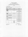
GAR MIN Ltd. or its subsidiaries
c/o Garmin International
1200 E. 151" Street, Olathe, KS 66062 USA
FAA APPROVED
ROTOR CRAFT FLIGHT MANUAL SUPPLEMENT
GARMIN 400W SERIES GPS-WAAS NA VIGA nON SYSTEM
As Installed In
Bell 206B
Reg. No.
SIN
_
This document serves as a Rotorcraft Flight Manual Supplement when the rotorcraft is
equipped with the Garmin 400W Series unit. This document must be carried in the
rotorcraft at all times when the Garmin 400W Series unit is installed in accordance with
STC SR02080SE.
The information contained herein supplements or supersedes the information made
available to the operator by the manufacturer in the form of clearly stated placards,
markings, or manuals or in the form of an FAA approved Rotorcraft Flight Manual, only
in those areas listed herein. For limitations, procedures and performance information not
contained in this document, consult the basic placards, markings, or manuals or the basic
FAA approved Rotorcraft Flight Manual.
FAA APgOVED
~~~
J;<y Manager, Flight Test Branch
Federal Aviation Administration
Seattle Aircraft Certification Office
DATE:~
190-01226-06 Rev. 1
Page I of 14
GARMIN Ltd. or its subsidiaries
c/o Garmin International
1200 E. 151" Street, Olathe, KS 66062 USA
ROTORCRAFT FLIGHT MANUAL SUPPLEMENT
GARMIN 400W SERIES GPS.WAAS NAVIGATION SYSTEM
Bell 206B
LOG OF REVISIONS
Page
Rev. No.
No.
1
All
Date
Description
Complete
Supplement
Original
FAA Approved
~,,-r~
..
Mgr. Fit. Test Br.
Federal Aviation Administration
Seattle Aircraft Certification Office
Date
190-01226-06 Rev. I
Page 2 of 14
'1/-.:, II")
GARMIN Ltd. or its subsidiaries
c/o Garmin International
1200 E. 151" Street, Olathe, KS 66062 USA
ROTORCRAFT FLIGHT MANUAL SUPPLEMENT
GARMIN 400W SERIES GPS-WAAS NAVIGATION SYSTEM
Bell 206B
Table of Contents
Section
I. I
1.2
I.3
1.4
1.5
1.6
1.7
1.8
Section
2.1
2.2
Section
3.1
3.2
3.3
3.4
3.5
Section
I. LIMIT ATIONS
Pilot's Guide
System Software:
Navigation Database
4
4
4
5
Terrain Database
5
Navigation
Terrain Proximity Display [Units without HTA WS]
HTAWS Function [Units with HTAWS]
HTAWS Annunciations on the PFD [Units with HTAWS]
2. EMERGENCY PROCEDURES
Emergency Procedures
Abnormal Procedures
5
6
6
7
8
8
8
3. NORMAL PROCEDURES
Approaches with Vertical Guidance
WFDE Prediction Program
HTA WS Controls
IITAWSAlerts
G500H Interface
4. PERFORMANCE
9
9
9
10
II
12
12
GENERAL
Garmin 400W Series GPSiWAAS Nav Com
13
13
Operation
14
Class II Oceanic, Remote, and other Operations
14
FAA APPROVED
190-01226-06 Rev. I
Page 3 of 14
DATE:
SEP 2 7 2010
GARMIN Ltd. or its subsidiaries
c/o Garmin International
1200 E. 151" Street, Olathe, KS 66062 USA
ROTORCRAFT FLIGHT MANUAL SUPPLEMENT
GARMIN 400W SERIES GPS-WAAS NA VIGATION SYSTEM
Bell 206B
Section I. LIMITATIONS
1.1
Pilot's Guide
The GARMIN 400W Series Pilot's Guide, part number and revision listed below (or later
revisions), must be immediately available for the flight crew whenever navigation is
predicated on the use of the 400W Series unit.
400W Series Pilot's Guide & Ref
PIN 190-00356-00 Rev G
400W/500W Series Optional Displays
PIN 190-00356-30 Rev H
This model helicopter when equipped with the G400W is limited to VFR ONLY
operations in accordance with 14 Code of Federal Regulations Part 91 and Part 135. The
placard listed below shall be located in close proximity to the 400W Series unit.
"APPROVED FOR DAYINIGIIT VFR".
1.2
System Software:
The system must utilize the Main and GPS software versions listed below (or later FAA
approved versions for this STC). The software versions are displayed on the self-test
page immediately after turn.on for approximately 5 seconds or they can be accessed in
the AUX pages.
Subsequent software versions may support different functions. Check the 400W Series
Pilot's Guide for further information.
Table 1 - Almroved
Software Item
Software
Versions
Approved
SW version
Main SW Version
GPS SW Version
Software
(or lacer FAA annroved
4.01
3.2
Version
versions
(or chis STCJ
As disnlaved on unit
4.01
3.2
FAA APPROVED
190-01226-06 Rev. I
Page 4 of 14
DATE:
SEP 27 2010
-----
GARMIN Ltd. or its subsidiaries
c/o Gannin International
1200 E. 151" Street, Olathe, KS 66062 USA
ROTORCRAFT
FLIGHT MANUAL SUPPLEMENT
GARMIN 400W SERIES GPS-WAAS NAVIGATION
SYSTEM
Bell 206B
1.3
Navigation
Database
The 400W Series unit database cards must he installed and current. The software
automatically precludes invalid databases for use by the 400W. Database cycle
information is displayed at power up on the screen, hut more detailed information
available on the AUX - UTILITY page.
a)
is
Installations with dua1400W/500W
Series units will only crossfill between units
when they contain the same database cycle. Updating of each database must be
accomplished on the ground prior to flight.
1.4
Terrain Database
The 400W Series unit supports Terrain Proximity or HTAWS and requires a Terrain
database card to be installed in order for the feature to operate. Database cycle
information is displayed at power up on the screen, hut more detailed information is
available on the AUX - UTILITY page. Terrain database cards contain the following
data:
a)
Due to the terrain resolution used in this system, the terrain database is divided into
six regions [Americas North; Americas South; Atlantic North; Atlantic South;
Pacific North; Pacific South]. Use of the proper database region must be verified.
b)
The Obstacle Database has an area of coverage that includes the United States and
Europe, and is updated as frequently as every 56 days.
NOTE:
The area of coverage
available.
I.S
may be modified as additional
terrain data sources become
Navigation
No navigation is authorized
south latitude.
north of 890 (degrees)
north latitude or south of 890 (degrees)
FAA APPROVED
190-01226-06
Page 5 of 14
Rev. I
DATE: __
SE_P_2 7 2010
GARMIN Ltd. or its subsidiaries
c/o Garmin International
1200 E. 151" Street, Olathe, KS 66062 USA
ROTORCRAFT
FLIGHT MANUAL SUPPLEMENT
GARMIN 400W SERIES GPS.WAAS NA VIGATION SYSTEM
Bell 206B
1.6
Terrain
Proximity
Display
IUnits without
IITA \\'51
Terrain Proximity refers to the display of terrain information and comprises of a 2-D
picture of the surrounding terrain and obstacles relative to the position and altitude of the
rotorcraft. however it does not provide any alerts.
Navigation must not be predicated upon the use of the terrain display. The terrain display
is intended to serve as a situational awareness tool only. By itself, it may not provide
either the accuracy or the fidelity on which to base decisions and plan maneuvers to avoid
terrain or obstacles.
Terrain is not depicted on the terrain display within 10m of airports and heliports.
however terrain hazards may exist in these areas.
1,7
IITAWS
Function
IUnits with IITAWSI
HTA WS is an optional extension of Terrain Proximity. Pilots are authorized to deviate
from their current A TC clearance to the extent necessary to comply with HT A WS
warnings.
HT A WS shall NOT be used for navigation
purposes.
HT A WS is an alerting system. The system does NOT guarantee successful recovery
from a conflict due to factors such as pilot response. aircraft performance. and database
limitations. No standardized recovery technique is defined as recovery maneuvers may
vary.
HTA WS functions perfonned
30 knots groundspeed.
by the Garmin 400W Series navigator
are inhibited below
Display of the terrain and obstacles is supplemental data only. Maneuvering
reference to the terrain and obstacle display is not authorized.
solely by
NOTE:
The Terrain and Obstacle Display is intended to serve as a terrain and obstacle
awareness tool only. The Display and database may not provide the accuracy or
fidelity on which to base routine navigation decisions and plan routes to avoid
terrain or obstacles.
FAA APPROVED
190.0 1226.06 Rev. I
Page 6 of 14
DATE:
SEP 2 7 2010
GARMIN Ltd. or its subsidiaries
c/o Garmin International
1200 E. 151" Street, Olathe, KS 66062 USA
ROTORCRAFT FLIGHT MANUAL SUPPLEMENT
GARMIN 400W SERIES GPS-WAAS NA VIGATION SYSTEM
Bell 206B
The Obstacle Database does not contain the location of power line poles or wires. Also
the Obstacle Database contains only KNOWN obstacles and docs not contain ALL
existing obstacles.
When alerting is inhibited, all Forward Looking Terrain Alerting aural and visual alerting
is suppressed. HTA WS should be only inhibited when in visual contact with terrain and
when the pilot can be assured of maintaining clearance from terrain and obstacles.
1.8
IITAWS Annunciations
on the PFD IUnits with IITAWSj
HTA WS (Terrain Awareness and Warning System) visual annunciations from the GNS
400W series unit are displayed on the G500H PFD. The required HTAWS annunciations
appear in the upper right of the PFD. These annunciations include TERRAIN (red),
TERRAIN (yellow), OBSTACLE (red), OBSTACLE (yellow), HTAWS N/A (yellow),
HTA WS INHB (white). These annunciations are not relative to the terrain elevation
information displayed on the G500H MFD.
FAA APPROVED
190-01226-06 Rev. 1
Page 7 of 14
DATE:
SEP 2 7 2010
GARMIN Ltd. or its subsidiaries
cIa Garmin International
1200 E. 151" Street, Olathe, KS 66062 USA
ROTORCRAFT
FLIGHT MANUAL SUPPLEMENT
GARMIN 400W SERIES GPS-WAAS NA VIGATION SYSTEM
Bell 206B
Section
2.1
2, EMERGENCY
PROCEDURES
Emergency Procedures
No change.
2.2
Abnormal Procedures
a) If the Garmin 400W Series unit GPS navigation information is not available, or is
invalid, utilize other remaining operational navigation equipment installed in the
aircraft as appropriate. If the 400W Series unit loses GPS position and reverts to Dead
Reckoning mode (indicated by the annunciation of"ORn in the lower left of the
display), the moving map will continue to be displayed. Rotorcraft position will be
based upon the last valid GPS position and estimated by Dead Reckoning methods.
Changes in airspeed or winds aloft can affect the estimated position substantially.
Dead Reckoning is only available in Enroute and Oceanic mode; Terminal and
Approach
b)
modes do not support DR.
If a "Loss of Integrity"
(INTEG)
message is displayed
during:
Enrouterrerminal: continue to navigate using GPS equipment and periodically
cross-check the GPS guidance to other approved means of navigation.
c)
When a Terrain or Obstacle Awareness CAUTION occurs, verifY the aircraft flight
path and correct it, ifrequired.
d) When a Terrain or Obstacle Awareness WARNING occurs, immediately initiate a
maneuver that will provide maximum terrain or obstacle clearance, until all alerts
cease.
FAA APPROVED
190-01226-06
Page 8 of 14
Rev. I
DATE: __
~S~EP272010
GARMIN Ltd. or its subsidiaries
c/o Garmin International
1200 E. 151" Street, Olathe, KS 66062 USA
ROTORCRAFT
FLIGHT MANUAL SUPPLEMENT
GARMIN 400W SERIES GPS-WAAS NAVIGATION
SYSTEM
Bell 206B
Section
3. NORMAL
PROCEDURES
Refer to the 400W Series unit Pilot's Guide defined in paragraph 1.1 of this document for
nonnal operating procedures.
This includes all GPS operations, VHF COM and NAY,
and Multi-Function Display information.
Although intuitive and user friendly the 400W Series unit requires a reasonable degree of
familiarity to enable unit operations without becoming too engrossed at the expense of
basic see-and-avoid. Pilot workload will be higher for pilots with limited familiarity in
using the unit. Gannin provides training tools with the Pilot's Guide and PC based
simulator. Pilots should take full advantage of these training tools to enhance system
familiarization.
3.1
Approaches with Vertical Guidance
The 400W Series unit supports three types ofGPS approaches with vertical guidance:
LPV approaches, LNAVNNAV
(annunciated as LNNAV) approaches, and LNA V
approaches with advisory vertical guidance (annunciated as LNA V+V). For LNA V
approaches with advisory vertical guidance, the 400W Series will annunciate LNA V+V
indicating vertical guidance is available. LNA V minimums will be controlling in this
case.
3.2
"'FDE Prediction Program
The Gannin WAAS Fault Detection and Exclusion (WFDE) Prediction Program
required for Remote/Oceanic
operations. The Prediction Program should be used
conjunction with the Gannin 400W/500W Simulator. After entering the intended
of flight in the Simulator flight plan the pilot selects the FDE Prediction Program
the Options menu of the Simulator program.
is
in
route
under
For detailed infonnation refer to the WFDE prediction program instructions
(190-00643-01).
The availability of FOE is only required for Oceanic or Remote
operations.
FAA APPROVED
190-01226-06
Page 9 of 14
Rev. I
DATE:
SEP 27 2010
------
GARMIN Ltd. or its subsidiaries
c/o Gannin International
1200 E. 151" Street, Olathe, KS 66062 USA
ROTOR CRAFT FLIGHT MANUAL SUPPLEMENT
GARMIN 400W SERIES GPS-WAAS NAVIGA nON SYSTEM
Bell 206B
3,3
HT AWS Controls
The HTAWS function has control options on the HTAWS Page using the MENU key.
The options are activated by highlighting the desired option and pressing ENTER.
The "Inhibit HTA WS?" menu selection is used to inhibit HT AWS alerts. When alerting
is inhibited, all HTA WS aural and visual alerting is suppressed. HT AWS should be only
inhibited when in visual contact with terrain and when the pilot can be assured of
maintaining clearance from terrain and obstacles. Use the "Enable HTA WS?" to uninhibit the unit.
The "Mute Active Caution?" menu selection is used to mute an HTA WS caution that is
presently active. When the caution is resolved, the next caution will be heard. It does not
mute warnings, only cautions. The "Unrnute Active Caution?" is used to cancel the
mute. An optional "MUTE" external switch installation on the cyclic stick is allowed to
mute the caution that is presently active in the same manner as using the Page Menu
selection.
The "Reduce Protection?" menu selection is used to activate the Reduce Protection (RP)
functionality. RP Mode reduces alerting thresholds and suppresses aural and visual
cautions to allow operation in closer proximity to terrain and obstacles while continuing
to provide protection from terrain and obstacles. The "Enable Full Protection?" menu
selection is used to select full protection functionality again. An optional "RP MODE"
external switch installation on the cyclic stick is allowed to toggle Reduce Protection and
Enable Full Protection in the same manner as using the Page Menu selection.
The "Test HTA WS?" menu selection is used to activate a manual test which verifies
proper operation of the aural and visual annunciations of the system. The aural message
"HTA WS System Test, OK" is played if the system passes the test, if the system fails the
test "HTA WS System Failure" is played. HTA WS test is only available while on the
ground.
Yoice callouts (yeas) provide voice annunciation of the aircraft height above terrain
when that threshold is crossed. VCOs may be enabled by the pilot in 100ft increments
from 500 feet above ground level to the surface. Enabling yeas is accomplished using
Voice Callout selection in the AUX pages.
FAA APPROVED
190-01226-06 Rev. I
Page 10 of 14
DATE:
£,...EP272010
GARMIN Ltd. or its subsidiaries
c/o Garmin International
1200 E. 151" Street, Olathe, KS 66062 USA
ROTORCRAFT
FLIGHT MANUAL SUPPLEMENT
GARMIN 400W SERIES GPS-WAAS NA VIGATION SYSTEM
Bell 206B
3.4
liT AWS Alerts
HTA WS visual and aural alerts provided by the Garmin 400W Series GPsrw AAS
Navigator are shown in the table
below.
Pop-Up Alert
Aural Message
Description
ItARs FAIL I
None
"HTAWS System Failure'
HTAWS has failed
ttliJA tSfII!
None
None
HTAWS
Annunciation
HT AWS has been inhibited by the
crew, or the aircraft groundspeed
fallen below 30 knots (automatic
has
inhi-
bitlng).
NIA!
I TAHS
!tmINI
Non'
CAlIIICll - TBIlAIN
"HTAWS Not Available"
'Caution-
HTAWS not available.
T,maln, Terrain"
Forward Looking Terrain Avoidance
Caution for Terrain
p,l:.
":I, .•
"Warning.
Terrain. Terrain"
Forward Looking Terrain Avoidance
Warning 101'Terrain
IIINeU!
CJiJlI(JI.1llST1IC1I
.Caution.
Obstacle, Obstade.
Forward Looking Terrain Avoidance
Caution for Obstacle
'I :fi'!3
il
lAp HOtEl
"WamlOg'
None
Obstacle,
Forward Looking Terrain Avoidance
Warning for Obstacle
Obstacle"
Non.
Alerting thresholds
are reduced. Visual
and aural annunciation
of caution
alerts are suppressed.
N",,,
No~e
"Five Hundred"
HTAWS provides optionalSOO ft
"Four Hundred'
through 100 ft (in 100 ft increments)
"Three Hundred'
altitude can out alerts.
"Two Hundred"
"One Hundred"
FAA APPROVED
190-01226-06
Page II of14
Rev. I
DATE:
SEP 2 7 2010
GARMIN
Ltd. or its subsidiaries
c/o Garmin International
1200 E. lSI" Street, Olathe, KS 66062 USA
ROTORCRAFT
FLIGHT MANUAL SUPPLEMENT
GARMIN 400W SERIES GPS-WAAS NAVIGATION
SYSTEM
Bell 206B
3.5
G500H Interface
The GNS 400W series unit is interfaced to the GSOOH display system for the purpose of
displaying HTA WS annunciations in the pilot's primary field of view. Terrain and
obstacle alerts are provided by the GNS 400W series unit. The alerting mode for GSOOH
Terrain Helicopter Synthetic Vision Technology (HSVT) will be driven by the HTA WS
mode selected on the GNS 400W series unit. In the event of a failure of the GNS unit
providing HTA WS functionality. the HSVT Terrain alerting may be available and the
alerting mode can be selected by the pilot on the GSOOH terrain page.
Section
4. PERFORMANCE
No change.
FAA APPROVED
190-01226-06
Page 120fl4
Rev. I
DATE: __
~S~F~P
272010
GARMIN
Ltd. or its subsidiaries
c/o Gannin International
1200 E. \5\"
Street, Olathe, KS 66062 USA
ROTORCRAFT
FLIGHT MANUAL SUPPLEMENT
GARMIN 400W SERIES GPS-WAAS NA VIGATION SYSTEM
Bell 206B
GENERAL
Gormin
400W Series GPS/WAAS
Nov Com
The Garmin 400W Series GPSIW AAS Navigator is a panel-mounted product that
contains a GPS/W AAS receiver for GPS approved primary navigation under TSO C 146a,
(plus optional VHF Com, VHF Nav radios and HTAWS) in an integrated unit with a
moving map and color display. The 400W Series unit features a graphical display.
The navigation functions arc operated by dedicated keys and graphical menus which are
controlled by the buttons and the dual concentric rotary knob along the bottom and right
side of the display.
Optional VHF Com and VHF Nav radio functions arc controlled via dedicated buttons
and knobs on the left side of the display and adjacent to frequencies they are controlling.
Gr'pllle Mo••.•.•
g
Map Oospilly and
Na""llllloQl'llofO
DMeel.To
RaOlQeKeys
/
Key
Meou Key
/ . ~c.,,'"
,
"'.----
"".~
t>llv RadIO
._--.-
EOTer Key
FuncloQl'l and
NIV RadIO __ ---
Pa.ge Nurnl>oe<
__
- -
laf1;leKilob
F1~p
l...-ge KnOb
Com'VLOC
_
Freq (1,11-11)
........--Terr.in FIiQIl1
~
Sma. Knob
Ph'5e .fl<l
Col'ni"'AOC
Freq (~Hl)
~~o~~~~::?
I \
I
MOUo"OlQ
Sere....
I
COl
Key
06S
Key
NaVlllDhOO
Source GPS,
\/LOC, Or
GPS-F'T)(
Figure I - 400\V Series Control and Display Layout
Optional HTA WS functions are controlled by soft keys located on the dedicated TA WS
page. An installation option allows some of the controls to be installed on the cyclic grip.
FAA APPROVED
\90-0\226-06
Rev. I
Page \3 of 14
DATE: __
~S£~P
272010
GARMIN Ltd. or its subsidiaries
c/o Garmin International
1200 E. 151" Street, Olathe, KS 66062 USA
ROTORCRAFT
FLIGHT MANUAL SUPPLEMENT
GARMIN 400W SERIES GPS-WAAS NA VIGATION SYSTEM
Bell 206B
Operation
GPS/WAAS TSO-CI46a Class 3 Operation: The Garmin 400W Series unit uses GPS
and WAAS (within the coverage of a Space-Based Augmentation System complying
with ICAO Annex 10) for emoute, terminal area, non-precision approach operations
(including "GPS", "or GPS", and "RNA V" approaches), and approach procedures
with vertical guidance (including "LNAVIVNA V" and "LPV").
Navigation is accomplished using the WGS-84 (NAD-83) coordinate reference datum.
GPS navigation data is based upon use of only the Global Positioning System (GPS)
operated by the United States of America.
Class II Oceanic,
Remote, and other Operations
The Garmin 400W Series, as installed, has been found to comply with the requirements
for GPS primary means of Class II navigation in oceanic and remote airspace, when used
in conjunction with WAAS Garmin Prediction Program part number 006-AO 154-03.
Oceanic operations are supported when the 400W Series unit annunciates OCN. This
provides an alarm limit of four NMI and a mask angle oftive degrees. The 400W series
unit also has the ability to predict RAIM availability at any waypoint in the database or if
WAAS corrections are expected to be absent or disabled. This RFMS does not constitute
an operational approval for Oceanic or Remote area operations. Additional equipment
installations or operational approvals may be required.
a) Oceanic navigation requires an additional approved long range oceanic and/or
remote area navigation system with independent display, sensors, antenna, and
power source. (It may be a second 400W/500W Series unit.)
b) Redundant VHF Com and VHF Nav systems may be required for other than
U.S. 14 CFR Part 91 operations. Check foreign regulation requirements as
applicable. (It may be a second 400W/500W Series unit.)
c) Operations approval may be granted for the use of the 400W Series unit RAIM
prediction function in lieu of the Prediction Program for operators requiring
this capability. Refer to your appropriate civil aviation authorities for these
authorizations.
FAA APPROVED
190-01226-06 Rev. I
Page 14 of 14
DATE: __
~SE.-f?
272010