1
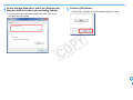
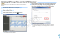
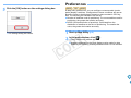
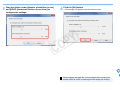
Map Utility
Ver. 1.5
Instruction Manual
● Content of this Instruction Manual
● Switching Between Pages
● In this manual, the windows used in the
Y
P
O
● Click on arrows on the bottom right of the screen.
examples are from Windows 7.
● GPS receiver or camera is displayed as an icon.
Example: GPS Receiver GP-E1 J GP-E1
EOS 6D J
6D
● ` indicates the selection procedure of the menu.
(Example: [File] menu ` [Exit].)
● Square brackets are used to indicate items such
as menu names, button names and window
names that appear on the computer screen.
● ** indicates a reference page.
Click to move to the relevant page.
●
: Marks information that should be read
before use.
●
: Marks additional information you may find
helpful.
C
: next page
: previous page
: return to a page you had previously
displayed
© CANON INC. 2014
CCS-M105MUE-000
READ CAREFULLY BEFORE USING!
CANON SOFTWARE LICENSE AGREEMENT
IMPORTANT - READ THIS AGREEMENT BEFORE USING THE SOFTWARE ON THE CD-ROM
IN THIS BOX. BY USING THE SOFTWARE, YOU AGREE TO BE BOUND BY THE TERMS OF
THIS AGREEMENT.
This is a license agreement (the [Agreement]) between you and Canon Inc. ([Canon]).
IF YOU DO NOT AGREE TO THE TERMS AND CONDITIONS OF THIS AGREEMENT, DO NOT
USE THE SOFTWARE PROGRAM ON THE CD-ROM AND THE USER MANUAL IN THIS BOX
(COLLECTIVELY, THE [SOFTWARE]) AND RETURN THE SOFTWARE WITHIN 30 DAYS FROM
THE DATE OF PURCHASE TO YOUR POINT OF PURCHASE FOR A REFUND.
In consideration of the right to use the SOFTWARE, you agree to abide by the terms and conditions
of this Agreement.
1. LICENSE: Canon grants you the non-exclusive right to use the SOFTWARE only on a single
computer. You may physically transfer the SOFTWARE from one computer to another provided
that the SOFTWARE is used on only one computer at a time. You shall not install or use the
SOFTWARE on a network, multiple CPU, multiple site arrangement, or any other hardware
configuration where the SOFTWARE is accessible to more than one CPU or to more than one
user.
YOU SHALL NOT ASSIGN, SUBLICENSE, RENT, LEASE, LOAN, CONVEY OR OTHERWISE
USE, TRANSFER, COPY, TRANSLATE, CONVERT TO ANOTHER PROGRAMMING
LANGUAGE, ALTER, MODIFY, DECOMPILE OR DISASSEMBLE THE SOFTWARE, IN WHOLE
OR IN PART, EXCEPT AS EXPRESSLY PROVIDED IN THIS AGREEMENT.
2. BACK-UP COPY: You may make one copy of the SOFTWARE solely for back-up purposes, or
copy the SOFTWARE onto the permanent storage device (e.g. a hard disk) of your computer
and retain the original for back-up purposes. Any other copying of the SOFTWARE is a violation
of this Agreement. You must reproduce and include the copyright notice on the back-up copy.
NEITHER CANON NOR ANY OF CANON’S SUBSIDIARIES, DISTRIBUTORS OR DEALERS IS
LIABLE FOR ANY DAMAGES HOWSOEVER CAUSED, INCLUDING WITHOUT LIMITATION,
DIRECT, CONSEQUENTIAL OR INCIDENTAL LOSS OR DAMAGE INCLUDING LOSS OF
PROFITS, EXPENSE OR INCONVENIENCE HOWSOEVER CAUSED OR ARISING OUT OF THE
SOFTWARE OR THE USE THEREOF.
NEITHER CANON, NOR ANY OF CANON’S SUBSIDIARIES, DISTRIBUTORS OR DEALERS
SHALL HAVE ANY OBLIGATION TO INDEMNIFY YOU AGAINST ANY CLAIM OR SUIT
BROUGHT BY A THIRD PARTY ALLEGING THAT THE SOFTWARE OR THE USE THEREOF
INFRINGES ANY INTELLECTUAL PROPERTY OF SUCH THIRD PARTY.
5. TERM: This Agreement is effective upon your using the SOFTWARE and remains in effect until
expiration of all copyright interests in the SOFTWARE unless earlier terminated. You may
terminate this Agreement by destroying the SOFTWARE. This Agreement will also terminate
without notice to you if you fail to comply with any of the terms of this Agreement and you must
then promptly return the SOFTWARE. In addition, Canon may enforce its other legal rights.
6. U.S. GOVERNMENT RESTRICTED RIGHTS NOTICE: The SOFTWARE is provided with
restricted rights. Use, duplication or disclosure is subject to restrictions as set forth in either
subparagraph (c) (1) (ii) of the Rights in Technical Data and Computer software clause at
DFARs 252.227-7013 or subparagraph (c) (1) and (2) of the Commercial Computer Software
Restricted Rights Clause at FAR 52.227-19, as applicable.
8. CONTROLLING LAW: The terms of this Agreement as it relates to purchases of the Software in
the United States of America shall be governed and construed in all respects in accordance with
the laws and regulations of the State of New York, without reference to choice of law principles.
The terms of this Agreement as it relates to purchases of the Software in Canada shall be
governed by the laws of the province of Ontario.
C
3. SUPPORT AND UPDATES: Canon is not responsible for providing maintenance or support for
use of the SOFTWARE. No updates, fixes or support will be made available for the
SOFTWARE.
4. LIMITED WARRANTY AND LIMITATION OF LIABILITY: It is your responsibility to choose,
maintain and match the hardware and software components of your computer system. Thus
Canon does not guarantee uninterrupted service or correction of errors or that the functions or
performance of the SOFTWARE will meet your requirements. THE SOFTWARE IS LICENSED
ON AN [AS IS] BASIS AND WITHOUT WARRANTY OF ANY KIND. The CD-ROM storing the
SOFTWARE is warranted only against defective material under normal use for a period of ninety
(90) days after purchase from an authorized Canon dealer as evidenced by your sales receipt.
Your sole remedy for a defective CD-ROM shall be replacement of the same without charge
when returned by you at your expense to your point of purchase and proven to be defective
upon inspection. The replacement CD-ROM will be warranted for the remainder of the original
ninety (90) day warranty period of the defective CD-ROM. The limited warranty does not apply if
the failure of the CD-ROM resulted from accident, abuse or misapplication of the SOFTWARE
and shall not extend to anyone other than the original user of the SOFTWARE.
EXCEPT AS SPECIFICALLY SET FORTH IN THIS PARAGRAPH 4, CANON, CANON’S
SUBSIDIARIES, DISTRIBUTORS AND DEALERS DISCLAIM ALL WARRANTIES, EXPRESS OR
IMPLIED, INCLUDING ANY WARRANTY OF MERCHANTABILITY OR FITNESS FOR A
PARTICULAR PURPOSE, WITH RESPECT TO THE SOFTWARE.
Y
P
O
7. SEVERABILITY: In the event that any provision of this Agreement is declared or found to be
illegal by any court or tribunal of competent jurisdiction, such provision shall be null and void
with respect to the jurisdiction of that court or tribunal and all the remaining provisions of this
Agreement shall remain in full force and effect.
9. OWNERSHIP: All rights, including but not limited to copyrights and trade secret rights, to the
SOFTWARE belong to Canon, its affiliated corporations and third party licensors. Your use of
the SOFTWARE is subject to the United States, Canada and other applicable copyright and
trademark laws and nothing in this Agreement constitutes a waiver of the rights of Canon, its
affiliated corporations and third party licensors under such laws.
Nothing contained in Paragraph 1 shall be construed to give Canon any ownership rights in any
images, graphics or textual material that you save in connection with the Software.
10.ACKNOWLEDGEMENT: BY USING THE SOFTWARE, YOU ACKNOWLEDGE THAT YOU
HAVE READ THIS AGREEMENT, UNDERSTOOD IT, AND AGREE TO BE BOUND BY ITS
TERMS AND CONDITIONS. YOU ALSO AGREE THAT THIS AGREEMENT IS THE
COMPLETE AND EXCLUSIVE STATEMENT OF AGREEMENT BETWEEN YOU AND CANON
CONCERNING THE SUBJECT MATTER HEREOF AND SUPERSEDES ALL PROPOSALS
OR PRIOR AGREEMENTS, VERBAL OR WRITTEN, AND ANY OTHER COMMUNICATIONS
BETWEEN THE PARTIES RELATING TO THE SUBJECT MATTER HEREOF. NO
AMENDMENT TO THIS AGREEMENT SHALL BE EFFECTIVE UNLESS SIGNED BY A DULY
AUTHORIZED OFFICER OF CANON.
1
Introduction
Map Utility version 1.5 is a software utility for viewing the shooting
locations of images shot with EOS DIGITAL cameras either with built-in
GPS*1 functionality or used with a Canon GPS receiver. If you shoot
photos with an EOS 6D*2, EOS 7D Mark II or with another EOS DIGITAL
camera used with GPS Receiver GP-E2, you can view them with the
route you traveled (motion paths).
*1 GPS: Global Positioning System, a system of satellites used to
determine the current location
2
* “EOS 6D” and
in this manual indicate EOS 6D (WG), the
6D
model equipped with an internal GPS receiver.
● Adjust the logging interval, delete
logs GP-E2
● Connect the GP-E2 to a computer to adjust the receiver’s logging
interval, or to delete log information in the receiver.
● Update GPS receiver firmware
● Connect the GP-E2 to a computer to update the receiver’s
firmware to the latest version.
● Other features
Main Features of Map Utility Version 1.5
Main features of Map Utility are as follows.
● View where images were taken
6D
GP-E1
GP-E2
7D Mk II
● Import geotagged images and view shooting locations on a map.
● Import GPS log files
GP-E2
● Connect the GP-E2 to a computer to import and save GPS log
files to the computer.
● Edit GPS log files
GP-E2
6D
C
7D Mk II
● You can edit information in imported GPS log files.
● View routes traveled (motion paths)
GP-E2
6D
7D Mk II
● Import GPS log files from the GP-E2, the EOS 6D or EOS 7D Mark II
to view the routes traveled between shooting locations on a map.
● Geotag images
GP-E2
● Use GPS log files from the GP-E2 to geotag images without GPS
information.
GP-E2
● You can search desired locations on a map, and save shooting
locations or other information displayed in Map Utility as Google
Earth™ files.
● For importing GPS log files in EOS 6D or EOS 7D Mark II to the
computer and deleting the log information, use the EOS Utility
software included in the EOS DIGITAL Solution Disk provided
with EOS 6D, EOS 7D Mark II.
Y
P
O
● Map Utility compatible with 7D Mk II is Ver.1.5.3 or later.
● This software uses Google Maps™ to display images and routes
traveled on a map. Location information in images and GPS logs
is sent to service providers.
● Internet Service Provider (ISP) connection fees or access point
connection fees may apply.
● Geotagged images and GPS logs may contain personally
identifiable information. Be careful when sharing the files or
posting images online where many people can view them.
● Do not operate Map Utility while editing images with Digital Photo
Professional. Edited images may not be saved properly.
About ImageBrowser EX
ImageBrowser EX is required when installing or uninstalling Map
Utility.
When you start up ImageBrowser EX while connected to the
Internet, both ImageBrowser EX and Map Utility will be updated
automatically to the latest version, as needed.
2
System Requirements
Supported Files
Image Files
File type
OS
Windows 8.1, Windows 8, Windows 7*
Computer
Computers running one of the above operating
systems (preinstalled), with an included USB
port. Internet access required.
CPU
1.6 GHz Pentium or higher
RAM
Windows 8.1, 8 (64-bit): 2 GB or more
Windows 8.1, 8 (32-bit): 1 GB or more
Windows 7 (64-bit): 2 GB or more
Windows 7 (32-bit): 1 GB or more
Interface
USB
Display
1,024 x 768 resolution or higher
Still
photos
Extension
RAW
images
Images in Canon RAW format
.CR2
JPEG
images
Exif 2.2, 2.21, and 2.3-compliant
JPEG images
.JPG
Movies shot with EOS DIGITAL
cameras released since January
2012*
.MOV
.MP4
Movies
* Except movies shot with the EOS REBEL T5/1200D
GPS Log Files
* Compatible with Service Pack 1
OS
Mac OS X 10.8, 10.9
Computer
Computers running one of the above operating
systems (preinstalled), with an included USB
port. Internet access required.
CPU
Core 2 Duo or higher
RAM
2 GB or more
Interface
USB
Display
1,024 x 768 resolution or higher
C
Y
P
O
File type
Extension
GPS log files in NMEA text format recorded by GPS
Receiver GP-E2 and EOS 6D or EOS 7D Mark II
.LOG
3
Contents
Introduction ................................................................ 2
Main Features of Map Utility Version 1.5 ................... 2
System Requirements................................................ 3
Supported Files .......................................................... 3
Starting Up Map Utility ............................................... 5
Viewing Image Location Information .......................... 6
Importing GPS Log Files from the GPS Receiver ...... 7
Importing GPS Log Files from the Computer ............. 9
Editing Information in GPS Log Files ......................... 9
Removing Unnecessary GPS Log Files from
the List...................................................................... 10
Geotagging Images.................................................. 11
Geotagging Images Automatically ........................... 12
C
Updating the GPS Receiver Firmware ..................... 13
Setting the Positioning Interval................................. 14
Y
P
O
Deleting GPS Log Files on the GPS Receiver ......... 16
Preferences.............................................................. 17
List of Main Window Functions ................................ 19
Reference................................................................. 21
Installation Could not be Completed Correctly .......... 21
Deleting the Software (Uninstalling) .......................... 21
4
Starting Up Map Utility
In the taskbar, click the [Start] menu ` [All Programs]
` [Canon Utilities] ` [Map Utility] folder ` [Map Utility]
icon.
Open the [Applications] folder and [Canon Utilities]
folder, and then open the [Map Utility] folder.
Double-click the [Map Utility] icon.
➜ Map Utility starts up.
➜ Map Utility starts up.
C
Y
P
O
5
Viewing Image Location Information
Import images into Map Utility and view location information.
window, select the [Images] tab and click
1 Inthethe[ main
] button. On the screen displayed next, select
image files by specifying the storage location or
entering the file names, and then click the [Open]
button.
C
● To magnify an image, double-click the image file on the image list
or the thumbnail image shown on the map. For movies, a
separate window will open for playback.
● To view location details of images, select image files on the image
list and select [Display location information details] in the [View]
menu.
Y
P
O
Map data ©2012 ZENRIN -
➜ Image files are imported and added to the image list on the
[Images] tab. Image shooting locations are indicated by red pins
on the map.
● To view images on the map with their location, click an image file
on the image list or a pin on the map.
● Images on the image list may be tagged with times that match
the times for GPS log files on the GPS log file list. In this case,
clicking a pin will show the route the GPS log file has traveled.
● For image files tagged with the shooting direction, pins indicating
the shooting directions are displayed.*
* For movies in MP4 format shot with 7D Mk II , pins indicating the
shooting directions are not displayed.
● You can add image files to the image list by directly dragging and
dropping them on the list.
● Map Utility maps are not displayed unless your computer is
connected to the Internet.
6
Importing GPS Log Files from the GPS Receiver
GP-E2
GPS log files stored on the GPS Receiver GP-E2 can be imported into
Map Utility. Once imported, the log information is saved on the
computer.
the main window, select the [GPS log files] tab.
3 InClick
the [ ] button, and then click the [Next]
button on the next screen.
1 Connect the GP-E2 to the computer.
Turn on the GP-E2, and connect its [DIGITAL] terminal to a USB
port on the computer.
Use the interface cable provided with the camera to connect.
● Insert the larger cable plug into the computer’s USB port. For
details on positions and orientations of the USB ports, refer to the
computer instruction manual.
● Insert the smaller cable plug into the GP-E2’s [DIGITAL] terminal.
For details on the GP-E2’s [DIGITAL] terminal, refer to the GP-E2
instruction manual.
2 Start up Map Utility.
(p.5)
C
Y
P
O
➜ GPS log files are imported to the computer and added to the log
file list on the [GPS log files] tab.
7
● Imported GPS log files are saved in the following locations:
[Canon Utilities] in the documents folder of the computer ` [GPS
Log Files]
[Documents] ` [Canon Utilities] ` [GPS Log Files]
● Click a GPS log file on the GPS log file list to view routes traveled
(motion paths) on a map.
C
Y
P
O
Map data ©2012 ZENRIN -
8
Importing GPS Log Files from the Computer
Editing Information in GPS Log Files
GP-E2
Import GPS log files saved on the computer into Map Utility as follows.
1
In the main window, select the [GPS log files] tab and
click the [
] button. On the next screen, specify the
storage location or the file names, and then click the
[Open] button.
6D
7D Mk II
Certain information in GPS log files imported into Map Utility can be
edited. The items which can be edited are [Name] and [Time difference]
(time difference between local time and Greenwich Mean Time). This
[Time difference] setting is used in case such as the camera’s [Time
zone] setting is incorrect.
the main window, select the [GPS log files] tab.
1 InSelect
the log file to edit and click the [ ] button.
C
➜ GPS log files are imported.
➜ Once importing is finished, the files are added to the GPS log file
list. To view routes traveled (motion paths) on a map, click one of
the listed GPS log files.
Y
P
O
Map data ©2012 ZENRIN -
➜ The [GPS log file information] window appears.
9
Removing Unnecessary GPS Log Files from the List
the GPS log file information, and then click the
2 Edit
[OK] button.
Unnecessary GPS log files can be removed from the GPS log file list.
However, note that the files themselves are not deleted from the
computer.
the main window, select the [GPS log files] tab.
1 InSelect
a log file to remove from the list, and then
click the [
➜ Edited information is applied to the GPS log file.
C
] button.
Y
P
O
Map data ©2012 ZENRIN -
2 On the screen displayed next, click the [OK] button.
➜ The selected log file is removed from the GPS log file list.
10
Geotagging Images
Images without location information can be geotagged as follows.
1 Import image files.
main window, select the [Images] tab. Select
2 Inanthe
image, and then click the [
] button.
(p.6)
a desired location on the map, and in the dialog
3 Click
box displayed next, click the [Save] button.
C
Y
P
O
Map data ©2012 ZENRIN -
➜ The blue pin changes to a red pin, and location information is
added to the image file.
Map data ©2012 ZENRIN -
● You can delete location information from geotagged image file by
selecting an image and clicking the [
] button.
● Entering a place name in the search box above the map area will
display a list of possible place names. Once you select a
destination and click the [
] button, the map display will move
accordingly. This is useful when finding shooting locations.
11
Geotagging Images Automatically
4 Click the [Save] button.
GP-E2
Images without location information can be geotagged automatically,
using GPS log information from the GP-E2.
1 Import image files.
2 Import GPS log files.
main window, select the [Images] tab. Click the
3 In[ the] button.
(p.6)
(p.7, p.9)
C
Y
P
O
Map data ©2012 ZENRIN -
➜ The blue pins change to red pins, and GPS location information
is added to the image files.
Map data ©2012 ZENRIN -
➜ Latitude and longitude of the images for which the shooting time
matches a time in the GPS log file are labeled with blue pins.
● The GPS location information added is from the positioning
location closest in time to the shooting time.
● To view routes traveled (motion paths) attained by GPS
positioning on a map after adding GPS location information to
image files, click one of the pins on the map.
12
Updating the GPS Receiver Firmware
GP-E2
GPS Receiver GP-E2 firmware can be updated to the latest version, as
needed. Download the firmware from the Canon Web site before
following these steps.
Note that downloading firmware requires an Internet connection.
the settings dialog box, select the [General] tab.
4 On
Under [Firmware version], click the [Update] button.
1 Connect the GP-E2 to the computer.
2 Start up Map Utility.
3 In the main window, click the [ ] button.
On the screen displayed next, specify the storage
location of firmware and the file name, and then click
the [Open] button.
(p.7)
(p.5)
C
Y
P
O
➜ Update of the receiver firmware will begin.
● A message appears when the firmware update is finished.
On the screen displayed, click the [OK] button to close the screen.
➜ The settings dialog box appears.
13
Setting the Positioning Interval
5 Click the [OK] button on the settings dialog box.
GP-E2
You can specify the interval the GPS Receiver GP-E2 acquires new
position information. Shorter positioning intervals yield more accurate
location information for your images. However, it will consume more
battery power.
1 Connect the GP-E2 to the computer.
2 Start up Map Utility.
3 In the main window, click the [ ] button.
(p.7)
(p.5)
➜ The settings dialog box closes.
C
Y
P
O
➜ The settings dialog box appears.
14
the settings dialog box, select the [Settings] tab.
4 On
Drag the slider to the desired positioning interval.
5 Click the [OK] button.
➜ The setting is updated, and the settings dialog box closes.
● You can specify the interval on a eight-level scale, from every
second to every 5 minutes.
C
Y
P
O
15
Deleting GPS Log Files on the GPS Receiver
GP-E2
GPS log files stored on the GPS Receiver GP-E2 can be deleted as
follows.
the settings dialog box, select the [Settings] tab.
4 On
Under [Clear log data], click the [Clear] button. On
the screen displayed next, click the [OK] button.
1 Connect the GP-E2 to the computer.
2 Start up Map Utility.
3 In the main window, click the [ ] button.
(p.7)
(p.5)
C
Y
P
O
➜ The GPS log files are deleted.
● A message appears when GPS log file deletion is finished.
On the screen displayed, click the [OK] button to close the
screen.
➜ The settings dialog box appears.
16
Preferences
5 Click the [OK] button on the settings dialog box.
➜ The settings dialog box closes.
GP-E2
6D
7D Mk II
In Map Utility preferences, you can configure routes traveled (motion
paths) display conditions. Configuration of these conditions will narrow
down the routes to be displayed, based on data recorded in GPS log
files. The following two conditions can be set.
● Number of satellites used for positioning: The more satellites used for
positioning, the greater the location accuracy.
● HDOP (Horizontal dilution of precision): Calculated from the
distribution of satellites at the time of positioning. The smaller the
value, the greater the location accuracy.
1 Start up Map Utility.
2 In the main window, click [
(p.5)
Y
P
O
].
➜ The [Preferences] window appears.
● Append checkmark to the [Only display motion paths for data
matching the following criteria] checkbox when it is not checked.
C
17
the sliders under [Number of satellites in use]
3 Drag
and [HDOP (Horizontal dilution of precision)] to
4 Click the [OK] button.
➜ The settings are updated, and the window closes.
configure the settings.
C
Y
P
O
Clicking [Apply] will apply the current settings without closing the
window, which is useful in checking how the display will change.
18
List of Main Window Functions
[GPS log files] tab (p.7, p.9, p.10)
[Images] tab (p.6, p.11, p.12)
Image list (p.6)
Image file (p.6, p.11, p.12)
GPS mark
Pin (p.6, p.11, p.12)
Export file for Google Earth™ button*1
Launch another program button*2
Search map
button (p.11)
Macintosh version:
GPS device
settings button
(p.13, p.14,
p.16)
GPS log file
(p.9, p.10)
Help button
GPS log file list
(p.7, p.8, p.10)
C
Preferences
button (p.17)
Y
P
O
Import from GPS
device button
(p.7)
Map data ©2012 ZENRIN -
Import from file button
(p.9)
Edit GPS log file
information button (p.9)
Delete GPS log files from list
button (p.10)
GPS log file routes traveled (motion paths) (p.8, p.17)
Automatically add location information button (p.12)
Add Landmark button
Add location information button (p.11)
Add images button (p.6)
Macintosh version:
19
*1 Export file for Google Earth™
This button enables you to export images and location information in the image list in a standard file format for maps that can be opened with Google
Earth™ . As the [Save As] dialog box is displayed, specify a location to save the file, then click the [OK] button.
Exported files have the file extension “.kmz”
Using these files requires Google Earth™ to be installed. Note that the windows may not be displayed accurately in some versions of Google Earth™ .
*2 Launch another program
This button enables you to start up compatible software. When you click this button, a menu to select software compatible with Map Utility is displayed.
The software you select will start up, enabling you to open the image currently displayed in Map Utility.
C
Y
P
O
20
Reference
Installation Could not be Completed Correctly
Deleting the Software (Uninstalling)
● Select an administrator-level privilege ([Computer administrator],
[Administrator], etc.) as a user setting. You cannot install the software
if a user setting other than an administrator-level privilege is selected.
For detailed information on selecting an administrator-level privilege,
refer to your computer User’s Manual.
● You cannot install software unless you are logged into an account with
Administrator privileges. Log in again into an account with
Administrator privileges. For how to log in and how to specify
Administrator settings, refer to the User’s Manual for the Macintosh
computer you are using or for Mac OS X.
● Exit all the applications before uninstalling the software.
● Log in under an administrator-level privilege when uninstalling the
software.
● To prevent computer malfunctions, always restart your computer after
you have uninstalled the software. Re-installing the software without
restarting your computer may cause computer malfunctions.
Windows 7
the [
] button ` [All Programs] ` [Canon
1 Select
Utilities] ` [ImageBrowser EX] ` [ImageBrowser EX
Y
P
O
Uninstall].
with the uninstallation as directed by the
2 Proceed
on-screen messages.
C
➜ The software (Map Utility and ImageBrowser EX) is uninstalled.
Windows 8.1, Windows 8
● Uninstall the software according to the OS software uninstalling
method.
21
About This Instruction Manual
1
Display the folder in which the software is saved.
➜ Open the [Canon Utilities] folder.
● It is prohibited to reproduce, in whole or part, the contents of this
Instruction Manual without permission.
● Canon may change without notice the software specifications and
contents of this Instruction Manual.
● The software screens and displays printed in this Instruction Manual
may differ slightly from the actual software.
● The content of this Instruction Manual has been reviewed thoroughly.
However, if you should notice any errors or omissions, please contact
a Canon Service Center.
● Please note that irrespective of the above-mentioned, Canon does
not take responsibility for the outcome of the operation of the
software.
Y
P
O
Trademark Acknowledgments
2
the [Finder] menu on the desktop ` [Empty
3 Select
Trash].
Drag the [Map Utility] folder to the Trash.
➜ The software is deleted.
4
Restart your computer.
● Microsoft and Windows are registered trademarks or trademarks of
Microsoft Corporation in the United States and/or other countries.
● Macintosh is a trademark of Apple Inc., registered in the United States
and other countries.
● Google™ , Google Maps™ , and Google Earth™ are trademarks of
Google Inc.
● Other names and products not mentioned above may be registered
trademarks or trademarks of their respective companies.
C
The camera and accessories mentioned in this Instruction Manual are
current as of August 2014. For information on the software’s
compatibility with any cameras and accessories introduced after this
date, contact any Canon Service Center.
22