1
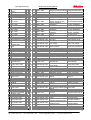
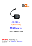
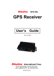
Rikaline
GPS-6021-X6
【High Sensitivity】
CF GPS Receiver
User’s
Guide
Aug 24, 2004
Rikaline
International Corp.
14F, 171, ChenGong Rd,. Sanchong City, Taipei 241, Taiwan
Phone: +886-2-8973-1899 Fax: +886-2-8973-1896
E-Mail: [email protected] Web: www.rikaline.com.tw
All Right Reserved
Xtrac High Sensitivity
GPS-6021-X6 Operating Manual
Rikaline
TABLE OF CONTENTS
0.
Quick USe ……….…………………………………………………………………………………..
0.1 Check GPS Package ..…………………………………………………………………..
0.2 Check Accessories …..…………………………………………………………………..
0.3 Connect GPS-6021-X6 to your machine ….……………………………………….
0.4 Manufacturing Default ……………………………………………………………………..
0.5 Important Information …………………………………………………………………….
0.6 Accssories …………………………………………………………………………………….
3
3
3
3
3
3
3
1.
Introduction ………………………………………………………………………………………..
1.1 Overview ……………………………………………………………………………………..
1.2 Features ……………………………………………………………………………………..
1.3 Technical Specifications ………………………………………………………………..
4
4
4
4
2.
Operational Characteristics ……………………………………………………………….…
2.1 Initialization ………………………………………………………………………………….
2.2 Navigation ………………………………………………………………………………….
6
6
6
3.
Hardware Interface ………………………………………………………………………….……
3.1 Dimension ………………………………………………………………………………….…
3.2 Hardware Interface …..……………………………………………………………….……
3.3 Connector ………………………………………………………………………………….…
3.4 Accessories ………………………………………………………………………………….
7
7
7
7
7
4.
PCMCIA Installation File …………………………………………………………………….… 8
4.1 System Requirement ……………………………………………………………………… 8
4.2 Installation ………………….…………………………………………………………….… 8
5.
Waranty …………………………………………………………………………………………….…
8
Appendix A Software Inferface ……………………………………………………………. 9
A.1 NMEA Transmitted Sentences ……………………………………………………..… 9
A.2 RTCM Received Data ………………………………………………………………….. 12
Appendix B
Earth Datums and Output Setting ……………………………………… 13
B.1 Setting ………..………………………………………………………………….………….. 13
B.2 Earth Datum ……..……………………………………………………………………….… 13
Appendix C
Ordering Information ……………………………………………………….. 19
C.1 Product Options ……..………………………………………………………….………… 19
C.2 Accessories ………………………………………………………………………….……… 19
2
Rikaline International Corp.
Tel: ++886 2 8973 1899
14F, 171, Chen-Gong Road, SanChung City, Taipei 241, Taiwan
Fax: ++886 2 8973 1896
E-Mail: [email protected]
Web: www.rikaline.com.tw
Xtrac High Sensitivity
GPS-6021-X6 Operating Manual
Rikaline
0. Quick Use
0.1 Check GPS Package
0.1.1 Standard Package
GPS-6021-X6 (GPS Receiver) + CD + Warranty Card + quick installation reference.
0.1.2 Optional Package
The shop may bundle different accessories for you as follows:
1. Active Antenna
2. PCMCIA Adapter
3. PDA Holder
4. Software (Navigation Software + Digital Map)
5. Others
0.2 Check Accessories
1.
A-10302-M Active antenna is used when GPS-6020 can not get good signal. We do not recommend
you to connect it all the way. If you got signal from both the GPS-6020 main unit and the active
antenna, the signal strength could be less than they have to be.
2. The GPS-6021-X6 is design as plug in and use. You do not need any driver for CF slot.
3. GPS-6020 is CF type I device. It could be used for CF type I and II. When you put GPS-6020 in CF
type II slot, please pay attention not to damage the CF slot or the GPS.
4. When you connect GPS-6021-X6 with your PC (Webpad PC, Tablet PC, Laptop PC or other PCs)
through a PCMCIA adapter, you need a driver which is included in the CD.
0.3 Connect GPS-6021-X6 to your machine.
Turn on your machine and execute the navigation software.
0.4 Manufacturing Default
1. Sentence: GGA, GSA, GSV, RMC, VTG
2. Baud Rate: 4800
3. Datum: WGS84
4. DGPS: Not connected
0.5 Important Information
1. First time use: please wait a little bit longer to have the unit got position fix for minimum 1 minutes.
Then you may experience the high sensitivity of using GPS-6021-X6.
2. Active Antenna:
a// The connector of the active antenna might be fragile. Be sure to place it correctly when plug in and
un-plug it.
b//
3.
If your device can not receive GPS signal when you un-plug the active antenna, please plug in
and un-plug again. Because there is a small switch inside the small MC card connector in the
GPS unit, some time it does not retain to its normal position when you un-plug the active antenna.
o
o
Operating temperature range from -40 C to +85 C (internal temperature)
0.6 Accessories
1.
2.
3.
Active Antenna: A-10302-MC, with 2 meter cable, MC card connector.
Active Antenna: A-10305-MC, with 5 meter cable, MC card connector.
PDA Holder: Please refer page 11.
3
Rikaline International Corp.
Tel: ++886 2 8973 1899
14F, 171, Chen-Gong Road, SanChung City, Taipei 241, Taiwan
Fax: ++886 2 8973 1896
E-Mail: [email protected]
Web: www.rikaline.com.tw
Xtrac High Sensitivity
GPS-6021-X6 Operating Manual
Rikaline
1. Introduction
1.1 Overview
The Rikaline GPS-6021-X6 High Sensitivity CF GPS Receiver is a total solution GPS receiver, designed
based on SiRF Star II Architecture with the newest Xtrac high sensitivity system. This revolutionary system
provides you unbelievable positioning sensitivity allowing you to have easy position fix in urban canyon
conditions. This positioning application meets strict needs such as car navigation, mapping, surveying, security,
agriculture and so on. Only clear view of sky and certain power supply are necessary to the unit. It
communicates with other electronic utilities via compatible dual-channel through RS-232 and saves critical
satellite data by built–in backup memory. With low power consumption, the GPS-6021-X6 tracks up to 12
satellites at a time, re-acquires satellite signals in 100 ms and updates position data every second.
Trickle-Power allows the unit operates a fraction of the time and Push-to-Fix permits user to have a quick
position fix even though the receiver usually stays off.
1.2 Features
The GPS-6021-X6 provides a host of features that make it easy for integration and use.
1. SiRF Star II chipset with embedded ARM7TDMI CPU available for customized applications in firmware.
2. High performance receiver tracks up to 12 satellites while providing first fast fix and low power
consumption.
3. Differential capability (Optional function built by demand) utilizes real-time RTCM corrections producing 1-5
meter position accuracy.
4. Compact design ideal for applications with minimal space.
5. A rechargeable battery sustains internal clock and memory. It is recharged during normal operation.
6. User initialization is not required.
7. Dual communication channels and user selectable baud rates allow maximum interface capability and
flexibility.
8. FLASH based program memory: New software revisions upgradeable through serial interface.
9. LED display status: The LED will be “ON” when power connected.
10. Built-in WAAS / EGNOS demodulator.
11. Small size.
1.3 Technology specifications
1.3.1 Physical Dimension
Single construction integrated antenna/receiver.
Size: 83.0(H) x 47.5(W) x 14.5(D) (mm)
3.27"(H) x 1.87"(W) x 0.57"(D).
1.3.2 Environmental Characteristics
o
o
1) Operating temperature: -40 C to +85 C(internal temperature).
2) Storage temperature: -55oC to +100oC.
1.3.3 Electrical Characteristics
1) Input voltage: +2.5 ~ 5.5 VDC without accessories.
2) Backup power: 3V Rechargeable Lithium cell battery, up to 767 hours (31.9 days) discharge.
1.3.4 Performance
1) Tracks up to 12 satellites.
2) Update rate: 1 second.
3) Acquisition time
Reacquisition 0.1 sec., averaged
Snap start
2 sec., averaged
Hot start
8 sec., averaged
Warm start
38 sec., averaged
4
Rikaline International Corp.
Tel: ++886 2 8973 1899
14F, 171, Chen-Gong Road, SanChung City, Taipei 241, Taiwan
Fax: ++886 2 8973 1896
E-Mail: [email protected]
Web: www.rikaline.com.tw
Xtrac High Sensitivity
GPS-6021-X6 Operating Manual
Rikaline
Cold start
45 sec., averaged
4) Position Accuracy
A) Non DGPS (Differential GPS)
Position
15-meter 2D RMS
7-meter 2D RMS with WAAS corrected
Velocity
0.1 meters/second, with SA off
Time
1
microsecond synchronized GPS time
B) DGPS (Differential GPS)
Position
1 to 5 meter, typical
Velocity
0.05 meters/second, typical
5) Dynamic Conditions:
Altitude
18,000 meters (60,000 feet) max
Velocity
515
meters / second (1000 knots) max
Acceleration
4 G,
max
3
Jerk
20
meters/second , max
(DGPS function built by demand)
1.3.5 Interfaces
1)
2)
3)
4)
Dual channel RS-232 level, with user selectable baud rate (4800-Default, 9600, 19200, 38400).
NMEA 0183 Version 2.2 ASCII output (GPGGA, GPGLL, GPGSA, GPGSV, GPRMC, GPVTG).
Real-time Differential Correction input (RTCM SC-104 message types 1, 5 and 9).
SiRF protocol.
5
Rikaline International Corp.
Tel: ++886 2 8973 1899
14F, 171, Chen-Gong Road, SanChung City, Taipei 241, Taiwan
Fax: ++886 2 8973 1896
E-Mail: [email protected]
Web: www.rikaline.com.tw
Xtrac High Sensitivity
GPS-6021-X6 Operating Manual
Rikaline
2. Operational characteristics
2.1 Initialization
As soon as the initial self-test is complete, the GPS-6021-X6 begins the process of satellite acquisition and
tracking automatically. Under normal circumstances, it takes approximately 45 seconds to achieve a position fix,
38 seconds if ephemeris data is known. After a position fix has been calculated, information about valid position,
velocity and time is transmitted over the output channel.
The GPS-6021-X6 utilizes initial data, such as last stored position, date, time and satellite orbital data, to
achieve maximum acquisition performance. If significant inaccuracy exists in the initial data, or the orbital data
is obsolete, it may take more time to achieve a navigation solution. The GPS-6021-X6 Auto-locate feature is
capable of automatically determining a navigation solution without intervention from the host system. However,
acquisition performance can be improved when the host system initializes the GPS-6021-X6 in the following
situation:
1) Moving further than 1,500 kilometers.
2) Failure of data storage due to the inactive internal memory battery.
2.2 Navigation
After the acquisition process is complete, the GPS-6021-X6 sends valid navigation information over output
channels. These data include:
1)
2)
3)
4)
5)
Latitude/longitude/altitude
Velocity
Date/time
Error estimates
Satellite and receiver status
The GPS-6021-X6 sets the default of auto-searching for real-time differential corrections in RTCM SC-104
standard format, with the message types 1, 5, or 9. It accomplishes the satellite data to generate a differential
(DGPS) solution. The host system, at its option, may also command the GPS-6021-X6 to output a position
whenever a differential solution is available.
6
Rikaline International Corp.
Tel: ++886 2 8973 1899
14F, 171, Chen-Gong Road, SanChung City, Taipei 241, Taiwan
Fax: ++886 2 8973 1896
E-Mail: [email protected]
Web: www.rikaline.com.tw
Xtrac High Sensitivity
GPS-6021-X6 Operating Manual
Rikaline
3. Hardware interface
3.1 Dimension
Size: 83.0(H) x 47.5(W) x 14.5(D) (mm)
3.27"(H) x 1.87"(W) x 0.57"(D).
3.2 Hardware Interface
The GPS-6021-X6 includes an antenna in a unique style gadget. It is a type I CF card device, which
can be used with both type I and type II CF slot. Simply put it into a CF card slot or insert it into PCMCIA slot
through a PCMCIA adapter of any type of PC with Windows OS. The interface is through a standard 50-pin
PCMCIA connector with RS-232 level.
3.3 Connector
1)
2)
Standard 50-pin CF female connector.
Optional active antenna female MC Card connector.
3.3.1 Function definition of CF card connector
Please download detail at
http://compactflash.org/specdl1.htm
3.4 Accessories
3.4.1 Active Antenna
A-10302-MC
A-10305-MC
Active Antenna with 2 meter 180° MC Card connector
Active Antenna with 5 meter 180° MC Card connector
7
Rikaline International Corp.
Tel: ++886 2 8973 1899
14F, 171, Chen-Gong Road, SanChung City, Taipei 241, Taiwan
Fax: ++886 2 8973 1896
E-Mail: [email protected]
Web: www.rikaline.com.tw
Xtrac High Sensitivity
GPS-6021-X6 Operating Manual
Rikaline
4. PCMCA Installation File
4.1 System Requirements
IBM, Pentium or other compatible PC, Windows 98/Me/2000.
4.2 Installation
1. Insert GPS-6021-X6 into PCMCIA card, then insert PCMCIA card into your PC.
2. Turn your PC.
3. Your PC will show new device found.
4. Indicate to the direction you store GPS-6021-X6.inf file.
5. Click “Yes”. Your PC will installation the file automatically.
Note: 1// The GPS-6021-X6.inf installation file is needed when a PCMCIA adapter used.
2// PDA does not need to install any extra file.
3// Please download installation file at
http://www.socketcom.com/support/redirect.asp?URL=ftp://ftp.socketcom.com/io/sio9xme2k.ex
e
5. Warranty
The GPS-6021-X6 is warranted to be free from defects in material and functions for one year from the
date of purchase. Any failure of this product within this period under normal conditions will be replaced at no
charge to the customers.
8
Rikaline International Corp.
Tel: ++886 2 8973 1899
14F, 171, Chen-Gong Road, SanChung City, Taipei 241, Taiwan
Fax: ++886 2 8973 1896
E-Mail: [email protected]
Web: www.rikaline.com.tw
Xtrac High Sensitivity
Appendix
A
GPS-6021-X6 Operating Manual
Rikaline
Software Interface
The GPS-6021-X6 interface protocol is based on the National Marine Electronics Association's NMEA
0183 ASCⅡ interface specification, which is defined in NMEA 0183, Version 2.2 and the Radio Technical
Commission for Maritime Services (RTCM Recommended Standards For Differential Navstar GPS Service,
Version 2.1, RTCM Special Committee No.104).
A.1 NMEA Transmitted Messages
The GPS-6021-X6 supported by SiRF Technology Inc. also outputs data in NMEA-0183 format as defined
by the National Marine Electronics Association (NMEA), Standard.
The default communication parameters for NMEA output are 4800 baud, 8 data bits, stop bit, and no parity.
Table A-1 NMEA-0183 Output Messages
NMEA Sentence
Description
GPGGA
Global positioning system fixed data
GPGLL
Geographic position latitude \ longitude
GPGSA
GNSS DOP and active satellites
GPGSV
GNSS satellites in view.
GPRMC
Recommended minimum specific GNSS data
GPVTG
Coruse over ground and ground speed
A.1.1 Global Positioning System Fix Data (GGA)
Table A-2 contains the values for the following example:
$GPGGA,161229.487,3723.2475,N,12158.3416,W,1,07,1.0,9.0,M, , , ,0000*18
Table A-2 GGA Data Format
Name
Example
Message ID
$GPGGA
UTC Time
161229.487
Latitude
3723.2475
N/S Indicator
N
Longitude
12158.3416
E/W Indicator
W
Position Fix Indicator
1
Satellites Used
07
HDOP
1.0
MSL Altitude
9.0
Units
M
Geoid Separation
Units
M
Age of Diff. Corr.
Diff. Ref. Station ID
0000
Checksum
*18
<CR> <LF>
Units
Meters
Meters
Meters
Meters
second
Description
GGA protocol header
Hhmmss.sss
ddmm.mmmm
N=north or S=south
dddmm.mmmm
E=east or W=west
See Table 5-3
Range 0 to 12
Horizontal Dilution of Precision
Null fields when DGPS is not used
End of message termination
Table A-3 Position Fix Indicator
Value
Description
0
0 Fix not available or invalid
1
GPS SPS Mode, fix valid
2
Differential GPS, SPS Mode, fix valid
3
GPS PPS Mode, fix valid
9
Rikaline International Corp.
Tel: ++886 2 8973 1899
14F, 171, Chen-Gong Road, SanChung City, Taipei 241, Taiwan
Fax: ++886 2 8973 1896
E-Mail: [email protected]
Web: www.rikaline.com.tw
Xtrac High Sensitivity
GPS-6021-X6 Operating Manual
Rikaline
A.1.2 Geographic Position with Latitude/Longitude (GLL)
Table A-4 contains the values for the following example:
$GPGLL,3723.2475,N,12158.3416,W,161229.487,A*2C
Table A-4 GLL Data Format
Name
Example
Message ID
$GPGLL
Latitude
3723.2475
N/S Indicator
N
Longitude
12158.3416
E/W Indicator
W
UTC Position
161229.487
Status
A
Checksum
*2C
<CR> <LF>
Units
Description
GLL protocol header
ddmm.mmmm
N=north or S=south
dddmm.mmmm
E=east or W=west
hhmmss.sss
A=data valid or V=data not valid
End of message termination
A.1.3 GNSS DOP and Active Satellites (GSA)
Table A-5 contains the values for the following example:
$GPGSA,A,3,07,02,26,27,09,04,15, , , , , ,1.8,1.0,1.5*33
Table A-5 GSA Data Format
Name
Example
Message ID
$GPGSA
Mode 1
A
Mode 2
3
Satellite Used (1)
07
Satellite Used (1)
02
……
Satellite Used
PDOP
1.8
HDOP
1.0
VDOP
1.5
Checksum
*33
<CR> <LF>
(1) Satellite used in solution.
Units
Description
GSA protocol header
See Table 5-6
See Table 5-7
Sv on Channel 1
Sv on Channel 2
….
Sv on Channel 12
Position Dilution of Precision
Horizontal Dilution of Precision
Vertical Dilution of Precision
End of message termination
Table A-6 Mode 1
Value
Description
M
Manual—forced to operate in 2D or 3D mode
A
2D Automatic—allowed to automatically switch 2D/3D
Table A-7 Mode 2
Value
Description
1
Fix Not Available
2
2D
3
3D
A.1.4 GNSS Satellites in View (GSV)
Table A-8 contains the values for the following example:
$GPGSV,2,1,07,07,79,048,42,02,51,062,43,26,36,256,42,27,27,138,42*71
$GPGSV,2,2,07,09,23,313,42,04,19,159,41,15,12,041,42*41
Table A-8 GSV Data Format
10
Rikaline International Corp.
Tel: ++886 2 8973 1899
14F, 171, Chen-Gong Road, SanChung City, Taipei 241, Taiwan
Fax: ++886 2 8973 1896
E-Mail: [email protected]
Web: www.rikaline.com.tw
Xtrac High Sensitivity
Name
Example
Message ID
$GPGSV
Number of Messages
2
Message Number
1
Satellites in View
07
Satellite ID
07
Elevation
79
Azimuth
048
SNR (C/No)
42
....
....
Satellite ID
27
Elevation
27
Azimuth
138
SNR (C/No)
42
Checksum
*71
<CR> <LF>
GPS-6021-X6 Operating Manual
Rikaline
Units
Description
GSV protocol header
Range 1 to 3
Range 1 to 3
Range 1 to 12
Channel 1 (Range 1 to 32)
degrees Channel 1 (Maximum 90)
degrees Channel 1 (True, Range 0 to 359)
dBHz Range 0 to 99, null when not tracking
Channel 4 (Range 1 to 32)
degrees Channel 4 (Maximum 90)
degrees Channel 4 (True, Range 0 to 359)
dBHz Range 0 to 99, null when not tracking
End of message termination
NOTE: Items <4>,<5>,<6> and <7> repeat for each satellite in view to a maximum of four (4) satellites per
sentence. Additional satellites in view information must be sent in subsequent sentences. These fields will be
null if unused.
A.1.5 Recommended Minimum Specific GNSS Data (RMC)
Table A-9 contains the values for the following example:
$GPRMC,161229.487,A,3723.2475,N,12158.3416,W,0.13,309.62,120598, ,*10
Table A-9 RMC Data Format
Name
Example
Units
Description
Message ID
$GPRMC
RMC protocol header
UTC Time
161229.487
hhmmss.sss
Status
A
A=data valid or V=data not valid
Latitude
3723.2475
ddmm.mmmm
N/S Indicator
N
N=north or S=south
Longitude
12158.3416
dddmm.mmmm
E/W Indicator
W
E=east or W=west
Speed Over Ground
0.13
Knots
Course Over Ground
309.62
Degrees True
Date
120598
ddmmyy
Magnetic Variation (1)
Degrees E=east or W=west
Checksum
*10
<CR> <LF>
End of message termination
(1) SiRF Technology Inc. does not support magnetic declination. All “course over ground” data are
geodetic WGS84 directions.
A.1.6 Course Over Ground and Ground Speed
Table A-10 contains the values for the following example:
$GPVTG,309.62,T, ,M,0.13,N,0.2,K*6E
Table A-10 VTG Data Format
Name
Example
Message ID
$GPVTG
Course
309.62
Reference
T
Course
Reference
M
Units
Degrees
Degrees
Description
VTG protocol header
Measured heading
True
Measured heading
Magnetic (1)
11
Rikaline International Corp.
Tel: ++886 2 8973 1899
14F, 171, Chen-Gong Road, SanChung City, Taipei 241, Taiwan
Fax: ++886 2 8973 1896
E-Mail: [email protected]
Web: www.rikaline.com.tw
Xtrac High Sensitivity
Speed
Units
Speed
Units
Checksum
<CR> <LF>
0.13
N
0.2
K
*6E
GPS-6021-X6 Operating Manual
Knots
Km/hr
Rikaline
Measured horizontal speed
Knots
Measured horizontal speed
Kilometers per hour
End of message termination
(1) SiRF Technology Inc. does not support magnetic declination. All “course over ground” data are
geodetic WGS84 directions.
A.2 RTCM Received Data
The default communication parameters for DGPS Input are 9600 baud, 8 data bits, stop bit, and no parity.
Position accuracy of less than 5 meters can be achieved with the GPS-6021-X6 by using Differential GPS
(DGPS) real-time pseudo-range correction data in RTCM SC-104 format, with message types 1, 5, or 9. As
using DGPS receiver with different communication parameters, GPS-6021-X6 may decode the data correctly to
generate accurate messages and save them in battery-back SRAM for later computing.
12
Rikaline International Corp.
Tel: ++886 2 8973 1899
14F, 171, Chen-Gong Road, SanChung City, Taipei 241, Taiwan
Fax: ++886 2 8973 1896
E-Mail: [email protected]
Web: www.rikaline.com.tw
Xtrac High Sensitivity
Appendix
B
Rikaline
GPS-6021-X6 Operating Manual
Earth Datums & Output Setting
B.1 Setting
B.1.1 Manufacturing Default
Datum: WGS84.
Baud Rate: 4800.
Output: GGA, GSA, GSV, RMC.
B.1.2 Baud Rate and Output Sentences Setting
B.1.2.1 By SiRFdemo Program
1// Connect your GPS-6021-X6 to PC (through PCMCIA adapter)
2// Execute SiRFdemo.exe (Program is in the CD)
3// When “Data Source Setup” shows, select the port (COM 1, 2 or 3….) you used, click “OK”.
4// Click “Action”, select “Open Data Source”, Then you will see lots of sentences shows. All the sentences
start with $GPxxxx. This is NMEA protocol. If you do not see these sentences, please click “View”,
“Select Message”, then click “Development”. The message will appear. If it still shows nothing, then
continue below steps.
5// There is a screen “Selection of Target Receiver Software” might appear, please select “SiRFstar II”.
6// Click “Action”, Select “Switch to SiRF Protocol”. Then you will see SiRF binary and the sentences start
with #Time, shows every 4 lines and you can not see the sentences start with $GP. These sentences
are for setting or viewing the GPS receiver’s performance. If your software is using standard NMEA
protocol, please do the following:
7// Click “Action”, Select “Switch to NMEA Protocol”. You will see GGA, GSV, GSA and RMC in black and
the Baud Rate is 4800. These are the default we put inside the receiver. Please click “OK”. Then you
can use it as a standard GPS receiver. If your software uses different sentence, please choose the
sentences you need.
After above actions, the new setting will be kept in SRAM. If no power supplied to GPS-6021-X6 for more
than 30 days, user must re-set again when power on.
B.2.2.2 By other SiRF based demo program
There are a few companies or private website providing some very good demo software.
B.2 Earth Datums
The GPS-6021-X6 is built in earth datum with WGS84.
B.2.1 Built –in Earth Datums
The GPS-6021-X6 supports 219 datums. You may change it by following Change Datum step by step.
Note: dX, dY and dZ are the 3 dimension tolerance with WGS-84 (scale: meter).
Datum
WGS-84
Adindan
Adindan
Adindan
Adindan
Adindan
Adindan
Adindan
Afgooye
Ain el Abd 1970
dX dY
dZ
0
0
-118 -14
-134 -2
-165 -11
-123 -20
-166 -15
-128 -18
-161 -14
-43 -163
-150 -250
11. Ain el Abd 1970
-143 -236
1.
2.
3.
4.
5.
6.
7.
8.
9.
10.
0
218
210
206
220
204
224
205
45
-1
Ellipsoid
WGS 84
Clarke 1880
Clarke 1880
Clarke 1880
Clarke 1880
Clarke 1880
Clarke 1880
Clarke 1880
Krassovsky 1940
International 1924
Region of use
Global
Burkina Faso
Cameroon
Ethiopia
Mali
Mean for Ethiopia; Sudan
Senegal
Sudan
Somalia
Bahrain
7
International 1924
Saudi Arabia
Name in GM-305
WGS 1984
Adindan- Burkina Faso
Adindan- Cameroon
Adindan- Ethiopia
Adindan- Mali
Adindan-Regional Mean
Adindan- Senegal
Adindan- Sudan
Afgooye- Somalia
Ain el Abd’70- Bahrain
Ain el Abd’70- Saudi
Arabia
12. American Samoa 1962 -115 118 426 Clarke 1866
American Samoa Islands American Samoa’62
13. Anna 1 Astro 1965 -491 -22 435 Australian National Cocos Islands
Anna 1 Astro’65
13
Rikaline International Corp.
Tel: ++886 2 8973 1899
14F, 171, Chen-Gong Road, SanChung City, Taipei 241, Taiwan
Fax: ++886 2 8973 1896
E-Mail: [email protected]
Web: www.rikaline.com.tw
Xtrac High Sensitivity
14.
15.
16.
17.
18.
Antigua Island Astro
1943
Arc 1950
Arc 1950
Arc 1950
Arc 1950
-270 13
-138 -105
-153 -5
-125 -108
-161 -73
62 Clarke 1880
-289
-292
-295
-317
Clarke 1880
Clarke 1880
Clarke 1880
Clarke 1880
19. Arc 1950
-143 -90 -294 Clarke 1880
20.
21.
22.
23.
-134 -105
-169 -19
-147 -74
-142 -96
-295
-278
-283
-293
-160 -6
-302 Clarke 1880
Arc 1950
Arc 1950
Arc 1950
Arc 1950
24. Arc 1960
25.
26.
27.
28.
29.
30.
Arc 1960
Arc 1960
-157
-175
Ascension Island 1958 -205
Astro Beacon E 1945 145
-320
Astro DOS 71/4
Astro Tern Island
(FRIG) 1961
Rikaline
GPS-6021-X6 Operating Manual
-2
-23
107
75
550
-299
-303
53
-272
-494
Clarke 1880
Clarke 1880
Clarke 1880
Clarke 1880
Clarke 1880
Clarke 1880
International 1924
International 1924
International 1924
114 -116 -333 International 1924
Astronomical Station
124 -234
31. 1952
Australian
Geodetic
1966
-133
-48
32.
33. Australian Geodetic 1984 -134 -48
34. Ayabelle Lighthouse -79 -129
-127 -769
35. Bellevue (IGN)
-73 213
36. Bermuda 1957
-173 253
37. Bissau
38. Bogota Observatory 307 304
-25 International 1924
Botswana
Burundi
Lesotho
Malawi
Arc’50- Botswana
Arc’50- Burundi
Arc’50- Lesotho
Arc’50- Malawi
Mean for Botswana; Lesotho;
Malawi; Swaziland; Zaire;
Arc’50-Regional Mean
Zambia; Zimbabwe
Swaziland
Zaire
Zambia
Zimbabwe
MEAN FOR Kenya;
Tanzania
Kenya
Tanzania
Ascension Island
Iwo Jima
St Helena Island
Arc’50- Swaziland
Arc’50- Zaire
Arc’50- Zambia
Arc’50- Zimbabwe
Arc’60- Mean of
Kenya, Tanzania
Arc’60- Kenya
Arc’60- Tanzania
Ascension Island’58
Astro Beacon E’45
Astro DOS 71/4
Tern Island
Astro Tern Island
Marcus Island
Astronomical Station’52
52. DOS 1968
230 -199 -752 International 1924
53. Easter Island 1967
Estonia Coordinate
54.
System 1937
55. European 1950
56. European 1950
211 147 111 International 1924
Australian Geodetic’66
Australia; Tasmania
Australian Geodetic’84
Australia; Tasmania
Djibouti
Ayabelle Lighthouse
Efate & Erromango Islands Bellevue
Bermuda
Bermuda 1957
Guinea-Bissau
Bissau
Colombia
Bogota Observatory
Indonesia (Bangka &
Bukit Rimpah
Belitung Ids)
Antarctica (McMurdo
Camp Area Astro
Camp Area)
Argentina
Campo Inchauspe
Phoenix Islands
Canton Astro’66
South Africa
Cape- South Africa
Bahamas; Florida
Cape Canaveral
Tunisia
Carthage- Tunisia
New Zealand (Chatham Chatham Island
Island)
Astro’71
Chua Astro- Paraguay
Paraguay
Brazil
Corrego Alegre
Guinea
Dabola- Guinea
Deception Island; Antarctia Deception Island
Indonesia (Sumatra)
Djakarta-Batavia
New Georgia Islands (Gizo
DOS 1968
Island)
Easter Island
Easter Island’67
374 150 588 Bessel 1841
Estonia
Estonia Coord Sys’37
-104 -101 -140 International 1924
-130 -117 -151 International 1924
Cyprus
Egypt
Euro’50- Cyprus
Euro’50- Egypt
57. European 1950
-86 -96 -120 International 1924
58. European 1950
-86 -96 -120 International 1924
59. European 1950
60. European 1950
61. European 1950
-87 -95 -120 International 1924
-84 -95 -130 International 1924
-117 -132 -164 International 1924
148
149
145
472
296
27
-318
Australian National
Australian National
Clarke 1880
International 1924
Clarke 1866
International 1924
International 1924
Antigua (Leeward Islands) Antigua Island Astro’43
39. Bukit Rimpah
-384 664 -48 Bessel 1841
40. Camp Area Astro
-104 -129 239 International 1924
41.
42.
43.
44.
45.
-148 136
298 -304
-136 -108
-2 151
-263 6
46.
47.
48.
49.
50.
51.
Campo Inchauspe
Canton Astro 1966
Cape
Cape Canaveral
Carthage
Chatham Island
Astro 1971
Chua Astro
Corrego Alegre
Dabola
Deception Island
Djakarta (Batavia)
90
-375
-292
181
431
International 1924
International 1924
Clarke 1880
Clarke 1866
Clarke 1880
175 -38 113 International 1924
-134
-206
-83
260
-377
229
172
37
12
681
-29
-6
124
-147
-50
International 1924
International 1924
Clarke 1880
Clarke 1880
Bessel 1841
England; Channel Islands;
Scotland; Shetland Islands
England; Ireland; Scotland;
Shetland Islands
Finland; Norway
Greece
Iran
Euro’50- England
Euro’50- North
Regional Mean
Euro’50- Finland,Norway
Euro’50- Greece
Euro’50- Iran
14
Rikaline International Corp.
Tel: ++886 2 8973 1899
14F, 171, Chen-Gong Road, SanChung City, Taipei 241, Taiwan
Fax: ++886 2 8973 1896
E-Mail: [email protected]
Web: www.rikaline.com.tw
Xtrac High Sensitivity
62. European 1950
63. European 1950
64. European 1950
Rikaline
GPS-6021-X6 Operating Manual
-97 -103 -120 International 1924
-97 -88 -135 International 1924
-107 -88 -149 International 1924
Italy (Sardinia)
Italy (Sicily)
Malta
65. European 1950
-87 -98 -121 International 1924
Mean for Austria; Belgium;
Denmark; Finland; France; W
Germany; Gibraltar; Greece; Euro’50-West Regional
Italy; Luxembourg;
Mean
Netherlands; Norway; Portugal;
Spain; Sweden; Switzerland
66. European 1950
-87 -96 -120 International 1924
67. European 1950
-103 -106 -141 International 1924
68. European 1950
69. European 1950
-84 -107 -120 International 1924
-112 -77 -145 International 1924
Portugal; Spain
Tunisia
70. European 1979
-86 -98 -119 International 1924
Mean for Austria; Finland;
Netherlands; Norway; Spain; European 1979
Sweden; Switzerland
71. Fort Thomas 1955
-7 215 225 Clarke 1880
-133 -321
72. Gan 1970
73. Geodetic Datum 1949 84 -22
Graciosa Base SW
-104 167
74.
1948
-100 -248
75. Guam 1963
-403 684
76. Gunung Segara
252 -209
77. GUX 1 Astro
-333 -222
78. Herat North
Hermannskogel
653 -212
79.
Datum
-73 46
80. Hjorsey 1955
-156 -271
81. Hong Kong 1963
-637 -549
82. Hu-Tzu-Shan
282 726
83. Indian
295 736
84. Indian
283 682
85. Indian
217 823
86. Indian 1954
182 915
87. Indian 1960
198 881
88. Indian 1960
210 814
89. Indian 1975
-24 -15
90. Indonesian 1974
506 -122
91. Ireland 1965
92. ISTS 061 Astro 1968 -794 119
93. ISTS 073 Astro 1969 208 -435
94. Johnston Island 1961 189 -79
-97 787
95. Kandawala
96. Kerguelen Island 1949 145 -187
97. Kertau 1948
-11 851
98. Kusaie Astro 1951
647
Korean Geodetic
System
0
99.
50 International 1924
209 International 1924
-38 International 1924
259
41
-751
114
449
-86
-189
-203
254
257
231
299
344
317
289
5
611
-298
-229
-202
86
103
5
Clarke 1866
Bessel 1841
International 1924
International 1924
Bessel 1841
(Namibia)
International 1924
International 1924
International 1924
Everest (India 1830)
Everest (India 1956)
Everest (Pakistan)
Everest (India 1830)
Everest (India 1830)
Everest (India 1830)
Everest (India 1830)
Indonesian 1974
Modified Airy
International 1924
International 1924
International 1924
0
Nevis; St. Kitts (Leeward
Islands)
Republic of Maldives
New Zealand
Azores (Faial; Graciosa;
Pico; Sao Jorge; Terceira)
Guam
Indonesia (Kalimantan)
Guadalcanal Island
Afghanistan
Croatia -Serbia,
Bosnia-Herzegovina
Iceland
Hong Kong
Taiwan
Bangladesh
India; Nepal
Pakistan
Thailand
Vietnam (Con Son Island)
Vietnam (Near 16øN))
Thailand
Indonesia
Ireland
South Georgia Islands
Diego Garcia
Johnston Island
Everest (India 1830) Sri Lanka
International 1924 Kerguelen Island
Everest (Malay. & West Malaysia &
Sing)
Singapore
177
-1124 International 1924
7
0
Mean for Austria; Denmark;
France; W Germany;
Netherlands; Switzerland
Mean for Iraq; Israel; Jordan;
Lebanon; Kuwait; Saudi
Arabia; Syria
GRS 80
Euro’50-Italy-Sardinia
Euro’50-Italy-Sicily
Euro’50-Malta
Euro’50-East Regional
Mean
Euro’50-South
Regional Mean
Euro’50- Portugal,Spain
Euro’50- Tunisia
Fort Thomas 1955
Gan 1970
Geodetic Datum’49
Graciosa Base SW’48
Guam’63 Guam
Gunung Segara
GUX 1 Astro
Herat North
Hermannskogel Datum
Hjorsey 1955
Hong Kong’63
Hu-Tzu-Shan
Indian- Bangladesh
Indian- India,Nepal
Indian- Pakistan
Indian 1954
Indian’60- Con Son Island
Indian’60-Vietnam
Indian 1975
Indonesian’74
Ireland 1965
ISTS 061 Astro’68
ISTS 073 Astro’69
Johnston Island’61
Kandawala
Kerguelen Island’49
Kertau 1948
Caroline Islands
Kusaie Astro’51
South Korea
Korean Geo Sys
100.L. C. 5 Astro 1961
101.Leigon
102.Liberia 1964
42 124 147 Clarke 1866
-130 29 364 Clarke 1880
-90 40 88 Clarke 1880
Cayman Brac Island
Ghana
Liberia
L. C. 5 Astro’61
Leigon
Liberia 1964
103.Luzon
-133 -77
-51 Clarke 1866
Philippines (Excluding
Mindanao)
Luzon-Philip
104.Luzon
105.M'Poraloko
106.Mahe 1971
-133 -79 -72 Clarke 1866
-74 -130 42 Clarke 1880
41 -220 -134 Clarke 1880
Philippines (Mindanao)
Gabon
Mahe Island
Luzon-Philip- Mindanao
M'Poraloko
Mahe 1971
15
Rikaline International Corp.
Tel: ++886 2 8973 1899
14F, 171, Chen-Gong Road, SanChung City, Taipei 241, Taiwan
Fax: ++886 2 8973 1896
E-Mail: [email protected]
Web: www.rikaline.com.tw
Xtrac High Sensitivity
107.Massawa
108.Merchich
109.Midway Astro 1961
110.Minna
111.Minna
Montserrat Island
112.
Astro 1958
639
31
912
-81
-92
113.Nahrwan
-247 -148 369 Clarke 1880
Oman (Masirah Island)
114.Nahrwan
-243 -192 477 Clarke 1880
Saudi Arabia
115.Nahrwan
405 60 Bessel 1841
146 47 Clarke 1880
-58 1227 International 1924
-84 115 Clarke 1880
-93 122 Clarke 1880
174 359 365 Clarke 1880
-249 -156 381 Clarke 1880
-10 375 165 International 1924
116.Naparima BWI
117.North American 1927 -5 135 172 Clarke 1866
118.North American 1927 -2 152 149 Clarke 1866
119.North American 1927 2
204 105 Clarke 1866
120.North American 1927 -4 154 178 Clarke 1866
121.North American 1927 1
140 165 Clarke 1866
122.North American 1927 -7 162 188 Clarke 1866
123.North American 1927 -9 157 184 Clarke 1866
124.North American 1927 -22 160 190 Clarke 1866
125.North American 1927 4
159 188 Clarke 1866
126.North American 1927
127.North American 1927
128.North American 1927
129.North American 1927
139
125
152
114
-7
0
-9
11
Rikaline
GPS-6021-X6 Operating Manual
181
201
178
195
Clarke 1866
Clarke 1866
Clarke 1866
Clarke 1866
Ethiopia (Eritrea)
Morocco
Midway Islands
Cameroon
Nigeria
Montserrat (Leeward
Islands)
Massawa
Merchich
Midway Astro’61
Minna- Cameroon
Minna- Nigeria
Montserrat Island
Astro’58
Nahrwan-Oman-Masir
ah Island
Nahrwan- Saudi Arabia
Nahrwan- United Arab
United Arab Emirates
Emirates
Trinidad & Tobago
Naparima BWI
Alaska (Excluding Aleutian Ids) N-Amer’27-Alaska
Alaska (Aleutian Ids East N-Amer’27-Aleutian
of 180øW)
Ids E
Alaska (Aleutian Ids West N-Amer’27-Aleutian
of 180øW)
Ids W
Bahamas (Except San
N-Amer’27-Bahamas
Salvador Id)
Bahamas (San Salvador N-Amer’27-San
Island)
Salvador
Canada (Alberta; British
N-Amer’27-Alberta
Columbia)
Canada (Manitoba;
N-Amer’27- Manitoba,
Ontario)
Ontario
Canada (New Brunswick;
N-Amer’27- New
Newfoundland; Nova
Brunswick
Scotia; Quebec)
N-Amer’27Canada (Northwest
Territories; Saskatchewan) Saskatchewan
Canada (Yukon)
N-Amer’27- Yukon
N-Amer’27-Canal Zone
Canal Zone
Cuba
N-Amer’27-Cuba
Greenland (Hayes Peninsula) N-Amer’27-Greenland
130.North American 1927 -3 142 183 Clarke 1866
Mean for Antigua; Barbados;
Barbuda; Caicos Islands; Cuba;
N-Amer’27-Antigua,
Dominican Republic; Grand
Barbados
Cayman; Jamaica; Turks
Islands
131.North American 1927 0
Mean for Belize; Costa Rica;
N-Amer’27-Costa Rica,
El Salvador; Guatemala;
El Salvador
Honduras; Nicaragua
125 194 Clarke 1866
132.North American 1927 -10 158 187 Clarke 1866
Mean for Canada
N-Amer’27- Mean of
Canada
133.North American 1927 -8 160 176 Clarke 1866
Mean for Conus
N-Amer’27-Mean of
Conus
134.North American 1927 -9 161 179 Clarke 1866
135.North American 1927 -8 159 175 Clarke 1866
Mean for Conus (East of
Mississippi; River Including
Louisiana; Missouri;
Minnesota)
Mean for Conus (West of
Mississippi; River Excluding
Louisiana; Minnesota;
Missouri)
N-Amer’27-E-Mississip
pi
N-Amer’27-W-Mississi
ppi
136.North American 1927 -12 130 190 Clarke 1866
0
0 GRS 80
137.North American 1983 0
Mexico
N-Amer’27-Mexico
138. North American 1983
-2
0
4
GRS 80
Aleutian Ids
N-Amer’83-Aleutian Ids
139.North American 1983
140.North American 1983
141.North American 1983
142.North American 1983
0
0
1
0
0
0
1
0
0
0
-1
0
GRS 80
GRS 80
GRS 80
GRS 80
Canada
Conus
Hawaii
Mexico; Central America
N-Amer’83-Canada
N-Amer’83-Conus
N-Amer’83-Hawaii
N-Amer’83-Mexico,
Alaska (Excluding Aleutian Ids) N-Amer’83-Alaska
16
Rikaline International Corp.
Tel: ++886 2 8973 1899
14F, 171, Chen-Gong Road, SanChung City, Taipei 241, Taiwan
Fax: ++886 2 8973 1896
E-Mail: [email protected]
Web: www.rikaline.com.tw
Xtrac High Sensitivity
143.North Sahara 1959 -186 -93 310 Clarke 1880
Observatorio
-425 -169 81 International 1924
144.
Meteorologico 1939
145.Old Egyptian 1907 -130 110 -13 Helmert 1906
89 -279 -183 Clarke 1866
146.Old Hawaiian
45 -290 -172 Clarke 1866
147.Old Hawaiian
65 -290 -190 Clarke 1866
148.Old Hawaiian
149.Old Hawaiian
Ordnance Survey
154.
Great Britain 1936
Central America
North Sahara’59
Observatorio
Meteorologico’39
Old Egyptian 1907
Old Hawaiian- Hawaii
Old Hawaiian- Kauai
Old Hawaiian- Maui
58 -283 -182 Clarke 1866
-346 -1 224 Clarke 1880
Algeria
Azores (Corvo & Flores
Islands)
Egypt
Hawaii
Kauai
Maui
Mean For Hawaii; Kauai;
Maui; Oahu
Oahu
Oman
371 -112 434 Airy 1830
England
371 -111 434 Airy 1830
England; Isle of Man;
Wales
Old Hawaiian- Oahu
Oman
Ord Sur GB’36England
Ord Sur GB’36- Isle of
Man
375 -111 431 Airy 1830
Mean For England; Isle of
Man; Scotland; Shetland
Islands; Wales
Ord Sur
GB’36-Regional Mean
384 -111 425 Airy 1830
Scotland; Shetland Islands
Ord Sur GB’36Scotland, Shetland
61 -285 -181 Clarke 1866
150.Old Hawaiian
151.Oman
Ordnance Survey
152.
Great Britain 1936
Ordnance Survey
153.
Great Britain 1936
Rikaline
GPS-6021-X6 Operating Manual
Old Hawaiian-Regional
Mean
Ordnance Survey
155.
Great Britain 1936
Ordnance Survey
156.
Great Britain 1936
157.Pico de las Nieves
158.Pitcairn Astro 1967
370 -108 434 Airy 1830
Wales
Ord Sur GB’36- Wales
-307 -92 127 International 1924
185 165 42 International 1924
Canary Islands
Pitcairn Island
Pico de las Nieves
Pitcairn Astro 1967
159.Point 58
-106 -129 165 Clarke 1880
MEAN FOR Burkina Faso &
Point 58
Niger
160.Pointe Noire 1948
161.Porto Santo 1936
Provisional South
162.
American 1956
Provisional South
163.
American 1956
Provisional South
164.
American 1956
Provisional South
165.
American 1956
Provisional South
166.
American 1956
Provisional South
167.
American 1956
-148 51 -291 Clarke 1880
-499 -249 314 International 1924
Congo
-270 188 -388 International 1924
Bolivia
Prov
S-Amer’56-Chile-North
-279 175 -379 International 1924
Peru
Prov S-Amer’56- Peru
-295 173 -371 International 1924
Venezuela
Prov S-Amer’56Venezuela
-305 243 -442 International 1924
-282 169 -371 International 1924
-278 171 -367 International 1924
-298 159 -369 International 1924
-288 175 -376 International 1924
Provisional South
169.
American 1956
Provisional South
170.
American 1956
Provisional South
171.
Chilean 1963
172.Puerto Rico
173.Pulkovo 1942
174.Qatar National
175.Qornoq
176.Reunion
177.Rome 1940
178.S-42 (Pulkovo 1942)
179.S-42 (Pulkovo 1942)
16 196
93 International 1924
11 72 -101 Clarke 1866
28 -130 -95 Krassovsky 1940
-128 -283 22 International 1924
164 138 -189 International 1924
94 -948 -1262 International 1924
-225 -65
9 International 1924
28 -121 -77 Krassovsky 1940
23 -124 -82 Krassovsky 1940
180.S-42 (Pulkovo 1942) 26 -121 -78 Krassovsky 1940
181.S-42 (Pulkovo 1942) 24 -124 -82 Krassovsky 1940
Rikaline International Corp.
Tel: ++886 2 8973 1899
Prov S-Amer’56Bolivia
Chile (Northern; Near 19
øS)
Chile (Southern; Near 43
øS)
-270 183 -390 International 1924
Provisional South
168.
American 1956
Pointe Noire 1948
Porto Santo; Madeira Islands Porto Santo 1936
Prov
S-Amer’56-Chile-South
Prov S-Amer’56Colombia
Colombia
Prov S-Amer’56Ecuador
Ecuador
Prov S-Amer’56Guyana
Guyana
Mean for Bolivia; Chile;
Prov
Colombia; Ecuador;
S-Amer’56-Regional
Guyana; Peru; Venezuela Mean
Chile (Near 53 øS) (Hito
Prov S-Chilean’63
XVIII)
Puerto Rico; Virgin Islands Puerto Rico
Russia
Pulkovo 1942
Qatar
Qatar National
Greenland (South)
Qornoq
Mascarene Islands
Reunion
Italy (Sardinia)
Rome 1940
Hungary
S-42 Pul’42- Hungary
Poland
S-42 Pul’42- Poland
S-42 Pul’42Czechoslavakia
Czechoslavakia
Latvia
S-42 Pul’42- Latvia
17
14F, 171, Chen-Gong Road, SanChung City, Taipei 241, Taiwan
Fax: ++886 2 8973 1896
E-Mail: [email protected]
Web: www.rikaline.com.tw
Xtrac High Sensitivity
182.S-42 (Pulkovo 1942) 15 -130 -84 Krassovsky 1940
183.S-42 (Pulkovo 1942) 24 -130 -92 Krassovsky 1940
184.S-42 (Pulkovo 1942) 28 -121 -77 Krassovsky 1940
185.S-JTSK
589 76
480 Bessel 1841
186.Santo (DOS) 1965
170 42
84 International 1924
187.Sao Braz
-203 141
53 International 1924
188.Sapper Hill 1943
-355 21
72 International 1924
Bessel 1841
616 97 -251
189.Schwarzeck
(Namibia)
190.Selvagem Grande 1938 -289 -124 60 International 1924
-88 4 101 Clarke 1880
191.Sierra Leone 1960
192.South American 1969 -62 -1 -37 South American 1969
193.South American 1969, -61 2 -48 South American 1969
194.South American 1969, -60 -2 -41 South American 1969
195.South American 1969, -75 -1 -44 South American 1969
196.South American 1969, -44 6 -36 South American 1969
197.South American 1969, -48 3 -44 South American 1969
198.South American 1969,
-47 26
199.South American 1969,
-53
3
200.South American 1969,
-57
1
201.South American 1969,
202.South American 1969,
South American
203.
1969,
South American
204.
1969,
-61
-58
2
0
205.South Asia
Rikaline
GPS-6021-X6 Operating Manual
S-42 Pul’42- Kazakhstan
Kazakhstan
Albania
S-42 Pul’42- Albania
Romania
S-42 Pul’42- Romania
Czechoslavakia (Prior 1
S-JTSK
JAN 1993)
Espirito Santo Island
Santo DOS’65
Azores (Sao Miguel; Santa
Sao Braz
Maria Ids)
East Falkland Island
Sapper Hill’43
Namibia
Salvage Islands
Sierra Leone
Argentina
Bolivia
Brazil
Chile
Colombia
Ecuador
Ecuador (Baltra;
-42 South American 1969
Galapagos)
-47 South American 1969 Guyana
Schwarzeck
Selvagem Grande’38
Sierra Leone’60
S-Amer’69- Argentina
S-Amer’69- Bolivia
S-Amer’69- Brazil
S-Amer’69- Chile
S-Amer’69- Colombia
S-Amer’69- Ecuador
S-Amer’69- Baltra,
Galapagos
S-Amer’69- Guyana
Mean for Argentina; Bolivia;
Brazil; Chile; Colombia;
S-Amer’69-Regional
-41 South American 1969 Ecuador; Guyana; Paraguay;
Mean
Peru; Trinidad & Tobago;
Venezuela
-33 South American 1969 Paraguay
S-Amer’69- Paraguay
-44 South American 1969 Peru
S-Amer’69- Peru
-45 12
-33 South American 1969 Trinidad & Tobago
S-Amer’69Trinidad,Tobago
-45
8
-33 South American 1969 Venezuela
S-Amer’69- Venezuela
7
-10
-26
Modified Fischer
1960
Singapore
South Asia
Tananarive Observ’25
Tananarive
206.
Observatory 1925
-189 -242 -91 International 1924
Madagascar
207.Timbalai 1948
-679 669 -48
Everest (Sabah
Sarawak)
-148 507 685 Bessel 1841
Brunei; E. Malaysia
(Sabah Sarawak)
Japan
-148 507 685 Bessel 1841
Mean for Japan; South
Korea; Okinawa
Tokyo-Regional Mean
Okinawa
South Korea
Tristan da Cunha
Fiji (Viti Levu Island)
Algeria
Wake Atoll
Marshall Islands
Global Definition
Uruguay
Suriname
Tokyo- Okinawa
Tokyo- South Korea
Tristan Astro’68
Viti Levu 1916
Voirol 1960
Wake Island Astro’52
Wake-Eniwetok’60
WGS 1972
Yacare
Zanderij
208.Tokyo
209.Tokyo
-158 507
210.Tokyo
-147 506
211.Tokyo
-632 438
212.Tristan Astro 1968
51 391
213.Viti Levu 1916
-123 -206
214.Voirol 1960
215.Wake Island Astro 1952 276 -57
216.Wake-Eniwetok 1960 102 52
0
0
217.WGS 1972
-155 171
218.Yacare
-265 120
219.Zanderij
676
687
-609
-36
219
149
-38
0
37
-358
Bessel 1841
Bessel 1841
International 1924
Clarke 1880
Clarke 1880
International 1924
Hough 1960
WGS 72
International 1924
International 1924
Timbalai 1948
Tokyo- Japan
18
Rikaline International Corp.
Tel: ++886 2 8973 1899
14F, 171, Chen-Gong Road, SanChung City, Taipei 241, Taiwan
Fax: ++886 2 8973 1896
E-Mail: [email protected]
Web: www.rikaline.com.tw
Xtrac High Sensitivity
Appendix C
GPS-6021-X6 Operating Manual
Rikaline
Ordering Information
C.1 Product Options
C.1.1 Standard Package
GPS-6021-X6: CF GPS with main unit, CD, Warranty card and quick reference.
C.2 Optional Accessories
C.2.1 Active Antenna
A-10302-MC
A-10305-MC
Active Antenna with 2 meter 180° MC Card connector
Active Antenna with 5 meter 180° MC Card connector
C.2.2 PDA Holder
1
2
3
4
5
6
7
8
9
10
Part No.
A-2001
A-2001-L
A-2002-B
A-2002-BL
A-2005
A-2005-BL
A-2006
A-2006-BL
A-2007
A-2008
Description
PDA Holder, Suction Cup, 150mm, Short Arm
PDA Holder, Suction Cup, 150-320mm Adjustable
PDA Holder, Suction Cup, 150mm, Short Arm, Magnetic Pad
PDA Holder, Suction Cup, 320mm, Long Arm, Magnetic Pad
PDA Holder, Suction Cup, 150mm, Short Arm, 4-Claw
PDA Holder, Suction Cup, 320mm Long Arm, 4-Claw
PDA Holder, Suction Cup, 150mm Short Arm, 3-Claw
PDA Holder, Suction Cup, 150mm Long Arm, 3-Claw
PDA Holder, Suction Cup, 150mm, Straight Short Arm, 4-Claw
PDA Holder, Suction Cup, 150mm, Straight Short Arm, 3-Claw
19
Rikaline International Corp.
Tel: ++886 2 8973 1899
14F, 171, Chen-Gong Road, SanChung City, Taipei 241, Taiwan
Fax: ++886 2 8973 1896
E-Mail: [email protected]
Web: www.rikaline.com.tw