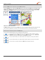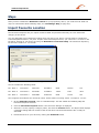
1
PLND 35 SOFTWARE MANUAL www.pyleaudio.com User's Guide Destinator 1. Limited Product Warranty Destinator Technologies, warrants to the Client that the Products shall substantially conform to Destinator Technologies’ specification for a period of one (1) year from the date of the original purchase by the end user (the "Warranty Period"). As Destinator Technologies' sole obligation and Client's exclusive remedy for any breach of warranty, Destinator Technologies agrees, at its sole option, to (i) use reasonable efforts to repair the Product with new or refurbished replacement parts; (ii) replace the Product with a new or refurbished unit; or (iii) refund the purchase price, provided Client returns the defective Products to Destinator Technologies with proof of purchase and Destinator Technologies’ authorization. Destinator Technologies’ warranty hereunder does not apply in case of any damage caused by accident, abuse, misuse, misapplication, or alteration of any kind performed by anyone other than Destinator Technologies. The Products are not designed or licensed for use in mission-critical applications, or in hazardous environments, requiring fail-safe controls, including without limitation operation of nuclear facilities, aircraft navigation or communication systems, air traffic control, or life support or weapons systems. Without limiting the generality of the foregoing, Destinator Technologies specifically disclaims any express or implied warranty or condition of fitness for such purposes. Destinator Technologies’ warranty does not, in any event, apply to physical damage to the surface of the Product or replacement. Destinator Technologies shall have no obligation with respect to any data stored in the Product. Except as expressly stated in this section, Destinator Technologies makes no warranties or includes any conditions with respect to the products, express or implied, including, but not limited to, the implied warranties or conditions of merchantability, fitness for a particular purpose and no infringement. 2. Liability Limitation. In no event shall Destinator Technologies, be liable to Client, (and Client hereby waives any indirect, special, incidental, or consequential damages in connection with) the transactions contemplated by this agreement, whether or not such damages were foreseen, or their likelihood disclosed. Destinator Technologies shall not be liable to Client or any third party claiming through Client, for any damages of any kind in excess of the amounts paid by Client under the terms of this agreement with respect to the products giving rise to such damages. Some jurisdictions do not allow the exclusion of or limitation on implied conditions, warranties or damages, thus some of the foregoing may not apply to Client. 3. Intellectual Property Rights. Hardware and Software are proprietary to Destinator Technologies or its suppliers and are subject to copyright and other intellectual property laws. Client's only rights with respect to any Destinator Technologies software included with the Products shall be provided, under the terms of Destinator Technologies’ software license. The title to all Destinator Technologies Software remains with Destinator Technologies. Client agrees that Destinator Technologies retains ownership of all rights, title and interest in all intellectual property, works of authorship, trade secrets and like’s in all aspects of the Product(s). Client and its affiliates and subcontractors agree not to reverse engineer any aspect of the Software and/or Products supplied under this agreement and further agree to pay assessed damages should such action take place. 4. Copyright and Copies. The Software (including any copy thereof) is owned by Destinator Technologies or its suppliers and is protected by United States, Canada, European, Brazilian and Australian copyright and patent laws and international treaty provisions. The Software copy is licensed to you the client, not sold to you, and you (the client) are not an owner of any copy thereof. You may make one copy of the software for backup or archival purposes. You may not otherwise copy the software, except as authorised by applicable law, nor the written materials accompanying the Software. Destinator Technologies hereby reserves all rights not explicitly granted in this license agreement. Copyright © 2006, Destinator Technologies Part Number: 11nl60_UK Contents 1- Introduction 2 Destinator Features .......................................................................................................................................2 Destinator Guided Tour ................................................................................................................................2 2- Getting Started 3 Menus ...........................................................................................................................................................3 Main Map......................................................................................................................................................6 GPS Not Found.............................................................................................................................................7 Map Views....................................................................................................................................................8 Point on the Map...........................................................................................................................................8 Screen Buttons ..............................................................................................................................................9 Cycling Through Screens..............................................................................................................................9 3- Search for a Location 10 Enter Address..............................................................................................................................................10 Recent Locations.........................................................................................................................................14 My Favourites .............................................................................................................................................15 POI (Points of Interest) ...............................................................................................................................18 My Contacts (Optional) ..............................................................................................................................20 Traffic Information (Optional)....................................................................................................................21 Route Manager............................................................................................................................................25 Map Manager..............................................................................................................................................28 Extras ..........................................................................................................................................................30 4- Settings 35 Prompts .......................................................................................................................................................35 Language Settings.......................................................................................................................................35 Look & Feel Settings ..................................................................................................................................35 GPS Settings ...............................................................................................................................................36 5- Installation Requirements 37 PC Requirements ........................................................................................................................................37 Installing the Console .................................................................................................................................37 Console Toolbar..........................................................................................................................................38 Maps ...........................................................................................................................................................39 Import Favourite Location ..........................................................................................................................39 Exporting a Favourite Location from the Device........................................................................................40 Quick Activation.........................................................................................................................................41 6- Maps 42 Map Screen Interface ..................................................................................................................................42 Installing a Map ..........................................................................................................................................42 Map Cutter Screen Interface .......................................................................................................................42 Focus the Map.............................................................................................................................................44 Cut Map ......................................................................................................................................................45 Load Map....................................................................................................................................................45 Remove Map...............................................................................................................................................45 7- System Settings 46 Volume Settings..........................................................................................................................................47 Power Settings ............................................................................................................................................47 Backlight Settings .......................................................................................................................................47 Date-Time Settings .....................................................................................................................................48 Language Settings.......................................................................................................................................48 System Information.....................................................................................................................................48 Index User's Guide Destinator 49 i 1 - Introduction Welcome to the world of mobile navigation! With Destinator, you can steer into a new era of mobile navigation. Simple operation, clear maps in 2D or 3D mode as well as numerous innovative features and functions have made Destinator the essential guide for every traveller – whether in the car, on foot or by bike. Destinator Features Destinator provides the following features for easy navigation: Route calculation within seconds High quality 2D/3D maps with display of street names· QuickNav button for travel to a predetermined address Address input via a full-size keyboard optimized for finger input Storing of any location one click away Cross border navigation without switching maps Address retrieval from History, Favourites, Points of Interest (POI) or Microsoft® Outlook® contacts Planning and optimising of multi-stop trips· Car navigation with fastest or shortest route Pedestrian navigation in parks and town centres Fast installation, no activation Short tutorial for an easy start· Day and night views or turn-by-turn information Real time, high accuracy traffic data Destinator Guided Tour When you first start the Destinator navigation system, a message box appears prompting you to open the Destinator Guided Tour program. The Guided Tour is an excellent way of becoming familiar with the different navigation features available. You can also start the Destinator Guided Tour any time, by tapping the Tutorial button from the Extras menu. User's Guide Destinator 2 2 - Getting Started Menus Destinations – (see "Destinations Menu" on page 3) menu - Provides the central navigation features, such as Addresses, Recent Locations, My Favorites, POI (Points of Interest), and My Contacts. Options (see "Options Menu" on page4) menu - Provides 2D/3D and Day/Night map view options, Traffic Info. functionality and the following submenus: o Route Manager (see "Route Manager Menu" on page 4) - Displays features relating to route information, avoiding roads, and setting up a QuickNav route. o Map Manager (see "Map Manager Menu" on page 5) - Displays features relating to selecting maps and specifying map settings. o Extras (on page 5) - Displays Destinator’s add-on features Settings (see "Settings Menu" on page 6) menu - Provides setting options to configure the navigation system. button from the Main Map screen to display the Destinations menu, as shown You can press the below. Destinations Menu The Address button lets you navigate to an address, as described in "Enter Address" (see on page 10). The Points of Interest button lets you navigate to thousands of interesting places. For more information, see "POI (Points of Interest) (on page 17)". The Recent Locations button lets you navigate to a previously visited destination, as described in "Recent Locations (on page 14)". The My Favourites button lets you navigate to a favourite location, as described in "My Favourites (on page 15)". The My Contacts button lets you navigate to an address saved in your Contacts folder, as described in "My Contacts (on page 19)". Figure 2 - Destinations Menu The Cancel Route button stops the current navigation. The Map button lets you return to the Main Map screen. The Quit button lets you close the Destinator Navigation System. The More button lets you move between the Destinations and Options menus. User's Guide Destinator 3 Getting Started Options Menu Traffic information from FM radio transmissions is received by the TMC-enabled GPS receiver and monitored by your navigation software. For more information, see "Traffic Information (on page 21)". The Day/Night Mode toggle button lets you display the map view for either day or night driving. For a display of day and night maps, see "Map Views (on page 8)". Figure 3 - Options Menu The 2D/3D Mode toggle button lets you display the map view in 2 dimensional or 3-dimensional views for either day or night driving. For a display of 2D and 3D maps, see "Map Views (on page 8)". The Map Manager button displays a menu that lets you select from the following map buttons: Select Map, Pedestrian Mode, Free Map Browsing , Units of Measure, and Map Settings. For more information, see “Map Manager (on page 28)”. The Extras button displays a menu that lets you select additional Destinator features. For more information, see “Extras (on page 30)”. The Route Manager button displays a menu that lets you select from the following route buttons: Show Route, Turn-byTurn, Route Playback, Avoid Road, and QuickNav. For more information, see “Route Manager (on page 25)”. Route Manager Menu The Turn-by-Turn button lets you display the complete, stepby-step directions to your destination. For more information, see "Turn-by-Turn List (on page 25)". The Route Summary button lets you display your complete route on the Map screen. This button is disabled when no route exists. The Avoid Roads button lets you avoid a road type, such as toll roads or selected streets, as described in "Avoid Roads (on page 26)". Figure 4 – Route Manager Menu The QuickNav Settings button lets you specify an address or place to which you can navigate with a single tap on the QuickNav button. For more information, see "QuickNav (on page 28)". The Route Playback button lets you record your route and play it back later. For more information, see "Route Playback (on page 28)". User's Guide Destinator 4 Getting Started Map Manager Menu The Select Map button lets you choose among different maps on your memory card. For more information, see "Select Map (on page 29)". The Pedestrian Mode/Driving Mode button lets you toggle between travelling as a pedestrian or in a vehicle. When in Pedestrian Mode, you are not limited by vehicle constraints, such as one way streets. Note that you can only generate a route up to ten kilometres and Voice prompts are not available. The Units of Measure button lets you specify the system measurement units. For more information, see "Units of Measure (on page 30)". Figure 5 – Map Manager Menu The Map Settings button lets you specify map orientation, font, and zoom features. For more information, see "Map Settings (on page 30)". The Free Map Browsing button lets you browse the map unconnected to the current location. In this mode, the GPS system is not used. Your current position is not detected and Destinator does not keep track of your driving progress. Extras The Multi-Stop Planner button lets you designate several stops on a route, as described in "Multistop Planner (on page 30)". The Tutorial button opens the Destinator Guide Tour program. The Guided Tour is an excellent way of becoming familiar with the different navigation features available. Figure 6 - Extras Menu User's Guide Destinator The SMS Inbox button lets you set a route by an address received through an SMS message, as described in "Navigating to an SMS Address (on page 32)". Note: This feature is available in PhoneEnabled devices only. 5 Getting Started Settings Menu The button, at the bottom of the Options menu, lets you configure your settings options. The Prompts button lets you specify the types of voice or visual prompts that you want to use. For more information, see " Prompts (on page 35)". The Language button lets you select the language for announcing travel prompts, street names, and driving directions. For more information, see “Language Settings (on page 35)”. The GPS button lets you configure the GPS settings. For more information, see "GPS Settings (on page 36)". The Help button opens the Destinator help file. Figure 7 - Settings Menu The About button opens an information box, providing version and copyright information. The Look & Feel button lets you select a different skin. For more information, see “Look & Feel Settings (on page 35)”. Main Map You can use the icons displayed on this screen to plan and view your route. Figure 8 - Map Screen User's Guide Destinator 6 Getting Started Current location in Vehicle Mode. Current location in Pedestrian Mode. Last known location when GPS signal is unreliable. Generated route Travel direction The red GPS receiver means that a reliable GPS signal is not yet located. The green GPS receiver means that a reliable GPS signal is located and that you are ready to navigate. These icons display your power source, electricity or battery. The battery appears as green, yellow, or red depending on whether the battery is recharged or weak. The GPS bar is a toggle button that displays the remaining travel distance and travel time, estimated time of arrival, street name and address number, and speed and altitude. When you have calculated a route, the Directions bar displays information about your next turn. Click this bar for a complete list of turn-by-turn directions. GPS Not Found When you first start your navigation device, you will hear the message "Signal too low". This message means that your navigation device hasn’t yet located a reliable GPS signal. Check that your device is connected to the cigarette lighter and has a clear view of the sky. The “GPS not found” message means that there is no GPS antenna or the antenna is not properly installed. For more information about GPS, see GPS Settings (on page 36. Please check that: The GPS antenna is extended or flipped up. The GPS antenna has a clear view of the sky for uninterrupted GPS reception. Destinator cannot calculate the route if there is no GPS reception (for example, in a tunnel). The navigation device is charged or connected to the cigarette lighter. User's Guide Destinator 7 Getting Started Map Views From the Options menu, you can determine whether you want to see a two-dimensional or threedimensional map in daylight or night-time conditions. Figure 9 - 2D Day Map View Figure 10 - 2D Night Map View Figure 11 - 3D Day Map View Figure 12- 3D Night Map View Point on the Map You can navigate to any point by tapping its location directly on the Main Map screen in both 2D and 3D map view. This feature is especially handy when you want to navigate to a specific point on the map, but you don’t have the street address. When you tap on the map, the context menu appears. Go There – This button lets you calculate a route from the map point. Add to My Favourites – This button lets you save a point on the map as a favourite destination. This is helpful if you see a location that you want to return you later. Set as Origin –This button lets you designate the selected point as the starting point and not the designation. This is helpful when you want to calculate a route from a point other than your current location. Tap the Free Map Browsing button to disconnect from the GPS receiver. Send SMS Message – If you are using a phone-enhanced navigation device, you can send your current location in an SMS message. For more information, go to "Sending an SMS Address (on page 33)" . Figure 13 - Point on the Map Options User's Guide Destinator 8 Getting Started Screen Buttons The following buttons appear on many of the navigation Destinator screens. When you tap the Next button for a selected address, group, or place, Destinator automatically opens the next screen in the sequence. When you tap the Back button, Destinator returns you to the previous screen. When you tap the GO button, Destinator calculates the route to your selected destination. The Actions button provides a list of command options available for the selected address or place. The Save, OK, or Done buttons confirm your value preferences and returns you to the menu or map. Cycling Through Screens Every navigation function in the system, such as Address, POI, or My Favourites consists of a sequence of screens. You can cycle through the screen sequences by either: Selecting an item from the list and tapping it. Selecting an item form the list and tapping the Next button. The sequence ends with the Show on Map screen, where the destination is displayed and the GO button is available for you to calculate a route. Note: You must first select an item for Actions, Next and Back buttons to be enabled. User's Guide Destinator 9 3 - Search for a Location Enter Address When you click the Address button, the Address screen appears as shown below. Figure 14 - Display the Address Screen Note: For United States maps, an additional States Address screen appears. User's Guide Destinator 10 Search for a Location You can use the keyboard to enter the characters of the address name. The characters appear in the Address field. Destinator automatically searches the Address list for the first occurrence of the entered characters. After you have selected a city, Destinator displays the next address field, such as street and address number. You can also tap the Next button to move through the sequence of address screens. The following command keys are available to enhance your search process: If the automatic search feature does not find your specified name, use the Find button to conduct a sub-search, particularly useful when the address name consists of two or more words. The Scroll buttons let you move up or down the list of address items, such as town or street names. The Hide/Display Keyboard toggle button lets you extend or shorten the address list by hiding or displaying the keyboard. Note: The keyboard is automatically hidden, displaying the address list only, when the number of address search results fits on a single screen. If the search results do not display the desire address, display the keyboard and enter additional search characters. The Select key lets you display lowercase, numeric, and special characters This button also displays different alphabet characters (for example, Greek). The operating system installed on the device must be able to support these characters. The Erase key lets you delete the last character in an address field. You can change your address search method by tapping the Mode button to select from a variety of address formats, as described in "Address Modes" (on page 11). Note: If the entered characters are not found at the beginning of the name in the Address list, the Smart Search System automatically searches for the entered characters throughout the entire list, for example, in the middle or the end of the name. Destinator lets you search for city and street names without having special characters, such as umlauts or accent marks, which are used in many European languages. Address Modes You can define the information used to locate an address by tapping the provides a variety of options for entering an address. button. Destinator State-City For United States maps only. This sequence provides the following address screens: State, City, Street, Address Number Town-Street This sequence provides the following address screens: Town, Street, Address Number For every city, you also have the option of selecting the City Centre. If you don't know address number, you can select the Street Midpoint. Town-Street is the default format. User's Guide Destinator 11 Search for a Location Street-Town This sequence provides the following address screens: Town, Street, Address Number This mode lets you enter a street name without having to first designate a town. Useful when you're looking for an address in a metropolitan area where there are many cities and towns. Side Streets This sequence provides the following address screens: Town, Street 1, Street 2 You can locate a road junction by entering the names of two intersecting streets. Post Code This sequence provides the following address screens: Post Code, Street, Address Number You can locate a street address by entering the post code, without entering a town name. Useful when you have no information about the town. In Other Maps You can select another map of a country that you can travel to by vehicle. This feature is available only when you have the following maps installed: Map of the country where you are currently located. Map of the country where you wish to travel. The map of the major roads for that continent that connect one map to another (for example, the major roads of Europe) For example, if you are in Paris and you want to travel to Munich, select the map of Germany and designate Munich Town Centre as your destination. Destinator automatically displays the map of France when travelling on local roads of that country, a map of Major Roads of Europe when travelling on a European motorway, and the map of Germany when travelling on local roads of that country. Address Actions When you have specified an address, tap the Actions button to select from the following Address commands: Set as Origin Lets you designate the selected location as the route origin. You would use this command when calculating a route from a point other than your current location. Tap the Free Map Browsing button to disconnect from the GPS receiver. Show on Map Lets you see the selected address on the map. User's Guide Destinator 12 Search for a Location Add to My Favourites Lets you add an address to your list of favourite locations, as shown in the figure below. For more information, see "My Favourites". Figure 15 - Add Address to My Favourites If you are using a phone-enabled navigation device, you can send your current location in an SMS message. For more information, see "Sending an SMS Address" (on page 33). Go to your Destination After you have specified the address, tap the Next button. Destinator shows your destination on the Map screen before calculating a route. Check that the destination address is correct at the top of the screen. If you want to change the destination, tap the Back button and change your address entries. Figure 16 - Calculate your Destination When you have specified the address, you can instruct Destinator how to calculate your route by tapping either the Quick or Short button. This option selects the route that takes the least amount of time. Quick is the default value. This option selects the route that is the shorter distance. Remember, the shorter route may not always be the quickest, as you are able to travel faster on some roads than on others. When you are ready, tap the button to create a route to your selected destination. Note: Route generation excludes any detours, stops or delays along the route. User's Guide Destinator 13 Search for a Location Recent Locations The Recent Locations screen lets you select an existing destination from a list of destinations that you have previously travelled to. Destinator automatically stores the last 64 destinations in memory. As each new route is added to the top of the list, the older destinations at the bottom are erased. To navigate to a recent destination, tap the Recent Locations button. From the Recent Locations screen, select a location and tap the Show or Next button. A map appears showing the specified location. Tap the GO button to calculate the route. Figure 17 -Travelling to a Recent Location User's Guide Destinator 14 Search for a Location From this screen, you can tap the Actions button to select from the following command options. Set as Origin Lets you designate the selected location as the route origin. You would use this command when calculating a route from a point other than your current location. Tap the Free Map Browsing button to disconnect from the GPS receiver. Delete Item Lets you delete a recent location. Clear List Lets you clear all locations in the Recent Locations screen. Send SMS If you are using a phone-enabled navigation device, you can send your current location in an SMS message. For more information, see "Sending an SMS Address (on page 33)". Information This button displays the location’s address information. My Favourites A Favourite is a destination that you have stored for easy retrieval. To access a favourite destination, open the Destinations menu and tap the My Favourites button. The My Favourites screen displays your favourites groups. When you tap on a selected group, Destinator automatically displays its stored locations. Tap the selected location to show your destination on a map. Tap the GO button to calculate your route. Figure 18 - Travel to a Favourite Location Note: The My Favourites folder is the default folder where all favourites are stored if not assigned to a group. The Show Map screen also lets you set your route type, Quick or Short. For more information, see "Go to your Destination" (on page 13). User's Guide Destinator 15 Search for a Location Favourite Groups You can tap the Actions button from the My Favourites screen to add, edit, or delete groups, as described below. Add Group When you tap this button, the Favourites Group screen appears. Enter the group name and select an icon to identify the group, as shown below. Figure 19 - Create Favourites Group The icon identifies all destinations located in that group, as displayed on the map. Edit Group When you tap this button, the Favourites Group screen appears with the name and selected image of the highlighted group. You can change the name and icon. Delete Group When you tap this button, the selected group and its associated entries are removed. The My Favourites group cannot be deleted. Favourite Alerts Alerts let you know that you are within a certain distance of a favourite location. You can tap the Alerts button to set the distances for the 1st and 2nd Alerts. When you travel closer than the designated distance, the alert will sound, as shown below. Figure 20 - Setting Your Favourite Alerts User's Guide Destinator 16 Search for a Location Notes: Favourite Alert settings affect all Favourites Groups. The 2nd Alert must be set to go off at closer distance than the 1st Alert. Alerts can be set for a group but not for individual locations. Of course, you can always create a group that has just one location. You can disable the alerts for all groups by selecting the 1st Alert setting to Off. You can disable the alerts for a particular group by removing the tick next to the selected group. Activate that disabled alert by adding a tick next to the selected group. Figure 21 - Disabled Favourite Alerts Add Favourite Locations Tap MY FAVOURITES or any selected group that you have created to display its locations. You can save a location to your favourites groups from the Address, Recent Locations, or POI screens. For more information, see "Add to My Favourites (on page 13)". Favourites Actions From this screen, you can tap the Actions button to display the following commands. Set as Origin Lets you designate the selected location as the route origin. You would use this command when calculating a route from a point other than your current location. Tap the Free Map Browsing button to disconnect from the GPS receiver. Show Map Lets you see the selected address on the map. Edit Favourite Location Lets you change the name, comment, or group location for the selected location. Delete Favourite Location Tap the button to remove the selected location. Send SMS If you are using a phone-enabled navigation device, you can send your current location in an SMS message. For more information, see Sending an SMS Address (on page 33). Information This button displays additional address information, such as address details, phone number, and other comments about your favourite location that you have entered. User's Guide Destinator 17 Search for a Location POI (Points of Interest) The POI list is a collection of hundreds of interesting or useful places organised by easy-tofind categories. For example, you can use Destinator to guide you to a shopping centre, hotel, restaurant, or petrol station. From the Destinations menu, tap the Points of Interest button. The POI screen appears. You can find a category by tapping the Hide/Display Keyboard button and entering text in the POI Category field. The Smart Search System automatically displays the POI categories that match the characters entered. If you didn’t find the category through the initial search you can also use the Find button to do a sub-search, particularly useful when the category name consists of two or more words. You can always browse the POI Category list by using the Scroll buttons. When selecting a category, Destinator automatically displays the category entries and the distance each entry is from your current position. Select your entry and tap or click the Next button to display your selected destination on the map and then tap the GO button to calculate your route. From the Show on Map screen, you can designate a route type, Quick or Short. For more information about calculating a route, see "Go to your Destination (on page 13)" on page 13. Figure 22 – Points of Interest Note: From the Actions screen, click the Sort by ABC button to display the category entries in alphabetical order. Subcategories Many categories have subcategories to provide for an even greater list of choices. For example, “Petrol Station” may have many subcategories each representing a particular brand name. The same is also true for Hotels. Restaurants have subcategories that represent different types of food, such as Indian, Italian, and French, as shown below. Figure 23 - POI Subcategories User's Guide Destinator 18 Search for a Location Search Near a Location You can tap the Near button to determine the location area, where you want to search for a specific place, such as a petrol station, hotel, or restaurant. The available options are listed below. Current Location Lets you search near your current location. This is the default value. Destination Lets you search near a specified destination. For example, you know your general destination, but not very much about interesting locations in the area. You can use Destinator to locate the tourist attractions close to your destination. Note that this button is enabled only when a destination is entered. Other Address Lets you search near another address. For example, you have set a destination, but on the way you want to stop at another location. You can use this feature to search near that location for restaurants, lodging, historical sites, or other locations. Search Radius Enter the location distance to search for a designated place. For example, if you enter 5 km, Destinator only searches within a five kilometre radius. When you select a large search radius, you risk the chance of finding too many locations, which makes it harder to find the place that you are searching for. It is best to start with a small search radius size, and then increase the radius size if necessary. Note: if you don’t specify a search radius, Destinator searches the whole map and displays the locations according to the distance from you. Show or Hide Symbol on Map You can add or remove the ticks next to a POI entry to show or hide the POI symbol on the Map. POI Actions When you have selected a POI location, tap the Actions button to display the commands listed below. Set as Origin Lets you designate the selected location as the route origin. You would use this command when calculating a route from a point other than your current location. Tap the Free Map Browsing button to disconnect from the GPS receiver. Show on Map Lets you see the selected address on the map. Add to My Favourites Lets you add an address to your list of favourite locations, as shown in the figure below. For more information, see "My Favourites". Sort By ABC or Distance Lets you sort the entries of the selected category alphabetically or by distance from your current location. Note: Destinator initially displays the entries by distance. Send SMS If you are using a phone-enabled navigation device, you can send your current location in an SMS message. For more information, see "Sending an SMS Address (on page 33)". Information This button displays the location’s address information. User's Guide Destinator 19 Search for a Location My Contacts (Optional) You can specify a contact address as a destination, by selecting a contact from your PC folder, found under the Start menu. From the Destinations menu, tap the My Contacts button to display your list of contacts. Select a contact and click Next to display the addresses entered for the contact. From the Contact Address screen, tap Next to display the similar addresses that are recognised by Destinator. Select a Destinator address and click Next to show the location on the map. Tap the GO button to instruct Destinator to navigate to the selected address. Figure 24 - Locating a Contact's Address When you tab the Actions button, you can choose from the following options: Add to My Favourites Lets you add an address to your list of favourite locations, as shown in the figure below. For more information, see "My Favourites". Set as Origin Lets you designate the selected location as the route origin. You would use this command when calculating a route from a point other than your current location. Tap the Free Map Browsing button to disconnect from the GPS receiver. Send as SMS If you are using a phone-enabled navigation device, you can send your current location in an SMS message. For more information, see "Sending an SMS Address (on page 33)". User's Guide Destinator 20 Search for a Location Traffic Information (Optional) What is the Traffic Message Channel? The Traffic Message Channel (TMC) is a specific application of the FM Radio Data System (RDS) used for broadcasting real-time traffic and weather information. Data messages are received silently, decoded, and delivered to a TMC-enabled navigation system that can offer dynamic route guidance – alerting the driver to a problem on the planned route and calculating an alternative route to avoid the incident. Coverage of the Service TMC Services cover nearly all of Western Europe. Each service is transmitted by a national, regional, or local broadcaster. TMC Service provides traffic information for monitored roads only, motorways and main roads. TMC radio transmissions reception can change from area to area, depending on weather conditions, static electricity, power lines, and other natural or man-made conditions. Disclaimer Destinator Technologies is not responsible for any damage caused by an accident due to unreliable TMC radio transmissions by national, regional, or local broadcasters caused by TMC service restrictions, or by natural and man-made conditions that prevent real-time traffic and weather information from being delivered to the TMC-enabled navigation system. Destinator Technologies is not responsible for the quality or accuracy of the events broadcast and the method by which they are displayed. TMC Antenna Installation Installing the TMC Antenna: 1. Place the wired antennas horizontally in the car using the rubber stickers provided. It is recommended that the antenna be attached to the windscreen. Please note that some car models (especially French) use coated windscreen glass and placing the radio antenna on other windows is therefore recommended on these cars. 2. The TMC system automatically locates the frequency of the closest radio station and recommends an alternate route when traffic events (such as congestion or an accident) are detected. For more information, please refer to the user manual. 3. Other traffic events – such as General Information, Roadworks and Weather – are also monitored to let the user avoid these events manually. Destinator Traffic Service Destinator provides the following traffic service: 1. The Destinator Traffic Engine monitors the events relevant to your route only. 2. Destinator automatically calculates the best alternative route. 3. Every 5 minutes, Destinator re-evaluates the traffic conditions and route accordingly. 4. No additional registration or activation is required. Simply use your device in the way you are used to. User's Guide Destinator 21 Search for a Location Traffic Info Alert Traffic (TMC) messages are national and regional FM radio broadcasts that are used to inform drivers of traffic, weather, and other driving conditions, as shown below. The Traffic Alert icon appears each time a traffic event is encountered. The alert description is displayed in the TMC Inbox screen, which can be opened by tapping on the Traffic Alert icon. Figure 25 - Traffic Info Alert Note: Some car models (especially French) use coated windscreen glass, and placing the radio antenna on other windows is therefore recommended on these cars. An alternative solution is to install an Antenna Splitter that lets you use your usual radio antenna. For more information about the Antenna Splitter, please go to http://www.gns-gmbh.com TMC information is received by your TMC-enabled GPS receiver and monitored by your software. Destinator can automatically reroute your travel to avoid areas that TMC indicates are troublesome to drivers. For instance, if there is a storm or accident in your vicinity, your route would be recalculated to avoid the problem. User's Guide Destinator 22 Search for a Location Note: Please go to http://www.tmcforum.com for information about European countries that provide TMC service. A TMC receiver is required to receive TMC broadcasts. From the Options menu, select the Traffic Info button, which opens the TMC inbox, and displays traffic reports. You can select a traffic report and click Next to show a map of the affected road. If you click the Avoid button, Destinator recalculates your route. Note that if the event was avoided, the Show Map screen displays the Allow button to recalculate to that previously avoided route section. Figure 26 - Traffic Info Events All TMC messages are delivered to the TMC Inbox, but only messages relating the direct route and a 200 metre radius are displayed. The radius is set to 160 kilometres when no route has been selected. Note: It is strongly recommended that you let Destinator automatically scan and lock onto the TMC stations and do not manually search for a TMC station. You can use the following buttons to go to a different radio frequency: Lets you search for a traffic channel at a lower frequency. When a station is located, Destinator checks for TMC data. If there is no TMC data for this station, Destinator continues to scan until a radio station with TMC data is located. Lets you make minimal (0.1) steps toward a lower frequency to bring in the channel. Lets you make minimal (0.1) steps toward a higher frequency to bring in the channel. Lets you scan for a traffic channel with TMC data at a higher frequency. User's Guide Destinator 23 Search for a Location TMC Options You can tap the Options button The Traffic Information Options dialogue box is displayed, as shown below. Figure 27 - Defining Traffic Information Settings You must configure the Traffic Message Channel (TMC) be defining the following settings: When an event occurs: You can select either: Automatically - Destinator automatically recalculates the route to avoid a road with adverse traffic conditions – traffic jam or accident only. Manual - You can manually select the TMC event from the inbox and tap the Avoid button from the Show Map screen. Search for TMC Stations: Automatically - Destinator automatically scans the FM radio frequencies until a TMC station is found. Should you lose the station frequency, Destinator will automatically scan for a new TMC station. Manual - You can use the frequency keys to scan for a TMC station [Not advised]. Test TMC When you tap this button, Destinator expands the search radius for to the "Whole Map" for one minute, switches automatically to the TMC Inbox screen and displays a test message called "Testing TMC Service". After one minute, Destinator reverts to the route and the 200 metre radius.” If you do not receive a message after tapping this button, please check in the following sequence: The TMC receiver is locked on to a TMC station. If not, reconnect your TMC receiver If you see the tuner scanning but not locking on to a TMC station, try to change your position and check that your antenna is vertical. Depending on your location, you might not have TMC coverage. Check that you are using the map of the country that you are currently travelling in. User's Guide Destinator 24 Search for a Location Traffic Info Map Icons You can display Traffic Info. icons on the main map by selecting the Traffic Info. radio button in the GPS Connection Settings screen. This icon appears only when you have activated the TMC from the GPS Connection Settings screen. You can tap the TMC icon to display the TMC Inbox screen. The Route Alert icon appears in place of the TMC icon, notifying you that there are relevant TMC messages in your inbox Route Manager From the Options menu, tap the Route Manager button to display Destinator’s route navigation features, as described in the sections below. Turn-by-Turn List When you display the Turn-by-Turn screen by tapping the Directions Bar on the main map, the Turn-byTurn list changes as you navigate the route. After you have entered a destination and calculated a route, the Directions bar appears on the Main Map screen, displaying the following information: The next turn direction The distance to the next turn The street name of the next turn When you tap the Directions bar, Destinator displays a complete set of turn-by-turn directions from your current point to your selected destination. You can also tap the Turn-by-Turn button to display the direction list. Use the Scroll buttons to move up or down the directions list. Figure 28 - Turn-by-Turn Display The following options are available: The Route Summary button displays your entire route on the Map screen, plus the travel distance and the Estimated Travel Time Remaining (ETR). The Show Turn button displays the next turn on the Map screen, including the street name, the distance to it, and the turn direction. The Avoid button lets you avoid the selected turn in the directions list. Destinator recalculates the route automatically. Note that when you exclude a turn, the recalculated route may take longer. User's Guide Destinator 25 Search for a Location Route Summary or Cancel Route The Route Summary button lets you display an overview of your complete route on the Map Manager screen, the total driving distance to your destination, the estimated travel time, and the complete destination address. The Cancel Route button, in the Destinations menu, stops the current navigation and clears the route. This feature is active only after a destination has been set. Avoid Roads You can specify that certain roads be permanently excluded from your route calculations. Use this feature when you want to avoid congested roads, toll roads, or unsafe streets. From the Route Manager menu, tap the Avoid Roads button. The Avoid Roads screen appears, displaying the Toll Roads and Avoid Road groups. Figure 29 – Creating Avoid Road Groups Avoid Road Groups From the Avoid Roads screen, tap the Actions button. The Actions screen lets you select from the following commands: Add Group Create a new a group of roads to avoid. For example, you can create a group called “Country Roads”, where you designate the roads in that area to be avoided. When you tap the Add Group button, the Avoid Roads Group screen appears. Enter the group name and tap Save. Edit Group Select a group and tap this button to change the group name. When you tap the Edit Group button, the Avoid Roads Group screen appears displaying the group name. Change the group name and tap Save. The new name is displayed on the Avoid Roads screen. User's Guide Destinator 26 Search for a Location Delete Group Select a group and tap this button to remove the group from the Avoid Roads screen. The road entries in this group are also removed. When selecting a group route, you can tap the roads located in the group. or buttons to include or exclude all Avoid Road Locations When you tap Default or an Avoid Roads group, Destinator displays the group screen, which lets you select roads to avoid. From this screen, you can use the Allow or Avoid buttons to include or exclude a selected road when calculating a route. Figure 30 - Adding a Road to Avoid Note: You cannot specify a particular toll road. You can tap the Actions button from this screen to select from the following commands: Add Road Lets you select a road. An address screen appears for you to specify a town and street. When you have completed updating your road information, tap Save. Edit Road Lets you rename the road and select a different group. When you have made your changes, tap Save. Delete Road Select a road and tap this button to remove the road from your group. Destinator no longer avoids the removed road. Show on Map Lets you show the map with the displayed destination for you to review before creating a route. Information This button displays the location’s address information. User's Guide Destinator 27 Search for a Location Route Playback This feature lets you record your route as you’re driving and then to play it back on the Main Map screen. From the Route Manager menu, tap the Route Playback button. To record a route, tap the Record button in the Route Playback screen. Destinator shows the Main Map screen and navigates you to your selected destination. To stop recording, return to the Route Playback screen and tap the Stop button. To playback your recording, select the data file, and tap the Play button. Destinator shows the Map screen to play the recorded route. To stop the playback, return to the Route Playback screen and tap the Stop button. Route Playback Actions You can tap the Actions button to display the following commands: Delete Recording This button lets you remove a selected recording. Clear All Recordings This button removes all recordings. Playback Speed Use the arrow keys to adjust the playback speed. The range is from 100% to 300%. Quick Navigation You can define the QuickNav location by selecting either the To Predefined Address or To Nearest POI Category in the QuickNav Settings screen. When the location is selected, you can navigate to your address by tapping the QuickNav button displayed on the Main Map screen. For example, if you have selected "Gas Stations" as the QuickNav destination, when you click the QuickNav from the Main Map screen, Destinator automatically creates a route to the closest gas station. Figure 31 - Setting the QuickNav Location Map Manager From the Options menu, tap the Map Manager button to display Destinator’s map navigation features, as described in the sections below. User's Guide Destinator 28 Search for a Location Select Map This feature lets you change the currently selected map to another map saved on your SD memory card. If you want to store additional maps on your memory card, see “Maps” on page 1. You can tap the Select Map button to display the maps saved on your SD memory card. The Select Map screen displays map details and version numbers. The map currently used appears at the top of the list. Figure 32 - Select a Map You can choose from the following Select Map commands: Refresh Lets you refresh the screen when a new memory card is inserted into the device. Delete Lets you permanently remove a selected map. Note: You cannot delete the current map. Select Lets you designate a selected map as the current map. Pedestrian Mode The Pedestrian Mode button lets you toggle between travelling as a pedestrian or in a vehicle. When in Pedestrian Mode, you can generate a route up to ten kilometres and you are not limited by vehicle constraints, such as one way streets. When creating a pedestrian route, Destinator avoids motorways or other roads where pedestrians would not travel. Voice prompts are deactivated in this mode. Free Map Browsing This feature lets you browse the map without the GPS receiver returning you to your current location. Tap the Free Map Browsing button to disconnect from the GPS receiver. When you are ready to reconnect to the GPS receiver, go to the Settings menu and tap the button. From the GPS Signal screen, tap the User's Guide Destinator button. 29 Search for a Location Units of Measure You can tap the Units of Measure button to specify the measurement system you would like to use. You can select: o Miles/Yards o Miles, 10 o Kilometres, Metres th of a Mile Map Settings You can tap the Map Settings button to customize your map display, as shown in the figure below. The following map settings are: Map Orientation Forward is up – This option orients the map so that your forward direction is always at the top. North is up – This option orients the map so that North is always at the top. Use Automatic Zoom When this option is selected, the zoom is speed dependent. The map zooms out at higher speeds, displaying a larger map area, and zooms in at slower speeds, displaying a smaller map area. If you manually change the zoom, the Automatic Zoom returns to a system defined zoom level after several seconds of inactivity. Use Larger Print This option increases the size of street names to make the map easier to read. Extras From the Options menu, tap the Extras button, to display the Destinator add-ons as described in the sections below. Multistop Planner The Multistop Planner lets you plan a route with up to twelve stops. When you tap the GO button, the route is calculated in stages, from the departure point to the first stop. When you reach the first stop, the route recalculates to the second stop, and so on. User's Guide Destinator 30 Search for a Location Figure 33 - Travel to Multiple Routes The Show Map screen provides you with the following route types: Quick and Short. You can select Short (the default value) to calculate a route with the shorter physical distance between your current location and the selected designation. When you tap the GO button, Destinator automatically calculates the faster route. Defining Route Groups A Route Group represents a group of stops. From the Multistop Planner screen, select the Actions button and tap Add Group. From the Add Group screen, enter the Group name and save. The Actions screen also lets you edit or delete a selected group. Figure 34 - Defining the Route Group Setting Stops Along the Route You can set up stops by selecting the Route Group and tapping the Next button. From the Stops screen, tap the Actions button to add, rename, or delete a destination. Add a stop by Address, POI, My Favourites, or Recent Locations. Select one of these options, and specify a location. The selected location appears in the Stops screen. Figure 35 - Specifying a Stop When in the Stops screen, you can use the following commands: Use the Up or Down buttons to change the order of your itinerary. Shows the stop destination on the map and lets you select a route type, Quick or Short. Tap GO to calculate the stop destination. Select the Show button to view the selected stop destination on the map. User's Guide Destinator 31 Search for a Location Stops Actions You can tap the Actions button for the following command options: Set as Origin Lets you designate the selected address as the route origin. You would use this command when calculating a route from a point other than your current location. Tap the Free Map Browsing button to disconnect from the GPS receiver. Add Stop Lets you add a location by specifying an address from recent locations, favourite locations, or pre-defined POIs, such as fuel, food, or lodging. Rename Stop Lets you change the stop information, such as name, comments, or route group. Delete Stop Lets you remove a selected stop. Optimize Route Your trip itinerary is created by the sequence of stops entered. This may not be the most efficient route. When you click Optimize Stops, Destinator changes the order of stops to create the most efficient route. Information This button displays the location’s address information. Navigating to an SMS Address You can navigate to an address received from an SMS message. This feature is available only when both the sender and receiver have phone-enabled navigation devices that run Destinator. When an SMS message is sent to a phone-enabled navigation device, an Alert icon appears on the Main Map screen. Tap this icon to open the SMS inbox and select the SMS message. Tap Next to display the location on the Show Map screen. Tap the GO button to calculate the route to the address in the SMS message. Figure 36 – Receiving an Address by SMS Message User's Guide Destinator 32 Search for a Location SMS Address Actions Tap the Actions button to select from the following commands. Set as Origin Lets you designate the selected location as the route origin. You would use this command when calculating a route from a point other than your current location. Tap the Free Map Browsing button to disconnect from the GPS receiver. Delete Message Lets you delete the selected SMS message. Clear List Lets you clear all SMS messages. Add to My Favourites Lets you add an address to your list of favourite locations, as shown in the figure below. For more information, see "My Favourites (on page 15)" on page 1. User's Guide Destinator 33 Search for a Location Sending an SMS Address If you are using a phone-enhanced navigation device, you can send your current location in an SMS message to someone in your Contacts list. From the Actions menu, click Send Location. The SMS message automatically includes your current address, which can be used by the recipient to calculate the route. To send an address through an SMS message: 1. From the Actions menu, select Send Location. Your Contacts list appears. You can also choose a point on the map and select Send SMS from the context menu. 2. Select the contact and press Send. The SMS Inbox screen appears. 3. The mobile number of your contact is automatically entered into the Mobile # field. You can add a message of up to 20 characters in the Comment box. The Address field displays the location of the destination you have selected. 4. Press Send. A confirmation message confirms that the SMS message was sent. Note: If you want to send an SMS message to someone who is not listed in your Contacts folder, select Your Number when the Contacts list is displayed. Press Send. The SMS Contents screen appears. Enter any valid mobile number into the Mobile # field. User's Guide Destinator 34 4 - Settings Prompts You can select the types of voice and visual notifications that you would like to use while navigating. From the Settings menu, tap the Prompts button. The Prompts screen appears. Voice Prompts Speed Warning Warns you when your car exceeds the speed limit. This prompt is not active by default. Route Recalculation Activated when Destinator recalculates a new route. This prompt is not active by default. Unreliable GPS Signal Warns that the GPS signal is too low and unreliable for navigation. This prompt is automatically active by default. GPS Not Found Alerts you if the GPS signal is lost, or if the power is removed from the GPS receiver. Drive Carefully Reminder at the start of each journey. This prompt is automatically active by default. Visual Prompts Text Directions are displayed as text. Symbols Directions are displayed as symbols. None Directions are not displayed. Language Settings Lets you select the language for text and voice travel messages and driving directions. Look & Feel Settings Lets you select from other preinstalled skins. A skin determines how screens and buttons are displayed. User's Guide Destinator 35 Settings GPS Settings Destinator uses the GPS receiver to pinpoint your location. GPS signals are automatically acquired and your vehicle's location and position are constantly updated unless you are working in the Free Browse Map mode or you tap the GPS Off button. The GPS receiver may take a few minutes to find its initial location. For best results, ensure that the GPS receiver has a clear view of the sky. The following GPS information is displayed: Longitude - The angular distance east or west on the earth's surface. Latitude - The location of a place north or south of the earth's surface. Speed - The rate of movement, as expressed by kilometres or miles per hour. Altitude - The height above sea level. and buttons let you connect or disconnect from the GPS receiver. If you are The working in Free Browse Map mode, Destinator automatically disconnects from the GPS receiver. Tap the GPS Set button to display the following Connection fields: COM Port This field lets you specify the Communications port. Note: Most Bluetooth receivers use COM 6 or COM 8. Most serial receivers use COM 1. Baud Rate This field lets you specify the transmission rate of data. Protocol This field displays the GPS protocol. The default value is NMEA. Note: Most receivers use NMEA 4800. Traffic Info. Select the ON radio button to activate the TMC service. This service lets you enjoy live traffic updates from local broadcasters, including premium toll services in England, France, and Germany. Connect to GPS This button lets you locate the GPS receiver by the values you have entered in the COM, Baud, and Protocol fields. User's Guide Destinator 36 5 - Installation Requirements PC Requirements Minimum System Requirements for PC: o CPU: AMD/ c 3.8 and higher. Intel® Processor (300 MHz or faster) o Operating System: Windows® 2000/XP o Memory: 128 MB RAM (or more) o Free space on hard drive for installation: at least 500 MB o CD-ROM: 4x drive (or more) o Support ActiveSyn Installing the Console To install the Destinator Console: 1. Insert the Destinator Disk into the PC's CD-ROM drive. The Destinator Console Installation Wizard prompts you to select the language used for the installation process. When you have selected a language, click OK. 2. Please read the Welcome message and click Next. 3. Click Next. 4. The Installation Status box displays the progress of the installation process. 5. When the installation is complete, click the Finish button to close the wizard. Note: You can uninstall the Destinator Console by opening the Microsoft Windows Programs menu, selecting DestinatorApps>Uninstall Console. User's Guide Destinator 37 Installation Requirements Console Toolbar The following options are available from the Console Toolbar: Figure 37 – Console Toolbar Install/Remove Maps lets you install or remove a map. For more information, see "Installing a Map (on page 42)". Cut Map Lets you customize an installed map. For more information, see “Map Cutter Screen Interface (on page 42)”. Favorites Importer Lets you download a list of your favourite locations from your PC to the selected My Favourites group on your device. For more information, see "Import Favourite Location (on page 39)". Favorites Exporter Lets you download a category of favourite locations from your device to a selected folder on your PC. For more information, see "Exporting a Favourite Location from the Device" on page 40. Quick Activation (Optional) User's Guide Destinator Lets you activate your Navigation System through an automated process (on page Error! Bookmark not defined.). 38 Installation Requirements Maps After you have installed the Destinator Console to your proprietary device, you must select at least one map. For information about installing maps, see "Installing a Map (on page 42)". Import Favourite Location The Favourites Importer lets you import content created and provided externally as a new Favourites category on the device. You can download a list of favourite locations from your PC to your device. The list must be contained in Comma-Separated Values (.csv) files. As part of the download procedure, you convert the .csv files to .dat format for storage on your device by using the Destinator Conversion Utility. The Favourites Importing file structure must be in .csv format. Figure 38 – Destinator Conversion Utility The file contains the following fields: Fav. Place 1 Comment 1 39.21370 38.78903 8033 Munich 173 Fav. Place 2 Comment 2 24.79360 37.08604 75010 Paris 3013 Fav. Place e Comment 3 44.97889 23.82718 8044 Zurich 123 The Longitude and Latitude are numerical values. All the others are string values. To import a .csv file: 1. On the Destinator Console, click on a Standard Map. This will enable the Installing Map and Favourites Importer features. 2. Click the Favourites Importer button. The Converter dialogue is displayed. 3. Select the .csv file, specify a category name, and click the Convert button. The Report Area displays a message stating that the content of the file has been converted and that the file is ready for download. 4. Download the file to your device by clicking the Download button. User's Guide Destinator 39 Installation Requirements Exporting a Favourite Location from the Device You can export a list of favourite locations from your device to your PC. The list will be stored in CommaSeparated Values (.csv) files. As a part of the export procedure, you convert the .dat files to .csv format for storage on your PC by using the Destinator Conversion Utility. Figure 33 – Favorite Export Destinator Conversion Utility To export a .dat file: 5. Click the Favourites Exporter button. The Converter dialogue is displayed. button and then select the .dat file. Specify a category name, and click the 6. Click the Browse Convert button. The Report Area displays a message stating that the content of the file has been converted and that the file is ready to Upload. 7. Upload the file to your PC by clicking the Upload button. User's Guide Destinator 40 Installation Requirements Quick Activation Note: This section is not relevant for maps of Western Europe and North America. Recommended Registration for Support You can activate Destinator automatically by using Quick Activation. To activate Destinator: 1. Check that your PC has an Internet connection. 2. Check that the navigation device is communicating with your PC through Microsoft ActiveSync. 3. Open the Destinator Console. 4. Click the Quick Activation button from the Destinator Console toolbar. 5. The Quick Activation Welcome screen appears. Please review the information and click Next to continue. 6. The User Information screen appears. Complete the information fields. Note that fields with asterisks (*) require information. Click Next. 7. The Licence Key screen appears. Enter the licence key and select your device type. Click Finish. 8. The Congratulations screen appears. Your Destinator licence key has been activated. User's Guide Destinator 41 6 - Maps Map Screen Interface On the Destinator Console, a collection of available maps is displayed, as shown in the figure below. Standard Maps Maps available for installation. My Maps Maps that have been customized from a standard map. Installed Maps Standard and customised maps that are already loaded on your device. Installing a Map You can install a map by selecting it from the Standard Maps pane in the Destinator Console and clicking the Install/Remove Maps button. The Target Device dialogue box appears. Select either Storage Card (on a mobile device) or Main Memory (on a PC). The amount of memory available for the selected target device appears on the Target Device Memory Balance pane. The installed map appears in the Installed Maps pane. Figure 39 –Installing a Map Map Cutter Screen Interface User's Guide Destinator 42 Maps Due to memory limitations of your device, you may want to customize a standard map by selecting the area you need. You can crop a standard map from the Map Cutter screen. Select a standard map and click the Cut Map button. The Map Cutter screen appears, as shown in the figure below. Figure 40 –Cutting a Map The following tools are provided to help you easily move, view, and designate an area on the map: You can use the Pan tool to move the map up, down, left, or right. You can use the Zoom tool to increase or decrease the map detail. You can also use the scroll bar to zoom in or out. You can use the Crop tool to designate an area on the map that you want to cut. When you have selected your focus by using the focus tools, as described below, click the Crop tool to designate an area on the standard map. You can use the Cut tool to create a customized map from your designated area. User's Guide Destinator 43 Maps Focus the Map The following tools are provided to help you focus your map, so you can designate the area that you want to cut. You can click the Address tool to set the origin of the map to a Town, Street Address, or Road Junction. The Address dialog box provides the Show… and Set… buttons to view and set the map focus. You can click the POI tool to set the origin of the map to a point of interest. The POI dialogue box displays all categories in the left pane. When you click a category, the items associated with the category appear in the right pane. You can click the Show POI and Set POI buttons to view and set the map focus. You can click the Select tool to set the origin of the map by a predefined sub-region. A list of sub-regions is displayed in a pane to the right of the map. When you click a subregion, that area is highlighted. Focus the Map by Route Destinator supports route cutting, which allows you to create a map composed of points on a route. To create the route, you must specify two or more points. After the route has been created, you can cut a map from your route specifications. Click the Route tool. The Route pane appears. Use the Address and POI tools to set route points. Click the Create Route button. Your route is highlighted in blue. Click the Cut Map tool. The following commands are described below: Click this button to centre the map on the selected point. Click this button to delete the selected point. Click this button to delete all selected points. Click these buttons to move a selected point up or down. Corridor You can select the amount of surrounding area that is included along the route's path, as measured in kilometres or miles. Route You can select either the quickest route, as determined by speed limit, or the shortest physical route. User's Guide Destinator 44 Maps Cut Map When you have designated your map area, click the Cut Map appears, as shown in the figure below. tool. The Cut Map dialogue box Figure 41 – Cut the Map Box You must enter a map name and description. If you have entered a name that already exists, Destinator prompts you to enter a different name. You can click the Estimate button to display the map size. This is an important feature when memory space is limited. Load Map On the Destinator Console, you can refresh your maps by clicking Tools>Refresh New Map Data. Select the map that you wish to load by clicking on the map image or select it from the list. A checkmark represents a selected map. From the Target Device pane, click the Change button to specify where to install the map. You can choose from Main Memory, Storage Card, or Removable Disk. After you have selected your target device and have confirmed that there's sufficient memory, click the Install/Remove Maps button. Your selected maps are installed and appear in the Installed Maps pane. Remove Map In the Target Device pane, click the Change button and select the location from where to remove the map. You can choose from Main Memory, Storage Card, or Removable Disk. This updates the Installed Map pane. The Installed Map pane displays a list of all the loaded maps available. Select the check box by the map you want to remove. Click the Install/Remove Maps button to remove the selected map. User's Guide Destinator 45 7 - System Settings Starts the Destinator OP application Opens the device’s System Settings screen Figure 1 - The Main Menu You can change the system settings by tapping the System button. The System screen shows all of the system settings that you can change, as displayed below. Power Settings – See Figure 4 Returns you to the Main Screen. Backlight Settings – See Figure 5 Volume Setting – See Figure 3 System Information – See Figure 8 Time Settings – See Figure 6 Language Settings - See Figure 7 Figure 2 - System Settings You can tap the Back User's Guide Destinator button to return to a previous screen. 46 System Settings Volume Settings Figure 3 - Volume Settings This screen lets you change the volume level for voice prompts and tap sounds. Power Settings Figure 4 - Power Settings This screen indicates the battery status of the device. You can select the hot key checkboxes to determine whether you want the backlight for the device keys. Backlight Settings Figure 5 - Backlight Settings This screen lets you determine the brightness of the screen. You can save power by selecting how long the backlight will stay on before it dims when running the device either on battery or on AC power. User's Guide Destinator 47 System Settings Date-Time Settings Figure 6 - Date-Time Settings This screen lets you select your time zone, and to set the date and time. Language Settings Figure 7 - Language Settings This screen lets you select the language to be used for screen displays and voice prompts. System Information Figure 8 - System Information This screen displays information about the device. User's Guide Destinator 48 Index Index A Add Favourite Locations • 17 Add to My Favourites • 13, 17 Address Actions • 12 Address Modes • 11 Avoid Road Groups • 26 Avoid Road Locations • 27 Avoid Roads • 4, 26 Map Manager • 4, 28 Map Manager Menu • 3, 5 Map Screen Interface • 42 Map Settings • 5, 30 Map Views • 4, 8 Maps • 39, 42 Menus • 3 Multistop Planner • 5, 30 My Contacts • 3, 20 My Favourites • 3, 15, 33 N Navigating to an SMS Address • 5, 32 B O Backlight Settings • 47 Options Menu • 3, 4 C P Console Toolbar • 38 Cut Map • 45 Cycling Through Screens • 9 PC Requirements • 37 Pedestrian Mode • 29 POI (Points of Interest) • 3, 18 POI Actions • 19 Point on the Map • 8 Power Setting • 47 Prompts • 6, 35 D Date-Time Settings • 48 Defining Route Groups • 31 Destinations Menu • 3 Destinator Features • 2 Destinator Guided Tour • 2 E Enter Address • 3, 10 Extras • 3, 4, 5, 30 F Favourite Alerts • 16 Favourite Groups • 16 Favourites Actions • 17 Focus the Map • 44 Focus the Map by Route • 44 Free Map Browsing • 29 G Getting Started • 3 Go to your Destination • 13, 15, 18 GPS Not Found • 7 GPS Settings • 6, 7, 36 I Import Favourite Location • 38, 39 Installation Requirements • 37 Installing a Map • 38, 39, 42 Installing the Console • 37 Introduction • 2 L Language Settings • 6, 35, 48 Load Map • 45 Look & Feel Settings • 6, 35 M Main Map • 6 Map Cutter Screen Interface • 38, 42 User's Guide Destinator Q Quick Activation • 41 Quick Navigation • 4, 28 R Recent Locations • 3, 14 Recommended Registration for Support • 41 Remove Map • 45 Route Manager • 4, 25 Route Manager Menu • 3, 4 Route Playback • 4, 28 Route Playback Actions • 28 Route Summary or Cancel Route • 26 S Screen Buttons • 9 Search for a Location • 10 Search Near a Location • 19 Select Map • 5, 29 Sending an SMS Address • 8, 13, 15, 17, 19, 20, 34 Set as Origin • 12 Setting Stops Along the Route • 31 Settings • 35 Settings Menu • 3, 6 Show on Map • 12 Show or Hide Symbol on Map • 19 SMS Address Actions • 33 Stops Actions • 32 Subcategories • 18 System Information • 48 System Settings • 46 T TMC Options • 24 Traffic Information • 4, 21 Turn-by-Turn List • 4, 25 49 Index U Units of Measure • 5, 30 V Visual Prompts • 35 Voice Prompts • 35 Volume Settings • 47 User's Guide Destinator 50