1
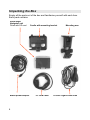
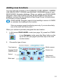
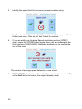
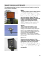
USER GUIDE Road Angel Group Ltd Email: Web: Address: [email protected] www.roadangelgroup.com Clark House Silverstone Technology Park Silverstone Circuit Northants NN12 8GX Thank you for buying your new ROAD ANGEL Navigator As our roads become busier, more congested and more regulated, staying alert to road and traffic conditions is a challenge to everyone. Even the most conscientious driver can have a momentary lapse of concentration that could easily lead to an accident or a fine and points. ROAD ANGEL Navigator is specially designed to be a simple-to-use addition to any vehicle, to alert and warn you in advance of known danger areas and provide point-to-point navigation with a full-screen interface. In the comprehensive ROAD ANGEL Navigator database are stored Police, Local Authority and Ministry of Transport designated danger spots, including accident black spots and safety camera locations. Using the latest Global Positioning Satellite (GPS) technology, ROAD ANGEL Navigator compares your position with the known danger spot locations and gives you an audible and visual warning as you approach them. An accurate GPS speedometer in the display gives you time to adjust your driving to the approaching danger. The safety of you and your passengers is our prime consideration, and we trust that for all the miles you drive, your ROAD ANGEL Navigator will enhance the safety and enjoyment of your journey. Join other ROAD ANGEL Navigator users in guarding your life and livelihood. We are pleased to have you as a valued customer and hope you will be delighted with your fully integrated ROAD ANGEL Navigator. Having listened to our customers we think the new features will make this product your perfect driving companion. Dave Clark, Managing Director Road Angel Group Ltd. The directors of Road Angel Group Ltd. sell ROAD ANGEL Navigator as a road safety enhancement device. Driving within the speed limits at all times and within the limitations of the road condition and your abilities is paramount. The directors of Road Angel Group Ltd. take no responsibility for the use of ROAD ANGEL Navigator for other purposes than those stipulated. Table of Contents 1. Introduction....................................................................5 Unpacking the Box........................................................................ 6 Subscriptions................................................................................ 7 Warranty ........................................................................................ 7 Security ......................................................................................... 7 Controls and Connectors ............................................................. 8 2. Registration....................................................................9 3. Putting It All Together.................................................. 11 Adjusting the Mounting Arm ...................................................... 11 Attaching the Cradle ................................................................... 12 Fitting the ROAD ANGEL Navigator........................................... 12 4. Getting Started.............................................................15 Switching On for the First Time ................................................. 15 Switching Off............................................................................... 19 Suspend Mode ........................................................................... 19 Powering Down .......................................................................... 19 1 5. Road Hazard Warnings................................................20 ROAD ANGEL Mode.................................................................... 20 Navigator Mode........................................................................... 21 Acting on an Alert ....................................................................... 22 About Fatigue Alerts................................................................... 23 6. Destinations and Routes.............................................24 By Address.................................................................................. 25 If you know the postcode ............................................................ 26 If you don’t know the postcode.................................................... 27 Fine-tuning ................................................................................. 28 By POI (Points of Interest).......................................................... 29 Getting to a POI.......................................................................... 30 By Recent .................................................................................... 31 By Favourites .............................................................................. 32 My Home and My Work .............................................................. 32 Bookmarks ................................................................................. 34 Using the Map ............................................................................. 34 Moving On ................................................................................... 35 Planning your Route ................................................................... 36 7. Getting There ...............................................................38 Map Settings ............................................................................... 39 About Info Layers ....................................................................... 40 Route Settings ............................................................................ 41 Making a Detour.......................................................................... 42 Changing Settings from Standby Mode..................................... 43 2 8. Hazard Warning Settings ............................................44 Navigating the Menus ................................................................. 46 Alerts ........................................................................................... 47 Distances..................................................................................... 48 Unit Settings................................................................................ 49 9. Adding and Deleting Danger Zones ...........................50 Deleting zones ............................................................................ 50 Adding new locations ................................................................. 51 10. Updating the Database ................................................53 Updating by PC/ActiveSync ........................................................ 53 Updating using your Mobile Phone ............................................. 54 Doing an Update ........................................................................ 54 Pairing........................................................................................ 56 Troubleshooting.......................................................................... 57 11. Media Options..............................................................59 Music ........................................................................................... 59 Storing MP3 files onto SD memory cards.................................... 59 Starting music playback.............................................................. 59 Photos ......................................................................................... 60 Storing image files onto SD memory cards ................................. 60 Image Browsing.......................................................................... 60 Settings ....................................................................................... 61 System....................................................................................... 61 Backlight .................................................................................... 62 Version....................................................................................... 62 Restarting ROAD ANGEL Navigator........................................... 62 3 12. Background Information .............................................63 About Global Positioning Satellites (GPS) ................................ 63 ROAD ANGEL Navigator's Database.......................................... 64 Using ROAD ANGEL Navigator Abroad...................................... 64 Speed Cameras and Hazards ..................................................... 65 13. Accessories .................................................................68 14. End User License Agreement .....................................69 4 1. Introduction ROAD ANGEL Navigator uses the latest global positioning satellite technology (based on the Sirf3 chipset) to give you point-to-point navigation information combined with audible and visible alerts as you approach hazardous sections of road: Accident black spots (as designated by the Police and Local Authorities) Safety camera locations (including mobile vans) Average speed monitoring zones Primary schools Congestion charging zones ROAD ANGEL Navigator displays a constantly updated and accurate speed reading. Should you break down, ROAD ANGEL Navigator allows you to pinpoint your location and direct rescue services to your vehicle. You can update the safety camera database at any time using a Bluetoothenabled mobile phone with GPRS connectivity or via an Internet-connected PC. IMPORTANT SAFETY INFORMATION! Never attempt to alter settings while you are driving; ask a passenger to make any changes or find a suitable and safe place to pull over and park your vehicle. ROAD ANGEL Navigator is designed as an aid to safe driving and route navigation; always drive within the speed limits and traffic regulations, taking account of the road conditions and your own abilities. ROAD ANGEL Navigator should not be used in any way that may interfere with the safe operation of your vehicle. Ensure that your ROAD ANGEL Navigator and its associated equipment and cables are securely and correctly mounted within the vehicle. Road Angel Group Ltd assumes no responsibility for any damage or injury resulting from the use of this product. 5 Unpacking the Box Empty all the parts out of the box and familiarise yourself with each item. Each pack contains: Road Angel Navigator unit Fitted with SD card Mains power adapter 6 Cradle with mounting bracket PC USB cable Mounting arm 12V/24V cigar socket lead Subscriptions Your ROAD ANGEL Navigator comes with a free subscription for six months to the award-winning Road Angel camera and accident black spot database. It is critical to the operation of your ROAD ANGEL Navigator that you update the unit regularly and so continued subscription is essential. With constant additions to the ROAD ANGEL Navigator database (1000+ sites per year), the benefit of your ROAD ANGEL Navigator and the protection it provides will be dramatically reduced if you fail to maintain the database. In order to receive free access to updates for the first six months, you will be asked to complete an online Direct Debit form after registration. If you prefer, you may print the form and post it to us (our address is on the front of this manual). There are two subscription options: monthly or yearly. Current subscription rates can be found at http://www.roadangelgroup.com/ . We will not debit your account until the first 6-month period has elapsed. Warranty Your ROAD ANGEL Navigator is guaranteed for one year from the date of purchase from all defects that occur with normal use. If your unit fails to perform as specified in these instructions, please visit: http://www.roadangelgroup.com/warranty It is possible to purchase extended warranty and theft-loss insurance, details of which can be found at the above address. Security Owing to the high number of thefts, we strongly suggest you remove your ROAD ANGEL Navigator and its bracket from view when you leave your vehicle. Security can also be increased by cleaning the marks from your windscreen. 7 Controls and Connectors This section shows the main features of your ROAD ANGEL Navigator. Menu button (use for mode selection and to access hazard menu (see page 44). Resume/Suspend button Put ROAD ANGEL Navigator in Suspend mode when temporarily not in use to save battery power (<36 hours). The main power switch is on the back of unit (see page 12). Charging indicator LED: Red – charging Green – fully charged External Antennae connector USB connector Stylus SD Card slot Reset button Connectors indicated here are protected by watertight rubber covers. 8 2. Registration If you're in a rush to get started, you can come back to this step later. However, it is important that you register your ROAD ANGEL Navigator as soon as possible after purchase. You will need: A PC with internet access running Microsoft Windows 98SE, ME, 2000, or XP Internet Explorer version 5.5 or above To register online: 1. Go to www.roadangelgroup.com 2. Click on the Product Registration link. The Product Registration form is displayed. 3. Enter your ROAD ANGEL Navigator's serial number. You can find this on the back of the unit. Confirm the number by typing it again into the second box. 4. Click on the Next button. The registration process normally takes one full working day – you can then use the software to update your ROAD ANGEL Navigator. 9 Why should I register? Registration is important for two reasons: You cannot update the unit until it has been registered. Hazard and safety camera database information may be significantly out-of-date at the time of purchase and should be updated as soon as possible. Without registration, we cannot resolve warranty issues, log queries or solve problems with your ROAD ANGEL Navigator. How do I update my ROAD ANGEL Navigator? You can update your ROAD ANGEL Navigator in two ways: Connect the unit to a PC using a USB cable, or Pair and dock the unit to a mobile phone via Bluetooth (the phone must have access to the Internet). Refer to the Updating the Database section on page 53 for details. How often should I update my ROAD ANGEL Navigator? As a guide, we recommend that you update your ROAD ANGEL Navigator every two weeks. My ROAD ANGEL Navigator keeps displaying the ‘Please register...’ message every time it is switched on. You need to complete an update of your ROAD ANGEL Navigator. How much do updates cost? Your ROAD ANGEL Navigator comes with a free subscription for six months of database updates and product support. In order to receive free access to updates for the first six months, you will be asked to complete an online Direct Debit form after registration. If you prefer, you may print the form and post it to us (our address is on the front of this manual). There are two subscription options: monthly or yearly. Current subscription rates can be found at www.roadangelgroup.com . We will not debit your account until the first 6-month period has elapsed. 10 3. Putting It All Together Adjusting the Mounting Arm 1. Loosen both vertical adjustment knobs, and change the angle of the central joint so that the connecting flange is vertical when the suction cup is held against your vehicle's windscreen. Tighten the knobs to lock in place. 2. Unfasten the horizontal adjustment knob, and change the horizontal angle of the connecting flange so that it is facing in your preferred direction: in line with the vehicle, towards the driver, or towards the passenger. Tighten the knob to lock in place. 11 Attaching the Cradle 1. Attach the bracket to the mounting arm. 2. Slide the cradle onto the mounting arm/bracket assembly. 3. Take the power lead, and plug it into the socket on the rear of the cradle. Don't connect the other end to the cigar lighter socket yet. 4. Hold the suction cup against the windscreen. Position the cradle so that the two feet rest on the dashboard of your vehicle. In some cases, you may need to extend the telescopic arm. 5. Pull the lever upwards to apply suction. For maximum adhesion, it may help to dampen the suction cup beforehand. Fitting the ROAD ANGEL Navigator 1. 12 Slide the ROAD ANGEL Navigator's power switch to the On position. 2. Push the ROAD ANGEL Navigator into the cradle so that the clip snaps into position and holds the unit firmly in place. 3. Route the power cable to the cigar socket. Ensure that it does not interfere with any of the vehicle's controls or airbag modules. If you use your cigar socket for any other devices, a dual adaptor may be used. You are now ready to use the unit for the first time. An optional vent mount can be purchased for discrete mounting. 13 Where should I put my ROAD ANGEL Navigator? ROAD ANGEL Navigator has a high sensitivity GPS antenna and requires a clear view of the sky to receive information from GPS satellites. We highly recommend that ROAD ANGEL Navigator is positioned in the centre of the front windscreen, low down, just above the dashboard. If screen glare is a problem in this position, try installing the unit beside the driver's “A-pillar”. Check that the GPS reception operates correctly in this position. If you want to install ROAD ANGEL Navigator anywhere else within your vehicle, you may require an external GPS antenna. Please contact Road Angel Group Ltd or visit www.roadangelgroup.com for details. My car has a UV/heated windscreen UV screens block GPS signals from entering the vehicle, stopping ROAD ANGEL Navigator from acquiring its position. This can be a problem with certain models of vehicle, i.e. BMW, Mercedes, Renault, Peugeot & Citroen. Heated screens can also affect GPS signal strength. If your vehicle has a UV or heated screen, you may need an external antennae (please contact Road Angel Group Ltd or visit www.roadangelgroup.com for details). Most vehicles fitted with a UV screen have a defined section behind the rear view mirror where you can fit the antennae. Can I hardwire the unit? ROAD ANGEL Navigator has a 5V regulator built into its power cable. If the cable is cut and used to hardwire the unit into the vehicle, you will damage the ROAD ANGEL Navigator. To hardwire ROAD ANGEL Navigator into your vehicle, purchase a cigar socket, wire this into the power system and use with the supplied cable. Consult an auto electrician if you are unsure how to carry out this procedure as incorrect hardwiring may affect the validity of vehicle and product warranty. Consult vehicle manufacturer if in doubt. 14 4. Getting Started Switching On for the First Time 1. Park your vehicle so that ROAD ANGEL Navigator has a clear view of the sky away from obstacles such as tall buildings and over-hanging trees (these may delay or prevent satellite acquisition). 2. Plug the power lead into the cigar lighter socket. If your socket is ignition-switched you will need the ignition to be on. The power indicator light on the unit should now be on (make sure the power switch on the back of the unit is in the On position (see page 12). The display shows the Welcome screen whilst the unit is starting up. 3. If you haven’t updated the unit yet, the ROAD ANGEL Navigator screen will show the registration prompt. Tap on the Exit button (please return to step 1 and register your unit as soon as possible). 4. ROAD ANGEL Navigator now tries to identify its location by acquiring information from GPS satellites. This may take a few minutes. During the procedure, the unit displays the following screen. 15 5. When ROAD ANGEL Navigator has identified its position it displays the Standby screen in its ROAD ANGEL mode: Time Heading Speed Satellite reception Battery charge Menu button NAV button Switch to Navigator mode) MEDIA button Access Photo, Music Update and Settings functions (see page 53) STORE button Add current location to camera database This screen shows battery level and satellite signal meters, the time (calculated from your GPS position), and your current speed and compass heading. In this mode, you can start driving and ROAD ANGEL Navigator will show you your speed and compass heading. If you are approaching a known hazard, it will alert you to the type and proximity of the hazard (see page 20). Alternatively, if you want ROAD ANGEL Navigator to guide you to your destination, tap on the NAV button to change to Navigator mode. 16 6. ROAD ANGEL Navigator now shows a ‘satellite’ view and zooms in to your current location. This may take a while. Tap on the screen if you want to skip this intro. 7. The Tracking screen is displayed. This shows a map of your current GPS location and tracks your route: Speed Zoom out Latitude/Longitude Time Elevation above sea level Current location GPS status information Zoom in Info box Exit button Compass rose Menu button Tracking screen If you encounter a road hazard (see page 65), ROAD ANGEL Navigator will provide visual, spoken and sound warnings about the type of hazard and its proximity (see page 20). 17 8. If you click on the Tracking screen, ROAD ANGEL Navigator stops tracking your position. Now, you can use the map to find a destination and get information about your surroundings. Click on a location on the map and ROAD ANGEL Navigator centres the view at that point. Use the + and – buttons, and the scroll bar that appears when you do so, to change the magnification. Tap on the compass rose to change the orientation of the map. Click on a road or POI (Point of Interest) icon to view information about it in the Info box. Standby screen You can use this mode to identify a destination (see page 34). 9. To return to the Tracking Mode, tap on the GPS button: 10. Tap on the Menu button to enter your destination and create a route (this is described fully in the Destinations and Routes section on page 24). How do I change back to Full Screen ROAD ANGEL mode? If you don't want to use the navigation features now, and want to return to ROAD ANGEL Mode, press the Menu button on the top of the unit and then tap on the Full Screen RA Mode button on the screen. 18 Switching Off Suspend Mode Resume/Suspend switch When you have a temporary break in travelling, press the switch on the top right hand side of the unit. This will turn off the screen and suspend processing but it will not shut down the unit. When you are ready to resume your journey, press the button again to 'wake up' your ROAD ANGEL Navigator. Suspend mode saves battery power when the unit is in regular use. It means that you can resume travelling immediately without having to wait for ROAD ANGEL Navigator to complete its full start-up procedure. If you leave the unit in Suspend mode for a prolonged period, the battery may be flat next time you try to use it. Powering Down If you don't intend to use your ROAD ANGEL Navigator for a long time, you should turn the unit off using its power switch (located on the back of the unit). This shuts down the unit completely and isolates the battery, retaining power for the next time you use it. On/Off switch 19 5. Road Hazard Warnings When you are approaching a known danger zone, the display changes to show the type of hazard and, for a fixed, temporary or average speed camera location, the advisory speed. In addition: 1. A proximity-to-hazard meter increases from 1 to 5 bars as you get closer to the danger zone. 2. Speech warnings will tell you the type of zone followed by an audible tone that increases with your proximity to the hazard. USE THE ADVISORY SPEED LIMIT FOR GUIDANCE ONLY. YOU SHOULD ALWAYS KNOW THE SPEED LIMIT AND TAKE ACCOUNT OF DRIVING CONDITIONS. ROAD ANGEL Mode In ROAD ANGEL mode, the display changes to show the type of hazard and, for a fixed, temporary or average speed camera location, the advisory speed. If you are approaching one of these locations and travelling below the advisory speed limit, the display background is green. If you are travelling above the advisory limit the background changes to red. If your speed subsequently drops below the advisory speed limit, the background changes to green. Hazard type Advisory speed limit Actual Speed Audio On/Off icon Proximity-tohazard meter Hazard icon If you are approaching another type of hazard, no advisory speed limit is shown. The background is blue for accident black spot, congestion zone or primary school hazards and orange for mobile camera van locations. To mute the audio alert, tap on the Mute button or the Hazard icon. To remove the hazard from the database, tap on the DELETE button (see page 50). 20 Navigator Mode In Navigator Mode, when you are approaching a known danger zone, the display shows an alert message, an icon indicating the type of hazard and an advisory speed limit (if appropriate). Hazard warning message Audio On/Off icon Advisory speed limit/Alert-type icon (alternating) Proximity-tohazard meter Actual speed To mute the audio alert, tap on the Alert-Type/Advisory Speed icon. ROAD ANGEL Navigator’s hazard menus allow you to customize the way it alerts you to road dangers. For a full description, see Hazard Warning Settings on page 44. When you have passed the danger, ROAD ANGEL Navigator resumes its previous mode. 21 Acting on an Alert To stop an alert, press the Menu button on the top of the unit (see page 8). The following screen is displayed: Tap on the Dismiss button to cancel audio and visual warnings for the hazard and restore the previous screen mode. The hazard zone remains in your unit’s database and you will be warned about it the next time you approach it. Delete the hazard zone (see page 50) CAUTION! This permanently removes the zone from your database – you will not be warned about this hazard again. To restore a deleted hazard you will have to add the hazard manually (see page 51) or carry out a factory reset (see page 50). Return to the Alert screen. 22 About Fatigue Alerts The Highway Code recommends a minimum break of at least 15 minutes after every two hours of driving. ROAD ANGEL Navigator’s fatigue alert warns you whenever you have been driving for two hours without a break. The alert resets after any break of 5 minutes and can be temporarily halted for 15 minutes. To dismiss or suspend a fatigue alert, press the menu button on the top of the unit. The following screen is displayed: Dismiss the alert. Suspend the alert for 15 minutes. 23 6. Destinations and Routes ROAD ANGEL Navigator knows where you are from its GPS data; to calculate your route, it only needs you to specify the destination (see page 25). It can then use its map data and your preferences to calculate the most efficient route for your journey. For more complicated journeys, you can specify multiple destinations (see page 35). ROAD ANGEL Navigator works out the best route between each stop. If you encounter any traffic problems on your journey, ROAD ANGEL Navigator can calculate a detour for you. On the Start screen, tap on the Menu button: menu is displayed: Tracking screen . The Find Destination Find Destination menu This offers you a number of different ways to specify the destination: By Address Enter a new address (see page 25). By POI Search Search for a Point of Interest (see page 29). By Recent Pick your destination from a list of places you have visited previously (see page 31). By Favourites Select a bookmarked destination (see page 32). You can also tap on the Back button to return to the Start screen or the Change Settings button to modify the way that your ROAD ANGEL Navigator works (see page 43). 24 By Address 1. Tap on the Address button to identify your destination by its postal address or postcode. The Find Address window is displayed. 2. Tap on Country. Select your country from the list. This step is only necessary for the first address you enter on the unit. There are two ways you can specify your destination: The best way is to enter the postcode (see page 26). If you don’t know the postcode, you can enter the name of the town or city and, optionally, the street and house number (see page 27). 25 If you know the postcode 1. Tap on the Postcode button and enter the post code of your destination. Enter at least the first three characters and then tap on the search symbol (magnifying glass). Switch between letter and number mode by pressing 123 or ABC. If at any point you want to backspace and delete characters, press the backspace button <- on screen. To add a space, press the space bar _. 2. After the first few characters, you may tap on the search symbol (magnifying glass) to display a hit list of postcodes matching your entry. 3. Choose the appropriate postcode from the list. 4. Tap on the forward arrow button: section on the next page. 26 . Go to the Fine Tuning If you don’t know the postcode 1. Tap on the City button. Use the displayed keypad to enter the name of your destination. Enter at least the first three characters and then tap on the search symbol (magnifying glass). Switch between letter and number mode by pressing 123 or ABC. Characters that will not produce a match with records in ROAD ANGEL Navigator’s database are greyed and disabled. If at any point you want to backspace and delete characters, press the backspace button <- on screen. To add a space, press the space bar _. 2. Find your target city or town in the ‘hit’ list and tap on its name. 3. Tap on Street to enter the name of the street. 4. Type the name of the street you are looking for. After the first few characters, you may tap on the search symbol (magnifying glass) to display a hit list of streets matching your entry. Choose the appropriate street from the hit list. 27 5. Optionally enter the number of the property. 6. Tap on the forward arrow button: . Fine-tuning 1. When you tap on the forward arrow button: Navigator displays the following screen: , ROAD ANGEL This offers you a number of different ways to change your destination: More Stops Enter further stops to your journey (see page 36). Route Settings Change the Guidance options (see page 41). On Map Use the map display to identify your destination more accurately. 2. If you want to change your destination, tap on Find Address screen. 3. To start driving to your destination, tap on the Navigate button: ROAD ANGEL Navigator calculates a route to your destination and displays your first route instruction (see page 38). 28 to return to the . By POI (Points of Interest) ROAD ANGEL Navigator contains a database of information about amenities and attractions. These are collectively called Points of Interest (POI). You can use this feature to identify destinations. For example, you could use the POI database to find the nearest garage or identify a restaurant close to your route. POIs are arranged in the following categories: Overnight e.g. Campsites, Hotels Eat and Drink e.g. Restaurants, Coffee Shops Shopping e.g. Florists, Groceries, Childrens, Sports and Outdoors, Home&Garden Transport e.g. Airports, Railway Stations Automotive e.g. Picnic Sites, Car Parks, Garages Services e.g. Educational Facilities, Hospitals Sights e.g. Museums and Galleries, Tourist Attractions Venues e.g. Cinemas, Golf Clubs, Zoos 29 Getting to a POI 1. On the Find Destination screen (see page 24), tap on the By POI button. The following menu is displayed: 2. Tap on a POI category, for example: Automotive. ROAD ANGEL Navigator will search for a POI close to your current location. Tap on the Menu button to identify another location for the search (using the method described on page 25) or carry out a text search of the POI database. 3. On the next menu, choose a subcategory, for example: Gas Stations. 4. A list of the POIs in the category is shown (in this example, gas stations) with their distance from your current location. 5. Select a POI by tapping on it. 6. Now refer to the Moving On section on page 35. 30 By Recent Tap on the By Recent button to choose your destination from a list of your recently visited or looked-up destinations: Select an item by tapping on it. Now refer to the Moving On section on page 35. 31 By Favourites If you want to go to your designated home or work locations (see below), or choose a bookmarked destination, tap on the By Favourites button. The following menu buttons are displayed: My Home and My Work The My Home and My Work buttons provide shortcuts to your most commonly used destinations. Setting up Home/Work buttons for the first time To assign a destination to one of these buttons, tap on it. The following menu buttons are displayed: You can choose the destination in three ways: By searching for an address in the way described on page 25. By selecting your current GPS position. By choosing a recently visited location. 32 Using My Work/My Home After you have followed the setup procedure described above, the next time you want to travel to home or work, tap on the appropriate button. The address is shown, with a map of the destination. 1. Tap on the Menu button. The following menu buttons are displayed: 2. Tap on the Navigate button. ROAD ANGEL Navigator calculates a route and guides you to the destination (see page 38). Editing/Deleting My Work/My Home Destinations 1. Tap on the My Work/My Home button as required. 2. Tap on the Menu button. 3. Choose from the required option: To edit the assigned destination, tap on the Edit button. Assign a new destination using the procedure described on the previous page. To delete the assigned destination, tap on the Delete button. The Start screen is displayed. 33 Bookmarks The Bookmarks list contains the destinations you have saved (see pages 35 and 42). Tap on the Bookmarks button. The bookmark list is displayed: Use the up and down arrows to scroll up and down in the list. Select an item by tapping on it. Now refer to the Moving On section below. Using the Map You can also use select your destination from the map while ROAD ANGEL Navigator is in its standby mode (see page 18). 1. Display your destination on the map. 2. Tap on its location. 3. Tap on the Info bar. 4. Tap on the Menu button. 5. Choose one of the following options: Tap on the Navigate button to immediately receive instructions to take you to your destination (see page 38). Tap on the Via button to add the location as a stop in your journey (see page 36). Tap on the Save button to store your current location as a Bookmark (see above). 34 Moving On When you select a location from a Bookmark (see page 34), Recent (see page 31) or POI (see page 29) hit list, ROAD ANGEL Navigator shows you a map view of your selected destination. Use the left and right arrows to scroll through other locations in the list or tap on to return to the list. Tap on to continue. Choose from the following options: Navigate Start driving; ROAD ANGEL Navigator calculates a route and guides you to the destination (see page 38). Via Add another stop to your journey (see Planning Your Route below). Save Store the location in your Bookmarks list. On Map Use the display to identify your destination more accurately. 35 Planning your Route In most cases, you will enter a single destination and allow ROAD ANGEL Navigator to determine your route and guide you there. However, if you want to stop at one or more places on the way, you can enter more destinations into your itinerary as stops and let ROAD ANGEL Navigator calculate the best route to get you from one stop to the next. This section describes ROAD ANGEL Navigator’s route planning feature. This allows you to plan your route in advance, choosing multiple stopovers along your journey. To plan your route: 1. Identify the location for your destination or stop as described in the previous sections. 2. Tap on the More Stops (see pages 28) or Via button (see page 35) to add the location to your destination list: 3. To add a stopover, tap on the + symbol. The Choose stopover screen is displayed. 4. Enter a stop using one of the procedures described in the last section: 36 a home or work address, a bookmark, a point of interest, a recent location, an address or a destination pinpointed on the map. 5. Repeat the procedure to add further stops. 6. To change the order of the stopovers, select one and then use the up and down arrows to move it up or down the list. 7. To delete a stopover, select it and then tap on the ‘Bin’ symbol. 8. When you have completed your route, tap on the menu symbol (bottom right-hand corner of the screen). 9. Choose from the following options: Tap on the Back button to return to the Choose Stopover screen. Tap on Simulate to view a map showing the route. Tap on Start Navi to start your journey (see page 38). Tap on Routing if you want ROAD ANGEL Navigator to calculate the itinerary for your route. The Route Summary is displayed. Tap on one of the stopovers in the Route Summary to display a detailed itinerary in the Waylist. 37 7. Getting There When you have specified your route, and tapped on the Navigation or Start Navi buttons, ROAD ANGEL Navigator switches to the full screen Guidance mode. It then provides you with on-screen and audio directions to get you to your destination. Distance to next turn Name of next road Route (shown in blue – direction of one-way roads shown in red) Speed display/ Alert area Speed/ Route information box Current position (shown by cross hairs) Normally, the screen shows your speed in a box on the left-hand side (see the picture on page 40). If you tap on this box, route information (your speed, the current time, estimated time of arrival, the distance to your destination and GPS status information) is displayed instead. After 20 seconds, or if you tap on the box again, the speed display is restored. Tap on the + and – icons to increase or decrease the map magnification. Tap on the screen to browse across the map. Tap on the Satellite button to return to Guidance mode. If you want to cancel the route guidance instructions and return to standby mode, click on the Cancel button. If you want to make changes to your route or change any other settings, tap on the Menu button. The following menu is shown: 38 This provides the following options: Back Return to the Guidance screen. Route Settings Change guidance and route-finding options (see page 41). Map Settings Display the Map Settings menu (see page 39). Volume Change the sound output level of the unit. Map Settings Tap on the Map Settings button to change the appearance and style of screen maps. The Map Settings menu is displayed: Use this menu to: Change the information displayed on the map (see Info Layers below). Toggle between night and day modes. In the Automatic mode, ROAD ANGEL Navigator changes between day and night modes at 07.00 and 19.00. Toggle between 2D and 3D map modes Change the compass tracking used by ROAD ANGEL Navigator. The two options are to automatically rotate the map display so that your current direction is always up the screen or to lock the map display so that it always faces north. Select your time zone. 39 Choose between the standard map display or a basic direction style: About Info Layers The elements and symbols displayed on the maps are determined by information layers. Select the boxes of any category you want to have displayed on the map. Deselect those that should be hidden. Press the confirmation symbol in the bottom right-hand corner to select/deselect all categories. Tap the back arrow symbol to return to the map. 40 Route Settings Tap on the Route Settings button if you want to change the way ROAD ANGEL Navigator calculates routes. The Guidance menu is displayed: Fast/Slow/Bike Motorbike/ Scooter/Van/ Pedestrian ROAD ANGEL Navigator uses this setting to calculate the best route and estimate your journey time. By default, ROAD ANGEL Navigator assumes you are travelling by car. Tap on this button to specify your mode of transport: fast car, slow car, motorbike, etc. Fastest/Shortest Tap on this button to choose whether ROAD ANGEL Navigator selects the fastest (based on road quality, terrain and speed restrictions) or the shortest route (based on the shortest distance on good roads) Toll Roads Tap on this button if you want ROAD ANGEL Navigator to avoid toll roads when it calculates a route. Tap on the button again to restore the use of toll roads. The London Congestion Zone in Central London is regarded as a toll road: if you choose to avoid toll roads, you will not be guided through this zone. Motorways Tap on this button if you want ROAD ANGEL Navigator to avoid motorways when it calculates a route. Tap on the button again to restore the use of motorways. Ferries Tap on this button if you want ROAD ANGEL Navigator to avoid the use of ferries when it calculates a route. Tap on the button again to restore the use of ferries. Miles/Kilometres Tap on this button to change the distance units used onscreen between miles and kilometres. 41 Making a Detour 1. To make a detour from your route, tap on the info bar. The Detour menu is displayed: 2. Tap on the Alt. route button. The Detour menu is displayed: 3. You can block the original calculated route for a given distance (e. g. 0.5 mile) and force an alternative route. Tap on the required distance icon. Your route is recalculated, and the previous instructions will be discarded for the given distance. You can also use the Detour menu to select, and navigate to, a POI close to your route. Tap on the Search button to open the POI menu (see page 30). Tap on the List of Way.. button to view the full itinerary of your route. Tap on the Save button to store your current location as a Bookmark (see page 34). 42 Changing Settings from Standby Mode To change settings when the unit is not in guidance mode, tap on the Menu button. On the Find Destination menu (see page 24), tap on the Change Settings button. The Change Settings menu is displayed: This provides the following options: Find Destination Return to the Find Destination menu. Change Route Options Change guidance and route-finding options (see page 41). Change Language Set the language for use ((English supplied - for other options, please contact Road Angel Group Ltd).). Change Map Settings Display the Map Settings menu (see page 39). Choose Maps Select default map data (UK supplied - for other options, please contact Road Angel Group Ltd).). Back Return to Standby mode (see page 18). 43 8. Hazard Warning Settings This section describes how you can change the way that ROAD ANGEL Navigator alerts you to road hazards. 1. Press the Menu button on the top of the unit (see page 8). If you are using Full Screen RA mode, you can also view the Road Hazard menus by tapping on the on-screen MENU button. 2. Tap on the RA Menu button: The Alerts menu screen is displayed. Next Menu Open Menu Switch between Full Screen RA and Nav RA modes Back Use the Full Screen RA/Nav RA button to change between ROAD ANGEL and Navigator modes. 44 3. 4. ROAD ANGEL Navigator's properties are listed in the following menus: Alerts How ROAD ANGEL Navigator alerts you to road dangers with audio and visual prompts. Distances Set the distance at which ROAD ANGEL Navigator commences its alerts. System Settings Screen brightness, clock adjustment, serial number and firmware version. Updates Download the latest road hazard information using your PC or mobile phone (see page 53). Use the on-screen buttons to view and edit system settings. View the next menu category or property. Exit Road Angel menus and return to original screen. Open the displayed menu and view the first property (see the next section). Switch between ROAD ANGEL and Navigator modes. After several seconds of inactivity on a menu screen, the display returns to normal mode. 45 Navigating the Menus If you want to change a value or property: 1. Tap on the Edit button 2. Tap on the Adjust button to cycle through the available values. 3. Tap on the Store button to save the new value. 4. Tap on the Back button to return to the menu. If you have changed the property or value, the original setting is restored.. Alert Distances value Editing Alert Distances The following tables list the properties in each menu category. 46 Alerts Settings in the Alerts menu determine how ROAD ANGEL Navigator warns you about road hazards. Property Details Options (factory setting in bold) Voice alert Switch voice alerts on or off. Camera alert volume Change the sound level of safety camera related warnings. Off..20..40..60..80..100% Camera alert single beep Switch alert on or off, as each proximity bar counts up it will emit a single beep. Off...On Safety alert volume Change the sound level for Blackspot, School and Congestion related warnings. Safety alert single beep Switch alert on or off, as each proximity bar counts up it will emit a single beep. Off...On Blackspot alert Switch Blackspot alerts on or off. Off...On Railway crossings Alerts you to railway crossings with no barrier. Off...On Safety camera van alerts Switch camera van alerts on or off. Off...On School zone alert Switch School alerts on or off. Off...On Congestion zone alert Switch Congestion zone entry warnings on or off. Off...On Overspeed alert Set a speed at which the unit will warn if you exceed the speed. Fatigue timer alert Select this option if you want to be alerted whenever you have been driving for two hours without a break. Off...On Off..20..40..60..80..100% Off..20 - 165 in increments of 5mph Off...On 47 Details Options (factory setting in bold) Slow speed auto mute When travelling less than 15MPH the unit will not give an audible warning. If you enter a zone below 15MPH you will hear a single beep, followed by the proximity count up. Off...On Speed sensitive volume Adjust the warning volumes depending on how fast the vehicle is travelling. Off...On Property Distances With its factory setting, ROAD ANGEL Navigator alerts you to when you are within 250m of a hazard; you can change this to 500m or 1000m. In addition, ROAD ANGEL Navigator has a feature to increase the warning distance when you are travelling over 50mph. Property Details Options (factory setting shown in bold) Alert distance Adjusts the warning range as you approach danger zones. 250..500..1000m Speed distance sensitivity Doubles the advanced warning at 50MPH and above. Off...On 48 Unit Settings Using this menu, you can adjust the clock, screen brightness and display mode, and view technical information about your ROAD ANGEL Navigator: the serial number and firmware version. Property Details Options (factory setting shown in bold) Backlight brightness Change the intensity of the screen display. Night Mode Select night mode colours for the full screen ROAD ANGEL mode. Clock adjust Change time – ROAD ANGEL Navigator uses GPS data; may require ± 20 hours in ½ hour intervals. offset to account for daylight saving (+1.00) time. Factory reset Restore the unit to its original factory settings. CAUTION: you will lose all your personal settings. Unit serial number Serial number of ROAD ANGEL Navigator unit Read only; 8 digit number Firmware ROAD ANGEL Navigator Software version Read only, in format x.xx Off..20..40..60..80..100 Off..On 49 9. Adding and Deleting Danger Zones Road Angel Group Ltd. is constantly updating the central database of danger zones. You can be of great value to all ROAD ANGEL Navigator users by adding any new zones you encounter to your unit's own database. When you subsequently update your ROAD ANGEL Navigator, this data can be verified by Road Angel Group Ltd before being added to the central file. PLEASE ONLY ADD OR DELETE DANGER ZONES WHEN IT IS SAFE TO DO SO. Deleting zones When your ROAD ANGEL Navigator alerts you to a danger zone, you can delete it from the database on your unit so that you will not be warned about it in future. In full-screen ROAD ANGEL mode (see page 20), press the DELETE button. In Navigator mode, press the Menu button on the top of the unit. The following screen is displayed: Confirm or cancel the deletion or tap on the Dismiss button to stop the alert on this occasion but leave it in the database. When a location has been deleted it can only be restored by reentering the location (see Adding new locations, below) or by requesting a factory reset for your next update: email [email protected] with your serial number and contact details. Note: By using a factory reset all your personally stored locations will be lost. 50 Adding new locations You may add new locations to the AVERAGE, FIXED, MOBILE, CAMERA VAN, BLACK SPOT, SCHOOL and RAILWAY CROSSING areas of your ROAD ANGEL Navigator database. When you update your ROAD ANGEL Navigator, these new locations will also be downloaded to the central database, and can then be verified by Road Angel Group Ltd technicians for inclusion in future updates. ROAD ANGEL Navigator needs to be travelling in excess of 4 MPH to calculate the heading for the location. Store an average speed monitoring area only if you are absolutely sure of the start and finish points. When your vehicle is precisely alongside the new location: 1. In full-screen ROAD ANGEL mode (see page 16), press the STORE button. In any Navigator mode, press the Menu button on the top of the unit (see page 8) and then tap on the Add location button. 2. Choose the type of zone: Fixed camera Mobile camera Average Speed (SPECS zone) Camera van School Unprotected railway crossing Black spot 51 3. Identify the speed limit for the zone (camera locations only): Use the + and – buttons to adjust the displayed advisory speed limit for the new zone. Click on the ‘tick’ button to continue. 4. If you are adding an Average Speed monitoring section (SPECS zone), press the STORE button again when you are underneath the finish camera. ROAD ANGEL Navigator prompts you to confirm the end of the zone: The section of average speed detection is now stored. 5. 52 ROAD ANGEL Navigator confirms that the zone has been saved. Tap on the Exit button to restore the original display mode. 10. Updating the Database Your ROAD ANGEL Navigator is capable of storing up to 50,000 unique danger zones (see page 64). As soon as possible after your purchase, you should: REGISTER the unit online at www.roadangelgroup.com (see page 9). Download the latest version of the database. We recommend that you update your ROAD ANGEL Navigator fortnightly, as safety camera locations are constantly changing. If you are a high mileage motorist, using unfamiliar roads, you may want to update your database weekly. You should also update the database before you set off on a long trip. You can update your ROAD ANGEL Navigator over the Internet using your PC or via a Bluetooth-enabled mobile phone. Updating by PC/ActiveSync To update your ROAD ANGEL Navigator using your PC, you will need: A PC with internet access running Microsoft Windows 98SE, ME, 2000 or XP (we do not support Apple Macs) Internet Explorer version 5.5 or above Microsoft ActiveSync 3.8 or above To set up your ROAD ANGEL Navigator with ActiveSync: 1. Switch on your ROAD ANGEL Navigator (if the internal battery is flat, you will need to connect it to the PC first) and wait for it to boot up. 2. Connect your ROAD ANGEL Navigator to the PC using the USB cable. 3. Microsoft ActiveSync starts; when it prompts you to set up a partnership, select the No option and then click on the Next button. The ActiveSync window displays 'Connected'. 4. Now follow the procedure described in the Doing an Update section on the next page. 53 Updating using your Mobile Phone To update your ROAD ANGEL Navigator using your mobile phone, you will need a Bluetooth-enabled mobile phone with GPRS capability. Doing an Update 1. Press the Menu button on the top of the unit (see page 8). 2. Tap on the RA Menu button. The Alerts menu is displayed. 3. Tap on the Next button until the Updates menu is displayed: 4. Tap on the Open button. The Updates screen is displayed: 5. If you are attempting to update using a Bluetoothenabled mobile phone for the first time, you will need to pair your phone with the ROAD ANGEL Navigator. For 54 future updates, the unit will connect automatically. Refer to the Pairing section on page 56. Confirm that you want to search for updates by tapping on the Yes button. 6. Your ROAD ANGEL Navigator attempts to connect to the Road Angel Group website: 7. If the update has been successful, the following screen is displayed: Refer to the Troubleshooting section on page 57 if this is not the case. Tap on the Exit button. If database updates have been downloaded, your ROAD ANGEL Navigator will need to restart to complete their installation. If the unit was already up-to-date, and no updates were downloaded, this will not be necessary. 55 Pairing You should only need to pair your phone the first time you attempt an update via Bluetooth. For future updates, the unit will connect automatically. To pair the phone and unit: 1. Tap on the Pair First button on the Updates screen (or the Pair button on the Update failed screen). The following screen is displayed: 2. Search for a new Bluetooth device via the options on your mobile phone. You will need to ensure you enable Bluetooth on your phone first. Refer to the documentation that came with your phone for more information. 3. If the pairing is successful, the update resumes; otherwise the Search failed.. screen is displayed again. Please visit the support section at www.roadangelgroup.com if you continue to have problems. 56 Troubleshooting If your ROAD ANGEL Navigator fails to detect an Internet connection or fails to complete the update, it displays one of the following screens: No Internet connection detected Update not completed The following suggestions should help you solve your updating problem: USB Checklist If you are attempting to use your PC and a USB connection for the update, check the following: The USB cable is securely plugged into both your PC and the USB socket on your unit (see page 8). ActiveSync is running on the PC. Your PC has an active Internet connection. Check that your firewall or Internet Security software allows the unit access to the Internet; the software may state that “wcescomm.exe” is attempting to access the internet. Please refer to your firewall’s documentation. Tap on the Retry button to try again. 57 Bluetooth Checklist If you are trying to use your mobile phone for the update: Ensure that the phone is capable of carrying out an update: it must have Bluetooth and GPRS capabilities. Check that the phone has an active Internet connection. Check that you have paired the phone correctly with the ROAD ANGEL Navigator. If not, tap on the Pair button to try again. Check that Bluetooth is enabled on your phone. Check the GPRS settings in your phone with your Network provider. Check GPRS coverage is not too low by moving to an area with better coverage and/or try again later. Tap on the Retry button to try again. 58 11. Media Options In addition to the navigation and hazard warning system, you can also play music, browse photos and change system settings on this unit. To close ROAD ANGEL Navigator, and access the unit’s media options: From Navigator mode, tap on the Exit button on the Standby screen (see page 18). From ROAD ANGEL mode, tap on the Media button. Music This unit can play MP3 files stored on SD memory cards through the built-in speaker. Storing MP3 files onto SD memory cards On your computer, convert the music from an audio CD into MP3 files, then save them onto the SD memory card in a folder named "mp3". Starting music playback 1. Insert the SD memory card with stored MP3 files into the SD memory card slot on the unit. 2. Power on, and at the main menu screen, select the Music icon. 3. In the music playback screen, use the buttons in the Music Playback Window to control each playback function. 4. Tap on the X button to exit the music player and return to the main menu. 59 Photos Storing image files onto SD memory cards You must use your computer to save the image files on to the SD card in a folder named "image". Image Browsing The system has an Image Browsing function, capable of displaying images/photographs stored on SD memory cards. 1. Insert the SD memory card with stored image files into the SD memory card slot on the unit. 2. Power on, and at the Main Menu Screen, select the Photo icon. 3. In the Image Browsing Window: 4. 60 Use the forward and back buttons to navigate through the images. Use the Full screen button (right angle & arrow) to see a slide show of images. Use the zoom button [+] to view the image (1x, 2x, 4x, 8x). There are 4 levels of zoom. When selecting zoom on the top level, the image will return to 1x. Pan an expanded image by dragging the stylus around on the screen. Tap on the X button to go back to Main Menu. Settings Tap on the More icon and choose Settings from the next menu. In the Settings menu, you can adjust the basic system options, including volume control (navigation volume control in navigation application), screen calibration, startup message, backlight setting and view version info. System Volume Control the volume directly with the scroll bar. There are six levels of volume. Loading Voice Select the Loading Voice Off/On box to determine whether the welcome message is to be played during startup. Stylus Adjustment Control of the unit is accomplished primarily through the stylus by touching/writing on the screen. If the system cannot correctly identify your stylus’ input, please run through the screen calibration procedure. 1. From the settings window, select the Stylus Adjustment option to start the screen calibration procedure. 2. Use the stylus and touch once on the centre of the cross displayed on screen. 3. Touch once on the cross at the second position. 4. Touch once on the cross at the third position. 5. Follow the prompts and touch on the forth and fifth positions. 6. To finish the screen calibration procedure, press the Enter key to accept the new settings. Press the Esc key to keep the old settings. 7. Select [o] to go back to the main menu screen. 61 Backlight The backlight settings will let you set the brightness of the backlight and the auto-off time. 1. Under the setting window, select Backlight to enter the backlight settings window. 2. Select the time to turn off backlight for “Powered by battery”. (1 min, 3 min, 5 min, 10 min, 30 min, Always On) 3. Select the time to turn off backlight for “Powered by plug”. (1 min, 3 min, 5 min, 10 min, 30 min, Always On) 4. Scroll the brightness bar to control backlight brightness for a total of six levels. 5. Select [o] to confirm or select [x] 6. Select [o] to return to main menu screen. to keep the original settings. Version Tap on the More icon and choose About in the next menu to see version number information and the help screen. Restarting ROAD ANGEL Navigator If you have been playing music or viewing photos, replace the ROAD ANGEL Navigator’s SD Card. Tap on the RANav button to restart the ROAD ANGEL Navigator software. 62 12. Background Information About Global Positioning Satellites (GPS) Operational since 1990, 24 satellites orbit the earth at a height of 11,000 miles. At any given point on the globe, at least 4 satellites are in view at any one time. Using sophisticated aerials and triangulation techniques, units such as ROAD ANGEL Navigator are able to compute your position to within 5-10 metres. ROAD ANGEL Navigator is equipped with a Sirf3 chipset, which enables fast and deep GPS signal search capabilities. Occasionally, when roads are close together, ROAD ANGEL Navigator may place you on the wrong road. If this happens, keep driving and ROAD ANGEL Navigator will automatically correct itself when it has a better fix or when the road network simplifies. ROAD ANGEL Navigator may lose the GPS satellite signal temporarily owing to tunnels, tall buildings, bridges, dense foliage or adverse weather conditions. When you are clear of the obstruction, ROAD ANGEL Navigator should re-acquire satellite signals in a few seconds. 63 ROAD ANGEL Navigator's Database ROAD ANGEL Navigator uses a database of Police, Local Authority and Ministry of Transport designated danger spots, including accident black spots and safety camera locations, primary schools and congestion charging zones. Your ROAD ANGEL Navigator can store up to 50,000 unique danger locations. Using the latest Global Positioning Satellite (GPS) technology, ROAD ANGEL Navigator compares your position with known danger spot locations and gives you an audible and visual warning as you approach them. It is critical to the accurate operation of your ROAD ANGEL Navigator that you update your unit regularly to maintain the very latest data. With up to 100 new hazard locations added each month, we suggest that you update your ROAD ANGEL Navigator fortnightly. If you are a high mileage driver, using unfamiliar roads, we recommend weekly updates. To qualify for database updates: 1. Register your ROAD ANGEL Navigator with Road Angel Group Ltd. You cannot update the database until you have registered (see page 9). 2. Purchase a valid subscription package (see page 7). Your new ROAD ANGEL Navigator comes with an initial, free, 6-month subscription For information about how to update your ROAD ANGEL Navigator, see page 53. Using ROAD ANGEL Navigator Abroad Your ROAD ANGEL Navigator is specifically designed for use within its designated country, as stated on the packaging. It will have limited functionality in other countries because the appropriate map and camera/safety GPS data will not be present. If you intend to use ROAD ANGEL Navigator abroad, seek independent legal advice prior to departure. 64 Speed Cameras and Hazards This section describes the type of cameras and road hazards covered by ROAD ANGEL Navigator: Gatso The most common type of speed camera – used in fixed positions mounted on poles at the roadside. Measures vehicle speed using radar and, if the speed limit has been exceeded, photographs the rear of the vehicle. Uses a flash unit inside the camera cabinet or mounted on a gantry to illuminate the offending vehicle's rear number plate. ROAD ANGEL Navigator relies on up-to-date database information for detection. SPECS Takes a digital photograph of your vehicle at the ‘start’ point and then another a set distance further down the road. If your average speed is greater than the speed limit between these two cameras you are automatically prosecuted. ROAD ANGEL Navigator relies on up-to-date database information for detection. Watchman Measures vehicle speed and, if the speed limit has been exceeded, takes a photograph of the rear of the vehicle. Can be accessed remotely allowing operators to download live video, stored images or data. ROAD ANGEL Navigator relies on up-to-date database information for detection. 65 Speedcurb Measures the speed of vehicles in the monitored section of road using pressure sensors in the road surface. If the speed limit has been exceeded, it takes a photograph of the rear of the vehicle. Uses a flash module for night-time operation. ROAD ANGEL Navigator relies on up-to-date database information for detection. Traffiphot Uses pressure sensors in the road (similar to Speedmaster – see below) to measure vehicle speed and photographs the rear of any speeding vehicle. Not to be confused with red-light cameras. ROAD ANGEL Navigator relies on up-todate database information for detection. Speedmaster Semi-permanent (fixed location but only used part-time), system that uses pressure sensors in the road to measure vehicle speed. Connects to a camera on a tripod for evidence of any offence. ROAD ANGEL Navigator relies on up-todate database information for detection. Black spot A specific location, identified by the police and local authorities, where a high number of accidents have occurred e.g. a difficult junction. Black spots are often targeted by mobile speed enforcement units. ROAD ANGEL Navigator relies on up-to-date database information to identify black spots. 66 Mobile Safety Vans Operators generally publish the locations where their mobile safety camera vans will be sited 1-2 weeks in advance. You should update your ROAD ANGEL Navigator regularly to ensure it contains the latest mobile safety van information. Congestion Drivers must pay in advance or on the day of travel to enter the designated zone during the scheme’s hours of operation. There are substantial penalties if you do not pay the congestion charge. Primary Schools You can set up ROAD ANGEL Navigator to alert you whenever you are within 250 metres of a primary school. Unprotected Railway Crossings Alerts you to railway crossings with no barrier. Fatigue Timer Warning The Highway Code recommends a minimum break of at least 15 minutes after every two hours of driving. ROAD ANGEL Navigator alerts you whenever you have been driving for two hours without a break. 67 13. Accessories The following table lists the accessories available for ROAD ANGEL Navigator. Please visit the ROAD ANGEL Navigator online shop at www.roadangelgroup.com for more details. Item Details Vent mount kit For discrete mounting from air vent. 12v Cigar Lead (Straight) 2.5 metre with standard fused cigar plug. GPS External Antenna (2m) Connects to ANT socket on ROAD ANGEL Navigator – for use in vehicles with UV screens or for discrete mounting. USB Lead USB to mini USB PC lead Car Charger In-vehicle cigar lighter power lead Leather Carry Case Protects device when not in use. Stylus For use on the screen of the ROAD ANGEL Navigator Mains Charger UK mains power charger Road Angel Group Ltd. has made every effort to ensure that all the information contained in this manual is accurate and reliable. However, the information is subject to change without notice. 68 14. End User License Agreement Portions of the software are copyright © 1996-2002 The FreeType Project (www.freetype.org). All rights reserved. Please read the following agreement (“Licence”) carefully. Acceptance: Installation or use of the enclosed ROAD ANGEL GROUP LTD software (the “Software") on your computer constitutes your acceptance of these terms. If you do not agree to the terms of this Licence, you must immediately delete the Software from your computer and destroy any copies you made of the Software and of any written materials relating to the software, and promptly return the Software and, if bought as part of a package, any associated devices to your retailer for a refund. Licence: ROAD ANGEL GROUP LTD grants you, as an individual, a licence to install and use one copy of the Software on a single personal computer and a single PDA (“personal digital assistant”) at a time. Your licence to use the Software is subject to you complying with the terms of this Licence. A licence is required for each installation of the Software, unless the Software is (i) installed temporarily on a computer during the repair or maintenance of the computer and/or PDA on which the Software is normally installed and (ii) is immediately deleted from such computer/PDA as soon as those repairs or maintenance are complete. You may make one copy of the Software for backup purposes only. Copyright: United States copyright law and international treaty provisions protect the Software. You agree that no title to the intellectual property in the Software is transferred to you. You further acknowledge that title and ownership rights will remain the exclusive property of ROAD ANGEL GROUP LTD, and you will not acquire any rights to the Software except as expressly set out in this licence. You agree that any copies of the Software will contain the same proprietary notices that appear on and in the Software. Prohibited Use: Unless you have ROAD ANGEL GROUP LTD’s prior written permission, you may not (i) use, copy, modify, alter, or transfer the Software or accompanying documentation, except as expressly permitted in this Licence; (ii) translate, disassemble, decompile, or reverse engineer the Software (iii) sublicense or lease the Software or its documentation; or (iv) use the Software in a multi-user or networked environment or on a rental basis or in a time-sharing or computer service business. 69 Limited Warranty: ROAD ANGEL GROUP LTD warrants that the Software will perform substantially in accordance with the accompanying written materials for a period of 12 months from the date of purchase. Any implied warranties relating to the Software are limited to 12 months provided that limitation is permitted by applicable law. End-User Remedies: If the Software does not conform to the “Limited Warranty” above, ROAD ANGEL GROUP LTD’s entire liability and your sole and exclusive remedy will be, at ROAD ANGEL GROUP LTD’s option, either to (i) correct the error, or (ii) help you work around the error, or (iii) accept a return and issue a refund through your retailer. The Limited Warranty is void if failure of the Software has resulted from your fault, abuse, or misapplication. If we correct an error in the Software for you, then the unexpired portion of the Limited Warranty period as at the date you informed us of the error will apply to the corrected software once you have received the corrected version. NO OTHER WARRANTIES: EXCEPT AS SET OUT IN THE LIMITED WARRANTY, ROAD ANGEL GROUP LTD DOES NOT WARRANT THAT THE SOFTWARE IS ERROR FREE. ROAD ANGEL GROUP LTD DISCLAIMS ALL OTHER WARRANTIES WITH RESPECT TO THE SOFTWARE, WHETHER EXPRESS OR IMPLIED, INCLUDING BUT NOT LIMITED TO IMPLIED WARRANTIES OF MERCHANTABILITY, FITNESS FOR A PARTICULAR PURPOSE AND NON-INFRINGEMENT OF THIRD PARTY RIGHTS. Some jurisdictions do not allow the exclusion of implied warranties or limits on how long an implied warranty may last, or an exclusion of incidental damages. This means the above limitations or exclusions may not apply to you. This warranty gives you specific legal rights and you may also have other rights depending on your country. No Liability for indirect loss: In no event will ROAD ANGEL GROUP LTD be liable to you for any loss of profit, wasted time, lost business or for any incidental, or indirect loss of any kind arising out of the performance or use of the Software, even if ROAD ANGEL GROUP LTD has been advised of the possibility of such damages. Termination: Without prejudice to its other rights, ROAD ANGEL GROUP LTD may terminate this Licence if you fail to comply with these terms and conditions. In that situation, you must destroy all copies of the Software. Choice of Law: This Licence is governed by the laws of England. 70