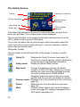
1
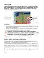
USER GUIDE
Blackspot Interactive Limited
Unit 5, New Rookery Farm, Little London
Silverstone, Northants NN12 8UP
Email: [email protected]
Web: www.blackspot.com
Thank you for buying your new ROAD ANGEL Navigator
As our roads become busier, more congested and more regulated, staying
alert to road and traffic conditions is a challenge to everyone. Even the most
conscientious driver can have a momentary lapse of concentration that
could easily lead to an accident or a fine and points.
ROAD ANGEL Navigator is specially designed to be a simple-to-use
addition to any vehicle, to alert and warn you in advance of known danger
areas. In the comprehensive ROAD ANGEL Navigator database are stored
Police, Local Authority and Ministry of Transport designated danger spots,
including accident black spots and safety camera locations.
Using the latest Global Positioning Satellite (GPS) technology, ROAD
ANGEL Navigator compares your position with the known danger spot
locations and gives you an audible and visual warning as you approach
them. An accurate GPS speedometer in the display gives you time to adjust
your driving to the approaching danger.
The safety of you and your passengers is our prime consideration, and we
trust that for all the miles you drive, your ROAD ANGEL Navigator will
enhance the safety and enjoyment of your journey. Join other ROAD
ANGEL Navigator users in guarding your life and livelihood.
We are pleased to have you as a valued customer and hope you will be
delighted with your fully integrated ROAD ANGEL Navigator. Having
listened to our customers we think the new features will make this product
your perfect driving companion.
Dave Clark, Managing Director
Blackspot Interactive Ltd.
The directors of Blackspot Interactive Ltd. sell ROAD ANGEL
Navigator as a road safety enhancement device. Driving within
the speed limits at all times and within the limitations of the
road condition and your abilities is paramount. The directors of
Blackspot Interactive Ltd. take no responsibility for the use of
ROAD ANGEL Navigator for other purposes than those
stipulated.
Table of Contents
1. Introduction........................................................................1
Front View.......................................................................................... 2
Back View.......................................................................................... 3
Left Side View.................................................................................... 4
Lower Side View................................................................................. 4
Cradle – Front View............................................................................ 5
Cradle – Back View............................................................................ 5
Cradle Mounting Arm......................................................................... 6
Register Now!..................................................................................... 7
Subscriptions........................................................................................ 8
Warranty................................................................................................. 8
Security.................................................................................................. 8
2. Installation..........................................................................9
Unpacking.............................................................................................. 9
Mounting the Unit.................................................................................. 9
Installing ROAD ANGEL Navigator................................................... 10
Hardwiring........................................................................................ 12
Getting Started.................................................................................... 13
3. Basic Operation................................................................15
Understanding the Display................................................................. 15
Safety Mode.....................................................................................
Alert Mode........................................................................................
Muting Audio and Speech Warnings................................................
Alert Types.......................................................................................
15
16
16
17
Getting There....................................................................................... 18
The Safety Screen............................................................................ 20
Navigation Screens.......................................................................... 21
Night Mode....................................................................................... 22
i
4. Advanced Operation.........................................................23
Multiple Stops...................................................................................... 23
Rearranging Stops........................................................................... 23
Optimizing Stops.............................................................................. 23
Picking Stops from the Map............................................................. 23
Alternative Navigation Methods......................................................... 24
Getting to a POI............................................................................... 24
Getting to a Road Junction............................................................... 24
Navigating to a Latitude/Longitude Point.......................................... 25
Making a Detour.................................................................................. 25
Automatic Detour............................................................................. 25
Manual Route Editing....................................................................... 26
Using Waypoints.............................................................................. 26
Changing Guidance Modes................................................................ 27
5. Customizing ROAD ANGEL Navigator............................28
Navigation Settings............................................................................. 28
Routing.............................................................................................
Guidance..........................................................................................
Map..................................................................................................
Favourites........................................................................................
POI Alerts.........................................................................................
29
30
31
32
33
Road Hazard Settings......................................................................... 34
Alerts................................................................................................ 35
Distances......................................................................................... 36
System Settings............................................................................... 36
Adding and Deleting Danger Zones................................................... 37
Deleting zones.................................................................................. 37
Adding new locations....................................................................... 37
Adding an Average Speed monitoring section (SPECS zone)..........38
Protecting and Cleaning..................................................................... 38
Cleaning the case............................................................................. 38
Cleaning the screen......................................................................... 38
General precautions......................................................................... 38
6. Updating the Database....................................................39
System requirements....................................................................... 39
Updating........................................................................................... 40
7. Troubleshooting...............................................................41
8. Background Information..................................................44
About Global Positioning Satellites (GPS)........................................ 44
GPS Status........................................................................................... 44
ROAD ANGEL Navigator's Database............................................... 45
Using ROAD ANGEL Navigator Abroad........................................... 45
Speed Cameras and Blackspots........................................................ 46
9. Accessories......................................................................48
10. End User License Agreements......................................49
NAVTEQ European Data for Portable Navigation Device
Applications......................................................................................... 49
Software............................................................................................... 51
iii
1. Introduction
ROAD ANGEL Navigator uses the latest global positioning satellite (GPS –
see page 44) technology to give you step-by-step navigation information
combined with audible and visible alerts as you approach hazardous
sections of road:
•
Accident black spots (as designated by the Police and Local Authorities)
•
Safety camera locations
•
Average speed measurement areas
•
Primary Schools
•
Congestion charging zones
ROAD ANGEL Navigator displays a constantly updated and accurate speed
reading. Should you break down, ROAD ANGEL Navigator allows you to
pinpoint your location and direct rescue services to your vehicle.
IMPORTANT SAFETY INFORMATION!
Never attempt to alter settings while you are driving; ask a
passenger to make any changes or find a suitable and safe
place to pull over and park your vehicle.
ROAD ANGEL Navigator is designed as an aid to safe driving
and route navigation; always drive within the speed limits and
traffic regulations, taking account of the road conditions and
your own abilities.
ROAD ANGEL Navigator should not be used in any way that
may interfere with the safe operation of your vehicle. Ensure
that your ROAD ANGEL Navigator and its associated equipment
and cables are securely and correctly mounted within the
vehicle.
Blackspot Interactive Ltd assumes no responsibility for any
damage or injury resulting from the use of this product.
1
Front View
▲ Volume UP
▼ Volume DOWN
◄ Night Mode
► Day Mode
■ Menu
Display
Shows speed, satellite
reception and indicates
type of hazard (see
page 16).
2
Zoom In/Out
On/
Use to change
Suspend
map magnification.
Delete Button
Press to remove alert
zone from database
(see page 37).
Power LED
Store Button
Press to enter new zones
(see page 37)
Back View
Internal Speaker
Used by ROAD
ANGEL Navigator
when the unit is not in
its cradle.
Registration
information
See page 7)
GPS Receiver
Before use, raise the antennae and ensure it
has a clear view of the sky. Note: The Unit
cannot be inserted into its cradle unless
the antennae is raised.
Mounting catch
Locates and secures
ROAD ANGEL
Navigator in its cradle.
Reset button
3
Left Side View
USB Port
Used by ROAD ANGEL
Navigator when the unit
is not in its cradle.
SD Card Slot
Contains all software do not remove.
GPS Antennae socket
Use to connect external
GPS antennae –
required in vehicles with
UV windscreens.
Lower Side View
Power switch
Slide switch to turn unit On/Off.
Note: Unit is supplied with
power switched off.
4
Cradle connector
Extends sound and
power connectivity to
cradle.
Cradle – Front View
Power indicator
Blue LED indicates
power on.
Release Lock
Press, and hold down,
to release ROAD Angel
Navigator from the
cradle.
Volume
Adjusts volume of
sound from cradle's
internal speaker.
Cradle – Back View
Power Connector
Connects to cigar
lighter socket using
supplied cable.
Mounting Arm Connector
Speaker
Used by unit when in
cradle.
5
Cradle Mounting Arm
Suction Cup
Press against windscreen then lift
Suction Lever to fasten arm in place.
Vertical Adjuster
Use to adjust angle of
cradle to windscreen and
dashboard.
Suction Lever
Applies or releases
suction to fix to
windscreen.
Horizontal Adjuster
Use to adjust
horizontal position of
cradle: e.g. to face
driver or passenger.
6
Cradle Flange
Slides into slot on
rear of cradle.
Register Now!
Register your ROAD ANGEL Navigator immediately after purchase. This is
important for two reasons:
•
You cannot update the unit until it has been registered. Database
information will be significantly out-of-date at the time of purchase and
should be updated as soon as possible (see page 39).
•
Without registration, we cannot resolve warranty issues, log queries or
solve problems with your ROAD ANGEL Navigator.
REGISTER your unit online:
1. Go to www.blackspot.com
2. Click on the Product Registration link. The Product Registration form is
displayed.
3. Enter your ROAD ANGEL Navigator's serial number. You can find this
on the base of the unit.
4. Click on the Next button. Once your details have been entered, you will
be prompted to download the update software directly to your PC. The
registration process normally takes one full working day – you can then
use the software to update your ROAD ANGEL Navigator (see page 39).
If online registration is not possible, please call the Registration helpline
(recorded) on: 0870 084 7439. Leave your name, address and telephone
number and we will forward a registration form to you the same working day
(Mon – Fri).
7
Subscriptions
Your ROAD ANGEL Navigator comes with a free subscription for six
months of database updates and product support. It is critical to the
operation of your ROAD ANGEL Navigator that you update the unit regularly
and so continued subscription is essential. With constant additions to the
ROAD ANGEL Navigator database (1000+ sites per year), the benefit of
your ROAD ANGEL Navigator and the protection it provides will be
dramatically reduced if you fail to maintain your database.
You can also subscribe online at http://www.blackspot.com/subscriptions/.
Warranty
Your ROAD ANGEL Navigator is guaranteed for one year from the date of
purchase from all defects that occur with normal use. If your unit fails to
perform as specified in these instructions, please visit:
http://www.blackspot.com/warranty
Security
Owing to the high number of thefts, we strongly suggest you remove your
ROAD ANGEL Navigator and its bracket from view when you leave your
vehicle.
Please contact Blackspot Interactive Ltd if your unit is stolen or lost. Each
ROAD ANGEL Navigator is identified by a unique serial number on the
base. We can disable a unit through our security systems and detect any
attempt to re-register it. This has frequently resulted in the safe return of a
ROAD ANGEL Navigator to its rightful owner.
8
2. Installation
This section shows you how to install ROAD ANGEL Navigator in your
vehicle. ROAD ANGEL Navigator can also be used as a free-standing unit
for GPS navigation whilst walking or for route planning prior to your journey
(see page 27).
Unpacking
Empty all the parts out of the box and familiarise yourself with each item.
Each pack contains:
•
The ROAD ANGEL Navigator unit (SD card is pre-installed)
•
A mounting cradle
•
A windscreen mounting arm
•
User manual
•
Anti-glare screen protector
•
Cables:
•
•
•
1 x Straight power lead
1 x Sprung power lead
1 x USB cable
Mounting the Unit
ROAD ANGEL Navigator has a high sensitivity GPS antenna and requires a
clear view of the sky to receive information from GPS satellites. We highly
recommend that ROAD ANGEL Navigator is positioned in the centre of the
front windscreen, low down, just above the dashboard. If screen glare is a
problem in this position, try installing the unit beside the driver's “A-pillar”.
Check that the GPS reception operates correctly in this position.
If you want to install ROAD ANGEL Navigator anywhere else within your
vehicle, you may require an external GPS antenna. Please contact
Blackspot Interactive Ltd or visit www.blackspot.com for details.
Use with UV and Heated screens
UV screens block GPS signals from entering the vehicle, stopping ROAD
ANGEL Navigator from acquiring its position. This can be a problem with
certain models of vehicle, i.e. BMW, Mercedes, Renault, Peugeot & Citroen.
9
Heated screens can also affect GPS signal strength.
If your vehicle has a UV or heated screen, you may need an external
antennae (please contact Blackspot Interactive Ltd or visit
www.blackspot.com for details). Most vehicles fitted with a UV screen have
a defined section behind the rear view mirror where you can fit the
antennae.
Installing ROAD ANGEL Navigator
The following instructions describe the installation of ROAD ANGEL
Navigator:
1. Adjust the mounting arm as follows:
a) Unfasten the vertical adjustment knob, and change the angle of the
central joint so that the connecting flange is vertical when the suction
cup is held against your vehicle's windscreen. Tighten the knob to
lock in place.
b) Unfasten the horizontal adjustment knob, and change the horizontal
angle of the connecting flange so that it is facing in the required
direction: in line with the vehicle, towards the driver, or towards the
passenger. Tighten the knob to lock in place.
2. Hold the suction cup against the windscreen. Rotate the lever clockwise
to apply suction. For maximum adhesion, it may help to dampen the
suction cup beforehand.
3. Take the power lead, and plug it into the socket on the rear of the cradle.
Don't connect the other end to the cigar lighter socket yet.
4. Slide the cradle onto the mounting arm's connecting flange.
5. Take your ROAD ANGEL Navigator, and lift up the GPS Receiver panel.
6. Slide the ROAD ANGEL Navigator's power switch to the On position
(towards the navigation buttons – see page 4). The device will start to
load up.
7. Slide the unit into the cradle and press firmly into place (support the
cradle underneath whilst you do this).
8. Route the power cable to the cigar socket. Ensure that it does not
interfere with any of the vehicle's controls or airbag modules. If you use
your cigar socket for any other devices, a dual adaptor may be used.
You are now ready to use the unit for the first time (see page 13).
10
1(a)
1(b)
2
3
4
5
6
7
11
Hardwiring
ROAD ANGEL Navigator has a 5V regulator built into its power cable. If the
cable is cut and used to hardwire the unit into the vehicle, you will damage
the ROAD ANGEL Navigator.
To hardwire ROAD ANGEL Navigator into your vehicle, purchase a cigar
socket, wire this into the power system and use with the supplied cable.
Consult an auto electrician if you are unsure how to carry out
this procedure as incorrect hardwiring may affect the validity of
vehicle and product warranty. Consult vehicle manufacturer if
in doubt.
12
Getting Started
1. Find a location outside with a clear view of the sky (away from obstacles
such as tall buildings and over-hanging trees – these may delay or
prevent satellite acquisition).
2. Plug the power lead into the cigar lighter socket. If your socket is
ignition-switched you will need the ignition to be on.
3. Press the On/Off switch in the top right corner (see page 2).
ROAD ANGEL Navigator displays the following screen.
If you have not updated your ROAD ANGEL Navigator, the display
illuminates red and prompts you to ‘Please register your ROAD ANGEL
Navigator and execute an update. Any key to continue’. Press any
button to clear this screen. When you have updated ROAD ANGEL
Navigator, this message will not appear again.
4. The display illuminates blue and shows a satellite symbol:
The first time the unit is switched on, it must acquire data from a
minimum of 4 satellites to establish its position. THIS MAY TAKE UP TO
13
45 MINS. After approximately 4 hours use, ROAD ANGEL Navigator's
internal battery will be charged sufficiently for it to be able to memorise
its position. Subsequent starts will acquire satellites within 1-2 minutes.
5. When ROAD ANGEL Navigator has established its position, the display
shows your speed (0 if you are stationary).Your unit is now ready for
use.
14
3. Basic Operation
Understanding the Display
Safety Mode
In its normal standby mode, with no route selected, ROAD ANGEL
Navigator's display shows your speed, satellite reception (indicated by a
flashing 3-bar sequence – green: good satellite signal (3D fix), yellow:
searching (2D fix), red: no signal and the status of audio output:
Speed Measurement
ROAD ANGEL Navigator calculates your vehicle speed from GPS data.
The speed is updated every second and, at a constant speed, is highly
accurate. If you are accelerating or decelerating, the displayed value will lag
behind the actual speed by a small margin.
You may find a difference between the reading on your vehicle's
speedometer and ROAD ANGEL Navigator. This is because all vehicles are
manufactured with a tolerance on the speedometer to allow for tread depth,
tyre size and pressure changes.
15
Alert Mode
When you are approaching a known danger zone, the display shows an
alert message and an icon indicating the type of hazard and an advisory
speed limit. The table on the next page shows the types of alert icons
displayed by ROAD ANGEL Navigator.
Alert message/
Proximity-tohazard counter
Actual speed
Audio On/Off
icon
Advisory speed
limit/Alert-type
icon (alternating)
In addition:
•
The Proximity-to-hazard counter increases from 1 to 5 bars as you get
closer to the danger zone.
•
Speech warnings will tell you the type of zone followed by an audible
tone that increases with your proximity to the hazard.
USE THE ADVISORY SPEED LIMIT FOR GUIDANCE
ONLY. YOU SHOULD ALWAYS KNOW THE SPEED LIMIT
AND TAKE ACCOUNT OF DRIVING CONDITIONS.
When you have passed the danger, ROAD ANGEL Navigator returns to
standby mode.
Muting Audio and Speech Warnings
You can stop audio and speech warnings temporarily when you are in a
danger zone, or permanently from Standby mode.
To temporarily mute audio and speech warnings when in a danger zone,
tap the warning symbol. When you have passed out of the danger zone,
ROAD ANGEL Navigator restores audio and speech alerts to your current
menu settings.
To customise audio and speech alerts for each type of danger zone, adjust
the appropriate settings in the Alerts menu (see page 35).
16
Alert Types
Alert Type
Icon
Location Type
Fixed
You are approaching a fixed Speed Camera
ahead. ROAD ANGEL Navigator only alerts you if
you are travelling in the direction that the camera
enforces.
Mobile
Temporary speed camera ahead, often seen in
road works, or at a Speedmaster location.
Average
You are entering an average speed detection
zone. The icon remains on screen whilst you are
inside the enforcement zone.
Blackspot
You are approaching an accident black spot – an
area identified by the police and local authorities.
School
Optional setting:
You are near a Primary school (see Alerts on
page 35). Secondary schools and other
educational establishments are not recorded in
the database.
Congestion
Optional setting:
You are approaching a congestion charging zone
(see Alerts on page 35).
Overspeed
Optional setting:
You are exceeding the speed limit you have set in
the Alerts menu (see Alerts on page 35).
17
Getting There
1. From the Welcome screen, tap the Going to... button. The Going to..
screen is displayed.
2. Tap the Enter Destination button. The Select Stop screen is displayed.
This offers you a number of different ways to specify the destination:
18
Address
Enter a new address.
Home
Enter your home address.
Work
Enter your work address.
Favourite
Select a previously visited destination.
Junction
Enter the name of a road junction (see page 24).
Postcode
Enter your destination's postcode.
POI
Search for a Point of Interest (see page 24).
Latitude/Longitude
Enter a Latitude/Longitude point (see page 25).
3. If this is the first time you have used ROAD ANGEL Navigator, tap on
either the Address or Post Code buttons.
4. If you want to enter an address, ROAD ANGEL Navigator will prompt
you for your country name. Enter UK and tap the Next button.
5. Enter the destination address or post code following any prompts and
using the screen keyboard. Tap on the ABC button to enter letters or the
123 button to enter numerals.
6. ROAD ANGEL Navigator helps you find your destination by listing its
best guess throughout the procedure. At any time, you can select a
choice from its list. When you have finished, tap the Next button.
7. Type a name to identify the selected destination (optional). Tap the Next
button. The Going To screen is displayed again, with your destination
listed in the box.
8. Tap on the destination to highlight it, and then tap on the Start Driving
button. The Safety screen is displayed.
19
The Safety Screen
Toolbar
Distance to next turn
Route directions
Speed display/
Alert area
Information bar
Status bar
GPS reception
indicator
This shows the distance to the next turn with instructions on what to do
when you get there. Your current speed is also displayed.
The line at the bottom of the screen shows your estimated time of arrival
(ETA), distance left to go and GPS status.
Tap on the line above this to cycle through further information about the
route: the road you are currently driving on, nearest crossroad, nearest
major road and nearest town.
Navigation Toolbar
Use the toolbar on the left-hand side of the screen to create or modify
routes:
Going To
Safety mode
Displays the Going To screen (see page 18).
Use this to create a new trip, select a destination
or start driving to the displayed destination.
Display the Driver Safety screen.
Change the display mode from the safety
screen to a 2D or 3D map. Shows your current
position as a pink arrow and indicates the next
turn with a yellow arrow. ROAD ANGEL
Navigator scales the map so that your current
position and the next turn are always on screen.
Itinerary mode Displays a list of the directions in your route (see
page 26).
Make a detour from the selected route (see
Detour
page 25).
Choose further options such as the Guidance
More
mode (see page 27), settings (see page 28) or
GPS status (see page 44).
Map mode
20
Navigation Screens
ROAD ANGEL Navigator offers four different types of screen display:
Driver Safety
2D Map Mode
This is the recommended mode for safe
driving. ROAD ANGEL Navigator
automatically uses this view unless your
speed is less than 10mph or you are
within 0.7 mile of a turn. If this is the
case, it will switch back to your
previously selected map mode.
Shows a standard road map with your
current position and direction of travel
indicated by a pink arrow. Turns in your
route are shown by yellow arrows. You
can change the scale of the map or
scan across it by dragging your finger
across the area or in the direction of
interest.
3D Map Mode
Itinerary
Shows an aerial perspective map. As in
the 2D Map mode, your position and
direction is indicated by a pink arrow.
You can scale the map or scan across it
by dragging your finger across the area
or in the direction of interest.
Displays your route as a list of driving
directions. You can scroll through the
list, identifying stops (see page 23) and
specifying any stages you want to avoid
(see page 26).
21
Night Mode
Both 2D and 3D map modes can be viewed with either a day or night
display. Night mode, has a dimmed display and a darker map style to
reduce glare while driving at night. ROAD ANGEL Navigator switches to
Night mode automatically; it determines the transition time from your current
time zone and the date. You can also switch between day and night modes
by pressing the left arrow on the directional pad.
22
4. Advanced Operation
The last section explained the basic use of ROAD ANGEL Navigator:
dealing with alerts and navigating to a single address or postcode. This
section describes its advanced features:
•
Making multiple stops
•
Navigating to a Point of Interest (POI), Road Junction or
Latitude/Longitude point, or a point on the map
•
Making a detour
•
Using ROAD ANGEL Navigator for planning or walking.
Multiple Stops
In most cases, you will enter a single destination and allow ROAD ANGEL
Navigator to determine your route and guide you there. However, if you
want to stop at one or more places on the way, you can enter more
destinations into your itinerary as stops and let ROAD ANGEL Navigator
calculate the best route to get you from one stop to the next.
Make sure you enter the stops in reverse order and that your final
destination is the last (top) stop.
Rearranging Stops
To rearrange a list of stops, tap on any stop in your itinerary and select
Move Up or Move Down from the pop-up menu. You can use the same
menu to delete one or all of the stops in the itinerary.
Optimizing Stops
To make your journey more efficient, you can tell ROAD ANGEL Navigator
to calculate the optimum route and rearrange your stops accordingly. Tap
on any stop in your itinerary (there must be three or more) and select
Optimize Stops from the pop-up menu.
Picking Stops from the Map
If you don't know the postcode or address of your destination, you can use
ROAD ANGEL Navigator's maps to locate and identify it as a stop.
When you have found the destination, tap on the map. ROAD ANGEL
Navigator displays the street name.
23
Hold your finger on the position and select Add as Stop from the pop-up
menu.
On the Pick a stop from map screen, check the details and enter a name for
the destination.
Tap on Apply to add the stop to your current itinerary.
This is a useful method to enter waypoints for a detour (see page
25).
Alternative Navigation Methods
Getting to a POI
1. At the Select Stop screen (see page 18), tap on the POI button. The
Points of Interest screen is displayed.
2. Choose a POI category and type from the list boxes. If you know the
name of the POI, use the keyboard to enter the first few letters in the
Starting With: Name box. When you have finished, tap on Next.
3. Choose how ROAD ANGEL Navigator searches for the POI:
•
Along current route
•
Near current location
•
Near a city (enter the county and postcode when prompted)
4. Tap on Next. ROAD ANGEL Navigator searches its database and
displays a list of the best matches to the criteria you have entered.
5. To preview the location of a POI, tap on it and then tap on Map.
6. To extend your search for the POI to a larger area, tap on the Expand
button. The list is regenerated.
7. To enter the POI as a destination in the Going To screen, tap on the
Finish button.
Getting to a Road Junction
1. At the Select Stop screen (see page 18), tap on the Junction button.
The Junction screen is displayed.
2. Enter the name of the first road and then tap on Next.
3. Enter the name of the second road and then tap on Next.
24
4. Enter a name for the location (optional) and then tap on Finish. The
junction is added as a destination to the Going To screen.
Navigating to a Latitude/Longitude Point
1. At the Select Stop screen (see page 18), tap on the Latitude/Longitude
button.
2. Choose a format for the reference: Decimal Degrees, Decimal Minutes
or DMS (degrees, minutes, seconds).
3. Enter the Latitude, specifying N or S.
4. Enter the Longitude, specifying E or W.
5. Tap on Next.
6. Enter a name for the location (optional) and then tap on Finish. The
location is added as a destination to the Going To screen.
Making a Detour
There are three ways you can change the route to your destination:
•
Using ROAD ANGEL Navigator's automatic detour feature.
•
Manually editing your route in Itinerary mode.
•
Creating a detour with waypoints
Automatic Detour
1. Tap on the Detour button. ROAD ANGEL Navigator calculates a new
route. It displays new instructions with an estimate of the number of
miles that it will add to your journey.
2. If you decide to accept the detour, continue to follow the new
instructions.
3. To return to the original route, tap on the Cancel Detour button.
25
Manual Route Editing
You can change the route calculated by ROAD ANGEL Navigator by
customizing the route in Itinerary mode to avoid specific roads or turn
instructions.
1. With the route selected (see page 18), change to Itinerary Mode. ROAD
ANGEL Navigator lists the roads and turn instructions for your route.
2. Tap on the section of the route that you want to avoid.
3. Tap the Avoid button. ROAD ANGEL Navigator calculates a new route
avoiding the section.
4. Repeat this procedure to avoid other roads.
ROAD ANGEL Navigator will not allow you to avoid a road and will
keep it in the itinerary if there is no practical alternative.
5. You can return to your original route at any time by tapping on the
Cancel button.
Using Waypoints
A route can consist of any number of intermediate stops (see page 23). You
can use additional stops as waypoints to create a diversion to ROAD
ANGEL Navigator's default route. To create a waypoint:
1. Create a route to your destination on the Going To screen (see page 18)
entering each waypoint as a stop. Remember to enter the stops and
your final destination in reverse order.
2. To change a stop into a waypoint, tap on it and select Set As Waypoint
from the pop-up menu. You can change a waypoint back into a stop by
repeating this procedure, selecting Set As Stop from the pop-up menu.
3. ROAD ANGEL Navigator will now choose a route to your destination
passing through the waypoint(s).
26
Changing Guidance Modes
ROAD ANGEL Navigator has three modes of operation:
Driving
Provides on-screen and spoken directions and other
route information to guide you to a chosen destination.
Walking
Similar to Guidance mode. On-screen and spoken
directions are modified for pedestrian use. ROAD
ANGEL Navigator provides direct-line directions and
distance measurement to your destination.
Planning
Allows you to use ROAD ANGEL Navigator for pre-trip
planning or as a reference guide. You can use the maps
to create trip itineraries for later use. This mode does not
require GPS reception.
To change mode:
1. Tap on
.
2. Select Guidance Mode from the menu.
3. Choose the required mode from the menu list.
27
5. Customizing ROAD ANGEL Navigator
You can change the way ROAD ANGEL Navigator works by adjusting its
menu settings. There are two types of settings:
•
Navigation settings
•
Road hazard alert settings
Navigation Settings
Tap on
and select Options to view the menus:
Routing
Adjust the way that ROAD ANGEL Navigator chooses a
route to a selected destination.
Guidance
Change the way ROAD ANGEL Navigator directs you to
your destination.
Map
Settings for map display and control.
Favourites
Delete routes from your Favourites, Home and Work
lists.
POI Alerts
Change the way that ROAD ANGEL Navigator alerts you
to points of interest (POI) such as Airports, Restaurants
and Hotels.
Tap on the menu title to view its options.
28
Routing
Routing settings determine how ROAD ANGEL Navigator selects a route to
a chosen destination.
Details
Options
(factory setting
shown in bold)
Routing Type
Choose whether ROAD ANGEL
Navigator selects the quickest (based
on road quality, terrain and speed
restrictions) or the shortest route
(based on the shortest distance on
good roads).
Quickest....Shortest
Routing Options
Additional routing options: choose a
route avoiding toll roads
None...Avoid Tolls
Distance Unit
Select the displayed distance unit:
miles or kilometres
Miles..Kilometres
Property
29
Guidance
Guidance settings adjust the way that ROAD ANGEL Navigator indicates
turnings during a route.
Property
Details
Speak turn warning at
Determines when ROAD ANGEL
Navigator announces turn information.
Choose from up to three set
distances: 2 miles, 1mile and 0.3 mile.
Just Ahead
Adjustable distance/ time setting for
route announcement as you approach
a turning.
Custom display
Choose from a number of display
options for the guidance mode.
30
Options
(factory setting
shown in bold)
2...1...0.3 mile (all on)
5sec/100ft
ETA, speed, elevation,
heading. current time, nearest
town, nearest major road,
nearest crossing, current
road, destination
Map
Map settings provide a number of options for the way that ROAD ANGEL
Navigator displays maps.
Property
Details
Options
(factory setting
shown in bold)
Map Display
Choose manual or automatic day night Automatic Day/Night Mode
mode switching and whether point of
Display POIs
interest information is displayed.
Map Control
Select either zoom or drag mode. In
zoom mode, if you drag your finger or
a stylus across the map, ROAD
ANGEL Navigator increases the scale
of the map to show the selected area;
in Drag mode, the same action will
cause the map to move in the dragged
direction, without a change of scale.
Box Zoom
Drag Map
31
Favourites
The Favourites list is displayed from the Go To screen (see page 18). It
allows you to quickly select a previously entered route. In the Favourites
menu, you can delete routes from the Favourites list or delete your Home or
Work routes.
To delete one or more destinations:
1. Choose the location of the routes to be deleted: tap on the Favourite,
Home or Work option button. All routes in the chosen category are
listed.
2. Tap on the route you want to delete.
3. Tap on the Delete One button. If you want to remove all the listed
routes, tap on the Delete All button.
Note. The favourites list holds up to 50 routes. Beyond this, new routes
replace the least used routes in the list.
32
POI Alerts
Use this screen to enable or disable point-of-interest (POI) alerts. By
default, these are disabled.
To change POI settings:
1. Tap on the Enable POI Alert check box to enable or disable POI Alerts.
2. If you have enabled POI Alerts, choose the 'ahead' range – the distance
from your route at which you want to exclude POIs: 0.2, 0.5, 1, 3, 10, 25
miles.
3. Choose the category of POIs for the alert by tapping on the arrows
alongside the box. You can choose All Categories (the default setting) or
select one category from the list: Airport, Automotive & Maintenance,
Custom, Education Institution, Emergency & Medical, Facilities and
Buildings, Gas Stations, Hotels, Restaurants, Retail Outlets, Sport &
Recreation, Travel & Transportation, Visitor Attractions.
4. In several of these categories there are also further options listed in the
Types box. For example, in the Facilities & Buildings category, there are
the following types: Business Facilities, City Hall, Community Center,
Exhibition or Conference. You can opt to receive alerts for All Types (the
default option) or choose a type by tapping on the arrows alongside the
Types box.
5. Tap on the OK box to apply your settings or the Cancel box to discard
any changes.
33
Road Hazard Settings
To change the way that ROAD ANGEL Navigator alerts you to road
hazards, press the Menu button on the front of the unit (see page 2). ROAD
ANGEL Navigator's properties are listed in the following menus:
Alerts
How ROAD ANGEL Navigator alerts you to
road dangers with audio and visual prompts.
Distances
Set the distance at which ROAD ANGEL
Navigator commences its alerts.
System
Settings
Screen brightness, clock adjustment, serial
number and firmware version.
After several seconds of inactivity on a menu screen, the display will return
to normal mode. Use the on-screen buttons to view and edit system
settings. The following sections list all the editable properties in each of the
menu categories.
View the next menu category or property
View the previous menu category or property
Open the displayed menu and view the first property
Edit the displayed property
Adjust the displayed value, cycling through available options.
(Clock Adjust – increase clock offset in 30 minute increments)
(Clock Adjust only) Decrease clock offset in 30 minute increments.
Save the new value.
Exit Road Hazard settings and return to normal display.
34
Alerts
Settings in the Alerts menu determine how ROAD ANGEL Navigator warns
you about road hazards.
Property
Details
Voice Alert
Switch voice alerts on or off.
Camera Alert
volume
Change the sound level of safety camera
related warnings.
Camera alert single Switch alert on or off, as each proximity
bar counts up it will emit a single beep.
beep
Options
(factory setting in bold)
Off...On
0..20...40...60...80...100%
Off...On
Safety Alert Volume
Change the sound level for Blackspot,
School and Congestion related warnings.
Safety Alert single
beep
Switch alert on or off, as each proximity
bar counts up it will emit a single beep.
Off...On
Blackspot alert
Switch Blackspot alerts on or off.
Off...On
School zone alert
Switch School alerts on or off.
Off...On
Congestion zone
alert
Switch Congestion zone entry warnings
on or off.
Off...On
Overspeed alert
Set a speed at which the unit will warn if
you exceed the speed.
Off...25 - 165
Slow speed
automute
When travelling less than 15MPH the unit
will not give an audible warning. If you
enter a zone below 15MPH you will hear
a single beep, followed by the proximity
count up.
Off...On
Speed sensitive
volume
Adjust the warning volumes depending
on how fast the vehicle is travelling.
Off...On
0..20...40...60...80...100%
35
Distances
With its factory setting, ROAD ANGEL Navigator alerts you to when you are
within 250m of a hazard; you can change this to 500m or 1000m. In
addition, ROAD ANGEL Navigator has a feature to increase the warning
distance when you are travelling over 50mph.
Property
Details
Options
(factory setting
shown in bold)
Alert distance
Adjusts the warning range as you
approach danger zones.
250...500...1000m
Speed distance
sensitivity
Doubles the advanced warning at
50MPH and above.
Off...On
System Settings
Using this menu, you can change the appearance of the display: its contrast
and the speed units in use. You can also adjust the clock and view technical
information about your ROAD ANGEL Navigator: the serial number and
firmware version.
Property
Details
Options
(factory setting
shown in bold)
Backlight brightness
Adjust the brightness of the ROAD
ANGEL Navigator display.
0..20..40..60..80 100
Speed units
Change displayed speed between
mph and km/hr
MPH....km/H
Clock adjust
Change time – ROAD ANGEL
Navigator uses GPS data; may require
offset to account for daylight saving
time.
Unit serial number
Serial number of ROAD ANGEL
Navigator unit
Read only; 8 digit number
Firmware
ROAD ANGEL Navigator Software
version
Read only, in format x.xx
36
± 20 hours in ½ hour
intervals. (+1.00)
Adding and Deleting Danger Zones
Blackspot Interactive Ltd. are constantly updating the central database of
danger zones. You can be of great value to all ROAD ANGEL Navigator
users by noting new information accurately, adding it to your ROAD ANGEL
Navigator's database and then downloading the information to our central
database. All general information is verified by Blackspot Interactive Ltd.
before it is added it to the central file.
PLEASE ONLY ADD OR DELETE DANGER ZONES WHEN IT IS
SAFE TO DO SO.
Deleting zones
You can delete any of the locations stored in the ROAD ANGEL Navigator
database. When your ROAD ANGEL Navigator alerts you to the required
danger zone:
1. Press the DELETE (“D”) button on the front of the unit (see page 2).
2. Confirm the deletion by pressing DELETE again.
When a location has been deleted it can only be restored by reentering the location (see Adding new locations, below) or by
requesting a factory reset for your next update: email
[email protected] with your serial number and contact details.
Note: By using a factory reset all your personally stored
locations will be lost.
Adding new locations
You may add new locations to the FIXED, MOBILE, AVERAGE,
BLACKSPOT and SCHOOL areas of your ROAD ANGEL Navigator
database. When you update your ROAD ANGEL Navigator these new
locations will also be downloaded to the central database, and can then be
verified by Blackspot technicians for inclusion in future updates.
ROAD ANGEL Navigator needs to be travelling in excess of 4 MPH
to calculate the heading for the location.
When your vehicle is precisely alongside the new location:
1. Press the STORE (“S”) button on the front of the unit (see page 2). This
will confirm your location.
2. Choose the type of warning and then the speed limit.
3. Press STORE to confirm your choice.
37
Adding an Average Speed monitoring section (SPECS
zone)
Store an average speed monitoring area only if you are absolutely sure of
the start and finish points. When passing underneath the first ‘start’ SPECS
camera carry out the following:
1. Press STORE once to store the first camera position.
2. Press DELETE to select the location type: AVERAGE.
3. Press STORE to confirm.
4. When you are underneath the finish camera, press STORE to confirm
the finish position.
The section of average speed detection is now stored.
If you press STORE by mistake, you have the option to cancel by
pressing the MENU button.
Protecting and Cleaning
Cleaning the case
Your unit is made from tough polycarbonate moulded plastic and is
designed to withstand normal daily handling. Only clean with a dry or slightly
damp cloth. Do not use solvents or a wet cloth.
Cleaning the screen
When cleaning the LCD display, avoid pressing too hard as this may
damage the display.
General precautions
Avoid water or very damp conditions, extremes of heat (60ºC) or cold
(-10ºC) and dropping the unit. We recommend removing ROAD ANGEL
Navigator and its bracket from the dashboard if the vehicle is parked for
long periods in direct sunlight.
38
6. Updating the Database
Your ROAD ANGEL Navigator is capable of storing up to 50,000 unique
danger zones (see page 45). As soon as possible after your purchase, you
should:
•
REGISTER the unit online at www.blackspot.com (see page 7). If online
registration is not possible, please call the Registration helpline
(recorded) on: 0870 084 7439. Leave your name, address and
telephone number and we will forward a registration form to you the
same working day (Mon – Fri).
•
Download the latest version of the update software.
•
Download the latest version of the database. You cannot update your
ROAD ANGEL Navigator until your registration has been processed –
this can take up to 24 hours online. Allow 3-4 days for registrations using
the recorded form request service.
We recommend that you update your ROAD ANGEL Navigator on a regular
basis, as safety camera locations are constantly changing. With new
locations being added and old cameras being removed, we recommend a
monthly update. If you are a high mileage motorist, using unfamiliar roads,
you may want to update your database weekly. You should also update the
database before you set off on a long trip.
To update ROAD ANGEL Navigator, you will need to install the supplied
software (also available as a download from our website) on a PC with
Internet access. The software is supplied with full installation instructions.
This also explains how to set up the USB communications between your PC
and ROAD ANGEL Navigator.
System requirements
•
IBM PC or 100% compatible
•
Microsoft Windows 98SE, ME, 2000, XP
•
Internet Explorer version 5.5 or above
We do not support Apple Macs
39
Updating
1. Connect your ROAD ANGEL Navigator to the PC using the USB cable.
2. With your Internet connection active, start the ROAD ANGEL Navigator
software.
3. Click on the Synchronise button.
4. Your ROAD ANGEL Navigator is updated from the the central database.
Any additions you have made to your database are downloaded for
confirmation and possible inclusion in future updates.
You may need to configure your firewall or Internet Security software
to allow the update software access to the Internet. Please refer to
your product support guide.
ROAD ANGEL Navigator's updating software in action
40
7. Troubleshooting
ROAD ANGEL Navigator fails to power up
1. Check that the power lead is plugged into the correct port on the back of
the ROAD ANGEL Navigator cradle (see page 5).
2. Is the ROAD ANGEL Navigator's green Power LED on (see page 2)? If it
is, press the On/Off button next to the Power LED. If the Power LED is
not illuminated, check that the unit's power switch is in the On position
(see pages 4 and 10).
3. On the plug in the cigar socket, check that the LED is illuminated. If it is
not, please check that the plug is located properly and then test the
internal fuse. If this is OK, then no power is reaching the socket –
consult a qualified auto-electrician.
ROAD ANGEL Navigator lights up but does not acquire satellites
(shows satellite symbol but the five bars fail to light up - see page 13)
1. Check the position of your ROAD ANGEL Navigator in the car: it must
have a clear view of the sky to acquire GPS data.
2. Are you in a built-up area? If so, move to an area clear of tall buildings or
overhanging trees.
3. If this is the first time the unit has been switched on it may take up to 45
minutes to acquire a signal.
4. Power down the unit and reboot by pressing the Reset button on the
back (see page 3).
5. Has the vehicle got a UV screen? Place ROAD ANGEL Navigator onto
the roof of the vehicle and wait for it to acquire satellite data; once
acquired, place back into the car and see if it can hold the signal. If it
cannot then an external antenna is required. Please visit
www.blackspot.com for details. If you have a Ford Focus or Mondeo with
a Quickclear windscreen, ROAD ANGEL Navigator will work if placed on
the far right hand side of the dashboard.
41
ROAD ANGEL Navigator loses the satellite signal (the speed display is not
shown)
1. This may happen temporarily owing to tunnels, tall buildings, bridges or
dense foliage. When you are clear of the obstruction, ROAD ANGEL
Navigator should re-acquire satellite signals in a few seconds.
2. Have you moved the unit within the vehicle? Reposition ROAD ANGEL
Navigator to its original position.
3. You may be experiencing poor GPS coverage – very occasionally one or
more satellites are out of sequence and the signal temporarily drops out.
It should be restored within minutes.
No audible signal
On powering the unit, irrespective of the volume level, the unit will
sound. If you can hear this then the volume has been adjusted to
minimum.
a) Press the MENU button on the front of the unit (see page 2).
b) Tap the OPEN button and then NEXT to view the Camera alert
volume setting.
c) Tap the EDIT button to edit the value.
d) Tap ADJUST repeatedly until the display shows the required value.
e) Tap on the STORE button to save the setting. ROAD ANGEL
Navigator confirms that the setting has been stored.
f) Tap on the EXIT button.
I am not getting a warning on all fixed cameras
1. Has the unit been updated recently? Carry out an update to add all the
new locations (see page 39).
2. ROAD ANGEL Navigator has a directional feature that allows it to ignore
cameras that are enforcing the speed limit in the opposite direction.
42
I am not getting sufficient warning as I approach fixed cameras
Increase the Alert distance setting:
a) Press the MENU button on the front of the unit (see page 2). The
Alerts menu symbol is displayed.
b) Tap the NEXT button to view the Distances menu.
c) Tap the OPEN button to view the Alert distance (see page 36).
d) Tap on the EDIT button.
e) Tap on the ADJUST button repeatedly until the unit shows the
required value.
f) Tap on the STORE button to save the setting. ROAD ANGEL
Navigator confirms that the setting has been saved.
g) Tap on the EXIT button.
Sometimes when I am driving I get a warning for a camera that is not there.
1. Has the unit been updated recently? The camera may have been
removed from the database.
2. ROAD ANGEL Navigator may be warning you about a camera on a
parallel road very close to the road you are travelling on. If this is the
case, the proximity bars may switch off before they go all the way to
maximum. This problem is more likely to occur if your ROAD ANGEL
Navigator is set to a long alert distance setting. Try reducing the Alert
Distance setting (see above).
ROAD ANGEL Navigator displays the message 'Please Register..' when I
power it up
Your ROAD ANGEL Navigator has not been updated. You need to
register (see page 7) and update your ROAD ANGEL Navigator (see
page 39).
ROAD ANGEL Navigator flashes the message 'Alert Data Out Of Date'
ROAD ANGEL Navigator has not been updated for 30 days. You need
to update ROAD ANGEL Navigator as soon as possible (see page 39).
43
8. Background Information
About Global Positioning Satellites (GPS)
Operational since 1990, 24 satellites orbit the earth at a height of 11,000
miles. At any given point on the globe, at least 4 satellites are in view at any
one time. Using sophisticated aerials and triangulation techniques, units
such as ROAD ANGEL Navigator are able to compute your position to
within 5-10 metres.
Occasionally, when roads are close together, ROAD ANGEL Navigator may
place you on the wrong road. If this happens, keep driving and ROAD
ANGEL Navigator will automatically correct itself when it has a better fix or
when the road network simplifies.
ROAD ANGEL Navigator may lose the GPS satellite signal temporarily
owing to tunnels, tall buildings, bridges, dense foliage or adverse weather
conditions. When you are clear of the obstruction, ROAD ANGEL Navigator
should re-acquire satellite signals in a few seconds.
GPS Status
To view GPS information, tap on
screen is displayed:
44
and select GPS Status. The following
ROAD ANGEL Navigator's Database
ROAD ANGEL Navigator uses a database of Police, Local Authority and
Ministry of Transport designated danger spots, including accident black
spots and safety camera locations, primary schools and congestion
charging zones. Your ROAD ANGEL Navigator can store up to 50,000
unique danger locations. Using the latest Global Positioning Satellite (GPS)
technology, ROAD ANGEL Navigator compares your position with known
danger spot locations and gives you an audible and visual warning as you
approach them.
It is critical to the accurate operation of your ROAD ANGEL Navigator that
you update your unit regularly to maintain the very latest data. With up to
100 new hazard locations added each month, we suggest that you update
your ROAD ANGEL Navigator monthly (see Updating the Database on
page 39). If you are a high mileage driver, using unfamiliar roads, we
recommend weekly updates.
To qualify for database updates:
1. Register your ROAD ANGEL Navigator with Blackspot Interactive
Ltd. You cannot update the database until you have registered (see
page 7).
2. Purchase a valid subscription package (see page 8). Your new
ROAD ANGEL Navigator comes with an initial, free, 6-month
subscription
Using ROAD ANGEL Navigator Abroad
Your ROAD ANGEL Navigator is specifically designed for use within its
designated country, as stated on the packaging. It will have limited
functionality in other countries because the appropriate map and
camera/safety GPS data will not be present.
If you intend to use ROAD ANGEL Navigator abroad, seek independent
legal advice prior to departure.
45
Speed Cameras and Blackspots
This section describes the type of cameras and road hazards covered by
ROAD ANGEL Navigator:
Gatso
The most common type of speed camera –
used in fixed positions mounted on poles at
the roadside. Measures vehicle speed using
radar and, if the speed limit has been
exceeded, photographs the rear of the
vehicle. Uses a flash unit inside the camera
cabinet or mounted on a gantry to illuminate
the offending vehicle's rear number plate.
ROAD ANGEL Navigator relies on up-todate database information for detection.
TruVelo
Measures vehicle speed using sensor strips
in the road and photographs the front of a
speeding vehicle, along with the driver. Uses
an infra-red flash. ROAD ANGEL Navigator
relies on up-to-date database information for
detection.
SPECS
Takes a digital photograph of your vehicle at
the ‘start’ point and then another a set
distance further down the road. If your
average speed is greater than the speed
limit between these two cameras you are
automatically prosecuted. ROAD ANGEL
Navigator relies on up-to-date database
information for detection.
46
Watchman
Measures vehicle speed and, if the speed
limit has been exceeded, takes a
photograph of the front of the vehicle,
including the driver. Can be accessed
remotely allowing operators to download live
video, stored images or data. ROAD ANGEL
Navigator relies on up-to-date database
information for detection.
Speedcurb
Measures the speed of vehicles in the
monitored section of road using pressure
sensors in the road surface. If the speed
limit has been exceeded, it takes a
photograph of the rear of the vehicle. Uses a
flash module for night-time operation. ROAD
ANGEL Navigator relies on up-to-date
database information for detection.
Traffiphot
Uses pressure sensors in the road (similar
to Speedmaster – see below) to measure
vehicle speed and photographs the rear of
any speeding vehicle. Not to be confused
with red-light cameras. ROAD ANGEL
Navigator relies on up-to-date database
information for detection.
Speedmaster
Semi-permanent (fixed location but only
used part-time), system that uses pressure
sensors in the road to measure vehicle
speed. Connects to a camera on a tripod for
evidence of any offence. ROAD ANGEL
Navigator relies on up-to-date database
information for detection.
47
Black spot
A specific location, identified by the police
and local authorities, where a high number
of accidents have occurred e.g. a difficult
junction. Black spots are often targeted by
mobile speed enforcement units. ROAD
ANGEL Navigator relies on up-to-date
database information to identify black spots.
Congestion
Drivers must pay in advance or on the day
of travel to enter the designated zone during
the scheme’s hours of operation. There are
substantial penalties if you do not pay the
congestion charge.
Primary Schools
You can set up ROAD ANGEL Navigator to
alert you whenever you are within 250
metres of a primary school.
9. Accessories
The following table lists the accessories available for ROAD ANGEL
Navigator. Please visit the ROAD ANGEL Navigator online shop at
www.blackspot.com for more details.
Item
Details
Dual Lock
Two-piece, recloseable fastener.
12v Cigar Lead (Straight)
2.5 metre with standard fused cigar plug.
12v Cigar Lead (Sprung)
1.5 metre extendable with standard fused cigar plug.
Optional External Antenna (2m)
Connects to ANT socket on New ROAD ANGEL
Navigator – for use in vehicles with UV screens or for
discrete mounting.
Blackspot Interactive Ltd. have made every effort to ensure that all
the information contained in this manual is accurate and reliable.
However, the information is subject to change without notice.
48
10. End User License Agreements
NAVTEQ European Data for Portable Navigation
Device Applications
The data (“Data”) is provided for your personal, internal use only and not for
resale. It is protected by copyright, and is subject to the following terms and
conditions which are agreed to by you, on the one hand, and BLACKSPOT
INTERACTIVE LTD and its licensors (including their licensors and
suppliers) on the other hand.
© 2005 NAVTEQ. All rights reserved.
TERMS AND CONDITIONS:
Personal Use Only. You agree to use this Data together with ROAD
ANGEL Navigator for the solely personal, non-commercial purposes for
which you were licensed, and not for service bureau, time-sharing or other
similar purposes. Accordingly, but subject to the restrictions set forth in the
following paragraphs, you may copy this Data only as necessary for your
personal use to (i) view it, and (ii) save it, provided that you do not remove
any copyright notices that appear and do not modify the Data in any way.
You agree not to otherwise reproduce, copy, modify, decompile,
disassemble or reverse engineer any portion of this Data, and may not
transfer or distribute it in any form, for any purpose, except to the extent
permitted by mandatory laws.
Restrictions. Except where you have been specifically licensed to do so
by BLACKSPOT INTERACTIVE LTD, and without limiting the preceding
paragraph, you may not (a) use this Data with any products, systems, or
applications installed or otherwise connected to or in communication with
vehicles, capable of vehicle navigation, positioning, dispatch, real time route
guidance, fleet management or similar applications; or (b) with or in
communication with any positioning devices or any mobile or wirelessconnected electronic or computer devices, including without limitation
cellular phones, palmtop and handheld computers, pagers, and personal
digital assistants or PDAs.
Warning. The Data may contain inaccurate or incomplete information due
to the passage of time, changing circumstances, sources used and the
nature of collecting comprehensive geographic data, any of which may lead
to incorrect results.
No Warranty. This Data is provided to you “as is,” and you agree to use it
49
at your own risk. Blackspot Interactive Ltd and its licensors (and their
licensors and suppliers) make no guarantees, representations or warranties
of any kind, express or implied, arising by law or otherwise, including but not
limited to, content, quality, accuracy, completeness, effectiveness,
reliability, fitness for a particular purpose, usefulness, use or results to be
obtained from this Data, or that the Data or server will be uninterrupted or
error-free.
Disclaimer of Warranty: BLACKSPOT INTERACTIVE LTD AND ITS
LICENSORS (INCLUDING THEIR LICENSORS AND SUPPLIERS)
DISCLAIM ANY WARRANTIES, EXPRESS OR IMPLIED, OF QUALITY,
PERFORMANCE, MERCHANTABILITY, FITNESS FOR A PARTICULAR
PURPOSE OR NON-INFRINGEMENT. Some States, Territories and
Countries do not allow certain warranty exclusions, so to that extent the
above exclusion may not apply to you.
Disclaimer of Liability: BLACKSPOT INTERACTIVE LTD AND ITS
LICENSORS (INCLUDING THEIR LICENSORS AND SUPPLIERS) SHALL
NOT BE LIABLE TO YOU: IN RESPECT OF ANY CLAIM, DEMAND OR
ACTION, IRRESPECTIVE OF THE NATURE OF THE CAUSE OF THE
CLAIM, DEMAND OR ACTION ALLEGING ANY LOSS, INJURY OR
DAMAGES, DIRECT OR INDIRECT, WHICH MAY RESULT FROM THE
USE OR POSSESSION OF THE INFORMATION; OR FOR ANY LOSS OF
PROFIT, REVENUE, CONTRACTS OR SAVINGS, OR ANY OTHER
DIRECT, INDIRECT, INCIDENTAL, SPECIAL OR CONSEQUENTIAL
DAMAGES ARISING OUT OF YOUR USE OF OR INABILITY TO USE
THIS INFORMATION, ANY DEFECT IN THE INFORMATION, OR THE
BREACH OF THESE TERMS OR CONDITIONS, WHETHER IN AN
ACTION IN CONTRACT OR TORT OR BASED ON A WARRANTY, EVEN
IF BLACKSPOT INTERACTIVE LTD OR ITS LICENSORS HAVE BEEN
ADVISED OF THE POSSIBILITY OF SUCH DAMAGES. Some States,
Territories and Countries do not allow certain liability exclusions or
damages limitations, so to that extent the above may not apply to you.
Export Control. You agree not to export from anywhere any part of the
Data provided to you or any direct product thereof except in compliance
with, and with all licenses and approvals required under, applicable export
laws, rules and regulations.
Entire Agreement. These terms and conditions constitute the entire
agreement between BLACKSPOT INTERACTIVE LTD (and its licensors,
including their licensors and suppliers) and you pertaining to the subject
matter hereof, and supersedes in their entirety any and all written or oral
agreements previously existing between us with respect to such subject
matter.
50
Governing Law. The above terms and conditions shall be governed by the
laws of the Netherlands, without giving effect to (i) its conflict of laws
provisions, or (ii) the United Nations Convention for Contracts for the
International Sale of Goods, which is explicitly excluded. You agree to
submit to the jurisdiction of the Netherlands for any and all disputes, claims
and actions arising from or in connection with the Data provided to you
hereunder.
Software
Please read the following agreement (“Licence”) carefully.
Acceptance: Installation or use of the enclosed BLACKSPOT
INTERACTIVE LTD software (the “Software") on your computer constitutes
your acceptance of these terms. If you do not agree to the terms of this
Licence, you must immediately delete the Software from your computer and
destroy any copies you made of the Software and of any written materials
relating to the software, and promptly return the Software and, if bought as
part of a package, any associated devices to your retailer for a refund.
Licence: BLACKSPOT INTERACTIVE LTD grants you, as an individual, a
licence to install and use one copy of the Software on a single personal
computer and a single PDA (“personal digital assistant”) at a time. Your
licence to use the Software is subject to you complying with the terms of
this Licence. A licence is required for each installation of the Software,
unless the Software is (i) installed temporarily on a computer during the
repair or maintenance of the computer and/or PDA on which the Software is
normally installed and (ii) is immediately deleted from such computer/PDA
as soon as those repairs or maintenance are complete. You may make
one copy of the Software for backup purposes only.
Copyright: United States copyright law and international treaty provisions
protect the Software. You agree that no title to the intellectual property in
the Software is transferred to you. You further acknowledge that title and
ownership rights will remain the exclusive property of BLACKSPOT
INTERACTIVE LTD, and you will not acquire any rights to the Software
except as expressly set out in this licence. You agree that any copies of the
Software will contain the same proprietary notices that appear on and in the
Software.
Prohibited Use: Unless you have BLACKSPOT INTERACTIVE LTD’s prior
written permission, you may not (i) use, copy, modify, alter, or transfer the
Software or accompanying documentation, except as expressly permitted in
this Licence; (ii) translate, disassemble, decompile, or reverse engineer the
Software (iii) sublicense or lease the Software or its documentation; or (iv)
51
use the Software in a multi-user or networked environment or on a rental
basis or in a time-sharing or computer service business.
Limited Warranty: BLACKSPOT INTERACTIVE LTD warrants that the
Software will perform substantially in accordance with the accompanying
written materials for a period of 30 days from the date of purchase. Any
implied warranties relating to the Software are limited to such 30 day period
provided that limitation is permitted by applicable law.
End-User Remedies: If the Software does not conform to the “Limited
Warranty” above, BLACKSPOT INTERACTIVE LTD’s entire liability and
your sole and exclusive remedy will be, at BLACKSPOT INTERACTIVE
LTD’s option, either to (i) correct the error, or (ii) help you work around the
error, or (iii) accept a return and issue a refund through your retailer. The
Limited Warranty is void if failure of the Software has resulted from your
fault, abuse, or misapplication. If we correct an error in the Software for
you, then the unexpired portion of the Limited Warranty period as at the
date you informed us of the error will apply to the corrected software once
you have received the corrected version.
NO OTHER WARRANTIES: EXCEPT AS SET OUT IN THE LIMITED
WARRANTY, BLACKSPOT INTERACTIVE LTD DOES NOT WARRANT
THAT THE SOFTWARE IS ERROR FREE. BLACKSPOT INTERACTIVE
LTD DISCLAIMS ALL OTHER WARRANTIES WITH RESPECT TO THE
SOFTWARE, WHETHER EXPRESS OR IMPLIED, INCLUDING BUT NOT
LIMITED TO IMPLIED WARRANTIES OF MERCHANTABILITY, FITNESS
FOR A PARTICULAR PURPOSE AND NON-INFRINGEMENT OF THIRD
PARTY RIGHTS. Some jurisdictions do not allow the exclusion of implied
warranties or limits on how long an implied warranty may last, or an
exclusion of incidental damages. This means the above limitations or
exclusions may not apply to you. This warranty gives you specific legal
rights and you may also have other rights depending on your country.
No Liability for indirect loss: In no event will BLACKSPOT INTERACTIVE
LTD be liable to you for any loss of profit, wasted time, lost business or for
any incidental, or indirect loss of any kind arising out of the performance or
use of the Software, even if BLACKSPOT INTERACTIVE LTD has been
advised of the possibility of such damages.
Termination: Without prejudice to its other rights, BLACKSPOT
INTERACTIVE LTD may terminate this Licence if you fail to comply with
these terms and conditions. In that situation, you must destroy all copies of
the Software.
Choice of Law: This Licence is governed by the laws of England.
52