1
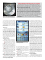
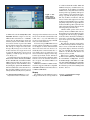
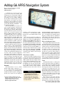
AvMap G6 APRS Navigation System Reviewed by Howard Robins, W1HSR ARRL Contributing Editor [email protected] A disclaimer is in order: I am not an expert on the many mass market GPS navigation devices in the hands of millions today, so please do not expect a comparative analysis. As far as I know, AvMap is the only maker of GPS navigation systems with hardware and software specifically designed to support APRS, the Amateur Packet/Position Reporting System developed by Bob Bruninga, WB4APR — end of comparative analysis. The Geosat6 (G6) is the latest in a series of GPS navigation systems by the Italian maker AvMap that are designed to be integrated into mobile APRS installations. The G6, like its predecessors the G4 and G5, has a serial port to interface with Kenwood APRS capable radios, the Byonics TinyTrak4 (TT4, see the accompanying sidebar), or pretty much any 2-meter radio and terminal node controller (TNC) with APRS capability.3 The G6 includes several significant differences compared to the G4 and G5. In addition to smaller overall size; it has much higher display resolution and an awesome magnetic mounting system. My first impression when I opened the box was “Oh no! — They made the G6 too small.” I really liked the relatively large display of the G5. After I got the G6 working, I realized that its display is unbelievably sharp, and it’s controlled by a touch screen so there are no hard buttons taking up space on its face. These two factors support the reduced size with virtually no reduction in readability. The fonts used scale up and down or disappear depending upon map zoom level, and they are quite readable. APRS positions have crisp icons and a block font that does not wash out or get lost in the background. Normal fonts are black with white background, so they also stand out on the map. Clarity is supreme on the G6. Overview The G6 measures 31⁄4 × 51⁄4 × 3⁄4 inches (height, width, depth) compared to 41⁄8 × 51⁄2 × 11⁄2 inches for the G5. The LCD is 43⁄16 inches wide by 25⁄16 inches high, has a resolution of 480 × 272 pixels, and supports 65,536 colors. By the way, the display is 3H. Robins, W1HSR, “AvMap G5 Personal Navigator,” Product Review, QST, Feb 2008, pp 48-49. QST Product Reviews are available to ARRL members online at www.arrl.org/product-review. actually 4.8 inches diagonally in a widescreen format — not really much smaller than the G5, yet in a smaller, handier overall package. The connectors and hard controls are mostly on the right flange and include I/O SERIAL port, USB port, AUDIO OUTPUT, POWER jack and POWER switch. There are also internal SPEAKER ports on both sides of the frame. The bottom flange has the main power ON/OFF switch, RESET and SD CARD slot. The rear panel has a daylight sensor and proprietary keyed four point POWER connector that mates with the magnetic mount (more later). The CPU runs at 520 MHz, and is supported with 64 MB of RAM. The operating system is Windows CE. It weighs in at 9.7 ounces. What Comes in the Box The G6 comes with everything you need to power the unit and charge the internal Li-ion battery, and interface with Kenwood APRS capable radios and computer. There is an ac charger in addition to the dc cigarette lighter cord. The ac charger plugs into the POWER port on the side of the G6. The dc cord plugs into the included magnetic mount, which contains a voltage regulator circuit that converts a 12 V source to 5 V. An Bottom Line The AvMap Geosat6 APRS navigator builds on the success of the G4 and G5. The new version is smaller and more capable than previous models, yet it is still easy to hook up and use. included CD-ROM contains the instruction manual and desktop software called Geosat Suite. A 4 GB SD card containing Navteq mapping for North America and Mexico comes with the G6. The G4 and G5 use TeleAtlas mapping. An on-the-glass suction cup mount is also included. More on the Magnetic Mount The magnetic mount has four slots on its rear that mate with the on-the-glass mount. On its front, there are four powerful magnets around electrical contacts that mate with the keyed gold contacts on the rear of the G6 (see Figure 5). There are actually two sets of contacts in a recessed socket that allow the G6 to be viewed in either portrait or landscape mode by simply rotating the G6 in the mount accordingly (Figure 6). The magnets are strong enough to hold the G6 tight, even on the bumpiest roads, but it is easy to pull the G6 off the mount and take it with you when you leave your vehicle. Power I mentioned that there is a main power switch on the bottom flange in addition to a power button on the side. When the main switch is off, the G6 is completely off. When the main power switch is on and the G6 is connected to an external power source, the internal battery will charge. In this mode the G6 senses the presence or absence of external power and will go into standby mode — display off, but GPS receiver engine and position cache memory remain on — until external power is sensed. This conserves power while allowing for faster position acquisition by using the internal battery for power. This mode is great when you are in and out of your vehicle From January 2012 QST © ARRL Adding Capability with the Byonics Tiny Tracker 4 Figure 5 — The AvMap G6 magnetic mount holds the unit in place while driving yet makes it easy to remove and take with you. The Byonics Tiny Tracker 4 (TT4) is an APRS capable TNC available as a kit or built and tested. It is supported by a host of available interface cables for computer and radio, free downloadable firmware, keyboard and display options, and downloadable documentation. The TT4 is a relatively inexpensive way to turn any 2 meter radio into an APRS station. While the AvMap GeoSat 6 APRS is designed to work with all Kenwood APRS capable radios, Kenwood does not support all of the messaging capabilities of the G6. Kenwood does support message sending via the mic keypad, only. With a capable TNC such as the TT4 connected between the G6 and your radio, it is possible to select a received station from the G6 APRS contact list and send that station a message. When such a station is selected a soft keyboard appears on the screen. The “keys” are about the size of my finger tips and make message creation as easy as one could imagine. The G6 keeps a log of messages sent, received, and pending, much like an email application. For a full description of features and related information, see www.byonics. com/tinytrak4. as you do not have to start from complete power off position each time you restart. On the other hand, when you are parked for the night or any length of time, turning off the main power conserves the internal battery. I could not wear down the battery from normal use. Geosat Suite Geosat Suite is the desktop software that recognizes your G6 when it is connected to your PC via the USB port. It reports the status of the G6’s software and automatically checks for available updates. The following functions are supported by soft buttons: Software Update, Map Update, User Manual, Change Welcome Page, Explore Device, Add Contents from PC, POI (points of interest), Change Text-to-Speech Voice, Backup and Restore. Navigation Features The G6 has a number of navigation features that make it useful for normal driving: You can choose 2D, 3D or night view. Multiple destinations, up to 10 waypoints. Thousands of preloaded points-ofinterest (POI) in numerous groupings can be displayed on the map. POI management is quite powerful. The G6 will take you to any location that you select with a touch of a finger. The “Where To Go” page lets you choose among the following: Address, POI, Contact, Drive me Home, Lat/Lon, Favorite POI, Save Routes and Pick on Map. You can ask for the fastest or shortest route and customize the route to avoid toll roads, walkways, ferry routes, U turns, highways, unpaved roads or built-up areas. Lane Assistant visually warns you what lanes are good, and which to avoid, to From January 2012 QST © ARRL Figure 6 — The G6 can be operated in landscape or portrait mode by rotating it in the magnetic mount. get to your destination. This is to keep you on course, not warn you of construction or accident obstructions. This is a smart feature as it only displays when a potential detour is coming up. A Stop Planner helps organize meal breaks and gas stops. Trip Computer — provides data and graphics for speed, altitude, etc. Turn-by-turn voice instructions with text-to-speech. Highway speed limits are usually displayed in the info bar below the map, and they changed, for example, from 50 to 55, just when I saw the posted speed limit sign. I drive I-95 between Connecticut and South Florida quite frequently, and can tell you that some states are better than others about giving advance warning for rest areas. So, I did an internet search and found a POI website that actually had a file of all the rest areas on the interstate highways in the US. Geosat Suite can convert and import such files in most standard formats. In the process I found a bitmap file of a rest area sign that I doctored to suit me for an icon and uploaded that with the associated POI file. I am writing this portion of this review in Fayetteville, North Carolina (my trip midpoint), and can tell you that this has worked quite well so far. I know this route well, so really did not need a navigator. However, for this review I decided to see how the G6 would get me into Broward County, Florida, and take me to my destination from the first exit on I-95 in Florida. It could have taken me straight down I-95, but it did not. Since I did not tell it to avoid toll roads, it did exactly what I would have done — it directed me to Florida’s Turnpike when I reached the crossover in Fort Pierce. This crossover takes you off of I-95 to surface streets that take you to the turnpike’s entrance. (This route avoids the traffic tie-ups that are typical around the Palm Beach airport on I-95.) The G6’s Lane Assistant pointed out the right lanes for me to be in throughout the transition. The navigator brought me right to my door in a gated condo community in northern Broward. Unique Capabilities I tested text messaging using the Byonics TT4 and G6 with a handheld radio. The TT4 is a way to turn any 2 meter FM set into Figure 7 — The APRS contact list can store up to 1000 contacts. an APRS radio. Check www.byonics.com/ tinytrak4. With this setup I received my APRS weather station beacon — W1HSR. I went into the G6 functions menu and found my station on the APRS contact list and selected it. Then I pressed the SEND message button and used the soft keyboard that came up to compose and send a short message. My message was received at my weather station. I sent a reply and received it on the G6. The G6 has a text-to-speech capability, so I had my reply message read to me. Pretty cool. I tested the Target function (aka Tactical Mode) and it worked.4 I had my friend Mike DeVivo, N1CHP, take a ride with his mobile APRS setup beaconing his position. Once I had his position on the G6 APRS contact list (and display), I pushed the GO TO button. The G6 calculated the route and took me to him, providing audible as well as on-screen turn-by-turn directions. By the way, when he www.youtube.com/w6gps for a more complete demonstration of tactical mode. 4See changed position and that was beaconed out and received, the G6 recalculated the route to him. Also — very cool! The G6 lets you set any received position as a target and will route you to that destination. You can store up to 1000 APRS contacts sorted by call sign or date/time. A secondary screen (Figure 7) shows full information about each contact. You can choose to automatically delete contacts from the list — a great feature when you realize that every contact on this list is displayed on the map. Contacts aged 2 hours, 5 hours, 10 hours or 24 hours can be deleted to eliminate clutter from the screen. No automatic deletion is also an option. All standard APRS icons are supported. Full bidirectional RS-232 APRS communication is supported. The G6 is compatible with NMEA and Kenwood format sentences at 4800 and 9600 bauds. of evolution that makes mobile APRS and APRS for emergency communications easy to implement. Its flexibility in handling APRS contacts, along with its tactical mode and target intercept capability, make practical use of GPS receiver and navigation technology, especially in emergency scenarios. The only weakness I found was with the low level of the audio output. To solve that problem I found amplified stereo speakers (originally designed for an Apple iPod) for less than $10. This speaker system fits in the palm of my hand, and plugs directly into the external speaker jack on the G6.5 I did the mobile portion of this review with my Kenwood TM-D710A and was disappointed to learn that Kenwood does not support all of the messaging capabilities of the G6. On the other hand, something as inexpensive as the Byonics TT4 can turn any 2 meter rig into an APRS station with text messaging. The pull-away magnetic mount and its size make it handy to take the G6 with you when it is not needed. With the landscape and portrait displays and hours of battery life, you could take the G6 along for long walks in a city like New York and use it to navigate your way around. Manufacturer: AvMap, Viale Zaccagna 6, 54033 Carrara (MS), Italy; www.avmap. it. US distributor: AvMap/USA, 133 Falmouth Rd, Mashpee, MA 02649; tel 1-800363-2627; www.avmap.us. Amateur Radio contact: Don Arnold, W6GPS, 410 Cyndica Dr, Chattanooga, TN 37441; www.geosat. us. Price: $499.95. Wrapup The AvMap Geosat6 APRS navigator is really special. It reflects several generations from www.amazon.com/gp/ product/B00065XSP8. 5Available From January 2012 QST © ARRL