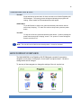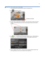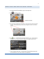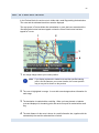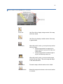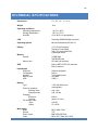
1
430 GPS Navigator User Manual 2 WELCOME .......................................................................................................................8 ABOUT THIS MANUAL ....................................................................................................9 CUSTOMER SERVICE ................................................................................................... 10 ABOUT GPS NAVIGATION ........................................................................................... 11 GETTING STARTED ...................................................................................................... 12 SAFETY INFORMATION ................................................................................................ 15 RW 430 MOUNTING SYSTEM ....................................................................................... 16 BASIC OPERATIONS .................................................................................................... 17 Lock/Unlock Switch .............................................................................................................................. 17 Charging the Battery ............................................................................................................................ 17 Powering On & Off ................................................................................................................................ 18 Main Window Overview ........................................................................................................................ 18 NAVIGATION .................................................................................................................. 19 Main Navigation Window Overview .................................................................................................... 20 Returning to the Main Navigation Window ........................................................................................ 20 Status Indicators ................................................................................................................................... 21 Power Icon ............................................................................................................................................................................ 21 Compass Icon ....................................................................................................................................................................... 21 GPS Icon .............................................................................................................................................................................. 22 Volume.................................................................................................................................................................................. 22 ENTERING INFORMATION ........................................................................................... 23 Menus..................................................................................................................................................... 23 Software Keyboards ............................................................................................................................. 23 Using Predictive Text ........................................................................................................................... 25 SELECTING THE SEARCH AREA ................................................................................ 28 3 The Search Area Button ....................................................................................................................... 28 Changing the Search Area ................................................................................................................... 29 THE NEW DESTINATION BUTTON............................................................................... 30 Ways to Search for Destinations......................................................................................................... 31 Enter an Address .................................................................................................................................................................. 31 Search for a POI ................................................................................................................................................................... 31 Tap on the Map ..................................................................................................................................................................... 31 Entering an Address ............................................................................................................................. 32 Street First ............................................................................................................................................................................ 33 City First................................................................................................................................................................................ 34 Selecting a Point of Interest (POI) ....................................................................................................... 36 Search for POI ...................................................................................................................................................................... 36 Search for POI Nearby .......................................................................................................................................................... 37 Search for POI In a City ........................................................................................................................................................ 39 Search for POI – Nationwide ................................................................................................................................................. 41 Search for POIs on the Map .................................................................................................................................................. 42 Search for POI Near a Selected Location .............................................................................................................................. 43 Direct Access Points of interest ............................................................................................................................................. 44 MY DESTINATIONS ....................................................................................................... 47 Favorites ................................................................................................................................................ 48 Saving to Favorites ............................................................................................................................................................... 48 Modifying Your Favorites List ............................................................................................................. 51 Rename Destination.............................................................................................................................................................. 51 Designating or Changing a Home Address ............................................................................................................................ 51 Delete a Favorite Destination ................................................................................................................................................ 52 Add a Favorite to Route ...................................................................................................................................................... 52 Last Destinations .................................................................................................................................. 53 Selecting a Destination from the Last Destinations List ......................................................................................................... 53 Adding a Favorite from the Last Destinations List .................................................................................................................. 53 Designating a Home Address .............................................................................................................. 55 4 THE SHOW MAP BUTTON ............................................................................................ 56 THE START NAVIGATION BUTTON ............................................................................. 58 Map in Preview Mode ........................................................................................................................... 59 Map in Navigation Mode ....................................................................................................................... 60 To Exit Navigation Mode ....................................................................................................................................................... 61 Map Modifications in Navigation Mode .................................................................................................................................. 62 Map in Destination Search Mode ........................................................................................................ 64 Destination Search Tools ...................................................................................................................................................... 65 Operating in Destination Search Mode .................................................................................................................................. 66 Destination Search Mode Buttons ......................................................................................................................................... 67 To Exit Destination Search Mode .......................................................................................................................................... 68 To Return to the MAIN NAVIGATION WINDOW ................................................................................................................... 68 The Turn-by-Turn List Button .............................................................................................................. 69 To View Turn-by-Turn List from Preview Mode...................................................................................................................... 69 To View Turn-by-Turn List from Navigation ........................................................................................................................... 69 The TURN-BY-TURN WINDOW............................................................................................................................................ 70 THE OPTIONS BUTTON ................................................................................................ 72 General Routing Information ............................................................................................................... 73 Starting Point ........................................................................................................................................................................ 73 Route Points ......................................................................................................................................................................... 73 Flow Numbers ....................................................................................................................................................................... 73 Route Planning...................................................................................................................................... 74 Creating a Route ................................................................................................................................................................... 74 Saving Routes....................................................................................................................................................................... 79 Using Saved Routes ............................................................................................................................................................. 80 Show Route .......................................................................................................................................................................... 81 Run a Simulation of a Route.................................................................................................................................................. 82 Viewing Route Profile ............................................................................................................................................................ 83 GPS STATUS ................................................................................................................. 85 5 View GPS Data ...................................................................................................................................... 86 Save Current Location ......................................................................................................................... 86 No GPS Reception ................................................................................................................................ 87 CUSTOMIZING YOUR UNIT .......................................................................................... 88 A Settings Page & It’s Parts................................................................................................................. 88 Moving Between Pages ........................................................................................................................ 89 Viewing Information About a Setting .................................................................................................. 89 Viewing a List of Options for a Setting ............................................................................................... 90 Toggling Between Options .................................................................................................................. 90 Saving Your Changes ........................................................................................................................... 91 Canceling Your Changes ..................................................................................................................... 91 BASIC SETTINGS .......................................................................................................... 92 Setting Which Can Be Changed .......................................................................................................... 92 Basic Settings & Their Options ........................................................................................................... 94 CURRENT MAP SETTING ........................................................................................... 100 Changing Maps ................................................................................................................................... 100 POI SETTINGS ............................................................................................................. 102 Selecting POI Categories Shown on Map ........................................................................................ 103 Selecting Direct Access POIs ............................................................................................................ 104 ROUTE PROFILE SETTINGS ...................................................................................... 105 Changing Route Profile Options ....................................................................................................... 106 Canceling Changes ............................................................................................................................ 106 Route Profile Settings & Their Options ............................................................................................ 107 BONUS PROGRAMS ................................................................................................... 109 Memory Card ....................................................................................................................................... 110 MUSIC PLAYER ........................................................................................................... 112 MUSIC PLAYER Screen ...................................................................................................................... 113 6 Music Player Buttons ......................................................................................................................... 114 MOVIE VIEWER ........................................................................................................... 115 MOVIE VIEWER Screen ...................................................................................................................... 116 Movie Player Buttons ......................................................................................................................... 117 E-BOOK READER ........................................................................................................ 118 E-BOOK READER Screen .......................................................................... Error! Bookmark not defined. E-Book Reader Buttons ..................................................................................................................... 119 Using the Jump Button ........................................................................................................................................................ 120 PHOTO VIEWER .......................................................................................................... 121 Photo Viewer Buttons ........................................................................................................................ 122 SETTINGS MENU ......................................................................................................... 123 Navigation Setup ................................................................................................................................ 124 Touch Screen Calibration .................................................................................................................. 125 Re-calibrating the Touch Screen ......................................................................................................................................... 125 Language ............................................................................................................................................. 126 Changing Language Used ................................................................................................................................................... 126 Volume ................................................................................................................................................. 127 Changing the Volume .......................................................................................................................................................... 127 GPS Status .......................................................................................................................................... 128 Viewing the GPS Status Menu ............................................................................................................................................ 128 Backlight ............................................................................................................................................................................. 131 Power ................................................................................................................................................................................. 133 Time.................................................................................................................................................................................... 134 System ................................................................................................................................................. 136 Skin ...................................................................................................................................................... 137 FREQUENTLY ASKED QUESTIONS .......................................................................... 138 Why won’t my unit turn on? ................................................................................................................................................. 138 Why am I unable to get a GPS signal or fix? ....................................................................................................................... 138 Why does my unit sometimes make a popping or static like noise? ..................................................................................... 138 7 Why does my unit only accept every other letter entered for an address? ........................................................................... 138 Why does my unit sometimes miss announcing the street name? ....................................................................................... 139 Why doesn’t the unit accept the street I am entering? Why can’t I find my address? .......................................................... 139 My device provided me a route that was different than the one I would ordinarily expect the system to select. Why is that? 139 What is the difference between searching for a POI nearby and searching for a POI near a destination?............................ 139 TECHNICAL SPCIFICATIONS ..................................................................................... 140 END USER’S LICENSE AGREEMENT ........................................................................ 141 FCC PART 15 COMPLIANCE STATEMENT ............................................................... 141 TRANSPLANT GPS, INC. LIMITED WARRANTY ....................................................... 142 8 WELCOME INTRODUCING YOUR RIGHTWAY GPS NAVIGATOR 430 Welcome to the world of stress free driving. The RightWay 430 makes driving in new places a pleasant adventure. With over 1.7 million points of interest, turn-by-turn spoken directions – including the name of the street – and easy address entry, the RW 430 will get you where you are going. Caution! Do not operate the RW 430 GPS Navigator while driving. Park the vehicle safely first. Transplant GPS, Inc., its dealers, suppliers and distributors disclaim all liability for any use of this product in a way that may cause accidents, damage or that may violate the law. 9 ABOUT THIS MANUAL SYMBOLS The following symbols refer to specific passages of text: Warnings. Instructions and tips for operation. LIABILITY RightWay GPS, its dealers, suppliers and distributors disclaim all liability for any use of this product in any way that may cause accidents, damage or that may violate the law. RightWay GPS, its dealers, suppliers and distributors disclaim all liability for any use of this product in delivering medical aid, transporting of medical patients and/or equipment, or transporting medical emergency victims. Do NOT use this product during the time of local, state or national emergencies. If you wish to obtain versions of a navigation system optimized for us in medical emergencies, please contact Transplant GPS. When using navigation aids, both hardware and software, in a vehicle, it is your sole responsibility to place, secure, and use these aids in a manner that will not cause accidents, personal injury, or property damage, or in any manner obstruct your view. You, the user of this product, are solely responsible for observing safe driving practices. 10 CUSTOMER SERVICE We want your experience with the RW 430 GPS Navigator to be an enjoyable one. If you have any questions or problems, please contact our customer service team. ON-LINE www.RightWayGPS.com E-MAIL Customer Service [email protected] Technical Support [email protected] Accessories [email protected] Customers will receive a response within 2 business days. TELEPHONE Telephone: (507) 529-0041 Service Hours: Monday through Friday, 8:30 a.m. to 5 p.m. CT (excluding National holidays) 11 ABOUT GPS NAVIGATION The Global Positioning System (GPS) is a space-based radio-navigation system. This system consists of 24 satellites, which orbit the Earth at an altitude of approximately 17,500 kilometers. Each of the 24 satellites is deployed in 6 orbital planes and circles the earth twice a day. These systems of satellites continuously transmit signals containing precise information, 24 hours a day in any weather condition, everywhere around the world. By processing the signals received, the RW 430 GPS Navigator provides users with helpful information of position, velocity, and time for navigation and location based services anytime. The time it takes the GPS to find the satellites is called the Time to First Fix (TTFF). The GPS receiver needs to lock on to at least 3 satellites for a position fix. The RW 430 GPS Navigator acquires a position fix typically within 10 seconds from a hot-start state and roughly 80 seconds from a cold-start state. The initial state of the receiver, (i.e. the latest status in the memory of the receiver) primarily determines the time of TTFF. If you have not used your GPS unit for several months, the almanac data for the satellites may be out of date. The unit is capable of recollecting this information on its own, but the process can take as long as 3 to 5 minutes. The TTFF will also be longer the very first time the user first turns on the GPS receiver, when a GPS receiver has lost memory, or has been moved over 300 miles (500 km) from its last location will also be longer. Both TTFF and positional accuracy can be affected by obstructions such as tall buildings, narrow streets & passageways, protective film on glass, heavy foliage, large cliffs, and other situations where GPS satellite signals are blocked. Once there is a position fix, the RW 430 uses the satellite signals to calculate an exact geodetic location through triangulation method, contained in 10 meters CEP accuracy devoid of Selective Availability (SA). The position data is then converted within the receiver to latitude and longitude coordinates, which is usually provided in the geodetic datum on which GPS is based (WGS 84). The map datum selected on a GPS receiver needs to match the datum listed on the corresponding paper map in order for the position readings to match. Using the wrong datum can result in position offsets of hundreds of meters or much more. In addition to using the wrong datum, accuracy can be limited by satellite orbiting errors, multi-path signals, atmospheric delay and receiver clock timing. Caution! The United States government operates the Global Positioning System (GPS) and is solely responsible for its accuracy and maintenance. Changes by the United States government may affect the accuracy and performance of all GPS equipment, including your personal navigation device. Caution! Ordinances or laws may restrict use of certain abilities of your navigation device on public or private land. 12 GETTING STARTED WHAT‟S INCLUDED Your RightWay 430 GPS Navigator comes with the following accessories. If your box is incomplete, please notify us within 14 days of purchase. The purchased products include: RW 430 GPS Navigator Car charger Wall charger RW 430 mounting system Quick Start Guide User Manual on CD 13 RW 430 GPS NAVIGATOR HARDWARE Your RightWay 430 GPS Navigator is a sophisticated electronic device. To ensure a long lasting and trouble free experience, please take great care to avoid dropping or damaging the device. Power Button Menu Button TOP VIEW Switch LEFT SIDE Volume Dial RIGHT SIDE Switch Switch Memory Card Slot Headphone Jack Lock/Unlock Switch USB Charging Port Reset Button BACK Switch Stylus 14 Caution! Do not open the navigation device's casing under any circumstances. Caution! Protect the device from moisture. The device is not waterproof and is not protected against water damage. Caution! Do not expose the navigation device to extreme heat or cold. This may damage the device or impair its function. Caution! Use only the charger provided or one that has been approved by the manufacturer. 15 SAFETY INFORMATION NAVIGATION SAFETY INFORMATION Use this navigation system at your own risk. Caution! To prevent accidents, do not operate the navigation system while driving. Caution! Do not look at the display unless it is absolutely safe to do so! Caution! Traffic regulations have priority over any instructions from the navigation system. Caution! Follow the instructions of the navigation system only when the circumstances and the road traffic regulations allow you to do so! The navigation system guides you to your destination even if you deviate from the calculated route. Caution! Check that the unit is secured in the mount and adjusted properly before each journey. Note: If you have not understood the spoken instructions, or you're not sure about what to do next, you can briefly refer to the map or arrow view of your navigations system. CARE & SAFE KEEPING ON THE RW 430 Caution! Protect the unit from moisture. It is not waterproof and is not protected against water damage. The warranty does not cover water damage. Caution! Do not open the unit's casing under any circumstances. Caution! Do not attempt to replace the battery. For problems related to the battery, contact Customer Support. Caution! Do not expose the unit to extreme heat or cold. This may damage the device or impair its function. Caution! Use only the charger provided or one that has been approved by the manufacturer. Note: To clean the screen of the RW 430, use a dry cloth. Paper towels will scratch the screen. 16 RW 430 MOUNTING SYSTEM Included in your package, you will find a mounting solution to easily secure your RightWay Navigator to either the windshield or the dash. Caution! It is illegal in California and Minnesota to attach anything to the windshield. Caution! When using navigation aids in a vehicle, it is your sole responsibility to place, secure and use these aids in a manner that will not cause accidents, personal injury, property damage, or in any manner to obstruct your view. You, the user of this product, are solely responsible for observing safe driving practices. 1. Select a suitable location on the windshield or dashboard for the mount. Clean and dry this area to remove any grease and dirt. 2. If mounting the GPS on the dashboard, remove the protective backing from the dash disc, exposing the adhesive. Adhere the disc to the dashboard in the desired location. Dash Disc Note: The adhesive is permanent. 3. With the locking lever in the up position, hold the suction cup to the windshield or on the dash disc with the locking lever and pull tab on top. 4. Push the locking lever towards the base of the mount. The mount should suction to the surface. 5. Align the tabs on the holder with the slots on the Navigator cradle. Slide together until you feel a firm click. 6. Adjust the holder to the best viewing angle by loosening the adjustor dials, moving the corresponding part to the desired position, and then tightening the adjustor dial. 7. To remove the mount, pull the locking lever away from the base, and then gently pull on the pull tab. This should break the suction so you can remove the mount. Adjuster Dial Right & Left Locking Lever (in up position) Pull Tab Adjuster Dial Up & Down 17 BASIC OPERATIONS LOCK/UNLOCK SWITCH On the right side of the RW 430 Navigator is a Lock/Unlock switch. This feature is designed to prevent the unit from accidentally being turned on or off. The RW 430 will not turn ON when in the locked position. It must be in the unlocked position to turn on the unit. When in the unlocked position, all buttons and the touch screen are activated. When the unit is ON and in the locked position, all buttons and the touch screen are deactivated but all programs will run. CHARGING THE BATTERY The RightWay Navigator comes ready to use with a charged battery. But at some point in time, the internal battery will need to be re-charged. This is done through either DC ower (car charger), or AC power (wall charger). DC POWER (CAR CHARGER) 1. Connect the USB plug of the car adapter to the USB port of the device. 2. Plug the car adapter to the jack of the cigarette lighter. 3. Battery charging begins. The operation indicator lights red. AC POWER (WALL CHARGER) 1. Connect the USB plug of the adapter to the USB port of the device. 2. Plug the adapter to an electrical outlet. 3. Battery charging begins. The operation indicator lights red. Note: The indicator light is green when the unit is on and the battery is fully charged. While charging, the indicator light will be orange. Note: The RightWay 430 can be used for navigation while the unit is recharging. 18 POWERING ON & OFF Turn ON Press and hold the power button for three seconds to turn ON the RightWay 430 GPS Navigator. The opening screen will appear indicating the programs are loading. When loaded, the PROGRAMS WINDOW will appear. SLEEP Mode To put the RW 430 in sleep mode, press and hold the power button until the screen says “sleeping.” To “wake” the unit from sleep mode, press the power button. Turn OFF To fully turn off the unit, press and hold the power button. Continue pressing the power button through the “sleeping” screen. The “power off” screen will appear and the unit will turn off. Note: The unit will not turn ON from the locked position. It must be unlocked. MAIN WINDOW OVERVIEW The MAIN WINDOW of the RightWay 430 GPS Navigator contains five programs – navigation, music player, movie player, e-book reader, and photo viewer – as well as settings which can be changed. To start any of these programs or change the settings of the unit, tap the icon. 19 NAVIGATION To begin navigation, tap the „Navigation‟ button. A screen will appear asking if you have read the End User‟s License Agreement found at the end of this document. Tap „OK‟ and the main navigation window will open. 20 MAIN NAVIGATION WINDOW OVERVIEW The MAIN NAVIGATION WINDOW opens when the navigation software starts. You can reach all of the navigation software functions from this window. Tap the New Destination button to: • Select an address by city or street. • Select a POI as a destination. Tap the My Destinations button to select a destination from: • A list of destinations you have saved. • A list of the most recently entered destinations. Tap the Take Me Home button to: • Quickly create a route back to your home address from your present location. Tap the Show Map button to: • Show your location on the current map. (GPS reception required.) • Select a destination by tapping on the map. Tap the Options button to: • Access the Route Planning • Go to the GPS Status • Access the Settings window • View product information RETURNING TO THE MAIN NAVIGATION WINDOW To return to the MAIN WINDOW from any other window tap WINDOW appears. (Back), until the MAIN 21 STATUS INDICATORS When the unit is on, in the upper right-hand corner you will find three icons. These symbols provide valuable information about your device. POWER ICON The Power symbol can display the following conditions of the built in battery: The device is powered by an external power source. The battery is charging. The device is powered by its internal battery. Battery is fully charged. The device is powered by its internal battery. Battery charge is sufficient. The device is powered by its internal battery. Battery charge is low. COMPASS ICON The Compass symbol shows the direction you are currently heading using the following points of the compass: N, NE, E, SE, S, SW, W and NW. Note: The direction indicator will not appear until the GPS is ready and a position can be determined. 22 GPS ICON In the upper right-hand corner of the display, the GPS symbol appears. Acquiring Satellites Data is being received from less than three satellites. Position cannot be calculated. GPS Ready Data is being received from at least three satellites. Position can be calculated. No Symbol The built-in GPS receiver is not operational. Please press the reset button. Contact customer service if the problem persists. Note: The very first time you use the RightWay Navigator, it can take up to 10 minutes to initialize the GPS. After the first time, GPS reception should start within one minute of turning on the device. If the navigation device has been switched off for more than a week, the next initialization can take up to 5 minutes. VOLUME The volume of the spoken driving instructions can be adjusted during navigation. With the map displayed, tap (volume). The volume menu contains three buttons for adjusting volume: Louder Quieter Volume On/Off (mute) Tap the appropriate button until the desired volume is reached. Tap again to close the volume menu. Note: There is also a volume dial on the left side of the unit. 23 ENTERING INFORMATION MENUS Many buttons have menus which open when activated. To activate a menu, tap on the button with your finger or stylus. To close a menu without selecting a function, tap on the same button you used to open the menu. SOFTWARE KEYBOARDS Software keyboards appear on the screen when text entries are necessary. All entries can be made on the software keyboard using the fingertips or stylus. Three keyboards are available for entering destination information. ALPHABETIC KEYBOARD The alphabetic keyboard automatically appears when text entries are necessary. Only capital letters can be entered. Tap to display the alphabetic keyboard from another keyboard. Note: Only capital letters can be entered from the alphabetic keyboard. 24 NUMERIC KEYBOARD Tap to display the numeric keyboard from another keyboard. SPECIAL CHARACTER/SYMBOL KEYBOARD Tap to display the special character keyboard. Note: After you have entered a special character, the alphabetic keyboard will appear automatically. 25 SPECIAL KEY Spacebar. Moves the cursor forward one space. Found on the alphabetic and numeric keyboards. Delete. Removes the previous character & moves the cursor back one space. Found on the alphabetic and numeric keyboards. Opens the numeric keyboard. Opens the alphabetic keyboard. Opens the special character keyboard. USING PREDICTIVE TEXT The RW 430 GPS Navigator has a predictive text feature to facilitate speedy address entry. When you are entering a location, after you type the first letter, the largest state, city or street beginning with that letter in the selection area appears. After the second letter is entered, the list shows all map areas corresponding with the letters typed. The more characters you enter, the shorter the returned list becomes. The predictive text feature is automatically activated when you begin entering an address. Use (Up) and (Down) to scroll through the list. Double tap on an entry to select it. (The list will close once an entry is accepted.) 26 TIPS FOR USING PREDICTIVE TEXT To use predictive text most successfully, follow the suggestions: Pause after each letter or number is entered to allow the predictive text feature to work. Keep in mind that the number you entered may not be the first character that appears on the list. Example: You may enter “5” and CR-151 appears on the list. For streets with directions (i.e. South Main, 53rd Street NW), enter the street name without the directional portion (i.e. Main, 53rd Street). After the number part of the address is entered a list will appear with choices including the directional portion of the street. EXAMPLE OF PREDICTIVE TEXT 1. You want to enter “Madison Street” for the street name. Tap “M”. Macalpin Ave appears as a possible match. 2. That is not the street you want, so you enter “A”, the next letter in the street name. 3. Madison Street still isn‟t on the list of possibilities, so you enter the next letter, “D”. 27 4. A new list appears with possible matches. Madison Street is on the list. 5. To select Madison Street, either double click on Madison Street or highlight it and tap the checkmark. 28 SELECTING THE SEARCH AREA The maps preloaded on the RW 430 GPS Navigator cover a large area. If the unit had to list every city named Rochester in the United States and Canada it would take a very long time. To narrow down the search area, use the Search Area Button. THE SEARCH AREA BUTTON The Search Area button is used to select the map area to search, such as a state or province. When you enter a new destination for the very first time, the SEARCH AREA list opens. Enter the state you would like to navigate to or within. Once an area is selected, the code on the button reflects the selection. For example, if “Illinois” or “IL” is selected, “IL – Illinois” appears on the button. Note: The address entry screen assumes the search area is the same as the previous address entry. 29 CHANGING THE SEARCH AREA To select a Search Area that if different from the one currently shown: 1. Tap the Search Area button. The SEARCH AREA WINDOW opens. 2. Use the alphabetic keyboard to enter the area (i.e. state or province) you wish to search for your destination. 3. Either tap your selection on the list or highlight it and tap the checkmark. 4. The Search Area button displays the code for the newly selected destination area. 30 THE NEW DESTINATION BUTTON New destinations are destinations that you have not yet navigated to, or those that you have not yet stored. Destinations may be selected by entering an address, selecting a point of interest (POI), or selecting from the quick search function. Tap the New Destinations button to: • Enter an address by city or street. • Search and select POI as a destination. • Search & select POI by direct access. 31 WAYS TO SEARCH FOR DESTINATIONS There are three ways you can search for a destination: enter an address, select a POI, or select a destination from the quick search function. ENTER AN ADDRESS To find an address, specify: City First if you do not know the exact street address. Street First if you do not know the actual city. SEARCH FOR A POI Points of Interest (POIs) are useful addresses that are organized according to particular criteria. POIs include airports, restaurants, hotels, gas stations, government offices, banks, hospitals, shopping centers, etc. Icons representing the POIs can be displayed on the map. A search for a specific point of interest may be conducted one of five ways: 1. Nearby Searches for destinations located within a given radius of your current location. This feature is useful for locating destinations such the next gas station or closest hospital. 2. In a City Searches for destinations located within a given city. This feature is useful for locating hotels, restaurants, etc. when navigating in an unfamiliar town. 3. Nationwide Searches for destinations of nationwide significance. This feature is useful for locating airports, national monuments, etc. 4. Direct Access The POI direct access system contains three categories of special destinations. POIs in your vicinity that correspond to these categories can be listed quickly, without the need for additional entry. 5. Near a Selected Location Searches for destinations located within a given radius of a specified location. This feature is helpful for planning trips and does not require satellite reception. TAP ON THE MAP You may indicate a destination by tapping directly on the map. 32 ENTERING AN ADDRESS When searching for a location, you do not have to enter all of the address details. If you do not know the house number, leave the field blank to display the Intersection field. In this field, enter the name of a nearby side street and the navigation system calculates a route to the intersection of the specified streets. Additionally, if you only specify the: • City - a route is calculated to the town center. • City and street - a route is calculated to the middle of the street in the specified city. 33 STREET FIRST Entering a new destination using Street First is helpful when the exact city is unknown. For example, you want Grand Avenue but you do not know if it is in Minneapolis or St. Paul. In this case, entering the street first assists in determining the city. 1. From the MAIN NAVIGATION WINDOW, tap New Destination. A menu will appear with your options for entering your destination. 2. Tap Enter an Address. 3. Another menu appears. Tap Street First to open the ADDRESS WINDOW. Note: If you have not previously specified the search area, you will be prompted to do so before reaching the ADDRESS WINDOW. 4. In the ADDRESS WINDOW, enter the name of the street. 5. Enter the house number. Tap (OK button) when complete. 6. Tap the Start Navigation button. The map opens in Preview Mode. 34 CITY FIRST The City First option of entering a destination is the fastest way to enter an address when all information is known. 1. In the MAIN NAVIGATION WINDOW, tap New Destination, then tap Enter an Address. 2. Tap City First to open the ADDRESS WINDOW. 6. Enter the name of the city or the postal code using the alphabetic keyboard. Tap (OK button) when complete. 7. Enter the name of the street. 8. Enter the house number. Tap 6. Tap the Start Navigation button. (OK button) when complete. 35 Note: If a street name is not entered, a route will be calculated to the city center. Note: If a house number is not entered, a route will be calculated to the center of the street. Note: To change information you have already entered, tap the category that needs to be changed, NOT the back button. 36 SELECTING A POINT OF INTEREST (POI) Points of Interest or POIs are useful addresses that are organized according to particular criteria. POIs include airports, restaurants, hotels, gas stations, government offices, banks, hospitals, shopping centers, etc. Icons representing the POIs can be displayed on the map. POINTS OF INTEREST INFORMATION AVAILABLE Gas Stations Parking Restaurants Hotels/Motels Banks ATMs Airports Railway Stations Car Dealers Motorcycle Dealers Car Rental Shopping Centers Tourist/Nature Culture Sports School & Education Government Offices Health Care Exhibition Post Office Places of Worship Marina Business Facility Public Phone Public Toilet Border Crossing For many POIs, there will be additional information stored in the navigation system's database. For example, for many restaurants there is a telephone number available in addition to the address. SEARCH FOR POI A search for a specific point of interest may be conducted one of five ways: 1. Nearby 2. In a City 3. Nationwide 4. On the Map 5. Near a Selected Location Note: GPS reception must be sufficient to determine your current position for the unit to search for a POI. You can see if GPS reception is sufficient by looking at the GPS icon in the upper right hand corner. Note: Enter the first characters from the beginning of the POI name to shorten the returned list of POIs. 37 SEARCH FOR POI NEARBY 1. In the MAIN NAVIGATION WINDOW, tap New Destination, and then tap Search for POI. 2. Tap Nearby. 3. A list of POI categories will appear. Use the list. (Up) and (Down) to scroll through 4. To accept a category from the list, tap on the entry. If a sub-category exists, specify a sub-category by tapping. 38 4. The Name of the Destination List opens. It contains the nearest POIs in the specified category, sorted by distance. Tap on the name of the desired destination. 5. Information about your selected POI opens. Tap the Start Navigation button. The map opens in Preview Mode. Note: GPS reception must be sufficient to determine your current position for the unit to search for a POI. You can see if GPS reception is sufficient by looking at the GPS icon in the upper right hand corner. 39 SEARCH FOR POI IN A CITY 1. In the MAIN NAVIGATION WINDOW, tap New Destination, and then tap Search for POI. 2. Tap in a City. 3. Enter the name or the postal code of the destination location. 4. Specify a category from which you would like to select a POI. Use (Up) and (Down) to scroll through the list. To accept a category from the list, tap on the entry. If a sub-category exists, specify a sub-category by tapping. 4. The Name of the Destination list opens. It contains POIs from the specified category, sorted alphabetically. Tap on the name of the destination. 40 6. Tap the Start Navigation button. The map opens in Preview Mode. 41 SEARCH FOR POI – NATIONWIDE 1. In the MAIN NAVIGATION WINDOW, tap New Destination, and then tap Search for POI. 2. Tap Nationwide. 3. The POI OF NATIONAL SIGNIFICANCE WINDOW opens. Tap on the name of the category from which you would like to select. 4. The name of the category list opens. It contains a list of national POIs, sorted by distance. Tap on the name of the desired destination. 5. Tap the Start Navigation button. The map opens in Preview Mode. 42 SEARCH FOR POIS ON THE MAP 1. In the MAIN NAVIGATION WINDOW, tap the Show Map button. 2. Tap (Destination search). 3. The map opens in Destination Search Mode. Tap on the point to which you wish to navigate. The destination that you have selected appears under the cross hairs 4. Tap (OK). The DESTINATION ON MAP WINDOW opens. Detailed address information for the selected destination displays in the upper left-hand corner. 5. Tap the Take Me There button. The map opens in Preview Mode and shows the route calculated from your current location to this destination. 43 SEARCH FOR POI NEAR A SELECTED LOCATION 1. In the MAIN NAVIGATION WINDOW, tap New Destination, then tap Enter an Address. 2. Tap City First to open the ADDRESS WINDOW. 3. Enter the name of the city or the postal code using the alphabetic keyboard. 4. Tap the Options Button. 5. The options menu appears. Tap the Search Nearby button. 6. A list of POI categories will appear. Use (Up) and (Down) to scroll through the list. To accept a category from the list, tap on the entry. If a sub-category exists, specify a sub-category by tapping. sub-category 44 7. A list of POIs is returned sorted by distance from the location. Tap on a POI to view more information. Note: GPS reception is not required to search for a POI near a selected destination. DIRECT ACCESS POINTS OF INTEREST The Direct Access button allows you to quickly access frequently used POIs such as gas stations and restaurants. The Direct Access button is subdivided into three smaller buttons. The symbols for the POI categories selected for direct access can be seen on these smaller buttons. The default setting for these buttons – gas stations, parking & restaurants – can be changed to your specifications. 45 USING THE DIRECT ACCESS BUTTONS 1. From the MAIN NAVIGATION WINDOW, tap New Destination. A menu will appear with your options for entering your destination. 2. The Direct Access button is the third button. Icons on this button represent the three POI categories designated for quick access. Tap the category from which you would like to select a POI. 3. The destination category list opens. It contains the nearest POIs in the specified category, sorted by distance. 4. Tap on the desired destination. The map opens in preview mode. 46 SPECIFYING DIRECT ACCESS POI CATEGORIES 1. In the MAIN NAVIGATION WINDOW, tap Options, and then tap Settings. 2. Tap POI. 3. In the Direct Access 1 field, tap (List) and select a POI category. 4. Repeat the above step in the Direct Access 2 and Direct Access 3 fields. 5. When finished, tap Done to save the changes. 47 MY DESTINATIONS The My Destination button is used to select favorite destinations, frequently used destinations and/or destinations recently entered. Every destination that you enter, as well as the destinations from the LAST DESTINATIONS list, can be saved to the FAVORITES list. This is useful if you often navigate to a particular destination. Tap the My Destinations button to select a destination from: • A list of favorite destinations you have saved. • A list of destinations to which you have previously navigated. 48 FAVORITES Destinations to which you often travel can be saved on the FAVORITES list so you only have to enter the address once. The RightWay 430 GPS Navigator can save up to 300 different destinations on your FAVORITES list. SAVING TO FAVORITES There are three ways to save a destination to FAVORITES: save while entering an address, save after an address has been entered or save from your current location. WHILE ENTERING A DESTINATION 1. Enter a destination. Do not tap the Start Navigation button! 2. Tap the Options buttons, then the Save Destination button. 3. The SAVE DESTINATION AS... WINDOW opens. Enter the name you would like the destination saved under and indicate whether it is a home address or not. 4. Tap Save. The destination will be added to the Favorites List under the name you entered. 5. Tap the Start Navigation button to begin navigation to your destination. The map opens in preview mode. 49 AFTER ENTERING AN ADDRESS 1. From the MAIN NAVIGATION WINDOW, tap My Destinations, and then tap Last Destinations. 2. A list of destinations you have previously navigated to will appear. Tap on the destination to add to your FAVORITES LIST. Do not tap the Start Navigation button! 3. Tap the Options button. 4. The options menu will appear. Tap the Save as Favorite button. 5. The SAVE DESTINATION AS... WINDOW opens. Enter the name you would like the destination saved under and indicate whether it is a home address. 6. Tap Save. The destination will be added to the Favorites List under the name you entered. 7. Tap the Start Navigation button to begin navigation to your destination. The map opens in preview mode. 50 FROM THE YOUR CURRENT LOCATION 1. From the MAIN WINDOW, tap Options, and then tap GPS Status. 2. The GPS SETTINGS WINDOW will appear. Tap the Save Position button. 3. The SAVE DESTINATION AS... WINDOW opens. Enter the name you would like the destination saved under and indicate whether it is a home address. 4. Tap Save. The destination will be added to the Favorites List under the name you entered. SELECTING A DESTINATION FROM THE FAVORITES LIST 1. In the MAIN NAVIGATION WINDOW, tap My Destinations, and then tap Favorites. 2. Your FAVORITE LIST will appear. Use (Up) and (Down) to scroll through the list. Tap the name of the destination to which you would like to navigate. 3. Tap the Start Navigation button. The map opens in Preview Mode. 51 MODIFYING YOUR FAVORITES LIST RENAME DESTINATION 1. In the MAIN NAVIGATION WINDOW, tap My Destinations, and then tap Favorites. 2. Your FAVORITE LIST will appear. Use (Up) and (Down) to scroll through the list. Tap the name of the destination to which you would like to rename. 3. Tap Options button, then tap Rename button. 4. Enter the name you would like the destination saved under and indicate whether it is a home address. 5. Tap Save. The destination will be added to the Favorites List under the name you entered. DESIGNATING OR CHANGING A HOME ADDRESS 1. In the MAIN NAVIGATION WINDOW, tap My Destinations, and then tap Favorites. 2. Your FAVORITE LIST will appear. Use (Up) and (Down) to scroll through the list. Tap the name of the destination to which you would like to designate as your home address. 3. Tap Options button, then tap Home Address. 4. The destination will now be saved on the FAVORITES LIST under My Address. Note: Only one destination from the FAVORITES LIST can be defined as My Address. 52 DELETE A FAVORITE DESTINATION 1. In the MAIN NAVIGATION WINDOW, tap My Destinations, and then tap Favorites. 2. Your FAVORITE LIST will appear. Use (Up) and (Down) to scroll through the list. Tap the name of the destination to which you would like to delete. 3. Tap Options, and then tap Delete Destination. 4. The screen will say, “Do you really want to delete this destination?” Tap the Yes button. 5. The entry is removed from the FAVORITES LIST. ADD A FAVORITE TO ROUTE 1. In the MAIN NAVIGATION WINDOW, tap My Destinations, and then tap Favorites. 2. Your FAVORITE LIST will appear. Use (Up) and (Down) to scroll through the list. Tap the name of the destination to which you would like to add to your route. 3. Tap Options, and then tap Add to Route. 4. The destination will now be added to your route. 53 LAST DESTINATIONS The RightWay Navigator saves the last 30 destinations to which you have navigated in the Last Destinations list. You may select a destination from the Last Destinations list or add a destination to your favorites. SELECTING A DESTINATION FROM THE LAST DESTINATIONS LIST 1. In the MAIN NAVIGATION WINDOW, tap My Destinations, and then tap Last Destinations. 2. A list of your LAST DESTINATIONS appears. Use (Up) and (Down) to scroll through the list. Tap the name of the destination to which you would like to navigate. 3. Tap the Start Navigation button. The map opens in Preview Mode. ADDING A FAVORITE FROM THE LAST DESTINATIONS LIST 1. In the MAIN NAVIGATION WINDOW, tap My Destinations, and then tap Last Destinations. 2. A list of your Last Destinations appears. Use (Up) and (Down) to scroll through the list. Tap the name of the destination you would like to save to favorites. 3. Tap Options. 4. Tap Save as Favorite. 5. Enter the name you would like the destination saved under and indicate whether it is a home address. 6. Tap Save. The destination will be added to the Favorites List under the name you entered. 54 THE TAKE ME HOME BUTTON The Take Me Home button enables you to route to your home address with the touch of a button. Only one destination from the Favorites list can be defined as your home address. Tap the Take Me Home button to: Immediately route from your current position to your home address. Note: If your home address has not previously been specified on your FAVORITES LIST, when you tap Take Me Home, you will be prompted to enter your home address. 55 DESIGNATING A HOME ADDRESS 1. In the MAIN NAVIGATION WINDOW, tap the Take Me Home button. 2. A message saying you haven‟t entered a home address appears. Tap the OK button. 3. The HOME ADDRESS WINDOW opens. Enter your home address, then tap the Home Address button. 4. The selected destination is saved as your home address. On the Favorites list, a house icon is shown next to your home address. 56 THE SHOW MAP BUTTON Tap the Show Map button to: Show your exact location on a map. Select a destination using the map. 57 SELECTING A DESTINATION USING THE MAP 1. In the MAIN NAVIGATION WINDOW, tap the Show Map button. 2. Tap (Destination search). 3. The map opens in Destination Search Mode. Tap on the point to which you wish to navigate. The destination that you have selected appears under the cross hairs 4. Tap (OK). The DESTINATION ON MAP WINDOW opens. Detailed address information for the selected destination displays in the upper left-hand corner. 5. Tap the Take Me There button. The map opens in Preview Mode and shows the route calculated from your current location to this destination. 58 THE START NAVIGATION BUTTON Tap the Start Navigation button to: View map in Preview Mode View map in Navigation Mode View map in Destination Search Mode Show Turn-by-Turn List of directions 59 MAP IN PREVIEW MODE In the Preview Mode, the entire route is visible with a small flag marking the destination. The route and the estimated travel time are also displayed. The map opens in Preview Mode after a destination or route has been entered and the Start Navigation button has been tapped or when the Show Route button has been tapped for a route. 1 2 3 4 1 An orange triangle shows your current position. Note: If you display a planned or loaded route and the specified starting point is not the same as your current location, the current position may or may not be shown on the preview. 2 The route is highlighted in orange. A route with several stages shows information for each stage. 3 The destination is marked with a small flag. When you have planned or loaded a route and displayed it, the starting point and each route point is marked with a small flag. 4 The total distance for the route is shown in a small information box, together with the estimated trip time and the estimated time of arrival. 60 MAP IN NAVIGATION MODE Tap Start Navigation to view the map in Navigation Mode. When operating in Navigation Mode, the direction you are traveling is at the top. 2 3 4 4 11 5 10 6 9 7 8 1 Sign postings to be followed are displayed here. 2 The route is marked in orange. 3 A triangle in orange shows your current position on the map. The map area displayed continually changes so that your current position is always centered on the map. 4 TMC indicator (not available on RW 430) 5 The remaining distance to the destination, the estimated duration of the trip, and the estimated time of arrival are shown. 6 If you are navigating a route with several stages, the remaining distance, estimated duration of the trip, and the estimated time of arrival for the next interim destination is displayed here. 7 The name of the next stretch of road that you must travel on is displayed in the upper street field. 8 The name of the street you are currently traveling on is displayed in the lower street field. 9 The large arrow field shows a schematic depiction of the next maneuver. The remaining distance to the junction is displayed below the arrow. As you get closer 61 to the junction, a spot diagram, rather than the distance, is shown. The nearer you get to the junction, the more yellow spots are displayed. (See below.) If you don't have to change direction for a longer period, you see only a forward facing arrow. The distance you travel on the road you are on is displayed beneath the arrow. Note: Tap the large arrow field to hear current route instructions repeated. 10 When two maneuvers need to be executed in quick succession, the small arrow field indicates the second maneuver to be executed. 11 Posted speed limits (when available) are displayed here. Note: Some displays only function if the corresponding information is available on the map. Note: The displays of many of the above mentioned fields can be configured to your specifications through Options>Settings>Basic Settings. TO EXIT NAVIGATION MODE Tap (Back) to return to the MAIN NAVIGATION WINDOW. If you are currently navigating, you are prompted to confirm your decision to quit navigation. 62 MAP MODIFICATIONS IN NAVIGATION MODE When the map is open in Navigation Mode, tap any point on the map to bring up map modification buttons. 2D/3D Tap this button to change between 2D and 3D map view. The symbol for the mode that is currently set is marked orange. DAY/NIGHT Tap this button to changes between "day" and "night" display colors to reduce eye strain. The symbol for the mode that is currently set is marked orange. INTERIM DESTINATION Tap this button to add an interim destination to your itinerary. The navigation system will guide you to the interim destination, and then continue navigation to your original destination. SKIP ROUTE POINT Tap this button to omit the next route point. This button is inactive when less than 2 route points are pending. Tap this button again to remove the block. 63 BLOCK Tap this button to block a section of the route and create an alternate path. This is useful for avoiding navigating around traffic jams and road construction. POI ON YOUR ROUTE Tap this button to display POIs on your route. This enables you to find out, for example, how far it is to the nearest services. A destination shown here can be added as an interim destination by tapping (Interim Destination) to the right of its entry in the list. 64 MAP IN DESTINATION SEARCH MODE From either Preview Mode or Navigation Mode, tap (Destination search) to activate the Destination Search Mode. In this mode, the map‟s orientation does not change; north is always at the top of the screen. A pair of cross hairs can be seen when the map is in Destination Search Mode. 65 DESTINATION SEARCH TOOLS Zoom Out Use Zoom Out to display a larger section of the map with fewer details. Zoom In Use Zoom In to display a smaller section of the map in greater detail. Zoom Mode When this mode is active, you can plot a map section with your finger. Plot the map section from upper left to bottom right and it zooms in to fit the size of the screen. Plot the map section from bottom right to top left, and the map zooms out. Pan Mode When this mode is active, you can move the map a section with your finger. Tap on the map and drag it in the desired direction. Entire Route Zooms the map so that the entire route is visible. Current Position Selects the map section shown so the current location is centered. 66 OPERATING IN DESTINATION SEARCH MODE 1. From either Preview Mode or Navigation Mode, tap (Destination search). 2. The screen changes to DESTINATION SEARCH MODE and displays two cross hairs. Tap on the point to which you wish to navigate. The destination that you have selected appears under the cross hairs. 3. Tap (OK). 4. Buttons with various functions appear. Tap on a button to activate its function. 67 DESTINATION SEARCH MODE BUTTONS Information Detailed address information for the selected destination displays in the upper left-hand corner. Tap for more information about the POI. Take Me There Immediately begins navigation to that location. If you are currently navigating to another destination, it cancels that route and creates a new route to the selected point. Interim Destination Sets the selected point as an interim destination. If you are currently navigating to another destination, the route is changed to navigate to the selected point first, then to the original destination. This function is only active during navigation. Set as Destination Adds the selected point as the last point in the route plan. If no route plan was open, the selected point becomes the first point in a new route plan. Save Opens the SAVE DESTINATION AS... WINDOW. You can enter a name for the selected point to be stored in the FAVORITES list. Search Nearby Opens the POI NEARBY WINDOW enabling you to search for POI destinations near the specified point. 68 TO EXIT DESTINATION SEARCH MODE Tap (Destination search) to exit the Destination Search Mode and return to the window from which you started this mode. TO RETURN TO THE MAIN NAVIGATION WINDOW Tap (Back) to return to the MAIN NAVIGATION WINDOW. If you are currently navigating, you are prompted to confirm your decision to quit navigation. 69 THE TURN-BY-TURN LIST BUTTON From the Map Preview Mode, tap the Show Turn-by-Turn List button to view detailed directions of the calculated route before starting navigation or at any time during navigation. The list displays all of the driving instructions in table form. TO VIEW TURN-BY-TURN LIST FROM PREVIEW MODE 1. Tap the Show turn-by-Turn List button. 2. The TURN-BY-TURN LIST WINDOW opens displaying the driving instructions calculated for your entire route. 3. Tap (Back) to close the TURN-BY-TURN LIST WINDOW. TO VIEW TURN-BY-TURN LIST FROM NAVIGATION 1. Tap the Options button to open the options menu. 2. Tap the Show turn-by-Turn List button. 3. The TURN-BY-TURN LIST WINDOW opens displaying the driving instruction calculated from your current location to your destination. 4. Tap (Back) to the close the TURN-BY-TURN LIST WINDOW. 70 THE TURN-BY-TURN WINDOW 1 Distance to the junction. 2 Schematic depiction of the next junction where you must turn. 3 Name of the street onto which you must turn. 4 Indicates whether you want to travel on the section of the route. (Allow) Include this section in the route. (Forbid) Exclude this section from the route. 71 BLOCKING ROUTE SECTIONS 1. In the TURN-BY-TURN LIST WINDOW, tap on the route section you do not want to travel. The (Forbid) symbol will appear next to it. 2. Tap (Modify Route). 3. The navigation system calculates an alternative route avoiding the designated route sections selected. New driving instructions are displayed in the TURN-BY-TURN LIST WINDOW. REMOVING BLOCKS & USING ORIGINAL ROUTES Section blocks can be removed at anytime. In the TURN-BY-TURN LIST WINDOW, tap Options, and then tap Calculate the original route. 72 THE OPTIONS BUTTON The Options button allows you to customize your RW 430 GPS Navigator to meet your specific needs and personal preferences. Tap the Options button to: A. Access the Route Planning: • Create a route. • Save a route. • Load a saved route. • Run a simulation of a route. B. Go to the GPS Status: • View current GPS status and location information. • Save the current location as a destination (GPS reception required). C. Access the Settings: • Basic Settings. • Show information on the current map or change maps. • POI settings. • View or change route profile information. D. View product information. 73 GENERAL ROUTING INFORMATION STARTING POINT The starting point of a route is the point at which you want to begin your trip. This does not need to be your current location. For example, if you are planning a route for a vacation, your hotel could be entered as the starting point. Note: The starting point is only important if you want to see a planned route on the map and are not at the planned starting point or do not currently have GPS reception. As soon as you begin navigation, your current location is used as the starting point for route calculation. ROUTE POINTS Route points are destinations to which you want to navigate on the route. FLOW NUMBERS Flow numbers are listed on the left side of the ROUTE PLANNING WINDOW. They refer to the number and order of the destination points on the route. The starting point that you enter has the flow number "0". The first stage of the trip (i.e. route to the first destination point) is identified with the flow number “1”. The second stage (i.e. from the first destination to the second) has the flow number “2”, etc. 74 ROUTE PLANNING CREATING A ROUTE 1. In the MAIN WINDOW, tap Options button, then tap Route Planning button. 2. The ROUTE PLANNING WINDOW opens. Tap Specify Starting Point button. 3. The STARTING POINT menu opens. Tap the button corresponding to the how you wish you enter your starting point. 4. Enter the starting point. The selected destination appears next to the flow number “0”, indicating that it is the Starting Point of the route. 75 5. Tap the Add Route Point button. The ROUTE POINT menu opens. Tap the button corresponding to how you wish you enter your destination. 6. Enter the route point, and then tap the Add button. The selected destination appears next to the flow number “1”, indicating that it is the first stage of the route. 7. Repeat steps 5 & 6 for each additional destination that you want to add to the route. 8. Tap Show Route button after all route points have been added. 76 CHANGING THE STARTING POINT OF A ROUTE 1. In the ROUTE PLANNING WINDOW, tap flow number “0” (the starting point). 2. The STARTING POINT menu opens. Tap the button corresponding to how you wish to enter your new starting point. 3. Enter the new starting point. The selected destination appears next to the flow number “0”, indicating that it is the new Starting Point of the route. 77 CHANGING THE ORDER OF ROUTE POINTS 1. In the ROUTE PLANNING WINDOW, tap the route point you want to change. 2. A menu will appear with route management options: Route Point Up Moves the selected route point up one stage. Example: Route Point 2 becomes Route Point 1 Route Point Down Moves the selected route point down one stage. Example: Route Point 2 becomes Route Point 3 3. Tap the button corresponding to the change you would like to make. The route point changes will be made. 4. Tap the highlighted route point to return to close the route management options and return to the ROUTE PLANNING WINDOW. 78 DELETING A ROUTE POINT 1. In the ROUTE PLANNING WINDOW, tap the route point you want to change. Note: The starting point (flow number “0”) cannot be moved or deleted. 2. A menu appears with the following route management options: 3. Tap (delete). 4. A screen will appear asking, “Do you really want to delete this interim destination?” Tap Yes. 5. The route point will be deleted and the flow numbers of the route adjust accordingly. 79 SAVING ROUTES 1. In the ROUTE PLANNING WINDOW, tap Options. 2. A menu will appear. Tap Save Route. 3. Using the alphabetic keyboard, enter a name for the route. Tap Save. 4. The route is saved to the SAVED ROUTES list under the name you entered. Note: Only the start point and route points are saved. The calculated route is not. If you load a route that has been saved, it must be recalculated before navigation can begin. 80 USING SAVED ROUTES 1. In the ROUTE PLANNING WINDOW, tap Options. 2. A menu will appear. Tap the Saved Routes button. 3. The SAVED ROUTES list will appear. Tap the route you would like to select. 4. Tap the Load Route button. The ROUTE PLANNING WINDOW displays the starting point and the route points of the selected route 5. Tap the Show Route button. The map opens in Preview Mode. Note: Only the start point and route points are saved. The calculated route is not. If you load a route that has been saved, it must be recalculated before navigation can begin. 81 SHOW ROUTE 1. In the ROUTE PLANNING WINDOW, after either loading a saved route or entering your route points, tap Show Route button. 2. The map opens in Preview Mode. The starting point and the route points are marked by flags. For each stage, the distance and the estimated trip time is given. This information is also displayed for the entire route. 3. After the route is calculated, you can show the route Turn-by-Turn, Start Navigation, or view a simulation of the route. 82 RUN A SIMULATION OF A ROUTE 1. In the ROUTE PLANNING WINDOW, after either loading a saved route or entering your route points, tap Show Route button. 2. The map opens in Preview Mode. Tap Options. 3. A menu will appear. Tap Simulation. 4. The route is calculated and a simulation of the route is seen and heard. Note: GPS signal reception is not required for simulation. Note: Simulations are restricted to routes of a maximum of 90 miles. 83 VIEWING ROUTE PROFILE The calculation of a route is based on route options which are found in the Route Profile. The Route Profile settings can be modified to meet your specifications. 1. In the ROUTE PLANNING WINDOW, after either loading a saved route or entering one route point, tap Show Route button. 2. The map opens in Preview Mode. Tap Options. 3. A menu will appear. Tap Route Profile. 4. The first page of the ROUTE PROFILE WINDOW will appear. There are 2 pages of route profile options. To move between pages tap (next page). (previous page) and 3. For each setting there is a (Help) button. When you tap it, you see a precise explanation of the corresponding setting. 84 4. Each setting also has either a (toggle) button or a (list) button. Tap (toggle) to alternate between two or three different values. The selected value will be in white. Tap (List) to view a list of available choices for the setting. From the list, tap your selection, and then tap OK. 5. Tap the Done button to save changes you have made and return to Map Preview Mode. Tap the Cancel button to discard any changes you have made and return to the Map Preview Mode. Note: Route Profile may also be viewed and changed through the SETTINGS WINDOW. Note: Once options are changed, they remain in effect for all subsequent navigation. 85 GPS STATUS GPS Status provides an overview of the data received by the GPS via satellite that the navigation software uses in calculating routes. Tap the GPS Status button to: View GPS data (longitude, latitude, altitude, etc.) Save current position 86 VIEW GPS DATA 1. From the MAIN WINDOW, tap Options, and then tap GPS Status. 2. The GPS SETTINGS WINDOW will appear. From this window you can determine: GMT (Greenwich Mean Time) Longitude Latitude Altitude Direction traveling Satellites (need 3 to navigate) HDOP (measure of accuracy of the GPS receiver) Speed currently traveling SAVE CURRENT LOCATION 1. From the MAIN WINDOW, tap Options, and then tap GPS Status. 2. The GPS SETTINGS WINDOW will appear. Tap the Save Position button. 3. The SAVE DESTINATION AS... WINDOW opens. Enter the name you would like the destination saved under and indicate whether it is a home address or not. 4. Tap Save. The destination will be added to the Favorites List under the name you entered. Note: The save position icon will not be highlighted if you not currently on a road. 87 NO GPS RECEPTION When GPS signal is interrupted, the following screen appears: When this message appears, you have the following options: Wait for reception. When GPS reception is sufficient for determining position, the route will be automatically recalculated and you can begin navigation. Tap the Cancel button. The MAIN WINDOW will open and your destination is saved in the LAST DESTINATIONS list. This options enables you to use other functions of the RightWay Navigator while waiting for GPS reception. Tap the Demo button. A simulated route is calculated using the last known position as a starting point. Note: The very first time you use the RightWay Navigator, it can take up to 10 minutes to initialize the GPS. After the first time, GPS reception should start within one minute of turning on the device. If the navigation device has been switched off for more than a week, the next initialization can take up to 5 minutes. 88 CUSTOMIZING YOUR UNIT The RightWay 430 Navigator allows users to customize their unit to fit their specific needs though the Options Menu, which includes basic settings, POIs, the current map and the route profile. These screens contain a lot of information and appear very busy, but are easy to navigate once you understand how they are organized. A SETTINGS PAGE & ITS PARTS 89 MOVING BETWEEN PAGES When there is more than one page of options to choose from, tap and (previous page) (next page) to move between the pages. VIEWING INFORMATION ABOUT A SETTING 1. Tap the 2. (Information) button. A precise explanation of the corresponding setting appears on the screen. 3. Tap OK to return to the settings screen. 90 VIEWING A LIST OF OPTIONS FOR A SETTING Some settings have several values from which to choose. To view a list of options for a setting: 1. Tap (List) in the category you wish to see the options for. 2. A list of choices for the setting will appear. The current setting will have an orange button next to it. From the list, tap your selection, and then tap OK. 3. The list closes and your new selection will be is displayed. TOGGLING BETWEEN OPTIONS Some settings can only accept two or three different values. The selected value is shown in white while the alternate values are grey. Tap (toggle) to alternate between two or three different values. 91 SAVING YOUR CHANGES After changing an option, tap the Done button to save your changes. Note: Once options are changed, they remain in effect for all subsequent navigation! CANCELING YOUR CHANGES Tap the Cancel button at any time to discard the changes you have made and return to the SETTINGS WINDOW. 92 BASIC SETTINGS SETTING WHICH CAN BE CHANGED The following is a list of settings which can be modified. 2D Auto-zoom 2D Map: Orientation 2D Map: Show Street Names Brightness Day 3D Auto-zoom 3D Map: Show Street Names Brightness Night Coordinate Format Display Compass Distance Units Info When Crossing Borders Language Menu Animation Navigation View Show Altitude & Speed Show Duration of Journey Show Lanes Show Remaining Distance Show Signs Show Speed Limits Show Time of Arrival Speak Street Names Speed-Dependent Volume Time Format Warn Against Certain Speed Limits Warnings Outside Urban Areas Warnings Within Urban Areas Zoom Factor 93 CHANGING BASIC SETTINGS 1. From the MAIN NAVIGATION WINDOW, tap Options, Settings, and then tap Basic Settings. 2. The first page of the BASIC SETTINGS WINDOW will appear. There are 6 pages of basic settings. To move between pages tap (previous page) and (next page). 3. For each setting there is an (Help) button. When you tap it, you see a precise explanation of the corresponding setting. 4. Each setting also has either a (toggle) button or a (list) button. Tap (toggle) to alternate between two or three different values. The selected value will be in black. Tap (List) to view a list of available choices for the setting. From the list, tap your selection, and then tap OK. 5. Tap the Done button to save any changes you have made and return to the SETTINGS WINDOW. CANCELING CHANGES Tap the Cancel button to discard any changes you have made and return to the SETTINGS WINDOW. 94 BASIC SETTINGS & THEIR OPTIONS Page 1 of 6 Setting Category Language Options English Default English Spanish French Speak Street Names Yes Speak street names No 2D Zoom Factor No Automatic Zoom Standard Smaller Map Section Standard Larger Map Section 3D Map: Show Street Names Yes No Yes 95 Page 2 of 6 Setting Category 2D Map: Show Street Names Options Yes Default Yes No 2D Map: Orientation Always North In Direction of Travel In Direction of Travel Show Altitude and Speed Yes – show altitude & speed Display Compass Yes – display compass Yes No – do not show altitude & speed No – do not display compass No 96 Page 3 of 6 Setting Category Show Remaining Options Yes – show remaining distance to destination and, if applicable, interim destinations Default Yes Distance No – do not show remaining distance Show Duration of Journey Yes – show remaining travel time to destination and, if applicable, interim destinations No No – do not show remaining travel time Show Time of Arrival Yes – show arrival time at destination Info When Crossing Borders Yes – display local speed restrictions when crossing a national or country border Yes No – do not show arrival time at destination No – do not display local speed restrictions when crossing a national or country border Yes 97 Page 4 of 6 Setting Category Show Speed Limits Options Yes – always show speed limit Default Yes Only if exceeding – show speed limit only when exceeding speed limit No – do not show speed limit Warnings Within Urban Areas Warnings Outside Urban Areas Warn Against Certain Speed Limits Do not warn 10 mph too fast 5 mph too fast 15 mph too fast Do not warn 10 mph too fast 5 mph too fast 15 mph too fast Yes – warn of speed restrictions that apply in special circumstances (rain, snow, certain times of day, etc.) No – do not warn of speed restrictions that apply in special circumstances 5 mph too fast 10 mph too fast No 98 Page 5 of 6 Setting Category Menu Animation Options Yes – menus are animated Default Setting Yes No – menus pop up Distance Units Kilometers Miles Miles Time Format 24h – military time 12h (am/pm) 12h (am/pm) Coordinate Display Yes No Yes 99 Page 6 of 6 Setting Category Coordinate Format Options Decimal coordinates (e.g. 16,5425°) Coordinates in minutes & seconds (e.g. 16°32‟33‟‟‟) Brightness Day Degree of brightness for the display in the “day” mode. Default Minutes & Seconds (e.g. 16°32‟33‟‟‟) 8 boxes 1 box (dim) 8 boxes (most bright) Brightness Night Degree of brightness for the display in the “night” mode. 3 boxes 1 box (dim) 8 boxes (most bright) Speed-Dependent Volume Volume automatically increases as your speed increases. No Low Amplification High Amplification No 100 CURRENT MAP SETTING The RightWay 430 GPS Navigator comes with maps allowing you to navigate in the United States, Canada, Puerto Rico and the U.S. Virgin Islands. The default setting is the USA & Canada map. If you are navigating in Alaska, Hawaii, Puerto Rico or the U.S. Virgin Islands you will need to change the current map. CHANGING MAPS 1. From the MAIN NAVIGATION WINDOW, tap Options, and then tap Current Map. 2. The CURRENT MAP WINDOW will appear displaying the map currently being used. Tap the List button. 101 3. A list of available maps is shown with a small button next to each. The orange button indicates the current map selection. Tap the map you would like to switch to. 4. The orange button should switch to the map you tapped. When the correct map has the orange button next to it, tap OK. 5. The CURRENT MAP WINDOW will appear displaying the new map selection. Tap the Done button to begin using the maps for navigation. 102 POI SETTINGS The RightWay 430 GPS Navigator has over 1.7 million POIs (points-of-interest) available for your use. The POI setting button enables you to select the POI categories to be shown on the map as well as designate POI categories to be used for direct access. POI Categories Airport ATM Bank Border Crossing Business Facility Car Dealer Car Rental Culture Exhibition Gas Station Government Office Health Care Hotel or Motel Marina Motorcycle Dealer Parking Post Office Public Phone Public Toilet Railway Station Religion Restaurant School & Education Shopping Center Sports Tourist/Nature 103 SELECTING POI CATEGORIES SHOWN ON MAP 1. From the MAIN NAVIGATION WINDOW, tap Options, then tap Settings, then tap POI. 2. The POI SETTINGS WINDOW will appear. Tap Categories Shown. 3. A list of POI categories is shown with a box next to each. Boxes with checkmarks are the categories selected to be shown on the map. Boxes without checkmarks are categories that will not be shown on the map. Check or uncheck boxes by tapping the category. Use (Down) to scroll through the list. (Up) and 4. Tap the OK button to save your selections and return to the POI SETTINGS WINDOW. 5. Tap the Done button to save the changes you have made or tap Cancel to discard the changes and return to the SETTINGS WINDOW. 104 SELECTING DIRECT ACCESS POIS 1. From the MAIN NAVIGATION WINDOW, tap Options, then tap Settings, then tap POI. 2. The POI SETTINGS WINDOW will appear. Tap Direct Access 1. 3. A list of POI categories is shown with a small button next to each category. The orange button indicates the POI selected for direct access. Use (Up) and (Down) to scroll through the list. Tap the category you would like to designate as one of the three quick access buttons. 4. Tap OK button to save your selections and return to the POI SETTINGS WINDOW. 5. Follow the same procedure for Direct Access 2 and Direct Access 3. Tap the Done button to save any changes you have made or tap Cancel to discard the changes and return to the SETTINGS WINDOW. Note: Default settings are Gas Station, Parking and Restaurants. 105 ROUTE PROFILE SETTINGS Route Profile Settings Which Can Be Changed Calculate the Next Stage Ferries Highways Speed Profile Toll Roads Type of Route U-Turns 106 CHANGING ROUTE PROFILE OPTIONS 1. From the MAIN NAVIGATION WINDOW, tap Options, and then tap Settings. 2. Tap Route Profile. The first page of the ROUTE PROFILE WINDOW will appear. There are 2 pages of route profile options. To move between pages tap (previous page) and (next page). 3. For each setting there is an (Help) button. When you tap it, you see a precise explanation of the corresponding setting. 4. Each setting has a (toggle) button to alternate between two or three different values. The selected value will be in black. 5. Tap the Done button to save any changes you have made and return to the SETTINGS WINDOW. CANCELING CHANGES Tap the Cancel button to discard any changes you have made and return to the SETTINGS WINDOW. 107 ROUTE PROFILE SETTINGS & THEIR OPTIONS Page 1of 2 Category Speed Profile Options Type of transportation being used. Important for calculating route & arrival times. Default Car Car Bicycle Pedestrian Type of Route Fast route-Favors use of fast roads (interstate/highway) Optimum Route Optimum route-Combination of Fast & Short Routes Short route-Geographically shortest route (distance) Highways Allow – can be used Allow Avoid – only use if there is no other option Forbid – cannot be used Toll Roads Allow – can be used Avoid – only use if there is no other option Forbid – cannot be used Allow 108 Page 2 of 2 Category Ferries Options Allow – can be used Default Allow Avoid – only use if there is no other option Forbid – cannot be used Calculate the Next Stage Automatically This setting only applies if you are navigating a route with several stages. Determine how, after reaching a certain route point, the next stage should be calculated. Automatically Automatically On request U-turns Not following a navigation instruction may result in the route being recalculated. Should the recalculation include a U-turn? Yes – guided back to the original route after making a U-turn No – a new route is calculated to the destination where hopefully no U-turn will be required No 109 BONUS PROGRAMS In addition to superior GPS navigation, the RightWay 430 GPS Navigator allows users to listen to music, watch movies, read e-books, and view photos stored on a memory card. The following sections will provide information on using the bonus programs and the features available. Music Player Navigation Movie Player E-Book Reader Settings Photo Viewer 110 MEMORY CARD The music, books, videos, and/or pictures used with these programs need to be stored on a storage or memory card (i.e. SD card). A memory card is not included with the RW 430 GPS Navigator package. SD cards may be purchased at most stores carrying electronic devices and come in a wide range of capacity. Please follow the directions that come with your card for saving items to an SD card. INSERTING A MEMORY CARD 1. Locate the notched end of the memory card. This is the end to insert into the memory slot. 2. Locate the memory card slot on the right side of the RW 430. 3. With the memory card label facing front (i.e. same side as the screen) and the notched end of the card at the top, gently slide the card into the device, until it locks into place. Note: When the card is locked in place, it will be even with the edge of the unit and not sticking out. Note: Memory cards work best when the contact points of the card (i.e. the metal parts) are clean and undamaged. 111 REMOVING A MEMORY CARD 1. To safely remove the memory card, exit out of any files being used from the memory card. 2. Gently press the memory card into the device until the lock disengages and the card pops out slightly. 3. Grabbing the edge of the card, carefully slide the memory card out of the unit and store in a safe place. Caution! Removing the memory card while using it may corrupt the files contained on the card. 112 MUSIC PLAYER The RightWay 430 Navigator allows users to listen to music. It can play MP3, WMA, and PCM files. 1. Copy the desired music files to a memory card. 2. Insert the memory card into the unit. 3. Tap the Music button to open the music menu 4. The MUSIC PLAYER screen will briefly open, then switch to the window showing the NANDFlash and the memory card. Either double click on the memory card or highlight the storage card and tap the checkmark to open the file. 5. A window will open displaying the music contents of memory card. Either double tap on the song you wish to hear, or highlight it and then tap the checkmark to open the file. 6. The MUSIC PLAYER screen opens and the music begins to play. 113 MUSIC PLAYER SCREEN Action Indicator (Play or Pause) Length of Selection Played Mute Indicator Total Length of Selection Mode of Play Indicator (Shuffle or Loop) Name of Selection 114 MUSIC PLAYER BUTTONS List Music* Loop/ Shuffle Volume Previous Song Next Song Pause/ Play Mute *When you tap the Open List button, three additional buttons appear on the screen. Add Music to Play List Back to Play Music Screen Remove Music from Play List Clear Play List 115 MOVIE VIEWER The RightWay 340 Navigator allows users to watch movies and videos. It can play MP4, ASF, WMV, AVI, and DIVX files. 1. Copy the movie and/or video file you wish to view to a memory card. 2. Insert the memory card into the unit. 3. Tap the Movie button to open the movie menu. 4. The MOVIE VIEWER screen will briefly open, then switch to the window showing the NANDFlash and the memory card. Either double tap on the memory card or highlight the storage card and then tap the checkmark to open the file. 5. A window will open displaying the movie contents on the memory card. Either double click on the movie you wish to view, or highlight it and then tap the checkmark to open the file. 6. The MOVIE VIEWER screen opens and the movie begin to play. 116 MOVIE VIEWER SCREEN Name of Movie Video Progress Minutes of Movie Viewed & Total Length of Movie 117 MOVIE PLAYER BUTTONS Full Screen Close Previous Movie Mute Increase Volume Pause Next Movie Decrease Volume List Movies* *When you tap the List Movie button, three additional buttons will appear on the screen. Add Movie to Play List Remove Movie from Play List Clear Play List 118 E-BOOK READER The RightWay 430 Navigator allows users to read TXT files on their device. 1. Copy the TXT file for the book you would like to read to a memory card. 2. Insert the memory card into the unit. 3. Tap the E-Book button to open the E-BOOK READER screen. 4. Tap the Add Book button. 5. A window will open showing the NANDFlash and the memory card. Either double click on the memory card or highlight it and tap the checkmark to open the file. 6. A window will open displaying the E-Book contents of memory card. Either double click the book or highlight it and then tap the checkmark to open the file. 7. The E-BOOK READER opens and you may begin reading. 119 E-BOOK READER SCREEN Title of Book Current Page Number Total Number of Pages E-BOOK READER BUTTONS Close Scroll Up Scroll Down Jump* Add Book *When you tap the Jump button, a new screen will open enabling you to “jump” to any page in the book. 120 USING THE JUMP BUTTON 1. Tap the Jump button. 2. The PAGE NUMBER WINDOW opens. Use the number buttons to tap in the page number you want to go to, then tap the Enter button. Back Space Page Number Enter 3. The E-BOOK READER screen appears displaying the page corresponding to the number you entered. Page Number 121 PHOTO VIEWER The RightWay 430 Navigator can be used to view photos in BMP, JPG, GIF, and PNG formats 1. Copy the photo files for the pictures you would like to view to a memory card. 2. Insert the memory card into the unit. 3. Tap the Photo button to open the PHOTO VIEWER screen. b. Tap the Add Photo button. c. A window will open showing the NANDFlash and the memory card. Either double click on the memory card or highlight it and tap the checkmark to open the file. d. A window will open displaying the contents of the memory card. Either double click on the image you would like to see or highlight it and tap the checkmark. 122 e. The image will open on the PHOTO VIEWER screen. PHOTO VIEWER BUTTONS Close Add Photo Previous Full Screen Photo Next Photo Move Image (when zoomed in) Rotate o Image 90 Zoom In Zoom Out 123 SETTINGS MENU The RightWay Navigator allows users to make changes to various settings on their device. Each will be described in greater detail on the following pages. Tap the Close button at any time to return to the Programs Window. Calibrate Touch Screen Change Language Navigation Set Up Adjust Volume Scroll to additional settings options GPS Status Adjust Backlight Change Stand-by Time Change Date, Time & Time Zone Settings Provides systems information Change color scheme 124 NAVIGATION SETUP The Navigation Setup button tells the RightWay 430 Navigator the path and file name of the navigation software. The device is programmed to the proper settings for navigation. 125 TOUCH SCREEN CALIBRATION The Emend Touch Screen button enables you to re-calibrate your touch screen. RE-CALIBRATING THE TOUCH SCREEN 1. Tap Settings, then the emerald T-Scr button. 2. A white screen will appear with a + in the center. Tap the center of the + with either the stylus or your finger. 3. A new + will appear in a corner, again tap in the center of the +. 4. Repeat the process until the word OK appears on the screen indicating the screen has been recalibrated. Tap OK to return to the Settings Window. 126 LANGUAGE The RightWay 430 GPS Navigator can be viewed in 18 different languages, enabling you to chose the language which works best for you. CHANGING LANGUAGE USED 1. Tap Settings, then the Language button. 2. The language screen will appear. Use the arrows to scroll up and down to view the list of languages available. Highlight the language you want use, then tap the close button. 3. The screen opens featuring the chosen language. 127 VOLUME The volume feature enables you to adjust the volume of the unit and the touch tone. CHANGING THE VOLUME 1. Tap the Settings button, then the Volume button to open the volume screen. 2. Tap + to make the volume louder or – to make the volume softer. 3. When the volume is at your desired level, tap the Close button. Softer Louder Close Mute Button Touch Tone Volume Options Note: There is also a volume adjustment dial on the left side of the unit. 128 GPS STATUS The GPS Status button enables you to view information about the GPS, its function and your current location. VIEWING THE GPS STATUS MENU 1. Tap Settings, then the GPS Status button. 2. The GPS Status window opens showing the number and strength of the satellite signals. Tap the T button. 3. The full GPS STATUS MENU screen appears. Tap the button next to the type of information or action you would like. 129 RESET THE GPS If you are having trouble acquiring a GPS fix, sometimes it is helpful to reset the GPS and have it begin searching for satellites again. Tap the T button next to the words „GPS Reset‟ to reset the GPS. GPS DATA FROM SATELLITE Tap the satellite icon to bring up the GPS DATA screen. This shows the NMEA message being received from the satellites. The GPS receiver then translated this message into usable information. 130 GPS SIGNAL Tap the bar graph icon to view the GPS SIGNAL screen. This screen shows how many satellites you are currently receiving information from. The GPS receiver needs information from at least three satellites to acquire a fix. LONGITUDE, LATITUDE, ALTITUDE & UTC Tap the grid icon to see your current longitude, latitude and altitude. It also shows the UTC or Universal Time Code. which is another way of saying Greenwich Mean Time. Note: UTC is another way of saying Greenwich Mean Time, which is near London, England. To determine the time where you are, subtract the appropriate number of hours from the UTC. Time Zone Subtract Eastern 5 hours Central 6 hours Mountain 7 hours Pacific 8 hours 131 BACKLIGHT The backlight feature enables you to adjust the brightness of the screen and designate the length of time to wait before shutting down the back light. CHANGING THE BRIGHTNESS OF THE SCREEN 1. Tap the Settings button, then the Backlight button to open the backlight screen. 2. Tap + to make the screen brighter or – to make the screen darker. 3. When the screen is the brightness you want, tap the Close button. Darken Screen Brighten Screen Close 132 CHANGING THE BACKLIGHT SHUT DOWN TIME 1. Tap the Settings button, then the Backlight button to open the backlight screen. 2. Scroll up and down to find the option that suits your needs best. Highlight that option, and then tap the Close button. Close Scroll Up Scroll Down 133 POWER The Power button allows you to adjust the length of the stand-by time to meet your needs. Simply highlight your choice and tap the close button. CHANGING THE STAND-BY TIME 1. Tap the Settings button, then the Power button to open the power source screen. 2. Scroll up and down to find the option that suits your needs best. Highlight that option, and then tap the Close button. Close Scroll Up Scroll Down 134 TIME The Time button enables you to modify the date, time, or time zone displayed by your unit. CHANGING THE TIME OR TIME ZONE 1. Tap the Settings button, then the Time button to open the Time & Date screen. 2. Use the up and down arrows to scroll through the date and time options. Use the right and left arrows to scroll through the time zone options. 3. When the screen displays the desired date, time and/or time zone, tap the Close button. Date Time Scroll Up Scroll Down Scroll Left Time Zone Scroll Right 135 Note: The time is displayed in military time. In military time, the hours are numbered from 00 – 24 instead of 12 hours AM and 12 hours PM. Using the military time system, any number smaller than 12 is AM while any number larger than 12 is PM. So 01 would be 1 AM and 13 would be 1 PM. The minutes are the same as regular time. To convert military time to regular time, subtract 12 from any number over 12. If the time reads 18:40, that means it is 6:40 PM. (18 – 12 = 6) 136 SYSTEM The System button enables you to view information specific to your unit, such as the ID number and availability of memory. When you tap the System button, the following screen will appear. Note: Tapping „Initial Setup‟ will cause a factory reset, losing any information or settings you have made. 137 SKIN Skin refers to the background color(s) of the unit. There are two choices for the skin color: black or light green. Light green is the default setting. CHANGING THE COLOR SCHEME 1. Tap the Settings button, then the Skin button to open the Skin screen. 2. Highlight your choice of skin, and then tap the Close button. 3. The screen opens in the selected skin. 138 FREQUENTLY ASKED QUESTIONS WHY WON‟T MY UNIT TURN ON? The power button must be held down for 3 seconds for the unit to turn on. Typically the problem when a unit will not turn on is that it is locked. Check the lock/unlock switch on the right side of the device. It must be in the unlocked position. If that isn‟t the problem, check the power. Does the battery need to be charged? When connected to the power cord does the charging light come on? If the unit still does not turn on, press the reset button on the back of the unit to the left of the speaker. WHY AM I UNABLE TO GET A GPS SIGNAL OR FIX? The very first time you use the RightWay 430 GPS navigator, it can take up to 10 minutes to initialize the GPS. After the first time, GPS reception should start within 1 minute of turning on the device. If the navigation device has been switched off for more than 1 week, the next initialization can take up to 5 minutes. For the GPS to properly receive satellite data it needs a clear view of the sky. The most common limitations to receiving GPS signals are urban canyons, tunnels and metallic surfaces. Most of the time, this isn‟t an issue. If you are experiencing difficulty, place your unit near the rearview mirror. WHY DOES MY UNIT SOMETIMES MAKE A POPPING OR STATIC LIKE NOISE? The popping/static noise comes from interference with cell phones. It doesn‟t impact the unit or its performance. If the occasional noise is bothersome, either turn the cell phone off or move the unit further away from the phone. WHY DOES MY UNIT ONLY ACCEPT EVERY OTHER LETTER ENTERED FOR AN ADDRESS? The RW 430 has predictive text which enables it to search its data bases for possible matches after each letter or number is entered. While searching its data bases, the unit doesn‟t register the input of another character. So if you are entering information quickly, it appears to only accept every other letter or number. When entering characters, pause slightly after each entry to allow time for the data base search. 139 WHY DOES MY UNIT SOMETIMES MISS ANNOUNCING THE STREET NAME? When one turn immediately follows another, the name of the second street is not announced. This is to ensure you have the information needed to make the correct turn. WHY DOESN‟T THE UNIT ACCEPT THE STREET I AM ENTERING? WHY CAN‟T I FIND MY ADDRESS? Most often when this occurs, you are in the wrong search area. The address screen assumes the search area is the same as the previous address entry. So if your last designated search area was Illinois, then the current search area is Illinois. To change your search area: 1. Tap the Search Area button. The SEARCH AREA WINDOW opens. 2. Use the alphabetic keyboard to enter the state or province you wish to navigate to or within. 3. Either tap your selection on the list or highlight it and tap the checkmark. 4. The Search Area button displays the code for the newly selected destination area. MY DEVICE PROVIDED ME A ROUTE THAT WAS DIFFERENT THAN THE ONE I WOULD ORDINARILY EXPECT THE SYSTEM TO SELECT. WHY IS THAT? GPS navigators rely on the quality of navigation software and maps, and the complex interaction between then. The Route Profile setting determines the routing. The Fastest Route setting relies on fast roads such as interstates and highways. This is not necessarily the shortest route. The Shortest Route setting relies on the shortest distance between two points, which may or may not be the fastest. The Optimum Route setting is a blend of both the shortest and fastest routes. WHAT IS THE DIFFERENCE BETWEEN SEARCHING FOR A POI NEARBY AND SEARCHING FOR A POI NEAR A DESTINATION? POI nearby searches for destinations located within a given radius of your current location. This feature is useful for locating destinations such the next gas station or closest hospital. POI near a destination searches for destinations located within a given radius of a specified location. This feature is helpful for planning trips and does not require satellite reception. 140 TECHNICAL SPCIFICATIONS Dimensions 5” × 3¼” × ¾” Weight 8 oz. Operating conditions: Operating temperature Storage temperature Humidity -10°C to +45°C -20°C to +70°C 0% to 90%, non-precipitating CPU Samsung ARM9 400 MHz processor Operating System Microsoft Windows® CE Net 5.0 Display 4.3” LCD-Color display Resistive Touch-Panel 480 x 272 pixels (WQVGA) Landscape format Memory: Internal Memory slot GPS (W × H × D) 64 MB RAM 2GB NAND flash SD card (not included) Built-in SiRF III GPS, 20 channels Built-in antenna Input/Output Keyboard Loudspeaker Headset Memory card USB Battery: Type Period of operation: Working mode Sleeping mode Charging Electronic Duration Car charger cable Input Output Multi-media Audio E-Book Photo Viewer Video Software keyboard Built-in 3.5 mm phone jack SD, MMC USB 1.1 1150 mAh Lithium-ion rechargeable avg. 3 hrs avg. 180 hrs Built-in Approx. 3 hours 24V DC 5V 1A DC MP3, WMA, PCM TXT BMP/JPG/GIF/PNG MP4, ASF, WMV, AVI, DIVX 141 END USER’S LICENSE AGREEMENT DO NOT OPERATE THIS PRODUCT WHILE DRIVING. PARK THE VEHICLE SAFELY FIRST. RIGHTWAY GPS, ITS DEALERS, SUPPLIERS AND DISTRIBUTORS DISCLAIM ALL LIABILITY FOR ANY USE OF THIS PRODUCT IN A WAY THAT MAY CAUSE ACCIDENTS, DAMAGE OR THAT MAY VIOLATE THE LAW. RIGHTWAY GPS, ITS DEALERS, SUPPLIERS, DISTRIBUTORS DISCLAIM ALL LIABILITY FOR ANY USE OF THIS PRODUCT IN DELIVERING MEDICAL AID, TRANSPORTING OF MEDICAL PATIENTS AND/OR EQUIPMENT, OR TRANSPORTING MEDICAL EMERGENCY VICTIMS. DO NOT USE THIS PRODUCT DURING THE TIME OF LOCAL, STATE OR NATIONAL EMERGENCIES. IF YOU WISH TO OBTAIN VERSIONS OF A NAVIGATION SYSTEM OPTIMIZED FOR USE IN MEDICAL EMERGENCIES, PLEASE CONTACT THE COMPANY. WHEN USING NAVIGATION AID, BOTH HARDWARE & SOFTWARE, IN A VEHICLE, IT IS YOUR SOLE RESPONSIBILITY TO PLACE, SECURE, & USE THESE AIDS IN A MANNER THAT WILL NOT CAUSE ACCIDENTS, PERSONAL INJURY, OR PROPERTY DAMAGE, OR IN ANY MANER OBSTRUCT YOUR VIEW. YOU, THE USER OF THIS PRODUCT, ARE SOLELY RESPONSIBLE FOR OBSERVING SAFE DRIVING PRACTICES. DO NOT LEAVE THE NAVIGATOR IN DIRECT SUNLIGHT WHEN NOT OPERATING. TO PREVENT THEFT OR DAMAGE, REMOVE THE UNIT FROM THE VEHICLE OR STORE IT OUT OF DIRECT SUNLIGHT. FCC PART 15 COMPLIANCE STATEMENT This device is in conformance with Part 15 of the FCC Rules and Regulations for Information Technology Equipment. Operation of this product is subject to the following two conditions: 1. This device may not cause harmful interference. 2. This device must accept any interference received, including interference that may cause undesired operation. 142 TRANSPLANT GPS, INC. LIMITED WARRANTY Hardware: Transplant GPS, Inc. warrants to the original end user (i.e. Customer) that this product will be free from defects in workmanship and materials, for one year from the date of original purchase from Transplant GPS, Inc. The provisions of this warranty shall not apply if, in Transplant GPS, Inc.‟s judgment, the product has been subject to misuse or neglect, improper installation, damaged in an accident, or repaired or altered in any way that adversely affects its performance and reliability. Transplant GPS, Inc.‟s sole obligation under this express warranty shall be, at Transplant GPS, Inc.‟s option, to replace the product or part with a comparable product or part, repair the product or part, or if neither repair nor replacement is reasonably available, Transplant GPS, Inc. may, in its sole discretion, refund to Customer the purchase price paid for the product or part. Replacement products or parts may be new or reconditioned. Transplant GPS, Inc. warrants any replaced or repaired product or part, and any hardware upgrade to which Customer is entitled under an agreement between Customer and Transplant GPS, Inc. for a period of ninety (90) days from shipment, or through the end of the original warranty, whichever is longer. All products or parts that are replaced become the property of Transplant GPS, Inc. This warranty does not cover products sold AS IS or WITH ALL FAULTS. Obtaining Warranty Service: Customer must contact Transplant GPS, Inc. within the applicable warranty period to obtain warranty service authorization. Dated proof of original purchase from Transplant GPS, Inc. or its authorized reseller will be required. Transplant GPS, Inc. is not responsible for Customer products or parts received without a warranty service authorization. Products or parts shipped by Customer to Transplant GPS, Inc. must be sent prepaid and packaged appropriately for safe shipment, and it is recommended that they be insured or sent by a method that provides for tracking of the package. THIS WARRANTY SHALL NOT BE EXTENDED, ALTERED OR VARIED EXCEPT BY A WRITTEN INSTRUMENT DULY SIGNED BY TRANSPLANT GPS, INC. WARRANTIES EXCLUSIVE. IF THIS PRODUCT DOES NOT OPERATE AS WARRANTED ABOVE, CUSTOMER‟S SOLE REMEDY FOR BREACH OF THAT WARRANTY SHALL BE REPLACEMENT OR REPAIR OF THE RODUCT OR PART OR REFUND OF THE PURCHASE PRICE PAID, AT TRANSPLANT GPS, INC.‟S DISCRETION. THIS WARRANTY IS IN LIEU OF ALL OTHER WARRANTIES (OR CONDITIONS), EXPRESSED OR IMPLIED, INCLUDING (WITHOUT LIMITATION), ANY WARRANTIES OF MERCHANTABILITY, NON-INFRINGEMENT, OR FITNESS FOR A PARTICULAR PURPOSE. TRANSPLANT GPS, INC. SHALL NOT BE LIABLE FOR LOSS OF PROFITS OR ANY SPECIAL, INCIDENTAL, OR CONSEQUENTIAL DAMAGES WHICH THE PURCHASER MAY SUSTAIN. IN NO EVENT SHALL TRANSPLANT GPS, INC.‟S LIABILITY EXCEED THE PURCHASE PRICE OF THE DEFECTIVE PRODUCT. TRANSPLANT GPS, INC. NEITHER ASSUMES NOR AUTHORIZES ANY OTHER PERSON TO ASSUME FOR IT ANY OTHER LIABILITY IN CONNECTION WITH THE SALE, INSTALLATION, MAINTENANCE OR USE OF ITS PRODUCTS. TRANSPLANT GPS, INC. SHALL NOT BE LIABLE UNDER THIS WARRANTY IF ITS TESTING AND 143 EXAMINATION DISCLOSE THAT THE ALLEGED DEFECT OR MALFUNCTION IN THE PRODUCT DOES NOT EXIST OR WAS CAUSED BY CUSTOMER‟S OR ANY THIRD PERSON‟S MISUSE, NEGLECT, IMPROPER INSTALLATION OR TESTING, 25 UNAUTHORIZED ATTEMPTS TO OPEN, REPAIR, OR MODIFY THE PRODUCT, OR ANY OTHER CAUSE BEYOND THE RANGE OF THE INTENDED USE, OR BY ACCIDENT, FIRE, LIGHTNING, OTHER HAZARDS, OR ACTS OF GOD. THIS WARRANTY DOES NOT COVER PHYSICAL DAMAGE TO THE SURFACE OF THE PRODUCT, INCLUDING CRACKS OR SCRATCHES ON OUTSIDE CASING. THIS WARRANTY DOES NOT APPLY WHEN THE MALFUNCTION RESULTS FROM THE USE OF THIS PRODUCT IN CONJUNCTION WITH ACCESSORIES, OTHER PRODUCTS, OR ANCILLARY OR PERIPHERAL EQUIPMENT AND TRANSPLANT GPS, INC. DETERMINES THAT THERE IS NO FAULT WITH THE PRODUCT ITSELF. THIS WARRANTY DOES NOT APPLY TO ANY MALFUNCTION OR FAILURE OF THE PRODUCT OR PART DUE TO ANY COMMUNICATION SERVICE CUSTOMER MAY SUBSCRIBE TO OR USE WITH THE PRODUCT. Limitation of Liability: TO THE FULL EXTENT ALLOWED BY LAW, TRANSPLANT GPS, INC. ALSO EXCLUDES FOR ITSELF AND ITS SUPPLIERS ANY LIABILITY, WHETHER BASED IN CONTRACT OR TORT (INCLUDING NEGLIGENCE), FOR INCIDENTAL, CONSEQUENTIAL, INDIRECT, SPECIAL, OR PUNITIVE DAMAGES OF ANY KIND, OR FOR LOSS OF REVENUE OR PROFITS, LOSS OF BUSINESS, LOSS OF INFORMATION OR DATA, OR OTHER FINANCIAL LOSS ARISING OUT OF OR IN CONNECTION WITH THE SALE, INSTALLATION, MAINTENANCE, USE, PERFORMANCE, FAILURE, OR INTERRUPTION OF THIS PRODUCT, EVEN IF TRANSPLANT GPS, INC. OR ITS AUTHORIZED RESELLER HAS BEEN ADVISED OF THE POSSIBILITY OF SUCH DAMAGES, AND LIMITS ITS LIABILITY TO REPLACEMENT, REPAIR, OR REFUND OF THE PURCHASE PRICE PAID, AT TRANSPLANT GPS, INC.‟S DISCRETION. THIS DISCLAIMER OF LIABILITY FOR DAMAGES WILL NOT BE EFFECTED IF ANY REMEDY PROVIDED HERE-IN SHALL FAIL OF ITS ESSENTIAL PURPOSE. Disclaimer: Some countries, states, or provinces do not allow the exclusion or limitation of implied warranties or the limitation of incidental or consequential damages for certain products supplied to consumers, or the limitation of liability for personal injury, so the above limitations and exclusions may be limited in their application to you. When the implied warranties are not allowed to be excluded in their entirety, they will be limited to the duration of the applicable written warranty. This warranty gives you specific legal rights which may vary depending on local law. Governing Law: This Limited Warranty shall be governed by the laws of the State of Minnesota, U.S.A. excluding its conflicts of laws principles and excluding the United Nations Convention on Contracts for the International Sale of Goods. S