1
Asian Development Bank
TA 4669-CAM
Technical Assistance to the Kingdom of Cambodia
for the Study of the Influence of Built Structures
on the Fisheries of the Tonle Sap
(financed by the Government of Finland)
Database Component
BUILT STRUCTURES DATABASE
TONLE SAP BUILT STRUCTURES STATISTICS
DATABASE DOCUMENTATION
DATABASE USER MANUAL
Prepared by
Hannu LAURI
Environmental Impact Assessment Center of Finland Ltd
April 2007
Asian Development Bank
TA 4669-CAM
Technical Assistance to the Kingdom of Cambodia
for the Study of the Influence of Built Structures
on the Fisheries of the Tonle Sap
(financed by the Government of Finland)
Database Component
BUILT STRUCTURES DATABASE
TONLE SAP BUILT STRUCTURES STATISTICS
Prepared by
Hannu LAURI
Environmental Impact Assessment Center of Finland Ltd
April 2007
CONTENTS
Introduction ............................................................................................................................. 2
1.
Statistics by sub-catchment ............................................................................................ 3
2.
Statistics by province ...................................................................................................... 5
3.
Number of structures by class......................................................................................... 7
4.
Structure statistics by subcatchment............................................................................... 7
5.
Structure statistics by province ..................................................................................... 14
INTRODUCTION
This document contains summary statistics of the Tonle Sap Basin built structures database.
Data sets used to identify structures are detailed in the database documentation. In short this
census is based on the best available GIS information covering the whole basin, with a specific
focus on floodplains and the three project study areas: Stung Chinit, Prek Toal and Pursat. For
these study areas, more detailed information has been sought, maps of higher resolution have
been used and details of these maps have been digitized (e.g. fishing gear in Prek Toal) to be
better quantified.
More than fourteen thousand built structureshave been identified during the studying the Tonle
Sap Basin. However counting all existing structures in the Tonle Sap Basin (i.e. over 44 percent
of the whole country) is a titanic undertaking; during this project only 3 study areas could be
covered in detail. Roads cannot be easily counted (their length, width or design might be more
important than their number). Counting structures also relies on automatic mapping (e.g. to
identify rice fields), with subsequent uncertainties. Categorizing them into simple, distinct
groups is often tricky (e.g. difference between weirs, dykes and embankments). Fishing fences
can be identified as long as they are not under vegetation cover nor underwater (which is often
the case with extensive nylon barriers). Canals are many but include a large majority of canals
from the Khmer Rouge period that are not actually operational. Major pollution sources (mines,
factories, etc.) can be counted, but not diffuse pollution sources due to agriculture or human
settlements. Last, the influence of many structures depends on how they are designed and
operated. For instance a sluice gate in an irrigation scheme counts as one structure, but its role
depends whether it is open or closed, and when; similarly a floodplain road that counts as one
structure will have a different influence depending upon the number and size of its culverts.
2
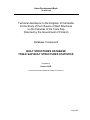
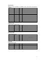
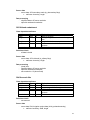
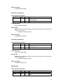
1. STATISTICS BY SUB-CATCHMENT
St.Sreng
St.Chikreng
St.Siem Reap
St.Mongkol Borey
St.Sanger
To
St.Staung
nl
e
Sa
St.Sen
p
St.Battambang
St.Dauntri
St.Chinit
St.Pursat
St.Baribo
Siem Bok
0
100 km
Figure 1: Tonle Sap subcatchments
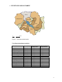
Tonle Sap subcatchment statistics
Subcatchment
Area (km2)
Siem Bok
St. Baribo
St. Battambang
St. Chikreng
St. Chinit
St. Dauntri
St. Mongkol Borey
St. Pursat
St. Sangker
St. Sen
St. Siem Reap
St. Sreng
St. Staung
Tonle Sap
Sum
8851.22
7153.78
3708.31
2713.90
8236.86
3695.97
14966.42
5964.77
2344.47
16359.58
3618.98
9986.27
4357.39
2743.80
94701.70
Flooded (km2)
medium flood
2171.99
1032.37
431.79
700.19
1983.23
1174.30
1834.95
687.25
1548.73
1773.03
1017.23
1430.55
1186.82
2743.80
19716.23
Flooded (%) in
medium flood
24.54
14.43
11.64
25.80
24.08
31.77
12.26
11.52
66.06
10.84
28.11
14.33
27.24
100.00
20.82
3
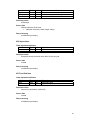
Lake dry season and medium flood (year 2001) statistics
Dry season lake from MRC shoreline data (50m resolution):
Lake shoreline length
1059
km
Main islands shoreline length
1309
km
Together
2368
km
Lake area (islands subtracted)
2767
km2
Medium flood lake shoreline length from MRC 2001 flood level data (50m
resolution):
Total shoreline length
7007.8
km
Area under flood
19718.7
km2
Dry season and medium flood shoreline lengths by catchment area
Catchment
Siem Bok
St. Baribo
St. Battambang
St. Chikreng
St. Chinit
St. Dauntri
St. Mongkol Borey
St. Pursat
St. Sangker
St. Sen
St. Siem Reap
St. Sreng
St. Staung
Tonle Sap
Sum
Dry season (km)
0
368.1
0
298.5
181.2
133.9
0
109.7
176.5
106.4
69.4
41.7
482.8
400.8
2368.1
Flooded (km)
736.24
554.33
267.85
162.42
379.19
725.48
1626.26
351.88
89.5
531.38
449.58
814.25
319.42
0
7007.78
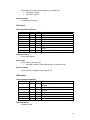
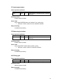
Figure 2: Data used in shoreline length and area computation, dry season lake area in blue,
medium flood area in light blue, and catchment boundaries in red.
4
Dry season lake shoreline length during low water level, computed from
subcatchment boundary data:
Catchment
Siem Bok
St. Baribo
St. Battambang
St. Chikreng
St. Chinit
St. Dauntri
St. Mongkol Borey
St. Pursat
St. Sangker
St. Sen
St. Siem Reap
St. Sreng
St. Staung
Tonle Sap
Sum
Length (km)
0
80.5
0
22.2
15.5
30.0
0
83.7
33.6
46.6
56.6
11.9
40.5
0
421.1
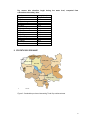
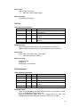
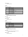
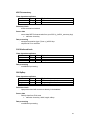
2. STATISTICS BY PROVINCE
Oddar Meancheay
Thailand
Preah Vihear
Banteay Meanchey
Stung Treng
Siem Reap
Battambang
Pailin
To
n
Le
Sa
p
Kampong Thom
Kratie
Pursat
Kampong Chhnang
Kampong Cham
Kampong Spe
Phnom Penh
Kandal
0
100 km
Figure 3: Cambodian provinces intersecting Tonle Sap catchment area
5
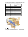
Area data for provinces in the Tonle Sap catchment, including flooded area of
provinces within the Tonle Sap catchment boundary (see Figure 4).
Province
Area (km2)
Stung Treng
Oddar Meancheay
Preah Vihear
Banteay Meanchey
Siem Reap
Thailand
Battambang
Kampong Thom
Kratie
Tonle Sap
Pailin
Pursat
Kampong Chhnang
Kampong Cham
Kampong Spe
Kandal
Phnom Penh
12016.42
5211.71
14030.75
6148.69
11963.74
4102.97
11857.86
12446.57
11972.83
2524.603
1090.97
11576.90
5327.54
9482.88
6964.62
3563.69
373.72
0
Flooded (km2) in medium
flood and within Tonle Sap
catchment
0
30.90
0
1347.75
2825.36
0
3331.61
3625.73
268.88
2524.603
0
1612.47
1964.28
1642.04
0.2
506.35
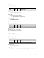
56.06
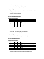
100 km
Figure 4: Medium flood area with provinces and Tonle Sap catchment boundary (wide
blue line).
6
3. NUMBER OF STRUCTURES BY CLASS
Class ID
110
211
220
230
310
320
321
322
323
324
340
371
372
411
413
414
415
440
450
610
620
630
640
650
710
730
814
Sum
Class name
Reservoir
Irrigation canal
Bridge
Culvert
Dam
Embankment
Road embankment primary
Road embankment other
Railroad embankment
Reservoir dike
Weir
Hydrological station
Meteorological station
Dai fishery
Fence system
Fence trap
Fence pen
Fishing lot
Fish sanctuary
Rice field
Field crops
Plantation
Other agriculture
Irrigated area
Docks/Harbour
Ferry
Mine
Count
55
3992
1311
323
38
908
45
2149
20
3
2
44
85
11
163
258
51
41
7
1597
473
77
2961
159
4
4
62
14843
4. STRUCTURE STATISTICS BY SUBCATCHMENT
Length of primary roads (km)
Catchment
Count
Siem Bok
8
St. Baribo
16
St. Battambang
1
St. Chikreng
1
St. Chinit
2
St. Dauntri
2
St. Mongkol Borey
5
St. Pursat
1
St. Sangker
1
St. Sen
1
St. Siem Reap
1
St. Sreng
2
St. Staung
2
Sum
43
Length (km)
138.47
188.79
18.89
19.88
68.72
51.26
155.61
29.31
20.63
50.32
77.83
35.6
44.49
899.81
7
Length of other roads (km)
Catchment
Count
Siem Bok
106
St. Baribo
225
St. Battambang
152
St. Chikreng
8
St. Chinit
129
St. Dauntri
85
St. Mongkol Borey
509
St. Pursat
191
St. Sangker
6
St. Sen
212
St. Siem Reap
228
St. Sreng
243
St. Staung
54
Sum
2148
Length (km)
657.27
844.73
443.27
41.97
600.12
208.99
1604.24
588.8
49.73
1013.28
678.61
1091.97
215.56
8038.54
Length of railroad embankments (km)
Catchment
Count
Siem Bok
0
St. Baribo
9
St. Battambang
1
St. Chikreng
0
St. Chinit
0
St. Dauntri
2
St. Mongkol Borey
3
St. Pursat
1
St. Sangker
1
St. Sen
0
St. Siem Reap
0
St. Sreng
0
St. Staung
0
Sum
17
Length (km)
0
143.07
21.53
0
0
51.97
111.34
31.72
20.15
0
0
0
0
379.78
Length of embankments (km)
Catchment
Count
Siem Bok
232
St. Baribo
108
St. Battambang
15
St. Chikreng
17
St. Chinit
67
St. Dauntri
62
St. Mongkol Borey
124
St. Pursat
4
St. Sangker
12
St. Sen
33
St. Siem Reap
167
St. Sreng
44
St. Staung
23
Sum
908
Length (km)
363.88
197.61
24.72
57.36
117.92
168.09
347.11
8.62
34.86
64.82
418.73
144.82
89.56
2038.11
8
Length of irrigation channels (km)
Channels selected for a catchment if the channel mid-point is within the catchment.
Catchment
Count
Length (km)
Siem Bok
264
259.49
St. Baribo
133
285.81
St. Battambang
94
108.77
St. Chikreng
30
65.56
St. Chinit
493
626.94
St. Dauntri
282
479.58
St. Mongkol Borey
1622
2039.92
St. Pursat
249
405.84
St. Sangker
86
154.17
St. Sen
161
215.69
St. Siem Reap
63
155.73
St. Sreng
373
429.15
St. Staung
142
187.98
Sum
3992
5414.63
Length of reservoir dikes (km)
Catchment
Count
Siem Bok
0
St. Baribo
0
St. Battambang
0
St. Chikreng
0
St. Chinit
3
St. Dauntri
0
St. Mongkol Borey
0
St. Pursat
0
St. Sangker
0
St. Sen
0
St. Siem Reap
0
St. Sreng
0
St. Staung
0
Sum
3
Length (km)
0
0
0
0
25.89
0
0
0
0
0
0
0
0
25.89
Length of fish fences (km)
Data was available from Preak Toal area only, see figure 5.
9
Figure 5: Area from where fishing fences, pens and traps data have been digitized.
Catchment
Siem Bok
St. Baribo
St. Battambang
St. Chikreng
St. Chinit
St. Dauntri
St. Mongkol Borey
St. Pursat
St. Sangker
St. Sen
St. Siem Reap
St. Sreng
St. Staung
Sum
Count
0
0
0
0
0
0
0
0
54
0
1
74
34
163
Number of traps (km)
Catchment
Siem Bok
St. Baribo
St. Battambang
St. Chikreng
St. Chinit
St. Dauntri
St. Mongkol Borey
St. Pursat
St. Sangker
St. Sen
St. Siem Reap
St. Sreng
St. Staung
Sum
Count
0
0
0
0
0
0
0
0
83
0
0
105
70
258
Length (km)
0
0
0
0
0
0
0
0
55.66
0
4.1
56.45
8.16
124.37
10
Number of pens (km)
Catchment
Siem Bok
St. Baribo
St. Battambang
St. Chikreng
St. Chinit
St. Dauntri
St. Mongkol Borey
St. Pursat
St. Sangker
St. Sen
St. Siem Reap
St. Sreng
St. Staung
Sum
Count
0
0
0
0
0
0
0
0
17
0
0
24
10
51
Area of reservoirs (km2)
Catchment
Siem Bok
St. Baribo
St. Battambang
St. Chikreng
St. Chinit
St. Dauntri
St. Mongkol Borey
St. Pursat
St. Sangker
St. Sen
St. Siem Reap
St. Sreng
St. Staung
Sum
Count
2
0
0
2
1
0
6
0
0
4
3
5
32
55
Area (km2)
1.74
0
0
3.64
0.85
0
27.36
0
0
6.83
14.27
12.03
35.56
102.28
Area of paddy fields (km2)
Catchment
Count
Siem Bok
206
St. Baribo
167
St. Battambang
29
St. Chikreng
51
St. Chinit
109
St. Dauntri
48
St. Mongkol Borey
139
St. Pursat
45
St. Sangker
12
St. Sen
370
St. Siem Reap
40
St. Sreng
289
St. Staung
89
Sum
1594
Area (km2)
1196.25
2656.31
539.88
402.85
1607.71
1349.02
4476.1
674.7
427.61
1624.11
1347.38
1988.98
790.19
19081.11
11
Area of field crops (km2)
Catchment
Siem Bok
St. Baribo
St. Battambang
St. Chikreng
St. Chinit
St. Dauntri
St. Mongkol Borey
St. Pursat
St. Sangker
St. Sen
St. Siem Reap
St. Sreng
St. Staung
Sum
Count
37
46
28
3
99
1
160
2
0
40
17
27
13
473
Area (km2)
209.43
53.51
70.33
2.57
387.8
10.11
742.31
17.42
0
65.51
23.31
31.15
10.52
1623.98
Area of plantations (km2)
Catchment
Siem Bok
St. Baribo
St. Battambang
St. Chikreng
St. Chinit
St. Dauntri
St. Mongkol Borey
St. Pursat
St. Sangker
St. Sen
St. Siem Reap
St. Sreng
St. Staung
Sum
Count
8
0
9
0
37
0
22
0
0
1
0
0
1
78
Area (km2)
111.92
0
2.52
0
218.37
0
85.54
0
0
0.17
0
0
0.5
418.90
Area of other agriculture (km2)
Catchment
Count
Siem Bok
450
St. Baribo
422
St. Battambang
100
St. Chikreng
61
St. Chinit
316
St. Dauntri
90
St. Mongkol Borey
325
St. Pursat
62
St. Sangker
26
St. Sen
354
St. Siem Reap
201
St. Sreng
391
St. Staung
159
Sum
2957
Area (km2)
826.83
362.74
172.51
123.65
338.2
96.1
354.58
83.54
14.2
278.09
865.59
693.68
132.35
4342.06
12
Area of irrigation (km2)
Catchment
Siem Bok
St. Baribo
St. Battambang
St. Chikreng
St. Chinit
St. Dauntri
St. Mongkol Borey
St. Pursat
St. Sangker
St. Sen
St. Siem Reap
St. Sreng
St. Staung
Sum
Count
12
27
0
2
5
17
5
14
1
19
14
13
30
159
Number of dams
Catchment
Siem Bok
St. Baribo
St. Battambang
St. Chikreng
St. Chinit
St. Dauntri
St. Mongkol Borey
St. Pursat
St. Sangker
St. Sen
St. Siem Reap
St. Sreng
St. Staung
Sum
Count
1
0
0
0
0
0
23
0
0
11
0
2
1
38
Number of bridges
Catchment
All bridges
Siem Bok
St. Baribo
St. Battambang
St. Chikreng
St. Chinit
St. Dauntri
St. Mongkol Borey
St. Pursat
St. Sangker
St. Sen
St. Siem Reap
St. Sreng
St. Staung
Sum
132
147
60
13
41
65
202
164
21
204
79
162
21
1311
Area (km2)
186.42
146.01
0
259.54
48.86
562.49
965.03
139.24
356.29
141.78
297.2
109.84
313.37
3526.08
Bridges
roads
39
68
10
4
23
24
67
23
18
16
30
22
10
354
on
primary
13
Number of culverts
Includes only bridges on primary roads (no data on culvers elsewhere)
Catchment
Siem Bok
St. Baribo
St. Battambang
St. Chikreng
St. Chinit
St. Dauntri
St. Mongkol Borey
St. Pursat
St. Sangker
St. Sen
St. Siem Reap
St. Sreng
St. Staung
Sum
Count
5
43
5
2
9
13
46
8
5
12
78
56
41
323
14
5. STRUCTURE STATISTICS BY PROVINCE
In that section, statistics about built structures are detailed by province. Two special cases are to
be mentioned:
- the tables below include a “Tonle Sap” category, that corresponds to the permanent water body
that includes structures but does not pertain to any province in particular;
- the tables also include a “Thailand” category; as a matter of fact a small fraction of the Tonle Sap
basin lies in Thailand, and this area includes built structures that have also been recorded in the
database.
Length of primary roads (km)
Province
Count
Stung Treng
0
Oddar Meancheay
0
Preah Vihear
0
Banteay Meanchey
4
Siem Reap
4
Thailand
1
Battambang
4
Kampong Thom
3
Kratie
0
Tonle Sap
0
Pailin
0
Pursat
3
Kampong Chhnang
1
Kampong Cham
6
Kampong Spe
3
Kandal
16
Sum
45
Length
0
0
0
121.36
131.66
0.94
111.65
141.78
0
0
0
88.04
93.34
109.76
1.07
100.47
900.08
Length of other roads (km)
Province
Stung Treng
Oddar Meancheay
Preah Vihear
Banteay Meanchey
Siem Reap
Thailand
Battambang
Kampong Thom
Kratie
Tonle Sap
Pailin
Pursat
Kampong Chhnang
Kampong Cham
Kampong Spe
Kandal
Sum
Count
4
188
118
228
288
91
292
208
49
2
90
308
97
93
24
65
2145
Length
42.28
799.99
602.74
848.73
1029.28
161.03
1032.8
960.53
401.46
1.08
148.35
907.66
449.99
367.79
107.55
171.07
8032.33
15
Length of railroad embankments (km)
Province
Count
Stung Treng
0
Oddar Meancheay
0
Preah Vihear
0
Banteay Meanchey
1
Siem Reap
0
Thailand
1
Battambang
4
Kampong Thom
0
Kratie
0
Tonle Sap
0
Pailin
0
Pursat
3
Kampong Chhnang
2
Kampong Cham
0
Kampong Spe
1
Kandal
8
Sum
20
Length
0
0
0
70.78
0
0.73
113.74
0
0
0
0
80.14
75.17
0
14.83
24.39
379.78
Length of irrigation channels (km)
Province
Count
Stung Treng
1
Oddar Meancheay
13
Preah Vihear
41
Banteay Meanchey
964
Siem Reap
431
Thailand
0
Battambang
1047
Kampong Thom
507
Kratie
20
Tonle Sap
0
Pailin
0
Pursat
403
Kampong Chhnang
77
Kampong Cham
452
Kampong Spe
6
Kandal
30
Sum
3992
Length
0.55
13.71
24.91
1255.68
566.49
0
1455.06
750.74
14.23
0
0
670.24
147.94
459.97
12.27
42.84
5414.63
16
Length of embankments (km)
Province
Count
Stung Treng
0
Oddar Meancheay
3
Preah Vihear
7
Banteay Meanchey
90
Siem Reap
224
Thailand
1
Battambang
106
Kampong Thom
56
Kratie
4
Tonle Sap
0
Pailin
0
Pursat
31
Kampong Chhnang
122
Kampong Cham
173
Kampong Spe
11
Kandal
80
Sum
908
Length
0
7.3
25.21
245.04
587.44
4.2
300.25
137.4
8.08
0
0
80.93
255.12
265.12
14.43
107.58
2038.11
Length of reservoir dikes (km)
Province
Count
Stung Treng
0
Oddar Meancheay
0
Preah Vihear
0
Banteay Meanchey
0
Siem Reap
0
Thailand
0
Battambang
0
Kampong Thom
3
Kratie
0
Tonle Sap
0
Pailin
0
Pursat
0
Kampong Chhnang
0
Kampong Cham
0
Kampong Spe
0
Kandal
0
Sum
3
Length
0
0
0
0
0
0
0
25.89
0
0
0
0
0
0
0
0
25.89
17
Length of fish fences (km)
Province
Count
Stung Treng
0
Oddar Meancheay
0
Preah Vihear
0
Banteay Meanchey
0
Siem Reap
41
Thailand
0
Battambang
115
Kampong Thom
0
Kratie
0
Tonle Sap
7
Pailin
0
Pursat
0
Kampong Chhnang
0
Kampong Cham
0
Kampong Spe
0
Kandal
0
Sum
163
Length
0
0
0
0
45.49
0
76.67
0
0
2.2
0
0
0
0
0
0
124.37
Number of traps (km)
Province
Stung Treng
Oddar Meancheay
Preah Vihear
Banteay Meanchey
Siem Reap
Thailand
Battambang
Kampong Thom
Kratie
Tonle Sap
Pailin
Pursat
Kampong Chhnang
Kampong Cham
Kampong Spe
Kandal
Sum
Count
0
0
0
0
60
0
171
0
0
27
0
0
0
0
0
0
258
18
Number of pens (km)
Province
Stung Treng
Oddar Meancheay
Preah Vihear
Banteay Meanchey
Siem Reap
Thailand
Battambang
Kampong Thom
Kratie
Tonle Sap
Pailin
Pursat
Kampong Chhnang
Kampong Cham
Kampong Spe
Kandal
Sum
Count
0
0
0
0
12
0
34
0
0
5
0
0
0
0
0
0
51
Area of reservoirs (km2)
Province
Stung Treng
Oddar Meancheay
Preah Vihear
Banteay Meanchey
Siem Reap
Thailand
Battambang
Kampong Thom
Kratie
Tonle Sap
Pailin
Pursat
Kampong Chhnang
Kampong Cham
Kampong Spe
Kandal
Sum
Count
0
1
1
6
8
0
1
36
0
0
0
0
0
2
0
0
55
Area
0
8.94
0.64
16.11
28.27
0
12.89
42.6
0
0
0
0
0
1.74
0
0
111.2
19
Area of paddy fields (km2)
Province
Count
Stung Treng
41
Oddar Meancheay
136
Preah Vihear
334
Banteay Meanchey
146
Siem Reap
191
Thailand
15
Battambang
102
Kampong Thom
174
Kratie
57
Tonle Sap
0
Pailin
9
Pursat
80
Kampong Chhnang
124
Kampong Cham
113
Kampong Spe
21
Kandal
52
Sum
1595
Area
28.69
624.76
369.19
3350.5
2927.83
38.77
2983.65
2841.25
189.7
0
6.85
1650.73
1592.3
1498.17
573.14
405.51
19081.02
Area of field crops (km2)
Province
Stung Treng
Oddar Meancheay
Preah Vihear
Banteay Meanchey
Siem Reap
Thailand
Battambang
Kampong Thom
Kratie
Tonle Sap
Pailin
Pursat
Kampong Chhnang
Kampong Cham
Kampong Spe
Kandal
Sum
Area
0
4.5
18
159.93
43.16
10.29
509.97
163.66
1.04
0
144.09
27.53
34.91
481.89
6.74
18.27
1623.97
Count
0
3
14
79
35
46
45
90
3
0
27
3
37
76
8
4
470
20
Area of plantation (km2)
Province
Stung Treng
Oddar Meancheay
Preah Vihear
Banteay Meanchey
Siem Reap
Thailand
Battambang
Kampong Thom
Kratie
Tonle Sap
Pailin
Pursat
Kampong Chhnang
Kampong Cham
Kampong Spe
Kandal
Sum
Count
0
0
0
2
0
19
7
6
0
0
2
0
1
39
0
0
76
Area of other agriculture (km2)
Province
Count
Stung Treng
86
Oddar Meancheay
97
Preah Vihear
156
Banteay Meanchey
237
Siem Reap
522
Thailand
23
Battambang
295
Kampong Thom
491
Kratie
56
Tonle Sap
16
Pailin
3
Pursat
149
Kampong Chhnang
297
Kampong Cham
247
Kampong Spe
85
Kandal
202
Sum
2962
Area
0
0
0
24.71
0
60.71
1.47
9.51
0
0
1.05
0
0.2
321.26
0
0
418.9
Area
21.23
271.75
50.8
191.69
1459.43
7.83
382.52
454.24
78.44
1.07
3.83
162.09
501.55
509.7
23.2
222.7
4342.06
21
Area of irrigation (km2)
Province
Stung Treng
Oddar Meancheay
Preah Vihear
Banteay Meanchey
Siem Reap
Thailand
Battambang
Kampong Thom
Kratie
Tonle Sap
Pailin
Pursat
Kampong Chhnang
Kampong Cham
Kampong Spe
Kandal
Sum
Count
0
6
0
2
22
0
10
50
0
0
0
34
10
12
7
6
159
Area
0
31.53
0
235.56
614.5
0
1507.42
461.83
0
0
0
334.23
63.58
192.95
24.43
60.05
3526.08
Number of bridges
Province
All bridges
Bridges
roads
0
0
0
42
51
0
77
40
0
0
0
52
39
16
0
37
317
Stung Treng
Oddar Meancheay
Preah Vihear
Banteay Meanchey
Siem Reap
Thailand
Battambang
Kampong Thom
Kratie
Tonle Sap
Pailin
Pursat
Kampong Chhnang
Kampong Cham
Kampong Spe
Kandal
Sum
17
106
138
118
158
0
187
99
36
0
14
242
87
53
6
50
1311
on
primary
22
Number of culverts
Province
Stung Treng
Oddar Meancheay
Preah Vihear
Banteay Meanchey
Siem Reap
Thailand
Battambang
Kampong Thom
Kratie
Tonle Sap
Pailin
Pursat
Kampong Chhnang
Kampong Cham
Kampong Spe
Kandal
Sum
Count
0
0
0
34
126
0
42
58
0
0
0
17
20
9
4
13
323
Number of dams
Province
Stung Treng
Oddar Meancheay
Preah Vihear
Banteay Meanchey
Siem Reap
Thailand
Battambang
Kampong Thom
Kratie
Tonle Sap
Pailin
Pursat
Kampong Chhnang
Kampong Cham
Kampong Spe
Kandal
Sum
Count
0
2
10
23
0
0
0
2
1
0
0
0
0
0
0
0
38
23
Asian Development Bank
TA 4669-CAM
Technical Assistance to the Kingdom of Cambodia
for the Study of the Influence of Built Structures
on the Fisheries of the Tonle Sap
(financed by the Government of Finland)
Database Component
DATABASE DOCUMENTATION
Prepared by:
Hannu LAURI
EIA Ltd, Finland
April 2007
CONTENTS
Purpose of the database component .......................................................................... 3
Classification of built structures................................................................................... 3
Structure type classification .................................................................................... 3
Structure attributes.................................................................................................. 5
Selection criteria for structures.................................................................................... 6
Spatial extent .......................................................................................................... 6
Flow impact classification........................................................................................ 6
Database..................................................................................................................... 6
Database tables ...................................................................................................... 7
Class dependent data ........................................................................................... 10
Area data............................................................................................................... 30
System components and setup................................................................................. 30
Appendix A: Glossary................................................................................................ 34
Appendix B: Tonle Sap catchment statistics ............................................................. 35
Appendix C: Data directory ....................................................................................... 37
2
PURPOSE OF THE DATABASE COMPONENT OF THE PROJECT
The main task of the database component of the Built Structures project is to prepare
a database of existing surface water and surface water quality related structural
works in the Tonle Sap Basin. The database should contain the geographic extent
and characteristics of these structures.
The database will be used in the assessment of the consequences of built structures
on the environmental and human components of the lake ecosystem.
A built structure is defined here as a structure that
(i)
opposes water outflow (e.g. dams, weirs, irrigation schemes, levees,
embankments);
(ii)
prevents water inflow (e.g. . roads, railways, flood control works, polders,
dykes, wharves and quays);
(iii)
alters water inflow or outflow (e.g. drainage canals, diversion structures,
agricultural works, and flow modifications);
(iv)
may degrade water quality (e.g. plants with aqueous effluents, mining and
mineral processing facilities, petroleum storage facilities, sewerage
systems, and dredges); and
(v)
Fishing gears that can alter hydrological flows and obstruct fish
movement.
The main emphasis of the database is on structures of type (i), (ii) and (v).
CLASSIFICATION OF BUILT STRUCTURES
The structures are grouped in the database using structure type classification,
derived from structure type and usage. The type classification
1. Assigns exactly one type class for each existing structure in the target area,
2. Determines what characteristics of a given structure are stored in the
database,
3. Aids database users in searching for structures that have specific impacts,
4. Is easy to understand for the database user.
STRUCTURE TYPE CLASSIFICATION
1
110
120
Storage
Reservoir
Floodwater storage
2
210
211
210
230
240
Flow route
Canal
Irrigation canal
Bridge
Culvert
Spillway
3
3
310
320
321
322
323
324
330
340
350
360
370
371
372
Flow control
Dam
Embankment
Road embankment primary road
Road embankment other
Railroad embankment
Reservoir dike
Gate
Weir
Pumping station
Hydropower station
Measurement station
Hydrological station
Meteorological station
4
410
411
412
413
414
415
420
430
431
432
440
450
Fish and aquaculture
Fishing gear
Dai fishery
River barrage with bagnet or trap
Fence system fence
Fence system trap
Fence system pen
Fishway
Aquaculture
Fish pond
Fish cage
Fishing lot
Fish sanctuary
5
510
520
Erosion prevention
Reinforced bank
RipRap
6
610
620
630
640
650
Agriculture
Rice field
Field crops
Plantation
Other agriculture
Irrigated area
7
710
720
730
Transportation
Docks/Harbour
Breakwater
Ferry
8
810
811
812
813
814
820
821
Discharge
Point source
Sewage treatment plant
Sewage outlet
Industrial sewage outlet
Mine
Diffuse source
Scattered population
4
STRUCTURE ATTRIBUTES
Structure attributes are values that describe a given structure and are stored in the
database. The following data is stored:
− Structure name
− Structure position (mid-point position), UTM (Universal Transverse Mercator,
zone 48N with false easting of 500000, and WGS84 datum)
− Structure outline, mid-line or point location, coordinate system as above
− Structure creation (and demolition) date
− Database diary data; entry date and user ID
− Main physical dimensions of the structure
− Main hydrological characteristics of the structure
− Photographs of the structure
Below is a table of attributes based on the above structure classification.
Attributes for all classes
Field
id
class_id
name
info
xpos
ypos
boundary
constructed
demolished
entrydate
entryby
datasource
srid
boundary
Type
Int
Int
String
String
Real
Real
Geom
Date
Date
Date
String
String
Int
Geom
Unit
m
m
-
Explanation
Structure identifier
Structure class identifier
Name of structure
Additional information in text format
x-coordinate of mid-point (UTM)
y-coordinate of mid-point (UTM)
Boundary/mid-line/mid-point data
Construction date (when taken to use)
Demolition date (when taken out of use)
Date when entered into database
Userid of user who created this entry
Datasource acronym
Coordinate system identifier
Mid-point/boundary/mid-line geometry data
Class-dependent attributes
Field
width
height
length
area
activestorage
Type
Real
Real
Real
Real
Real
Unit
m
m
m
m2
m3
minlevel
Real
m
maxdepth
crestlevel
Real
Real
m
m
maxflow
crsection
Real
Real
m3/s
m2
wldrop
material
Real
String
m
-
Explanation
Width of structure
Height of structure
Length of structure
Area or structure (at the maximum water level)
Storage volume between minimum and
maximum water levels
Water level at which flow out or through a
structure stops
Maximum water level for a structure
Minimum water level for flow to occur over
structure
Maximum flow on maximum water level
Channel/opening cross section area at
maximum water level
Water level drop over structure
Construction
material,
e.g.
timber/earth/stones/concrete/metal
5
production
Real
kg/a
Approximate production per year
SELECTION CRITERIA FOR STRUCTURES
SPATIAL EXTENT
The database contains structures in the Tonle Sap Basin as defined by the
watershed boundary. Spatial emphasis is on the areas through which water flows to
the Tonle Sap, and more generally on areas that are or have been under water
during the flood season. The Tonle Sap flooded area is shown in Figure 1 and is
mostly limited by National Roads nº 5 and 6. The project target sites in Preak Toal,
Pursat and Chinit are included in the database with some more detail.
Figure 1: Geographic boundary for database contents
FLOW IMPACT CLASSIFICATION
Structures in the area are divided roughly into three categories according the impact
of the structure on water flow. The classes are large, mid-size and small structure.
Large structures may have catchment scale impacts, mid-size structures have
regional scale impacts, and small-scale structures have only local impacts.
A limit for large structures is here defined as a structure that can store at least 2.5
million m3 water (in a year), or modify existing flows for at least 1 m3/s on average, or
4 m3/s during peak flow time.
A limit for mid-size structures is defined as a structure that can store at least 0.5
million m3 water (in a year), or modify existing flows for at least 0.5 m3/s on average,
or 2 m3/s during peak flow time.
Structures that store water modify flows less than mid-size structures that belong to
the small category.
The database mainly contains large and mid-size structures. Structures classified as
small may also be included in the database in some cases, for example, if the impact
of a structure is not known or the attributes required for assessing the structure size
are not available.
6
DATABASE
The data is put into a relational database with the capability to store geometry types
MySQL database version 5.0.21 is used here. The MySQL database is free, and
contains user friendly tools for installation, database management, and queries. Also,
tools for data import from shapefile to the database are available.
A map-based data viewer Java applet was constructed to allow remote access to the
database data using an Internet browser.
Export of data to and from the database to GIS programs can be done by writing
selected database contents to an ESRI shapefile. The shapefile attribute table will
contain selected structure properties.
DATABASE TABLES
The database contains the following tables:
− Structure table – table for storing structure attributes
− Class table – table for storing structure classification data
− Photo table – table for storing photographs of structures
− Contact table – table for storing contact information for structure managers,
database users and data sources
− Validation table – table for storing validation data
− Discharge table – table for storing point load data
− Area table – geographic data that can be used to geographically select
structure data, for example, catchment boundaries, main rivers, districts and
province boundaries, and main settlement locations.
Structure table
Since many types of structures have common attributes, all structures are put in to a
single table that has a set of attributes shown below. The list of attributes can be
extended if required. Not all attributes are relevant to all structures, so only the
relevant attributes, defined by the structure class, will be set for each structure. The
irrelevant attributes will have undefined (null) values.
Field
id
class_id
name
info
xpos
ypos
boundary
constructed
demolished
entrydate
entryby
datasource
srid
boundary
width
height
length
Type
Int
Int
String
String
Real
Real
Geom
Date
Date
Date
String
String
Int
Geom
Real
Real
Real
Unit
m
m
m
m
m
Explanation
Structure identifier
Structure class identifier
Name of structure
Additional information in text format
x-coordinate of mid-point (UTM)
y-coordinate of mid-point (UTM)
Boundary/mid-line/mid-point data
Construction date (when put into use)
Demolition date (when taken out of use)
Date when entered into database
Userid of user who created this entry
Datasource acronym
Coordinate system identifier
Mid-point/boundary/mid-line geometry data
Width of structure
Height of structure
Length of structure
7
area
activestorage
Real
Real
m2
m3
minlevel
Real
m
maxdepth
crestlevel
Real
Real
m
m
maxflow
crsection
Real
Real
m3/s
m2
wldrop
material
Real
String
m
-
production
Real
kg/a
Area of structure (at the maximum water level)
Storage volume between minimum and
maximum water levels
Water level at which flow out or through a
structure stops
Maximum water level for a structure
Minimum water level for flow to occur over
structure
Maximum flow on maximum water level
Channel/opening cross section area at
maximum water level
Water level drop over structure
Construction
material,
e.g.
timber/earth/stone/concrete/metal
Approximate production per year
Class table
The class table contains data on structure classes.
Field
id
name
parent
description
shapetype
linecolor
linestyle
Type
Int
String
Int
String
tinyint
Integer
tinyint
Unit
-
fillcolor
fillstyle
integer
tinyint
-
Explanation
Structure class identifier
Name of class
Identifier of parent class
Description of the class
Shape type point/polyline/polygone
RGB linecolor (256*R+256*(G+B))
Line style: 0=thin, 1=medium, 2=thick,
3=dashed
RGB fillcolor (256*R+256*(G+B))
Fill style, 0=solid, 1-28 hatch: 1: ' ' ,
4: '\\\', 7: '///', 10: '|||', 13:'xx' , 16:'++';
+0=dense, +1=medium, +2=sparse
Photo table
The photo table contains photos that can be added to structure descriptions. Photos
are stored using a maximum size of 1600x1200 pixels and in .jpeg format.
Field
id
structure_id
image
description
priority
date
ypos
ypos
direction
Type
Int
Int
BLOB
String
Int
date
Real
Real
Int
Unit
m
m
degr.
distance
Real
m
Explanation
Photo identifier
Structure identifier
Photograph data (.jpeg 1600x1200)
Photo description
Photo presentation order, smaller first
Date photo was taken
Photo position X-coordinate (UTM)
Photo position Y-coordinate (UTM)
Direction from structure to photographer,
0=from north, 90=from east side
Distance from structure to photographer
8
Contact table
Table for contact information
managers.
Field
Type
id
Int
acronym
String
firstname
String
lastname
String
userid
String
institute
String
department
String
address1
String
address2
String
phone1
String
phone2
String
fax
String
email
String
date
Date
of database users, data sources and structure
Unit
-
-
Explanation
Contact identifier
Acronym
Firstname
Lastname
Database userid, if exist
Institute
Department
Street address
Post number and city
Phone number
Mobile phone number
Fax number
Email address
Date of last update
Validation table
Table for structure validation data.
Field
Type
Unit
id
Int
structure_id
Int
contact_id
Int
validated
Date
method
String
description
String
-
Explanation
Validation identifier
Structure identifier
Validator identifier
Date of validation
Validation method; visit/indirect
If anything was changed
Discharge table
Table for discharge data.
Field
Type
id
Int
structure_id
Int
substance
String
amount
Real
dyear
Int
Unit
kg/d
-
Explanation
Load identifier
Associated structure
Load variable, e.g. PTOT, NTOT
Amount of load per day
Year for discharge
Unit
m2
-
Explanation
Area identifier
Area name
Catchment/district/river/settlement/road
Area of boundary
Area boundary
Area table
Table for selection data.
Field
Type
id
Int
name
String
type
String
area
Double
boundary
Geometry
9
CLASS DEPENDENT DATA
110 Reservoir
Class-dependent attributes
Attribute
Type
Unit
*info
String width
Real
m
length
Real
m
area
activestorage
minlevel
Real
Real
Real
km2
m3
m
maxdepth
Real
m
Explanation
Reservoir owner (owner: name)
Reservoir extent (bounding box width) in
east-west direction
Reservoir extent (bounding box height) in
north-south direction
Area of reservoir at the maximum water level
Active storage of the reservoir
Water level at which outflow from the storage
stops
Difference from minlevel to activestorage
level
Selection criteria
Large: Reservoirs with a volume larger than 2.5 million m3. For typical
reservoirs in the area with a water depth of 0-2 meters, this would mean an
area of at least 2.5 km2 when 1 m average water depth is used in volume
computation.
Midsize: Reservoirs with a volume 0.5-2.5 million m3. For typical reservoirs in
the area with a water depth of 0-2 meters, this would mean an area of at least
0.5 km2 when 1 m average active depth is used in volume computation.
Reservoirs that are next to each other are included in the database if the
combined estimated volume exceeds the above criteria.
Source data
- source data JICA reservoirs (ts_reservoir2.shp),
• attributes: boundary, name and area
Data processing
- reservoirs with area smaller than 0.5 km2 dropped out
- selection criteria applied to original data
10
120 Floodwater_storage
Class-dependent attributes
Attribute
*info
width
Type
String
Real
Unit
length
Real
m
area
activestorage
minlevel
Real
Real
Real
km2
m3
m
maxdepth
Real
m
m
Explanation
Storage owner (owner: name)
Storage extent (bounding box width) in eastwest direction
Storage extent (bounding box height) in
north-south direction
Area of storage at the maximum water level
active storage of the reservoir
Water level at which flow to/from the storage
stops
Difference from minlevel to water level at
activestorage volume
Selection criteria
− same as for reservoirs (class 110)
Source data
- source data Kampong Thom private reservoirs, Agriculture Office Kampong
Thom Province (kt_reservoir.shp)
• attributes: boundary, owner, area
Data processing
- no addition processing
210 Canal
Class-dependent attributes
Attribute
Type
Unit
width
Real
m
length
minlevel
maxdepth
crsection
material
Real
Real
Real
Real
String
m
m
m
m2
Explanation
Channel/opening width perpendicular to flow
direction
Channel/opening length along flow
Channel bottom level
Channel depth from minlevel to bank level
Channel cross section area at maxlevel
Selection criteria
Large: Canals with an average flow larger than 1m3/s, or a peak flow larger
than 10m3/s. Channels with high water cross section larger than 10 m2
Midsize: All channels wider than 2 meters
Source data
- no data
Data processing
- no addition processing
11
211 Irrigation canal
Class-dependent attributes
Attribute
Type
Unit
width
Real
m
length
Real
m
minlevel
Real
m
maxdepth
Real
m
crsection
Real
m2
material
String -
Explanation
Channel width perpendicular to flow direction
Channel length along flow
Channel bottom level
Channel depth from minlevel to bank level
Channel cross section area at maxlevel
Bank material, if not earth
Selection criteria
− same as canal (class 210)
Source data
- source data JICA irrigation channel data (ts_irr_canal2.shp)
• all data included
• attributes: mid-line, small/large size classification
- source data Chinit irrigation project channel data (added ts_reservoir2.shp)
• all data included
• attributes: mid-line, size: main/secondary/tertiary canal/drain
Data processing
- simplified data to 10 meter resolution
- split with catchment boundaries
220 Bridge
Class-dependent attributes
Attribute
Type
Unit
width
Real
m
height
Real
m
length
minlevel
maxdepth
crsection
Real
Real
Real
Real
m
m
m
m2
material
String
-
Explanation
Channel/opening width perpendicular to flow
direction
Height of bridge bottom from dry-season
water level
Channel/opening length along flow
Bridge opening bottom level
Typical maximum water depth under bridge
Channel/opening cross section area at
maxlevel
Material
Selection criteria
Large: Bridges longer than 30 meters
Midsize: Bridges longer than 5 meters
Source data
- source data JICA map road bridges (ts_rd_bridge.shp)
• all bridges included
• attributes: location
12
-
source data JICA map railroad bridges (ts_rr_bridge.shp)
• all bridges included
• attributes: location
Data processing
− no additional processing
230 Culvert
Class-dependent attributes
Attribute
Type
Unit
*info
String
width
Real
m
height
Real
m
length
Real
m
minlevel
Real
m
maxdepth
Real
m
crsection
Real
m2
wldrop
Real
m
material
String
Explanation
Culvert type, pipe/box
Width perpendicular to flow direction
Height of culvert opening
Length along flow
Culvert bottom level
Culvert maximum water depth
Cross section area at maxdepth
Difference of height from start to end of
culvert
Material, if not earth
Selection criteria
- all culverts included
Source data
- source data (ts_culvert2.shp)
• attributes: location, culvert type box/pipe, construction year
Data processing
- Culverts with no completion year dropped out
240 Spillway
Class-dependent attributes
Attribute
Type
Unit
width
Real
m
length
minlevel
Real
Real
m
m2
maxdepth
crsection
wldrop
material
Real
Real
Real
String
m2
m2
m
Explanation
Channel/opening width perpendicular to flow
direction
Channel/opening length along flow
Minimum water level for flow to occur over
structure
Typical maximum water depth
Cross-section area
Water level drop over the length of structure
Bank material, if not earth
Selection criteria
- all data included
13
Source data
- field visit data from Chinit
• attributes: width, length, wldrop
Data processing
- no additional processing
310 Dam
Class-dependent attributes
Attribute
Type
Unit
width
Real
m
height
length
Real
Real
m
m
crestlevel
Real
m
material
String
-
Explanation
Width of structure/opening perpendicular to
flow direction
Largest height of dam
Length of flow path in structure along flow
direction
Minimum water level for flow to occur over
structure
Timber/earth/stone/concrete/metal
Selection criteria
Large: Dams with active reservoir volume larger than 2.5 million m3
Midsize: Dams with active reservoir volume between 0.5-2.5 million m3
Source data
- source data JICA map (ts_dam_earth2.shp)
• attributes: boundary, material
Data processing
- all data included
- joined lines
- simplified to 10 m resolution
320 Embankment
Class-dependent attributes
Attribute
Type
Unit
width
Real
m
height
Real
m
length
crestlevel
Real
Real
m
m
material
String
-
Explanation
Width of structure
Average height of embankment from ground
level
Length of embankment
Minimum water level for flow to occur over
structure
Timber/soil/concrete/metal
Selection criteria
Large: Any embankment potentially catching water for more than 2.5 million
m3, or, an embankment longer that 10 km.
Midsize: Embankments higher than 1 m if longer than 2 km. Also, other
embankments that potentially trap more than 0.5 million m3 of water.
14
Source data
- source data JICA embankments (ts_levee3.shp)
• attributes: boundary, material, length
Data processing
- joined lines
- dropped out embankments shorter than 0.8 km, and not within distance of 0.5
km of a selected embankment
- simplified to 10 m resolution
- split with catchment boundaries
321 Road embankment (primary)
Class-dependent attributes
Attribute
Type
Unit
width
Real
m
height
Real
m
length
crestlevel
Real
Real
m
m
material
String
-
Explanation
Width of structure
Average height of embankment from ground
level
Length of embankment
Minimum water level for flow to occur over
structure
Timber/soil/concrete/metal
Selection criteria
- all data included
Source data
- source data JICA primary roads (ts_rdprimary2.shp)
• attributes: boundary, length
Data processing
- split with catchment boundaries
- set the crestlevel to 12 meters (equal to above flood)
322 Road embankment (other)
Class-dependent attributes
Attribute
Type
Unit
width
Real
m
height
Real
m
length
crestlevel
Real
Real
m
m
material
String
-
Explanation
Width of structure
Average height of embankment from ground
level
Length of embankment
Minimum water level for flow to occur over
structure
Timber/soil/concrete/metal
Selection criteria
- all data included (no knowledge on embankment heights available)
15
Source data
- source data JICA secondary roads (ts_rdsecondary2.shp)
• attributes: boundary, length
Data processing
- simplified data to 25 meter resolution
- split with catchment boundaries
323 Railroad embankment
Class-dependent attributes
Attribute
Type
Unit
width
Real
m
height
Real
m
length
crestlevel
Real
Real
m
m
material
String
-
Explanation
Width of structure
Average height of embankment from ground
level
Length of embankment
Minimum water level for flow to occur over
structure
Timber/soil/concrete/metal
Selection criteria
- all data included
Source data
- source data JICA railroads (ts_railway2.shp)
• attributes: boundary, length
Data processing
- joined lines
- simplified data to 25 meter resolution
- split with catchment boundaries
- set crestlevel to 12 (above flood)
324 Reservoir dike
Class-dependent attributes
Attribute
Type
Unit
width
Real
m
height
Real
m
length
Real
m
crestlevel
Real
m
material
String
-
Explanation
Width of structure
Largest height of dike from ground level
Length of dike
Minimum water level for flow to occur over
structure
Timber/earth/stone/concrete/metal
Selection criteria
- see reservoir
Source data
- source data Chinit irrigation project data (chinit_embankment.shp)
• attribute: boundary, width, length
16
Data processing
- no additional processing
330 Gate
Class-dependent attributes
Attribute
Type
Unit
width
Real
m
height
Real
m
length
Real
m
minlevel
Real
m
maxdepth
crsection
Real
Real
m
m2
material
String
-
Explanation
Width of gate perpendicular to flow direction
Height of gate from bottom to max water level
Length of flow path in gate along flow
direction
Min water level on which flow can occur
through the gate
Typical maximum water depth for gate
Cross section though which water can flow at
maxdepth
Timber/earth/stone/concrete/metal
Selection criteria
Large: Gate with width of at least 3.0 meters
Midsize: Gate with width of 1.0 to 3.0 meters
Source data
- field survey data
Data processing
- no additional processing
340 Weir
Class-dependent attributes
Attribute
Type
Unit
width
Real
m
height
Real
m
length
Real
m
crestlevel
Real
m
wldrop
material
Real
String
m
-
Explanation
Width of weir perpendicular to flow direction
Height of weir
Length of weir flow path in flow direction
Minimum water level for flow to occur over
structure
Water level drop (typical)
Timber/earth/stone/concrete/metal
Selection criteria
Large: Weir with width of at least 30 meters
Midsize: Weir with width of 2.0 to 30 meters
Source data
- source data Chinit irrigation project data (chinit_weir.shp)
• attributes: length, wldrop, material
Data processing
- no additional processing
17
350 Pumping station
Class-dependent attributes
Attribute
Type
Unit
minlevel
Real
m
production
Real
m3/s
Explanation
Minimum water level where the station can
work
Maximum pumping capacity
Selection criteria
Large: Station with capacity of at least 2 m3/s
Midsize: Station with capacity over 0.5 m3/s
Source data
- no data
Data processing
- no additional processing
360 Hydropower station
Class-dependent attributes
Attribute
Type
Unit
minlevel
Real
m
maxdepth
maxflow
Real
Real
m
m3
wldrop
Real
m
production
Real
Gwh
Explanation
Min water level on which flow can occur
through the structure
Typical maximum water depth from minlevel
Maximum flow though structure on maximum
water level
Water level drop (maxlevel to bottom of
structure)
Annual hydropower production
Selection criteria
Large: Station with production over 50 Gwh
Midsize: Station with production less than 50 Gwh
Data processing
- no additional processing
370 Measurement station
Class-dependent attributes
Attribute
Type
Unit
*info
Real
m
Explanation
Type of station: automatic/manual, measured
variable(s)
Selection criteria
- all data stations included
Data processing
- no additional processing
18
371 Hydrological station
Class-dependent attributes
Attribute
Type
Unit
*info
Real
m
Explanation
Type of station: automatic/manual, measured
variable(s)
Selection criteria
- all data stations included
Source data
- source data MOWRAM water level stations (river_station.shp)
• attributes: location, station id code, measured variables
Data processing
- no additional processing
372 Meteorological station
Class-dependent attributes
Attribute
Type
Unit
*info
Real
m
Explanation
Type of station: automatic/manual, measured
variable(s)
Selection criteria
- all data stations included
Source data
- source data MPWT rainfall stations (rainfall_st.shp)
• attributes: location, station id, measured variables
Data processing
- no additional processing
410 Fishing gear
Class-dependent attributes
Attribute
Type
Unit
production
Real
kg/a
Explanation
Approximate production in one year
Selection criteria
- stationary gears included
Data processing
- no additional processing
19
411 Dai fishery
Class-dependent attributes
Attribute
Type
Unit
width
Real
m
production
Real
kg/a
Explanation
Number of nets
Approximate production in one year
Selection criteria
- all known dai fisheries included
Source data
- satellite picture from Google Earth
• attributes: boundary, number of nets
Data processing
- no additional processing
412 River barrage with bagnet or trap
Class-dependent attributes
Attribute
Type
Unit
width
Real
m
production
Real
kg/a
Explanation
Width of barrage
Approximate production in one year
Selection criteria
Large: Barrages longer than 50 meters
Midsize: Barrages between 10-50 meters
Data processing
- no additional processing
413 Fence system fence
Class-dependent attributes
Attribute
Type
Unit
length
Real
m
production
Real
kg/a
Explanation
Length of associated fence system (main
fence part only)
Approximate production in one year
Selection criteria
- all fences, traps and pens
Source data
- digitized from aerial photos (fence_pen.shp, fence_trap.shp, fish_fence.shp),
Preak Toal area only
• attributes: boundary, length
20
Data processing
- no additional processing
414 Fence system pen
Class-dependent attributes
Attribute
Type
Unit
length
Real
m
production
Real
kg/a
Explanation
Length of associated fence system (main
fence part only)
Approximate production in one year
Selection criteria
- all fences, traps and pens
Source data
- digitized from aerial photos (fence_pen.shp, fence_trap.shp, fish_fence.shp),
Preak Toal area only
• attributes: boundary, length
Data processing
- no additional processing
413 Fence system rap
Class-dependent attributes
Attribute
Type
Unit
length
Real
m
production
Real
kg/a
Explanation
Length of associated fence system (main
fence part only)
Approximate production in one year
Selection criteria
- all fences, traps and pens
Source data
- digitized from aerial photos (fence_pen.shp, fence_trap.shp, fish_fence.shp),
Preak Toal area only
• attributes: boundary, length
Data processing
- no additional processing
420 Fishway
Class-dependent attributes
Attribute
Type
Unit
width
Real
m
length
Real
m
Explanation
Channel width perpendicular to flow direction
Channel length along flow (measured along
bank)
21
crestlevel
crsection
wldrop
material
Real
Real
Real
String
m
m2
m
Minimum water level for flow to occur
Channel cross section
Water level drop over the length of structure
Bank material, if not earth
Selection criteria
- all fishways
Source data
- field trip data from Chinit area
• attributes: boundary, width, length, wldrop
Data processing
- no additional processing
430 Aquaculture
Class-dependent attributes
Attribute
Type
Unit
area
Real
m2
production
Real
kg/a
Explanation
Aquaculture area
Approximate production in year
Selection criteria
- farms with annual production more than 10 tons per year
Source data
- no data
Data processing
- no additional processing
431 Pond fish farm
Class-dependent attributes
Attribute
Type
Unit
area
Real
m2
production
Real
kg/a
Explanation
Aquaculture area
Approximate production in year
Selection criteria
- same as for aquaculture (class 430)
Source data
- no data
Data processing
- no additional processing
22
432 Cage fish farm
Class-dependent attributes
Attribute
Type
Unit
area
Real
m2
production
Real
kg/a
Explanation
Aquaculture area
Approximate production in year
Selection criteria
- same as for aquaculture (class 430)
Source data
- no data
Data processing
- no additional processing
440 Fishing lot area
Class-dependent attributes
Attribute
Type
Unit
*name
String
area
Real
m2
production
Real
kg/a
Explanation
Province and number
Lot area
Approximate production in year
Selection criteria
- all fishing lots included
Source data
- source data MRC fishing lots from year 2001 (c_lot2001_commercial_3.shp)
• attributes: boundary, lot number, area code
Data processing
- extracted commercial lots (type 2) from c_lot2001.shp
- union of lots with same region code and lot number
- simplified to 50 m resolution
23
450 Fish sanctuary
Class-dependent attributes
Attribute
Type
Unit
*name
String
area
Real
m2
Explanation
Province and number
Lot area
Selection criteria
- all fish sanctuaries included
Source data
- source data MRC fish sanctuaries from year 2001 (c_lot2001_sanctuary.shp)
• attributes: boundary
Data processing
- extracted sanctuaries (type 3) from c_lot2001.shp
- simplified to 50 m resolution
510 Reinforced bank
Class-dependent attributes
Attribute
Type
Unit
width
Real
m
length
Real
m
material
String -
Explanation
Description of material used
Data processing
- no additional processing
520 RipRap
Class-dependent attributes
Attribute
Type
Unit
width
Real
m
length
Real
m
material
String -
Explanation
Width across flow direction
Length along flow direction
Description of material used
Selection criteria
- ripraps associated with a structure already in the database
Source data
- field trip data from Chinit area
• attributes: boundary, width, length, wldrop
Data processing
- no additional processing
24
610 Rice field
Class-dependent attributes
Attribute
Type
Unit
area
Real
km2
Explanation
Area of structure
Source data
- source data JICA paddy field areas (ts_paddyfield5.shp)
• attributes: boundary, area
Data processing
- simplified to 50 m resolution
- split to catchment areas
- areas smaller than 0.1 km2 removed
620 Field crops
Class-dependent attributes
Attribute
Type
Unit
area
Real
km2
Explanation
Area of structure
Source data
- source data JICA plantation areas (ts_fieldcrop2.shp)
• attributes: boundary, area
Data processing
- simplified to 50 m resolution
- areas smaller than 0.1 km2 removed
- split to catchment areas
630 Plantation
Class-dependent attributes
Attribute
Type
Unit
area
Real
km2
Explanation
Area of structure
Source data
- source data JICA plantation areas (ts_plantation2.shp)
• attributes: boundary, area
Data processing
- simplified to 50 m resolution
- areas smaller than 0.1 km2 removed
- split to catchment areas
25
640 Other agriculture
Class-dependent attributes
Attribute
Type
Unit
area
Real
km2
Explanation
Area of structure
Source data
- source data JICA agricultural areas (ts_otheragri2.shp)
• attributes: boundary, area
Data processing
- simplified to 50 m resolution
- areas smaller than 0.1 km2 removed
- split to catchment areas
650 Irrigated area
Class-dependent attributes
Attribute
Type
Unit
area
Real
km2
Explanation
Area of structure
Selection criteria
- Irrigated areas with field area larger than 2.5 km2
Source data
- source data MRC irrigated areas (ts_irriarea.shp)
• attributes: boundary, project name, area
- source data Kampong Thom private reservoir areas (kt_irriarea.shp)
• attributes: boundary, area, owner name
Data processing
- no additional processing
710 Dock/Harbour
Class-dependent attributes
Attribute
Type
Unit
length
Real
m
Explanation
Length of structure
Selection criteria
- all data included
Source data
- no data
Data processing
- no additional processing
26
720 Breakwater
Class-dependent attributes
Attribute
Type
Unit
length
Real
m
Explanation
Length of structure
Selection criteria
- breakwaters with length of at least 100 meters
Source data
- no data
Data processing
- no additional processing
730 Ferry
Class-dependent attributes
Attribute
Type
Unit
length
Real
m
Explanation
Length of structure
Selection criteria
- all data included
Source data
- source data JICA ferry lines (ts_ferry_line.shp)
Data processing
- no additional processing
810 Point source
Class-dependent attributes
Attribute
Type
Unit
production
Real
m3/d
Explanation
Volume of water coming from outlet
Selection criteria
- waste water flow of at least 100 m3/d, or P load of at least 0.1 kg/d, or N load
of at least 1 kg/d, or otherwise non-negligible point source.
Source data
- no data
Data processing
- no additional processing
27
811 Sewage treatment plant
Class-dependent attributes
Attribute
Type
Unit
production
Real
m3/d
Explanation
Volume of water coming from outlet
Selection criteria
- with waste water flow of at least 100 m3/d
Source data
- no data
Data processing
- no additional processing
812 Sewage outlet
Class-dependent attributes
Attribute
Type
Unit
production
Real
m3/d
Explanation
Volume of water coming from outlet
Selection criteria
- with waste water flow of at least 50 m3/d
Source data
- no data
Data processing
- no additional processing
813 Industrial sewage outlet
Class-dependent attributes
Attribute
Type
Unit
production
Real
m3/d
Explanation
Volume of water coming from outlet
Selection criteria
- with waste water flow of at least 50 m3/d
Source data
- no data
Data processing
- no additional processing
28
814 Mine
Class-dependent attributes
Attribute
Type
Unit
*info
String
production
Real
tn
Explanation
Mineral/material,
type
openpit/placer/quarry/sub-surface
Production of material processed/taken out
yearly
Selection criteria
- all data included
Source data
- source data MIME mine data (mine_mime2.shp)
Data processing
- removed points outside Tonle Sap catchment areas
820 Diffuse source
Class-dependent attributes
Attribute
Type
Unit
*info
String
area
Real
km2
width
Real
height
Real
kg
production
Real
units
Explanation
Type of source
Area of source
Number of units
Production per unit per year
Total production per year
Source data
- no data
Data processing
- no additional processing
821 Scattered population
Class-dependent attributes
Attribute
Type
Unit
*info
String
area
Real
km2
width
Real
height
Real
kg
production
Real
units
Explanation
Type of source, waste produced
Area of source
Number of people
Production per person per year
Total production per year
Selection criteria
- Village (“phum”) level division
Source data
- population data from year 1998 (ts_phum2.shp)
29
-
attributes: village position, number of persons
Data processing
- no additional processing
AREA DATA
The area table contains the following data:
- Tonle Sap catchment and subcatchment boundaries
• Data source: MRC (tls_catchments.shp)
• Attributes: boundary, name, area
- Medium flood extent boundaries
o Data source: MRC (tls_catchments.shp)
o Attributes: boundary, name, area
- Cambodian province boundaries (the provinces intesecting Tonle Sap
catchment area)
o Data source: MRC (tls_provicnes.shp)
o Attributes: boundary, name, area
SYSTEM COMPONENTS AND SETUP
The database system is based on the following MySQL standard software
components
• MySQL database server (version 5.0. community edition)
• MySQL Query browser (version 1.1.20)
• MySQL Administrator (version 1.1.9)
Additional tools were created in the project to enable transfer of GIS file data to and
from the database server, and to allow data to be shared in internet. These are:
• BSViv tool to access database locally, and to import and export data from
ESRI shapefile format
• BSMap tool (a java applet) to view data in internet
• BSConn program (a www-server cgi-program) to retrieve data from database
server to BSMap applet
The MySQL database server stores the database data and provides database
services to client applications. The MySQL Query browser is an interactive tool that
can be used to view and modify the data in the database in the computer that
contains the database. Use of the tool requires knowledge of SQL. The Administrator
tool is used to manage the database server, for example, create new users and
create data backups. The programs are available at the MySQL www-site
www.mysql.com free of charge.
The Local database access tool "BSViv" can be used to view, add, and modify
structure data on map-based windows application. Also import and export of data to
ESRI shape file is possible. This feature can be used, for example, when larger
amounts of structure data need to be moved to GIS system. The BSViv program
utilizes an open-source GIS tool package called FWTools (version 1.0.7), which can
be downloaded from http://fwtools.maptools.org.
30
The Internet access interface "BSApp" can be used to view database data remotely
using an internet browser. To use BSApp a www-server with system html pages and
bsconn- cgi-program needs to be setup.
Installation of the system for local and internet access is described in the chapter 2 of
the Built Structures Database User Manual.
MySQL tools
-Administrator
- Query browser
Client
Server
local
access
MySQL
server
internet
shape
files
data import/
export with
bsshapeio
Internet
browser
Apache
www-server
bsconn.exe
Data
BsMap
Applet
BsMap
Applet
Figure 1: System components and connections
BSVIV APPLICATION FILES
The BSViv application is implemented using a viv-language interpreter, that is
developed in EIA Ltd. for simple graphical user interface implementation. The
installation will setup the BSViv application under the installation directory to several
subdirectories listed below with contents. Starting the program is done by running the
"viv.exe" program with the "bs.ip"-file as a parameter.
The viv (=program) subdirectory contains following files:
bs.ip
- program statup file
bsmain.ip
- main program file
common.ip, rl*.ip
- application program files
viv.exe
- ip-file interpreter
vivres.dll, vivbmp.dll - viv.exe resources and bitmaps, required by viv.exe
rlgis.bmp
- about dialog bitmap file
The map-subdirectory contains following files:
tls_lake.*
- lake and river data for BSViv application
tls_subcatch_utm.* - subcatchment boundaries for BSViv application
The doc-subdirectory contains following files:
BSApp-help.doc
- BSApp help file
BSDB_manual.doc - Built structure database system user manual
bsdb_techdoc.doc
- this document
The bsdb-subdirectory contains following files:
bs0.sql
- sql macro to create bs-database tables
31
bs0create.sql
bs0dump.sql
bs0users.sql
classdata.sql
- sql macro to create bs-database
- database dump file
- sql macro to setup default database users
- sql macro to populate structure class data to database
WWW-SITE FILES
To access the bs-database using internet, the files listed below need to be setup in a
www-server directory. The built structures – site contains BSApp java applet,
composed of several jar-files, a bsconn – cgi-bin program, and some html pages.
By defatul user authentication is setup using as in the Apache www-server basic
authenication using .htaccess file. The bs-www site countains the following files
Main directory: www/bs
.htaccess
index.html
tlsstart.jpg
bsapp.shtml
bsapp.jar
openmap.jar
swingset.jar
bsapp_help.html
exitwindow.html
- Apache access control file
- startup page
- picture in the startup page
- applet window
- applet code
- applet code library
- applet code library
- help window
- file used to exit applet
Help pictures : www/bs/bsapp_help_files
*.*
- bsapp_help.html pictures
cgi-bin programs: www/bs/cgi-bin
bsconn.exe
- cgi-bin program to connect bsapp to MySQL database
libmysql.dll
- mysql dll-library, used by bsconn
Documentation: www/bs/doc
bsdb_manual.doc
- bsdb user manual
bsdb_techdoc.doc
- this documentation
Apache configuration: wwwconf
.htpasswd
- password file
htpasswd.exe
- password generator program
httpd.conf
- example Apache configuration file
DATABASE AND WWW-SITE USER AUTHENTICATION
The user authentication is setup by default for the Apache www-server using basic
authentication. Entering the www/bs directory requires giving a user identification and
password, after this no more passwords are asked.
The "bsconn" cgi-bin program uses defult username and password (see user
manual/Installation) hard coded in the program for accessing MySQL database
server. Therefore, it is necessary to setup the default user to the database server if it
is to be used via BSApp – applet. If required, the username and password can be
easily changed in the bsconn source code.
32
SOURCE CODE FILES
The bsconn c++ source files and BSApp java source files are included in the
"BSSourceSetup.exe" installation package. The bsconn is compiled with Borland
C++ builder 6, and the BsApp with Java 1.5.0_08.
33
APPENDIX A: GLOSSARY
(Reference: http://www.nalms.org/glossary/glossary.htm)
Channel
A course, such as a trench or aqueduct, through which water is moved or
directed; the bed of a river or stream.
Conduit
Any channel or pipe used for conducting the flow of water.
Culvert
A hydraulically short conduit which conveys water e.g. through a roadway
embankment or through some other type of flow obstruction below ground
level.
Dam
A barrier built across a valley or river for storing water.
Detention basin
A basin or reservoir where water is stored for regulating a flood. It has outlets
for releasing the flows during the floods.
Embankment
A man-made earth structure constructed for the purpose of impounding water
and/or carrying a roadway.
Fish ladder
An inclined trough which carries water from above to below a dam so that fish
can easily swim upstream.
Fishway
A structure allowing fish to pass over vertical impediments. It may include
special attraction devices, entrances, collection and transportation channels,
a fish ladder, and an exit.
Gauge (gauging station)
Specific locations on a stream where systematic observations of hydrologic
data are obtained through mechanical or electrical means.
Intake
A hydraulic structure built at the upstream end of the diversion canal; a tunnel
or power plant for controlling the flow and preventing silt and debris from
entering the diversion.
Levee
A natural or man-made earthen barrier along the edge of a stream, river, or
lake to prevent the flow of water out of its channel.
Reservoir
An artificial lake, pond, tank, or basin (natural or man-made) into which water
flows and is stored for future use.
Riprap
A layer of large stones, broken rock, boulders, or precast blocks placed in
random fashion on the upstream and downstream faces of embankment
dams, on stream banks, on reservoir shores, on the sides of a channel, or on
other land surfaces to protect them from erosion caused by current, wind,
wave, and/or ice action.
Sluice
An artificial channel for conducting water, with a valve or gate to regulate the
flow.
Sluice gate
A valve or gate used in a channel to regulate flow.
34
Spillway
Section of a dam designed to permit water to pass over its crest; a weir or
channel taking overflow from the dam; serves as a safety channel to prevent
erosion of the dam.
Weir
A dam, usually small, in a stream to raise the water level or divert its flow.
Weir (measurement)
A notch or depression in a levee, dam, embankment, or other barrier across
or bordering a stream, through which the flow of water is measured or
regulated.
Weir (fish)
A barrier constructed across a stream to divert fish into a trap.
35
APPENDIX B: TONLE SAP CATCHMENT STATISTICS
(references. MRC hydrology report, 2005, WUP-FIN Tonle Sap modelling project,
www.eia.fi/wup-fin)
Catchment area ~ 95000 km2
Dry season lake ~ volume 1-2 km3, depth minimum 0.5 m, area 2500 km2
Rainy season lake ~ volume 50-80 km3, depth 6-9 m, area 13000-14500 km2
Lake retention capacity ~ 80 km3
80 % of sediments brought to lake by flood retained
Average leaching from lake catchment area ~ 30 km3/a = 10 l/s/km2
Average volume flowing to lake outside catchment 40 km3/a
Outflow from lake 7.5-8.5 months, 70.4 km3, or 3375 m3/s average for 8 months
Inflow to lake from outside catchment area 40.7 km3, starting mid-May to mid-June,
duration 3.5-4.5 months, 3860 m3/s average for 4 months
Precipitation ~ 1300 mm/a, typically no rain from December to February
For rainy season, peak precipitation per month is typically over 300 mm/a, or about ¼
of the total yearly precipitation, three times the average precipitation.
Pan evaporation ~ 2100 mm/a = 5.8 mm/d
1 cm water level change in dry season lake level is 2.5 km3
36
APPENDIX C: DATA DIRECTORY
JICA data point data
− ts_rr_bridge.shp
− ts_rd_bridge.shp
− ts_culvert.shp
− mine_mime.shp
− ts_hystation.shp
JICA line data
− ts_ferry_line.shp
− ts_railway2.shp
− ts_canal.shp
− ts_levee.shp
− ts_rdprimary2.shp
− ts_dam_earth.shp
− ts_rdsecondary_aw.shp
− ts_rdsecondary_dw.shp
JICA polygon data
− ts_reservoir.shp
MRC data
− Tonle Sap catchment boundary
− Tonle Sap subcatcment boundaries
37
Asian Development Bank
TA 4669-CAM
Technical Assistance to the Kingdom of Cambodia
for the Study of the Influence of Built Structures
on the Fisheries of the Tonle Sap
(financed by the Government of Finland)
Database Component
BUILT STRUCTURES DATABASE
USERS MANUAL
Prepared by
Hannu LAURI
EIA Ltd., Finland
April 2006
Contents
1.
Introduction................................................................................................................... 2
Classification of structures .................................................................................................. 3
Database access................................................................................................................. 3
2.
Setting up the BSData database.................................................................................. 4
Running environment .......................................................................................................... 4
Setting up database for local use ........................................................................................ 4
Setting up database remote access .................................................................................... 5
3.
Using BSViv to access BSData locally........................................................................ 6
Installation and starting the program ................................................................................... 6
Main window, tools and main menu .................................................................................... 6
Viewing and updating database data .................................................................................. 8
Importing data from ESRI shapefile to the BSData database .............................................. 9
Exporting data from BSData database to shapefile ........................................................... 10
Adding and removing single structures from the database................................................ 10
Importing photos to the database ...................................................................................... 11
Modifying class related database data .............................................................................. 11
Creating database dump file and importing all data from an existing dump file. ................ 11
Creating a database report................................................................................................ 11
4.
Using BSApp to access BSData remotely ................................................................ 12
Installation and starting the program ................................................................................. 12
Main window, tools and main menu .................................................................................. 12
Querying database data .................................................................................................... 14
Viewing structure data....................................................................................................... 14
Other functionality ............................................................................................................. 15
2
1. INTRODUCTION
The Built Structures database "BSData" contains data on man-made hydraulic
structures on the Tonle Sap catchment. The structures are classified according to the
intended use. For each structure position, extent and structure attributes such as
structure height and construction material are stored.
Classification of structures
The structures are classified for eight higher level classes that may have one or more
subclasses. The detailed classification can be found in the technical documentation.
The main classes are:
1. Storages (e.g. reservoirs)
2. Flow routes (e.g. canals)
3. Flow controls (e.g. dams, gates)
4. Fish and aquaculture (e.g. dai fisheries)
5. Erosion prevention (e.g. ripraps)
6. Agriculture (e.g. irrigated areas)
7. Transportation (e.g. docs and harbours)
8. Discharge (e.g. sewage outlets, mines)
Database access
The database can be accessed using three methods (see Figure 1.1):
1. Standard SQL tools (MySQL)
2. Local database access
3. Internet access interface
BSApp – data access
(using internet)
• select data to display
• show data on map
• show structure attribes
Database management
(database in local computer)
• MySQL Administrator
• Command line tools
BSData
Database
Server
(MySQL 5.0)
BSViv data access
(database in local computer)
• draw data on map
• input and import new data
• export data to GIS
Standard MySQL tools
(database in local computer)
• MySQL query browser
• command line tools
Figure 1.1: Database access and management tools
The standard MySQL tools are:
a. MySQL database server (version 5.0. community edition)
b. MySQL Query browser (version 1.1.20)
c. MySQL Administrator (version 1.1.9)
3
The MySQL database server stores the database data and provides database services
to client applications. The Query browser is an interactive tool that can be used to view
and modify the data in the database in the computer that contains the database.
Remote access is also possible. Use of the tool requires knowledge of SQL. The
Administrator tool is used to manage the database server, for example, create new
users and create data backups. The programs are available at the MySQL www-site
www.mysql.com free of charge.
Please see the technical documentation on database structure. Chapter 1, "Setting up
the database"", explains how to set up the database and access it using Query
Browser.
The Local database access tool "BSViv" can be used to view, add, and modify
structure data on map-based windows applications. Also, importing and exporting to
and from ESRI shape files is possible if larger amounts of structure data need to be
moved to or from a GIS system. See Chapter 3 below on how to set up and use this
application.
The Internet access interface "BSApp" can be used to view database data remotely
using an Internet browser. In order to use this access method, a www-browser
installation of the database system needs to be set up. See Chapter 4 below on how to
setup and use this system.
Database management, such as adding users and backing up data, can be done using
Database standard tools. Some tasks can be done using the "BSViv" applications. See
Chapter 5 on database administration and updating.
2. SETTING UP THE BSDATA DATABASE
Running environment
The database system works on PC computers using Windows 2000/XP operating
systems. About 150 Mb of disk space is needed to set up the system. Software
installation packages can be found on the distribution CD.
Setting up database for local use
To set up the BSData database the following software needs to be installed:
1. MySQL database server (version 5.0.21)
2. MySQL Query Browser (version 1.1.20)
3. BSViv application (version 1.0)
4. FWTools toolset (version 1.1.0)
Detailed installation instructions for the MySQL database server can be found on the
MySQL www-site (www.mysql.com). The following instance configuration options
seem to work quite well:
• Developer machine
• Multifunctional database
• Tablespace in C: disk and "Installation Path"
• Number of concurrent connections 15 (Manual setting)
• Enable TCP/IP networking (also configure your Firewall, so that access to port
3306 is allowed from localhost ip-address 127.0.0.1 only)
• Standard character set
4
•
Set password to 'tietoa'. If you change this the password in the BSViv
application must be changed as well. See below.
To install the Query Browser, BSViv application and FWTools just run the
corresponding
installation
files
"mysql-query-browser-1.1.20-win.msi",
"BSVivSetup.exe" and "FWTools100.exe". Please use the default installation
directories. The database data is in the BSViv setup.
After the database server is installed and working, the database data needs to be
imported. This can be done using the BSViv application, or by using MySQL command
line client.
If you are using the BSViv, do the following:
• Start the BSViv application (Windows “Start” menu)
• If you changed the database root password, select the Database/Connection
setup from the main menu and type in the new password to dbpasswd-field.
• To create to database select the "Database/Create bs0 database" menu item. If
the database already exists, this will return an error.
• To import data to the database select the "Database/Import dump file" menu
item, then select "bs0dump.sql" from the file list, and click "Open". The dump
file is located in "C:\Program Files\BS\bsdb directory".
If you like to use MySQL command line, do as follows:
• Start MySQL command line (from Windows “Start” menu)
• create the database by typing "create database bs0;", then press <Enter>
• import data by typing "source C:/Program Files/BS/bsdb/bs0dump.sql;".
Setting up database remote access
There are two possibilities for accessing the database remotely:
• Access through IP-port 3306, using BSViv and Query Browser.
• Access using www-browser and BSApp
First, access to the database server can be opened to selected remote computers, by
configuring the firewall of the server computer to allow access to IP-port 3306 from the
remote computers. Note that access to port 3306 should be allowed for friendly ipaddresses only. In this case the BSViv and Query Browser can be used to access the
database. Just configure the database server to the remote server computer.
The second way is to set up remote access using a www-server and the BSApp data
browsing program. This configuration allows access to anyone with an Internet
browser, and knowledge of the correct userid and password.
To setup remote intenet access the following software needs to be installed (in
addition to the local database installation):
• Apache 2.2.2 www-server
• BSApp www-pages and cgi-program.
The Apache www-server setup is on the distribution CD. The latest version can be
downloaded from http://www.apache.org.
The BSApp system setup can be done by running the BSAppSetup program from the
distribution disk. The setup program will put the BSApp www-pages to directory
c:\bs\www by default. In addition to running the setup program following task need to
be done:
5
•
•
Set up network access userid's for the MySQL database by running the
"bsdb/bs0users.sql" macro using the BSViv "Run SQL macro" command.
Modify Apache configuration file so that it works with BSApp. After installing the
BSApp, an example configuration file "httpd.conf" can be found from the
wwwconf-directory. To setup the default configuration for Apache, with local
www-server access only, copy the provided example configuration file to
Apache configuration directory (typically "C:\Program files\Apache
Group\Apache2\conf"). Note that Apache must be restarted after the
configuration has been changed. To modify the file by hand, "Includes" must be
allowed for bs directory, and "bs/cgi-bin" directory must be defined to contain
script files. See the provided "httpd.conf" file for details.
3. USING BSVIV TO ACCESS BSDATA LOCALLY
The BSViv program is used to access BSData locally; that is, the database server
containing the data is in the same computer. The program can be configured to access
data in remote servers as well.
The BSViv can be used for the following tasks:
• querying database data by class, and showing the results on the map
• moving data from an ESRI shapefile to the BSData database
• exporting data from the BSData database to a shapefile
• modifying single structure attributes
• adding and removing single structures from the database
• importing photos to the database
• modifying class related database data
• creating a database dump file and importing all data from an existing dump file
• creating a database report of the number of structures in each class.
Installation and starting the program
To install the BSViv application, see chapter 2, Setting up the database for local use.
The installation program creates a start-menu item "BSViv", that is used to start the
program. To start the system from command line, move to the installation directory
("C:\Program Files\BS\viv") and give command "C:\Program Files\BS\viv\viv bs.ip".
Main window, tools and main menu
The BSViv main window displays a menu, toolbar, data layer list, and map window
workspace typically containing a single map window.
The top part of the window holds the main menu and toolbar. Main menu commands
are used to initiate actions such as querying of the database. Toolbar tools are used to
zoom and pan the map window, and select, add and remove structures from the data
layers.
The map window displays some base map data (catchment boundaries and main
rivers) from which database structure data is drawn. The data in the map window is
divided into layers that are listed in the layer list. The map window can be zoomed and
panned using the toolbar tools. The UTM coordinates of the current mouse location
are shown on the toolbar as well.
On the left side of the window is the layer list containing a list of data layers shown in
the map window. A data layer can hold data for one class of structures only. Many
6
data layers can be shown at the same time. Some actions require selecting a data
layer from the layer list. This can be done simply by clicking the layer name in the layer
list. Clicking a layer name with the right mouse button causes a popup menu to
appear. By using this menu the layers can be rearranged or completely removed.
tool bar
main menu
map data
layer list
Structure data
Figure 3.1: BSViv main window
The toolbar has the following tools:
Zoom in by dragging a rectangle to a model window
Zoom back to previous zoom setting
Pan by dragging the mouse
Copy window contents to the clipboard as a Metafile
Zoom to selected layer boundaries
Add a new structure to the selected data layer
X,Y (Lat,Lon)
Current mouse position coordinates:
UTM-East,UTM-North, (latitude, longitude)
Units: meters and decimal degrees
The main menu has the following commands:
File menu
New
Run SQL command
Run SQL macro
Show cmd window
Exit
Create a new map window
Run a SQL command
Select a SQL macro file and run it
Display viv command window
Exit program
7
LayerData menu
New layer
Query by class
Read shapefile
Write to shapefile
Import to database
Other data menu
Import photo
Edit class data
Database menu
Connection setup
Program path setup
Report by class
Dump to file
Create bs0 database
Reset tables
Import dump file
Create a new empty structure data layer
Query data from the database and create a new data
layer
Import graphics and attributes from a shapefile to a
structure data layer
Write structure graphics and attributes to a shapefile
Write structure data from a structure data layer to the
database
Read a .jpeg photo to database, convert to standard
size and also create an icon file
Select class and edit related data, such as line and
fill color
Set database location and userid information
Set MySQL command line and FWTools paths
Count and report the number of items in each class
Dump all database data to a SQL-script file
Create a database, used when setting up the
database
Create database tables, used when setting up the
database
Used to import all database data and tables from a
SQL dump file
Viewing and updating database data
To view and edit database data, a database query must first be made. The query will
then fetch data from the database and create a new data layer in the map window. To
perform a query use the "LayerData/Query by class" command from the main menu,
select structure class and click OK. After the query is completed a new data layer is
added to the layer list, and the structure data is drawn to the window.
To view or modify single structure attributes zoom in on the area of the map where the
structure is located, and click the structure graphic with the mouse. This action will
create a popup menu showing a list of nearby structures, where the preferred structure
can be selected. A dialog box containing the structure data then opens in the window,
shown in Figure 3.2 below.
8
Figure 3.2: Structure data dialog box
The dialog box allows editing of structure attribute data. Attribute fields visible in the
window depend on the structure class. To modify and update the data to the database
first modify the desired fields, and then click the "Update" button. To close the window
with no update click "Close". To remove the structure from the database click
"Remove".
Graphical structure data cannot for now be modified in the BSViv application. If
graphical data needs to be modified, the old structure must be removed, and a new
structure with the modified data must then be created.
Importing data from ESRI shapefile to the BSData database
To move data from the ESRI shapefile to the database, first the shapefile must be
imported to BSViv, and then from BSViv to the database.
To import shapefile contents to BSViv, use the "LayerData/Read shapefile" menu
command. After giving the command two things need to be selected. First the
shapefile to import, and then the structure class for the objects in the shapefile. Each
shapefile may contain only structures belonging to same structure class. After
selecting these an attribute selection window opens, in which the shapefile attribute
data can be mapped to BS database structure attributes. (See Figure 3.3 below).
9
Figure 3.3: Setting class attributes during shapefile import
For each structure attribute there are the following options: “set to given value”, “use
attribute from shapefile”, or “compute from geographic data”. The dialog box "Action"
column pull-down menus define how to set the field value. Items staring with “%” are
values that are computed from geographical data ("%length", "%xpos", "%ypos"). The
items starting with "#" are attributes from the shapefile. If the action column value is
"set" then the value in the "Value" column is set for all imported structures.
After pressing OK the shapefile data is imported to BSViv and displayed on the map.
The structures are, however, not yet in the database, (structure “id” values are set to
zero to show that the structures are not yet in the database). To copy the data from the
new shapefile layer to the database, first select the new layer from the layer list, and
then use the "LayerData/Import to database" command.
Exporting data from BSData database to shapefile
To export data from the database to a shapefile, first query the preferred structure from
the database using the "LayerData/Query by class" command. After the query is done
and a new data layer is created in the map window, select the data layer from the layer
list and select the "LayerData/Write to shapefile" command from the main menu.
Select a new name for the new shapefile and press OK:
Adding and removing single structures from the database
Adding new structures to the database can be done by importing shapefile data as
described above, or by creating new structures manually.
To create a new structure, a data layer for the structure data must first be created
using the "LayerData/New Layer" command. The command asks for the structure
class of the new layer, after which it creates a new empty layer in the layer list.
To add a new structure to the created data layer, click the "Add new structure" tool
from the toolbar, and the use the mouse to click a location on the map for the new
structure. If the structure is a point, one mouse click is sufficient. If the structure is a
line-type of polygon, draw the structure on the map with a sufficient number of mouse
clicks, and finish the drawing by double clicking. After the geographic data is clicked to
the map, a dialog box asking for structure attributes opens. Fill the structure data and
press "Create" to create the structure in the database.
10
Importing photos to the database
Photos can be put into the database and associated with structures that are already in
the database. The imported photos must be in .jpeg format. Photos can be imported
using the "Other data/Import photo" command, which will open a dialog box asking for
the photo file name, photo location and associated structure id. After the information is
given, the command creates a 800x600 pixel size version of the photo and copies it to
the database. Also, a 80x60 pixel size icon is made and put into the database as well.
The www-interface is able to show the photos along with structure data. The BSViv
cannot display photos.
Modifying class related database data
Class related data, such as drawing line color and fill color, can be modified using
"Other data/Edit class data". After selecting the class to edit, a class data edit dialog
box opens. The drawing attributes and class description can be changed. Class
identifiers and shapetype cannot be changed, since other applications use the defined
values.
Creating database dump file and importing all data from an existing dump file
Database dump files can be used to move the whole database to another computer, or
to backup the database before making changes to the data content. To create a
database dump use the menu command "Database/Dump to file", select a new name
for the database dump, and click OK.
To restore the database from a dump file, use the menu command "Database/Import
dump file", select the database dump file from the file window, and click OK.
Creating a database report
A simple report listing number of items in each structure class can be created using
the menu command "Database/Report by Class". The command will create a new text
window containing the generated report.
class items class name
110
211
220
230
310
320
321
322
323
324
340
371
372
411
413
440
450
610
620
630
640
650
710
730
814
55
3732
1278
323
38
892
28
1848
14
3
2
44
85
11
472
41
7
1323
372
77
2708
157
4
4
62
Reservoir
Irrigation canal
Bridge
Culvert
Dam
Embankment
Road embankment primary
Road embankment other
Railroad embankment
Reservoir dike
Weir
Hydrological station
Meteorological station
Dai fishery
Fence system
Fishing lot
Fish sanctuary
Rice field
Field crops
Plantation
Other agriculture
Irrigated area
Docks/Harbour
Ferry
Mine
Figure 3.4: Database Report by class
11
4. USING BSAPP TO ACCESS BSDATA REMOTELY
The BSApp interface can be used to connect to the BSData database using an
Internet browser, such as IE 6.0 or Firefox 1.5. The Internet server should have
BSData database installed for remote access.
The BSApp can be used for the following tasks:
• querying database data by class and geographical area, and showing the
results on the map
• Viewing structure attribute data for selected structures
• Viewing structure attribute data in table format
Installation and starting the program
The BSApp runs in any modern Internet browser that can run Java applets. To run the
program an Internet browser should be installed. The BSApp also uses Java Runtime
Environment 5 or later, which should be installed on the client computer (JRE
download: http://java.sun.com/javase/downloads/index.jsp).
To start the BSApp, start your browser program and type the address of the BSData
server into the address bar of the browser. A test version of the database is available
during 2007 at http://www.eia.fi/bs, userid "bsclient" and password "gh4ntx89". On the
welcome page there is a button where the BSApp can be started.
After clicking the start button the application downloads from the www-server, which
can take some time, since a few megabytes of data program code need to be
downloaded. The application code is cached to the accessing computer, so next time
the program is started the start time will be shorter.
Main window, tools and main menu
The main window of the BSApp applet is shown in Figure 4.1. The window displays a
base map with main rivers and catchment boundaries, a coordinate grid and a scale
bar. On the right side of the window is a data layer list displaying all data layers shown
in the window. The top part of the window contains the menu and toolbar.
The map window can be zoomed and panned using the toolbar tools. Also, the Zoom,
Query, Classes and Areas commands are located on the toolbar for fast access. The
geographic coordinates of the current mouse location are shown on the toolbar as
well.
On the right side of the window the layer list containing a list of maps and data layers
in shown in the window. A data layer holds data that results from one database query.
Many data layers can be shown at the same time. Some actions require selecting
data layers from the layer list. This is done simply by clicking the layer name in the
layer list. By clicking a layer name with the right mouse button, a popup menu appears.
Using this menu the layers can be rearranged or completely removed.
12
tool bar
map data
scale bar
layer list
Structure data
Figure 4.1: BSApp main window
The toolbar has the following tools and buttons:
Arrow tool: Show structure data (point and click),
Zoom (drag) and Pan (Shift+drag)
Zoom in by dragging a rectangle to model window
Zoom back to previous zoom setting
Pan by dragging with the mouse
Zoom to preset area
Lat N, Lon E
Mouse position geographical coordinates in degrees
and decimal minutes
Query data from the database
13
The window menu contains the following commands:
File menu
Print
Exit
Print window contents
Exit program
Help menu
Help
About
Open up a help window
Application version etc. information
Querying database data
To view database data a database query must be made. The query will then fetch data
from the database and create a new data layer in the map window. To perform a query
click the "Query" button on the toolbar, which opens a query dialog box (Figure 4.2). In
the query dialog box select a structure class and area and click OK. After the query is
completed a new data layer is added to the layer list, and the structure data is drawn in
the window.
Figure 4.2 Query data window
Viewing structure data
To view structure attribute data zoom the map to the area where the preferred
structure is located and click the structure graphic with the mouse (when the Arrow tool
is active). This will open a dialog window showing the structure data (Figure 4.3). The
displayed attributes depend on structure class.
To view all the attribute data of a data layer in table format, click the layer title in the
layer list with the right button, and select "Show table" from the popup menu. This will
open a table view of all structure attribute data (Figure 4.4). The table rows can be
selected using the mouse and copied to Clipboard by pressing Ctrl-C on the keyboard.
14
Figure 4.3 Structure data dialog box
Figure 4.4 Table view of layer attribute data
Other functionality
"Zoom" – toolbar button has some zoom shortcuts, including, "TonleSap river",
"TonleSap lake" and "Full extent".
"Areas" – toobar button can be used to draw selection areas to map window. This
includes subcatchments, provinces and mediumflood boundary
15