1
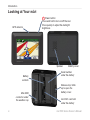
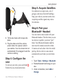
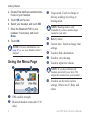
nüvi 500 series
®
owner’s manual
© 2008-2009 Garmin Ltd. or its subsidiaries
Garmin International, Inc.
1200 East 151st Street,
Olathe, Kansas 66062, USA
Tel. (913) 397.8200 or
(800) 800.1020
Fax (913) 397.8282
Garmin (Europe) Ltd.
Liberty House
Hounsdown Business Park,
Southampton, Hampshire, SO40 9LR UK
Tel. +44 (0) 870.8501241 (outside the UK)
0808 2380000 (within the UK)
Fax +44 (0) 870.8501251
All rights reserved. Except as expressly provided herein,
no part of this manual may be reproduced, copied,
transmitted, disseminated, downloaded or stored in any
storage medium, for any purpose without the express
prior written consent of Garmin. Garmin hereby grants
permission to download a single copy of this manual
onto a hard drive or other electronic storage medium to
be viewed and to print one copy of this manual or of any
revision hereto, provided that such electronic or printed
copy of this manual must contain the complete text
of this copyright notice and provided further that any
unauthorized commercial distribution of this manual or
any revision hereto is strictly prohibited.
Information in this document is subject to change
without notice. Garmin reserves the right to change or
improve its products and to make changes in the content
without obligation to notify any person or organization
of such changes or improvements. Visit the Garmin
Web site (www.garmin.com) for current updates and
supplemental information concerning the use and
operation of this and other Garmin products.
Garmin®, nüvi®, MapSource®, BlueChart® g2, g2
Vision®, Garmin TourGuide®, and TracBack® are
trademarks of Garmin Ltd. or its subsidiaries, registered
October 2009
Garmin Corporation
No. 68, Jangshu 2nd Road,
Shijr, Taipei County, Taiwan
Tel. 886/2.2642.9199
Fax 886/2.2642.9099
in the USA and other countries. Garmin Lock™,
myGarmin™, and g2 Vision™ are trademarks of Garmin
Ltd. or its subsidiaries. These trademarks may not be
used without the express permission of Garmin.
microSD™ is a trademark of the SD Card Association.
Microsoft, MSN, the MSN logo, Windows, and
Windows NT are either registered trademarks or
trademarks of Microsoft Corporation in the United
States and/or other countries. Mac® is a trademark of
Apple Computer, Inc., registered in the U.S. and other
countries. SaversGuide® is a registered trademark of
Entertainment Publications, Inc. The Wherigo logo is a
trademark of Groundspeak in the United States and other
countries. Used with permission. Use of geocaching.
com data is subject to the Geocaching.com Terms of
Use Agreement located at http://www.geocaching.
com/about/termsofuse.aspx. The Bluetooth® word mark
and logos are owned by the Bluetooth SIG, Inc. and any
use of such marks by Garmin is under license.
Other trademarks and trade names are those of their
respective owners.
Part Number 190-00937-00 Rev. C
Printed in Taiwan
Introduction
Introduction
Thank you for purchasing the Garmin®
nüvi® 500‑series GPS‑enabled navigator.
S ee the Important Safety and
Product Information guide in the
product box for product warnings
and other important information.
Product Registration
Help us better support you by completing
our online registration today! Connect to
our Web site at http://my.garmin
.com. Keep the original sales receipt, or a
photocopy, in a safe place.
In the UK, contact Garmin (Europe) Ltd.
by phone at 0808 2380000.
In Europe, go to www.garmin.com
/support and click Contact Support
for in‑country support information, or
contact Garmin (Europe) Ltd. by phone
at +44 (0) 870.8501241.
More Information
For more information about your nüvi,
touch Tools > Help. For information
about accessories, go to http://buy.garmin
.com or www.garmin.com/extras, or
contact your Garmin dealer.
Contact Garmin
Contact Garmin Product Support if you
have any questions while using your
nüvi. In the USA, go to www.garmin
.com/support, or contact Garmin USA by
phone at (913) 397‑8200 or
(800) 800‑1020.
nϋvi 500 Series Owner’s Manual
Introduction
Table of Contents
Introduction......................................i
Finding a Place Using the Map.......13
Using TracBack® . ...........................13
Searching Near Another Location...13
Product Registration...........................i
Contact Garmin..................................i
More Information................................i
Looking at Your nüvi......................... iv
Using the Map...............................14
Getting Started................................1
Managing Files..............................16
Step 1: Install the nüvi Battery...........1
Step 2: Charge Your nüvi..................2
Step 3: Mount Your nüvi....................2
Step 4: Configure the nüvi.................3
Step 5: Acquire Satellites..................3
Step 6: Pair your Bluetooth®
Headset........................................3
Using the Menu Page........................4
Where To?.......................................7
Finding an Address............................7
Setting a Home Location...................7
Finding a Place by Spelling the
Name . .........................................8
Finding Recently Found Places.........9
Favorites............................................9
Extras..............................................10
Using Custom Routes..................... 11
Entering Coordinates.......................12
Finding Geographic Points..............12
ii
Trip Computer..................................15
Turn List...........................................15
Next Turn.........................................15
Supported File Types......................16
Loading Files...................................16
Loading Photos for Photo
Navigation..................................18
Deleting Files .................................18
Using the Tools.............................19
Settings...........................................19
Where Am I?....................................19
Wherigo™ . ......................................19
Help.................................................19
Picture Viewer.................................19
Custom Routes................................20
My Data...........................................20
World Clock ....................................20
Calculator .......................................21
Unit Converter ................................21
Compass.........................................22
Traffic...............................................23
MSN® Direct....................................23
nϋvi 500 Series Owner’s Manual
Introduction
Customizing the nüvi...................24
System Settings..............................24
Navigation Settings.........................24
Display Settings...............................25
Time Settings...................................25
Language Settings..........................25
Map Settings...................................26
Security Settings.............................27
Bluetooth Settings...........................27
Traffic Subscription Information.......28
Proximity Points Settings.................29
Restoring All Settings......................29
Using FM Traffic ..........................30
Traffic in Your Area..........................30
Severity Color Code........................31
Traffic on Your Route.......................31
Viewing the Traffic Map...................32
Viewing Traffic Delays.....................32
Traffic Subscriptions........................32
Geocaching...................................33
Quick Links......................................33
Downloading Geocaches................33
Finding Geocaches.........................34
Wherigo...........................................34
Viewing Tide Information.................36
Viewing Marine Currents.................36
More Information.............................36
Appendix.......................................37
myGarmin™ . ...................................37
Caring for Your nüvi . ......................37
Locking Your nüvi............................38
Calibrating the Screen.....................39
Resetting the nüvi............................39
Updating the Software.....................39
Clearing User Data..........................40
Battery Information .........................40
Replacing the Battery in the nüvi.....40
Charging Your nüvi..........................40
Changing the Fuse..........................41
Mounting on Your Dashboard..........41
Additional Maps...............................42
Extras and Optional Accessories.....42
About GPS Satellite Signals............44
Software License Agreement..........45
Specifications..................................46
Troubleshooting...............................47
Index..............................................49
Boating Mode................................35
Viewing Marine Maps......................35
Finding Marine Points......................36
nϋvi 500 Series Owner’s Manual
iii
Introduction
Looking at Your nüvi
GPS antenna
Power button:
Press and hold to turn on/off the nüvi.
Press quickly to adjust the backlight
brightness.
Speaker
Battery
contacts
Mini‑USB
connector under
the weather cap
iv
Battery cover
Serial number
under the battery
Release key: Slide
up to open the
battery cover.
microSD™ card slot
under the battery
nϋvi 500 Series Owner’s Manual
Getting Started
Getting Started
Warning: This product contains
a lithium-ion battery. To prevent
damage, remove the unit from the
vehicle when exiting or store it out of
direct sunlight.
Before mounting the nüvi, see
the Important Safety and Product
Information guide for information
about laws pertaining to windshield
mounting.
nϋvi 500 Series Owner’s Manual
Step 1: Install the nüvi
Battery
1. Locate the lithium‑ion battery that
came in the product box.
2. Slide the release key up to open the
battery cover on the back of the nüvi.
3. Locate the metal contacts on the end
of the lithium‑ion battery.
4. Insert the battery so that the metal
contacts on the battery match up with
the metal contacts inside the battery
compartment.
Getting Started
5. Press the battery into place.
6. Slide the battery cover back on until it
clicks into place.
Suction cup
arm
Step 2: Charge Your nüvi
Use the vehicle power cable to charge
your nüvi. To purchase an optional USB
cable or AC adapter cable, go to
http://buy.garmin.com.
Step 3: Mount Your nüvi
1. Pull back the weather cap from the
mini-USB connector located on the
back of your nüvi.
2. Plug the vehicle power cable into the
mini-USB connector.
3. Snap the cradle onto the suction cup
arm.
Cradle
Lever
4. Remove the clear plastic from the
suction cup. Clean and dry your
windshield and the suction cup with a
lint‑free cloth.
5. Place the suction cup on the
windshield.
6. Flip the lever back, toward the
windshield.
7. Fit the bottom of your nüvi into the
cradle.
nϋvi 500 Series Owner’s Manual
Getting Started
Step 5: Acquire Satellites
Go outdoors to an open area, out of
garages, and away from tall buildings.
Stop your vehicle, and turn on the nüvi.
Acquiring satellite signals may take a
few minutes.
Step 6: Pair your
Bluetooth® Headset
8. Tilt the nüvi back until it snaps into
place.
9. Plug the other end of the vehicle
power cable into a power outlet in
your vehicle. Your nüvi should turn on
automatically if it is plugged in and the
vehicle is running.
Step 4: Configure the
nüvi
To turn on your nüvi, press and hold
Follow the on‑screen instructions.
nϋvi 500 Series Owner’s Manual
.
You can listen to nüvi audio with your
Bluetooth headset. The first time you use
two devices together, you must “pair”
them. Your Bluetooth headset and the
nüvi must be turned on and be within
10 meters of each other. After the initial
pairing, the two devices can connect
automatically each time you turn them
on.
1. Touch Tools > Settings > Bluetooth.
2. Enable Bluetooth technology on your
nüvi.
3. Under connections, touch Add or
Change.
Getting Started
4. Enable Find Me/Discoverable/Visible
mode on your headset.
5. Touch OK on the nüvi.
6. Select your headset, and touch OK.
7. Enter the Bluetooth PIN for your
headset, if necessary, and touch
Done.
8. Touch OK.
NOTE: For more information, see
page 27, or see your headset owner’s
manual.
Using the Menu Page
➍
➊
➋ ➌
➎
➏
➐
➑
➊
➋
➌
NOTE: Boating mode is only
available if you have marine maps
loaded to your nüvi.
➍ Battery status.
➎ Current time. Touch to change time
settings.
➏ Touch to find a destination.
➐ Touch to view the map.
➑ Touch to adjust the volume.
NOTE: If you have a Bluetooth
headset paired with your nüvi 510,
adjust the volume from your headset.
➒
➒
Usage mode. Touch to change to
driving, walking, bicycling, or
boating mode.
Touch to use the tools such as
settings, Where Am I?, Help, and
routes.
GPS satellite strength.
Bluetooth headset status (nüvi 510
only).
nϋvi 500 Series Owner’s Manual
Getting Started
nüvi Tips and Shortcuts
• To quickly return to the Menu page,
touch and hold Back.
• Touch
and
to see more
choices. Touch and hold these buttons
to scroll faster.
• Pages appear differently based on
your usage mode and settings.
Selecting a Usage Mode
Driving
Walking
Bicycling
Boating
Your nüvi offers several usage modes
for different modes of transportation.
Routing and navigation are calculated
differently based on your usage mode.
For example, one‑way streets are treated
differently in walking mode than they are
in driving mode.
To change your usage mode:
1. Touch the usage mode icon.
2. Select a mode, and touch OK.
3. Touch Yes, and follow the on‑screen
instructions to configure your usage
mode settings. For more information
about custom settings, see page 24.
Finding Points of Interest
1. Touch Where To? > Points of
Interest.
2. Select a category.
3. Select a destination, and touch Go!.
To search by name, touch Where To? >
Points of Interest > Spell Name.
To search in a different area, touch
Where To? > Near.
nϋvi 500 Series Owner’s Manual
Getting Started
Using the Go! Page
➊
➋
➌
➍
➊
➋
➌
Touch to view the route on the map.
Touch to start navigating the route.
Touch to view this location and
surrounding areas on the map. See
page 14.
➍ Touch to save this location to your
Favorites.
Adding a Stop to Your Route
1. With a route active, touch Menu >
Where To?.
2. Search for the extra stop (Via Point).
3. Touch Go!.
4. Touch Add as Via Point to add this
stop before your destination.
OR
Touch Set as new Destination to
make this your new final destination.
Taking a Detour
If the road ahead is closed, you can take
a detour.
NOTE: Detour is not available when
navigating off road.
1. With a route active, touch Menu.
2. Touch Detour.
The nüvi attempts to find an alternate
route that avoids the current road or the
next road on your turn list, and then
returns to your original route. If the route
you are currently navigating is the only
reasonable option, the nüvi might not
calculate a detour.
nϋvi 500 Series Owner’s Manual
Where To?
Where To?
The
Where To? menu provides
several different categories you can use
to search for locations. To learn how to
perform a simple search, see page 5.
Tip: Touch Near to change the search
area. See page 13.
Finding an Address
1. Touch Where To? > Address.
2. Change the state, country, or
province, if necessary.
3. Touch Spell City, enter the city/postal
code, and touch Done. Select the city/
postal code in the list. (Not all map
data provides postal code searching.)
If you are unsure of the city, touch
Search All.
4. Enter the number of the address, and
touch Done.
5 Enter the street name, and touch
Done.
nϋvi 500 Series Owner’s Manual
6. Select the correct street in the list, if
necessary.
7. Touch the address, if necessary.
note: Depending on the version
of the maps loaded on your nüvi, the
button names can change and some
steps could be ordered differently.
Setting a Home Location
You can set a home location for the place
you return to most often.
1. Touch Where To? > Go Home.
2. Select an option.
Going Home
After you set your home location, you
can route to it at any time by touching
Where To? > Go Home.
Where To?
Changing Your Home
Location
To change your home location, you must
first delete it from Favorites.
Using the On‑Screen
Keyboard
When an on‑screen keyboard appears,
touch a letter or number to enter it.
1. Touch Where To? > Favorites > All
Favorites.
2. Touch Home > Edit > Delete > Yes.
After you delete your home location,
reset it by following the steps on page 7.
Finding a Place by
Spelling the Name
If you know the name of the location you
are looking for, you can spell it using the
on‑screen keyboard. You can also enter
letters contained in the name to narrow
the search.
1. Touch Where To? > Points of
Interest > Spell Name.
2. Using the on‑screen keyboard, enter
letters in the name. Touch Done.
• Touch
to view a list of recently
found search words.
• Touch
to delete a character.
Touch and hold
to erase the
entire entry.
• Touch
to add a space.
• Touch
to change to uppercase or
lowercase.
• Touch Mode to select the keyboard
language mode.
• Touch 123 to enter special characters,
such as punctuation marks.
nϋvi 500 Series Owner’s Manual
Where To?
Finding Recently Found
Places
Your nüvi stores the last 50 of your
recent finds in the Recently Found list.
Touch Where To? > Recently Found.
The most recently viewed places appear
at the top of the list.
Deleting Recently Found
Places
To remove all places from the Recently
Found list, touch Clear > Yes.
Note: When you touch Clear, all
items from the list are removed. This
process does not delete the actual place
from your nüvi.
Fa��������
vorites
Saving Your Current Location
From the Map page, touch . Touch
Save Location to save your current
location.
Saving Places You Find
1. After you have found a place you
want to save, touch Save.
2. Touch OK. The place is saved in
Favorites.
Finding Saved Places
Touch Where To? > Favorites. Your
saved locations are listed.
Editing Saved Places
1. Touch Where To? > Favorites.
2. Touch the location you want to edit.
3. Touch Edit.
You can save places in your Favorites so
that you can quickly find them and create
routes to them. Your home location is
also stored in Favorites.
nϋvi 500 Series Owner’s Manual
Where To?
Using Photo Navigation
4. Touch an item to edit:
• Change Name—enter a new
name, and touch Done.
• Attach Photo—select a picture to
assign to the location.
• Change Map Symbol—touch
a new symbol used to mark this
location on the map.
• Change Phone Number—enter a
phone number, and touch Done.
• Change Categories—select
another category for the location.
• Delete—removes this item from
the Favorites list. Touch Yes.
10
Your nüvi device provides photos that
include location information. You can
load these photos on your nüvi or on a
microSD card and create routes to them.
For more information about loading
photos, see page 18.
1. Touch Where To? > Favorites >
Photos. Photos you have saved on
the nüvi drive or on the microSD card
are listed.
2. Touch a photo.
3. Touch Go! to navigate to the location.
Touch Map to view the location on the
map.
Extras
For information about extras such as
safety camera information and Garmin
Travel Guide, see pages 42–44.
nϋvi 500 Series Owner’s Manual
Where To?
Using Custom Routes
Touch Where To? > Custom Routes.
Select the route you want to take, and
touch Go!.
Creating a Custom Route
Use your nüvi to create and save custom
routes before your next trip. You can save
up to 10 custom routes.
1. Touch Where To? (or Tools) >
Custom Routes > New.
2. Touch Add New Start Point.
3. Find a location as your starting point,
and touch Select.
4. Touch Add New End Point.
5. Find a location as your ending point,
and touch Select.
6. Touch
to add another location
to your custom route. Touch
to
remove a location.
7. Touch Next to calculate your custom
route and view it on the map.
8. Touch Save to save the custom route
and exit.
Editing Custom Routes
1. Touch Where To? (or Tools) >
Custom Routes.
2. Select the route you want to edit.
3. Touch Edit.
4. Touch an item to edit:
• Change Name—enter a new
name, and touch Done.
• Add/Remove Points—add or
remove points from the route.
• Manually Reorder Points—
change the order of points along
your route.
• Optimally Reorder Points—
automatically order the points.
nϋvi 500 Series Owner’s Manual11
Where To?
• Recalculate—change the route
preference to calculate by faster
time, shorter distance, or off road.
• Delete—remove this route.
Entering Coordinates
If you know the geographic coordinates
of your destination, you can use your
nüvi to navigate to your destination
using the latitude and longitude
coordinates (or other coordinate
formats). This can be especially helpful
when geocaching. For information about
geocaching, see pages 33–34.
Finding Geographic
Points
If your nüvi has topographic maps, it
includes locations for various geographic
points, such as lakes, rivers, mountain
peaks, and other landmarks. For
information about additional maps, see
page 42.
1. Touch Where To? > Geographic
Points.
2. Select a geographic point from the
list.
3. Touch Go!.
1. Touch Where To? > Coordinates.
2. Touch Format to change the type of
coordinates. Because different maps
and charts use different position
formats, the nüvi allows you to select
the correct coordinate format for the
type of map you are using.
3. Enter the coordinates, and touch
Done.
12
nϋvi 500 Series Owner’s Manual
Where To?
Finding a Place Using the
Map
Touch Where To? > Browse Map.
Tips for Browsing the Map
• Touch the map, and drag to view
different parts of the map.
• Touch and to zoom out and in.
• Touch any object on the map. An
arrow appears pointing at the object.
• Touch Save to save this location.
• Touch Go! to navigate to the location.
If the GPS mode is off, touch Set
Location to set your location to the
selected location. See page 24.
Searching ��������������
Near Another
Location
Note: Your nüvi automatically
searches for places near your current
location.
1. Touch Where To? > Near.
2. Select an option:
• Where I Am Now—search near
your current location.
• A Different City—search near the
city you enter. In boating mode,
this option is A Map Location.
• My Current Route—search along
your active route.
• My Destination—search near
your current destination.
Using TracBack®
Touch Where To? > TracBack to view
your recent track. Touch Save to save
the track to your Favorites. Touch Go! to
retrace your recent path of travel.
nϋvi 500 Series Owner’s Manual13
Using the Map
Using the Map
Your route is marked with a magenta
line. As you travel, your nüvi guides you
to your destination with voice prompts,
arrows on the map, and directions at the
top of the map. A checkered flag marks
your destination. If you depart from the
original route, your nüvi recalculates the
route and provides new directions.
➊
➋
➌
➎
➊
14
Touch to
view the
next turn
(navigating
on road).
➍
➏
➊
Touch to
view the
compass
(navigating
off road).
➋ Touch the
text bar to
view the
turn list.
➌ Touch to zoom in and out.
➍ Touch the
vehicle icon
to view the
Where Am
I? page.
➎ Touch to
view the trip
computer.
➏ Touch to view the Menu page.
nϋvi 500 Series Owner’s Manual
Using the Map
Trip Computer
The trip computer displays your current
speed and provides helpful statistics
about your trip.
To view the trip computer, touch Speed
on the map. If you make frequent
stops, leave the nüvi turned on so it can
accurately measure elapsed time during
the trip.
Resetting Trip Computer
If you want accurate trip information,
reset the trip computer before beginning
a trip. Touch Reset Trip to reset the
information on the Trip Computer page.
Touch Reset Max to reset the maximum
speed.
Touch the text bar on the top of the map
to open the turn list. Touch a turn on the
list to view the next turn information.
Touch Show Map to view the entire
route on the map.
Next Turn
When you are navigating a route, you
can view the next turn on the map and
the distance and time left before you
reach the turn.
To view the next turn, touch the top left
corner on the map, or touch any turn
from the turn list.
Turn List
When you are navigating a route,
the turn list displays turn‑by‑turn
instructions for your entire route and the
distance between turns.
nϋvi 500 Series Owner’s Manual15
Managing Files
Managing Files
You can store files, such as JPEG image
files and GPX route files, in the internal
memory on the nüvi or on a microSD
card.
Note: The nüvi is not compatible
with Windows® 95, 98, Me, or
Windows NT®. It is also not compatible
with Mac® OS 10.3 and earlier. This
is a common limitation of most USB
mass storage devices.
Supported File Types
• JPEG, JPG, PNG, BMP, and GIF
image files: see page 18
• Maps, routes, and waypoints files
from MapSource®: see page 42
• GPX and GPW files: see pages 33–34
• GPI custom POI files from the
Garmin POI Loader: see page 43
16
Loading Files
microSD
card slot
under the
battery
Release
key: Slide
up to open
the battery
cover.
Mini‑USB
connector
under the
weather
cap
Step 1: Insert a microSD Card
(Optional)
1. Slide the release key up to open the
battery cover on the back of the nüvi.
2. Remove the battery.
3. To insert or remove the card, press it
in until it clicks.
4. Replace the battery.
5. Slide the battery cover back on until it
clicks into place.
nϋvi 500 Series Owner’s Manual
Managing Files
Step 2: Connect the USB
Cable (Not Included)
Connect the mini‑USB connector to the
back of the nüvi. Connect the larger end
of the cable to an available USB port on
your computer.
Your nüvi and microSD card appear as
removable drives in My Computer on
Windows computers and as mounted
volumes on Mac computers.
Note: Some operating systems or
computers with multiple network
drives cannot display the nüvi drives.
See your operating system Help file to
learn how to map the drives.
Step 3: Transfer Files to Your
nüvi
Copy and paste files from your computer
into the nüvi drives/volumes.
1. Browse your computer for the file you
want to copy.
2. Select the file, and touch Edit >
Copy.
3. Open the “Garmin” or microSD card
drive/volume.
4. Click Edit > Paste. The file appears
in the list of files in the nüvi memory
or on the microSD card.
Step 4: Eject and Unplug the
USB Cable
When you are finished transferring files,
click the eject
icon in your system
tray, or drag the volume icon to the
Trash
on Mac computers. Unplug
your nüvi from your computer.
nϋvi 500 Series Owner’s Manual17
Managing Files
Loading Photos for Photo Deleting Files
Connect the nüvi to your computer, and
Navigation
Download photos with location
information to your nüvi or microSD
card for photo navigation. Visit
http://connect.garmin.com/photos for
more information.
1. Connect your nüvi to your computer.
2. Go to http://connect.garmin.com
/photos, and sign in.
3. Select a photo.
4. Follow the on‑screen instructions.
18
open the nüvi or microSD card drive/
volume. Highlight the file you want to
delete, and press the Delete key on the
computer keyboard.
Caution: If you do not know the
purpose of a file, do not delete it.
Your nüvi memory contains important
system files that should not be deleted.
nϋvi 500 Series Owner’s Manual
Using the Tools
Using the Tools
The Tools menu provides many features
that are helpful when you are traveling.
From the Menu page, touch Tools to
access the Tools menu.
in that category. Touch Save Location to
save your current location.
Wherigo™
For information about Wherigo, see
page 34.
Help
Touch Help to get information about
using your nüvi.
Picture Viewer
Settings
For information about the settings, see
pages 24–29.
Where Am I?
Touch Where Am I? to view current
location information. This feature is
helpful if you need to tell emergency
personnel your location. Touch a button
on the right to view the nearest locations
Use the picture viewer to view pictures
that you have stored in your nüvi or on a
microSD card.
1. Touch Tools > Picture Viewer.
2. Touch a picture to view a larger image
of it.
3. Touch the arrows to view all the
images.
nϋvi 500 Series Owner’s Manual19
Using the Tools
Viewing a Slide Show
My Data
Navigating to a Picture
World Clock
Touch Slide Show to start a slide show,
which displays each image for a few
seconds and then displays the next
image. Touch anywhere on the screen to
stop the slide show.
If a picture contains location
information, touch Info > Go! to create
a route to it. See page 18 for more
information about loading pictures to
your nüvi.
Custom Routes
For information about custom routes, see
page 11.
20
Use this tool to manage and delete your
saved data, such as your Favorites.
If you have transferred a route from
MapSource, touch Import Route from
File to use that route in your nüvi.
1. Touch Tools > World Clock.
2. To change a listed city, touch the city.
3. Enter a city name, and touch Done.
4. Select the correct city, if necessary.
5. Touch Save.
6. Touch World Map to view a map.
Nighttime hours are shown in the
shaded area.
7. Touch World Clock to view the
clocks again, or touch Back to exit.
nϋvi 500 Series Owner’s Manual
Using the Tools
Calculator
1. Touch Tools > Calculator.
2. Enter the first number of your
calculation.
3. Touch an operator (÷, ×, -, or +).
4. Enter the second number of your
calculation.
• Touch . to add a decimal.
• Touch ± to make the number
negative or positive.
• Touch % to make the number a
percent (0.01).
• Touch C to clear the entry.
5. Touch =.
6. Touch C to make a new calculation.
Unit Converter
1. Touch Tools > Unit Converter.
2. Touch Conversion, select a type of
measurement, and touch OK.
3. Touch a unit of measure that you
want to change.
4. Select a unit of measure, and touch
OK. Repeat if necessary.
5. Touch the blank rectangle to enter a
value.
6. Enter a value, and touch Done. The
unit is converted.
7. Touch Clear to perform another
conversion.
nϋvi 500 Series Owner’s Manual21
Using the Tools
Updating Conversion Rates
You can update the currency conversion
rates manually so that you are always
using the most current rates.
1. Touch Tools > Unit Converter >
Conversion. Select Currency.
2. Touch the currency buttons and
select the currencies you want to
update.
3. Touch Update.
4. Touch the boxes next to the
currencies to enter new rates.
5. Touch Save to save the new rates.
Touch Restore to use the original
rates.
22
Compass
Heading in
degrees
Bug
indicator
Information
fields
GPS Compass
You can navigate using a GPS compass.
No calibration is required; however,
you must have a clear view of the sky.
Touch Tools > Compass. When you are
traveling, the compass rotates. The bug
indicator shows your current heading.
Your heading is also shown in degrees
in the center of the compass. The
information fields display the speed, the
elevation, the time of day, and the GPS
signal accuracy.
nϋvi 500 Series Owner’s Manual
Using the Tools
Navigating Off Road
When navigating an off‑road route, the
red arrow indicates the direction you
should travel to stay on the route. When
the red arrow points at the bug indicator,
you are going directly to the destination.
The lower‑right information field
displays the distance to your destination.
Direction
arrow
Bug
indicator
Distance
to
destination
Traffic
You can only access the traffic
information if your nüvi is connected to
an optional FM traffic receiver. For more
information, see pages 30–32 and
www.garmin.com/traffic.
MSN® Direct
You can only access MSN Direct content
with an optional MSN Direct receiver.
For more information, visit
http://garmin.msndirect.com or
www.garmin.com/traffic. To purchase an
accessory, visit http://buy.garmin.com.
GPS Compass While
Navigating an Off‑Road
Route
nϋvi 500 Series Owner’s Manual23
Customizing the nüvi
Customizing the nüvi
1. Touch Tools > Settings.
2. Touch the setting you want to change.
3. Touch the button beside the setting
name to change it.
NOTE: Some menus and settings
change based on your usage mode.
Look for a usage mode icon next to the
setting. Not all settings are available
for all usage modes.
System Settings
Touch Tools > Settings > System.
Usage Mode—specify how you will be
navigating to optimize routes: Driving,
Walking, Bicycling, or Boating. See
page 5.
GPS Simulator—turn on the simulator
to turn off the GPS mode and simulate
navigation and/or to save battery power.
Units—change units of measure to
Kilometers or Miles.
24
About—display the nüvi software
version number, the unit ID number,
the audio version number and the GPS
software version number. You need this
information when you update the system
software or purchase additional map
data. See page 42.
Restore—restore the system settings.
Navigation Settings
Touch Tools > Settings > Navigation.
Route Preference—select a preference
for calculating your route:
• Faster Time—to calculate routes that
are faster to drive but can be longer in
distance.
• Shorter Distance—to calculate
routes that are shorter in distance but
can take more time to drive.
• Off Road—to calculate point‑to‑point
routes (without roads).
nϋvi 500 Series Owner’s Manual
Customizing the nüvi
Avoidances—select the road types you
want to avoid on your routes.
Time Settings
Restore—restore the original navigation
settings.
Time Format—select a 12‑hour,
24‑hour, or UTC time format.
Display Settings
Current Time—Use + and ‑ to set the
time in 15‑minute increments. Check
Automatic to automatically set the time
when your nüvi is receiving satellite
signals.
Touch Tools > Settings > Display.
Color Mode—select Day for a
light background, Night for a dark
background, or Auto to automatically
switch between the two.
Screen Shot—turn on screen shot mode.
Touch the
to take a screen shot.
The picture bitmap file is saved in the
screenshots folder on the nüvi drive.
Brightness—adjust the backlight
brightness level. Reducing the backlight
brightness increases your battery life.
Restore—restore the original display
settings.
Touch Tools > Settings > Time.
Restore—restore the original time
settings.
Language Settings
Touch Tools > Settings > Language.
Voice—change the language for voice
prompts.
Text—change all on‑screen text to the
selected language. Changing the text
language does not change the language
of user‑entered data or map data, such as
street names.
nϋvi 500 Series Owner’s Manual25
Customizing the nüvi
Keyboard—select the keyboard for
your language. You can also change
the keyboard language mode from any
keyboard by touching the Mode button.
Restore—restore the original language
settings.
Map Settings
Touch Tools > Settings > Map.
Map Detail—adjust the amount of detail
shown on the map. Showing more detail
can cause the map to redraw slower.
Map View—select a map perspective.
• Track Up—display the map in two
dimensions (2D) with your direction
of travel at the top.
• North Up—display the map in 2D
with North at the top.
• 3D View—display the map in three
dimensions (3D) with your direction
of travel at the top.
26
Vehicle—touch Change to change the
icon used to display your position on the
map. Touch the icon you want to use,
and touch OK. Download additional
vehicle icons at www.garmin.com
/vehicles.
Trip Log—show or hide the log of your
travels. To clear your trip log, touch
Tools > My Data > Clear Trip Log.
Map Info—view the maps and the
version of each map loaded on your
nüvi. Touch a map to enable (check
mark) or disable (no check mark) that
map.
Restore—restore the original map
settings.
nϋvi 500 Series Owner’s Manual
Customizing the nüvi
Security Settings
Touch Tools > Settings > Security.
Garmin Lock—turn on Garmin Lock™
to lock your nüvi. Enter a 4‑digit PIN,
and set a security location. For more
information, see page 38.
Bluetooth Settings
Bluetooth headset voice guidance is a
feature of the nüvi 510 only. For pairing
information, see page 3.
Touch Tools > Settings > Bluetooth.
Safe Mode—turn on or off safe mode.
When your vehicle is moving, safe
mode disables all functions that require
significant operator attention and could
become a distraction while driving.
Connections—touch the button to
pair with a headset that has Bluetooth
wireless technology, or to see a list
of available devices. Touch Drop to
disconnect a headset. Touch Remove to
delete a headset from the nüvi memory.
Restore—restore the original security
settings. Note that restoring the security
settings will not clear your Garmin Lock
PIN or security location.
Bluetooth—enable and disable the
Bluetooth component. To prevent a
headset from automatically connecting,
select Disabled.
Restore—restore the original Bluetooth
settings. This does not clear the pairing
information.
nϋvi 500 Series Owner’s Manual27
Customizing the nüvi
Traffic Subscription
Information
The traffic information is only available
if you have an optional FM traffic
receiver. Touch Tools > Settings >
Traffic.
Note: If your traffic receiver has a
trial subscription, it does not need to
be activated and you do not need to
purchase a subscription until the trial
subscription expires.
North American Options
Your FM traffic subscriptions and
expiration dates are listed. Touch Add to
add a subscription.
European Options
Auto—select to use the best provider for
the area. You can also select a specific
provider.
28
Search—search for additional TMC
traffic providers. To increase the search
time, touch Yes to clear the provider
table.
Subscriptions—view your FM traffic
subscriptions and expiration dates. Touch
Add to add a subscription.
Adding a Subscription
You can purchase additional
subscriptions or a renewal if your
subscription expires. Go to www.garmin
.com/fmtraffic.
Note: You do not need to activate
the subscription included with your
FM traffic receiver (if it came with
one). The subscription activates
automatically after your nüvi acquires
satellite signals while receiving traffic
signals from the service provider.
1. From the Menu page, touch Tools >
Settings > Traffic.
nϋvi 500 Series Owner’s Manual
Customizing the nüvi
2. For non‑North American units, touch
Subscriptions > Add. For North
American units, touch Add.
3. Write down the traffic receiver unit ID.
4. Go to www.garmin.com/fmtraffic to
purchase a subscription and get a
25‑character code.
5. Touch Next on the nüvi, enter the
code, and touch Done.
The traffic subscription code cannot be
reused. You must obtain a new code
each time you renew your service. If you
own multiple traffic receivers, you must
obtain a new code for each receiver.
Proximity Points Settings
You must have proximity points (such as
custom POIs, a safety camera database,
or a Garmin TourGuide® file) loaded
to adjust the proximity points settings.
See page 43. Touch Tools > Settings >
Proximity Points.
Proximity Alerts—turn on or off the
alerts when you approach custom POIs
or safety cameras.
Restore—restore the proximity points
settings.
Restoring All Settings
1. Touch Tools > Settings.
2. Touch Restore.
3. Touch Yes.
nϋvi 500 Series Owner’s Manual29
Using FM Traffic
Using FM Traffic
Note: You must purchase the traffic
receiver separately.
Use an FM TMC (Traffic Message
Channel) traffic receiver to receive traffic
information that is broadcast over the FM
Radio Data System.
The traffic receiver is integrated in the
vehicle power cable.
To a power outlet in
the vehicle
To the power connector
on the nüvi
Note: Garmin is not responsible for
the accuracy of the traffic information.
The traffic receiver receives signals
from the traffic service provider and
displays that information on your nüvi.
Traffic in Your Area
When you are receiving traffic
information, a traffic icon appears in the
upper‑left corner of the Map page. The
traffic icon changes color to indicate
the severity of traffic conditions on
your route or the road you are currently
driving on.
Traffic icon
FM TMC Traffic Receiver
If the nüvi is connected to the traffic
receiver and connected to vehicle power,
and you are in a coverage area, the nüvi
can receive traffic delay information. For
more information, go to www.garmin
.com/traffic.
30
nϋvi 500 Series Owner’s Manual
Using FM Traffic
Severity Color Code
The color of the traffic icon indicates the
severity of the traffic delay.
Color
Description
Meaning
Green
is flowing
Low severity Traffic
normally.
Yellow
Medium
severity
Traffic is slightly
congested.
Red
High
severity
Traffic is heavily
congested or
stopped.
Traffic on Your Route
If a non‑severe traffic delay occurs on
your route, the traffic icon displays a tab
that shows how much time the delay has
added to your route. This time is already
included in your estimated arrival time.
To manually avoid traffic on your
route:
1. On the Map page, touch the traffic
icon.
2. Touch Traffic On Route.
3. Touch the arrows to view other traffic
delays on your route, if necessary.
4. Touch Avoid to avoid the traffic delay.
When calculating your route, the
nüvi examines the current traffic and
automatically optimizes the route for
the shortest time. If a severe traffic
delay occurs on your route while you
are navigating, the nüvi automatically
recalculates the route. You might still
be routed through traffic if no better
alternative routes exist.
nϋvi 500 Series Owner’s Manual31
Using FM Traffic
Viewing the Traffic Map
The Traffic map shows color‑coded
traffic flow and delays on nearby roads.
1. On the Map page, touch the traffic
icon.
Viewing Traffic Delays
1. On the Map page, touch the traffic
icon.
2. Touch Traffic Search to view a list of
traffic delays.
3. To view details, touch an item in the
list. If there is more than one delay,
touch the arrows to view additional
delays.
Traffic Subscriptions
2. Touch Show Traffic Map to view the
traffic incidents on a map.
For information about adding or
renewing a traffic subscription, see
page 28.
To return to the normal map from the
Traffic map, touch the traffic icon, and
touch Show Normal Map.
32
nϋvi 500 Series Owner’s Manual
Geocaching
Geocaching
Geocaching is a high‑tech version of
treasure hunting. Geocachers seek
hidden treasures or “caches” using GPS
coordinates posted on the Internet. Using
your nüvi, you can navigate the woods
or urban streets to find the hiding spot of
the cache.
Quick Links
•
•
•
•
Selecting a usage mode: page 5
Entering coordinates: page 12
Finding geographic points: page 12
Finding a place using the map:
page 13
• Using TracBack: page 13
• Using the compass: page 22
Downloading Geocaches
1. Go to www.geocaching.com.
2. Register for a free basic membership.
3. Search for a geocache. The nüvi
accepts *.GPX files.
4. Use a USB cable (not included) to
connect your nüvi to an available USB
port on your computer.
Note: In order to download
geocaches to your nüvi, you must
first download and install the Garmin
Communicator plug‑in.
5. Click Send to GPS. Follow the
on‑screen instructions.
Note: You can also download
geocaches to the optional microSD
card. For more information, see
pages 16–18.
nϋvi 500 Series Owner’s Manual33
Geocaching
Finding Geocaches
1. Touch Where To? > Geocaches.
2. Select a geocache from the list.
• Touch Go! to navigate to this
location.
• Touch Map to view this location
and surrounding areas on the
map.
• Touch Save to save this location
to your Favorites. This saves only
the location of the geocache.
Additional geocache details are
not saved.
• Touch More to view the
description, the hints, or the log for
the geocache. Hints and logs may
not be available for all geocaches.
Touch Log Attempt to save your
found status and a comment.
Note: When routing to a geocache,
touch
on the map page to view the
geocache details.
34
Wherigo
Wherigo is an application that allows
you to build and play location‑based
adventure games using your nüvi. For
more information, go to
www.wherigo.com.
To download cartridges:
1. Go to www.wherigo.com.
2. Register for a free basic membership.
If you have already signed up at
www.geocaching.com, sign in.
3. Search for a cartridge. The nüvi
accepts *.GWC files.
4. Use a USB cable (not included) to
connect your nüvi to an available USB
port on your computer.
5. Click Download. Follow the
on‑screen instructions.
6. To play a cartridge on your nüvi, touch
Tools > Wherigo.
nϋvi 500 Series Owner’s Manual
Boating Mode
Boating Mode
You must have BlueChart® g2 or g2
Vision® maps loaded on your nüvi to use
boating mode. Visit www.garmin
.com/cartography for more information
about BlueChart g2 maps.
To change to boating mode:
1. Touch the usage mode icon.
2. Touch Boating > OK.
3. Touch Yes, and follow the on‑screen
instructions to configure your boating
mode settings. For more information
about custom settings, see
pages 24–29.
Viewing Marine Maps
Your nüvi supports BlueChart g2
maps, which contain detailed marine
information, such as depth charts, tide
and current information, and marine
points of interest.
In boating mode, the map appears in
universal marine chart colors.
BlueChart g2 maps loaded on your nüvi
are surrounded by a tan border on the
map.
Touch the icon in the top left corner of
the map to switch between
fishing
charts and
navigation charts. Touch
the
scan icon to look for points of
interest near your map cursor.
Changing Units for Boating
Mode
1. Touch Tools > Settings > System >
Units.
2. Select Miles, Kilometers, Nautical
Statute, or Nautical Metric.
nϋvi 500 Series Owner’s Manual35
Boating Mode
Finding Marine Points
Using your nüvi, you can navigate to
marine points, such as marine services,
anchorages, and wrecks.
1. Touch Where To? > Marine Points.
2. Select a subcategory.
3. Select a marine point from the list,
and touch Go!.
Viewing Tide Information
BlueChart g2 maps include information
about daily high‑tide and low‑tide depths,
as well as a 24‑hour tide‑depth chart.
1. Touch Tools > Tides.
2. Select a tide location from the list, or
touch Spell to enter a location name.
• Touch Map to view the tide
location on the map.
• Touch Save to save the location in
Favorites.
36
Viewing Marine Currents
BlueChart g2 maps include information
about currents for marine navigation.
1. Touch Tools > Currents.
2. Select a current from the list, or touch
Spell to enter a location name.
• Touch Report to view a report
of the maximum ebb, maximum
flood, and slack water times.
• Touch Map to view the current on
the map.
• Touch Save to save the location in
Favorites.
More Information
For more information on
BlueChart g2 map data and symbols,
refer to the manual included with your
BlueChart g2 maps.
nϋvi 500 Series Owner’s Manual
Appendix
Appendix
myGarmin
™
Go to http://my.garmin.com to access the
latest services for your Garmin products:
• Register your Garmin unit.
• Download myExtras including safety
camera databases and geocaches.
• Unlock optional maps.
Caring for Your nüvi
Your nüvi contains sensitive electronic
components that can be permanently
damaged if exposed to excessive shock
or vibration. To minimize the risk of
damage to your nüvi, avoid dropping
your unit and operating it in high‑shock
and high‑vibration environments.
Cleaning the Unit
The nüvi is constructed of high‑quality
materials and does not require user
maintenance other than cleaning. Clean
the outer casing of the unit (not the touch
screen) using a cloth dampened with a
mild detergent solution, and wipe dry.
Avoid chemical cleaners and solvents
that can damage plastic components.
Cleaning the Touch Screen
Clean the touch screen with a soft, clean,
lint‑free cloth. Use water, isopropyl
alcohol, or eyeglass cleaner, if needed.
Apply the liquid to the cloth, and gently
wipe the touch screen.
Protecting Your nüvi
• Do not store the nüvi where prolonged
exposure to extreme temperatures can
occur, because it can cause permanent
damage.
nϋvi 500 Series Owner’s Manual37
Appendix
• Although a PDA stylus can be used
to operate the touch screen, never
attempt this while operating a vehicle.
Never use a hard or sharp object to
operate the touch screen because
damage might result.
Avoiding Theft
• To avoid theft, remove the unit
and mount from sight when not in
use. Remove the residue left on the
windshield by the suction cup.
• Do not keep your unit in the glove
compartment.
• Register your product at
http://my.garmin.com.
• Use the Garmin Lock™ feature.
Locking Your nüvi
Garmin Lock is a theft‑deterrent system
that locks your nüvi. Each time you turn
on the nüvi, enter the PIN or drive to the
security location.
1. Touch Tools > Settings > Security.
2. Touch the button below Garmin
Lock.
3. Enter a 4‑digit PIN, and drive to a
security location.
What is a Security Location?
Your security location should be a
location you return to often, such as your
home. If the nüvi has satellite signals
and you are at the security location, you
do not need to enter the PIN.
NOTE: If you forget your PIN and
your security location, you must send
your nüvi to Garmin to get it unlocked.
You must also send a valid product
registration or proof of purchase.
38
nϋvi 500 Series Owner’s Manual
Appendix
Calibrating the Screen
If the touch screen is not responding
properly, calibrate the touch screen.
1. Turn off your nüvi.
2. Press your finger on the upper‑left
corner of the touch screen.
3. While holding your finger on the touch
screen, turn on the nüvi. Continue
to hold your finger on the touch
screen for about 30 seconds until
the calibration screen appears (white
screen with “Touch dot”).
4. Follow the on‑screen instructions.
Resetting the nüvi
If the nüvi stops functioning, turn the
nüvi off and then on. If this does not
help, press and hold for 10 seconds.
The nüvi should operate normally. You
can also remove the battery and reinstall
it.
Updating the Software
NOTE: In order to connect the nüvi
to your computer, you must have the
optional USB cable. For information
about accessories, go to http://buy
.garmin.com or www.garmin.com
/extras, or contact your Garmin dealer.
1. Go to www.garmin.com/products
/webupdater, and download
WebUpdater to your computer.
2. Connect the nüvi to your computer
using the optional USB cable.
3. Run WebUpdater, and follow the
on‑screen instructions.
After confirming that you want to
perform an update, WebUpdater
automatically downloads the update and
installs it on your nüvi.
nϋvi 500 Series Owner’s Manual39
Appendix
Clearing User Data
Caution: This deletes all
user‑entered information.
1. Turn off your nüvi.
2. Press your finger on the lower‑right
corner of the touch screen.
3. While holding your finger on the touch
screen, turn on the nüvi. Continue to
hold your finger on the touch screen
until the message appears.
4. Touch Yes to clear all user data.
All original settings are restored. Any
items that you have saved are erased.
Battery Information
Your nüvi contains a user‑replaceable,
lithium‑ion battery. To maximize the
lifetime of the battery, do not leave
your nüvi in direct sunlight, and avoid
prolonged exposure to excessive heat.
of the battery gauge, fully discharge the
battery and fully charge it.
Replacing the Battery in
the nüvi
If you need to replace the battery in the
nüvi, use a Garmin lithium‑ion battery
010‑11143‑00. Purchase a replacement
battery at http://buy.garmin.com. Contact
your local waste disposal department for
information about properly disposing of
the battery.
Charging Your nüvi
• Use the vehicle power cable.
• Use the optional USB cable.
• Use an optional AC adapter cable.
The
battery icon in the corner of
the Menu page indicates the status of the
nüvi battery. To increase the accuracy
40
nϋvi 500 Series Owner’s Manual
Appendix
Changing the Fuse
Caution: When replacing the fuse,
do not lose any of the small pieces, and
ensure they are put back in the proper
place.
If your unit will not charge in your
vehicle, you might need to replace the
fuse located at the tip of the vehicle
adapter.
1. Unscrew the black, round end piece,
and remove it.
2. Remove the fuse (glass and silver
cylinder), and replace it with a 3 A
fast‑blow fuse.
End
piece
Silver tip
Fuse
Mounting on Your
Dashboard
Use the enclosed mounting disk to mount
your unit to the dashboard and comply
with certain state regulations.
Caution: The permanent mounting
adhesive is extremely difficult to
remove after it is installed.
1. Clean and dry the dashboard where
you are placing the disk.
2. Remove the backing from the
adhesive on the bottom of the disk.
3. Place the disk on the dashboard.
4. Remove the clear plastic cover from
the top of the disk.
5. Place the suction cup mount on top of
the disk. Flip the lever down (toward
the disk).
3. Ensure that the silver tip is placed in
the black end piece. Screw on the
black end piece.
nϋvi 500 Series Owner’s Manual41
Appendix
Additional Maps
You can purchase additional MapSource
map data from Garmin and load the
maps in your nüvi internal memory or on
an optional microSD card.
To determine the versions of the maps
that are loaded on your nüvi, open the
Menu page. Touch Tools > Settings >
Map > Map Info. Check
www.garmin.com/unlock/update.jsp to
see if an update for your map software
is available. To enable additional maps,
you need your unit ID (see page 24) and
serial number (located under the battery).
Refer to the MapSource Help file for
more information.
Extras and Optional
Accessories
For information about accessories, go to
http://buy.garmin.com or www.garmin
.com/extras, or contact your Garmin
dealer.
42
Safety Cameras
Check your local laws and regulations before
using these features. Garmin is not responsible
for the accuracy of, or the consequences of
using, a custom POI or safety camera database.
Safety camera information is available in
some locations. Check http://my.garmin
.com for availability. For these locations,
the nüvi includes the locations of
hundreds of safety cameras. Your nüvi
alerts you when you are approaching
a safety camera and can warn you if
you are driving too fast. The data is
updated at least weekly, so you always
have access to the most up‑to‑date
information.
You can purchase a new region or extend
an existing subscription at any time.
Each region that you purchase has its
own expiration date.
nϋvi 500 Series Owner’s Manual
Appendix
Custom Points of Interest
Use the POI Loader to load custom
points of interest (POIs) onto your nüvi.
POI databases are available from various
companies on the Internet. Some custom
databases contain alert information
for points, such as safety cameras and
school zones.
Go to www.garmin.com/extras, and
click POI Loader to install the POI
Loader onto your computer. For more
information, refer to the POI Loader
Help file. Press F1 to open the Help file.
Garmin TourGuide
The Garmin TourGuide allows your nüvi
to play third‑party, GPS‑guided audio
tours. These audio tours can take you on
a route while playing interesting facts
about historical sites along the way.
To view your Garmin TourGuide files,
touch Where To? > Extras > Custom
POIs.
To view your Custom POIs, touch
Where To? > Extras > Custom POIs.
To change the proximity alert settings,
touch Tools > Settings > Proximity
Points > Proximity Alerts.
To delete the Custom POIs from
your nüvi, connect your nüvi to your
computer. Open the Garmin\poi folder
in the nüvi drive or the microSD card
drive. Delete the file titled poi.gpi.
nϋvi 500 Series Owner’s Manual43
Appendix
Garmin Travel Guide
Much like a paper travel guide, the
Garmin Travel Guide provides detailed
information about places, such as
restaurants and hotels.
To use the Garmin Travel Guide, insert
the microSD card into your nüvi. Touch
Where To? > Extras. Touch the name of
your travel guide to open it.
SaversGuide®
With the SaversGuide preprogrammed
microSD data card and membership
card, your nüvi is a digital coupon book.
To use the SaversGuide, insert the
microSD card into your nüvi. Touch
Where To? > Extras > SaversGuide.
44
About GPS Satellite
Signals
Your nüvi must acquire GPS (Global
Positioning System) satellite signals in
order to navigate. If you are indoors,
near tall buildings or trees, or in a
parking garage, your nüvi cannot acquire
satellites. Go outside to an area free from
tall obstructions to use your nüvi.
When your nüvi has acquired satellite
signals, the signal strength bars on the
Menu page are green
. When it
loses satellite signals, the bars turn red or
clear
.
For more information about GPS, go to
www.garmin.com/aboutGPS.
nϋvi 500 Series Owner’s Manual
Appendix
Software License
Agreement
BY USING THE nüvi, YOU AGREE
TO BE BOUND BY THE TERMS AND
CONDITIONS OF THE FOLLOWING
SOFTWARE LICENSE AGREEMENT.
PLEASE READ THIS AGREEMENT
CAREFULLY.
Garmin grants you a limited license to
use the software embedded in this device
(the “Software”) in binary executable
form in the normal operation of the
product. Title, ownership rights, and
intellectual property rights in and to the
Software remain in Garmin.
and that the Software in source code
form remains a valuable trade secret of
Garmin. You agree not to decompile,
disassemble, modify, reverse assemble,
reverse engineer, or reduce to human
readable form the Software or any part
thereof or create any derivative works
based on the Software. You agree not to
export or re‑export the Software to any
country in violation of the export control
laws of the United States of America.
You acknowledge that the Software
is the property of Garmin and is
protected under the United States
of America copyright laws and
international copyright treaties. You
further acknowledge that the structure,
organization, and code of the Software
are valuable trade secrets of Garmin
nϋvi 500 Series Owner’s Manual45
Appendix
Specifications
Physical size: W×H×D: 4.21 × 3.35 ×
0.90 in. (106.9 × 85.1 ×
22.9 mm)
Weight: 7.6 oz. (215.5 g)
Display: W×H: 2.8 × 2.1 in.
(72.0 × 54.0 mm); 320 × 240 pixels;
64K bright, 18‑bit LCD display;
white backlight; touch screen
Case: Water resistant IPX7
Operating temperature range:
from ‑4°F to 131°F
(from ‑20°C to 55°C)
Charging temperature range:
from 32°F to 104°F
(from 0°C to 40°C)
Data storage: Internal memory and
optional removable microSD card.
Data stored indefinitely.
Computer interface: USB 2.0 full
speed (12 Mbit) mass storage,
plug‑and‑play
46
Charge time: Approximately 4 hours
Power input: Vehicle power using
included vehicle power cable
Usage: 5 W max.
Battery life: up to 8 hours
Battery type: User‑replaceable
rechargeable lithium‑ion battery
Replacement battery for nüvi: Garmin
lithium‑ion battery 010‑11143‑00
GPS receiver: High‑sensitivity,
WAAS‑enabled
Acquisition times*:
Warm: <1 sec.
Cold: <38 sec.
Factory Reset: <45 sec.
*Average acquisition times for a
stationary receiver with a clear view of
the sky.
nϋvi 500 Series Owner’s Manual
Appendix
Troubleshooting
Problem/Question
Solution/Answer
My nüvi never gets
satellite signals.
Take your nüvi out of parking garages and away from tall
buildings and trees. Remain stationary for several minutes.
The suction cup will not
stay on my windshield.
Clean the suction cup and windshield with rubbing alcohol. Dry
with a clean, dry cloth. Mount the suction cup as described on
page 2.
My nüvi does not charge
in my vehicle.
Check the fuse in the vehicle power cable (see page 41).
Ensure that the vehicle is turned on and is supplying power to
the power outlet.
Your nüvi can only charge between 32°F and 104°F (between
0°C and 40°C). If the nüvi is placed in direct sunlight or in a hot
environment, it cannot charge.
My battery does not stay
charged for very long.
To maximize the time between charges, turn down the backlight.
Touch Tools > Settings > Display > Brightness.
To avoid draining the battery, remove the battery when your nüvi
is not in use.
My battery gauge does not Allow the unit to fully discharge, and fully charge it (without
seem accurate.
interrupting the charge cycle).
Hold your finger on the lower‑right corner of the nüvi screen
How do I clear all my user
while it is turning on. Keep your finger pressed until the message
data?
appears. Touch Yes to clear all user data.
The nüvi is locked
up/frozen.
If the nüvi stops functioning, turn the nüvi off and on again. If
this does not help, press and hold
for 10 seconds. The nüvi
should operate normally. You can also remove the battery, and
then reinstall it.
nϋvi 500 Series Owner’s Manual47
Appendix
Problem/Question
Solution/Answer
The touch screen is not
responding to my touches Calibrate the touch screen as described on page 39.
properly.
How do I know my nüvi
is in USB mass storage
mode?
When your nüvi is in USB mass storage mode, a picture of a nüvi
connected to a computer is shown. Also, you should see two new
removable disk drives listed in My Computer.
My computer never
senses that the nüvi is
connected.
1. Unplug the USB cable from your computer.
2. Turn the nüvi off.
3. Plug the USB cable into a USB port on your computer and
into your nüvi. The nüvi automatically turns on and goes into
USB mass storage mode. Ensure that your nüvi is connected
to a USB port and not a USB hub.
If you have several network drives mapped on your computer,
I cannot see any new
Windows can have trouble assigning drive letters to your nüvi
removable drives in my list
drives. See your operating system Help file to learn how to map
of drives.
or assign drive letters.
1. Touch Where To? > Near > Different City (and enter your
vacation destination).
2. Find the hotel, and touch Go!.
How can I find restaurants
3. Touch Menu > Where To? > Near > My Destination.
near the hotel I will be
4. Search for a restaurant. Restaurants nearest your hotel are
staying at in the future?
listed first.
You can also use the GPS simulator (Tools > Settings >
System).
48
nϋvi 500 Series Owner’s Manual
Index
Index
Symbols
2-D, 3-D map view 26
A
accessories 42, 43
additional maps 42
addresses 7
alerts
proximity 29
safety camera 42
attaching a photo to a location
10
avoiding
road types 25
theft 38
B
background color 25
battery iv, 40, 47
installing 1
replacing in the nüvi 40
status 4
BlueChart g2 35
Bluetooth technology
headsets 4
pairing 3
settings 27
boating mode 35
brightness 25
browsing the map 13
E
C
F
calculator 21
caring for your nüvi 37
charging your nüvi 2, 40, 47
compass 22
computer connection 17
configuring 3
contacting Garmin i
converting units 21
coordinates 12
current location, saving 9
customizing the nüvi 24–29
custom POIs 43
custom routes 11
D
deleting
all user data 40
character 8
custom POIs 43
Favorites 10, 12
files 18
recent finds list 9
route 12
detours 6
diacritical characters 8
display settings 25
driving directions 15
extras 10, 42–44
Favorites 9
files 16–18
deleting 18
managing 16–18
supported types 16
transferring 16–18
finding places
by address 7
by coordinates 12
by name 8
Favorites 9
geographic points 12
home 7
near another location 5, 13
recent selections 9
saved places (Favorites) 9
spell name 5
using the compass 22
using the map 13
using TracBack 13
FM traffic receiver 30–32
fuse, changing 41
G
Garmin Lock 27, 38
Garmin Product Support i
nϋvi 500 Series Owner’s Manual49
Index
Garmin TourGuide 43
Garmin Travel Guide 44
geocaching 12, 33–34
geographic points 12
Go! page 6
go home 7
GPS 4
about GPS 44
off/on 24
H
Help i, 19
home location 7
K
keyboard 8
language mode 8, 26
L
language settings 25
lithium-ion battery 40, 46
locking
the nüvi 38
M
map 14
adding 42
browsing 13
customizing 26
detail level 26
Map Info button 26
50
marine 35
moving 13
settings 26
traffic 32
updating 42
version 26
viewing 26
zooming 13
MapSource 42
marine features 35
measurements, converting 21
Menu page 4
microSD card 16, 46
mounting
on dashboard 41
on windshield 2, 47
MSN Direct 23
My Data 20
myGarmin i, 37
N
navigation
mode 24
settings 24
next turn 15
nüvi
case iv
cleaning 37
mount 2, 41
O
off road, routing 12, 23, 24
on-screen keyboard 8
P
photo navigation 10
loading photos 18
pictures 19
types 16
PIN
Garmin Lock 38
POI Loader 43
points of interest 5
custom 43
product support i
proximity points
settings 29
R
recently found locations 9
registering i, 38
resetting
clearing all user data 40
the trip data 15
your nüvi 39
routes 11
adding one stop 6
custom 11
detours 6
importing 20
nϋvi 500 Series Owner’s Manual
Index
off road 23, 24
on the map 14
preferences 24
simulating 24
traffic 31
S
safe mode 27
safety camera database 42
satellite signals 3, 44
SaversGuide 44
saving
places you find 9
your current location 9,
13, 19
school zone database 43
screen
brightness 25
screen shots 25
security
location 38
settings 27
serial number iv
settings 24–29
setting your location 13
simulating a route 24
software
license agreement 45
updating 39
version 24
nϋvi 500 Series Owner’s Manual
specifications 46
spell name 5, 8
storing the nüvi 37
subscriptions
traffic 28
supported file types 16
system settings 24
T
text language 26
time settings 25
time zone 25
tools 19–23
touch screen
calibrating 39, 48
cleaning 37
settings 25
TourGuide 43
TracBack 13
traffic 23, 30–32
adding subscriptions 28
transferring files 16–18
Travel Guide 42
trip computer 15
trip data, reset 15
trip log 26
troubleshooting 47
turn-by-turn directions 15
turn list 15
U
unit converter 21
unit ID 24
updating
maps 42
software 39
usage mode 4, 5, 24
USB 17, 48
eject 17
mass storage mode 16–18
user data, deleting 40
V
vehicle icon 26
voice language 25
volume 4
W
WebUpdater 39
Where Am I? 14, 19
Where to? 7–13
Wherigo 19, 34
world clock 20
Z
zoom 13
51
For the latest free software updates (excluding map data) throughout the
life of your Garmin products, visit the Garmin Web site at www.garmin.com.
© 2008-2009 Garmin Ltd. or its subsidiaries
Garmin International, Inc.
1200 East 151st Street, Olathe, Kansas 66062, USA
Garmin (Europe) Ltd.
Liberty House, Hounsdown Business Park, Southampton, Hampshire, SO40 9LR UK
Garmin Corporation
No. 68, Jangshu 2nd Road, Shijr, Taipei County, Taiwan
www.garmin.com
Part Number 190-00937-00 Rev. C