1
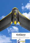
The drone for
precision agriculture
Reap the benefits of scouting
crops from above
If precision technology has driven the farming revolution of
recent years, monitoring crops from the sky will drive the next.
With a drone or UAV you can capture highly accurate images
of your fields, covering hundreds of hectares/acres in a single
flight. Without the cost and hassle of manned services. And at
a greater resolution than satellite imagery typically provides.
By using image processing software you can then transform
these shots into one large ‘orthomosaic’ image. Apply
algorithms like Normalized Difference Vegetation Index (NDVI)
to this and you create a reflectance map of your crop.
This map is the key to boosting yields, cutting costs, and
driving your business forwards. It highlights exactly which
areas of crop need closer examination – for less time spent
scouting, and more time treating the plants that need it.
4 reasons to
choose
the eBee Ag
01. Versatile
02. Reliable
With its four different camera options
the eBee Ag suits numerous agricultural
applications. Use the NIR camera supplied
or add one of our red-edge, RGB or
multispectral sensors.
The eBee Ag’s artificial intelligence
and robust lightweight construction
ensure it will survive numerous flights
(and landings), thus safeguarding your
investment.
03. Easy to use
04. Complete solution
The eBee Ag is a fully automonous drone.
Just select the area you want to map
using our eMotion software, throw your
drone into the air, and the eBee Ag will fly,
acquire images and land itself.
The eBee Ag is supplied with a sturdy
carry case and two advanced software
packages: eMotion 2 for flight planning
and monitoring; and Postflight Terra 3D
for post-flight image processing and
analysis.
Wide camera choice
• 4 sensor options: NIR, red-edge, RGB, multispectral
Electric
• Brushless electric motor
• Low noise
• Environmentally friendly
Ground sensor
• Highly accurate
• Allows eBee Ag to land softly & more precisely
than GPS alone
Onboard artificial intelligence
• Analyses data from Inertial Measurement
Unit & onboard GPS
• Optimises all aspects of every flight
Onboard eBee Ag
The eBee Ag is an artificially intelligent, fully
autonomous drone. It is designed with safety
in mind and contains numerous built-in failsafe systems.
Thanks to its modular design, its wings can
be easily disassembled and stored with its
central body in a convenient carry-on sized
case (supplied).
Reliable
• Onboard artificial intelligence
• Robust lightweight construction
• Able to survive numerous flights
Fully automated
• Create your flight plan
• Throw eBee Ag into the air
• Flies, acquires images & lands itself
Super lightweight
• Durable EPP foam body & wings
• Take-off weight: 0.71 kg (1.56 lbs)
Plan & control your flight
senseFly’s intuitive eMotion software makes
it easy to plan and simulate your scouting
mission.
Plan: Import your base map of choice and
define the area you want to assess. Then
specify your required ground resolution, with
a GSD of down to 2 cm per pixel, and image
overlap.
eMotion automatically generates a full flight
plan, calculating the eBee Ag’s required
altitude and displaying its projec ted
trajectory.
Flying over uneven terrain? Use eMotion’s 3D
mission planning feature to take into account
elevation data when setting the altitude of
mission waypoints and the resulting flight
lines - improving ground resolution and
increasing mission safety.
Simulate: To ensure your mission’s success,
run a virtual flight that simulates wind
strength and direction. Then make any flight
plan updates required and prepare to launch.
Create maps to assess crop health
Process: Once the eBee Ag has landed, use
its supplied Postflight Terra 3D software to
process your flight’s photos.
In just a few click s you can transform
this imager y into geo -referenced 2D
orthomosaics and 3D digital elevation
models.
Analyse: Postflight Terra 3D includes a
handy index computation tab - just select a
band from your near infrared or multispectral
camera and calculate NDVI to assess plant
health.
You can also input custom formulas and
customise colours to create exactly the map
you require.
S110 NIR
Supplied
Like all eBee Ag cameras, this customised 12 MP model has been
adapted so that it can be controlled by the drone’s autopilot. It acquires
image data in the near infrared (NIR) band, the region where high plant
reflectance occurs. Its exposure parameters can be set manually and its
RAW files are fully supported by the eBee Ag’s software.
Example applications: biomass indication, growth monitoring,
crop discrimination, leaf area indexing.
S110 RE
Unlike the NIR camera above, the 12 MB S110 RE acquires data in
the red edge band, the region where a plant’s reflectance changes
from low to high. The S110 RE’s exposure parameters can also be
set manually and its RAW files are fully supported by the eBee Ag’s
software.
Example applications: plant stress assessment, chlorophyll
indication, senescence analysis, drought assessment.
S110 RGB
The 12 MB S110 RGB acquires regular image data in the visible
spectrum. Like the cameras above, its exposure parameters can be
set manually and its RAW files are fully supported by the eBee Ag’s
software.
Example applications: real colour 2D and 3D visual rendering,
chlorophyll indication, drainage evaluation.
Choose your accessory
The multiSPEC 4C is a cutting-edge sensor unit developed by
Airinov’s agronomy specialists and customised for the eBee Ag. It
contains four separate 1.2 megapixel sensors that are controlled
by the eBee Ag’s autopilot. These acquire data across four highly
precise bands, plus each sensor features a global shutter for sharp,
undistorted images.
Example applications: biomass indication, leaf area indexing,
nitrogen recommendation, phenology and many more.
thermoMAP
With thermoMAP you can literally take your crop’s temperature,
capturing thermal video and/or still images to create full thermal
maps of your fields.
Applications: water distribution management, irrigation checking,
alternative method of plant stress analysis.
Radio tracker
If your region is prone to sudden gusty winds, or you plan to fly out
of line of sight, this accessory can serve as a useful extra safeguard
against unexpected aircraft loss. It comprises a small transmitter
that fits snugly next to the eBee Ag’s battery bay, plus a portable
handheld receiver.
Biomass & yield
estimation
Plant
counting
Chlorophyll
indication
Plus…
Stress assessment
Senescence analysis
Leaf area indexing
Phenology
Growth monitoring
Crop discrimination
Weed detection
Tree classification
Drainage planning
… and much more.
Technical specifications
Hardware
Weight (inc. supplied camera)
Wingspan
Material
Propulsion
Battery
Camera (supplied)
Cameras (optional)
Carry case dimensions
Approx. 0.71 kg (1.56 lbs)
96 cm (38 in)
EPP foam, carbon structure & composite parts
Electric pusher propeller, 160 W brushless DC motor
11.1 V, 2150 mAh
12 MP S110 NIR
S110 RE, S110 RGB, multiSPEC 4C, thermoMAP
55 x 45 x 25 cm (21.6 x 17.7 x 9.8 in)
Operation
Maximum flight time
Nominal cruise speed
Radio link range
Maximum coverage (single flight)
Wind resistance
Ground Sampling Distance (GSD)
Relative orthomosaic/3D model accuracy
Absolute horizontal/vertical accuracy (w/GCPs)
Absolute horizontal/vertical accuracy (no GCPs)
Multi-drone operation
Automatic 3D flight planning
Linear landing accuracy
45 minutes
40-90 km/h (11-25 m/s or 25-56 mph)
Up to 3 km (1.86 miles)
1,000 ha / 2,470 ac (at 974 m / 3,195 ft altitude AGL)
Up to 45 km/h (12m/s or 28 mph)
Down to 2 cm (0.79 in) per pixel
1-3x GSD
Down to 4 cm (1.5 in) / 7 cm (2.75 in)
1-5 m (3.3-16.4 ft)
Yes (inc. mid-air collision avoidance)
Yes
Approx. 5 m (16.4 ft)
Package contents
•
•
•
•
•
•
•
•
•
•
eBee Ag body (inc. all electronics & built-in autopilot)
Pair of detachable wings
12 MP S110 NIR still camera (inc. 16 GB SD card, battery, USB
cable & charger)
2.4 GHz USB radio modem for data link (inc. USB cable)
Two Lithium-Polymer battery packs & charger
Spare propeller
Carry case with foam protection
Remote control & accessories (for safety pilots)
User manual
Software included: eMotion (flight planning & control) &
Postflight Terra 3D (image processing & index calculation)
VPS Trading DMCC
PO Box 35819
Jumeirah Lakes Towers
Dubai
United Arab Emirates
[email protected]
+971 4 453 2647
www.vps.ae
Where can you buy your eBee Ag? Visit www.sensefly.com/about/where-to-buy to locate
your nearest distributor.
senseFly Ltd
Route de Genève 38
1033 Cheseaux-Lausanne
Switzerland
Swiss made
About senseFly: senseFly designs, assembles and markets autonomous mini-drones and
related software solutions for civil professional applications such as precision agriculture, land
surveying, GIS, construction, environmental conservation and more.
Content and images non contractual © 2014 senseFly Ltd
EN
For eBee Ag updates
subscribe to our newsletter at
www.sensefly.com