1
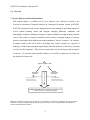
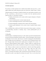
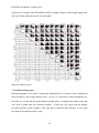
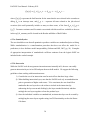
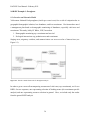
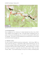
EAGLES User Manual –February 2011 1.0 Overview 1.1 Project Objective and Intended Audience This manual outlines a workflow and a set of software tools collectively known as the Ecosystem Assessment Geospatial Analysis & Landscape Evaluation System (EAGLES). EAGLES is designed to aid resource management decision making by providing support for species habitat planning efforts that integrate changing landscape conditions with demographic responses. Managers seeking to evaluate multiple development plan proposals can use this system to compare alternatives and scenarios, including changes in land-use practices, and explore their implications using hypothetical ‘what-if’ scenarios. For example, a manager could use this set of tools to investigate how coyotes currently use a portion of landscape, and how that use pattern might change when the landscape is altered (e.g., through fire, flood, or development). These tools are particularly relevant for legacy data on species of concern. To reach the widest possible audience, an ArcGIS environment was selected as the platform for these tools. Fixed (static) predictors Slope, aspect, elevation Existing habitat/cover Custom remote sensing MDA (merged data array) Species ‘response’ Data Dynamic (time varying) predictors Climate parameters Mapped disturbance types % water, forage biomass, etc. EAGLE System: analysis, modeling, predictions, and what-if-scenarios for decision support Figure 1.1: Schematic representation of the process of matching (1) fixed and (2) temporally dynamic geospatial covariates with spatio-temporal response data from legacy data sets to create a merged data array (MDA) for analysis and modeling in EAGLES. 2