1
Shading
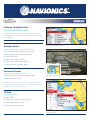
To display map shading:
oPress MENU.
oSelect Chart Options and press 3 key.
oSelect Shading and press 3 key to enable/disable shading.
Note: 3D cartography can be viewed in full screen, split screen, and in a
variety of views. Refer to your User’s Manual for more information.
Photo Overlay
To display Aerial or Satellite Photos:
oPress Menu.
oSelect Chart Options and press 3 key.
oSelect Photo Overlay and press 3 key.
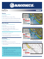
Disable/enable shading
3D chart view with land only
photo overlay
Photo overlay selection
Photo overlay on land only at
level 5 transparency
oSelect Off, Land only, Land and shallow water, or
Full and press 3 key.
To change photo transparency:
o Select Photo Transparency.
oUses right and left arrows to increase and decrease
Photo transparency level.
Fish’N Chip
To display Fish’N Chip:
oPress MENU.
oSelect Chart Options, then press 3 key.
oSelect Fish’N Chip, then press 3 key to enable/disable
Fish’N Chip data.
Navionics exclusive feature! Adjustable depth shading.
oPress MENU
oSelect Chart Options and press 3 key.
oSelect Settings and press 3 key.
oSelect Safety Depth or Contours Depth and press 3 key.
oSelect preferred depth setting and press 3 key.
Fishing data layer