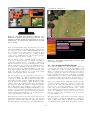
1
Autonomous operation and control of a Multirotor
Unmanned Aerial Vehicle through 4G LTE using onboard
GPS and image processing
Mechatronics Engineering Final Year Project Report
Faculty of Engineering, Computing and Mathematics
The University of Western Australia
Semester Two, October, 2014
Alexander Mazur, 20516281
[email protected]
Supervisors: Thomas Braunl and
Christopher Croft
ABSTRACT
Through utilising modern telecommunication networks, we present a ‘hexacopter’ capable
of intelligent remote waypoint navigation and image processing. Through the use of a
web interface employing mapping software, users are able to specify remote waypoints for
the hexacopter to navigate. The hexacopter maintains an internet connection through 4G
LTE (or 3G if necessary), allowing monitoring and control within regions of no WiFi or
radio reception. The hexacopter is controlled through a Raspberry Pi, employing GPS
and 4G modules, along with a suite of sensors including a 5 megapixel camera. Utilising
various image processing algorithms for object detection, the hexacopter can coordinate
flight patterns to perform tasks such as object tracking and surveillance. Through utilising
GPS and image processing techniques in tandem, the hexacopter can perform intelligent
searching operations.
Acknowledgements
”If you can’t take a little bloody nose, maybe you oughtta go back home and crawl under
your bed. It’s not safe out here. It’s wondrous, with treasures to satiate desires both subtle
and gross; but it’s not for the timid.”
– Q, from Star Trek: The Next Generation
I’d like to thank my supervisors and team mates for accompanying me throughout this
project; my team mates (Omid Targhagh, Michael Baxter and Merrick Cloete) especially
for being excellent sounding boards for whatever (possibly awful!) hexacopter-related ideas
I may have had.
Gratification also goes out to Isaac Hochberg; who frequently helped me to test the hexacopter when nobody else was available, and who did his best to convince me to not
procrastinate writing my report.
I extend further gratitude to Laura Pitts, who helped me greatly in editing this report into
something comprehensible, and for her encouragement throughout the year.
Last, but not least, I’d like to thank you, dear reader, for reading these words. I hope the
next 8000 hold your attention just as dearly!
CONTENTS
1 Introduction
1.1
1.2
1
Applications . . . . . . . . . . . . . . . . . . . . . . . . . . . . . . . . . . . . . . . . . . . . .
1
1.1.1
Package Delivery . . . . . . . . . . . . . . . . . . . . . . . . . . . . . . . . . . . . .
1
1.1.2
Agriculture . . . . . . . . . . . . . . . . . . . . . . . . . . . . . . . . . . . . . . . . .
2
1.1.3
Filming and Surveillance . . . . . . . . . . . . . . . . . . . . . . . . . . . . . . . . .
2
Project Scope . . . . . . . . . . . . . . . . . . . . . . . . . . . . . . . . . . . . . . . . . . . .
2
1.2.1
Previous Work . . . . . . . . . . . . . . . . . . . . . . . . . . . . . . . . . . . . . . .
2
1.2.2
Current Work . . . . . . . . . . . . . . . . . . . . . . . . . . . . . . . . . . . . . . .
2
2 Literature Review
2
2.1
Hexacopter UAVs . . . . . . . . . . . . . . . . . . . . . . . . . . . . . . . . . . . . . . . . .
2
2.2
UAV Control Methodologies . . . . . . . . . . . . . . . . . . . . . . . . . . . . . . . . . . .
3
2.2.1
External Control . . . . . . . . . . . . . . . . . . . . . . . . . . . . . . . . . . . . . .
3
2.2.2
Onboard Control . . . . . . . . . . . . . . . . . . . . . . . . . . . . . . . . . . . . .
3
Arduino . . . . . . . . . . . . . . . . . . . . . . . . . . . . . . . . . . . . . . . . . . .
3
Raspberry Pi . . . . . . . . . . . . . . . . . . . . . . . . . . . . . . . . . . . . . . . .
3
Sensors . . . . . . . . . . . . . . . . . . . . . . . . . . . . . . . . . . . . . . . . . . .
3
GPS Device . . . . . . . . . . . . . . . . . . . . . . . . . . . . . . . . . . . . . . . . .
3
Raspberry Pi Camera . . . . . . . . . . . . . . . . . . . . . . . . . . . . . . . . . . .
4
Communications . . . . . . . . . . . . . . . . . . . . . . . . . . . . . . . . . . . . . .
4
Radio Remote Control . . . . . . . . . . . . . . . . . . . . . . . . . . . . . . . . . .
4
IEEE 802.15.4 . . . . . . . . . . . . . . . . . . . . . . . . . . . . . . . . . . . . . . .
4
Wi-Fi . . . . . . . . . . . . . . . . . . . . . . . . . . . . . . . . . . . . . . . . . . . .
4
4G LTE . . . . . . . . . . . . . . . . . . . . . . . . . . . . . . . . . . . . . . . . . . .
4
Human-Computer Interface . . . . . . . . . . . . . . . . . . . . . . . . . . . . . . . . . . . .
4
2.3.1
Graphical User Interface Design . . . . . . . . . . . . . . . . . . . . . . . . . . . .
4
2.3.2
Hardware . . . . . . . . . . . . . . . . . . . . . . . . . . . . . . . . . . . . . . . . . .
5
Smart Phones and Tablets . . . . . . . . . . . . . . . . . . . . . . . . . . . . . . . .
5
Laptop Computers . . . . . . . . . . . . . . . . . . . . . . . . . . . . . . . . . . . .
5
Software . . . . . . . . . . . . . . . . . . . . . . . . . . . . . . . . . . . . . . . . . . .
5
Mobile Apps . . . . . . . . . . . . . . . . . . . . . . . . . . . . . . . . . . . . . . . .
5
Web Interface . . . . . . . . . . . . . . . . . . . . . . . . . . . . . . . . . . . . . . .
5
Web Interface Technologies . . . . . . . . . . . . . . . . . . . . . . . . . . . . . . . . . . . .
5
2.4.1
Browser . . . . . . . . . . . . . . . . . . . . . . . . . . . . . . . . . . . . . . . . . . .
5
HTML/CSS . . . . . . . . . . . . . . . . . . . . . . . . . . . . . . . . . . . . . . . .
5
JavaScript and AJAX . . . . . . . . . . . . . . . . . . . . . . . . . . . . . . . . . . .
5
2.2.3
2.2.4
2.3
2.3.3
2.4
2.4.2
Web Server . . . . . . . . . . . . . . . . . . . . . . . . . . . . . . . . . . . . . . . . .
5
Apache HTTP Server . . . . . . . . . . . . . . . . . . . . . . . . . . . . . . . . . . .
6
Nginx . . . . . . . . . . . . . . . . . . . . . . . . . . . . . . . . . . . . . . . . . . . .
6
Lighttpd . . . . . . . . . . . . . . . . . . . . . . . . . . . . . . . . . . . . . . . . . .
6
Inter-Process Communication . . . . . . . . . . . . . . . . . . . . . . . . . . . . . .
6
Network socket communication . . . . . . . . . . . . . . . . . . . . . . . . . . . . .
6
Representational State Transfer . . . . . . . . . . . . . . . . . . . . . . . . . . . . .
6
Binary Communication Protocol . . . . . . . . . . . . . . . . . . . . . . . . . . . .
6
Mapping Software . . . . . . . . . . . . . . . . . . . . . . . . . . . . . . . . . . . . . . . . .
6
2.5.1
Google Maps . . . . . . . . . . . . . . . . . . . . . . . . . . . . . . . . . . . . . . . .
6
2.5.2
Leaflet . . . . . . . . . . . . . . . . . . . . . . . . . . . . . . . . . . . . . . . . . . . .
7
2.4.3
2.5
3 Process
3.1
3.2
3.3
7
Project Management . . . . . . . . . . . . . . . . . . . . . . . . . . . . . . . . . . . . . . . .
7
3.1.1
Team collaboration . . . . . . . . . . . . . . . . . . . . . . . . . . . . . . . . . . . .
7
Code Base Design . . . . . . . . . . . . . . . . . . . . . . . . . . . . . . . . . . . . . . . . .
7
3.2.1
Languages . . . . . . . . . . . . . . . . . . . . . . . . . . . . . . . . . . . . . . . . .
7
User Interface . . . . . . . . . . . . . . . . . . . . . . . . . . . . . . . . . . . . . . . . . . . .
7
3.3.1
Platform . . . . . . . . . . . . . . . . . . . . . . . . . . . . . . . . . . . . . . . . . .
7
3.3.2
Graphical User Interface Design Requirements . . . . . . . . . . . . . . . . . . . .
8
3.3.3
User Acceptance Testing . . . . . . . . . . . . . . . . . . . . . . . . . . . . . . . . .
8
3.3.4
Web Interface Implementation . . . . . . . . . . . . . . . . . . . . . . . . . . . . .
8
4 Results and Discussion
9
4.1
Final Design . . . . . . . . . . . . . . . . . . . . . . . . . . . . . . . . . . . . . . . . . . . . .
9
4.2
User Acceptance Testing Results . . . . . . . . . . . . . . . . . . . . . . . . . . . . . . . .
10
4.3
Response Times . . . . . . . . . . . . . . . . . . . . . . . . . . . . . . . . . . . . . . . . . .
11
5 Conclusions and Future Work
11
5.1
Applications . . . . . . . . . . . . . . . . . . . . . . . . . . . . . . . . . . . . . . . . . . . . .
11
5.2
Future Work . . . . . . . . . . . . . . . . . . . . . . . . . . . . . . . . . . . . . . . . . . . .
12
6 References
12
A Web Interface User Manual
14
A.1 Setting Up . . . . . . . . . . . . . . . . . . . . . . . . . . . . . . . . . . . . . . . . . . . . . .
14
A.2 Connecting to the Hexacopter . . . . . . . . . . . . . . . . . . . . . . . . . . . . . . . . . .
14
A.2.1 4G LTE Connection . . . . . . . . . . . . . . . . . . . . . . . . . . . . . . . . . . . .
14
A.2.2 Wi-Fi Connection . . . . . . . . . . . . . . . . . . . . . . . . . . . . . . . . . . . . .
14
A.3 Manual Hexacopter Operation . . . . . . . . . . . . . . . . . . . . . . . . . . . . . . . . . .
14
A.4 Device Orientation and Screen Size . . . . . . . . . . . . . . . . . . . . . . . . . . . . . . .
15
A.5 Operating Modes . . . . . . . . . . . . . . . . . . . . . . . . . . . . . . . . . . . . . . . . . .
15
A.5.1 All Stop . . . . . . . . . . . . . . . . . . . . . . . . . . . . . . . . . . . . . . . . . . .
15
A.5.2 Status . . . . . . . . . . . . . . . . . . . . . . . . . . . . . . . . . . . . . . . . . . . .
15
A.5.3 Manual . . . . . . . . . . . . . . . . . . . . . . . . . . . . . . . . . . . . . . . . . . .
15
A.5.4 Automatic . . . . . . . . . . . . . . . . . . . . . . . . . . . . . . . . . . . . . . . . .
15
A.5.5 Tracking . . . . . . . . . . . . . . . . . . . . . . . . . . . . . . . . . . . . . . . . . . .
15
A.5.6 Settings . . . . . . . . . . . . . . . . . . . . . . . . . . . . . . . . . . . . . . . . . . .
16
A.6 Flight Safety Procedures . . . . . . . . . . . . . . . . . . . . . . . . . . . . . . . . . . . . .
16
A.7 Shutting Down . . . . . . . . . . . . . . . . . . . . . . . . . . . . . . . . . . . . . . . . . . .
16
A.8 Troubleshooting . . . . . . . . . . . . . . . . . . . . . . . . . . . . . . . . . . . . . . . . . .
16
A.8.1 The web interface doesn’t display correctly . . . . . . . . . . . . . . . . . . . . . .
16
A.8.2 No connection can be made through 4G LTE . . . . . . . . . . . . . . . . . . . .
16
A.8.3 The hexacopter beeps three times instead of flying . . . . . . . . . . . . . . . . .
16
A.8.4 The hexacopter doesn’t take o↵ . . . . . . . . . . . . . . . . . . . . . . . . . . . . .
17
A.8.5 The hexacopter does not hover in place, but moves erratically . . . . . . . . . .
17
B UAV Control Software
17
C Web Interface Design Inspiration
17
1.
INTRODUCTION
ing system [62]. This combination of computing power and
an operating system allow the Raspberry Pi to perform a diverse spectrum of tasks, from image processing to network
connectivity.
Unmanned aerial vehicles (UAVs) have drawn significant
levels of interest and research in the past decade. Over
the years, electronic components have undergone a steady
decrease in size and price, whilst levels of standardisation
have increased. This has allowed the development of relatively cheap and lightweight small helicopter ‘drones’, or
multirotor UAVs. These UAVs can be fitted with a variety
of sensors and equipment to perform a multitude of tasks from aerial photography [17] to disaster search and rescue
[78].
Communication with an autonomous UAV can be achieved
through a variety of means, such as analogue radio control
(for example, with a remote control), or digitally through a
WiFi network utilising 2.4 GHz UHF radio waves. In both
cases, a wireless radio receiver is installed on the UAV, requiring the user to be within a fixed distance of the UAV to
maintain communications. Alternatively, mobile communications networks can also be utilised through the use of 4G
LTE or 3G modules, allowing communication with the UAV
from any location with network coverage.
A multirotor UAV (MUAV) traditionally comprises four rotors (a quadcopter, exemplified in Figure 1). This configuration allows similar flight capabilities to a regular helicopter:
movement in three dimensions is possible, along with yaw
and hovering in place. The MUAV physically consists of a
central enclosure, housing the majority of the electronics,
with four fixed radial arms with a motor and propeller on
the end of each. The MUAV achieves movement through
varying the speed of these rotors. For example, by reducing
the speed of two rotors on one side, the MUAV looses lift
on this side, causing it to angle slightly. This angle, in turn,
creates horizontal thrust (much like a helicopter angling forwards to move) [38].
A fully autonomous UAV is able to utilise a variety of onboard sensors to complete tasks. Two common sensors are
global positioning system (GPS) devices and cameras. Through
the use of a GPS device, the UAV is able to locate itself in
terms of latitude, longitude and altitude [32]. This system
can be used to allow the UAV to follow a set of predefined
waypoints. An onboard camera can be used to allow the
UAV to perform tasks based on what is immediately visible. For example, the UAV can be programmed to recognise
certain objects and attempt to ‘follow’ them.
An autonomous UAV must be supplied directives to complete; this can either occur during construction (‘pre-loaded’
instructions), or in real time through communicating with an
operator. There are a variety of methods of communication,
ranging from specially constructed remote control devices to
common smart phones. The latter option involves several
further possibilities: communication through a smart phone
‘app’ or through a web interface. This report elaborates on
methods of control and applications for an autonomous UAV
and presents a workable UAV control solution.
1.1
Applications
The global market share of autonomous UAVs in the civilian
sector is expected by the EU to increase to up to 10% of aviation in the next 10 years [20]. This forecast is given in light
of recent developments in the private UAV sector, where
several major multinational corporations have launched research and development operations into potential applications for autonomous UAVs.
Figure 1: A multirotor UAV with four rotor sets - a
‘quadcopter’. (XAircraft, 2014 [83])
UAVs can be controlled directly by an operator (much like
a remote-controlled aeroplane), or they can be controlled by
a pre-programmed computer. UAVs controlled by a computer with the ability to complete tasks with no human interaction are known as autonomous UAVs. The computer
can be located on the ground, from where it can send commands wirelessly which will be processed and carried out by
the UAV. Alternatively, a computer can be installed on the
UAV, allowing the UAV to act completely independently.
1.1.1
Package Delivery
In December 2013, electronic commerce company Amazon.com
announced plans to deliver packages utilising autonomous
drones capable of carrying 5 pound packages, at speeds of
50 miles per hour [65, 2]. In the same month, Deutsche
Post (the world’s largest courier company) delivered a subkilogram quantity of medicine using their own autonomous
UAV, raising speculation about potential uses for disaster relief e↵orts [25, 30]. In February 2014, the United Arab Emirates announced plans to launch a fleet of UAVs for civilian
purposes such as the delivery of official documents, utilising sensors for fingerprint and iris-recognition systems [42].
Furthermore, Google revealed in August 2014 that they had
been developing UAVs for delivery purposes in Australia for
the past two years [47].
Modern single-board microcontroller designs are sufficiently
small and lightweight to be installed directly on a UAV.
The Raspberry Pi is a popular single-board computer built
around a 32-bit Atmel ARM microprocessor [60, 8]. The
Raspberry Pi includes a 700MHz ARM processor [7], a GPU,
and 512MB of RAM, and runs variants of the Linux operat1
1.1.2
Agriculture
Several companies o↵er UAV-based imaging solutions for
crop fields [45, 55]. UAVs are used to capture visual, thermal, LiDAR or multi/hyperspectral images of crop fields.
These images can be used to map the terrain of the crops,
giving plant heights and counts, along with weed detection.
Canopy cover can be determined, along with various metrics
for judging crop ‘health’. Intelligent solutions can inform
farmers of regions that need to be harvested or sprayed, and
can help fix problems before they occur [41, 57, 66].
Figure 3: The hexacopter, a DJI F550 chassis modified to include a Raspberry Pi, Raspberry Pi Camera and Qstarz GPS.
To develop a suite of adaptable software for basic hexacopter control.
To develop advanced flight algorithms for GPS waypoint navigation.
Figure 2: A combination of multispectral images
taken of a crop, used to assess crop ‘health’ through
a variety of metrics (Precision Hawk USA Inc., 2014
[55])
1.1.3
To develop advanced image processing functionality
for tasks such as object tracking, whilst providing dynamic environment awareness.
To develop a user interface for high-level hexacopter
control.
Filming and Surveillance
Today, a many commercial UAVs are available for both hobbyist and commercial applications, such as the popular Parrot AR.Drone [54]. Drones specifically designed with high
quality cameras for filming purposes are abudant in the private sector. Examples include the Coptercam [58] and SteadiDrone [68].
1.2
1.2.1
This report focuses on the latter task; presenting a method
of control for a Raspberry Pi controlled autonomous UAV
through a web interface, operable from any modern webenabled device (smart phone, tablet, laptop computer, etc).
This is presented in combination with a suite of ‘back end’
software for UAV control, along with methods of communication between the user and all presented layers of software.
Project Scope
Previous Work
The purpose of the autonomous UAV project is to integrate
a Raspberry Pi with a six-rotor UAV (hexacopter) and build
autonomous functionality utilising only onboard sensors and
onboard processing. This project commenced in 2013, when
students purchased a DJI F550 UAV chassis, along with a
DJI NAZA M flight controller and all additional components
required for user-controlled flight [77, 53] . This ‘hexacopter’
(illustrated in Figure 3) could be operated utilising a Futaba
T14SG 14 channel 2.4GHz remote control, allowing flight in
a fashion much like a toy helicopter. Students then spliced
a Raspberry Pi between the Futaba R7008SB receiver and
the flight controller on the UAV, allowing the Raspberry
Pi to simulate the output from the remote control device.
Combined with a Qstarz GPS module and a Raspberry Pi
Camera module, they were able to achieve autonomous flight
of the UAV.
1.2.2
2. LITERATURE REVIEW
2.1 Hexacopter UAVs
The family of vehicles falling under the category ‘UAV’ is
large. Fixed wing aircraft (such as the infamous ‘Predator
drone’ [22]) and weather balloons can be classified as UAVs.
The UAV used throughout this project is a ‘Vertical Take
O↵ and Landing’ UAV (VTOL UAV), capable of taking o↵
and landing without need of a runway.
A hexacopter features six rotor sets, each comprising of two
identical aerofoils, known as blades. These are attached from
one end to a common rotating shaft, which generates lift
upon rotation. The aerofoils generate a pressure gradient
between the regions above and below them when spun in
the correct direction through a fluid. The e↵ect of this is
a higher pressure on the bottom side of the aerofoil than
on the top side, causing the aerofoil to experience a net
vertical force known as aerodynamic lift [5]. In a hexacopter
configuration, the six rotors must each rotate counter to the
Current Work
The project this year was handled by a team of four students.
As such, four additional broad tasks were identified:
2
rotors directly adjacent to them in order to counteract the
torque experienced by the UAV, so as to generate lift [4].
duino unsuitable for computationally intensive tasks, such
as image processing. As Arduino’s are not intended to be
used as general computers, they do not come with several
features such as LAN (Local Area Networking) and A/V
(Audio/Video) output. This functionality must be added
separately. [15]
Rotation of the hexacopter is achieved by speeding up individual motors relative to the others, causing an imbalance
resulting in a yaw rotation. Vertical thrust is generated by
spinning all rotors faster, and horizontal travel is generated
by decreasing the thrust of rotors on a certain side of the
hexacopter, causing it to move in that direction [24].
Raspberry Pi. The Raspberry Pi [60] (shown in Figure 4)
includes a 700MHz ARM processor [7], a GPU, and 512MB
of RAM, significantly outperforming the Arduino. Instead
of executing code directly, the Raspberry Pi can run variants of the Linux operating system, allowing a greater potential of tasks to be completed. Due to its increased power
over the Arduino, the Raspberry Pi can more easily handle
computationally intensive tasks such as image processing.
Additionally, due to running the Linux operating system,
the Raspberry Pi is able to handle additional tasks such as
wireless communication and interfacing, allowing for a user
to input directives to an autonomous UAV system. [75]
The extra rotors of a hexacopter o↵er several additional capabilities when compared to a helicopter (two rotors) or
quadcopter (four rotors) . A hexacopter features greater
lifting strength and stability, along with the ability to lose
one motor and still have sufficient power to control the UAV
[13].
2.2
UAV Control Methodologies
In order for a UAV to be autonomous, it must be able to
complete tasks without human interaction. Such control is
achieved through the use of computer systems.
2.2.1
External Control
An autonomous UAV can be controlled through a ground
control station. This is similar to an operator manually
controlling the UAV, except a computer is ‘using the remote
control’. The UAV can communicate information wirelessly
to the ground control station, such as camera and GPS data.
Such a setup exploits the power of conventional computer
systems to process commands for the UAV. Image processing can be performed rapidly and efficiently, and the ground
computer may have access to extensive databases of information useful in determining the UAVs next course of action
(for example, map data). This control scheme is limited,
however, by the range of wireless communications between
the UAV and the ground control station, and the bandwidth
of these communications. Bandwidth limitations are common, and as such smooth, high resolution video is not always possible. An externally controlled UAV is ’tethered’,
and can never move out of the range of the control station
[34].
2.2.2
Figure 4: The Raspberry Pi Model B is a credit
card sized computer capable of running the Linux
operating system. (The Register, 2014 [64])
2.2.3
Sensors
An autonomous UAV cannot operate meaningfully with a
computer alone; it requires information from the world around
it. Common sensors used for flight include GPS devices for
latitude and longtitude positioning, Inertial Measurement
Units (IMUs) for compass and accelerometer data, and cameras for visual awareness [37].
Onboard Control
A ‘truly’ autonomous UAV is able to control itself without
need for external systems. One step towards this goal is
achieved by placing a computing system onboard the UAV,
allowing it to process all commands itself. Such a computer
system must be compact and lightweight; the most popular systems meeting this criteria are the Arduino family of
microcontrollers and the Raspberry Pi.
GPS Device. A GPS device can be used to provide positional data for a UAV in terms of latitude, longitude and
altitude [32]. Common GPS devices can provide horizontal
positional accuracy to within 3 metres, with a ‘worst case’
pseudorange accuracy of 7.8 metres at a 95% confidence level
[51]. Higher accuracy can be achieved through higher quality GPS devices, or augmentations such as the International
GNSS Service [40] and Global Di↵erential GPS [50].
Arduino. The Arduino [6] is a popular single-board microcontroller designed around an 8-bit Atmel AVR microcontroller [9], or a 32-bit Atmel ARM [8]. The Arduino was
introduced in 2005 as an inexpensive and simple way to
allow the creation of devices that can interact with their
environment. As a relatively low-powered microcontroller
(the Arduino Uno has a maximum CPU clock speed of 20
MHz), the Arduino is designed to be used to solve specific
application problems; it is not intended to run an operating
system. This processing power limitation makes the Ar-
Commercially available GPS devices suitable for connection
to an Arduino or Raspberry Pi include the QStarz BTQ818X GPS Module [59] and the Swift Navigation Piksi
GPS receiver [71]. The QStarz GPS Module is a standard
accuracy GPS device, with an operational accuracy of 100m
3
always, whilst the Piksi GPS Module is an experimental device featuring centimetre level accuracy.
rived from a ‘play on words’ of the term Hi-Fi. Wi-Fi is a
ubiquitous technology, with the majority of modern smart
phones, tablets, and laptop computers coming with Wi-Fi
capabilities. Wi-Fi operates over the 2.4 GHz ISM and 5
GHz radio bands, however traditionally have very limited
range compared to that possible utilising a 2.4 GHz analogue remote control. This is due to a plethora of factors,
such as limited transmission power, lower fault tolerances
than an analogue signal, and the congestion of the Wi-Fi
wireless radio band. Outdoors, ranges of 50-100 metres can
be expected [16, 84].
Raspberry Pi Camera. Visual cameras are a common data
rich sensor used to provide environmental awareness to autonomous systems. A camera can allow a UAV to be aware
of obstacles or to track objects [74]. The Raspberry Pi Camera [61] is an inexpensive five megapixel camera directly
compatible with the Raspberry Pi. Capable of both 1080p
and 720p images and video, this camera allows the Raspberry Pi to locate objects by applying appropriate image
processing algorithms.
2.2.4
4G LTE. 4G LTE is a marketing term for a standard of
wireless communication for cellular networks called LongTerm Evolution, or LTE. LTE does not meet the technical
requirements specified by the 3GPP consortium for a new
generation of cellular wireless communication, and hence the
term ‘4G’ is a misnomer.
Communications
An autonomous UAV must be supplied directives to complete; this can either occur during construction or operation.
In order to send the UAV directives, a wireless communication protocol must be chosen. There exist several options
utilising a range of wireless spectra and standards.
LTE is based on the previous ‘3G’ network standards (GSM
/ EDGE and UMTS / HSPA). LTE increases the capacity
and speed of the previous standards by using di↵erent radio
interface combined with core network improvements. From
a practical perspective, both LTE and ‘3G’ networks allow
data to be transferred through a global cellular network,
removing the need to set up a local wireless network through
Wi-Fi or the IEEE 802.15.4 standards. A device controlled
through LTE or ‘3G’ can be operated from across the world,
if deemed necessary.
Radio Remote Control. Radio remote control devices can
be used to send flight instructions directly the UAV. These
devices generally send analogue yaw, pitch and roll signals
directly to a receiver on the UAV, allowing it to respond in
near real-time. Most modern remote control systems utilise
a spread spectrum technique over the 2.4 GHz band. This
technique spreads the bandwidth of the transmitted signal
over the frequency domain, allowing for a more stable connection with increased immunity to interference and noise
[1]. The 2.4 GHz band is chosen as this is part of the industrial, scientific and medical (ISM) portion of the radio
spectrum; utilising this band (usually) does not require any
licensing or approval worldwide [10]. Depending on the receiver/transmitter used, ranges of several kilometres can be
achieved utilising the 2.4 GHz band. The Futaba T14SG 14
channel 2.4GHz remote control is currently used to control
the hexacopter directly [31]. It is possible to utilise a modified remote control to directly transmit telemetry to the
UAV; however, this is contrary to the goals of constructing
an autonomous UAV.
LTE features peak download rates up to approximately 300
Mb/s, an improvement over 3G by roughly a factor of ten.
Furthermore, LTE provides low latency communication (sub
5 ms), making it suitable for quick communication to a UAV
[21].
2.3
Human-Computer Interface
A human-computer interface, or user interface, is required
to supply directives to a UAV. As a common task in UAV
control is GPS navigation, a graphical user interface capable
of displaying a map is required. In designing such a user interface, there are several considerations to take into account.
These include general user interface design principles, along
with what hardware and software the interface will be designed for. In the case of the UAV, appropriate hardware
and software must be chosen to operate in a predominantly
outdoors environment, and the interface must provide clarity in bright environments with potentially small screens.
IEEE 802.15.4. The IEEE 802.15.4 standard specifies the
requirements for low-rate wireless personal area networks
(LR-WPANs) [85]. These networks focus on low-cost, lowspeed communication between devices. The standard is the
basis for several standards such as the ZigBee and XBee
specifications [27]. These specifications are used to produce
inexpensive, compact radio modules allowing digital communications. These can operate on the 868 MHz, 902 MHz
or 2.4 GHz ISM bands. Whilst the range of the 2.4 GHz
band is limited, utilising the lower frequency ISM bands can
allow for e↵ective ranges of up to 20 km. However, utilising
this standard requires specialised hardware on the receiving end, and restricts communications to low bandwidths
(making applications like video streaming impractical) [14].
2.3.1
Graphical User Interface Design
As a general consensus from a multitude of various sources,
the following elements are considered to be essential to any
well-designed user interface:
Clarity. The interface must avoid ambiguity through
using clear language and visual elements [56].
Concision. The interface must not be tedious to use,
or ‘bloated’. This criteria often must be balanced with
clarity [63].
Wi-Fi. Wi-Fi is a local area network wireless technology
based on the IEEE 802.11 standards [73]. The name is de4
Web Interface. A web interface is a user interface that op-
Familiarity. Even if an interface is used for the first
time, it can be made to feel familiar to the user through
elements such as real-life metaphors [35].
erates through a internet browser. Modern internet browsers
do not su↵er the cross-compatibility problem to the same extent as mobile apps; code written for one internet browser
will operate similarly in another without any modification.
Furthermore, all modern hardware identified in Section 2.3.2
is capable of running a variety of internet browsers. As such,
a web interface is a more broadly compatible solution for
hexacopter control than a suite of mobile apps. However,
due to their generic nature, web interfaces can often su↵er
from poor, unresponsive design compared to mobile apps,
which are specifically tailored for their devices.
Responsiveness. The interface should provide timely
feedback to the user without causing frustration. This
criterion is especially important for a UAV; the user
must be able to tell the UAV to stop before something
goes wrong [23].
Consistency. Allowing a user to recognise usage patterns across the interface aids the speed and understanding with which a user can operate the interface
[67].
2.4
Aesthetics. A ‘good’ looking interface helps users to
enjoy using the application, which assists in their use
of the interface [18].
Forgiveness. The interface should assist users in operating it, without causing unnecessary errors [44].
2.3.2
Hardware
Smart Phones and Tablets. Smart phones and tablets have
become ubiquitous devices across the world in the past decade
[12]. These devices typically come with a touch screen and
GPS and Wi-Fi modules, allowing a user to access the internet and third party apps (including mapping software).
Modern smart phones and tablets have access to a similar
level of processing power as a Raspberry Pi, making them
suitable for many levels of control. However, most modern smart phones and tablets are not able to communicate
through more specialised protocols without external hardware, such as 802.11.4 compliant protocols or analogue radio
transmission.
2.4.1
Browser
Popular modern web browsers include Google Chrome, Mozilla
Firefox, Microsoft Internet Explorer and Apple Safari. Perhaps unfortunately, no modern web browser complies to the
standards of website rendering dictated by the World Wide
Web Consortium (W3C), the main international standards
organisation for the World Wide Web. This means that a
web interface must be adapted (if necessary) to render similarly on each of these browsers [48].
Laptop Computers. Modern laptop computers are gener-
HTML/CSS. A web browser is designed to display websites
ally more powerful than smart phones or tablets, and as such
are capable of more computationally intensive tasks, such as
image and video processing. However, they su↵er the same
limitations in that they require extra hardware for specific
applications such as GPS tracking or communication over
802.11.4 protocols.
2.3.3
Web Interface Technologies
A modern web solution utilises a standard paradigm: a web
browser is used by a user to display web pages. These web
pages are constructed from the HTML and CSS languages,
describing the static layout of the web page; dynamic content is provided by a language called JavaScript. The web
page is constructed on a server through a language called
PHP, and then communicated to the user through the use
of a web server. Due to the dynamic nature of web pages,
the user always receives the most up-to-date version of a
web page at all times, without the need to manually update
[81, 49].
written in HyperText Markup Language (HTML). HTML is
intended to define data and the structure in which it is to
be displayed. In order to change the look and layout of
this displayed data, Cascading Style Sheets (CSS) are used.
Together, these languages are used to describe a static (nonchanging) web page [36].
Software
JavaScript and AJAX. In order for a web page to be inter-
Mobile Apps. Three primary operating systems are installed
active, web browsers are capable of executing a scripting language called JavaScript. JavaScript can dynamically alter
the HTML and CSS content of a webpage, allowing for the
webpage to interact with the user. Furthermore, JavaScript
can be used for asynchronous communication; that is, allowing the webpage to communicate with a server in the background, without refreshing the page. This method of communication is known as Asynchronous JavaScript + XML
(AJAX), with the XML component describing the contents
of the data packets sent to and from the server [33].
on modern smart phones and tablets: Microsoft Windows
Phone, Google Android, and Apple iOS. Each of these distributors maintains their own ‘app’ stores, allowing developers to create and distribute software to users. Developing
apps for each platform is a mutually exclusive task; an app
developed for one platform will not operate on another. This
is due, in part, to each platform executing code in di↵erent
languages: Objective C for iOS, Java for Android, and various C derivatives for Windows Phone. As such, developing
an app-based user interface would require supporting three
di↵erent code bases for three di↵erent platforms. Furthermore, development of mobile apps excludes operation of the
user interface on other platforms, such as laptop computers
[19].
2.4.2
Web Server
A web server is required to send webpages written in HTML/CSS/JavaScript to a user. Web pages can be initially
written in a scripting language called PHP, which is then
5
processed and constructed, with the output send to the web
server [11]. The final product is sent to the user through
TCP/IP network communications. There are several web
servers available to choose from, each o↵ering a di↵erent set
of features.
a reliable interface [26].
Representational State Transfer. As an alternative to utilising network sockets directly, there exist implementations
at a higher level of abstraction. For example, a Representational State Transfer (REST) interface abstracts network
communication to a uniform resource identifier (URI) and
standard HTTP methods (GET, PUT, POST, DELETE).
An example of a ‘REST-ful’ interface is an address ’http://
example.com/gps/location’; navigating to this address (or
URI) may return the current location of some device.
Apache HTTP Server. The Apache HTTP Server [72],
colloquially called Apache, is the most popular web server
used on the internet, estimated to serve 54.2% of all active
web sites as of June 2013 [80]. Apache is a full featured
web server, providing extensive functionality and methods
of configuration. As such, Apache can be rather resource
intensive compared to other alternative web servers [29].
A REST-ful implementation does come with downsides; as
each URI is accessible through a web browser, it can be simple for malicious users to exploit commands; this is especially
a concern for a UAV. Furthermore, a REST-ful implementation is not the fastest method of communication, and does
not provide any facility for handling errors in commands
[28].
Nginx. Nginx (pronounced ‘engine-x’) is a suite of software
containing a web server. Nginx is estimated to serve 14.56%
of websites on the internet as of June 2013, and is rapidly
growing as a popular alternative to Apache [80]. Nginx o↵ers
performance improvements over Apache, but requires more
in-depth configuration. As such, incorrectly configured Nginx servers can open up the potential for security holes and
errors [52].
Binary Communication Protocol. A binary communication protocol is a protocol intended to be read by a machine
rather than a human being. This comes with advantages in
terms of speed; but can add complexity in design. A binary
communication protocol utilises network socket communication, but provides a fast and ready made interface with
facilities for error management.
Lighttpd. Lighttpd (pronounced ‘lighty’) is a lightweight
web server, o↵ering small CPU load and a low memory
footprint when compared to Apache and Nginx, whilst still
maintaining the majority of features common to the others.
Lighttpd is an excellent choice for operation on a Raspberry
Pi, owing to the limited computing power of the Raspberry
Pi [43].
2.4.3
Several implementations exist, such as Apache Thrift and
Google Protocol Bu↵ers. Apache Thrift is a protocol originally developed by Facebook for internal use in 2007, but
since released as an open source project to the Apache Software Foundation (the maintainers of the Apache HTTP Server).
Google Protocol Bu↵ers was released a year later, and is used
internally by Google [69].
Inter-Process Communication
A web server/PHP configuration is suitable for generating
web sites, but not for controlling the flight or hardware of
a UAV. This is due, in part, to PHP being a scripting language; it is not designed to run in the background. Rather,
it is designed to run as required, for example when a user
requests a web page. A flight control program must run
continuously to ensure correct UAV operation. As such, a
method of communication between PHP and a flight control program is required. There are several options, ranging
from manual network socket communication to higher levels
of abstraction in the form of interface description languages.
2.5
Mapping Software
A common requirement for an autonomous UAV is mapping
software, to display where the UAV is and any routes it may
take. There exist several web-based solutions providing this
functionality.
2.5.1
Google Maps
endpoint of inter-process communications across a computer
network. Through the use of protocols such as TCP or UDP,
programs can send and receive data. In order for this to
occur, a program can either transmit or listen for data on a
network port. A port is software construct, existing to isolate
multiple streams of network communication from each other.
For example, web pages from the internet are served over
port 80.
The most popular and well-known mapping software, Google
Maps provides an extensive developer Application Programming Interface (API) allowing, among other things, the display of custom routes and markers. Google Maps operates
by presenting the user with a rectangular region defined by
two latitude and longitude pairs. This region is divided
into a grid based on the physical size of the users viewport
(screen). For each grid square, Google sends a small image
(a tile) mapping to that specific coordinate for a particular zoom level. The application tracks the movement and
zoom of the users viewport, and sends new tile information
appropriately.
Utilising network socket communication requires the writing
of a server (to listen for and respond to requests), and a
client to send out requests. This is a low-level method of
communication, and a lot of e↵ort must be expended to write
Google stores this tile data on its servers, and does not provide functionality for downloading these tiles for permanent
storage on a device. As such, Google Maps requires an active internet connection to operate, which may limit its use
Network socket communication. Network sockets are the
6
for UAV position marking [70].
2.5.2
Leaflet
Leaflet is a JavaScript library providing similar functionality to Google Maps; however it is open source and usable
o✏ine [3]. In order to present a map image to the user,
tiles corresponding to certain coordinates need to be saved
locally. It is against Google’s terms of service to download
and use their tiles in this way, however several alternative
tile sources exist, such as the OpenStreetMap project [39].
3.
PROCESS
3.1
Project Management
The hexacopter project is a team project with four individuals contributing software. Each team member focuses on
distinct areas; one on writing fundamental control and interface systems for the hexacopter, GPS, and IMU; another on
intelligent searching algorithms; and another on image processing. Much of this work is interdependent, for example,
the intelligent searching algorithms depend on being able
to access the hexacopter flight systems and GPS. The user
interface sits at the top level, and must access and control
the searching and image processing functions. In order to
construct a user interface, work must be done in integrating
systems designed by other team members. As such, it was
necessary to establish a regime for collaboration.
3.1.1
Figure 5: The structure of the collaborative code
base used by the hexacopter team.
Team collaboration
3.2.1
To facilitate multiple team members working on the same
code base, Git was chosen. Git is a distributed revision control and source code management system, originally released
by Linus Torvalds, the namesake of the Linux operating system [46]. A Git system allows multiple users to modify the
same code base simultaneously, with each change (or commit) logged and saved, allowing users to compare and/or
revert changes. The hexacopter Git system was set up on
GitHub, a public, free Git repository. 1
3.2
Languages
Due to the limited processing capabilities of the Raspberry
Pi, and the hexacopter requirements for speed and responsiveness, C++ was chosen as the primary language for flight
control programs. Compared to languages such as Java and
Python, C++ is relatively low level, allowing for faster execution times and less overhead [76]. As the base system development was completed in C++, other modules and apps
were also written in C++.
3.3
Code Base Design
3.3.1
User Interface
Platform
To facilitate the software from di↵erent team members, the
code base was heavily modularised, allowing individual algorithms and methods of control to be easily adapted to
di↵erent situations. The code base was split into several
levels; base, modules and apps. Base holds all the lower
level control code for hexacopter flight, the GPS, IMU and
buzzer. Modules holds higher level algorithms for flight maneuvouring, waypoint tracking, intelligent search patterns,
and image processing functionality. Apps holds high level
applications for controlling the hexacopter, utilising combinations of various modules and base functions to perform
defined tasks.
In order to build a functional, reliable and understandable
user interface for the hexacopter, several steps were taken.
Firstly, a method of interface had to be chosen. As waypoint
navigation is one of the objectives of the project, a visual
interface capable of displaying mapping information must be
used. This excluded the possibility of using the radio remote
control, or some other button-based interface without visual
feedback. As the hexacopter will generally be used in a
variety of di↵erent environments, the device used for control
must also be easily portable. This leads to several classes of
portable LCD screen based devices: smart phones, tablets,
and laptops.
Under this scheme, illustrated in Figure 5, the user interface
is an app; a piece of software capable of instructing the hexacopter to perform various tasks as dictated through modules
functions.
Depending on the situation, a user may prefer to control
the hexacopter ‘on the go’ with a smart phone or tablet, or
they may prefer a more immobile setup with a larger screen
through a laptop. As such, the user interface application
must be cross-platform, that is, capable of running on common smart phone, tablet, and laptop computer operating
systems. This requires the development of an application
1
The
hexacopter
Git
can
be
https://github.com/crazyoldmans/picopter
seen
at
7
to run on Microsoft Windows and Windows Phone, Apple
Macintosh and iOS, and Google Android and Chrome OS.
There are a variety of cross platform languages available to
accomplish this task, such as Java. However, due to the
restrictive nature of application development on mobile devices (see Section 2.3.3), the possibility of using an app was
discounted. As such, a web interface was chosen - this will
work on all required devices without the need to maintain
separate code bases for each platform.
Table 1: User Acceptance Testing Questionnaire
Hexacopter User Experience Questionnaire
Please rate the user interface in each of the following
categories by circling the appropriate star.
Clarity
Concision
Familiarity
In order for a user to connect to the interface, the hexacopter was connected to a 4G LTE device, allowing the web
interface to be published to the internet. Due to the inherent insecurities faced here, the web interface was locked with
a password, rendering it inoperable to a malicious user. A
user would be able to access the interface utilising either a
Wi-Fi network or their own mobile broadband connection.
Additionally, a Wi-Fi device was also installed on the hexacopter, allowing the hexacopter to broadcast its own secure
‘hot spot’. A user would be able to connect to this, then
navigate to the appropriate web page to control the hexacopter.
3.3.2
Responsiveness
Consistency
Aesthetics
Forgiveness
Comments and Suggestions
Graphical User Interface Design Requirements
In addition to the usability guidelines listed in Section 2.3.1,
the web interface must accomplish several tasks mandated
by the overall project scope:
3.3.3
User Acceptance Testing
To ensure the web interface operates as expected and to ascertain whether it meets the criteria in Section 2.3.1, user
acceptance testing was performed. This testing involves allowing a user to control the hexacopter through the web interface, and then asking them a series of questions designed
to help improve the design of the interface. These tests were
performed as the the interface was developed, allowing it to
develop ‘organically’, meeting the needs and requirements
of its user base.
Display the location of the hexacopter (and the user,
if possible) on a map.
Display the hexacopter’s camera feed in real time.
Display the status of the hexacopter. This details what
the hexacopter is doing, whether that be standing by,
flying to a location, etc...
The ‘questionnaire’ given to each user (illustrated in Table
3.3.3) asked them to rate how the interface performed in
each of the design criteria given in Section 2.3.1. The users
were also asked to rate their experience with operating the
hexacopter for each of the primary functions listed in Section
3.3.2. Furthermore, general comments, feedback and suggestions were also requested. An analysis of user responses is
provided in Section 4.2.
Track the movement of the hexacopter on the map
through a path.
Send the user’s location to the hexacopter, allowing
the hexacopter to track the user.
Allow the user to specify GPS waypoints for the hexacopter to traverse to.
3.3.4
Allow the user to specify a region for the hexacopter
to ‘scan’ over. The hexacopter will perform a ‘lawnmower’ pattern over this region, using the camera to
search for objects of interest.
Web Interface Implementation
The web interface was implemented using the broad spectrum of technologies described in Section 2.4, in combination
with a server to control the functionality described in Section 3.2. This flight control server was written in C++ in
order to interact with and control the functionality written
by other team members for purposes such as region scanning and image processing. The overall implementation is
illustrated in Figure 6.
Allow the user to tell the hexacopter to commence
flight operations (either waypoint traversal, region scanning, or user tracking), and allow the user to stop the
hexacopter moving at any time.
The Lighthttpd web server was chosen over alternatives for
several reasons: Lighttpd is simple to set up and operate, requiring minimal configuration compared to other web
servers. Furthermore, Lighttpd is a lightweight web server,
and when used in conjunction with PHP, it was found to use
no more than 5-10% of the processing power of the Raspberry Pi for a short period of time (> 1 second), per request.
Furthermore, the web interface must be designed to be scalable, allowing detection of various screen sizes and orientations to tailor the interface to the device being used. Code
must be written to give a consistent experience across the
major browsers.
8
As the primary code base for hexacopter control is written
in C++ (see Section 3.2.1) and the web interface server-side
control achieved through PHP, the web interface is not natively able to communicate with the hexacopter control system. This obstacle was overcome through the use of Apache
Thrift (Section 2.4.3). Apache Thrift was chosen for interprocess communication over alternatives due to its binary
nature; it is fast, secure, and reliable.
2.3.1, with supporting evidence given through user acceptance testing results in Section 4.2.
In order to facilitate a mapping interface, the Leaflet JavaScript
mapping library (see Section 2.5.2) was used in conjunction
with tiles acquired from the OpenStreetMap project. This
was chosen over alternatives such as Google Maps as the
hexacopter may be operating o✏ine (if controlled through
Wi-Fi). A map of UWA was downloaded, given that the
hexacopter was primarily tested on campus.
Figure 7: The final user interface, rendered on a
Nexus 7 Android tablet. The user interface is shown
waiting in ‘Manual Mode’, waiting for a connection
to the hexacopter.
The interface is segmented into two main areas; a viewing
window and an options menu. The orientation and further
segmentation of these areas depends on the screen size and
orientation with which the interface is accessed. As seen
in Figure 7, the interface provides only a map and options
menu in a vertical fashion on a portrait-orientated tablet
or smart phone. In this scenario, the option is given to
toggle the map view with a camera feed (with an overlay
showing detected objects of interest). If the tablet or smart
phone is rotated, the interface will adapt itself to a landscape
orientation appropriately.
Figure 6: The structure of software and languages
used in the final design, illustrating methods and directions of communication between di↵erent layers.
If used on a laptop computer, or any device with a large
enough screen, the interface will detect unused screen area
and attempt to fill it intelligently. For example, as shown in
Figure 8, the interface has filled the bottom right area with
a camera feed, meaning there is no need to toggle the map.
4. RESULTS AND DISCUSSION
4.1 Final Design
The final design of the web interface is presented in Figures 7 and 8, with a User Manual provided in Appendix A.
The interface provides the functionality required by Section
3.3.2 and meets the design guidelines presented in Section
The options menu of the interface follows a tabbed design;
that is, presenting the user with a series of ‘modes’ for overall
9
ity is illustrated in Figure 9.
Figure 8: The final user interface, rendered on a
Windows 8 machine through Google Chrome. The
interface is shown waiting in ‘Manual Mode’ for user
instructions. A camera feed (showing the research
lab) is shown.
hexacopter functionality (waypoint traversal, region scanning, user tracking), and only allowing them to interact with
one of these modes at one time. This streamlines the interface, and reduces the potential for error or confusion. However, a button to stop the hexacopter is always available
on the screen, ensuring the user can stop the hexacopter
regardless of the mode they’re viewing.
The web interface is kept constantly informed by the hexacopter as to what it is doing, for example, traversing to
a waypoint, scanning a region, or standing by. This information is displayed to the user at all times as the current
‘status’ of the hexacopter, adding to the dynamic nature of
the web interface. Furthermore, the current location of the
hexacopter and user are continuously displayed on the map,
along with a path showing the previous movements of the
hexacopter. The user may choose to toggle and reset the
display of this path through an options tab.
Figure 9: Screenshot illustrating the hexacopter
traversing waypoints.
4.2
User Acceptance Testing Results
As described in Section 3.3.3, user acceptance testing was
performed throughout the development of the interface. Users
were requested to complete a questionnaire, illustrated in
Table 3.3.3. The users chosen for testing were selected from
a diverse a sample as possible; however this was restricted
by factors such as the battery life of the hexacopter (10-15
minutes flight time per battery) coupled with the availability
of candidates at times when the hexacopter was able to be
flown (and not undergoing software or hardware changes).
The user is able to specify waypoints for traversal, or a
region for scanning over. This is implemented through a
‘lock-down’ technique. The user specifies they wish to enter
waypoints by pressing a button, causing all buttons (except
the ’edit’ and ‘stop’ buttons) to disable themselves on the
interface. Any touch on the map after this point will add a
new waypoint. Waypoints can also be dragged around the
map to have their location changed, or tapped again to be
deleted. This functionality is illustrated in Figure 12, Appendix A. A region is added in much the same way, except
only two waypoints can be specified and changed. The web
interface will automatically draw a ‘box’, showing the region
to be scanned (Figure 13, Appendix A).
A spread of 15 di↵erent users trialled the interface throughout its development. Trials were conducted over ten weeks
(weeks 32 to 41 of the year), with at least two trials occurring per week. A total of 22 trials were conducted, with
some of the 15 users trialling the interface twice. As the
study continued, suggestions were taken into account and
developed, resulting in a general trend for mean scores to
increase. A graph of the mean trial scores from each week
is shown in Figure 10.
When the hexacopter traverses between waypoints, the next
waypoint is indicated through a di↵erent colour and status message, with already ‘completed’ waypoints indicated
through a di↵erent colour change (to red). This functional-
The early iterations of the interface were simple; with the
major overhaul to resemble the final interface occurring by
Week 36. The results of this overhaul are evident in Figure
10; a significant improvement. It was found that, on average,
10
Figure 10: Mean user rating of the web interface out
of five as it was developed over ten weeks.
Figure 11: Raspberry Pi CPU load over a period of
two minutes when running the flight control server
with a user connected to the web interface.
scores for clarity and concision remained high throughout
development, whilst responsiveness, aesthetics and consistency improved as the study progressed.
These times are below half a second, and were found to give
the user the impression of a responsive system through the
user acceptance testing survey described in Section 4.2.
Through utilising this method of progressive user acceptance
testing, the web interface design was able to progress into a
highly polished and proven form.
4.3
5.
CONCLUSIONS AND FUTURE WORK
This report presents a highly polished and tested user interface and control server software package enabling autonomous
control of a UAV. This software was applied to a DJI F550 +
NAZA M hexacopter package which was modified to enable
control through a Raspberry Pi computer. This software
package allows a user to interface with a UAV through a
variety of input devices, such as smart phones, tablets, and
personal computers. The functionality to specify waypoints
for UAV to traverse and regions for the UAV to scan over
utilising a camera is provided through the interface.
Response Times
In keeping with the design requirements of the web interface, it is essential that the interface control the hexacopter
rapidly; especially in dangerous scenarios (for example, sending a sudden stop command to avoid a crash). Furthermore,
the resource usage of the web interface and control server
in terms of CPU and memory usage were to be kept to a
minimum, to allow the Raspberry Pi ample computational
power to smoothly calculate flight plans and perform image
processing.
In addition to concerns over computational power, network
latency must also be taken into account. This concern is especially valid for when the hexacopter is controlled through
4G network; cellular networks have the potential to be unreliable as compared to conventional Wi-Fi networks.
The interface was developed utilising existing web technologies for a uniform experience across a multitude of devices
and browsers. Capable of working o✏ine, the interface provides o✏ine mapping data and live video feeds from a connected UAV. UAVs may be connected to the interface through
a Wi-Fi network, or through 4G LTE, allowing for control
at great distances.
To achieve these ends, lightweight design choices were made
throughout the construction of the web interface, for example, the use of the Lighttpd web server, the binary communication protocol Apache Thrift, and the use of the relatively
low level language C++ for core flight control (see Sections
3.2.1 and 3.3.4).
The interface is non-resource intensive; utilising resourcelight technologies and techniques to operate such as Lighttpd,
Apache Thrift, and C++, as demonstrated in Section 4.3.
Furthermore, utilising the recommended methods of communication with the hexacopter results in sub 0.5 second
response times.
5.1
Figure 11 illustrates the CPU demand through normal usage
of the web interface with the flight control server running.
It is seen to be consistently at roughly 5-10% usage, leaving
most of the CPU power available for other flight programs
to utilise.
Applications
As described in Section 1.1, there is a wide array of commercial and industrial applications for UAVs, including parcel
delivery, agriculture, and filming and surveillance. Utilising the software package presented in this report, UAVs can
be programmed to automatically scan over regions of land
for objects of interest. This is especially applicable to agriculture, where UAVs can be fitted with specialised spectral
cameras, allowing for the automated detection of irregulari-
When Wi-Fi is used, hexacopter response times are found
to be fairly constant at 200 milliseconds. When 4G LTE
is used, response times are consistent at 250 milliseconds.
11
ties within crop fields. Furthermore, utilising the navigation
capabilities presented through this software, UAVs can be
used for small manual package delivery and filming.
5.2
[10]
Future Work
[11]
The interface described in this report allows the user to
specify UAV tasks for completion, along with informing the
user about the current status of the UAV. This interface
is expandable to accommodate additional flight algorithms
as they are developed, for example, to allow the UAV to
perform specialised aerial manoeuvres.
[12]
[13]
The installation of a lightweight longwave infrared sensor
on UAV could be used to scan for regions of interest in temperature, leading to applications in the agricultural sector.
An example of such a sensor is the FLIR Lepton compact
sensor.
[14]
The QStarz GPS used on the hexacopter can be upgraded
to the Swift Navigation Piksi GPS receiver. This will allow
for centimetre level GPS accuracy, allowing the hexacopter
to perform advanced, intricate flight manoeuvres.
[15]
[16]
Further interface improvements are possible; for example, an
automated ‘return to home’ feature could be implemented,
in the event that the UAV leaves the range of wireless reception. Furthermore, the possibility for further integration
with various flight algorithms is possible. For example, the
interface could o↵er the user the possibility to tune parameters used in an automated search operation.
[17]
[18]
A new and upcoming technology is the Oculus Rift, a virtual reality headset [79]. It would be possible to adapt the
user interface to display through this, allowing a user full
immersion with the activities of the UAV.
6.
[19]
[20]
REFERENCES
[1] Proceedings of 2004 ieee international symposium on
spread spectrum techniques and applications, sydney,
australia. IEEE International Symposium on Spread
Spectrum Techniques and Applications, September
2004.
[2] E-commerce giant amazon seeks faa nod for testing
drones, July 2014. [Online; posted 12-July-2014]
http://www.seattlebulletin.com/index.php/sid/
223727243.
[3] V. Agafonkin. Leaflet, October 2014. [Online;
retrieved 20-October-2014] http://leafletjs.com/.
[4] A. Alaimo, V. Artale, C. Milazzo, A. Ricciardello, and
L. Trefiletti. Mathematical modeling and control of a
hexacopter. 2013 International Conference on
Unmanned Aircraft Systems, pages 1043–1050, May
2013.
[5] J. D. Anderson. Fundamentals of Aerodynamics.
McGraw-Hill, 2007.
[6] Arduino. Arduino, 2014. [Online; retrieved
20-October-2014] http://www.arduino.cc/.
[7] ARM Limited. Arm11 mpcore processor, revision r1p0
- technical reference manual, 2008.
[8] Atmel Corperation. At91sam arm-based embbedded
mpu - sam9260 datasheet, 2012.
[9] Atmel Corperation. Atmel 8-bit avr microcontroller
[21]
[22]
[23]
[24]
[25]
[26]
[27]
[28]
12
with 2/4/8k bytes in-system programmable flash attiny25/v / attiny45/v / attiny85/v datasheet, 2014.
S. M. A. (Australia). Australian Radiofrequency
Spectrum Plan : including general information.
Canberra, ACT : Australian Govt. Pub. Service, 1997.
S. S. Bakken, Z. Suraski, and E. Schmid. PHP
Manual: Volume 2. iUniverse, Incorporated, 2000.
R. Ballagas, J. Borchers, M. Rohs, and J. G. Sheridan.
The smart phone: a ubiquitous input device.
Pervasive Computing, IEEE, 5(1):70–77, 2006.
R. Baranek and F. Solc. Modelling and control of a
hexa-copter. 13th International Carpathian Control
Conference (ICCC), 2012.
P. Baronti, P. Pillai, V. W. Chook, S. Chessa,
A. Gotta, and Y. F. Hu. Wireless sensor networks: A
survey on the state of the art and the 802.15. 4 and
zigbee standards. Computer communications,
30(7):1655–1695, 2007.
S. F. Barrett. Arduino Microcontroller Processing for
Everyone! Third Edition. Synthesis Lectures on
Digital Circuits and Systems, August 2013.
G. Bianchi. Performance analysis of the ieee 802.11
distributed coordination function. Selected Areas in
Communications, IEEE Journal on, 18(3):535–547,
2000.
M. Bryson, A. Reid, F. Ramos, and S. Sukkarieh.
Airborne vision-based mapping and classification of
large farmland environments. Journal of Field
Robotics, 27:632–655, 2010.
J. M. Carroll. Human–computer interaction.
Encyclopedia of Cognitive Science, 2009.
A. Charland and B. Leroux. Mobile application
development: web vs. native. Communications of the
ACM, 54(5):49–53, 2011.
E. Commission. European Commission calls for tough
standards to regulate civil drones. 2014. [Online;
retrieved 20-October-2014] http://europa.eu/rapid/
press-release_IP-14-384_en.htm.
E. Dahlman, S. Parkvall, and J. Skold. 4G:
LTE/LTE-advanced for mobile broadband. Academic
Press, 2013.
Deagel.com. Mq-1 predator / mq-1b, mq-1l block 10,
May 2014. [Online; retrieved 20-October-2014] http:
//www.deagel.com/Unmanned-Combat-Air-Vehicles/
MQ-1-Predator_a000517002.aspx.
A. Dix. Human-computer interaction. Springer, 2009.
L. DongBin, T. C. Burg, X. Bin, and D. M. Dawson.
Output feedback tracking control of an underactuated
quad-rotor uav. American Control Conference, pages
1775–1780, 2007.
D. Elliot. Dhl testing delivery drones, December 2013.
[Online; posted 9-December-2013] http://www.
cbsnews.com/news/dhl-testing-delivery-drones/.
K. R. Fall and W. R. Stevens. TCP/IP illustrated,
volume 1: The protocols. addison-Wesley, 2011.
R. Faludi. Building wireless sensor networks: with
ZigBee, XBee, arduino, and processing. ” O’Reilly
Media, Inc.”, 2010.
R. Fielding. Representational state transfer.
Architectural Styles and the Design of Netowork-based
Software Architecture, pages 76–85, 2000.
[29] R. T. Fielding and G. Kaiser. The apache http server
project. Internet Computing, IEEE, 1(4):88–90, 1997.
[30] B. Fuest. Dhl testet erstmals paketlieferung per
drohne, December 2013. [Online; posted
9-December-2013] http:
//www.welt.de/wirtschaft/article122747484/
DHL-testet-erstmals-Paketlieferung-per-Drohne.
html.
[31] Futaba. 14sg, October 2014. [Online; retrieved
20-October-2014] http:
//www.futaba-rc.com/systems/futk9410-14sg/.
[32] L. R. Garcia-Carrillo, E. Rondon, A. Dzul, A. Sanche,
and R. Lozano. Hovering quad-rotor control: A
comparison of nonlinear controllers using visual
feedback. 49th IEEE Conference on Decision and
Control (CDC), pages 1662–1667, 2010.
[33] J. J. Garrett et al. Ajax: A new approach to web
applications. 2005.
[34] J. G. V. Ghadiok and W. Ren. On the design and
development of attitude stabilization, vision-based
navigation, and aerial gripping for a low-cost
quadrotor. Autonomous Robots, 33:41–68, 2012.
[35] C. A. Gough, R. Green, and M. Billinghurst.
Accounting for user familiarity in user interfaces. In
Proceedings of the 7th ACM SIGCHI New Zealand
chapter’s international conference on
Computer-human interaction: design centered HCI,
pages 137–138. ACM, 2006.
[36] I. S. Graham. The HTML sourcebook. John Wiley &
Sons, Inc., 1995.
[37] C. Guowei and et al. Modeling and control of the yaw
channel of a uav helicopter. Industrial Electronics,
IEEE Transactions, 55(3):3426–3434, 2008.
[38] S. Gupte, P. I. T. Mohandas, and J. M. Conrad. A
survey of quadrotor unmanned aerial vehicles.
Proceedings of IEEE Southeastcon, pages 1–6, 2012.
[39] M. Haklay and P. Weber. Openstreetmap:
User-generated street maps. Pervasive Computing,
IEEE, 7(4):12–18, 2008.
[40] IGS Central Bureau. International gnss service, 2014.
[Online; retrieved 20-October-2014]
http://www.igs.org/.
[41] T. Jensen, L. Zeller, and A. Apan. The use of an
unmanned aerial vehicle as a remote sensing platform
in agriculture. Australian Journal of Multi-disciplinary
Engineering, 8(2):139–146, 2011.
[42] S. Kerr. Uae to develop fleet of drones to deliver
public services, February 2014. [Online; posted
12-February-2014] http://www.ft.com/cms/s/0/
7f65fb32-9270-11e3-8018-00144feab7de.html#
axzz2t3xx0VLS.
[43] J. Kneschke. Lighttpd, 2003.
[44] B. Laurel and S. J. Mountford. The art of
human-computer interface design. Addison-Wesley
Longman Publishing Co., Inc., 1990.
[45] P. D. LLC. Drones for agricultural crop surveillance,
October 2014. [Online; retrieved 20-October-2014]
http://precisiondrone.com/
drones-for-agriculture.html.
[46] J. Loeliger and M. McCullough. Version Control with
Git: Powerful tools and techniques for collaborative
software development. ” O’Reilly Media, Inc.”, 2012.
[47] A. C. Madrigal. Inside google’s secret drone-delivery
program, August 2014. [Online; posted
14-August-2014] http://www.theatlantic.com/
technology/archive/2014/08/
inside-googles-secret-drone-delivery-program/
379306/?single_page=true.
[48] A. Mesbah and M. R. Prasad. Automated
cross-browser compatibility testing. In Proceedings of
the 33rd International Conference on Software
Engineering, pages 561–570. ACM, 2011.
[49] S. Murugesan, Y. Deshpande, S. Hansen, and
A. Ginige. Web engineering: A new discipline for
development of web-based systems. In Web
Engineering, pages 3–13. Springer, 2001.
[50] NASA Jet Propulsion Laboratory. Global di↵erential
gps (gdgps) system, 2014. [Online; retrieved
20-October-2014] http://www.gdgps.net/.
[51] National Coordination Office for Space-Based
Positioning, Navigation, and Timing. Gps accuracy,
2014. [Online; retrieved 20-October-2014] http://www.
gps.gov/systems/gps/performance/accuracy/.
[52] C. Nedelcu. Nginx HTTP Server: Adopt Nginx for
Your Web Applications to Make the Most of Your
Infrastructure and Serve Pages Faster Than Ever.
Packt Publishing Ltd, 2010.
[53] R. O’Conner. Developing a multicopter uav platform
to carry out research into autonomous behaviours,
using on-board image processing techniques. Final
year project thesis, The University of Western
Australia, November 2013.
[54] Parrot SA. Ar.drone 2.0, May 2014. [Online; retrieved
20-October-2014]
http://http://ardrone2.parrot.com/.
[55] PrecisionHawk. Lancaster platform, October 2014.
[Online; retrieved 20-October-2014]
http://precisionhawk.com/.
[56] J. Preece, Y. Rogers, H. Sharp, D. Benyon,
S. Holland, and T. Carey. Human-computer
interaction. Addison-Wesley Longman Ltd., 1994.
[57] J. Primicerio et al. A flexible unmanned aerial vehicle
for precision agriculture. Precision Agriculture,
13(4):517, August 2012.
[58] C. Pty.Ltd. Coptercam, October 2014. [Online;
retrieved 20-October-2014]
http://www.coptercam.com.au/.
[59] Qstarz International Co. Ltd. Qstarz bt-q818x, 2014.
[Online; retrieved 20-October-2014]
http://www.qstarz.com/Products/GPS%20Products/
BT-Q818X-F.htm.
[60] Raspberry Pi Foundation. Raspberry pi, 2013.
[Online; retrieved 20-October-2014]
http://www.raspberrypi.org/.
[61] Raspberry Pi Foundation. Camera module, 2014.
[Online; retrieved 20-October-2014] http:
//www.raspberrypi.org/products/camera-module/.
[62] Raspbian. Raspbian, 2014. [Online; retrieved
20-October-2014] http://www.raspbian.org/.
[63] E. S. Raymond. The art of Unix programming.
Addison-Wesley Professional, 2003.
[64] T. Register. New raspberry pi b+, October 2014.
13
[65]
[66]
[67]
[68]
[69]
[70]
[71]
[72]
[73]
[74]
[75]
[76]
[77]
[78]
[79]
[80]
[Online; retrieved 20-October-2014]
http://www.theregister.co.uk/2014/07/14/
raspberry_pi_b_debuts_with_four_usb_ports/.
K. Robillard and A. Byers. Amazon drones: Obstacles
to the bezos dream, December 2013. [Online; posted
2-December-2013]
http://www.politico.com/story/2013/12/
obstacles-to-the-jeff-bezos-drone-dream-100536.
html.
P. E. Ross. Chris anderson’s expanding drone empire,
February 2014. [Online; posted 27-February-2014]
http://spectrum.ieee.org/aerospace/aviation/
chris-andersons-expanding-drone-empire.
J. W. Satzinger and L. Olfman. User interface
consistency across end-user applications: the e↵ects on
mental models. Journal of Management Information
Systems, pages 167–193, 1998.
SteadiDrone. Steadidrone, October 2014. [Online;
retrieved 20-October-2014]
http://www.steadidrone.com/.
A. Sumaray and S. K. Makki. A comparison of data
serialization formats for optimal efficiency on a mobile
platform. In Proceedings of the 6th International
Conference on Ubiquitous Information Management
and Communication, page 48. ACM, 2012.
G. Svennerberg, M. Wade, C. Andres, S. Anglin,
M. Beckner, E. Buckingham, G. Cornell, J. Gennick,
J. Hassell, M. Lowman, et al. Beginning Google Maps
API 3. Springer, 2010.
Swift Navigation Inc. Piksi, 2014. [Online; retrieved
20-October-2014] http://swiftnav.com/piksi.html.
The Apache Software Foundation. Apache http server
project, 2014. [Online; retrieved 20-October-2014]
http://httpd.apache.org/.
The Wi-Fi Alliance. Wi-fi, 2014. [Online; retrieved
20-October-2014] http://www.wi-fi.org/.
Z. Tianguang, K. Ye, M. Achtelik, K. Kuhnlenz, and
M. Buss. Autonomous hovering of a vision/imu guided
quadrotor. International Conference on Mechatronics
and Automation (ICMA), pages 2870–2875, 2009.
E. Upton and G. Halfacree. Raspberry Pi User Guide
Second Edition. Wiley, August 2013.
T. L. Veldhuizen and M. E. Jernigan. Will c++ be
faster than fortran? In Scientific Computing in
Object-Oriented Parallel Environments, pages 49–56.
Springer, 1997.
C. Venables. Multirotor unmanned aerial vehicle
autonomous operation in an industrial environment
using on-board image processing. Final year project
thesis, The University of Western Australia, November
2013.
R. Ventura and P. U. Lima. Search and rescue robots:
The civil protection teams of the future. Third
International Conference on Emerging Security
Technologies (EST), pages 12–19, 2012.
O. VR. Oculus rift, October 2014. [Online; retrieved
20-October-2014] http://www.oculus.com/rift/.
W3Techs. Usage of web servers for websites, October
2014. [Online; retrieved 20-October-2014]
http://w3techs.com/technologies/overview/web_
server/all.
[81] B. Ware et al. Open Source Development with LAMP:
Using Linux, Apache, MySQL and PHP.
Addison-Wesley Longman Publishing Co., Inc., 2002.
[82] Wikipedia. File:enterprise-e lcars.jpg, October 2014.
[Online; retrieved 20-October-2014]
http://en.wikipedia.org/wiki/File:
Enterprise-E_LCARS.jpg.
[83] XAircraft. X650 flight style/en, October 2014. [Online;
retrieved 20-October-2014] http://wiki.xaircraft.
com/en-us/X650_Flight_Style/en.
[84] Y. Xiao. Ieee 802.11 n: enhancements for higher
throughput in wireless lans. Wireless
Communications, IEEE, 12(6):82–91, 2005.
[85] J. Zheng and M. J. Lee. A comprehensive performance
study of ieee 802.15. 4, 2004.
APPENDIX
A. WEB INTERFACE USER MANUAL
This manual describes the operation of the DJI F550 +
NAZA M hexacopter package modified for autonomous operation as described this report. The hexacopter is shown
pictured in Figure 3, Section 1.2.1.
A.1
Setting Up
To power on the hexacopter, attach a charged battery to the
underside of the base and connect the battery leads. Then,
flick the switch atop the hexacopter. If powered, the hexacopter will play a short startup melody and prepare itself
for operation. Additionally, ensure that the Qstarz GPS
module is powered on. Once the hexacopter autonomous
control software has started, the hexacopter will beep once.
At this point, you may connect to the hexacopter using a
web enabled device.
A.2
Connecting to the Hexacopter
There are two methods of connection to the hexacopter; either through the 4G LTE module or through local Wi-Fi.
A.2.1
4G LTE Connection
Once connected to the cellular network, the hexacopter web
interface will be accessible from any internet connected device through the following URL:
h t t p : / / p i c o p t e r . mooo . com
If using 4G LTE, for security reasons, the interface will
prompt for a password. By default, this is qwerty12345.
A.2.2
Wi-Fi Connection
The hexacopter will broadcast a WPA encrypted wireless
network hotspot called picopter. The default password is
qwerty12345. Once connected to this network, the web interface will be accessible from the following URL:
http : / / 1 0 . 5 . 5 . 1
A.3
Manual Hexacopter Operation
For safety purposes, the hexacopter will not take o↵ or
change altitude by itself. This functionality must be controlled manually through the Futaba T14SG remote control.
14
To launch the hexacopter, place it on flat ground with no obstructions within a 2 metre radius. Tilt both joysticks of the
remote control inwards and downwards to start the motors,
then release and tilt the left joystick up slowly to gain altitude. The hexacopter will hover in place unless instructed
to move.
The hexacopter has two modes defined by the remote control; manual and automatic, corresponding to the top right
switch being down and up. In manual mode, the hexacopter
will not control itself autonomously, and will allow the remote control to send telemetry. In automatic mode, the remote control will have no control except for altitude, whilst
the hexacopter controls yaw and pitch.
A.4
Device Orientation and Screen Size
The web interface will automatically scale itself to suit the
screen size and orientation of the device you are using. If
used on a portrait orientated device, the display will consist
of a map and an options menu, vertically aligned. To toggle the map with the camera in this orientation, select the
Options tab, and select Toggle Camera.
If the interface is used on a landscape orientated device with
sufficient resolution, the camera feed will display in the bottom right corner of the screen automatically.
A.5
Operating Modes
To change between di↵erent operating modes of the interface, select one of the tabs listed on the side of the overall
menu structure.
A.5.1
Figure 12: Screenshot illustrating waypoints being
added to the web interface.
All Stop
This button will stop the hexacopter moving, and cause it
to hover in place. This button is always accessible.
A.5.2
the options menu will disable, except for the All Stop, Edit
Boundaries and Reset Boundaries buttons. At this point,
tap anywhere on the map to add the first corner an area, and
tap again to add the second. The web interface will draw
a box between these two points, showing the region to be
scanned over. This is illustrated in Figure 13. Tapping again
on a corner of the box will delete it, and dragging a corner
will resize the box. Once the boundaries have been configured, tap Edit Boundaries once more to leave the editing
mode.
Status
This tab details the detailed status of the hexacopter. Information such as bearing, state, GPS location, and latency
are given.
A.5.3
Manual
This tab enables manual waypoint traversal mode. To add
waypoints, tap Edit Waypoints. The rest of the buttons in
the options menu will disable, except for the All Stop, Edit
Waypoints and Reset Waypoints buttons. At this point, tap
anywhere on the map to add a new waypoint. This is illustrated in Figure 12. Tapping again on a waypoint will delete
it, and dragging a waypoint will move relocate it. Once all
waypoints have been configured, tap Edit Waypoints once
more to leave the editing mode.
Tap Reset Boundaries at any time to remove the boundaries on the screen.
Tap Begin Flight to start the hexacopter scanning the specified region.
Tap Reset Waypoints at any time to remove all waypoints
on the screen.
A.5.5
Tap Begin Flight to start the hexacopter traversing the
waypoints.
A.5.4
Tracking
This tab enables automatic user tracking mode. This mode
will only function if the hexacopter is controlled from a
device with an inbuilt GPS. Tap Begin Tracking to have
the hexacopter move towards the control device. The hexacopter will then follow the device at a safe distance.
Automatic
This tab enables automatic region scanning mode. To add
a region, tap Edit Boundaries. The rest of the buttons in
A.5.6
15
Settings
Figure 13: Screenshot illustrating a bound region
being added to the web interface.
Figure 14: Screenshot illustrating toggling the camera display in the portrait orientation.
This tab allows the adjustment of settings for the web interface. If using the interface from a lower resolution device,
tap Toggle Camera to toggle the map view with a camera
feed from the hexacopter, illustrated in Figure 14. Tap Toggle Flight Path to toggle display of the red flight path of
the hexacopter.
To cease flight, ensure that the hexacopter is not moving
by pressing the All Stop button on the interface. Then,
using the remote control, lower the altitude slowly until the
hexacopter touches the ground. Move the altitude control
stick directly downwards to disengage the motors. The hexacopter can now be safely powered o↵.
A.6
A.8
Flight Safety Procedures
The hexacopter will not move unless the remote control is
switched to automatic mode, as described in Section A.3.
If the hexacopter is requested to start moving, and the remote control is in manual mode, the interface will display a
prompt. The hexacopter will then wait for automatic mode
to engage before moving.
A.8.1
The web interface doesn’t display correctly
Ensure that you are using a modern browser such as Google
Chrome, Mozilla Firefox, Apple Safari or Microsoft Internet
Explorer, and that it is up to date. If this does not resolve
the problem; refresh the webpage manually.
A.8.2
If an IMU (Inertial Measurement Unit) is not installed on
the hexacopter, it will perform a bearing test before commencing any flight manoeuvres. The bearing test involves
moving in a straight line for 5 seconds. The interface will
warn before the hexacopter performs this test. Ensure that
the front of the hexacopter (denoted by two red coloured
arms) is facing away from any obstructions before starting
this test.
A.7
Troubleshooting
No connection can be made through 4G LTE
The domain name is configured to redirect to the public IP
address of the hexacopter, which can change occasionally.
Wait for the IP address change to propagate to DNS servers
(a few minutes), then retry connection.
A.8.3
The hexacopter beeps three times instead of
flying
Ensure that the Qstarz GPS module is switched on. If this
is the case, the module has not aquired a GPS lock, and the
Shutting Down
16
hexacopter cannot perform navigation. Wait for the GPS
module to aquire a lock.
A.8.4
The hexacopter doesn’t take off
The DJI NAZA-M flight controller comes with its own integrated GPS, used as a safety feature. The hexacopter will
not take o↵ unless this achieves a GPS lock. Wait for this
GPS module to aquire a lock.
A.8.5
The hexacopter does not hover in place, but
moves erratically
Land the hexacopter immediately. Perform an IMU calibration using the DJI NAZA-M flight software. Ensure that
the hexacopter IMU is aligned correctly; it may need to be
rotated.
B.
UAV CONTROL SOFTWARE
The complete suite of UAV control software is available at:
h t t p s : / / g i t h u b . com/ c r a z y o l d ma n s / p i c o p t e r
The web interface described in this report is available from:
h t t p s : / / g i t h u b . com/ c r a z y o l d ma n s / p i c o p t e r / t r e e
/ master /www
The control server software is available from:
h t t p s : / / g i t h u b . com/ c r a z y o l d ma n s / p i c o p t e r / t r e e
/ master /www w a y p o i n t s
C.
WEB INTERFACE DESIGN INSPIRATION
The web interface design is inspired by a fictional computer
system called LCARS, based on the Star Trek entertainment
franchise. This design was chosen as it is a fluid, simple and
visually appealing design, and will hold value to certain users
of the system. Aesthetics, as mentioned in Section 3.3.2, are
a major design consideration and feature. An image, for
comparison, is given in Figure 15.
Figure 15: A screenshot from Star Trek Nemesis, illustrating the LCARS computer display system the web interface in this report is inspired by.
(Wikipedia, 2014 [82])
17