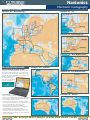
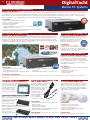
1
Call Now! 01179 114111
NEW FOR 2012
NEXT GENERATION VHF
Marine Electronics
Buyer’s Guide 2012
PAGE
44
Icom’s
’ New
N
Cutting
C tti Ed
Edge R
Radios
di With Innovative Features!
PAGE
33
PAGE
PAGE
49
3
New Handheld
H dh ld S
Satellite
t llit
i
Ph
Phones
DigitalYacht
l
h iNavConnect
C
New eTrex From Garmin!
THE LATEST PRODUCTS • THE LOWEST PRICES • EXPERT, UNBIASED ADVICE
PAGE
PAGE
26
PAGE
15
PAGE
35
43
PAGE
25
PAGE
44
LLatest
t t Safety
S f t At Sea Products
P
AIS - Standalone & Black Box
New Intellian VSAT Systems
FAST DELIVERY ANYWHERE IN THE WORLD • INSTALLATION & SERVICE FACILITIES
PAGE
PAGE
15
Raymarine e7 Touchscreen MFD with iPad Integration
10
New Simrad NSS Touchscreen MFD Range
PLUS 100’S OF OTHER GREAT PRODUCTS INSIDE!
THIS GUIDE FEATURES JUST A SMALL SELECTION OF OUR FULL RANGE OF OVER 6,000 PRODUCTS
VISIT OUR ONLINE SHOP AT WWW.MESLTD.CO.UK FOR THE LATEST PRICES AND SPECIAL OFFERS
Welcome to mesltd.co.uk
2
Index
THE MARINE ELECTRONICS BUYER’S GUIDE 2012
CONTENTS
Welcome to our latest Buyer’s Guide with
hundreds of exciting new products including
radars, plotters, autopilots, instruments and
satellite communications. Over the past 24
years, mesltd.co.uk has grown to become
Europe’s leading specialist marine electronics
supplier. Our philosophy of expert advice, a
passion for customer service and competitive prices offers a winning combination –
unmatched by any of our competitors.
Garmin
Simrad
B&G
Lowrance
NASA Marine
Furuno
Tacktick
Raymarine
Humminbird
Geonav
Echopilot
McMurdo/Kannad
Echomax
Ocean Signal
Navionics
C-Map by Jeppesen
DigitalYacht
Digital Deep Sea
KVH
Intellian
Icom
Standard Horizon
Shakespeare
Sailor
Thuraya
Iridium
Moerer
Vesper
Avtex
Our specialist advice and an unbiased selection make choosing the right electronics
for your application even easier. Plus, our well stocked showrooms offer the biggest
selection ever and the ability to compare products from the world’s leading manufacturers. Most importantly, our team don’t just answer the phone – they provide solutions
and expert knowledge.
Plus, with installation and service facilities in the UK and Europe, we’re your first choice
for a professional installation. Our office in Poole will look after all your South Coast
installation needs and if you can’t find an office close to you, take advantage of our mail
order and export facilities – fast despatch to anywhere in the world at globally
competitive prices. The choice is yours - call in, call up or click on our online store
www.mesltd.co.uk - your route to a better marine electronics solution.
Finally, remember that what you see here is just a selection of our 6000+ product line –
if it works on wires and fits on boats, then we like to think we do it!!
Good Boating!
3
10
10
11
12
13
14
15
20
21
22
24
25
26
27
30
32
39
40
41
44
46
48
49
49
49
50
50
50
ANDREW SMYTHE
Managing Director
© 2012 mesltd.co.uk. The information in this catalogue is correct at the time of going to press, using specifications supplied by the manufacturers. However, products are constantly being updated, hence mesltd.co.uk can
accept no responsibility for any errors in the description of any of the products featured in this catalogue.
CALL NOW! 01179 114111 • [email protected] • www.mesltd.co.uk
Garmin
3
Handheld Navigation
GARMIN eTREX 10
GARMIN Montana 600 Bundle
Handheld GPS
Handheld GPS Chartplotter with G2 BlueChart UK & Ireland SD Card
The eTrex 10 is a great choice for the budget conscious
looking for a basic GPS device. It has a 2.2in sunlight
readable monochrome display and comes with a
worldwide basemap.
The New Montana marine bundle combines detailed mapping with a sturdy GPS
handheld. The bundle includes G2 BlueChart UK & Ireland mapping (HXEU706L)
featuring smooth layering and seamless integration of map graphics for easy panning, scrolling and zooming. With rich colours and shading for easy interpretation
and clear visibility, it gives boaters greater capabilities on the water. The rugged
Montana 600 features a bright 4in sunlight readable, 65k colour TFT touchscreen
display, a High-sensitivity, WAAS-enabled
GPS receiver and HotFix® and a
Worldwide built-in basemap with
shaded relief.
KEY FEATURES
• High-sensitivity, WAAS-enabled GPS receiver with
HotFix® with GNSS support
• Paperless geocaching
• Waterproof standard: IEC 60529 IPX7
• USB interface
• Measures just 5.3 x 10.1 x 3.3cm, weighs 142g
• Up to 25 hours of battery life, 2 x AA
ALSO AVAILABLE
NEW FOR
• eTrex 20 - With 65k colour TFT display, 1.7Gb
internal memory, microSD card slot
• eTrex 30 - All the features of the eTrex 20 with unit-to-unit
wireless transfer, 3 axis electronic compass and barometric altimeter
KEY FEATURES
• 3-axis compass
• Barometric altimeter
• Waterproof (IEC 60529 IPX7)
• Multiple battery options (included)
• microSD™ card slot for optional mapping
• High speed USB and Serial interface
• Wirelessly share data between compatible units
GARMIN GPS72H
GARMIN GPSMap62 & GPSMap62S
Handheld GPS
Handheld GPS Chartplotter
2012
This rugged GPS features a high sensitivity receiver for faster
signal acquisition. WAAS enabled, waterproof and it floats!
Also available as marine bundle pack with marine mounting
bracket, 12v cigarette lighter cable and carrying case.
KEY FEATURES
• 500 waypoints, 50 routes
• Alarms
• Trip computer
• Auto track log, 10 saved tracks
• Course and speed filtering
• Built-in celestial tables
GARMIN DAKOTA 10 & 20
2.6in Handheld Touchscreen Chartplotter
Entry-level touchscreen handheld with high-sensitivity GPS with HotFix™ satellite
prediction, and a worldwide basemap. Durable and waterproof, Dakota is built to
withstand the elements and makes outdoor navigation simple
with an easy to use interface. 850Mb internal memory.
KEY FEATURES
• 20hrs battery life (2 x AA)
• Automatic turn by turn routing on roads
• Optional mapping for detailed roads
• 1000 waypoints, 50 routes, 10,000 track points
• Chartsource and BlueChard g2 Vision compatible
• Inbuilt hunting/fishing calendar, sun and moon info
• Dakota 20 - microSD™ card slot, tilt compensated 3-axis
compass, barometric altimeter, wireless data transfer, also
accepts OS mapping
GARMIN OREGON 450 & 550
3in Handheld Touchscreen Chartplotter
Rugged, lightweight and waterproof to IPX7, the Oregon
range features a high sensitivity WAAS GPS, an easy to
use interface and is ideal for both marine and land use
with turn by turn routing on roads, a barometric altimeter
and a tilt-compensated 3-axis electronic compass.
KEY FEATURES
• 16hrs battery life (2 x AA)
• 850Mb memory
• USB and NMEA0183 compatible
• Wireless data transfer
• Oregon450 - 1000 waypoints, 50 routes
• Oregon550 - 2000 waypoints, 200 routes
• 10,000 track points, 20 saved tracks
• Internal basemap
• Chartsource and BlueChard g2 Vision compatible
• Supports geocaching GPX files
• Inbuilt hunting/fishing calendar, sun and moon information and tide tables
• Oregon450t & 550t - Preloaded with topographic charts
• Oregon550/550t - 3.2 megapixel camera with autofocus, 4x digital zoom
Rugged waterproof unit with a 2.6in sunlight-readable colour
screen, 1.7Gb internal memory plus a built-in worldwide
basemap with shaded relief. The GPSMap62S adds a
microSD card slot for additional maps, barometric altimeter,
electronic compass and unit-to-unit transfer functionality.
KEY FEATURES
• Add marine, topographic and road maps
• High sensitivity, high precision GPS receiver
• Photo navigation - download pictures from
Garmin Connect™ Photos and navigate to them
• Compatible with Custom Maps - transform your own
paper and electronic maps into downloadable maps
• USB (high speed on 62S) and NMEA0183 interface
• 20hr battery life, uses 2 x AA batteries
• 2,000 waypoints, 200 routes, 10,000 track points,
200 saved tracks
GARMIN GPSMap78 & GPSMap78S
Handheld GPS Chartplotter
Rugged unit with crisp colour mapping, high-sensitivity
receiver, moulded rubber side grips plus a microSD card
slot for loading additional maps. The GPSMap78S adds
an electronic compass, barometric altimeter, unit-to-unit
transfer functionality and high speed USB interface.
KEY FEATURES
• Inbuilt worldwide basemap
• Waterproof and floats
• 1.7Gb internal memory
• Add marine, topographic and road maps
• BirdsEye satellite imagery (subscription required)
• Compatible with Custom Maps - transform your own
paper and electronic maps into downloadable maps
• USB (high speed USB on 78S) and NMEA0183 interface
• 20hr battery life, uses 2 x AA batteries
GARMIN GPSMap620
5.2in Colour Touchscreen Marine/Automotive Chartplotter
Full-featured chartplotter featuring an automotive mode when loaded with City
Navigator NT road charts. Preloaded with worldwide satellite basemap of shorelines and other surface features. Marine mode provides 3D “mariner’s eye view”
above the waterline, “fish eye view” below the waterline and Auto Guidance
that searches chart data to suggest the best passage.
KEY FEATURES
• Turn-by-turn voice prompts
• 1500 waypoints, 50 routes (marine)
• 1000 waypoints, 10 routes (automotive)
• 10,000-point auto track log
• AIS and DSC compatible
• Optional remote antenna
• Inbuilt tide and celestial tables
• Optional flush mount kit
Turn to the back page for pricing and ordering info NOW!
Garmin
4
Electronic Cartography
BLUECHART g2 & g2 VISION
BLUECHART g2 & g2 VISION
BLUECHART g2 & g2 VISION
UK, Ireland, France Large
USA West Coast Large
Caribbean Regular
BLUECHART g2 & g2 VISION
Mediterranean Large
BLUECHART g2 & g2 VISION
USA East Coast Large
BLUECHART g2 & g2 VISION
BLUECHART g2 & g2 VISION
Nordic Large
New Zealand Regular
BLUECHART g2 & g2 VISION
USA Gulf of Mexico Large
BLUECHART g2 & g2 VISION
Canada West Large
BLUECHART g2 & g2 VISION
USA Alaska Large
BLUECHART g2 & g2 VISION
Asia East Regular
BLUECHART g2 & g2 VISION
Canada East Large
BLUECHART g2 & g2 VISION
USA Great Lakes Large
Please note that this is just a small selection of
the full Bluechart coverage - please call us for
assistance if the cruising area you require is not
shown here.
We accept most major credit and debit cards
Garmin
5
Cartography, Chartplotters & Chartsounders
BLUECHART g2 & g2 VISION
GARMIN GPSMap4x1/4x1S
UK, Ireland, France Regular
4in Colour Chartplotter/Fishfinder
Available as a chartplotter (Map4x1) or a combination chartplotter/fishfinder
(Map4x1S), this unit features an ultra-bright 4in colour QVGA display. The
GPSMap4x1s comes with powerful dual frequency or dual beam sonar to clearly
paint depth contours, fish targets, structure, etc. It’s also CANet capable, allowing
sounder data to be shared with other plotter displays on your boat.
KEY FEATURES
• Satellite-enhanced 3D worldwide
basemap
• Preloaded US inland lakes maps
• Preloaded US coastal maps
• Preloaded with UK coastal maps
• Models include dual frequency
or dual beam sounder
• Upgradeable to BlueChart g2
Vision cartography via plug in card
• Simple user interface, easy operation
• Simplify navigation with Auto Guidance
• NMEA2000 compatible
GARMIN GPSMap5x1/5x1S
5in Colour Chartplotter/Fishfinder
BLUECHART g2 & g2 VISION
Europe South Atlantic Coast Regular
Chartplotter (Map5x1) or combination
chartplotter/fishfinder (Map5x1S) with
all the features of the GPSMap4x1
series, but with a larger ultra-bright 5in
colour QVGA display.
KEY FEATURES
• GPSMap521 - Satellite-enhanced 3D
worldwide basemap
• GPSMap531 - Preloaded with US
inland lakes maps
• GPSMap541 - Also preloaded with
US coastal maps
• GPSMap551 - Also preloaded with
UK coastal maps
• S models include dual frequency or dual beam sounder
ALL 4 & 5in MODELS SUPPLIED WITH
Internal GPS antenna (optional external antenna), unit cover, tilt/swivel
mount, cables, transducers sold separately
GARMIN GPSMap750/750S
7in Colour Touchscreen Chartplotter/Fishfinder
The GPSMAP 750 series can connect with any Garmin GMR™ series marine radar
and come preloaded with UK & Ireland charts, which can easily be added to with
optional BlueChart® g2 or g2 Vision® cards for expanded coverage of specific
regions. The 750s features a powerful 1000 watt capable digital sounder.
BLUECHART g2 & g2 VISION
Mediterranean Regular
KEY FEATURES
• NMEA 2000 connectivity for engine, fuel, VHF, autopilot and other data monitoring
• Single SD memory card slot
• Two NMEA 0183 ports
GPSMap750S FEATURES
• Optional 1kW transducer: 1000W (RMS) 8000W (p to p)
• Optional 500W dual frequency transducer: 500W (RMS) 4000W (p to p)
• Depth: 2,000ft / 600m (1kW), 1,500ft / (500W)
• UltraScroll high rep rate sonar provides lightning-fast screen updates
SUPPLIED WITH
Internal GPS antenna (optional external antenna), bail mount with built-in cable
management, flush mount gasket, power/data cable, protective cover
Turn to the back page for pricing and ordering info NOW!
Garmin
6
Combi Displays
GARMIN GPSMap4000 SERIES
GARMIN HD DIGITAL RADAR
8.4in, 10.4in & 12.1in Colour Combination Displays
High Definition Digital Radar
These powerful combi displays combine video-quality
resolution and luminous colour with the latest sensor and data options. Worldwide satellite imagery
enhances the standard vector basemap format, add
the optional BlueChart Vision card for high-resolution
aerial reference photos which help in navigating tricky
harbours and channels or locating places such as
marinas, fuel barges or restaurants. The g2 Vision
plugin data card also allows the units to graphically
depict a true 3D “mariner’s eye” topside view or “fish
eye” underwater navigation perspective.
HOT
PRODUCT
Self-contained signal
processing provides a more precise, easy to read
signature. Data is transmitted over the Garmin
Marine Network to any compatible Garmin display.
KEY FEATURES
• GPSMap4008/4208 - 8.4in 640x480 pixel VGA
• GPSMap4010/4210 - 10.4in 800x600 pixel SVGA
• GPSMap4012/4212 - 12.1in 1024x768 pixel XGA
• Worldwide satellite basemap
• GPSMap4208, 4210 & 4212 - preloaded with US
coastal maps
• Auto Guidance searches all the chart features to
suggest the best known charted route for navigation
• Dual Bluechart g2 card slots
• 4000 waypoints, 50 outes, 300 waypoints/route
• GPSMap4012/4212 - 2 video inputs for onboard
cameras, 1 SVGA PC monitor output
• Anchor drag, arrival, off-course, shallow water, deep
water, proximity waypoint, clock and battery alarms
• Inbuilt celestial tables for sun and moon calculations
• Add radar with optional GMR series digital antennas
• Radar/chart overlay and split screen modes
• MARPA target tracking
• Add sonar with optional GSD22 digital remote
sounder
KEY FEATURES
• Narrow beamwidth
• MARPA target tracking (10 targets)
• 24/30rpm dual rotation on open array antennas
• Minimum range - 20m
Tech info
Garmin Radar Scanners
When ordering your radar system you’ll
need to specify the antenna you require -
SUPPLIED WITH
GPS 17 WAAS sensor, A/V cable, power/data cable, mounting bracket, unit cover, flush mount, bail mount
GARMIN GPSMap5000 SERIES
8.4in, 12.1in & 15in Touchscreen Colour Combination Displays
The GPSMap 5000 series features a radical touchscreen interface that makes navigation as easy as
pointing your finger. The units are supplied with a
worldwide basemap with high-quality satellite images
in place of more traditional charts. For even more
detail, you can add charts easily using the SD card
slots. Keep watch on your engine room or other
areas of your vessel by connecting a live video feed
using the video input/output.
BlueChart g2 Vision charts add a whole new dimension of exceptional feature - 3D mariner’s eye view or
fish eye view provides you with a 3D perspective of
map information, both above and below the waterline. High-resolution satellite images and aerial photographs help you orient yourself in unfamiliar areas.
Auto Guidance creates a route that avoids shallow
water, buoys and other obstacles.
The Garmin HD digital radomes and open array
antennas offer high-powered Digital Signal Processing
for sharper radar imagery and improved target separation. Automatic pulse optimisation matches pulse
width and repetition rate with the selected range.
Part No.
GMR 18
GMR 18HD
GMR 24HD
GMR 404xHD
GMR 406xHD
GMR 604xHD
GMR 606xHD
GMR 1204xHD
GMR 1206xHD
Size
18in
18in
24in
48in
72in
48in
72in
48in
72in
Power Beam Type Range
4kW
RD 36nm
4kW
5º
RD 36nm
4kW 3.6º
RD 48nm
4kW 1.8º
OA 72nm
4kW 1.18º OA 72nm
6kW 1.8º
OA 72nm
6kW 1.1º
OA 72nm
12kW 1.8º
OA 72nm
12kW 1.1º
OA 72nm
RD - Radome Antenna (enclosed)
OA - Open Array
HD - High Definition
GARMIN GC10
Marine Camera
Durable and waterproof, the Garmin GC 10 was built
to brave the elements. With a
small and unobtrusive design
in a rugged housing that makes
it easy to mount almost
anywhere on your boat.
EDITOR’S
CHOICE
KEY FEATURES
• All the features of the 4000 series combi displays
• Innovative touch-screen design
• Dual Bluechart g2 card slots
• Add radar with optional GMR series digital antennas
• Add sonar with optional GSD22 digital remote
sounder
• GPSMap5008/5208 - 8.4in 640x480 pixel VGA
• GPSMap5012/5212 - 12.1in 1024x768 pixel XGA
• GPSMap5015/5215 - 15in 1024x768 pixel XGA
• GPSMap5208, 5212 & 5215 - preloaded with US
coastal maps
SUPPLIED WITH
GPS 17 WAAS sensor, A/V cable, power cable, mounting bracket, unit cover, flush mount, marine grommet kit,
NMEA2000 drop cable, NMEA2000 T-connector & terminator kit, NMEA2000 power cable, NMEA0183 cable
KEY FEATURES
• Can be used with on-board TV,
video monitors or chartplotters with video input
• No need to add separate hardware to view feed
• Standard-image and reverse-image models
• Automatic infra-red functionality
GARMIN GFS10
Fuel Sensor
Add fuel tracking to your Garmin
combi and optimise your
fuel economy.
KEY FEATURES
• 10-22v
• Unlike other fuel sensors
it will measure fuel level when connected to an
existing analogue fuel gauge or resistive fuel tank
sensor
• Flow rate 2 - 50 Gallons per hour per engine
• Data transfer via CANet or NMEA 2000
We accept most major credit and debit cards
Garmin
7
Touchscreen Combi Displays
GARMIN GPSMap6000 SERIES
8.4 & 12.1in Colour Combination Displays
The next evolution in Garmin’s series of full-featured marine products, the 6000
series brings unprecedented speed to your vessel with Garmin G Motion™ technology - blazing-fast map redraw and refresh rates offers near real-time data to guide
you. Whether you’re in a crowded harbour or in uncertain weather, you’ll have the
confidence to navigate with the 6000 series as your guide. Compatible with an
optional remote for added flexibility and with a sleek and stylish design that was
built to brave the elements, they look great in any position on the boat.
HOT
PRODUCT
The 6000 series features a worldwide basemap with high quality satellite images
in place of more traditional charts, plus you can easily add charts with the dual
card slots. Optional BlueChart g2 Vision charts add a whole new dimension of
exceptional features to your chartplotter - MarinerEye view and FishEye view provide you a 3-dimensional perspective of map information, both above and below
the waterline. High-resolution satellite images and aerial photographs help you
orient yourself in unfamiliar areas. Auto Guidance technology searches through all
relevant charts to create a route you can actually follow - one that avoids obstacles,
shallow water, buoys and other obstructions.
Keep tabs on your engine room or other area of your boat with a live video feed
using the video input and output options. The 6000 series easily connects to
your network so you can interface with additional displays and add remote sensors, cameras and more. Once connected, you can share information between
the 6000 series and other chartplotters on your boat. You can also add highpowered radar, sonar and XM satellite weather and radio to your system.
KEY FEATURES
• GPSMap6008/6208 - 12.1in 1024x768 pixel XGA
• GPSMap6012/6212 - 15in 1024x768 pixel XGA
• Worldwide satellite basemap
• GPSMap6208 & 6212 preloaded with US coastal maps
• Add radar with optional GMR series digital antennas
• Radar/chart overlay and split screen modes
• MARPA target tracking
• Add sonar with optional GSD22 digital remote sounder
• 5000 waypoints, 100 routes, 50,000 track points, 50 saved tracks
• 4 NMEA 0183 inputs, 2 NMEA 0183 outputs, 2 video inputs for onboard
cameras, 1 PC monitor video output
• Anchor drag, arrival, off-course, shallow water, deep water, proximity waypoint,
clock and battery alarms
• Inbuilt celestial tables for sun and moon calculations
• Tide tables
• AIS compatible
SUPPLIED WITH
GPS 17x NMEA 2000 with pole, flush and under deck mount adapters, front
cover, power cable, video cable, NMEA 0183 cable, NMEA 2000 drop cable, 10m
NMEA 2000 backbone cable, NMEA 2000 power cable, NMEA 2000 T-connector
and terminator kit, bail mount, flush mount kit, marine grommet kit
GARMIN GPSMap7000 SERIES
12.1 and 15.5in Touchscreen Colour Combination Display
Put the power of Garmin’s next-generation marine navigator right at your fingertips with the GPSMap7000 Series.
The 7000 series brings all the features, all the power and speed of the 6000 series but with innovative touchscreen
control and the choice of larger displays. The 7000 Series comes standard with a worldwide, satellite-enhanced
basemap as well as video-quality resolution on an impressive 12.1in or 15.5in XGA display. The 7000 Series also
provides total system integration – allowing support for the addition of sonar, radar, weather and more. For additional enhanced features, you can add the optional BlueChart g2 Vision card.
KEY FEATURES
• GPSMap7012/7212 - 12.1in 1024x768 pixel XGA
• GPSMap7015/7215 - 15in 1024x768 pixel XGA
• Dual Bluechart g2 card slots
• Worldwide satellite basemap
• GPSMap7212 & 7215 preloaded with US coastal maps
• Auto Guidance searches all the chart features to suggest the best known charted
route for navigation
• AIS compatible
• Add radar with optional GMR series digital antennas
• Radar/chart overlay and split screen modes plus MARPA target tracking
• Add sonar with optional GSD22 digital remote sounder
• 5000 waypoints, 100 routes, 50,000 track points, 50 saved tracks
• 4 NMEA 0183 inputs, 2 NMEA 0183 outputs
• GPSMap7012/7212 - 2 video inputs for onboard cameras,
1 PC monitor video output
• GPSMap7015/7215 - 4 video inputs for onboard cameras,
1 PC monitor video output, 1 PC monitor video input
• Anchor drag, arrival, off-course, shallow water, deep water, proximity waypoint,
clock and battery alarms
• Inbuilt tide tables and celestial tables for sun and moon calculations
SUPPLIED WITH
GPS 17x NMEA 2000 with pole, flush and under deck mount adapters, front cover, power cable, video cable, NMEA 0183 cable, NMEA 2000 drop cable, 10m NMEA
2000 backbone cable, NMEA 2000 power cable, NMEA 2000 T-connector and terminator kit, bail mount, flush mount kit, marine grommet kit
Turn to the back page for pricing and ordering info NOW!
Garmin
8
Fishfinders & Instruments
GARMIN echo 100
GARMIN echo 200
GARMIN echo 300c
4in Mono Single Beam Fishfinder
5in Mono Dual Beam Fishfinder
3.5in Colour Dual Beam Fishfinder
State-of-the-art target tracking technology brings a
new level of fishfinding capability to the budget
minded buyer. Garmin’s
exclusive HD-ID target
tracking technology brings
enhanced separation and
definition of images on the
echo 100’s fast refreshing
4in grayscale display.
The single-beam 200kHz
transducer lets you scan to
depths of up to 180m.
Combines the features of the echo 150 with a larger
5in grayscale display. The dual-beam transducer
scans deep water to 450m with a wide scanning
angle perfect for shallow water
as well. Smooth Scaling™
technology means you
won’t lose sight of the
sonar history as the unit
changes depth ranges
and allows you to rewind
your sonar history in order
to ensure that you haven’t
missed a thing.
The echo 300c combines the performance and features of the echo 200 with the compact design of
the echo 150 and a 3.5in
colour sunlight viewable
display. echo 300c is the
only colour dual-beam
fishfinder on the market
at this price, making it the
premier sonar option for
fishermen on a budget!
KEY FEATURES
• Garmin HD-ID™ technology
• 200kHz, 100 watts (RMS)
• Beam width to 60º
• Max Depth 180m (600ft)
• Compact design for smaller boats
KEY FEATURES
• Garmin HD-ID™ technology
• 200/77kHz, 200 watts (RMS)
• Max depth 450m (1,500 ft)
• Beam width to 120º
KEY FEATURES
• Garmin HD-ID™ technology
• 200/77kHz, 200 watts (RMS)
• Max depth 450m (1,500 ft)
• Beam width to 120º
SUPPLIED WITH
Tilt/swivel mount, transducer, trolling motor clamp
and transom mount
SUPPLIED WITH
Tilt/swivel mount, transducer, trolling motor clamp
and transom mount
SUPPLIED WITH
Tilt/swivel mount, transducer, trolling motor clamp
and transom mount
GARMIN echo 150
GARMIN echo 500c/550c
4in Mono Dual Beam Fishfinder
5in Colour Dual Beam Fishfinders
With dual-beam technology at a single-beam price,
echo 150 is the sport fisherman’s dream. Scan to
depths of 400m in fresh water.
In shallower water, a viewing
angle of up to 120º lets you
see fish well beyond the sides
of your boat. HD-ID target
tracking technology provides
you with better separation and
definition of images.
Range of colour dual frequency fishfinders ideal for both shallow and deep water. HD-ID target tracking technology brings
enhanced separation and definition of images. Smooth
Scaling™ technology means you won’t lose sight of the sonar
history as the unit changes depth ranges and allows you to
rewind your sonar history in order to ensure that you haven’t
missed a thing. The echo 550c boasts a video-quality
640x480-pixel VGA screen, providing an amazing level of
detail on fish returns, structure and bottom contours.
KEY FEATURES
• Garmin HD-ID™ technology
• 200/77kHz, 200 watts (RMS)
• Beam width to 120º
• Max Depth 400m (1,300ft)
• Compact design
SUPPLIED WITH
Tilt/swivel mount, transducer,
trolling motor clamp and transom mount
KEY FEATURES
• Garmin HD-ID™ technology
• 200/77kHz, 500 watts (RMS)
• Max depth 580m (1,900 ft)
• Beam width to 120º
• echo 500c - 5in colour QVGA 234 x 320 pixel display
• echo 550c - 5in colour VGA 480 x 640 pixel display
SUPPLIED WITH
80/200kHz transom transducer, power/data cable, mounting bracket, flush mount hardware
GARMIN GMI 10
Digital Marine Instrument Display
Radical colour multifunction display that integrates
with the Garmin Marine Network and other sensors
via NMEA2000 and NMEA0183. By showing data
from multiple remote sensors on one display, the
GMI 10 offers a streamlined approach to marine
instrumentation. Display data such as depth, speed,
water and air temperature, wind speed/direction, fuel
flow rate, engine data, fuel level and more, depending
upon what sensors are connected. The GMI 10 supports more than two dozen standard NMEA2000 and
more than 20 NMEA0183 data sentences and can
also connect to any Garmin Marine Network chartplotters with an NMEA 2000 port.
KEY FEATURES
• Clear, bright 320 x 240 pixel colour QVGA display
• Flexible, expandable system suits all boat sizes
• GWS 10 wind sensor with barometric pressure and
air temperature
• GPS 17x 12-channel WAAS GPS sensor
• GFS 10 fuel sensor
• NMEA2000 and NMEA0183 compatible
• Waterproof
• Flush mountable
HOT
PRODUCT
SUPPLIED WITH
Display, mounting hardware, sun cover, power/NMEA 0183 cable, NMEA 2000 power cable, NMEA 2000 drop
cable, NMEA 2000 tee & terminator kit
GWS 10 Wind Sensor
GPS 17x GPS Sensor
We accept most major credit and debit cards
GFS 10 Fuel Sensor
9
Autopilot, AIS & VHF Radios
GARMIN GHP 12
GARMIN VHF 100i & VHF 200i
Sailboat Autopilot System
Fixed DSC VHF Radios
GHP 12 brings Garmin’s marine autopilot technology to sailboats. This second-generation autopilot
is designed to suit most 20 to 70ft sailboats with
linear-actuated steering systems with a choice of two
drives (supplied separately).
The Garmin VHF 100i and 200i range of VHF radios feature a large backlit 3.2in display, rotary volume, squelch
and channel selection knobs, up to 25W transmission power and provides full Class D DSC capability.
KEY FEATURES
• Steer to GPS (requires GPS input)
• Integrates with GWS 10 wind sensor
or compatible NMEA windvanes
• Heading hold, wind hold, step turn, tack/gybe
LINEAR ACTUATORS AVAILABLE
• Class A Drive Unit - up to 28,500lbs displacement
• Class B Drive Unit - up to 79,000lbs displacement
SUPPLIED WITH
GHC 10, course computer, electronic control unit,
interconnect cable, buzzer, power cable, NMEA2000
drop cable, 2 x NMEA2000 T-connectors. Drive units
sold separately
GARMIN GHP 10
KEY FEATURES
• Locate and monitor up to three other boats with position tracking capability
• 200i - Two-way hailer functionality when connected to compatible horn speaker
• 200i - Automatic and manual foghorn signals and adjustable base fog frequencies
• LOCAL receiver mode improves performance in busy port environments
• Ergonomic fist mic with built-in speaker
• Programmable international channels
• ATIS and private channel customisation options
• 200i - Multi-language user interface
• 200i - Supports GHS 10i second station
• Automatic power-on when boat starts
• Waterproof to IPX7 standard
• Easy front flush-mounting option
• NMEA 0183 compatible
• 200i - NMEA 2000 compatible
SUPPLIED WITH
Fistmike, power cable, hailer/NMEA cable (200i), mounting bracket, flush mount gasket, protective cover
GARMIN VHF 300i & VHF 300i AIS
Fixed DSC VHF Radios
Multi-station Class D DSC VHF transceiver comes with a two-way hailer system and a voicemail feature that lets you pre-record a 15-second message and send to any DSC radio. Replay the last 90
seconds of any incoming voice transmission at the touch of a button. Listen via the supplied 4in
active speaker with volume control, the handset’s inbuilt speaker or third-party passive speakers.
Also features an inbuilt dual channel AIS receiver which
simultaneously receives Class A and Class B AIS signals.
NMEA 0183 and 2000 compatible.
Powerboat Autopilot System
KEY FEATURES
• Space-saving black box configuration
• 30w hailer when connected to compatible horn speaker
• GHS 10i handset microphone with 2in LCD display
• Rotary key and three soft buttons for dynamic controls
• Multi station support with intercom facility
• Locate and monitor up to three other boats with position
tracking capability
• VHF 300i AIS - display AIS ship information - position,
course and speed of AIS equipped vessels within range
• Waterproof to IPX7 standard
Powerful, easy to use autopilot system. The GHC
10 fixed control unit integrates via a NMEA2000 bus,
so autopilot heading data can easily be shared with
other devices including chartplotters. Up to three
GHC 10 controls can be interfaced with a single pilot,
ideal for multiple helm station boats.
SUPPLIED WITH
GHS 10i handset microphone, active speaker, power
cable, 10m deck cable, mounting hardware
KEY FEATURES
• Suitable for all types of hydraulically steered power
boats - inboard, outboard, stern-drive, diesels
• NEW FOR 2011 - GHP 10V version for Volvo Penta
IPS steering systems
• No rudder feedback unit required
• Gyro-stabilised compass
• Patented Shadow Drive™ technology automatically
disengages autopilot if the helm is turned and
re-engages when a steady course is held
• Hold position against wind, waves or current
• Can steer in reverse
• Bright 320 x 240 pixel QVGA colour LCD display
HYDRAULIC REVERSING PUMPS AVAILABLE
• 1.2L (up to 160cc, 10in3)
• 2.0L (160-400cc, 10-24in3)
• 2.1L (160-400cc, 10-24in3), engine size 400hp+
SUPPLIED WITH
GHC 10, course computer, gyro compass, drive unit,
interconnect cable, buzzer, power cable, NMEA2000
drop cable, NMEA2000 T-connector
GARMIN AIS300
GARMIN AIS600
Black Box AIS Receiver
Black Box AIS Transceiver
This affordable NMEA2000 compatible black box AIS
receiver alerts you to potential collisions with other
AIS-equipped vessels in your vicinity. It integrates
with a Garmin chartplotter and VHF radio to enable
automatic AIS target calling and to display AIS target
data directly on the chartplotter screen.
Receive and transmit AIS data. Inbuilt active splitter
allows one VHF antenna to serve both the AIS 600
and VHF radio with minimal signal loss. The AIS 600
connects to your existing Garmin marine network and
is controlled via the chartplotter, so all the information
you need will be right at your fingertips.
HOT
PRODUCT
KEY FEATURES
• Class A and Class B reception
• Closest Point of Approach (CPA) alarm
• 12-volt and 24-volt boat systems
• NMEA 0183 output with selectable speed
• Inbuilt passive splitter enables one VHF antenna to
serve both the AIS 300 and any VHF radio
SUPPLIED WITH
Power/data cable, 2m NMEA2000 cable, NMEA2000
T-connector, VHF interconnect cable, mounting kit
KEY FEATURES
• ClearTrack™ technology ensures no interruption of
AIS traffic position while the VHF radio is in use
• Integrates with chartplotters & VHF via NMEA2000
• Call With Radio function - initiate a call to any MMSI
target directly from the chartplotter
SUPPLIED WITH
GPS antenna, pole & surface mount, power cable,
SRM cable, 2m NMEA2000 cable, NMEA2000
T-connector, USB cable, 2m VHF interconnect cable,
PC/Software CD, mounting kit
Turn to the back page for pricing and ordering info NOW!
Simrad, B&G
10
Navigation Equipment
SIMRAD NSS
SIMRAD NSE8 & NSE12
SIMRAD RS25 + AHK05
7, 8 & 12in Touchscreen Displays
8in & 12in Combi Displays
Fixed DSC VHF and Wireless Handset
NEW FOR
2012
KEY FEATURES
• Touch screen user interface
• Complementary rotary and button control
• Network up to four processors via Ethernet and
SimNet / NMEA2000
• Network with Simrad NSE and NSO systems
• Internal GPS with external option
• Autopilot Integration
• BEP C Zone integration
• Audio Support
KEY FEATURES
• Single, Dual or multi-station configurations
• Intuitive control interface for easy operation
• Input and output of video or navigation data
• Network NMEA0183, NMEA2000 or Simnet data
• Pre-loaded with complete European Navionics
Platinum charts for Europe
• Award winning echosounder and radar technology
• Brilliant Low Power LED Display Technology
SIMRAD HD RADARS
SIMRAD SONICHUB
High Definition Digital Radar
Marine Audio Server
KEY FEATURES
• Intercom and Conference Features
• Position display if integrated with GPS
• Position Polling, Track your Buddy and Group Call
• Barometer, thermometer and weather forecasting
• Dual watch, Tri watch and All-Scan functions
• ATIS facility for inland waterways
• Waterproof to JIS-7
• NMEA 0183 input
SIMRAD NAIS300 & AI50
AIS Class B Transceiver Units
KEY FEATURES
• Plug and Play installation viaa NMEA0183
N
or Simnet
• Both models can be integrated with a compatible
chart display or PC via NMEA0183 or Simnet
KEY FEATURES
• DX42S 2kW 18in Radome, 24nm, 5.3º beamwidth
• DX64S 4kW 24in Radome, 48nm, 4º beamwidth
• TX06S 6kW 4ft Open Array, 64nm, 1.8º beamwidth
• TX10S 10kW 6ft Open Array, 72nm, 1.2º beamwidth
• TX25S 25kW 8ft Open Array, 96nm, 1º beamwidth
SIMRAD BROADBAND RADAR 3G/4G
Networked Radar
KEY FEATURES - 3G & 4G
• Crystal clear image
• Automatic clarity
• 10 MARPA tracking
• Dual guard zones
• Instant on
• Low power consumption
• Extremely low emissions
NEW FOR
2012
KEY FEATURES - 4G ONLY
• 50% greater ranger than 3G
• Dual range (when used with NSE, Zeus and NSO)
• 48 RPM option
• Advanced target detection
SIMRAD BSM-1
Broadband Sounder Module
KEY FEATURES
• Four channel x 50 watt speaker amplifier
• AM/FM stereo tuner
• Line-out to subwoofer
• Audio source inputs including Apple products,
other MP3 sources via USB port and flash drive
• Stereo AUX line input for audio, mono line input for
intercom, alarm and emergency override
• Music control for up to three individual zones
KEY FEATURES
• Tri-frequency capability for optimal performance
• Deep water performance of over 3000ft
• Low Power and Low-noise Sonar
• High Resolution Linear receiver providing superior
clarity in shallow and mid water
B&G ZEUS Z8 & Z12
B&G TRITON
8in & 12in Combi Displays
Instrument System
HOT
PRODUCT
SIMRAD TP10, TP22 & TP32
Cockpit Tillerpilots
KEY FEATURES
• TP10 (Up to 10m) - Budget standalone Tillerpilot.
• TP22 (Up to 11m) - Faster hard over time plus
SimNet and NMEA compatibility.
• TP32 (Up to 12m) - Top spec high performance
pilot with 85kg thrust and ultra-fast hard over time.
• Waterproof double sealed design
• NMEA interfacing to GPS & windvane (TP22/32)
• SimNet compatible (TP22/32)
• Optional external fluxgate sensor (TP22/32)
• Hand remote option (TP22/32)
SUPPLIED WITH
Mounting kit, deck socket (TP22/32 only)
KEY FEATURES
• Radar, sail navigation and weather chart overlays
• Water and ground vectors show the effect of tide
and leeway on your course
• Mark and boat laylines, with time and distance to
layline for each tack
• WindPlot allows you to make route choice decisions
- whether to tack or stand on in the next gust etc
• B&G H-Link, NMEA0183 & NMEA2000 compatible
• Edit and backup of H3000 Polar tables
• Preloaded cartography (Nautic Insight™ for the USA,
Navionics coastal packages for Europe and APAC)
• Optional cartography including Navionics Platinum+
• Compatible with wide range of Navico equipment
including Broadband Radar, SonicHub and other
approved Ethernet, SimNet and NMEA2000 devices
NEW FOR
KEY FEATURES
• Multifunction “do it all” display
• Straightforward user interface
• Large 4.1in colour display nearly 40% more area than competing products
• Bonded screens - excellent visibility in all conditions
• Low power consumption
• Dedicated pilot control - or interface with Zeus MFD
• B&G Wind sensor technology
We accept most major credit and debit cards
2012
Lowrance
11
Navigation Equipment
LOWRANCE HDS 2
LOWRANCE ELITE-4 SERIES
LOWRANCE ELITE-5 SERIES
5-10in HD Combi Displays
4in Colour Fishfinder, Chartplotter
and Chart Fishfinder
5in Colour Fishfinder, Chartplotter
and Chart Fishfinder
NEW FOR
2012
KEY FEATURES
• Real time side scan image overlay onto chart
plotter screen (structure needs to be connected)
• Lighting fast graphics redraw
• SolarMAX Plus display for the best detail in bright
sunlight, the best wide-angle viewing ever achieved
• Multi station networking
• Compatible with Navionics Gold, Platinum and
Platinum plus cartography
• Add Sonic Hub, Structure Scan, AIS, Instrumentation
and other NMEA 2000 devices
LOWRANCE BROADBAND RADAR
Networked Radar System For HDS
NEW FOR
HOT
PRODUCT
2012
KEY FEATURES
• New high bright 320x240 pixel display
• Choose either the legendary Lowrance Dual
frequency 83/200 echosounder or the award
winning 455/800 DSI echosounder
• Inbuilt 16 channel GPS
• Quick release tilt and swivel mount bracket
KEY FEATURES
• High Definition 480x480 pixel sun viewable screen
• Simple and Intuitive operation
• Quick release tilt and swivel mount bracket
• Internal 16 Channel precision GPS
• Navionics Gold Compatible
MODELS AVAILABLE
• Elite 4m - 4in chartplotter
• Elite 4x - 4in echo sounder 83/200kHz
• Elite 4 - 4in chartplotter/echo sounder 83/200kHz
• Elite 4x DSI - 4in downscan image echo sounder
• Elite 4 DSI - 4in chartplotter/downscan echo sounder
MODELS AVAILABLE
• Elite 5x - 5in 83/200kHz echo sounder
• Elite 5m - 5in chartplotter
• Elite 5x - 5in chartplotter & 83/200kHz echosounder
• Elite 5x DSI - 5in downscan echosounder
• Elite 5 DSI - 5in chartplotter/downscan echosounder
LOWRANCE LVR-250
Fixed Class D DSC VHF Radio
KEY FEATURES
• 19in radome, 5.2º beamwidth
• Crystal clear image of your immediate surroundings
• First radar with no radiation hazard
• InstantOn™ with no tuning required
• Low power consumption, ideal for yachts
LOWRANCE STRUCTURESCAN
Sonar Imaging For HDS
KEY FEATURES
• 1 x 1.8in LCD channel/function display with backlighting
• 25 watts transmit power / 1 watt low power mode
• 6 tactile microphone keys
• Rotary Channel control with press-to-ente
• 3 favourite channel mode with scan
• 3W external speaker and GPS interface
• Display position and time when connected to compatible GPS
• Rotary Channel control with press-to-enter
• Local/Distant feature eliminates interference
• Case and mic waterproof (JIS 7 submersible)
LOWRANCE LVR-880
Fixed DSC VHF Radio
KEY FEATURES
• Fully Networkable
• Down Scan high detail sonar imaging up to 90m
• Side Scan imaging to at least 45m
• View DownScan imaging with HDS Broadband
Radar in split screen mode
• Transducer includes water temperature sensor
LOWRANCE SONICHUB
KEY FEATURES
• All the features of the LVR-250 plus:
• NMEA0183 and NMEA2000 DSC integration
• Navigation to waypoint with transfer capability to plotters
• 200 waypoints with up to 6 character naming
• Intercom with talkback plus built-in 22w hailer-horn
• Extra-large and bright FSTN full-matrix screen
• Large 57mm speaker for great audio output when
running at high speed
• Instant “GO” and MOB key
Marine Audio Server
LOWRANCE LHR-80
KEY FEATURES
• AM/FM stereo tuner
• Simple, menu-driven control via HDS display
• 4 x 50 watt amplifier plus line-out to subwoofer
• Supplied with 2 x 200w 6.5in marine speakers
• Audio source input via USB port and flash drive
• Stereo AUX line input for audio, mono line input for
intercom, alarm and emergency override
• Music control for up to two individual zones
KEY FEATURES
• Built-in GPS receiver with unique trackplotter screen feature
• Great Circle waypoint navigation
• Storage of up to 500 waypoints
• Man Over Board functionality
• “Track-Your-Buddy” allows boaters to pinpoint and display the exact location of
other vessels via position polling
• “Get Buddy” transmits radio’s position at the push of a button
• Save a buddy list of up to 20 people
• Large display with adjustable contrast and backlighting
• 1400mAh Li-Ion battery
• Signal Strength Indicator
• NOAA Wx 1050Hz tone alert for weather/storm warnings (US only)
• Lat/Long and time display
• Distress call button
• Up to 13hrs battery life
Handheld Waterproof Floating VHF
Turn to the back page for pricing and ordering info NOW!
NASA Marine
12
Navigation Equipment
NASA PC NAVTEX USB
NASA CLIPPER EASY NAVTEX
NASA METEOMAN
Dual Frequency PC Navtex Receiver
Dual Frequency LCD Navtex Receiver
Digital Barometer
KEY FEATURES
• Receives messages even without PC connected
• Supports selected message filtering and printing
• Low current consumption - can be left on 24/7
Easy to read, this Navtex receiver features big, bold
characters and intuitive message formatting.
KEY FEATURES
• 518/490kHz, programmable channel switching
• Built in real time spectrum analyser
• Very high contrast display with white backlight
SUPPLIED WITH
Compact stub antenna, software, cable
SUPPLIED WITH
Compact stub antenna
Precision high resolution barograph. Easy to use and
reliable with low power consumption.
KEY FEATURES
• Wind speed and direction, ambient temperature
and barometric pressure
• Chronometer, stop watch, race countdown timer,
internal temperature display and battery monitor
• Optional NMEA Wind sensor
NASA AIS ENGINE 3
NASA AIS RADAR
NASA WEATHERMAN
2 Channel AIS Receiver
AIS Receiver
RTTY Telex Receiver
View Navtex messages on your PC! Instantly get the
latest weather forecast from your local station or any
other message stored in the unit’s memory.
Turn your PC or compatible chart plotter into an AIS
display! Windows 95, 98, ME, XP, 2000, NT and
Vista compatible, the software includes a world map
on which vessels are plotted.
KEY FEATURES
• Optional GPS input
• Display vessel name,
MMSI number, position,
call sign, destination etc
• Works with all plotters,
radars, PCs etc with AIS input
• Super sensitive receiver with GPS multiplexer
• Receives all class A and class B messages
• AIS Engine 3 decodes all available AIS messages
HOT
PRODUCT
Standalone AIS receiver that shows AIS equipped
vessels in a radar-style format. A trail of previous positions clearly shows the relative track of all the targets
on the screen. Requires standard VHF antenna.
SUPPLIED WITH
Software, 9-pin serial data cable, 12 volt power cable
KEY FEATURES
• 1, 2, 4, 8, 16 and 32nm ranges
• SOG, vessel’s name, MMSI and current Lat/Long
• Low power consumption
NASA HF3/W
NASA MOBi
MF/HF Receiver
Man Overboard Indicator
Compact Radioteletype weather forecast receiver.
Memory can store several thousand lines of text.
KEY FEATURES
• High contrast 16 lines x 40 character display
• Power save auto timer on backlight
• Spectrum screen for simple signal analysis
SUPPLIED WITH
Active micro antenna
Keep your crew safe with this state of the art man overboard
system, consisting of a base unit and up to eight waterproof
active transponder tags, each of can be individually named.
Covering 30Khz - 30Mhz, this compact MF/HF
receiver includes a weatherfax interface.
KEY FEATURES
• Failsafe transponder technology
• Base unit alarm if crewmember falls overboard
• Each tag is individually identified on the display
• 3 x AAA batteries will power each transponder for several
weeks’ continuous use
SUPPLIED WITH
Antenna, PC cable, power supply, Meteoscan lite software to download weatherfax pictures, RTTY weather
forecasts and navtex messages.
SUPPLIED WITH
Base unit, three tags
NASA CLIPPER
NASA BM-1
NASA BM-1 COMPACT
Instrument System
Battery Monitor
Battery Monitor
Budget 110mm instrument system with large clear
displays. Supplied with transducers and cabling.
Monitors the performance of 12v lead acid battery
systems with up to
600Ah capacities. It
shows voltage, current
(charge or discharge),
the battery’s state of
charge and the time
to charge or discharge.
This compact 12v lead acid battery system monitor
displays the voltage, current (charge or discharge),
state of charge and the time to charge or discharge.
KEY FEATURES
• Log - log, trip log and trend indicator, kts/mph
• Depth - keel/waterline offset, deep/shallow
alarms, trend indicator, feet or metres
• Wind - “digital analogue”, selectable pointer style
• Duet - combines the Clipper Speed and Depth
• Compass - true or magnetic display, steering
function, off-course alarm
• GPS Repeater - COG, SOG, Lat/Long, BTW, DTW,
XTE, rolling road display
KEY FEATURES
• Supply current 3mA
• Battery capacities 5-600Ah
• Load current 100A maximum
• 110mm case with high contrast LCD
• 24v version also available
HOT
PRODUCT
KEY FEATURES
• Supply current 1.5mA
• Battery capacities 5-600Ah
• Load current 100A maximum
• Compact - 125x62x23mm with high contrast LCD
• Also available in white
BM-1 & BM-1 COMPACT SUPPLIED WITH
Display, precision shunt and prefabricated cables for simple DIY installation
We accept most major credit and debit cards
Furuno
13
NavNet 3D Navigation System
FURUNO NAVNET 3D
Multifunction Navigation System
A groundbreaking navigation system that introduces new concepts in user interface design that makes this powerful system easy to use. NavNet 3D introduces a new
dimension to charting with Full Time 3D chart rendering - choose traditional 2D top-down view or pan/zoom the chart to any 3D angle instantly - there’s no delay
switching to “3D mode” as with other chartplotters as NavNet 3D operates in this 3D environment at all times. The cutting edge “Time Zero” technology gives instant
chart zoom, panning and display mode changes seamlessly with no lag.
With NavNet 3D’s true 3D environment, you can see all the information you want - radar overlay, AIS, chart symbols, depth soundings etc. Choose the type of charts
you want to view - raster, vector or combine them with Furuno’s Satellite Photofusion charts, giving unprecedented control over your charting environment.
FURUNO MFD8 & MFD12
FURUNO NAVNET 3D RADAR
NavNet 3D 8.4in & 12.1in Combi Displays
Digital Radar
Choose between an 8.4in or 12.1in colour sunlight-viewable displays with high brightness and anti-reflective
glass coating that allows use even in direct sunlight. The low profile design is ideal for flush mounting or can
be bracket mounted.
HOT
PRODUCT
KEY FEATURES
• Enhanced detection both in long and short range
• Enhanced auto tuning, gain and anti-clutter controls
• 48rpm rotation speed for HSC and river applications
• Adaptive rotation speed according to pulse length
• Accurate radar overlay on both 2D and 3D charts
• True Colour Radar shows density of targets
• Radar Guard Zone and Watchman features
• Dual VRM and dual EBL
• Off-centre display capability
Tech info
Furuno UHD Radar Scanners
When ordering your radar system you’ll
need to specify the antenna you require -
KEY FEATURES
• Choice of an 8.4in TFT 640x480 pixel (MFD8) or a
12in TFT 800x600 pixel (MFD12) display
• Jeppesen C-Map On Board Charts
• Stores up to 2,000 waypoints, 200 routes of 100
waypoints per route
• Head up, course up, North up, relative motion or
true motion display modes
• True 3D environment for a more instinctive chart
presentation
• Simple, intuitive operation with Rotokey & Scrollpad
• Dedicated 3D button - toggle between 2D
perspective and favourite 3D angle
• High-resolution satellite photography can be fused
with raster or vector chart information, viewable in
2D or 3D
• No preset chart scales - zoom to the exact
magnification level you wish
• Ultra High Definition (UHD) Digital Radar
• 3D chart-radar overlay (requires sat compass input)
• Furuno Digital Filter (FDF) Fish Finder
Part No.
DRS2D
DRS4D
DRS4A
DRS6A
DRS12A
DRS25A
Size
19in
24in
3.5ft
4ft
4ft/6ft
4ft/6ft
Power
2.2kW
4kW
4kW
6kW
12kW
25kW
Type
RD
RD
OA
OA
OA
OA
Range
24nm
36nm
48nm
64nm
72nm
96nm
RD - Radome Antenna (enclosed)
OA - Open Array
FURUNO NAVNET 3D
Upgrade Modules
Add powerful features to your NavNet 3D system
with these optional modules.
FURUNO NAVNET 3D BB
NavNet 3D Black Box System
If NavNet 3D sounds right for you, but you want a bigger display,
then the NavNet 3D BB system offers all the features of the MFD8/
MFD12, linking a powerful NavNet3D black box processor with a
range of LCD displays, from 12.1in up to 19in. Control
is via a separate dedicated control keyboard.
NavNet 3D BB is compatible with all the peripherals available
to the MFD8 & MFD12 systems - radar, digital sounder, AIS,
satellite compass, weatherfax etc.
KEY FEATURES
• 12.1in SVGA marine monitor, 800x600px
• 15in XGA marine monitor, 1024x768px new HD version
• 17in SXGA marine monitor, 1280x1024px
• 19in SXGA marine monitor, 1280x1024px
• Dedicated control keyboard
HOT
PRODUCT
MODULES AVAILABLE
• BBWX1 Sirius Satellite Weather Receiver (US only)
• DFF1 Digital Sounder Module
• FA30 AIS Receiver
• FA50 Class A & B AIS Transponder
• FAX30 Weatherfax & Navtex Receiver
• PG700 Integrated Heading Sensor
• SC30, SC50 & SC110 Satellite Compasses
Turn to the back page for pricing and ordering info NOW!
Tacktick
14
Find out more...
Wireless Instruments
TACKTICK T035 SPEED SYSTEM
TACKTICK T034 DEPTH SYSTEM
Entry Level Speed System
Entry Level Depth System
The T035 Speed system is the ideal solution for all
yachts 35ft or under. A large, wireless 38mm (15in)
display shows speed. There are no cables to pull
through headlinings
or bulkheads, the only
requirement is a 12v
connection to power
the display.
The T034 Depth system is the ideal solution for all
yachts 35ft or under. A large, wireless 38mm (15in)
display shows depth. There are no cables to pull
through headlinings
or bulkheads, the only
requirement is a 12v
connection to power
the display.
KEY FEATURES
• Boat Speed and Log
• Large clear backlit digital display
• Completely waterproof to 10 metres
• Simple installation, easy calibration
• Show depth on the same display simply add a T912 Depth Transducer
SUPPLIED WITH
Speed transducer, hull transmitter and display unit
KEY FEATURES
• Depth & Sea Temp
• Large clear backlit digital display
• Completely waterproof to 10 metres
• Simple installation, easy calibration
• Show speed on the same display simply add a T911 Speed Transducer
SUPPLIED WITH
Depth transducer, hull transmitter and display unit
TACKTICK T106 REMOTE DISPLAY
TACKTICK T038 SPEED/DEPTH/WIND
TACKTICK T033 WIND SYSTEM
Handheld Wireless Remote Display
Entry Level Cruise Pack System
Entry Level Wind System
Not just a remote control, this is an independent
Micronet wireless palm sized display which shows all
system data and also incorporates
a rolling road and performance
pages for displaying uploads
from tactical software, and it
can function as a remote control for Micronet displays. Add
as many handsets as needed
for key crew members.
Ideal for either replacing existing instruments, first
time installations or new-builds. Wireless data transfer
means the system is simple to install with no wires
down the mast or through the deck and just 12v
required for the displays
and speed/depth
pod.
The T033 Wind system is the ideal solution for cruising yachts 35ft or under. Wind speed and direction
information is delivered wirelessly from the wind
transmitter, whilst the display itself is powered by
your boat’s 12-volt battery.
Tacktick Wireless Instruments
BREAK
FREE!
EASY TO INSTALL - a typical installation can be
done in just a few hours, with no need to drill
holes in bulkheads, run cables through headlining or down the mast.
PERFORMANCE ADVANTAGE - with no mast
cable, spar weight is reduced and the boat’s centre of gravity is lowered.
DATA WHERE YOU NEED IT - with clip in cradles, displays can be positioned anywhere on the
boat.
SEALED FOR LIFE - all Tacktick products are
totally waterproof (submersible to 10m), which
also eliminates condensation. Reliability also
increases since wiring faults typically account for
80% of system problems on boats.
KEY FEATURES
• Repeats a wide range of data
• Palm sized, easy to hold
• Totally multifunction
• Graphic multi-line display
• Solar powered with integrated
lithium batery
• Can be used with other
manufacturers’ equipment
KEY FEATURES
• Boat Speed & Log
• Depth & Sea Temp
• Wind Speed & Direction
• Cost effective solution
• Large clear backlit digital displays
• Completely waterproof to 10 metres
KEY FEATURES
• True and apparent wind speed and
direction (true wind requires boat speed)
• Large clear backlit analogue display
• Completely waterproof to 10 metres
• Simple installation, easy calibration
SUPPLIED WITH
3xDisplays, hull transmitter, triducer, masthead unit
SUPPLIED WITH
Wind transmitter and display unit
TACKTICK T108 CRUISE PACK
TACKTICK T100 SPEED/DEPTH
TACKTICK T101 WIND
Wireless Speed, Depth, Wind System
Bidata System
Wind System
This great value package is ideal for sailboats of all
sizes, coming complete with a ‘digital analogue’ and
a dual digital
display.
The Tacktick Speed/Depth system is a compact solution for those on a budget or where space is limited.
The single display shows
boat speed, depth and
distance travelled.
The wireless T101 Wind System does away with all
the inconvenience of installing a traditional wind
system - with no mast cable the mast doesn’t need
to be stepped, plus the weight saved improves the
yacht’s performance. The display shows wind
direction (360º and close hauled) and wind speed.
HOT
PRODUCT
SUPPLIED WITH
Remote display, universal wireless NMEA interface
EDITOR’S
CHOICE
SEEN IT
FOR LESS?
KEY FEATURES
• Speed, Depth, Distance
• Wind Speed and Direction
• Calculated functions
• Compatible with other manufacturers via NMEA
• Solar powered with integrated lithium batteries
• Efficient power consumption - units can run
autonomously for up to 300 hours
KEY FEATURES
PRICE!
• Speed, Depth and Distance
• Solar powered with integrated lithium battery
• Efficient power consumption - units can run
autonomously for up to 300 hours
• Easy to expand system
SUPPLIED WITH
Dual Digital Display, Analogue Display, Speed and
Depth transducers, Wind Transmitter, Hull Transmitter
SUPPLIED WITH
Dual digital display, through hull speed and depth
transducers, hull transmitter
WE WON’T BE
BEATEN ON
KEY FEATURES
• Large clear ‘analogue’ display
• Solar powered with integrated lithium battery
• Efficient power consumption - units can run
autonomously for up to 300 hours
SUPPLIED WITH
Wind transmitter and display unit
We accept most major credit and debit cards
Raymarine
15
E Series Combi Displays
RAYMARINE e7 / e7D
RAYMARINE AIS350
Touch Screen Multifunction Display
Black Box AIS Receiver
The Raymarine e7 is a feature rich MFD that sets a new standard for ease of use, performance, and connectivity. A networking wonder, the e7 breaks new ground with Wi-Fi streaming to Apple iPhones (4+) and iPads.
Dual-channel AIS receiver
which recieves Class A
and Class B broadcasts.
Transform your Apple iPhone (4 and above), or iPad 1 and 2 into a remote Raymarine e7 multifunction display viewer! Using the Raymarine e7’s built-in Wi-Fi and the Raymarine Viewer App, you can view the entire
Raymarine e7 display simultaneously, thanks to the e7’s video streaming capability. View charts, sonar, radar
and thermal night vision from anywhere onboard, right in the palm of your hand.
User friendly screens and a clear menu structure enable immediate access to the most relevant functions.
Easily swipe between homescreen pages and create your own custom navigation pages by simply dragging
and dropping the application icon to the desired location on the page.
2012
RAYMARINE AIS650
The e7D chartplotter-fishfinder features a built-in dual
frequency HD Digital sonar capable of depths down
to 3,000 feet which targets fish and depicts structure
with amazing clarity. Connect the Raymarine e7D
chartplotter-fishfinder to optional through-hull, in-hull
or transom transducers.
Black Box Class B AIS Transceiver
Class B AIS transceiver allowing you to transmit your
data to other AIS equipped vessels, and receive their
data for viewing on your Raymarine multifunction
display’s radar or chartplotter screen.
HOT
PRODUCT
KEY FEATURES
• HybridTouch™. Full touch screen interaction or
total keypad control - your choice
• Home screen. Simple application selection and
page customisation
• Fast. Equipped with three processors including
a dedicated graphics processor
NEW FOR
KEY FEATURES
• SeaTalkng, NMEA0183
and USB 2.0 connections
• NMEA2000 compatible
• Inbuilt NMEA0183 multiplexer with normal and
high-speed input/output for 3rd party integration
NEW FOR
2012
• Wi-Fi streaming to Apple iPhones (4 and
above) and iPads (1 and 2)
• Network up to six displays with SeaTalkHS
• Bluetooth integration
• e7D HD Digital Chartplotter-Fishfinder model
RAYMARINE RCU-3
Remote Control Unitt
NEW FOR
2012
KEY FEATURES
• Dual channel receivers
• Dedicated 50 channel RAIM compliant GPS receiver
• Silent mode turns off transmitter while still enabling
you to see transmissions from other vessels
• SeaTalkng integration with C Series Widescreen,
E Series Widescreen and G Series systems
• USB 2.0 plug-and-play connection to PCs
• SD Card Slot for recording of AIS data.
• Inbuilt NMEA multiplexer simplifies integration with
older displays, VHF radios and 3rd party devices
Stay in command of the e7
without letting go of the
wheel! Bluetooth wireless
control from up to 15ft.
Radar display
KEY FEATURES
• Attaches directly to steering
ng wheel
• Change range scales, control
trol music,
switch between apps, markk waypoints etc
• Lanyard mount option (supplied)
RAYMARINE SR100
RAYMARINE DSM30 & DSM300
Sirius Weather Receiver (US Only)
HD Digital Sounder Module
Graphically display up to the minute state-of-the-art
weather forecast information and animated weather
forecasts on your Raymarine system. A monthly
Sirius Marine Weather subscription is required.
Add HD Digital sounder technology to the C and
E Series with the DSM30 (600W) and DSM300
(1000W) 50/200kHz dual frequency digital sounder
modules. See table
on right for the
transducers available.
KEY FEATURES
• WSI NowRad® Weather Radar
• Lightning and Storm Tracks
• Sea Surface Temperature
• Warnings, observations and buoy reports
• Surface Pressure, Wind and Wave forecast and more
KEY FEATURES
• hsb2 compatible
• HD Digital technology
virtually eliminates clutter
• Auto Adaptive Gain control - no adjustment required
• Digitally Adaptive Transmitter Receiver with infinite
receiver bandwidth settings and digital filter
• A-Scope (Real-Time Display)
• Auto or manual zoom (x2, x4 or x6)
• Bottom lock and white line
SUPPLIED WITH
Transducers must be specified. If fitting to an E
Series a SeaTalkhs crossover coupler or SeaTalkhs
Network Switch is required
Tech info
Raymarine Echosounder Transducers
Suitable for the Digital Sounder Modules
and most stand-alone fishfinders
P319
Plastic thru hull
600W, 50/200kHz
Depth only
B744V Bronze thru hull
600W, 50/200kHz
Depth, speed, temp
Also available with long
stem B744VL (shown)
P66
High speed transom mount
600W, 50/200kHz
Depth, speed, temp
P79
Adjustable in-hull
600W, 50/200kHz
Depth only
SS555
Stainless steel thru hull
600W, 50/200kHz
Depth only
B256
Bronze thru hull high perf’
1000W, 50/200kHz
Depth, temp
B260
Bronze thru hull v high perf’
1000W, 50/200kHz
Depth, temp
Turn to the back page for pricing and ordering info NOW!
Raymarine
16
E Series & C Series Displays
RAYMARINE E SERIES WIDESCREEN
RAYMARINE HD & SHD DIGITAL
9, 12 & 14in Colour Touch Screen Combi Displays
Radar Scanners
HOT
PRODUCT
E Series Widescreen is one of the most flexible, technically advanced,
and easy to use multi-function touch screen navigation displays.
HybridTouch™ gives users the flexibility of touch screen control alongside
traditional hard keys - a seamless mix of both methods.
KEY FEATURES
• Network up to 5 E Series displays via SeaTalkhs
• Optically bonded super high resolution displays
• Inbuilt tutorial guides you through the features
• Full ‘qwerty’ on-screen keyboard
• Intuitive touch-by-touch manual route building
• 48rpm high speed radar scanning
• Fully customisable screen layouts
• Rugged IPX6 waterproof housing
•
•
•
•
Composite Video In
Optional on board cameras
Smartpilot X Series autopilot control
Compatible with Digital Radar, Digital Sounder
Module, AIS and SIRIUS Weather Module
SUPPLIED WITH
Power & interface lead
Raymarine’s exclusive Super HD Digital technology
gives amazingly clear radar images with unmatched
target separation and lifelike presentation that virtually
eliminates noise, clutter and false echoes. Super HD
Digital processing delivers a radar image that can’t be
matched by similar analogue or digital radar systems,
with a level of performance that rivals that of systems
of more than twice the size and power output.
RADOME KEY FEATURES
• Narrow horizontal beam angle - 4.9° for 18in and
3.9° for 24in
• Custom designed LNC (Low Noise Converter)
• Lowest noise on the front end of the system,
superior sensitivity and weak target acquisition
• Greatest number of pulse lengths, pulse repetition
frequencies and IF bandwidths
• Optimises range discrimination and target
detection performance over the entire range scale
• Quieter belt drive operation
• Superior auto functions
• Thin interconnect cable (12.3mm)
RAYMARINE C SERIES WIDESCREEN
9, 12 & 14in Colour Combi Displays
HOT
PRODUCT
OPEN ARRAY KEY FEATURES
• Twice the performance of analogue radar systems
• Reduces the effective horizontal beam width giving
the target resolution of a much larger radar array
• Adaptive digital receiver automatically adjusts to
changing environmental and sea conditions for a
dramatically clearer picture
• Fast digital receiver processor
• 256 colour target levels
• Dual range capable
• Thin interconnect cable (12.3mm)
• 12 or 24 volt operation
Tech info
The C Series Widescreen expands the capabilities of the original multifunction display with larger, brilliant displays, increased performance, expanded networking and video integration. Available in 9, 12 and 14in display
sizes the C Series now offers dual station networking capability, a high sensitivity internal GPS receiver and high
quality embedded charts. The optically bonded LCD display dramatically improves contrast, eliminates condensation and improves readability.
KEY FEATURES
• Internal high sensitivity GPS sensor eliminates need
for an external antenna for most installations
• Embedded chart options: Europe, Coastal US,
Latin America-Asia-Oceania
• Also compatible with Navionics Gold and Platinum
• Low profile flush mounting
• Rugged IPX6 waterproof housing
• Dual display networking via SeaTalkhs
• Sunlight viewable, super high resolution displays :
C90W: WXGA resolution (800x480)
C120W: WXGA resolution (1280x800)
C140W: WXGA resolution (1280x800)
• Intuitive softkeys for essential navigation functions
• Processors are 2.5 times faster
•
•
•
•
•
•
•
•
•
Faster pans & screen refresh
On board graphics accelerator
Smoother 3D graphics and video
Unicontrol™ integrates ‘OK’, Cursor & Rotary
controls into one
Highly customisable user interface with multiple
page and split window combinations
Composite Video In
Optional on board cameras
Smartpilot X Series autopilot control
Compatible with Digital Radar, Digital Sounder
Module, AIS and SIRIUS Weather Module
SUPPLIED WITH
Power & interface lead
Raymarine Radar Scanners
When ordering your radar system you’ll
need to specify the antenna you require Part No.
RD418D
RD424D
RD418HD
RD424HD
A1048HD
A1048SHD
A1072HD
A1072SHD
A3048HD
A3072HD
Size
18in
24in
18in
24in
48in
48in
72in
72in
48in
72in
Power
4kW
4kW
4kW
4kW
4kW
4kW
4kW
4kW
12kW
12kW
Type
RD
RD
RD
RD
OA
OA
OA
OA
OA
OA
Range
48nm
48nm
48nm
48nm
72nm
72nm
72nm
72nm
72nm
72nm
RD - Radome Antenna (enclosed)
OA - Open Array
Digital and HD Domes are only compatible with
C Wide, E Wide and G Series systems
We accept most major credit and debit cards
Raymarine
17
Instruments
RAYMARINE ST70
RAYMARINE i70
Instrument System
Instrument System
Multifunction Colour display designed for simple setup and customisation. ST70’s
capabilities include depth, speed, wind, navigation data, autopilot status, engine
monitoring and more via the SeaTalkng data bus. Waterproof to CFR-46 standard.
Packed full of powerful features but very easy to use, the i70 instrument family
consists of the Raymarine i70 multifunctional instrument head and two autopilot
control heads - one tailored for powerboaters (p70R) and one for sailors (p70).
The whole system is compatible with the latest SeaTalkng tranducers, as well as
NMEA 2000 and SeaTalk1 sources.
The whole system is very easy and intuitive to set up and use,
thanks to Raymarine’s exclusive LightHouse User Interface.
KEY FEATURES
• Full colour graphical displays, virtual analogue displays and histograms
• 8 user defined instrument data pages, 16 layout options for each data page
• High contrast sunlight viewable TFT colour display with wide viewing angles
• Day and Night mode colour palettes
• Easily retrofitted to ST60 surface mount installations
• Compatible with SeaTalk, SeaTalk2, SeaTalkng and NMEA 2000 devices
• Intelligently converts first-generation SeaTalk data to SeaTalkng
SUPPLIED WITH
• Snap-on sun cover, surface and flush mounting kits, SeaTalkng backbone cable,
SeaTalk adapter cable-
RAYMARINE ST70+
Instrument System
6.5in wide angle high-visibility displays. Create
a system with SeaTalkng sensors for wind,
speed, depth and NMEA2000 engine systems.
HOT
PRODUCT
i70 KEY FEATURES
• 4in LCD display with 160º viewing angle
NEW FOR
• Anti-reflective coating for improved visibility in bright sunlight
• LightHouse user interface is simple and quick to use
• AIS repeater
• Display Wind, Speed, Depth, Tridata, Engine (NMEA 2000),
Environmental (NMEA 2000), Fuel (NMEA 2000) and navigation data
• Low power consumption - typically 132mA/ 1.6W
2012
p70/p70R KEY FEATURES
• Uses Raymarine’s easy to use LightHouse user interface
• Start up wizard helps you configure the pilot quickly and easily
• Button or rotary control options for sail and power applications
• Supports Pattern, Track, Wind Vane, Power Steer and Jog Steer modes
• Display the pilot information in different formats
• Support for multiple data sources
• SeaTalkng/ NMEA 2000 and SeaTalk1 connectivity (no bridging required)
KEY FEATURES
• Night and Inverse lighting modes
• User defined instrument pages
• Analogue, digital and historical displays
• Configure as instrument or autopilot display
RAYMARINE ST60+ GRAPHIC
RAYMARINE ST60+ SPEED
Multifunction Dot-Matrix Display
Speed/Log System
Combi System
Versatile multifunction dot matrix display that can
show any data on the SeaTalk network bus.
KEY FEATURES
• Boat speed 0-60kts
• Log & Resettable Trip
• Sea temperature
• Pilot Status display*
• Max & avg speed, VMG*
• Speed over ground*
• Stopwatch/lap timer
• Race start timer
KEY FEATURES
• Combined Speed and
Depth multi-line display
• Boat speed 0-60kts
• Water depth 0.8-180m
• Speed over ground
• Automatically switches
depth sensors when depth
sounder module is detected, to avoid interference
RAYMARINE ST60+ DEPTH
RAYMARINE ST40
Depth System
Entry Level Instrument System
KEY FEATURES
• Intuitive Chapter and Page control keys
• Up to seven user configurable favourites pages
• View and control multiple data sources
• Large digit, graphical or multi-line format displays
• Single, split or quad screen displays
KEY FEATURES
• Water depth 0.8-180m
• Depth trend indicator
• Transducer, waterline or
keel offset
• Pilot status display*
• Shallow, deep & anchor
alarms
Simple and elegant,
with large digit LCD
displays. Optional
snap-on bezels, three
levels of back lighting and waterproof to
USCG-CFR 46. SeaTalk
compatible, all necessary transducers are included.
RAYMARINE ST60+ COMPASS
RAYMARINE ST60+ WIND
Compass System
Wind System
KEY FEATURES
• Heading
• Average course
• Course Over Ground*
• Man overboard display
• Keypad heading
alignment
KEY FEATURES
• Apparent wind speed
• True wind speed*
• True wind direction*
• Max wind speed alarm
• Beaufort, knots, m/sec
• Master or repeater
*Requires relevant data present on SeaTalk
RAYMARINE ST60+ TRIDATA
Speed
Depth
Bidata
Wind
Compass
Turn to the back page for pricing and ordering info NOW!
Raymarine
18
Cockpit & Wireless Autopilots
RAYMARINE ST1000+/ST2000+
RAYMARINE SMARTPILOT X SERIES
Cockpit Tiller Autopilot
Inboard Autopilot System
Raymarine’s range of tiller autopilots are suitable for most tiller-steered sailboats.
Easy to use and install they feature a useful backlit display.
Raymarine’s Smartpilot X range of inboard autopilots offer more power and
greater steering accuracy with advanced steering software and powerful features.
The ST70 autopilot control enables you to take full advantage of the SmartPilot X
Series capabilities and performance. Each system must include at least one ST70
autopilot control, but additional ST70, ST6002, ST7002 or ST8002 control heads
can also be added for multi-station control. The pilot can also be engaged
directly from a Raymarine combi display.
KEY FEATURES
• ST1000+ suitable for sailboats up to 2,500kg
• ST2000+ suitable for sailboats up to 4,500kg
• Inbuilt SeaTalk and NMEA interface
• Autopilot and navigation info display
• Weatherproof design, 2-stage pushrod seal
• Low power consumption
• Intelligent course holding software
ALSO CONSIDER
• Eagle ETP10, ETP22, ETP33
Add second station
control to your
ST1000, ST2000 and
SPX5 Cockpit Pilots by
adding the wireless
S100 controller.
RAYMARINE SPX5/SPX5GP TILLER PILOT
High Performance Cockpit Tiller Autopilot
The ultimate tiller autopilots, with a fixed control head and compass unit and two
very powerful drive unit options but still with low power consumption.
SMARTPILOT X KEY FEATURES
• Complete all in one box autopilot
• Linear, hydraulic and sterndrive options
• Inbuilt rate gyro sensor
• AST (Advanced Steering Technology)
and SmartSteer gives superior steering
in all conditions and speeds
• Smart Rudder Sense eliminates
rudder feedback unit
• SeaTalkng compatibility with
ST70 instruments
• Control the pilot from your
Raymarine combi display
• Automatic fishing patterns
ST70 AUTOPILOT CONTROL KEY FEATURES
• Unlock the full functionality of the SmartPilot X system
• 3.5in sunlight viewable colour display
• SeaTalkng and NMEA2000 interface
• Digital, compass or 3D isometric displays
• Surface or flush mount
SUPPLIED WITH
Control, course computer, gyro compass, drive.
RAYMARINE ST6002
Second Station Control Head
The ST6002 is a basic optional secondary control
unit that can be used alongside the main ST70
control head. It features a large clear display
with an analogue rudder angle indicator.
KEY FEATURES
• For sailboats up to 6,000kg (SPX5) and 7,500kg (SPX5-GP)
• Inbuilt SeaTalk and NMEA interface
• Weatherproof design with two stage pushrod seal
• Intelligent course holding software
RAYMARINE ST7002
RAYMARINE SPX5 WHEEL PILOT
Second Station Control Head
Cockpit Wheel Autopilot
Optional secondary control head takes all the features and performance of the
ST6002 and adds a multifunction control unit
with large, clear LCD display.
Fully enclosed wheel mounted
autopilot - no belts or untidy
trailing wires. Features wheel
mounted drive and a fixed
control unit with large backlit
display. The convenience of
an inboard pilot at the cost of
a cockpit pilot.
KEY FEATURES
• Low power consumption
• Backlit display and keypad
• SeaTalk and NMEA interface
• Navigational information repeater
• Intelligent course holding software
• Suitable for sailboats up to 7,500kg
• Can be used on hydraulically steered boats
(with optional rudder feedback)
SUPPLIED WITH
Control unit, drive/gearbox unit,
fluxgate compass and cabling
KEY FEATURES
• Inbuilt SeaTalk & NMEA interface
• Autopilot, navigation and instrument displays
• Multi station control options
• Remote control ST60/ST60+ instruments
KEY FEATURES
• Large display
• Analogue rudder angle indicator
• Inbuilt SeaTalk & NMEA interface
• Autopilot, navigation and instrument displays
• Multi station control options
• Remote control ST60/ST60+ instruments
RAYMARINE ST8002
Second Station Rotary Control Head
Optional Extras
Add second station
control to your
ST1000, ST2000 and
SPX Cockpit Pilots by
adding the wireless
SmartController.
Optional secondary control head with all the features of the ST7002, but with a
large, easy to use rotary control knob and
power steer option.
KEY FEATURES
• Large display
• Inbuilt SeaTalk & NMEA interface
• Autopilot, navigation and instrument displays
• Multi station control options
• Remote control ST60/ST60+ instruments
We accept most major credit and debit cards
Raymarine
19
Communications
RAYMARINE RAY49
RAYMARINE RAY55E
DSC VHF Radio
DSC VHF Radio
The Ray49 is a compact, rugged, submersible (IPX7) VHF radio with easy-to-use
rotary controls for volume, squelch and menu operation, a large 7-segment, backlight LCD display and the fistmike includes integrated channel controls
and an inbuilt speaker. The receiver offers excellent noise rejection and best-inclass audio output. Features four scan modes modes and programmable scanning.
The Ray55E features rotary controls for volume, squelch and menu operation
and an extra large LCD display. The fistmike includes integrated channel controls
and an inbuilt speaker. The Ray55E is also
expandable to 2 stations with full duplex
intercom capability using
the optional Raymic Full
Function Handset.
KEY FEATURES
• Class D DSC - distress key transmits GPS position and a digital mayday
• NMEA0183 input for chartplotter position polling
• Programmable Scanning, dual and Tri Watch
• Quick Access channel 16/9 Key
• NOAA Weather Alert (US only)
• External loudspeaker option
• Available in gray or white
• Optional flush mount kit
KEY FEATURES
• Position, COG & SOG
display via NMEA input
• Chartplotter position polling
• Favourite channel softkeys
• Dual Channel Display shows active and stand by channel simultaneously
• All Scan, Saved (Memory) Scan, Priority All Scan and Priority Saved Scan
• Submersible (IPX7) rugged housing
• Low profile bezel, optional flush mount kit
ALSO AVAILABLE
• Ray218 - Adds an inbuilt 30 Watt Hailer
with “Listen Back” capability and automatic
foghorn to the features of the Ray55E
SUPPLIED WITH
Radio, microphone,
sun cover, mounting bracket,
power/speaker/data cable
SUPPLIED WITH
Radio, microphone, sun cover, mounting bracket, power/speaker/data cable
RAYMARINE RAY240E
RAYMARINE RAYMIC
Modular DSC VHF Radio
Remote Station Handset
Modular multi-station system with separate transceiver unit that can
be mounted out of sight, with only the waterproof handset and
remote loudpeaker on show. Each handset provides full VHF
and DSC functionality plus intercom facility between stations.
Add full function remote control of the Raymarine Ray55 and
Ray218 VHF radios with the Raymic remote station handset.
•
•
•
•
Full function alphanumeric keypad
Programmable scan and tri-watch
Loudspeaker with on/off switch and volume control
Optional fog horn/loudhailer
SUPPLIED WITH
One handset, loudspeaker, transceiver unit, cables
KEY FEATURES
• Full control of all features and functions of the Ray55
and Ray218 VHF radios
• Extra large dot matrix LCD
• Speaker microphone
• Submersible (IPX7 Standard)
• Full duplex intercom between stations
SUPPLIED WITH
Handset, cradle
RAYMARINE 33STV
RAYMARINE 37STV
RAYMARINE 45STV & 60STV
Satellite TV Antenna System
Satellite TV Antenna System
Satellite TV Antenna System
The 33STV makes satellite
TV reception available to
boats as small as 20ft
in length. 33STV is HD
compatible and comes
standard with the
Multi-satellite Interface
Module which conveniently switches
the system across 3
satellites automatically,
providing uninterrupted
channel surfing just like a home satellite TV system.
The antenna control unit can connect with up to 6
onboard satellite receivers via USB.
KEY FEATURES
• High performance compact antenna
• Only 14in diameter, weighs less than 4.5kg
• Channel Surf without Delay - Fast Tracking
• Built-in HD Module
• Wide Power Supply Range: DC 9V~ 31V
• Easy & Simple Installation
• NMEA 0183 GPS Interface
If you want the benefits of satellite TV onboard, but
you’ve always thought your boat was too small, then
the 37STV system is the solution, which will fit on
most boats 25-40ft in length.
KEY FEATURES
• All the key features in a small boat package
• Footprint of only 14.5in, weighs only 8.6kg
• Watch on TV, monitor, G Series or E Series display
• Engineered for the harshest marine environments
• Quickly acquires signals from all DVB compatible
service providers
For DVB satellite TV receivers, the compact, fully
automatic stabilised antenna provides uninterrupted
reception in almost any conditions. It quickly
identifies compatible DVB satellites
using a unique Wide Range
Searchalgorithm. Highly
accurate satellite tracking at
sea is achieved using
Dynamic Beam
Tilting technology,
ensuring a clear
picture in the
most challenging
conditions.
KEY FEATURES
• 45STV footprint only 19.2in, weight is only14kg
• 23.5in 60STV for vessels of 50ft and above offers
greater signal range and improved reception
• Watch on TV, monitor, G Series or E Series display
• Dual LNB Design - watch the weather at the helm
while others watch TV down below
• Supports multiple receivers
ALL MODELS SUPPLIED WITH
Antenna, Antenna Control Unit. You will need to purchase and activate a DVB compatible satellite TV receiver with the provider of your choice and provide a television
monitor or other suitable video display
Turn to the back page for pricing and ordering info NOW!
Humminbird
20
Fishfinders & Chartsonars
HUMMINBIRD 570x DI
HUMMINBIRD 597cxi HD DI
5in Dual Beam Mono Fishfinder
5in Combination Chartplotter and Sonar
Outstanding performance and incredible value come together in the Humminbird
570x DI. Take advantage of the Down Imaging and DualBeam Sonar with exclusive Humminbird SwitchFire technology, sensitive enough to track a jig down to
70 feet and separate fish as
close as 2.5in apart. Enable
Humminbird’s Fish ID+ target
identification system to convert
sonar returns into easy-to-read
icons. In-dash mount, or use
the Tilt & Swivel Disconnect
Mounting System.
Features a Best in Class brilliant colour 640x640 5in display. Down Imaging and
Single Beam Sonar with 4000 Watts power output, 50 channel internal GPS
Chartplotting, a card slot for maps and saving waypoints and a Tilt & Swivel Quick
Disconnect Mounting System. The
new design also allows drop-in
replacement capability for
competitive in-dash models.
KEY FEATURES
• Display: 5in 640x320,
FSTN LCD 16 Level Grayscale
• Sonar: Dual Beam 455/80/200kHz
• Power: 2400W PTP, 250W RMS
• Depth: 1000ft/300m
KEY FEATURES
• Freeze Frame with ability to Mark
Structure on Sonar
• Real Time Sonar RTS Window
• Selective Fish ID
• Sonar Echo Enhancement
• Split Screen Zoom
• Custom Digital Readout Selection
• Large Digits View
• Selectable Background Colour
• X Press Menu System
HUMMINBIRD PIRANHAMAX 170x & 190cx
HUMMINBIRD 385cxi
3.5in & 4in Ultra-Compact Fishfinders
3.5in Combination Chartplotter and Sonar
With one touch you can take advantage
of the advanced PiranhaMAX Series fishfinders. Unlock the power of Fish ID+,
fish alarms, depth alarms and zoom. You
won’t believe how easy it is to put the
high-performance sonar to work for you.
Simply mount your PiranhaMAX in-dash,
and let the Transflective Color TFT or
contrast enhanced, Clear Edge Grayscale
display show you everything, even in
direct sunlight!
The Humminbird 385cxi is designed for those who demand top-of-the-line technology, but don’t have space for a bigger fishfinder. With oceans of new features,
the 300 Series performs way beyond its size, and is right at home in the most
extreme fishing situations. With exclusive SwitchFire™ technology you’ll get the
most out of the DualBeam Sonar
that gives you wide coverage with
the best picture of the bottom.
It’s powerful sonar technology
built into a pint-size package. With
internal GPS and built-in UniMap™
you’ll be able to pinpoint your
position with ease. A built-in card
slot allows you to upgrade with a
Navionics chart card for enhanced
navigation and map detail.
KEY FEATURES PIRANHAMAX 170x
• Display: 4in 240x160, FSTN LCD 8 Level Grayscale
• Sonar: DualBeam 200kHz/83kHz
• Power Output: 1600W PTP 200W RMS
• Depth: 800ft/250m
KEY FEATURES PIRANHAMAX 190cx
• Display: 3.5in 320x240, 256 colour TFT
• Sonar: SingleBeam 200kHz
• Power Output: 1600W PTP 200W RMS
• Depth: 800ft/250m
HUMMINBIRD 788cxi HD
KEY FEATURES
• 3.5in 320x240 256 colour TFT
• Sonar: DualBeam 200kHz/83kHz
• Power Output: 2400W PTP, 300W RMS
• Depth: 1000ft/300m
• Available as a portable version
HUMMINBIRD 798cxi HD SI
5in Combination Chartplotter and Sonar
5in Combination Chartplotter and Side Imaging Sonar
The 788cxi HD DI Combo features a Best-In Class High Definition 640x640 5in
display, DualBeam PLUS and Down Imaging sonar with 4000 Watts PTP power
output, GPS Chartplotting and advanced Fishing System capabilities. In addition,
it includes dual card slots for maps and saving waypoints, as well as three
programmable preset buttons to save your favorite views.
This powerful fishfinder is packed with professional technology. With exclusive
Humminbird SwitchFire, Side Imaging and Down Imaging and DualBeam PLUS
dual frequency technology, you have more fishfinding options than ever. It’s
the first sonar that adapts with your fishing conditions. Detail explodes off the
5in display, with amazing 640x640 pixel clarity, unbeatable colour and contrast.
Programmable preset buttons put your favorite views at your fingertips. Mount it
in-dash, or use the Tilt & Swivel
Quick Disconnect Mounting
System. Add Navionics Gold or
Hotmaps cartography using the
dual SD card slots.
KEY FEATURES
• 5in 640x640 256 colour TFT
• DualBeam PLUS 455/80/200kHz
• 4000W PTP, 500W RMS
• Depth 1000ft/300m
• 50 channel GPS
• Trackplotting, chartplotting
• 3000 waypoints, 50 routes
• 50 tracks with 20,000 points each
• Dual SD Card Slots
• Upgradeable Software
• Optional Weathersense, Wireless
Sonar link, CannonLink & InterLink
network modules
• Navionics Gold & HotMaps compatible
KEY FEATURES
• 5in 640x640 colour TFT display
• DualBeam PLUS™ 200/83kHz
• Side Imaging and Down Imaging
455kHz, 180° total coverage
• 4000W PTP, 500W RMS
• Depth 100ft/30m (SI),1500ft/450m
• Memory: Dual SD Card Slots
• Upgradeable Software
• Navionics Gold & HotMaps compatible
We accept most major credit and debit cards
Humminbird, Geonav
21
Chartsonars and Chartplotters
HUMMINBIRD 898cx SI
HUMMINBIRD 998cx SI
7in Widescreen Chartplotter and Side Imaging Sonar
8in Widescreen Chartplotter and Side Imaging Sonar
This impressive combi unit is a blend of form and function, with a generous
7in screen, featuring a 16:9 aspect ratio and incredibly clear picture quality. With
Humminbird Side Imaging, Down Imaging and SwitchFire Sonar, the 800 Series
puts you in control of the
most versatile fishfinding system on the water.
Exclusive Humminbird
ContourXD cartography,
GPS track and chartplotting and any of the
Humminbird network
modules.
With the screen’s 16:9 aspect ratio, crystal-clear pixel resolution, and Humminbird
Side Imaging, Down Imaging and SwitchFire Sonar systems, these high-performance units give serious anglers a huge on-the-water advantage. The widescreen
display makes for easy-toread split screen viewing
of sonar displays or the
incredibly detailed optional
cartography. Add on the
powerful HumminbirdPC
software, and you’ve got
an all-in-one tool to
dominate the competition.
KEY FEATURES
• 7in 800x480 TFT display
• DualBeam PLUS™ 200/83kHz
• HD Side Imaging and Down Imaging 455/800kHz,
180° total coverage
• Optional 200/50kHz transducer
• 8000 Watts (PTP), 1000 Watts (RMS)
• 150ft/45m (SI),1500ft/450m, 3000ft/900m with optional 50kHz transducer
• Memory: Dual SD Card Slots
• Upgradeable Software
KEY FEATURES
• 8in 800x480 TFT display
• DualBeam PLUS™ 200/83kHz
• HD Side Imaging and Down Imaging 455/800kHz,
180° total coverage
• Optional 200/50kHz transducer
• 8000 Watts (PTP), 1000 Watts (RMS)
• 150ft/45m (SI),1500ft/450m, 3000ft/900m with optional 50kHz transducer
• Memory: Dual SD Card Slots
• Upgradeable Software
HUMMINBIRD 1198cx SI
10.4in Widescreen Chartplotter and Side Imaging Sonar
The 1198cx SI Combo features a huge 10.4in display, Side Imaging and DualBeam PLUS
sonar with up to 8000 Watts PTP* power output, GPS Chartplotting with built-in ContourXD
maps, and advanced Fishing System capabilities. Includes unit cover and in-dash mounting kit.
Maximise your angling experience with the Humminbird 1198c SI Combo fishfinder system.
* Requires the use of the optional 1KW (8000watt) transducer.
KEY FEATURES
• 10.4in 800x600 TFT display, 65,000 colours
• DualBeam PLUS™ 200/83kHz
• HD Side Imaging and Down Imaging 455/800kHz,180° total coverage
• Up to 8000 Watts (PTP), 1000 Watts (RMS)
• Optional 200/50kHz transducer
• Max Depth 450m/1500ft (900m/3000ft with optional 50kHz transducer)
• Max Depth (Side Imaging) 150ft/45m
• Memory: Dual SD Card Slots
• Upgradeable Software
GEONAV 3/3S
GEONAV 5 TOURING
GEONAV 7 WIDE
Handheld GPS Navigator
5in Colour Navigator/Fishfinder
7in Colour Chartplotter/Fishfinder
The Geonav 3 & 3S are
powerful but compact
handheld marine GPS
navigators with Navionics
compatibility (Gold
recommended, but will
take some Platinum+,
check with Navionics)
and it also functions as
an in-car satnav. Clear,
bright 2.2in colour TFT
display. The Geonav 3S
model also includes a
magnetic compass and
barometer.
An innovative unit which combines a chartplotter, fishfinder and in-car navigator in one package.
Features an inbuilt 12 channel WAAS-EGNOS
GPS and world map, just add the F170 black box
sounder for fishfinder functionality.
Featuring a sunlight view transflective TFT LCD display guaranteed against fogging and condensation
and an inbuilt 12 channel GPS. Data windows are
optimised for intuitive control and the split screen
function enables chart and fishfinder data to be displayed simultaneously. The unit can be linked to the
Geonav F170 black box fishfinder.
KEY FEATURES
• Compact, lightweight
all in one solution
• 2.2in transflective TFT
display (240x320 pixel)
• Navionics Gold and Platinum+ compatible
• Rechargeable lithium battery, 9hr battery life
KEY FEATURES
• Marine chartplotter, fishfinder and in-car satnav
• Navionics Land&Sea, Platinum and Land & Sea
Platinum chart compatible
• Save unlimited markers, routes and waypoints on
CompactFlash cartridge
KEY FEATURES
• 2D or 3D cartography, built-in world map
• Waterproof (IPX6), panel, bracket or flush mounting
• Acoustic Anchor Alarm
• Autozoom™, Easy View
• EBL/VRM, Runway display
• Overzoom and Screen Amplifier™
SUPPLIED WITH
NMEA power supply cable, Quick-mount bracket with
snap-on socket, sun cover
SUPPLIED WITH
NMEA power supply cable, Quick-mount bracket with
snap-on socket, sun cover
SUPPLIED WITH
NMEA power supply cable, Quick-mount bracket with
snap-on socket, sun cover
Turn to the back page for pricing and ordering info NOW!
Echopilot
22
Forward Looking Sonar
Find out more...
ECHOPILOT 2D
Colour Forward Looking Sonar
The EchoPilot FLS 2D offers all the best features of the EchoPilot forward sonar range, now displayed on a full
colour transflective TFT LCD with a 7in viewable area. The benefits of colour include
being able to gain more information about the nature of the sea bed.
Stronger echoes give different colours. Alternatively
the colours can be set to correspond to depth.
Simple digital sounders show historical data, they
may show a depth which is 10-15sec out of date
and represents the seabed your boat passed over
a hundred metres ago. The digital depth on the 2D
is an average of the first one third of the screen
ahead and so is far closer to the reality of what is
under your boat right now.
KEY FEATURES
• Max Range Ahead 200m
• Max Depth Range 100m
• Digital Depth
• Forward Alarm
• Optional Swivel Bracket
• Multiple Display Options
SUPPLIED WITH
Power cable, data cable, standard plastic transducer
(bronze professional model also available), throughhull fitting and blanking cap, protective cover
ECHOPILOT 3D
BB Colour Forward Looking Sonar
Black Box FLS which displays a 3D representation of the waters ahead of
the boat. Seabed terrain and potential hazards are shown for the first
time with unparalleled realism. You see a real time sonar image of what
is actually ahead, not a chart rendered into 3D. Twin retractable
transducers ensure complete forward coverage whatever the hull form.
The screen updates every 1-2 seconds depending on the range setting.
KEY FEATURES
• 200m forward range, 100m depth range
• 200KHz twin retractable transducers
• Beam width 90º vertical, 60º horizontal
• Multiple display viewpoints
• Ethernet style transducer connection
(allows data cable of up to 150m)
• 12 or 24v operating voltage
• Full HD capable
• DVI, VGA, S-Video and Component Video outputs
SUPPLIED WITH
Transducer interface box, visual processor box, twin retractable transducers, control unit, two skin fittings
Real Time Forward Looking
Technology Explained
Real Time means that the FLS doesn’t gradually
build up a picture, instead it scans the whole forward view and updates the screen several times
a second. An obstruction ahead of the boat will
be shown immediately.
The FLS displays a profile of the seabed below
and 3-5 times that depth ahead of the vessel
on a flat muddy bottom. This increases to 8 or
9 times if the seabed shoals upward and more
than this for a large target. Rocky bottoms give
especially strong reflections and hard vertical
surfaces like quay walls or reefs will often be
seen at 150m or more.
In the vertical plane the FLS scans through 90º
from straight ahead to straight down. The FLS
is not designed to be a fishfinder, it is a collision
avoidance device. In reality it does pick up larger
fish and sometimes shoals of smaller fish.
ECHOPILOT PLATINUM VIDEO
ECHOPILOT BRONZE
BUNDLE MEGADEAL!
BB Colour Forward Looking Sonar
Forward Looking Sonar
Echopilot Bronze S/D/W Bundle
If you’re stuck for space but still want to fit an FLS,
the Echopilot Bronze is ideal, contained in a standard
110x110mm instrument-sized case with the latest
transflective LCD technology.
We’re offering you a great value for money
instrument bundle pack giving you speed,
depth and wind data on two multifunction
instrument displays!
Black box colour forward sonar which links with third
party combi displays with a composite or S-Video
input. Available as a complete black box solution
comprising transducer, skin fitting, cables, electronics
and control keypad.
KEY FEATURES
• 200m forward range
• Forward Alarm
• Digital Depth
• Speed Option
• Built in GPS Repeater
EXPERT
ADVICE
KEY FEATURES
• Simple two key operation
• Forward range 100m, depth range 50m
• Forward alarm
• Optional professional transducer for long keel boats
over 35ft
SUPPLIED WITH
200kHz standard or professional transducer with
12m cable
PACKAGE CONTENTS
• 2 x Bronze Trio Multifunction instruments
• Speed Transducer
• Depth Transducer
• NMEA Wind Transducer
EVERYTHING YOU NEED TO GET STARTED
VISIT OUR WEBSITE FOR
THE LATEST PRICES!
We accept most major credit and debit cards
Echopilot
23
AIS & Instruments
ECHOPILOT EASYRESCUE
ECHOPILOT BRONZE+ SERIES
AIS SART
Instrument Display System
easyRESCUE is a personal AIS transmitting
beacon with inbuilt GPS. When triggered,
it transmits an emergency AIS-SART
sentence which triggers an alarm on all
AIS enabled vessels within range, along
with your current position which will be
displayed as a marker on AIS-equipped
chartplotters. The GPS is a new generation fast acquiring type and the VHF
AIS transmitter repeats the message
and position several times per minute.
Versatility is the principle of the Bronze Instrument series. Stand alone instruments,
they are also fully NMEA compatible and interfaceable. They bring all the features
of far more expensive instruments into one neat package and a number of completely unique new ideas too.
All displays are fully functional GPS repeaters, displaying position, BTW, DTW, COG
and SOG. The innovative steering screen displays course to waypoint on a simulated compass card and has an off course arrow showing course over ground.
Input can be accepted from any other NMEA compatible depth or log, including
Echopilot FLS units. NMEA speed, log, depth and GPS information is also output.
KEY FEATURES
• AIS Class B SAR transmitter
• Very compact size
• 2W transmission power
• Inbuilt, fastest at the market GPS receiver
PRODUCT
• Waterproof to IP68 standard
• Simple self test for function check
• Personalised “emergency telegram” (Ship’s MMSI may also be transmitted)
• Transmission range up to 3nm (dependent on wave and antenna height)
• Battery lifespan 4 years (if not used except for self tests)
• Service interval - after use or after 4 years, whichever comes first
• BSH approved
HOT
ECHOPILOT AIS & AIS-IS
Black Box Dual Frequency AIS Receiver
The Echopilot AIS is a dual frequency AIS receiver that receives both Class A and
Class B AIS signals. It makes integrating AIS with your plotter, combi display, PC or
laptop simple. Improved drivers and matching allows
cable lengths of up to 15m between the
Echopilot AIS and chartplotter/ PC
without data loss. The Echopilot AIS-IS
model features an integral antenna
splitter, further simplifying installation.
KEY FEATURES
• Very low power consumption
• NMEA compatible
• GPS data in and out
• Robust metal case, only 140 x 140 x 36 mm
ECHOPILOT TRX-2
Black Box Dual Frequency AIS Transceiver
The Echopilot TRX is a 2nd generation dual frequency AIS transceiver with inbuilt
GPS receiver (GPS antenna not included). It receives Class A
and B AIS data from other vessels and also transmits
your boat’s own data, so you can be seen by
other AIS equipped vessels. Features
a USB port for PC integration and
an SD card recorder.
KEY FEATURES
• CPA (Closest Point of Approach)
• Alarm
• SD card recorder
• Silent mode capable
• Fully approved
ECHOPILOT EASY SPLIT & EASY SPLIT OCB
VHF Antenna Splitter
The Easy Split removes the need for a separate
VHF antenna for an AIS transponder and allows
a single antenna to be shared with a VHF
radio. The Easy Split OCB is for Class B AIS
installations where the signal is transmitted
at 2W, meaning the other equipment must
be disconnected very quickly - with the Easy Split
OCB, this happens in less than 1millisecond!
KEY FEATURES
• Simplifies installation - no need for two VHF antennas
• VHF antenna input, VHF radio output, AIS output, FM radio output
• Easy Split OCB for Class B AIS installations
The Bronze range uses a transflective, backlit, high definition LCD matrix for maximum visibility in all conditions. The matrix enables the instruments to be menu
driven - this way the instruments can be operated simply using just two buttons.
The flush mount case is waterproof and matches the Bronze FLS.
ECHOPILOT BRONZE+ TRIO
Combination Log & Depth Instrument Display
Versatile instrument with simple, intuitive menu driven operation with transflective
backlit, high definition dot matrix LCD for maximum visibility. The Trio is a combination log and depth unit, but is also a fully functional NMEA repeater and features
an innovative steering screen displays course to Waypoint on a simulated compass
card and has an off course arrow showing course over ground.
As the Trio will work with a wide range
of third party transducers it’s ideal as a
replacement if you don’t want the cost
and hassle of lifting your boat out of the
water to change the existing transducers
EDITOR’S
CHOICE
KEY FEATURES
• NMEA repeater
• NMEA input accepted from any other
NMEA compatible depth or log units
• Compatible with many old 150kHz or
200kHz depth transducers
• Compatible with many old paddlewheels
ECHOPILOT BRONZE+ DEPTH
Depth Instrument Display
The Bronze Depth+ is unlike all other existing sounders - it is Multi Frequency,
which means that you can select the transmit frequency to match the transducer
already installed in your boat, making installation simple.
KEY FEATURES
• Multi frequency functionality
• Available with or without transducer
• Graphical depth history
• Deep/shallow alarm
• Keel offset
• Selectable units - feet or metres
• Built in GPS Repeater
• NMEA Compatible
• Repeater Option
• Compatible with many old 150kHz or
200kHz depth transducers
ECHOPILOT BRONZE+ LOG
Speed/Log Instrument Display
The Bronze Log+ can accept input from
either a standard Echopilot paddlewheel
transducer, or it can repeat NMEA speed
and log data from any other source as
well as acting as an NMEA GPS repeater.
KEY FEATURES
• Boat speed, log, trip log, speed history
• Sunlight viewable monochrome display
• Calibration Adjustment
• NMEA Compatible
• Repeater Option
• Selectable units - kts, mph, km/h
Turn to the back page for pricing and ordering info NOW!
McMurdo
24
EPIRBs, PLBs & SARTs
McMURDO SMARTFIND E5
McMURDO SMARTFIND G5
406MHz EPIRB
406MHz GPS EPIRB
The Smartfind E5 is an ultra-compact 406MHz EPIRB. Once
removed from its Carrysafe mounting bracket, the unit can be
activated either manually or automatically by immersion in
water. A hydrostatic release casing is also available.
Ultra-compact 406MHz EPIRB with a high performance multichannel integral GPS. Supplied with a Carrysafe mounting bracket,
the G5 can be activated manually or automatically by
immersion in water. A hydrostatic release casing
is also available.
Smartfind EPIRBs are programmed with a unique serial
number which must be registered with the national
authorities. Where permitted by these authorities,
beacons can be re-programmed with the vessel’s
MMSI or Radio Call Sign.
Smartfind EPIRBs are programmed with a unique serial
number which must be registered with the national
authorities. Where permitted by these authorities,
beacons can be re-programmed with the vessel’s
MMSI or Radio Call Sign.
SEEN IT
FOR LESS?
KEY FEATURES
WE WON’T BE
• Stylish and compact
BEATEN ON
PRICE!
• GMDSS compliant
• 121.5MHz homing transmitter
• Non hazardous battery for safe and easy transportation
• High brightness LED flashing locator lights
• Comprehensive diagnostic and self-test facilities
• 6 year battery life
EDITOR’S
KEY FEATURES
CHOICE
• State of the art multi-channel GPS
• GMDSS compliant
• 121.5MHz homing transmitter
• Non hazardous battery for safe and easy transportation
• High brightness LED flashing locator lights
• Comprehensive diagnostic and self-test facilities
• 6 year battery life
McMURDO FAST FIND 210
McMURDO FASTFIND MAX G
406MHz GPS PLB
406MHz GPS PLB
Extremely compact and powerful PLB with a built in
50 channel GPS for additional pinpoint accuracy, further speeding up time of location. Once activated,
Fast Find will continue to transmit for at least 24 hrs
at a powerful 5W output, the 406 MHz transmission
ensures that a call for help gets through whatever
the conditions. Fast Find also includes a unique
SOS LED flash light facility which is
manually activated to further assist
in speeding up recovery during night
time rescues.
Handheld PLB with integral GPS featuring the same
advanced technology found in the award winning
Precision EPIRB. Designed using miniature
components to fit into an erogonomically styled
compact casing, it employs a simple 3 stage manual
operation and features user replaceable battery
packs. It is ideal for alerting the rescue services of
an emergency during maritime,
light aircraft and outdoor
activities (where licensing
allows).
KEY FEATURES
• Extremely compact and lightweight
• 406 MHz international messaging
and 121.5 MHz homing signal
• 50 channel integral GPS
• 5 year replaceable battery
• SOS Morse LED flash light
• Simple three-stage activation
• Minimum 24hrs continuous operation
KEY FEATURES
• Compact and lightweight
• 406MHz transmitter,
121.5MHz homing frequency
• Integral GPS receiver
• Battery life 5 years,
transmission
life 48 hrs
McMURDO FAST FIND 200
McMURDO S4 RESCUE
406MHz PLB
SART
All the features of the Fast Find 210, but without the
internal GPS. Alert signal to rescue services within
90 mins, typical positional accuracy to within 3nm.
A 9GHz X-Band Radar transceiver
for assisting air/sea ship or
survival craft rescue operations in
accordance with IMO GMDSS
requirements.
WE CAN PROGRAM
INTERNATIONAL VERSIONS
OF ALL THESE EPIRBS VISIT OUR WEBSITE,
PART NO. ZMCMPROG
KEY FEATURES
• Ship or survival craft use
• 96hr operation (standby mode)
• 5 year long life
replaceable battery pack
• Audio/visual alarm
• Inbuilt test facility
• Internal/external mounting
options
SUPPLIED WITH
Mounting bracket, lithium battery
Find out more...
What is an EPIRB?
An Emergency Position Indicating
Radio Beacon (EPIRB) is used to alert the
Search And Rescue services in the event of an
emergency. It transmits a coded message on
the 406MHz distress frequency, which is
detected by the COSPAS-SARSAT satellites.
Emergency alerts are relayed to the closest
Local User Terminal, which then forwards the
information to the Mission Control Centre where
the message is decoded. The distress details
and vessel details (taken from the registration
details) are then passed to the appropriate
Rescue Coordination Centre who co-ordinate the
relevant Search And Rescue authorities.
What’s the difference between an EPIRB
and a PLB?
Once the Search And Rescue service are in the
area, they need to pinpoint your position directly.
McMurdo’s Smartfind E5 and G5 EPIRBs contain
a 121.5MHz location transmitter for this purpose.
That’s fine if you’re with the EPIRB, but if you’re
in the water or have become separated from
the vessel, you’ll still want the rescue services to
find you quickly and easily. A Personal Locator
Beacon (PLB) transmits on the same 121.5MHz
frequency, but is designed to be carried on your
person - many quality foul weather jackets have
a pocket on the sleeve for this purpose.
And what’s a SART?
Generally deployed in the liferaft on a long pole,
a Search And Rescue Transponder (SART)
performs a similar function to a PLB, the difference being that a SART sends out a 9GHz signal
which is detected by a ship’s radar, appearing as
a dotted line pointing to your position.
We accept most major credit and debit cards
McMurdo/Echomax
25
AIS SARTs, Radar Target Enhancer
McMURDO SMARTFIND S5
McMURDO SMARTFIND S10
KANNAD SAFELINK R10
AIS SART
Personal AIS Beacon
Survivor Recovery System
A manual deployment survivor location device for
use on life rafts or survival craft, it meets IMO SOLAS
requirements and is an alternative to a Radar SART.
Compact, easy to operate and deploy, the Smartfind
S5 is supplied in a quick release carry off bag for
quick evacuation. When activated it triggers an alarm
on all AIS enabled vessels within range, transmitting
your vessel’s MMSI number along with your current
position, which will be displayed as a marker on AISintegrated chartplotters. Once activated the Smartfind
S5 AIS SART transmits continually for a minimum of
96hrs. An inbuilt GPS provides high speed position
information to assist in
the quick recovery
of survivors.
The Smartfind S10 AIS Beacon is an innovative
manually activated personal safety device which
incorporates both AIS (Automatic Identification
System) and GPS technology.
The SafeLink R10 SRS (Survivor Recovery System),
is a personal AIS device designed to be fitted to a
lifejacket and assist in Man Overboard recovery. It
enables those on board any vessel with an AIS chart
plotter to quickly and efficiently locate and retrieve a
missing crew member. It also features a flashing LED
indicator light to aid detection.
The highly visible,
buoyant carry case
can be wall mounted
the bridge or packed
inside a survival craft.
Smartfind S10 is waterproof,
buoyant and compact, intended
for carriage by divers, crew and
anyone who works or carries out
leisure activities on the water.
When activated the Smartfind
S10 transmits a unique alert
signal to the vessel the
individual has come from
and to all AIS enabled
equipment within a
typical 4 mile range,
signalling that help is
required in a man
overboard or lost
diver situation.
HOT
PRODUCT
NEW FOR
2012
KEY FEATURES
• Ship or Survival craft options
• Buoyant/floats, waterproof to 10m
• Rugged, compact and lightweight
• Non-hazardous battery for safe, easy transportation
• 6 year battery life
• Visual indication of operation
• Built-in test facility
• Integral lanyard
• Internal/external mounting options
KEY FEATURES
• Manually activated personal safety
device to aid recovery of persons in difficulty
• Transmits GPS target tracking information over AIS
• Unique serialised ID
• Small and light for unobtrusive carriage
• Waterproof, buoyant and fully submersible to 60m
• Flashing LED light
• Minimum 24 hour continuous operation
• 5 year battery storage life
ECHOMAX ACTIVE-X
ECHOMAX ACTIVE-XS
X Band Radar Target Enhancer
Dual Band Radar Target Enhancer
Active Radar Target Enhancer which dramatically
improves your safety at sea by increasing the chances
of being seen by on radar by commercial shipping.
The unit receives a signal from a transmitting radar,
amplifies it and returns a stronger signal.
State of the art Radar Target Enhancer which
works on both X and S band radar systems,
greatly increasing your chances of being seen
by large vessel radar systems. The quadruple alarm indicates whether you are painted
by S or X Band radar signal.
The operating range is typically up to 30nm,
this will vary depending on the height that it
is installed, the heel angle of the boat and
also the position and power of the scanning
vessel’s radar system, but independent
performance tests by QinetiQ showed a
dramatic increase in the visible radar signal
when using the Active-X system, and a test
by Practical Boat Owner magazine showed
that it significantly outperformed competitive
Active RTE systems.
HOT
PRODUCT
KEY FEATURES
• Reception frequency: X band 9.3 - 9.5GHz
• Exceeds ISO 8729-2 performance requirements
• Standby current consumption less than 15mA
• Size of boosted radar signal generated 0º heel: 111.36m2
10º heel: 78.96m2
20º heel: 20.80m2
• Only weighs 327g (excluding cable)
• External alarm relay
SUPPLIED WITH
Control box, 24m cable (base shown not included)
KEY FEATURES
• Reception frequency:
X band 9.3 - 9.5GHz
S band 2.9 - 3.1 GHz
• Exceeds ISO 8729-2 requirements
• Standby current consumption
less than 23mA
• Weight 573g (excluding cable)
• External alarm relay
SUPPLIED WITH
Control box, 24m cable
ECHOMAX ACCESSORIES
Mounting Hardware
A range of stainless steel fittings are available:
•
•
•
•
Base fitting for cabin roofs etc
150mm extension pole
300mm extension pole
Mast bracket
Carrying a SafeLink R10 is a
must for every safety
conscious sailor. Using this
simple to operate, yet
state of the art device
gives the best chance
of retrieval in a man
overboard situation.
NEW FOR
2012
HOT
PRODUCT
KEY FEATURES
• Lifejacket mounted personal AIS beacon
• Transmits GPS target tracking information over AIS
• Unique serialised ID
• Compact and lightweight
• Webbing clip or oral inflation tube mounting
• Provides exact location, range and bearing to locate
person(s) in need of assistance
• Minimum 24 hour continuous operation
• 7 year battery storage life
Tech info
Why Fit an Active Radar Target
Enhancer?
One of the biggest dangers facing small
boats is the risk of being run down by larger
commerical vessels, particularly in busy shipping
lanes. These large vessels generally rely on radar
to inform them of any potential collision hazards,
particularly at night or in bad weather where
visibility is poor.
Most small boats are built from GRP, composite
materials or wood which are poor radar signal
reflectors. This, coupled with the fact that most
small boats sit relatively close to the water
means that it is very difficult for them to be
picked up on a ships radar. Even a yacht at full
sail doesn’t necessarily present a strong radar
target, especially when it is heeled over, which
reduces the visible cross-section.
A common solution is the use of passive radar
reflectors which are designed to reflect the
incoming radar signals more efficiently through
the use of angular metallic plates, but these
only have limited effectiveness, especially if the
incoming radar pulse is weak to begin with.
Active Radar Target Enhancers improve on this
by electronically amplifying and re-transmitting
the incoming radar pulses, so your small sailing
yacht will look like a much larger vessel to any
ship within radar scanning range. In independent
tests, the radar echo returned by an unheeled
boat fitted with the Echomax Active-X RTE was in
excess of 110 sq m, certainly big enough for the
skipper of any tanker to sit up and take notice!
Turn to the back page for pricing and ordering info NOW!
Ocean Signal
26
Safety Equipment
INTRODUCING OCEAN SIGNAL®
Communication and Safety Products
Ocean Signal, the new name in communication and safety at sea, has brought together one of the most highly
experienced electronic engineering teams in the marine communications industry who have a vision to provide
the very best communication and safety products for today’s mariners.
All Ocean Signal products are designed to meet or exceed the technical requirements of the International
Maritime Organisation (SOLAS), International Electrotechnical Commission standards, European Directives and
Decisions, United States Coastguard standards as well as many other applicable national and international rules.
Offering exceptional value, the Ocean Signal range of products gives commercial, fishing and recreational users
the confidence that their equipment will work to, and beyond, their expectations when it is needed most. Ocean
Signal customers are their highest priority. Using the latest technologies available and paying meticulous
attention to detail throughout the manufacturing process, Ocean Signal believes its products to be the best in
class and to provide the highest standards of communication and safety at sea.
OCEAN SIGNAL SAFESEA V100
OCEAN SIGNAL SAFESEA S100
GMDSS Handheld VHF Radio
SART
Ultra-rugged and easy to use handheld VHF radio that
meets all IMO requirements for carriage on SOLAS ships.
The novel battery protection tab means the primary
battery can be permanently attached to the radio without
fear of losing its charge. In an emergency simply break off
the red protective tab and the radio
will be immediately ready to turn
on. An optional rechargeable
lithium
polymer battery is available for everyday use. The quick release rapid
charger provides the ideal
solution for keeping the batteries
Battery
fully charged.
protection tab
KEY FEATURES
• High efficiency transmitter for maximum battery life
• Lithium primary battery for emergency use
• Novel battery protection tab protects from inadvertent use
• Battery classified as non-hazardous for shipment
• Battery provides in excess of 16hrs typical operation,
even at -20°C. (10% Tx, 10% Rx, 80% Squelched)
• Lithium Polymer rechargeable battery option available
with rapid charger, for everyday normal use
• High contrast, backlit LCD and keypad
• Rugged accessory socket option - waterproof to IP68
for use with headsets, helmets, fist mikes, etc.
Dedicated radar transponder which complies with IMO
SOLAS regulations. When switched on, the SART remains
in a standby mode until automatically activated by an
X-Band Radar sweep from any vessel in the vicinity. The
SafeSea S100 transmits a series of pulses which are displayed on the ships Radar as a line of
dots, providing a bearing to the survival
craft. Simple, intuitive
operating controls under snap-off
cover prevent accidental activation.
Optional
accessory socket
Intuitive controls
KEY FEATURES
• Superior battery life, even at -20°C
• User replaceable, non hazardous battery
• Five year replacement interval
• Compact size for easy liferaft packing
• Supplied with telescopic pole and storage bracket
• 1 SART required per IMO SOLAS vessel (300 tonnes
and above on international voyages)
• 1 SART for every 4 liferafts on RO-RO passenger vessels
• Nationally mandated vessels, including fishing vessels,
passenger craft, commercial workboats, etc
• Most Super and Megayachts are required to carry a
SART, especially if covered by the MCA code of
practice, which is recognised by many countries.
• Voluntary fit vessels will also benefit by carrying a SART
OCEAN SIGNAL SAFESEA E100/E100G
406MHz/121.5MHz EPIRB & GPS EPIRB
SafeSea EPIRB Mounting Options
Two optional housings for the SafeSea
EPIRB are available. Both are manufactured
in a durable and highly UV stable plastic and
provide excellent protection of the unit until it is
required.
SafeSea EPIRBs operate in the 406MHz satellite band
monitored by Cospas-Sarsat, the international satellite
operator, ensuring a signal can be located wherever it
is activated around the globe. SafeSea EPIRBs are also
fitted with a 121.5MHz homing beacon and a high
brightness LED strobe light for fast on-scene location.
The SafeSea E100G includes a dedicated inbuilt 50
channel GPS providing fast and accurate signal
acquisition (typically within 30 seconds).
Tech info
High brightness LED
strobe light
At over 96hrs, battery operating life is the highest in
the industry, so an Ocean Signal EPIRB keeps rescue
services updated with your location for longer.
User replaceable,
KEY FEATURES
non hazardous
• Choice of GPS and non-GPS models
battery
• E100G incorporates a state of the art 50 channel GPS
receiver for fast and accurate position acquisition
• Manual bracket, manual release housing and float free housing options
• Typically 96 hours operation
• User replaceable batteries with five year replacement interval
• Non hazardous battery
• Intuitive operating controls protected from accidental activation
• Meets or exceeds all International standards
• Class 2 (-20°C - +55°C) for general use
• MRH100 manual release housing
• ARH100 automatic release housing, containing a
hydrostatic release that automatically deploys the
EPIRB if the vessel is sinking. IMO regulations
require an automatic release housing to be
provided for mandatory fitted EPIRB’s.
The EPIRB is easily removed from either housing.
We accept most major credit and debit cards
Navionics
27
Electronic Cartography
Find out more...
NAVIONICS
Electronic Cartography
Navionics offers two main chart types, the popular Gold and the multi-award winning Platinum+. Both are
based on Navionics’ exclusive vectorised fully seamless technology, providing clearly legible charts without
clutter, holes or gaps. Visit www.navionics.com to access the list of compatible plotters.
NEW FOR 2012 - THE FRESHEST DATA AVAILABLE EVERY WEEK!
NEW FOR
Why update your charts? Water levels fluctuate, buoys change, and new data is constantly being
added to Navionics’ database - they make over 10,000 changes every week! Freshest Data gives
you access to Navionics’ most current database which includes the latest Notices to Mariners,
tidal data, port plans, POIs, improved bathymetric coverage, new data sets, updated coastlines, windfarm
development, marina changes and updated wreck info. New 2012 Navionics products are eligible for unlimited FREE updates* to the nautical chart for one year. Freshest Data updates are available online for Gold and
Platinum+ marine charts. * Does not include Denmark (where government regulations do not support this offer).
2012
NEW FOR 2012 - USER GENERATED CONTENT
Join the UGC revolution and contribute to building the best localised data available. With a few simple steps,
you can edit your charts to indicate local data like Rocks, Wrecks, Obstructions, Buoys, Beacons & Signs, Lights,
Shops & Repairs, Ports & Marinas and Anchorages, Moorings and more. In sharing your UGC, a community of
users will benefit and it is visible almost instantly!
NAVIONICS GOLD
Electronic Cartography
Gold charts bring electronic cartography a step closer
to the official paper charts. Bathymetries are easily
distinguishable thanks to the different colour shadings with selectable contour colours, light sectors of
lighthouses and real forms and colours of buoys.
KEY FEATURES
• Spot soundings and contours
• Best range 1/32nd mile
• Detailed port plans and port services guide
• Animated tide height, current speed/direction data
• Available in Small or XL9 sized areas of coverage
• Compatible with PC Planning kits
Why upgrade embedded charts?
The Raymarine C & E series, Simrad
NSE & NSO and the B&G Zeus
chartplotters are all supplied with embedded
Navionics Silver
cartography, so why would you need to think
about upgrading these to Gold or Platinum+?
Navionics Silver
This is a very simple embedded chart of a large
cruising area (eg Europe). The advantages are
that you get huge coverage, you can use your
chartplotter “straight out the box” and it’s great
for route planning as it enables you to plan trips
outside your regular cruising area.
However, there are limitations - the detail is only
down to 0.5nm, there is no depth information
beyond 10m (spot sounding, contours, etc.),
no tidal heights, no current speed and direction, no port plans or Points Of Interest, it’s not
Navionics freshest data and most importantly, it’s
not updateable because it is preloaded into the
chartplotters at the factory.
Portland Bill & The Shambles - Navionics Silver
NAVIONICS PLATINUM+
Electronic Cartography
From detailed 2D base charts to top-down satellite photo overlays and 3D view, Platinum+ allows you to navigate in multiple dimensions for the ultimate in situational awareness. TurboView™ Technology offers powerful
multi-dimensional charting - the embedded Navionics TurboView Charting Engine dramatically increases the
functionality and display capabilities of compatible GeoNav, Simrad, Lowrance, B&G and Raymarine plotters to
provide boaters with the ultimate charting experience.
Portland Bill & The Shambles - Navionics Gold
Portland Bill & The Shambles - Navionics Platinum+
The above examples clearly show the difference
in the level of detail and presentation of the
same area between Silver, Gold and Platinum+.
Only Platinum+ is compatible with TurboView,
Navionics’ exclusive software engine which
enables you to switch seamlessly between 2D
and 3D views.
KEY FEATURES
• Award-winning Multi-Dimensional charts
• Sold in two sizes, XL and XL3
• Shaded depth contours for enhanced definition
• Panoramic Port Photographs
• Detailed Pilot Books
• Detailed top-down aerial photographs that overlay
over the chart at variable transparency
• Enhanced Points of Interest data
• Seamless, fluid pan and zoom, rotation and pitch
functionality, much like a flight simulator!
• Seamless transition between 2D and 3D views
• Real-time overlay of navigation data on 3D profiles
• Depth and elevation shadowing
• High-speed flythrough, detailed aerial photo overlay
The latest Raymarine, Simrad and B&G plotters are
designed to take full advantage of all the features
of Navionics Gold and Platinum+ cartography, In
our view it would be a waste to invest in this level
of technology and to not use it to the full.
Call us now for unbiased advice and to find out
more about the chart coverage of your area.
Turn to the back page for pricing and ordering info NOW!
Navionics
28
Electronic Cartography
NAVIONICS PLATINUM+
Platinum+ XL3 - Western Europe
Platinum+ XL - UK
Platinum+ XL - Northern Europe
Platinum+ XL - West Mediterranean
FDI NAVIGATIONPLANNER
Platinum+ XL3 - Americas
PC-Based Chart Viewing System
Designed specifically for Navionics charts, this allows
you to plan using your PC at home, on board or in
the office and save directly to a compatible cartridge
for your chart plotter. Backup all your navigation waypoints and routes on your
PC, import data from
other sources and transfer
them to your plotter.
Platinum+ XL - East Mediterranean
KEY FEATURES
• View the chart on your PC
• Load, create and edit routes and save to chart card
• Keep your own waypoint library, import waypoints
from CSV files and other sources
• Transfer data directly from the card to the plotter
• Use the same chart symbols on your plotter and PC
• Create a route with just a few mouse clicks
• International or US colours and symbols
• View and print full details of routes and waypoints
• Locate ports with the Go-to-port function
• Measure distances, bearing, fuel use and more
• Access tide & current, sun & moonrise data - show
tidal flow direction and velocity on chart. (Subject to
chart data availability)
Platinum+ XL - Oceania
Platinum+ XL3 - Oceania
We accept most major credit and debit cards
Navionics
29
Electronic Cartography
NAVIONICS GOLD
Gold XL9 - Western Europe
Gold XL9 - Africa
Gold XL9 - Americas
Gold XL9 - Asia & Oceania
Gold Small - UK
Please note that the coverage maps shown on these pages are just
a small selection of Navionics’ entire worldwide chart catalogue
Contact us for further information if the area you’re looking for is
not shown here, or visit our website.
Code
557
558
559
560
561
562
563
564
565
566
567
568
569
570
571
572
573
574
575
576
Area
JERSEY - LE TREPORT
ST-VALERY - ZEEBRUGGE
TENBY - EXMOUTH
FALMOUTH - WAYMOUTH
START PT - CHICHESTER
KEYHAVEN - RYE HBR.
LITTLEHAMPTON - WALTON
BURNHAM - SCARBOROUGH
GRIMSBY - ANSTRUTHER
SCOTLAND EAST
SCOTLAND NORTH WEST
SCOTLAND WEST
ISLE OF JURA - BARMOUTH
LIVERPOOL - GOWER
IRELAND EAST
IRELAND SOUTH
IRELAND WEST
IRELAND NORTH WEST
IRELAND NORTH
SHANNON - ERNE
Turn to the back page for pricing and ordering info NOW!
Jeppesen (C-MAP)
30
Electronic Cartography
A closer look...
C-MAP MAX
Electronic Charting System
MAX is C-Map’s dynamic and interactive chart technology that has revolutionised the way electronic charts look
and behave. MAX brings new life to the electronic chart, combining unparalleled levels of chart accuracy and
detail, striking presentation and a huge collection of new value added data.
KEY FEATURES
Embedded photos & coastal land mapping
Aerial photography of ports and marinas
Fully animated worldwide tide & current database
Perspective view - “rolling road” chart display
We accept most major credit and debit cards
Jeppesen (C-MAP)
31
Electronic Cartography
C-MAP MAX WORLDWIDE CHART COVERAGE
West European Coasts Megawide/Wide
North & Baltic Seas Megawide/Wide
Mediterranean & Black Sea Megawide/Wide
West Europe Fresh Waters Megawide/Wide
Canada & USA Wide
Atlantic European Coasts Megawide/Wide
MAX US Lakes Wide
North & Central America Megawide
US Fishing Contour Charts Wide
This is just a small selection of the total C-Map coverage. If you are looking for a region not shown here, please call us for more details or check our website.
Turn to the back page for pricing and ordering info NOW!
Raymarine
DigitalYacht
32
E Series
Combi
Marine
PCDisplays
Systems
DIGITALYACHT AQUA STANDARD PC
Compact 12v Marine PC
Aqua PC is designed as a general purpose, great value on board PC. With the latest ultra low power, fanless, Intel Atom N270 processor (2.5W) the complete Aqua PC
system typically consumes just 20W but provides all of the performance needed to run navigation software, e-mail, surf the web, etc. All Aqua PCs can be connected
directly to the boat’s 12v or 24v DC supply with no inverter and all models can be switched on/off either from the front panel switch or from a remote push button
switch (not supplied). Can be supplied with optional built-in Hi-Power Wi-Fi adaptor or built-in NMEA 2000 Gateway.
KEY FEATURES
• 12/24v DC, ultra rugged, fanless marine PC
• Compact - measures just 30 x 27 x 7cm!
• Easy mounting and installation
• Fitted with CD/DVD RW
• Supplied with Windows 7 (on UK versions) - Linux version also available
• 2 x NMEA Ports and 3 x USB Ports
• Intel Atom N270 processor for low power consumption and fast computing
• 160GB hard drive fitted in Anti-Vibration mount
HOT
PRODUCT
DIGITALYACHT AQUAPRO 2 PC
DIGITALYACHT AQUAMEDIA 2 PC
Compact 12v Marine Navigation PC
Compact 12v Marine MediaCentre PC
Designed specifically for high speed, demanding 3D charting and bathymetric applications, AquaPro 2 has
been successfully tested on the latest MaxSea TimeZero technology. For exceptional performance it uses the
latest AMD Fusion APU technology, with 8GB RAM, 6 USB ports (including 2 x USB3.0), Windows 7 (64 bit)
as standard. It can be fitted with an internal 4 port isolated NMEA interface with built in multiplexing functions,
allowing complex NMEA systems to be integrated with the PC.
Featuring the latest AMD Fusion E-350 dual core
processor with Radeon graphics chip, the complete
system typically consumes just 35W while
giving the performance you need for a
NEW FOR
full function HD Media Centre PC.
2012
KEY FEATURES
• 320GB hard drive, 4GB of RAM
• BluRay drive, true HD 1080P movie playback
• Supports 8 channel Dolby 7.1 surround sound
• Digital TV tuner - record, pause and rewind live TV!
• 4 x USB 2.0 and 2 x USB 3.0 ports
DIGITALYACHT AQUANAV PC
Compact 12v Marine Navigation PC
NEW FOR
2012
KEY FEATURES
• 64GB solid state hard drive, 8GB RAM
• Latest AMD A6-3500 processor
• Optimised for graphics-intensive navigation software
• 802.11n wireless adaptor for easy networking
• 6 x USB Ports
• 1090P HDMI output, Dolby 7.1 surround sound
AquaNav is optimised as a powerful marine navigation
PC. Standard interfaces include three USB ports and
a VGA and DVI port allowing the system to drive up
to two compatible LCD monitors. It is supplied ready
preconfigured and interfaced so the GPS and AIS
work straight out of the box.
KEY FEATURES
• Super fast 64GB solid state hard drive, 2GB of RAM
• Two NMEA ports
• Inbuilt dual channel AIS receiver
• Dedicated GPS Antenna
• CD/DVD RW drive
ALL AQUA PCs SUPPLIED WITH
0.75m power/IO cable, bulkhead and desktop mounting brackets, SmarterTrack Lite software, driver CD. Aqua Nav PC also includes a navigation IO cable and GPS
smart antenna
DIGITALYACHT T112
DIGITALYACHT USB TO NMEA
DIGITALYACHT GPS105
12in Marine Touchscreen Monitor
USB To NMEA Adaptor
12 Channel WAAS/EGNOS GPS
A compact 12v DC high resolution 1024x768 LCD
touch screen with VGA, DVI
and composite video input.
Supplied with flush mount
kit and software. Touch
screen operation requires a
USB connection to the PC.
Bi-directional NMEA to USB Adaptor
which works on PCs, Mac and
Linux computers and converts
NMEA 0183 data used by many
marine systems into a USB
format that can be plugged
into most modern
computers. It supports
traditional 4800 baud
data or the higher
speed 38400 baud
rate used by AIS systems.
Rugged, waterproof high sensitivity GPS ideal for use
with DSC radios, radar, chart plotters or any other
devices that require GPS data. Simple connection
and zero configuration make it easy and reliable to
install and use. Use with DigitalYacht’s USB-NMEA
adaptor cable to interface with a PC.
DIGITALYACHT KEYBOARDS
KB05 - Great compact USB keyboard that doesn’t
take up too much chart table space. Inbuilt 2 port
USB hub, great for connecting
dongles or memory sticks
where getting access to
the PC may be difficult.
KB55 - Wireless keyboard with inbuilt trackball, ideal
for use in rougher seas where you can brace yourself
against a bulkhead and hold
the keyboard in your
hands, operating the
trackball with your thumb.
KEY FEATURES
• Plug and play connection to most PCs, Macs and
Linux computers
• Bidirectional data conversion
• Inbuilt data indicator lights
• Multiple adaptors can be used with the computer
• Supports 4800 or 38400 baud rate
KEY FEATURES
• Suitable for 12v and 24v systems
• Low power consumption < 150mA
• On-board rechargeable battery
• Interference filter for radar and VHF channels
• NMEA 0183 v2.20 output
SUPPLIED WITH1.8m cable, driver CD, SmarterTrack
Lite AIS software
SUPPLIED WITH
Integral 1in 14TPI threaded base and 10m cable
We accept most major credit and debit cards
DigitalYacht
33
Navigation Equipment
DIGITALYACHT SMARTERTRACK
DIGITALYACHT SMARTERTRACK LITE
Navigation Software
PC AIS Display Software
Ideal for anyone with a dedicated chartplotter using Navionics Gold, Platinum or Platinum+ chart cartridges or is
new to electronic charting and wants simple to use PC navigation software with excellent AIS support.
A simple but effective graphical AIS display program
for any PC running Windows XP/Vista/7. AIS data is
meaningless unless it shows where the targets are
in the real world relative to your vessel. SmarterTrack
LITE does this by plotting all surrounding AIS targets
on a world map or, as you zoom in, on a radar type
screen with variable range rings. Features include
colour coded targets, user selectable target labelling,
target course lines and fast AIS information recovery,
making it the ideal introduction to AIS software.
SmarterTrack turns your Windows XP/Vista/7 PC into a navigation tool that overlays your position and AIS
targets onto the chart. AIS features include colour coded targets, user selectable target labelling, fully
configurable CPA and TCPA alarms, visual indication of CPA, AIS targets drawn to scale and
more. Programming routes, checking tides, depths or nav-aids on the chart and a host of
other navigation tasks can be performed simply and effortlessly.
PRODUCT
HOT
KEY FEATURES
• NMEA2000 compliant version available
• Customisable instrument displays
• Weather overlays (GRIB files)
• Displays all NMEA instrument data
•
•
•
•
Transfer route and waypoints to your chartplotter
Optimum departure time capability from tidal data
Full set of configurable alarms
Will display wireless NMEA0183 data from
DigitalYacht iAIS, WLN10 and Boatranet products
SUPPLIED WITH
Navionics USB cartridge reader, USB to NMEA2000 interface (NMEA2000 version only), CD-ROM, manual
KEY FEATURES
• Graphical AIS display software plots all detected
AIS targets on world map
• Automatically switches to AIS “Radar” type display
as you zoom in
• Colour coded AIS Targets with course lines
• Each AIS target shown with user selectable label
• Can be upgraded to full SmarterTrack package
SUPPLIED WITH
Installation CD-ROM and manual
DIGITALYACHT WLN10 & WLN10HS
DIGITALYACHT SMARTERCHART 500 AIS COMBO
Wireless NMEA Server
5in Colour Chartplotter With AIS
Innovative and cost effective wireless device which creates its own 802.11b+g
wireless access point which any other wireless device can connect to, such as a
Smart Phone, Netbook or Laptop. Connect it to any device or system that has an
NMEA0183 output - either 4800 baud (WLN10) or 38,400 baud (WLN10HS)
and it’ll automatically read the data and transmit it wirelessly to another device via
TCP/IP protocol to a suitably compatible
application such as SeaPro and Rose Point
Coastal Explorer (PC), MacENC (Macs) or
iNavX (iPhone/iPad).
The SmarterChart 500 AIS Combo from Digital Yacht is the world’s first 5in chart
plotter to feature an inbuilt AIS receiver. With all the features of the SmarterChart
500 Chartplotter, it effortlessly plots your position on the electronic chart and also
overlays all AIS targets typically
within 20 miles of your boat.
KEY FEATURES
• Easy to install IP54 black box solution
• Can be fitted to any AIS unit, instrument system
or other device with an NMEA 0183 output
• WLN10 - 4800 baud NMEA data rate
• WLN10HS - 38,400 baud NMEA data rate
• Free iAIS App for iPhone, iTouch or iPad
SUPPLIED WITH
1m Power/Data cable, Wifi Antenna, software CD and User Manual
DIGITALYACHT HSC100
Compass Sensor
Fluxgate compass to provide heading data to chartplotters,
radar and instrument systems. Unlike most low cost heading
sensors, the HSC100 outputs at 10Hz which is required for
MARPA target tracking and accurate radar overlays.
KEY FEATURES
• Industry standard NMEA 0183 “HDG” output
• Gimballed to 45º
• Waterproof to IPx7
• Automatic calibration and manual compass offset feature
• Additional AD10 heading output for Furuno systems
SUPPLIED WITH
15m Cable and manual
Sharing the same 5in sunlight
viewable display as the other Smarter
Chart 500 plotters, the AIS Combo
is fully compatible with C-Map MAX
charts, providing unprecedented value
and detail. As the AIS receiver is
inbuilt you don’t have to worry about
integrating a separate receiver unit,
simply connect to a suitable antenna
or splitter and you’re ready to go!
AIS target range, like VHF range is
dependent upon installation factors
such as antenna gain, antenna height
and size of ground plane. Ranges in
excess of 20-30 miles should be
possible if all of these factors are
ideal.
HOT
PRODUCT
KEY FEATURES
• World’s first 5in chart plotter with built-in AIS
• Full C-Map MAX chart compatibility
• 12v or 24v DC supply
• Worldwide built-in electronic charts showing C-Map
detail down to a level of two nautical miles
• High sensitivity, dual channel AIS receiver - BNC connector for antenna
• 50 channel internal GPS (external GPS available as option)
• Requires connection to existing VHF/AIS antenna (optional accessory) or splitter
SUPPLIED WITH
Mounting brackets, 1m power/data cable, sun cover, fuse holder and user manual
Turn to the back page for pricing and ordering info NOW!
DigitalYacht
34
WiFi Access & Intranet Systems
DIGITALYACHT BOATRANET
Wireless Navigation Server
BoatraNet... the world’s first wireless navigation server for boats!
BoatraNet integrates with the boat’s navigation system via NMEA0183 or NMEA2000
and creates a dynamic website for the boat that can be accessed even at sea without
an internet connection. It creates a wireless network that works with iPhones, iPads,
iPod Touch, Android Devices, Smart Phones, Laptops, Windows, LINUX and Mac OS X PCs in fact any wireless enabled device with a HTML5 compliant browser. No special apps or
difficult setup are required, simply connect to the Boatranet WiFi hot spot and start browsing!
Featuring a Navionics based chart plotter, Boatranet can be supplied with optional Navionics Silver
embedded cartography for your region (Europe, USA, Canada or ROW) and will then display your boat’s
position, the next waypoint and any AIS targets on the detailed chart. But it’s not limited to just navigation photos, documents, music and video etc can also be stored using a USB memory stick which then is available to
all connected devices. Compatible with Digital Yacht’s high power WL510 system, local users of BoatraNet can
connect to marina hot spots to get internet access. What’s more, BoatraNet automatically shares the internet
connection allowing all of the wireless devices on the boat to access the internet!
KEY FEATURES
• 10-32v DC
• Less than 2A consumption
• Intel Atom D410 processor
• 1Gb RAM
• LINUX Server OS
• Fully HTML5 compliant
• Apache Web Server
• 802.11n Wireless LAN
• Two NMEA0183 Ports
• Optional NMEA2000 Gateway
HOT
PRODUCT
DIGITALYACHT iNAVCONNECT
DIGITALYACHT WL50
DIGITALYACHT WL400
12v Wireless Router
Wi-Fi Booster
High Power Wi-Fi System
All in one solution for setting up a wireless network
on your boat. With direct connection to the boat’s
12v or 24v DC, higher gain 5dB antenna and a rugged IP54 black box, iNAVConnect can be easily fitted
to any GRP or wooden hulled vessel.
Compact all-in-one system, ideal temporary
mount solution for boats, caravans, RVs etc
which should boost your Wi-Fi range to over
0.5 miles in perfect conditions. With simple
plug & play connection, it comes with all
software and drivers for Windows XP, Vista,
Mac OS X 10.3 (and higher) and LINUX.*
Compact, all-in-one system supports 802.11b/g
protocols as well as WEP and WPA encryption.
Compatible with Windows XP/Vista/7, Mac OS
X 10.3+ and LINUX* operating systems, we’ve
seen ranges of up to 3-4 miles with this low
cost system!
KEY FEATURES
• Ideal solution for temporary installation
• 200mW Wi-Fi modem and high gain
(8dBm) omni-directional antenna
• 4 x suction cup mount
• USB bus powered
HOT
PRODUCT
NEW FOR
2012
SUPPLIED WITH
Mounting Suction Cups, Mounting
brackets, 5m USB cable, Driver CD
KEY FEATURES
• Ideal for semi-permanent installation
• Simple Plug and Play USB connection
• All in one 200mW Wi-Fi modem and high gain
(12dBm) omni-directional antenna
• Industry standard 1in x 14 TPI thread mount
• USB Bus Powered
SUPPLIED WITH
5m USB cable, Driver CD
* Not tested with all LINUX distributions, but all of the latest Debian-based distributions should include these drivers
Pre-configured and optimised for connection to a
Raymarine E Series network, allowing waypoints
and routes to be instantly transferred between the
iPhone/iPad and your Raymarine E Series plotter.
Full integration with Digital Yacht’s WL510 long range
Wi-Fi adaptor means everyone on board can share
the long range internet connection when you arrive
in port and connect to the marina’s hotspot. The
optional NMEA 0183 to TCP/IP interface allows it to
wirelessly transmit all of the vessels NMEA 0183 data
to any mobile wireless device running a navigation
app compatible with TCP/IP data transfer.
KEY FEATURES
• Allows Navionics’ “Plotter Sync” feature to wirelessly
transfer routes and waypoints to E series plotter
• Integrates with Digital Yacht’s WL510 long range
Wi-Fi Adaptor
• Creates 802.11n wireless network with full WEP/
WPA/WPA2 encrypted password protection
• Easy to install IP54 black box solution
SUPPLIED WITH
1m Power cable, 1m Network Cable, Wifi Antenna
and User Manual
DIGITALYACHT WL510
High Power Wi-Fi System
The WL510 allows boat owners to connect to Wi-Fi hot spots. With internet connectivity on board you can
download the latest weather or chart updates as well as having a mobile office on board. The system has
a compact 12v DC below deck 600mW booster/modem and an external 12dBm high gain antenna.
The WL510 modem connects to the PC via a regular RJ45
network cable for plug ‘n’ play, driver free operation on
Windows XP/Vista/7, Mac OS X 10.3 (and higher) and
LINUX operating systems. It supports 802.11b/g protocols
as well as WEP/WPA/WPA2 encryption. Even if you already
have Wi-Fi access you will still want to take advantage of the
superior range and speed that this system will offer. Wi-Fi
range depends on many factors, we’ve seen ranges of up
to 4-6 miles with this low cost system.
KEY FEATURES
• Ideal for permanent installations and new builds
• Easy to set up and control from any browser via
web-based interface
• 600mW Wi-Fi modem and high gain (12dBm)
omni-directional antenna
• Industry standard 1in x 14 TPI thread mount
NEW FOR
2012
• Supplied with 10m of low loss coax cable
• 1m network cable can be extended with
any CAT5 network cable up to 50m
• Requires connection to boat’s 12v supply
• Windows XP/Vista/7 compatible
• Mac OS X and LINUX compatible
SUPPLIED WITH
WiFi modem, antenna with 10m cable, base mount, 1m network cable, User Manual
We accept most major credit and debit cards
DigitalYacht
35
AIS Systems
DIGITALYACHT AIS100/AIS100USB/AIS100PRO
DIGITALYACHT AIS LIFE GUARD
AIS Receivers
AIS Man Overboard Alarm
These value priced, entry level AIS receivers are Digital Yacht’s most cost effective
solution for adding AIS to your boat. Three models are available, all with the same
dual frequency receiver - the AIS100 with NMEA0183 output, the AIS100USB with
USB interface, or NEW FOR 2012, the AIS100PRO with multiplexed NMEA0183
input plus USB interface. For use with existing AIS compatible chart plotters, such
as the latest Garmin, Raymarine, Navico, Standard Horizon and Furuno units.
Connected to an existing VHF antenna via a splitter or
to a dedicated AIS antenna, you can receive
all AIS targets typically within 20 miles
of your boat.
The world’s first AIS Man Overboard Alarm designed to work with the new generation of AIS SARTs. Many existing AIS compatible chart plotters don’t fully support
AIS SARTs, but connect the AIS Life Guard to an AIS receiver and you can have a
complete working AIS SART man overboard system. Operation is automatic, simply
connect the AIS Life Guard to the AIS receiver’s NMEA output and it will listen to all
AIS traffic.
NEW FOR
2012
KEY FEATURES
• Low cost entry level AIS receivers
• High performance dual-channel AIS receiver for use with existing plotter and
radar systems
• AIS100 - NMEA0183 output
• AIS100USB - USB output
• AIS100PRO - NMEA0183 and USB output, multiplexed NMEA0183 input
• Requires VHF antenna, dedicated AIS antenna (optional accessory) or splitter
• Easy to install IP54 black box solution
An AIS SART transmission is indicated by the
internal alarm and red warning light, it
can also be connected to an
external alarm. Both AIS
Message 1 and Message
14 are detected, as well as
AIS SART test messages.
It is compatible with all
Digital Yacht AIS receivers
and transponders and it is
designed to operate on 12v or
24v DC systems.
NEW FOR
KEY FEATURES
• World’s first dedicated AIS Man Overboard Alarm system
• Listens to AIS data on NMEA0183 Input
• Alarms when AIS SART message 1 and 14 are detected
• Internal 95dB buzzer with option to drive external alarm (not supplied)
• Audible and Visual Alarms
• Push button to silence alarm (short press) and reset alarm (long press)
• Easy to install IP54 black box solution
2012
SUPPLIED WITH
Integral mounting brackets, 0.75m power/data cable, AIS Lite software on CD and
User Manual
SUPPLIED WITH
Integral mounting brackets, 0.75m Power/Data cable and User Manual
DIGITALYACHT AIS200N2NET
DIGITALYACHT iAIS
Tri-Output AIS Receiver
Wireless Tri-Output AIS Receiver
Top of the range AIS receiver with Tri-Output connectivity, featuring the very latest AIS technology to give unrivalled levels of reception and data throughput.
With easy connections to all of the latest PC navigation software and chart plotters, the AIS200N2NET matches and exceeds the performance of other more
expensive, big brand AIS receivers. With NMEA 2000, dual NMEA 0183 and USB
outputs, interfacing and installation is simple and it supports all of the latest AIS
message types including AIS SARTs, AtoNs and base stations. Connected to an
existing VHF antenna (via a splitter) or dedicated AIS antenna, you’ll receive all
AIS targets within range – typically up to 30nm. Simple plug and play USB connection to a PC running Windows, Mac OSX or LINUX Kernels since V2.4.20, the
AIS200N2NET is automatically mapped to an available “virtual” com port.
The world’s first AIS receiver that links wirelessly with the latest iPhone, iPad and
iTouch devices. Consisting of a high performance dual channel AIS receiver and
an integrated 802.11b+g wireless access point, the iAIS also multiplexes any other
NMEA data available - GPS, depth, speed and wind etc., all of which is available to
any compatible application. By using the boat’s own GPS, even an iPod Touch or
iPad that does not have an internal GPS can now be used for navigation and
superior performance will also be seen on an iPhone.
The AIS200N2NET has dual
NMEA0183 outputs - one provides AIS data only, the other
multiplexes AIS data with the
NMEA 0183 data it receives
on the NMEA input (4800
baud). With NMEA 2000 and
USB output capability, the
AIS200N2NET can provide AIS
feeds to multiple equipment at
the same time, great for larger
more complex installations.
NEW FOR
2012
KEY FEATURES
• Latest generation AIS Technology - featuring a brand new AIS receiver design
• Tri-Output: NMEA2000, NMEA0183 and USB PC
• High performance dual channel AIS receiver for use with existing plotter and
radar systems
• Rugged IPX5 aluminium housing
• USB Interface for simple plug and play connection to a PC
• Two high speed NMEA outputs (38,400 baud)
• Requires VHF antenna, dedicated AIS antenna (optional accessory) or splitter
• Multiplexed NMEA input for single NMEA GPS+AIS data output on all three ports
• Simple “fit and forget” black box solution
SUPPLIED WITH
Mounting brackets, 1m Power/Data cable, 1m USB Cable, 0.5m NMEA2000
cable, AIS Lite software on CD and User Manual
The iAIS also has an NMEA0183 and USB interface so that you can output data to
a PC or a dedicated plotter. The free iAIS app from the App Store is a simple AIS
display program, for more advanced use DigitalYacht recommends the iNavX app
(www.inavx.com). Compatible with Navionics charts, iNavX provides a complete set
of navigation functions that turns your Apple device into a full function chartplotter
with waypoints, route and tidal data and GRIB weather data overlay.
HOT
KEY FEATURES
PRODUCT
• Tri-output - WiFi, NMEA 0183 and USB
• Integrated 802.11b+g wireless access point
• Fully compatible with iNavX navigation application for Apple mobile devices
• Simple “fit and forget” black box solution
• Requires VHF antenna, dedicated AIS antenna (optional accessory) or splitter
SUPPLIED WITH
Mounting brackets, 1m Power/Data cable, 1m USB Cable, iAIS app (from Apple
App Store), software CD and User Manual
Turn to the back page for pricing and ordering info NOW!
DigitalYacht
36
AIS Systems
DIGITALYACHT AIT2000
DIGITALYACHT AISnet
Black Box AIS Class B Transponder
Internet Base Station
This ultra-compact Class B Transponder uses the latest AIS Transponder technology
to squeeze more performance and interfacing options in to a housing that is half
the size of the previous generation. Featuring a remote silence button option, two
NMEA 0183 Inputs and Outputs, NMEA 2000 and USB connections, the AIT2000
is the perfect AIS transponder solution for all light marine vessels up to 300 tons.
Configuration of your vessel’s fixed data such as MMSI, call sign, boat name,
dimensions etc. is made easy with the Windows and Mac compatible proAIS2
software included. As well
as transmitting your own
NEW FOR
vessel’s position so that
other AIS equipped vessels
know where you are, the
AIT2000, when connected
to an existing VHF antenna
(via a splitter) or dedicated
AIS antenna, will receive all
AIS targets within range of
your boat - typically up to
30NM.
AIS base station receiver for use at home or in the office. With the same high
performance dual channel AIS receiver as the rest of the Digital Yacht range, AISnet
features an ethernet socket so that you can connect it to your broadband router and
send AIS data to an online AIS tracking service. There are now a large number of
websites which offer a view of AIS equipped vessels on a background chart allowing
users to check the position and identity of ships and yachts. If your are close to the
coast and you would like to contribute your data to one of these sites, simply register with the company and they will give you an IP address and port number.
KEY FEATURES
• Easy to install black box solution
• Latest generation AIS technology featuring a brand new AIS transponder design
• Ideal for use with existing plotter and radar systems
• Built-in high performance 50 channel GPS receiver (ideal also as a backup GPS)
• USB Interface for simple plug and play connection to a PC or Mac
• Includes N2Net interface and cable for connection to NMEA 2000 network
• 2 x NMEA0183 outputs - one high speed (38,400 baud) with AIS + GPS +
multiplexed data and the other 4800 baud for GPS output to DSC VHF Radio
• Comes complete with GPS antenna with integral 1”x14TPI thread mount
• Requires VHF antenna or dedicated AIS antenna (available as optional
accessory) or splitter (SPL250)
• Remote Silence Switch option
• Supplied with programming software for user programming
KEY FEATURES
• Integrated ethernet network controller for supplying AIS data to AIS websites
• High performance dual channel AIS receiver
• Simple configuration via free setup program
• USB Interface for simple plug and play connection to a PC
• Requires VHF antenna, dedicated AIS antenna (optional accessory) or splitter
• Simple “fit and forget” black box solution
2012
SUPPLIED WITH
0.75m Power/Data cable, 0.75m USB cable, 0.75m N2Net cable, GPS Antenna
with 7.5m cable, AIS software on CD and User Manual
AIS Smart Antenna Receiver
KEY FEATURES
• High performance dual channel AIS receiver
for use with existing chartplotter and radar systems
• Multiplexed NMEA input for single NMEA GPS
• High speed (38,400 baud) NMEA output of both
GPS and AIS data to chartplotter, radar etc
• Integral 1in x 14 TPI thread for standard VHF mounts
SUPPLIED WITH
15m Power/Data cable, AIS Lite software, User Manual
DIGITALYACHT uAIS
USB Powered AIS Smart Antenna Receiver
Perfect “all in one” solution for anyone using a Laptop on a small boat
that wants to receive AIS data. Uses standard Windows XP/Vista/7
drivers and is automatically mapped to an available “virtual” com port,
which your PC software can read. Also compatible with Mac OS X and
all LINUX Kernels since V2.4.20. For use with any AIS compatible PC
navigation software, such as the latest SmarterTrack, MaxSea, SeaPro,
Nobeltec and RosePoint applications.
KEY FEATURES
• Integral 1” x 14 TPI thread for fixing to standard VHF mounts
• Simple plug and play USB connection to a PC
• High performance dual channel AIS receiver
NEW FOR
• High speed NMEA output (38,400 baud)
SUPPLIED WITH
5m USB cable, AIS Lite software, User Manual
2012
SUPPLIED WITH
UK/Euro/US mains adaptor, 1m USB Cable, AIS Lite + Setup software on CD and
User Manual
DIGITALYACHT SPL250
AIS Antenna Splitter
Removes the need for a separate VHF antenna for an AIS transponder and allows
a single antenna to be shared with a VHF radio. This is the only VHF antenna splitter suitable for use with two transmitting devices.
Compatible with all Class B AIS transponders
and AIS receivers.
KEY FEATURES
• Saves installation time and cost
• Guarantees priority to VHF voice and DSC radio
operation even if the splitter power supply fails
• Additional output for FM radio antenna connection
DIGITALYACHT ANT200
Perfect “all in one” AIS Smart Antenna solution for small
boats, particularly RIBs, sports boats and small yachts,
where dry space to mount black box AIS units is limited.
It takes seconds to program the IP address and
port into AISnet, which then start
sending your local AIS data across
the internet to be displayed on the
site. It is also possible to view the
AIS data on your PC using the free
SmarterTrack Lite software included
with AISnet. Simply plug the USB connector into your PC and the AIS data will
appear on your PC and still be transmitted
over the internet.
HOT
PRODUCT
SUPPLIED WITH
RF leads for connection with AIS transponder, VHF radio and a power lead
DIGITALYACHT HA156
AIS VHF Stub Antenna
This compact, ultra lightweight 0.2m antenna is optimised for AIS use
and is ideal for use with all DigitalYacht AIS receivers and transponders.
Important Note: The 20m cable fitted to this antenna acts as a tuned
ground plane and should not be shortened or lengthened.
KEY FEATURES
• Tuned for optimum gain and performance at AIS frequencies
• Unobtrusive design for mounting at deck level
• Can be used as emergency backup VHF aerial
• Bayonet (BNC) fitting for quick connection
DIGITALYACHT AA10
AIS VHF Whip Antenna
A 47cm whip antenna which is ideal if you want a dedicated AIS
antenna instead of using your current VHF antenna with a splitter.
It is supplied with 10m cable and fitted with a neat fast fit coupler,
which allows the cable to be routed without having to cut off and
reconnect the plug.
KEY FEATURES
• Integral 1in 14TPI industry standard VHF mount
• Miniature FME connector (with BNC adaptor) for easier
routing of the cable through the boat
• Can be used as an emergency backup VHF antenna
We accept most major credit and debit cards
Digital Deep Sea
37
Commercial AIS Systems
DIGITAL DEEP SEA
Introduction To Digital Deep Sea
Digital Deep Sea is Digital Yacht’s sister division that designs and manufactures products to meet the needs of the fishing, workboat, naval, deep sea, superyacht and
commercial sectors. Digital Deep Sea systems are designed for demanding professional conditions and minimum in service costs, offering great performance and terrific
value for the professional mariner.
DIGITAL DEEP SEA CLA1000
Class A AIS Transponder
A Class A AIS transponder is a mandatory fit on all commercial vessels over 300
tons and is also required on many smaller passenger carrying vessels. The CLA1000
meets all the global approvals and can consequently be fitted on any IMO vessel. It
provides an automatic transmission of the vessel’s own position, speed and heading
to other AIS equipped vessels within VHF range.
It features a large LCD display which lists all AIS targets within range and can also
provide a graphical target plot. The CLA1000 provides alarms for Closest Point of
Approach (CPA) and Time to Closest Point of Approach (TCPA) for any potential
targets on a collision course. Measuring just 195mm x 105mm, the CLA1000 is
currently one of the world’s smallest Class A AIS systems available.
It also incorporates a universal pilot plug which allows quick and easy connection
of a PC running electronic chart plotting software, allowing GPS and AIS data to be
overlaid onto the chart. Digital Deep Sea have developed their own range of PC
programs and accessory cables which allow quick and easy programming of static
data into the transponder without the use of the dedicated display.
KEY FEATURES
• Fully approved and MED Wheel Marked Class A AIS transponder
• Full Class A functionality with dedicated controller
• Ultra compact design with 240x128 pixel backlit LCD display
• Automatic transmission of vessel’s own position, identity, speed
and heading toother AIS equipped vessels within VHF range
• Easy soft key and rotary encoder operation
• Positively identify other AIS targets with name, call sign and MMSI data
• See an overlay of targets on a graphical plot
HOT
PRODUCT
• Automatically calculate closest point of approach (CPA) and time to closest point
of approach (TCPA)
• Pilot plug for PC connections
• Remote break out box for interfacing with ext alarms, ECS and ECDIS systems
• Inbuilt GPS with GPS antenna supplied
SUPPLIED WITH
PC tracking software, GPS antenna. VHF antenna required (optional accessory)
DIGITAL DEEP SEA ARX100
DIGITAL DEEP SEA CLB1000
Class B AIS Receiver
Class B AIS Transponder
Suitable for non-SOLAS mandate vessels, the ARX100 offers exceptional sensitivity
and target acquisition capability. With USB and NMEA output, it can be integrated
with compatible chartplotter, radar and PC systems and AIS data overlaid onto the
chart. Connect the NMEA0183 (4800 baud) output of your GPS to the ARX100
and it will automatically multiplex (merge) the slower GPS data with the high speed
AIS data and transmit everything on one high speed NMEA output, ideal for systems
with limited available NMEA inputs.
Featuring dual NMEA and USB connections, remote silence button option, four status LEDs and rugged vibration-proof mounting brackets the CLB1000 is an ideal AIS
transponder solution for all light marine vessels up to 300 tons. When connected
to an existing VHF antenna via a splitter or dedicated AIS antenna the CLB1000 will
transmit your vessel’s position so that other AIS equipped vessels know where you
are as well as receive all AIS targets within range of your boat.
KEY FEATURES
• NMEA0183 (38400 baud) output
• USB PC connection
• 4800 baud NMEA GPS input
• Multiplexes GPS and AIS input
• Requires suitable VHF antenna
Mounting brackets, 1m Power/Data cable,
1m USB Cable, AIS Lite software, User Manual
DIGITAL DEEP SEA PILOT PLUG CABLE
Class A PC Pilot Plug USB Connection Cable
The Digital Deep Sea Pilot Plug Cable allows Commercial Pilots etc to connect their
laptop PC to a Class A Transponder via its Pilot Plug. This cable also allows some
Class A transponder models to be configured with the static AIS data and / or mandatory voyage data that must be programmed in before starting a passage.
KEY FEATURES
• Low cost simple solution
• 1.8m cable
• Bidirectional data connection
• Confirms to the IMO SN/Circ.227
• Fully NMEA 0183 compatible
(differential RS422)
• Built-in indicator lights flash to show data is being received and transmitted
• Easy plug and play connection to most computers (Windows/Mac/LINUX)
SUPPLIED WITH
1.8m Cable, Driver CD with SmarterTrack Lite AIS software, User Manual
Configuration of your vessel’s fixed data - MMSI, call sign, boat name, dimensions
etc is made easy with the included Windows compatible proAIS software. The
unit can be connected to a PC running suitable navigation software or a dedicated
chart plotter. With simple plug and play USB connection to a PC, it uses standard
Windows XP/Vista/7 drivers and is automatically mapped to an available “virtual”
com port, which your PC software can read. Also
compatible with Mac OS X and all LINUX Kernels
since V2.4.20.
The CLB1000 automatically outputs AIS
and GPS data together on both the
USB and NMEA ports, plus it will
also retransmit (multiplex)
any valid NMEA0183 data
that it receives on its NMEA
input.
KEY FEATURES
• High-performance Clas B AIS Transponder sends and receives AIS data
• Easy to install black box solution
• Ideal for use with existing plotter and radar systems
• Built-in GPS receiver (ideal also as a backup GPS)
• USB Interface for simple plug and play connection to a PC
• High speed 38,400baud NMEA output compatible with industry standard plotters
• Remote silence function
• Supplied with user programming software (Except US where dealer programming required)
• Requires VHF antenna, dedicated AIS antenna (optional accessory) or splitter
SUPPLIED WITH
Mounting brackets, 0.75m Power/Data cable, 0.75m USB cable, Low Profile GPS
Antenna with 7.5m cable, AIS software and User Manual
Turn to the back page for pricing and ordering info NOW!
Scanstrut
38
Marine Electronics Mounts & Electronic Accessories
Scanstrut offers a comprehensive range of installation solutions to maximise the performance of your marine electronics. All major antenna brands and models
are catered for, with options for mounting radar, satcom, GPS, VHF and TV aerials and nav lights. For further product information visit www.scanstrut.com.
SCANSTRUT WATERPROOF IPAD CASE
SCANSTRUT UV MONITOR
Go anywhere – inshore, offshore, onboard, overboard. Integrate with your
onboard systems and retains full touchscreen and camera functionality.
Have you ever come back to shore and found that you were sunburnt? Protect
yourself and your crew by raising your UV awareness and avoid accidental sun
exposure.
NEW FOR
NEW FOR
2012
KEY FEATURES
• Easy to fit and remove
• Slim enough to be left
on permanently
• Most compact waterproof
case on the market
• IP67 waterproof and shockproof
• Models for iPad 1 and 2
SCANSTRUT MAST MOUNTS
2012
KEY FEATURES
• Auto activates upon exposure to
sun and UV
• Displays UV levels using UV Index
Scale (0-11)
• Solar powered, no batteries required
• LEDs highlight UV strength
SCANSTRUT SC100
Mast Platforms
Scanstrut Mast Mounts are a popular choice for mounting radar or
satcom antenna onto your yacht’s mast, raising the antenna clear of
any obstructions or interference.
RADAR
SATCOM
CAMERA
EDITOR’S
CHOICE
Pole Mount
Available in Aluminium, Stainless Steel and Carbon.
Complete kit with everything needed for quick and easy
installation.
RADAR
SATCOM
KEY FEATURES
• Two heights - 1.9m recommended for deck mounting
and 2.5m recommended for transom mounting
• 360º adjustable base fits angled decks & sloping transoms
• Supplied with two support modules for maximum
fore/aft support
ALSO AVAILABLE
SC2 Pole Mount for larger radomes, open array antennas
and satcoms, choice of 1m deck mounted and 3m or 4m
through deck mounted versions
KEY FEATURES
• Universal Mounting: Attach to any mast with
four swivel feet
• Strong Fixing: 12 point fixing using high quality monel rivets
• Safety wire kit independently attaches scanner to mast in case an
accident damages the installation
ACCESSORIES
Lifting Crane, 55W Halogen Deck Flood Light, Light & GPS/VHF Antenna Mounts
SCANSTRUT SELF-LEVELLING RADAR MOUNT
SCANSTRUT SCANPOD
Mast, Backstay or Pole Antenna Mount
Instrument Mounting Pods
TESTED BY YACHTING MONTHLY AND PROVEN TO GIVE
PICTURE PERFECT RADAR PERFORMANCE.
Ensures radar stays level with the horizon at all times for
optimum antenna performance. Hydraulic damping
eliminates minor oscillations. Single GPS / VHF
mounting accessory available.
MAST MOUNTED
• Reduced weight aloft, weighs only 3.4 kg
BACKSTAY MOUNTED
• Options to mount fore or aft of backstay
• Suitable for single and split backstays
• 2.6m aluminium mounting polel
• High strength universal base eliminates
loading on backstay
• Deck, transom or chainplate mount
HOT
PRODUCT
POLE MOUNTED
• 360° adjustable base enables installation
on sloping transoms and level decks
• 2.5m mounting pole
• Option to install both satcom and radar on one pole mount
RADAR
For mounting chartplotters, radar displays, instruments and autopilot controls,
manufactured from acrylic capped ABS plastic in high gloss silver or white.
HELM PODS
• No drill fixing kit - unique clamping system
provides universal fit to all pedestal
rails 25mm - 33.7mm dia.
• Fits rail widths from 178mm (7in)
FLEX MOUNT SYSTEM ACCESSORY
• Tilt display forward / back and side to side for
best viewing angle
• Clamp onto existing rail or steering binnacle install Helm Pod as normal
MAST PODS
• Universal mounting system fits a wide range of
mast sizes (76 - 223mm)
• Carbon Mast Pod - lightweight unit designed to
fit 3 or 4 maxi instruments
DECK PODS
• Quick release lever to alter the angle of the
screen quickly
• Adjustable base allows a range of
movement and multiple mounting angles
We accept most major credit and debit cards
DISPLAYS
INSTRUMENTS
Scanstrut
39
Marine Electronics Mounts
SCANSTRUT POWERTOWER
Antenna Mount
Mount 2kW, 4kW radomes or small satcom antennas on the cabin
roof, flybridge or radar arch, giving a clear view of the horizon for
maximum antenna performance. Pre-fitted IP65 cable gland and
watertight base seal.
SCANSTRUT TAPERED MAST
RADAR
SATCOM
COMPOSITE POWERTOWER
• Choice of heights - 150mm or 350mm
• 200mm2 footprint
• 30° aft leaning profile
KEY FEATURES
• T-Pole - 1.5m adjustable height,
fits to flat or sloping surfaces
• T-Bar - Mount to upright stanchions,
sloping transoms, cabin roofs
• Rail Mount - Mount to rails, standard
1in by 14 tpi thread
RADAR
Rail Mount
SATCOM
KEY FEATURES
• Aesthetic dome-shaped profile provides a stronger, impact-resistant design
• Split-seal option does not require connector removal during install
• Available in 30% Glass-filled Nylon or 316 stainless steel
• Long life stainless fastenings with captive nuts
• Tapered bung forms watertight seal
SATCOM
KEY FEATURES
• Reduce antenna footprint by up to 60%,
providing greater choice of antenna position
• Watertight seal and gland systems
MULTI DECK SEAL
• Supplied with 1 blank seal
• Marine grade aluminium with hard
anodised finish to resist impact marks
SCANSTRUT THROUGH BULKHEAD CABLE SEAL
Eliminate time consuming, sub-standard routing of
cables through watertight bulkheads.
ACCESSORIES
Adjustable Base Wedge (provides level mounting
platform for antenna)
SCANSTRUT ROK-LOK
KEY FEATURES
• Ball and socket gives smooth secure adjustment
• Locking design provides rock solid platform and
high clamping forces
T-Pole
100% WATERPROOF - IPX6 & IPX7 tested and approved. Provides waterproof
cable routing with options for 16mm to 40mm connectors. Supplied with both
pre-drilled and blank inner seals
SCANSTRUT SATCOM ANTENNA MOUNT
Multi position mount for small electronic
devices onboard. Install fishfinders and
chartplotters at the helm, RIB console, fishing
boat dashboard, nav station and more.
T-Bar
Waterproof Cable Routing
POWERTOWER ACCESSORIES
Gantry Mount, Light GPS & VHF Antenna Mounts
and 4° Base Wedge.
Electronics Mount
GPS/VHF
SCANSTRUT DECK SEAL
KEY FEATURES
• Raises antenna by 300mm for maximum performance
• Two models available - 30° aft leaning
Stainless and vertical profile Aluminum
For 30cm, 40cm and 60cm satcom/tv antennas.
CAMERA
SATCOM
SCANSTRUT SATCOM POWERTOWER
Satcom Dome Mounts
LIGHTS
Cost effective mounts for up to 4 GPS / VHF antennas.
Easy to install and ideal for both sail and powerboats.
KEY FEATURES
• Installs satcom antenna above the radar eliminates antenna interference, ensures
maximum performance
• Accessory available - install additional lights
For 30cm, 40cm and 60cm satcom antennas
GPS/VHF
Antenna Mounts
SCANSTRUT DUAL POWERTOWER
Antenna Mount
SATCOM
SCANSTRUT T-BAR / T-POLE / RAIL MOUNT
ALUMINIUM POWERTOWER
• Choice of heights - 130mm or 250mm
• 30º aft leaning (open array) or 25º forward lean
(radomes) profiles
• 180mm2 footprint
For radomes or open-array antenna and 30cm, 40cm or
60cm satcom antennas.
RADAR
Single combination mount for radar, lights,
GPS and VHF antennas, cameras and
searchlights, with each item perfectly
positioned for maximum performance.
KEY FEATURES
• Removable wings for safe
low cost shipping
• Hollow wings and stem
allow hidden cabling
• Option to fit search
light or camera
• NEW - Mount additional satcom
STAINLESS POWERTOWER
• Small footprint - only 150mm2 mounting footprint
makes it ideal for use on narrow arches or RIB A-frames
• 150mm height
• 30º aft leaning profile
Antenna Mount
Antenna Mount
DISPLAYS
KEY FEATURES
• Access required from only one side of bulkhead
• Push cables through pierceable membrane
• Options for 4 x 15mm cables or 10 x 7mm cables
NEW FOR
2012
SCANSTRUT JUNCTION BOXES
NEW FOR
2012
Secure, watertight connections for marine electrical
cables anywhere on board.
KEY FEATURES
• ‘Standard’ 5 screw down terminals or ‘deluxe’
10 fast fit terminals
• IP66 membrane guarantees waterproofing
• Upgrade to IP67 with seal upgrade kit
NEW FOR
2012
Turn to the back page for pricing and ordering info NOW!
KVH, Nauticomp
40
Satcoms, Sat TV & LCD Displays
KVH TRACPHONE V3
NAUTICOMP INFINITY II
NAUTICOMP INFINITY PRO
Voice and Broadband Internet Access
15in & 19in LCD Displays
15in & 19in LCD Displays
At 14.5 inches (37 cm) in diameter, the Tracphone
V3 is the world’s smallest maritime VSAT antenna.
With airtime rates 1/10th the cost of Inmarsat it’s the
perfect solution for staying
in touch. Enjoy surfing the
web, communicating via
e-mail, and calling home
with a system designed for
boats as small as 30 feet!
The cost effective Infinity II features highly efficient
CCFL or LED backlight technology, combining the best
cutting edge technology with ease of use and a slim
case design.
With the smallest chassis frame and user friendly
controls, all functions are easily accessed via the
compact external keypad allowing the user to quickly
and easily switch between inputs, and even switch
between auto or manual input selection. Up to 3
inputs per screen.
KEY FEATURES
• Complete with 14.5in antenna, ACU and modem
• ViaSat Arclight® spread spectrum technology for
seamless global roaming
• Dynamic, gyro-stabilised tracking
NEW FOR
• Integrated WiFi and Ethernet hub
• Download speeds as fast as 2 Mbps
• KVH’s Enhanced Voice Service
technology for crystal clear calling
• Rugged, commercial-grade, high-performance
antenna design for tracking in bad weather
KEY FEATURES
• Sunlight viewable, waterproof to IP67
• Bonded glass - optically enhanced for clarity
• Deep dimming - 0 to 100%
• Superior image - scalable resolution up to SXGA
• Extended temperature range
• DVI, VGA and composite (optional) inputs
• Picture in Picture
KEY FEATURES
• Sunlight viewable, waterproof to IP67
• Bonded glass - optically enhanced for clarity
• Deep dimming - 0 to 100%
• Extended temperature range
• Superior image - scalable resolution up to SXGA
• DVI, VGA and composite (optional) inputs
• Picture in Picture
KVH TRACPHONE FB150
KVH TRACPHONE V7
KVH TRACPHONE FB250/FB500
Broadband Internet Access
Broadband Internet Access
Voice and Broadband Internet Access
The perfect solution if you’re looking for data-only
communications at broadband speeds. Consistent,
high quality data connections, crystal clear multiple
VoIP telephone lines and low cost always-on, fixed
price or per-Mb
subscriptions,
ideal for heavy
data use.
The perfect solution for boat owners who high speed
“always on” broadband access to email, the internet
and Virtual Private Networks (VPNs) as well as
simultaneous, reliable
telephone service
at an affordable rate.
2012
Now, even small boat owners
can have access to weather
data, sea conditions, chart
updates and communication
when at sea! Low cost airtime packages and affordable
hardware/airtime bundles.
HOT
PRODUCT
KEY FEATURES
• Designed for the harsh marine environment
• Always-available 150 Kbps data connection with
outstanding quality voice and text messaging
• Rugged, compact antenna is reliable, simple to
install, and easy to integrate with your computer or
phone network
• Global coverage via Inmarsat’s I-4 satellite network
KEY FEATURES
• Seamless regional roaming
• 85% smaller, 75% lighter than standard VSAT
antennas, with dynamic, gyro-stabilised tracking
• Integrated WiFi and Ethernet hub
• Up to 512Kbps for ship-to-shore transmissions
• Up to 2Mbps for shore-to-ship downloads
• Military-grade modem for outstanding performance
KEY FEATURES
• Fully automatic operation and dynamic stabilisation,
even in the roughest seas
• No monthly fees, affordable pay-as-you-go service
• Convenient shipwide integration with PABX systems
• FB250 up to 284Kbps standard, 128Kbps streaming
• FB500 up to 432Kbps standard, 256Kbps streaming
KVH TRACVISION M2
KVH TRACVISION M3DX
KVH TRACVISION M5, M7 & M9
“At Anchor” Satellite TV System
Compact Satellite TV System
HDTV Satellite TV Systems
A great choice for those who want to watch Satellite
TV while at anchor or at the dock, offering the highest
signal strength available for “at-anchor” systems. The
high-efficiency antenna features Ring Fire™ technology,
which offers reception and
signal gain previously only
available in 18in diameter
systems! Enjoy KVH’s awardwinning quality and reliability
at an affordable price thanks
to this fully automatic system.
If you thought your boat was too small for satellite TV then think again! The world’s smallest, fully
stabilised mobile satellite television antenna system
is ideal for boats as small
as 25ft! The ultra-compact
40cm antenna weighs only
8.6kg and gives crystal-clear
reception and coverage comparable to the larger sat TV
antennas. Supports multiple
receiver/TV installations.
Enjoy HD programming from any leading provider
with automatic satellite switching directly from the
remote control! Unsurpassed
High-Performance
DVB® tracking.
HOT
KEY FEATURES
PRODUCT
• Height 45cm, diameter 40cm
• Ideal for use on boats as small as 25 feet
• Fully automatic satellite acquisition and satellite
• Ultra-quiet motors, no cable wrap, single-cable
install, user-friendly onscreen set-up and control
KEY FEATURES
• Great offshore coverage (100-200 miles)
• Fast, powerful, ultra-quiet motors
• Fully automatic satellite acquisition
• Single LNB - simple single cable installation
• Voltage 9-16V DC, power consumption 50W
• Height 45cm, diameter 40cm
SUPPLIED WITH
Deluxe integrated 12V mobile receiver, backlit RF/
IR remote control, 15m Antenna cable. Requires a
digibox or satellite decoder (eg Sky box)
SUPPLIED WITH
Deluxe integrated 12V mobile receiver, backlit RF/
IR remote control, 15m Antenna cable. Requires a
digibox or satellite decoder (eg Sky box)
KEY FEATURES
• Tracvision M5 - 45cm system ideal for 40-60ft
boats, weight 13.6Kg, power consumption 50W
• Tracvision M7 - 60cm system ideal for 60-80ft
boats, weight 25Kg, power consumption 55W
• Tracvision M9 - 82cm system with integral Gyro/
GPS and Remote Service Modem ideal for 80ft+
boats, weight 38.5Kg, power consumption 120W
• RingFire technology gives 30% greater reception
and range than any other comparably sized system
• Superior offshore performance
• M5 & M7 - optional GyroTrac gyrocompass upgrade
• Supports multiple TVs and receivers
We accept most major credit and debit cards
Intellian
41
Introduction To Satellite TV
Find out more...
Choosing the right antenna
In recent years brands like Intellian have taken marine satellite
TV - once only something you saw on superyachts - and brought it to the
small boat owner. But with a range of antenna sizes from 11 to 33.5in, the
biggest question is - which is the right one for my boat?
Where are you headed?
Where you’re planning on sailing to has a lot to do with which Intellian
antenna you need. For example, the entry-level i1 is ideal if you’re just doing
some cruising in UK coastal waters, if you’re going further afield the i2 or i3
antennas are perfect. But if you’re planning on doing some serious bluewater
sailing or cruising northern latitudes then you may need to step up to the i4
or i6. Intellian has a full range of antenna systems to suit your needs.
The map below shows the typical footprint of the Astra 2A satellite, covering most of the Europe. The coloured bands indicate the typical reception
ranges of the Intellian dome models. Compare this to where you’re headed,
then talk with us to make sure you get exactly what you need.
What about...
What else will I need?
It’s important to understand that a marine sat TV system only
provides you with a means of tracking and receiving satellite signals.
In order to receive actual programming you will need to connect this to a settop unit (STU), sometimes referred to as a digibox from a TV service provider,
either subscription based or a free to view service.
The best known subscription based service in the UK
and Ireland is Sky Digital, which currently gives access
to almost 700 TV and radio channels. It is certainly
possible to receive Sky services via an Intellian system,
however this introduces an extra level of complexity
regarding setting up the service, as there will now be
a monthly subscription to pay and Sky have certain requirements of their subscribers - for example, they normally require that their digibox is connected to
a phone line, which could cause some problems on a boat. If you are certain
that you want to receive Sky broadcasts, we recommend you call and talk to
our Sat TV experts who will be able to recommend the best arrangement to
suit your needs.
If this is sounding too involved for your needs, a simpler system to consider is
a free to view service such as Freesat.
What is Freesat?
Freesat is a free-to-air digital satellite television service
developed by the BBC and ITV. Best described as the
satellite alternative to the terrestrial Freeview service,
it currently offers over 140 TV and radio channels
without subscription to users, including HDTV services.
There is a one-time cost when you purchase the set
top unit, after that the programming is free.
Freesat uses the Astra and Eurobird
satellites, so you will be able to use
Freesat services within the footprint
of these satellites.
NOTE - The map is for information purposes
only. The actual coverage can be variable
dependant on weather conditions. Intellian
make no warranties as to the coverage area
here and the information can be changed
without notice.
Can I get all Freeview channels
On Freesat?
Because of contractual issues, some
Freeview channels are not available
on Freesat. Channel1, TMF, 4Music,
UKTV History, Dave, Five US, Fiver,
Sky3 and Sky Sports News are all
available on Freeview but encrypted
on digital satellite. Sky News is not
encrypted but is not available on the
Freesat EPG. Channel availability
also varies depending on which
Freesat set-top box you are using.
Whether you are planning on using
Intellian with Sky, Freesat or another
provider it should also be noted that
the satellites have more than one
beam which have different footprints
(eg Astra 2D has a North and South
beam) and the channels available
vary depending which beam you
are receiving.
Some of the 140+ FreeSat channels
Intellian
42
Satellite TV & Communications
INTELLIAN
Satellite TV & Satellite Communication Systems
The advanced technology of Intellian’s satellite antennas has long delivered the
sharpest, most reliable satellite television reception at sea. In fact, Intellian’s proven satellite television antenna systems can be found today on some of the finest
yachts and vessels in more than 40 countries around the world.
Exclusive Intellian satellite TV antenna system features include patent-pending
Wide Range Search (WRS) algorithm for faster signal acquisition, Advanced
Dynamic Beam Tilting (DBT) for optimum signal stability in heavy seas, an innovative built-in GPS on Intellian i3, i4, i6 and i9 series which automatically uploads
data and Auto Skew Angle Control System (i4P version only). The complete
system includes Antenna, Radome and Antenna Control Unit (ACU) for simple
installation and easy control.
For 2010, Intellian brings boaters a full line of high-performance satellite systems
for a range of power and sailboats worldwide including Fleet Broadband communications systems, so now Intellian can fulfill all your Sat TV AND Satcom needs.
INTELLIAN i1
INTELLIAN i2
11in Satellite TV Antenna System
13in Satellite TV Antenna System
The Intellian i1 system has the world’s smallest in-motion marine satellite TV
antenna ever, perfect for small boats. It brings the boaters an affordable, yet
luxurious entertainment system to access their favourite satellite TV channels
freely whether in port or cruising coastal waters. Wide Range Search (WRS) and
Dynamic Beam Tilting (DBT) technologies make fragile motion sensors unnecessary with the most precise tracking capability and superior satellite signal reception
at high speed or in rough sea conditions. The more up-to-date design of the i1
has an intelligent, built-in TriSat module in its control unit that offers boaters satellite TV broadcasts automatically without any extra conversion boxes and wiring.
The Intellian i2 is the world’s first high-performance and compact satellite TV
system with integrated HD and TriSat modules. The i2 is an absolute choice
for boats as small as 25ft with its small, simple and powerful designs. WRS and
DBT technologies maintain the highest signal strength available for crystal-clear
TV reception even in rough conditions. The new intelligent Antenna Control Unit
(ACU) offers a complete turnkey solution designed for simplicity and ease. To
enjoy as many as three different satellites, the ACU supports automatic satellite
switching right from your remote control just like home.
KEY FEATURES
• High quality antenna with 2-axis step motor
• Fully automated satellite search
• LHCP/RHCP or Horizontal/Vertical polarisation
• Superior dynamic tracking
• Fastest Wide Range Search (WRS) algorithm
• DVB signal identification
• Inbuilt NMEA 0183 GPS interface
• Easy satellite information change and update
• Easy antenna status check and automatic diagnosis
• Easy antenna control using PC interface
• Reliable power supply to the antenna
• Embedded TriSat function
• Easy installation - single cable from the ACU to the antenna
HOT
PRODUCT
KEY FEATURES
• High quality antenna with 2-axis step motor
• Fully automated satellite search
• LHCP/RHCP or Horizontal/Vertical polarisation
• Antenna weighs less than 10lbs (4.5kg)
• DVB signal identification
• Inbuilt GPS system for fast satellite acquisition
• Inbuilt NMEA 0183 GPS interface
• Easy satellite information change and update
• Antenna status check and automatic diagnosis
• Easy antenna control using PC interface
• Built-in MIM (Multi-satellite Interface Module)
• Up to six receivers can be connected to ACU directly
• Every receiver connected to ACU can be a master receiver which can change
the satellite freely by TV remote control
INTELLIAN i3
INTELLIAN i4
15in Satellite TV Antenna System
18in Satellite TV Antenna System
The Intellian i3 gives superior tracking performance and efficiency over systems
of a similar size and is ideal for boats over 25ft whether crusing in coastal waters
or offshore. The i3 offers the highest signal strength available - its innovations in
Wide Range Search (WRS) and Dynamic Beam Tilting (DBT) technologies meaning there is no compromise in reception quality even in rough seas. Integrated
smart HD and TriSat modules allow access to HDTV channels just like at home.
Its single cable design between the antenna and the control unit means troublefree installation and operation.
With its rugged, reliable and durable design, the Intellian i4 provides outstanding
performance while the vessels cruising at high speed or in rough sea conditions.
The i4 offers all the features of the i3 system and is ideal for boats over 50ft.
EXPERT
ADVICE
SEEN IT
FOR LESS?
WE WON’T BE
BEATEN ON
PRICE!
KEY FEATURES
• 15in antenna with 2-axis step motor
• Fully automated satellite search
• LHCP/RHCP or Horizontal/Vertical
polarisation
• DVB signal identification
• Inbuilt GPS for fast satellite acquisition
• Inbuilt NMEA 0183 GPS interface
• Easy satellite change and update
• Antenna status check and
automatic diagnosis
• Easy antenna control using PC interface
We accept most major credit and debit cards
Intellian
43
Satellite TV & Communications
INTELLIAN t80 & t80W
INTELLIAN v80G
33in Stabilised TV Antenna System
33in Ku-Band VSAT Antenna System
Ideally suited for 80ft plus yachts requiring a compact antenna size with global
satellite TV service reception. The t80 antenna locks onto satellites quickly and
multiple HD receivers can be connected to the system as standard, providing a
truly hands off global coverage depending on the regions visited.
The v80G offers reliable, “always-on” broadband connection at sea. It acquires
and locks onto the satellite without requiring a separate input from the ship’s
gyro-compass. It is built to meet or exceed industry and military standards for
vibration, shock and EMC for the greatest reliability in any sea conditions.
The t80w version includes the patented WorldView™ LNB which automatically
switches frequency depending on the region the antenna is operating in. As the
satellite TV provider is selected electronically, there is no requirement to purchase
multiple LNB modules, reconfigure complex systems and manually change the
LNB unit inside the antenna dome each time the vessel crosses into a different
satellite service region.
It is the smallest antenna that works without the need for a spread spectrum satellite network transmission. This provides a compact system in a TDMA or SCPC
transmission format. The higher-gain performance design enables the antenna to
operate on the fringes of the signal footprint.
NEW FOR
NEW FOR
2012
HOT
KEY FEATURES
• 3-axis stabilised antenna platform with
PRODUCT
fourth axis for LNB auto-skew control
and unlimited azimuth capability
• Wide elevation angle (-10°~110°) for extremely low or high latitude regions
• Cross level axis ensures uninterrupted viewing even near the equator
• Built-in GPS with patented Wide Range Search (WRS) for fast satellite acquisition
• Wi-Fi connection for complete control and monitoring anywhere onboard
• Weighs just 58Kg, with internal shock absorbtion system
2012
KEY FEATURES
• 3-axis stabilised antenna platform with
unlimited azimuth capability
• Wide elevation angle (-10°~110°)
PRODUCT
for extremely low or high latitude regions
• Built-in GPS for fast satellite acquisition
• Built-in ISMC transceivers enable faster data
communication between antenna and control unit
• Remote antenna management - monitor and control from anywhere in the world
• Wi-Fi and Bluetooth for complete control and monitoring anywhere onboard
• Easy installation - just two cables to the antenna
HOT
What about...
How do I receive HDTV?
First, you must have a high-definition television set, along with an activated HD receiver.
Domes fitted with the Intellian HD Antenna
Control Unit (ACU) enables you enjoy full range
of HD broadcasting.
Can I have more than one TV on my boat?
One Intellian antenna can be connected with
multiple TVs. If each screen has its own satellite
“set top” box (eg Sky Plus, FreeSat etc) you can
watch different channels on each TV. However, if
you only have one satellite set top box, all of the
TVs will show the same channel -
Multiple TVs through single set-top-box all TVs will see the same channel
In the UK, HD programming is available through
the Sky network or by using a FreeSat box. In
the US, HD channels are available from Dish
Network and Bell TV with the addition of a
multi-satellite interface module (MIM). This
electronic switch provides automatic switching
between satellites.
Multiple Tvs with individual set-top boxes each TV can watch different channels
“I’m sailing from Europe to Asia - can the
Intellian satellite TV antenna be used in
different regions?”
The Intellian antenna models for Asia and Europe
may appear to be identical physically but there
are distinct differences in hardware inside the
antenna - the Low Noise Block (LNB) used to
convert the satellite signal into an IF signal is
specific to the geographic location - this applies
to any brand of SatTV antenna. It is impossible to
receive Asia satellite signals using the European
version and vice versa. If the vessel is installed
with the European system and the vessel is
cruising into Asian coverage then the system will
become inoperative and will need to have the
LNB replaced by an authorized Intellian Service
dealer. Intellian recommends if you are going
to travel to different geographical regions (North
America, South America, Africa etc), please contact an authorized Intellian dealer in advance to
check if there is any specific adjustment needed
to be made.
Turn to the back page for pricing and ordering info NOW!
Icom
44
ICOM VHF FOREIGN FLAG & PRIVATE CHANNEL
PROGRAMMING VISIT OUR WEBSITE, PART NO. ZICOPPC
Handheld VHF Radios & AIS
ICOM IC-M91D
ICOM MA-500TR
Buoyant Handheld DSC VHF Radio with GPS
Class B AIS Transponder
The world’s first GPS Marine VHF/DSC Handheld with Man Overboard
feature, which automatically sends a DSC message if you fall into the water.
HOT
PRODUCT
KEY FEATURES
• Active Noise Cancelling Technology reduces background noise by up to 90%
• High definition dot matrix display
• New Icom Marine Family User Interface provides simple operation
• Waypoint/compass function
• “Float’n Flash” - the LCD, keypad and distress button
will flash when IC-M91D comes into contact with water
• 700mW Loud Internal Speaker
• Aquaquake draining function provides clear audio
• Optional Speaker Microphone
NEW FOR
• Waterproof construction equivalent to IPX7 (1m depth for 30 minutes)
• 3 Year Warranty
2012
ICOM IC-M23
Designed for non-SOLAS vessels such as pleasure
craft and fishing boats, the MA-500TR AIS transponder not only receives information from AIS vessels
within range, it also transmits your vessel’s information as well, so you will be seen by other vessels. It
features a full dot-matrix display and visually shows
real-time vessel traffic information.
The MA-500TR can operate as a stand alone unit or
it can be connected via NMEA to a PC or compatible chartplotters, radars etc allowing AIS data to be
overlayed in real time onto chart and radar displays.
It can also be integrated with the Icom IC-M505 and
IC-M603 fixed VHF radios which allows you to send
DSC individual calls to a selected vessel instantly
without the need to manually enter the vessel’s
MMSI number (requires firmware upgrade).
Compact Buoyant Handheld VHF Radio
At just under 13cm in height, the IC-M23 is one of the smallest and lightest buoyant handhelds on
the market and can match the audio and battery performance of comparable models. The IC-M23
features a bright internal red LED at the bottom of the radio automatically which starts flashing
when the radio detects contact with water, a useful feature should you accidently drop the radio.
Another useful feature is that the DC charging jack is protected with a watertight rubber cap
which should keep the charging points of the radio free from corrosion for years to come.
KEY FEATURES
• “Float’n Flash” LED
• Can deliver 5W RF / 600mW AF for 10 hours at 5-5-90 operation
• Aqua Quake draining function blows water away from the speaker grille
• Rugged submersible body (1m depth for 30 minutes, equivalent to IPx7)
• Easy to read LCD with large channel indication
• Dual/Tri-watch and TAG Scan functions
• Instant access to Ch 16 or Ch 37A (M1).
SUPPLIED WITH
Li-ion Battery Pack, charger, belt clip and hand strap
ICOM IC-M35
Buoyant Handheld VHF Radio
Imagine a radio smart enough to adjust its volume level to account for the surrounding
noise level. Icom’s IC-M35 buoyant VHF marine handheld radio does just that with its
Clear Voice Boost technology. This measures the ambient sound pressure level so that
during a sudden burst of noise the IC-M35 not only automatically adjusts the volume
but also the transmit level as well so your conversation is sent and received as clearly
as possible no matter how noisy the background is. The inbuilt noise cancelling
microphone further enhances the audio quality.
KEY FEATURES
• 6W output power
• Buoyant and waterproof to IPX7
• Clear Voice Boost override button
• Up to 8 hours use on a single charge
• Optional waterproof speaker microphone
SUPPLIED WITH
Li-Ion battery pack, charger, belt clip and lanyard
KEY FEATURES
• Dual channel receive capability
• 3 lines of NMEA0183 Input/Output
• IPX7 waterproof protection - 1 metre
depth for 30 minutes
• Features collision-risk management functions
including CPA (Closest Point of Approach), TCPA
(Time to CPA), Target list and dangerous list and
collision alarm
• External alarm connection
SUPPLIED WITH
Comes complete with the MXG-5000 GPS
ICOM MXA-5000
Dual Channel AIS Receiver
This black box dual channel AIS receiver allows boat
owners to receive AIS info (both Class A and Class B
signals) on two channels simultaneously and output
the information onto compatible PCs, combi displays,
chartplotters or radars, aiding navigation and collision
avoidance.
ICOM IC-M71
Handheld VHF Radio
The IC-M71 sets the standard for handheld VHF radios in design, waterproofing and
battery technology. The durable and rugged body is waterproof to IPX8 standard and
it was the first VHF marine handheld to feature output power of 6 Watts. Its internal
speaker uses a bridge-tied load (BTL) audio amplifier to increase the audio output and
it delivers a loud 600mW audio output for clear sound, even in noisy environments.
The AquaQuake function ejects water from the speaker grille with low frequency sound.
KEY FEATURES
• Standard high capacity 2000mAh Li-Ion battery pack - up to 16 hours operation
• 2-step power saver
• 70 programmable channels
• Voice scrambler version available
EDITOR’S
• Hands-free operation with optional headset
CHOICE
• Optional speaker mic
SUPPLIED WITH
2000mAh Li-Ion battery pack, “Smart” battery charger, belt clip, lanyard
KEY FEATURES
• Data input port for multiplexing GPS and AIS data
• AIS data output via NMEA0183
• Full Class A and B duplex receiver
• Inbuilt antenna splitter
We accept most major credit and debit cards
Icom
45
Fixed VHF/SSB Radios
ICOM VHF FOREIGN FLAG & PRIVATE CHANNEL
PROGRAMMING VISIT OUR WEBSITE, PART NO. ZICOPPC
ICOM IC-M505E
ICOM IC-M423
Fixed DSC VHF Radio
Fixed DSC VHF Radio
All-in-one DSC VHF with large dot matrix LCD, rotary volume, squelch and channel select knobs and fistmic. The IC-M505 is compatible with the HM-162
Commandmic enabling full function dual station control of its DSC functions,
intercom and other remote functionality including foghorn and a loudhailer.
Icom’s Next Generation compact fixed VHF with
high definition dot matrix display. The new
Icom Marine Family User Interface provides
simple operation. Rotary selector
and directional keypad provide
intuitive operation. Compatible
with the Icom MA-500TR AIS
Transponder for one-touch
DSC individual calls.
Three year warranty.
KEY FEATURES
• Advanced IPX8 waterproof protection
• Large backlit dot matrix LCD display
• NMEA GPS input/output
• Dual / Tri Watch
NEW FOR
2012
• Fast Scan
• 25w hailer and auto fog horn facility
KEY FEATURES
• Active Noise Cancelling Technology reduces background noise by up to 90%
• 10W Loud Audio, Public Address and Fog Horn
• Optional HM-195 Commandmic
• Compatible with Icom MA-500TR, AIS Transponder for one-touch AIS Target Call
• Aquaquake draining function provides clear audio
• Waterproof construction equivalent to IPX7 (1m depth for 30 minutes)
SUPPLIED WITH
Fistmic, power cable
SUPPLIED WITH
Fistmic, power cable
ICOM IC-M603E
ICOM HM-162 COMMANDMIC III
Fixed DSC VHF Radio
Full Function Remote Fistmic
The IC-M603E is compatible with up to two HM-162 Commandmic’s, allowing full
remote control of all the built-in Class D DSC functions, as well as providing intercom capabilities and other remote functionality including foghorn and a loud hailer.
With LCD display and multi jog dial giving full control of the
IC-M505 and IC-M603 radios including DSC functions,
intercom, foghorn or loudhailer etc.
This allows the user to operate the transceiver from
many areas of the vessel such as the deck or fly bridge
with ease. The Commandmic fits in the palm of your
hand comfortably and the multi jog dial enables easy
and intuitive operation.
KEY FEATURES
• High resolution LCD with clear, easy to read characters.
• IPX7 Waterproof construction (1m depth for 30 minutes)
• Innovative AquaQuake draining function emits a vibrating sound to clear water
away from the speaker grille
• Front and rear microphone connection
• Inbuilt 30 Watt 2-way hailer with listen back capability
SUPPLIED WITH
Fistmic, power cable
ICOM IC-M411E
Fixed DSC VHF Radio
A compact waterproof VHF/DSC radio ideal for small boats or where space is at a
premium. The large speaker grille gives excellent audio quality. The buttons and
display are easy to see in poor lighting
conditions. The Aquaquake draining
function emits a buzzing sound
which sheds any water that gets
PRODUCT
into the speaker system, ensuring
sharp, clear audio even in
the worst conditions.
KEY FEATURES
• Large backlit dot matrix LCD display
• Distress Alert button on rear of unit
• Large 45mm speaker give loud,
clear sound
• Compatible with IC-M505
• Waterproof to IPX8
ICOM IC-M802
SSB Transceiver
Powerful SSB radio system meeting GMDSS Class A specifications, with inbuilt DSC
facilities. The main transceiver unit can be installed out of sight, while operation is
via a compact remote control panel with a large, easy to read display.
Two large bank and channel dials make channel selection fast and easy. 1355 ITU
channels, up to 16 banks of user channels, 17 banks of ITU channels - each with
up to 20 channels per bank Inbuilt modem for email and data services. NMEA in
for GPS, RS-232C port for PC input. Integrate the remote control with the IC-M603
or IC-M505 VHF radio to form a complete MF/HF/VHF communications station.
HOT
KEY FEATURES
• Dual/Tri watch
• Multiple scan
• External speaker connection
• Up to 70 programmable channels
• Programmable channel comment
• 100 MMSI directory and up to 40 received DSC messages
• Low voltage indicator and 2-step power saver function
SUPPLIED WITH
Fistmic, power cable
KEY FEATURES
• Digital signal processor
• 125W (PEP) output
• VFO mode option
• Wide band receive coverage (0.5 – 29.9999MHz)
• Headphone jack, RS-232C/NMEA input, GPS input, printer output and D-SUB
connector for NBDP/FSK terminal
• Available with telephone handset or fistmike
• IC-M801GMDSS meets MED96/98/EC wheelmark requirements for SOLAS
• Icom M802 for non-UK vessels also available
Turn to the back page for pricing and ordering info NOW!
Standard Horizon
46
VHF Radios
STANDARD HORIZON GX1100E
STANDARD HORIZON HX280E
Fixed DSC VHF Radio
Waterproof Handheld VHF Radio
Affordable ultra compact Class D DSC VHF Radio with an
advanced die-cast chassis. Position, date and time are
also displayed when interfaced with a GPS.
Submersible rated JIS7/IPX7.
Compact, rugged submersible handheld featuring all International,
USA and Canadian channels and a highly legible LCD display with
automatic backlight. The preset key allows you to recall the 10
most frequently used channels. Standard Horizon are so
confident of the HX280E’s waterproof integrity and reliability
that they are offering a three year no quibble free of charge
“repair or replace” guarantee if it fails for any reason.
KEY FEATURES
• Channel naming
• Large clear dot matrix display
• ATIS compatible
• NMEA in and out connections
• Programmable Scan, Priority Scan, Dual Watch
KEY FEATURES
• 16hr duty cycle from 1650mAh Li-Ion battery
• Dual Watch
• Battery charge level indicator
• Standard three year guarantee
STANDARD HORIZON GX1600E
Fixed DSC VHF Radio
SUPPLIED WITH
1650mAh Li-Ion battery pack, belt clip
Mounting a VHF radio has never been easier! The
GX1600E’s ultra thin, compact rear case is only 3.5in
deep - half the depth of comparable VHF radios
on the market. Submersible to JIS-8 standard
with three year waterproof guarantee!
STANDARD HORIZON HX290E
Waterproof Floating Handheld VHF Radio
KEY FEATURES
• Oversized dot matrix display
• Customisable channel names
• Programmable soft keys
• GPS compass and navigation
(LAT/LON, SOG, and COG) display
NEW FOR
• Enter, save and navigation to waypoint
• Navigation to DSC Distress Call position
• Automatically poll the GPS position of up to 4 ships using DSC
• Noise canceling microphone with channel select, 16/9 and H/L keys
• NOAA weather channel selection with alert
• Programmable Scan, Priority Scan, and Dual Watch
• NMEA input and output
• Compatible with CMP30 Remote Access Microphone
2012
STANDARD HORIZON GX2000E & GX2100E
Fixed DSC VHF Radio
Compact AIS enabled DSC VHFs with large, clear 1.8in dot-matrix displays. The
GX2100E has an inbuilt dual channel AIS receiver, the GX2000E receives external
AIS data via NMEA - AIS targets are displayed in a radar
style format*. Connect to a GPS and both models
can store up to 100 waypoints, which can be
navigated to using a unique compass display.
The display also shows position, speed,
course and bearing to waypoint.
* GX2000E requires an external AIS input
KEY FEATURES
• AIS info - MMSI, call sign, ship name,
bearing, distance, speed and course
• Closest Point of Approach (CPA) alarm
• No need to enter the MMSI number to
call a specific AIS vessel - simply select
the target and press the call button!
• Position polling, ideal for flotillas and fishing fleets
• 30 Watt PA/loudhailer pre-programmed with fog signals
• Output AIS data to chartplotters etc via NMEA
• ClearVoice noise cancelling speaker microphone
• Rugged die cast chassis, waterproof to JIS7 / IPX7
HOT
PRODUCT
An affordable floating handheld radio with speaker microphone
socket and large easy to read display
KEY FEATURES
• Submersible JIS-8 / IPX8 (3.3 feet for 30 minutes)
• Slim form fitting case
• Selectable 5 and 1 Watt transmit power output
• Glow-In-the-Dark strip
• Huge channel display
• Optional speaker microphone or headset capable
• All USA, International and Canadian Marine Channels
• Programmable Scan, Priority Scan and Dual Watch
• Preset key used to recall up to 10 favorite channels
• NOAA Weather channels and Weather Alert
• Key lock
• Squelch level on display
• Low battery indicator
• Optional FBA-40 Alkaline battery tray available
• 3 Year Waterproof Warranty
SUPPLIED WITH
Li-Ion battery, belt clip, AC charger, cradle with charging indication and wrist strap
STANDARD HORIZON HX750E
Waterproof Floating Handheld VHF Radio
Rugged handheld with an inbuilt thermometer, SOS strobe light
and 6W transmit power. Features programmable scan, priority
scan, dual watch and an external speaker mic connector.
Can be powered using standard AAA drycell batteries in an
emergency using the optional FBA-38 adaptor.
KEY FEATURES
• Waterproof and floats
• External speaker mic jack
• Preset key (10 channels)
• 700mW audio output
SUPPLIED WITH
1150mAh li-Ion battery pack, mains charger and belt clip
STANDARD HORIZON CMP30
STANDARD HORIZON HX500E
RAM3 Second Station Mic
Waterproof Handheld VHF Radio
This submersible remote has an oversized LCD display
and backlit keys. It operates as a second station to the
radio allowing full control of the VHF at the flybridge,
in the cockpit, tower or location of your choice.
Submersible handheld VHF that has all the features of the
HX280E with the option of using external speaker microphones and headsets via the waterproof accessory socket.
Now with Lithium Ion battery pack for longer life.
KEY FEATURES
• Control all VHF functions including PA, foghorn, DSC
• Inbuilt distress alert button
• Display shows channel names and repeats GPS info
• Also controls AIS and waypoint functions when used
with the GX2000E and GX2100E
KEY FEATURES
• Selectable transmit power
• 700mW loud audio
• VOX hands-free operation
with optional VC-24 headset
SUPPLIED WITH
Bulkhead socket assembly, mounting clip
NEW FOR
2012
SUPPLIED WITH
Li-Ion battery pack, 12v overnight charger, cigarette
lighter cable, belt clip
We accept most major credit and debit cards
Standard Horizon
47
Chartplotters
STANDARD CPN700i & CPN1010i
STANDARD HORIZON FF525
7in & 10in Chartplotter and Chart Sounder
Dual Frequency Fishfinder Module
A range of 7in (CPN700i) and 10in (CPN1010i) colour chartplotters - the first to offer built-in Wi-Fi®, Internet
Explorer 6.0 and Windows Media Player capabilities. Stream live music or video and listen effortlessly from the
chartplotter’s front panel built-in speakers.
Black box dual frequency 50/200kHz fishfinder for
the Standard Horizon range of chartplotters.
NEW FOR
2012
KEY FEATURES
• Fish symbols or coloured echo
• Up to 4 x zoom
• Fish alarms
• Sensitivity time control reduces surface clutter
• White line distinguishes between fish and seabed
• Xducer ID detection system auto configures power
output to suit the transducer
SUPPLIED WITH
Transducer supplied separately and must be specified
Tech info
Sitex Radar Scanners
KEY FEATURES
• CPN700i - 7in 800x480 sunlight viewable bonded
touchscreen, 1000Nit backlight
• CPN1010i - 10in XVGA 1024x600 sunlight
viewable bonded touchscreen, 1000Nit backlight
• Built-in Wi-Fi®, Internet Explorer 6.0 and Windows
Media Player
• Stream live music or video and listen effortlessly
from the chart plotter’s front panel built-in speakers
• USB connection for memory stick to watch movies,
view pictures, or listen to music
• Dual station networking capability
• Optional C-Map 4D cartography for viewing 3D,
raster or vector charts and an intensive library of
photos and POI’s
• Internal 50 channel WAAS GPS antenna with
external antenna connection
• Dual chart window with independent zoom levels
• Displays DSC Distress and Position report calls
received from a DSC VHF radio
• AIS and FF525 Fish Finder capable
• 1 (CPN700i) or 2 (CPN1010i) NTSC or PAL Video
inputs with Picture in Picture display
• CPN1010i - VGA Video output to connect to a
monitor at a second station
• 3000 Marks / 50 Routes / 20 Tracks with 10,000
available track points
SUPPLIED WITH
50 channel GPS, swivel mount bracket, flush mount
To add radar functionality on your Standard
Horizon chartplotter, you simply need to add a
Sitex radar scanner Part No.
ZSITMDS1
ZSITMDS8
ZSITMDS9
ZSITMDS10
Size
12in
20in
24in
48in
Power
2kW
2kW
4kW
4kW
Type
RD
RD
RD
OA
Range
24nm
24nm
36nm
48nm
RD - Radome Antenna (enclosed)
OA - Open Array
STANDARD CP180 & CPF180
STANDARD CP300 & CPF300
STANDARD HORIZON CP500
5in Chartplotter and Chart Sounder
7in Widescreen Chartplotter and
Chart Sounder
12in Chartplotter
Available as a chartplotter or a combination chart
sounder with inbuilt 600W dual frequency fishfinder,
both models are packed with features normally
reserved for much bigger, more expensive units
including AIS integration.
Available as a chartplotter or combination dual frequency chart sounder with a large, high resolution
800x480 pixel display and 6 customisable quick keys.
With a big 12in sunlight-viewable screen, the CP500
offers all the features of the CP300 with the addition
of an alphanumeric keypad and radar compatibility.
KEY FEATURES
• CP180 - colour chartplotter
• CPF180 - inbuilt 600W 50/200kHz fishfinder
• External or internal 50 channel GPS antenna
• 3000 waypoints, 50 routes, 10,000 marks
• 2nm worldwide basemap
• 1 NMEA input and 2 outputs
• Dual chart window with independent zoom
• VHF DSC polling capability
• Route Check alerts to hazards
along the way
• Radar integration
KEY FEATURES
• External or internal 50-channel WAAS/EGNOS GPS
• CP300 - colour chartplotter
• CPF300 - inbuilt 600W 50/200kHz fishfinder
• 2nm worldwide background map included
• Radar and AIS integration
• 3000 marks/waypoints, 50 routes
• 5 NMEA outputs, 2 NMEA inputs, video input
• VHF DSC position polling
KEY FEATURES
• 12in 800x600 sunlight viewable TFT colour display
• Radar and AIS integration
• 5 NMEA outputs, 2 NMEA inputs, 2 video inputs for
security cams, DVD etc
• VGA output for repeaters/second stations
SUPPLIED WITH
50 channel GPS, mounting bracket, flush mount kit
SUPPLIED WITH
50 channel GPS, swivel mount bracket, flush mount
SUPPLIED WITH
12 channel GPS, mounting bracket, flush mount kit
Turn to the back page for pricing and ordering info NOW!
Shakespeare
Raymarine
48
E Antennas
Series Combi
& Accessories
Displays
V-TRONIX ANTENNAS AND FITTINGS
This is just a small sample of the full range of Shakespeare’s range of antennas and accessories. Contact us for advice and full details.
YHK HAWK
HA156C & HA156C-AIS
YRR RAIDER
Stainless Steel Whip & Hawk Stainless Steel Whip
Wind Indicator
YWX WHIPFLEX
Stub Antennas
RIB Antenna
MD 10S
RV120
RV120-P
1.5m GRP Antenna with
polycarbonate ferrule
1.5m GRP Antenna with
stainless steel ferrule
1.5m GRP Antenna
with polycarb ferrule
ARMNT-P
ARMNT
ARMRM-S
Ratchet Mount, Nylon
Ratchet Mount, Stainless Steel
Ratchet Rail Mount, Stainless Steel Ratchet Rail Mount, Nylon
ARM-S
ARM-P
ALDHM
ALDHM-P
Economy Rail Mount, S/Steel
Fixed Rail Mount, Nylon
Fixed Base Mount, Stainless Steel
Flange Mount, Nylon
5216
5911 STOWAWAY
Whip Antenna
Emergency VHF Antenna
NEW FOR
2012
NEW FOR
2012
NEW FOR
2012
ARMRM-P
5187
Quick Release Ratchet Mount
NEW FOR
2012
5218
NEW FOR
2012
Magnetic Whip Antenna
WS200-P
ACC105
PV3i
Extension Loudspeaker
Deck Plug & Socket
DC-DC Converter
NEW FOR
2012
MD23
Helical VHF Antenna
NEW FOR
5250 SKINNY MINI™
RV-240
0.9m Stainless Steel Whip
2.4m GRP Antenna with
stainless steel ferrule
2012
NEW FOR
2012
NEW FOR
2012
Remember...
A radio is only as good
as its antenna!
No matter how much you
pay for a radio, its performance will
be directly proportional to the quality
and performance capabilities of the
antenna. Don’t compromise - insist
on Shakespeare!’s V-Tronix range.
We accept most major credit and debit cards
T&T/Thuraya/Iridium
49
Satcoms
THRANE & THRANE SAILOR FLEETBROADBAND 150 & 250
INMARSAT iSATPHONE PRO
Voice & Broadband Internet Access
Handheld Satellite Phone
Sailor 150 FleetBroadband features a small and light antenna, which enables simple user-installation, so
smaller vessels with a requirement for reliable, high quality global internet and voice can enter the broadband
era with a true IP solution.
The first global handheld from Inmarsat - the world’s
most reliable satellite communications network. The
iSatphone Pro offers clear voice quality and is easy to
use with an intuitive GSM-style interface and a highvisibility colour screen. The larger keypad makes it
easy operate even when wearing gloves. It is also
the only satellite phone that
currently supports Bluetooth.
The Sailor 250 FleetBroadband harnesses the flexibility of Inmarsat’s latest I-4
satellite technology. It offers budget conscious fishing vessels, workboats and
private yachts the opportunity to enter the broadband arena whilst providing
the reliability and functionality expected of systems for large commercial vessels.
It also offers highly
competitive handset,
accessory and
airtime pricing.
The same benefits are available for private yachts. Users can be confident
that the rugged and reliable design engineered
for professional use means it will take
everything from a Mediterranean cruise
to an Ocean crossing in its stride.
KEY FEATURES
• Data rate - 150kbps (150), 284kbps (250)
• Antenna diameter less than 30cm
• Weight - 3.9kg (150), 5kg (250)
• Competitively priced hardware and airtime
• Voice and data simultaneously
• IP connection for e-mail, internet & intranet access
• LAN interface
• IP Handset interface
EXPERT
ADVICE
THRANE & THRANE SAILOR TT-6110
No professional seaman ever compromises the safety of his crew and vessel, and the new Sailor 6110 mini-C
GMDSS is the world’s most powerful, user-friendly and reliable satellite transceiver system for all ship tracking,
monitoring, messaging and distress communications.
NEW FOR
2012
Handheld Satellite Phone
Splash resistant, dust protected, and shockproof,
the Thuraya XT is one of the most rugged handsets,
combining satellite phone functionality with
the technology of the Thuraya network.
GmPRS capability means you can tether
the phone to your laptop or PC
to receive emails and browse
the web from anywhere.
KEY FEATURES
• Rugged design with an IP54/
IK03 rating
• Internet-on-the-go
• Weighs only 193g
• Compact - measures only
128 x 53 x 26.5mm
• Download speed - 60kbps
• Upload speed - 15kbps
• Fax and data @ 9.6kbps
KEY FEATURES
• First ever approved touch screen terminal for GMDSS use
• External storage via SD card or USB flash disk
• Innovative approach to cabling for simple networking
and expansion
• Accurate, reliable 50 channel GPS module that is
also Galileo ready
• ThraneLINK
IRIDIUM 9555 & 9575
Handheld Satellite Phones
The 9555 is a compact, light and easy to use handheld Iridium phone with SMS
and email capabilities and an upgraded mini-USB data port. Water and shockresistant, it is engineered to perform in demanding and industrial environments.
For really demanding applications, the new 9575 Extreme model puts all the features of the 9555 in a ruggedised, military-grade designed handset and adds additional functionality such as GPS-enabled location-based services, online tracking and
accessories to create instant Wi-Fi hotspots.
KEY FEATURES
• Dust, splash and shock resistant
• Voicemail, text and email
• Call history, caller ID
• Call waiting, call divert,
call holding and barring
• Conference calling
• Speed dialling
• GPS location data
• Up to 8 hours talk time
• Up to 100 hours standby time
THURAYA XT
Mini-C System
As the latest in the exceptional range of Inmarsat-C systems that have been
watching over seamen for the last two decades, the SAILOR 6110 mini-C
features a range of unique enhancements, such as superior durability,
ThraneLINK compatibility, SSAS compliance and a Galileo-ready
50 channel GPS module.
HOT
PRODUCT
NEW FOR
2012
KEY FEATURES
• True global coverage
• Retractable antenna for compact carrying
PRODUCT
• Illuminated, weather-resistant keypad
• Menu configurable in any of 21 languages
• Additional address book fields for phone
numbers, email addresses and notes
• Programmable international codes for automatic dialling
• Built-in help function
• Integrated speakerphone
• Mini-USB data port
• Standby time up to 30 hours, talk time up to 4 hours
• 9575 Extreme - GPS-enabled location-based services
• 9575 Extreme - Online tracking
• 9575 Extreme - Accessories to create instant Wi-Fi hotspots
• 9575 Extreme - Certified S.E.N.D. by RTCM
IRIDIUM SAILOR SC4000
Fixed Iridium Satellite Phone
Suitable for any size of vessel, comprises transceiver,
intelligent handset and small marinised antenna. Ideal
for crew calling use with pre-paid scratch cards.
HOT
9555
SUPPLIED WITH
Battery, AC charger, DC car charger, holster, handsfree kit, external antenna
KEY FEATURES
• True global coverage - voice and data
• Data rate 9.6kps when compressed
• Rugged construction, lightweight waterproof antenna
• Flexible installation - up to 50m between handset
and transceiver, up to 30m coax cable available
• RJ11 port for secondary analogue telephone
9575 Extreme
SUPPLIED WITH
Transceiver, antenna, handset. Antenna cable sold
separately (10, 15, 20 & 30m sizes)
Turn to the back page for pricing and ordering info NOW!
Moerer, Vesper, Avtex
50
Navtex, AIS Repeater, TVs
MOERER WIB2D
VESPER AIS WATCHMATE
Navtex Receiver & Barograph
AIS Information Repeater
Smaller than a pack of cigarettes, this dual
channel Navtex receiver with inbuilt LCD
display and internal antenna shows
weather and navigation information.
The inbuilt rechargeable battery can
last up to three days and it can
also be connected to a PC.
Compact AIS repeater with 5in 320x240 pixel backlit display. The AISWatchMate
is a valuable tool to help avoid collisions at sea, displaying data from AIS equipped
vessels in your vicinity. It can simultaneously track up to 128 targets and audibly
warn if a potentially dangerous situation exists. Note: This is not an AIS receiver,
an AIS receiver/transceiver is required to work in conjunction with this product.
KEY FEATURES
• Simultaneously monitors 490kHz & 518kHz
• Display of air pressure trends over the past 48 hrs
• Automatic message decoding
• Charge battery via USB lead, 12V DC cable or optional 230V charger
• Compact - only 103 x 62 x 26.5mm
• Supplied with USB connection/charge cable (optional 12 v and 220v chargers)
and software for Windows 2000, XP, VISTA
MOERER WIBE
PC Navtex/Weatherfax Decoder
Black box Navtex and Weatherfax receiver
with USB PC connection that enables you
to display Navtex messages and synoptic
weather charts on your PC or laptop.
KEY FEATURES
• Receives HF Fax, NAVTEX (490 & 518KHz),
SYNOP and sea weather forecasts
• Europe-wide weather information from
Northwood and DWD
• Built in electronic barograph
• No software to install - works through your web browser
• Memory card slot to store images for viewing on PDAs or monitor
• Low power consumption
• Requires connection to external active antenna (optional) or insulated backstay
MOERER WIB2B
PC Navtex Receiver
Innovative dual frequency 490kHz and 518kHz Navtex module with internal antenna no separate antenna required. No software installation is necessary, simply
plug into a spare USB port to display the Navtex messages on your
PC or laptop. The messages are stored in HTML
format and can be viewed via web browser.
Compatible with Windows ME, 2000, XP,
Mac OS and Linux systems.
KEY FEATURES
• Simultaneous reception on both frequencies
• Includes inbuilt barograph
• Compact - only 90x57x23 mm
• Internal battery will power the unit for approx 3 days without PC
• The battery is recharged via the PC
• Non volatile memory for 762,000 characters
• Optional 12/24V or 230V charger
MOERER WIB2BX
PC Navtex Receiver
Navtex receiver with PC connection supplied
with either a balun antenna adaptor (allowing a long wire or insulated stay to act as the
antenna) or a dedicated compact active
antenna. Sail boat owners will appreciate
the ability to use a stay as an antenna
without more masthead antenna clutter.
KEY FEATURES
• Connect to PC via USB interface
• True dual channel receiver simultaneous reception of both
Navtex frequencies
• Inbuilt highly accurate (to 0.1hPa)
barograph with 7 day log
KEY FEATURES
• Graphical radar style display
• Ultra low power consumption
• Unique CPA plot shows whether target
will pass ahead or behind to determine
the best collision avoidance strategy
• Organises targets by priority for
operation in high traffic areas
• Filters eliminate false alarms when PRODUCT
navigating in crowded shipping areas
• Customisable profiles (anchored, harbour, coastal
and offshore) tailor alarm settings to your situation
• Handles all types of AIS (class A and B,
aids to navigation and safety messages)
• Two NMEA0183/RS232 inputs and one output
• AIS data can be output to PCs and chartplotters/
combi displays
• External alarm output
• Waterproof to IP67/CFR46
HOT
Unique CPA plot
AVTEX W103D
10.4in LCD 7-in-1 Combi TV
Ultra compact LCD TV which will fit in even the smallest cabin! Digital/Analogue
receiver DVD/CD player, with a built-in FM radio, a digital photo viewer, and PVR
function allowing you to record programs to a USB memory device.
KEY FEATURES
• Digital and analogue receiver
• Resolution 1024 x 600
• Card reader
• Integral MHEG5 decoder
• Instant or schedule recording to USB
or external hard drive
• AC/DC power
• Dimensions 21.0H x 28.1W x 3.7D cm
AVTEX W164DR
16in Widescreen LCD 7-in-1 Combi TV
Super-slim DVD/TV Combi loaded with features such
as One Button Tuning and Pause Live TV, inbuiltt
FM radio and Freeview receiver, it also has a
VGA input so it can double up as a PC monitor,
saving even more space!
KEY FEATURES
• HDMI x 2
• Resolution 1366 x 768
• Integral MHEG5 decoder
• Instant or schedule recording to USB
or external hard drive
• AC/DC power
• Dimensions 28.7H x 40W x 5.2D cm
AVTEX L185DR
18.5in Widescreen LED 7-in-1 Combi TV
Compact LED TV, ideal for onboard use in cabins etc or where space is limited.
Inbuilt CD/DVD player, FM radio, PC monitor input and inbuilt Freeview receiver.
KEY FEATURES
• HDMI x 2
• Resolution 1366 x 768
• One button tuning
• Pause live TV
• Integral MHEG5 decoder
• Instant or schedule recording to USB
or external hard drive
• AC/DC power
• Dimensions 32.5H x 47.0W x 3.2D cm
We accept most major credit and debit cards
MES Ltd
Information
HOW WE DO BUSINESS
WHY NO PRICES?
People often ask why we don’t print prices in our Buyer’s Guide, the reason is simple • The Buyer’s Guide comes out once a year, but prices change daily.
• At any one time there will be a number of special offers or mega deals on particular items.
• Some of our suppliers don’t like us advertising low prices as it upsets the other dealers who don’t have our volume and can’t compete!
If you want to find out our latest prices why not visit our online store www.mesltd.co.uk where you can shop securely online, 24hrs a day.
Getting an account is easy and free of charge - simply visit our site, register and you can immediately benefit from our megadeals, bundle
package specials and other great offers - it even remembers what you’ve put in your basket for when you return next time!
If you wish we can also provide you with our complete price list as PDF file on request -
HOW W
- email us on [email protected],
- call us on 01179 114111 or
- fax us on 01179 556289
PAYMENT
We accept the following methods of payment - cash, cheque and most credit and debit cards -
• MES will not charge your credit/debit card until the goods are shipped unless it is a highly specialised item, in which case we may ask for a
small deposit at the time of order.
• MES also accept Euro and US Dollar payments and bank transfers.
EXPERT INSTALLATION & SUPPORT
Whilst all of the products we offer come with detailed installation instructions, you can’t beat the performance you will get from a professional
installation. Ocean Install - a sister company of MES - provides specialist marine electronics design, consultancy, installation and service.
• With installation bases in Southampton, Poole, Bristol, London, Falmouth, Palma and Antibes, we offer a pan European service at
extremely competitive prices. Our team of highly trained technicians offer an unrivalled degree of quality, know-how and craftsmanship.
• Ocean Install’s services start at the outset of any project. Our design and consultancy division will put together a detailed electronic system
design - ideal for large scale projects where equipment is to be installed by 3rd parties or by a boat builder.
• Our unique Kre-8! design solution gives you a single document to allow a sophisticated electrical and electronics system to be implemented
in a cost effective manner - and to deliver the required technology effectively. The Kre-8! package can including kitting and tendering lists
allowing you to shop for the best value solution.
• Our engineers are all factory trained electronic technicians as well as having intimate knowledge of boats. This winning combination of
knowledge and practical experience means you’ll get a truly professional installation and get the most out of your equipment. Whether it is a
simple radar system or a complex computer network, we’ll be happy to offer a competitive quote.
• If you prefer to fit yourself, then you may like to take advantage of our commissioning service - our team will pick up where you leave off,
carrying out final connections and setting up the system. You may also be able to take advantage of extended warranty options where we
commission the equipment.
• Service - we also offer on board and bench service repair for electronic equipment.
• Support & Training - a few hours spent on professional training can really reap rewards in terms of product operation and usability. Ocean
Install has a team of people happy to offer friendly and easy to understand product training and help you get the best out of your system.
• Sophisticated products need sophisticated and specialist support. We’re here to provide the support you need by phone, fax and e-mail.
The fastest route to a support solution is to e-mail our team of technicians at [email protected] with your customer reference
number and details of your query and we’ll have you up and running in no time.
• We offer a range of extended warranty packages with onboard and world wide support
PROFESSIONAL TRAINING
With loads of extra functionality and a whole host of new features built
into the latest electronic products, it makes sense to get up to speed
on your system and get professional training.
Our training facility at our Bristol office runs a series of short, 1 day
intensive courses on some of the most popular systems we sell. They
aim to provide you with the techniques to get the best from your system
and can also cover installation and interfacing for DIY installers.
Courses are endorsed by the manufacturers and are designed around
small user groups to get the best possible knowledge transfer. Book
today by calling 01179 114111 or email [email protected]
CALL NOW! 01179 114111 • [email protected] • www.mesltd.co.uk
51
UK Head Office mesltd.co.uk
Marine House
Unit 10, City Business Park
Easton Road
Bristol BS5 0SP
Tel 01179 114111
Fax: 01179 556289
Email: [email protected]
Web www.mesltd.co.uk
Poole Sales Office Unit 2
Vitrage Technical Park
Nuffield Industrial Estate
Witney Rd
Poole BH17 0GL
Tel 01202 666066
PAGE
47
Please call for European offices
mesltd.co.uk is a Cactus020 Company
Reg. No. 7844892
Standard Horizon CPN700i & CPN1010i
Multimedia Touchscreen MFDs
PAGE
38
Scanstrut iPad Waterproof Case
PAGE
10
New Colour Multifunction Integrated
Instruments From B&G And Raymarine
©2012 mesltd.co.uk
Created by
Avalyn Design avalyn.co.uk
01179 114111 • www.mesltd.co.uk