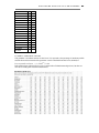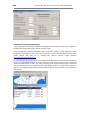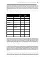
1
Water Allocation Impacts On River Attributes (Version 2.0)
N AT I O N AL I N S T I T U T E O F WAT E R & AT M O S P H E R I C R E S E AR C H L T D
USER MANUAL & HELP FILES
Ian Jowett
Sandra Kingsland
Kevin Collier
PROGRAMMING
Ian Jowett & Jane Hill
MODEL DEVELOPMENT
Ian Jowett, Graham McBride & Kit Rutherford
PROJECT CO-ORDINATION
Kevin Collier
Prepared for Ministry for the Environment
Information containedwithin this report
shouldnot beusedwithout theprior consent of the client
NIWA
PO Box 11-115
Hamilton, New Zealand
Telephone +64-7-856-7026
Fax +64-7-856-0151
NIWA Client Report No. HAM2003-163
June 2004
Project No. MFE03201
This system developed under Sustainable Management Fund (SMF) contracts 9002 and 2204 . This is
in the public domain as per schedule B, section 4 of those contracts. Additional development was also
funded by ARC in addition to the above are copyright to ARC. NIWA retains copyright of code,
models etc. which NIWA brought into the project.
Funding for the development of WAIORA 1.0 (the prototype version) and version 1.1 was provided
by the Auckland Regional Council (ARC) and the Ministry for the Environment (MfE). The
extensions in this version (Version 2.0) were funded by MfE in association with the Auckland
Regional Council, Hawkes Bay Regional Council, Wellington Regional Council, Environment
Waikato, and Environment Southland.
Ian Jowett, NIWA, P.O. Box 11-115, Hamilton, New Zealand, Telephone +64-7-856-1793, Fax +64-7856-0151, email [email protected].
!
NIWA 2004: WAIORA Version 2.0. National Institute of Water and Atmospheric Research Ltd.,
Hamilton.
"
!
#
$
Hoteo River at Gubbs, Auckland.
%&'%&(
%&
"
&
%
)
!
!
!
+
$
*
+
)
)
!
'&& %
(&
(
&'"
,
-
,
!
,
!
.
/
0
1!
2
3
!
!#
!
4
(%
5
" & 6 ('
5
))
/
!
*
1$
&
!
).
(('((1'%&
)0
" &
)2
7!8 !
! !
!
"
#
&
! !
:,
! !
,)
%1'%& /
&%
!
)
! !
!
/
(
! !
9
'%
'
)5
!
"'/ %'(
'33' &
3 3/
!8 !
!
#
7 % '(
,,
,,
!
"
,:
.:
9
.2
!
.4
(
!
0.
(
!
05
& !
2
'3' '% '(
2:
$$'%" ;
20
3' &
'( %
<
!
20
<!
!#
*
20
1'% (
22
25
'
!
4)
*
4
4:
=
4,
&7'
%"
( 3' &
'(
4,
% &
%&
!
!
"
"
&
%
)
& %
* +
The Revised Dictionary of Modern Maori (Ryan 1989) defines WAI as the word for water and ORA the
word for life, well, full and alive. Combined, WAIORA is the Maori word for health but it also means a
fountain or well. Fountains and wells are considered good/healthy/sacred to the Maori people as the water
from these two sources is considered pure and therefore fit for human and animal consumption (Dean Grace
pers. com.). As an acronym for the computer package, WAIORA stands for Water Allocations Impacts On
River Attributes.
!
+
WAIORA Water Allocation Impacts on River Attributes, is a decision support system designed to provide
guidance on whether a flow change could have adverse impacts on the following environmental parameters:
Dissolved Oxygen, Total Ammonia, Water Temperature and Habitat for aquatic life.
WAIORA uses information on stream geometry and numerical models to estimate the effects of flow on
these parameters, and compares the predictions to environmental guidelines that can be specified by the user
to determine if an adverse effect is likely to occur. A number of assumptions have been made during model
development and these are detailed in this manual and Help Files. The outputs of
WAIORA reflect the nature of these assumptions and the quality of the data entered by the user. The models
are better at predicting the relative amount of change associated with flow scenarios than at predicting
absolute changes. Some guidance on the expected accuracy of models and “comfort zones” associated with
guideline thresholds is provided in the Help Files and the Summary Plots.
WAIORA provides:
•
•
information on environmental criteria that can be used;
predictions of the absolute and relative change associated with a flow change and whether
specified environmental guideline thresholds are exceeded;
where possible, predicted effects of avoidance/mitigation options and
•
an audit trail of the procedures followed.
To use WAIORA you should:
have knowledge of the existing stream conditions above and below the proposed abstraction, and
either collect data from two site visits to assess changes in habitat or carry out a more detailed
instream habitat survey and calibration using RHYHABSIM.
% &
$
"
&
%
!
WAIORA is a decision support system that can be used to assess the effects of flow changes on instream
habitat, water temperature, dissolved oxygen concentration and ammonia concentration. WAIORA applies
to a section of river, along which the stream conditions (e.g., geometry, flow, gradient, shade, and aquatic
flora) are reasonably consistent.
The steps in the assessment process are:
1. select parameters to evaluate (stream geometry is required for all)
2. data collection
3. calibration (water temperature and DO models)
4. calculation of effects
5. evaluation of effects
The quality and scope of the stream habitat survey data will determine the reliability of the results,
particularly the degree to which you can extrapolate beyond the flows that were surveyed. Two levels of
survey are available. For quick assessments, stream widths and depths can be measured at two flows in at
least 3 locations in each habitat type (e.g., pool, run, and riffle). Stream habitat is then estimated assuming
logarithmic hydraulic relationships (Jowett 1998). In cases where you want to extrapolate to flows higher or
lower than those surveyed, cross-section data can be collected and calibrated in RHYHABSIM. The normal
procedure is to survey at least 5 cross-sections in each habitat type (e.g., pool, run, and riffle) and remeasure
water levels at least two other flows.
Calibration data can also be collected for water temperature and dissolved oxygen models. These calibration
data should be collected at times of maximum stress, normally mid summer. DataSondes can be deployed to
measure diurnal variation in water temperature and dissolved oxygen concentration and inexpensive
temperature loggers are available. Water temperatures are required at both the start and end of the section of
river for calibration of the water temperature model. Although it is possible to model water temperature and
dissolved oxygen without calibrated models, calibration is desirable to calculate appropriate parameters and
coefficients for the dissolved oxygen models and to set appropriate initial water temperatures for the water
temperature model.
Once the models have been calibrated, WAIORA calculates how instream habitat, water temperature, and
dissolved oxygen and ammonia concentrations vary with flow and displays the values of these parameters
for the index flow and the new flow that will result from the proposed abstraction or flow discharge.
1! !
8>
#
The evaluation of the effect of flow change on habitat, temperature, oxygen and ammonia is the final and
most difficult step in the WAIORA process.
Although WAIORA provides some guidelines for this evaluation process, but it is not possible to provide
guidelines for all situations. This is because instream flow management is a complex process, usually
involving a combination of technical, public, and legal considerations. To be effective, the instream flow
management process should consider the present status of the river and its ecosystem, and then, in
consultation with public and institutional organisations, set goals and objectives before establishing
appropriate flow requirements.
Conventionally, we recognise instream values and instream uses - those that are associated with water that is
flowing in a channel - and out-of-stream values and uses - those that are enjoyed when the water is taken
from the channel for use elsewhere. The "social, economic and cultural" values referred to in Section 5 of the
% &
"
&
%
:
Resource Management Act (RMA) may be either instream or out-of-stream values. For example, water used
for irrigated agriculture has out-of-stream value, whereas the water used by a commercial rafting enterprise
has instream value. The attributes listed in Sections 6 and 7 of the RMA generally are instream values.
WAIORA helps to quantify the requirements of instream uses in terms of water quality and hydraulic
parameters. The two volumes of Flow guidelines for instream values (Ministry for the Environment 1998)
provide a very much more comprehensive coverage than is possible here.
A basic principle established in the Flow guidelines is that instream values and their requirements must be
identified and appraised within the context of definite Instream Management Objectives. Resource
management objectives have been defined by regional councils in their various regional policy statements,
and an increasing number of councils are developing more specific objectives in regional or catchment water
resources management plans.
An important decision is the level at which instream values are to be maintained. Where there are established
water quality standards, such as for dissolved oxygen and ammonia, this is relatively simple. However,
acceptable levels of instream habitat and even water temperature are more difficult to decide. The Flow
guidelines suggest that the level of maintenance should reflect the merits of instream values in a particular
river - the quality of a recreational fishery, the biological diversity of a stream ecosystem, the conservation
status of a breeding bird population on a river bed, the proximity to a large population centre of a kayaking
river, the availability of alternatives or means of mitigation, etc.
,
(
'&& %
(
(&
%
&'"
-
Before you install WAIORA make sure your computer meets the minimum hardware and software
requirements:
•
•
•
Any IBM compatible machine with an 80486 processor or higher.
A hard disk with a minimum of 3 megabytes available space for a full installation.
Windows 98 or higher.
WAIORA will not run properly if your computer does not meet these requirements.
!
WAIORA is installed simply by creating a directory such as c:\Program Files\WAIORA and then copying
the files WAIORA.EXE, WAOIRA2.HLP, and WAIORA2.CNT into it.
The programme METDATA.EXE, and its associated data file METDATA.FDA, is an accessory that shows
a map of New Zealand with the distribution of climate recording sites, the data that are collected, and the
period of record (until December 2003).
You can make the program accessible by:
CR E AT I NG A WAI O RA S HO RT CUT
)
Run Windows Explorer (Choose Start Menu | Programs | Windows Explorer).
Choose the directory that contains the WAIORA program (e.g., c:\Program Files\WAIORA).
Click on WAIORA.EXE with the right button and select Copy.
:
Move the mouse cursor so that it over the desktop or Quicklaunch bar, click the right button,
and select Paste shortcut.
,
Alternatively, click on WAIORA.EXE and then drag it over to the desktop or Quicklaunch bar.
(
%
.
Desktop showing the WAIORA icon on the desktop
and in the Quicklaunch bar.
!
To uninstall WAIORA simply delete the program directory (normally C:\Program Files\WAIORA and any
directories and database files (WAIORA.MDB) that you have created.
0
(
%
/
FIR ST LOGIN
The first time that WAIORA runs,
the WAIORA Microsoft Access
database (WAIORA.MDB) will
not be found and you will see the
following message:
Don’t worry!
For a new installation press Create
and
a
new
database
(WAIORA.MDB) will be created
in the directory that you select. If
you subsequently run WAIORA,
and you receive the message
“database .. not found” as above, you can Locate the appropriate directory. Alternatively, you can create
WAIORA databases in different directories and select the appropriate directory (Options/Select database) for
any stream evaluation.
After the new database is created, you are then given
instructions on how to proceed:
1. Login as ANONYMOUS
2. Add yourself as user
3. Login as user
4. Set up catchment database
5. Start stream evaluation process.
1. Select Anonymous from the User name drop-down box.
2. Click the OK button.
Some features of WAIORA are limited when you are an
anonymous user. For example, an anonymous user cannot edit
or delete records belonging to other users and database access is
restricted. Therefore, you should add yourself as a user (File/Add
User) when logged on as ANONYMOUS and then login
(File/Login) under that name.
AD D I NG A N E W US E R
Any user may register a new user (with a name of 3 characters or
more that is not already registered). To add a new user:
1. Select Add User… from the File menu (ALT+F+U).
2. Enter the new user name in the User name text box of the Add
New User dialog window.
(
%
2
3. Click the OK button or push ENTER.
N O R MAL L O G I N
Once WAIORA has been run for the first time, the user is
prompted to enter a user name when the program is started. The
last user will be displayed as the default. To continue:
1.
2.
If the correct name is not displayed, select your user name from
the User name drop-down list box
Click the OK button or push ENTER.
1!
This section describes the elements of the main window. These help you manoeuvre/navigate around
WAIORA. Many of the elements are consistent with windows applications, such as a control-menu box, the
title bar and menus (see the section on Windows Features in WAIORA).
When you are running WAIORA your work takes place on a surface similar to a desktop, (the screen space
WAIORA occupies). On this surface, you can move work items (windows) around, open new windows and
remove those you do not need.
When WAIORA is started the Main Window appears (shown here).
4
3
(
!
%
!# !
The flow chart, located at the far right of the main window, allows the user to visually
identify where the currently active window is relative to the other windows
Any open windows will be depressed, while all other unopened windows will be raised. The
active window will have a bold border. Any unavailable windows will have grey text rather
than black. All windows are unavailable if there are no records open.
To access the next window the user can either press the Next button on the active window or
press the subsequent button on the flow chart navigator.
In the example shown here, the Location Information, Impact Assessment and Data
windows are open with the Data window being the focus (active). The Summary Plots,
Summary Results and Audit Trail windows are not available until data has been entered.
The Guidelines window is unavailable and cannot be accessed until the appropriate check
box has been activated in the Impact Assessment window.
The Exit button allows the user to close the program.
(
5
%
(%
The previous section outlined the basic functionality of the program. This section presents each of the
windows in WAIORA and describes more fully how to use this package.
"! !8!
The WAIORA database (WAIORA.MDB) is a Microsoft Access database that contains information on
users who have been added to the database, catchment, stream, location, and flow change information, as
well as the records of impact assessments. Catchment, stream, site, location and flow change details are
stored in the WAIORA database and can be accessed from the View/edit database on the Database menu.
The catchment, stream, location, and flow change information can be edited directly under the database
menu. Records of stream assessments are retrieved and saved under the File menu, as described previously.
The Database Access window (shown here) enables users to view database records and sort records by
columns. The database file (WAIORA.MDB) also contains information on registered users, guidelines,
evaluation data and audit trail information.
Grids display tabled
WAIORA database.
information
from
the
)
(
%
To adjust the Column Width, select the column whose width you want to adjust and drag the border at the
right of the column heading until the column is the width you want.
Registered users may add, edit and delete catchment, stream, site, location, and flow change details and load
and save them from or to a csv or xls file. Note: import and export of xls files is only supported when
Microsoft Excel is installed.
AD D I NG A N E W D AT AB AS E E NT R Y
)
:
,
Select the table to which you want to
add the new record.
Select the New Record button or push
ALT+N.
Enter the new information into the text
boxes and drop-down list boxes
provided.
Accept the entry by selecting the Save
button or by pushing ENTER.
When a catchment is chosen from the dropdown list provided, the streams provided are
limited to those located within the selected catchment.
E D I T I N G A D AT AB AS E E NT R Y
)
:
,
Select the table and record that you
want to edit.
Select the Edit Record button or push
ALT+E.
Enter the amended information into
the text boxes and drop-down list
boxes provided.
Accept the changes by selecting the
Save button or by pushing ENTER.
For the site and location tables, when a
catchment is chosen from the drop-down list
provided, the streams provided are limited to those located
within the selected catchment.
D E L E T I N G A D AT AB AS E E NT R Y
)
:
,
Select the field that holds the record you want to delete.
Select the record you want to delete.
Select the Delete Record button or push ALT+D.
Accept the deletion by pushing the Yes button on the
Confirm dialog window or selecting Y on the keyboard.
(
) )
%
All other records that refer to this record will also be deleted.
For example, if you delete a catchment, all streams, locations,
and flow change details in that catchment will be deleted.
L O AD I N G D AT AB ASE F R O M F I L E
Database information can be loaded directly into the WAIORA database from a comma delimited (.csv) file
or and Excel spreadsheet (.xls) by selecting Database/Import database from file or pressing ALT+D+I. Note:
import and export of xls files is only supported when Microsoft Excel is installed.
The file requires headings and should be in the following order, but they are not case sensitive. All headings
must be present but entries can be blank. The headings are:
Catchment number
Catchment name
Stream number
Stream name
Location reference
Location name
Index flow
Flow statistic
Flow data source
Flow change description
Abstraction rate
An example spreadsheet is:
Catchment Catchment Stream Stream
number
name
number name
Location
reference
Location Index Flow
Flow data Flow change Abstraction
name
flow statistic source
description rate
434567
Waikato
434002
Waipa
Z34:456765 Te Kuiti
432000
Awakino
567003
Makatinui D45:642896 Farm
145
90
malf
123
35
New One
50
Database entries are checked as they are added to the database to ensure that flows and abstraction
rates are valid numbers and that catchment and stream numbers are unique.
Saving the existing database to a file is the reverse procedure.
In WAIORA, a record holds location information, impact assessment information, data and environmental
guidelines for a given scenario. This allows the user to retrieve previously run scenarios and modify settings
if desired.
CR E AT I NG A NE W R E CO R D
7 8
•
From the File menu on the main WAIORA desktop, select New Record with the mouse
or press ALT+F+N.
This action opens a blank Location Information form (shown below). The user is then able to select an
existing Catchment and Stream. These must already exist in the Database. To add a catchment and stream to
the database, select Database then View/edit database or press ALT+D+V. The location reference (usually a
map reference) and name can be entered directly or selected from those already in the database. The
Location reference is mandatory. The catchment, stream, and location names can be specified as
<Unknown>, if required. The value of the index flow must also be specified because this is the baseline for
impact assessment. A flow change description is also required. All other fields are optional, although a
default abstraction/discharge of 0 will be used.
)
(
%
If a record is open, the user is unable to open a new record without closing the original first by selecting
File/Close record or pressing ALT+F+C.
S E L E CT I NG AN E X I ST I NG R E CO R D
7 8
)
:
From the File menu on the main WAIORA desktop, Select Record or press ALT+F+S.
This action opens a window that lists all records that have been saved in the database.
Select a record you wish to open using the scroll bar and mouse, the PAGE UP and
PAGE DOWN keys or the UP and DOWN ARROW keys. The selected record is
highlighted in blue.
Select the Open button or press ENTER.
(
%
) :
The Sort button allows the user to sort saved records by one or two fields. Fields are chosen from the dropdown lists provided on the Sort Records dialog window.
If a record is open, the user is unable to open another existing record without closing the current record first.
CL O SI N G A R E CO R D
7 8
•
From the File menu on the main WAIORA desktop, select Close Record with the
mouse or press ALT+F+C.
This must be done before another record can be opened. If the record has not been saved the user is
prompted to save it.
D E L E T I N G A R E CO R D
7 8
)
:
From the File menu on the main WAIORA desktop, select Delete Records… or press
ALT+D. This action opens the Delete Record window.
Select a record you wish to delete using the scroll bar and mouse, the PAGE UP and
PAGE DOWN keys or the UP and DOWN ARROW keys. The selected record is
highlighted in blue.
Selected the Delete button or press ENTER.
) ,
(
%
If a user is logged in as anonymous, the delete option is unavailable. Registered users are only able to delete
records created by themselves.
The Sort button allows the user to sort saved records by one or two fields. Fields are chosen from the dropdown lists provided on the Sort Records dialog window. This option is not available while a record is
currently open.
'
/
!
*
/
&
%
' 3 3 '
& (
3
3 /
7
%
' (
) .
!
Location, flow, and flow change information is entered into the Location Information window shown here.
/
!
The user can select any catchment and stream that already exist in the Database. To add a catchment and
stream to the database, select Database/View/edit database or press ALT+D+V. The catchment name and
stream name must be selected from the drop-down lists. If unknown, <Unknown> can be chosen from the
list.
The location reference (usually a map reference) and name can be entered directly or selected from those
already in the database. The Location reference is mandatory and can either be chosen from the drop-down
list or typed in. If the user selects a known location with the dropdown box, the flow and flow change details
of that location will be displayed. These details may then be changed by the user. The location name is not
required but can be used to identify assessments that are made at the same location.
3
*
!
The Index flow must also be provided by the user because it is used as a baseline for impact assessment.
There are several index flow information statistics available. The user can choose from the drop-down list,
leave them blank, or type in information.
WAIORA recommends the use of the 1-day median annual low flow (MALF). Estimates of MALF can be
derived from a flow recorder at the location or by correlation with records at other locations. Local
hydrological recording authorities should be contacted for these analyses. Several national methods
(Hutchinson 1990; Pearson 1995) of deriving estimates of 5-year low flow and mean annual low flow have
) 0
'
/
&
%
' 3 3 '
& (
3
3 /
7
%
' (
been derived. These can be used in the absence of flow information or flow correlations for the site. Methods
of low flow estimation based on GIS data are being developed.
3
!
!
The user must also to enter a description of the flow change that is being assessed and the proposed
abstraction or discharge. Note: At this stage, the rate (in litres per second) can be either the removal of water
from the river or the addition of water to the river and the value is always positive.
!
!
The Impact Assessment window allows the user to enter assessment details.
(
!
The user can evaluate the parameters for the index flow (evaluate status quo) or can compare the assessment
status for the index flow to that with the new flow (less than the index flow where water is abstracted and
greater where water is discharged).
$! !
*
#! !
The four categories below are available to the user to be evaluated.
'
•
•
•
•
/
&
%
' 3 3 '
& (
3
3 /
7
%
' (
) 2
Habitat
Water Temperature
Dissolved Oxygen
Total Ammonia
For each of the parameters selected WAIORA will predict the magnitude of change associated with the new
flow and the relative change. The assessment of total ammonia uses data from the habitat and temperature
assessment so all three categories are automatically selected when you click Total Ammonia. Similarly,
habitat and water temperature data are used in the assessment of dissolved oxygen, and will be automatically
selected when you click on dissolved oxygen.
*
#
!
To identify whether an new flow exceeds environmental
guidelines, the user will need to specify guideline thresholds.
To specify environmental guideline thresholds tick the check box (shown here). When unchecked, the
Guideline window is unavailable.
"! !
The data window shows data tabs for each of the categories that were selected in the previous window. In
the example below, habitat, water temperature, dissolved oxygen, and total ammonia were all selected.
The user enters data into the active edit boxes. If the user holds the cursor over an edit box, an additional
description of the edit box will appear. Pressing F1 while in the edit box will open the help file at the page
that describes the appropriate parameter and operation.
All data are recorded in the Audit Trail, along with an assessment of the status of the data used in the impact
assessment. The status is shown in the checkbox to the right of an edit box. When the checkbox is first
displayed, it contains the default data and there is a red tick in the checkbox. When the user changes the
default value, the tick disappears from the checkbox to indicate that the value is a guesstimate. If confident
) 4
'
/
&
%
' 3 3 '
& (
3
3 /
7
%
' (
about a value, the user should click the checkbox and a blue tick will appear to indicate that the data value is
reliable.
Default values for the data sheet currently displayed can be restored by pressing F9. Values that have been
entered in all of the category tabs can be saved as default values by selecting Options/Default data/Save
current values.
The habitat, water temperature, dissolved oxygen, and ammonia models in WAIORA are all single station
models, in that it is assumed that they apply to a single reach along which there is negligible variation in
stream conditions.
'
7!8 !
/
&
%
' 3 3 '
& (
3
3 /
7
%
' (
) 5
!!
Habitat data are required by all evaluation categories. Habitat data can be entered in two ways. Either by
measuring the average stream depth and width at two flows, flow 1 and flow 2. Note that the mean depth
mean is entered for the first measurement at flow 1, but the mean stage change is entered for the second.
This is because it is not necessary to measure the average depth on the second visit. In fact, it is more
accurate and easier to install temporary staff gauges in the stream and measure the change in water level
between flow 1 and flow 2.
The temporary staff gauge can be a survey stake, reinforcing rod, or waratah driven into the streambed. The
cross-section should be clearly identified so that the site can be found easily on a return visit. The temporary
staff gauge should be placed so that any change in water level in the main channel is reflected by changes on
the gauge. Usually the gauge should not be in very shallow water near the stream edge where local
obstructions can cause localised water level differences. If the gauge is likely to be disturbed, the top of the
gauge can be referenced to a datum peg driven to ground level on the bank.
Repeat measurements of stream width should be taken at exactly the same location. The two flow and level
measurements should be sufficiently different to define the change in level with discharge accurately. A
change in level of 25 mm or 15% change in flow is a minimum. When taking repeat measurements of either
width or water level, record the second set of measurements on the original data sheet and check that any
change in width or level is consistent with the earlier measurements and with other measurements in the
reach.
All data fields, except the date fields, must be entered if the “Specify survey data at two flows” button is
selected. Data status checkboxes are not shown with habitat data because it is assumed that these data are
measured and therefore reliable.
D AT E
Date 1 and Date 2 are the dates in the format dd/mm/yy on which the measurements of average stream
width, depth and flow were carried out. It is not necessary to specify these dates but they do record
information that is useful for checking and audit purposes.
F LO W
Flow should be gauged at the best flow measuring site in the reach. Usually the change in level for flow is
relatively consistent along a stream and is controlled by the reach geometry, particularly riffles. Flow
measurements should be to high accuracy (3%). Normal gauging standards should be used with 20
measurements of velocity and depth across the section, 40 second counts, and measurements of velocity at
more than one point in the vertical in deep water or where the vertical velocity distribution is not uniform.
The accuracy of predictions made from a survey will decrease if the flow impacts that are being examined
are for flows that differ greatly from the flows at which the measurements are made. Thus, it is better to
limit the amount of extrapolation from measured flows by making measurements at a flow that is close to the
flow of interest, usually low summer flow.
WI D T H
The stream width (metres) is the water surface width and excludes islands and any protruding items, such as
boulders. Ideally, stream depths and widths should be measured in as many locations as possible. Five cross-
'
/
&
%
' 3 3 '
& (
3
3 /
7
%
' (
sections in runs would be a minium requirement, and three cross-sections in pools, runs and riffles (total of
9) would give a better measure of the stream average.
ME AN D E PT H AN D S T AG E CHANG E
The mean stream depth (metres) is the best possible estimate of average stream depth, and is best calculated
as the cross-section area divided by the water surface width. The mean stage change is the average change in
water level that occurred when the flow changed from flow 1 to flow 2. It is best measured by installing
temporary staff gauges at each of the cross-sections and measuring the height of the water surface below the
top of the gauge at flow 1 and flow 2, subtracting these 2 readings and averaging to give the mean stage
change. The mean stage change is always entered as a positive number and it is assumed that the water level
falls as the flow reduces, and vice versa.
In situations where multiple readings are made in the field and an average value is required, the user can
access a data entry window by pushing the averaging button. The user is then able to enter up to five values
in the Enter values window (shown here). These values are automatically averaged and entered into the
Data window once the user pushes the OK button.
I NS T R E AM HAB I T AT S UR V E Y
To use instream habitat survey data instead of widths and depths surveyed at two flows, select the “Use
instream habitat survey” button and then press the Habitat file button. This will display a file open dialog in
which you select the folder and file that you want to use to describe the stream geometry and habitat . This
file must be a calibrated instream habitat model produced by RHYHABSIM. The survey and calibration
procedures in RHYHABSIM mean that this will be a more accurate reflection of the stream geometry and
will give better predictions of stream width, depth and velocity than the two flow method when predicting
beyond the range of flow 1 and flow 2 (Jowett 1998).
'
!
!
/
&
%
' 3 3 '
& (
3
3 /
7
%
' (
)
!!
Water temperatures may affect aquatic systems in many ways, ranging from acute lethal effects, to
modification of behavioural cues, to chronic stresses, to reductions in overall water quality. Water
temperature modelling is included to help predict the consequences of stream manipulations, either flow or
shade, on water temperatures.
Water temperature data (above) describe the meteorological, hydrological, shading and streambed
conditions. The model is a one-dimensional heat transport model that predicts the daily mean and maximum
water temperatures from the abstraction point as a function of stream distance downstream and
environmental heat flux. In general terms, WAIORA calculates the heat gained or lost from a parcel of water
as it passes through a stream segment. This is accomplished by simulating the various heat flux processes
that determine that temperature change (see figure below). These physical processes include convection,
conduction, evaporation, as well as heat to or from the air (long wave radiation), direct solar radiation (short
wave), and radiation back from the water. WAIORA first calculates the solar radiation and how much is
intercepted by shading. This is followed by calculations of the remaining heat flux components for the
stream segment.
'
/
&
%
' 3 3 '
& (
3
3 /
7
%
' (
The heat transport model tracks heat and water fluxes downstream. It assumes that mean daily temperature
and radiation data can be represented by sinusoidal variation about the average, and that other
meteorological and hydrological variables can be represented by average values.
Water temperatures are modelled downstream of the abstraction point. The water flowing downstream will
then increase or decrease in temperature until a dynamic equilibrium is established between the diurnal
pattern of incoming radiation and the diurnal heat losses from the river through radiation and evaporation.
This final state, when there is no further change in the diurnal variation of water temperature with distance
downstream, is known as the equilibrium condition. The magnitude and rate of change in water temperature
will depend on meteorological conditions such as radiation, air temperature, shade and flow.
Air temperatures, solar radiation, wind velocity and relative humidity should be measured for accurate water
temperature model calibration. These meteorological parameters may be obtained from the National Institute
of Water and Atmospheric Research for a meteorological station near your site.
Limitations/assumptions:
•
The characteristics of the selected reach represent the characteristics of a longer section of river and
do not change with lateral inflow.
•
The model does not handle rapidly fluctuating flows.
•
Turbulence is assumed to thoroughly mix the stream vertically and transversely (i.e., no
microthermal distributions).
R E ACH L E NG T H
The reach length, specified in metres, is the length of the stream that is being evaluated for changes in
habitat, water temperature and dissolved oxygen. It is assumed that the hydraulic geometry (flow, stream
width, depth, and velocity) and other characteristics, such as meteorology, shade, and steam bed conditions,
are constant along the reach. Water temperature and dissolved oxygen concentration apply to the end of
reach, whereas habitat conditions apply throughout the length of the reach.
Because water temperature usually increases with distance downstream until the equilibrium temperature is
reached, the reach length should usually be long enough to ensure that the equilibrium temperature is
reached. The variation in water temperature with distance below the abstraction point can be viewed to
determine an appropriate reach length. The exception to this would be when the reach is close to the sea or
when a large tributary joins the river below the abstraction point.
'
/
&
%
' 3 3 '
& (
3
3 /
7
%
' (
:
AI R T E MP E R AT UR E
All temperatures are in degrees Centigrade. Daily means are usually the average of the daily maximum and
daily minimum temperatures. The daily maximum/minimum air temperature is usually the
maximum/minimum recorded on a max/min thermometer over a 24 h (9am to 9am) period.
Air temperatures should be measured for accurate water temperature model calibration. This and the other
meteorological parameters may be obtained from the National Institute of Water and Atmospheric Research
for a meteorological station near your site.
The adiabatic lapse rate can be used to correct for elevation differences:
Ta = To + Ct * (Z - Zo)
where Ta = air temperature at elevation Z (°C)
To = air temperature at elevation Zo (°C)
Z = mean elevation of stream (m)
Zo = elevation of met. station (m)
Ct = moist-air adiabatic lapse rate (-0.00656 °C /m)
NOTE: Air temperature, radiation, and shade are usually the most important factors in determining water
temperature.
Temperature
recording sites
Daily maximum air temperature (°C) from selected sites. Data are monthly averages of daily maxima for the
1971-2000 period for locations having at least 5 complete years of data.
Location
JAN FEB MAR APR MAY JUN JUL AUG SEP OCT NOV DEC
KAITAIA
23.9 24.5 22.9 20.8 18.5 16.3 15.6 15.7 16.8 18.1 19.6
WHANGAREI
24.4 24.2
AUCKLAND
23.3 23.7 22.4
TAURANGA
23.9 23.8 22.3 19.9 17.1 14.9 14.3 14.9 16.3
HAMILTON
23.8 24.3 22.7 19.9 16.6 14.1 13.6 14.6 16.2 17.9
ROTORUA
23
23
23
20.4
20
18
16
17.4 15.2 14.5
21.1 18.3 15.1 12.6 12.1
15
13
16.2 17.8 19.6 21.6
18
14.7 16.7
GISBORNE
24.9 24.2 22.6 19.9 17.1 14.7 14.1 14.9 16.8
TAUPO
23.3 23.3 20.9 17.6 14.1 11.8 11.2 12.1 14.1 16.5
NEW PLYMOUTH 21.8 22.3 21.1 18.7
16
14
22
15.1 15.6 16.8 18.3 20.6 22.6
13.3 13.9
15
19
20
21.9
20
22
19
20.9
21.3 23.3
19
21.3
16.3 18.1 19.9
,
'
/
&
%
' 3 3 '
& (
3
NAPIER
24.4 24.1 22.6 19.9 17.1 14.5 14.1 14.8 16.9 19.2
WANGANUI
PALMERSTON
NORTH
22.4 22.7 21.3 18.8
MASTERTON
23.9 23.9 21.8 18.7 15.2 12.8
16
13.8 13.2 13.8 15.3
17
3 /
21
7
%
' (
23
18.8 20.7
22.4 22.9 21.1 18.4 15.3 13.1 12.5 13.3 14.9 16.7 18.5 20.7
19
15.1 17.3 19.5 21.9
11.4
12
13.5
20.3 20.6
NELSON
22.4 22.4 20.8 18.1 15.2 12.9 12.4 13.1 14.9 16.8 18.7 20.5
BLENHEIM
23.8 23.6
19
12
13
WELLINGTON
22
16.7 14.2
12
15.8 13.3 12.8 13.8
20.4 19.5 17.2 14.7
13
16
15
16.6 18.5
18.1 20.1
22
WESTPORT
20
KAIKOURA
20.6
20
18.8 16.6 14.1 11.6 10.9 11.5 13.6 15.3 16.9 19.1
12.6 13.2 14.3 15.3 16.9 18.6
HOKITIKA
19.4
20
18.7 16.7 14.2 12.3
12
12.5 13.9 15.1 16.6 18.1
CHRISTCHURCH 22.5 22.2 20.4 17.8 14.6 11.7 11.3 12.4 14.9 17.4 19.2 21.2
MT COOK
20.3 20.8 17.9 14.5 10.8 7.3
6.4
8.4 11.6
LAKE TEKAPO
21.5 21.6 18.7
5.9
8.1 11.7 14.6
TIMARU
21.1 20.9 19.3 16.6 13.3 10.6 10.1 11.4 14.2
MILFORD SOUND 18.9 19.5
18
15
10.8 6.9
15.6 12.3 9.5
14
16
9.1 11.2 13.1 14.4
16.2 18.2
17
19.3
18.3 19.9
16
17.6
QUEENSTOWN
22.6 22.7 19.9 16.1 11.9 8.6
8.2 10.3 13.5 16.2 18.6 20.7
ALEXANDRA
23.5 23.8 21.5 17.5 12.4 7.5
7.9 11.4
MANAPOURI
20.7 20.8
8.2
DUNEDIN
18.9 18.7 17.2 15.5 12.6 10.2 9.8
11
12.8 14.6 16.1 17.4
INVERCARGILL
CHATHAM
ISLANDS
18.6 18.8 17.2
11
12.9 14.4 15.8 17.5
18
14.6
15
12
8.3
12.2 9.7
9.5
15
17.5 20.2 22.1
9.6 12.6 14.9 16.1 18.9
17.8 18.1 17.1 15.1 12.8 11.1 10.4 10.9 11.8 13.1 14.5 16.5
Daily average air temperature (°C) at selected sites. Data are monthly averages of daily values for the 19712000 period for locations having at least 5 complete years of data
LOCATION
JAN FEB MAR APR MAY JUN JUL AUG SEP OCT NOV DEC
KAITAIA
19.7 20.0 18.6 16.9 14.8 12.7 12.2 12.1 13.1 14.5 15.8 17.9
WHANGAREI
19.9 20.0 19.0 16.5 14.0 12.2 11.2 11.7 12.9 14.3 16.4 18.2
AUCKLAND
19.3 19.8 18.5 16.2 13.7 11.6 10.8 11.3 12.6 14.1 15.8 17.8
TAURANGA
19.2 19.2 17.9 15.4 12.5 10.4 9.7 10.5 12.1 13.6 15.6 17.5
HAMILTON
18.3 18.7 17.1 14.5 11.6 9.4
8.7
9.8 11.4 13.1 15.0 16.8
ROTORUA
17.8 17.9 16.4 13.5 10.5 8.4
7.6
8.7 10.4 12.3 14.3 16.1
GISBORNE
19.2 18.9 17.4 14.8 12.0 10.0 9.3 10.2 11.8 13.8 15.9 17.8
TAUPO
NEW
PLYMOUTH
17.4 17.5 15.6 12.5
17.7 17.9 16.9 14.7 12.1 10.3 9.4 10.1 11.5 12.7 14.4 16.1
NAPIER
19.5 19.3 17.7 15.1 12.1 9.7
WANGANUI
18.2 18.3 17.1 14.7 12.3 10.2 9.4 10.0 11.7 13.3 14.9 16.7
9.6
7.6
6.7
7.6
9.4 11.5 13.6 15.7
9.3 10.0 12.0 14.3 16.1 18.2
PALMERSTON N 17.9 18.2 16.6 14.1 11.3 9.2
8.6
9.3 11.0 12.7 14.3 16.3
MASTERTON
17.8 17.6 16.1 13.3 10.4 8.2
7.5
8.4 10.3 12.1 14.0 16.1
WELLINGTON
16.9 17.1 15.8 13.8 11.5 9.5
8.8
9.2 10.6 12.0 13.4 15.3
NELSON
17.7 17.7 16.1 13.1 10.1 7.7
7.0
8.1 10.2 12.3 14.2 16.2
BLENHEIM
18.2 17.9 16.7 13.7 10.4 7.9
7.4
8.5 10.8 12.8 14.9 16.7
WESTPORT
16.2 16.5 15.7 13.5 11.0 9.2
8.6
9.3 10.7 11.8 13.4 15.1
KAIKOURA
16.7 16.4 15.3 13.3 10.9 8.7
8.0
8.5 10.1 11.7 13.4 15.4
HOKITIKA
15.6 16.0 14.7 12.5 10.0 8.0
7.5
8.2
CHRISTCHURCH 17.4 17.1 15.5 12.8
9.6
6.9
6.6
7.7 10.0 12.3 14.0 16.0
9.8 11.3 12.7 14.3
MT COOK
14.6 14.8 12.5
9.4
6.1
3.0
2.2
3.7
6.6
8.9
10.8 12.8
LAKE TEKAPO
15.2 15.1 12.7
9.5
6.0
2.5
1.7
3.4
6.6
9.1
11.1 13.3
'
TIMARU
MILFORD
SOUND
/
&
%
' 3 3 '
16.2 16.0 14.7 11.9
8.6
& (
3
3 /
6.0
5.7
6.8
9.4 11.2 13.4 15.1
14.7 15.0 13.5 11.2
8.3
5.7
5.2
6.7
8.5 10.1 11.7 13.4
QUEENSTOWN 16.7 16.6 14.4 11.1
7.6
4.6
4.1
5.8
8.6 10.9 13.0 15.1
ALEXANDRA
17.1 17.1 15.1 11.3
7.0
2.9
3.0
5.5
8.9 11.5 13.9 16.0
MANAPOURI
14.5 14.3 11.8
9.2
7.2
4.2
3.9
4.7
7.1
DUNEDIN
15.2 15.1 13.7 11.9
9.2
7.0
6.5
7.5
9.3 10.9 12.4 13.9
INVERCARGILL 14.0 13.9 12.5 10.4 8.0 5.6
CHATHAM
ISLANDS
14.7 15.1 14.2 12.5 10.2 8.7
5.2
6.4
8.3 10.0 11.3 13.0
8.0
8.5
9.3 10.5 11.8 13.7
9.4
7
%
' (
.
10.3 12.8
R AD I AT I O N
The daily total radiation is one of the most important factors affecting water temperature. Daily total
radiation is highest in mid-summer and lowest in winter, and is measured in units of megajoules per square
metre.
The intensity (or rate) of radiation is usually expressed in (W/m2). One watt is equal to one joule of work per
second. A megawatt (MW) is the same as 1000000 watts. One langley/min is equivalent to 697.3 W/m2 or
697.3 J/sec/m2.
Radiation is usually measured continuously with a pyrometer as a rate in MJ/sec/m2 or MW/m2. This is
integrated over the day to give the daily total radiation in MJ/m2.
Global radiation
recording sites
Daily total radiation (megajoules/square metre) from selected sites around New Zealand. Data are monthly
averages of daily totals for the 1971-2000 period for locations having at least 5 complete years of data.
Location
Jan Feb Mar Apr May Jun Jul Aug Sep Oct Nov Dec
KAITAIA
21.7 19.4 16.4 11.6
8.5
7.0
7.7 10.1 13.5 16.9 19.9 22.1
WHANGAREI
20.8 18.4 15.5 11.3
8.4
7.1
7.4 10.3 13.7 16.9 18.8 20.4
TAURANGA
23.0 20.2 16.4 11.4
8.1
7.0
7.1
9.8 13.7 17.2 20.4 22.6
ROTORUA
22.5 19.6 16.0 11.1
8.0
6.3
6.7
9.4 12.9 16.6 19.5 21.6
AUCKLAND
23.1 20.1 16.0 11.7
8.3
6.6
7.9 10.0 13.8 17.5 20.9 23.1
HAMILTON
21.7 19.2 15.8 11.1
7.7
6.2
6.7
9.0 12.7 15.9 19.9 22.0
NEW PLYMOUTH 23.2 20.9 16.3 10.8
7.6
6.1
6.7
9.7 13.0 16.7 20.9 22.6
0
MASTERTON
'
21.7 19.0 15.2
/
&
%
' 3 3 '
& (
3
3 /
9.7
7.0
5.5
5.9
GISBORNE
22.6 19.4 15.4 10.8
7.9
6.6
6.8 10.0 13.9 18.5 20.7 23.0
NAPIER
PALMERSTON
NORTH
22.1 19.4 15.5 10.8
7.8
6.3
6.8
9.7 13.6 18.4 20.8 22.5
21.9 19.2 14.7 10.1
6.8
5.2
5.9
8.4 11.8 15.7 19.0 20.9
WELLINGTON
23.6 19.9 15.1 10.3
6.6
4.9
5.7
8.1 12.3 16.9 20.9 22.6
WANGANUI
23.8 21.5 15.6 10.9
7.7
6.1
6.9
9.3 13.3 17.1 21.2 23.7
WESTPORT
20.9 18.7 14.5
9.2
6.5
4.8
5.7
8.2 11.6 14.4 19.5 20.0
HOKITIKA
20.7 18.1 13.8
9.2
5.8
4.5
5.3
7.7 11.5 14.9 19.2 20.5
NELSON
23.4 20.5 15.6 11.2
7.6
5.7
6.2
8.8 13.2 17.2 21.0 22.9
BLENHEIM
23.1 19.8 15.9 11.1
7.5
5.8
6.5
9.0 12.9 17.5 20.8 22.5
KAIKOURA
21.3 18.7 14.9 10.1
7
%
' (
8.6 12.6 17.0 20.6 22.5
7.1
5.3
6.1
9.1 12.8 17.8 21.1 22.4
CHRISTCHURCH 21.9 18.6 13.9
9.5
6.1
4.6
5.1
7.7 12.1 16.8 20.6 22.2
TIMARU
20.0 17.3 14.4
9.3
6.2
5.5
6.2
8.9 13.0 16.7 20.4 21.2
DUNEDIN
18.5 17.2 12.3
8.1
4.9
3.6
4.5
6.8 11.0 14.3 17.1 18.9
MANAPOURI
21.4 18.5 13.6
8.4
5.0
3.7
4.2
7.2 11.4 15.8 19.9 22.5
QUEENSTOWN
23.9 20.8 15.5 10.2
6.3
4.7
5.7
8.6 13.0 18.0 21.7 24.3
CLYDE
22.2 19.2 15.0 10.0
5.9
4.3
4.7
8.0 12.3 17.5 21.3 22.8
INVERCARGILL
CHATHAM
ISLAND
20.4 17.5 12.6
7.9
4.6
3.6
4.3
7.0 11.1 15.5 19.8 21.5
20.0 16.9 12.8
8.6
5.1
4.0
4.7
7.2 10.9 15.2 18.9 20.7
T I ME O F MAX I MUM T E MP E R AT UR E
The time of maximum temperature is used to describe the sinusoidal variation in air temperature. It is
specified in hours using the 24h clock. This is not a particularly important parameter for water temperature
modelling, but can be relevant for calibration of water temperature models. The maximum air temperature
usually occurs between 14h and 16h.
WI ND V E L O CI T Y
The average daily wind velocity over the water surface in m/s. Readings of wind velocity at meteorological
stations are often higher than those at water surface level. Adjustment of wind velocity (and shade) can be
used to calibrate a water temperature model to known downstream water temperatures. Wind velocity
increases evaporative cooling of water as it flows downstream and in some situations can actually result in
water temperatures decreasing in a downstream direction.
Daily average wind velocity (m/s) and sunshine hours at selected New Zealand sites. Data are mean annual
values 1971-2000.
Location
hours m/s
KAITAIA
5.7
WHANGAREI
5.4
4.2
4.4
AUCKLAND
5.6
4.7
TAURANGA
6.2
4.4
HAMILTON
5.5
3.3
ROTORUA
5.8
3.6
GISBORNE
6.0
4.2
TAUPO
5.4
3.6
NEW PLYMOUTH
6.0
5.6
NAPIER
6.0
3.9
WANGANUI
5.6
5.0
PALMERSTON
NORTH
4.7
4.7
Wind recording sites
'
MASTERTON,
5.2
3.1
WELLINGTON
5.7
6.1
NELSON
6.6
3.3
BLENHEIM
6.6
3.6
WESTPORT
5.0
3.1
KAIKOURA
5.7
4.2
HOKITIKA
5.1
3.1
CHRISTCHURCH
5.8
4.2
MT COOK
4.2
2.8
LAKE TEKAPO
6.0
1.9
TIMARU
5.0
3.3
MILFORD SOUND
4.9
2.5
QUEENSTOWN
5.3
3.3
ALEXANDRA
5.5
1.7
MANAPOURI
4.7
2.8
DUNEDIN
4.3
4.2
INVERCARGILL
CHATHAM
ISLANDS
4.4
5.0
3.9
6.9
/
&
%
' 3 3 '
& (
3
3 /
7
%
' (
2
P O S S I B L E S UNS HI N E HO UR S
This parameter is an indirect measure of cloud cover. It is expressed as the percentage of maximum possible
sunshine hours and is measured with a pyrometer or can be calculated from cloud cover (decimal) as:
Percent possible sun hours = (1 - Cloud(5/3)) * 100
Both sunshine hours and total cloud cover are recorded at New Zealand meteorological sites, but there are
more sites recording total cloud than sunshine hours.
4
'
/
&
%
' 3 3 '
& (
3
3 /
7
%
' (
R E L AT I V E HUMI D I T Y
The relative humidity is specified as a percentage. The relative humidity increases the rate at which heat is
transferred between the air and water, and an increase in humidity will increase water temperature. Correct
for elevation differences by:
Rh = Ro * (1.0640 (To-Ta)) * ((Ta+273.16)/(To+273.16))
where
Rh = relative humidity for temperature Ta (decimal)
Ro = relative humidity at station (decimal)
Ta = air temperature at stream (deg C)
To = air temperature at met. station (deg C)
Humidity
recording sites
Relative humidity (%) at selected sites around New Zealand.
Data are monthly averages of 9am relative humidity for the
1971-2000 period for locations having at least 5 complete years
of data.
Location
JAN FEB MAR APR MAY JUN JUL AUG SEP OCT NOV DEC
KAITAIA
85.1 86.0 84.5 85.4 87.1 88.9 88.7 87.1 85.3 84.3 83.0 83.8
WHANGAREI
80.7 83.6 83.8 86.4 87.4 89.0 88.0 84.6 80.2 81.2 77.9 78.5
AUCKLAND
77.1 78.3 79.0 82.2 85.2 89.0 88.5 85.7 80.2 76.8 76.3 75.9
TAURANGA
74.2 75.9 77.8 80.8 83.0 85.6 83.5 79.8 75.9 76.1 72.0 72.1
ROTORUA
77.9 80.0 80.3 81.9 84.9 85.0 84.9 83.4 79.0 78.4 76.2 78.1
TAUPO
77.1 78.2 79.4 81.6 85.6 87.6 87.5 84.3 80.4 78.4 74.8 76.0
HAMILTON
79.4 82.4 82.4 85.1 88.5 90.2 89.7 87.0 81.5 79.6 78.7 78.8
NEW PLYMOUTH 82.3 83.8 80.4 80.3 83.4 84.6 84.1 82.9 80.4 80.4 77.3 80.7
MASTERTON
67.2 73.0 73.2 75.3 80.4 82.2 79.6 78.1 72.2 70.3 69.2 67.8
GISBORNE
69.6 76.7 75.7 78.2 78.9 80.1 80.6 76.4 71.7 69.9 68.0 66.7
NAPIER
PALMERSTON
NORTH
68.4 73.2 73.6 76.8 77.3 81.0 79.6 77.1 69.9 67.3 66.2 66.3
76.5 78.2 78.2 80.5 85.6 87.7 87.5 84.4 78.9 77.9 76.4 76.6
WELLINGTON
80.3 83.0 81.9 83.3 84.9 87.0 86.3 84.9 81.8 80.9 80.1 80.4
WANGANUI
74.8 78.3 78.1 80.5 83.4 84.7 85.1 82.3 77.5 74.6 73.7 74.1
WESTPORT
82.7 86.2 84.1 84.6 86.5 85.9 83.3 84.2 81.7 83.9 78.8 82.0
HOKITIKA
83.3 86.1 84.3 86.0 87.6 86.6 85.7 83.4 81.7 81.3 80.6 82.2
MILFORD SOUND 90.3 92.3 92.8 94.3 93.9 93.5 93.6 92.3 91.8 90.5 87.9 87.8
NELSON
71.8 75.1 76.4 77.6 80.9 83.2 83.9 81.2 79.6 76.3 72.1 71.5
BLENHEIM
71.2 76.8 76.2 78.0 80.9 82.8 82.7 80.1 75.8 74.8 67.8 67.7
KAIKOURA
74.0 76.1 75.5 73.2 70.5 71.6 69.8 70.4 71.9 72.3 73.4 73.7
MT COOK
73.1 75.9 77.8 79.3 81.3 82.8 82.3 80.6 72.9 70.6 73.2 74.3
CHRISTCHURCH 72.9 79.7 79.0 83.2 85.6 87.0 87.3 85.0 78.7 73.5 71.9 71.5
LAKE TEKAPO
65.4 72.8 74.8 77.6 79.3 84.5 83.4 81.9 73.3 66.6 65.0 65.3
TIMARU
79.0 81.4 78.7 79.7 83.2 84.2 84.6 79.9 78.0 76.0 75.1 76.0
DUNEDIN
73.1 77.0 76.3 77.2 78.0 79.0 80.2 78.1 74.2 71.8 71.4 73.1
MANAPOURI
78.7 84.0 84.5 87.6 88.8 88.9 87.4 89.2 84.9 81.9 76.8 74.7
QUEENSTOWN
71.8 76.0 75.8 78.5 81.3 83.7 82.6 78.1 70.7 71.1 69.9 70.4
'
/
&
%
' 3 3 '
& (
3
3 /
ALEXANDRA
69.8 76.0 76.2 85.0 85.9 88.6 90.5 86.5 75.6 67.8 68.0 68.2
INVERCARGILL
CHATHAM
ISLAND
80.8 83.5 84.3 86.3 86.9 88.4 88.9 86.4 82.2 78.9 78.7 79.0
7
%
' (
5
80.1 83.1 81.7 82.6 84.1 84.3 84.5 83.2 82.9 83.5 80.2 80.3
D AY N UMB E R AN D L AT I T UD E
The day number is the Julian day number with January 1st being 1 and 31 December 365. The day number
and latitude are used to calculate the sun angle (solar elevation) at different times of day and hence the times
at which the stream is shaded by topography or riparian vegetation. They are also used to calculate the time
between sunrise and sunset for the time of year.
E L E V AT I O N
The elevation in metres above sea level at the abstraction point (start of the stream reach to be modelled).
This is used to calculate atmospheric pressure for convection heat flux:
Pressure = 1013 * ((288-0.0065 * Elevation)/288)5.256
S T R E AM S HAD E
Every stream or river is shaded by the banks and surrounding hills and vegetation. Shade has a large
influence on water temperature and it is important to make reliable estimates of stream shade. The shade
angle is estimated as the average angle of sky visible in around the 360 deg horizon. A shade angle of 90 deg
is 100% shading. Shade represents the proportion of the incoming solar radiation that does not reach the
water. The amount of shade can be determined either by a trial and error calibration procedure to a known
downstream water temperature or by measurement where the elevation angles of the trees, banks and/or
hillsides are measured and the fraction of radiation penetrating the canopy estimated.
The topographic angle is the average angle of the tops of hills and other solid objects on the horizon, the
canopy angle is the average angle of the tops of riparian vegetation, and the fraction through canopy is the
fraction of radiation penetrating the vegetation canopy, as shown below.
Ca
no
py
an
gle
ic a
aph
ogr
Top
ngle
The total shade fraction is calculated as topographic shade plus canopy shade.
Topographic shade = 1 - (Cos(topographic angle))0.5
Canopy shade = (1 - Fraction penetrating Canopy) * ((Cos(topographic angle))0.5 - (Cos(canopy angle))0.5)
The canopy and topographic angles are values between 0 and 90, and the canopy angle must always be equal
to (no vegetation) or greater than the topographic angle.
We have found it difficult to estimate shade angles in the field and suggest that shade angles can be varied
(within reason) in the process of calibrating a water temperature model.
S T R E AM B E D
Heat from the water is lost and gained from the streambed. The streambed acts as a long-term buffer or heat
store, effectively damping the response of water temperature to meteorological variations. For this reason,
mean monthly air temperatures can be used as bed temperatures if measurements of ground temperature are
not available.
:
'
/
&
%
' 3 3 '
& (
3
3 /
7
%
' (
In the model, heat is transferred between the streambed and water according to:
Heat transfer = bed conductivity * (bed temperature – water temperature) /bed thickness
An estimate of the bed temperature can be obtained from measurements of ground temperature taken at
climatological stations. If possible, ground temperatures measured at 1.0 m below ground level should be
used. In such cases, 1 m would be the streambed depth. Measurements at lesser depths can be used if 1 m
depth ground temperature measurements are not available.
The conductivity of the streambed (J/m/sec/°C) is often considered to be 1.65 for water-saturated sands and
gravel mixtures. However, the heat transfer process is often more complicated that a simple conductive
model because water flows in to and out of the streambed, thus effectively increasing conductivity. For this
reason, we suggest a default value of 10 J/m/sec/°C.
Streambed temperatures and bed conductivity can also be used to calibrate water temperature models (see
calibration).
Ground temperature
recording sites
I NI T I AL WAT E R T E MP E R AT UR E
The initial water temperature is the temperature of the water flowing into the upstream end of the reach. Its
units are degrees Centigrade. The initial water temperature at the abstraction point can be either specified
directly or calculated from the stream characteristics upstream of the reach by assuming that the water
temperature has reached equilibrium temperature. The initial water temperatures and upstream
characteristics can be specified in Advanced settings. The default assumption is to use the equilibrium
temperature calculated from upstream characteristics that are the same as the reach characteristics. These
assumptions can be altered by selecting Advanced settings. The change in water temperature is then
calculated as the water flows downstream using the sinusoidally varying water temperature at the abstraction
point (beginning of the reach).
By default, the initial water temperature is the equilibrium temperature calculated assuming an infinitely
long upstream channel with a flow equal to the index flow and the same characteristics as the reach,
including shade. If this default assumption is true, there will be little change in temperature with flow and
distance downstream.
Note that differences in the amount of shade between upstream and downstream reaches will invalidate the
default assumption of equilibrium.
The default assumptions can be changed by altering the characteristics of the upstream channel in Advanced
settings as illustrated below:
'
/
&
%
' 3 3 '
& (
3
3 /
7
%
' (
: )
or clicking on the “Use equilibrium temperature” checkbox and specifying initial upstream daily mean and
daily maximum water temperatures.
L AT E R AL AND T R I B UT AR Y F L O WS
Water entering the stream reach below the abstraction point can be accounted for in the water temperature
model either as a tributary inflow or as a uniformly distributed lateral inflow, such as would occur if
groundwater were seeping into the stream along the length of the reach. Thus, the inflow (or outflow if
negative) can be either uniformly apportioned through the length of the reach (i.e., by selecting lateral
inflow) or can flow into the reach at a point (i.e., by selecting tributary inflow).
The location of a point tributary inflow is specified by its distance below the abstraction point and that value
is entered as the tributary distance. The temperature of tributary inflows is specified in the same way as
upstream water temperatures, either an equilibrium water temperature calculated from the tributary stream
shade and bed conditions or by specifying the daily mean and maximum water temperature.
The temperature of the uniformly distributed lateral inflow generally should be the same as groundwater
temperature. Groundwater temperature may be approximated by the mean monthly air temperature.
Exceptions may arise in areas of geothermal activity.
:
'
! 8!
*
!
/
&
%
' 3 3 '
& (
3
3 /
7
%
' (
!
A water temperature model should be calibrated, although this is not necessary in order to get a rough idea of
the temperature changes that will be caused by a change in flow.
Actual meteorological and water temperature data are required to calibrate a water temperature model.
Ideally, these are recorded on site, but at times it is necessary to obtain meteorological data from nearby
climate stations. Such data can be obtained from NIWA’s National Climate Database.
http://www.niwa.co.nz/services/clidb/
It is often difficult to find out the nearest climate stations and the data that they record. WAIORA includes an
interactive program METDATA that shows the distribution of all climate stations, the type of data they
contain and record period. To find a site, simply open the program, display the map of New Zealand and
zoom in on the location you are interested in. The climate stations are shown as symbols on the map. If you
right click on a symbol the Site number and name will be displayed along with details of the data that are
collected there.
'
/
&
%
' 3 3 '
& (
3
3 /
7
%
' (
: :
The distribution maps of recording sites were generated by this program and you display locations of, say
radiation stations, by pressing the Marker options button or selecting Format markers and then select the data
type you want to display in the drop down box labelled “Show location of.”
It may be easiest to set the index flow as the flow used for calibration of the water temperature model. The
appropriate meteorological parameters are then entered. Values of shade and wind velocity can be varied to
try and match measured daily mean and maximum water temperatures. If this procedure does not correctly
predict both mean and maximum water temperatures, or if the values of shade and wind velocity are
unreasonable, the conductivity and temperature of the streambed may need calibration.
The bed temperature can be adjusted by trial and error until observed and predicted daily mean water
temperatures match. Bed conductivity can then be adjusted until observed and predicted daily maximum
water temperatures match. Using this procedure, the value of bed conductivity can be up to 50 J/m/s/°C and
its value will increase with bed thickness. An assumed bed thickness of 1 m is suggested when calibrating
bed conditions.
: ,
'
"
#
9
/
&
%
' 3 3 '
& (
3
3 /
7
%
' (
!!
Three important parameters, as well as habitat and water temperature data, are required to calculate flow
effects on dissolved oxygen concentration. These are:
•
daily community respiration rate (the average rate of oxygen consumption by aquatic plants and
micro-organisms),
•
production/respiration ratio (ratio of the daily rates of photosynthetic production of oxygen to daily
oxygen respiration by plants and micro-organisms), and
•
reaeration coefficient (the coefficient that describes the rate at which oxygen is exchanged between
the atmosphere and the stream).
The WAIORA DO model applies to streams with a reasonably homogenous distribution of aquatic plants
(which can include algae) in a reach. Three main assumptions are invoked:
•
a single reach analysis is appropriate - this assumes that while DO at a site exhibits substantial time
variation, at any time spatial gradients of DO along the stream are minimal. This is tenable if there
is a homogenous distribution of plants over a reach upstream of the site.
•
the mass of plants present is not affected by changes in the low flows - this means that rates of
photosynthesis and respiration rates are inversely related to flow.
•
water temperature is constant over 24 hours - if water temperature varies throughout the day three
aspects of the DO balance are affected. These are: reaeration, respiration and the saturation DO
concentration. Experience to date in applying both constant-temperature and varying-temperature
models to the same data indicate that the combined effect of water temperature variations on these
three processes is small, so long as the diurnal water temperature variation is also "small" (say <
5ºC). This is a reasonable assumption for most deep, incised lowland streams. If variation is greater
than this, a more complicated model would have to be used.
WAIORA assumes that diurnal DO is affected by these three fundamental processes: reaeration, plant and
bacterial respiration, and photosynthesis, as described by the following equation for the rate of change in
dissolved oxygen, dC/dt:
dC/dt = k(Cs – C) + P - R
where C is the dissolved oxygen concentration at time t, Cs is the saturation value for dissolved oxygen (and
depends on water temperature), k is the reaeration coefficient, and P and R are the instantaneous rates of
photosynthetic production and respiration by plant and microorganisms at time t, respectively. Dissolved
oxygen is expressed in units of grams of oxygen per cubic metre of water (g(O2)/m3), or the equivalent
milligrams of oxygen per litre of water (mg(O2)/L).
The dissolved oxygen data entry form (below) has three sections. The first section sets the reference
conditions. These conditions apply to either the diurnal DO field measurements in the second section or the
DO parameters that are entered in the third section.
'
/
&
%
' 3 3 '
& (
3
3 /
7
%
' (
: .
The default assumption is that field measurements will be used to
calculate oxygen parameters. If you change this by de-selecting
Use field measurements of diurnal DO variation, and the second section (Diurnal DO measurements) will
become inactive and grey, and the DO parameter section will become active and values for the parameters
can be entered.
Accurate estimates of the parameters describing the three fundamental processes are essential for prediction
of dissolved oxygen and we suggest that these parameters should be determined from field measurements,
rather than estimated. However, whether oxygen parameters are derived by calibration or based on
experience of calibration in similar streams, it is necessary to specify the following stream reference
conditions.
R E F E R E NCE F L O W D O
The reference flow (Qref) is the flow (L/s) at which calibration measurements are carried out or the flow to
which the estimated oxygen parameters apply. The reference flow (and its associated velocity and depth
calculated using the habitat component of WAIORA) is used to establish a reference reaeration coefficient
(kref) so that the reaeration coefficient (k) can be calculated for another flow with an associated Velocity and
Depth according to:
k = kref * (Velocity) 0.5/(Depth) 1.5
Respiration rates and photosynthetic production are also adjusted for flow. The method of adjustment
depends on the plant biomass present. If the stream is dominated by macrophytes, respiration and production
rates are directly proportional to the flow; if benthic algae dominate respiration rates are directly proportional
to stream depth (calculated from flow using the WAIORA habitat component). Thus, for a macrophyte
dominated reach, the respiration rate R at flow Q is :
R = Rref * Qref /Q
where Rref is the reaeration rate at the reference flow Qref. In a stream dominated by algae, the flow terms are
replaced by the stream depth at the reference flow.
: 0
'
/
&
%
' 3 3 '
& (
3
3 /
7
%
' (
R AT I O O F R E S P I R AT I O N R AT E S 1 0 º C AP AR T
The ratio of the respiration rates 10ºC apart (Q10) is used to adjust respiration rates either to a standard
temperature or to the predicted temperature for a particular flow.
The adjustment for temperature is according to:
R(20) = R * Q10(2-0.1T)
where R(20) is the respiration rate at 20ºC, R is the respiration rate at T the daily mean water temperature (ºC),
and Q10 is the ratio of respiration rates 10oC apart. We expect that Q10 should lie between 1 and 2. The daily
mean water temperature is predicted using the WAIORA water temperature model when assessing flow
effects or is specified by the user when calibrating oxygen parameters.
P L AN T B I O MAS S
This specifies if the stream is dominated by macrophytes or benthic algae. This is used to determine whether
respiration and production rates should be scaled by flow or average stream depth.
3
!
*
#
9
!!
Diurnal variation of dissolved oxygen concentration and water temperature during periods of stable weather
and stream flow can be used to calculate reaeration, respiration and production rates. The data must be
collected by DataSonde, or similar recorder, during a period of steady flow, such as base flow or during a
recession period. The 24-h period used for analysis should exclude measurements made at the start and end
of the DataSonde deployment because they are often affected by odd electrode responses that occur during
the transfer to the stream site, and generally 24-h periods should start at midnight. Most importantly, it is
important to establish a pattern in the diurnal variations and choose the one 24-h period that best represents
that whole data set.
Diurnal curve analysis can be used to determine these parameter values. WAIORA uses a simple, direct
analytical solution procedure advanced by Chapra & Di Toro (1991), and explained in McBride et al.
(1998).
9
40
30
night
0
4
8
Solar noon
P
C
6
5
Dawn
7
Time lag:
solar noon
to DO
maxi mum
Dusk
8
DO range
Dissolved oxygen
C (mg/L)
50
12
20
night
16
20
Photosynthe sis
P (mg/L/day)
Photoperiod
10
10
0
24
Time since midnight (h)
The following data are requited for this calculation:
'
/
&
%
' 3 3 '
& (
3
3 /
7
%
: 2
' (
D AT E O F O X Y G E N ME AS UR E ME NT S
The date (dd/mm/yy) of the measurement of 24 h period of diurnal oxygen variation is used to calculate the
photoperiod (hours of day light). Because the hours of daylight are unlikely to alter significantly throughout
the deployment of a DataSonde, the date need not specify the exact 24-h period used for analysis.
L O CAT I O N
The location at which field measurements are carried out will be listed in the audit report. However, it is not
essential to enter any data in this field.
T I ME L AG B E T WE E N D O MAX AND S O L AR NO O N.
The time lag between the maximum dissolved oxygen concentration and solar noon can be estimated from
plots of diurnal oxygen variation. Generally, it will be necessary to examine a number of periods of 24-h to
determine this value.
The DO maximum should always occur after solar noon for correct calculation of oxygen parameters. Solar
noon is the mid-point between sunrise and sunset. The Royal Astronomical Society of New Zealand lists
sunrise and sunset times for major centres www.rasnz.org.nz/SRSStimes.htm.
The following table gives the times of sunrise and sunset for four centres in New Zealand. These can be used
for any year as times will not vary by more than a minute or two on the same date from year to year. Times
are for a horizon level with the observer and do not allow for hills or mountains obscuring the horizon. New
Zealand Standard Time (NZST) is used in the winter months and New Zealand Daylight Time (NZDT) is
used in the summer months. NZDT starts on the first Sunday in October and ends on the third Sunday in
March. Times in the table are in NZST or NZDT, as is appropriate.
Date
Auckland
Wellington
Christchurch
Dunedin
NZDT
Rise
Set
Rise
Set
Rise
Set
Rise
Set
Jan 1
06:05
20:43
05:51
20:57
05:52
21:14
05:51
21:31
Jan 11
06:13
20:43
06:01
20:56
06:02
21:12
06:02
21:29
Jan 21
06:24
20:40
06:12
20:51
06:14
21:06
06:15
21:23
Jan 31
06:35
20:33
06:25
20:43
06:28
20:57
06:30
21:12
Feb 10
06:46
20:24
06:38
20:32
06:42
20:45
06:45
20:59
Feb 20
06:56
20:12
06:50
20:18
06:55
20:30
07:00
20:43
Mar 2
07:06
19:59
07:02
20:03
07:09
20:14
07:14
20:25
Mar 12
07:16
19:45
07:14
19:47
07:21
19:57
07:28
20:07
Date
Auckland
Wellington
Christchurch
Dunedin
NZST
Rise
Set
Rise
Set
Rise
Set
Rise
Set
Mar 22
06:25
18:30
06:25
18:30
06:33
18:39
06:42
18:47
Apr 1
06:34
18:15
06:36
18:14
06:45
18:21
06:55
18:28
Apr 11
06:42
18:01
06:46
17:57
06:57
18:04
07:08
18:10
Apr 21
06:51
17:48
06:57
17:42
07:09
17:47
07:21
17:52
May 1
07:00
17:36
07:07
17:28
07:20
17:32
07:34
17:36
May 11
07:08
17:26
07:18
17:16
07:32
17:20
07:46
17:22
May 21
07:16
17:18
07:27
17:07
07:42
17:10
07:58
17:11
May 31
07:24
17:13
07:36
17:01
07:51
17:03
08:08
17:03
Jun 10
07:30
17:11
07:42
16:58
07:58
16:59
08:15
16:59
Jun 20
07:33
17:11
07:47
16:58
08:03
16:59
08:20
16:59
Jun 30
07:35
17:14
07:48
17:01
08:04
17:02
08:21
17:02
Jul 10
07:33
17:19
07:46
17:07
08:01
17:09
08:18
17:09
Jul 20
07:29
17:26
07:40
17:15
07:55
17:17
08:11
17:18
Jul 30
07:22
17:33
07:31
17:24
07:46
17:27
08:01
17:29
: 4
'
/
&
%
' 3 3 '
& (
3
3 /
7
%
' (
Aug 9
07:12
17:41
07:20
17:33
07:33
17:37
07:47
17:40
Aug 19
07:00
17:50
07:07
17:43
07:19
17:48
07:32
17:52
Aug 29
06:47
17:58
06:52
17:53
07:03
17:59
07:14
18:05
Sep 8
06:33
18:06
06:35
18:03
06:45
18:10
06:56
18:17
Sep 18
06:18
18:14
06:18
18:13
06:27
18:21
06:36
18:29
Sep 28
06:02
18:22
06:01
18:23
06:09
18:32
06:17
18:42
Date
Auckland
Wellington
Christchurch
Dunedin
NZDT
Rise
Set
Rise
Set
Rise
Set
Rise
Set
Oct 8
06:47
19:30
06:44
19:34
06:51
19:44
06:58
19:55
Oct 18
06:33
19:39
06:28
19:45
06:34
19:56
06:39
20:08
Oct 28
06:21
19:49
06:14
19:57
06:18
20:09
06:22
20:22
Nov 7
06:10
20:00
06:01
20:09
06:05
20:22
06:07
20:37
Nov 17
06:02
20:10
05:51
20:21
05:54
20:36
05:55
20:51
Nov 27
05:57
20:20
05:44
20:33
05:46
20:48
05:46
21:05
Dec 7
05:55
20:30
05:41
20:43
05:42
20:59
05:42
21:17
Dec 17
05:56
20:37
05:42
20:51
05:43
21:08
05:42
21:26
Dec 27
06:01
20:42
05:47
20:56
05:48
21:13
05:47
21:30
D O R ANG E
The DO range is the difference between the maximum and minium dissolved concentration recorded over a
selected 24-h period. The selected 24-h period should be within a period of stable weather and stream flow
and show a regular pattern of diurnal oxygen and temperature variation.
AV E R AG E D AI L Y D O
This is the average dissolved oxygen concentration over the 24-h period for the daily mean water
temperature, described below. WAIORA uses this value to calculate the average daily oxygen deficit at the
average temperature as the saturation oxygen concentration less the daily average dissolved oxygen
concentration.
D AI L Y ME AN WAT E R T E MP E R AT UR E
The daily mean water temperature is the average water temperature in °C over the day on which the average
DO and DO range were measured. This temperature is used for the calculation of saturation oxygen
concentration and standardising values of reaeration coefficient and respiration rate to 20°C. The daily mean
water temperature can be approximated simply by averaging the maximum and minimum daily water
temperatures.
Dissolved oxygen parameters
Accurate estimates of the parameters describing the three fundamental processes are essential for prediction
of dissolved oxygen and we suggest that these parameters should be determined from field measurements,
rather than estimated. However, in some streams it may be possible to estimate oxygen parameters based on
experience and calibration through field measurements.
The parameters used to characterise stream reaches are: the daily community respiration rate (R) at 20°C;
the daily production/respiration ratio (P/R) being the 24-h average value for the ratio of P to R, where P is
the maximum daily rate of photosynthetic production of oxygen and the reaeration coefficient k at 20°C.
'
/
&
%
' 3 3 '
& (
3
3 /
7
%
' (
: 5
Note that in any particular application the stream temperature will not be 20°C, but the values of the
reaeration coefficient (k) and respiration rate (R) do depend on temperature. For this reason when k and R are
calibrated, their values are adjusted, using standard formulae, to a reference temperature (20°C). This
enables us to more simply compare these values from one stream to another.
R E AE R AT I O N CO E F F I CI E NT
The stream reaeration coefficient inferred from a single-station diurnal oxygen curve analysis is a function
only of the photoperiod duration and of the time lag between solar noon and oxygen maximum—it is
independent of rates of primary production and respiration. The reaeration coefficient k is an important way
of characterising a stream’s capacity to exchange oxygen with the atmosphere. It is a "first-order"
coefficient, meaning that the overall rate of reaeration (or deaeration in super-saturated conditions) is
proportional to the oxygen deficit (or surplus), with the coefficient being the constant of proportionality. The
process it describes is not connected to other biologically mediated processes and is commonly
approximated by functions of velocity, depth and slope. Streams that are sluggish and weedy will have low k
values and, correspondingly, wide diurnal variations in DO. If the respiration rate is also high then we can
expect low daily DO minima during summer low flows. The most accurate way of measuring k is by the gas
tracer method but this can be labour intensive.
When using field measurements to establish dissolved oxygen parameters, WAIORA uses the following
equation (McBride 2002; McBride & Chapra submitted) to calculate k:
5.3
k = 7.5
photoperiod
14
0.85
0.75
photoperiod
14
− timelag
0.75
* timelag
where k is in reciprocal days, the photoperiod is the day length, and the time lag is the time between noon
and the dissolved oxygen maxima.
The reaeration coefficient (k) for the 20°C reference temperature is calculated from a standard formula as:
k(20) = (1.0241T-20) * k
where again T is daily average water temperature (°C). The reaeration coefficient is also adjusted for the
depth and velocity at reference flow:
kref = k * (Depth) 1.5/ (Velocity) 0.5
D AI L Y P R O D UCT I O N /R E S P I R AT I O N R AT I O
The daily production/respiration ratio (P/R) is the total production of oxygen by photosynthesis over a 24hour period divided by the total consumption of oxygen by respiration in that period. It is thus the daily
average quotient of the rates of these two processes, with "daily" meaning 24-hours.
An analysis of 28 Waikato lowland streams found R(20) values between 3.5 and 55.0 g O2/m3/day, and P/R
values between 0.07 and 1.87. Four main groups of streams were identified in this analysis and the mean
values for these groups provide some general guide for estimating values of R(20) and P/R for use in
WAIORA in absence of direct field measurement.
1.
Deep streams with low shade and slow-flowing water: R(20) 10; P/R 1.0
These streams were typically wide, deep (>1m) and sluggish with moderate plant biomass.
They were considered particularly susceptible to small reductions in flow and have a high risk
of DO deficit stress.
2.
Deep streams with low shade and moderate-flowing water: R(20) 38; P/R 0.4
,
'
/
&
%
' 3 3 '
& (
3
3 /
7
%
' (
These streams typically had high plant biomass and high amounts of decomposing organic
matter. Mean depths were usually >0.8 m. Higher current velocities allowed for higher than
average reaeration. These streams were considered to have a moderate risk of DO stress.
3.
Streams with high shade and low-moderate depths: R(20) 8; P/R 0.3
These streams typically had low plant biomass due to shade often provided by riparian trees,
and mean depths <0.8 m. They were considered to constitute a low DO stress risk, although
low reaeration during droughts could reduce night time DO levels.
4.
Streams with low-moderate shade and low-moderate depths: R(20) 24; P/R 0.2
These streams were typically cool and had high respiration rates indicating large amounts of
decomposing organic matter. Reaeration was high indicating moderate-fast current velocities
and low-moderate mean depths (<0.8 m). They were considered to have a low risk of incurring
large DO deficits.
'
& ! !
/
&
%
' 3 3 '
& (
3
3 /
7
%
' (
, )
! !!
WAIORA calculates the total ammonia concentration at the end of the reach, assuming an ammonia
concentration at the start of the reach, and the number of point source discharges uniformly distributed
along the reach, each with a flow (L/s) and ammonia concentration.
The predicted ammonia concentrations at the end of the reach are compared to guideline standards.
Habitat and water temperature data are required in total ammonia assessment for the assessment of
guideline ammonia concentrations.
! !!
-
N UMB E R O F PO I N T S O UR CE D I S CHAR G E I NF L O WS
This is the number of point inflows discharging into the reach. It is assumed that the point sources are
uniformly distributed along the reach, so that the modelling distance is the reach length divided by the
number of point sources.
The ammonia reach length can be different from the reach length specified for the water temperature model,
because it describes the length along which there are ammonia discharges, with maximum ammonia
concentration at the end of this reach.
P O I NT S O URCE D I S CHAR G E
This is the flow rate (L/s) of the point source discharge. The flow rate of the point source times the total
ammonia concentration of the point source is its ammonia loading in mg(N)/s. WAIORA provides a default
value of 0.1 L/s based on the following assumptions:
•
average daily flow for modern dairy sheds of 80 L/cow/d (Hickey et al. 1989)
•
summer pond evaporation factor of 0.7 (C. Hickey, NIWA, pers. comm.)
•
average dairy herd size of 170 cows.
T O T AL AMMO NI A O F E ACH I N F L O W
This is the total ammonia concentration (mg(N)/L) of each of the point sources. The median concentration of
total ammonia in dairy shed oxidation ponds in the Manawatu and Southland was 75 mg/l (Hickey et al.
1989). Sixty percent of values were between 30 and 100 mg(N)/L. WAIORA uses the 80%-ile value of 100
mg(N)/L as a default, but this can be changed if more appropriate information exists.
T O T AL AMMO NI A AT T O P O F R E ACH
This is the total ammonia concentration at the top of the reach before any of the point source discharges.
Total ammonia concentrations at the top of a reach are best derived from local records for the site under
,
'
/
&
%
' 3 3 '
& (
3
3 /
7
%
' (
study or analysis of water samples as reported values are highly variable (e.g., 0-3.60 mg/L for Waikato
streams). The average value for 187 Waikato streams sites was 0.227 mg(N)/L.
'
'%
/
&
%
%1'%& /
' 3 3 '
& (
3
3 /
7
%
' (
, :
"'/ %'(
WAIORA uses a set of guidelines to evaluate the compliance or non-compliance of scenarios. While
WAIORA has a set of default guidelines, users can select their own guideline sets. These sets consist of
groups of guidelines usually corresponding to the parameters being assessed. The Environmental Guidelines
window (shown here), allows the user to access individual guidelines and sets of guidelines. Individual
guidelines can created and edited using the guideline builder, which is accessed through the Edit and New
buttons. The methods for adding, editing and deleting guidelines are described in the Appendix.
*!
The default WAIORA guidelines are reloaded by clicking the Reset Defaults button.
, ,
'
'
/
/
&
%
' 3 3 '
& % '33' & 3 3/
& (
3
3 /
7
%
' (
7 % '(
WAIORA predicts how stream parameters change with flow, and in particular, it predicts how the conditions
under one state, the index flow, will change with additional abstraction or discharge of water. As discussed
in the section on management objectives and levels of maintenance the decision on whether the change is
acceptable or not depends on environmental, economic and socio-political factors. In this section, we try to
give some guidance on the environmental considerations.
(
!
!8 !
The velocity and depth of water are an essential characteristic of streams and these two factors are the
primary determinants of the aquatic community and instream uses. The velocity and depth of water in a
stream depend upon the flow, gradient and substrate, as given by well-known hydraulic formulae (e.g.,
Manning and Chezy equations). These factors are all inter-related. For example, substrate size depends upon
gradient and flow, with large substrate elements in steep rivers and fine substrate in low gradient slow
flowing streams and rivers. The morphology of the stream or river is shaped by its flood flows and the
surrounding geology that provides the sediment that is transported by the river.
When the flow in a river is reduced, the water velocity and depth usually reduces. Studies of at-a-station
geometry in 73 New Zealand rivers (Jowett 1998) indicate that the general relationships between flow (m3/s)
and depth (m), velocity (m/s), and width (m) are:
Width = 15.8 × Flow 0.175
Depth = 0.31 × Flow 0.30
Velocity = 0.24 × Flow 0.425
There is considerable variation in these relationships between rivers, especially the depth and velocity
relationships, and it is advisable to collect field data that are able to describe how the hydraulic geometry of a
river changes with flow.
If habitat curves have been derived by the hydraulic geometry (two flow) method, the two calibration flows
can be shown on the graphs, by selecting the appropriate graph display option.
Changes in stream habitat with flow are examined to determine if physical habitat at low flow is being
reduced to the extent that it might compromise biota and instream use. This requires knowledge of the
ecosystem and the physical requirements of stream biota. The basic premise is that if suitable physical
habitat is absent, then the species cannot exist. However, if there is physical habitat available for a given
species, then that species may or may not be present, depending on other factors not directly related to flow.
In other words, habitat can be used to set the ‘outer envelope’ of suitable living conditions for the target
biota.
'
/
&
%
' 3 3 '
& (
3
3 /
7
%
' (
, .
The minimum water depth and velocity requirements depend on the function or aquatic community of the
stream, which in turn is determined by the character of the stream – its flow regime and depth, velocity and
substrate at normal flow. Thus, average velocities of less than 0.05 m/s are suitable, and even necessary, for
macrophyte dominated streams, whereas velocities of more than 0.15 m/s are ideal for trout streams (Table
1).
Table 1. Average stream conditions for the maintenance of aquatic communities. Locations in streams and
rivers that are less than 100 m amsl are considered lowland, and locations at elevations greater than 100 m
amsl are considered upland. Streams are generally less than 5 m in width.
Stream type
Function/community
Depth
(m)
Lowland stream
Macrophyte
>0.2
<0.05
Lowland stream
Whitebait
>0.2
0.02-0.08
Lowland stream
Banded kokopu
>0.2
<0.05
Lowland river/stream
(gravel bed)
Native fish
>0.05
0.05-0.3
Lowland stream
(gravel bed)
Diverse benthic
invertebrates
>0.05
0.15-0.5
Lowland river (gravel
bed)
Diverse benthic
invertebrates
>0.1
0.15-1
Upland stream (gravel
bed)
Native fish
>0.05
0.05-0.15
Upland stream (gravel
bed)
Trout spawning
>0.2
0.15-0.5
Upland river (gravel
bed)
Adult trout
>0.4
0.15-1
!
!
range
Velocity range
(m/s)
*
Habitat methods and instream habitat models have been used for many minimum flow studies in the last two
decades. Conventional instream habitat models link a traditional hydraulic engineering model to habitat
suitability curves for water depth, velocity and bed particle size. The hydraulic model predicts the values of
point habitat variables (velocity, depth, particle size) for the discharge in a stream reach. Suitability curves
are used to calculate point habitat values for each combination of point habitat variables. Their product is a
habitat value (HV, ranging between 0 and 1), and when summed over the reach surface area, HV gives the
'weighted usable area' (WUA). Therefore, the major reach-scale outputs of these models are relationships
between WUA and discharge.
Applying conventional instream models in a stream reach requires considerable field effort and experience.
It involves a complete survey of bed topography and precise measurements of current velocities and water
depths along several geo-referenced cross-sections, depending on the form of hydraulic model. The
hydraulic model also requires calibration for which cross-section water levels need to be measured at 2 or
more flows.
Several approaches have been proposed for reducing this effort. Some are based on a simplification of the
hydraulic complexity within the reach by using hydraulic geometry relationships and considering point
velocities as equal to their average (Jowett 1998), or simplifying their statistical distribution. Lamouroux and
Capra (2002) proposed to model directly the output of conventional instream habitat model using simplified
, 0
'
/
&
%
' 3 3 '
& (
3
3 /
7
%
' (
and cost-effective reach descriptions (depth- and width-discharge relationships, particle size, median flow).
The advantage of the resulting generalised habitat models is that no simplifying hypothesis is made on the
distribution of hydraulic variables within reaches. Their use requires little experience and field effort, and the
models provide HV and WUA curves which can be interpreted in a similar way as conventional ones.
Tests of generalised models in France (Lamouroux and Capra 2002) and New Zealand (Lamouroux &
Jowett in press) found that habitat values for taxa were predictable from simplified hydraulic data. Reach
hydraulic geometry (mean depth and mean width-discharge relationships), average bed particle size and
mean natural annual discharge could be used to provide reliable estimates of habitat values in natural stream
reaches. Key physical variables driving habitat values were found to be similar in New Zealand and in
France. The Reynolds number of reaches (discharge per unit width) governs changes in habitat value of all
species within-reaches. The Froude number at the mean natural discharge, which indicates the proportion of
riffles in stream reaches, was generally the major variable governing overall habitat value in the different
reaches. This is consistent with the preference of the benthic fauna, such as many of the native New Zealand
fish species and benthic invertebrates, for riffles (Jowett and Richardson 1995; Jowett 2000), and the nonbenthic aquatic fauna for runs or pools (e.g., Jowett 2002).
The generalised habitat models were robust. Tests of the French models of Lamouroux and Capra (2002) in
New Zealand rivers were very satisfactory, and most New Zealand models gave reasonable accuracy when
applied in rivers larger or smaller than those used to calibrate them (with some loss of accuracy for some
taxa). This suggests that the generalised model equations can be used to model habitat quality anywhere in
the world for taxa with comparable microhabitat suitability, at least within their calibration range.
Generalised models necessarily lose some information compared to conventional models such as
PHABSIM. This loss must be balanced against requirement for field work and experience in conventional
modelling. In particular, hydraulic geometry relationships in reaches can be easily obtained from field
measurements made at two different discharges or using regional models (Jowett 1998; Lamouroux et al.
1998). By combining generalised models and hydraulic geometry relationships, estimating habitat values in
multiple streams is possible from few field measurements; detailed topographies of stream reaches,
associated velocity measurements and hydraulic model calibration are not required.
Generalised habitat models suggest general, simple rules can be used to improve flow management or to
estimate regulation impacts over whole river networks. An example of such a rule is that a discharge value
of about Q = 0.3*Width would provide optimal habitat values for several freshwater taxa in New Zealand.
"
#!
!
!
!
*!
!
The generalised model takes the form:
The values c and k describe the shape of the curve, whereas the parameter a is a scaling factor that varies
from reach to reach. The values c and k are of most interest, because the assessment of flow requirements is
based on the shape of the curve, rather than the absolute values. The equation has a maximum at c/k, so that
this ratio specifies the discharge per unit width that provides maximum habitat.
The values of model coefficients for each taxa were derived from a dataset of 99 reaches. The reaches in this
dataset have mean flows varying from 0.6 m3/s to 53.8 m3/s (the same data were used by Lamouroux &
Jowett (in press). Lamouroux & Jowett (in press) fitted a non-linear mixed effects model to these data for
habitat and flows ranging from 0.05 times the mean flow to the mean flow. This model described a common
shape for each taxa (i.e., c and k were held constant), but a was allowed to vary between reaches.
'
/
&
%
' 3 3 '
& (
3
3 /
7
%
' (
, 2
For some taxa, generalised curves could not be developed by the method used in Lamouroux & Jowett (in
press) because the flow range that was modelled did not include the flow that provided maximum habitat.
An alternative method of deriving generalised curves was used to avoid the problem of modelling an
inappropriate flow range. Instead of fitting one value of c and k to all reaches, values of c and k were fitted to
each reach. Values for c and k were then examined and reaches with negative values and outlying values of
c/k were excluded.
The median values of c and k are shown in Table 2. These were then used to calculate the likely range of
optimum flows for each taxon using average New Zealand at-a-station hydraulic geometry relationships
from Jowett (1998) as follows:
Minimum Flow/width
= Flow / (15.8-1 sd) x Flow(0.176-1 sd)
= Flow 0.89 / 8.3
The lower bound of flow range is where minimum flow/width = c/k.
Hence, Flow = (8.3 x c/k)1.1236
Similarly, maximum flow/width = Flow / (15.8+1 sd) x Flow(0.176+1 sd)
And the upper bound of flow range = (23.3 x c/k)1.316
The origins of the habitat suitability curves used for the calculation of generalised curves are shown in Table
3.
, 4
'
/
&
%
' 3 3 '
& (
3
3 /
7
%
' (
Table 2. Generalised habitat models used to predict habitat values (HV) from average characteristics of
stream reaches. Model parameters c and k are developed for each reach and the median value selected,
excluding reaches with negative values of c and k and outlying values of c/k.
C
Species
Optimum
discharge
per
unit Optimum flow
width
range (m3/s)
k
(m2/s)
Inanga
Min.
Max.
0.19
19.74
0.01
0.06
0.14
Shortjaw kokopu
0.19
16.35
0.01
0.07
0.18
Upland bully
Crans bully
Banded kopopu (juvenile)
Galaxias vulgaris
0.11
0.09
0.19
0.03
8.63
6.84
13.3
2.29
0.01
0.01
0.01
0.01
0.08
0.09
0.09
0.09
0.21
0.22
0.23
0.25
Roundhead galaxias
Flathead galaxias
Longfin eel (< 30cm)
Lowland longjaw galaxias
Redfin bully
0.31
0.28
0.07
0.33
0.26
10.64
9.11
2.07
9.35
7.39
0.03
0.03
0.03
0.04
0.04
0.21
0.21
0.24
0.25
0.25
0.61
0.64
0.72
0.77
0.77
Shortfin eel (< 30cm)
Common bully
0.13
0.39
2.32
6.51
0.05
0.06
0.41
0.46
1.37
1.55
Brown trout fry
Brown trout yearling
0.86
0.4
10.21
4.18
0.08
0.09
0.67
0.76
2.42
2.82
Nesameletus*
0.26
2.62
0.1
0.8
2.98
Brown trout spawning
Bluegill bully
Rainbow trout spawning
1.24
1.01
1.49
9.89
6.13
8.78
0.13
0.16
0.17
1.05
1.42
1.47
4.11
5.88
6.12
Deleatidium*
Torrentfish
Brown trout adult
0.33
0.88
1.17
1.92
4.05
4.35
0.17
0.22
0.27
1.5
1.95
2.46
6.25
8.49
11.18
Food producing habitat
Rainbow trout feeding (30-40 cm)
1.19
0.93
4.25
2.89
0.28
0.32
2.57
3.02
11.77
14.19
Coloburiscus humeralis*
3.02
14.22
+
Aoteapsyche
1.35
4.17
0.32
*
1.44
3.17
0.45
4.44
22.29
*
1.71
3.4
0.5
4.97
25.43
Zelandoperla
*
large river habitat suitability curves (see Jowett 2000).
+
suitability for cover locations only
'
/
&
%
' 3 3 '
& (
3
3 /
7
%
' (
, 5
Table 3. Source of suitability criteria used for the development of generalised habitat curves.
Species
Reference
Aoteapsyche
Banded kopopu (juvenile)
Jowett et al. 1991
McCullough 1998
Bluegill bully
Jowett & Richardson 1995
Brown trout adult
Hayes & Jowett 1994
Brown trout fry
Raleigh et al. 1984
Brown trout s pawning
Shirvell & Dungey 1983
Brown trout yearling
Raleigh et al. 1984
Coloburiscus humeralis
Common bully
Jowett et al. 1991
Jowett & Richardson 1995
Crans bully
Jowett & Richardson 1995
Deleatidium
Flathead galaxias
Jowett et al. 1991
Baker et al. 2003
Food producing habitat
Waters 1976
Galaxias vulgaris
Inanga
Jowett & Richardson 1995
Longfin eel (< 30cm)
Jowett & Richardson 1995
Jowett 2002
Lowland longjaw galaxias
Baker et al. 2003
Nesameletus
Rainbow trout feeding (30-40 cm)
Jowett et al. 1991
Rainbow trout spawning
Jowett et al. 1996b
Redfin bully
Jowett & Richardson 1995
Bovee pers. comm..
Roundhead galaxias
Baker et al. 2003
Shortfin eel (< 30cm)
Jowett & Richardson 1995
Shortjaw kokopu
McDowall et al. 1996
Torrentfish
Jowett & Richardson 1995
Upland bully
Jowett & Richardson 1995
Zelandoperla
Jowett et al. 1991
Instream habitat data from the Kuratau River (18.53 m wide at a flow of 5.58 m3/s) are used to illustrate an
application of the generalised method.
The average NZ hydraulic geometry relationship between width W and discharge Q
is used to calculate the width for flows of 0 to 10 m3/s. The generalised model is then applied in the
following steps:
1.
the hydraulic geometry width constant c is calculated as W/Q0.176 or 13.69.
2.
the width is then calculated for each flow as 13.69Q0.176
3.
the discharge per unit width (Q/W) is calculated for each flow
4.
the habitat value (HV) is calculated for each flow using the appropriate values of c and k for each
species
5.
the values are then normalised so that the maximum value is 1.
.
'
/
&
%
' 3 3 '
& (
3
3 /
7
%
' (
The habitat value (HV) is the dimensionless habitat value and is equivalent to expressing weighted usable
area as the proportion of river width. The habitat value (HV) can be converted to the equivalent of WUA in
m2/m by multiplying by the river width at each flow.
Figure 1 shows the curves of dimensionless HV predicted using the generalised relationship compared to
those predicted using the instream habitat data and RHYHABSIM and Figure 2 shows the same set of
curves with HV multiplied by the river width at each flow.
Figure 1. Comparison of normalised habitat per unit width predicted by habitat modelling in RHYHABSIM
(above) and the generalised method (below).
'
/
&
%
' 3 3 '
& (
3
3 /
7
%
' (
. )
Figure 2. Comparison of normalised habitat area predicted by habitat modelling in RHYHABSIM (above)
and the generalised method (below).
Changes in instream habitat for fish and benthic invertebrates can be evaluated using the generalized
method. Curves of habitat quality versus flow are displayed for the selected species. The species for which
there are generalized curves are listed and the user can select, one, several or all. The species are listed in
order of velocity preference, so that the first species are most appropriate for small slow flowing streams and
the species listed towards the end are most appropriate for large swift rivers.
.
'
/
&
%
' 3 3 '
& (
3
3 /
7
%
' (
The maximum y-ordinate of these curves is 1 and is normalized by dividing the area of suitable habitat
(WUA) at each flow by the maximum area of habitat.
The duration of low flows will also need to be taken into consideration when assessing the effect of a flow
change. In most situations, a reduction in stream habitat for a short time will have less effect than a reduction
for a period of several months or more. Thus, the flow (depth and velocity) requirements of a river that is
diverted will generally be greater than the requirements in a river where water is abstracted.
'
!
/
&
%
' 3 3 '
& (
3
3 /
7
%
' (
. :
!
Water temperature can limit aquatic communities. Some species of benthic invertebrates are restricted to
cool waters and trout have a definite limit to their distribution that is believed to be related to incubation
water temperature requirements in winter.
Predicted ‘typical’ daily maximum and mean water temperature can be compared with temperature criteria
derived from laboratory tests. The laboratory results usually specify either a 4-day average temperature
criterion (i.e., the temperature at which 50% of test organisms die after exposure for 4 days) or a critical
thermal maximum (CTM, the temperature at which movement becomes erratic). In this approach the
thermal tolerances are reduced by a ‘safety factor’ (estimated to be 3-4ºC) to derive a ‘safe’ temperature.
Quinn et al. (1994) found that the maximum temperatures at which several invertebrates occurred in the field
were 3-4ºC lower than those measured in laboratory tests.
Cox and Rutherford (2000) found that the upper thermal tolerance under diurnally varying temperatures was
less than at a constant temperature, at least for a mayfly and snail species. At constant temperature, 50% of
test organisms died after exposure for 4 days at 24.2ºC for mayflies and 31ºC for snails. However with
diurnally varying temperatures (daily amplitude 10ºC), 50% mortality occurred when the daily mean
temperature was 21.9ºC (mayflies) and 28.6ºC (snails), 2.5ºC lower than the constant temperature. Cox and
Rutherford suggest that temperature limits should be applied to a temperature midway between the daily
average and the daily maximum of a diurnal profile.
There are two possible criteria against which to assess predictions:
•
temperature increase
•
actual temperature
The first criterion stems from the Resource Management Act and its predecessors (which limit temperature
increase to +3ºC).
The second criterion places an upper limit on temperature. For example, field observations indicate trout
deaths at water temperatures above 26ºC (brown) and 28ºC (rainbow), and 26ºC has been used as a
maximum temperature for the sustainability of smelt and inanga populations below the Huntly Power
Station in the Waikato River. Published temperature limits for fish and invertebrates are summarised below;
invertebrates tend to be more sensitive than fish.
Meteorological conditions must be specified to predict maximum water temperatures. In selecting
meteorological conditions, you should consider the likelihood of all meteorological conditions occurring
together with the low flow. Daily average meteorological conditions for each month are given in this
manual. These can be used to predict average summer water temperatures. A more detailed analysis of
meteorological data is required to determine the conditions that are likely to results in extreme water
temperatures.
WAIORA uses default guidelines of a 23ºC maximum temperature and a +3ºC maximum increase; these
can be changed if desired. Alternative thresholds include:
•
daily maximum temperature
20ºC
if ‘sensitive’ organisms present;
•
daily maximum temperature
26ºC
if native fish present but trout absent.
‘Sensitive’ organisms include stoneflies and mayflies.
If the predicted temperature midway between the daily average and the daily maximum of a diurnal profile
exceeds the temperature criterion then there is a significant risk of an adverse effect. If the daily maximum
. ,
'
/
&
%
' 3 3 '
& (
3
3 /
7
%
' (
just complies with the temperature criterion then there is a very low risk of an adverse effect. Temperature
criteria should be appropriate to the duration that they persist. For example, it makes no sense to compare a
predicted daily maximum water temperature (which may only persist for 1 hour) with a 4-day average
temperature criterion if the species being considered can tolerate high temperatures for short periods.
The following steps can be followed:
Step 1: compare the maximum temperature rise from the abstraction point to the bottom of the study reach
with the limit +3ºC. If the temperature increase exceeds +3ºC it is unlikely to be acceptable. Nevertheless it
is advisable to proceed to the next step.
Step 2: compare the highest daily maximum equilibrium temperature (i.e., maximum far field temperature)
with the criteria 20ºC for ‘sensitive’ streams or 26ºC for ‘native fish’ streams. If these criteria are NOT
breached there is a low risk of an adverse effect and there is no need to proceed to the next step. If these
criteria ARE breached a further step is necessary.
Step 3: compare the highest daily mean temperature in the study reach (i.e., maximum near field
temperature) with the criteria 20ºC for ‘sensitive’ streams or 26ºC for ‘native fish’ streams. If these criteria
are breached there is significant risk of an adverse effect.
The following table lists various measures of the temperature preference and tolerance for some fish and
invertebrates. CTM Critical Thermal Maxima; i.e., the thermal point at which movement becomes erratic
and the animal loses its ability to escape from conditions that will promptly lead to its death. The animal is
exposed to water heated at a continuous and rapid rate in this test. LT50 the constant temperature at which
half of the test animals die within the test period. FP final preference, the long-term preferred temperature.
ND no data.
Fish Species
Life
stage/size
Acclimated
temp.
o
( C)
Upper lethal
o
temp. ( C) and
method
Preferred
temp. (and
o
quartiles) ( C)
28.0
LT50
33.4-38.1 CTM
35.7
LT50
39.7
LT50
26.9 (25.628.5)
Jellyman 1974
Simons 1986
Richardson et al. 1994
Richardson et al. 1994
24.4 (22.626.2)
21.0 (19.622.1)
20.2 (18.721.8)
-
Jellyman 1974
Richardson et al. 1994
Richardson et al. 1994
Shortfinned eel
(Anguilla australis)
Glass eel
Elver
Elver
Adult
15
12-28
15
15
Longfinned eel
(A. dieffenbachii)
Glass eel
Elver
Adult
15
15
15
Cran’s bully
(Gobiomorphus basalis)
mixture
12,20
15
Common bully
(G. cotidianus)
mixture
12,20
15
32.7,34
30.9
CTM
LT50
Upland bully
(G. breviceps)
Torrentfish
(Cheimarrichthys fosteri)
Inanga
(Galaxias maculatus)
Juvenile
15
32.8
CTM
Adult
15
30.0
LT50
Giant kokopu
(G. argenteus)
Shortjawed kokopu
(G. postvectis)
Whitebait
Whitebait
Juvenile
Juvenile
Adult
15
20
12-26.5
15
15
Whitebait
16
16
16
16
Juvenile
25.0
34.8
37.3
LT50
LT50
LT50
32.3,33.9 CTM
30.9
LT50
33.1
CTM
30.5-35.4 CTM
30.8
LT50
30.0
29.0
30.0
29.0
CTM
LT50
CTM
LT50
21.8 (20.122.9)
18.8 (18.019.8)
18.7 (17.320.0)
18.1 (17.219.1)
-
Source
Simons 1984
Richardson et al. 1994
Simons 1984
Richardson et al. 1994
Teale 1986
Richardson et al. 1994
Richardson et al. 1994
Simons 1986
Simons 1986
Richardson et al. 1994
Richardson et al. 1994
Main 1988
Main 1988
Main 1988
Main 1988
'
Banded kokopu
(G. fasciatus)
Whitebait
Whitebait
Adult
Koaro
(G. brevipinnis)
Common smelt
(Retropinna retropinna)
Juvenile
Grey mullet
(Mugil cephalus)
78-122 mm
Juvenile
1
Brown trout
(Salmo salar)
Rainbow trout
(Oncorhynchus mykiss)
1
Adult
Adult
Juvenile
Adult
Juvenile
/
&
%
' 3 3 '
14-26
15
16
16
15
30.6-34
30.0
29.0
28.5
CTM
CTM
LT50
LT50
16
16
15
20
20,20.5
21
20
28.0
27.0
28.3
31.9
31.8,33.4
27-29
34.3
CTM
LT50
LT50
LT50
CTM
CTM
CTM
-
-
FP
FP
FP
FP
& (
3
3 /
16.1 (14.817.7)
17.3 (16.318.3)
16.1 (15.117.4)
-
7
%
' (
. .
Simons 1986
Richardson et al. 1994
Main 1988
Main 1988
Richardson et al. 1994
Main 1988
Main 1988
Richardson et al. 1994
Richardson et al. 1994
Simons 1984
Sylvester et al. 1974
Davenport & Simons
1985
14-16
17.4-17.6
13-21
15-22
Preferred temperatures derived from a 1989 literature review conducted by Boubee, NIWA.
. 0
Invertebrate Species
'
Life
stage/size
(mm)
/
&
%
' 3 3 '
& (
Acclimated
Upper lethal
o
temp.
temp. ( C) and
o
( C)
method
3
3 /
Preferred
temp. (and
o
quartiles) ( C)
7
%
' (
Source
Freshwater shrimp
(Paratya curvirostris)
4.5-6.5mm
Adult
Adult
12,20
20
15
28.9,32.6 CTM
2
26-27
LT50
25.7-27.4
-
Freshwater crayfish
(Paranephrops
planifrons)
Paracalliope fluviatilis
12-23mm
6-22mm
12,20
28.8,31.9 CTM
-
Simons 1984
Davenport & Simons
1985
Quinn et al. 1994
Simons 1984
15
24.1-27.5 LT50
2
-
Quinn et al. 1994
15
2
-
15
22.6-26.8 LT50
24.2
LT50
2
23.6-26.9 LT50
-
Quinn et al. 1994
Cox & Rutherford 2000
Quinn et al.1994
15
ND-c.28
2
-
Quinn et al. 1994
15
25.9-27.8 LT50
2
-
Quinn et al. 1994
32.4
2
LT50
-
Quinn et al. 1994
15
25.0-30.4
2
LT50
-
Quinn et al. 1994
15
32.6->34 LT50
2
-
Quinn et al. 1994
15
2
-
15
32.4-32.4 LT50
31
LT50
2
30.5-32.8 LT50
-
Quinn et al. 1994
Cox & Rutherford 2000
Quinn et al. 1994
15
26.7-30.1 LT50
2
-
Quinn et al. 1994
mid-late
instar
Deleatidium spp.
mid-late
instar
Zephlebia dentata
mid-late
instar
Zelandobius furcillatus
mid-late
instar
Aoteapsyche colonica
mid-late
instar
Pycnocentrodes aureola mid-late
instar
Pyconocentria evecta
mid-late
instar
Hydora sp.
mid-late
instar
Potamopyrgus
mediumantipodarum
large
Sphaerium
mediumnovaezelandiae
large
Lumbriculus variegatus ND
2
96 hour - 24 hour LT50 values.
15
LT50
'
"
#
/
&
%
' 3 3 '
& (
3
3 /
7
%
' (
. 2
9
The Third Schedule of the Resource Management Act specifies that dissolved oxygen shall exceed 80% of
saturation concentration for freshwaters being managed for aquatic ecosystem purposes (Class AE), fishery
purposes (Class F), and fish spawning purposes (Class FS). The USEPA (1986) identifies four levels of
impairment for salmonid embryos and other life stages. Slight impairment to non-embryo life stages of the
fishery was considered to occur 6 g/m3, moderate impairment at 5 g/m3, and severe impairment at 4 g/m3.
For salmonid embryos, USEPA consider intra-gravel dissolved oxygen to be at least 3 g/m3 lower than the
oxygen concentration in the water. The Australian Water Quality Guidelines (1992) recommend that
dissolved oxygen should not normally be permitted to fall below 6 g/m3 or 80-90% saturation determined
over at least one diurnal cycle and preferably over several days.
Recent work on juvenile life stages of some native fish species suggests that they can be tolerant of low
levels of constant dissolved oxygen over periods up to 48 hours (Dean & Richardson, 1997). Juvenile smelt
are the most sensitive native fish species and respond similarly to juvenile rainbow trout which succumbed
to DO levels of 3 g/m3 at 15ºC over 24–36 h. Some of the native galaxiid species studied have shown the
ability to alter behaviour in response to low oxygen levels (e.g., surface gulping, leaving the water).
Fluctuating dissolved oxygen levels also need to be considered. High water temperatures can increase the
adverse effects of low dissolved oxygen on fish, and the additive effects of these two potential stressors is an
important consideration.
. 4
'
/
&
%
' 3 3 '
& (
3
3 /
7
%
' (
!
Recent studies of headwater streams show that ammonia is removed from stream water primarily through
assimilation by photosynthetic (unicellular algae, filamentous algae and bryophytes) and heterotrophic
(bacteria and fungi) organisms and by sorption to sediments, and secondarily by nitrification. At higher
flows, some of these processes may be inhibited by shear, or slowed because of lower stream temperatures.
In addition, the surface area-to-volume ratio is reduced so that ammonia molecules do not come into contact
as often with surfaces and attached organisms.
Much confusion can arise in the usage of the term "ammonia". In WAIORA, we adopt the following
definitions:
•
Total ammonia is ammonia (NH3) plus ammonium (NH4+). This is the USA terminology. It is
sometimes also called "ammoniacal-nitrogen" in New Zealand. Because this module uses USEPA
toxicity limits, WAIORA uses the term "total ammonia" exclusively.
•
Ammonia (NH3) is "free ammonia" or "un-ionised ammonia" or "non-ionised ammonia". It is
sometimes used interchangeably with "total ammonia", but not here.
The USEPA (1999) report total ammonia as mg(N)/L and we use that terminology here.
Measurements in Auckland streams at summer low flows indicate that stream values of the total ammonia
removal rate (decay) coefficient increase as water velocity decreases. WAIORA assumes that the decay
coefficient is constant at 2 /day, but increases linearly with water velocity (V), when velocities are less than
0.08 m/s.
Decay coefficient = 5 – 36.8 * V for V < 0.08
Average stream velocity (m/s)
0.12
0.1
0.08
0.06
0.04
0.02
0
0
1
2
3
4
5
6
Decay coefficient /day
Relationship between total ammonia decay coefficients measured in the Kumeu and Waiwera rivers.
Calculation of ammonia concentration
With only one point source discharge, the calculation of ammonia concentration is relatively simple. With a
point source discharge of qin L/s and total ammonia concentration of 100 mg(N)/L and a total ammonia
concentration of 0.1 mg(N)/L at the top of the reach, the ammonia concentration at the end of the reach (C)
for a flow Q is simply the conservation (dilution) equation:
C = ( Q * 0.1 + 100*qin) / (Q+qin)
With more than one point source, the calculation of ammonia concentration is more complicated and the
decay constant is used to reduce the ammonia concentration through the reach.
'
/
&
%
' 3 3 '
& (
3
3 /
7
%
' (
. 5
1−α n
q + α n−1ctop
1−α
c=
1 + nq
where:
c = C/Cin is the ratio of total ammonia concentration at the downstream end of the reach (C) that contains n
evenly-spaced inflows of concentration Cin, q is the ratio of the discharge of each point source (qin) to the
reach discharge (Q), and ctop is that ratio of the total ammonia concentration at the upstream end of that
segment to that of each point source inflow;
= e–k x/V is the “total ammonia decay number”, with x being the distance between each equally-spaced
inflow and V is the reach average water velocity.
Ammonia guidelines
Water temperature and pH values are used to interpret appropriate ammonia toxicity criteria for streams.
Both water temperature and pH values can show marked diurnal variation. Maximum and daily average pH
are specified by the user and the daily mean temperature is calculated by WAIORA.
For lowland streams with incised channels about 1–5 m wide, such as those in many parts of the Waikato
and Northland, the pH of stream water typically varies between 6.8 and 8.5 during a 24-hour period. This is
equivalent to a maximum 1-hr pH of around 8.5 and a 4-day average pH of 7.7.
For shallow, shingle streams with channels >10 m wide and <0.5 m deep, the pH of water in streams
typically varies between 6.8 and 9.5 during a 24-hour period. This is equivalent to a maximum 1-hr pH of
around 9.5 and a 4-day average pH of 8.0.
If you have access to a pH meter, you could do some in-situ pH measurements when you do your site visits
to see how well they correspond to expected values. Stream pH is usually at a maximum during the late
afternoon. Maximum values are affected by the amount of plant and algal biomass present upstream.
WAIORA uses the latest (1999) USEPA guidelines for acute toxicity to aquatic organisms. The acute
toxicity values are criteria for maximum concentration (CMC), and are the same in the 1998 and 1999
editions of the USEPA guidelines and refer to the maximum 1-h average not to being exceeded once in three
years. The maximum 1-h average concentration is varied according to the maximum daily stream pH.
USEPA guidelines are also given for chronic 4-day and 30-day average total ammonia concentrations. The
4-day and 30-day average guidelines are criteria for continuous concentration (CCC) at the average daily
pH, with the 4-day average guideline equal to 2.5 times the 30-day guideline value. Allowable acute (1-h)
concentrations in the USEPA guidelines depend on whether salmonids are present. Allowable acute toxicity
levels in streams with salmonids present are about one third of those in streams without salmonids. If early
life stages of fish are present, the allowable chronic total ammonia concentration 30-day guideline may be
reduced, depending on the average water temperature.
ANZECC ammonia guidelines are used as well as the USEPA guidelines. The ANZECC guidelines specify
chronic concentrations of ammonia and these concentrations increase as protection levels decrease. The
ammonia concentration at the ANZECC 80% protection level is similar to the concentration specified by the
USEPA 30-day guideline.
The USEPA guideline standards for 1-h, 4-day and 30-day, as well as the ANZECC guideline for the
selected protection level, are given in WAIORA results and on plots as shown below.
0
'
/
&
%
' 3 3 '
& (
3
3 /
7
%
' (
! **
Toxicity to aquatic organisms concerns ammonia, not ammonium, but laboratory tests measure total
ammonia. The proportion of the total ammonia that is free (non-ionised) is a function of the water pH and
temperature, so that the higher these variables are the more toxic a sample becomes. Therefore, stream pH
and temperature are important variables in assessing stream toxicity.
Most toxicity studies on native organisms in New Zealand are not reported as total ammonia. An exception
is for the native finger-nail clam Sphaerium novaezelandiae which had LC50 values over 30-60 days of 3.8
mg(N)/L (pH 7.5) (Hickey & Martin 1999). Reproductive success was influenced by total ammonia values
of 0.80 mg(N)/L. Mesocosm studies for freshwater invertebrate sensitivity to ammonia are also reported as
total ammonia values (Hickey et al 1999).
As there is a paucity of data on the response of native organisms to total ammonia, WAIORA uses the
USEPA and ANZECC total ammonia toxicity criteria. These are calculated internally based on pH and
water temperature, but other guideline thresholds can be entered if desired.
The toxicity of ammonia is largely dependent on the concentration of un-ionised ammonia present, which is
dependent on the pH and temperature of the solution. For this reason, water quality guidelines generally have
tables of pH and temperature values for acute (short-term) and chronic (long-term) protection. While earlier
tables were presented as values for un-ionised ammonia with conversion tables from the generally measured
total ammonia, more recent guideline derivations provide tables based on total ammonia nitrogen. This
change in format is prone to introduce confusion for comparison of guidelines or 'criteria' values, while also
making it difficult to compare the published sensitivity data for some native species.
Both the ANZECC and USEPA guidelines are adjusted for pH. For example the ANZECC guidelines,
adjust pH = 8 allowable concentrations by the daily average pH according to:
0.0676
2.91
+
( 7.688− pHAv )
1 + 10
1 + 10 ( pHAv−7.688)
The US EPA criteria have both acute and chronic data but do not include consideration of any data for
ammonia sensitivity of species not resident in North America. The recent ANZECC revisions use only
chronic sensitivity data and include most recent New Zealand studies (Hickey and Martin 1999, Hickey et al
1999).
A number of studies have been undertaken which examine the sensitivity of New Zealand native freshwater
invertebrates and fish to ammonia. Comparison of the relative sensitivity of species from these studies
requires conversion of the sensitivity data to a common pH value. The relative sensitivity of native
invertebrate and fish species is compared in Table 4 with the inclusion of rainbow trout. This indicates that
two invertebrate species, amphipod and snail, are more sensitive than rainbow trout. Rainbow trout are the
most acutely sensitive species in the USEPA criteria derivation.
'
>
/
&
%
' 3 3 '
& (
3
3 /
7
%
' (
0 )
*
The USEPA criteria were revised in 1998, with a further revision in 1999 to incorporate temperature
sensitivity. Table 5 shows the USEPA (1999) acute criteria table with adjusted New Zealand data.
The USEPA acute Criterion Maximum Concentration (CMC) data is derived from the most sensitive
species, rainbow trout, sensitivity value divided by a factor of 2. Thus the trout acute value (AV) of 11.28
mg(N)/L at pH 8 (Table 4) becomes the guideline value of 5.62 mg(N)/L (Table 5). Converting this to New
Zealand data uses the same factor of 2 applied to the most sensitive species, the amphipod, with an AV of
7.2 mg(N)/L (Table 4), giving an adjusted value of 3.6 mg(N)/L (Table 5). This indicates that NZ species are
36% more sensitive and all pH related values are adjusted by this factor.
ANZECC 2000 guidelines incorporate a risk-based calculation procedure with total ammonia guidelines in
relation to pH. The ANZECC (2000) guidelines include chronic data for three native NZ invertebrate
species. The fingernail clams (Hickey and Martin 1999) and artificial streams studies with invertebrate
communities showed high sensitivity for the mayfly Deleatidium sp. (Table 6), together with the mayfly
Coloburiscus humeralis (Hickey et al. 1999). The ANZECC dataset includes data for 16 species ranging in
sensitivity from 0.54 mg(N)/L (at pH 8.0) to 19.8 mg(N)/L. The ANZECC trigger value for 95% protection
at pH 8.0 is 0.90 mg(N)/L. Comparison of this value with the fingernail clam value (pH 8, EC20 0.42
mg(N)/L, Table 6) indicates that some slight adverse effect may occur for these species.
Examination of the mesocosm community responses to chronic ammonia exposure (Hickey et al. 1999)
provides an indication of the sensitivity of both individual species and of various species groups. The results
showed that: (i) macroinvertebrates were generally tolerant of ammonia exposure, with biodiversity indices
such as taxa richness and the number of taxa in the orders Ephemeroptera, Plecoptera and Trichoptera (EPT)
showing no significant reduction for <11X ANZECC guideline (i.e., <10.1 mg(N)/L at pH 8.0); (ii)
abundance measures were more sensitive with mayfly abundance the most sensitive group; (iii) snail
abundance was also strongly affected at 11X ANZECC guideline; (iv) trichoptera (caddisflies) were a
particularly tolerant group and showed no marked reduction in species diversity (from 15 species to 13
species) or abundance.
Comparison of the NZ invertebrate data (Table 6) with the USEPA (1999) chronic 30 day guideline of 2.3
mg(N)/L for fish early life stages present at 15°C indicates that insufficient protection would be provided for
both mayfly and finger nail clams. This showed that both the mayflies and fingernail clams were more
sensitive, by 1.8X and 5.5X respectively. USEPA data also indicates that fingernail clams are among the
most sensitive species. This data suggests that if mayflies or fingernail clams are present in a receiving water
then US EPA guideline values should be adjusted by a factor of 2 or 6 respectively (Hickey et al. 1999).
0
'
/
&
%
' 3 3 '
& (
3
3 /
7
%
' (
Table 4. The sensitivity of New Zealand native freshwater invertebrates and fish to ammonia. All
concentrations are mg(N)/L total ammonia with exposures at 15ºC and 96h (except * = 48h). Bold indicates
the most sensitive species in the lower 25%ile of the species used to derive USEPA water quality criteria. - =
no data. (After Hickey 2000, with rainbow trout sensitivity added).
Species: common name
Species: scientific name
AV
a
(mg(N)/L)
EPA
%ile
b
Rank of
NZ species
7.2*
<1
1
9.8
<1
2
Oncorhynchus mykiss
11.23
1
Caddisfly
Pycnocentria evecta
16.3
9
3
Snail
Potamopyrgus antipodarum
16.5
9
4
Mayfly
Deleatidium spp.
17.5
9
5
Fingernail clam
Sphaerium novaezelandiae
22.2
15
6
Shrimp
Paratya curvirostris
22.4
15
8
Fish - Banded kokapu
Galaxias fasciatus
22.4
15
8
Fish - Common smelt (adult)
Retropinna retropinna
22.4
15
8
Oligochaete
Lumbriculus variegatus
25.9
26
10
Shrimp
Paratya curvirostris
31.1
35
11
Fish - Banded kokapu
Galaxias fasciatus
32.4
35
12
Fish - Common bully (juvenile)
Gobiomorphus cotidianus
34.8
50
13
Fish – inanga
Galaxias maculatus
39.0
62
14
Fish - Redfin bully
Gobiomorphus huttoni
41.2
62
15
Fish - Common smelt (adult)
Retropinna retropinna
50.1
65
16
Fish - Inanga (juvenile)
Galaxias maculatus
59.4
71
17
Fish - Shortfin eels (elvers)
Anguilla australis
95.0
82
18
Stonefly
Zealandobius furcillatus
>30.0
•
•
Stonefly
Zephlebia dentata
>30.0
•
•
Shrimp
Paratya curvirostris
>30.0
•
•
Fish - Common bully (adult)
Gobiomorphus cotidianus
>39.1
•
•
Fish - Longfin eels (elvers)
Anguilla dieffenbachii
>53.7
•
•
Amphipod
Paracalliope fluviatilis
Snail
Potamopyrgus antipodarum
Rainbow trout
a
b
AV = Adjusted Value. EC50 value adjusted to pH 8 using the algorithm given USEPA 1998
Percentile rank of the local species sensitivity relative to the ranked sensitivities of the 34 North American
resident species data used to derive the USEPA 1998 water quality criteria.
'
/
&
%
' 3 3 '
& (
3
3 /
7
%
' (
0 :
Table 5. pH-dependent values of the CMC 1 (acute criterion) (from USEPA 1999) incorporating adjustment
for New Zealand acute data.
CMC, mg N/L
pH
6.5
6.6
6.7
6.8
6.9
7
7.1
7.2
7.3
7.4
7.5
7.6
7.7
7.8
7.9
8
8.1
8.2
8.3
8.4
8.5
8.6
8.7
8.8
8.9
9
1
Salmonids present
32.6
31.3
29.8
28.1
26.2
24.1
22
19.7
17.5
15.4
13.3
11.4
9.65
8.11
6.77
5.62
4.64
3.83
3.15
2.59
2.14
1.77
1.47
1.23
1.04
0.885
Salmonids present with NZ adjustment
21.2
20.3
19.4
18.3
17.0
15.7
14.3
12.8
11.4
10.0
8.6
7.4
6.3
5.3
4.4
3.7
3.0
2.5
2.0
1.7
1.4
1.2
1.0
0.8
0.7
0.6
= Criterion Maximum Concentration
Table 6. Summary of acute and chronic results for the mayfly Deleatidium spp. and fingernail clam
Sphaerium novaezelandiae (from Hickey et al. 1999).
Species
Mayfly,
Deleatidium
spp.
Fingernail clam,
Sphaerium
novaezelandiae
a
Acute results
Temp pH EC50c
(°C)
15
7.6
34.3
(23.185.2)
15
8.2
11.8
(9.914.4)
Ref
1
1
d
Chronic results
Temp pH
EC2 0c
(°C)
16
8.4
0.679
(0.420.95)
20
7.5
0.76
(0.481.1)
b
d
Ref
Adjusted to pH = 8
EC 50c
ACRe
EC20c
2
16.9
1.28
13.2
3
17.3
0.42
40.9
a
Acute values are for 96 h exposures and were calculated from references cited. Each EC50 value was
converted to total ammonia nitrogen in the table above, using the speciation relationship derived by Emerson
et al. (1975)
b
Acute and chronic values adjusted to pH = 8 using the equations given in USEPA (1998)
c
Expressed as total ammonia (mg (N)/L)
0 ,
'
/
&
%
' 3 3 '
& (
3
3 /
7
d
%
' (
(1) Hickey and Vickers (1994); (2) This study based on total Deleatidium numbers (Table 5); (3) Hickey
and Martin (1999)
e
ACR = acute chronic ratio. Calculated from adjusted acute EC50 and chronic EC20 values
'
(
/
&
%
' 3 3 '
& (
3
3 /
7
%
' (
0 .
!
This window graphically displays the results for each of the parameters selected in the Impact Assessment
window against the flow (in L/s). Results are based on the scenarios selected, the data entered in the Data
window, and the specified environmental guidelines if they are used. If the results at the new flow comply
with the specified environmental guidelines, and if values of the index flow comply with the guideline
threshold, a green flag or tick is displayed in the upper right corner of the graph (as specified by Display
Options under the Options menu). For evaluate status quo scenarios, only the index flow is taken into
account.
To access an enlarged view of any of the parameters of the results the user can click within the specified
graph (clicking on the tick or flag will not work). Both the summary view and the enlarged view (shown
over) present the index flow as a vertical green line and the new flow (if applicable) as a vertical red line.
Thus, the points where the vertical lines intercept the blue curves indicate the change in the parameter. Any
threshold values are presented as maroon lines across the graphs. Again, guideline compliance or noncompliance is indicated by the colour of the flag or ticks and crosses (as specified by Display Options under
the Options menu). Advice on the sensitivity of the results is offered in the text boxes below the plots.
0 0
'
/
&
%
' 3 3 '
& (
3
3 /
7
%
' (
When enlarged graphs are displayed, they can be copied either as pictures or in the form of tables of X-Y
values that can be pasted into an application such as Microsoft Excel.
The user can change the graph display options by selecting the options button. The minimum and maximum
values for the X- and Y-axes, number of tick marks and decimal places, axis labels, title, legend display, and
grid display can be specified.
'
/
&
%
' 3 3 '
& (
3
3 /
7
%
' (
0 2
Copy graph CTRL+C, print graph CTRL+P, and copy data CTRL+D facilities are also available to the user
by right clicking on the enlarged plot. The graph or data can then be pasted into other applications such as
Microsoft Word or Excel.
The print graph option displays a print preview where the size and location of the graph on the page can be
altered by clicking and dragging on the image outline. The layout (portrait or landscape) can also be set in
the print preview.
The reach length that is specified can have a significant effect on predicted water temperatures. If the reach
length is short, the water temperature will be similar to that at the abstraction point. However, a long reach
length may not be applicable, because the size of the stream or river increases significantly downstream and
the differences in shade and geometry, as well as the addition of water, invalidate the model assumptions.
The way in which water temperature changes with distance shows the rate of change of temperature with
distance, and hence sensitivity to reach length.
The variation of water temperature with distance downstream
of the abstraction point can be plotted by selecting the Plot
temperature versus distance in graph options when the
enlarged water temperature graph is displayed.
0 4
'
/
&
%
' 3 3 '
& (
3
3 /
7
%
' (
Both the mean and maximum daily temperature are shown in the same colour, with temperatures for the
index flow shown in blue and those for the new flow shown in green. The mean daily temperature will
always be less (above) than the maximum daily temperature.
There will be no further change in water temperature with distance when the water temperature reaches the
equilibrium temperature.
'
(
/
&
%
' 3 3 '
& (
3
3 /
7
%
' (
0 5
!
The Summary Results window presents a summary of results for each of the selected parameters. The user
may choose to evaluate mitigation options and sensitivity, and if this is done, these results are shown here.
The results of the habitat, water temperature, dissolved oxygen, and ammonia models in WAIORA apply to
a single reach along which there is negligible variation in stream conditions.
The Results page shown below displays values of the selected parameters for the index flow (this is the flow
that was specified in the first window – Location information) and the new flow (this is the index flow less
the abstraction specified in Location information). If the impact assessment scenario is “Evaluate status
quo” in the Impact assessment window, parameters will only be displayed for the index flow. Noncompliance of the specified parameters with environmental guidelines is shown by highlighting the
particular table entry in red or showing the text in red.
The results are presented in the form of a table, followed by a list of the guidelines that were applied, then a
detailed summary of results for each parameter, listing the value at each flow and the amount of change.
2
'
/
&
%
' 3 3 '
& (
3
3 /
7
%
' (
The results can be copied to clipboard (Ctrl P) and pasted into applications
such as Microsoft Excel and Word, saved to a file as plain text or rich text form rtf (Ctrl S), or printed (Ctrl
P).
Mitigation and sensitivity
To assess possible mitigation scenarios or to examine sensitivity to selected parameters, the user may click
the Mitigate… button. This displays accesses the Mitigation/Sensitivity window shown below.
The user may select the parameter(s) for which the mitigation will apply. At least one parameter must be
chosen. Once the parameter(s) have been chosen the user can enter alternative values in the appropriate text
boxes (white background) in the New Value column. Unavailable text boxes are greyed.
For example, if the Water Temperature parameter is selected the user can enter alternative values in three
active New Value text boxes; the abstraction rate, the US canopy angle (shade above the abstraction point)
and Canopy angle (shade below the abstraction point). If the Habitat or Dissolved Oxygen parameters are
'
/
&
%
' 3 3 '
& (
3
3 /
7
%
' (
2 )
selected a new value may only be entered into the abstraction rate text box, whereas if Total Ammonia is
selected, new values can be entered in all six boxes. For mitigation scenarios, new values for abstraction rate,
number of point source discharge inflows, total ammonia of inflows and total ammonia at top of reach
should be less than the current values, whereas the new shade values should be higher that the current value.
Once new values have been entered, the user can return to the Summary Results window (shown here) by
either pressing the OK button.
In the Results window, the mitigated parameter values (at both the index flow and the new mitigated flow),
are shown along with the pre-mitigation index flow and proposed new flow.
#
!
To remove mitigation results from the results and audit trail, press the mitigate button on the Summary
Results window, de-select all the evaluation parameters, then press OK.
2
'
/
&
%
' 3 3 '
& (
3
3 /
7
%
' (
&!
This window gives the audit trail for the current record. It reproduces the information in the Summary
Results window and adds more information on the location of the site and details of the parameters used for
the assessment. The user and login date and time are recorded and the location information with the
catchment and stream name (with a location reference) are presented. Which scenario was chosen by the
user is logged (with flow change description and abstraction rate in the abstraction scenario case). All data
entries made throughout the program run are displayed. The results for each of the parameters are also
presented.
The details displayed in this window can be copied (Ctrl C), saved as a text or rtf file (Ctrl S), or printed (Ctrl
P). These options will also be shown in menu for with a right click and allow the user to paste the
information into other applications or open the file in other applications (such as Microsoft Word, Notepad
or Excel).
2 :
*
ANZECC & ARMCANZ (2000). National water quality management strategy: Australian and New
Zealand Guidelines for Fresh and Marine Water Quality. July, 2000. Australian and New Zealand
Environment and Conservation Council & Agriculture and Resource Management Council of
Australia and New Zealand, Canberra, Australia.
Australian Water Quality Guidelines (1992). Australian water quality guidelines for fresh and marine waters.
Australian and New Zealand Environment and Conservation Council, Canberra, Australia.
Baker, C.F.; Jowett, I.G.; Allibone, R. M. (2003). Habitat use by non-migratory Otago galaxiids and
implications for water management. Department of Conservation, Science for conservation 221.
Chapra, S.C.; Di Toro, D.M. (1991). Delta method for estimating primary production, respiration, and
reaeration in streams. Journal of Environmental Engineering 117(5): 640–655.
Cox, T.J.; Rutherford, J.C. (2000). Thermal tolerances of two stream invertebrates exposed to diurnally
varying temperature. New Zealand Journal of Marine and Freshwater Research 34: 203-208.
Davenport, M.W; Simons, M.J. (1985). Waikato Coal Fired Power Station investigation: review of aquatic
invertebrate monitoring at Huntly and thermal tolerance studies. Waikato Valley Authority
technical report 1985/6, Hamilton.
Dean, T.; Richardson, J. (1997). Native fish survival during exposure to low levels of dissolved oxygen.
Water & Atmosphere 5: 12-14.
Hayes, J.W.; Jowett, I.G. (1994). Microhabitat models of large drift-feeding brown trout in three New
Zealand rivers. North American journal of fisheries management 14: 710-725.
Hickey, C.W. (2000). Ecotoxicology: laboratory and field approaches. In: Collier, K.C.; Winterbourn, M.,
(eds.) New Zealand stream invertebrates: Ecology and implications for management. New Zealand
Limnological Society, Christchurch, New Zealand. pp. 313-343.
Hickey, C.W.; Golding, L.G.; Martin, M.L.; Croker, G.C. (1999). Chronic toxicity of ammonia to New
Zealand freshwater invertebrates: a mesocosm study. Archives of environmental contamination and
toxicology 37: 338-351.
Hickey, C.W.; Martin, M.L. (1999). Chronic toxicity of ammonia to the freshwater bivalve Sphaerium
novaezelandiae. Archives of environmental contamination and toxicology 36(1): 38-46.
Hickey, C.W.; Quinn, J.M.; Davies-Colley, R.J. (1989). Effluent characteristics of dairy shed oxidation
ponds and their potential impacts on rivers. New Zealand Journal of Marine and Freshwater
Research 23: 569-584.
Hickey, C.W.; Vickers, M.L. (1994). Toxicity of ammonia to nine native New Zealand freshwater
invertebrate species. Archives of environmental contamination and toxicology 26: 292-298.
Hutchinson, P.D. (1990). Regression Estimation of Low Flow in New Zealand. Publication of the
Hydrology Centre No. 22. DSIR Marine and Freshwater, Christchurch, N.Z. p51.
Jellyman, D.J. (1974). Aspects of the biology of juvenile freshwater eels (Anguillidae) in New Zealand.
Unpublished Ph.D. thesis, Victoria University.
Jowett, I.G. (1998). Hydraulic geometry of New Zealand rivers and its use as a preliminary method of
habitat assessment. Regulated Rivers 14: 451-466.
2 ,
Jowett, I.G. (1998). Hydraulic geometry of New Zealand rivers and its use as a preliminary method of
habitat assessment. Regulated Rivers 14: 451-466.
Jowett, I.G. (2000). Flow management. Pp 289-312 in Collier, K. J.; Winterbourn (eds) New Zealand
stream invertebrates: ecology and implications for management. Hamilton, New Zealand
Limnological Society.
Jowett, I.G. (2002). In-stream habitat suitability criteria for feeding inanga (Galaxias maculatus). New
Zealand Journal of Marine and Freshwater Research 36: 399-407.
Jowett, I.G.; Richardson, J. (1995). Habitat preferences of common, riverine New Zealand native fishes and
implications for flow management. New Zealand Journal of Marine and Freshwater Research 29:
13-23.
Jowett, I.G.; Richardson, J.; Biggs, B. J. F.; Hickey, C. W.; Quinn, J. M. (1991). Microhabitat preferences of
benthic invertebrates and the development of generalised Deleatidium spp. habitat suitability curves,
applied to four New Zealand rivers. New Zealand Journal of Marine and Freshwater Research 25:
187-199.
Jowett, I.G.; Rowe, D.; West, D. 1996b: Fishery flow requirements of the Tongariro River. Consultancy
report ELE301, National Institute of Water and Atmospheric Research, Hamilton. 140 p.
Lamouroux, N., Capra, H., and Pouilly, M. (1998). Predicting habitat suitability for lotic fish: linking
statistical hydraulic models with multivariate habitat use models. Regulated Rivers: Research and
Management 14: 1-11.
Lamouroux, N.; Capra, H. (2002). Simple predictions of instream habitat model outputs for target fish
populations. Freshwater Biology 47: 1543-1556.
Lamouroux, N.; Jowett, I. G. (in press). Generalized instream habitat models. Canadian Journal of Fisheries
and Aquatic Sciences.
Main, M.R. (1988). Factors influencing the distribution of kokopu and koaro (Pisces: Galaxiidae).
Unpublished M.Sc. thesis, University of Canterbury.
McBride, G.B. (2002). Calculating stream reaeration coefficients from oxygen profiles. Journal of
Environmental Engineering 128(4): 384–386.
McBride, G.B.; Chapra, S.C. (submitted). Approximate delta method for rapid calculation of stream
reaeration, primary production and respiration. Journal of Environmental Engineering.
McBride, G.B.; Jowett, I.G.; Rutherford, J.C.; Pearson, C. (1998). Water allocation impacts on river
attributes: technical report on modelling. NIWA Client Report ARC70214/1. Report to Auckland
Regional Council. 59 p.
McCullough, C. D. (1998). Abundance, behaviour, and habitat requirements of the banded kokopu
(Galaxias fasciatus Gray)(Pisces: Galaxiidae). MSc thesis, University of Waikato, Hamilton.
McDowall, R. M.; Eldon, G. A.; Bonnett, M. L.; Sykes, J. R. E. (1996). Critical habitats for the conservation
of the shortjawed kokopu, Galaxias postvectis Clarke. Conservation Sciences Publication 5.
Department of Conservation, Wellington. 80 p.
Ministry for the Environment (1998). Flow guidelines for instream values (2 volumes). Ministry for the
Environment, Wellington.
2 .
Pearson, C.P. (1995). Regional frequency analysis of low flows in New Zealand rivers. Journal of
Hydrology (NZ) 33(2): 94-122.
Quinn, J.M.; Steele, G.L.; Hickey, C.W.; Vickers, M.L. (1994). Upper thermal tolerances of twelve New
Zealand stream invertebrate species. New Zealand Journal of Marine & Freshwater Research 28:
391-397.
Raleigh, R. F., Hickman, T., Solomon, R.C., Nelson, P.C. (1984). Habitat suitability information: Rainbow
trout. U.S. Fish & Wildlife Service Biological Services Program FWS/OBS/-82/10.60.
Raleigh, R.F.; Zuckerman, L.D.; Nelson, P.C. (1986b). Habitat suitability index models and instream flow
suitability curves: brown trout, revised. U.S. Fish and Wildlife Service Biological Report 82
(10.124).
Richardson, J. (1991). Acute toxicity of ammonia to juvenile inanga (Galaxias maculatus). New Zealand
Journal of Marine and Freshwater Research 25: 327-330.
Richardson, J. (1997). Acute ammonia toxicity for eight New Zealand indigenous freshwater species. New
Zealand Journal of Marine and Freshwater Research 31: 185-190.
Richardson, J.; Boubee, J.A.T.; West, D.W. (1994). Thermal tolerance and preference of some native New
Zealand freshwater fish. New Zealand Journal of Marine and Freshwater Research 28: 399-407.
Ryan, P.M. (1989). The revised dictionary of modern Maori, Heinemann Educational, New Zealand. 176 p.
Simons, M.J. 1984: Species-specific response of freshwater organisms to elevated water
temperatures. Waikato Valley Authority technical publication 29, Hamilton.
Shirvell, C.S.; Dungey, R.G. (1983). Microhabitats chosen by brown trout for feeding and spawning in
rivers. Transactions of the American Fisheries Society 112: 355-367.
Simons, M.J. (1984). Species-specific response of freshwater organisms to elevated water temperatures.
Waikato Valley Authority technical publication 29, Hamilton.
Simons, M.J. (1986). Effects of elevated temperatures on three migratory fish from the Waikato River.
Waikato Valley Authority technical report 40, Hamilton.
Sylvester, J.R.; Nash, C.E.; Emberson, C.E. (1974). Preliminary study of temperature tolerance in juvenile
Hawaiian mullet (Mugil cephalus). Progressive fish-culturist 36(1): 99-100.
Teale, S.S. (1986). Effects of temperature on the survival, activity, and metabolic rate of the upland bully,
Gobiomorphus breviceps. Unpublished M.Sc. thesis, University of Canterbury.
USEPA (1985). Ambient water quality criteria for ammonia – 1984. EPA-440/5-85-001. United States
Environmental Protection Agency, Criteria and Standard Division, Washington D.C.
USEPA (1986). Ambient water quality criteria for dissolved oxygen. United States Environmental
Protection Agency, Washington DC.
USEPA (1998). 1998 update of ambient water quality criteria for ammonia. EPA 822-R-98-008. United
States Environmental Protection Agency, Office of Water, Washington D.C.
USEPA (1999). 1999 update of ambient water quality criteria for ammonia United States Environmental
Protection Agency, EPA-822-R-99-014, Washington DC.
2 0
$$'%" ;
3 !
Many of the features in WAIORA are consistent with many other windows applications. These features
have been summarised. All of these actions can be performed with the mouse or with shortcut keys.
< !
<!
!#
*
CO P Y I N G
)
7 8
Right click in the zoomed summary plot, summary results or audit window and select
Copy, or press CTRL+C.
Paste into application such as Microsoft Word.
P RI NT I N G
)
7 8
Right click in the zoomed summary plot, summary results or audit window and select
Print, or press CTRL+P.
A print preview will be displayed. If the table or plot does not fit on the page the page
layout can be altered to landscape by pressing the Setup button. Press OK to print to the
selected printer.
T O S AV E AS A T E X T F I L E
7 8
)
:
,
Right click or press CTRL+S to save the audit or results
widow to text file.
Select the directory (folder) where you want to save the file.
Enter a name and file type (either rich text format (rtf) or
ASCII text (txt)) for the document.
Click OK.
$ $ ' % "
;
2 2
1'% (
The following items are in the WAIORA File menu:
F I L E ME N U
New Record
Creates a new record.
Select Record
Loads an existing record.
Save Record
Saves the changes made to the current record to the database.
Save As New Record…Saves the current settings to a new record in the database, using
the current user and login time.
Close Record
Closes the current record and its associated windows. If the
record has not been saved, the user is prompted to save it. New
records are saved as new.
Delete Records…
Allows the user to delete their own records from the database.
Login…
Allows an alternative user to log in.
Add User…
Allows a new user to be added to the database.
Exit
Closes the open record and exits WAIORA. If changes are unsaved, a prompt will
ask whether they should be saved.
View/edit database
Displays the Database with tabs for Catchments (catchment number and name),
Streams (stream number, stream name and catchment name), Locations (location
reference, location name, stream name and catchment name, index flow, flow
statistic, flow data source), and Flow change (description, abstraction rate, location
reference, stream name and catchment name). Data can be sorted, added, edited or
deleted within each tab.
2 4
$ $ ' % "
;
Import database from file…
Displays the following instruction:
To import a file press OK, Select the
file type (comma delimited *.csv, or
excel spreadsheet *.xls) and then open
to add the data in the file to the existing
database.
Export database to file…
Select the file type (comma delimited
*.csv, or excel spreadsheet *.xls) and
name, press open and all data
(catchment, stream, location and flow
change) will be written to the selected file.
VI E W
Location Information Displays the Location Information window.
Impact Assessment Displays the Impact Assessment window.
Data
Displays the Data window.
Environmental
Displays the Environmental
Guidelines
Guidelines window.
Summary Plots
Displays the Summary Plots window.
Summary Results
Displays the Guideline Summary window.
Audit Trail
Displays the Audit Trail window.
O P T I O NS
Display Options…
User references
Select Database…
Default data
Program Status…
Allows the user to specify if coloured flags
or crosses are displayed throughout the
program.
Displays a list of documents that can be
edited and saved by the user.
Allows you to change the WAIORA
Database (WAIORA.MDB) that you are
using by specifying the location of the directory that you wish to use.
This allows you to change the default data that are used when a new record is
created. You have the option of using the data that you have entered as the default set
or selecting the default set, although you need to decide whether they are relevant to
your stream. These default data are saved in the text file WAIORA.INI. You can
also edit the values in this file to create your default data set.
Displays any errors that occurred during calculation of results.
WI ND O W
Cascade
Tile
Arrange Icons
1,2,3… command
Cascades the open windows so all the titles are displayed, and
the active window is on top.
Tiles the open windows so that all can be viewed at the same
time.
Arranges the icons for minimized windows.
Switches to the window and makes it active.
$ $ ' % "
;
2 5
HE L P
Contents
Topic Search
About…
Opens the WAIORA Help file. The Online Help provides a comprehensive contents
screen that summarises the contents of the Help system.
Displays the Search All dialog box. The Search All dialog box lets you reference
Help topics on specific subjects.
Displays WAIORA’s version number, programmers and contact address for
program enquires.
WAIORA provides an Online Help facility that provides background information about how the program
should be used.
7 8
You can access this Help facility in the following ways:
• By selecting the Contents page option (ALT+C) or the Topic Search
option (ALT+T) on the Help menu (ALT+H).
•
By choosing the Help command button that is available on many
windows. This method gives you quick access to specific information
about the current window.
•
By pressing F1. Online Help facilities are linked to many edit boxes and
check boxes. Specific information is displayed by pressing F1 while selecting either of these
boxes. If there is no information related to a topic, the user is sent directly to the Online Help
Contents Page.
S AV I NG A G UI D E L I NE S E T
To save a guideline set:
)
:
Select the Save Set button (ALT+S) on the Environmental
Guidelines window to activate the Guideline Set dialog
window.
Type in the name of the guideline set in the Enter name for
set text box.
Select OK or push ENTER.
The user is unable to save a guideline set if the name specified already exists in the database or a name is
not entered in the Enter name for set dialog box.
L O AD I N G A G UI D E L I N E S E T
To load an existing guideline set:
)
:
Select the Load Set button (ALT+L) on the
Environmental Guidelines window to activate the Load
Guideline Set dialog window.
Select the set name from the Set name drop-down box.
Select OK or push ENTER.
The user is unable to load a guideline set if the name specified does not exists in the database.
4
$ $ ' % "
;
D E L E T I N G A G UI D E L I N E S E T
To delete an existing guideline set:
)
:
Select the Delete Set button (ALT+D) on the
Environmental Guidelines window to activate the Delete
Guideline Set dialog window.
Select the set name from the Set name drop-down box.
Select OK or push ENTER.
An anonymous user is unable to delete guideline sets.
%
AD D I NG A N E W G UI D E L I N E
To add a guideline:
)
Select the New button (ALT+N) on the
Environmental Guidelines window to activate
the New Guideline dialog window.
Construct a new guideline using the options in
the New Guideline dialog box.
Guidelines are constructed interactively using the
various build components displayed on this window.
As the guideline is constructed, the result is displayed
in the text box at the top of the screen. This cannot be
edited directly; guidelines can only be changed by
using the build tools. To save this information push
the OK button, to reject push Cancel.
E D I T I N G AN E X I ST I N G G UI D E L I NE
To edit an existing guideline:
)
:
Select the guideline on the Environmental
Guidelines window. (The text will turn
maroon.)
Select the Edit button (ALT+E) on the
Environmental Guidelines window to
activate the Edit Guideline dialog window.
Edit the selected guideline using the options
in the Edit Guideline dialog box.
Like adding a guideline, guidelines are edited
interactively using the various build components
displayed on this window. As the guideline is
constructed, the result is displayed in the text box at
the top of the screen. This cannot be edited directly,
guidelines can only be changed by using the build
tools. To save this information push the OK button;
to reject push Cancel.
D E L E T I N G A G UI D E L I N E
To delete an existing guideline, select the guideline on the Environmental Guidelines window (the text will
turn maroon). Click the Delete button on the Environmental Guidelines window. The guideline will be
automatically removed.
$ $ ' % "
'
;
4 )
!
WAIORA errors will generally be reported to the user with a small message dialog box or will be displayed
next to the relevant parameter . However, in some cases, the errors need further expansion and in this case
the Program Status window is used. The example shown below displays the error message where the
maximum daily temperature could not be predicted. The user can access additional information on specific
errors by selecting the Program Status option under the Options menu (or by pushing F5).
ME S S AG E D I AL O G WI N D O WS
An example of a message dialog is shown here. Common reasons for these to occur are:
• the user tries to perform a restricted action (such as deleting another users
record);
• missing data or information where a value is required;
• database conflicts (such as saving a guideline set with the same name as
one that already exists), and
• providing incorrect information (such as an unreasonable value for a
parameter).
R E CO R D S T AT US
If there are problems in calculating the results for any of the parameters and/or nomograms, an error message
will be displayed in the Summary Plot and/or Results window(s). This message will indicate the type of
error and provide a source where more information on the error can be obtained (see examples below).
These errors generally occur because of missing data, entered values are outside the valid range, or because
of an internal calculation error.
An error message can also be displayed in the Database Access window when a
conflict is detected. This usually occurs when the user tries to load flow change
information that already exists.
The user can access additional information on specific errors by selecting the Program Status option under
the Options menu (or by pushing F5).
4
$ $ ' % "
;
*
WAIORA contains a reference database for up to 50 relevant references and publications. New entries can
be added to this database and existing references and publications can be edited or deleted. All changes
made to this window are saved by pushing the OK button. By pushing the Cancel button, any changes are
rejected. This window (shown below) can be accessed by selecting User references... under the Options
menu (or by pushing ALT+O+R).
AD D I NG A R E F E R E NCE
To make a new reference entry, push the New button or push ALT+N. Reference and publication
information can then be entered into the text boxes of the New Reference window (shown over). To save
this information push the OK button. To reject push Cancel.
E D I T I N G A R E F E R E NCE
To edit an existing reference, select the entry with a single left click (the text will turn maroon). Click the
Edit button or press ALT+E. Reference and publication information can then be edited from the Edit
Reference window (shown below). To save the changes push the OK button, to reject them push Cancel.
$ $ ' % "
;
4 :
D E L E T I N G A R E F E R E NCE
To delete an existing reference, select the entry with a single left click (the text will turn maroon). Click the
Delete button. The reference will be automatically removed.
Background information
The background information splash screen provides the user with information about what WAIORA is
designed to accomplish, the results the program produces and what is required of the user. This splash
screen (shown below) can be accessed by selecting Background Info... under the Options menu (ALT+O+I).
"
!
The user has two options available on how environmental guideline compliance or non-compliance are
displayed throughout the program. The display can be either red and green flags, or a red cross and a green
tick (as shown below).
The red flag or red cross indicate that the calculated results do not comply with the chosen
environmental guidelines.
The green flag or green tick indicate that the calculated results comply with the chosen
environmental guidelines.
4 ,
$ $ ' % "
;
The Display Options window (shown here) can be accessed by selecting
Display Options under the Options menu (or by pressing ALT+O+O). Once
the Display Options window is open, the user can click the desired guideline
compliance indicator or can press F for flags and T for ticks and crosses.
When WAIORA is opened for the first time, it defaults to the green and red
cross option.
=
Before quitting WAIORA the current record must be closed. The user may exit WAIORA from the main
window by either:
7 8
•
Clicking the
(Close button) at the top right corner of the screen.
•
Clicking the
(Exit button) at the bottom right.
•
Selecting File | Exit (ALT+F+X) on the menu bar.
•
Selecting ALT+F4.
•
Selecting ALT, SPACEBAR then use the UP ARROW or DOWN ARROW keys to
move to Close and push ENTER, or type "C".
If a record is open, the user will be prompted to close it.
* !
&
8!
The title bar shows the program icon (upper-left corner), the program or active window name, and the
maximise, minimise and the cancel buttons. If more than one window is open, the title bar of the active
window has a different colour to the others.
?
All windows in WAIORA have a Control menu box in the upper-left corner of each
window (the program icon). This feature allows you to resize, move, maximize,
minimize, and close windows.
T O O P E N T HE CO N T R O L ME N U:
•
8
7
)
Click the Control-menu box/application icon in the upper-left corner of the
window and drag to the desired option.
Press ALT, SPACEBAR to open the Control menu on the main window or ALT,
HYPHEN (-) to open the Control menu on the active window.
Use UP ARROW or DOWN ARROW keys to move to the desired option and push
ENTER, or type the underlined letter.
MI NI MI S E , MAX I MI SE AND R E S T O R E B UT T O N S
The maximise, minimise and the cancel buttons are displayed to the upper
right corner of the title bar.
$ $ ' % "
8
7
;
•
Click the minimise or maximise button
in the upper-right corner of the window.
To restore the window after minimising instead of maximising it, press the restore
button
.
)
Press ALT, HYPHEN (-) to open the Control menu.
From the Control menu, use UP ARROW or DOWN ARROW keys to move to the
desired option and push ENTER, or type the underlined letter.
4 .
T O CL O S E A S E L E CT E D WI ND O W
•
•
•
7 8
Click the
(close button) at the top right corner of the screen.
Double click the Control-menu box.
Click the Control-menu box/application icon in the upper-left corner of the window and
drag to the Close option.
Double Click the Control-menu box.
Selecting CTRL+F4.
Selecting ALT, HYPHEN (-) then use the UP ARROW or DOWN ARROW keys to
move to the desired option and push ENTER, or type the underlined letter.
•
•
•
N.B. To close a window without completing a command, choose the CANCEL button.
1
Menu options allow you to select a range of commands. Firstly, select the menu and then choose the
command from within that menu. Choosing a command carries out the corresponding action.
T O S E L E CT A ME NU:
•
8
7
Using the mouse, point to the name on the menu bar, and click the left mouse button.
This opens the menu. To move directly to a menu item, you can drag the selection
cursor down the menu until the menu item is highlighted, and then release the mouse
button.
Press ALT or F10 to select the menu bar.
Press LEFT ARROW or RIGHT ARROW key to select the menu you want.
:
Press ENTER to open the selected menu.
If the name in the menu bar has an underlined letter, you can press ALT to move to the menu bar,
and then type the letter that is underlined to open the menu. For example, to open the File menu,
press ALT+F.
)
T O CL O S E A ME NU:
•
7 8
Click the menu with the mouse or Press ALT or F10 again, or press ESC.
T O CHO O S E A ME NU CO MMAND :
•
•
•
7 8
!
Click the item.
Type the letter that is underlined in the item name.
Use the UP ARROW and DOWN ARROW keys to select the item you want and then
press ENTER.
8
You can choose a command button to initiate an immediate action, such as carrying out or cancelling a
command. The Help, Cancel, Back and Next buttons are common command buttons in WAIORA and are
located to the bottom right of each window. Unavailable buttons are dimmed. The currently selected button
4 0
$ $ ' % "
;
(the default) has a darker border than the other buttons. You can choose the currently selected button by
pressing ENTER.
•
•
7 8
Click the command button with the mouse
Press TAB to move to the button you want, then press SPACEBAR or ENTER.
N.B. If the button has an underlined letter in its name, you can choose the command button in one step.
Press and hold down the ALT button while typing the underlined letter.
& 9 8 9
Information may be entered into a text box. When you move to an empty text box, an
insertion point (flashing vertical bar) appears. The text you type starts at the insertion point. If
the box you select already has text, this text is selected, and any text you type replaces it. You can also
delete the existing text by pressing DEL or BACKSPACE.
T O S E L E CT A T E X T B O X :
8
7
•
Drag the pointer across the text you want to select, or double click on the word to select
one word at a time.
)
Use TAB to select the desired text box.
Use arrow keys to move to the first character you want to select in the box.
To extend the selection, press and hold down the SHIFT while pressing the appropriate
arrow key.
:
"
?
8 9
A drop-down list box appears initially as a rectangular box with a current
selection marked by the selection cursor. When you select the arrow in the
square box at the right, a list of available choices appears. If there are more
items than can fit in the box, scroll bars are provided.
)
8
:
)
7
:
,
Click the arrow to the right to open the information box.
If there is a scroll bar present on the information box, click the up of down scroll arrow,
or drag the scroll box to move to the item you want to select.
Click the item.
Use TAB to select the desired text box.
Press ALT+DOWN ARROW to open the box.
Use the ARROW keys to move the selection cursor to the item you want.
Press ALT+UP ARROW or DOWN ARROW to select the item.
8
Option buttons represent mutually exclusive options. You can select only one option
at a time. The selected option contains a black dot. Unavailable options are dimmed.
8 9
A check box next to an option means you can select or clear the option. You can select as many check-box
options as needed. When a check box is selected, it contains a .
$ $ ' % "
;
8
•
Click each blank check box to select, click a selected box to clear.
7
)
Use TAB to move to the check box you want to select or clear.
Press the SPACEBAR to select the box, press the SPACEBAR again to clear the
selection.
4 2
NB: If the user has tabbed to a group of check boxes as display here, the ARROW keys allow the user
to navigate from check box to check box.
(
8!
By using scroll bars, you can move parts of the window into view
when the window does not fit into the desktop. You can also use
scroll bars to view unseen portions of lists and other information that cannot fit in the allotted space.
Some windows have scroll bars to allow you to view information that exists beyond the borders of the
window. When you can view all the contents of a window without scrolling, scroll bars may be absent.