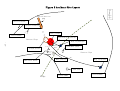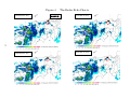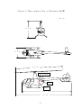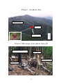
1
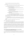
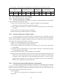
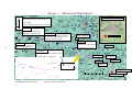
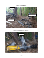
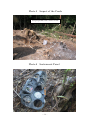
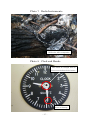
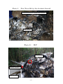
AA2011-2
AIRCRAFT ACCIDENT
INVESTIGATION REPORT
PRIVATELY OWNED
J
A
3
2
C
T
February 25, 2011
Japan Transport Safety Board
The objective of the investigation conducted by the Japan Transport Safety Board in
accordance with the Act for Establishment of the Japan Transport Safety Board and with
Annex 13 to the Convention on International Civil Aviation is to determine the causes of
an accident and damage incidental to such an accident, thereby preventing future
accidents and reducing damage. It is not the purpose of the investigation to apportion
blame or liability.
Norihiro Goto
Chairman,
Japan Transport Safety Board
Note:
This report is a translation of the Japanese original investigation report. The text in Japanese shall
prevail in the interpretation of the report.
AIRCRAFT ACCIDENT INVESTIGATION REPORT
PRIVATELY OWNED
ROBINSON R44Ⅱ (ROTORCRAFT), JA32CT
AT ABOUT 15 KILOMETERS SOUTHEAST OF TAJIMA AIRPORT,
JAPAN
AT ABOUT 09:30 JST, JULY 20, 2009
February 4, 2011
Adopted by the Japan Transport Safety Board
Chairman
Norihiro Goto
Member
Shinsuke Endoh
Member
Toshiyuki Ishikawa
Member
Sadao Tamura
Member
Yuki Shuto
Member
Toshiaki Shinagawa
1. PROCESS AND PROGRESS OF THE INVESTIGATION
1.1
Summary of the Accident
On July 20 (Monday), 2009 at 08:37 Japan Standard Time (JST: UTC+9hr, unless
otherwise stated all times are indicated in JST based on a 24-hour clock), a Robinson R44 Ⅱ,
registered JA32CT, privately owned, took off from Miho Airport with visual flight rules for the
purpose of familiarization flight. While flying toward Tajima Airport, the radio contact with the
aircraft was lost and the aircraft went missing. On August 6 (Thursday), 2009, the aircraft was found
to have crashed into a forest on the western slope of Mt. Higashi-tokonoo with a height of 839.1
meters about 15 kilometers southeast of Tajima Airport.
The captain and a passenger were on board the aircraft and both of them died in the crash.
The aircraft was destroyed and a fire broke out.
1.2 Outline of the Accident Investigation
1.2.1 Investigation Organization
On August 6, 2009, the Japan Transport Safety Board designated an investigator-in-charge
and another investigator to investigate this accident.
Search and rescue activities for the accident aircraft had been continued by the National
Police Agency, the Fire and Disaster Management Agency, the Ministry of Land, Infrastructure,
Transport and Tourism, the Japan Coast Guard and the Ministry of Defense since it went missing on
July 20, 2009. On August 6, 2009 at about 10:53, a Hyogo Prefectural Police helicopter found
aircraft wreckage and it was confirmed to be that of JA32CT. This investigation was launched on the
same day.
1.2.2
Representatives from Foreign Authorities
An accredited.representative of the United States of America, as the State of Design and
Manufacture of the aircraft involved in this accident, participated in the investigation.
1.2.3
Implementation of the Investigation
August 6-10, 2009
Interviews, on-site investigation and aircraft
examination
August 24-26, 2009
Interviews and aircraft examination
September 24-December 20, 2009
Analysis of ATC radar records
November 6 and 7, 2009
Teardown inspections of flight instruments
and navigation equipment
December 7-9, 2009
Teardown inspections of engine and main
gearbox
February 3, 2010
Examination of data retrieved from navigation
equipment
November 24, 2010
Examination of data retrieved from portable GPS
receiver
1.2.4
Comments from Parties Relevant to the Cause of the Accident
Comments were not obtained from the parties relevant to the cause of the accident because
-1-
they were dead.
1.2.5
Comments from the Participating State
Comments were invited from the participating State.
-2-
2.
FACTUAL INFORMATION
2.1
History of the Flight
On July 20, 2009, a Robinson R44Ⅱ, registered JA32CT (hereinafter referred to as “the
Aircraft”), privately owned, took off from Miho Airport at 08:37 for the purpose of familiarization
flight with the captain and a passenger on board, and began a flight toward Tajima Airport.
The outline of the flight plan was as follows:
Flight rules:
Visual Flight Rules (VFR)
Departure aerodrome:
Miho Airport
Estimated off-block time:
08:40
Cruising speed:
100 knots
Cruising altitude:
VFR
Route:
Tottori
Destination aerodrome:
Tajima Airport
Total estimated elapsed time:
1 hour and 00 minute
Purpose of flight:
Familiarization flight
Fuel load expressed in endurance:
2 hours and 00 minute
Persons on board:
2
Color of the aircraft
Silver
The history of the flight up to the time of the accident is summarized below, based on the
records of communications between the Aircraft and a flight advisory service station, the ATC radar
records, flight track records of portable GPS receiver (hereinafter referred to as “GPS records”) and
the statements of witnesses.
2.1.1 Records of Communications with a Flight Advisory Service Station, ATC
Radar Records and GPS Records
08:37
The Aircraft took off from Miho Airport
08:41:02
The Aircraft was detected by the ATC radar at a point about 3.5 nautical
miles east-southeast of Miho Airport
09:19:53
The Aircraft reported to the Osaka Flight Service Center (hereinafter
referred to as “Osaka FSC”) of the Ministry of Land, Infrastructure,
Transport and Tourism at a point about 8.6 nautical miles west of Tajima
that it was flying 8 nautical miles west of the Tajima Airport. Osaka
FSC instructed the Aircraft to communicate with the Tajima Flight
Advisory Service Station (hereinafter referred to as “the Flight
Service”).
09:20:40
The Aircraft became undetected by the ATC radar at a point about 7.6
nautical miles west-southwest of the Tajima Airport. The ground speed
just before the time was about 60 knots and the altitude was about 2,900
feet.
09:21:13
The Aircraft reported to the Flight Service at a point about 6.6 nautical
miles west of the Tajima Airport that it was at a point 6 nautical miles
from the Tajima Airport at an altitude of 3,000 feet and that it would
-3-
approach from the east of the Airport because it was flying an on-top
flight
09:21:45
The Aircraft changed its direction slightly to the south from the east at a
point about 5.6 nautical miles west of the Tajima Airport.
09:23:52
The Aircraft reported to the Flight Service at a point about 2.9 nautical
miles west-southwest of the Tajima Airport that it was looking for an
opening in the clouds.
09:25:04
The Aircraft reported to the Flight Service at a point about 1.9 nautical
miles south of the Tajima Airport that it thought that it was above the
runway and that it would fly to the east.
09:27:44
The Aircraft passed at a point about 0.9 nautical miles south-southwest
of Mt. Shiroyama.
09:28:28
The Aircraft changed its direction to the south from the east-southeast at
a point about 0.8 nautical miles north of the accident site and its altitude
began to lower slowly.
09:29:56
The Aircraft made left turn at a point about 0.2 nautical miles northeast
of the Accident Site and its altitude suddenly lowered. The GPS records
were finished around the accident site.
09:37:10
The Flight Service called the Aircraft but there was no response. (Calls
to the Aircraft had been continued, but there was no response.)
(See Figure 1
2.1.2
Estimated Flight Route)
Statements of Persons Relevant to the Accident
(1) An Air Traffic Service Flight Information Officer at Miho Airport Office of the Ministry of
Land, Infrastructure, Transport and Tourism
The captain and the passenger visited our office past 08:00 on the day of the accident.
I checked the flight plan submitted by the captain and found no particular problem. The
captain told me that the flight was originally scheduled for the previous day but that it was
postponed due to bad weather. He did not particularly refer to the weather condition for the
day. I did not notice any particular problem with his manner. When I was monitoring
communications between the Aircraft and the control tower at the time of departure, I
recognized that it was the captain who was talking to the controller. The captain did not
seem to be flurried and there were no reports of malfunctioning or irregularities about the
Aircraft, either.
(2) An official at the Flight Service
When the Aircraft was at 6 nautical miles west of the Tajima Airport, we received a
position report from the captain that he would hope to land on the Tajima Airport while
supposing instrument meteorological conditions there. We informed the captain that the
Tajima Airport was in visual meteorological conditions and we provided him with the
METAR as of 09:00. We also advised him that there were fairly large amounts of fogs in
the west of the Tajima Airport but fewer in the east. The captain reported to us that the
Aircraft was flying above the clouds and that it would approach from the east after passing
over the Tajima Airport. We informed the captain that the runway can be approached from
-4-
either direction and asked him to communicate with us when the Aircraft came out of the
bottom of the clouds. The captain replied that he would do so, though he also said he was
not sure about the exact time. The voice of the captain was relatively composed, and there
was no sense of flurry with him. Later, we received a report from the captain that he
thought that that the Aircraft was above the runway and that it would move to the east.
There were no communications from the captain even after about 10 minutes passed. We
called the captain several times, but we could not communicate with him.
(3) Witness A (About 8 kilometers north of the crash site)
On the day, I heard a sound of a helicopter flying around in the direction of a
mountain to the south. I did not see the helicopter itself, but I was surprised when I heard
sounds like the tip-tap of slippers. I think the sounds came from fairly close. There were
clouds in the sky, but it was not raining on that day. The time was before 10:00.
(4) Witness B (About 3.9 kilometers northwest of the crash site)
On the day, I saw a helicopter flying at a low altitude to the direction of Mt.
Tokonoo (southeastward). I think the time was before 09:40. I also heard sounds and the
helicopter was flying at fairly low an altitude that I could see the bottom of the helicopter.
The altitude appeared to be lower than the line of the mountain ridges. I saw the helicopter
for about 10 seconds. The color of the helicopter was gray. I thought the height of the
clouds was relatively high on that day.
(5) Witness C1 (About 5.5 kilometers northwest of the crash site)
When I was driving a car, I think it was between 09:30 and 10:00, I saw a
helicopter flying on the right side of Mt. Shiroyama (321.5 meters elevation) from the
driver’s seat at a place between Izushi Tunnel and Hotarubashi Bridge on a bypass from
Toyooka City to Izushi-Town. The altitude of the helicopter was 100 to 200 meters higher
than the mountain. I also heard sounds. The color was whitish. I thought it was a helicopter
the base of which was located at Izushi, but I thought the color of the helicopter was a little
bit whiter than that. Initially, I thought the helicopter was flying from so early in the
morning. It was flying with the mountain in the left.
Witness C2 (About 3.5 kilometers north of the crash site)
I was riding in the car driven by C1. I saw a helicopter on the right hand’s side
when we passed Terasaka Elementary School. I remember this very well because then I
thought “we see helicopters so frequently today.” The altitude was so low that I suspected it
was flying low because there was an event. There was a fog hanging on the mountains and
the helicopter was flying beneath the fog. I have no memory of strength of a rain, but I
remember it was foggy.
(6) Witness D (About 4 kilometers northwest of the crash site)
When I was playing catch with my child in front of my house, I heard fairly strong
sounds, something like the sounds when trees are cut down, from the top of the mountain in
the back. The time was between 09:30 and 09:40, I think. I did not hear any sounds of a
helicopter, nor did I see a helicopter itself. Clouds were hanging over the mountain on that
day. I could not see the upper part of the mountain, but the outskirts of the mountain were
visible. It was not raining. The sound was very large, but it was not a metallic sound. It was
a sound of something which hit trees and cut them down.
-5-
This accident occurred at about 09:30 on the western slope of Mt. Higashi-tokonoo of
Izushi-Town, Toyooka City, Hyogo Prefecture, at 519 meters (about 1,700 feet) elevation (Latitude
35°25'12" N and Longitude 134°53'52" E).
(See Figure 1
Estimated Flight Route,
Site,
Photo 2
2.2
Injuries to Persons
Figure 2
Accident Site Layout,
Photo 1
Accident
Wreckage of Accident Aircraft)
The captain and the passenger were killed.
2.3 Damage to the Aircraft
2.3.1 Extent of Damage
Destroyed
2.3.2
Damage to the Aircraft Components
Fuselage
Entirely broken and damaged, partially burned
Main rotor blades
Both blades broken
Tail cone
Broken and detached
Tail rotor blades and tail wing
Broken and detached
Landing gear
Broken
Aircraft control system
Broken
(See Figure 2
Crash Site,
2.4
Accident Site Layout,
Photo 4
Photo 2
Wreckage of Accident Aircraft,
Photo 3
Main Rotor Blades)
Other Damage
Dozens of trees were cut down and burned.
2.5
Personnel Information
(1) Captain
Male, Age 58
Private pilot certificate (Rotorcraft)
October 5, 1993
Type rating for single-piston (land)
October 5, 1993
Class 2 aviation medical certificate
Validity
December 4, 2009
Total flight time
1,385 h 06 min
Flight time in the last 30 days
Unknown
Total flight time on the type of aircraft
Unknown
Flight time in the last 30 days
Unknown
(The flight log on the Aircraft was lost in the fire. The figure for the total flight time
mentioned above is a record as of May 10, 2009.)
(2) Passenger
Male, Age 37
Private pilot certificate (Rotorcraft)
Issued by U.S. Federal Aviation Administration
January 18, 2009
Total flight time
41 h 18 min
-6-
(When the accident occurred, he was in the process of switching from the U.S.-issued
certificate to a Japanese pilot certificate. The total flight time mentioned above is the
figure recorded in the Aeronautical Experience Form attached to his application
form.)
.
2.6 Aircraft Information
2.6.1 Aircraft
Type
Robinson R44 Ⅱ
Serial number
11948
Date of manufacture
October 17, 2007
Certificate of airworthiness
DAI-20-641
Validity
February 2, 2010
Category of airworthiness
Rotorcraft, Normal N
Total flight time
64 h 06 min
Flight time since last periodical check (100h check on January 28, 2009)
Unknown
(The total flight time mentioned above is a record as of the date of the 100h check.)
(Instrument flights and instrument flight rules are not authorized in the operating
limitations.)
(See Figure 5
2.6.2
Three Angle View of Robinson R44 Ⅱ)
Engine
Type
Lycoming IO-540-AE1A5
Serial number
L-32239-48E
Date of manufacture
May 8, 2007
Total time of use
93 h 48 min
Flight time since last periodical check (50h check on June 24, 2009)
Unknown
(The total time of use mentioned above is a record as of the date of the 50h check.)
2.6.3
Weight and Balance
When the accident occurred, the Aircraft’s weight is estimated to have been 2,052.3 pounds
and the center of gravity is estimated to have been 97.6 inches aft of the reference point and 0.04
inch right of the centerline, all of which are estimated to have been within the allowable ranges (the
maximum takeoff weight of 2,500 pounds, and 92.0 to 102.5 inches and 3.0 inches left to 3.0 inches
right of range of the center gravity corresponding to the weight at the time of the accident).
2.7
Meteorological Information
2.7.1 Weather Information
General weather forecasts issued by the Kobe Marine Observatory for Hyogo Prefecture at
04:30 on July 20 is as follows:
In Hyogo Prefecture, rain should be observed intermittently in some areas due to the
influence of the “Baiu” rain front staying in western Japan, sometimes heavy rainfalls and thunders
-7-
likely to be seen.
(Warnings and advisories issued by the Kobe Marine Observatory for Hyogo Prefecture at
07:15 on July 20 did not include those for the northern and southern Tajima regions in which the
accident site is located.)
2.7.2
Aeronautical Weather Observations around Airports
(1) Aeronautical weather observations at Miho Airport were as follows:
08:00
Wind direction 070˚ ; Wind velocity
7 knots,
Visibility 10 kilometers Light showers
Cloud: Amount 3/8, Type Stratus, Cloud Base 600 feet,
Amount 3/8, Type Cumulus, Cloud Base 3,500 feet
Amount 7/8, Type Altocumulus, Ceiling 9,000 feet
Temperature 23°C; Dew point 22°C
Altimeter setting (QNH)
29.73 in.Hg
(2) Aeronautical weather observations at the Tajima Airport, located about 15 kilometers
northwest of the accident site, around the time of the accident were as follows:
08:30
Wind velocity 2 knots; Wind direction Variable
Visibility 1,600 meters,
light showers,
fog patches
Cloud: Amount 1/8, Type Stratus, Cloud Base 0 foot
Amount 4/8, Type Stratus, Cloud Base 600 feet
Amount 5/8, Type Cumulus, Ceiling 1,000 feet
Temperature 22°C; Dew point
Altimeter setting (QNH)
21°C
29.78 in.Hg
Visibility southeastward 700 meters; Fogs in the directions from northeast to
southeast
Visibility eastward 8 kilometers
09:00
Wind velocity 2 knots; Wind direction
Variable
Visibility 6 kilometers; Fogs around the Airport
Cloud: Amount 1/8, Type Stratus, Cloud Base 0 foot
Amount 4/8, Type Stratus, Cloud Base
600 feet
Amount 6/8, Type Cumulus, Ceiling 1,000 feet
Temperature 22°C; Dew point 21°C
Altimeter setting (QNH)
29.78 in.Hg
Visibility northwestward 3 kilometers; Fogs in the directions from northwest to
southwest
10:00
Wind velocity 2 knots; Wind direction
Variable
Visibility 10 kilometers
Cloud: Amount 1/8, Type Stratus, Cloud Base 100 feet
Amount 3/8, Type Stratus, Cloud Base 600 feet
Amount 6/8, Type Cumulus, Ceiling 1,000 feet
Temperature 22°C; Dew point 21°C
Altimeter setting (QNH)
29.76 in.Hg
(3) Weather observations at the Toyooka weather station of the Kobe Marine Observatory, located
-8-
about 15 kilometers northwest of the accident site, around the time of the accident were as
follows:
09:00
Wind direction
northeast; Wind velocity
1.5 m/s; Visibility
28.3 kilometers;
Hours of sunshine 0
Temperature 24.2°C; Dew point 20.7°C; Humidity 81 %
Atmospheric pressure 1,007.4 hPa; Atmospheric pressure change +0.2 hPa
10:00
Wind direction
east-southeast; Wind velocity
0.7 m/s; Visibility
26.5
kilometers; Hours of sunshine 0
Temperature 24.5°C; Dew point 20.6°C; Humidity 79 %
Atmospheric pressure 1,006.6 hPa; Atmospheric pressure change
2.7.3
-0.6 hPa
Information from Weather Charts and Others
Asia-Pacific Surface Analysis Chart as of 09:00 on July 20 indicated the “Baiu” rain front
extending from the Yellow Sea to western Japan, which was seen almost stationary. The 850 hPa and
700 hPa weather charts showed the whole of western Japan was covered by a humid air area. As the
tip of the area extended to the Kinki region, the weather condition was highly likely to create clouds.
A cloud imagery by a geostationary meteorological satellite indicated the whole of western Japan
was enveloped by many layers of clouds over a wide area.
(See Figure 3 The Asia-Pacific Surface Analysis Chart (0900JST 20 July))
2.7.4
Radar Observation Data, Echo Intensity
Radar observation data and echo intensity (hereinafter referred to as “the Radar Echo
Chart”) for the day of the accident indicates a strong echo area believed to have been caused by
cumulonimbus existed mainly over Yamaguchi Prefecture. But the echo intensity was relatively
weak at less than 6 millimeters an hour in the Sea of Japan coast areas from Tottori to Hyogo
prefectures. According to the radar echo chart around the time between the beginning of
communications between the Aircraft and Osaka FSC and the occurrence of the accident, at 09:00, a
long echo area with a relatively weak reading of 0 to 4 millimeters an hour was lying from the east to
west 15 kilometers south of the Tajima Airport and moving slowly to the east. At about 09:20, the
time when the captain started communications with the Flight Service, the echo area observed
exactly to the south of the Tajima Airport had temporarily disappeared and became so weak that it
could not be shown up on the radar screen. At about 09:30, the time when the Aircraft is believed to
have crashed into the mountain, an echo area was moving from the west to the south side of the
Tajima Airport or to the southeast side of the Tajima Airport, which is in the direction of the accident
site. The cloud top height of the echo was at about 6 to 8 kilometers.
(See Figure 4 The Radar Echo Charts)
2.7.5 Weather Report from Scheduled Flight which Landed on Tajima Airport on
the Same Day after Occurrence of the Accident
09:28
Took off from Osaka International Airport
09:49
Landed on Tajima Airport
Cloud top height en route to ASAGI Point (about 28 nautical miles south of the Tajima
Airport) : 9,000 to 10,000 feet
-9-
Cloud top height beyond ASAGI Point : 6,000 feet,
Cloud amount 8/8
Airstreams were smooth while descending.
Many layers of clouds were seen from 6,000 feet with the ceiling at 1,100 feet.
Visibility was generally good beneath the clouds.
Height of runway insight: around 1,100 feet, airstreams were smooth.
2.8 Accident Site and Wreckage Information
2.8.1 Accident Site Condition
Mt. Higashi-tokonoo (839.1 meters elevation), located about 15 kilometers southeast of the
Tajima Airport, is a craggy mountain with many ridges. The accident site was near a ridge 519
meters elevation in the middle of the western slope of the mountain. The eastern and western sides of
the ridge are very steep slopes at inclines of about 50 degrees. The western side of the ridge is
occupied by copse, while a cedar forest spreads on the eastern side.
The Aircraft crashed into a slope beneath the peak of the ridge with its nose lying in the
direction of south-southeast. The main rotor blades and the wreckage were found widely scattered
around the ridge and on eastern and western slopes. The fuselage of the Aircraft was lying in the
direction of southeast with its right side down on the ground. The front part of the Aircraft was
destroyed that its original shape could not be observed. When the Aircraft crashed into the ground, it
is believed that the nose broke down and flew ahead toward a pine tree, and the tree was found
burned from the bottom of its trunk.
The body of the passenger was found at a place about 4 meters ahead left of the fuselage,
while the body of the captain was found on the eastern slope of the ridge about 16 meters ahead right
of the place where the passenger’s body was found. Their seat belts were found to have been torn
apart in the joints with which they were fixed to the Aircraft.
The shell plating of the tail cone barely remained connected to the fuselage, but the shaft of
the inside was found broken. The tail rotor and the stabilizer were removed and scattered around.
The main gearbox was detached from the fuselage and found at a place about 4 meters ahead of the
fuselage with the mast lying in the direction of the west. The crash created a dent 2.7 meters in
length, 1.8 meters in width and 0.5 meter in depth on the ground.
The nose section of the Aircraft and some trees in the surrounding areas were burned.
Branches and leaves of trees were found to have turned red-brown in a broad area ahead of the
fuselage. On the western slope, to which the Aircraft approached, about 20 trees with a diameter of 4
to 23 centimeters were found chopped at the top. A line linking the place of the chopped trees and
the place where the blades hit the ground had an angle of about 25 degrees downward from the level
surface.
(See Figure 2
Accident Site Layout,
Aircraft, Photo 3
Photo 9
2.8.2
Crash Site,
Photo 1
Photo 4
Accident Site,
Main Rotor Blades,
Photo 2
Photo 5
Wreckage of Accident
Impact of the Crash,
Pine Trees Hit by the Accident Aircraft)
Detailed Information on Damage
(1) Fuselage
The whole sections were extensively damaged with the original shape unseen. The
nose section was burned out by a fire and a part of it was burned down.
- 10 -
(2) Main rotor blades
The red blade was found bent at a distance of 180 centimeters from the joint.
The black blade was found bent at distances of 65 and 235 centimeters from the joint.
Both blades were found partially broken and torn apart in the honeycomb structure
section.
(3) Tail cone
The tail cone was found broken and detached at the joint with the fuselage.
(4) Tail rotor and stabilizer
The tail rotor drive shaft was found broken at the joint with the fuselage.
The clutch belt for power transmission was found totally displaced.
(5) Landing gears
The skids on both sides were found broken and scattered around.
(6) Flight control system
The flight control system, including the rudder pedal, the collective stick and the
cyclic grip, etc. was found broken and detached.
(See Figure 2
Accident Site Layout,
Photo 3
Crash Site, Photo 4
Main Rotor Blades)
2.9 Communications
2.9.1 Circumstances of Communications
The Aircraft made communications with Osaka FSC at a frequency of 118.4 MHz at 09:19
and with the Flight Service at a frequency of 130.8 MHz at 09:21 and 09:25 before the occurrence of
the accident. The condition of these communications was favorable. The communications were made
by the captain.
2.9.2
Emergency Locator Transmitter
(1) Distress signals
The Aircraft was equipped with an emergency locator transmitter (hereinafter
referred to as “ELT*1”). Regarding the ELT, the core wire of the cable linking the body to an
antenna was found cut off on the side of the connector for the antenna joint. The ELT itself
was burned out and the condition of batteries and others could not be examined. Any distress
signals were not received by the search and rescue satellite system (Cospas-Sarsat) and
airplanes which happened to be flying nearby around the time when the accident occurred.
(2) Position for ELT installation
The Aircraft’s ELT was installed by Robinson as the manufacturer of the Aircraft
when the Aircraft was made. The position where it must be installed and others were based
on the installation manual prepared by the ELT manufacturer. The installation manual calls
for following rules set by the U.S. Federal Aviation Administration, FAA, about the manner
of installing ELTs. An FAA rule states as follows about the installation of ELTs:
FAR 91.207
The ELT must be attached to the aircraft in such a manner that the probability of
*1 ELT transmits signals (in frequency bands of 121.5 MHz, 243 MHz and 406 MHz) to get the
location of accident known for search by parties involved, mainly in cases in which the aircraft
distressed or crashed.
- 11 -
damage to the transmitter in the event of a crash impact is minimized.
However, specific position where the ELT must be installed is not stated.
(3) Types of ELT
ELTs are roughly divided into the following types according to whether they can be
automatically activated on an impact or they must be manually activated.
Automatic fixed ELT (ELT(AF))
This type is automatically activated and permanently fixed to the aircraft.
Automatic portable ELT (ELT(AP))
This type is automatically activated and usually fixed to the body, but it can
be easily detached from the aircraft.
Automatic deployable ELT (ELT(AD))
This type is fixed to the aircraft and automatically extended and activated
on an impact. It can also be deployed manually.
Survival ELT (ELT(S))
This type is equipped into the aircraft so that it can be easily used in the
case of an emergency. It must be activated manually.
Annex 6 to the Convention on International Civil Aviation states that all rotorcraft
must be equipped with at least one automatically activated ELT. It also states that the
position where the ELT is installed is important to ensure that it is activated without fail
when an accident occurred.
Japan has also required all rotorcraft to be equipped with automatic ELTs unless the
equipment has been respited as a provisional measure. The Aircraft was equipped with an
ELT(AF).
(See Figure 5
2.9.3
Three Angle View of Robinson R44 Ⅱ,
Photo 10
ELT)
Track by Radar for Air Traffic Control
After the Aircraft took off from Miho Airport, the Aircraft’s air traffic control transponder
(hereinafter referred to as “the ATC transponder”) code (1200) was detected between a point about
3.5 nautical miles east-southeast of Miho Airport (08:41:02) and a point about 23.6 nautical miles
east-southeast of Miho Airport (08:53:24) and between a point about 22.3 nautical miles
west-southwest of Tajima Airport (09:11:34) and a point about 13.3 nautical miles west of Tajima
Airport (09:17:01) as well as between a point about 7.8 nautical miles west of the Tajima Airport
(09:20:30) and a point about 7.6 nautical miles west of the Tajima Airport (09:20:40). During these
periods, the direction and the altitude of the Aircraft were changed several times. When it was last
detected at 09:20:40, its altitude was about 2,900 feet with its direction almost eastward and its speed
about 60 knots.
2.9.4 Information from Scheduled Flight with Traffic Alert and Collision
Avoidance System (TCAS) at the Time of Accident
At 09:47 of the day, the Flight Service asked a scheduled flight whether any aircraft are not
be observed nearby with its TCAS. The scheduled flight replied that while it was approaching from 5
nautical miles south of the Tajima Airport, nothing could be seen in the 20 nautical miles range on its
TCAS.
- 12 -
2.10
Medical Information
According to the Hyogo prefectural police headquarters, autopsies carried out on August 8,
revealed that the causes of death for the captain and the passenger were bruises on the whole of the
bodies.
2.11
Information about Search and Rescue
As contact with the Aircraft was lost, the Flight Service made a notice to Osaka FSC at
9:40. Osaka FSC asked airports and others in the neighboring areas to provide information, but no
information on the Aircraft was obtained. After coordinating with the Rescue Coordination Center of
the Civil Aviation Bureau of the Ministry of Land, Infrastructure, Transport and Tourism, Osaka FSC
issued an INCERFA (Uncertainty phase)*2 to related organizations at 10:06. As a result, the Rescue
Coordination Center started operation for search and rescue. As necessary information remained
unavailable, Osaka FSC concluded that the Aircraft met an accident and issued a DETRESFA
(Distress phase) *3 at 10:30. The Rescue Coordination Center asked the Maritime Self-Defense
Force at 10:56 to dispatch search and rescue personnel for disasters.
In the last contact with the Flight Service at 09:25, the Aircraft only said it would fly
eastwardly from above the Tajima Airport. Since the weather condition was bad around the Tajima
Airport on that day with clouds hanging low in the sky, it was considered somewhat likely that the
Aircraft might have attempted to turn back. As a result, search activities for the day were carried out
by aircraft and ships mainly along the Aircraft’s estimated flight route and over areas from the
Tottori-Hyogo prefectural border to the Tango Peninsula of Kyoto Prefecture. But the Aircraft was
not found.
Search for the Aircraft had been continued for 18 days mainly in Toyooka City and
neighboring areas. At about 10:53 on August 6, a Hyogo prefectural police helicopter found
discolored trees at a place with a height of about 1,700 feet on the western slope in the middle of Mt.
Higashi-tokonoo. Personnel descended on the ground near the discolored trees and examined the
area. Then they found the wreckage of an aircraft. The registration number on the aircraft showed it
was the Aircraft which went missing.
Search for the surrounding areas found the body of the passenger left ahead of the Aircraft
and the body of the captain further ahead on the east side of a ridge. Following figures show the
numbers of personnel and gear mobilized by Hyogo, Kyoto and Tottori prefectural police authorities,
the Self-Defense Forces, the Japan Coast Guard and fire fighting authorities:
*2 INCERFA means cases in which there is no report about the aircraft’s location even after a lapse
of 30 minutes past the scheduled time or in which the aircraft has not reached the destination even
after a lapse of 30 minutes past the scheduled time. Search will be made mainly by communications
organizations.
* 3 DETRESFA means cases in which information about the aircraft was not obtained by the
above-mentioned search by communications organizations and cases in which the aircraft’s fuel loads
got exhausted or they are believed to be insufficient for safely arriving at the destination. Search and
rescue organizations will start necessary actions.
- 13 -
Aircraft, ships, vehicles and personnel mobilized for search and rescue operations (in total)
Police
Japan Coast
Self-Defenses Force
Fire Defense
Guard
Aircraft
Vehicle
Person
Aircraft
Vehicle
Person
Aircraft
Ship
Aircraft
Vehicle
Person
32
460
2084
85
101
504
4
9
7
17
100
2.12 Tests and Research for Fact Finding
2.12.1 Teardown Inspection of Engine
The result of the inspection is as follows: No defects or component failures were identified
other than the damage caused by the crash.
(1) There were no defects inside the engine. Abnormal conditions such as binding and
interference were not found in each of the driving sections.
(2) The condition of burning in each cylinder was favorable and uniform, and no abnormality
was found.
(3) The magnetos were found burned out on both sides.
(4) The starter ring gear and the alternator were damaged.
2.12.2
Teardown Inspection of Main Gearbox
A teardown inspection of the main gearbox revealed many places of damage, but these
were all sections displaced or broken due to the impact at the time of the accident. The inspection
found no failure and defects regarding components which may be linked to the cause of the accident.
The outline of the result of the inspection is as follows:
(1) There was no abnormality with the gear and the gear carrier.
(2) There were no metals and stains with the chip detector.
(3) The gearbox housing was found broken in the bearing sheet section of the input pinion
bearing holder.
(4) The main rotor drive shaft had traces of contact with the mast tube or components like that in
a section slightly above the middle.
(5) The mast tube was broken in a section slightly above the middle.
(6) The pitch link of the black blade of the main rotor was broken, but that of the red blade of the
main rotor was bent only partially and it was not broken. The red blade was found rotated
180 degrees with its pitch link left connected. Both blades had traces of contact with the
spindles inside of the hubs. There were dents in the middle of the teeter stops on both sides,
but there was no abnormality with the droop stops.
2.12.3
Teardown and Functional Inspections of Instruments
A teardown inspection and function checks of instruments revealed many places of damage,
but these were all parts damaged due to the impact at the time of the accident. There were no
problems and defects regarding components which may be linked to the cause of the accident. The
outline of the results of the inspection is as follows:
(1) Speed indicator
There were no components lost. The indication was 122 knots.
(2) Altimeter
- 14 -
The case, the mechanical section inside and the front glass were mostly damaged.
The indications of altimeter setting, the long needle which shows hundreds of feet and
the short needle which points to thousands of feet were 29.74 in.Hg, around 40 feet and
around 1,900 feet, respectively.
(3) Clock
The hands were found displaced inside. When stains and scratches left on the dial were
matched to traces of damage and scratches on the hands so that the hands may be brought
back to where they were believed to be before, the time proved to be around 09:30.
(4) Gyro horizon
Compressive load was applied on the instrument from both sides horizontally and
vertically. The indication was left bank 20 degrees and dive 5 degrees.
(5) Directional gyro
A trace of damage on the dial and the position of the base showed that the indication
was 250 degrees.
(6) Engine / rotor tachometer
The mechanical section was seriously damaged, while the indicator was broken and
bent. The movement became loose and unable to keep the condition at the time of the
accident. But the indicator showed 90 %RPM.
(See Photo 6
2.12.4
Instrument Panel,
Photo 7
Radio Instruments,
Photo 8
Clock and Hands)
Radio Navigation Instruments Installed on the Aircraft
(1) VHF transmitter/receiver
Burned out
(2) VOR receiver
Burned out
(3) ILS receiver
Burned out
(4) ATC transponder
Burned out
(5) ELT
Burned out
(6) GPS receiver (GNS430)
Burned out
This system had been installed on the Aircraft as auxiliary navigation equipment. The
user’s manual indicates that the aircraft’s location, airports, navigational aid and the
geographical features of the surrounding areas can be colorfully displayed on the screen. Its
functions include a terrain mode designed to issue a warning on the screen when the aircraft
descends too low toward the ground. Because the equipment was burned out, it was unable to
retrieve records regarding the trace of the Aircraft at the time of the accident.
2.12.5
Other Radio Equipment (Not Authorized as Radio Navigation Equipment)
A teardown inspection and a function check were made for radio equipment believed to
have been brought into the Aircraft by the persons on board. The results are as follows: These radio
equipment were found damaged, burned out or deformed.
(1) Handy receiver (ICOM-IC-22)
(According to the user’s manual, it can transmit and receive signals at all frequencies in the
aeronautical mobile VHF frequency band and receive VOR and LOC signals and at the same
time, it can display the courses.)
Inside of the equipment, there was a trace of liquid crystal leaked in the display, but
- 15 -
no apparent damage was seen on any of the substrates. When it was connected to an outside
power source to get activated, it was confirmed that its switch turns on. But the display did
not work due to the inaction of the main processor. As a result, the state of the equipment at
the time of the accident could not be reenacted.
(2) Portable GPS receiver (GARMIN-GPSMAP-495)
(According to the user’s manual, the location of the aircraft, airports, navigational aid and
map data can be indicated on the color display. Areas with an altitude above 100 feet down
from the aircraft are indicated in red and lower areas in yellow and warnings are issued on a
terrain page.)
The lower part of the equipment was seriously damaged due to the impact of the
accident. The liquid crystal panel, an antenna and control buttons were damaged, but they
were not burned. There was no apparent damage to the substrate inside. After the equipment
was repaired, data on the aircraft track were retrieved from an internal memory.
(3) Portable collision avoidance system (XAON-PCAS-XRX)
(According to the user’s manual, the positions of aircraft flying around are indicated and if
and when the threat of a collision emerges, an advisory is issued.)
The front part and the indicator display were seriously damaged. An antenna inside
and the substrate were also damaged. Because this system has no log function, the data
received before the accident about the locations of other planes could not be recovered.
2.13 Additional Information
2.13.1 The Aircraft’s Flights on the Previous Day
(1) Flights on the Previous Day
On July 19, one day before the accident, the Aircraft took off from Nagashima
temporary operation site in Mie Prefecture with the captain, the passenger involved in the
accident and another person (hereinafter referred to as “the Other Passenger”) on board. After
a refueling stop at Kounan Airport, the Aircraft landed on Miho Airport. According to the
Other Passenger, the three were originally planned to return to Nagashima within the same
day after refueling at the Tajima Airport, after seeing a triathlon event in Tottori City. But
when the captain checked the weather condition at Kounan Airport, he concluded that a return
flight would be difficult due to bad weather in the Tottori area. The captain changed the plan
and they delayed the return on the following day after staying one night in Yonago City. On
the flight from Kounan Airport to Miho Airport, the captain sat in the right seat and the Other
Passenger in the left seat, while the passenger sat in a rear seat. The passenger possessed a
U.S.-issued competence certificate, but he did not have a Japanese competence certificate.
(2) Statements of trader who refueled the Aircraft at Kounan Airport on the Day before Accident
On that day, I was told to fill it up and refueled 133 liters to the Aircraft. When I
asked them about their destination, they said they were going to Miho. They were worried
about the weather condition. They said they would return in case of bad weather. The weather
was good in the surrounding areas, but they said the weather condition would be bad over the
mountains. I was asked if refueling would be possible if they turn back. The three persons,
including the captain, were standing around the Aircraft. I did not know any of them.
- 16 -
2.13.2
Acquisition of Meteorological Information at Miho Airport
At Miho Airport, flight crewmembers can obtain meteorological information through
self-briefing terminals set up at the Tajima Airport. If necessary, they can also receive briefings
directly from weather forecasters via a direct telephone linked to the Aviation Weather Service
Center at Kansai International Airport. But logs at the center for the day showed no record that the
captain of the Aircraft received a briefing from the center.
2.13.3
Acquisition of Meteorological Information during Flight
The Ministry of Land, Infrastructure, Transport and Tourism has Flight Service Centers
(FSC) at eight airports across the country and provide various kinds of meteorological information,
including the meteorological radar echo, to assist in flights of aircraft and aeronautical information
for safe operations of aircraft. These kinds of information can be obtained by contacting FSCs by
radio. When the weather condition changed abruptly, FSCs give advice about the selection of
alternate airports and accept requests for coordination to this end. In the case in question, it was
possible for the Aircraft to obtain information from Osaka FSC in the course of its flight. But
according to records of communications at the FSC, there was no request for meteorological
information from the Aircraft.
2.13.4
Ensuring Safety in Visual Flights
The Civil Aviation Bureau of the Ministry of Land, Infrastructure, Transport and Tourism
has issued an official order for ensuring the safety of flights under visual flight rules urging the
operators to abide by the following points:
The operators must collect the latest meteorological information before making a
judgment if the flight is possible or not and depart only when the visual meteorological
conditions can be maintained all the time to ensure the safety of flight. When the weather
is expected to change, the operators must consider an alternate flight plan for cases in
which the weather condition becomes difficult to maintain the visual meteorological
conditions and in the course of flight, the operators must try continuously to obtain
meteorological information. When there is an unexpected sign of worsening weather,
they must determine as quickly as possible and with no hesitation whether the flight can
be continued and if necessary, choose to return to the departure aerodrome or land on
airports and other appropriate places around the course of flight.
The order (kokukuukou No. 86) was issued by the Flight Standards Division of the Civil
Aviation Bureau on April 30, 2002 to the All Japan Air Transport and Service Association and the
Japan Aircraft Pilot Association.
According to another official order issued by the bureau:
The operators must make preventive landing without delay when the continuance
of flight under the visual meteorological conditions and the continuance of safe flight is
feared to become difficult and it is considered to be difficult to return to the departure
aerodrome or land on an alternate airport.
The order (kokukuukou No. 808) was issued by the Director of the Flight Standards
Division of the Civil Aviation Bureau on January 27, 2006 to the All Japan Air Transport and Service
Association, the Japan Aircraft Pilot Association and nonprofit organization AOPA-JAPAN.
- 17 -
2.13.5
Structure of Flight Control System of the Aircraft
The Aircraft’s main flight control system is installed mainly around the seat on the right
side. The press talk switch for radio transmission is equipped on the grips of the control sticks on
both of the left and right seats. The control stick on the right seat also has a switch to change the
radio frequency, but there is no such switch on the control stick on the left seat.
2.13.6
The Tajima Airport and Areas around the Airport
The Tajima Airport, about 2 kilometers southwest of Toyooka City, stands on a developed
hill. With a height of 176 meters, the Airport has a runway 1,200 meters long and 30 meters wide in
the direction of 01/19. As navigation aids, VOR/DME and LOC are installed in the Airport.
Meteorological information about the Airport and information about landing and take-off are
available from the Flight Service.
As far as geographical features are concerned, the height of areas from the north to the east
of the Airport is lower than that of the Airport. Around the Airport, there are dry riverbeds and fields
that can be used for emergency landing.
2.13.7
Visual Meteorological Conditions
Article 5 of the Ordinance for Enforcement of the Civil Aeronautics Act of Japan states as
follows for the visual meteorological conditions: (An excerpt from the part relating to the Aircraft)
1
For the aircraft that flies at an altitude of less than 3,000 meters,
For the aircraft that flies in control area, control zone or information zone.
(a) Flight visibility is over 5,000 meters;
(b) No cloud is within the vertical distance of 150 meters above and 300 meters
below the aircraft.
(c) No cloud is within the horizontal distance of 600 meters from the aircraft.
2
For the aircraft that flies at an altitude less than 300 meters from the ground surface or
the water surface in the airspace other than control area, control zone and information
zones (Regarding helicopter that flies at the speed of which collision with other object is
avoidable, excludes the item listed in (a))
(a) Flight visibility is over 1,500 meters.
(b) The aircraft may fly away from clouds and that the pilot may visibly recognize the
ground surface or water surface.
3
For the aircraft that tries to take off or land at aerodrome etc within control zone and
information zone, or at aerodrome etc outside control zone and information zone
designated in the public notice by the Minister of Land, Infrastructure, Transport and
Tourism.
(a) Ground visibility is more than 5,000 meters.
(b) Height of cloud is more than 300 meters from the ground surface or the water
surface.
- 18 -
3.
ANALYSIS
3.1
Flight Crew Qualifications
The captain held both a valid airman competence certificate and a valid aviation medical
certificate.
3.2
Airworthiness Certificate
The Aircraft had a valid airworthiness certificate and had been maintained and inspected as
prescribed.
Judging from the condition of the chopped part of a tree cut down when the Aircraft
crashed, details of damaged parts of the fuselage and the result of a teardown inspection of major
components, it is considered highly probable that there had been no abnormality until the time when
the Aircraft crashed into the mountainside and was destroyed.
3.3
The Aircraft’s Flight Route
As described in 2.1, it is considered highly probable that the Aircraft took off from Miho
Airport at 08:37 for a flight to the Tajima Airport via Tottori. Assuming that the Aircraft was flying
as scheduled, it is considered highly probable that it had reached around the Tajima Airport at about
9:30.
The Aircraft was detected by an ATC radar through a point about 7.6 nautical miles west of
the Tajima Airport. Even after the Aircraft disappeared from the range of the radar, the Aircraft
continued to fly to the east of the Tajima Airport. After changing its direction slightly to the south at
a point about 5.6 nautical miles west of the Tajima Airport, it is considered highly probable that the
Aircraft made a position report at a point about 1.9 nautical miles south of the Tajima Airport that it
was supposed to be over the runway of the Tajima Airport. As to the reason for its change of
direction, the radar echo chart showed the existence of echoes with a cloud ceiling of 2 kilometers or
lower around an area where it changed its direction. Therefore, it is considered somewhat likely that
the Aircraft flew toward an area where there were fewer clouds while avoiding clouds at high
altitudes ahead. Regarding its erroneous report that it was over the runway of the Tajima Airport, at
the time when the Aircraft was actually flying in the south of the Tajima Airport, it is considered
somewhat likely that the Aircraft avoided the clouds just ahead by changing its direction to the south,
but it was unable to return to its original course due to clouds which appeared further ahead and
there was no enough time to confirm its own location because it had to concentrate on finding an
opening in the clouds in a situation where the ground could not be visibly confirmed. It was
considered highly probable that the Aircraft later flew on to the east-southeast and changed its
direction to the south from around a point 0.8 nautical mile north of the accident site and at the same
time, it started descending and then, after turning to the left at a point northeast of the accident site, it
crashed into the mountainside.
3.4
Progress of the Aircraft’s Crash
Judging from the condition of the chopped top parts of trees at the accident site, it is
considered highly probable that the Aircraft came from the direction of north-northwest and crashed
into a slope with a height of about 1,700 feet, with no time to avoid a collision with the ground. The
chopped parts of trees cut down by the Aircraft had an angle of about 25 degrees downward.
- 19 -
Therefore, it is considered highly probable that the Aircraft came to approach the slope with its nose
slightly downed and then its main rotor cut down trees in an area around the site and finally the
Aircraft crashed into the ground with its body inclined to the left side because of power applied by
the tail rotor to turn the nose to the left and the body lied sideways with its right down on the ground.
It is considered highly probable that when the Aircraft crashed, the front part of the aircraft
broke down and the captain and the passenger were thrown out ahead with the impact of the crash
along with the front part of the aircraft, which hit a pine tree with a diameter of about 30 centimeters
standing ahead of the place of the crash, and that the passenger was thrown ahead to a place left of
the nose section and the captain to a place beyond the ridge and his body further fell to the southeast
down a steep slope on the east side.
The result of a teardown inspection as described in 2.12.3 (5) estimates that the indication
of the directional gyro was 250 degrees. But judging from the condition of the accident site, it is
considered probable that this resulted from the impact of the accident.
3.5
Flight Control by the Captain
Based on the following points, it is considered probable that the Aircraft was being
controlled by the captain just before the accident:
(1) As described in 2.13.5, the main flight control system of the Aircraft is installed mainly
on the right seat’s side.
(2) As described in 2.9.1, it is considered probable that the captain was making
communications with the ground. As described in 2.13.5, the Aircraft was equipped with
a switch to change the radio frequency for the radio transmitter/receiver for
communications with the ground on the cyclic grip on the right seat, which makes it
easier to make radio operations while seating on the right side.
(3) Judging from the meteorological conditions as described in 2.7, the less experienced
passenger was unlikely to be let control the Aircraft under the circumstances.
(4) As described in 2.5, the passenger was in the process of shifting to a Japanese competence
certificate from a U.S.-issued competence certificate at the time of the accident. He had
no competence certificate that allows him to control an aircraft in Japan.
3.6
Circumstances at the Time of the Accident
According to a statement of the witness who heard big sounds at a place about four
kilometers northwest of the accident site, as described in 2.1.2, it was not raining but clouds were
lingering low when the witness heard something like the sounds when trees are cut down twice
between 9:30 and 9:40. The Aircraft contacted the Flight Service at 09:23:52 that it was looking for
an opening in the clouds while flying above the clouds at 3,000 feet. It also contacted the Flight
Service at 09:25:04, at a point which is not exactly above the runway, that the Aircraft was supposed
to be over the runway and it would fly to the east. As described in 2.7.2 (2), the ceiling was 1,000
feet at the time of the accident. As described in 2.7.5, a meteorological report from the scheduled
flight indicated many layers of clouds were seen from 6,000 feet with the ceiling at 1,100 feet.
Based on these points, it is considered highly probable that the areas around the accident
site had been covered with clouds and fogs and the situation was difficult to maintain visual
meteorological conditions in most of the areas.
- 20 -
3.7
Time of the Occurrence of the Accident
Based on the following points, it is considered highly probable that the accident occurred at
around 09:30.
(1) As described in 2.9.3, the Aircraft became undetected by the ATC radar at 09:20:40 at a
place 7.6 nautical miles west of the Tajima Airport at an altitude of 2,900 feet. The Aircraft
also reported at 09:25:04 that it was flying above the runway. While considering the place
where it disappeared from the range of the radar and the position report from the captain as
well as the GPS records at that time, the Aircraft’s speed is estimated at 100 knots, when
figured out from the position where the report was made that the Aircraft was supposed to
be over the runway. Assuming that the Aircraft continued to fly at this speed to the
east-southeast, it takes about 5 minutes to reach the accident site.
(2) As described in 2.1.1, there was no response to a call from the Flight Service past 09:37.
(3) As described in 2.9.4, the sight of the Aircraft did not appear on TCAS installed on the
scheduled flight which happened to fly near the accident site at 09:47.
(4) As described in 2.12.3 (3), a teardown inspection of the clock shows that traces of blow
believed to have stemmed from the impact of the crash exist at positions around 09:30.
(5)Judging from the GPS records as described in 2.1.1, the time when the Aircraft’s track
disappeared near the accident site is believed to be around 09:30.
3.8
Use of Radio Navigation Equipment and Others
As described in 2.12.4 and 2.12.5, the Aircraft had been equipped with VOR, ILS and GPS
receivers. Therefore, it is considered probable that the captain had an intention to use information
obtained with these equipment as auxiliary information during the flight. When the weather is
favorable, the location and other matters can be easily confirmed because strong attention is less
needed for flight operations. But when the weather is bad with many layers of clouds hanging, as
was the case with the situation in this accident, much attention must be paid for the flight and as a
result, it is considered probable that the captain didn’t have enough time to fully use information
from VOR and other equipment during the flight.
3.9 Meteorological Condition
3.9.1 Confirmation of Meteorological Condition before Departure
According to a statement of the refueling trader as described in 2.13.1.(2), the captain was
paying attention to the meteorological condition on the previous day. Therefore, it is considered
probable that the captain had knowledge that the weather along the flight route was generally
unfavorable. However, because the weather at Miho Airport was good, as described in 2.7.2 (1) and
because it is considered probable that the captain had not received a briefing as described in 2.13.2,
it is considered probable that the captain decided to depart without obtaining the latest
meteorological information for areas on his flight route.
3.9.2
Judgment about Meteorological Condition for the Day
As described in 2.7, clouds were broadly hanging and rain fell intermittently on the day of
the accident as a “Baiu” rain front was staying in the western part of Japan. But the radar echo charts
- 21 -
showed the echo area along the Sea of Japan coasts was relatively small and weak. Similar echo
charts are widely available through the broadcasting media. Therefore, it is considered somewhat
likely that the captain checked these kinds of information at his hotel or elsewhere on the day of the
accident and concluded that if the route is carefully selected, it would be possible to maintain visual
meteorological conditions while watching ground signs. However, the radar echo charts are drawn
by collecting radio waves emitted from a meteorological radar and echoed back on raindrops to be
recaptured by the radar, and this means that the charts fail to show radio waves whose size is smaller
than the standard level. Signs on the charts do not necessarily correspond to actual cloud areas
particularly at low altitudes, which may become a hindrance to visual meteorological conditions. It is
considered somewhat likely that the captain’s judgment that it would be possible to fly had been
influenced by a slight improvement in the weather condition from the previous day and one day
delay in the return schedule.
3.9.3 Meteorological Condition during Flight
As described in 2.1.1, the GPS records show that the captain changed the direction and the
altitude several times after taking off on the flight to the Tajima Airport. It is considered highly
probable that the captain continued the flight while trying to avoid the clouds, as many clouds were
believed to be hanging as an obstacle to visual meteorological conditions on the scheduled flight
route. It is considered probable that if the captain had obtained detailed information beforehand, he
would have been able to foresee that the maintenance of visual meteorological conditions may
become difficult along the scheduled flight route. It is considered highly probable that a route over a
coastal area where the weather was relatively favorable may have been selected.
As described in 2.7.2 (2), visibility at the Tajima Airport as of 09:00 was 6 kilometers and
the ceiling was 1,000 feet. Landing with visual flight rules was barely possible. But the surrounding
areas had been covered with many layers of clouds at altitudes of 1,000 feet or higher, as reported by
the scheduled flight in 2.7.5. Therefore, it is considered highly probable that the situation was
difficult for the captain to maintain the visual flight. Because the Aircraft reported to the Flight
Service from a position which is not exactly above the runway that it was supposed to be over the
runway of the Tajima Airport, it is considered highly probable that the Aircraft was making an on-top
flight and unable to confirm the ground and other geographical features. Mountainous areas extend
from the south to the east of the Tajima Airport, and it is considered highly probable that the
mountains could not be visibly observed with clouds and fogs hanging around. Further, as described
in 2.7.4, a thick rain cloud area was coming from the west. Therefore, it is considered probable that
the Aircraft was flying amid clouds temporarily.
3.9.4
Appropriate Acquisition of Meteorological Information after Departure
As far as the acquisition of meteorological information after departure is concerned, ground
assistance systems for privately owned aircraft are less prepared than those for commercial air
carriers. Therefore, captains have to collect meteorological information by themselves. But it is
considered highly probable that the captain did not collect meteorological information from Osaka
FSC and other organizations during his flight. As described in 2.13.3, it was fully possible to confirm
meteorological information by contacting the FSC on the flight route in the latest case. Therefore, it
is considered highly probable that the captain should have tried to precisely grasp the weather
- 22 -
condition and made a judgment about how to maintain the safety of flight, while considering
whether the meteorological condition is appropriate for continuing the flight and whether to return to
the departure aerodrome or land on Tottori Airport as an alternate aerodrome in the course of its
flight.
3.10
Captain’s Judgment until Crash
It is considered highly probable that based on an advisory received from the Flight Service
that fogs are relatively limited on the east side of the Tajima Airport, the captain concluded that
clouds are also relatively limited on the east side and that after contacting the Flight Service at a
position about 1.9 nautical miles south of the Tajima Airport that the Aircraft was supposed to be
above the runway and after flying above the clouds to the east-southeast, it is considered highly
probable that the captain started descending as he found a small opening in the clouds or without
finding any opening, after changing the direction to the south. Even if the captain had descended
through an opening he found in the clouds, it is considered somewhat likely that the Aircraft would
have entered the clouds again in the weather condition as described in 2.7 and the captain would
have descended without confirming the ground.
As described in 2.1.2, the Aircraft was visually observed from the ground. Therefore, it is
considered highly probable that the Aircraft got out of the bottom of the clouds temporarily but the
captain continued the flight while he was unable to confirm the location of the Tajima Airport and
that the Aircraft pushed into the clouds again and strayed into a mountainous area southeast of the
Tajima Airport. As described in statements of witnesses in 2.1.2, it is considered highly probable that
visibility was poor and the bottom of clouds was low in areas southeast of the Tajima Airport.
It is considered highly probable that after the captain started descending, he lowered the
altitude again while turning to the left after finding further openings in the clouds, but the Aircraft
pushed into the clouds later again and the captain became unable to determine the altitude from the
ground with the ground visibly unconfirmed and he could not notice the existence of a mountain
until the Aircraft crashes into the mountainside. When geographical features are not clearly
confirmed, as is the case with the latest accident, it is dangerous to continue the flight amid the
clouds. Therefore, it is considered probable that the captain had to pull out of the clouds as quickly
as possible. It is considered probable that one of means to get out of the clouds was to turn the nose
to the opposite position to get the Aircraft back to the direction where it came.
3.11
Flight with Visual Flight Rules
As described in 2.1, the Aircraft was flying with visual flight rules. Therefore, the captain
needs to maintain visual meteorological conditions as described in 2.13.7. As described in 3.9.3, it is
considered somewhat likely in this accident that most areas along the scheduled flight route had been
covered with clouds. As a result, it is considered probable that it was difficult for the captain to
continue the flight while satisfying the conditions all the time.
3.12
Map Reading
As described in 2.1.2 (5), it is considered highly probable that the Aircraft could confirm
the ground temporarily. In the circumstances as such, the position of the aircraft must be confirmed
by using navigation equipment and the aeronautical chart. But it is considered highly probable that
- 23 -
the captain in this case was unable to confirm the location of the Aircraft, because he is believed to
have descended through a small opening in the clouds or through the clouds and because the Aircraft
was seen by witnesses flying at a remote place from the Tajima Airport in the opposite direction to
the Tajima Airport. It is considered probable that the captain did not use the aeronautical chart and
other materials as he continued the flight while looking for the Tajima Airport but he unexpectedly
pushed into the clouds. It is considered somewhat likely that the captain failed to use the
aeronautical chart and other materials when he could temporarily confirm the ground can be ascribed
to insufficient preparations for collecting necessary pre-flight information, including data about the
flight route.
3.13
Preventive Landing
As described in 2.1.2 (5), the Aircraft was seen flying normally, though the altitude was
low. Therefore, it is considered highly probable that the ground could be visibly observed by the
Aircraft, too, temporarily. As described in 2.13.6, fields spread in areas around the Tajima Airport,
and there were many places for safely making an emergency landing. Therefore, it is considered
probable that this accident would have been avoided if the captain had made an appropriate
judgment mainly by choosing a preventive landing while ensuring the safety of the Aircraft and
areas around the place of landing.
3.14
Condition of ELT
ELTs are so designed as to send emergency signals when they are activated on the strong
impact of crashes. But no emergency signal was received from the Aircraft despite the fact that the
Aircraft crashed into the ground from the nose. Judging from the condition of the damaged
connector part of the cable that links the ELT itself to the antenna, as described in 2.9.2 (1), it is
considered highly probable that when the Aircraft crashed into the mountain, the section of the ELT
near the antenna was destroyed and the core wire inside was torn apart, making it impossible to send
out an urgency signal. In addition, it is considered somewhat likely that a weak signal was sent till
ELT was damaged by fire if it was operated, even if the cable had been cut off.
As described in 2.9.2 (2), rules such as those of the U.S. Federal Aviation Administration
call for attaching an ELT to the aircraft at a place where damage to the equipment may be minimized.
But as far as small aircraft, such as the Aircraft in this case, are concerned, the places where ELTs
can be installed are limited due to structural reasons. As a result, it is considered highly probable that
ELTs cannot be protected against all types of accident. In this accident, the Aircraft crashed into the
mountain at a high speed and the main gearbox was broken and displaced. It is considered probable
that damage to ELT antennas cannot be avoided in this kind of accident. But in general, it is
considered probable that when ELTs are installed, maximum possible attention must be paid to not
only the place of the transmitter but also that of its antenna so that damage of a crash may be
minimized.
- 24 -
4.
PROBABLE CAUSES
It is considered highly probable that while the Aircraft was flying to the destination
aerodrome, the captain became unable to maintain visual meteorological conditions due to clouds
and without noticing that it had come close to a mountain, he continued the flight and as a result, the
Aircraft crashed into the mountainside and it was destroyed, causing the captain and the passenger to
be killed.
It is considered probable that the fact that the captain failed to fully confirm meteorological
information before and during the flight and the fact that he failed to make a judgment to ensure
points for the maintenance of safe flight, such as a possible return to the departure aerodrome or the
possibility of changing to a different destination, contributed to the cause of this accident.
- 25 -
5.
REMARKS
In this accident, it became difficult for the Aircraft to maintain visual meteorological
conditions during its flight because appropriate efforts had not been made for acquisition of
meteorological information and a judgment based on the information and the Aircraft further
continued the flight before meeting an unexpected situation. To prevent this kind of accident, as
described in 2.13.4, the Civil Aviation Bureau of the Ministry of Land, Infrastructure, Transport and
Tourism has been striving to ensure that the importance of obtaining meteorological information and
using the information to make a necessary judgment is thoroughly understood by aviation-related
organizations. However, the acquisition of meteorological information and a judgment based on the
information are entirely left to the captain’s hands particularly in cases of privately owned aircraft,
and as a result, the captains sometimes fail to properly take these procedures and confirm necessary
matters before departure, and these results have become causes for some aircraft accidents and
incidents. Therefore, the Civil Aviation Bureau of the Ministry of Land, Infrastructure, Transport and
Tourism is required to make further efforts to ensure that the related parties abide by basic
procedures without fail for making flights.
- 26 -
Figure 1
N
Estimated Flight Route
Enlarged drawing
Wind direction : variable Wind
speed 2kt
(09:00Tajima airport observation)
09:21:13
ACFT PSN reported to
Flight Service (6nm W)
09:23:52
ACFT PSN reported to Flight
Service that looking for an
opening in the clouds
Tajima Airport
Accident site
09:25:04
ACFT PSN reported to
09:19:53
ACFT PSN reported to
Osaka FSC (8nm W)
Witness A
Flight Service lastly
09:20:40
ACFT PSN become undetected by
Witness C1
the ATC radar (7.6nm W)
美保飛行場
Shiroyama
美保飛行場
WitnessD
Miho Airport
Tottori Airport
Witness B
Tajima Airport
0
Radar Truck Route
GPS Truck Route
Witness C2
5km
Mt.Higashitokonoo
Accident site
Mt.Nishitokonoo
7
2
-
Figure 2 Accident Site Layout
Approach direction
Tail rotor blade
Vertical stabilizer
Place of fire
Contour(510m)
Nose section of aircraft
Western Slope
Body of passenger
- 28 -
4m
2.9m
Pine
Instrument panel
tree
Gouged ground
Eastern Slope
20m
Main gear box
Main Rotor Blade
Body of captain
Fuel tank
Ridge
Contour(520m)
Contour(510m)
Figure 3
The Asia-Pacific Surface Analysis Chart (0900JST 20 July)
- 29 -
Figure 4
0900JST 20 July
但馬飛行場
The Radar Echo Charts
0910JST 20 July
- 30 0920JST 20 July
0930JST 20 July
Figure 5 Three Angle View of Robinson R44Ⅱ
Unit:m
3.28
2.18
10.06
ELT Antenna
Cable
ELT
8.97
11.66
- 31 -
Photo1 Accident Site
Mt.Higashitokonoo
Accident site
Enlarged drawing
Approach direction
Photo 2 Wreckage of Accident Aircraft
Pine tree hit by the nose
section of the aircraft
Fuselage
Approach direction
Main gear box
- 32 -
Photo 3 Crash Site
Fuselage
Body of passenger
Main gear box
Photo 4 Main Rotor Blades
Fuselage
- 33 -
Photo 5
Impact of the Crash
Gouged ground(1.5m×0.8m×0.5m)
Photo 6 Instrument Panel
- 34 -
Photo 7 Radio Instruments
VHF radio, ATC transponder
写真8 時 計
Photo 8 Clock and Hands
The hands be brought back to
where were believed to be before
打
痕
Traces of damage
- 35 -
Photo 9
Pine Trees Hit by the Accident Aircraft
Pine tree hit by nose section of the aircraft
Place of fire
Photo 10
ELT
ELT pedestal
Antenna connecter
打
Torn core wire
- 36 -
痕