1
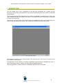
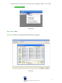
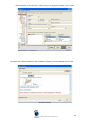
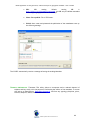
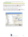
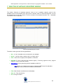
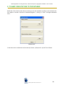
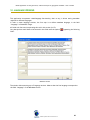
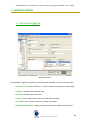
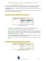
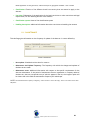
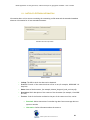
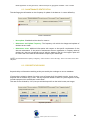
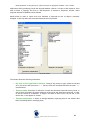
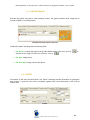
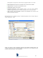
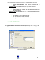
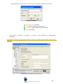
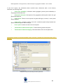
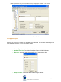
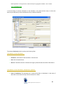
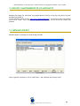
Global Spatial Data Infrastructure
User manual of the application MetaD
for the creation, edition and
exportation of geographical metadata
(ISO 19115 – ISO 19139)
Version: 3.0.5
August 2009
MetaD application for the generation, edition and export of geographic metadata – User’s manual
ÍNDEX
1. INTRODUCTION
2. INSTALLATION
3. MENÚ
3.1 FILE MENU
3.2 LANGUAGE MENU
3.3 UTILITIES MENU
• XML Viewer
• Metadata Import
• Send Metadata
• Thesaurus Maintenance
• Data language Maintenance
3.4 HELP MENU
4. HOW TO VALIDATE
5. HOW TO USE THE PROGRAM HELP
5.1 THE MICROHELP
6. HOW TO BROWSER BY THE PROGRAM
7. WINDOW OF SELECTION OF METADATA REGISTRIES
8. TO MAKE CONSULATIONS TO THE DATABASE
9. SPECIAL WINDOWS
9.1 SELECTION CONTACTS
9.2 INFORMATION CITATION
10. LANGUAGE VERSIONS
11. METADATA EDITION
11.1 METADATA INFORMATION
11.1.1 RESOURCE CONSTRAINTS
11.1.2 MAINTENANCE
11.1.3 METADATA EXTENSION INFORMATION
11.2 IDENTIFICATION INFORMATION
11.2.1 CONSTRAINTS
11.2.2 MAINTENANCE
11.2.3 DESCRIPTIVE KEYWORDS
11.2.4 GRAPH
11.2.5 EXTENT
11.2.6 AGGREGATE INFORMATION
11.3 DATA QUALITY
11.4 SPATIAL REPRESENTATION
11.5 REFERENCE SYSTEM INFORMATION
11.6 CONTENT
11.7 DISTRIBUTION
11.8 SHEETS IN THE SERIE
12. EDITION AND MAINTENANCE OF METADATA
13. METADATA EXPORT
Global Spatial Data Infrastructure
3
4
5
5
5
7
7
8
11
12
15
15
16
17
17
18
19
20
21
21
23
25
26
26
28
29
30
31
32
34
34
36
36
38
39
42
46
47
49
52
54
54
2
MetaD application for the generation, edition and export of geographic metadata – User’s manual
1. INTRODUCTION
This user manual tries to be a complement to the help that incorporates the program and the
document of the Profile of the Standard ISO 19115 with his implantation ISO 19139, which it contributes
some examples.
The principal objective of this application is the creation of metadata of orientated way, in such a way
that it facilitate, besides the creation: the edition, the maintenance and the exportation of metadata
of simple way for the user.
The structure and terminology of this manual follows the Standard ISO 19115 with his implantation ISO
19139. As this standard is very complex, the C.S.IDEC has created an extraction own profile.
Main application window
This window is formed by four menus placed in the most top part, from where we access to the
functionalities of the program.
The application, in the moment to be loaded, establishes connection with his database and, later, it
shows the principal window, together with the window of Metadata selection.
When the application is loaded connects to its database and shows the main window”
Global Spatial Data Infrastructure
3
MetaD application for the generation, edition and export of geographic metadata – User’s manual
2. INSTALLATION
To install the program MetaD to execute the file “Setup.exe” and to follow the steps that the assistant
marks.
To reach a correct running of MetaD the system requirements are:
Operative System Windows 98, 2000, NT, XP or VISTA.
Available space in the hard disc: between 6 and 30 Mb.
NOTE: The available space of the hard disk will vary according to the number of components (mdac, Windows installer...) installed in the
PC.
This new version (MetaD 3.0.5) installed also a mdb backup (when there are previous versions installed)
For any problem to send a mail to IDEC: [email protected]
Global Spatial Data Infrastructure
4
MetaD application for the generation, edition and export of geographic metadata – User’s manual
3. MENU
3.1 FILE MENU
File Menu shows the creation, edition and consult of metadata stored in the database. It has the
following functionalities:
File Menu
•
New metadata: Generation of new metadata registers. During metadata generation appears
the window with the mandatory fields to be completed as minimum. When user click on
“OK” the program will show a new window with edition and metadata flanges.
•
Metadata consultation: It allows the maintenance, edition and metadata consultation,
previously stored.
•
Database selection: It permits to connect with the selected database. By defect, the
program will accede to database inside off folder “mdb”.
For this version of MetaD is essential to maintain the database that is installed by default and work
from imports for the old database.
3.2 LANGUAGE MENU
From this menu, the user will be able to choose the language of the program. MetaD incorporates three
different languages: Catalan, Spanish and English. By defect, the application is in Catalan. If one wants
to be employed at another language it is necessary to change it before initiating every metadata.
MetaD will remember the last language that had the program before closing itself; this way it will not
have to specify the language constantly.
Global Spatial Data Infrastructure
5
MetaD application for the generation, edition and export of geographic metadata – User’s manual
Language menu
Note: We can choose the language of the code list; this option is found under the tab "Metadata"
Choose Language
Global Spatial Data Infrastructure
6
MetaD application for the generation, edition and export of geographic metadata – User’s manual
3.3 UTILITIES MENU
Utilities menu
The “Utilities” menu:
XML Viewer: Useful tool to display XML files generated by the program.
XML Viewer
Global Spatial Data Infrastructure
7
MetaD application for the generation, edition and export of geographic metadata – User’s manual
XML Viewer
Metadata Import: This function will allow the users to interchange metadata with other organisms or
companies, and even, with other departments inside the same company or organism. What it is
tried to obtain is the maximum interoperability.
There are two options: Import other MetaD databases and Import XML files from FGDC. MetaD not
matter xml own.
IMPORT OTHER MetaD DATABASES
The importation of metadata from another data base as much guarantees the maintenance of the
languages version as of the sheet structure.
In order to import registries from other data base is necessary to choose the MetaD.mdb file that is
wanted to import by means of the button “Choose Origin Database”. Once chosen, they will appear in
the window “Available Metadata” all the registries that data base includes. To the right of each registry
there is a square that can be selected. Each selected registry will be the one that will be import to our
data base. Finally, the button is pressed “Import”.
Global Spatial Data Infrastructure
8
MetaD application for the generation, edition and export of geographic metadata – User’s manual
Import other MetaD databases
IMPORTA XML FILES FROM FGDC
Import XML files from FGDC
Global Spatial Data Infrastructure
9
MetaD application for the generation, edition and export of geographic metadata – User’s manual
In order to do this is necessary to choose, in the first place, the directory where are the archives that
are wanted to import. Next, these will be in list “XML Files”. Finally, the user will have to select those
that wish to import ant to pass them, by means of the key “> >” to the list “File to import” y to press
“Import”.
Note: The xml file import FGDC works with some errors. There are some fields to be filled again once
imported the xml. The screenshots show the steps to complete the validation of this type of file
The application indicates that the xml does not pass validation because some areas still to be filled
choose "yes" and edit these fields, to know just what you need to go to the window on the left part of
MetaD and find content within the tree those sections that have the symbol red
Global Spatial Data Infrastructure
and fill.
10
MetaD application for the generation, edition and export of geographic metadata – User’s manual
Send Metadata: When the edition of the metadata is finished it can be published with this tool.
Metadata publishing
Global Spatial Data Infrastructure
11
MetaD application for the generation, edition and export of geographic metadata – User’s manual
•
URL:
URL
catalog.
Default
catalog
URL
is
http://delta.icc.es/idecwebservices/metad, this URL only it Publisher metadata
concerning the geographical area of Catalunya.
•
Select file to publish: File in ZIP format.
•
Publish: Once cosen and pioneered the publication of the metadatum turns up
the following message.
The CS IDEC automatically receive a message informing the sending Metadata
Thesaurus Maintenance: Thesaurus: This utility allows to incorporate and to maintain thesauri of
subjects and key words, with the purpose of facilitating the edition of the metadata. To access
this tab go to Identification, Descriptive keywords, and from any typology (discipline, place,
stratum, temporal, theme) can access this tool.
Global Spatial Data Infrastructure
12
MetaD application for the generation, edition and export of geographic metadata – User’s manual
Thesaurus maintenance
THE THESAURUS IMPORT
The Thesaurus Import it allows, to the users, to incorporate own lists of key word. In order to do it, in
the first place, it is had to decide if it is included in Thesaurus existing, or new one is created one.
Next, is pressed the button to “Choose Source Database” and to open Thesaurus (the own program lists
the Tables in the data bases, if this structure is the correct ).
To include in existent Thesaurus. it allows to select Thesaurus of the list “ Choose Thesaurus” (in the
inferior part there are accountants, who show the name of keywords that has Thesaurus selected).
To include in a new Thesaurus. Here we give the name that will have this thesaurus in three different
languages.
Global Spatial Data Infrastructure
13
MetaD application for the generation, edition and export of geographic metadata – User’s manual
Note: In order to import thesaurus correctly, the fields must have the following structure
NAME
FORMAT
VALUE
CA
Text 240
Key word or object in Catalan
ES
Text 240
Key word or object in Spanish
EN
Text 240
TYPE
Integer or simple number
Key word or object in English
Subject of the key word:
1. - Discipline, 2. - Place, 3.- Stratum, 4.Storn, 5.- Subject, 0. - Object
MAINTENANCE OF THE TESAURUS
The Maintenance of the Thesaurus allows modifying Thesaurus existing (be. a delegation can eliminate
toponymy of the rest of the provinces, since it is not to him of any utility and it releases to the data
base of an important volume of information.
In order to modify Thesaurus it is had to choose the one that is tried to alter, as well as the type and to
press “Update List”. Next display the key words, in three languages, that Thesaurus are in that. With
the inferior buttons, key words can be added, be eliminated and be modified.
Thesaurus maintenance (maintenance)
Global Spatial Data Infrastructure
14
MetaD application for the generation, edition and export of geographic metadata – User’s manual
DATA LANGUAGE MAINTENANCE: This utility allows to add or to eliminate new languages concerning
the datum.
Data language maintenance
3.4 HELP MENU
It shows information about the version and copyright of the application and incorporates the Help Menu
for the user
HTML Help
About MetaD
Global Spatial Data Infrastructure
15
MetaD application for the generation, edition and export of geographic metadata – User’s manual
4. VALIDATION
In order to validate metadata registries, click on “Validate” that appears on the program flanges and
windows to know whether all requirements have accomplished with standard.
Validate Function
The validate function controls the mandatory of metadata nature, that’s to say, whether in the process
to enter metadata we forgot an element considered obligatory by the standard, the program will advise
and request this element. In this way, we make sure that metadata accomplish with Standard ISO
19115.
As soon as the symbolized information is validated symbol
into symbol
that means correct validated.
that appears in the above tree changes
Global Spatial Data Infrastructure
16
MetaD application for the generation, edition and export of geographic metadata – User’s manual
5. HOW TO USE THE PROGRAM HELP
5.1 THE MICROHELP
Help messages appear on the left. The Standard ISO 19115 text describes briefly the meaning of the
selected field. The “Error” flange advice about the mandatory fields to be fulfilled.
Micro help
Global Spatial Data Infrastructure
17
MetaD application for the generation, edition and export of geographic metadata – User’s manual
6. BROWSERING PROGRAM
This application incorporates a tree to facilitate browsering in different fields of the standard and find
them immediately and realizing witch is uncompleted. The symbol
shows a blank mandatory fields;
the symbol
shows a fulfilled fields; and the symbol
shows blank optional fields.
In order to accede to a field, users have to select it in the tree and click on “Show Field”.
Symbol ">>" allows to extent the tree windows and see all its contains.
The application doesn't allow to record metadata until mandatory fields have been completed.
Consequently, it is recommended to complete all fields with the red symbol
from the very beginning
and afterwards to record metadata. In this way, information losing can be avoided.
Tree
Global Spatial Data Infrastructure
18
MetaD application for the generation, edition and export of geographic metadata – User’s manual
7. SELECTION OF METADATA REGISTRIES WINDOW
The window “Selection of metadata registries” shows a list of metadata registries stored in the
database as well as the metadata title, type (series or dataset), date of creation and identifier. List can
be ordered by any of the four columns. In order to accede to this window the menu "File --> Metadata
Consultation" has to be opened.
Selection of Metadata Registers window
The above window gives the following possibilities:
•
New: A “new “metadata can be introduced in our database.
•
•
Delete: It allows erasing a registry that is no longer useful.
Show: Users select a registry to be updated or consulted.
•
Duplicate: To get a copy from the selected registry. Concerning registries series, program
requests if copy of sheets are needed.
XML Export: It allows generating selected metadata as XML file.
•
MEF: MetaD v.3.0.5 adds the new option of generating MEF format file (Metadata
Exchange Format) related with GeoNetwork architecture.
•
•
•
Filter: Basic filtered consultations to the database.
Show all: Filter deactivation.
Exit: Closing de window
Global Spatial Data Infrastructure
19
MetaD application for the generation, edition and export of geographic metadata – User’s manual
8. TO MAKE CONSULTATIONS TO THE DATABASE
MetaD has a filter function that allows recovering a concrete metadata according to users demand. We
can request to window “Selection of Metadata Registers”, clicking on “Filter” and appers Metadata
Filter.
Metadata Filter.
In the above chart consultations can be made by Contact, by Keyword or by the Title of Sheets.
Global Spatial Data Infrastructure
20
MetaD application for the generation, edition and export of geographic metadata – User’s manual
9. SPECIAL WINDOWS
9.1 SELECTION CONTACTS
This window provides the necessary information on the contact organization (producers, distributors,
etc.).
Selection of Contacts
Information concerning the Contact:
Individual Name: Person to be contacted in case of doubts.
-
Organization Name: Organization to be contacted in case of doubts. The contact for the data
set and the contact for the source can be different.
-
Position Name: In the organization, post of the person in charge of metadata.
-
Hour of Service: Public attention timetable of the person or organization.
-
Contact Instructions: Specific ways to contact persons or organizations
Global Spatial Data Infrastructure
21
MetaD application for the generation, edition and export of geographic metadata – User’s manual
Information concerning the contact address as follows:
•
Country: The country in which it is located the person or organization.
•
City: The city in which it is located the person or organization.
•
Administrative Area: The Administrative Area in which it is located the person or organization.
•
Postal Code: The Postal Code of the Organization.
•
Phone: Telephone to contact with the person or organization.
•
Facsimile: Fax to contact with the person or organization.
•
Electronic mail : Electronic mail to contact with the person or organization.
•
Delivery Point: Direction of the distribution centers and sale where the data can be acquired
Information about online resource to data:
•
Linkage: Web page in which the data is located, either dataset information or a form to get it.
•
Function: Services that can be found in the URL.
In order to edit (to add or to delete) the contacts, or, to modify the existing ones, please click on:
•
Validate: (the utility of which already it has been explained previously)
•
Save: It allows saving the changes made in the contacts. This function to save is independent of
which appears in the flanges.
To update data:
•
Add Contact: It issues a new registry where to insert information about the new contact.
•
Edit: It modifies the information contact.
Click on:
•
Select: To choose a contact of the list.
•
Exit: To close Contacts window.
Global Spatial Data Infrastructure
22
MetaD application for the generation, edition and export of geographic metadata – User’s manual
9.2 INFORMATION CITATION
The Information “Citation” provides a reference of data that are being described.
*NOTE: The control panel text Identifier, Name of the series and emission of the series will be deactivated if the option Series has been
chosen in the Metadata flange Level of Hierarchy.
Citation
•
Title: Dataset name.
•
Alternative title: Short name under which the cited information is known. Example: "DCW" as
an alternative for "Digital Chart of the World”
•
Collective title: Common title with holdings note. NOTE: Title identifies elements of a series
collectively, combined with information about what volumes are available in the source cited
•
Series: Information about the series, or aggregate dataset, of which the dataset is a part.
•
Edition: Data version.
•
Date of edition: Data version date.
•
Identifier: The unique number that refers to a single dataset
•
ISBN: Unique edition number to identify a concrete publication by a specific publisher.
•
ISSN: Standardized international number for publications in series.
Global Spatial Data Infrastructure
23
MetaD application for the generation, edition and export of geographic metadata – User’s manual
•
Other details: Additional and clarifying explanations for dataset understanding.
•
Date: The date in which dataset was created, reviewed or published.
•
Presentation: Format in which the resource is represented.
•
Cited Responsible: The person, group of people or the organization in charge of the dataset.
•
Position role: The position that has the person, the group of persons with regard to the
dataset.
Global Spatial Data Infrastructure
24
MetaD application for the generation, edition and export of geographic metadata – User’s manual
10. LANGUAGE VERSIONS
This application incorporates a Multilanguage functionality, that's to say, it allows storing metadata
registries in different languages.
In order to enter language versions, the first step is to define metadata language, in the field
“Language” in "Metadata" flange.
All fields with free text incorporating this tool In this version (3.0.5).
Long descriptions would have to be entered in the fields with the symbol
Chart.
appearing the following
Idiomatic versions
The window allows entering up to 5 language versions. Observe that the first language corresponds to
the field “Language” of the Metadata section.
Global Spatial Data Infrastructure
25
MetaD application for the generation, edition and export of geographic metadata – User’s manual
11. METADATA EDITION
11.1 METADATA INFORMATION
Metadata information
The "Metadata" flange will give general information about metadata. It has the following items:
-
Hierarchy Level: It selects “Dataset” or “Series” (datasets that belong to a same family).
-
Language: Language used to describe data.
-
Date Stamp: Metadata generation date
-
Contact: Contact Organization to solve any doubt about metadata.
-
Role: Position that occupies the person in charge of metadata.
-
Metadata Standard Name: It appears predetermined and the standard use is ISO 19115.
Global Spatial Data Infrastructure
26
MetaD application for the generation, edition and export of geographic metadata – User’s manual
-
Metadata Standard Version: It appears predetermined.
- Character Set: It appears predetermined the character codification standard used in Western
Europe.
Global Spatial Data Infrastructure
27
MetaD application for the generation, edition and export of geographic metadata – User’s manual
11.1.1 RESOURCE CONSTRAINTS
This sub flange provides information about the restrictions that can be applied in the data set. The
information is constructed in two blocks: the Legal Constraints and the Constraints of Security.
The Legal Constraints refer to those limitations and legal requirements before the access and the use
of the data set.
The Security Constraints are those limitations imposed on the data set to preserve the national,
private safety or other aspects of the data set.
The fields that appear in the Legal Constraints are the following ones:
Identification Legal Constraints
•
Use limitations: It describes the way to use the data set. It provides the possibility to the
producer of the data of orienting to the user in the good use of the data set.
•
Access constraints: Limitations of access applied to the data set to assure the privacy or
intellectual protection, and any restriction or special limitation in its obtaining. Limitations of
access applied to the data set to assure the privacy or intellectual protection, and any
restriction or special limitation in its obtaining.
•
Use constraints: Limitations of use applied to the data set to assure the privacy or intellectual
protection, and any restriction or special warning for its use.
•
Other constraints: It allows the user to describe the restrictions nonnamed in the other
options.
The fields that appear in the Security constraints are the following ones:
Identification Security Constraints
Global Spatial Data Infrastructure
28
MetaD application for the generation, edition and export of geographic metadata – User’s manual
•
Classification: Election of the different levels from security that are wanted to apply to the
data set.
•
User Note: Explanation of the application of the legal restrictions or other restrictions and legal
requirements, for the obtaining and use of the data set.
•
Classification system: Name of the classification system
•
Handling description: additional information about the restrictions on handling the resource
11.1.2 MAINTENANCE
This subflange gives information on the frequency of update of the data set. It comes defined by:
Resource maintenance
•
Next update: Scheduled revision date for resource
•
Maintenance And Update Frequency: The frequency with which the changes and updates of
the data set are made.
•
Maintenance notes: Additional information with respect to the specific requirements for the
data set maintenance. If the period of maintenance that an organization or company makes of
the data set, does not correspond to any of which it appears in the list, the irregular option will
be chosen and in this field the maintenance frequency will take shape.
*NOTE:
The field Maintenance Frequency is obligatory, reason for which it cannot be empty. This it is the reason for this small
adaptation
Global Spatial Data Infrastructure
29
MetaD application for the generation, edition and export of geographic metadata – User’s manual
11.1.3 METADATA EXTENSION INFORMATION
Information about on-line sources containing the community profile name and the extended metadata
elements. Information for all new metadata elements.
Metadata extension information
Online resource
•
Linkage: The URL in which the data can be obtained.
•
Protocol: Protocol of the connection that will be in use (for example, WWW:LINK-1.0http-link)
•
Name: Name of the document, (for example, Manual_Integració_web_services.pdf)
•
Description: Brief description of the content of the document (for example, llista WMS
de l’ICC)
•
Function: Code of the function realized on the part of the resource on line, can be:
•
Download: Online instructions for transferring data from one storage device or
system to another
•
Information: Online information about the resource
Global Spatial Data Infrastructure
30
MetaD application for the generation, edition and export of geographic metadata – User’s manual
•
OfflineAcces: Online instructions for requesting the resource from the provider
•
Order: Online order process for obtaining the resource
•
Search: Online search interface for seeking out information about the resource
11.2 IDENTIFICATION INFORMATION
Identification information
The Identification flange contains all the elements corresponding to necessary and basic information
for the identification, only data. As it is possible to be appreciated in figure 17, this flange includes five
sub flanges more, which will explain later sections. The use of each one of the fields of the flange
Identification is the following one:
•
Citation: It makes reference to the identification of the data set or series as well as to the
standardization of its data.
•
Status: It indicates the status of the update of the data set or series or regularity of the
revision processes.
•
Supplemental information: Any other descriptive information about the data set.
Global Spatial Data Infrastructure
31
MetaD application for the generation, edition and export of geographic metadata – User’s manual
•
Environment description: Description of the data set in the environment of processing of the
producer, including the type of software, the operating system, the name of the file.
•
Credit: Recognition of those who have contributed.
•
Abstract: It describes to the content and the main characteristic of the data set.
•
Purpose: It explains with that purpose has developed the set of data.
•
Languages: Language inside the set of data ser or series.
•
Point of contact: Identification of the person or organization, to which they can consult in case
of doubts relating to the data set.
•
Role: Status of the person responsible for the set of data or series.
•
Character Set: Name of the standard of codification of characters used for the set of data or
series.
•
Spatial Representation: Method used for the representation of the geographical information. It
is possible to choose between several options of representation.
•
Topic category: They will be able to classify geographical information to high level to allow
grouping and search of the data sets available. They are used to group key words.
11.2.1 IDENTIFICATION RESOURCE CONSTRAINTS
Provider This subflange provides information about the restrictions that can be applied in the data set.
The information is constructed in two blocks: the Legal Constraints and the Constraints of Security.
The Legal Constraints refer to those limitations and legal requirements before the access and the use
of the data set.
The Security Constraints are those limitations imposed on the data set to preserve the national,
private safety or other aspects of the data set.
The fields that appear in the Legal Constraints are the following ones:
Identification Legal Constraints
Global Spatial Data Infrastructure
32
MetaD application for the generation, edition and export of geographic metadata – User’s manual
•
Use limitations: It describes the way to use the data set. It provides the possibility to the
producer of the data of orienting to the user in the good use of the data set.
•
Access constraints: Limitations of access applied to the data set to assure the privacy or
intellectual protection, and any restriction or special limitation in its obtaining. Limitations of
access applied to the data set to assure the privacy or intellectual protection, and any
restriction or special limitation in its obtaining.
•
Use constraints: Limitations of use applied to the data set to assure the privacy or intellectual
protection, and any restriction or special warning for its use.
•
Other constraints: It allows the user to describe the restrictions nonnamed in the other
options.
The fields that appear in the Security constraints are the following ones:
Identification Security Constraints
•
Classification: Election of the different levels from security that are wanted to apply to the
data set.
•
User Note: Explanation of the application of the legal restrictions or other restrictions and legal
requirements, for the obtaining and use of the data set.
•
Classification system: Name of the classification system
•
Handling description: additional information about the restrictions on handling the resource
Global Spatial Data Infrastructure
33
MetaD application for the generation, edition and export of geographic metadata – User’s manual
11.2.2 MAINTENANACE IDENTIFICATION
This subflange gives information on the frequency of update of the data set. It comes defined by:
Resource maintenance
•
Next update: Scheduled revision date for resource
•
Maintenance And Update Frequency: The frequency with which the changes and updates of
the data set are made.
•
Maintenance notes: Additional information with respect to the specific requirements for the
data set maintenance. If the period of maintenance that an organization or company makes of
the data set, does not correspond to any of which it appears in the list, the irregular option will
be chosen and in this field the maintenance frequency will take shape.
*NOTE:
The field Maintenance Frequency is obligatory, reason for which it cannot be empty. This it is the reason for this small
adaptation
11.2.3 DESCRIPTIVE KEYWORDS
Keywords help to information searching as they are used by the catalogue to recover metadata.
If keywords are related to sheets of a series, most of keywords will be related to series, that is to say
keywords will be entered only on time. The only keywords related to sheet are "place keywords" as they
include toponyms which are different in each sheet.
This new version of MetaD (v.3.0.5) lets you add the keyword from the initial screen (see image).
Keywords information
Global Spatial Data Infrastructure
34
MetaD application for the generation, edition and export of geographic metadata – User’s manual
Application allows introducing words that describe dataset contents. In order to edit keywords, users
have to select a "Typology" and click on “Edit Keywords” to accede to “Keywords” window, where
keywords included in database can be defined.
MetaD allows to users to import their own thesaurus of keywords as well as objects, previously
designed. In this way users save time when keywords are incorporated.
Keywords window
The window shows the following information:
•
Key word in the of typeTema to thesaurus: Listing of key words, by type, related to the data
set or the series. With the button “> >” the key words are introduced and with the other “<<”
are eliminated.
•
Thesaurus Name: Document of reference of which that has been extracted the key words. In
this list they will appear the entire thesaurus on key words that have been concerned. In order
to see the content of a thesaurus, so single it will have to select one of the list and, in the
inferior box, it will appear its content.
•
Thesaurus maintenance: It allows to manage thesaurus; importing them of one another data
base, eliminating them or modifying them
Global Spatial Data Infrastructure
35
MetaD application for the generation, edition and export of geographic metadata – User’s manual
11.2.4 BROWSE GRAPHIC
Describe the graphic that gives a visual example of data. The graphic (dataset raster image) has to
include a legend for its interpretation.
Identification and Graphic Overview
The Browse graphic sub flange has the following fields:
•
File Name: It contains the graphic that provides dataset image. User has to click on
to
find the correct image. To cancel this selection, click on
•
File Type: Image format.
•
File Description: Image content description.
11.2.5 EXTENT
Information on the area covered by data. The "Extent" subflange provides information on geographic
data location. It gives the four corners coordinaes together with a brief description of the covered
dataset area.
Extent
Global Spatial Data Infrastructure
36
MetaD application for the generation, edition and export of geographic metadata – User’s manual
•
Extent description: Brief description of geographic area in which data are available.
•
Temporal extent: Time period covered by dataset content.
•
Vertical extent: Dataset vertical domain
•
Geographic Bounding Box: Dataset geographic position i.e. the four corners coodinates,
expressed in degrees decimal (and no in UTM), that bounder the area covered by dataset.
•
Spatial resolution /Scale denominator (v.3.0.5): Scale denominator from a data set and
distance (pixel spatial resolution).
MetaD application has a coordinate’s converser. To make the conversion, click on “Convert” below. of
the tab "identification", "extent"
Initially, user needs to choose "cartographic projection" and "metadata coordinates limits". The
"Converser" automatically converts UTM into geographic coordinates and vice versa. Application allows
a thematic searching with layers "cities" and "gazettes".
Global Spatial Data Infrastructure
37
MetaD application for the generation, edition and export of geographic metadata – User’s manual
11.2.6 AGGREGATE INFORMATION
Aggregate information
DataSet name: Citation information about the aggregate information
DataSet identifier: Identification information about aggregate information
Association type: Association type of the aggregate dataset
Initiative type: type of initiative under which the aggregate dataset was produced
Global Spatial Data Infrastructure
38
MetaD application for the generation, edition and export of geographic metadata – User’s manual
11.3 DATA QUALITY
The flange "Data Quality" informs about data quality and the applied measures to evaluate it.
Geographic information has its own roles and criteria to guarantee its quality.
Data quality gives information about the product and allows to potencial users to determine whether
data meet with their requirements.
Data Quality Information
"Data Quality" flange has the following sections:
•
Lineage: Information about processes or documentary sources used in data production
and steps for data generation.
•
Statement: General comment about dataset lineage.
•
Description of the information sourced: Information on sources used in data
generation. Explanation of parameters or characteristics related to source. It is
required to mention the source name, the scale and a short description of the source
features, as minimum.
NOTE: This element appears by duplicate in the flange "Sheet". It appears by duplicate because the source existing
information can vary from one sheet to another (i.e. flight date and flight scale). These two source parameters would
be stated in each sheet.
Global Spatial Data Infrastructure
39
MetaD application for the generation, edition and export of geographic metadata – User’s manual
•
•
Source citation: Information about data used for the generation of data specified by
the scope.
•
Process steps: Information about data production process. It can be taken as many
steps as required (+) and cancel those that are not necessary (-).
•
Description: Explanation about the process production steps.
•
Processor: Information on the Organization to be contacted for any doubt
about these processes, if any?
•
Role: Position that occupies the person in charge of production process.
•
Date: Date in which the production process is carried out.
•
Information's source description: Detailed source description.
•
Source citation: Information aboout the data set's version.
•
Scale denominator: Denominator of the map source's representative fraction.
Report type: It facilitates quantitative information about data quality specified in/on the
scope.
•
DQ_CompletenessComission: Presence or absence of features, their attributes
and relationships, Excess data present in a dataset
•
DQ_CompletenessOmission: Presence or absence of features, their attributes
and relationships, Data absent from a dataset
•
DQ_ConceptualConsistency: Degree of adherence to logical rules of data
structure, attribution and relationships, Adherence to rules of the conceptual
schema
•
DQ_DomainConsistency: Degree of adherence to logical rules of data structure,
attribution and relationships, Adherence of values to the value domains
Global Spatial Data Infrastructure
40
MetaD application for the generation, edition and export of geographic metadata – User’s manual
•
•
DQ_FormatConsistency: Degree of adherence to logical rules of data structure,
attribution and relationships, Degree to which data is stored in accordance with
the physical structure of the data set
•
DQ_TopologicalConsistency: Degree of adherence to logical rules of data
structure, attribution and relationships, Correctness of the explicitly encoded
topological characteristics of a dataset
•
DQ_AbsoluteExternalPositionalAccuracy: Accuracy of the position of features,
Closeness of reported coordinate values to values accepted as or being true
•
DQ_GriddeDataPositionalAccuracy: Accuracy of the position of features ,
Closeness of gridded data position values to values accepted as or being true
•
DQ_RelativeInternalPositionalAccuracy: Accuracy of the position of features;
Closeness of the relative positions of features in a dataset to their respective
relative positions accepted as or being true
•
DQ_ThematicClassificationCorrectness: Accuracy of quantitative attributes
and the correctness of non-quantitative attributes and of the classifications of
features and their relationships; Comparison of the classes assigned to features
or their attributes to a universe of discourse (e.g. ground truth or reference
data set)
•
DQ_NonQuantitativeAttributeAccuracy: Accuracy of quantitative attributes
and the correctness of non-quantitative attributes and of the classifications of
features and their relationships; Correctness of non-quantitative attributes
•
DQ_QuantitativeAttributeAccuracy: Accuracy of quantitative attributes and
the correctness of non-quantitative attributes and of the classifications of
features and their relationships; Accuracy of quantitative attributes
•
DQ_AccuracyOfATimeMeasurement: Accuracy of the temporal attributes and
temporal relationships of features ; Correctness of the temporal references of
an item (reporting of error in time measurement)
•
DQ_TemporalConsistency: Accuracy of the temporal attributes and temporal
relationships of features; Correctness of ordered events or sequences, if
reported
•
DQ_TemporalValidity: Accuracy of the temporal attributes and temporal
relationships of features; Validity of data with respect to time
Detail Report: Quantitative quality information for the data specified by the scope
•
Measure name: Test name to be applied to dataset.
•
Measure description: Brief explanation about measurement applied to data.
Global Spatial Data Infrastructure
41
MetaD application for the generation, edition and export of geographic metadata – User’s manual
•
Evaluation method description: Method description followed to apply to
dataset.
Conformance result: It indicates whether the result meets with the quality test:
•
Specification: Brief citation of product specifications
•
Explanation: Brief report concerning ther results obtained once measure has
been applied to dataset.
Quantitative result: Information about value or set of values obtained when applying the
quality measure.
•
Statistic Error: Statistical method used to determine the value.
•
Type: Value type to report the data quality result.
•
Unit: Value unit to report the data quality result.
•
Value: Quantitative value witch is determined by evaluation procedure used.
11.4 SPATIAL REPRESENTATION
The "Spatial Representation" flange gives information about data structure, raster or vectorial. In case
of non-graphical information (for example tabular information), this flange would remain empty.
Vectorial Spatial Representation
Global Spatial Data Infrastructure
42
MetaD application for the generation, edition and export of geographic metadata – User’s manual
Information concerning vectorial structure including the following fields:
•
•
Topology Level: Degree of complexity of space relations among objects that appear in the dataset.
Geometric Objects Types: Geometry of objects that appears in the dataset.
•
Geometric Object Count: Total number of points or vectorial objects in the dataset.
Grid Spatial Representation Information
Information related to raster structure includes the following fields
•
•
•
Number of Dimensions: Grid data identification like point or area.
Cell Geometry: Grid data identification like point or area.
Dimension Information: Description of characteristics of the space-temporary axis.
Global Spatial Data Infrastructure
43
MetaD application for the generation, edition and export of geographic metadata – User’s manual
Dimension information
•
•
•
•
•
Dimension name: Axis name
Size: Number of elements along the axis.
Resolution: Degree of detail in the grid dataset.
Units: Axis amount
Transformation Parameters Availability: It informs on the existence of transformation
parameters.
Information related to georectified raster structure, includes the following fields (3.0.5
version):
Grid Spatial Georectified Representation Information
Global Spatial Data Infrastructure
44
MetaD application for the generation, edition and export of geographic metadata – User’s manual
In this 3.0.5 version, the information about rectified raster information adds to the formerly
mentioned, the following fields:
•
Check point availability: Information about geographic position points availability in
the grid georectified data test.
•
Check point description: Description of the geographic position points used in the grid
georectified data test.
•
Corner points: There're 4 corner points in a georectified grid, or unless, 2 corner points
along a diagonal.
•
Center point : Location on earth in the cell's coordinate system halway between the
spatial dimension opposite ends of the grid.
•
Pont in pixel: Location on earth of the current pixel.
•
Transformation dimension description: Transformation's general description.
•
Transformation dimension mapping: Information about which are the spatial axis.
Information related to georeferenceable raster structure, includes the following fields (3.0.5
version):
Grid Spatial Georeferenceable Representation Information
Global Spatial Data Infrastructure
45
MetaD application for the generation, edition and export of geographic metadata – User’s manual
In this 3.0.5 version, the informatión about georeferenced raster information adds to the formerly
mentioned, the following fields:
•
Control point availability: Information about the existence or not of the control point.
•
Orientation parameter availability: Information about the existence or not of the
orientation parameters.
•
Orientation parameter description: Description of the parameters used for describing
the sensors' orientation.
•
Georeferenced parameters : Terms supported by the grid when georefering data.
11.5 REFERENCE SYSTEM INFORMATION
In the flange, System of Reference, introduces the information referring to the used system to
georeference spatial data.
The data that appear in the following fields come predetermined, since the reference system of
Catalunya is always the same one (31N zone). However also it includes other zones: 28N, 29N, 30N,
32N, 33N, 34N, 35N y 36N. Whatsoever the data can be edited, or, can be incorporated new systems of
reference to adapt to other geographic zones.
Reference System Information
Global Spatial Data Infrastructure
46
MetaD application for the generation, edition and export of geographic metadata – User’s manual
11.6 CONTENT
The flange Content describes dataset, i.e. the information associated to dataset objects
It allows describing the associated information to dataset and objects that appear on cartography as
well as their attributes.
The Content flange involves elements referred to Objects (Feature catalogue description- Vectorial
System) and Covers (Coverage description-Raster System):
Content Information (Object Catalogue)
Features Description Catalogue:
It identifies the objects of the catalog, the used thesaurus to define them and the attributes associated
to each object.
•
Feature type/Feature attribute: The user may edit objects and their attributes
represented in cartography.
Global Spatial Data Infrastructure
47
MetaD application for the generation, edition and export of geographic metadata – User’s manual
Content Information (Coverage description)
Coverage Description:
Choosing this option on the content of a raster data cell is described the information on the objects to
which they make reference, as well as its type of content.
•
Content Type: Information about the cell value.
•
Attribute Description: Description of attributes features included in dataset.
•
Dimension: Iformation on the dimensions of the cell measurement value
•
Image Description: Information about suitable images to be used.
Global Spatial Data Infrastructure
48
MetaD application for the generation, edition and export of geographic metadata – User’s manual
11.7 DISTRIBUTION
In this last flange it contains information of the distributor, the options and the steps to collect the
data; they already are by online transference like by traditional methods
Distribution
The element Distribution this formed by the following fields
Information of the Distributor:
•
Distributor: Information of the Distributor of the data set.
•
Role: Role of the distributor
•
Remove: This button allows to eliminate the registry selected within the table of distributors
Information of the Distributor transference options:
•
Units of distribution: The minimum unit in which the product is distributed. In the event of
that there is more than one they will be sorted out for comas.
Global Spatial Data Infrastructure
49
MetaD application for the generation, edition and export of geographic metadata – User’s manual
•
Transference Size: The size of the file.
•
Of line Access (offLine): Us of physical support to distribute the datum
Medium information
-
•
Name: Name of the type of support in which the data are given
•
Density: Density in the that the datum has avoided
•
Units: Units in those that it expresses the density
•
Name of the environment: Description about other requirements or limitations to use
the support
•
Format: Identification of the norm or standard on which the format of delivery of the
data is based
Access online: If the company or organism has the possibility of distributing the data through
Internet, here it is where this information is written.
Online resource
•
Linkage: The URL in which the data can be obtained.
•
Protocol: Protocol of the connection that will be in use (for example, WWW:LINK-1.0http-link)
Global Spatial Data Infrastructure
50
MetaD application for the generation, edition and export of geographic metadata – User’s manual
•
Name: Name of the document, (for example, Manual_Integració_web_services.pdf)
•
Description: Brief description of the content of the document (for example, llista WMS
de l’ICC)
•
Function: Code of the function realized on the part of the resource on line, can be:
• Download: Online instructions for transferring data from one storage device or
system to another
•
Information: Online information about the resource
•
OfflineAcces: Online instructions for requesting the resource from the provider
•
Order: Online order process for obtaining the resource
•
Search: Online search interface for seeking out information about the resource
Information on the Distribution Format:
•
Name: The name with which the data are transferred or distributed.
•
Version: The version of the format (data, number…).
•
Specification: Name of the subset, profile or specifications of the product of the
format
•
File decompression technique: Tool that it is necessary to use for the decompression
of the file
Information on the Standard Order Process:
•
Fees: The price of buy of the data (to include monetary unit).
•
Planned Available Date: Period in which the data are available.
•
Turnaround: Period since the order becomes until the data are received
•
Ordering Instructions: General trainings and services of distribution of the data set.
Global Spatial Data Infrastructure
51
MetaD application for the generation, edition and export of geographic metadata – User’s manual
11.8 SHEETS IN THE SERIES
The flange "Sheets in the series" allows to introduce the specific information for each sheet.
This flange is adequate for those companies that have very extensive cartographic series. Gathering the
sheet information, avoids to duplicate information on series.
Information concerning the sheet
To load sheet registries, click on “Load Sheets” below.
Process of loading sheets of the series
Global Spatial Data Infrastructure
52
MetaD application for the generation, edition and export of geographic metadata – User’s manual
Information about sheet
•
Identifier: Number assigned to identify each sheet.
•
Title: Sheet name. Usually, it corresponds to the most representative toponym of the sheet.
•
Source Description: Information on sources used in data creation, parameters or
characteristics explanation related to sources: source name, source scale and a brief
description of their features, as minium.
•
Source scale: Scale of the source on which they have been based to produce the set of
information
•
Source Date: Day, month and year in which this information was captured.
•
Edition: Sheet updating number.
•
Edition Date: Day, month and year in which edition information was ended.
•
Geographic Bounding Box: Coordinates of the four corners of sheets.
•
Spatial Display with Grid (v.3.0.5): Information about de dimension. Lines and columns.
Global Spatial Data Infrastructure
53
MetaD application for the generation, edition and export of geographic metadata – User’s manual
12. EDICIÓN Y MANTENIMIENTO DE LOS METADATOS
Metadata can change. For this reason, the program allows to recover, at any time, any former record of
metadata and modify it.
To edit metadata, please click on “Selection of Metadata Registers”, choose the record to be modified
and click on “Show”. Once metadata is displayed, modifications can be carried out without any
problem.
13. METADATA EXPORT
Metadata export to catalogues is made through files XML .
Metada Export
Select registries to be export, click on "XML Export”. And it displays the following items:
Global Spatial Data Infrastructure
54
MetaD application for the generation, edition and export of geographic metadata – User’s manual
XML Export
The first time you export a file, the "assign XSLT template" is empty, this template is in the installation
directory MetaD: Program files/MedaD/xsl/ISO19139.xsl.
MEF Export
•
First field shows the directory where XML files will be generated.
•
Second field shows the directory where the ZIP file will be generated. This file involves all XML
files export with the associated image.
•
Third field specifies in which XSL template will be linked XML files generated for their
presentation or printing
•
MEF: MetaD v.3.0.5 adds the new option of exporting the complete series or just the selected
sheets in MEF format (Metadata Exchange Format) related with the GeoNetwork architecture.
•
Series export: When the registry to be exported is a series, MetaD allows to export all series or
the selected sheets.
•
All the sheets: It exports the complete series.
•
Selection of Sheets: Only exports the selected sheets.
Global Spatial Data Infrastructure
55
MetaD application for the generation, edition and export of geographic metadata – User’s manual
Selection Sheets-ZIP
Selection Sheets-MEF
Global Spatial Data Infrastructure
56