1
15
TT UU N
O LL N TT RR O
ON
& CC O
N TT SS &
M EE N
N SS TT RR UU M
N GG RR AA YY II N
Section 1. Introduce
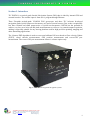
TIC INS700 is a tactical grade Inertial Navigation System (INS) that is aided by internal GPS and
external encoder. The encoder input is from user’s program through Ethernet.
Three Fizoptika tactical-grade VG095M FOG gyroscopes and three TIC in-house developed
navigation-grade QA100 quartz accelerometers are used as inertial sensors. Due to the exceptionally
low bias variation and small output noise of QA100 accelerometers, INS700 has the potential to
achieve very low error in its roll and pitch measurements as well as a very smooth output in position,
making it especially suitable for any moving platform used for high precision pointing, mapping and
other demanding applications.
The 18-states EKF algorithm is used to correct and calibrate INS error based on Zero-velocity Update
(ZUPT), wheel encoder measurements, GPS position measurement and vector-GPS yaw
measurement. The vector-GPS yaw measurement feature is a future option only.
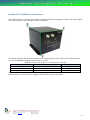
Fig. 1: The INS700 integrated navigation system.
TungRay Instruments & Control Pte Ltd
Co. Reg. No.:
200719313W
Address: Block 51 Ayer Rajah Crescent #02-09 Singapore 139948
Tel: (65) 6776 1070 / 6773 0170
Fax: (65) 6776 2610
website:
www.tic.sg
email: [email protected] 1