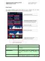
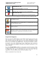
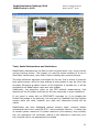
1
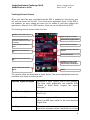
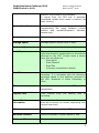
Bada Developers Challenge 2010
BADATracker v.1.0.0
Author: Filippo Forchino
Date: Oct 19th, 2010
User Manual
By Filippo Forchino
Oct 19, 2010
http://www.badatracker.com
1
Bada Developers Challenge 2010
BADATracker v.1.0.0
Author: Filippo Forchino
Date: Oct 19th, 2010
Chapter Index
Summary ............................................................................................ 3
Target and Use Cases ........................................................................... 3
Improvements compared with the Simulator Phase version ....................... 3
User Interface...................................................................................... 3
Tracking Control Screen ........................................................................ 4
Tracking Control Screen Icon Toolbar...................................................... 6
Recording a path .................................................................................. 6
Stats Screen ........................................................................................ 7
Stats Control Screen Icon Toolbar .......................................................... 8
Map Screen ......................................................................................... 9
Google Earth Integration ......................................................................10
Tests, Useful Informations and Limitations .............................................11
The Author .........................................................................................12
2
Bada Developers Challenge 2010
BADATracker v.1.0.0
Author: Filippo Forchino
Date: Oct 19th, 2010
Summary
BadaTracker is a GPS Tracker for everyone. It takes data from GPS and
calculates the total distance walked, average speed, maximum/minimum
height, slope and speed graphs, and so on. Tracking time is adjustable
according to the needs (sharper for running, more loose for long walking,
cycling, driving or trekking).
Using DeCarta mobile API current position, walked path and waypoints are
displayed on the map in real time. Trip data can be exported in KMZ format to
be archived on PC programs like Google Earth.
Target and Use Cases
The target user of the application is either the trekker or the tourist, who
would like to record his or her trip using the GPS. Our trekker arrives on the
place, starts recording and walks around. From time to time he may want to
take notes or pictures (thus saving a waypoint) that are saved on the map at
the exact coordinates where they were taken. Then he ends his trip, stops the
recording and the trip is saved on the phone as a KMZ file. When home, the
file can be imported in Google Earth, the trip can be thus reviewed and
archived on the PC.
Main Improvements compared with the Simulator Phase version
After the application has been first submitted to the Simulator phase, the work
hasn’t stopped. The application has undergone several improvements. The
most notable are:
- Redesigned User Interface
- Waypoint Feature. Waypoints (photo and description) can now be saved
- Calculation of time of Sunset/Sunrise according to the US Naval
Observatory algorithm
- Interactive map: start/end position and waypoints are displayed with
icons, zoom level and map centring/panning can be manually adjusted
- Support for both Metric and Imperial units of measure
- Improved speed and altitude graphs.
User Interface
The application is designed to make use of a compact and neat interface, to
provide accurate and useful information in a minimal set of forms, and as
much as possible in an user-friendly way. There are basically three screens:
tracking control, stats and map. You can navigate from one to another using
the big icons navigation bar in the footer.
In the next paragraph, the application screens and their functionalities are
described in detail.
3
Bada Developers Challenge 2010
BADATracker v.1.0.0
Author: Filippo Forchino
Date: Oct 19th, 2010
Tracking Control Screen
When you start the app, provided that the GPS is enabled on the device, you
will see the screen on the left. This is the main application form. If the GPS is
not enabled, an error popup will warn you to enable it, and then restart the
application. After all it is a GPS tracker, what can we do without the GPS?
The tracking control screen looks like this:
Satellites in view (v) and in use (u)
Current heading from the GPS
(becomes accurate when the speed
is >4 Km/h)
Current, average and maximum
speed.
Total distance covered during the
trip.
Signal strength of the satellites
Position valid or, if grayed, invalid
Current Latitude and Longitude
Road slope: downhill, uphill, flat or
unknown
Current time from GPS
Elapsed time since the start of the
trip.
Countdown to sunrise or sunset.
Estimated time of sunrise and
sunset for today is also displayed.
Current, maximum and minimum
altitude.
Toolbar
The various fields are described in detail below. The aqua-highlighted items are
available only when recording a path.
Satellite Signal Strength
Satellites in sight (green) and in use (yellow).
The bars show graphically the satellite SNR
(Signal to Noise Ratio, roughly the signal
strength).
Satellites in sight/use
Number of satellites in view (v) and in use for
the fix (u).
Position Valid Icon
The icon is greyed if the position is not valid.
When the GPS has a valid fix, the icons become
bright blue.
Heading
This information is shown both graphically (red
and white compass, where red points to current
4
Bada Developers Challenge 2010
BADATracker v.1.0.0
Author: Filippo Forchino
Date: Oct 19th, 2010
direction of movement) and textually.
It comes from the GPS and is generally
considered reliable when speed is relevant (at
least 4 Km/h).
Current Coordinates
Latitude and Longitude are displayed in degrees
(representing the angle between current
position and equator/Greenwich Meridian,
respectively).
Speed
Current speed in either Km/h or MpH.
Average Speed
Average speed in either Km/h or MpH.
Maximum Speed
Maximum speed in either Km/h or MpH.
Road Slope
The application uses an algorithm to detect
uphill and downhill slopes based on the altitude
returned by the GPS. Current slope is shown
here, this can either be:
- Road Uphill
- Road Downhill
- Road Flat
- Unknown (impossible to detect)
Total Distance
Total distance since the starting point of
recording. It is calculated with the Haversine
algorithm based on the positions returned by
the GPS. Measured in either Kilometers or
Miles.
Time
Local time derived from the GPS satellite
constellation.
Elapsed Time
Time interval
recording.
Sunset/Sunrise
Information
Predicted time of sunrise and sunset today, and
time left to sunrise (or sunset, depending from
current local time)
Altitude
Current altitude according to GPS.
Maximum Altitude
Maximum altitude in either meters or feet.
Minimum Altitude
Minimum altitude in either meters or feet.
since
the
starting
time
of
5
Bada Developers Challenge 2010
BADATracker v.1.0.0
Author: Filippo Forchino
Date: Oct 19th, 2010
Tracking Control Screen Icon Toolbar
RECORD PATH BUTTON
Start recording your path.
STOP RECORDING BUTTON
Stop recording your path. Your trip data is saved on the phone
memory in the /Media/Other folder. The path information is still
available on all the application screens until you start recording
another time.
STATS BUTTON
Takes you to the stats and graph screen.
MAP BUTTON
Takes you to the map screen.
WAYPOINT BUTTON
Allows you to store a waypoint over current GPS position
Recording a path
To start recording, press the RECORD button
once. You will be shown a popup where you can
choose the tracking time. This can be 10, 30 or 60
seconds.
BADATracker always evaluates a point every 2
seconds, but the tracking time will affect the size
of the data logged.
For example, if you plan a long trekking trip is not
useful nor wise to record a point every 10
seconds. Use 60 seconds resolution in this case.
Instead, if you go running you may want to have
more detailed stats so you can choose the 10
seconds resolution.
When recording, all stats and
become available.
more
options
6
Bada Developers Challenge 2010
BADATracker v.1.0.0
Author: Filippo Forchino
Date: Oct 19th, 2010
Stats Screen
This screen displays some more stats on your current trip (all these
information is thus available only if you are recording a path).
General trip information
Length and percentage of the road
done uphill and downhill, according
to the slope detection algoritthm
Speed vs time graph
Altitude vs time graph
Toggles between metric and
imperial units of measure
Back to the main screen
Average Speed
Average speed in either Km/h or MpH.
Trip Time
Time interval
recording.
Total Distance
Total distance since the starting point of
recording, measured in either Kilometers or
Miles.
Total Distance Uphill
Total distance run uphill, as detected by the
Slope Detection Algorithm. It is measured in
since
the
starting
time
of
7
Bada Developers Challenge 2010
BADATracker v.1.0.0
Author: Filippo Forchino
Date: Oct 19th, 2010
either feet or meters.
Total Distance Downhill
Total distance run downhill, as detected by the
Slope Detection Algorithm. It is measured in
either feet or meters.
Speed Over Time Graph
Auto-adaptative graph of the sampled speed (yaxis) over time (x-axis).
Altitude Over Time Graph
Auto-adaptative graph of the sampled altitude
(y-axis) over time (x-axis).
Stats Control Screen Icon Toolbar
BACK BUTTON
Back to the tracking control (main) screen.
TOGGLE UNIT OF MEASURE BUTTON
,
Allows you to toggle between metric and imperial units of
measure.
MAP BUTTON
Takes you to the map screen.
WAYPOINT BUTTON
Allows you to store a waypoint over current GPS position
8
Bada Developers Challenge 2010
BADATracker v.1.0.0
Author: Filippo Forchino
Date: Oct 19th, 2010
Map Screen
This form displays your current position (green) on the area map, and the
recorded path in blue. Beware! The map is dynamically loaded from DeCarta
servers, so it makes use of packet data traffic. You are warned of this the first
time you try to access to this feature. Additionally, to use DeCarta services you
are required to agree to Navteq (map provider) End-User Terms.
The agreement is displayed the first time you access this feature.
DeCarta Ads
Zoom map in and out
Map Information
Starting point
Ending point
Waypoint
Waypoint with picture. Double
tap it to show the picture.
Your current position
Your trip path is displayed in blue.
If this icon is not grayed out, click it
to set the map mode to autocenter. The map is automatically
centered on your position every
time is refreshed.
If this icon is not grayed out, click it
to move freely on the map.
Back to the main screen
You can use the standard map controls (multi-tap for zooming, slide finger to
scroll) to navigate the map. Additionally, the tool bar displays the following
options:
BACK BUTTON
Back to the tracking control (main) screen.
9
Bada Developers Challenge 2010
BADATracker v.1.0.0
Author: Filippo Forchino
Date: Oct 19th, 2010
FREEMOVE BUTTON
Allows you to move freely on the map.
AUTO-CENTER BUTTON
Locks the map, centring it on your current position.
WAYPOINT BUTTON
Allows you to store a waypoint over current GPS position
The following icons may be displayed on the map if you are recording a path:
Starting position of the recorded path (it is placed when you click
the RECORD button).
Ending position of the recorded path (it is placed when you click
the STOP RECORD button).
Waypoint. It is placed when you add a waypoint, and did not
specify a picture.
Waypoint with picture. It is placed when you add a waypoint, and
did attach a picture. You can double tap on this icon to display the
attached picture. Double tap on the picture to close it.
Google Earth Integration
When you click the STOP button on the Tracker Control screen, the trip you
were recording is saved in KMZ format on your phone /Media/Other storage
path. This file contains the GPS data of your trip and the thumbnails of all the
pictures you have taken using BadaTracker. The pictures themselves, instead,
are saved in the usual /Media/Images folder. BadaTracker does nothing to
them except adding geo-tagging information and waypoint description in the
image metadata.
If you have Google Earth installed, you can simply connect the phone in Mass
Storage mode to your PC. Then locate the KMZ file of your trip and double click
it. Google Earth will open it and display the trip on the map. Click the
waypoints to view the details and your picture thumbnail, if any.
Below a screenshot of how it looks like.
10
Bada Developers Challenge 2010
BADATracker v.1.0.0
Author: Filippo Forchino
Date: Oct 19th, 2010
Tests, Useful Informations and Limitations
BadaTracker was tested on the field on both long and short runs, trying out the
various tracking timers. The longest run was the whole tracking of a trip to
Mont Mars natural park, more than 6 hours trekking with several pictures.
The slope detection algorithm was tested on the car; this is where it gives the
best performances, while for bare walking at slow speeds it may be much less
accurate. Whenever a better version of the algorithm is worked out, it will be
available for all BadaTracker users as a free update.
Additionally, the algorithm relies on the GPS altitude measurement, that
depends on the fix quality and that can thus be inaccurate in some conditions.
If you travel in areas with no GPRS/UMTS coverage (or if you disable the
Packet Data usage in the settings), the map can’t be updated from the DeCarta
servers while you walk, however your path and viewpoints should still be
visible.
BadaTracker has been debugged against memory leaks, however please
understand that since it uses the GPS – and sometimes Camera - it makes use
of several system resources. If system resources (like memory) drop critically
low, the application will terminate making a last attempt to auto-save your
trip, however this is not guaranteed to succeed.
11
Bada Developers Challenge 2010
BADATracker v.1.0.0
Author: Filippo Forchino
Date: Oct 19th, 2010
For your convenience, the application keeps the screen always on, so that
when you are walking you can check on the map where you are going (like a
navigator does). So if you go for a long trip, remember to lock the screen
whenever you don’t use the phone. BadaTracker will keep working fine, and
you will save battery power.
The Author
Filippo Forchino, Italian, MS in Computer Science at the University of Turin.
Born in Ivrea, Italy, on April 2nd 1975. Working experiences include a lo
Working on Bada - for fun - since June 2010.
Contacts: [email protected]
Website – about me: http://www.borgomasino.net/forchino_online
12