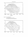
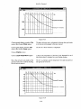
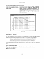
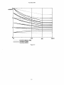
1
British Geological Survey
Natural Environment Research Council
Technical Report WC /93/04
International Geology Series
Basin Thermal Modelling using
HOTPOTversion 3.0
W J Rowley, R A Chadwick and D W Holliday
Tectonics and Database Gmup
Subject irrdrx
&sin analysis; computer mtxlelling
gculhcrmdI sl ud ic’s; hyd rocddxm
malurity; h yd rocadwn prospcct i v i t y
Ihis wport wds pwpdrcd for the O v c t x u b
I3cvelopment Administration
0 NERC Copyright 1993
Keyworth, Nottingham
British Geological Survey 1993
f
Contents
1
Introduction ......................................................................................................... 1-1
1.1 Background ....................................................................
1-2 ~
.................................................
~significance
~ of thermal
~
modelling
~
......................................................................
~
i
c
1-2.1 General statement .....................................................................................................
1.2.2 Generation of hydrocarbons .......................................................................................
1.3 Acknowl&gements
2
...............................................................................................................
Basin modelling with HOTPOT
...........................................................................
1-1
e.1-1
1-2
1-2
2-1
2.1 Data requirements ................................................................................................................. 2-1
2.1.1 Primary data ................................................................................................................
2-1
2.1.2 Auxiliary data ..............................................................................................................
2-2
.....................................................................................................................
2-3
2.2 Data processing
2.2.1 Decompaction by backstripping ................................................................................
2-3
2.2.2 Thermal calculation .....................................................................................................
2~
2.3 Prediction of palamheatflow ................................................................................................
2-7
2.4 HOTPOTprogram usage cycle ...............................................................................................
2-U
3 Installing HOTPOT..............................................................................................
3-1
3.1 System requirvments .............................................................................................................
3-1
3.2 User rcquiremcnts .................................................................................................................
3-1
3.3 Document conventions .........................................................................................................
3-1
3.4 Windows operating modes ...................................................................................................
3-2
3.5 Distribution disk contents
....................................................................................................
3-3
3.6 Installation .............................................................................................................................
3-3
3.7 Starting HOTPOT...................................................................................................................
34
3.8 Quitting HOTPOT..................................................................................................................
3-4
4 HOTPOTTutorial .................................................................................................
4-1
4.1 Thc tutorial data set ..............................................................................................................
4-1
4.1.1 Primary data ................................................................................................................
4-1
4.1.2 Auxiliary data .............................................................................................................. 4-2
4.1.3 Optional data ...............................................................................................................
4-9
4.2 Tutorial Modcl 1 .................................................................................................................... 4-9
4.3 Tutorial Model 2 ..................................................................................................................
4-32
4.4 Tutorial Model 3 ..................................................................................................................
445
i
Contcnts
4.5 lntcrprctation ................................................................ .......................................................
4.5.1 General statement .....................................................................................................
4-55
4-55
4.5.2 preliminary hydrmarbll pr()spcctivity assessment ..............................................
4-56
sipifjcance of temperature ma P’5 ............................................................................
4-57
4.5.3
5 Reference to HOTPOTversion 3.0 for Windows ...............................................5-1
5.1 Windows. menus and dialogues .......................................................................................... 5-1
5.2 General information ..............................................................................................................
5-1
5.3 Common dialogues ...............................................................................................................
5-2
5.3.1 The File Selector d jalopc ...................................................................................
*.-*****5-2
5.3.2 The File List dialogue..................................................................................................
5-2
5 - 3 3 The Print dialogue.......................................................................................................
5-3
5.3.4 The Printer k t u p dialogue .........................................................................................
5-4
5.3.5 The Prcgrcss Reporting dialoguc............................................................................... 5-4
5.4 The HOTPOTMain Window .................................................................................................. 5-4
5.5 The Graph Display Window .............................................................................................. 5-19
5.6 The Grid Display Window .................................................................................................
5-21
5.7 The Gridding Window ........................................................................................................
5-25
References ................................................................................................................
R-1
Glossary of selected terms .......................................................................................
G-1
Appendix I: Auxiliary data ....................................................................................... 1-1
1.1
Depth .
Density data ...........................................................................................................
1-1
1.2
Depth -Thermal conductivity data ...................................................................................
1-1
1.3
Thermal conductivity - Temperature relationship ...........................................................
1-3
Appendix 11: HOTPOTdata file formats .................................................................
11-1
11.1 Depthdata table files ......................................................................................................... 11-1
11.2 Digitised contour files ........................................................................................................ 11-2
11.2.1 BCS isoline file format..............................................................................................
11-2
11.2.2 Alternative file formats ............................................................................................
11-3
11.2.3 Co-ordinate systems.................................................................................................
114
11.3 Annotation files...................................................................................................................
11-5
11.4 Grid data save files .............................................................................................................
11-6
li
Appendix 111: Gridding and the search radius .....................................................
111-1
Appendix IV: Notes on estimation of palaeoheatflow in extensional basins ....JV-1
IV.1 Basin subsidence and cxtcnsion factors..........................................................................
1v-1
IV.2 Palacoheatflnw .................................................................................................................. 1v-2
11
SECTION
1
Introduction
1.1 Background
In 1989, at the request of tlie Technical Secretariat of the Committee for Co-ordination of Joint
Prospecting for Mineral Resources in Asian Offsliorc Areas (CCOP) and in collaboration with CCOP
Member Countries, tlie British Geological Survey (BGS) began an investigation of the thermal history
of petroliferous basins within the CCOP Region. The principal objective of the work was to develop,
for use by the Member Countries, a system based on an IBM-compatible personal computer (PC) for
the prediction of subsurface present-day and palaeotemperatures in scdimentary basins. To illustrate
the feasibility and usefulness of the study a pilot study using data from the Gulf of Thailand and
Malay basins was undertaken. The work was later cxtcndcd to includc othcr basins.
A preliminary version of tlie thermal modclling software, DECOMP3D (Rowley 1990), was
distributed to the CCOP Technical Secrctariat and t o Member Countries in July 1990. This program
formed the basis of the pilot study, which established thc fcasibility of the projwt and demonstrated
the value of the results that could be achicvcd.
The BGS sediment decompaction and gmtlicrmal modclling program was renamed HOTPOTand
redeveloped as a Microsoft Windows application i n 1991-2. The first usage of the new software was
in a study of the North Sumatra Basin. Modelling studies of the Subci - South Ycllow Sea Basin of
China wcre complctcd i n early 1992.
In response to rcqucsts from the CCOP Technical Secrctariat, and from Mcmber Countries, a
Workshop was arranged in order to demonstrate i n detail the application of the thcn current version
of HOTPOT,and to illustratc how its results miglit be intcrprctcd and cmploycd in hydrocarbon
exploration. The Workshop was Iield at the Petronas Training Ccntre at Bangi, Malaysia, from 25 to
28 February 1992 and was attcndcd by reprcsenta tivcs from: CCOP Technical Secretariat, China,
Indonesia, Malaysia, Thailand and Vietnam. The first public release of tlic HOTPOTprogram (Version
2.5) and user manual (Chadwick et al. 1992) was made at the Workshop.
Development of the HOTPOTprogram has continued throughout 1992-3, with the emphasis being on
generalising the inputdata specifications, to allow non-CCOP-specific data sets to be used, and
improving the user intcrface. Feedback from uscrs in the CCOP Technical Secretariat and CCOP
Member Countries, tcqy!tIier with cxpcricnce gained from BCS modclling studies of the
Northumberland - Solway Basin (UK) and the Bcngal Basin (Bangladcsh), has provided important
information which c n a b l d significant improvements t o bc made to somc of the algorithms uscd in
tlic program. The resulting program, HOTPOTVersion 3.0, forms the sccond public release of the
software.
1.2 Economic significance of thermal modelling
1.2.1 General statement
A review of the importance of tcmpcraturc in geological processcs in gcncral is beyond tlic scope o f
this report. However, it is thought useful, at this preliminary stage, bricfly t o consider the
1-1
In tmduction
significance of temperature change with depth in sedimentary basins, and the necessity of predicting
such changes.
Sedimentary basins are hosts to the world's oil, gas and coal reserves, and also contain a wide
variety of minerals of economic interest and significant amounts of exploitable geothemal ene%y.
Sedimentary K X ~ Sare also currently used or are being considered for short- or long-term d i s p o d or
storage o f a variety of materials, including toxic and radioactive wastes, CO,, natural gas and
compressed air. Whether the requirement is for extraction, or for storage or disposal, accurate
prediction o f present-day subsurface temperatures is necessary.
The origin, distribution and development of certain economic materials such as oil, gas, coal and
many mineral deposits is in part dependent on temperature. Hydmarbons are generated by the
action of heat on organic matter trapped and buried within sedimentary mcks. The progressive
development from peat, through bituminous coal and semi-anthracite to anthracite is in large part a
function of temperature. Many mineral deposits were formed from hot brines in the range 50-250°C.
The assessment of present-day temperatures can at best only in part allow judgement on when and
where such deposits might oxcur. A more complete evaluation, therefore, requires the prediction of
palaeotemperaturvs which need to be considered in the light of the basin's tectonic and sedimentary
history.
The main purpose of H o r P ( ~ ris the thennal modelling of sedimentary basins a s an aid to
hydrocarbon exploration. However, i t should be emphasised that the program does have much
wider applications in subsurface geological exploration and that there is a close genetic relationship
between the generation of oil and gas, coal rank and the origin of strata-bound mineral deposits,
many of which contain small amounts of hydrocarbons.
1.2.2 Generation of hydrocarbons
Temperature and time are the key parameters which determine hydrocarbon generation from
organic-rich sediments. Waples (1980), following Lopatin (1971), introduced a Time-TempentureIndex (TTI)which attempted t o pwdict the combined effects o f time and temperature (vitrinite
reflectance values) on organic matter in the subsurface. Mow recently, the theoretical basis o f the TTi
has been questioned and use made instead o f chemical kinetic models (Wtx~d1988; Burnham &
Sweeney 1989; Sweeney & Burnham 1990). However, in geologically young Cenozoic basins,
temperature is probably a more important factor than time. Thus, MacKenzie & Quigley (1988) and
Quigley & MacKenzie (1988) have suggested that most oil has formed between 100 and 150°C and
most gas between 150 and 220°C.
Most of the petrolifen)us basins of the CCOP Region are of Cenozoic age. Therefore, accurate
estimation of present-day and palaeo- subsurface temperatures, in particular the location of the 100",
150" and 220" isotherms, is assumed to be sufficient t o predict adequately the time and place of
hydrocarbon generation from known source rocks. Such knowledge o f the thermal history, allied
with information relating t o source potential, including kemgen-type, and t o structural history, is a
necessary pre-requisite in predicting the hydnK-arbon prospectivity of any region.
1.3 Acknowledgements
I t is a pleasure t o record the co-operation and the support o f past and prtlsent members of the CCOP
Technical Secretariat, principally Dr C R Balce, Prof. Wang Daxiong, Mr Sermsakadi Kulvanich, Mr
B Elishiwitz, Prof. H e Qixiang, Prof. Weng Shijie, Dr N Hanaoka, Dr 0 Matsubayashi, Mr I Miljeteig,
Mr S Maehle and Ms Petcharat Sarawisutra. The constructive advice of Prot. R Sinding-Larsen,
Special Advisor from Norway t o CCOP, is also acknowledged.
The pwject could not have pn)ceeded without the generous support o f Member Countries and their
representatives at the Working Croup on Resources Assessment ( W C R A ) . The Department o f
Introduction
Mineral Resources (Thailand), through Mr Nares Sattayarak, and the Exploration Department of
Petronas (Malaysia), through M r Ho Wan Kin, providcd data and valuable support to allow the pilot
study to take place. Further data were supplicd in support of latcr modelling by Lcmigas
(Indonesia), through Dr Ir Mujito, and the Institute of Marine Gcolo&y,Qingdao (China), through
Mr Li Shaoquan. M r Shuilin Zhao of the Institute of Geology, Yangzhou, China Iiclpcd in testing and
improving the program.
Thanks are due to colleagues at BGS for thcir help and advice during thc project, notably to Dr C A
Kirby, who reviewed the tutorial scytion of this report, and Ms B Birch, who hclpcd with report
production.
Special thanks go to Mr Ahmad Said and Petronas for thcir kind hospitality and logistical support of
the 1992 Workshop.
The software development and tlic Workshop formed part of the ODA/BGS Research and
Development Programme (Projcct numbers 91/23 and 92/13), funded by the United Kingdom
Overseas Development Administration (ODA).
1-3
SECTION
2
Basin modelling with HOTPOT
This chapter will describe in general terms the principal features of the HOTPOTbasin modelling
software. HOTPOTis a self-contained 3-Dsediment decompaction and thermal history modelling
program. The Microsoft Windows 3 Graphical User Interface is used to provide a flexible system
for controlling the program.
2.1 Data requirements
HOTPOTrequires that the basin to be modelled (Fig. 2.1) is described as a series of stratigraphical
units or layers (eroded layers can be incorporatcd into the basin model), which lie within a
specified thermal regime defined by heatflow and surface temperature.
sniiiple grid-ntxlcs
7-
AZ, = lhickncss of n'' lnyer at i" grid-ncxle
k, = llierrnal mnducliviiy of nAlayer RI 1" grid-node
'I; = 'I'eniperalure RIbase of n" laycr IIIi" grid-node
I,
= Age at b.mc of n" laycr RIi" grid-node
0, = I lcalflow llirocigli bmin nl i" grid-node
Figure 2.1: Schematic cross-scution through a model sedimentary
basin, illustrating the layer and thermal parameters
Data which relate directly to the stratigraphical layers and the thermal regime of the basin being
modelled are referred to as p r i i n a y data. Data which may relate t o a wider area than the basin being
modelled arc referred to as artxiliay data.
2.1.1 Primary data
The primary data are subdivided into layer-related and a,qe-reluted groups.
Layer-related primary data
These data define the structure and properties o f each individual hyer in the basin k i n g mtAelled.
2-1
Basin mcdclling with HOTPOT
The data required for each layer are:
Either a digitised isopach contour map showing the thlckness distribution of the layer
a digitised depth contour map show~ngtlie depths t o tlie base of the layer (see Notes,
bclow). Thesc digitised contour data are stored 111 data files; the various formats
recognised by HOTPOTare described in Appendix 11.
OT
The average lithological composition of tlie layer expressed as relativc proportions of
the standard lithologks (conventionally: sandstone, limestone, silty mudstone and
overpressured shale; but others may be uscd if tlic nccessary auxiliary data are
available). This information is entered via a Windows dialogue.
I
Chronological calibration of the base of the layer. This information is entercd via a
Windows dialoguc,
If tlie layer has bcvn eroded and is to be restored, chronological calibration of the onset
of erosion. This information is entered via a Windows dialogue.
The water depth at the end of deposition of tlic layer. This information is entercd via a
Windows dialogue.
An average thermal conductivity value for the layer, wlwrc depth us. tliermal
conductivity auxiliary data arc not available. This information is entered via a Windows
dialogue.
All normal layers must be dc’fiiied by eilhcr depth or isopach (thickness) data, the two
types must not be mixed.
Any eroded layers in a mtdcl must bci defined by isopnch (thickness) data.
Where depth data are uscd, a topographic o r bathymetric surface (either planar or
gridded from digitiscd contour data) must be defined, in order to compute the thickness
of tlie top layer.
Age-related primary data
The data pertinent to tlic ages o f tlie Iaycbr boundariets arc:
a ) Heatflow iniormation, expressed a s cithcr single basin-wide values, or digitised
heatflow contour maps, or a combination of both. Digitised contour data are stored in
data files; the various formats recognised by HOTPOTare dcscribcd in Appendix 11.
Single values are entered via Windows dialogues.
b) Surface or seabcd temperatures, expressed a5 single basin-wide valucs. Single valucs arc
entered via Windows dialoguc’s.
2.1.2 Auxiliary data
In addition to the basin-specific data, H o T r o T requires auxiliary information to enable the
backstripping-dccom~nctionand thc~malconductivity computations to be carricd out.
a)
Digitised density us. depth curvc’s for the standard lithologics (conventionally:
sandstone, limcstone, silty mudstone and ovcrprcssurcd shale) k i n g used.
2-2
Basin mtwlclling with HOTPOT
b) Digitised thermal conductivity us. depth data for the same standard litliologics.
These digitised curves are stored i n data filc~s;tlic format is described in Appendix 11. Ideally,
auxiliary data should be prepared by the usc'r, utilising informatioli from the basin under study.
However, if sufficielit information is not availablc, tlic data files provided for use in the HOTPOT
tutorial may be used. Tlicsc are based upon typical basin sequences and are described in
Appendix I.
2.2 Data processing
I n HOTPOT,tlie primary and auxiliary data are loaded into a rnodel database internal to the program.
The decompaction and tliermal calculation functions then operate on the database, generating new
entries within it. Data may be extracted from the database for graphical display or for export to
other programs. Tlic Windows interface provides the user with a flexible method of controlling
these processes.
Contour maps (depth, isopach and lieatflow data) are a useful reprexiitation of spatially-varying
data for geologists, but they are not readily manipulated by computer. For comput~tional
efficiency, spa tially-varying data are better represented in terms of values a t tlie intcrscdons
lodes) of regularly spaced grids. For the spatial variation o f different data types in an area t o be
compared, tlie grids used must have the same gcu~grapliiclimits and ncxk-spacing, this is done by
using a common area-of-iriterest spccifica t i o i i .
The resultant overlaying griddcd layers thus dcfinc the 3-D stratigrapliical architculture and
lieatflow of the basin. Each basin grid-node lias gc~)grapIiical(x, y) co-ordinates and several
thickness and licatflow values corrc~spoiidingto tlie layers tlirougli which i t passes (Fig. 2.1 ). Thus,
each basin grid-node Iiolds the 1-D stratigraphy and burial history of tlia t particular Itxa tion.
Digitised contour maps input t o HOTPOTarc griddcd using a distance-weighted moving-average
algorithm, dcscribcd in Appendix 111. Ntdcs which lie outside o f tlic basin, i.e. where data are not
defined, have a N U L L value.
2.2.1 Decompaction by backstripping
.
Layer-by-layer decompaction
As a stratigrapliical scqucncc is laid down, thc scdimcwtary laycrs are progressively compacted by
tlie weight of overlying strata. G~nscqucntly,prcscnt-day prcwrvcd thicknesses arc in general
lower than original depositional thicknc~sscs;the greijtcr the depth of burial, tlic greater the
discrepancy. I n order to compute tlic true subsidciicc history o f tlie basin i t is nculessary t o correct
for this effect. This is done by progressively dccompacting the sedimcnts by a procedure known as
buckst r i p p i r i ~ .
In HOTPOT, backskipping is c'jrricd o u t on a node-by-node basih, giving 1-D scdimcnt
dccompnction at c~icligrid-nodc*.
Thc backstripping mctlwd in HoTPoT utiliscs the fact that as scdimcmts arc compacted, their
porosity and, therefore, dclnsity, varies i n a prcdictablc manlier with depth of burial. The depthdensity rekitionship dcpeiids on litliology, but if sufficient density data a r c available, compaction
curves can be gcncmtcd for the basin o f intcnnst. Altc.riiatively, the compacticm curves supplied
with HOTPOTcan be used (Appendix I). Tlic rc~lationsliip1xtwcu.n tliickncss and density for a given
sedimentary layer is:
2-3
Basin mtHjelliiig with HUTPOT
-tl -- P 2 - P w
f2
PI-Pw
where: tl
=
thickness at depth 1
pl =
dcnsityatdepthl
t2 =
thickness at depth 2
P2 =
density at depth 2
PW
=
density of pore fluid (1.03 g cme3)
Thus if the thickness and depth of a sedimentary layer are known, its thickness at any other depth
can be predicted. Backstripping is an iterative process, accomplished as follows:
a) Strip off the top layer of the stratigraphical sequence, move the rcmaining layers
upwards and riromputc their densities.
b) Recompute the layer thicknesses using the new densities.
c) Recompute the layer densities using tlie new thicknesses.
d) Repeat b) and c) until the change in thicknesses is negligible (this normally requires no
more than about five iterations). Dccompaction with the top layer removed is now
complete.
e) Repcat a) to d ) stripping o f f successive top layers until tlie entire sequence has bcvn
d w o mpiicted .
It is important to remember that the process of backstripping is a synthetic procedure designed to
invert the real process of compaction. I n the real world scdimcnts do not actually dwompact as
they are uplifted; they tend to retain tlie porosities and thickncsx.s characteristic of their maximum
depth o f burial. The basic backstripping procedure, outlined above, has to bc modified to take this
into account when ercdcd layers are present. The compaction of layers beneath the eroded layers is
dctermincd by their maximum depth of burial; this may have occurred during burial bcncath thc
eroded material ra thcr than bcneath tlie present-day overburden. O n encountering eroded layers
within a succession, HOTPOTcomputes and compares the relative thicknesses of eroded material
and existing overburden. If the thickness of eroded material is the greater, the layers below arc not
dccompacted. Any eroded layers arc restored at the appropriate times in the basin history.
In basins with long and complex geological histories there may have bcwn more than one epistde o f
erosion. It may also bc desirable, for stratigraphic reasons, to represent erosional episodes by
several eroded layers. The algorithm which processes erodcd layers operates recursively and can
process models with multiple erosional episodes and with multiple layers in each episode.
A n example o f decompaction by backstripping is illustra tcd sclicmatically in Fig. 2.2. Note how the
dcvper scdimentary layers bcyome more compacted than the shallower ones. Note also the
sediinnit-loaded subsidence path which defines tlie subsidence history o f the basement bcncath the
basin.
Thus dccompaction of all the I-D grid-ncde stratigraphical sequences produces a pseudo-3-D basin
dccompaction. Chronological calibration of the dccompiictcd grid-node sequences gcncra tcs a
pseudo-3-D burial history of tlie basin.
2-4
Basin modelling with HOTPOT
___-
a
‘
srdiment-lmdcd subsidence
(=tolsl sediment thickncss)
/
b-
backstripping process
1=20Ma
l=25 Ma
t=~()Ma
t=40Ma
r=SOMa
scdimcnt-lmdcd suhsidenm
(=total scdiment lhickness)
.
Figure 2.2: Dccompaction o f schematic stratigraphical sequences
with a ) no erosion; b) an erosional cpisodc bctwecn 25
and 20 Ma. Note how the laycr tliickncsscs dccrcasc
with burial, but d o not increase again during crosional
uplift.
Sediment-starved thicknesses (tectonic subsidence)
As a precursor to more sophisticatccl basin-modclling techniques (sce Section 2.3 and Appendix
1V)
HOTPOTcomputes sediment-starved thickncsscs (also known as tccctutiic sirhsiilnzce).
The effect of scdimcnt-loading is nullified at cacli grid-node by using the sediment loading
cqua tion:
where: S,
=
sediment-starvcd thickness at griJ-ncK-lc
2-5
Basin modelling with HCYITO'I
=
sediment-loaded thickness at grid-node
pm =
density of mantle material (3.33 g cmS3)
pw =
density of sea-water (I .03 g cm-3)
ps =
bulk density of sedimentary column at grid-node
S,
This has the effect of normalising the thickness and density of the sedimentary .sequence deposited
at the end of each stratigraphical interval to an equivalent depth of sea-water. The depth of water
during deposition is accounted for by simply adding it to the sediment-starved thickness:
where: S,, =
h
=
crustal-subsidence corrected for water depth
water-depth
HorPor does not include a facility to take into account changes in global sea-level, which are at
present very poorly quantified.
By applying these procedures, HorPo?- produces sediment-starved subsidence values at each gridnode, and thus sediment-starved grids for the basin.
output
Backstripped o u t p u t from the program is as follows:
a) Colour-shaded gridded maps depicting present-day and palaeosediment thicknesses,
sediment-starved thicknesses, layer and bulk densities.
b) 1-D grid-node extractions, depicting sediment-loaded and sediment-starved subsidence
histories and layer burial histories.
2.2.2 Thermal calculation
Prior to the thermal calculation pmper, HorPoi' has the facility t o merge the stratigraphical
sequences with the auxiliary thermal conductivity zls. depth data. This allocates realistic thermal
conductivities to the present-day and decompacted stratigraphical layers at each @d-node.
The thermal calculation assumes simple vertical conductive heat transfer in the basin, with heat
input from below. Heat pniduction within the basin sediments is assumed t o be negligible, i.e.
heatflow at the bottom of the basin is equal to heatflow at the surface (or seabed).
Thus, at each grid-node:
where: Q
=
heatflow
k
=
thermal conductivity
T
=
temperature
z
=
depth
2-6
Basin modelling with HOTPOT
Therefore:
T,
' 1
j d t = Q j - dkz
To
0
where: T, =
To =
temperature at depth z
temperature at depth = 0 (surface or seabed)
Therefore:
For a basin with N layers, ith layer of thickness Azi and thermal conductivity
simplifies to the summation:
h, the
integral
Incorporating time variable heatflow Q(t), the subsurface temperature at each grid-node varies with
time, and can be described by the expression:
where: TN(t) =
temperature at base of Nthlayer at time t
TOO)
=
surface or seabed temperature at time t
Q(t)
=
heatflow at time t
AZi
=
thickness of ith time-slice layer
ki
=
thermal conductivity of ith time-slicc layer
HOTPOTutilises this summation in the computation of the thermal results, giving output as follows:
a) Colour-shaded gridded maps, depicting present-day and palacotemperatures, and layer
thermal conductivities.
b) I-D grid-node extractions depicting layer thermal histories.
2.3 Prediction of palaeoheatflow
As indicated above, HOTPOThas the facility to incorporate timc-variable heatflow into the thermal
calculation. Presentday heatflow values can be measund dircutly, but estimation o f
palacoheatflow is more difficult, requiring some knowlcdgc o f the mwhanisms o f basin formation.
2-7
Basin modelling with HOTPOT
Sedimentary basins fall into many different categories, depending upon their mtxle of development
(Fig. 2.3). World-wide however, the large majority o f hydrocarbon-bearing basins, can be classcd as
continental extensional basins. These basins form in response to tensional forces resulting from
destructive plate-margin proccsses (Fig. 2.4). The basins can form both in continental interiors or
closc to the continental margin, for example in a back-arc environment.
UNKNOWN CYCLE OR BASIN
~
BASINS FORME 0 ON CONTINENTAL CRUST.
SEDIMENTS CAN OVERLAP ONTO OCEANIC CRUST
ADJACENT TO CONTINENT
1
_.
-
.-
BASINS C O M P l h L Y FORMED
ON OCEANIC CRUST
I
!
I
CONTINENTAL BASINS
I
t
ARE^ OF
AREA OF DIVERCENT
PLATE MOVEMENTS
CONVERGENT
PLATE MOVEME NTS
AREA OF
CONVERGE NT
PLATE MOVE ME NTS
DIVERGENT
BASlNlCY ClES
CONVERGENT
BASlNlCYCLES
CONVE RCE NT
BASlNlCYCLES
I
OF PlATE
'
I
1
OF PLATE
-
-
%4
/
OCEANIC BASINS
r
L
I
1
SUBDUCTION
WLRCM
DIVERGENT
BASlNlCYClES
9
LDlLCfNl 10
IWltllOR OF
Plllf U S U l l l l
W f l R MlRClW
AREA Of DIVERGENT
PLATE MOVEMENTS
OF PLATE
,
+
6
I
Figure 2.0: Global basin clnssificntion system (after Kingston ct al.
1983)
Appendix 1V gives notcs on how palacwheatflow may be predicted o n a tlicorctical basis assuming
uniform lithospheric extension. Other methtds of estimating palacoheatflow may include vitrinite
rcflcctancc data, spore coloration, apatite fission-track analysis, etc. Ultimatcly, the means by which
palacoheatflow is estimated is u p t o the individual uwr.
l i c n c t i pull
Fl,r:rlon
~i?dmiriitm
v tiaqtr!
trrrich piill
sucI!ot?
(11
-
r ANIC
1'1 A 1
I
---
rtttms~on
Figure 2.4: Schematic diagram t o illustrate extension o f the
lithospheric plate (after Bott 19x2)
2.4 HOTPOTprogram usage cycle
Whilst the Windows user interface allows flexibility in the way that tasks arc accomplished and the
order in which they arc done, certain restrictions arc imposed by the naturc of thc mtdelling
process. Briefly:
2-8
Basin modelling with Ho'I'P~)'~
The area of interest must be defined before layer infonnation can be added, because i t is
needed for the gridding process.
The decompaction calculation can only be performed when all layers have been defined
and the density us. depth table has been loaded, because both data sets are needed for
the calculation.
Once the decompaction calculation has been performed, the layer structure cannot be
altered.
Thermal property values must be assigned t o layers and time calibration points before
the geothermal calculation can be performed, because these data are needed for the
calculation.
A thermal conductivity us. depth table must be loaded before the optional depthvariable thermal conductivity values can be used in the geothermal calculation.
Heatflow data must be gridded and the grids attached to time calibration points before
the optional g i d d e d heatflow data can be used in the geothermal calculation.
The user interface is designed to control the order of events by enabling o r disabling selectable
activities according to the above rules.
The thermal parameters may be altered after the thermal calculation has been
performed. However, this invalidates t h e results of the calculation, so i t must be
performed again to bring the database up to date.
This is the key to the usage cycle:
1
Enter layer data
2 Decompact to reconstruct basin history
3 Set thermal parameters
4
Compute thermal model
5 Display, examine and review model data
6 Modify thermal parameters and repeat from step 4
SECTION
3
Installing HOTPOT
3.1 System requirements
Version 3.0 of the BGS basin modelling software, HOTPOT,is designed to be used on an IBM PC or
PS/2 or compatible microcomputer with the following specification:
either an 80386 or 80486 processor
a t least 2h4b of RAM
a hard disk with at least 5Mb free space
a 3.5 inch 1.44Mb diskette (required for software installation only)
a VGA colour graphics display
a mouse and a keyboard
a maths coprocessor is not requircd but, where available, will provide a significant
increase in program performance
MS-DOS or PC-DOS version 4 (or above) operating system
Microsoft Windows version 3.0 (or above) graphical user interface system
3.2 User requirements
It is assumed that the user has a basic familiarity with the Windows user interface and its
terminology and knows how to:
manipulate displayed windows using tlie mouse-pointer
manipulate dialogue boxcs and their controls using the mouse-pointer and keyboard
copy files using File Manager
install third-party software using the Program Manager
start applications using either tlie Program Manager or tlie File Manager
These topics are described by the first six chapters of the Microsaft Wiiidmus User’s Guide (part of the
documentation supplied with tlie Windows software) and should be familiar to anybody who has
used applications such as Windows Write and Windows Paintbrush.
3.3 Document conventions
In this document the following printing styles are uscd for tlie stated purposes:
Bold Helvetica type
Text or prompts in windows or dialogues
SMALL CAPITALSTYPE
Windows key sequences
The following verbs are used with spcyific meaning in describing the operation o f Windows
3-1
Installing HOTroT
software:
to choose
means t o pick a n item that bcgins an action
to select
means t o mark an item for ux’ in a future action
This table shows how these terms relate t o the Windows controls used in the HOTPOTprogram.
I
Mouse
Keyboard
Choose
Control type
Choose
Menu ( d r o p d o w n
from menu bar)
Point to and singleclick
Press ALT + initial
letter keys together
Option in menu
Point to and single
click
I’rc* initial letter key
Button
Point to and singleclick
I’rcss AU‘+ initial
letter keys together
Select
I
=I
Select
,
~
I
he55 KITURN for ok
button
I’rc% I ~ Wfor Cancel
button
Radio button a n d
chrck box
I’oiiit
t o and \infile.-
click
I
I’rcxis ALT + initial
letter keys together
List box
Item in list box
I’oint
click
to
and double-
1 l’oint t o and w ~ g l c - I Locate with u p and
I
click
down arrow keys
then prcss RFrUHN
I
Locate with u p and
down arrow keys
then press SPACFHAK
Press AI.T + initial
letter keys together
Text in edit box
3.4 Windows operating modes
A comprehensive discussion o f Windows operating mcdcs is beyond the scope of this Manual. (The
interested reader may refer t o either Chapters 1 & 13 of the Wiiidtnus USLT’SClride Ifor Windows 3.0
users] or Chapter 1 o f G c t f i i i startrd
~
7trith Microsoft Wiiidortrs and Chaptcr 14 of the Windozos U s u ‘ s
Ciride [for Windows 3.1 users) for more information.)
Briefly, Windows has eitlwr two or thrc~boperating mtdcs:
Koal: uscd mainly for compatibility with old Windows 2.0 applications and on small PC
systcims with 1 M b o r Icvss o f R A M (Window, 3.0 only)
Sfarrdartl: used whcw virtual mcmory is not rcquircd (Windows 3.0 and 3.1 1
,386 Eirhaircal: used where virtual memory is required on PC systems which have an
XO386SX, HO386DX, Xo4HhSX, H(MX6DX or H04XhDX2 prtrc’ssor (Windows 3.0 and 3.1)
Although the HOTPOT software will work in any Windows mode, i t is designed for use with
Windows in 386 Enhanced mode, so that tlw Windows virtual memory manager is available. This is
0-2
I
SECTION
4
HOTPOTTutorial
4.1 The tutorial data set
4.1.1Primary data
In the tutorial, an imaginary sedimentary basin is modelled. The basin-fill comprises three
stratigraphical units. Isopach contour maps of these units are illustrated in Figures 4.1, 4.2 and 4.3.
The oldest unit, the Tollerton Formation, was deposited bctwmn 25 and 20 Ma ago and comprises
the syn-rifi part of the basin-fill, with scdiments restricted to local fault-bounded basins (Fig. 4.3).
Subsequent units form the pst-rift sequence and are unfaulted. The Ruddington Formation (Fig. 4.2)
was deposited between 20 and 10 Ma, and the Keyworth Formation (Fig. 4.1) bctwrvn 10 Ma and the
present. Layer information for the three units is summarised in Table 4.1.
._.. .
.
Age at base
of layer
Water depth
sandstone
10 ma
0m
Ruddington Formation
50% sandstone
50% limestone
20 Ma
10 m
Tollerton Formation
mudstone/siltstone
25 Ma
30 m
$ormatian name
Lithology
Keyworth Formation
I
-
Table 4.1
Figures 4.1, 4.2 and 4.3 also show the digitiscd contour data (digitised with latitude and longitude
increments of 0.05") derived from the isopacli maps. Note that the gridding algorithm within
HOTPOTcannot deal with faults, i t is necessary t o twat these features a s steep gradients (Fig. 4.3).
Tutorial Model 1 is a simple run of the program using data prepared in advance. It is designed to
give you an overview of the program's capabilities and features, and to familiarise you with the
program data displays and their use. In Tutorial Moclcls 2 and 3 you will d o much o f the data input
yourself, as you will d o when you use your own data sets with HOTPOT.
In Model 2 you will compare two data sets for the Ruddington Formation. You will find that the
original Ruddington Formation isopach contours (Fig. 4.2.4 are too widely spaced to permit
gridding with a reasonable search radius. You will then use a scwnd data set which has additional
control cmtorrrs. These were constructed by interpolation bctwcvn the original contours, digitised
and appended to the original dataset (Fig. 4.2b). This part o f Model 2 illustrates a common problem,
that you may experience when you use your own data with HOTPOT,and demonstrates its solution.
In parts of the backstripping process, HOTPOTmasks a11 layer grids down t o the data area common
to all the grids, with null ntdes generated elsewhere. The sedimentary area of the Ruddington and
Tollerton Formations is less than the scdimcntary area of thc Keyworth Formation. In order that
HOTPOTrealises that areas outside the zcro isopach contour rcpresent a known absence of sediment,
4-1
HOTPOTTutorial
rather than just an absence of data, it is necessary to plot additional zero contours, such that the
contoured areas of all the layers fill the known area (in this case the limits of the Keyworth
Formation). These zero-value a n t i - m a s k i q cmtortrs arc spaced at about the same distance as the mal
contours and are digitised as part of the layer data file. They are not illustrated in Figs. 4.2 and 4.3,
because their detailed shape is arbitrary, but the area within which they occur is marked by the
dashed line.
Model 1 assumes the simple case of constant heatflow through time. Model 2 assumes a spatial
variation of present-day heatflow which is expressed as a heatflow contour (mW m-*) map (Fig. 4.4).
This is digitised as above.
Model 3 of the Tutorial incorporates an episode of erosion. The topmost subdivision of the
Ruddington Formation, the Bingham Member, was deposited from 14 to 12 Ma and then eroded
between 12 and 10 Ma. The eroded layer is expressed as an isopach contour map (Fig. 45), digitised
as the above maps. The information for the eroded layer is summarised in Table 4.2.
I
Formation name
Uthology
Age at base
of layer
Bingham Member
50% sandstone
50%limestone
14 Ma
W a k t depth
I
I
'Om
Age eroded
I
12Ma
Table 4.2
After installation (section 3.6) the primary data should be stored on the disk as follows:
Keyworth Fm layer information ...............................................
c:\tutoria\keyworth.lay
Keyworth Fm digitised isopachs ..............................................
c:\tutoriaRkeyworth.iso
Ruddington Fm layer information (original) ...........................
c:\tutoriaRruddingo.lay
Ruddington Fm digitised isopachs (original) ..........................
c:\tutoria\ruddingo.iso
Ruddington Fm layer information (additional).......................
c:\tutoriaRruddinga.lay
Ruddington Fm digitised isopachs (additional) ......................
c:\tutoria\ruddinga.iso
Tollerton Fm layer information.................................................
c:\tutoriaRtoller.lay
Tollerton Fm digitised isopachs ................................................
c:\tutoria\toller.iso
Bingham Member digi tisd isopachs .......................................
c:\tutoriabingham.iso
Heat flow contours .....................................................................
c:\tutoriaRheatflow.iso
4.1.2 Auxiliary data
The following auxiliary data files arc stored on the disk:
Depth-Density data ....................................................................
c:\tutoriaI\malay.ddt
Depth-Thcrmal Conductivity data ...........................................
c:\tutorial\malay.dkt
4 -2
I
d
............ Coastline
Figure 4.1: Kcyworth Formation
Toy: Isopach map (contours in mctrcs)
Bottom: Digitiscd isopach data (file keyworth.iso)
"i
4-3
HOTPOTTutorial
......................
7.0
.....
L
............ Coastline
Figure 4.2b:Ruddington Formation
Toy:Isopacll map with additional curitrul cuiituirrs (contour values in mctres)
Bottom: Digitiscd isopach data (filc ruddinga.iso)
6 . 0 t 1 ~ 1 1 ~ 1 1 ~ 1 r 1 ~ ~ ~ ~ ~ ~ ~ ~ ~ ~ ~ ~ ~ l l l l l t 1 , l l l , l l , ~ 1 l , l l
1
160.0
161.0
162.0
--------.Area
163.0
164.0
of anti-masking contours
4-5
165.0
1
,
166.0
HOTPOTTutorial
c
.....
....................
9.0
c
....
c
8.0
c
E
-
7.0
c
c
Wl
6.0~""~"~""~"~""~""~"~~
161.0
160.0
162.0
163.0
I , ,
,,
164.0
..
1 ,
I , ,
.
..,. .
I
~, ,
I
165.0
166.0
............ Coastline
Figure 4.3: Tollerton Formation
Toy:lsopacli map (contour values in mctrcs)
Battoin: Digitiscd isopach data (file toller.iso)
, , , , , I
1 , 1 1 , 1 , , , , , , 1 , , 1 , , , 1 , , ,
--------.
,
,
I
,
,
,
1
,
,
1 , , , , , 1 , 1
Area of anti-masking contours
1
,I
1
,
,
,
,
,
HOTPOTTutorial
............ Coastline
Figure 4.4: Present-day heatflow map
Top:Heatflow contour map (contour values in mW m-2)
Bottom: d i g tiscd contour data (file heatflow.iso)
4-7
HOTPOTTutorial
10.0
9.0
............ Coastline
Figure 4.5: gingham Mcmbcr (crdcd topmost part of Ruddington Formation)
Toy: Isopach map (contour valucs in metres)
Baftom:digitised isopach data (file bingham.iso)
--------. Area of anti-masking contours
4-8
HOTPOTTutorial
4.1-3 Optional data
The area of interest (AoI) co-ordinates and grid spacing can bc input to HOTPOTby the user, but for
convenience are also stored in the file c:\tutoriahtutorial.aoi
Map annotation data, in the form of a digitised coastline, are stored in the file c:\tutoriallcoast.dat
4.2 Tutorial Model 1
This is a basic model, with no erosion and single-value constant heatflow. The modelling session is
designed to provide you with an overview of the HOTPOTprogram and makes use of prepared data
files wherever possible.
4.2.1 Set the model title
Start the HOTPOTprogram using the
method described in Section 3.7
You should have the HOTPOT Main Widow on the screen.
Choose Settings menu
This drop-douni 1nenu is used to set the w~odelparameters.
Choose Title
...option
This opens the Set Title dialogue.
Type Model 1 into the Title box, then
choose Ok button (or press RETURN
key)
This sets the rnodel title, Fix. 4.6.The HOTPOT Main Wirzduw is
redisylayed, with the lie70 title shmini 011 its caption bar.
Title
1
Model 1
Figure 4.6
4.2.2 Define the area of interest
Choose Settings menu
Choose Area of interest... option
Choose Load...button
Choose [..I from Directories list
This o p i s the area of interest (Aol) dialupre. The necessary data
cati be cithcr sitcred directly from the keyboard or, as in this
Tutorial, loaded from a yrevioirsly saved file.
This erlables yrcwiorrsly saved Aol coordiiiates arid grid spacirrgs
tu be loaded into HOTPOT.A file selector dialogue upetis.
This is a list of currsit directories. I..] is the directory mie level
above the current directory irr the hierarchy. The lists in the
Files arid Directorieslist boxes ririll be updated.
4-9
HOTPOTTutorial
Choose [tutorial] from Directories
list
The selector switches the cirrrerit Path to the c:\tutorial directory
and lists its files in the Files lis! box.
Choose tutorial.aoi from Files list
The file selector dialogue closes and the Aol co-ordinates arc
loaded from file tutorial.aoiand displayed in the boxes of the Aol
dialogue. (Fig 4.7).
Choose Ok button
The A01 dialogue closes and the arm of interest specification is
accepted. You may notice, next time you use the Sertings dropduwn menu, that the Area of interest... option is check-marked
to indicate that it is set.
I
N-S spacing
I
1
0
.
1
11
4
1
1
South
( 6 1
i
It
I
N-S nodes
i
W-E nodes
r]
Figure 4.7
4.2.3 Load and grid the layer isopach data
It is best to load the layer data in formation age order, starting with the youngest.
Load the Keyworth Formation data
Choose File menu
Choose Layer... option
This droy-durtni m m r is used to cuiitrd data input and output
operatimis.
The layer irifunnatiori dialopre opens. The riecessay lithological,
axe and uwter depth data can be either nitered directly frotn the
keyboard or, as in this Tittorial, loaded frow a previously saved
file.
...
Choose Load button
This enables yreviolrsly saved layer information to be loaded buck
iiitu HOTPOT. A file selector dialogue opens.
Choose keyworth.lay ffom Files list
Layer iiifunrratiori is l m f e d froin file keyworthhy. The layer
irrfunrratiurr dialoxire is redisylayed, with the iiiformatiorr shuuni
(Fix, 4.8, cf. Table 4.1). This ilifuntratioli also includes a
refererice tu the digitised isupach data file keyworth.iso.
4-10
HOTPOTTutorial
To confirm this file reference: Choose
Data files,.. button
A file-list dialupre y e t i s . You should see the fileriaine
c:\ruror;~/vceywolth.iso
ill the Selected files list box at the toy
o f f h e dialupe, Fig. 4.9.
Seleded files
1-1
-ormation name
Lithology code [SST=l 00%
Eroded?
0
I
I
File:
lm
Path:
c.ltutorlal
lsopach
files
bingham.iso
heatflow.iso
keyworth.lso
ruddinga.iso
ruddingo.iso
toller.iso
Qirectories
Driyes
J
I-h-I
I
Figure 4.8
Figure 4.9
Choose Cancel button
The file-list dialu,qrre closes 7uithoirt chairXe. The laycr
iiifunNatiuit dialogre is redisplayed.
Choose Ok button
The layer iirfunnatiuir dialqpie closes atid the pidditig riirtirmou,
y e n s as a fiill-wear rtiiid0.r~.The pru,qram is ready tu grid the
dixitised Kcyztrorth Fin isupach data.
Choose Grid... button
The pLidiitX search radius dialogre q7ens in the top left of the
piddir 18 uriitduw. The search radius colltrols the resolu tioii of
the ueighted-rneaiz type griddirrg algurithin itsed in HOTPOT.
Type 0.16 into Radius box
A griddiirg search radius of 0.1 6" is chusm, Fig. 4.10. The choice
of search radius is iinprtaut a i d u d l he reviectwd iir detail in
Model 2.
~
~~
Kcyworlh Formation
Keyworth Formation
Radlus
0.1 6
10.16
c:\lutoria~eyworth.Iso
24 96
~~
Figure 4.10
Figure 4.1 1
4-1 1
HOTPOTTutorial
Choose Ok button (or press RETUKN
key)
Criddirlg starts and a progress dialogire opens in the top-left of
the p’dding uriridozo. This shou~sinfunnation about the data
being gridded arid the percentage completed, Fig. 4.1 1 .
Wen piddirig is complete, a grid map is shown in the p ’ d d i n g
window, Fig. 4.12.
The m ‘ d is accepted, the griddin8 window closed and the
HOTPOT main window redisplayed.
Choose Accept button
10.0 I
I
I
I
I
I
8.0
1690
1560 :.:
1430 :x
1300 *
1170 *
1620
1690
1560
1430
1300
in411
. - .- = 1170
. .. -
6.0 I
160.0
I
1162.0
I
164.0
I
I
1
.o
910 = 1040
780 * 910
650 760
520 650
390 520
260 390
130 260
0.130
mean = 627.095
Figurc 4.12
The HOTPOTMain Window now shows a rectangular, cyan coloured Keyworth Formation button at
the top left, Fig. 4.13. This indicates that the Kcyworth Formation layer information and isopach grid
have been stored for later use.
Figure 4.13
Load the Ruddington Formation data
Choose File menu
4-1 2
HOTPOTTutorial
Choose Layer... option
The layer iiiforinatiort dialogrie oynrs.
Choose Load...button
A file selector dialogrle operrs.
Choose ruddinga.lay from Files list
Layer itifonnation is loaded from the file ruddingaJay. The layer
infonnatiotr dialogrte is redisplayed with the information shown.
This also includes a reference to the digitised isopach file
ruddinga.iso.
Choose Ok button
The gridding window opens. The proqam is rendy to grid the
digitised Ruddington Fm isoyach data.
...
Choose Grid button
Type 0.19 into Radius box, then
choose Ok button (or press RETURN
key)
The program p ' d s the isopach data w'th a search radius of 0.19"
A grid rnap is shown, Fig.4.14.
Choose Accept button
The gtid is accepted, the Hddiiig window closed and the
HOTPOT main windmu redisplayed.
10.0
m
8.0
'
6.0
160.0
1
1
I
162.0
I
164.0
I
J
166.0
2080
1920
1760
1600 *
1440
128OX
1120"
960 *
eo0
640.
480
320
8
2240
2080
1920
1760
1600
1440
1280
1120
960
800
640
480
160 8 320
0 160
mean = 604.582
Figure 4.14
The HOTPOTmain window display shows the Ruddington Formation button drawn bclow the
Kcyworth Formation button, in its correct stratigraphic position in the column (Fig. 4.15). Note that
the Ruddington Formation button has its text shown in white whilc the Kcyworth Formation button
now has its in black. The white text indicates the selectcd layer. Thc last layer addcd is automatically
sclccted.
Load the Tollerton Formation data
Choose File menu
4-10
HOTPOTTutorial
Figure 4.15
c
Choose Layer...option
Choose Load... button
Choose toller.lay from Files list
Layer irifonnatiori is loaded from file to//ef./ay. The layer
itifonnatiuri dialoAvie is redisplayed unth the iiifunnatioii shounr.
This also iiiclrides a reference to the digitised isoyach file
toller.iso.
Choose Ok button
The xriddirig 7uiiidou7 operis. The prugrarn is ready to grid the
di@tisrd Tollertori Fin isqach data.
... button
Choose Grid
Type 0.19 into the Radius box, then
choose Ok button (or press RETURN
key )
The y r o p i r i rids the isoyach data with a search radiirs of 0.7 9"
shoros a grill i m p , fix. 4.76. Note the large area of zero
thicbiess rrodes aruirrrd the actiral scdiirreiitary-fil/.
aid
Choose Accept button
10.0 I
m
-
8.0
1430
1320
1540
1430
1210 1320
1100 1210
990 x 1100
880
770
660
-
6.0
16
166.0
Figure 4.16
4-14
-
* 990
880
770
550 660
440 8 550
330 440
220 330
110 220
0.110
mean = 171.163
.
HOTPOT Tutorial
The HOTPOTmain window shows the Keyworth Formation, Ruddington Formation and Tollerton
Formation buttons displayed in a stratigraphic column (Fig. 4.17). All three model layers have bccn
loaded and are ready for decompaction.
Figure 4.17
4.2.4 Load auxiliary depth/density data
Before decompaction, a table of density us. depth data must be loaded from an auxiliary data file.
Choose File menu
... option
Choose Depth/Density
A file selector dialopie is displayed for you to select a
d q t h/deiis ity file.
Choose malay.ddt from Files list
The dcyth/dnrsity iiifunnatioii is loaded iiitu the yroxrain
the HOTPOT Maiii Wiiidow is redisylayed.
aiid
4.2.5 Decompaction by backstripping
HOTPOTnow has the necessary layer, isopach and dcpth/dcnsity data and is ready to begin the
backstripping and dtcompaction process.
Choose Calculate mcnu
This d r o p - d m i i mm colitairis the calcirlatiuii oytimis.
Choose Decompaction option
liidividiial deyth/deiisity ciimcs are pierated for each layer,
based i i p n the mix of staiidard litholodes duerr in the layer
iiifunnatioii data. Diagnostic iiifunnatioii OII the backstripyiiix
aiid decoinyactiuir yrocess is reyorted i i i a yrugress dialupre ( F i x .
4.18). On comyletioii, the HOTI’OT Mairi Wiridmu is
redisylayed, Fig. 4.19.
Decompscting
Ruddington Formation at
10.00Ms
50% done
I
Figure 4.18
4-15
HOTPOTTutorial
Two types of buttons are used, arranged as a serics of stratigraphic columns, to illustrate graphically
the stratigraphical evolution of the basin, Fig. 4.19. They show the present day basin scqucncc and
the dcyompacted sequences at stages in tlw basin history from 25 million years ago to the present.
The yellow button, at the top of each column, shows the age of the column i n millions of years bcforc
present (Ma). The cyan buttons show the layers present at each age. This important display forms
the basis of subsequent HOTPOTdata processing options.
Figure 4.19
4.2.6 Display of the backstripped data
There are two typcs of display:
a) displays related to an age button
b) displays relatcd to a layer button
The age-related display options
Select 10.00 Ma button
The black text of the 70.00 Ma bicttorr is charlged to white,
iridicatirig that it is selected arid, herice, oytiuris applicable to the
10 Mu time calibratiori pirrt are activated.
Choose Display menu
This mwii lists all the display optiuiis. Orrly those c~crreritly
available are aubled (i.e. shurini in black text). Display
availability is cu~itrulledby the data that have been h i e d , the
calcitlatiuris that have hem perfunned arid the brcttuii selected iri
the rnaiir wIriifou~.Here, the DeythlDaisity option arid the p m r p
of three age-related display qtiorrs are erlabled. Each can be
displayed by chousirix its rnotu oytiurt.
C h t ~ Loaded
~e
thickness option
A Grid Display Wiitdur~qxris, averlappiri~the rnairt U J ~ I I ~ U ~ L J ,
Fig. 4.20. A irray of total sedirn~~zt
thickrress at 70 Mu is s h i m
iri this wiriduri~. This ririii~iorc~is ~ o r othe artive rc~irzdurct,
iridicated by its bliie captiurt-bar. Yuii use it iiideyaiderltly of thr
mahi ruirdurc~ (it inay be moved, resixd, rnaxirriized or
rnir i i r n i z d ) .
4-16
HOTPOTTutorial
m
I
mean = 953.209
Figure 4.20
coritrols data output froin the grid
If you have a printer available on
your computer: Choose the grid
display window File menu
This dray-dorcni
display.
and then choose Print option
The grid-rriap is prirrted. The reyreseiitatio,i of the coloirrs will
depend or1 the priiitcr. Colour priritcrs should show the coloirrs
as seeri mi-screeri. Black-arid-zuhite pririters shoirld produce a
Fey-scale image. [Surne priiiters may pruduce a better ,~~ey-scale
froin the HOTPOT altenwtive colour palette. To try this: chmse
Style meriir, thai choose Alternate colours option, then repeat
the yririt uperatiori.1
Choose grid display window File
menu, then choose Close option
This closes the grid display rtn'ridoiu. The HOTPOT Mairi
Wirrdoro is redisplayed.
Choose Display menu then choose
Starved thickness or Bulk density
option
The other available a,ye-related uptiuris (Starved thickriess arid
Bulk dettsity) caii be displayed arid prirtted, as required. Their
~miidisplay iuiridom shuiild be used as described fur Loaded
thickriess, above.
Select 0.00 Ma or 20.00 Ma button
By selectiiig the other axe-buttorrs (U or 20 Mu) it is yossible to
display the other age-related aytiuiis, as required, in the martrier
described above for 70 Mu.
rnenit
The layer-related display options
Select Tollerton Fm button in
The text uii the brittori chaqes tu rtihite to iridicate selectiori.
column under 10.00 Ma button
4-1 7
HOTPOTTutorial
Choose Display menu
Two layer-related options are shuwn enabled (black text): Layer
thickness and Layer density. Either can be chosen fM- display.
Choose Layer thickness
A map of (decoinpacted) Tollerton Fin isopachs at 10 Mu is
shauni in a Grid Display Window, Fig. 4.21. This window
becomes the active 7oindow (blue caption bar).
10.0 I
-.-
160.0
I
I
162.0
164.0
1
iii:ffi
mean = 194.502
~
Figure 4.21
If you have a printer available on
your computer: Choose grid display
window File menu and then choose
Print option
The grid inay is printed.
Choose grid display window File
menu, then choose Close option
This closes the grid display window. The HOTPOT Main
Windmu is redisplayed.
Choose Display menu
Choose Layer density
A may of the (decompacted)density of Tollerton Fin at 10 Mu is
displayed, Fig. 4.22. The map inay be printed by choosing Print
from the File meiiu, as before. Note that the zero thickness rwdes
are assigned null in the density p i d , i.e. densities are only
displayed where the layer is present.
Choose grid display window File
menu, then choose Close option
This closes the xrid display z0indmu. The HOTPOT Main
Window is redisplayed.
By selectinx the other layer buttons it is possible to obtain
thickness and density displays of all the individual layers for
each of the tirrre-calibration yoints, as required.
These displays complete the backstripping and decompaction part of the program.
4-18
HOTPOTTutorial
dunb
0.0
2.588 2.653
2.523 .' 2.588
pl?[:%I
.328
6.0
160.0
162.0
164.0
66*o
.39
P:JSI
:E:88!
1.873 1.938
!!:I
:1:Iiil
mean = 2.38993
Figure 4.22
Adding annotation to displays
HOTPOThas a facility to draw geographic features, such as coastlines, rivers etc., on the grid maps.
This is called annotation. The co-ordinate data, e.g. digitised coastline, are stored in aniwtation files.
The format of annotation files is described in Appendix 11.3. An example annotation file, coastdat, is
supplied with the Tutorial data set.
Choose File menu from the HOTPOT
Main Window menu bar
,
... option
Choose Annotation
A file-list dialOp4e opens, for you to select one or more
antwtation files.
Choose coast.dat from Files list
The fir11 file path name, c:\tutoriaAcoast.dat,is copied into the
Selected files list in the top half of the dialogue (Fig. 4.23).
Choose Ok button
The file-list dialopre closes. The selected anrwtation file is stored
within the prograin.
Choose Display menu
Options qpropriate to the currently selected aRe or layer button
will be enabled.
Choose a map display option, e.g.
Layer thickness
The chosen data are displayed as a map in a grid display
Willd07U.
Choose Style menu
This drup-dollm inmu contains options zuhich control the style of
display. Currently selected options are checkmarked.
Choose Annotate option
The inay is redisplayed with a coastline overlay, Fig. 4.24. Note
that this slo7os d m ) n the display speed. IThis is why the
Annotate uption is twt iwrtnally selected.]
4-19
HOTPOTTutorial
Selected files
Path:
'
rqutorlal
Eiles
Piredories
1
.
J
................
.....................
.::<&b&fl;$
...........................
Driyes
Figure 4.23
Choose Style menu
Note that the Annotate oytiuii is checkrnarked.
Choose Annotate option again
The rnay is redisplayed ~uithO14tthe coastlirie overlay.
Wheri aririotatiori is on, chwsirix Annotate saritches it off.
Wheri aririotatiori is off, chwsiiig Annotate snn'tches it on.
This method of annotation is appropriate where geographic
features need to be shown on the map in precise position.
The reduction in display speed means that it is generally
only worthwhile using it for maps which you are printing.
10.0
8.0
You can also annotate maps by saving the HOTPOTscreen
displays into the Windows Clipboard, starting a graphics
program (such as Windows Paintbrush) and pasting the
6.0
display from the Clipboard into the graphics program. All
160.0
162.0
164.0
166.0
the facilities of the graphics program are then available to
edit the picture. Many of the h t r a t i o n s in this report
Figure 4.24
were prepared using this method. The Microsoft W i i r d m
User's Guide describes how window displays are saved into the Clipboard and pasted from the
Clipboard into Paintbrush. If you use a Windows-based word processor, you can use this technique
to insert HOTPOTdisplays into report texts.
4.2.7 Load auxiliary depth/ thermal-conductivity data
Before carrying out the thermal calculation, a table of tlwrmal-conductivity us. depth data must be
loaded from an auxiliary data file.
Choose File menu
Choose Depthkonductivity... option
A file selector dialopte oycrzs for you to choose a deyth/therral
coridirctiuity file.
4-20
#
HOTPOTTutorial
Choose malay.dkt from Files list
The dialogue closes arid the depthlconditctiuity table is loaded
into the program.
4.2.8 Set the layer thermal conductivities
You must now link the depth/conductivity table to each layer, at each time calibration point, in turn.
Select Keyworth Fm button under
0.00 Ma button
The text on the button changes to white to indicate selection.
Choose Settings menu
...
Choose Conductivity option
The Set Thermal conductivity dialogue opens. This allows you
to choose either constant value or depth-variable thermal
conductivity for the selected layer.
Keyworth Formation at O.OOMa
0 gonstant value
Figure 4.25
Select Depth-variable radio button
The depth/coridirctivity table is linked to the Keyurorth
0 Ma, Fig. 4.25.
Choose Ok button
The dialogue closes, coinpletirig the setting.
Select Ruddington Fm button under
0.00 Ma button
The procedure is repeated to link the drythlcmrducfiuity table to
the Rudditigtor~Fin at 0 Mu.
Fin
at
Choose Settings menu
Choose Conductivity... option
Select Depth-variable radio button
Choose Ok button
Now repeat the procedure for the
remaining 4 layers i.e.
Tollerton Fm at 0.00 Ma
Ruddington Fm at 10.00 Ma
Tollerton Fm at 10.00 Ma
Tollerton Fm at 20.00 Ma
Wheii this has been done, the depth/coiiditctiuity table from
malay.dkt is linked to all of the basin layers (present-day and
decornpacted).
4-21
HOTPOTTutorial
4.2.9 Set age-related thermal parameters
You must now specify further thermal pnramctcrs t o the program. These pwametcrs, surface
temperature and heatflow, may change during basin evolution, so they arc defined explicitly for
each time calibration point.
Select 0.00 Ma button
The text on the button chariges to mhite to irtdicate sdectwn.
This rnzans that thermal pararneters set subsequently Will apply
to the 0 Mu (present-day) tirnc calibratiori poirrt.
Choose Settings menu
Choose Surface temperature
...
The Set Surface Temyeratrrre dialogre opeiis for the selected
t irne-calibration poir it (0Mu).
option
Period: 0.00 Ma
Temperature
1'C
130.0
I
I
Figure 4.26
This sets the surface tanyeratwe at 0 M a to the assumed present
day m a t i aririiial surface fur seabed) tcnnyerature. 111 this
Tutorial the required value is 3O0C,Fix. 4.26.
Type 30.0 in Temperature box, then
choose Ok button (or press RETURN
key)
Choose Settings menu
Choose Heatflow... option
The Set Heatfluru dialque oyriis fur the selected tiine-calibration
yairrt (0 Mu).
Period: 0.00 Ms
0 constant value
0
0
I *I
Figure 4.27
4-22
HOTPOTTutorial
Type 80.0 in Constant value box,
then choose Ok button (or press
KETURN key)
This sets the heatflow at U Mu to the required value, in this case,
to 80 inW i w 2 . Note that the Constant value radio button is
aiitoinatically selected as yorr enter the value ( f i g . 4.27).
Select 10.00 Ma button
This links the follo7i7ii1~therinal pararnetrrs to 10 h4a.
Choose Settings menu
Choose Surface temperature...
option
Type 30.0 in Temperature box, then
choose Ok button (or press RETURN
key)
For this tutorial model, assume that surface temperatures
rernaiiied constant through tirne. Though this need not be true in
other cases.
Choose Settings menu
Choose Heatflow... option
Type 80.0 in Constant value box,
then choose Ok button (or press
RETURN key)
Now repeat the procedure for the
remaining two timecalibration
points, i.e.
f o r this tutorial rriodel, assutrie that heatflow remained constant
through time. Though this need iwt be true in other uses.
Set the thermal paraineters for 20 Mu and for 25 Mu (the onset
of basitz develqinent).
20.00 Ma
25.00 Ma
The thermal parameters (conductivity, surface temperature and heatflow) are now fully defined.
4.2.10 Printing a model report
It is advisable at this stage to check that the model parameters are correct by obtaining a summary
print-out (if you have a printer available on your computer):
Choose File menu
Choose Print option
A reyort oii the inudcl parameters is priiited. Coinpare the data
shvcini in this rcprt tu the data valiies xiveil in the iiistnrctioiis
abuvc. I f any are incorrect, yorr inrrst reyeat the relmaiit
iiistrirctioiis. The reprt text is reyrodzrced here as Table 4.3.
4.2.1 1 Thermal calculation
HOTPOTis now ready to carry out the thermal compu ta tion.
Choose Calculate menu
Choose Geothermal option
A proxress dialqire shoua iitfonnatioiz about the therrrral
inudelliq process. This shoria the naine and axe of each layer
processed, the type of calculation bein,q ycrfunned and thc
pcrcet I taxe coinplrted .
4-23
H o rPor Tutorial
Table 4.3
fotPot
-
Model 1
kpth/Density file: c:\tutorial\malay.ddt
kpth/Thermal-conductivity
file: c:\tutorial\malay.dkt
Lrea of Interest...
[file: c:\tutorial\tutorial.aoi]
--
Western limit
160
166
Eastern limit
Eaat/West spacing = 0.1
No. East/West nodes = 61
-
Southern limit = 6
10
Northern limit
North/South spacing = 0.1
No. North/South nodes = 4 1
Lge of top of top layer = O.OOMa
...
:nitial stratigraphy
Formation: Keyworth Formation
Age 10.00Ma at base
Lithology: SST
Water depth O.Om at end of deposition
Isopach files:
c:\tutorial\keyworth.iso
Formation: Ruddington Formation
Age 20.00Ma at base
50%
Lithology: SST = 5 0 0 LST
Water depth 10.0m at end of deposition
Isopach files:
c:\tutorial\ruddinga.iso
-
Formation: Tollerton Formation
Age 25.00Ma at base
Lithology: MDSLST
Water depth 30.0111at end of deposition
Isopach files:
c:\tutorial\toller.iso
3asin history
...
Period: 0.OOMa
Surface temperature 30.0"C
Constant heatflow 8OmW/m'
Formation: Keyworth Formation
Thermal conductivities calculated from depths
Formation: Ruddinqton Formation
Thermal conductivities calculated from depths
Formation: Tollerton Formation
Thermal conductivities calculated from depths
Period: 10.00Ma
Surface temperature 30.0"C
Constant heatflow 8OmW/m'
Formation: Ruddington Formation
Thermal conductivities calculated from depths
Formation: Tollerton Formation
Thermal conductivities calculated from depths
Period: 20.00Ma
Surface temperature 30.0"C
Constant heatflow 80mW/m'
Formation: Tollerton Formation
Thermal conductivities calculated from depths
Period: 25.00Ma
Surface temperature 30.0"C
Constant heatflow 80mW/m'
4-24
HOTPOTTutorial
4.2.1 2 Display of thermal model results
Display control is similar to that dcscribcd for the backstrippcd scqucncc (4.2.6). The thermal rcsults
are all layer-related. To enable thc layer-related options, wlcyt the desircd laycr button, for example:
Select Tollerton Fm button under
10.00 Ma button
The text label of the biittmt chanps to white to indicate selection.
Choose Display menu
In additiotr tu the earlier oytwns (4.2.6),Layer conductivity arid
Layer femperafure are m m enabled (black text); either -can be
displayed by choosing it.
Choose Layer temperature option
A map of the tnnperature of the base of the Tollerton F m at 10
Mu is shown in a p ' d display w'ndow, FiR. 4.28. Note that
twdes in the temperature p-id are set null zuhere correspiidinx
rwdes in the thickness ,qrid are zero, i.e. temperatitres are orily
displayed 7uhere the layer is present. (Compare figtrres 4.21 and
4.28.)
Eilc
Style
Limits
'C
158.7 168.6
148.8 158.7
138.9 148.8
129.0 * 138.9
119.1 129.0
109.2 1 1 9.1
99.3 " 109.2
8.0
-
'
160.0
6.0
1
I
I
162.0
164.0
166.0
fg- ;;j
-
59.7
49.8
39.9
30.0
mean =
69.6
59.7
49.8
39.9
1 1 1.851
Figure 4.28
If you have a printer available on
your computer: Choose File menu
from the grid display window, then
choose Print option
The ternyeratwe nap is printed.
l i i adriitiuii tu the "C taripatiire scale it is possible to dislday
fhr tnnperatiire grid U I I a thermal itiatiirity scale
Choose Limits menu
This drup-iiu7irii incirri allu7us you to specify the limits of the
cubiir scale irscd to draa) the inay.
4-25
HOTPOTTutorial
Choose Pseudo-maturity option
A map of the level of 0rn)aitic maturity is displayed in the
uriitdoro, Fin).4.29. The map can
be printed by choosing File then
Print.
Note that this ysatdu-maturity scale is based solely on the
tnnprature of the selected layer. It is iwt a TTI-type rnaturity
scale.
Elk Style Umlts
10.0
8.0
'C
6.0
160.0
220.0
162.0
164.0
166'o
150.0
100.0
:>,;<,.:3: a :.) I.
gas
oil
under mature
Figure 4.29
Choose grid display window File
menu, then choose ClOSe option
The grid display ruiiiduw closes and the HOTPOT Main Window
is redisylayed.
Choose Display menu
Choose Layer conductivity option
A inay of the coinptrted thermal condrrctivity of (decompacted)
Tollerton Fin at 70 Ma is shoiint in a ,$rid display m'ndmij, Fig.
4.30. The inay ran be printed by c h m i t t p File then Print.
Choose grid display window File
menu, then choose Close option
By selecting the other layer buttons it is possible to obtain temperature, maturity and thermal
conductivity displays of all the layers available at any age, as required.
These display options comprise the basic grid-map output of a complctc HOTPOTmcdelling session.
4.2.13 Additional display options
In addition to the grid-map displays, other display options arc available within HOTPOT.The most
important of these involve the extraction o f information about individual grid ntdes, giving I t m l
1-D burial and thermal history plots.
4-26
HOTPOTTutorial
rnW1mrK
8.0
2.06
.-
2.1 8
1.94 2.06
1 .82 1.94
g i i;g
6.0
162.0
160.0
166.0
164.0
I
.-
1.34- 1.46
1.22 1.34
l.lO= 1.22
0.98 1.10
mean = 1.8555
Figure 4.30
Age-related display options
Select 0.00 Ma button
Choose Display menu
Choose Loaded thickness option
A map of the total sedirnait thickriess at U Mu (pesait day) is
displayed iri a grid display wiizdo7u.
Move the cursor to any node on the
grid and click the left mouse button
to select the node
The X,Y co-urifimtes atid thickriess valire (Z) of that grid node
are displayed at the right of the 7uiridow menu-bar, Fig. 4.31.
I -File
Style
X = 162.5. Y = 7.5, Z = 5077.21
Limits
1
Figure 4.31
Double-click the left mouse button
while keeping the cursor on the
selected grid node.
The bitn'al history ciirue (total sedimart thickness agairist tirne)
of the Xrid node is draurll irz a p a p h display 7iiridou~,Fig. 4.32.
(This unridou7 tzmu becoines the active an'ndow.) This
curresyorids to the burial history of the base of the bottom layer
(Tollertori Frrr) at the p ' d rwde. The graph inay be printed by
choosiri~File the11 Print.
4-27
HOTPOTTutorial
24
22
20 18 16
14
12 10
8
6
4
2
0
0
2000
4000
m
Figure 4.02
Choose graph display window File
menu, then choose Close option
Choose grid display window File
menu, then choose Close option
The p a y h display ruiridorii closes aiid the ,qrid-map is
redisylayed. It is theii yossihle to display the birrial histories of
other grill iiodcs, as reqirired, i i i the sairre mariiier.
The xrid display
riiiiidori~cluses atid
thr HOTPOT Mairi Wiridmii
is miisplayed.
Layer-related display options
Select Keyworth Fm button under
0.00 Ma button
Choose Display menu
Chtwlse Layer thickness option
A iriap uf fhc thickiicss of Kqriurth Frn at 0 Ma (yrcserit day) is
drarivi iii a grid display r i i i i i d o r i i .
Move the cursor to any ntde on the
grid and selcyt the ncdc by clicking
the left mouse button.
The X,Y co-ortfiizatcsarid thc thickness ( Z ) ualrre arc xiueri at the
right of the rirerrrr-bar.
Double-click the left mouse button
while keeping the cursor o n the
sclectcd grid ntdc.
The hririal history uf all thrcc luyers at the xriii riode is riraurii iri
a xruiih display riiiritiu70, Fix. 4 . 3 3 . Thc xraph rimy be priritcd by
chuusiiix File thcri Print opt iutis.
4-28
HOTPOTTutorial
Elk
Style
24
I
22 20 18 16 14
12 10
8
6
4
2
0
0
,
2000
4000
I
m
Figure 4.33
Choose graph display window File
menu, then choose Close option
The layer thickiiess inap is redisplayed, allow hi^ other grid nodes
to be selected a i d displayed in the saine manner.
Choose grid display window File
menu, then choose Close option
The HOTPOT Maiii Wiiidow is redisplayed.
Choose Display menu
Choose Layer temperature option
A inap of the tnnperatirre of the base of the Keyurorth Fin at 0
Mu (presetit day) is displayed iii a grid display window.
Move the cursor to any node on the
grid and select the node by clicking
the left mouse button.
The X,Y co-urdiriates atid the tsnyeratirre (Z) value are @ve?i at
the right of the inetiir-bar.
Eile
Style
24 22 20 18 1 6 14 12 10
8
6
4
2
0
40
60
80
cyworth Formatton
100
120
140
160
180
I
'C
Figure 4.34
4-29
HOTPOTTutorial
Double-click the left mouse button
while keeping the cursor on the
selected grid node.
The therinal history of all three layers at the grid node is drawn
in a graph display window, Fig. 4.34. The graph may be printed
by choosing File then Printoptions.
Choose graph display window File
mcnu, then choose Close option
The tnnprature p ' d - m a p is redisylayed, allowing other p a d
nodes to be selected and displayed in the same manner.
Choose grid display window File
menu, then choose Close option
The HOTPOT Main Window is redisylayed.
You may display grid node extractions of other results (sediment-starved thicknesses, layer
densities, layer conductivities etc.) in the same way, as required.
Auxiliary data displays
You may also display the contents of the auxiliary data files:
Choose Display menu
Choose Depthldensity option
The depthldensity relationship stored in the auxiliary data file
malay.ddt is drawn in a graph display w'ndow, Fig. 4.35. It
inay be printed by choosing File theii Print.
Choose graph display window File
menu, then choose ClOM option
The HorPoT Main Windoro is redisylayed.
1.0
0
1.2
1.4
1.6
1.8
2.0
2.2
2000
4000
6000
0000
10000
12000
14000
m
Figure 4.35
Choose Display mcnu
4-30
2.4
2.6
2.8
3.0
HOTPOTTutorial
Choose Depthkonductivity option
The deyth/thennal coridirctivity relationship stored in the
airxiliary data file malay.dkt is drarini in a p a p h display
uririd~m,Fig. 4.36. It may be priirted by choosing File then Print
Choose graph display window File
menu, then choose Close option
The HOTPOTMaiii Wirrdo-cois redispiayed.
2.0
4.0
0
2000
4000
6000
8000
10000
12000
14000
m
Figure 4.36
4.2.14 End modelling session
Chmse File menu
This closes the HOTIYITprqvain. Becairse a rnodel is loaded into
the p q r a i n , HOTPOTruiii oyeri a dialo,spe, Fig. 4.37, asking
yoir to coiifinn yoirr iiiteritiuri to delctc the rnodel arid exit.
Chtmse Exit option
Do you want to exit from the HotPot program?
I
~
~~~
II
Figure 4.37
C h ~ s Yes
e button
The rrrodel is deleted. The HOTPOT prqrarn closes
Wiiiduros desktop is redisplayd.
Take a coffec break
Yuir 'uc c a n i d it!
4-31
aiid
the
HOTPOTTutorial
4.3 Tutorial Model 2
This model shows the use of time and spatially variant heatflow. The modelling session illustrates:
0
0
how some of the modelling procedures can be reorganised to improve efficiency
how the area of interest specification is entered and saved for use in later modelling
sessions
0
how the layer information is entered and saved for use in later modelling sessions
0
how gridding search radii are chosen
/
0
0
how the density of digitised data affects gridding and the need to include m t r o l contours
and anti-masking contours in the data sets prepared for use with HOTPOT
how model data grids can be savcd for use in later modelling sessions
(Note that we refer to some of the instructions given for Model 1 rather than repeat them here.)
4.3.1 Set the model title
Carry out the instructions given in
Section 4.2.1, but set the title to
Model 2 instead of Model 1
The title is s h u w i i 011 the main witidow caption bar.
4.3.2 Define the area of interest
In Model 1 you used an area of interest definition which we had prepared and savcd in a file. Here,
you will enter the definition yourself and save it for use in Model 3. Saving an area of interest
definition enables you to re-run modelling sessions quickly and easily.
The geographical limits of the area of interest for the Tutorial data set are specified in latitude and
longitude degrees. When you use your own data, you may use other units; geographical co-ordinate
systems are discussed in Appendix 11.2.3.
Choose Settings menu
Choose Area of interest... option
The area of iirterest dialoflie oyeiis. The irisertiuri poiiit (flashing
cursor) is irr the North box
Type 10.0 into North box
Sets the irurtherti liinit ufthe area to be latitrtde 20"N
Press TAB key
liisertiuti
Type 6.0 into South box
Sets the sorrtheni limit ofthe area tu he latitude 6"N
Press TAB key
liiscrtiurr p i l i t inuues to N-S spacing bux
Type 0.1 into N-S spacing box
Sets fhe spaciirx betri~ear,grid irudes in the north-south directiuir
(i.e. the distairce bet~ireerradjaceirt grid YUUPS)tu be 0.1"
yoiiit
4-32
inuves tu South box
HOTPOTTutorial
Press TAB key
lrisertiou pirit rnoues to West box
Type 160.0 into West box and press
TA13 key
Sets the rtmterti lirriit of the area of irzfcrcst to be lorigitrrdc 760"
E . Irisertiuti poirit moves to East box.
Type 166.0 into East box and press
Sets the eastem lirriit of the area of iritercst tu be lotigitude 7 66"
E . liisertioli poirit moves to W-E spacing box.
TAB key
Type 0.1 into W-E spacing box
Sets the spacirq betriieeti xrid rwdes i i i the west-east directiuti
(i.e. the distaiice betu~eenadjacerit grid coluiniid to be 0.1"
Choose Apply button
The values entered iri the boxes are verified. The N-S nodes arid
W-E nodes boxes are updated with the numbers of grid nodes iri
the north-south arid west-east directions, respectively, Fig. 4.38.
These riicmbers are calculated froin !he p-id dimensioris and
spucirigs yuir etitered.
[unsavcdl
r North-South
North
South 16.0
N-S spacing
N-S nodes
I
Figure 4.38
Choosc Save... button
Operis a file selector dialupre for you tu save the area of iriterest
defiriitiori
Use Directories list box t o find the
c:\tutorial directory
Typc model into File box, then
choose Ok button (or press KETUKN
key)
Fixirre 4.39. The file selector closes arid the Aol defiriitiori is
sauc~lirlto the file c:ltutoriaArnode/.aoi (iiote that the .aoi file
type is uirtoiriuticully added by the file selector).
The urea of iiitercst dialoxire reinairis o p i . The file rum is runu
shurt~riirrider the caytiori bar of the rfialupre.
Clioosc Ok button
The area of iriterest dialo~ire closes arid thc defiriitioii is
curriplete.
1-33
HOTPOTTutorial
Path:
c3tutorlal
files
Piredofie E
Driyes
~~
Figure 4.39
4.3.3 Load auxiliary depth/density data
HOTPOTrequires both depth/dcnsity data and layer data in order to d
calculation. However, the order in which they are loadcd is not important.
the dccomp ction
Carry out the instructions given in
Section 4.2.4
4.3.4 Load auxiliary depth/ thermal conductivity data
Loading the depth/thermal conductivity data now will allow you to sct the layer thermal
conductivities before doing the decompaction calculation. The settings will then bc copied to tlic
layers at 10 Ma and 20 Ma by the backstripping process, which will save you setting them manually
later.
Carry out the instructions given in
%xtion 4.2.7
4.3.5 Load the layer data
In this modelling session, you will save all the grids that you calculate for use in Modcl 3. Saving
grids enables you to re-run modelling sessions quickly and easily.
As each layer is loaded, you will set its thermal conductivity parameter; this is a n efficient working
practice.
Keyworth Formation
In M d c l 1 you used layer information which we had prepared and s a v d in files. Here, you will
cntcr tlic layer information for the Kcyworth Formation yourself and s a w it for use in Modcl 3.
Saving layer information cnablcs you t o rc-run mtdclling scssions quickly and easily.
Choose File menu
Choose Layer...option
The layer iiiforrnatioii dialupre operis. The irisertioii
(flashirig cirrsor) is iri the Formafion name box.
4-34
pilit
HOTPOTTutorial
Type Keyworth Formation in
Formation name box
This scts the
Press TAU key
Iizsertioir yoiiit irioues to the Lifhology code box.
Type SST i n Lithology code box,
tlwn press TAU key
This sets the litholohy to be p r e (i.e. 7 0 1 ) % ) saiidstmie.
iiaiiie
rrsed to ideiitih the formation. Fonnatioii
iiarrics iriay coiitaiii a i i y
priiitable characters aiid
iiiclirde spaces.
The TAB inoves the iiisertioii @it to the Age at base box.
This sets the age of the base ofthe layer to be 10 Mu.
Type 10 in Age at base box, then
press TAB key
The TAij moves the iiisertioii pirit to the Water depth box.
The umtcr depth was 0 irietres nibat deposition of the layer
Type 0 in Water depth box
fiir
ished.
The isopach duta are i i i inetres.
Select m radio button in lsopach
Units group box.
The ~ f i a l o pshoirld
e
lunsaved]
11010
look like Figirre 4.40.
Sejcded files
c:\tuto r ia i\keyworl h. is0
-ormation name Keyworth Formation
Lithology rode ISST
Age at base
water depth
Eroded?
I
]Ma
Settings -
I
...
[
I
m
Load
File:
1-
0
Path:
cAtutorlal
Eilcs
Pirectories
Driyes
heatllow.iso
.
kcyworth.iso
I-h-1
ruddinga.iso
ruddingo.iso
I-i-1
loilcr.iso
Figure 4.40
Figure 4.41
Choosc Data files... button in
lsopach box
This operis a file-list dialoxire for yoir to select mie or inure
di,yitised i.sopach duta files to be rrseii for sirbseqrrait griddiiig.
Choose keyworth.iso from Files list
The f i r / / file path i1uirw c:\tutoriallkeyworth.iso is copied iiito
the Selected files list box, i i i the ripper 17art of the dialoxire, Fix.
4.47..
Chtxm Ok button
This cltws the filc-list dialoxire uiid retirnis to the laycr
iiiforrtintioii d i u l o p ~ .
4-35
HOTPOTTutorial
Choose Settings menu
...
Choose Conductivity option
Operis the Set Therrnal Curidiictivity dialuxzie for the Key7uorth
Fin.
Select Depth-variable radio button
Liiiks the deyth/thmnal curidiictiuity table tu the Keyworth Fm
at 0 Mu (prcsoit day).
Choose Ok button
Closes the dialupie arid curnpletcs the settirzg.
The Keyworth Formation now has all its data loaded into the modcl and has its thermal conductivity
parameter set.
Ruddington Formation
In loading the data for this layer, you will use two files of layer information which we prepared for
you. The first demonstrates a common problem that you may encounter using your own data sets
with HOTPOT.The second shows a method for solving this problem.
Choose File menu
Choose Layer... option
The layer irifurtnatiuri dialupie oyeiis.
Choose Load... button
A file selector dialugite q m s .
Choose ruddingo.lay from Files list
Layer irrfunnatiuri is loaded frurn mddir?go./ay. The layer
iirfurinatiuri dialupic is redisplayed 7uith the irifunnatiuri shuuvi.
This iricliiries a referetice tu the ori,qiiial iiixitised isqach file
wddingo.iso.
Choose Ok button
C hmse Grid... but ton
Type 0.19 intc Radius box, then
choose Ok button (or press KEJ'UKN
key)
The p r o p m p i d s the isqwch data with a search radius of 0.19"
arid displays a p ' d inay (Fix. 4.43). There are large arms of iiull
iiudcs, particitlarly iri the cnitral aiid eastmi parts of the basiri.
This is bccaiise the curitairs iri the urixirlal datasd uiere lucally
too 717ide/y spccd (Fix 4 . 2 ~ ) .Tu xrid the dataset uiithotit
,qnieratirix riiill r i d e s reqiiires a search radius so lar,ye that
itriacccptablesinuuthiriR of the map ucciirs. iYuii inay wish tu try
wine other search radii tu cuiifinn this.] The Aw'd rnitst h?
discarded arid additiurul control contours digitised before
Ye~Yiddill~.
Choose Cancel button
The xrid is discarded, the p-iddirix nriridum closed arid the
HOTPOTMaiii Wiririuui redisplayed.
A revised Ruddington Formation dataset, in which additional coiitrul cuiztuiirs augment the original
dataset (Fig. 4.2b), is stored in the file ruddinga.iso.
Choose File menu
Choose Layer... option
4-07
HOTPOTTutorial
10.0 1
1
I
I
m
1950 2100
1800 .: 1950
1650 .: 1800
1500 1650
1350 * 1500
1200 1350
1050 1200
900 1050
750. 900
600 750
450.600
300 450
8.0
150 300
0.150
mean = 596.01 1
"."
160.0
162.0
164.0
166.0
/
Figure 4.43
...
Choose Load button
Choose ruddinga.lay from Files list
Layer information is loaded from the file mddinga./ay.The layer
information dialope is redisplayed uith the information shown.
This includes a r&ence to the revised dipitised isopach file
mddinga.iso.
Choose Ok button
The grinding wiiidm)y e n s .
Choose Grid...button
The pro,qram grids the revised i.sopach data ;rith a search radirrs
of0.19" and displays a grid map (Fig. 4.44). The search radius is
acceptably small and experimentation shows this to be thc
stnallest radius which yields no nirll p'd-iwdes [you may wish
to experimnt u i t h other smrch radii]. As well as additional
control contours uithin the zero isoyach contor~r,mddinga.is0
contains wo-value anti-masking contours (see 4.1.1) around
the margins of the sedimentary-fill. This is seen as a greater area
of zero iwdes (reylacirrg null nodes) compared to Fig.4.43.
Typc 0.19 into Radius box, then
choose Ok button (or press RETURN
key)
This prepares a n acceptable p ' d , which you unll save for later
iise ill Model 3.
10.0
6.0 I
160.0
1
I
I
162.0
1
1
I
r
164.0
Figurc 4.44
4-38
1
J
166.0
mean = 604.582
HOTRITTutorial
Choose the gridding window File
menu
Choose Save... option
Typc ruddinga into File box
The file selector offers ail airtornatically generated, unique file
nuine. Yorr replace this u)ith a inure ineaningfd name.
then choose Ok button (or press
The file selector closes and HOTPOT suves the p i d data into the
file ruddinga.hpg
RETURN key)
Choose Accept button
The p i d is accepted and the giddinx window closes. The
HOTPOT Main Window shows a Ruddinxton Fm layer button
below the Keyworth Fin button. The Ruddington Fm button has
its name in white text, to indicate that it is selected.
Choose Settings menu
...
Choose Conductivity option
Select Depth variable radio button
Oynis the Set Thmrnal Coiidirctivity dialogre far the
Hirddiiig,toii Fin.
Liiiks the dlyth/thennal coiidrrctivity table to the Rrrddington
at 0 Mu (present day).
Fin
Choose Ok button
Closes the d i a l o p e and coinplctes the setting.
Tollerton Formation
In loading the data for this layer, you may either enter the layer information yourself or use a file o f
layer information which we prepared for you. Here, you will experiment with the effects of differing
search radii on the grids prtduccd from the data set.
Choose File menu
Choose Layer... option
The layer iiiformation dialogrre opens.
To cntcr layer information yourself:
111 a siinilar inanircr to that describedfor the Keyuurth
Fin.
fill-in the dialogue boxes from the
data given in Table 4.1
specify toller.iso as the isopach
data file
To use saved layer information:
chcxw Load... but ton
0
Layer inforination is loaded frum file toller.lay, iiiclirdinx a
referoicc to the digitised iscpch file toller.is0.
choose toller.lay from Files list
Choose Ok button
Thc );ridding riliiidoru u p is.
Choose Grid... button
4-39
HOTPOTTutorial
Type 0.1 into the Radius box, then
choose Ok button (or press RETURN
key)
10.0,
1
The p r o p t n grids the isoyach data w'th a search radius of 0.1"
atid displays a grid inup (Fig. 4.45). The search radius is too
sinal1 atid t i i r l l rwdes (white)are seni betweerr the bands of colour
which follow the cotitours. The search radius needs to be
iricreased.
1
I
m
1430 1540
1320 1430
1210 1320
1100 1210
990 1100
880 990
770 880
660 770
550 1 660
440 550
330 440
220 330
110 220
0 110
mean = 184.61
8.0
160.0
162.0
164.0
166.0
Figure 4.45
...button
Choose Grid
Type 0.5 into the Radius box, then
choose Ok button (or press RETURN
key)
The program grids the isopach data with a search radius of 0.5"
(Fig. 4.46).There are m u rw rrull
riodes (iuhite) betrueerr the bairds of colour which fullow the
corttoirrs. Hori~evcrr, the t i m sinall basitis, within rohich the
Tollerton Ftn exists, r
m appear to merge (north-east of inup
centre). The senrch radius iieeds to be decreased.
a i d redisplays the grid rnap
10.0
m
1183
1092
1001
1274
1183
1092
910 P i n n 1
819 910
728 = 819
637 728
546 I 637
455 546
364 I 455
273 364
182 273
91 182
0.91
mean = 138.293
8.0
6.0
160.0
162.0
164.0
Figure 4.46
Choose Grid.. . button
4-40
166.0
HOTPOTTutorial
Type 0.19 into the Radius box, then
choose Ok button (or press RETURN
key)
The program grids the isoyach data with a search radius of 0.19"
and redisplays the F i d may (Fig. 4.47). The search radius is m u
acceptably small. There are rw null rwdes and separate features
are distinct. Note the large area of zero thickness nodes around
the actual sedimentary-fill, this is ditc to zero-value antimasking contours (see 4.1.I).
You will find more irifonnation about choosing gridding search
radii in Appendix Ill.
This has prepared an acceptable grid, which you will save for
later use in Model 3. You should also, now, appreciate the
convenience of being able to save p i d s for later use.
m
1430 1540
1320 '.' 1430
1210 :. 1320
i i.n- n- 1210
.- . 9 9 0 r 1100
880 990
8.0
fin
-.160.0
770 I880
660 770
550 8 660
440 8 550
330 440
220 330
110 220
0 110
mean = 171.1 63
162.0
164.0
166.0
Figure 4.47
Choose the gridding window File
menu
Choose Save... option
Type toiler into the File box, then
choose Ok button (or press RETURN
key)
The file selector closes and HOTPOT saves the grid data into the
file to//er.hpg
Choose Accept button
The xrid is accepted and the p ' d d i n x u?indm closes. The
HOTPOT Main Windmir shows the Tollerton Fin layer button
below the Kirddingtun Fin brrtton; it is selected.
Choose Settings menu
Choose Conductivity...option
Select Depth variable radio button
Links the depth/thennal condrrctivity fable to the Tollerton Fin at
0 Mu (yresait day).
Choose Ok button
4-41
HoTr'oT Tutorial
4.3.6 Decompaction by backstripping
Now all three layers of the model have bcm loadcd and have their thermal properties defined. T l ~ e
auxiliary data tables have been loaded. You arc ready to compute the basin history.
Carry out the instructions given in
section 4.2.5 for decompacting the
model.
The therrrial coitditctivity settiiixs will be cupied from the layers
loaded to the layers created duririg backstripping.
4.3.7 Confirm that settings have been copied
Select To1lerton Formation but ton
under 20 Ma button
Choose Settings menu
Choose Conductivity... option
Choose Cancel button (or press
key)
The Set Thertnul Coridiictivity dialoxire is q c i i e d fur the
Tollertoii Fin at 20 Mu. Note that the Depth variable radio
61rttmt is already selected.
ESC
Close the dialogue ruithoirt rnakiiig any chariges.
4.3.8 Display of the backstripped data
Carry o u t the instructions givcn in
section 4.2.5 for display of the
backstripped data.
Thcw iiispluys shorrlrf bc the suitre as the orics fur Modcl I as
affcctirix the decairr~actioiicalcirlatioii have riot heerr
c hf Ih'Cd.
purarrrctrrs
4.3.9 Setting the age-related thermal parameters for 0 Ma
Now you n w d to set further thermal paramctcrs in the program. These parameters change during
basin evolution, so they are defined explicitly for each time calibration point.
Firstly the heatflow data will be input t o HOTPOT.In this Tutorial a hcatflow map is available for the
present-day (Fig. 4.4), this ncvds t o be ailchoreif t o thc 0.00 Ma time-calibration point.
Select 0.00 Ma button
Chcx,se File menu
Choose Heatflow...option
This displays a file-list dialoxlie, ruhich alluuis you to select mie
or inure files of di,yitiscd hcatflm curitour data fur strbscqirait
grirfd; f i x .
Choose heatflow.iso from the Files
list
Thr f u l l file puuth irarwe c:ltutoriallheatf/ow.isois cqiied into the
Selected files list box, i i i the rry))cr part of the dialupe.
Iri this irrodel yuir arc urrly i r s i r ~ xuiie file; hmiruer, this dialoxire
allou~s irirrltilile file sclrctiori, iriilike the iiurrnal file selector
dialuxirc which wily allmm sirigle file sdcctioii.
4-42
HOTPOTTutorial
Choose Ok button
This closes the file-list dialupte arid uperis the p’dding wiiidou),
ready fur you tu grid the heatflow cuiitorrr data.
Choose Grid...button
Operis the search radius dialogue.
Type 0.26 into Radius box, then
choose Ok button (or press RETURN
key)
The yrugrain grids the heatflow data unth a 0.26” search radius,
Fig. 4.48. Expm’inent sho7us that this is the smallest value which
generates 110 iiull nodes, mureover the radius is acceptably small
for the smoothly-variable heatflow data.
lYou may, of course, save this grid for future use, in the same
m y that you saved the layer isoyach grids.]
10.0
mW/m’
114.0 119.7
108.3 114.0
102.6 108.3
96.9 t 102.6
91.2 * 96.9
85.5 91.2
79.8 85.5
74.1 * 79.8
68.4 8 74.1
62.7 8 68.4
57.0. 62.7
51.3. 57.0
45.6. 51.3
39.9 45.6
mean = 67.5251
8.0
.
6.0
160.0
162.0
164.0
166.0
Figure 4.48
Choose Accept button
The H C I T PIT~ Maiii Wiiidmo is redisylayed. The Rridded
heatflow inay is arichored tu the 0.00 Mu time-calibratioii p i n t .
This cui; be tcsted as follmis:
Choose Settings menu
Choose Heatflow
... option
Choose Cancel button
The Set Heatflaw dialogre q e i i s fur 0.00 Ma 7uith the Grid
radio brrttoii already selected, iiidicatiizx that the heatflow grid is
liiiked tu 0.00 Mu aizd ready fur use.
The Set Heatflow dialupe closes with iiu chaiiges.
The 0.00 Mu Button is still
tanyeratitre tu be set.
selcctcd,
alabliiix the surface
Chtmse Settings menu
Choose Surface temperature...
option
Type 30.0 into the Temperature box,
then choose Ok button (or press
RETURN key)
The preseiit-day surface teinyeratitre is sct tu 30°C.
4-43
HOTPOTTutorial
4.3.10 Setting the remaining age-related thermal parameters
It is most unlikely that the present-day heatflow distribution will be applicable to earlier periods of
basin evolution. The earlier timecalibration points will therefore bc assigned singlevalue heatflows
as in Tutorial Model 1.
Select 10.00 Ma button
Choose Settings menu
...
Choose Surface temperature
option
Type 30.0 into Temperature box,
then choose Ok button (or press
KETURN key)
For this tutorial model, the surface temperature is assumed to be
constant through the 0 to 25 Ma time p o i n t s .
Choose Settings menu
...
Choose Heatflow option
Type 80.0 into Constant value box,
then choose Ok button (or press
KETURN key)
For this tutorial model, the heatflow is assumed to be coristaiit
through the 10 to 25 Ma tirne points.
Repeat the procedure for the
remaining 2 time-calibration points,
i.e.
20.00 Ma
25.00 Ma
4.3.11 Printing a model report
Carry out the instructions given in
section 4.2.10 for printing a model
report.
Check that thennal parameter settitip are iiz accordartcc w’th the
procedures carried out above. I f any are not, repeat the
apprayriate irzstrirctions.
4.3.12 Thermal calculation
The thermal parameters (conductivity, surface temperature and heatflow) are now loaded and
HOTPOTis able to perform the thermal calculation.
Choose Calculate menu
Choose Geothermal option
cornpletioiz of the therinal calcirlatioiz the
Wiridorcr is reifisplayed.
011
4-44
HOT/’C)T
Main
HOTPOTTutorial
4.3.13 Display of thermal model results
Carry out the instructions given in
section 4.2.12 for displaying thermal
model results.
The results are essentially the same as Model 1 , except for the
thermal results at 0 Ma (heatflow map replaces single-value
heatflow). An example of this difference is given in Fig. 4.49,
which illustrates a grid-node extraction uf layer thermal history.
Compare with Fix. 4.34. Note how the temperatures are the same
at 25, 20 and 10 Ma, but different at the present day. Detailed
differences of the present-day tanperature grid maps are
discussed in section 4.5.
Figure 4.49
4.4 Tutorial Model 3
The third mode1 shows how an eroded layer is incorporated into the mcdcl. Single-value constant
heatflow is uscd for the thermal modelling, as in Mtdcl 1. The modelling session illustrates:
the re-use of griddcd data saved from previous modelling sessions (Model 2)
the manual completion of a layer information dialogue for an eroded layer
(Note that we refer t o some o f the instructions given for Models 1 and 2 rather than repeat them
here.)
4.4.1 Set the model title
Carry out the instructions given in
section 4.2.1, but set the title to
Model 3 instead of Model 1
The title is shoruiz on the rnain window caption bar.
4-45
HOTPOTTutorial
4.4.2 Define the area of interest
Carry out the instructions given in
Section 4.2.2, but use the file
model.aoi instead of tutorial.aoi
model.aoi U M S the file saved wheri defiriiirx the area of iriterest
Model 2 (sectiori 4.3.2).
dirriiig
4.4.3 Load auxiliary depth/density data
Carry out the instructions given in
section 4.2.4
4.4.4 Load auxiliary depth/ thermal conductivity data
Carry out the instructions given in
section 4.2.7
4.4.5 Load the layer data
Keyworth Formation
Choose File menu
Choose Layer... option
The layer iiifonnatioiI dialupre operis.
Choose Load... button
A file selector dialogire u p i s .
Choose kw.lay from Files list
Layer irifonnatiori is loaded froin file kw./ay, which ws saved
ulheri oitcririg layer irifonnatioii fur the Key7imrth Fin dirriiix
Model 2 (sectiori 4.3.5). The layer itifonnation dialogre is
red isplayed, with the ir ifonnat ior i shmur I .
Choose Ok button
The griddirig 7iriridmi~upetis
Choose thc gridding window File
mcnu
griddell data.
This drup-do7inr ineiiu is irsed to coritrol iripirt arid uutyut of
Choose the Load... option
This is irsed to load a p ‘ d saved d i r r i r i ~a previous rnodelliri~
scssiori. A file selector dialope opnis.
Choose keyworth.hpg from Files list
This 7iws the file saved whni ,qtiddirig the Keyulorth Fin d u r i q
Model 2 (sectiori 4.3.5).
The file selrpctor dialogire cluses arid HOTPOT loads irifonnatiori
from the keyworth.hpgfile. It thni up”the Grid Colifinnation
dialupre, nrhich shoaa both the riarne of the required p i d arid the
rmalnc of the xrid i r i the file yuir selected (these shoitld be the
surne), arid asks you to corifinri that this is the p i d you w r i t to
I I S C , Fix. 4.50.
HOTPOTTutorial
Require: Keyworth Formation
Found: Keyworth Formation
Use this grid?
EJ
~
~~
Figure 4.50
Choose Yes button
HOTPOT loads the p * d data from the file
displays the grid inap.
Choose Accept button
iiito
the layer grid and
The grid is accepted arid the piddinx window closes. The
HOTPOTMain Wiiiduw s h m the Keyworth Fin layer button; it
is selected.
Choose Settings menu
...
Choose Conductivity option
Select Depth-variable radio button
Links the deyth/thmnal conductivity table to the Keynlorth Fin
at 0 Mu (yresait day).
Choose Ok button
Bingham Member
You are now ready to load the next layer, the Bingham Membcr (the eroded part of the Ruddington
Formation), of the model.
Choose File menu
Choose Layer... option
The layer irifmnatioii dialupre oyeiis. The insertion poirzt
(flashiiig c14rsor)is in the Formation name box.
Type Bingham Member in
Formation name box
This sets the ilaine of the forinatioii.
Press TAB key
liisertiorr p i i i t inoves to the Lithology code box.
Type SST=50% LST=50% in
Lit hology code box
This defiries the IitholoXy of this layer to be 50% saiidstoiie aiid
50% lirnestorie (cf. Rirddinxtoir Fin). Note the space between the
trim cmnpiieiit cudes.
The coinyoiieiit codes are given i i i the Saine order (SST first, LST
secoiid) as fur the Kicddinxtoii F i n . This inakcs the decornpaction
arid ,qmthenrral calcirlatimis inme efficient as only mie set of
mixed litholqy ci~rvesneeds to be calcirlated fur the tiuu layers.
A l w a y s adopt a standard order for specifying the
coinponen ts of in ixed 1ithologies.
Press TA13 key
The TAtJ inoucs the iirsertioii print to the Age at base box.
4-47
HOTPOTTutorial
This sets the age of the base uf the layer tu be 14 Mu.
Type 14 in Age at base box, then
press TAB key
inuucs the iiiscrtiuir puiiit to the Water depth box.
The
Thc nuter depth itus 70 rnctrcs ujheii dqmsition of the layer
f i i t ishell.
Type 10 in Water depth box, thcn
press TAU kcy
The T A B inoues the insertion p i n t to the Eroded?check box.
Press SPACEBAR
Pressing the sr’AcE8AK selects the Eroded? check box, sa
marking this layer as eroded.
The Age eroded box is airtoinatically enabled and the insertion
p i n t inoved into it.
Type 12 in Age eroded box
This sets the age of the oriset of erosion to 12 Mu. Thus,
depsitiori of the BinRham Meinber lasted froin 14 Mu to 12 Mu
and the erosioiial episode lasted froin 12 Mu to 10 Mu, which is
the age of the base uf the overlying Kcyruorth Fin.
Select m radio button in lsopach
Units group box.
The isoyach data are in inetres.
Fig. 4.51 shoius the coinyleted dialogtte.
Choose Data Files... button in the
lsopach box
A file-list dialupre upem for yuii to select digtised isopach data
filcs for srrbseqirerit griddi,ig.
Cl~ooscbingham.iso from Files list
The f u l l file path iiaitie c:ltuforiallbingham.iso is copied into the
Selected files list box, i i i the rrppr part of the dialupre.
CIICWSC
Ok button
Thc file-list dialoxire cluses mid thc layer infunnation dialogue is
redisplaycd.
Choose Save... button
A file sclcctor dialupe opens.
c:\tutorlal\bingham.lay
1
Formation name Bingham Member
Lithology code ISST=50% LST=5O%
Age atbasc 114
IMa
water depth 110
1m
Age at top
krodcd?
F
I
M
Figure 4.51
4-48
a
HOTPOTTutorial
Type bingham then choose Ok (or
press RETURN key)
The file selector closes. The cotitnits of the layer infonnatimi
dialope (iriclirditig the rtarne of the isoyach data file,
bingham.iso)are saved i i i the file bingham.lay for use in a later
rnodellirig sessiot1.
The layer information dialope remains open. The layer
itifonnation file itaine is imo s h i i n below the dialogue caption
bar, Fig. 4.51.
Choose Ok button
The griddirtg roindm opnis.
Choose Grid... button
The search radiits dialogue opens.
Type 0.17 into Radius box, then
The program grids the eroded isopach data with a 0.1P smrch
radius aud displays the map, Fix. 4.52. Experiment indicates
that this is the smallest radius which generates no null nodes.
Note the lar,qe area of zero nodes (i.e. IW erosion), this is a
necessary conseqiteiice of the anti-masking zero contours (Section
4.1.1).
choose Ok button (or press RETURN
key)
D o i t may, of cmtrse, save this p ' d fm fiititre use, in the same
m y that yoic saved the layer isopach F i d s diiririg Model 2.1
10.0 I
I
I
m
754 812
696 754
638 696
580 Q 638
522 580
464 522
406 464
348 a 406
290.348
232 290
174 m 232
116 174
58. 116
0 58
mean = 158.767
160.0
162.0
164.0
166.0
Figure 4.52
Ch(x>seAccept button
The xrid is accepted aitd the xridding ruirrdaui closes. The
HOTPOT Main Wiiidoru shous the Biiixhain Member biitton
coloiir-coded mapmta, to distirixiiish it as an eroded laycr. It is
selected (rcihite text).
Choose Settings menu
Choose Conductivity...option
Select Depth-variable radio button
Liuks the depth/thmnal coridiictivity table to the BiiiXharn
Member at 0 Mu (present day).
Choose Ok button
4-49
HOTPOTTutorial
Ru d dington Form at ion
Choose File menu
Choose Layer... option
The layer irifonnation dialogue o p t s .
Choose Load...button
A file selector dialogue oynis.
Choose ruddinga.lay from Files list
Layer infunnation is loaded froin file ruddinga./ay. The layer
irifonnatwn dialogue is redisplayed, with the information shown.
Choose Ok button
The gridding window oyais.
Choose the gridding window File
menu
Choose the Load... option
A file selector dialogue oynis.
Choose ruddinga.hpg from Files list
This ims the file saved uiheri xriddiq the Ruddinaton Fin
during Model 2 (section 4.3.5).
The file selector dialuaite cluses arid HOTPOT l a d s irifonnatiori
from the mddingahpg file. It their opem the Grid Confinnatimi
dialupre, which shows both the ilcline of the required p ' d and the
rum of the p i d i i r the file you selected (these should be the
suine), aiid asks yoir to coiifinn that this is the grid yoir w n t to
irse.
Choose Yes button
HOTPOT loads the 8rid data into the layer arid aiid displays the
grid may.
Chwse Accept button
The 8rid is accepted and the p'ddin8 window closes. The
HOTPOTMain Window shozos the Kirddiii~tonFm buttun; it is
selected.
Choose Settings menu
...
Choose Conductivity option
Sclect Depth-variable radio button
Liiiks the dcyth/thmnal coridrrctiuity table to the Kuddiiiatoii
Fin at 0 Ma (present day).
Choose Ok button
Tollerton Formation
Choose File menu
Choose Layer... option
The layer irifunnatiori dialupe oyeiis.
Choose Load... button
A file selector dialogre q m i s .
Choose toller.lay from Files list
Layer iiifonnatiuri is lmded from file ro//er./ay. The layer
iiifunriatiuit dialogire is redisplayed, with the iiifurrnation s h u n .
4-50
I
HOTPOTTutorial
The gridding window opens.
Choose Ok button
Choose gridding window File menu
...
Choose the Load option
A file selector dialogue opens.
Choose toller.hpg from Files list
HOTPOT luads infonnation from the toll8f.hpgfile (saved when
p'ddirig the Tollerton Fin during Model 2, section 4.3.5)and
then opens the Grid Confinnation dialogue asking you to
confirm that this is the grid you want to use.
Choose Yes button
HOTPOT laids the grid data into the layer grid and displays the
grid map.
Choose Accept button
The p ' d is accepted and the p'dding window closes. The
HOTPOT Main Window shows the Tollerton Fm layer button
below the Ruddington Fm button; it is selected.
Choose Settings menu
...
Choose Conductivity option
Select Depth-variable radio button
Links the depth/thmnal coitductiuity table tu the Tollerton Fm ut
0 Ma (present day).
Choose Ok button
4.4.6 Decompaction by backstripping
The HOTPOT Main Window shows the Keyworth Formation, Bingham Mcmbcr ( e r o d d ,
Ruddington Formation and Tollerton Formation buttons in the stratigraphic column. This indicates
that all four model layers have been loaded and are ready for decompaction.
Carry out the instructions given in
section 4.2.5 for decompacting the
model.
The thermal conductivity settings urill be copied from the layers
loaded to the layers created during backstriw'rig.
Figure 4.53
4-5 1
HOTPOTTutorial
10.0
I
I
1
I
m
4030 4340
3720 4030
3410 3720
3100 * 3410
2790 * 3100
2480 2790
21 70 2480
1860 21 70
1550 I 1860
1240~1550
930 1240
620 930
310 620
0 - 310
mean = 1097.46
.
e.0
-
6.0 I
160.0
1
1
I
162.0
1
I
164.0
166.0
Figure 4.54
On completion, the HOTPOTMain Window should look similar to Fig. 4.53. The main window
display for this model is quite large and, therefore, may excccd the size of the main window. In this
case, scroll-bars will be displayed at tlie right and/or bottom sides of the window. These are uscd to
move additional parts of the main window display into view, as required.
The displayed buttons, arranged as stratigraphic columns, graphically illustrate the stratigraphical
evolution of the basin. They show the present day basin sequence and the dwompacted sequences at
stages in the basin history from 25 Ma to the present. Note the cxtra two time-calibration buttons
(14.00 and 12.00 Ma), which arc required to define the period of erosion. The eroded layer, the
Bingham Member, is represented by a magenta-coloured eroded boundary line between the
Keyworth and Ruddington Formations in the present-day (0.00 Ma) stratigraphic column. In the
10.00 Ma stratigraphic column, it is indicated by a magcnta-colourcd eroded surface line on top of
the Ruddington Formation. In the 12.00 Ma column, the Bingham Member is restored as a normal
layer; which has been removed by backstripping in tlie 14.(X) Ma column.
4.4.7 Display of the backstripped data
Display options for the results of backstripping are the same as those in Scrtion 4.2.6. Examples of
grid map displays are given in Figs. 4.54 and 4.55. Fig. 4.54 shows the loaded thickness grid at 12
Ma, immediately prior to erosion. Fig. 4.55 shows the loaded thickness grid at 10 Ma, immediately
after erosion. Note how the thicknesses in the southern part of the map are lower than those in
10.0 I
I
I
I
m
3640
3360
3080 .'
2800 L
2520
'
I
1
162.0
I
1
164.0
Figure 4.55
4-52
3080
zsoo
2240 * 2520
1960 2240
1680 1960
1400 I 1680
1120 I 1 4 0 0
840 1120
560 840
280 560
0 280
mean = 943.278
8.0
6.0
160.0
3920
3640
3360
1
166.0
HOTPOTTutorial
Tutorial Model 1 (Fig. 4.201, due to the compaction effects of the eroded layer. Tliicknesscs farther
north, where there was no erosion are identical to those on Fig. 4.20.
24
22
20
18
16
14
12
8
10
0
4
6
2
0
1
2000
4000
1
1
1
m
Figure 4.56
Results of grid-node extractions, at node 162.5"E, 7.5"N, are shown in Figs. 4.56 and 4.57. Fig. 4.56
shows the burial history of the base of the bottom layer (i.e. Tollerton Formation) and can be
compared to Fig. 4.32, Model 1. Fig. 4.57 shows the burial histories of all four layers and can be
compared to Fig. 4.33. Note the period of erosion and uplift between 12 and 10 Ma. Also note that
the Bingham Mcmbcr is shown only bctwccn start of deposition (14 Ma) and completion o f erosion
(10Ma) on Fig. 4.57.
24
22
20
18
16
14
12
10
8
0
2000
4000
1
m
Figure 4.57
4-53
6
4
2
0
HOTPOTTutorial
4.4.8 Setting age-related thermal parameters
Thermal computation can be carried out using eitlicr singlevalue constant heatflow (see Seytion
4.2.9) or spatially and time variant lieatflow (scv Sections 4.3.9 and 4.3.10) as required. When you set
the age-related parameters, remember the two additional timc-calibration points, at 12 Ma and 14
Ma, in this model.
4.4.9 Printing a model report
Carry out the instructions given in
section 4.2.10 for printing a model
report.
Confirm thaf thennal parameter settings are as intended.
4.4.10 Thermal calculation
Choose Calculate menu
Choose Geothermal option
4.4.11 Display of thermal model results
Display options for the thermal results are similar to those described in section 4.2.12 and are not
described in detail as you should, by now, bc familiar with the technique.
Example grid maps from a single-value constant hcatflow thcrmal calculation (as in Mtdcl 1, Section
4.2.6) are given in Figures 4.58 and 4.59. These show the tcmpcraturcs at the basc of the Tollerton
Formation at 12 Ma (Fig. 4.58) and 10 Ma (Fig. 4.59). Note the fall in temperature in the southern part
of the basin between 12 and 10 Ma. Note also how the temperatures calculated here (Fig. 4.59) are
lower than those obtained from Model 1 (Fig. 4.28). This is due to the compactional effects of the
crodcd layer, which decrease stratigraphical thicknesses and increase thermal conductivities. Figure
4.60 shows a grid-node extraction of layer thermal histories, compare this with Fig. 4.34 (Modcl 1).
I
'C
173 it14
162 173
151 162
140 * 151
129 * 140
118.129
107.118
96' 107
85 96
7 4 r 85
63. 74
52. 63
41 5 2
30. 41
mean = 11 9.1 71
8.0
1
160.0
1
162.0
I
1
164.0
Figure 4.58
4-54
1
0
HOTPOTTutorial
O-O
J
144.4 153.2
135.6 x 144.4
126.8 :L 135.6
118.0 a 126.8
109.2 * 118.0
100.4 109.2
91.6 = 100.4
82.8 91.6
74.0 82.8
65.2. 74.0
56.4 65.2
47.6 56.4
38.0 41.6
30.0. 38.8
mean = 100.424
8.0
6.0
160.0
I
I
I
I
162.0
I
1
164.0
‘C
166.0
Figure 4.59
-24
40 --
22
20
18
16
14
12
10
8
6
4
2
0
-
60
-
80
-
100
-
120
-
140
160
180
-
-
L
4.5 Interpretation
4.5.1 General statement
The accuracy of the above modelling of the imaginary basin, is constrained by the generalised nature
of the isopach maps and by the practical necessity for demonstration purposes o f grouping the strata
into only three stratigraphical divisions. It is probable that, in a real basin, the sequence would be
divided into many more units, with each isopach or structure contour map showing greater
complexity and detail than those employed here, leading to more prcvise thcrmal models from the
use of HOTPOT.Similarly, although the interpretation o f the maps generated above can only be of a
broad general nature, they suffice to illustrate the main principles of how results from more detailed
HOTPOT-based modelling could be uscd in hydrocarbon exploration.
4-55
HOTPOTTutorial
There is no single unique interpretation of tlic subsurface temperature maps as their meaning and
value are dependent on tlie objcutives of tlic user and tlie particular reasons for undertaking such
modelling. This report is concentrating on the use of thermal modelling in hydrtmrbon exploration
and, therefore, the layer temperature maps with maturity scales (Figs 4.30-4.35) arc the most
relevant. These indicate the present-day and palaeo-locations of the lOO", 150" and 220' isotlierms
which are taken as defining tlie oil, gas and overmature zones. As tlie basin mtdellcd is statcd to
have formed in the last 25 Ma years, this assumption is believed to valid. The influence o f time on
the maturity of any organic matter in such a young basin can be assumcd t o have bcrn negligible.
4.5.2 Preliminary hydrocarbon prospectivity assessment
Many of the preliminary data provided about tlie basin are o f relevance in hydrocarbon
prospectivity. The following main conclusions can be drawn.
The Tollerton Formation is an almost totally argi1laccy)us unit, deposited in an average water depth
of 30 m. Therefore, this unit could have good source potential, but no certain inference can be drawn
on likely kerogen type. Potential sandstone or limcstone reservoir rocks are absent, or perhaps
restricted to thin local basal and marginal clastic scdiments. As tlie Tollerton Formation was laid
down at a time of synextensional subsidence, some closcd structural traps could have formed
during deposition, but the potential for stratigraphical traps scvms t o be limited.
The Ruddington Formation comprises sandstone and limcstone in equal proportions laid down in
an average water depth of 10 m. This suggests a shallow marine sequence with little source
potential. Both sandstones and limestones could provide suitable reservoirs. The Ruddington
Formation forms part of the post-extension sequence and syn-dcpositional faulting is stated to have
largely ceascd during deposition of this unit, so few structural traps can have formed at this time.
However, a secpencc o f alternating marine sandstones and limestones could provide the I t m tion for
stra tigra pliica 1 traps.
A period of uplift and erosion followed the deposition o f the Ruddington Formation. I t is likely that
structural traps were generated at this time, particularly within the Ruddington Formation in which
the main potential reservoirs occur, but the lack o f argillaceous rocks suggests that the reservoirs
may not be well sealed.
The Keyworth Formation is a sandstone unit laid down close t o sea level during the later stages of
post-extension subsidence. The general lack of argillaccous rocks indicates that this unit can have no
source potential. The sandstones could have gcwd reservoir characteristics, but the lack of
interbedded sealing shales and tlic limited tectonic deformation suggest that there arc no c1osc.d
scaled structures within this layer.
To summarise:
1. Potential source rocks probably occur only in tlic Tollerton Formation.
2. Structural traps with suitable rescrvoir rocks arc largely restricted t o the Ruddington
Formation.
3. The main potential for stratigraphical traps is in tlic Ruddington Formation.
4. The main period o f structural trap gcwcration was at the end of deposition of the
Ruddington Formation, but some closcd structures could have formed during the synextension subsidcncc contemporary with the Tollcirton Formation.
A
HOTPOTTutorial
"C
150.0
100.0
gas
oil
under mature
162.0
160.0
164.0
166.0
Figure 4.61: Tollerton Formation at 20 Ma (Model 1)
4.5.3 The significance of the temperature maps
Figure 4.61 is a pseudo-maturity map of the base of the Tollerton Formation at 20 Ma from Model 1.
It suggests that any hydrocarbon source rocks, particularly in the lower part of the Tollerton
Formation could have begun to generate oil towards the close of syn-extension subsidence at 20 Ma.
However, because of the lack of suitable reservoir rocks and scaled structures at this time, it must be
assumed that most hydrocarbons formed were able to escape.
I
"C
\WtI
!?t..$k:>;
220.0
gas
150.0
oil
100.0
I
160.0
1
162.0
under mature
I
164.0
166.0
Figure 4.62: Tollerton Formation at 10 Ma (Mcdel 1 )
By the end of Ruddington Formation deposition, at 10 Ma, much of the Tollerton Formation was in
the oil generating zone and, in some dcvper central areas, some gas could have been generated (Fig.
4.62, from Model 1). Fig. 4.63, also from Model 1, shows that thc Ruddington Formation had reached
temperatures in the oil generating zone; however, as its lithology indicates a lack of source potential,
it is unlikely that any oil actually formed. Although the presence of suitable reservoir rocks in the
Ruddington Formation can be anticipated, the probablc lack of closed structures suggests that most
4-57
HOTPOTTutorial
O'O
rl-l--l
'C
220.0
maltsr c
150.0
100.0
6.0
160.0
I
I
162.0
I
I
164.0
/
!r mature
166.0
Figure 4.63: Ruddington Formation at 10 Ma (Model 1)
of the hydrocarbons generated continued to escape, unless significant numbers of stratigraphical
traps were present.
It is a reasonable expectation that sealed closed structural traps were formed during the postRuddington Formation deformational event and that significant hydrocarbon entrapment began. The
present-day temperature maps (Figs. 4.64 to 4.66) provide an qualitative estimate of the type and
area1 extent of hydrocarbon generation since tlic main structural traps were formed, and the likely
broad distribution of oil and gas in the sandstone reservoir rocks o f the Ruddington Formation.
As the main source potential is confined to the Tollerton Formation, the maps (Fig. 4.64) suggest that
gas will probably form a major proportion of any reservoircd hydrocarbons, particularly in the
central parts of the basin. However, there arc also significant areas in the Tollerton Formation whcrc,
if suitable kerogcns were present, oil could have been generated, before migration and entrapment in
the Ruddington Formation.
Comparison of the predicted temperatures derived from a single basin-wide value for heatflow
(Figs. 4.64a, 4.65a, 4.66a), with those obtained using the heatflow map (Figs. 4.64b, 4.65b, 4.66b),
suggests that the former generally predict lower present-day temperatures and, hence, lower current
levels of maturity of organic matter. Provided that the heatflow map is based on good data, and can
be employed with confidence, then tlie tcmpcrature predictions, based on its inclusion in the
calculations, are thought to provide the best possible estimates. However, it must always be
remembered that the current heatflow distribution is probably influenced by groundwater
convection, and that the heatflow pattern may have been significantly different during earlier
periods of basin history, particularly prior to the post-Ruddington Formation uplift and erosion. The
present heatflow pattern could be of relatively recent origin, in which case, the use of a single basinwide value may be more appropriate.
The effects of allowing in the modelling for the erosion of the topmost pnrt of the Ruddington
Formation (i.e. the Bingham Member in Mtdel 3) are shown in Figs. 4.67 and 4.68. Both the
Ruddington and Tollerton Formations were more dcvply buried in the south than allowed for in
Models 1 and 2, considered above. These, therefore, underestimatd the temperatures and organic
maturities attained, and the full extent of hydrocarbon generation prior to tlic post-Ruddington
Formation deformation and erosion.
4-58
HOTPOTTutorial
"C
uvc
81%
tj Y
220.0
150.0
gas
oil
I
160.0
I
162.0
100.0
under mature
I
164.0
166.0
Figure 4 . 6 4 ~Tollerton Formation at 0 Ma (Modcl 1)
gas
150.0
6.0 I
160.0
1
I
162.0
1
oil
100.0
I under mature
164.0
166.0
Figure 4.Mb: Tollcrtnn Formation at 0 Ma (Mtxlcl 2)
4-54,
HOTPOTTutorial
1o.a
8.0
150.0
100.0
6.0
160.0
gas
oil
under mature
162.0
164.0
166.0
Figure 4.65a: Ruddington Formation at 0 Ma (Mtdcl 1 )
10.0
8.0
150.0
100.0
6.0
160.0
gas
oil
under mature
162.0
164.0
166.0
Figure 4.6b: Ruddington Formation at 0 Ma (Modcl 2)
4-60
HOTPOTTutorial
10.0
8.0
"C
l.>V<?
: !'I$ t3 It.! < f:
220.0
gas
150.0
oil
100.0
under mature
6.0
160.0
162.0
164.0
166.0
Figure 4 . 6 6 Kcyworth
~
Formation at 0 Ma ( M t d c l 1 )
.
8.0
"C .\..
. . .> . \.. ,
<
<.>
>
.,>Y
\,
f:\.&$<:Y:.
.:>
220.0
150.0
6.0
160.0
I
1
162.0
I
I
164.0
I
I
100.0
166.0
Figure 4.Mb: Kcyworth Formation at 0 Ma ( M t d c l 2)
4-61
gas
oil
under mature
HOTPOTTu torinl
10.0
8.0
oil
100.0
6.0
160.0
under mature
162.0
164.0
166.0
Figurc 4.67: Ruddington Formation at 12 Ma (Modcl 3)
10.0
8.0
"C
':: <3$<:
:;\\'<'I:\
220.0
gas
150.0
oil
100.0
6.0
160.0
under mature
162.0
164.0
166.0
Figurc 4.68: Tollerton Formation at 12 Ma ( M t d c l 3 )
4-62
SECTION
5
Reference to HOTPOTversion 3.0 for
Windows
5.1 Windows, menus and dialogues
HOTPOTuses four types of windows for its displays:
the HOTPOTMain Window
Graph Display Windows
0
Grid Display Windows
0
the Gridding Window
Each window type has a menu bar containing drop-down menus. The following sections describe
how these window types and their menus are used.
Several dialogues are used to obtain information from the user during program operations. Some of
these (the File Selector dialogue, the File List dialogue, the Print dialogue, the Printer Sctup dialogue
and the Progress Reporting dialogue) are common to several operations and are dcscribcd
separately. The other dialogues arc described during the description of related menu items.
5.2 General information
The following Windows conventions have bccn used in the design of the HOTPOTuser interface:
Any menu option shown in black tcxt is enablcd and can be chosen. Any menu option
shown in grey text is disabled and cannot be chosen.
Check marks (4)
are used in conjunction with some menu items:
d to indicate a currently sclcytcd option
d to indicate to the user that an operation associated with the item has bcvn
performed successfully, whcrc no other visual confirmation would bc available
Buttons with their text shown in black arc enabled and can bc chosen. Buttons with their tcxt
shown in grey arc disabled and cannot bc chosen.
...
An ellipsis (a sequence of threc periods ) is appended to the text label o f any menu item or
button which, when chosen, invokes a dialogue box.
All dialogues have a system menu button at the left end of their caption bars. The system
menu provides an alternative method for users t o move and close the dialogue. Choosing
Close from a dialogue system menu is the same as choosing that dialogue's Cancel button.
5-1
Reference to HOTPOTversion 3.0 for Windows
5.3 Common dialogues
5.3.1 The File Selector dialogue
This is used whenever HOTPOTrequires
the user to select a single file so that data
can be saved to disk or read from disk. It
is similar in operation to the file selector
dialogues used by many Windows
applications. Figure 5.1 shows an
example of the HOTPOT file selector
dialogue.
File:
Path: c%cop\data
Eiles
dmalay.ddt
wessex.ddt
The dialogue caption, in the top border
will briefly explain what sort of file is
required and what operation is being
performed.
The Path
directory.
text
shows
the
/m
I
Figure 5.1
current
The File edit box shows either a suggested file name or a wild card file specification, uscd in
conjunction with the Files list box. Text in this edit b o x may bc selected and then edited using the
keyboard.
The Files list box shows files in the current directory (Path) matching the name in the File edit b o x .
The Directories list box shows a list of alternative directories. The directory [..I is the directory
above the current directory in the file hierarchy; any other directories are bclow the current
directory.
The Drives list box shows a list o f alternative disk drives. The use o f floppy disks or RAM disks with
HOTPOTis not recommended. Disk driyes attached to a local area network server can be uscd.
Choosing the Ok button will action the selections in the dialogue. If these form a valid file name, that
file will be used for the current opcration and the dialogue will close. Otherwise, the fields of the
dialogue will be updated with the selcqtions and the dialogue will continue. Choosing an item in a
list box is the same as selecting that item then choosing the Ok button.
Choosing the Cancel button will close the dialogue and cancel the current operation of the program
safely.
5.3.2 The File List dialogue
This is used whenever HOTPOTrequires the user to select a list of one or more files so that data can
bc read from disk. It is similar in opcration to the multiple file selector dialogues used in other
Windows applications. Figure 5.2 shows an example of the HOTPOTfile list dialogue.
The dialogue caption, in the top border will briefly explain what sort of files are requircd and what
opcration is being performed.
5-2
Reference to HOTPOTversion 3.0 for Windows
The Path text, File edit box and Files, Directories
and Drives list boxes, in the lower part of the
dialogue, perform the same functions as they d o in
the File Selector dialogue.
Choosing the Select button will action the
selections in the Path text, File edit box and Files,
Directories and Drives list boxes. If these form a
valid file name, that file name will be copied to the
Selected files list box in the upper part of the
dialogue. Otherwise, the fields of the dialogue will
be updated with the selections. The dialogue will
continue. Choosing an item in one of these list
boxes is the same as selecting the item then
choosing the Select button.
Scleded files
c~clccop\data\wgra\isolOlO.gco
Path:
c.%cop\data\wgra
Piredories
isol 01 O.geo
is01 1O9.geo
isol 1 1O.geo
1
Driyes
I-h-1
1-1-1
I-i-1
The Selected files list box in the upper part of the
dialogue lists the full path names (i.e. combined
disk drive letter, directories and filename) for each
file currently included in the file list.
Figure 5.2
Items in the Selected files list box may be selected
(hold down the cm~
key while making multiple selections) and then removed from the list by
choosing the Deselect button. Choosing an item in this list box is the same as selecting thc item then
choosing the Deselect button. This facility is provided in case incorrect names are inadvcrtcntly
copied into the file list.
Choosing the Ok button will use the list of filcs in the Selected files list b o x to perform the current
operation of the program and close the dialogue.
Choosing the Cancel button will close the dialogue and cancel the current operation of the program
safely.
5.3.3 The Print dialogue
This dialogue is displayed when HOTPOT is sending data to the
Windows Print Manager (Fig. 5.3). The Print Manager is used by
Windows to control access to the system's printer and to queue
documents to be printed. The Print Manager is described in Chapter 6
of the Microsoft Wirrdmus User's Guide.
Sending:
Hotpot - North England
to Prlnt Manager
The text in the dialogue box will describe the document being scnt to
the Print Manager. The user may cancel the operation by clicking the
Cancel button in the dialogue. In this case tlic document will not be
printed and the dialogue will be closed.
>
Figure 5.3
The dialogue will automatically close oncc the document has been scnt
to the Print Manager. Control of the printing operation then passes to
the Print Manager.
Any problem encountered as data is sent to the Print Manager or from the Print Manager to tlic
printer will be reported by a message dialogue. Acknowledge such a message by choosing its
dialogue Ok button; depending on the type of problem, this may also cancel the print operation.
5-3
Reference to HOTPOTversion 3.0 for Windows
5.3.4The Printer Setup dialogue
This is a dialogue which allows printers to be selected and
configured.
All printers installed on the computer system (including
any attached to the network in the case of networked
computers) and configured for Windows use will be listed
in the dialogue, e.g. Figure 5.4. The currently selected
printer is shown highlighted in the list. An alternative may
be selected from the list.
elnters
la
................
..........
::z::q&
................
,$
...............
..........
1
1 ,;,;e&$ig
1 4
...............
....
.............
...........
...
Figure 5.4
Choosing the Setup button in this dialogue will open the
printer driver configuration dialogue for the selected
printer. This is part of the Windows printer driver software, supplied by either Microsoft or the
printer manufacturer. Refer to the appropriate documentation for a description of printer
configuration.
...
Only Windows 3 printer drivers may be configured in this way. If the Setup button does not open
a configuration dialogue, this means that the printer driver is not Windows 3 compliant. Windows 2
printer drivers (which will work with Windows 3) must be configured from the Windows Control
Panel program instead.
Choosing the Ok button will close the dialogue and effect any changes made to the printer selection
or configuration. Such changes apply only to the current instance of the HOTPOTprogram, and may
be limited to some of the window types uscd by HOTPOT(see under File menu, Printer setup...
option in each of the window type descriptions, sections 5.4,5.5 and 5.6, for more information).
Choosing the Cancel button will close the dialogue without changing either the sclectcd printer o r
its configuration.
5.3.5 The Progress Reporting dialogue
This dialogue is displayed when HOTPOTis carrying out a lengthy
data processing operation. It is provided so that the user is aware of
what data processing is being done and how near to complction it is.
Figure 5.5 shows an example.
t
I
(
I
b
Decompsctlng
Ruddlngton Formstlon at
1O.OOMa
The text in the dialogue will describe: the data processing operation
being performed, which data are being used and what percentage of
the data have been processed.
For certain data processing operations, the Cancel button in the
dialogue may be chosen to cancel the data processing operation; for
example, if the text messages indicate an error.
50% done
Figure 5.5
5.4 The HOTPOTMain Window
The HOTPOTMain Window is uscd to control the overall operation of the program. The main
window is moveable and sizeable and may be minimized or maximized. Closing this window, by
choosing the Close option from its system menu, exits the program, closing all subsidiary windows
and releasing all system resources used.
Thc HOTPOT m d c l is displaycd symbolically using colour-codcd buttons, arrangcd t o simulntcu
stratigraphic columns, o n tlic light-grcy window hickground, Figure 5.6. Thc colour ctding sclicinici
is:
Before backstripping
cya n
Normil l,i\xbr
Magcn ta
Eroded layer
Black boundary line
Normal boundairy
After backstripping
Thc layer and age' huttons clisp1,iycd i n thci nxiiii ivindow m.iv he' scdcbctcd by using thc kl*yboi\rcl'15
Wc*ll as by using thci inOusc*. 'I'hc. T h l l and I!Ac'Kl'AI! (i.c.. 51 IlFT t TA11) keys llic\vcs the. f o C U S by 011c'
button at each prcss. Tlic button having ftxus is iiidic,itcd by a contr.isting-colour b o x drawn around
its text lalx+ T A I ~mows the focus down the laycr buttons o f a column, then to the age' button of that
column and then to thc top laycr button of thc n c x t oldilst column. IMCXTAH movcbs tlic fcxus i n tlic
opposite$ direction. Thc SI'Ac'EllhK 15 prc.sscd t o sckx-t thc button h,iving focus. Ki~yhmrdcontrol
allows thc Windows Rccordcr progr'im to
i i x d more. c4icctivr*lv t o r c u d and rcpl.iy HOTPC
)'r
scissions, c1.g. for dvmoiistrations o r prcxint,\ tioiis.
1 x 1
5-5
Reference t o HOTPOTversion 3.0 for Windows
The menu bar of the HOTPOTMain Window contains the following items:
File
loading, saving and printing data
Settings
setting program and data parameters
Calculate
performing calculations on the model
Display
displaying data from the model
Help
obtaining information about program operation
File
This is a dropdown menu with the following options:
New
delete current model and start a new one
...
Depth/Density
load dcpth/density data
Depth/Conductivity...
load dcpth/tlicrmalconductivi~data
Topography..
.
add a topographic surface to the model
Layer...
add a stratigraphic layer to the model
Heatflow ...
add heatflow map data t o tlic model
An notation...
sclcvlt a list of display annotation filcs
Print
print a description o f thc current model
Printer setup ...
sclcrt or configure printers
Exit
exit from the HOTPOTprogram
File : New
May be chosen at any time. If there is a modcl currently i n HOTPOT,a message dialogue will be
displaycd, asking for confirmation before deleting the mtdel.
Choose the Yes button to delete the m d c l and reset the program, ready to input a new mtdcl.
Choose the NObutton to resume working with the current model.
File : Depth/Density...
May be chosen at any time prior to performing the dccompaction calculation. A dcpth/density table
must be loaded in order to perform the dccompaction calculation. When a depth/density data table
is loaded a checkmark (4)
is displaycd ncxt to this menu item.
When this menu option is chosen, HOTPOT will display a file sclector dialogue for '.ddt
(depth/density table) files. Use this dialogue to locate the correct disk drive, directory and file. Then
choose the Ok button to load the data table from file into program memory. An hourglass cursor will
5-6
Reference to HOTPOTversion 3.0 for Windows
be shown during this operation.
If depth/density data are being displayed in a Graph Display Window (section 5.5) when a new
table is loaded, the graphic display will be automatically updated. This is a useful method for
browsing through the available depth/density table files.
File : Depth/Conductivity...
May be chosen at any time. A dcpth/conductivity table must be loaded in order to use
depth-varying thermal conductivity data when performing a thermal calculation. When a
depth/conductivity data table is loaded a checkmark (4)
is displayed next to this menu item.
When this menu option is chosen, HOTPOT will display a file selector dialogue for '.dkt
(depth/thermal conductivity table) files. Use this dialogue to locate the correct disk drive, directory
and file. Then choose the Ok button to load the data table from file into program memory. An
hourglass cursor will be shown during this operation.
If depth/conductivity data are being displayed in a Graph Display Window (section 5.5) when a
new table is loaded, the graphic display will be automatically updated. This is a useful method for
browsing through the available depth/conductivity table files.
File : Topography...
May be chosen when an area of interest
has been defined and prior to performing
A
the
decompaction
calculation.
topographic surface must be defined in
order to perform the decompaction
calculation in depth mode, as it is
required to calculate the thickness of the
topmost layer. When a topographic
surface is defined a checkmark (4)is
displayed next to this menu item.
0 pimar surface
I0
1
0 Topography
0Qigitiscd surlace
1Dal.J
Choosing this menu option displays the
dialogue (Fig. 5.7) which controls the
definition o f the surface.
Figure 5.7
The group of radio buttons labelled Type give a choice o f topographic or bathymctric specification.
Sclcct Topography for a conventional topographic surface where heights above mean sea level
(MSL) are represented by positive numbcrs and depths below MSL by negative numbers (used
with onshore data). Sclect Bathymetry for a conventional bathymetric surface where depths below
MSL are represented by positive numbcrs and heights above MSL by negative numbers (used with
offshore data).
The group of radio buttons labellcd Units specify the units of measure for the data. Sclcct one of the
available options, which are: metres (m), kilometres (km), feet and, for bathymctric data only,
fathoms.
Sclect the Planar surface radio button to define a flat surface at a constant elevation with rcspcvt t o
MSL. Then enter the elevation value into the Planar surface e d i t box. The elevation value entered
will be interpreted with respect to the Units and Type selctctions.
Select the Digitised surface radio button if digitiscd contour data are available. Then choose the
Data Files... button to open a file list dialogue and select the files containing the digitiscd contour
5-7
Reference t o HOTPOTversion 3.0 for Windows
data. The formats which may be used for digitised contour data files are described in Appendix 11.2.
Choose the Ok button to complete the dialogue. If the digitised surface option was selected, HOTPOT
will open a Gridding Window for tlic data in tlw digitised contour files to be griddcd. (Section 5.7
describes the data gridding window.) Otherwise, a planar surface will be calculated.
Choose the Cancel button to close tlic dialogue without defining a topographic surface.
File : Layer...
May be chosen when an area of interest has been
defined and prior to performing the decompaction
calculation. The model must have at least one layer
in order to perform the decompaction calculation.
c:\tutorlaI\blngham.lay
Formation name Bingham Member
Lithology code SST=50% LST=50%
Choosing this item will display the Layer
Information dialogue, Figure 5.8. This dialogue has
fields for entering the following information about
the layer.
Formation name: The geological formation name,
which will be used to identify the laycr. Text in the
edit b o x will scroll left when tlic right-most limit of
the b o x is reached. Any printing characters may be
used and spaces may be included in the name.
1
rl
s
o
p
a
c
h
.
1
Lithology code: The encoded lithological
description, which will be used to cross-reference
depth /density ai id depth / thermal conductivity
Figure 5.8
tables. The primary lithology codes used here must
match those used in the tables. (The supplied tables use the following primary lithology codes: SST
for sandstone, LST for limestone, MDSLST for mudstone/siltstone, OPSHAL for overpressured
shale.) Proportions o f primary lithologics may be assigned in percent; percentages must add u p to
100. Primary lithologies are separated by spaces. Text in the edit box will scroll left when the rightmost limit of the box is reached. Examples arc:
SST
pure sandstone (same as SST=lOO%)
SST=75% LST=25%
calcareous sandstone
M DSLST=20% LST=80%
muddy/silty limestone
SST=85% OPSHAL= 15%
sandstone with overpressured shale
Age at base: The age o f the base o f the layer in Ma (millions o f years before present). Decimal
fractions are pcrmitted.
Water depth: The water depth, in metres, whcn deposition of the layer finished. This value is used
in the calculation of tectonic subsidence (sec Section 2.2.1 ).
Eroded? Select this check b o x if the isopach data represent a layer which has beyn eroded. In this
case, the Age eroded edit b o x will be enabled. Enter the age at which erosion commenced, in Ma
(millions of years before present), decimal fractions are permitted. The difference between this age
and the age of the base of the layer above will determine the duration of the period of erosion.
lsopachs (isopach mode) or Depths (depth mode): This is a g o u p o f controls for linking isopach or
depth data files to the layer information. Sclcct one o f the Units radio buttons to specify the units o f
mcasurc (rn metres, krn kilometres or feet) uscd for thc isopnch or depth values. Chcmsc the Data
5-8
Reference to HOTPOTversion 3.0 for Windows
Files...button to display the a file list dialogue and select the digitised isopach or depth data files for
this layer (at least one file must be selected). The formats which may be used for isopach or depth
data files are described in Appendix 11.2.
...
Layer information entertd in this dialogue mal! bc saved for later use by choosing the Save
button. Previously saved layer information may bc recalled by choosing the Load button. Both
these actions will open a file selector dialogue for '.lay files, which are used to store Layer
Information dialogue entries. The names of isopach or depth data files (from tlie file list dialogue)
are also saved in the .lay files. When a .lay file is loaded, HOTPOTchecks to ensure that all specified
data file names are valid; if any are not, the whole list of data files is ignored.
...
Choosing the Ok button will complete the Layer Information dialogue and open a data gridding
window, for the data in the isopach or depth files to be gridded. The use of the data gridding
window is described in section 5.7. If tlie data gridding operation is successful, the data will be
added to the model and a button, bearing tlie Formation name, will be shown on the HOTPOTMain
Window (Fig. 5.6). The button will be coloured cyan for a normal layer or magenta for an eroded
layer. The layer buttons are shown as a stratigraphic column, ordered by age, with the youngest at
the top.
Choosing the Cancel button will cancel the Layer... operation and return to the HOTPOT Main
Window .
...
File : Heatflow
May be chosen at any time after the Jccompaction calculation has been performed and an age button
has been selected. It is used to compute a Iicatflow grid from digitised heatflow map data.
The Heatflow Files file list Jialoguc is displayed for the user to select one or more data files
containing digitised contours from a Iicatflow map. The formats which may be used for digitised
contour data files are described in Appendix 11.2.
Choosing tlie Ok button will close tlie dialogue and open the Gridding Window so that the user may
grid the data. The use of the data gridding window is described in scution 5.7. The grid, if
successfully computed, will be atbchcd to the sclcctcd boundary age in the model.
Choosing the Cancel button will retuni the user to the Main Window without computing a heatflow
grid.
File : Annotation...
May be chosen at any time.
The Annotation Files file list dialogue is displayed for the user to select a list of annotation files.
Annotation files are used in conjunction with the Annotate option in the Style menu o f Grid Display
Windows (section 5.6) t o overlay line-work (e.g. a coastline) on displayed grid maps. The format of
annotation files is dcwribcd in Appendix 11.3.
Chcwsing the Ok button will close the dialogue and, if the file list contains any files, the
Annotation... menu option will be check markcd.
Choosing the Cancel button will close the dialogue and Icavc any cxisting file list unchanged.
File : Print
May be chosen at any timc.
5-4,
Reference to HOTPOTversion 3.0 for Windows
This produces a formatted report of the current state of the program and model. The report is sent to
the printer via the Windows Print Manager. (The printcr and its configuration may be a l t e r d by
choosing the Printer setup option from this menu.) A Print dialogue is displayed while this option
is being processed.
...
The content of the report will dcpcnd on the status of HOTPOT.Details will include (as appropriate):
0
name of depth/density table file
0
name of depth/thermal conductivity table file
0
area of interest specification
0
0
summary of stratigraphy (layer information) including names of isopach or depth data
files
summary of basin history, including thermal parameter settings and names of heatflow
contour files
File : Printer setup...
May be chosen at any time.
This invokes a dialogue which allows printers to be selected and configurcd. (See description of
Printer Setup dialogue under common dialogues, scytion 5.3.4.)
When a Windows 3 printer driver is in use, HOTPOTwill, by default, print text reports using portrait
page orientation and grapliics using landscape page orientation. If the page orientation is changed by
choosing Printer setup... from the HOTPOTMain Window File menu, only the orientation of text
reports will be changed.
File : Exit
May be chosen at any timc. This exits (or quits;) the HOTPOTprogram and returns to the Windows
desktop. If a model is in use, a dialogue will open, prompting you to confirm your intention to delete
the model and exit. Choose the Yes button to exit. Choose the No button to resume work on the
model. (See also: Section 3.8 Quitting HOTPOT.)
Settings
This is a drop-down menu with the following options:
Title
...
main window caption text and model name
Depth mode
Iaycr data entered as depths
lsopach mode
layer data cntercd as isopachs [default]
Area of Interest...
area of interest (map and grid limits)
Top age...
age o f top of top layer
Surface temperature...
surface temperature at sclcctcd age
5-10
Reference to HOTPOTversion 3.0 for Windows
Heatflow...
heatflow at selected age
Conductivity...
thermal conductivity o f sclcyted layci
Settings : Title...
May be chosen at any time.
This changes the model title, shown in the caption on the
HOTPOTmain window. A dialogue is displayed with the
current title text shown in the Title edit b o x (Fig. 5.9).
The user may select and edit this text using the
keyboard.
ntic
Model 1
Choose the Ok button to use the contents of the Title edit
box a s the new model title and Main Window caption.
I
Figure 5.9
Choose the Cancel button to retain the existing model title and caption.
Settings : Depth mode
May be chosen at any time prior to performing the decompaction calculation. When Depth mode is
selected, this option will be check marked (4)in the menu.
This selects the depth mode of operation for HOTPOT.I n this mode, the data entered into the layer
grids (see File menu, Layer...) are assumed t o bc dcpths to the bases of the layers. Thc decompaction
calculation then computes Iaycr thicknesses from thcse. A topographic surface rntrst be defined
before the decompaction calculation can be performed, as it is ncuded to compute the thickness of
the topmost layer.
Settings : lsopach mode
May be chosen at any time prior to pcrforming the decompaction calculation. When lsopach mode
is selected, this option will be check markcd (4) in the menu. lsopach mode is the default mode for
HOTPOT.
This selects the isopach mode o f operation for HOTPOT.In this mode, the data entered into the Iaycr
grids (see File menu, Layer ) are assumed to be thicknesses of the layers. A topographic surface
necd not be specified when working in isopach mode.
...
Settings : Area of Interest...
Must be chosen to define the area of interest prior to choosing any menu option which invokes data
gridding. May be chosen at any time t o show the current area o f interest definition.
This will display a dialogue (Fig. 5.10) with edit boxes for entering the following information about
the geographical area of intercst:
North
the northern map limit
South
the southern map limit
N-S spacing
spacing bctwc.cn grid lines, north t o south
5-1 1
Reference to HOTPOTversion 3.0 for Windows
West
the western map limit
East
the eastern map limit
W-E spacing
spacing between grid lines, west to east
These data must be in appropriate and
consistent map grid units, e.g. UTM
metres, Latitude and Longitude degrees
(see the note on co-ordinate systems in
Appendix 11.2.3). Decimal fractions are
permitted .
rltulorlaI\tutori~l.aol
-Nolth-South
North
N-S ooadna
N-S nodes
Choosing the Apply button will cause
South
HOTPOTto verify information entered
into the dialogue edit boxes and to
calculate and display the numbers of
grid nodes in the N-S and W-E
directions. This is particularly useful
when defining a new area of interest. If
there are too many grid nodes
(maximum grid size is approxima tcly
16129 nodes, i.e. 127 x 127 nodes), a
Figure 5.10
warning message dialogue will be
displayed; in this case, reduce the number of nodes by increasing the N-S and W-E spacing values
and choose Apply again.
Choose the Ok button to complete the dialogue.
Choose the Cancel button to leave the dialogue contents unchanged.
...
The information entered into this dialogue may be saved for subsequent use by choosing the Save
button. Previously saved area of interest information may be reloaded by choosing the Load
button. Saved area of interest dialogue data is storcd in an .aoi file. Both the Load... and Save...
buttons will display file selector dialogues for '.aoi files.
...
Settings : Top Age ...
May be chosen at any time prior to performing the decompaction
calculation.
,
1
'
Age at top of top layer
I
A dialogue box is displayed with the current age of the top of the top
layer shown in an edit box (Fig. 5.11). The user may select and edit this.
The age of the top of the top layer is given in Ma (millions of years
before present). The default value is zero, which is correct for basins
where deposition is still in progress.
~
S e
y
I
M
a
Figure 5.11
Choose the Ok button to use the new value.
Choose the Cancel button to retain the existing value.
Settings : Surface temperature ...
May be chosen at any time after the decompaction calculation has bcvn performcd and an age button
5-1 2
Reference to HOTPOTversion 3.0 for Windows
Calculate
This is a drop-down menu with the following options:
Decompaction
perform dcyompaction calculation
Geothermal
perform gcothcrmal calculation
...
Options
select thermal conductivity vs. temperature relationship
Calculate : Decompaction
When using isopach mode this may be chosen at any time after a depth/dcnsity data table has bccn
loaded and at least one layer has becn added.
When using depth mode this may be chosen at any time after a depth/density data table has bccn
loaded, at least one layer has becn addcd and a topographic surface has becn defined.
Choosing this option performs the decompaction calculation. During the calculation a Progress
dialogue will be displayed. This reports the progress of the calculation, in terms of process, layer and
percentage completed. The Cancel button on the Progress dialogue is not enabled.
Note: this calculation will be quite s l m or1 a system which does iiot have a inaths coyrocessor irisfalled.
When the decompaction calculation has bevn completed successfully, the HOTPOT Main Window
display will be updatcd to show a series of stratigraphic columns which reflect the historical
development of the basin. Each column will be headed by an age brrttori (colour-codcd yellow),
representing an age boundary within the model, and will contain layer buttoris (colour-coded cyan)
for those layers which had bevn deposited at that time (Fig. 5.6). The boundaries bctwcen layer
buttons are drawn in black to indicate a normal boundary and magenta to indicate an erosional
boundary.
Calculate : Geothermal
May be chosen a t any time after the dccompaction calculation has been performed and thermal
properties (surface temperature, heatflow and thermal conductivity) have bcvn assigned to the
model. If it is chosen prior to assigning thermal properties, message dialogues will warn the user
and the calculation will not be carried out.
Choosing this option performs the geothcrmal calculation. During the calculation a Progress
dialogue will be displayed. This reports the progress of the calculation, in terms of process, layer and
percentage completed. The Cancel button in the progress dialogue is not enabled.
Note: this calculatimi will be quite slurit 011 a system which does riot have a rnaths copwessor iiistalled.
Calculate : Options...
May be chosen at any time.
Choosing this option opens a dialogue, Figure 5.15, which allows the user t o define the thermal
conductivity vs. temperature relationship. The complex nature o f this relationship is discussed in
Appendix 1.3.
5-15
Reference to HOTPOTversion 3.0 for Windows
Data from the table are displayed as a set o f curves on a depth us. density scale in a Graph Display
Window. This is an independent subsidiary window to the HOTPOT Main Window. (Tlie
manipulation of Graph Display Windows is dcscribcd in section 5.5.) The window title will show the
file name from which the table was loaded.
When this option is chosen after the decompaction calculation has bcrn performed, depth/density
curves for any proportional lithologics used, calculatcd during dccompaction, will be shown.
Display : Depth/Conductivity
May be chosen at any time after a depth/thermal conductivity data table has been loaded.
Data from the table are displayed as a set of curves on a depth us. thermal conductivity scale in a
Graph Display Window. This is an independent subsidiary window to tlie HOTPOTMain Window.
(The manipulation of Graph Display Windows is described in section 5.5.) The window title will
show the file name from which tlie table was loaded.
When this option is chosen after the gcothcrmal calculation has been performed, depth/thcrmal
conductivity curves for any proportional lithologies used, calculatcd during gcwthermal modelling,
will be shown.
Map displays: general information
The Topography option can only be chosen when a topographic surface lias bccn defined (scr File
menu, Topography... option).
Before any of the other options can bc clioscn cither an age button or a laycr button must be selected
in the HOTPOT Main Window. Only those map displays relevant to the mtdcl clcmcnt
corresponding to the selected button will be enabled in tlie menu.
The selected grid will be displayed in a Grid Display Window. This is a n independent subsidiary
window to the HOTPOTMain Window. (The manipulation of Grid Display Windows is described in
section 5.6.) The window title will show the type of display, tlie age and, if appropriate, layer name.
Display : Topography
This is only useful when a digitised topographic surface is k i n g uscd.
Display : Loaded thickness
May be chosen at any time after tlie dwompaction calculation lias bwn performed.
Display : Starved thickness
May be chosen at any time after the dccompaction calculation has kvn pcrformcd.
Display : Bulk density
May be chosen at any time after tlie dccompaction calculation lias been performed.
5-17
Reference to HOTPOTversion 3.0 for Windows
Display : Layer thickness
May be chosen at any time after the decompaction calculation has bccn performed.
Display : Layer density
May be chosen at any time after the dcyompaction calculation has becn performed.
Display : Heatflow
May be chosen at any time after a heatflow grid has been loaded.
Display : Layer conductivity
May be chosen at any time after a geothermal calculation has been performed in which the selected
layer has been set to use depth-variable thermal conductivity.
Display : Layer temperature
May be chosen at any time after the geothermal calculation has been performed.
Help
This is a drop-down menu with the following options:
Memory usage...
provide information about memory usage
About Hotpot ...
information about the HOTPOTprogram
Help : Memory usage...
May be chosen at any time.
Choosing this option displays an information message b o x (Fig.
5.16) showing the current memory usage by the program. Valucs
are given for Local Memory and Global Memory. Commonly
used information in the model database is stortd in Local
Memory. Data grids are stored in Global Memory.
The amount of local memory available is not affected by the
Windows operating mode. Local memory usage should not be
excessive and should not cause problems.
Local: 11 334 bytes
@
Global: 71 92256 bytes
Figure 5.16
The amount of global memory available is controlled by the Windows operating mode. In mtdes
other than 386 Enhanced, Windows d a i s not support virtual memory. This will restrict the size of
model which can be processed in these modes, both in terms of number of layers and grid spacing
within each layer. In 386 Enhanced mcldc virtual memory is available and there should bc no
problem with number of layers.
Choose the Ok button to acknowledge the information.
5-1 8
Reference to HOTPOTversion 3.0 for Windows
Help : About Hotpot...
May be chosen at any time.
Choosing this option displays a dialogue giving the version number and other information about the
version of HOTPOTbeing used. (This dialogue is automatically displayed when the program is
started.)
Choose the Ok button to acknowledge the information.
5.5 The Graph Display Window
This type of window is used for displaying depth/density data, depth/thermal conductivity data
and I-D basin history displays, as in Figure 5.17.
24 22 20 1 8 16 14 12 10 8
6
4
2
0
Figure 5.17
A Graph Display Window is sizeable and moveable and may bc minimized o r maximized. The
graph displayed within the window may bc zcx)mable or scrollable depending on the style setting.
These windows are owned by the HOTPOTMain Window and will always appear on top of the
HOTPOTMain Window. Any of these windows remaining open when either the New option is
chosen from the HOTPOT Main Window File menu or the HOTPOT application is closed will
automatically be closed. Thc user may close a Graph Display Window by double-clicking its system
menu button.
An estimate of the value of a point on the displayed graph may be obtained by identifying the point
with the cursor and clicking the left mouse button. The X and Y co-ordinates o f the point will bc
displayed on the right of the menu bar, Figure 5.18. For depth/dcnsity and depth/thermal
conductivity displays: X Corresponds to density or thermal conductivity and Y to depth. For I-D
basin history displays: X corresponds to gcdogic age and Y to the type of data shown. Note that the
value p v e n is only an estimate due to the effwts of xrcvn resolution.
5-19
Reference to HOTPOTversion 3.0 for Windows
Figure 5.18
The menu bar contains the following items:
File
provides facilities for data output
Style
controls the window scroll/zoom system
File
This is a drop-down menu containing the following items:
Print
prints the displayed graph
Printer setup...
select or configure printer
Close
closes the graph display window
File : Print
Choosing this option causes the displayed data to be output to the selected printer via the Windows
Print Manager. A Print dialogue box will bc displaycd during this process.
The representation o f the graph on the printer depends on the selected printer and its configuration.
These can be changcd either by choosing the Printer setup...option from this File menu or by using
the Windows Control Panel (described in Chapter 5 of the Microsoft Wiridmus User’s Guide). Most
dot-matrix and laser printers will attempt some sort of grey-scale representation of colour.
File : Printer setup...
Choosing this option invokes a dialogue which allows printers to bc sclectcd and configured. (SCC
description of Printer Setup dialogue under common dialogues, section 5.3.4.)
When a Windows 3 printer driver is in use, HOTPOTwill, by dcfault, print text reports using portrait
page orientation and graphics using landscapc page orientation. If the page orientation is changed by
choosing Printer setup... from a HOTPOTGraph Display Window File menu, only the orientation of
graphics will be changed.
File : Close
Choosing this option closes the graph display window and returns t o the HOTPOTmain window.
The same effect can be achieved by double-clicking the graph display window system menu button
(at the left end of the caption bar).
Style
This is a drop-down menu offering the following mutually exclusive options:
5-20
Reference to HOTPOTversion 3.0 for Windows
Zoomable
display ztx>mcdt o f i t window
Scrollable
d i splay scrolls w i thin window
When the window is maximized, these styles yield identical displays. The selected style is chmk
markcd (4).
Initially i t is zoomable.
Style : Zoomable
When this style is chosen, the graph is zoomed to fit the window size. If the window size is changed,
the graph size changes also. This is useful for making comparisons between entire graphs by
displaying them side by side in separate windows.
Style : Scrollable
When this style is chosen, the window is shown with scroll bars at the bottom and the right side. The
window shows a portion of the full size graph. The portion shown is selected by moving the scroll
bar sliders with the mouse. The size of the portion is sclcctcd by sizing the window. This style of
display is useful for comparing details of graphs by displaying them side by side in separate
windows and scrolling the windows so the details to bc compared are in view.
5.6 The Grid Display Window
This type of window is used for displaying data grids (tliickncss, tcmpcrature, ctc.) as maps, Figure
5.19.
-
8.0
6 .n
160.0
162.0
164.0
Figurci 5.19
5-2 1
166.0
-
m
2470 2660
2280 = 2470
2090 2280
1900 w 2090
1 7 1 0 " 1900
1520=1710
1330 1520
1 1 4 0 - 1330
9 5 0 - 1140
B8:358
380 8 570
190 380
0 190
mean = 733.299
Reference to HOTPOTversion 3.0 for Windows
A Grid Display Window is sizeable and moveable and may be minimized or maximized. The map
displayed within the window may be zoomable or scrollable depending on the style setting (it is
initially zoomable). These windows are owncd by the HOTPOTMain Window and will always
appear on top of the HOTPOTMain Window. Any of these windows remaining open when either the
New option is chosen from the HOTPOTmain window File menu or the HOTPOTapplication is closed
will automatically bc closed. The user may close a Grid Display Window by double-clicking its
system menu button.
The value of a node in the displayed grid may be obtained by identifying the node with the cursor
and clicking the left mouse button. The map co-ordinates (X = casting or longitude and Y = northing
or latitude) of the node and its data value (Z) will be displayed on the right of the menu bar, Figure
5.20. Unassigned nodes yield 2 = null.
[ File
Style
X = 162.6, Y = 7.7, Z = 2570.26
limits
I
Figure 5.20
Grid nodes may be cditcd before the decompaction calculation is performed. The use of the grid
node editor is described along with the Gridding Window in section 5.7.
After the decompaction calculation has bcvn performed, I-D basin history data can bc extracted and
displayed. Identify the node with the mouse-pointer and double-click the left mouse button. Data
will be extracted from the corresponding n d e s in all grids of the same type and displayed against a
geologic time scale in a Graph Display Window; Figure 5.17, scvltion 5.5 shows an example of this
type of display.
The menu bar contains the following items:
File
provides facilities for data output
Style
select display style settings
Limits
define displayed data range and scalc
Close
closes the grid display window
File
This is a drop-down menu with the following options:
Save...
save grid data in file
Print
print the displayed grid
Printer setup...
select or configure printer
File : Save...
Choosing Save... invokes a standard file selcctor dialogue. This will offer an automatically
generated file name of .hpg type and will show a list of files o f .hpg type i n the current directory. The
user may override the offered name by sclc~tingfrom the file list or typing a new name. If no file
type is specified, .hpg will be used.
5-22
t
Reference to HOTPOTversion 3.0 for Windows
The automatically generated name will be of the form:
hpxxxxaa.hpg
where: xxxx is the four hexadecimaldigit process identifier (PID) of the HOTPOTprogram in the
current Windows session and aa is a pair of letters in the series aa (for the first file), ab (for the
second) through to zz. Such automatically generated filenames are unique in any one directory. The
maximum number of such files per directory per HOTPOTprogram run is 262 (676).
The data file created is ASCII text and may be transferred to other computer systems or programs.
The format is described in Appendix 11.4
File : Print
Choosing this option causes the displayed data to be output to the selected printer via the Windows
Print Manager. A Print dialogue box will be displayed during this process.
The representation of the grid map on the printer depends on the selected printer and its
configuration. These can be changed either by choosing the Printer setup... option from this File
menu or by using the Windows Control Panel (described in Chapter 5 of the Microsoft Windaws
User's Guide). Most dot-matrix and laser printers will attempt some sort of grey-scale representation
of colour (seeStyle menu, Normal colours and Alternate colours options).
File : Printer setup...
Choosing this option invokes a dialogue which allows printers to be sclcctcd and configured. (See
description of Printer Setup dialogue under common dialogues, section 5.3.4.)
When a Windows 3 printer driver is in use, HOTPOTwill, by default, print text reports using portrait
page orientation and graphics using landscape page orientation. If the page orientation is changed by
choosing Printer setup... from a HOTPOTGrid Display Window File menu, only the orientation of
graphics will be changed.
File : Close
Choosing this option closes the grid display window and returns to the HOTPOTmain window. The
same effect can be achieved by double-clicking thc grid display window system menu button (at the
left end of the caption bar).
Style
This is a dropdown menu with the following options:
Small Crosses
grid cells shown as coloured small crosses
Large Crosses
grid cells shown as colourcd large crosses
Filled Cells
grid cells shown as solid colour rectangles
Zoomable
display zoomcd to fit window
Scrollable
display scrolls within window
5-23
Reference to HOTPOTversion 3.0 for Windows
Normal colours
colour scale for screen and colour printing
Alternate colours
colour scale for grey-scale printing
Annotate
overlay map with line-work
The Small Crosses, Large Crosses and Filled Cells styles are mutually exclusive. The selected
style will be check marked (4).
The initial style is Filled Cells. It is recommended that Filled Cells
style be used for printing on dot-matrix, ink-jet, laser or similar printers. The crosses styles may be
used for plotting on pen plotters.
Filled Cells
centred on the grid node and the same size as a grid cell.
Large Crosses
centred on the grid node and the same size as a grid cell.
Small Crosses
centred on the grid node and half the size of a grid cell.
The Scrollable and Zoomable options are mutually exclusive. The selected style will be check
marked (4).The initial style is Zoomable. These options are identical to those described for the
Graph Display Window. Refer to Style : Zoomable and Style : Scrollable under Graph Display
Window, section 5.5.
If these style selections are changed, the currcnt and any subsequent Grid Display Windows will use
the new selections but any preexisting windows will rctain the old selections.
The Normal colours and Alternate colours styles are mutually exclusive. The selcctcd style will be
check marked (4).The initial style for each Grid Display Window is Normal colours. These style
options apply to the current Grid Display Window only. The Normal colours style is for displaying
grids on a colour screcn or colour printer. The Alternate colours style is intended for displaying
grids as smoothly gradational grey-scale images on monochrome printcrs (e.g. dot-matrix or laser
printers).
Style : Annotate
May be chosen when a list of annotation files has been spccified. The see under HOTPOTMain
Window File : Annotation (section 5.4) for a description of how to specify annotation files. The
format of annotation files is described in Appendix 11.3
...
Each time this option is chosen, the annotation selection state is switched between on and off. The on
state is indicated by a checkmark (4)in the menu. The annotate style option applies to the currcnt
Grid Display Window only.
When annotate is on: Each time the grid data are displayed in the window or on the printer, the
display will be overlaid by the digitised map line-work, read from the annotation files. This can slow
the display considerably, especially if there are several annotation files and/or dense line-work.
Limits
This is a d r o p d o w n menu with the following mutually exclusive options:
Individual
scale sct to this grid's limits
Group
scale sct to limits of grid type group
5-24
Reference to HOTPOTversion 3.0 for Windows
...
User
scale set to user-supplied limits
Pseudo-maturity
use 4-colour maturity scale
The selected option will be check marked. The initial limits setting is Individual. The Pseudomaturity scale is only available for temperature grids.
Individual limits are determined from the minimum and maximum values present in the grid being
displayed. They are useful for seeing detail in the variations in the data.
Group limits are determined from the minimum and maximum values present in all grids in the
same display group (e.g. all the temperature grids, all the layer thickness grids, etc.). They are useful
for comparing grids, e.g. the thicknesses of a layer at different stages of decompaction.
...
When the User limits option is chosen, a dialogue is opened
showing the current minimum and maximum value settings in edit
boxes (Fig. 5.21). Edit these to the values required then choose the
Ok button to display the data using the new limits. Choose the
Cancel button to retain the existing limits. The User limits option is
useful for emphasising features in the displayed data. Note that any
data values falling outside the user limits (i.e. below minimum or
above maximum)will be shown in the minimum and maximum
colour bands.
Figure 5.21
The Pseudo-maturity scale shows four colour bands, representing: under-mature zone, oil
generating zone, gas generating zone and over mature zone. The boundaries are determincd solely
from temperature (i.e. a TTI-type calculation is not uscd). The boundary temperatures are shown, in
"C. Note that this display does not take into account any higher temperatures that may have existed
earlier in the basin history. To obtain a true picture of the basin maturity, the user must examine and
compare pseudo-maturity scale temperature plots for all layers at all ages in the model. The cover
illustration of this report shows an example of a pseudo-maturity display.
If the limits selection is changed, the current and any subsequent grid display windows will use the
new selection but any pre-existing windows will retain the old selection. If the Pseudo-maturity
option is selected when a non-temperature grid is displayed, the Individual option will be uscd
instead.
5.7 The Gridding Window
This is a special type of Grid Display Window which is used during the data gridding process.
Only one Gridding Window can be open. When it is in use all menu options which involve data
gridding are disabled. It is opened during the processing of the Layer..., Heatflow... and
Topography options in the HOTPOTMain Window Files menu. It is initially displayed as a full
screen window and, although it may be resized by the user, it is recommended that it be uscd fullsize.
...
Unlike a Grid Display Window, the Gridding Window has no Limits item in its menu bar, no Close
option in its File menu and it cannot be closed by doublc-clicking the system menu button in the
toplef t corner.
When the Gridding Window is opened (Fig. 5.22), it has an empty map graticule showing the area of
interest. There are three buttons: Accept, Grid... and Cancel. The Accept button is initially
disabled; it is only enabled when a valid grid has been generated.
5-25
Reference to HOTPOTversion 3.0 for Windows
f
Figure 5.22
...
The Accept, Grid and Cancel buttons may be chosen by using the keyboard as well as by using
the mouse. The TAB and BACKTAB (i.e. s1i1FT+ TAU) keys move the focus by one button at each press.
The SPACEBAR is pressed to choose the button which has the focus. Alternatively, a button may be
chosen by pressing its initial letter key, e.g. A for Accept. Additionally, Cancel may be chosen by
pressing the ESC key. The provision of keyboard control allows the Windows Recorder program to be
used more effectively to record and replay HOTPOT sessions, e.g. for demonstrations or
presentations.
Choosing the Cancel button cancels the command which initiated the
gridding process, closes the Gridding Window and returns control to the
HOTPOTMain Window.
Choosing the Grid... button opens a dialogue which shows the current
value of the search radius (Figure 5.23). Edit the value to that required
then choose the Ok button to start the gridding process. The Cancel
button may be chosen to cancel the dialogue and return to the Gridding
Window.
Kcyworth Formation
0.1 6
24 U
Figure 5.24
Kcyworth Formation
Figure 5.23
During the gridding process a Progress dialogue will be
shown (Figure 5.24). This tells the user which data file is
open and the percentage of the file processed. Note: this
~lculatiorzwill-be quite s&w on a system which does not have
a maths coyrecessor installed. If the user realises something
is wrong, e.g. the search radius is incomct, then the
Cancel button in the Progress dialogue should be chosen
to cancel the gridding process and return to the Cridding
Window.
When the gridding process has been completed
successfully, the grid will be displayed on the map
5-26
Reference to HOTPOTversion 3.0 for Windows
graticule and the Accept button will be enabled.
If the grid is satisfactory, choose the Accept button to complete the gridding operation, close the
gridding window and return to the HOTPOT main window.
If the grid is not satisfactory, choose the Grid ...button to repeat the gridding process with a different
seaKh radius.
The seamh radius and grid acceptability are discussed in Appendix 111.
The grid node edit function is always available in the Gridding Window.
To use it: identify the grid-node with the cursor and double-click the left
mouse button. The Edit Grid Node dialogue (Figure 5.25) will be
displayed. This will show the selected grid-node map co-ordinates as a
subtitle and the value of the grid-node in the edit box. The value may
then be selected and edited using the keyboard. Unassigned (null) nodes
have their value shown by the key-word "null"; nodes can be set to null
by entering this key-word.
x = 1 6 z Y = 8.2
Choose the Ok button to insert the edited value into the grid.
Figure 5.25
Choose the Cancel button to leave the existing value unchanged.
The File drop-down menu has an additional item in the Gridding Window:
Load ...
retrieve data from a saved grid file
File : Load...
Choosing this option allows a grid saved from the Gridding Window to be reloaded into the
Gridding Window. This avoids the need to regrid isopach data when repeating modelling sessions.
I t is particularly useful when the pmparation of a grid involves time-consuming manual editing of
grid nodes. This function may also be used to load data gridded using other software, such as
mapping and contouring programs (grid file format conversion will probably be required; Appendix
11.4 describes the HOTPOTgrid file format).
Load ... invokes a standard file selector dialogue which will, by
default, search for files of .hpg type. The grid title from the
selected file will be displayed in a confirmation message box
along with the title for the required grid, Figure 5.25.
Choose the Yes button to load the grid into the Gridding
Window.
Choose the NO button to return to the Gridding Window
without loading the grid.
Figure 5.25
The grid loading operation will verify the area-of-interest specification stored in the file against the
area-of-interest required; if they d o not match, a warning message dialogue will appear and the grid
will not be loaded.
Iv
The Accept button in the Gridding Window will only be enabled if the grid is loaded successfully.
5-27
References
BALDWIN, B. & BUTLER, C.O. 1985. Compaction curves. Bulletin of the American Association of
Petroleum Geologists, 69,622-626.
BALLING, N., KRISTIANSEN, J.I., BREINER, N., POULSEN, K.D., RASMUSSEN, R. & SAXOV, S .
1981. Geothermal measurements and subsurface temperature modelling in Denmark. GeoSkrifter
Aurhus Universitet, 16,l-172.
BOTT, M.H.P. 1982. Origin of lithospheric tension causing basin formation. Philosophical Transactions
London,A305 319-324.
of the Royal Society of
BUCK, W.R., MARTINEZ, F., STECKLER, M.S. & COCHRAN, J.R. 1988. Thermal consequences of
lithospheric extension: pure and simple. Tectonics, 7,213-234.
BURNHAM, A.K. & SWEENEY, J.J. 1989. A chemical kinetic model of vihinite maturation and
reflectance. Geochimica et Cosmochiinica Acta, 53,2649-2657.
CERMAK, V. & BODRI, L. 1986. Two-dimensional temperature modelling along five East European
gcotraverses. Iournal of Geodynarnics, 5, 135-163.
CHADWICK, R.A., HOLLIDAY, D.W. & ROWLEY, W.J. 1992. HOTPOT:Basin Thermal Modelling
Workshop Manual. British Geological Sirruey Technical Report WC/92/06C.
DEWEY, J.F. 1982. Plate tectonics and the evolution of the British Isles. joirrnal of the Geological
Society, London, 139,371-412.
EARLE, M.M., JANKOWSKI, E.J. & VANN, I.R. 1989. Structural and stratigraphic evolution of the
Faeroe-Shetland Channel and Northern Rockall Trough. Manoir of the American Association of
Petroleum Geologists, 46,461 -469.
HOUBOLT, J.J.U.C. & WELLS, P.R.A. 1980. Estimation of heatflow in oil wells based on a relation
between heat conductivity and sound velocity. Geologic en Mijnboirw, 59,215-224.
ISSLER, D.R. & BEAUMONT, C. 1989. A finite element model of the subsidence and thermal
evolution of extensional basins: applications to the Labrador Continental Margin. In NAESER, N.D
Thmnal histo y of sedirncnitay basins. Springer-Verlag, New York, 239-267.
KINGSTON, D.R., DISHROON, C.P. & WILLIAMS, P.A. 1983. Global basin classification system.
Bulletin of the American Association of Petrolaim Geologists, 67,2175-2193.
KLEMPERER, S.L. & WHITE, N. 1989. Coaxial stretching or lithospheric simple shear in the North
Sea? Evidence from deep seismic profiling and subsidence. Manoir of the American Association of
Petrolaim Geologists, 46,511-522.
LOPATIN, N.V. 1971. Temperature and gcnlogical time as factors in coalification. (In Russian).
Izvestiya Akudaniya Nairk S S S K , Seriya Geologicheskaya, 3,95-106.
MACKENZIE, A.S. & QUIGLEY, T.M. 1988. Principles o f geochemical prospect appraisal. Bulletin of
the American Association of Petroleiiin Geologists, 7 2 , 399-4 15.
R-1
References
McCLAY, K.R. 1989. Physical models of structural styles during extension. Memoir of the American
Association of Petroleum Geologists, 46,95-110.
McKENZIE, D.P. 1978. Some remarks on the development of sedimentary basins. Earth and Planetary
Science Lxtters, 40,25-32.
MICROSOFT. 1990. Microsoft Winduws User’s Guide. Microsoft Inc.
QUICLEY, T.M. & MACKENZIE, A.S. 1988. The temperature of oil and gas formation in the
subsurface. Nature, London, 333,549-552.
ROWLEY, W.J. 1990. Userguide to Version 1 of the 3-D sediment decompaction and geothermal
modelling program: DECOMP3D. British Geological Sumey Technical Report, WC/90/21C.
SALVESON, J.O. 1978. Variations in geology of rift basins - a tectonic model. Proceedings of the Rio
Grunde Riff Symposititn, Sunte Fe, Los Alainos Laboratory LA-7487-C, 82-86.
SCLATER, J.G.& CHRISTIE, F.A.F. 1980. Continental stretching: an explanation of the post-midCretaceous subsidence of the Central North Sea Basin. journal of Geophysical Research, 85,3711-3739.
SEKIGUCHI, K. 1984. A method for determining terrestrial heat flow in oil basinal areas.
Tectonophysics, 103,67-79.
SLEEP, N.H. 1971. Thermal effects of the formations of Atlantic continental margins by continental
breakup. Geophysical joirnral of the Royal Astronomical Society, 24,325-350.
SOMERTON, W.H. 1992. Thermal properties and tempcrature-related behaviour of rock/fluid
systems. Develuprnents in Petroleirm Scirricc, 37.
SWEENEY, J.J. & BURNHAM, A.K. 1990. Evaluation of a simple model of vitrinite reflectance based
on chemical kinetics. Birllctiti of the Atnerican Associatim of Petrolatin Geologists, 74,1559-1570.
WAN ISMAIL WAN YUSOFF 1984. Heat flow study in Malay Basin. Cumbined Proceedings of the joint
ASCOPEICCOP Workshays 1 and 11, CCOP/TP 15,77-87.
WAPLES, D.W. 1980. Time and tcmperature in petroleum formation: application of Lopatin’s
method to petroleum exploration. Birlletin of the Ainericaii Assuciutiorz of Petrolarm Geologists, 64, 916926.
WELSINK, H.J., SKRIVASTAVA, S.P. & TANKARD, A.J. 1989. Basin architecture of the
Newfoundland continental margin and its relationship to ocean crust fabric during extension.
Meinoir of the American Association of Petrolarm Geologists, 46, 197-214.
WOOD, D.A. 1988. Relationships between tlwrmal maturity indices calculated using Arrhenius
equation and Lopatin method: implications for petroleurn exploration. Bztlletin of the American
Association of Petrolnrm Geolugists, 72, 115-134.
R-2
Glossary of selected terms
Algorithm
A structured method of solving a problem, forming the basis of a computer
program.
Anti-masking contours Extra contours positioned around a data set, to prevent the gridding
procedure assigning null nodes and thus to control masking operations on
other grids. Their use is illustrated in the Tutorial, see sections 4.1.1 and
4.35.(Seealso: Masking)
Backstripping
Reconstruction of the subsidence history of a point location by the sequential
removal of successively older stratigraphical layers. As each layer is
removed, the remaining layers are allowed to decompact according to some
appropriate function.
Button
A box in a dialogue or window which may be chosen or selected.
Caption bar
The strip displayed along the top edge of the window containing title text.
Shown highlighted (traditionally in blue) when the window is active.
CCOP
Committee for Co-ordination of Joint Prospecting for Mineral Resources in
Asian Offshore Areas; Technical Secretariat based in Bangkok, Thailand.
Cenozoic
The division of geological time extending from about 65 million years ago to
the present day.
Check box
A square b o x in a dialogue which is marked with a x symbol when it is
selected. I t is used to enable a program option.
Checkmark
A 4 symbol, used in a menu to indicate either a currently selected option or
to provide visual confirmation that a procedure has been carried out.
Choose
To pick an item that begins an action within Microsoft Windows. How this
is done depends on the type of item and the method used. (Cf. Select)
Click
To press and relcase a mouse button.
Combo-box
Synonym for drop-down list box.
Control contours
Extra contours interpolated between existing, widely-spaced contours in
order to prevent the gridding procedure assigning null nodes in areas of
continuous data cover. Their use is illustrated in the Tutorial, see sections
4.1.1 and 4.3.5. %U.also Appendix 111.
Dccompaction
Calculating the original thickness of a layer prior to its burial and
compaction by younger overlying layers. (See also Backstripping.)
Depth contour
Synonym for structure contour.
Dialogue
A specialised window which is used both to provide information to and
request information from the user of a program, with rcfcrence to a
particular program p r o d we.
c-1
Glossary of sclectcd terms
Double-click
To press and release a mouse button twice, in quick succession, without
moving the mouse.
Drop-down list box
A type of list b o x which normally shows only the sclectcd item. The list of
alternatives is obtained by chtmsing the button at the right of the box.
Edit box
A box in a dialogue in which text may be entered and/or cdited by the uscr.
Grid
System of regularly spaced observations (or calculations) over a mappcd
area.
/
Grid-node
A intersection between a N-S grid line and an E-W grid line of a map
graticule, at which a parameter (e.g.thickness, temperature, etc.) is observed
or calculated.
Gridding
The computation of a grid from scattered data.
Hard ware
The computer and its associated peripheral equipment (display scrcvn,
printer, etc.).
Heatflow
The rate at which heat is lost from the crust of the earth to the atmosphere.
Units: mW m-2
Hotpot
A traditional English dish of vegetables and, optionally, meat. The
ingredients are placed in layers in a basin and then cooked.
Isopach
A line joining points of equal layer thickness.
Isotherm
A line joining points of equal temperature.
List b o x
A b o x i n a dialogue listing choices (e.g. file names). I f there arc many
choices, the list b o x may have a scroll bar on its right side.
Li thology
Rock type or composition.
Ma
Millicms o f years bcfore the present.
Masking
A grid-to-grid operation in which the values set in one grid are used to
control the assignment or interpretation o f values in a second grid. HOTPOT
uses two types o f grid masking: 1) during modelling calculations, values in a
layer grid are set null where values i n the corresponding grid for the layer
above are null; 2) in displays, density and temperature grid values are not
shown whcrc the corresponding thickness grid values are zero.
Maturity
Measure of thermal alteration of organic matter in rocks indicative of their
hydrocarbon generating potcntial; thus rocks can be classified as
undermature, mature for oil, mature for gas, or overmature according to the
dcgrcu. o f alteration o f their organic matter.
Menu
A list o f program commands o r options.
Menu bar
A list of menu names displayed along the top o f a window.
Microsoft Windows
A Graphical User Interface for IBM-PC type computers in which data,
programs etc. are reprcwntcd by stylised images on the computer display
Glossary of selected terms
screen and manipulated by a user-operated cursor. (Trademark of Microsoft
Inc.)
ODA
United Kingdom Overseas Development Administration.
Option button
A round button in a Windows dialogue which is marked with a symbol
when it is selected. Option buttons are grouped and only one from a group
of may be selected.
Overpressure
A situation commonly met in sedimentary basins where pressure of pore
fluids in rocks is greater than would be normally expected.
Palaeo-
Prefix meaning ‘ancient‘ or ‘of past times’ (from Greek); e.g. palaeotemperatures - temperatures in the past.
Pseudema turity
A HOTPOTdisplay which presents present day temperature or palaeotemperature maps as organic maturity estimates.
Radio button
Synonym for option button.
Scattered data
Irregularly spaced observations over a mapped area.
Scroll bars
Strips drawn at the bottom and/or right of a window when the data display
size is larger than the window size. Tliey are used to select the portion of the
data display to be shown in the window.
Sedimentary basin
A depression in the earth’s surface resulting from crustal subsidence and
infillcd by rocks formed largely by sedimentary processes.
Select
To mark an item for use in a subsequent Microsoft Windows action. (Cf.
Choose)
Software
A computer program or programs. (Cf. Hardware)
Stra tigraphy
The study of stratificd rocks, espeyially their sequence, composition and
correlation.
Structure contour
A line pining points on the base of a stratigraphic unit that are of equal
depth below a standard datum, typically mean sea level (MSL).
Text b o x
Synonym for edit box.
Thermal conductivity
A measure of the ability of rocks to conduct heat. Units: mW m-l O K - ’
WGRA
CCOP Working Group on Resources Assessment.
Window
A rectangular area on a cornputer display screen which is used by a
program to communicate with its user.
G-3
APPENDIX
I
Auxiliary data
1.1 Depth - Density data
The standard depthdensity compaction curves provided with HOTPOTare illustrated in Figure 1.1
and stored in file malay.ddt. The curves are based upon a detailed study of depthdensity data from
Cenozoic sedimentary sequences in SE Asia. The curves were further constrained at shallow
(c500m) and great (>35Oom) depths by published information (Water & Christie 1980; Baldwin &
Butler 1985).
1 0
0
1.2
1.4
1.6
1.8
2.0
2.2
2.4
2.6
2.8
3.0
2000
4000
6000
8000
10000
12000
14000
m
Figure 1.1
1.2 Depth - Thermal conductivity data
The standard depth-thermal conductivity curves providcd with HOTPOT?re illustrated in Figure 1.2
and stored in file malay.dkt. The curves are based upon data from Cenozoic sedimentary sequences
in SE Asia, with further constraints from published information (Issler & Bcaumont 1989; %later &
Christie 1980).
An alternative set of curves are supplicd in the file danish.dkt (Fig. 1.3). These are based on data
from the continental shelf under the Danish sector of the North Sea (Balling et al. 1980), except for
overpressured shale, which is taken from the SE Asian data.
Auxiliary data
4.0
2.0
rn
Figure 1.2
m
Figure 1.3
1-2
Auxiliary data
1.3 Thermal conductivity - Temperature relationship
It is necessary to take into account the effects of temperature on thermal conductivity. The precise
nature of this relationship is not well described, but basically, for a given rock type, thermal
conductivity decreases with increasing temperature (see e.g. Houbolt & Wells 1980; Wan Ismail
1984; Cermak &K Bodri 1986).
HOTPOTprovides four options for specifying the thermal conductivity - temperature relationship;
these are described in the following subsections. The required option is selected by choosing the
Options... item from the Calculate dropdown menu of the HOTPOTmain window (see section 5.4).
The Cermak & Bodri (1986) option is automatically selected when the program is started.
Cermak & Bodri (1986)
k20
kT
= (1 + 0.001bT)
k, = 5 O O
for T s 3 0 0 " C
for T > 300 "C
where: AT = T - 2 0 ° C
T
= tempcraturc,"C
k,
= thermal conductivity at tcmpcraturc T
k,,
= thermal conductivity at 20°C
k,,
= thermal conductivity at 300°C
Sekiguchi (1984)
kT = 366 (k20- 1.84)
kT
= k300
1
+ 1.84
for T I300 "C
for T > 300 "C
Somerton (1992)
J 2 %
k, =kzo-0.0O1M'(k2, - 1.38) k2,[0.0018(T+273)]
kT
= k300
for T > 300 "C
1-3
+1.28)k:w
for TS300"C
Auxiliary data
None
With this option selected, the thermal conductivity - temperature relationship is disabled
and thermal conductivity remains constant. The results obtained will be unrealistic but
provide a useful benchmark to assess the effects of the other options.
The three thermal conductivity - temperature relationship options have a 300 "C automatic cut-off.
This is because radiative heat transfer becomes important above about 300 "C, with a consequent
(and poorly understood) increase in effective thermal conductivity. We strongly recommend that
geothermal calculation options dialogue provides a facility to
this cut-off is retained. The HOTPOT
ovemde the cu t-off or modify the cut-off temperature.
Figure 1.4 illustrates the three thermal conductivity - temperature relationships, showing how
initial thermal conductivities (k2,,) of 1.0 to 6.0 mW m-' OK-' vary over the temperature range 20 to
400 "Cwith no cut-off temperature. Figure 1.5 shows these data with the 300 "C cut-off.
6
mWlm/'K
4
2
0
20
200
Ccrmak 8 Bodri (1 9861
Sckiguchi (1 984)
......................._\_....
Somerton (1 9821
Figure 1.4
1-4
I
300
-
400 'C
?
Auxiliary data
4
2
0
20
.....,....,... <...... n.,..... ,....,. .
I
--
200
Cermak & Bodri (1 986)
Sekiguchi [1984)
Somerton (1 982)
Figure 1.5
1-5
I
300
400 'C
APPENDIX
I1
HOTPOTdata file formats
General
The HOTPOT
program uses several types of data file:
1. depthdata table files
2. digitised contour files
3. annotation files
4. grid data save files
All these files are ASCII text format. Therefore, they can be manipulated using standard text editors
(e.g. Windows Notepad) or word processors (e.g. Windows Write) in nondocument mode. They can
also be printed out. This appendix describes the format of these file types in order that users can
prepare their own data for use with the program.
11.1 Depth-data table files
The depthdata table file format is used for storing digitised depthldensity curves and digitised
depth/thermal conductivity curves. A depthdata table is simply a list of depth values and
corresponding observed data measurements for a specific lithology. Several such tables may be
incorporated into one file. The recommended file types are .DDT for dcpth/density data and .DKT
for depth/thermal conductivity data.
To illustrate the format, here are some extracts from a depth/density table file for use with the
HOTPOTpackage:
!
I
malay.ddt - density/depth table for decompaction program
based on well data from the Malay Basin
Water sea water
0
1.03
Lst limestone
0.000 2 . 1 1 4
54.170 2.133
146.103 2.162
...
...
...
...
10000.00 2.710
15000.00 2.710
kIdS1s.t mudstone/siltstone
0.000 1 . 7 4 3
26.273 1.773
...
...
...
...
All blank lines in thc file are ignored; their use is remmmcnded to improve readability of the file.
11-1
HOTPOTdata file formats
All text on a line to the right of an exclamation point, !, or a hash, #, is treated as comment and
ignored. The use of comments is recommended as aides memoire to the data contained in the file (e.g.
its source and purpose).
Each table within the file begins with a header line. This comprises a one-word lithology code
followed by one or more SPACE and/or TAB characters and then a description of the lithology. For
example: in the second header in the extract, the lithology code is LSt and the description is
1imes t one.
Following the header line are one or more records each containing a pair of values. The first value is
the depth, in metres below sea-level, and the second value is the corresponding density, in grams
per cubic centimetre. The depths d o not have to be in regular increments; neither d o they have to be
in order. The values are read in free-format.
The end of a table is marked by either the header line for the next table or the end-of-file.
As a special case, sea water is treated as a lithology whose density does not vary with depth. The
depth-density table for sea water is:
Water sea water
0
1.03
Other lithologies with effectively constant density, such as anhydrite or salt, may be defined in a
similar manner.
11.2 Digitised contour files
Digitised contour map data used with HOTPOTmay include:
0
isopachs digitised from time-slice isopach maps
depth contours digitised from depth maps
topographic or bathymetric contours digitised from geodetic or hydrographic maps
heatflow contours digitised from heatflow maps
HOTPOTwill automatically rc?ognisc several file formats for this type of data:
0
thc digitised isoline format uscd by many British Geological Survey computer programs
the geographic data format uscd for maps produced by the CCOP WGRA Phases 1 and I1
formats uscd by several commercial mapping programs used by CCOP Member
Countries
Thcsc formats are recogniscd by analysing the contents of a file rather than by making assumptions
based on a file type suffix. This means that HOTPOTwill correctly interpret other file formats which
are similar to the ones i t has been programmed to recognise.
11.2.1 BGS isoline file format
The standard file type is .EO.HOTPOTinitially assumes this file format and file type when it asks
the user to specify a list of digitised contour files.
11-2
E
HOTPOTdata file formats
To illustrate the format, here are some fragments of a .IS0 file:
# a n example of a digitised c o n t o u r file
!C 0
99.791 11.539 0
99.790 11.565 0
99.789 11.591 0
...
...
...
...
101.352 12.056 0
101.378 12.048 0
101.403 12.045 0
101.428 12.044 0
101.440 12.043 9
!C 500
99.994 11.646 0
99.999 11.672 0
100.010 11.701 0
100.018 11.727 0
100.027 11.754 0
All blank lines in the file are ignored; their use is recommended to improve readability of the file.
All text on a line to the right of an exclamation point, !, or a hash, #, is treated as comment and
ignored. The use of comments is recommended as aides memoire to the data contained in the file (e.g.
its source and purpose).
The first line is a contour value reund. This begins with the pseudo-cornment !C. The contour value
then follows on the same line.
For example: in the extract, the first contour value record is ! c 0 which indicates the start of the 0
(zero) contour, and the second is ! C 5 0 0 which indicates the start of the 500 contour.
.
Following each contour value record are two or more records each containing three values. The first
value is the X co-ordinate (map easting or longitude), the second is the Y co-ordinate (map northing
or latitude) and the last is the flag number. The values are read in free-format. Each such record
represents a digitised point on the contour. The last point on the contour conventionally has the flag
number 9, although this is not strictly necessary as the HOTPOT program does not use the flag
number but recognises the end of a digitised contour by either encountering a new contour value
record or the end-of-file.
11.2.2 Alternative contour file formats
HOTPOTinterprets a digitised contour file according to the following rules:
a line in a file containing a single numeric value is recognised as a contour value record
subsequent lines in the file containing two (or more) numeric values are treated as
digitised points along that contour, the first value being regarded as the X co-ordinate
and the second as the Y co-ordinate
a contour is terminated when either a new contour value record or the end-of-file is
found
non-numeric data in the file are ignored.
This allows several digitised contour file formats to be recognised and interpreted correctly.
11-3
HOTPOTdata file formats
The CCOP WGRA digitised contour format
This format was devised for digitising the total sediment thickness and time-slice isopach maps
produced by CCOP Member Countries during the Phase I and I1 projects of the WGRA programme.
It should also be compatible with the line file format used by ARC/INFO (but note that ARC/INFO
line attributes may need translating to contour values, depending upon how the line attributes have
been encoded). The normal file type is .GEO.The format is illustrated by the following extract from
a .GEO file:
0
99.8586 11.8245
99.9018 11.8848
99.9487 11.9316
99.9877 11.9592
100.0000 11.9639
END
1
100.0000 10.4530
99.9823 10.4431
END
2
99.8361 11.4528
99.8905 11.3737
99.8961 11.3675
END
Each segment of digitised contour begins with a contour value on a line by itself. This is followed by
one or more lines, each with two values representing the X, Y co-ordinates of a digitised point on the
contour. A line containing the keyword END terminates the segment. The contour values are
specified in kilometres for isopachs. The example shows segments of the Okm, l k m and 2km
contou E.
ZCAP format
This data format is produced from the Zycor ZCAP digitising software. The format is illustrated by
the following extract from a data file:
0.1E+31
106.116
105.776
105.268
104.840
104.443
104.291
104.206
104.138
0.1E+31
108.278
108.060
107.953
108.271
2000
48.033
48.270
48.355
48.679
49.334
49.906
50.445
50.873
3000
49.809
49.897
50.323
50.975
Each line comprises two numeric values. If the first value is 0.1E+31 (i.e. 0.1 x Id1)then the second
value is interpreted as a contour value. Otherwise, the first value is the X co-ordinate and the second
the Y co-ordinate of a digitised point on that contour.
11.2.3 Co-ordinate systems
The X and Y co-ordinates may be either map easting and northing or longitude and latitude. Their
11-4
HOTPOTdata file formats
units are immaterial (use kilometres, metres or degrees as appropriate) but must be consistent with
the units used to specify the area of interest. HOTPOTassumes the use of a regular Cartesian coordinate system, i.e. X co-ordinates increase from west to east and Y co-ordinates increase from
south to north. Where longitude and latitude arc uscd, the origin is the intersection of the Greenwich
Meridian (Oo longitude) with the Equator (Oo latitude); longitudes west of the Greenwich Meridian
and latitudes south of the Equator are indicated by negative numbers.
11.3 Annotation files
These files are uscd to store digitised line-work which is to be plotted as overlays on displayed
maps, e.g. coastlines. The recommended file type is .DAT.
To illustrate the format, here is an example of an annotation file:
!
!
an example of a digitised annotation file, part of
COAST.DAT from the Tutorial data set
0
0
0
0
160.007
160.058
160.096
160.135
8.086
8.114
8.164
8.214
161.132
161.144
161.692
161.729
9.981 0
9.999 9
10.000 0
9.946 0
...
...
...
...
...
...
All blank lines in the file are ignored; their use is rccommended to improve readability of the file.
All text on a line to the right of an exclamation point, !, or a hash, #, is treated as comment and
ignored. The use of comments is recommended as aides memuire to the data contained in the file (e.g.
its source and purpose).
The file contains two or more rccords each comprising three numeric values. The first value is the X
co-ordinate (map casting or longitude), the second is the Y co-ordinate (map northing or latitude)
and the last is the flag number. The values are read in free-format. Each record represents a digitised
point on an annotation line. The last point on a line has the flag number 9. The example fragment of
an annotation file shown above contains two lines. The first ends at X = 161.144, Y = 9.999 and the
second starts at X = 161.692, Y = 1O.OOO. The notes on co-ordinate systems given in 11.2.3, above,
apply here also.
Normally, line work from annotation files is drawn in black at the standard line thickness. However,
the flag numbcrs may be uscd to select other colours from the standard Windows colour palette and
to change the line thickness. The colour and thickness selection is set by the flag number of the first
point on the line; the example filecould be edited to:
!
!
part of COAST.DAT from the Tutorial data set
modified to use different line colours and thicknesses
160.007
160.058
160.096
160.135
...
...
8.086
8.114
8.164
8.214
...
...
214
!
first line: thickness 2, colour 1 4
!
end of first line
0
0
0
161.132 9.981 0
161.144 9.999 9
11-5
HOTPOTdata file formats
161.692 10.000 107
161.729 9.946 0
...
...
!
second line: thickness 1, colour 7
...
...
The thickness number is a multiplier for the standard line thickness, therefore thickness 1 is the same
as the standard line thickness, thickness 2 is twice the standard line thickness and so on.
The basic Windows colour palette contains 20 values. HOTPOTsets the first 16 of these to:
black
8
dark grey
dark red
9
light red
dark green
10
light grren
dark yellow
11
light yellow
dark blue
12
light blue
dark magenta
13
light magenta
dark cyan
14
light cyan
light grey
15
white
/
Any other entries in the colour palette will depend on factors outside the contrc. of the € , ~ T P o T
program and are, therefore, unlikely to be consistent.
11.4 Grid data save files
To illustrate the format, here is an example grid data file, for the small (4 rows x 4 columns = 16
nodes) grid shown in Figure 11.1.
Globals . . .
Titles...
Example G r i d
Grid.. .
cols = 4
rows 5 4
Xrnin
1000
Xrnax = 4 0 0 0
Yrnin z 6 0 0 0
9000
Ymax
d-
-
-
~
Ymax :. 9000
Zmin z 2.25
Zmax = 3.5
Znull = -9999
2.25
2.625
3.125
2.58
2.75
3.125
4
1.5
2.42
:?.A2
2.5
6ooo
Ymin
/
3.375
1
2.25
2.625
3.1 25
.
r
Figure 11.1
11-6
7
2.875
1
2.5
2.875
3.375
2.58
2.67
2.75
3.125
2.75
2.83
2.92
3
End
2.67
3.5
HOTPOTdata file formats
These files are used to store grid data extracted from HOTPOTby selecting the Save ... option from
either the Gridding Window or a Grid Display Window File menu. The data from such a file may be
read into a HOTPOTgrid by selecting the Load... option from the Gridding Window File menu.
The files may also be read by other computer programs, such as data visualisation packages. Grid
data produced by other computer programs, such as mapping and contouring packages, may be
translated to this format and then loaded directly into HOTPOTgrids. The recommended file type is
.HPG.
This file format has proved useful in a number of British Geological Survey computing applications
that use gridded data. The format includes features needed for some of these other applications and,
therefore, not all parts of it are used by the current version of HOTPOT.To allow flexibility and
compatibility, the format is divided into named sections. Programs writing data need only write the
sections their target applications will want to read. Programs reading data need only search for and
then read the sections they require. As a safeguard, a program to read this file format must be coded
so that it will detect when a section that it requires is wholly or partly missing and take appropriate
action (e.g. issue a warning to the user and prompt for the omitted data). Section names can be easily
identified as they end with an ellipsis (..A The sections used by HOTPOTVersion 3.0 are:
...
Globals
This section is used to store any data about the data in the grid, for example the values of variables
used to calculate the grid. The format of lines in this seytion is: Key Word [= vulicel where the Keyword
identifies an item of data (e.g. a variable name) and the optional value indicates its setting. (This is
the same format as that used in the Grid ... section.)
HOTPOTVersion 3.0 for Windows does not store any data in the Globals... scvltion. The scvltion title
is, however, written into the file as a place holder for future use. When HOTI’OTVersion 3.0 for
Windows wads a grid file it ignores the contents of the Globals... section.
Titles...
This section is used to store text strings which describe the grid and which are to be used as titles or
captions on displays of the grid data. Each line is a separate title. Only one title, Example G r i d , is
shown in the example data file, above.
HOTPOTVersion 3.0 for Windows only stores one title in the Titles... section. This is the caption of
the Grid Display Window or Gridding Window from which the grid was saved. When HOTPOT
Version 3.0 for Windows reads a grid file it only uses the first line of the Titles ... section, ignoring
any subsequen t lines.
Grid ...
This section is always present and is used to store the dimensions of the grid and then the data
values at the grid ntdes. All applications using this file format use this scu7tion in the same way.
The grid dimensions arc stored one per line. The format of these lines is: K e y Word = vuhe where the
KeyWord identifies a dimpsion and the vulire indicates its setting. The keywords arc:
cols
the number o f columns in the grid
rows
the number o f rows in the grid
11-7
HUTPOTdata file formats
The number of nodes = cols x rows
min
the minimum x co-ordinate value (i.e. western limit) of the grid
Xmax
the maximum x co-ordinate value (i.e. eastern limit) of the grid
The distance between columns is given by:
- Xmin
cols - 1
Xmax
Ymin
the minimum y co-ordinate value (i.e. southern limit) of the grid
Ymax
the maximum y co-ordinate value (i.e. northern limit) of the grid
The distance between rows is given by:
Ymax
- Ymm
rows - 1
Zmin
the minimum data node value in the grid
Zmax
the maximum data n t d e value in the grid
Z n u l l the value used to indicate unassigned data nodes (null nodes) in the grid; HOTPOT
conventionally uses the value -9999 for this purpose but other values can bc
specified
The grid data node values follow. These are stored in row-major order, as displaycd on the gridmap, with onc value per line. Thc first value is at Xmin, Ymin (the south-west corner) and the last
value is at Xmax, Ymax (the northeast corner). Figure 11.1 shows how the nodes in the example grid
file are arranged.
The last grid data node value is followed by a line containing the keyword End. This marks the end
of the file. Its absence indicates an incomplete file.
APPENDIX
I11
Gridding and the search radius
The gridding algorithm used in the HOTPOT
program is a simple nearest-neighbour tYpe method. It
is, however, quite fast, has minimal memory requirements and is suited to dealing with digitised
contour data. This algorithm handles faults as steep slopes.
yi
Y .....
d
Y
....
I
’
I X
x*
Figure 111.1
The search radius, R, in Figurn 111.1, defines a circular
area around a data point o(d, Yd). The value at any grid
node located within this area is then adjusted to take
into account the value of the data point. The
adjustment is distance-weighted, i.e. a grid node, such
as (Xi, Y), near to a data point will be affected more
than wil one further away, such as (Xi, Y,). The search
radius is measured in the same units as grid spacing. A
good first estimate is the minimum of the grid spacing
or the average separation of data points.
il
The search radius is set by clicking the Grid... button in
the Gridding Window (section 5.7). This opens a
dialogue which shows the existing search radius value
in an edit box. The user should edit the existing value
or enter a new value then click the dialogue Ok button
to initiate gridding.
When the grid has been calculated, the program will display a grid check map of it in the Gridding
Window. On the map, each grid node which has had a value assigned to it is shown as a coloured
cell. A scale on the right side of the map shows what the colours represent in terms of the data units
(e.g. thickness in metres, for isopachs). Grid nodes which are outside the search radii of all data
points have no value assigned to them and are called null-nodes. Null nodes are not shown on the
map.
The description of the Gridding Window in Section 5.7 of
this Manual gives more information on the gridding
window and its manipulation.
The grid map is used to assess the reliability of gridding
and appropriateness of search radius. It should be checked
against the original isopach contour map. If the search
radius was too small, .then there will be null-nodes,
appearing on the grid check as ‘holes’ (Fig. 111.21, within
areas of continuous data coverage on the original map. In
this case, the gridding operation necds to be repeated with
a larger search radius.
If the search radius was too large, then features, especially
small structures, seen on the original map will have been
smoothed and will not be seen, be indistinct or begm to
merge together on the grid display (Fig. 111.3). in this case,
the gridding operation needs to be repeated using a
smaller search radius.
111-1
Figure 111.2
Gridding and the search radius
The best value for the search radius is the one which is just
large enough not to give any null nodes in areas of
continuous data coverage, Figure 111.4. It is often found
that large search radii give apparently satisfactory results
(compare figures 111.3 and 111.4, both seem acceptable) and
care is needed. A good strategy is to first select a too-small
search radius, then progressively increase it until no null
nodes are seen, then gradually reduce it until null nodes
reappear and, finally, to increase it by one step again.
Figure 111.3
After the grid check map has been examined, the user
should respond by clicking the Accept button on the
gridding window if the gridding is acceptable. If it has
been decided to repeat the gridding operation with a
different search radius, then the user should respond by
clicking the Grid... button, in this case the program will
open the search radius dialogue ready to repeat the
gridding operation.
If no value of the search radius can be found which gives a
satisfactory m a l t across the whole map area, it may be
necessary to insert some additional control umfours (these
are interpolated between existing contour levels) onto the
original isopach map and then redigitise the map. The
Tutorial data set shows an example of this process, see the
description of gridding the Ruddington Formation in
Model 2 (section 4.3.5). Control contours are typically
necessary in places such as basin margins where areas of
strata having uniform thickness (isopachs widely spaced)
are next to areas of rapidly changing strata1 thickness
(isopachs closely spaced).
Where there are only a few isolated null nodes in an
otherwise acceptable grid, the Edit Grid Node dialogue
(section 5.7) may be used to set their values, based on the
values of surrounding non-null grid nodes.
Experience has shown that the visual inspection and
comparison method, as outlined above, is more reliable
than statistical assessment of goodness of griddincr.
111-2
Figure 111.4
c
APPENDIX
IV
Notes on estimation of
palaeoheatflow in extensional basins
IV.l Basin subsidence and extension factors
Evidence for crustal extension during basin development lies in the large normal faults which
control basin evolution (Fig. IV.1). However, the evolution of typical extensional sedimentary basins
is rather more complex than would be expected from a simple crustal extension mechanism. These
basins characteristically show two distinct types of subsidence behaviour. An initial extensional
phase of rapid subsidence accompanied by active normal faulting is followed by a secondary phase
of more gradual, regional unfaulted subsidence. The first phase is commonly referred to as syn-rift or
syn-extenswnal subsidence. The second phase is known as post-rift, post-extensional, sag or thermal
subsidence. The two phases may be repeated several times during the evolution of the basin.
Examples of syn-rift and post-rift subsidence are given in Figure TV.2.
An important property of the post-rift phase of subsidence is the fact that the rate of subsidence
decreases exponentially with time in a manner similar to the progressive subsidence of oceanic
lithosphere as it moves away from a spreading ridge, cooling as it ages. Using this analogy, Sleep
(1971) proposed that sedimentary basins could be formed by a major thermal perturbation of the
lithosphere which produced uplift, erosion and upon cooling, subsidence. However in general, no
evidence exists for the required amounts of prc-subsidence erosion, and another explanation for the
formation of the majority of basins is required.
Salveson (1978) proposed a qualitative model of lithospheric thinning, which led to basin
subsidence, and ultimately to continental separation and the formation of passive continental
margins. McKenzie (1978) developed a quantitative model based upon the same concept of
lithospheric extension which can explain the obscrvcd types of basin subsidence.
McKenzie's model assumes an isostatically balanced crust as part of a lithospheric plate having a
linear geothermal gradient and overlying an isothermal asthenosphere. Instantaneous thinning of the
lithosphere occurs as a rcsult of horizontal extension that causes its surface area to increase by a
factor p. Both crust and lithosphere are thinned by a factor 1 /p, this thinning causing elevation of the
lithospheric isotherms (Fig. IV.3). The crustal thinning causes an isostatically driven, fault controlled
subsidence S, (the syn-extensional subsidence). Owing to the buoyancy effect of the elcvatcd
isotherms, SI is less than the subsidence that would result from thinning only the crust
With
time the elevated lithospheric isotherms relax back to their preextension position, allowing the
crustal subsidence gradually to approach &TAL. This secondary (post-extcnsional) subsidence %R
has the above mentioned characteristic of an cxponentially decreasing rate with time. Also it is of a
regional nature, characterised by an absence of normal faulting and may be accompanied by
lithospheric flexure. Sediments deposited during the phase of thermal relaxation subsidence
commonly overlap the margins of the earlier faultcd basin, producing a characteristic 'stccr's-head'
profile (Dewey 1982), illustrated in Figure IV.4.
Thus:
The total subsidence S(t) at time t Ma after extension can be expressed:
S ( t ) = s, + S,,(t)
IV-1
Notes on estimation of palaeoheatflow in extensional basins
The total subsidence h
,,,
attained after complete relaxation of the lithospheric isothcrms
being:
The initial, syn-extensional subsidence SI and the timedependent postextensional subsidence S,
can be predicted from the extension factor p, using the criterion of local isostatic balance (equations
in McKenzie 19781, to produce standard subsidence history curves for various p factors (Fig IV.5).
h
,
,
N.B. SI, S, and
are conventionally expressed as sediment-starved subsidence values. Thus,
the sediment-starved output from HOTPOTcan be used to estimate extension factors, either for the
basin as a whole (using the grid map mean value) or for parts of the basin using the grid-node
extractions.
IV.2 Palaeoheatflow
It is possible to predict the palaeoheatflow from the basin extension factor (equation in McKenzie
1978). Fig IV.6 illustrates a plot of heatflow against time at the base of the lithosphere for various
extension factors. Basically the curves show a pre-extension sub-lithospheric heatflow of Q, rising to
P.Q, after extension and gradually decreasing with time thereafter. Qm was assumed by McKenzie
to equal about 33 mW m-*. The curves will only predict heatflow at the base of a sedimentary basin
in the absence of lithospheric heat sources. In reality, crustal heat sources, particularly in granitic
terrains, are very important. Consequently, the absolute values on the heatflow axis of Fig. IV.6 necd
re-calibration. This can be accomplislwd if the present-day heatflow, the extension factor and the age
of the basin are known, simply by adding a constant value to the heatflow axis such that the
predicted present-day heatflow matches the observed heatflow.
Thus, it is possible to predict palaeoheaflows in an extensional basin by assuming the McKenzie
Model of uniform lithospheric extension. The balance of cvidcnce from heatflow studies (Buck et al.
1988) and deep seismic reflection profiling (e.g. Klemperer & White 1989) suggests that this model is
widely applicable. If local evidcnce unequivocally indicates non-uniform lithospheric extension, then
other palaeoheatflow models must be employed. The choice of model, and estimation of
palaeoheatflow is, ultimately, the responsibility of the uscr.
IV-2
Notes on estimation of palamheatflow in extensional basins
z
i
cn
a
w
m
>.
W
z
Y
vi
U
Y
0
t-
cn
5
E
X
2
0
>
U
U
W
Y
0)
Y
x
IMI
rv-3
.-
Notes on estimation of palamheatflow in extensional basins
b
Figure IV.2 Examples of syn-rift and post-rift sequences: a) East African Rift
System (after McClay 1989);b) East Canadian Shelf (after
Welsink et al. 1989)
1v4
Notes on estimation of palaeoheatflow in extensional basins
r
Moho
COOLING
Figure IV.3 Uniform extensional thinning of the lithosphere giving syn-rift
subsidence S,. Thermal re-equilibra tion (cooling) gives a further
post-rift subsidence S,
IV-5
1
Notes on estimation of palaeoheatflow in extensional basins
overlap
f-7
Lunconforrnity
Figure IV.4 Syn-rift and post-rift subsidence phases, giving a 'steefs head'
basin profile
TIME SINCE RlFTlNG (M.Y.)
Figure IV.5 Predicted sediment-starved subsidence curves for various
values of
lV-6
Notes on estimation of palaeoheatflow in extensional basins
I
0
n
I
I
I
I
I
10
40
60
00
100
time since extension (Ma)
Figure IV.6 Heat flux at the base of the lithosphere as a function of time for
various values of
IV-7
J