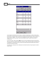
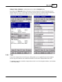
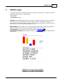
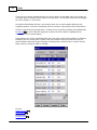
1
Oudie Help
for version 5.1
Last modified 12.2.2014
© 2003 - 2014 ... Naviter d.o.o.
I
Oudie
Table of Contents
Foreword
0
Part I Introduction
2
1 In the Box
................................................................................................................................... 2
2 Charging
...................................................................................................................................
the battery
3
3 Mounting
...................................................................................................................................
with the holder
4
Part II Getting started
6
1 Getting...................................................................................................................................
to know Oudie
6
2 Turning...................................................................................................................................
Oudie on and off
7
3 Upgrading
...................................................................................................................................
firmware
7
4 Running
...................................................................................................................................
SeeYou Mobile for the first time
10
5 Copying
...................................................................................................................................
files to SeeYou Mobile
11
6 Learning
...................................................................................................................................
to use SeeYou Mobile
12
7 Connecting
...................................................................................................................................
to the GPS source
13
Cables and converters
.......................................................................................................................................................... 16
8 Using ...................................................................................................................................
Profiles
17
9 Entering
...................................................................................................................................
the task
20
10 How Airspace
...................................................................................................................................
warning works
29
11 Flying...................................................................................................................................
badge, record and racing tasks
31
12 Flying...................................................................................................................................
Assigned Area tasks
34
13 Flying...................................................................................................................................
with the FAI Triangle Assistant
41
14 Using ...................................................................................................................................
Thermal Assistant
43
15 Flarm ...................................................................................................................................
Radar
45
Part III Map page
51
1 Cursor...................................................................................................................................
info
52
Waypoints
Flarm
Airspace
Task
.......................................................................................................................................................... 53
.......................................................................................................................................................... 54
.......................................................................................................................................................... 55
.......................................................................................................................................................... 56
2 Glider...................................................................................................................................
position
57
3 Arrow ...................................................................................................................................
towards the North
57
4 Wind vector
................................................................................................................................... 58
5 Glideslope
...................................................................................................................................
indicator
58
6 Speed...................................................................................................................................
to Fly indicator
59
7 Vector...................................................................................................................................
map
59
8 Flight ...................................................................................................................................
trace
59
9 Terrain
...................................................................................................................................
collision
60
© 2003 - 2014 ... Naviter d.o.o.
Contents
II
10 Airspace
...................................................................................................................................
warning
61
11 Navboxes
................................................................................................................................... 61
12 Animation
...................................................................................................................................
speed
61
13 Command
...................................................................................................................................
bar
62
Part IV Information page
64
Part V Statistics page
66
Part VI Menu
68
1 < Prev...................................................................................................................................
and Next >
69
2 Esc
................................................................................................................................... 69
3 Settings
................................................................................................................................... 69
4 Display
...................................................................................................................................
options
70
5 Map orientation
................................................................................................................................... 70
6 Add Waypoint
................................................................................................................................... 71
7 Zoom ................................................................................................................................... 73
8 Wind ................................................................................................................................... 74
9 McCready
...................................................................................................................................
& Altitude
75
10 Goto ................................................................................................................................... 78
Details overview
.......................................................................................................................................................... 80
Edit Waypoint .......................................................................................................................................................... 80
Waypoint filter.......................................................................................................................................................... 81
11 Task ................................................................................................................................... 84
List edit
.......................................................................................................................................................... 85
Map edit
.......................................................................................................................................................... 86
Edit Point
.......................................................................................................................................................... 87
Load task
.......................................................................................................................................................... 88
Task options .......................................................................................................................................................... 89
Upload Task declaration
.......................................................................................................................................................... 90
Multiple start ..........................................................................................................................................................
points
91
12 Next map
................................................................................................................................... 91
13 Info page
................................................................................................................................... 91
14 Statistics
................................................................................................................................... 91
15 About ................................................................................................................................... 91
16 Exit
................................................................................................................................... 92
17 Team ................................................................................................................................... 93
18 Save Settings
................................................................................................................................... 94
19 Flarm ...................................................................................................................................
points
95
20 Switch...................................................................................................................................
Profile
96
21 ConnectMe
................................................................................................................................... 97
22 Logbook
................................................................................................................................... 97
Flight Statistic.......................................................................................................................................................... 98
© 2003 - 2014 ... Naviter d.o.o.
II
III
Oudie
100
Part VII Settings
1 Map ................................................................................................................................... 100
Schem e properties
.......................................................................................................................................................... 101
2 Airspace
................................................................................................................................... 102
3 Waypoints
...................................................................................................................................
(Wpts)
103
4 Track...................................................................................................................................
& Target
105
5 OLC &
...................................................................................................................................
FAI area
106
6 Task ................................................................................................................................... 107
7 Navboxes
................................................................................................................................... 108
Edit
.......................................................................................................................................................... 112
8 Symbols
................................................................................................................................... 114
9 Warnings
................................................................................................................................... 115
10 Thermal
................................................................................................................................... 116
11 Polar................................................................................................................................... 118
12 Units................................................................................................................................... 119
13 Fonts................................................................................................................................... 120
14 Input................................................................................................................................... 121
Port Settings.......................................................................................................................................................... 123
Bluetooth .......................................................................................................................................................... 123
15 Commands
................................................................................................................................... 124
16 Setup...................................................................................................................................
Menu
125
17 Files................................................................................................................................... 126
18 Log ................................................................................................................................... 128
19 User ...................................................................................................................................
Interface (UI)
129
Manage languages
.......................................................................................................................................................... 131
20 Flarm................................................................................................................................... 132
21 Miscellaneous
...................................................................................................................................
(Misc)
134
22 Hardware
................................................................................................................................... 135
Term inal
.......................................................................................................................................................... 136
23 V7 / LX1600
................................................................................................................................... 137
Part VIII Oudie firmware
141
1 Main...................................................................................................................................
screen
141
2 Settings
...................................................................................................................................
screen
141
Volum e
Backlight
Language
Autorun
Calibration
USB
.......................................................................................................................................................... 142
.......................................................................................................................................................... 143
.......................................................................................................................................................... 144
.......................................................................................................................................................... 145
.......................................................................................................................................................... 146
.......................................................................................................................................................... 147
Part IX Windows Mobile tips and tricks
150
© 2003 - 2014 ... Naviter d.o.o.
Contents
IV
Part X Technical specification
152
Part XI Troubleshooting
155
Part XII Notice of non-liability
157
Part XIII Limited Warranty
159
Index
160
© 2003 - 2014 ... Naviter d.o.o.
IV
Part
I
Introduction
1
2
Introduction
Oudie v5.1
Company Naviter is dedicated to solving glider pilot's problems and Oudie is one of the answers in this
challenge. Its intended use is helping glider, para-glider and hang glider pilots navigate during leisure,
cross country and competition flights.
Oudie is a Personal Gliding Assistant which aims at providing everything a glider pilot needs in one simple
package. For this reason Oudie is shipped with all cables which are required to connect to your flight
data recorder or GPS, a basic suction cup holder as well as car and wall chargers. The proven Naviter
software packages SeeYou Mobile and ConnectMe are preinstalled already. You can literally take it out of
the box and use it in your glider.
Oudie works great in combination with other Naviter products such as SeeYou for the PC, ConnectMe,
Soaring Spot and others. It was designed to answer the question which was most frequently posted to us
as "Which device should I buy to run SeeYou Mobile?"
Naviter is a Slovenian based software company. We focus on highly featured and easy to use software
for glider pilots. The needs of glider pilots worldwide are what we are interested in.
Naviter d.o.o.
Planina 3
4000 Kranj
Slovenia
email: [email protected]
web: http://www.naviter.com/
All rights reserved by Naviter d.o.o. 2003-2014
1.1
In the Box
The Oudie is delivered with SeeYou Mobile and vector maps (topographical data, ground elevation data,
cities, rivers, lakes, roads, etc.) preinstalled. Airport and Airspace files for much of the world are also
pre-installed. Your Oudie was delivered in a package with the following items:
1. Oudie
2. USB cable
3. Serial cable and 12V charger cable with RJ45 connector
4. Car charger
5. Universal wall charger with 4 different plugs
6. Suction cup mount
7. Cradle
8. Universal RJ45 to DB9 Female converter
9. Universal RJ45 to DB9 Male converter
10. RJ45 Female/Female Gender Changer
11. RJ12 Cable extension
12. CD ROM
13. Getting started manual
14. Gift Box
© 2003 - 2014 ... Naviter d.o.o.
3
Oudie
See also:
Cables and converters
1.2
16
Charging the battery
There are several ways to charge Oudie's internal battery.:
© 2003 - 2014 ... Naviter d.o.o.
Introduction
4
˙
Connect the wall charger cable to AC 110-240 V power source and insert the connector to
the mini USB slot on the Oudie .
˙
Connect the car charger to the DC 12-24 V source and insert the connector to the mini USB
slot on the Oudie.
˙
Connect the Power and Serial data cable to DC 12V power source and insert the USB
connector to the mini USB slot
˙
Connect the USB cable to an external Power Pack battery (not included)
The Power indicator light indicates charging status of the Oudie. Green light means that the
device's internal battery is fully charged. Amber light indicates that the battery is charging.
In some cases connecting a cable to the USB port will open a screen where you get to choose
between connecting to PC and charging the battery:
Choosing Connect to PC, will shut down the navigation software in order to start the
communication with the PC. You should choose this option to copy your flights to the PC for
example.
Choosing Charge battery, will charge the Oudie's battery and no communication will be
attempted. This is what you should do in flight.
1.3
Mounting with the holder
The mounting kit consists of the cradle and the suction cup mount. First insert the cradle into the
suction cup mount until you hear and feel a strong click.
Then insert Oudie into the cradle so that you hear a strong click again.
Use the screw on the holder to adjust the tightness of the cradle. Turn the cradle into ideal
viewing position for your use.
N ote: Do not pla ce the O udie in positions w hich obstruct pilot's m ovem ents, vision of nea rby tra ffic
or instrum ents.
© 2003 - 2014 ... Naviter d.o.o.
Part
II
Getting started
2
6
Getting started
This topic wants to cover some of the basic things you need to know about how to use your Oudie. If this
is the first time you are using Oudie please take a few moments to read about the basics about how to
use Oudie:
. Getting to know Oudie 6
. Turning Oudie on and off
.
.
.
.
.
.
.
.
.
.
.
2.1
7
Running SeeYou Mobile for the first time
Copying files to Oudie 11
Learning to use SeeYou Mobile 12
Connecting to the GPS source 13
Cables and converters 16
Using profiles with SeeYou Mobile 17
Flying badge, record and racing tasks 31
Flying Assigned Area tasks 34
Using Thermal Assistant 43
Flying with the FAI Triangle Assistant 41
Flarm Radar 45
Getting to know Oudie
1.
2.
3.
4.
5.
6.
7.
8.
Power On/Off button
Power indicator
Earphone jack
microSD card slot
Mini USB port
Stylus
Speaker
Reset key
© 2003 - 2014 ... Naviter d.o.o.
10
7
2.2
Oudie
Turning Oudie on and off
To turn the Oudie ON press the power button for 1 second .
To turn the Oudie OFF, press the power button for 1 second while the device is running then choose the
desired action:
Power Off: will stop the navigation and turn off the device.
Sleep: will turn off the screen GPS and Bluetooth. The navigation will be put on hold but the battery
will drain slightly.
Cancel: will do nothing and return focus to navigation
To reboot press the reset button on the back of the device.
See also:
Getting to know Oudie
2.3
6
Upgrading firmware
Keep your Oudie updated at all times with OudieUpdater.
OudieUpdater is a very simple, amazingly effective software. It will help you keep your Oudie 3 updated
with latest versions, airspaces files and maps at all times.
On windows it installs into the tray, sits there quietly until there is something you need to know. That’s
all! Press the buttons when there is something to update and keep your Oudie updated at all times. Just
look out for this message:
Click on message and OudieUpdater will show up:
© 2003 - 2014 ... Naviter d.o.o.
Getting started
How it works?
Please download and install OudieUpdater on your PC: http://download.naviter.com/OudieUpdater/
ousetup.exe
1. To update Software, Airspace or Maps press buttons by side and wait until copying of all files is
completed.
2. Disconnect Oudie from PC.
3. Reboot Oudie with restart button on the back side.
4. Wait until it boots into an Update dialog box.
© 2003 - 2014 ... Naviter d.o.o.
8
9
Oudie
5. Press "Update" and wait until the process is finished.
© 2003 - 2014 ... Naviter d.o.o.
Getting started
10
6. Reboot Oudie. That´s all. Now you are running latest software version.
If you need to check your Oudie software version go to: Menu > About > Oudie (Ver 5.01.001).
2.4
Running SeeYou Mobile for the first time
After successful installation, use the SeeYou Mobile icon on your Today screen to start the application.
Unless you are connected to the GPS source already, it will inform you that a GPS input is unavailable and
ask you to select a new input. Click Yes and the Settings > Input 121 dialog will be opened. To run an
already recorded demo flight, select File, then press OK in the command bar at the bottom of the screen.
What you get is the demo flight on a demo map with demo waypoints and demo airspace. The airplane
will takeoff at a 20:1 accelerated replay and the Navboxes will start to show values which the pilot would
have been looking at if he was flying with SeeYou Mobile on that particular flight.
The Map page
51
display is divided into Map with symbols > Command bar sections from top to bottom.
Map 51 with symbols
is where you will be looking for information all the time. You can tap the symbols to bring up additional
dialogs for
© 2003 - 2014 ... Naviter d.o.o.
11
Oudie
.
.
.
.
Wind 74 by tapping on the Wind vector
Map orientation 70 by tapping on the North arrow
Flight properties 75 dialog by tapping on the arrival altitude/MC symbol
Move the glider if you tap on the glider. This is also a sort of Pan function for the map.
Tapping on a waypoint on the map gives you a list of Waypoints, sorted on distance from the tap. This is
a quick way to select a waypoint from a group of waypoints.
Dragging a line on the screen gives you a list of Waypoints, primarily sorted on the direction of the drag
and secondly on the distance from the glider. This is useful for searching for a waypoint that is not on the
screen, but you know it is in the specified direction.
The Navboxes 108 are what you will use to display the information you need. Be it Final glide, Navigation,
Optimization or another issue, use Menu > Navboxes to select which items you want displayed.
Command bar 62
holds 5 shortcuts to specific actions.
The default actions for software buttons from left to right (Command bar) are:
. Zoom 73
. Display options 70
. Goto 78
. Next page
. Menu 68
Try the functions of all of these buttons.
See also:
Getting Started
2.5
6
Copying files to SeeYou Mobile
Mobile Wizard connects SeeYou with Oudie to send files to the Pocket PC. Mobile Wizard never expires.
That means you don't have to have a registered version of SeeYou to transfer all of the required data to
the Pocket PC.
© 2003 - 2014 ... Naviter d.o.o.
Getting started
12
1. Connect Oudie to your PC by connecting the USB cable
2. Tap "Connect to PC" on your Oudie screen to start the communication if prompted (newer Oudies
won't ask)
3. Remember which drive letter was assigned to your Oudie
4. Run SeeYou
5. Go to File > Mobile Wizard
First page of the Mobile wizard allows you to select the Items you wish to transfer to the device. You
can choose from
. Waypoints and Tasks
. Airspace
. Settings (Vector map color scheme, units, triangle properties, default observation zones)
Second page gives you the possibility to select basename and destination folder for the data you have
selected to upload on the first page.
. Files that will be created will have the same name as Basename and respective extensions CUB for
airspace, CIT for vector maps and CUP for waypoints and tasks.
. Choose "Copy to my Computer" as the destination for files
. Click "Browse" to select the location on your Oudie where you would like to save the files
. Use the Browse buttons to select the destination folder easily.
Third page asks you to draw a rectangle for the area you want to transfer to the Pocket PC.
Use Ctrl+Up, Ctrl+Down to zoom out and zoom in. Click on the the borders of the map to move
horizontally and vertically. This is the same procedure as in the other Map views in SeeYou.
Fourth page shows progress in transferring or saving files.
Once the transfer has completed successfully, you may close Mobile wizard with the Finish button.
See also:
Getting Started
2.6
6
Learning to use SeeYou Mobile
There is two recommended options to learn SeeYou Mobile before you get airborne.
File replay
This is by far the most efficient way to learn SeeYou Mobile. What it does is it replays an already flown
flight and enables you to see the data you would have been looking at if you had SeeYou Mobile with you
© 2003 - 2014 ... Naviter d.o.o.
13
Oudie
on the particular flight.
In order to set this up, copy some of your flights from the desktop PC to your device. Then go to Menu >
Settings > Input 121 , then change input to "File". Press the "..." button and choose a flight you wish to
replay. Now use the buttons to change Waypoints, MacCready and pages. Tap on the screen to see what
happens and setup Navboxes to what you want them to be. Note that you can setup Navboxes 108
separately for each of the two Map pages.
A particularly useful way to replay a flight is if you managed to save a NMEA log of your flight. In the
NMEA log all of the messages that were sent to the device may be reproduced on screen, including other
Flarm data and its warnings. To replay a saved NMEA log you need to create a "TMP" folder in the root
of your Pocket PC memory, save the NMEA log as "nmeain.log" and select "File" as your input in Menu >
Settings > input.
Simulator
In the Simulator input mode, you can move the glider freely even without a prerecorded flight which
enables you to go places you haven't visited in the air yet. To move the glider, tap on it, then drag a line
out of the glider in the direction you want it to move. The longer the line, the faster it will go in the
specified direction.
Learning SeeYou Mobile on the ground will give you time to think about gliding, task and scenery in the
air rather than software.
SeeYou Mobile Simulator for desktop PC
In addition we have created a 100% functional copy of our software which runs on the desktop PC. This
program enables you to test all features of SeeYou Mobile at home without even having to buy a Pocket
PC before you decide that you would like to use SeeYou Mobile in flight.
See also:
Getting Started
2.7
6
Connecting to the GPS source
There are three basic ways to connect Oudie to the GPS source:
1. Built-in GPS
2. Serial cable connection to external GPS source
3. Bluetooth
You can choose which option you would like to use through Menu > Settings > Input dialog in SeeYou
Mobile:
© 2003 - 2014 ... Naviter d.o.o.
Getting started
14
1. Built-in GPS
The built-in GPS in Oudie is always on COM 1 > 4800bps. You can setup the Oudie to use internal GPS by
selecting Menu > Settings > Input > Internal GPS
2. Serial cable connection to external GPS source
The supplied Serial data cable enables you to connect to external data source such as your Variometer,
Flight data recorder, anti-collision device or similar. You should select Menu > Setting > Input > Serial
cable in order to use this option. You will need the manual from the other device in order to determine
the correct Port Settings such as Baud rate. You should always use COM 4 on Oudie for this type of
connection.
The supplied Data/Power cable has a RJ45 connector by default with standard IGC pinout. Several
converters are included in the box which enable you to connect to flight recorders with RJ12 or DB9
connectors. Special cables are also available as an accessory for a very simple direct connection to some
specific flight recorders such as LX 7007, CAI 302, LX 1600 etc. Please refer to the chapter Cables and
Converters 16 of this manual to learn more about how to connect your Oudie with different GPS devices.
It is very important to understand that the supplied Serial cable must be connected to 12 V direct current
source (such as your glider's battery) in order to work.
© 2003 - 2014 ... Naviter d.o.o.
15
Oudie
3. Bluetooth
Another way to receive external data source is to connect through Bluetooth. Go to Menu > Settings >
Input > Bluetooth to pair Bluetooth device with Oudie:
1.
2.
3.
4.
5.
press Lookup on Oudie (only devices which advertize SPP protocol are displayed)
Select the device you would like to connect to
Press "Pair..."
enter the PIN of the device you are connecting to
connection should be established on COM 5 (make sure the Baude rate is correct)
You should refer to the manual of the other device in order to find out about its settings such as Pairing
key, baud rate, availability of the serial communication protocols etc. Once the devices are paired and
serial communication is established the data flow starts immediately.
K6 Bluetooth is a special protocol which should be used when connecting to the K6 Bluetooth device
because it enables even more features than the standard Bluetooth protocol.
© 2003 - 2014 ... Naviter d.o.o.
Getting started
2.7.1
16
Cables and converters
Oudie is delivered with a variety of cables and converters which enable you to connect Oudie to your
almost any logger "out of the box":
1. Power and data cable
It provides power to Oudie and (optionally) to the device which is
connected to the RJ45 connector.
It has three connectors:
. mini USB connector must be connected to Oudie
. black and red cable must be connected to 12V power supply
(red is 12V, black is ground). Allowed input voltage is 10-30V.
. RJ45 connector with standard IGC pinout where
pins 1 and 2 = +12V (anything between 10-30V is ok)
pin 5 = Receive to Oudie
pin 6 = Transmit from Oudie
pins 7 and 8 = Ground
Use directly with these devices: Swiss Flarm, Volkslogger, K6 Mux, VW1150
2. RJ 45 Female/Female Gender Changer
This connector can be used for extending the 8-wires cable using another RJ45 connector (for example
ethernet cable). It can also be used to connect RJ12 connector with 6-wires cable which can be used for
data communication with Colibri, LX 20/2000, MiniBox, RedBox and other devices using RJ12 connectors.
3. 20 cm cable extension with male RJ12 connectors
This is an extension cable which can be used for both power
and data transmission between Oudie and connected device. It
must be used together with RJ45 Gender Changer. RJ12 can
be plugged into the RJ45 connector on the Gender Changer.
The other end is connected with the device. Pins 1 and 8 are
not connected when RJ12 cable is connected to the RJ45
Gender Changer.
Use RJ45 Gender Changer and RJ12 cable extension directly with these devices: Colibri, LX 20/2000,
MiniBox, RedBox
4. RJ45->DB9 Male and Female converters
This is a "do-it-yourself" DB9 converter. The converter pinout is free. You can pin any wire from the RJ45
connector to any pin on the DB9 connector.
Typical use:
. LX 5000, LX 7000: Use female DB9 connector: Black -> 2 (Transmit from Oudie), Red -> 3 (Receive to
Oudie), Orange -> 5 (Ground)
. GPS-NAV, SN10 Standard RS 232: Use male DB9 connector: Black -> 3 (Transmit from Oudie), Red ->
2 (Receive to Oudie), Orange -> 5 (Ground)
. LX 160 (NOT the "si" version - see the warning below): Use female DB9 connector: Black -> 4
(Transmit from Oudie), Red -> 3 (Receive to Oudie), Orange -> 1 (Ground)
. Zander/SDI GP940 and GP941: Black->3 (Transmit from Oudie), Red->2 (Receive to Oudie), Orange->5
(Ground), Brown->4 (DTR)
© 2003 - 2014 ... Naviter d.o.o.
17
Oudie
WARNING: If you are attempting to connect to devices which provide 5V on any of the pins please make
absolutely sure that the pin where the other device provides 5V is not connected to the White or Brown
wires (pins 1 and 2 on RJ45). This will cause collision and possibly damage to both connected devices!
Take particular care when connecting the following devices: Cambridge 302, LX 7007, LX 1600, LX160si,
Nano and others with built-in 12->5V converter. Be especially careful not to plug the standard Oudie and
standard Nano cable together because the plugs are compatible but the pinout is not!
RJ45 wire's colors:
1 = White (+12V)
2 = Brown (+12V)
3 = Yellow
4 = Green
5 = Red (Receive to Oudie)
6 = Black (Transmit from Oudie)
7 = Orange (Ground)
8 = Blue (Ground)
=============================================
The following cables are available as optional accessories:
1. CAI 302 Cable
Connects all models of Cambridge 302 with Oudie. This is a direct cable from CAI to Oudie which
provides both power and data communication between Oudie and CAI 302
2. LX Cable
Connects LX 7007, LX 1600, LX 160 si with Oudie. This is a direct cable from CAI to Oudie which
provides both power and data communication between Oudie and LX instruments.
2.8
Using Profiles
If you feel no need to use more than one set of navboxes or fly more than one sailplane ignore this
feature and go read the next chapter.
© 2003 - 2014 ... Naviter d.o.o.
Getting started
18
If however you fly several types of gliders
or fly at different locations you are likely to
be fed up with changing the polar, terrain,
waypoint and airspace files each time
before the flight. Profiles were added in
SeeYou Mobile 5.0. You can have separate
setups for each of your club's gliders plus
one profile for the competition you are
attending shortly. Here's how it works.
1. When you first ran SeeYou Mobile, a
Default profile was created. Anything you
have changed in the application was stored
to this profile. Now comes a day when you
fly the single seater of your club with a
significantly different polar and GPS source
than the one you have used previously. To
avoid entering the polar, header and
hardware data each time you go fly this
glider, you may create a new profile by
going to Menu > Settings > Misc 134 and
click the "Add Profile..." button.
© 2003 - 2014 ... Naviter d.o.o.
19
Oudie
2. You get to choose to either
. Copy current profile (which makes an exact copy of your
current settings)
. Create a new profile (which creates a copy of the
default settings)
You may give the new profile a name according to what
you are going to use it for. Be it "ASW 27", "LX 1600" or
"World Gliding Championships".
© 2003 - 2014 ... Naviter d.o.o.
Getting started
20
3. Next time you start SeeYou Mobile you will have two
(or more) profiles to choose from. You have 10 seconds
to select a profile. If you do nothing, the profile you used
last is loaded.
4. After you have loaded the profile for the first time you
will want to set it up according to your preferences. Here
is a handful of settings you will probably want to change
before use:
Links to Terrain, Airspace and Waypoint files 126
Pilot name and Glider type settings 128
Hardware that is connected to SeeYou Mobile 135
Navboxes for Map1 108
Navboxes for Map2 108 (they are separate, remember?)
See also:
Getting Started
2.9
6
Entering the task
This is a tutorial about entering the task in SeeYou Mobile. We have had the privilege to look over the
shoulder many impressively experienced pilots who have found a very difficult way to enter a task into
SeeYou Mobile.
Please read this because entering the task is just that - enter the waypoint names and go. No setting up
of observation zones is neccessary. Tutorial will focus on entering the demo task. The default one in the
evaluation version of SeeYou Mobile. The task will become a 500km FAI triangle in the south-eastern
part of the Alps. Both Racing, badge and record tasks as well as Assigned Area tasks are covered.
Always start from the scratch. Menu > Task > Tools > Clear task:
© 2003 - 2014 ... Naviter d.o.o.
21
Oudie
Make sure the first line in the empty list is selected (if you didn't touch the screen after clearing the task,
then it is already selected). Then press the "Keyb" (as in Keyboard) button:
© 2003 - 2014 ... Naviter d.o.o.
Getting started
22
Start typing and you will notice that the waypoint name auto-completes while you are typing (note that
the keyboard characters which do not make sense are disabled while you type):
© 2003 - 2014 ... Naviter d.o.o.
23
Oudie
Note that S and V keys were pressed while ". Peter" was auto-completed. If you know your waypoint is in
alphabetical vicinity of the currently auto-completed name of the waypoint, you may also use the "<<"
and ">>" buttons on the full screen keyboard to advance the waypoint names alphabetically. Once you
have found the waypoint you were looking for, press OK.
Edit point 87 dialog will open automatically after choosing each waypoint. Setup these values to fly
competitions or FAI records.???
© 2003 - 2014 ... Naviter d.o.o.
Getting started
Press the "OK" button again and start entering the first turnpoint's name, Corvara in this example:
© 2003 - 2014 ... Naviter d.o.o.
24
25
Oudie
Note that after entering "C" and "O" the suggested waypoint name is "Cortina", not "Corvara". Press ">>"
once and you are now at "Corvara". Press OK.
Repeat this procedure until all waypoints including the finish are entered:
© 2003 - 2014 ... Naviter d.o.o.
Getting started
26
If your default Observation Zone settings in Menu > Settings > Task > Observation Zone > Type > Start/
Point/Finish are what you wanted to use on this flight then you are finished. Go fly the task and enjoy!!
ASSIGNED AREA TASKS
Assigned Area tasks are only set in competitions. The organisation will always prepare a task sheet. This
is an excerpt of a task sheet showing the description of the observation zones:
© 2003 - 2014 ... Naviter d.o.o.
27
Oudie
For the tutorial we will edit the observation zone of the point "500Obert" (which is code name for "500
Obertauern" in the task sheet). Tap on the waypoint "500Obert" to make it blue. Then press the Edit
button as indicated in the screenshot:
In the Edit Waypoint dialog tap you need to enter the information from the task sheet. Generally speaking
the data is listed in the same order as you would follow through the dialog:
© 2003 - 2014 ... Naviter d.o.o.
Getting started
.
.
.
.
.
.
.
.
28
Direction (Symmetric)
Angle12 (not enabled for Symmetric direction)
Radius 1 = 20 km (you are free to use non-default units)
Angle 1 = 180
Radius 2 = 0
Angle 2 = 0
tick the "Assigned Area" checkbox
do not tick "Line only" because it is not listed in the observation zone description
That's it. Close the dialog with OK. Edit all remaining Assigned Area sectors. Don't forget the enter task
time under Tools > Options > Task Time.
SAVING TASK FOR LATER USE
It is always wise to make sure you have all the data securely stored in case of an unintended outage of
the device. Start from the main screen and select Menu > Next > Save Settings > tick the "Save profile"
and "Save waypoints and tasks" checkboxes (if they are both enabled), then tap "Yes".
"Save Settings" button is a new addition to SeeYou Mobile 3.1 and later. It may be positioned elsewhere
(i.e. not on the second Menu page) depending on your settings for the Menu > Settings > Menu.
© 2003 - 2014 ... Naviter d.o.o.
29
2.10
Oudie
How Airspace warning works
Avoiding forbidden airspace is often just as important as navigating in general. It can however be much
trickier than finding the right valley to go down to since the airspace structure is very abstract and often
complicated. SeeYou Mobile will be your best friend if you use the whole potential of what it's got to
offer.
1. Airspace Warning
The first stage - let's name it the Airspace Warning - is
often merely informative. The screen will display an
orange banner at the top of the page and highlight the
airspaces you are about to encounter. It will also display
a line with distances from your position to the narest
position of each airspace you are about to encounter. And
it will beep briefly.
You get to choose to turn the airspace warning off for the
airspace which is listed in the banner. You can turn it off
for either
. Today - until next takeoff
. 5 minutes - note that this number is user selectable
through Menu > Settings > Warnings)
. Ignore - for as long as you are flying towards it it won't
beep again)
© 2003 - 2014 ... Naviter d.o.o.
Getting started
30
2. Airspace Alarm
Once you come too close for comfort an airspace alarm
will sound. It gives you a red banner at the top where you
can read all about the airspace in question and it will
highlight the airspace in question. It will also draw the
line to the closest point of the airspace and it will give you
a sound alarm continuously.
You still get to choose to turn this alarm off for
. Today - until next takeoff
. 5 minutes - user selectable in Menu > Settings >
Warnings
. Mute - continue to display everything but stop the sound
alarm
After you have pressed Mute you can still Ignore this
airspace alarm.
3. Helpful Navboxes
There are three airspace related navboxes which will give you a good overview of the airspace situation
if you are familiar with what they are displaying:
1. "Nearest airspace - Horizontally" gives you the distance from your position to the nearest position of an
airspace where you are not horizontally inside (i.e. you are not below this airspace yet)
2. "Horizontally nearest airsapce - Altitude" gives you the altitude difference towards the horizontally
nearest airspace. The altitude difference is negative if you are below horizontally nearest airsapce. It is
positive if you are above and "Inside" if you are about to hit the lateral borders of the airspace in
question.
3. "Nearest airspace - Vertically" gives you the altitude difference towards the airspace above or below
the glider. The value is negative if you are below the airspace. It is positive if you are above, "Inside" if
you are already inside an airspace and "N/A" if there is no airspace at your location.
In addition to the airspaces there is also a very useful Action which can be assigned to any Navbox. It is
the action "Highlight nearest airspace" and it is assigned to the "Nearest airspace - Horizontally" by
default. If you touch a Navbox which has this action assigned to it, SeeYou Mobile will highlight the
airspace in question. It will link the glider with the airspace and display the distance from the glider to the
airspace.
© 2003 - 2014 ... Naviter d.o.o.
31
Oudie
4. Screen taps
In addition to all the above you may tap anywhere on the screen and then choose "Airspace" to quickly
access the list of airspaces at the location of the tap. With this list you can quickly change the visibility of
the airspaces or simply get an overview of what lies ahead. You can also change the properties of an
airspace such as lower or upper limit.
With this information airspace navigation should be easy and understandable even in a rather complex
airspace environment.
Read also:
. Setting up the Warnings
. Changing properties of an airspace
. Loading (multiple) airspace files
2.11
Flying badge, record and racing tasks
To complete this type of tasks, you need to do some preflight preparation.
1. Enter the task you will be flying.
You will need to go to the Menu > Task 84 dialog. Use the keypad to enter waypoint names in list view.
Type first few characters, then use left and right keys to complete the selection.
© 2003 - 2014 ... Naviter d.o.o.
Getting started
32
After you have entered the task waypoints, check that waypoint sectors are setup correctly. At each of
the waypoints, click on the Edit button to open Edit point 87 dialog. Setup these values to fly FAI records
or badges:
. Start: Direction = Next, Radius1 = 0.5km, check Line only checkbox.
. Waypoints 1-3: Direction = Symmetric, Radius1 = 3km, Angle1 = 45° (the rest is zero or not
unselected)
. Finish: Direction = Previous, Radius1 = 0.5km, check Line only checkbox.
© 2003 - 2014 ... Naviter d.o.o.
33
Oudie
2. Start the task in flight.
Look at the screen to see where the start line is in order not to miss it. You will get a sound warning
telling you that you have successfully crossed the start line. After you have crossed the start line a box
appears where the start time is displayed. To start navigating on the task, press the Start Time box.
Navigation is moved to the first waypoint of the task and statistics runs.
To make a re-start. Change the target waypoint back to start point. The quickest way to do it is to open
the Task dialog, select start point and press Goto. Statistics will be reset, when you cross the start line
again.
3. Flying the task
To navigate during the task use all of the featues that are made available to you through SeeYou Mobile:
. Map pages 51 to see where you are
. Navboxes 108 to see the flight parameters you are interested in
. Statistics 66 to see what you have done
. Airspace warning 61 to keep yourself out of trouble
. Goto dialog 78 to find nearest airports etc.
© 2003 - 2014 ... Naviter d.o.o.
Getting started
34
4. Final glide
Here's a suggestion. Flying final glides is the most comfortable when you use the Required L/D and
Current L/D navboxes 108 . What they do is they show the required L/D to the finish line and current L/D
you are doing at the moment. You are on glide slope when Current L/D is higher than Required L/D. The
calculation already includes reserve altitude. The nice part is that it is insensitive to the MC setting, glider
polar, wind calculation, setting for bugs and ballast. All of them can be wrong when you try to math
through the glider polar.
Current L/D however is pragmatic - it tells you what you are doing. Required L/D is pragmatic as well. It
tells you what you should be doing. If Current L/D is higher than the Required one you are doing good. If
it looks like you can keep going like that, you are doing great.
Have fun making those final glides!
See also:
Getting Started
2.12
6
Flying Assigned Area tasks
In an Assigned Area task one has a choice of a large area where a turnpoint can be set. Speed is all that
matters in an Assigned Area task. The pilot should have one fix in each are so, that he can maximize the
© 2003 - 2014 ... Naviter d.o.o.
35
Oudie
given meteorological conditions. Assigned Area tasks can hardly be considered without using a Pocket PC
device and its intuitive use of the touch screen.
1. Enter the task you will be flying.
You will need to go to the Menu > Task 84 dialog. Use the keypad to enter waypoint names in list view.
Type first few characters, then use left and right keys to complete the selection.
After you have entered the task waypoints, you must setup the properties for the Assigned Areas. Click
on the Edit button of each waypoint to open Edit point 87 dialog. To make the sector an Assigned Area,
you should:
. check the Assigned Area checkbox
. enter Direction, Angle12, Radius1, Angle1, Radius2 and Angle2 values as assigned at the briefing.
To setup a "disc" shape sector, you should enter
Direction = Symmetric (not required)
Radius1 = a value in kilometers or miles, given at the briefing
Angle1 = 180°
Assigned Area = Checked
© 2003 - 2014 ... Naviter d.o.o.
Getting started
36
The next thing to do is to setup the task time, also specified at the briefing. It is setup in minutes
through Menu > Task > Tools > Options > Task Time 89
2. Before the flight
Turnpoints in each sector are setup to the center of each sector by default. But this is probably not where
you are going to fly to given the latest meteo situation. If you have a rough idea about what you are
going to do, go to Menu > Task >Tools > Map 86 or tap on the screen and select the Task tab 56 in
Cursor Info dialog. Change the "navigate to" point in each sector to create a task of the desired length
and speed which you think is achievable in Task Time for the given day.
© 2003 - 2014 ... Naviter d.o.o.
37
Oudie
3. Start the task in flight.
Look at the screen to see where the start line is in order not to miss it. You will get a sound warning
telling you that you have successfully crossed the start line. After you have crossed the start line a box
appears where the start time is displayed. To start navigating on the task, press the Start Time box.
Navigation is moved to the first waypoint of the task and statistics runs.
To make a re-start. Change the target waypoint back to start point. The quickest way to do it is to open
the Task dialog, select start point and press Goto. Statistics will be reset, when you cross the start line
again.
4. Flying the task
To navigate during the task use all of the featues that are made available to you through SeeYou Mobile:
. Map pages 51 to see where you are
. Navboxes 108 to see the flight parameters you are interested in
. Statistics 66 to see what you have done
. Airspace warning 61 to keep yourself out of trouble
. Goto dialog 78 to find nearest airports etc.
© 2003 - 2014 ... Naviter d.o.o.
Getting started
38
While on the task, you will get a much better idea about what the weather is doing for you. You will want
to move the point in the next sector to optimize it for the speed you think is achievable for the rest of the
flight.
Observe how the finish time indicators change as you move the point around. This will give you a very
good idea about what you should be doing in the next couple of hours.
© 2003 - 2014 ... Naviter d.o.o.
39
Oudie
5. Statistics
While in flight, you will also be interested in the Task Statistics 66 of what you have achieved. Two
pages will help you understand what is going on. Task statistics gives you distance and speed achieved
since crossing the start line while 60 minue statistics tells you how you are doing in the last hour.
Comparing the two gives you a good idea about what you need to do to finish the task.
© 2003 - 2014 ... Naviter d.o.o.
Getting started
40
6. Final glide
Here's a suggestion. Flying final glides is the most comfortable when you use the Required L/D and
Current L/D navboxes 108 . What they do is they show the required L/D to the finish line and current L/D
you are doing at the moment. You are on glide slope when Current L/D is higher than Required L/D. The
calculation already includes reserve altitude. The nice part is that it is insensitive to the MC setting, glider
polar, wind calculation, setting for bugs and ballast. All of them can be wrong when you try to math
through the glider polar.
Current L/D however is pragmatic - it tells you what you are doing. Required L/D is pragmatic as well. It
tells you what you should be doing. If Current L/D is higher than the Required one you are doing good. If
it looks like you can keep going like that, you are doing great.
Enjoy Assigned Areas!
See also:
Getting Started
© 2003 - 2014 ... Naviter d.o.o.
6
41
2.13
Oudie
Flying with the FAI Triangle Assistant
FAI Triangle Assistant helps you complete the largest possible FAI Triangle.
You don't have to do much to use the FAI Triangle Assistant. Just turn it on and fly is how we tried to
design the assistant. Here's how it works.
Turning the FAI Assistant on or off follows the same phylosophy as toggling the Map, Waypoints,
Airspace, Navboxes etc. It is controlled through the Display Options 70 dialog.
Flying the Free FAI Triangle task
Once the FAI Area is on, you don't have to do much. You are of course required to know at least roughly
which direction you would like to fly to fly a triangle. The larger the triangle you are attempting, the more
you will know where to go. FAI Triangle Assistant will simply follow what you are doing. As you fly the
first leg it won't yet know which way you are going to fly. That is not a problem. The FAI Area will be
drawn on one side of the first leg. If you would like it to be on the other side, simply tap inside the area
and it will rotate (provided that "Rotate on click" is enabled in the settings, which - by default - it is).
Once you have turned your first waypoint, simply continue to fly towards your other waypoint (or rather a
larger area where you would like to turn your second waypoint). As soon as the triangle you have flown
© 2003 - 2014 ... Naviter d.o.o.
Getting started
42
is deep enough the FAI Area changes. It is not drawn on the longest leg anymore. Instead it is drawn on
the last leg you have flown. That means it is showing you the way towards the area where you will be
able to turn your second waypoint and allow your whole flight to be an FAI triangle.
When you are near your second waypoint you will appreciate some help from the FAI Triangle
optimization navbox, which is available through the list of Navboxes 108 . Place it visibly on the screen to
know exactly how large the triangle will be if you can finish it home. After you are happy with what you
have done in your second area, head home. The FAI Triangle optimization should not change anymore,
it's just about getting home.
The above example focused on an FAI Triangle which has been started from one of its corners. Flying a
triangle with the start on the leg is no different. The only difference is that the second point you turn
represents the first point from the above example and the third one is the final one from which you fly
home.
Finishing the task
An FAI Triangle is not finished unless you fly back to your start point. One finish fix within 1 km radius
from another fix that occured before turning the 1st waypoint of the optimized triangle is required to
finish the task. It may be a single fix if you started your triangle in one of its corners. It is a whole series
of fixes between soaring begin and the first waypoint if you started the triangle on one of its legs.
FAI Triangle Assistant also helps you identify the exact course to fly by always highlighting a 1km
diameter circle around the closest available finish fix.
Rotating the area
Sometimes the flight requires much more thinking than the above examples. You may wish to know if
your current leg is long enough already to cover Town X with the FAI Area of your current flight. For this
reason you will want to rotate the FAI area from its current position. It can hardly be easier to do simply tap on the FAI Area on the moving map and it will rotate. If you are on your first leg (or not far
enough on the second), it will rotate left/right around the first leg. Once you are far enough on the
second leg to make it obvious which way you are going to fly the triangle, it will rotate around the legs.
All this provided that "Rotate on click" is enabled in the settings, which - by default - it is.
The FAI Area icons may also be placed on the Command bar if you wish to have quick and constant
access to them in flight. There are options for toggling the FAI Area and Rotating the FAI Area under
Menu > Settings > Commands 124 .
FAI Triangle Assistant preferences
If you would like to influence the look and feel of the FAI Triangle Assistant you may do so through Menu
> Settings > OLC & FAI Area 106 dialog.
Example shows kilometer lines for Triangles between 160 - 280 km. If you fly into the violet area, the
triangle will be an FAI triangle.
© 2003 - 2014 ... Naviter d.o.o.
43
Oudie
See also:
Getting Started
2.14
6
Using Thermal Assistant
Thermal assistant is a feature of SeeYou Mobile which should help you get centered in a lift more quickly
if you decide to follow its instructions.
Thermal assistant analyses the lift in your thermal. It calculates the average and follows how strongly the
vario values change in each circle.
It uses three ways to catch your attention:
1. You may choose between Bubbles or a Zoomed map which shows the best part of the lift. Bubbles
are disabled by default, zooming in is enabled.
2. Thermal Assistant audio warning goes off if variance is large enough (see Settings - Thermal 116 ).
It whistles a selected amount of seconds or degrees (see Settings - Thermal 116 ) before the glider will
reach the same part of the circle where maximum lift was reached in the previous circle.
© 2003 - 2014 ... Naviter d.o.o.
Getting started
44
3. Thermal assistant graphics is displayed if variance for displaying the thermal assistant is large
enough (see Settings - Thermal 116 ). The size of the bubbles represents the amount of lift. The color of
the bubble is relative to the MacCready setting. Red is better thank MC, blue is more than 0.5m/s (1kts)
less than MC, yellow is in between. The arrow is pointing towards the maximum of the lift in the previous
circle while the length of the arrow is how "strong" the advice is to move your circle elsewhere. The
arrow is longer if variance is larger.
© 2003 - 2014 ... Naviter d.o.o.
45
Oudie
Your job:
. find a thermal
. start circling
. look outside
. observe the thermal clues
. observe traffic in your vicinity
. make use of Assistant's suggestions
Assistant's job:
. analyze the thermal
. find the strongest lift in the circle
. make audio and visual suggestions
We were not trying to develop a Thermal
Wizard, just an Assistant for the times
when you are tired or have better things
to do than focus 100% on the thermal. It
will only sound a bell if the thermal varies
significantly in strength.
If you would like to display Thermal assistant regardless of the current vario variation, feel free to
navigate to the Menu and press the Thermal Assistant button. To close the Thermal Assistant, just tap
the screen anywhere.
We will be happy if you continue to enjoy soaring and if you never find the need to use the Thermal
Assistant at all :-)
See also:
Getting Started 6
Settings - Thermal 116
2.15
Flarm Radar
Flarm is a collision-warning system for general aviation and recreational flying. It is an alternative to the
commercial airliners' expensive ACAS/TCAS system. It is however important to understand that Flarmlike devices were not designed to protect you from other flying objects. They are useful for situational
awarness of other Flarm devices in vicinity. There is lots of other traffic and obstacles that are not
covered by Flarm therefore be aware that the most important task in the cockpit is to keep a good
overview of the traffic around your glider at all times.
SeeYou Mobile is able to read the output from Flarm devices and present a radar-like system which
displays other Flarms with correct visibility/privacy settings in vicinity. Flarms that have privacy enabled
© 2003 - 2014 ... Naviter d.o.o.
Getting started
46
are hidden. The screen may look like this:
Screenshot???
Each circle represents 1 km distance from the other Flarm device. By default, those Flarms which are
less than 100 meters above or below your current altitude are marked red, others are black. Each Flarm
is presented by a glider symbol, its recent track and a group of numbers for altitude and average vario
(20s average). If a friendly name was added for a particular Flarm, then this name appears in the label
as well. Colors, visibility of the radar, track lenghts and some other settings are customizable through
Settings > Flarm 132 .
At zoom levels greater than 10km (by default) the radar circles around the glider disappear. New circles
appear in the upper right corner of your screen. This is a Flarm Radar Symbol (see also Settings >
Symbols 114 ) which displays the three concentric circles in the upper right corner of your screen (by
default, but you can move it around). They still represent 1km distance each regardless of the chosen
Zoom level and units.
You may tap anywhere on the screen and select the "Flarm" tab to see a list of all Flarm devices that are
being received at the moment:
© 2003 - 2014 ... Naviter d.o.o.
47
Oudie
In the example screenshot three Flarm devices are visible. By default they are sorted on distance from
the tap on the screen. If you tap on a specific aircraft that aircraft will be the first on the list. First item in
the screenshot is "DD8D07". This code is the Flarm identification number and thus not very useful or
intuitive. This is why you may select a device and click Edit to rename a specific Flarm to give it a
readable name.
You may also select a device and then Goto. This way you start navigating towards the selected Flarm
device for as long as it is within range. When it goes out of range, the aircraft symbol for that device will
start blinking for a default period of 120 seconds. After that the target becomes blank and the device is
removed from the maps and lists.
The keyboard for entering the Flarm friendly name and other information is large enough to be used in
flight by fingers:
© 2003 - 2014 ... Naviter d.o.o.
Getting started
48
Close all dialogs with OK and you will see an additional line in the Flarm-Radar screen which will report
Flarm's friendly name in addition to altitude and vario (see the first screenshot for Friend and Enemy
flarms). Additionally when you exit SeeYou Mobile these friendly names will be stored on your PDA for
the future. It is a simple text file, so feel free to share it with friends.
Further customization is possible through Settings > Flarm dialog 132 :
© 2003 - 2014 ... Naviter d.o.o.
49
Oudie
See also:
Getting Started 6
Settings > Flarm 132
© 2003 - 2014 ... Naviter d.o.o.
Part
III
51
3
Oudie
Map page
Map view is the main SeeYou Mobile window. It contains the following elements:
. Glider position 57
. Arrow towards the North 57
. Wind vector 58
. Glideslope indicator 58
. Speed to Fly indicator 59
. Vector map 59
. Flight trace 59
. Terrain collision 60
. Airspace warning 61
. Navboxes 108
. Animation speed 61
. Command bar 62
A function is assigned to each one of these elements. It is described in the chapters you will access by
following the above links.
An important feature of the Map page is Cursor info
52
.
There are two Map views (Map 1 and Map 2) which are setup independently from each other. Each map
view can be orientated differently, have different Zoom levels, details of the map and its own Navboxes.
This is useful because you can switch from an overview map.
Overview of the most important features of the Map view:
© 2003 - 2014 ... Naviter d.o.o.
Map page
3.1
52
Cursor info
A tap on the map brings up a dialog with relevant information about
. Waypoints 53
. Flarm 54
. Airspace 55
. Task 56
If either of the items above is present within the Drag limit 134 distance from the tap, such information is
presented in a dialog.
© 2003 - 2014 ... Naviter d.o.o.
53
3.1.1
Oudie
Waypoints
If a tap on the map occurred close to a Waypoint, cursor info dialog appears with Waypoints sorted on
distance from the position where the tap occurred.
You can also get a list of Waypoints, sorted on direction. Tap the screen and hold it down, then move the
finger in one direction. You will get a list of points sorted on distance (+-15 degrees from the direction of
the drag)
Columns are sortable in the Goto dialog. Click on the column header to sort ascending or descending on
these parameters:
. Name
. Type (Ascending ordering lists landable fields first. Sorting on this column effectively lists Near
Airports)
. Crs = Course
. Distance
. Arrival altitude
. Required L/D
. Code (short name)
If you would like to change the order or size of the columns, you may drag the boundaries to change size
or drag the header to change the order of the columns.
© 2003 - 2014 ... Naviter d.o.o.
Map page
54
Tap on a Waypoint, then tap OK to start navigating to the selected point.
3.1.2
Flarm
This screen is only available when Flarm messages are received in the NMEA input stream. If you tap
anywhere on the screen and select the "Flarm" tab to see a list of all Flarm devices that are being
received at the moment:
© 2003 - 2014 ... Naviter d.o.o.
55
Oudie
In the example screenshot three Flarm devices are visible. By default they are sorted on distance from
the tap on the screen. If you tap on a specific aircraft that aircraft will be the first on the list. First item in
the screenshot is "DD8D07". This code is the Flarm identification number and thus not very useful or
intuitive. This is why you may select a device and click Edit to rename a specific Flarm to give it a
readable name. In the example screenshot above, two flarm devices were renamed to "Friend" and
"Enemy" respectively.
You may also select a device and then Goto. This way you start navigating towards the selected Flarm
device for as long as it is within range. When it goes out of range, the aircraft symbol for that device will
start blinking for a default period of 120 seconds. After that the target becomes blank and the device is
removed from the maps and lists.
See also:
Getting Started > Flarm Radar
Settings > Flarm 132
3.1.3
45
Airspace
A tap on an airspace brings up a dialog where you can read the information on the airspace.
By default this page shows all airspace within a certain margin around the area of your tap. You can
quickly change the status of any of these airspaces by using the buttons for disabling an airspace for
© 2003 - 2014 ... Naviter d.o.o.
Map page
56
Always, Today, 5 minutes or turning them back on with the Activate button.
By turning on the Show all checkbox all airspace from the airspace file is listed. This helps you turn
remote airspaces on or off. It also helps you to turn several airspaces off quickly. Note that Multiselect
feature works in this dialog meaning that you can select as many airspaces as you wish.
3.1.4
Task
A tap on the Assigned Area sector brings up a dialog where you can graphically move the navigation
point to any place inside the area. Relevant information on the task is displayed below the sector.
To navigate to any place outside the Assigned Area which is not in the Waypoint database, use the Menu
> Task > Map dialog.
© 2003 - 2014 ... Naviter d.o.o.
57
3.2
Oudie
Glider position
The symbol always represents the current position of the glider. The nose of the symbolic aircraft is
pointed in the direction of the movement of the glider.
Tap and hold aircraft symbol to move its current position. You will want to do that if you wish to have a
different view of the map.
If the glider symbol is flashing, GPS reception is BAD. Have a look at what's wrong (connectors, cables,
battery...)
You can choose from several airplane symbols through Menu > Settings > Symbols 114
3.3
Arrow towards the North
Map orientation 70 in SeeYou Mobile is not always "North up" It can be anything, therefore the North
arrow is always pointed in the direction of true North. By tapping the North arrow a menu will open up
where you can select any of the other possible Map orientations.
© 2003 - 2014 ... Naviter d.o.o.
Map page
58
North, East, South and West Up, will rotate the map so, that the selected orientation is towards the top
of the screen.
Goal Up will put the direction of the Selected Goto Waypoint to the top of the screen. Track Up will put
the direction of the current track towards the top of the screen.
When panning the map freely, the arrow gets a caption "Pan mode". Tapping once on this symbol
returns the view back to the glider and original map orientation.
See also:
Map orientation
3.4
70
Wind vector
The wind vector gives you a graphical and textual orientation about the wind at current height. It is
measured in different ways depending on what data is available to SeeYou Mobile.
A tap on the Wind symbol will open the Wind dialog. You can also access it through Menu > Wind
3.5
74
Glideslope indicator
The glide slope indicator displays whether or not the glider has sufficient height to reach the goal the
glider is navigating to.
Tap on this control brings up the Flight parameters
Ballast and Altitude reserve can be set up.
75
dialog where Altitude, QNH, MacCready, Bugs,
1. Arrows indicate whether or not you are below or above glideslope. Each arrow represents 1 degree
above or below glideslope.
2. Red number (not always visible) indicates how much altitude you are missing to fly over the terrain
straight ahead of you.
3. Number in the middle is MacCready setting.
4. Number below MacCready tells you how much altitude is required to reach the selected waypoint.
Negative values mean that you have to climb, positive values mean you have enough altitude.
In addition to that, two more squares are displayed on the Target line which help you understand how
you are doing in the final glide:
1. Yellow square marks the position from which you can reach the selected Waypoint (or task finish)
from your current altitude at MacCready ring set to zero.
2. Green square marks the position from which you can reach the selected Waypoint (or task finish) from
your current altitude at your current MacCready setting.
These two squares represent final glide to task finish point if selected waypoint is part of the task.
© 2003 - 2014 ... Naviter d.o.o.
59
3.6
Oudie
Speed to Fly indicator
Speed to Fly indicator gives you a graphical display for Speed to Fly. Black line pointing down means you
should fly faster while a black line pointing up means you should slow down.
Fly faster:
Fly slower:
Please note that the Speed to Fly indicator and navbox present theoretical data and does not iclude the
current sink rate of the airmass.
3.7
Vector map
SeeYou Mobile uses the CIT maps to display terrain and topographic features. These are the same maps
also used in the desktop version of SeeYou. Map preferences can be setup through the Setup Map 100
dialog
3.8
Flight trace
The recently flown glider trace is optionally displayed behind the glider. Preferences can be set up
through the Settings > Flight dialog 105 . The trace can be colored in vario readings if "Show vario" option
is checked in Settings > Flight 105 dialog.
© 2003 - 2014 ... Naviter d.o.o.
Map page
60
When trace is colored to "Show vario", colored boxes represent:
. Red = climb better than the current MC setting
. Yellow = climb less than MC, but between MC and MC - 0.5m/s
. Blue = Climb less than MC - 0.5m/s
3.9
Terrain collision
SeeYou Mobile tells you whether or not you can fly over the terrain straight ahead of you. If you can't,
the red square represents the point of collision with the rocks and the height at which you will reach the
terrain. Red number above the MacCready value tells you what altitude you are missing to clear the
obstacle if you fly straight to the goal.
© 2003 - 2014 ... Naviter d.o.o.
61
3.10
Oudie
Airspace warning
SeeYou Mobile tries to estimate your position in the future and give you comprehensive warnings before
you enter airspace.
Please read How Airspace warning works
3.11
29
from the Getting Started chapter.
Navboxes
SeeYou Mobile supports several Navigation boxes. You have full control over which Navboxes you wish to
display, how large they should be and where they should be located.
Navboxes are setup separately for Map 1 and Map 2 views. That is because normally you will want to use
the two map views for two different reasons. One could be general navigation while the other one is
approaching the waypoint where details are important. You will require two different settings for which
Navboxes should be displayed in these conditions.
See Also
Settings > Navboxes 108
3.12
Animation speed
When in File reader mode 121 , you can control the speed and position of the airplane symbol by jumping
around the replayed IGC file. Tap on the animation rate box in the upper right corner of the Map page to
open this dialog.
Pause button will pause the animation
Rate box controls the speed of the animation. The higher the number, the faster animation, the slower
refresh rate for the Map page. Pocket PC reaches its limits here.
Slider allows you to quickly jump to a point within the flight.
© 2003 - 2014 ... Naviter d.o.o.
Map page
3.13
62
Command bar
The bottom line of SeeYou Mobile window is the Menu. It is optional (it can be disabled through Settings
> 134 Misc 134 ).
What it does is it adds 5 more shortcut buttons available in addition to all the hardware buttons on the
PDA device. You can setup what each of the buttons in the Menu does through the Settings > Commands
124 dialog. Change the actions for Toolbtn1 through Toolbtn5.
© 2003 - 2014 ... Naviter d.o.o.
Part
IV
Information page
4
64
Information page
This page gives you some very general information about your position. Use it to report your landing
position or check if everything is setup OK.
The Status panel gives information about GPS and additional pressure data if they are available.
Something like GTWAV may be listed after the GPS status message where
G=
T=
W=
A=
V=
Position panel shows present position, local date and time and Team code if setup.
Altitude panel shows Altitude QNH, Flight Level altitude and Height over ground
Sunrise and Sunset panel shows local sunrise and sunset (UTC Offset must be set correctly).
© 2003 - 2014 ... Naviter d.o.o.
Part
V
Statistics page
5
66
Statistics page
The statistics page gives you detailed information on Thermals and the flight. To change the content of
the statistics pane, tap on it to switch between
. Flight statistics
. Task statistics
. last 60 minutes statistics
Thermals panel graphically displays the last four thermals where the left most is newest. At the top of
each bar you can see the Thermal average. The height of each bar represents the entrance and
departure from each thermal relative to the other four. The number on the right is average for the last
four thermals. Use it for your MacCready setting if you wish.
Flight statistics gives averages for the Lift, Average speed, Distance flown, circling percentage and
duration of flight. Distance is the same as Optimized distance in the "Opt" navbox.
Task statistics gives averages achieved since the start of the Declared task 31 .
Last 60 minutes statistics gives averages achieved on the Declared task 31 or the Optimized task in
the last hour.
© 2003 - 2014 ... Naviter d.o.o.
Part
VI
Menu
6
68
Menu
The menu offers shortcuts to many features a pilot will want to access quickly. Buttons are large and
easily read. There are two pages of the menu located one next to the other:
Page 1:
. Esc 69
. < Prev and Next > 69
. Settings 100
. Display Options 70
. Map orientation 70
. Add Waypoint 71
. Zoom 73
. Wind 74
. MacCready & Altitude
. Goto 78
. Task 84
. Next Map 91
. Info page 64
. Statistics 66
75
Page 2:
. About 91
. Exit 92
. Save Settings 94
. Team 93
. Thermal Assistant 116
. Flarm points 95
. Switch Profile 96
. ConnectMe 97
. Logbook 97
Note that this is the default order of the Menu. It can be changed through the Settings > Menu 125 dialog.
© 2003 - 2014 ... Naviter d.o.o.
69
6.1
Oudie
< Prev and Next >
These buttons show the next and previous page in the Menu
6.2
68
.
Esc
The ESC button in the menu returns the view back to Map view.
6.3
Settings
The Settings button in the Menu opens the Settings dialog 100 where all of the preferences of SeeYou
Mobile can be setup.
Note that some settings like Map and Navboxes are separate for Map 1 and Map 2 views while others like
Units, Commands etc. are unique through the whole application.
© 2003 - 2014 ... Naviter d.o.o.
Menu
6.4
70
Display options
You can control what is visible on the Map page 51 . By default, a shortcut to this dialog is placed on the
Command bar which shows the first letters of some items (MAWT). All items which can be made visible
or invisible in SeeYou Mobile are listed in this dialog:
6.5
Map orientation
Opens a dialog which lets you choose from these different map display options:
. Circling North map is turned track up in straight flight and north up when circling
. North Up where top of the display is always true North
. East Up where true East is at the top of the screen
. South Up where true South is at the top of the screen
. West Up where true West is at the top of the screen
. Goal Up sets up the display so, that the point you are navigating to is always at the top of the screen
. Track Up puts your current track towards the top of the screen
. Heading Up puts your current heading towards the top of the screen. Heading is calculated by
subtracting Wind vector from the Track vector
. Pan mode is a special mode where you can freely move around the map, zoom in, zoom out and
rotate the map to explore some details along the course.
© 2003 - 2014 ... Naviter d.o.o.
71
Oudie
To move around the map in Pan mode you simply drag your finger over the screen and the map will
follow your finger. To rotate the map drag your finger in the bottom 10% of the screen left/right. The
map will again follow your finger, but this time it will rotate around the center point of the screen.
To return back to the location of the glider you need to tap on the North Arrow 57 which now includes
the caption "Pan mode". That will move the view back to the glider and will change the Map orientation
back to what it was before you started to pan.
There is a shortcut for this dialog if you tap with your finger on the North Arrow indicator.
See also:
North arrow symbol
6.6
57
Add Waypoint
You may edit and delete waypoints on this screen.
This window opens when you tap Menu > Add Waypoint or use the shorcut on a hardware or software
button. By default, add waypoint is connected to the Enter command on the 5-way Navigation button
which is present on most of the Pocket PCs today (not so on old Aero 1550).
Use the ++, +, - and -- buttons to change values quickly and without the use of the keyboard.
© 2003 - 2014 ... Naviter d.o.o.
Menu
72
Click GOTO if you would immediately like to navigate to the newly created waypoint. The reason for this
feature is to be able to come back to the current position with as few clicks as possible. Tipically when
trying to center a wave updraft.
See also:
Details overview
80
UTM Calculator
This tool converts usual coordinate format to UTM format or vice versa.
© 2003 - 2014 ... Naviter d.o.o.
73
6.7
Oudie
Zoom
The Zoom dialog lets you choose from several predefined values (depending on the units). The value
represents the width of the SeeYou Mobile window.
2km, 5km ... 35km, 50km ... are fixed zoom settings. Setting represents the width of the Map window.
Depending on the units, it can be in either kilometers, statute or nautical miles.
Target is a special kind of Zoom where the application determines what width of the Map window to use
to keep the target and the sailplane on the screen all the time.
© 2003 - 2014 ... Naviter d.o.o.
Menu
6.8
74
Wind
This dialog lets you see the wind in the third dimension as well as quickly adjust the wind for either one
or several layers.
To change the wind,
1. select a layer or several layers by dragging over the left side of the dialog
2. draw a wind vector in the square in the lower right corner
3. longer line means stronger wind. Direction of the movement determines direction of the wind
4. If needed, adjust Direction and Speed with the buttons in the lower part of the display
5. tap Apply, then OK.
Wind is calculated using three methods in SeeYou Mobile
. Position drift when Lat/Lon are the only available data
. Groundspeed difference when groundspeed and track are received from the GPS
. Combination of Groundspeed and straight flight when true air speed is received from the instrument. In
this case, the wind is updated in straight flight as well.
© 2003 - 2014 ... Naviter d.o.o.
75
6.9
Oudie
McCready & Altitude
This menu item opens the Flight Properties dialog box which lets you enter
. Take-off altitude
. QNH
. MacCready setting
. Bugs
. Ballast
. Altitude reserve
. Volume
. ETE
. Soaring time
© 2003 - 2014 ... Naviter d.o.o.
Menu
76
Take-off altitude
By changing this setting you can change your take-off altitude. Setting up this value correctly is essential
for correct final glide indications. When there is a waypoint or the terrain map with elevations in vicinity,
there is a suggestion at what to set up in the top line of this dialog.
QNH
By changing the QNH value you can change the pressure at start or change the QNH in flight to correct
the change in pressure
Linked
Whether this value should be linked or unlinked depends on whether pressure altitude or just GPS
altitude is received from the device.
When pressure altitude is transmitted, you should setup the two values for Altitude and QNH
independently (unlinked). Link them when done. When airborne you may change one value and the other
one will change accordingly. Example: when the weather report states QNH 1015 while your setting is
1020, you can change QNH setting to the correct value 1015 and simultaneously change the Altitude to
the correct value.
When only GPS altitude data is available, you should wait until the altitude reading is stable. Change the
altitude to the correct altitude and leave the "linked" checkbox unlinked. The GPS altitude accuracy
© 2003 - 2014 ... Naviter d.o.o.
77
Oudie
depends on the GPS device. Some devices send a corrected ellipsoid value while the others send
uncorrected values.
MacCready
You can setup the MC setting here. The optimum value for the MC setting can be derived from the
statistics page and other Navboxes.
Bugs
By changing the Bugs value you can degrade the performance of the polar by a certain percentage.
Ballast
This value sets up the wing loading parameter. Next to the brackets you can read the "overload" value.
Altitude reserve
All final glide calculations are subject to correction of the altitude reserve. If this value is greater than 0,
then your arrival altitude to the waypoint will be this much above the altitude of the waypoint elevation
from the waypoint database (this may not be its actual altitude, so use at own risk, needless to say).
Volume
This property is only used when connected to a variometer which is capable of receiving commands for
changing the Vario volume. Such instruments are LX 1600 and Cambridge 302.
ETE
Pressing the button you may choose from four different ways to calculate estimated time of arrival to the
airport. Calculation is always divided into straight flight and climb time calculations.
1. MC uses the Polar data and MacCready setting to calculate speed to fly and climb rate.
2. Vario uses the last four thermals average to compute climb rate and uses this value to calculate speed
to fly.
3. Avg Speed & Vario uses the average groundspeed over the last 5 minutes for distance and Vario
statistics for climb rate.
4. Avg Speed & MC uses the average groundspeed over the last 5 minutes for distance and MacCready
setting for climb rate.
You may disable "use altitude difference" if you know you will not climb anymore.
Soaring time
Lets you enter your soaring begin time manually. This is useful for motorgliders, since none of the
instruments send ENL data over NMEA.
Buttons at the bottom will help you enter the correct values by simply using your fingers.
© 2003 - 2014 ... Naviter d.o.o.
Menu
6.10
78
Goto
The goto dialog allows you to select the "Navigate to" point quickly. There are several ways to access this
dialog:
Tap on the map
Brings up the Goto dialog. Waypoints are sorted on distance from the point where the tap happened on
the Map screen. This way it is easy to select the waypoint you were trying to "tap" even though you
couldn't tell them apart in the Map view due to the Zoom level.
Through the menu
If the Goto dialog is accessed through Menu > Goto, waypoints are sorted first on type, then distance.
This is the Near Airport function of SeeYou Mobile.
Through the Command bar
By default, the Goto icon is displayed in the Command bar.
Landable waypoints which can be reached with the current MacCready setting are colored green.
Landable points which can be reached with MacCready setting zero are colored yellow while the others
are not colored. The glideslope calculation considers the altitude reserve if entered in the Flight
Properties 75 dialog.
© 2003 - 2014 ... Naviter d.o.o.
79
Oudie
There are more columns available than they are seen by default. Arrival height and L/D to the point are
not visible. Make the existing columns thinner to see the others. You may then reorder them by dragging
the column header to a new location.
Pressing the Details button will open a new window where you can read waypoint details and edit
waypoint properties. It will close automatically after 10 seconds or when you press the OK/Goto button.
Since the waypoint list may be huge there is a quicker way to accessing a particular point alphabetically
by Filtering 81 the points. When the waypoints are filtered, the Filter caption is highlighted in the
command bar (see screenshot below).
At the bottom of the screen, immediately above the menu, three recently used waypoints are displayed.
Landable points are colored green or yellow if they are reachable. At the top of the screen you can
choose between clearing the target all together, navigating back to takeoff location or back to Soaring
begin (useful for closing a triangle for example).
See also:
Details overview 80
Edit Waypoint 80
Edit Description
Waypoint filter 81
© 2003 - 2014 ... Naviter d.o.o.
Menu
80
6.10.1 Details overview
This window opens when you click on the Details menu option in the Goto 78 dialog or Cursor Info Waypoints 53 dialog. It displays the general information about a waypoint.
It also allows you to edit and delete waypoint properties on pages Edit Waypoint 80 and Edit Description
80 . You can access these pages with the ">>" and "<<" buttons in the command bar.
See also:
Goto dialog 78
Details overview 80
Edit Waypoint 80
Waypoint filter 81
6.10.2 Edit Waypoint
You may edit and delete waypoints on this screen.
This window opens when you click on the Details menu option in the Goto
Waypoints 53 dialog and press the ">>" button once.
78
dialog or Cursor Info -
Use the ++, +, - and -- buttons to change values quickly and without the use of the keyboard.
© 2003 - 2014 ... Naviter d.o.o.
81
Oudie
See also:
Goto dialog 78
Details overview 80
Edit Waypoint 80
Waypoint filter 81
6.10.3 Waypoint filter
Since SeeYou Mobile may use multiple files as the input for waypoints there is need for a simple way to
filter the waypoints so that only those waypoints which are of the most interest to the user are
presented.
Three filters are available in order for you to organize your waypoints in a more readable way:
. Alphabetical filter
. Filter by waypoint type
. Filter by file
Alphabetical filter allows you to simply enter the waypoint's name. As soon as the list of waypoints is less
than the length of the screen, the keyboard closes and then you may choose the waypoint that you were
looking for from the list that matches the filter you have entered. The screenshot below left displays such
filter with the letters "MAL" already entered. The result is a list of all waypoints that begin with MAL (see
© 2003 - 2014 ... Naviter d.o.o.
Menu
82
screenshot on the right):
Filter by waypoint type allows you to select which types of waypoints will be displayed in the Goto dialog.
In the example below, the button "Landable" was pressed and only landable types of waypoints remain
selected and will be displayed in the Goto dialog 78 :
© 2003 - 2014 ... Naviter d.o.o.
83
Oudie
Filter by file allows you to show or hide waypoints that are stored in separate files. In the example below
only one out of two waypoint files that were selected through Settings > Files 126 will be displayed in the
Goto dialog 78
© 2003 - 2014 ... Naviter d.o.o.
Menu
84
See also:
Goto dialog 78
Details overview 80
Edit Waypoint 80
Waypoint filter 81
6.11
Task
The task dialog allows you to edit and enter the task in list view. There is a shortcut to this dialog in the
Command bar.
© 2003 - 2014 ... Naviter d.o.o.
85
Oudie
You can edit the task either in
. List view 85
. Map view 86
6.11.1 List edit
Entering the task is best done in list view. You may enter waypoint names using the Oudie keyboard.
Open the keyboard (or letter recognizer) to start entering waypoint name. SeeYou Mobile will
automatically suggest the first waypoint in alphabetical order. Use the right/left button to change
waypoint name in alphabetical vicinity of what you had entered. Up and down keys change between
turnpoints.
By pressing the enter key or tapping on the Edit button Edit point 87 dialog opens where you can setup
preferences of the observation zone. Use Insert and Delete buttons to change the Task.
From the command bar you can choose:
. OK to accept any changes
. Cancel to discard any changes
. Tools to Edit point 87 , Delete point, Insert point, Move point up and down, Invert task, Load
task 88 , Save task, Delete task or setup Task Options 89 .
. Map 86 to change to graphical view.
© 2003 - 2014 ... Naviter d.o.o.
Menu
86
A warning dialog will be issued if finish altitude is set to zero. This is to protect you from making final
glides to the wrong altitude.
6.11.2 Map edit
The same simple philosophy from graphical task editing in SeeYou has been implemented in the
software.
Tap & Move anywhere except on a waypoint to move the map.
Tap & Move on a Waypoint to move it. FAI Area is drawn to easily fly an FAI Triangle
Tap & Hold on a Waypoint to delete it from the task.
Tap & Hold on a Leg to insert a point to this leg.
Tap & Hold anywhere on the map except on a leg and on a waypoint to append a waypoint to the end
of the task.
. Use Zoom (100km) to change zoom, then Tap&Move the map to pinpoint the position of the free
waypoint.
. OK to accept any changes
. Cancel to discard any changes
. Edit to Edit point 87 , Delete point, Insert point, Invert task, Copy task 88 , Delete task or
setup Task Options 89 .
© 2003 - 2014 ... Naviter d.o.o.
87
Oudie
. List
85
to change to graphical view.
6.11.3 Edit Point
Point
Choose the waypoint name. Note that the easiest way to do this is by typing its name in List view
85
.
Elev = Elevation
This is the reference altitude for the point in question. This is the altitude that is taken into account when
calculating the final glide.
Direction
This option changes the direction of the observation zone. It can either be towards the Next or Previous
point, a Fixed value (Angle12) or Symmetric to the courses in and out of the waypoint.
Angle12
If Fixed value is selected from the Direction combo box, a direction of the sector will be symmetrical to
this value.
Radius1, Angle1, Radius2 and Angle2 will setup the sector in the same way as already used to in the
desktop version of SeeYou.
© 2003 - 2014 ... Naviter d.o.o.
Menu
88
Assigned Area check box tells SeeYou Mobile the type of task
Line only can be selected for start and finish points only.
Buttons at the bottom will help you enter the correct values quickly with your fingers. The DEF button
will change values to the default ones.
6.11.4 Load task
Load task dialog is accessed through Menu > Task > Tools > Load task... You can access it through both
List 85 and Map 86 view of the Task.
Select a task from your database and press OK to make it your active task. Press Cancel to discard any
changes. You pressed Help to get here.
© 2003 - 2014 ... Naviter d.o.o.
89
Oudie
6.11.5 Task options
Task options dialog is accessed through Menu > Task > Tools > Options...
You can name a task. This is particularly useful at a competition briefing where you can name it Task A
and Task B.
Task time is essential for flying the Assigned Area tasks. It is used to calculate required speed to finish
as well as time difference on task.
The MC (MacCready) panel allows you to set your average lift in the edit box and see what your
theoretical speed will be if you fly according to the MacCready theory.
The Auto advance check box will automatically move the navigation point to the next point from the
Task if checked. In case of an Assigned Area sector, the "Navigate to" point will remain the same, but
statistics and distance to finish will be moved to the next point.
When Finish is 1000m below start is checked, the altitude of the finish point is automatically moved to
Start altitude less 1000m. This is useful when flying FAI badge and record flights.
Use the + and - buttons to quickly change values.
© 2003 - 2014 ... Naviter d.o.o.
Menu
90
6.11.6 Upload Task declaration
You can declare the task directly into the supported devices. This allows you to change the task literally
seconds before takeoff without even changing the cables. Do this:
. go to Menu > Task
. Options > Load task > select a new task which you would like to fly
. Press the "Upload" button
Some flight recorders require input from the pilot to get connected (such as pressing a key, restarting
the logger or such). After the communication is established, the following data is transfered automatically
to the flight recorder:
. Declared task in SeeYou Mobile which you have entered in Menu > Task
. Glider information which is entered in Menu > Settings > Polar (glider type) and Menu > Settings > Log
(glider registration)
. Pilot name as entered in Menu > Settings > Log
Reset device is available only for selected devices which do support this action. Volkslogger as an
example will cycle the power and return to the navigation mode after this action has completed.
When the action Close when upload is completed is checked, the Upload dialog will close upon
competion of the upload.
© 2003 - 2014 ... Naviter d.o.o.
91
Oudie
6.11.7 Multiple start points
If you wish to use the multiple start points option please enter all available start points for selected day in
Menu > Task > Tools > Start Points. Valid start will be detected from any of these start points.
6.12
Next map
If you are currently viewing Map 1 it changes the view to Map 2 and vice versa.
6.13
Info page
See Information page
6.14
Statistics
See Statistics page
6.15
64
66
About
Through the About dialog you can enter the registration key. It will then display your serial number and
the date until you can upgrade SeeYou Mobile free. Upgrades are available through http://www.naviter.
com
© 2003 - 2014 ... Naviter d.o.o.
Menu
6.16
Exit
Pressing this button quits the application.
Before you exit, the program will ask you whether or not you wish to:
. save the current profile changes
. save changes to the waypoints and tasks
. save changed or added Flarm aliases
. Finish the flight by signing the IGC file with SeeYou G-record
© 2003 - 2014 ... Naviter d.o.o.
92
93
6.17
Oudie
Team
The Team feature in SeeYou Mobile will help you find or hide your teammate. It lets you share your
position with other pilots and even encrypt this information so that your competitors won't be able to
decode it.
To use it:
. Enable the "Team Position Code (Team)" Navbox in Menu > Next > Navboxes 108 . Or use Menu > Next
> Team from the main menu.
. Go to the map view and tap on the Team navbox.
. Team dialog opens. You need to press Setup before first use.
. Press Select to select a source waypoint for the calculation. It is imperative that your teammate does
the same.
. If you would like to hide the information from others, enter the Encryption key. Again, both or all pilots
have to share the same key.
Go fly. When asked about your position, answer "One-Kilo-Bravo-Yankee". Your teammate will tap the
Team navbox, enter the code and say "Thanks" while others won't have a clue unless they have the
key :)
© 2003 - 2014 ... Naviter d.o.o.
Menu
6.18
94
Save Settings
Once you have setup SeeYou Mobile for your flight you may want to save the settings without exiting
SeeYou Mobile.
© 2003 - 2014 ... Naviter d.o.o.
95
6.19
Oudie
Flarm points
Shows a list of currently visible Flarm targets. You can choose one to navigate to by pressing Goto or
edit the properties of that point by choosing Edit.
© 2003 - 2014 ... Naviter d.o.o.
Menu
6.20
96
Switch Profile
The switch profile icon shuts down SeeYou Mobile and runs it again so you can choose another profile.
© 2003 - 2014 ... Naviter d.o.o.
97
Oudie
See also
Using Profiles
6.21
17
ConnectMe
Shuts down SeeYou Mobile and runs ConnectMe to download flights from your logger or vario. After
exiting ConnectMe it runs SeeYou Mobile again.
6.22
Logbook
The logbook displays a list of flights written by your Oudie. It also displays information about the glider
and the pilot if it is stored in the IGC file.
© 2003 - 2014 ... Naviter d.o.o.
Menu
98
6.22.1 Flight Statistic
At end of each flight some statistics is written to IGC file for later use.
To analyse and see statistic from your already flown flight go to Menu > Next > Logbook > select flight >
Details.
© 2003 - 2014 ... Naviter d.o.o.
Part
VII
Settings
7
100
Settings
The Settings dialog has an array of Pages where all of the SeeYou Mobile preferences can be setup.
Note that some settings like Map and Navboxes are separate for Map 1 and Map 2 views while others like
Units, Commands etc. are unique through the whole application.
Available pages are
. Map 100 where display of the vector map is setup
. Airspace 102 where display of airspace and airspace warning is setup
. Waypoints 103 page controls the way waypoints are displayed
. Flight 105 page sets up the trace, vario colors of the displayed trace
. Opt 106 page (short for Optimization) lets you setup how the optimizations are calculated
. Task 107 page sets up the observation zones and other task options
. Navboxes 108 page lets you choose which navboxes to display and control their appearance
. Symbols 114 page allows you to choose from symbols for the map display
. Warnings 115 page sets up airspace and altitude warnings
. Thermal 116 page sets up the Thermal assistant
. Polar 118 page has all the controls to choose the polar for your glider
. Units 119 by your preference
. Fonts 120 page changes the appearance of the text on the screen
. Input 121 page lets you select between GPS, Simulator and File replay mode
. Commands 124 page reassigns tasks to all buttons of your PDA and SeeYou Mobile
. Menu 125 page lets you control the content of the main Menu
. Files 126 page has shortcuts to the terrain, waypoint and airspace files
. Log 128 page sets up the header for the IGC file
. User interface 129 is short for User Interface
. Flarm 54 page is where you can control how Flarm data is presented on the screen
. Miscellaneous 134 page has all the rest
. Hardware 135 page controls communication to GPS with proprietary sentences
. LX 1600 137 pages control preferences of the LX 1600
Once you are in the Settings dialog you can use the big Left/Right button on the PDA to change between
pages. If you press and hold it, it will scroll through the pages. If you need to quickly find the last page,
just press and hold it until it's there.
7.1
Map
This dialog allows you to setup the appearance of the map in Map view 51 . SeeYou Mobile uses CIT
maps for rendering the terrain. It is the same map as in the desktop version of SeeYou.
Show map check box will enable the display of the Vector map if checked.
Terrain
You can choose from several levels of detail of the terrain which is being rendered. When terrain is Off,
you will still see Water bodies, Roads, Railroads, Towns and labels on the screen. With the setting at
Low contour lines will appear approximately 300m apart. With the setting at Medium, contour lines
appear about 100m apart. With the setting at High, you get exactly what you are used to in the desktop
SeeYou version.
Scheme
Several color schemes are preloaded in a new installation. It is easier to see how each one looks if you
© 2003 - 2014 ... Naviter d.o.o.
101
Oudie
look at it in the desktop SeeYou. We recommend "High contrast" for mountaneous terrain, ICAO for just
general navigation and Open Street Maps color scheme for the Flatlands.
If Custom color scheme is chosen you get to define your own colors and other properties for the map
objects.
Background color
For each cheme you can select background color.
Shade map
This function will shade map.
Draw surface objects will enable drawing woods and grass, glaciers, fields if newer Open Street Maps
are used.
7.1.1
Scheme properties
Scheme Properties dialog lets you change the color scheme for the topographic features of the map.
Object properties allows you to change the zoom level, transparency and color for each of the
topographic features in the combo box.
© 2003 - 2014 ... Naviter d.o.o.
Settings
102
You can also copy settings from another scheme with Copy from scheme function.
7.2
Airspace
In this dialog, you can setup airspace display and Warnings.
In the Type panel you can setup how airspace is displayed. You should setup each type of airspace
separately. Choose an airspace type from the drop down list. Choose until which zoom level it is visible
from the Zoom drop down list. By checking the Warn me check box you will be warned before entering
this type of zone. Choose whether or not a zone should be filled from the Fill drop down list. Chose a
Color for the airspace type from the drop down list. Fill transparencies could be set from 0 to 100% in
10% step.
Each airspace may be presented with its label (name). Choose until which zoom this label is visible from
the Labels zoom drop down list.
If Fill alarmed zones is checked, airspaces for which an alarm was triggered will be colored
transparently.
If Hide inactive zones option is checked, then an airspace zone will be hidden from the Map page
when dismissed.
If Show airspace check box is checked, then airspace will be displayed in the Map view 51 .
Combo box Hide airspace above enables you to exclude airspace with lower limit higher than the
© 2003 - 2014 ... Naviter d.o.o.
103
Oudie
height you select to show on the map screen. This helps declutter the screen in complex airspace.
7.3
Waypoints (Wpts)
The Waypoints dialog allows you to control how waypoints are displayed. Each waypoint consists of
. Waypoint symbol
. Label one
. Label two
Type panel allows you to select the type of waypoint. Several types are available. Each type has its own
waypoint symbol.
Zoom sets up until which zoom a waypoint label is visible.
Label one chooses what parameter is displayed in the Label one caption. Label two chooses what
parameter is displayed in the Label two caption.
Length chooses how many characters of each waypoint name are displayed in Label one or two.
Colorize label one/two will color the selected label with green or orange depending on whether or not
this waypoint is within glide slope. Green if it is within glideslope of the preset MC value. Orange if it is
© 2003 - 2014 ... Naviter d.o.o.
Settings
104
within glide range of MC set to zero.
Single line label will display the label one and two in a single line.
Select waypoint by code
Max number of visible symbols lets you setup how many waypoint symbols you wish to have
displayed with their icons before they become points.
Cursor sort allows you to select how the waypoints are sorted when you use the Up/Down key (by
default) to change the Target waypoint. The default setting is that waypoints are sorted on Name, but
you can select to sort them either on Name, Code, Style, Course, Distance, Arrival Alt, Required L/D or in
the same order as currently selected in the Goto dialog.
Show waypoints checkboxs lets you turn waypoints on/off.
Defaults button will return factory settings if pressed.
© 2003 - 2014 ... Naviter d.o.o.
105
7.4
Oudie
Track & Target
Setup the appearance of the flight on Map page.
Track panel
lets you choose the Color and Width of the trace of the flight through the combo boxes. Choose the tail
Length in minutes. If Show vario check box is checked, then the flight track is colored with vario
readings. If Show track checkbox is not checked, then the trace will not be drawn.
Show current track vector lets you draw a line ahead of the glider to show your projected flight path
if you continue to fly the current track. You may change the Color, Width and Length of the line
through the combo boxes. You may choose to disable the display of the current track vector by disabling
the option Show current track vector.
Target is a straight line that connects the glider's current position with the selected navigation goal. In
the Target panel you can select the Color and Width of this line through the combo boxes. You can also
choose to show or hide the Terrain collision point and the target line itself. The Terrain collision marker
is a red square which is only displayed when there is not enough altitude to reach the target with the
current glider settings.
Distance circles helps you to value how far you are from anything on the map.
© 2003 - 2014 ... Naviter d.o.o.
Settings
7.5
106
OLC & FAI area
Optimization panel lets you select the Color and Width of the optimized track. Nr. of points (5 is for
Online Contest, 3 for Net Coupe) and whether or not the Optimized track is shown.
FAI Area panel largely influences the behaviour of the FAI Triangle Assistant.
You may choose the Color and Fill for the FAI Area. Show area checkbox determines whether or not
the FAI area will be displayed in the first place. Note that you can control this option much more
conveniently through the Display Options 70 dialog.
The Rotate button will change where the FAI Area is drawn. If the currently flown triangle is not deep
enough it will switch sides over the longest currently flown leg, giving you the option to fly the triangle in
the left or right direction. Once the Triangle is deep enough, it will rotate between the legs so you can
accurately determine where to fly.
Rotate on click refers to the FAI Area when it is drawn on the moving map. A tap on the area will
rotate the area as described above.
Show km. lines will draw the curves connecting locations where the triangle has the same distance.
Example shows kilometer lines for Triangles between 340 - 380 km. If you fly into the violet area, the
triangle will be an FAI triangle.
© 2003 - 2014 ... Naviter d.o.o.
107
Oudie
See also:
. FAI Triangle Assistant
7.6
41
Task
Observation zone properties are setup with the same philosophy as in SeeYou. You can setup Fill and
Color properties for the display of the observation zone on the Map page.
You can separately design the Line only, Direction, Angle12, Radius1, Angle1, Radius2, Angle2
properties for the Start, Waypoint and Finish points.
Observation zone style lets you choose the color and width for the waypoint sector. Observation
zone fill determines whether or not the sector should be displayed filled or outlined.
Task style lets you choose the color and width for the line connecting the task waypoints.
Show task will show or hide the task from the Map page.
© 2003 - 2014 ... Naviter d.o.o.
Settings
7.7
108
Navboxes
Navigational boxes are one of the most important parts of SeeYou Mobile. They show all parameters of
flight. You have full control over which Navboxes you wish to display, how large and how transparent
they should be and where they should be located.
Navboxes are setup separately for Map 1 and Map 2 views. That is because normally you will want to use
the two map views for two different reasons. One could be general navigation while the other one is
approaching the waypoint where details are important. You will require two different settings for which
Navboxes should be displayed in these conditions.
Through this dialog you can select which of the available Navboxes you wish to display on the active map.
The Combo box allows you to choose from a sub-group of navboxes so you can more easily select or
change the ones you want. One sub-group is also "Currently visible navboxes" for example.
Navigation navboxes:
. Target name (Target) = Name of the selected waypoint
. Distance to target (Dis) = Distance to the selected waypoint
. Steering course (To) = Difference in degrees between Bearing to target and Track over ground
. Bearing to target (Brg) = Direction towards the selected waypoint
© 2003 - 2014 ... Naviter d.o.o.
109
Oudie
. Magnetic bearing to target (MagBrg) = Magnetic course to fly to get to the target
. Track over ground (Trk) = Direction of the flight (true)
. Magnetic Track over ground (MagTrk) = Current magnetic course of flight
. Radial (Radial) = Magnetic direction from the waypoint to the current position
. Speed over ground (GS) = Groundspeed. This value is negative if the difference between heading
and track is more than 90 degrees
. Local time (Time) = UTC time from GPS corrected by time zone set in the Pocket PC
. Arrival time (ETA) = Estimated time of arrival to the selected waypoint
. Estimated time enroute (ETE) = Estimated time to go to selected waypoint
. Nearest outlanding (Near Outl) = Name of the nearest outlanding. Tapping on this navbox opens
waypoint properties dialog.
. Nearest airport (Near Apt) = Name of the nearest airport. Tapping on this navbox opens airport
properties dialog
. Inverted Distance to target (DisInv) = Distance to selected target in inverted units as currently
selected units. If your units are kilometers, this distance will be in nautical miles
. Team position code (Team) = Code you need to tell to your teammate 93 so he can locate you easily
. GPS Status (GPS) = It displays the status of the GPS signal. It can be either NODATA, BAD, OK, 2D,
3D/x
. Battery info (Bat) = Displays battery status. It can be either Full, Chrg (Charging), Ext (External) or a
percentage value of the battery status
Altitude navboxes:
. Altitude QNH (Alt) = Altitude above sea level
. Flight level (FL) = Altitude above standard atmosphere pressure
. Height AGL (Agl) = Altitude above the ground elevation vertically below the glider position
. Altitude m QNH (Alt m) = Altitude in meters QNH regardless of the units you are currently using
. Altitude ft QNH (Alt ft) = Altitude in feet QNH regardless of the units you are currently using
. Ground elevation (Gnd) = Terrain elevation vertically below the glider position
. Arrival altitude (Arrival) = Expected Arrival altitude at the selected waypoint calculated by taking the
distance, MC, wind, glider polar, bugs and ballast into account. It is corrected for reserve altitude.
"Arrival altitude" will be positive when the glider is above the calculated glide slope, and negative when it
is below the calculated glide slope.
. Required Altitude (ReqAlt) = Estimated altitude loss from current position to target taking into accout
current MC, bugs, ballast and wind settings
. Task arrival altitude (tArr) = Arrival altitude if task will be finished from your position with current L/
D???
. Task required altitude (tReqAlt) = Altitude required to complete the task
Final glide navboxes:
. Flown L/D (Cur.L/D) = Current glide ratio estimated over the last two minutes of flight
. Required L/D (Req. L/D) = Required glide ratio to reach the selected waypoint
. Thermal L/D (Ther. L/D) = Glide ration since last circling phase finished
. Arrival altitude (Arrival) = Expected Arrival altitude at the selected waypoint calculated by taking the
distance, MC, wind, glider polar, bugs and ballast into account. It is
. Required Altitude (ReqAlt) = Estimated altitude loss from current position to target taking into accout
current MC, bugs, ballast and wind settings
. Required Mc (Req.Mc) = MacCready ring setting which will allow you to final glide exactly to the
Target. It shows Arrival Altitude when Arrival altitude for MC=0 is less than zero
. Task required L/D (tL/D) = Required glide ratio to complete the task
Speed navboxes:
. Speed over ground (GS) = Groundspeed. This value is negative if the difference between heading
and track is more than 90 degrees
© 2003 - 2014 ... Naviter d.o.o.
Settings
110
. True airspeed (TAS) = Groundspeed corrected with indicated wind
. Speed to Fly (STF) = Speed to fly according to MC theory which takes MC setting and sink into
account.
. Task speed (Tsk.Sp.) = Speed on task until the present position
. Task required speed (tReq.Sp) = Average speed you need to achieve to complete the task inside the
Task time
. Speed Last hour (60'.Sp) = Average speed achieved in the last 60 minutes
Vario navboxes:
. Thermal vario (VarT) = average vario since beginning of circling
. Average vertical speed (VarA) = average vario for the last 20s
. Vertical speed (Vario) = current vario reading
. Netto vertical speed (Netto) = Variometer reading corrected for the sink of the glider according to
the selected polar
Wind navboxes:
. Current wind (Wind) = Current wind measurment
. Current wind component (cWind) = Wind component in current direction of the flight. Positive values
are tailwind, negative values are headwind. Two numbers are displayed. First number is difference
between groundspeed and true airspeed. The second one is wind component derived from the calculated
wind at current altitude. When the two are significantly different you will know not to rely on the
calculated wind strength
Airspace navboxes:
. Nearest airspace - Horizontally (Near AS.H) = Distance to horizontally nearest airspace where you
are not "inside". The caption of this navbox will show airspace name. Tapping on this navbox will
temporarily arm this airspace so you can turn it off if you wish.
. Nearest airspace - Altitude (Near AS.V) = Relative altitude to the horizontally nearest airspace. It
can be either negative if you are below the lower limit of the airspace, positive if you are above the
upper limit of the airspace or "Inside" if your altitude is in between the lower and the upper limit of the
airspace in question.
. Nearest airspace - Vertically (Near AS.V) = Relative altitude to the airspace at the location of the
glider. It can be either negative if you are below an airspace , positive if you are above an airspace or
"Inside" if your altitude is in between the lower and the upper limit of the airspace in question.
Task navboxes:
. Task remaining distance (tDis) = Distance remaining on the task
. Task arrival altitude (tArr) = Altitude required to complete the task
. Task required L/D (tL/D) = Required glide ration to complete the task
. Task arrival time (tETA) = Estimated time of arrival to the finish
. Task estimated time (tETE) = Estimated time to go on task
. Task remaining time (tRemain) = Remaining time until task time elapses
. Task Delta time (tDelta) = Task established time - Task remaining time
. Task speed (Tsk.Sp.) = Speed on task until the present position
. Task required speed (tReq.Sp) = Average speed you need to achieve to complete the task inside the
Task time
Statistics navboxes:
. Thermal vario (VarT) = average vario since beginning of circling
. Optimized distance (Opt) = Optimization over a preselected number of waypoints (default is OLC
optimization)
. Closed optimized distance (cOpt) = Optimization of flight if you return back to the point of takeoff
. FAI Triangle distance (FAI) = Triangle optimization. It displays "FAI Tri" when proportions are correct
© 2003 - 2014 ... Naviter d.o.o.
111
Oudie
. Speed Last hour (60'.Sp) = Average speed achieved in the last 60 minutes
Action buttons:
There are a few "dummy" navboxes which are used on devices with few hardware buttons. Due to the
lack of hardware buttons you may place "software" buttons in the shape of a Navbox on your screen. The
following "buttons" are supported:
. MC increase will increase the MacCready value by 0.1 m/s or 0.2 kts
. MC decrease will decrease the MacCready value by 0.1 m/s or 0.2 kts
. Volume increase will increase the Volume of the device
. Volume decrease will decrease the Volume of the device
. Map 1 page will switch view to Map 1 51
. Map 2 page will switch view to Map 2 51
. Statistics page will switch view to Statistics page 66
. Info page will switch view to Info page 64
. Engine running will reset optimization when "engine" is stopped. Tap on the navbox changes the state
of the "engine"
. Sideview
When Select multiple is checked you can tap on a single navbox to select it and keep selected the ones
that were already selected. To select a number of navboxes at once, tap, hold and move the stylus.
Select All quickly selects all navboxes, so you can use the Edit button.
Edit... button allows you to change common values of the navboxes. Select single or several navboxes by
dragging the stylus over the navbox names. Then press Edit to select the Number of lines you wish
them to have and whether or not you want the selected navboxes to be Transparent.
You can assign an Action to each of the Navboxes. Action is performed when you tap on a specific
navbox. By default, only Team navbox has an action assigned to it. Tapping on the Team navbox will
open the Team 93 dialog where you can enter your teammate's position code.
Auto Arrange check box will rearrange new navboxes so, that they stack at the bottom of the screen.
Show navboxes check box will hide navboxes if not checked.
© 2003 - 2014 ... Naviter d.o.o.
Settings
7.7.1
112
Edit
While you editing selected or group of selected NavBoxes properties dialog will show you sample support.
© 2003 - 2014 ... Naviter d.o.o.
113
Oudie
Number of lines determines how many lines a navbox will have on the screen. A navbox consists of
three lines:
. Title line (Line 1) which is black by default and has white font
. Data line (Line 2) with white or transparent background and black text by default
. Units line (Line 3) with units or other sub data to the main data line.
When Number of lines is one, only the Data line (Line 2) will be displayed.
When you select two Title and Data lines will be displayed (Line 1 and Line 2).
When you select three all three lines will be displayed.
Size
There are three different sizes available: Normal, Large, Huge. For some Navboxes is usefull to set also
Width; for example Target name.
Colors panel accounts controls the looks of the Navboxes. You can change the colors for
. Background
. Frame
. Title line
. Data line
. Units line
© 2003 - 2014 ... Naviter d.o.o.
Settings
114
Note that you can change the Navbox colors separately for each Navbox. Select a group of navboxes in
Menu > Next > Navboxes, then press Edit to edit the Color and Number of lines settings for several
navboxes at once. By same system you can set size of Navboxes.
If the checkbox for Transparent is selected, the Data and Units line will be transparent. With the Fill
combo box you can control how transparent the navboxes are from 0 to 100 % in 10 % step. Text
Outline property could be used for Navbox text or by default with tap on Value only button.
Allow drag check box if checked will allow you to place any Navbox anywhere on the screen. To move
it, Tap on the Navbox in question, then move it to a new spot. Note that you can move the North Arrow,
Glider symbol, Wind indicator and Glideslope indicator in the same way.
With the Fill combo box you can control how transparent the navboxes are. 0% transparent navboxes'
background color is solid, you can not see through it.
7.8
Symbols
You can choose the preferences for these symbols:
. Aircraft,
. Wind,
. Orientation,
. Final glide,
. Scale,
. Task button,
. Speed to Fly,
. Vario.
Visible property shows or hides a specific symbol.
Transparent property makes the symbol outlined if checked.
Allow drag option lets you choose whether or not the symbol can be moved around the screen.
Reset position button will bring the selected button back to its default position on the screen.
The Size slider selects the size of each symbol.
Type combo box lets you choose from several options for a particular symbol.
Legend option is available only for Vario symbol.
All Symbols could be outlined with white color.
© 2003 - 2014 ... Naviter d.o.o.
115
7.9
Oudie
Warnings
There is three types of warnings in SeeYou Mobile
1. Airspace warnings
2. Altitude warnings
3. Flarm warnings
Airspace Warning is activated by two triggers. First warning is when the projected point of the flight is
inside a sector. Sector is outlined bold red, so you can clearly identify it on the screen. The position of
the glider is projected for the value in secons ahead of the current position. This value is setup in Time
[s] setting.
Second Airspace warning appears when you fly closer than the preselected Distance from the Airspace
or when your altitude is less than Alt.res different from the airspace boundaries. A continous sound
warning and whole-screen warning appears.
Altitude warning is a general warning, useful for example when there is a maximum altitude set for a
competition day or 18.000ft for the USA. When you come close to the airspace, you get a beep and the
red banner much like the airspace warning.
Flarm warning is special in that it reads the information from the Flarm device and then uses voice
© 2003 - 2014 ... Naviter d.o.o.
Settings
116
imitation in order to pass this information to the pilot.
7.10
Thermal
Thermal assistant continuously analyzes the thermal when you are circling. You can decide when you
would like to be warned about potential better lift in one part of the circle.
Vario variance is the difference between squares of deviations and the mean vario value. The bigger the
difference, the more possible it is that if you move your circle in the direction of the strongest lift that the
average climb will increase.
In the Menu > Settings > Thermal you can determine at which vario variance you would like the visual
Thermal Assistant and Audio thermal assistant will appear. For the audio you can also select how much
before the maximum the thermal assistance will whistle.
You may choose between Bubbles and Ring representation of the graph which shows the best part of the
lift. Ring is default setting. If Hide map option is choosen you will not see map while Thermal Assistant is
turned ON.
Thermal Assistant is automatically activated after 120 degrees turn. When you are flying out from
thermal for more than 500 m Thermal Assistant is deactivated.
© 2003 - 2014 ... Naviter d.o.o.
117
Oudie
Thermal Assistant could be completely disabled with Use thermal assistant checkbox.
© 2003 - 2014 ... Naviter d.o.o.
Settings
118
See also:
Getting started - Thermal Assistant 43
Menu 68 (with a shortcut to show the Thermal Assistant regardless of the variables)
7.11
Polar
The Polar dialog lets you enter your glider polar data into SeeYou Mobile. These data is essential for
performing the final glide calculations.
You can access a list of pre-generated polars by clicking on the "List..." button.
Glider field lets you enter a name for the polar.
Min. load sets up the minimum wing loading of the glider while Stall speed tells SeeYou Mobile about
the assumed stall speed of the glider.
a, b and c are parameters of the quadratic equation which is a mathematical approximation of the
glider's actual performance.
By checking the User polars only checkbox, only polars entered by the user will be displayed in the
© 2003 - 2014 ... Naviter d.o.o.
119
Oudie
Saved Polars combo box.
If you enter Min weight, Max weight, Empty weight and Pilot weights for the glider you will be able
to enter water in kilograms (or liters).
Info panel gives you a basic information about what has been setup.
If you tap on Calculate button new dialog will show up. Here you make complete polar curve
calculations for A,B and C coefficients.
7.12
Units
Setup the units you are used to in the Units dialog. You can choose the units for:
Distance - km, nm, ml
Altitude - m, ft
Speed - m/s, km/h, kts, mph
Vertical speed - m/s, kts, fpm
XC Speed (cross country speed or average speed) - m/s, km/h, kts, mph
Pressure - mbar, hPa, mmHG, inHg
Load (wing loading) - kg/m2, lb/ft2
Latitude/Longitude - DDMMSS, DD.MMmmm, DD.dd
© 2003 - 2014 ... Naviter d.o.o.
Settings
120
Set to metric sets up km, m, km/h, m/s, km/h, mbar, kg/m2 and DDMMSS
Set to imperial sets up ml, ft, mph, kts, mph, inHg, lb/ft2, DDMMSS
Set to British sets up km, kts, km/h, lb/ft2, inHg, °F, ft, lbs, DDMMSS
7.13
Fonts
The fonts dialog allows you to change preferences of the fonts in Oudie 3.
Choose one Item, then change Font, Size, Color, Bold, Underline, Outline and Italic preferences.
See an example in the Sample panel at the bottom of the dialog.
© 2003 - 2014 ... Naviter d.o.o.
121
7.14
Oudie
Input
The input dialog lets you choose from three different input methods for displaying a flight in SeeYou
Mobile.
Serial
is what you will want to use in the air. In normal circumstances all you need to do is attach a GPS to the
serial port of your PDA and enable the Serial radio button and the communication will run automatically.
Make sure that your GPS is sending the correct NMEA data. OR the Oudie is set by deafult to use the
internal GPS on COM1.
The header line of the Map view
input mode.
51
will display 3D/X, 2D/X or BAD in the top left corner when in Serial
The Port Settings... button will let you choose preferences for the GPS 123 .
Bluetooth button allows you to connect to a Bluetooth serial device
NODATA reset after will close and reopen the COM port if NODATA is received for the selected amount
of seconds.
Ignore Checksum will not control the checksum at the end of NMEA sentences. Do not turn this option
© 2003 - 2014 ... Naviter d.o.o.
Settings
122
on unless you have a good reason to do so.
Simulator
In this mode a glider is controlled by dragging a line out of the glider thus telling it in which direction to
move and how fast. You can specify a start Latitude and Longitude through the edit boxes if you wish.
File
This mode takes an IGC file and animates an old flight. This is the most perfect way to test the
application. You will be able to rely on own feelings from the actual flight and observe what SeeYou
Mobile would have been telling you if you had it with you in the air at that time. Use the "..." button to
select a flight you wish to animate and the Rate spinner to select how fast the animation should run.
A particularly useful way to replay a flight is if you managed to save a NMEA log of your flight. In the
NMEA log all of the messages that were sent to the device may be reproduced on screen, including other
Flarm data and its warnings. To replay a saved NMEA log you
need to create a "TMP" folder in the root of your Oudie memory, save the NMEA log as "nmeain.log" and
select "File" as your input in Menu > Settings > input.
© 2003 - 2014 ... Naviter d.o.o.
123
Oudie
7.14.1 Port Settings
This dialog sets up preferences for the GPS input like COM port (or GPD software port), COM
speed, Parity, Bits and stop bit.
DTR = Data Terminal Ready. Some GPS devices require this option to be checked to deliver NMEA data
RTS = Request To Send. This option should normally be unchecked
Most GPS devices will be happy with Port Settings "COM 1, 4800bps Speed, no Parity, 8 bits and 1 stop
bit", however there is some (like the Navman Sleeve GPS, Bluetooth GPS devices and CF card GPS
devices) that require different COM port settings. Please refer to the documentation of the GPS in
question or our Support pages to get the correct help.
OR
This dialog sets up the preferences for the GPS input such as the internal GPS on COM1, a device
attached using the supplied serial cable on COM4 (e.g. Cambridge302 or Flarm), a Bluetooth device on
COM5 or a K6 Bluetooth device on COM6.
7.14.2 Bluetooth
1. go to Menu > Settings > Input > Bluetooth OR This dialog displays all Bluetooth devices within range
(if any).
2. press Lookup on Oudie (only devices with SPP protocol are displayed)
3. Select the device you would like to connect to
4. Press "Pair..."
5. enter the PIN of the device you are connecting to
6. connection should be established on COM 5 (make sure the Baude rate is correct)
Some of the details such as PIN code, baude rate etc. must be obtained from the manuals of the device
where you are connecting to.
If you are connecting with the K6 Bluetooth device, please select KBT5 as your port. This will enable
additional functions which are available in the protocol for K6BT device.
© 2003 - 2014 ... Naviter d.o.o.
Settings
7.15
124
Commands
You can fully customize which button takes over which action through the Commands dialog.
There are three groups of buttons available through SeeYou Mobile. Note that each PDA may have
different buttons, located at different places and some will not have all of the buttons at all. This is all no
problem for SeeYou Mobile. It will detect which buttons your PDA has and will operate accordingly.
. 5-way navigation button (arrows and enter)
. Buttons on the casing of the PDA
. 5 software buttons in the Command bar of the SeeYou Mobile window.
. Keyboard letters
OR There are 5 software buttons in the Command bar of the SeeYou Mobile window.
This way you are sure to be able to setup your PDA to match your preferences. Select a button, then
choose an action for this button through the Edit button. You may also assign <no action> or <system
default> action to the button.
© 2003 - 2014 ... Naviter d.o.o.
125
7.16
Oudie
Setup Menu
You can fully control the content and order of the buttons in the menu. Use the Up/Down and Edit/
Insert/Delete buttons to change the main menu.
© 2003 - 2014 ... Naviter d.o.o.
Settings
7.17
126
Files
Setup the default file locations for SeeYou Mobile through this dialog. To read about how to transfer your
terrain, waypoint and airspace files to SeeYou Mobile, please read the chapter Copying files to SeeYou
Mobile 11 .
Note that any of the files can be stored either in Oudie internal memory or Storage Card. While internal
memory is slightly faster, Storage card is safer when the battery drains out. We recommend storing all
files on the removable micro SD card. It is possible to change files during runtime.
© 2003 - 2014 ... Naviter d.o.o.
127
Oudie
Selecting multiple waypoint and airspace files.
It is possible to select more than one waypoint and more than one airspace file in SeeYou Mobile.
Waypoint files only: If you decide to use more than one waypoint file, then one file must be selected as
Active. Tasks will be read and written to this file and no other files. Note that many waypoint file types
are supported, but the Active file must be in SeeYou Waypoint file format CUP. Example of a waypoint file
selection dialog where four out of six matching files are selected and the files are in three different file
formats:
© 2003 - 2014 ... Naviter d.o.o.
Settings
128
Automatic search for files. When you open the "Select files dialog" such as in the screenshot above,
the whole file system of your device is searched for corresponding files. If you are looking for terrain
files, all CIT files from your PDA will be listed etc.
OR
When you open the "Select files dialog" (the ‘…’ button) such as in the screenshot above, the whole file
system of your device Oudie is searched for corresponding files, including the MicroSD card. If you are
looking for terrain files, all CIT files from your PDA Oudie and the microSD card will be listed etc.
It can however be analyzed in SeeYou or similar software after the flight and be used to claim a flight in
the Aerokourier On-Line Contest (OLC).
7.18
Log
SeeYou Mobile does also log a flight and produces an IGC file. Note that this IGC file is not secure by
GFAC (IGC) standards and therefore can't be used for claiming badges and records. It can however be
analyzed in SeeYou or similar software after the flight.
This dialog lets you enter the Header information for the flights recorded with SeeYou Mobile.
Information on Pilot, Copilot, Registration, Competition ID and Class is collected here. Interval
© 2003 - 2014 ... Naviter d.o.o.
129
Oudie
spin box lets you select the interval between consecutive fixes that are recorded while Enable logging
check box turns logging on and off. The location of the stored IGC file is determined through the Settings
> Files 126 dialog.
Logger permanently on enables you to manually start or finish the recording of the flight regardless of
the current flight parameters which try to determine takeoff and landing automatically.
Launch Type determines how soaring begin is calculated. At the setting "Tow or winch" Soaring begin
is equal to takeoff. At other settings it is not.
7.19
User Interface (UI)
Screen orientation may not be supported on all devices. If certain or all directions are greyed out then
your devices does not support rotating the screen in that particular direction. The directions given are
relative to the default orientation:
0 = default orientation (Portrait on PDA, landscape on PNA)
90 = 90 degrees clock-wise from the default orientation
180 = upside down from the portrait orientation
270 = 90 degrees anti-clockwise from the default orientation
Changing the screen orientation requires a reboot of the Oudie in order for all changes to take effect.
© 2003 - 2014 ... Naviter d.o.o.
Settings
130
Dialog timeout sets up how long a dialog will wait for you to press something before it quits and
returns back to navigation. Dialogs subjected to this are Zoom, Flight Properties, Wind, Map orientation
and similar. Note that the Settings dialog is not subject to disappearing as we consider you know what
you are doing when you are going through the Settings.
Drag limit is an area of pixels within which the control will not move even if you move the stylus or your
finger. This is required for using the display with fingers because it is difficult to keep still in a shaky
environment of the glider.
Snap pix lets you choose the margin for how far away a point from the database is selected
automatically in Task > Map mode.
Show command bar will show the command bar with Tool buttons at the bottom of the Map view
Show task bar will show the task bar at the top of the Map view
51
51
.
.
Tap & Hold activation will force you to tap and hold a symbol on the Map page to bring up a dialog like
the Wind 74 , Map direction 70 , Flight properties 75 .
SeeYou Mobile speaks several Languages. You may select your language through the Language combo
box. Managing installed language files is possible through the Manage... 131 dialog. Note that you need
to have installed the Multilingual version of SeeYou to have other languages than English available.
Regional Settings drop down list allows you to select how you would like the date and time field to be
formatted. For example if you wish to use SeeYou Mobile in English but still want your local date and
time format choose your locale through this drop down list.
© 2003 - 2014 ... Naviter d.o.o.
131
Oudie
7.19.1 Manage languages
In this dialog you can see which language files are installed on your Oudie and what versions they carry.
A language file version must be the same as the installed application version or else, the translations
won't work. You will need to download the Multilingual version each time you upgrade SeeYou Mobile to
be able to use SeeYou Mobile in a language other than English.
The Delete button lets you delete any unwanted language files to save storage space on the device.
See also
. Units 119
OR This whole section can be deleted as it is not applicable to the Oudie.
© 2003 - 2014 ... Naviter d.o.o.
Settings
7.20
132
Flarm
Customizing the Flarm Radar 45 can be done through Menu > Settings > Flarm. This page only appears
when Flarm messages are received in the incoming NMEA stream.
© 2003 - 2014 ... Naviter d.o.o.
133
Oudie
Show Radar: Through this setting you may setup a Zoom level below which the Flarm radar is visible.
Default value is 10km which is also a suggested value. The reach of the Flarm Radar is about 3km and it
depends largely on the placing of the Flarm antenna in both transmitting and receiving aircrafts. The 3km
radar circle at Zooms above 10km becomes small and the screen cluttered, therefore we suggest 10km
as a default for this setting.
Show lost device for [s]: When sygnal from a particular Flarm device is lost, the aircraft remains
blinking on screen for this duration (default 120 seconds). After that the aircraft symbol is removed from
screen. If you were previously navigating towards the aircraft in question, the Target remains blank after
this period.
Show Labels: defines whether or not the labels with Friendly name (if entered), altitude and average
vario are visible.
Transparent Labels: defines whether or not the labels are transparent. When the labels are not
transparent (which is the default setting) then there is a white background behind the labels for each
Flarm unit. The labels may overlap. In that case the label for the device that you are navigating towards
(the one that is selected as Goto) is drawn on top of all labels. If you are not navigating towards a
particular Flarm device, then the closest label is drawn on top of the other ones.
Track length [s]: This is the duration for which you may see each Flarm's track in the Map view.
© 2003 - 2014 ... Naviter d.o.o.
Settings
134
Show tracks: defines whether or not the tracks of the Flarm devices are visible in Map view.
Colors are designed to present three values. The color for aircraft more than 100 meters below your
current altitude is defined by the first Below me selection box. The color for aircraft that are less than
100 meters below or above your current altitude is defined by the Inside 100m (i.e. roughly 300ft)
selection box. The color for aircraft more than 100 meters above your current altitude is defined by the
first Above me selection box. Default colors are black for "Below me" and "Above me" and red for
"Inside 100m".
7.21
Miscellaneous (Misc)
The Miscellaneous dialog takes care of all the rest of the options, not covered in other parts of the
application.
If all goes wrong, you can Restore all settings to default by checking this check box and restarting
the application.
Register on Today list will place a shortcut on your main page of the Oudie. OR is not applicable to the
Oudie and is greyed-out.
If the Power management checkbox is enabled then the device's power saving options are overridden.
For example. If your device is setup to turn off if not used for 2 minutes, then this option can override
this option while SeeYou Mobile detects flying mode. Please note that if not used carefully turning this
feature on can deflate your battery.
Add profile... button allows you to add new profiles to SeeYou Mobile. One application for several
profiles is when you fly different club gliders and need different setups for them (different loggers,
aircraft make and model etc.) Second reason to have more profiles is when several people use the same
Pocket PC in one glider. When there is more than one profile available, you get to choose it when starting
the application.
Reset "do not show again". There is several dialogs with "do not show again" labels at the bottom. If
you would like to see them all again, press this button.
Copy map settings... will replace settings of one map with settings from the other map. Please read
the message in the dialog carefully, so you don't accidentally replace the wrong map settings.
© 2003 - 2014 ... Naviter d.o.o.
135
7.22
Oudie
Hardware
Some GPS or Variometer devices send out proprietary NMEA data. In order to work with these, you will
need to tell SeeYou Mobile which GPS is connected through this dialog. Se IZBRIŠE?
You should tell SeeYou Mobile which GPS is at the other end of the Serial cable for some devices in order
to be able to communicate with it. You can do that with the Device drop down list. Note that some
devices are recognized automatically. A dialog will pop up in that case to let you know that a device was
recognized. OR The current device is selected on the Port Settings dialog (Note to Andrej – when I
change the port setting on this screen to Bluetooth, the Current Device remains on Generic GPS)
MacCready, Ballast, Bugs settings may be sent or received to some devices. Uncheck Receive from
device if you don't want the device to change these settings in SeeYou Mobile. Uncheck Send to device
if you don't want to change settings on the device through SeeYou Mobile. Play sound alarms on
device lets you enable playing sound alarms on the device which is connected to SeeYou Mobile.
Current label tells you which device was recognized. A caption Generic GPS means that the device was
not recognized as one of the special devices.
Port settings... opens up the COM Options 123 dialog.
© 2003 - 2014 ... Naviter d.o.o.
Settings
136
Terminal... 136 button opens up a dialog where NMEA input can be monitored.
7.22.1 Terminal
This dialog allows you to see what data SeeYou Mobile is receiving through the COM port. It may be very
useful for debugging any problems related to GPS input.
The upper edit box allows you to enter commands and sending them with the Send... button.
Port settings... opens up the COM Options 123 dialog.
The largest section of the screen shows NMEA input when GPS is connected.
Pause button pauses receiving of NMEA data.
Stamp will add a timestamp to each NMEA sentence which makes it easier to debug.
Save... button will save the log which you would perhaps like to send to [email protected] if there is
a problem you are debugging.
© 2003 - 2014 ... Naviter d.o.o.
137
7.23
Oudie
V7 / LX1600
I cannot comment on the functionality of this screen, as I do not have the hardware however please note
that the page in the Menu is entitled LXNAV V7, not V7/LX1600. Also, I have a LXNAV V7(2). What is
that?
This dialog only appears when SeeYou Mobile is connected to the LX 1600 variometer. For more
information on LX 1600, visit www.lxnavigation.si
LX 1600 is a modern vario-speed command system. It is especially designed to operate with PDA
devices. SeeYou mobile supports all features of LX 1600. You can use SeeYou Mobile to change the
volume and MacCready settings through the Flight Properties 75 dialog. You may also use the
Commands 124 dialog to set MacCready increase/decrease and Volume increase/decrease actions to the
available buttons.
There are four panels available on two LX 1600 settings dialogs. Panels are for setting up the
Variometer, Speed to fly, Audio and LCD Indicator settings.
Vario panel allows you to control the properties of the variometer needle.
. Filter affects sensitivity of the vario. The higher the number, the slower vario needle and audio sygnal
respond.
. Range selects max and min values for the vario needle. They can be 5 or 10m/s, 10 or 20kts, 1000 or
© 2003 - 2014 ... Naviter d.o.o.
Settings
138
2000fpm.
. Avg selects the averaging interval for the integrator.
. TE Filter selects the filter for Total Energy compensation. The higher the number, the longer it takes for
the vario to show the change in Total energy altitude of the glider.
. TE Level allows you to compensate for inaccuracies in static pressure/TE tubes. See the LX 1600
manual (chapter 3.2 - Pneumatic Connection) about how to connect the tubes in order to have electronic
compensation (it is different than the tubing when connected to TE pressure compensation).
. Smart filter is a dynamic filter and controls the rate at which the vario indication moves. Higher
number is slower, more filtered. (see LX1600 documentation for more on this)
. Autozero is used when you notice that the needle is not exactly zero on the ground when nothing is
moving and the wind is calm. Press autozero in a calm environment to re-calibrate vario parameters to
zero.
Speed to fly panel
. Mode selects when the vario sound changes from vario to speed to fly. When set to External it will
use the information from an external switch which you must have installed somewhere in the cockpit. In
the On circling mode it will change to vario when the glider is circling while it will be in Speed to fly
mode while cruising. Auto speed mode will switch to speed to fly mode when the airspeed becomes
greater than the Spd. value on this same panel.
. Switch style allows you to "invert" the switch operation through the software. Taster option will
change the modes each time the taster is pressed.
. TAB allows you to select how deep the silent are is (this is an area around zero where speed to fly
indication will not beep).
Write settings to eeprom will save your current settings from both pages (LX 1600 and LX1600-2) to
LX 1600, so they are used even if the PDA is not connected to LX 1600, which can happen in case of
power failure of the PDA.
Audio panel is at the second settings page - LX1600(2).
. Syle lets you choose between the following types of variometer sounds:
.. Lin/neg = The sound changes in linear correlation to the vario reading. It is intermittent at negative
vario values.
.. Lin/pos = The sound changes in linear correlation to the vario reading. It is intermittent at positivevario
values. This is the default setting.
.. Linear = The sound changes in linear correlation to the vario reading. It is not intermittent.
.. Dig/neg = The sound changes in discrete steps. It is intermittent at negative vario values.
.. Dig/pos = The sound changes in discrete steps. It is intermittent at positive vario values.
.. Digital = The sound changes in discrete steps. It is not intermittent at any vario values.
. SC Style lets you select between SC pos, SC neg and SC. SC pos beeps at positive values, SC neg
beeps at negative values wile SC gives a continous sound at positive values, so you won't mistaken its
beeps with vario sounds.
. Min.freq. is the sound you will hear when the vario is pegged at -10m/s.
. Zero freq. is the sound you will hear when vario equals zero.
. Max.freq. is the sound you will hear when the vario is pegged at +10m/s
. SC Vol allows you to select between noisy (Vol H) and more silent sound (Vol L) in Speed command
. Test button allows you to see and hear what you have setup. You must be positively connected to LX
1600 in order to test its audio settings.
LCD indicator is found on the second settings page - LX1600(2). It allows you to setup the upper and
lower numbers in the LCD separately for vario and speed command modes.
. Needle lets you setup what the needle on the indicator shows (Vario, Speed Command, Netto vario or
Relative vario)
. Num#1 lets you setup what the bottom number on the display shows (Altitude QNH, Distance to target,
© 2003 - 2014 ... Naviter d.o.o.
139
Oudie
Glide slope difference, Indicated airspeed or Leg speed)
. Num#2 lets you setup what the upper number on the display shows (Average vario, Current time,
Flight time or leg time)
© 2003 - 2014 ... Naviter d.o.o.
Part
VIII
141
8
Oudie
Oudie firmware
By default SeeYou Mobile will run automatically when you turn on the Oudie. If you exit SeeYou Mobile
(through Menu > Next > Exit) then you will end up in an environment where you can setup some basic
things on the Oudie.
8.1
Main screen
Main screen is where you can easily start SeeYou Mobile or ConnectMe software. SeeYou Mobile is the
navigation software while ConnectMe can download flight traces, upload declarations and more from
your flight recorder. A separate help file is available for running ConnectMe.
By tapping on the ">>" button you can proceed to the Oudie's Settings screen 141 .
8.2
Settings screen
The settings screen has links to subpages where you can setup:
. Volume 142
. Backlight 143
. Language 144
. Autorun 145
© 2003 - 2014 ... Naviter d.o.o.
Oudie firmware
142
. Screen calibration 146
. USB port 147
By tapping on the ">>" button you can proceed to the Oudie's Main screen 141
8.2.1
Volume
The slider allows you to select the volume setting on the device.
The checkbox allows you to select whether or not you would like the Oudie to make a sound each time
you tap the screen.
© 2003 - 2014 ... Naviter d.o.o.
143
8.2.2
Oudie
Backlight
The slider for Backlight allows you to setup the screen brightness. To be honest - you will want to leave it
on full brightness most of the time.
Auto OFF allows you to save battery life by selecting after which time the screen Backlight is
automatically switched off. Default setting is "Always ON".
Auto backlight checkbox allows Oudie to adapt its Backlight according to the light conditions as seen by
the sensor on the back of the device.
© 2003 - 2014 ... Naviter d.o.o.
Oudie firmware
8.2.3
144
Language
By pressing the left and right icons you can choose the language of the device. This will also change the
language in SeeYou Mobile.
© 2003 - 2014 ... Naviter d.o.o.
145
8.2.4
Oudie
Autorun
The checkbox allows you to select whether or not the software will run automatically after the Oudie has
been switched on or reset.
You can use the "..." button to determine which software will be run when pressing the SeeYou Mobile
icon on the main menu (or started if automatic start is enabled).
© 2003 - 2014 ... Naviter d.o.o.
Oudie firmware
8.2.5
Calibration
Allows you to re-calibrate the screen if the touch screen has become inaccurate.
© 2003 - 2014 ... Naviter d.o.o.
146
147
8.2.6
Oudie
USB
This option allows you to select how Oudie behaves when connected to PC with that USB cable.
In Mass Storage mode Oudie will become a logical drive when connected to PC. After you plug in the
USB cable you will be asked whether or not you wish to "Connect to PC" or "Charge Battery". If you
choose to "Connect to PC" then all running programs on Oudie will be shut down including SeeYou Mobile
and ConnectMe.
In Active Sync mode Oudie will be recognized as an external device. Transfer speeds are much lower
than in Mass Storage mode, but SeeYou Mobile and PC connection can work simultaneously.
© 2003 - 2014 ... Naviter d.o.o.
Oudie firmware
© 2003 - 2014 ... Naviter d.o.o.
148
Part
IX
Windows Mobile tips and tricks
9
150
Windows Mobile tips and tricks
There are some tricks in using the Windows Mobile and PDAs. Here's some which you will want to use
with SeeYou Mobile.
Using PDA with your fingers
Usually in office conditions, you will be using your PDA with the included stylus. However inside the glider
this is a pain. Stylus is small, PDA is shaking, so taping the screen is pretty inaccurate. The stylus could
get lost really quickly. SeeYou Mobile is therefore designed to be used with fingers rather than the stylus.
Tap
This is similar to mouse left-click in desktop Windows. Press your finger or nail anywhere on the screen
to create a "Tap". This way you can navigate through the menus or tap on the map to get the Goto and
Airspace menu for example.
Tap and Hold
Tap and hold is something similar to the mouse right-click in desktop Windows. There are few uses for a
pop-up menu in SeeYou Mobile, so Tap and Hold is normally used to perform special tasks on the map.
An example is moving the Nav-boxes or accessing the Flight parameters by tapping and holding the
Glideslope indicator. Similar use is assigned to tapping and holding the Wind and North indicators.
© 2003 - 2014 ... Naviter d.o.o.
Part
X
Technical specification
10
Technical specification
Device
Processor
RAM
Built-in Flash
Loudspeaker
Buttons
Battery
Battery indicator
Battery autonomy
Wall charger
12V charger
Size
Screen
Display
Resolution
Aspect ratio
Portrait
Landscape
Touchscreen
Connectivity
Built-in GPS
USB
Mass Storage
Active Sync
External Flash
Headphone
Wired Serial
Bluetooth
Pressure sensors
Software
Languages
Moving map
Preinstalled maps
3D Airspace warning
Final glide calculator
Thermal assistant
OLC optimization
FAI Triangle optimization
Profiles
Team function
Speed to fly indicator
Outlanding database
Settings
Navboxes
© 2003 - 2014 ... Naviter d.o.o.
ARM 11, 500 MHz
128MB
4GB
Yes
On/Off, Reset
1500mAh
Yes
2.6h
Yes
Yes
135 x 86 x 14 mm
5" TFT LCD
480x272
16:9
Yes
Yes
Yes
Yes
USB 2.0
Yes
Yes
microSDHC
3.5mm jack
Yes
Yes
No
17
Yes
world-wide
Yes
Yes
Yes
Yes
Yes
Unlimited
Yes
Yes
Optional
Complete
72
152
153
Oudie
Glider polars
Flarm Radar
Flight statistics
Task statistics
60' statistics
Navigation around Task
Assigned Area Tasks
Task declaration
IGC approved
Wind calculator
Units
File Replay
Flight recorder
124
Yes
Yes
Yes
Yes
Yes
Yes
Yes**
No
Circling/Straight***
Metric/Imperial
Yes
Yes
*Thermal assistant degraded due to lack of pressure sensor inputs
**If connected to external flight recorder
***If connected to external pressure sensor data
© 2003 - 2014 ... Naviter d.o.o.
Part
XI
155
11
Oudie
Troubleshooting
Sy mpt om: Device doesn't turn on after pressing the pow er button or shuts dow n during boot.
Solution: Charge the device's internal battery
Sy mpt om: Navigation softw are does not find m y position
Solution: Get out where the view to the sky is unobstructed and wait for up to 20 minutes. If you still
cannot acquire satellites check Menu > Settings > Input options.
Sy mpt om: Navigation softw are displays NODA T A in the GPS Fix navbox.
Solution: Check the Menu > Settings > Input options. Internal GPS is on COM 1, external Serial port is
COM 4. Other parameters depend on the connected device.
For other problems contact [email protected]
© 2003 - 2014 ... Naviter d.o.o.
Part
XII
157
12
Oudie
Notice of non-liability
Oudie is a personal navigation assistance device only. It is not a replacement for any legally required
device, method or service. User must maintain all safety measures as if this device was not on board of
the aircraft.
Before it is put to use it is the responsibility of any user who will use this device to become familiar with
operation and safety aspects of this device. Using the system improperly could cause failure and lead to
possible property damage and/or personal injury.
Naviter assumes no responsibility for property damage, accidents, injury or death that may result from
the misuse of this device/equipment. This includes any use of this device/equipment outside the scope of
common sense, the User Manual, inserts and other related documentation.
© 2003 - 2014 ... Naviter d.o.o.
Part
XIII
159
13
Oudie
Limited Warranty
Naviter company warrants your Oudie against defects in materials and workmanship for one (1) year
from date of purchase invoice. The warranty is non-transferable. Should any part of the Oudie become
defective within the warranty period return the Oudie with a description of what/why it is not functioning
and we will repair or replace it, at our discretion, free of charge (you pay only shipping to Naviter).
Return the unit to:
Naviter d.o.o.
Planina 3
4000 Kranj
Slovenia
The warranty is non-transferable and only valid if Naviter determines that the system and its components
have not been damaged due to improper use, been submerged in fluids, dismantled or abused. Naviter
reserves the right to determine if repairs are to be done under warranty or at a nominal charge. As a
proof of activated warranty you must send a copy of the purchase invoice.
© 2003 - 2014 ... Naviter d.o.o.
Index
Index
-<< Prev and Next >
68
-11 hour
1000m
61
89
-B-
-55 minutes
area
11
Arrival
108
Arrival altitude
108
Arrival time
108
Arrow towards the North
51
As.Dis
108
Assigned Area
34, 56, 87
Auto advance
89
Auto Arrange
108
Automatic search
126
automatically suggest
85
Average vario
108
55, 61
-AAbout
91
Action
108
Activate
55
Active
126
Active Sync
11
Add
71
Add Waypoint
71
Agl
108
Airspace
11, 52, 55, 61, 102, 115
Airspace warning
31, 34, 51, 61
Airspace warning banner
61
alarm
61
Allow drag
112, 114
Alphabetical
81
Alt
108
Alt. Colors
100
Altitude
101, 115
Altitude Colors
101
Altitude QNH
108
Altitude reserve
75
Always
55
Angle1
87, 107
Angle12
87, 107
Angle2
87, 107
Animation
61
Animation speed
51
Apply
74
© 2003 - 2014 ... Naviter d.o.o.
BAD
57
badge
31
banner
61
Bearing to target
beep
61
below start
89
Bits
123
Blue
59
Brg
108
Browse
11
Bugs
75
button
124
by file
81
by waypoint type
108
81
-Ccenter
43
Checksum
121
Circling North
70
CIT 59, 100
collision
45
Color
59, 105, 106
Colorize
103
Colors
112, 132
COM
136
COM port
123
COM speed
123
Combination
74
Command
62
command bar
10, 51, 129
Commands
124
160
161
Oudie
connection error
11
Copy
134
Copying
11
Cur.L/D
108
Current wind
108
Current wind component
Cursor sort
103
cWind
108
-F108
-Ddeclaration
90
Default
17
Defaults
100, 103
delete
80, 85, 86
Delete point
85
desktop PC
12
Destination folder
11
Details
78, 80
Direction
87, 107
Dis
108
DisInv 108
dismiss
61
Display
70
Display options
10, 41, 70
Distance to airspace
108
Distance to target
108
drag
70
Drag limit
129
DTR
123
-EEast Up
70
Edit
80, 87
Edit Point
85, 87
Edit Waypoint
80
Elev 87
Elevation
87
Enter the task
31, 34
Entering the task
85
Esc
69
establish
90
Established time
108
ETA
108
ETE
75, 108
Exit
92
FAI 108
FAI Area
106
FAI Triangle
41
FAI Triangle Assistant
41
FAI Triangle distance
108
File
12, 121
File replay
12
Files
126
Fill
102, 105, 106
filter
78, 81
Final glide
10, 31, 34
finger
150
Finish
41, 89
first time
10
FL
108
Flarm
45, 52, 54, 115, 132
Flarm Radar
45
flash
57
flashing
57
Flight
66, 105
Flight level
108
Flight properties
10
flight recorder
90
Flight statistics
66
Flight trace
51, 59
Flown L/D
108
Flying
31
Flying the task
34
fonts
120
Free FAI 41
friendly name
45
-GGetting Started
6, 43
glide slope
58
Glider
57
Glider position
51
Glideslope indicator
51
Gnd
108
Goal Up
70
goto
10, 45, 54, 71, 78
goto dialog
31, 34, 78
GPD
123
© 2003 - 2014 ... Naviter d.o.o.
Index
GPS
57, 108, 135
GPS Status
108
green
78
Ground elevation
108
Groundspeed difference
GS
108
Log
128
LX 1600
137
74
-HHardware
135
Header
10
Header line
51
Heading Up
70
Height above ground level
Hide
102
-IIGC file
128
imperial
119
inactive
61
Information
64
input
12, 121
insert
85, 86
Invert
85
-LL/D
31
LabelOne
103
LabelTwo
103
Lake
11
Landable
78, 81
languages
129, 131
last 60 minutes
66
layers
74
Leg Sp.
108
Leg speed
108
Length
105
lift
43
Line only
87, 107
Linked
75
list
85
List view
84
Load
75
Load task
85, 88
Local time
108
© 2003 - 2014 ... Naviter d.o.o.
108
-MMacCready
75, 89
MagBrg
108
Magnetic bearing to target
108
Magnetic Track over ground
108
MagTrk
108
map
10, 51, 70, 85, 86, 100
Map 1
51
Map 2
51
Map orientation
10, 57, 70
Map pages
31, 34
Map view
84, 100
MAWT 70
Max number
103
MC
59, 89
menu
10, 62, 68, 125
methods
74
metric
119
Misc
134
Miscellaneous
134
Mobile Wizard
11
move
85, 86
multi
17
multiple
126
multiple files
81
-NNavbox
61, 108
Navboxes
10, 31, 34, 51, 108
navigate
31
Navigation
10
Navigation button
150
Near Airport
53, 78
Netto
108
Netto vertical speed
108
Next
69
NMEA
12, 54, 135
NMEA log
12
nmeain.log
12
NODATA
121
North
10, 57
North arrow
10
162
163
North Up
Oudie
70
-OObservation zone
107
Opt
106, 108
Optimization
10, 106
Optimized distance
108
Optimized track
105
-PPan
57, 70
Pan mode
70
Parity
123
Pause
61, 136
PDA buttons
150
play
61
Pocket PC
2
Polar
118
Port settings
121, 123, 136
position
57, 64
Position drift
74
Prev 69
profile
17, 134
Profiles
17
proximity
61
-QQNH
75
quit
92
-Rracing
31
Radar
45, 132
Radial
108
Radius1
87, 107
Radius2
87, 107
Railroad
11
recently used
78
record
31
rectangle
11
Red
59
registration
91
registration key
91
Relative coloring
101
report
64
Req. L/D
108
Req.Mc
108
ReqAlt
108
Required Altitude
108
Required L/D
108
Required Mc
108
reserve
75
Reset
134
Restore
134
River
11
Road
11
Rotate
41, 70, 106
RTS
123
-SSave
85
Save As
101
Scheme
101
sector
107
SeeYou
11
SeeYou Mobile
2
SeeYou Mobile Simulator
12
Send
136
send files
11
Serial
121
settings
11, 69, 100, 134
several files
81
Show
100, 102, 103, 108
Show all
55
Show area
106
Show current track vector
105
Show track
105
Show vario
105
Simulator
12, 121
Soaring time
75
sort
53, 54
South Up
70
Speed over ground
108
Speed to Fly
59, 108
Speed to Fly indicator
51
Start the task
31, 34
statistics
31, 34, 66
Steering course
108
STF
108
stop
123
© 2003 - 2014 ... Naviter d.o.o.
Index
Storage Card
126
symbol
57
Symbols
10, 114
-TTake-off altitude
75
Tap
10, 53, 57, 66, 86, 150
Tap & Hold
129
Tap and Hold
57, 150
Target
105, 108
Target name
108
tArr
108
TAS
108
Task
10, 52, 56, 84, 90
Task arrival altitude
108
Task arrival time
108
task bar
129
Task declaration
90
Task Delta time
108
Task established time
108
Task options
89
Task remaining distance
108
Task remaining time
108
Task required L/D
108
Task required speed
108
Task speed
108
Task statistics
66
Task time
89
tasks
11, 31
tDelta
108
tDis
108
Team
93, 108
Team position code
108
Terminal
135, 136
Terrain
11, 59, 100
Terrain collision
51, 60
Terrain elevations
11
tETA
108
tETE
108
Thermal
43, 116
Thermal assistant
43, 116
Thermal vario
108
Thermals
66
Time
108
tL/D
108
To
108
Today
55, 61, 134
© 2003 - 2014 ... Naviter d.o.o.
Today screen
10
topographic
59
Town
11
Track
105
Track over ground
108
Track Up
70
transfer
11, 90
Transparent
108, 112, 114
tRemain
108
tReq.Sp
108
Trk
108
True airspeed
108
Tsk.Sp.
108
-UUI 129
units
119
Upgrades
91
Upload
90
Upload Task
90
Upload Task declaration
90
-VVarA
108
Vario
108
Variometer
135
VarT 108
Vector
59
Vector map
51
Visible
70, 114
visible symbols
103
Volume
75
-Wwarning
61
Warnings
115
Waypoint
53, 71
waypoint files
126
Waypoint filter
81
Waypoints
11, 31, 52, 53, 103
West Up
70
Width
105
Wind
10, 58, 74, 108
Wind vector
51, 58
164
165
Oudie
Wing loading
Wpts
103
75
-Yyellow
59, 78
-ZZoom
10, 73, 86
© 2003 - 2014 ... Naviter d.o.o.