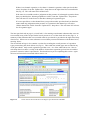
1
CS Technical Report No. 5/07: Freshwater Manual v1.0
CS Technical Report No.5/07
Freshwater Manual
John Murphy and Anita Weatherby
Centre for Ecology and Hydrology
(Natural Environment Research Council)
November 2008
Centre for Ecology and Hydrology
Maclean Building
Benson Lane
Crowmarsh Gifford
Wallingford
Oxfordshire
OX10 8BB
UK
1
Pond Conservation, Oxford Brookes University, Gipsy Lane, Headington, Oxford, OX4 2PD.
Current address: CEH Wallingford.
Contents
INTRODUCTION
1
EQUIPMENT
2
HEADWATERS
Introduction
5
Distribution of duties
7
Photographs
8
Water chemistry sampling and recording
9
Conductivity and pH measurement
9
SRP, TON, and alkalinity
9
Macroinvertebrate community sample
11
General principle
11
Three-minute kick sample
13
Kick sampling from gravel or cobbles
13
Sampling from soft sediments
13
Sampling from boulders
13
Sampling from vegetation
14
Sampling from still or slow-flowing water over gravel or cobbles
14
Sampling from deep waters
14
Manual searching
15
Sample fixing and labeling
15
Site environmental data
17
Water width
19
Water depth
19
Surface velocity
19
Substratum
20
Other habitats
21
Water chemistry
21
Sketch map
24
River Habitat Survey
25
General principle
25
Inputting survey data
26
Page 1
27
Page 2: Spot-checks
27
ii
Page 3: 500 m Sweep-up
30
Page 4: Dimensions and Influences
32
Validating data
34
Aquatic plant survey
35
General principle
35
Survey technique
35
Species identification
39
Assessing and recording physical variables
39
IRIS
42
Inputting survey data
43
Field Survey check-list
47
Quality control and assurance
47
Transit and storage of macroinvertebrate and plant specimens
49
References
51
POND CONDITION ASSESSMENT METHOD
Overview
52
Steps in carrying out the pond condition survey
53
Taking the water chemistry sample and readings
53
Overview
53
Estimating turbidity
54
Meter readings
54
Water chemistry sample for SRP. TON and alkalinity
54
Carrying out the environmental survey (including amenity use)
55
Overview
55
Identifying the outer pond boundary
55
Sketch the pond outline
55
Estimating pond area
55
Measuring drawdown height
56
Estimating the proportion of water present in the pond
56
Measuring sediment and water depths
56
Estimating composition of sediment and pond base
57
Estimating the extent of pollution in the pond
57
Describing inflows and outflows
57
Recording pond management
58
Evidence of livestock grazing
58
iii
Evidence of use by water birds
58
Evidence of fish
58
Evidence of amphibians
59
Recording surrounding land use
59
Amenity value: view of pond
60
Amenity value: public access to pond
60
Amenity value: evidence of amenity use
60
Macrophyte survey method
61
Overview
61
Carrying out the macrophyte survey
61
Plant identification
61
Rare species confirmation
62
Sending specimens for identification
64
Filling in the fieldsheet
65
Completing the survey
65
Checking survey data is complete
65
Returning samples and fieldsheets for analysis
65
iv
INTRODUCTION
Countryside Surveys in 1990 (CS1990) and 1998 (CS2000) included a survey of running
watercourses. There were 360 squares surveyed for freshwater in CS1990 and 425 surveyed in
CS2000. In 1996 the Lowland Pond Survey was undertaken at 150 CS squares in environmental
zones 1, 2 and 4. Following the success of LPS96, the assessment of pond biological condition will
now be fully integrated into CS2007 at all CS squares, not just lowland areas.
For CS2007, the biological condition of headwater streams and ponds will be surveyed. Countryside
Survey is the only national freshwater survey that has the potential to deal with a range of water body
types across the entire GB landscape.
For headwater streams, the following elements will be re-surveyed in each of the 425 squares visited
for CS2000:
•
Macroinvertebrate community
•
Aquatic plant community
•
Hydromorphological characteristics of the watercourse (River Habitat Survey)
•
Physical characteristics of the watercourse
•
Water chemistry
The following elements will be surveyed in a randomly selected pond in each of the 629 CS2007
squares found to contain ponds:
•
Aquatic plant community
•
Physical characteristics of the waterbody
Water chemistry
1
EQUIPMENT
Equipment will be provided as follows:
General Items
Safety & identification
Bivvy bags
Dayglo waistcoats
First aid kit
Handouts (explaining project)
Identity card
Mobile phones
Phone cards
Torches (in vehicles)
Whistle
Personal waterproof clothing
Navigation & location
Aerial photographs of the site
Compass
Hand held GPS
Maps of the site (1:10,000)
Road atlas
Maps to locate sites (1:50,000)
Recording & measuring
Survey poles (x plot)
Field assessment booklets (FAB's)
Weatherproof clipboards
Measuring tape (30 metre)
Digital camera
Rangefinder
Plot marker boards
Reloscope
DBH tape
Poly bags
Folding 2m ruler
Metal detectors
Spring balance
Rucksack (if available)
Pencils and rubber
Reference books (if needed)
Hand lens
Binoculars (if available)
Central
supply
Number
per team
b
b
b
b
b
b
b
b
b
(b)
2
3
2
b
b
b
b
b
Surveyor
3
3
1
3
3
b
1
2
1
2
1
1
b
b
b
b
b
b
1
1
3
2
1
1
1
1
1
b
b
b
b
1
1
1
3
b
b
2
b
b
b
b
Number
needed per
team
Freshwater equipment
Health and Safety
Life jacket
2
Spare CO2 cylinders
3
Bactericidal soap
2
Tap water container
1
Protek anti-septic cream
2
Antiseptic wipes
2
Hand gloves
2
Shoulder length gloves
2
Penknife
1
General
Thigh waders
2
Chest waders
2
Permanent broad marker pens
2
Scissors
1
Waterproof labels
1
Waterproof notepad
1
A4 aquascribe laser paper (box of 250 sheets)
1
Box file
1
Pencils (soft e.g. 3b)
4
Pencil sharpener
2
Rubber
2
Stapler
1
Stream Macroinvertebrate Sampling
Standard FBA pond-nets with graduated handles
2
18" x 12" plastic bags (pack of 100)
1
1.3 litre polythene pots with tight fitting lids
Toxis warning tape for small formalin transort bottles
and sample pots
56
PVC tape for sealing pot lids
2
40% formaldehyde
1
Small plastic bottles for transporting formalin
4
Stop watch
1
1
River Habitat Survey
Range poles
1
3
Stream Aquatic Plant Survey
9" x 7" re-sealable plastic bags for plants (pack of 100)
1
Small brown envelopes
1
Stream & Pond Chemical Survey
1l bottle for water sample
2
Hanna Combi hand-held pH & conductivity meter
1
pH calibration standards
1
Conductivity calibration standards
1
Distilled water washbottle
1
75 ml syringe
Disposable, non-sterile 0.45 µm filter cartridges (33
mm diameter)
5
50ml acid-washed water sample bottles
72
Pre-paid, pre-addressed padded envelopes
40
1
Pond Aquatic Plant and Environmental Survey
Grapnel
1
Pile of A4 white paper
Old newspaper (for drying and pressing plant
specimens)
Shallow plastic tray e.g 35cm x 25 cm x 5 cm to float
plants for pressing
1
1
Thin white card for lifting floating plants for pressing
2
Weight for pressing – e.g plant crib
A4 plastic punched wallets for keeping dry pressed
specimens
1
20
Box file for keeping dry pressed specimens
1
25ml sterilin tubes
30
80% alcohol (25l drum)
0.1
4
1
HEADWATERS
All 425 squares that were surveyed as part of the freshwater module of CS2000 will be re-surveyed as
part of the headwater stream survey in CS2007. At each of these 425 squares:
1. The stream macroinvertebrate community will be sampled (RIVPACS method).
2. Associated RIVPACS environmental variables will be recorded.
Stream width & depth, velocity or discharge category, substrate composition,
altitude, distance from source and slope.
3. The hydromorphological status of the site will be recorded (2003 River Habitat Survey
method).
4. The aquatic plant community will be surveyed (MTR method).
5. An indicative water chemistry sample will be taken and analysed for:
pH, conductivity, alkalinity, SRP, TON.
For 25 of the 425 squares we will be sampling a new site on a smaller watercourse to replace the
CS2000 site which has been found to be on >3rd order stream. This will ensure that for CS2007 and
future surveys the sampling effort is more effectively focussed on headwater streams.
The location of the headwater sampling site within a square was generally chosen to maximise the
length of RHS that could be conducted within the square, while also being as close as possible to the
exit-point from the square. This approach also tended to maximise the proportion of the site’s
catchment which lay within the bounds of the square.
The length of the headwaters sampling site is 500 m of watercourse. This 500 m defines the limits of
the RHS survey area. The 100 m aquatic plant survey stretch is located within this stretch, centred on
the macroinvertebrate and water chemistry sampling point, which in turn are, where possible, located
at RHS spot-check 6 (Figure 1). However it is not always possible to ensure that the sampling
locations adhere to the ideal arrangement. A number of reasons for this are envisaged and rules for
dealing with each circumstance have been devised (Fig 2). If there is any uncertainty about what
to do, then please contact CEH staff.
RHS
(500 m)
Aquatic plant
survey (100 m)
Macroinvertebrate
sample area (10-15 m)
Water
chemistry
RHS spot-check 6
Figure 1
The nested spatial arrangement of sampling stretches for the different tasks at each headwater
sampling site.
5
Macroinvertebrate sample
≥ 250m
No problem, standard arrangement
≥ 250m
flow
A+B ≥ 500m
Survey from source for 500 m
downstream
Source
A < 250m
B > 250m
Survey the strongest upstream tributary.
If equal strength, take right-hand trib.,
looking upstream,
< 250m
< 500m
Sample available length
* either sea or end of ditch/drain.
Source
End*
> 500m
Survey from confluence upstream for
500 m
≤ 250m
Survey from the source along the
watercourse and then down the Bigger
river to a total length of 500 m
A+B < 500m
Source
A
B
The culverted/underground section will
be part of the 500 m section. Assume
that the culverted section flows in a
straightline between disappearing and
re-appearing and record that the stecth is
part-culverted.
= Underground
Figure 2
Rules for surveying 500 m stretches of standard and non-standard watercourses
6
Distribution of duties
The two assigned freshwater surveyors in a team will be designated as person A and person B for the
purposes of this section. The following allocation of duties is a recommendation but may be
varied according to local circumstances.
Having established permission to sample, the surveyors should first find the macroinvertebrate
sampling point, using the maps and grid references provided. All other survey procedures relate to
this position.
Health and safety
Almost all CS2007 headwater survey sites have been previously sampled and therefore are not likely
to be unsafe to sample. However upon locating the the macoinvertebrate sample point along the
watercourse both surveyors should discuss whether the watercourse is safe to sample. Issues to
consider include:
•
Vehicle parking, access from road
•
Current weather/flow conditions/water colour (Does the watercourse appear to be in spate?)
•
River bed substrate, ease of access/bank stability and general condition.
•
Obstacles to the watercourse e.g. fencing
•
Livestock in adjacent fields
These factors need to be considered and if any are deemed to be HIGH RISK or more than two are
deemed MODERATE RISK, then do not proceed with the sampling. It is also advisable to note the
nearest location where there is an adequate mobile phone signal.
Sequence of completion of tasks
If A is the senior freshwater surveyor in each team and B the assistant freshwater surveyor (with
aquatic plant identification skills) then, the allocation of tasks might be as follows:
•
Surveyor A to collect the water sample and record pH and conductivity.
•
Surveyor B to meanwhile begin recording RIVPACS site environmental data.
•
Surveyor A to collect macroinvertebrate sample with assistance on timing, fixing and bagging
of sample from Surveyor B.
•
Surveyor A and B to complete the recording of RIVPACS site environmental data together.
•
Surveyor B to undertake the aquatic plant survey, calling out the information to Surveyor A,
who will enter the data into IRIS while following along on the bankside. The aquatic plant
survey should extend for 50 m upstream and 50 m downstream of the centre of the
macroinvertebrate sampling area.
•
Surveyor A to undertake the RHS, calling out the information to Surveyor B, who will enter
the data into RAPID while following along on the bankside. The RHS should, if possible, be
located along the identical stretch of watercourse as was covered in CS2000 (but see RHS
section of handbook for more detail). The limits of the CS2000 RHS site are indicated on the
map and on the tablet PC.
7
Photographs
Photographs are required of both the macroinvertebrate sampling area and any other features of
interest along the RHS reach. The macroinvertebrate photograph will be used to relocate the site for
future Countryside Surveys and should be sufficiently wide angled and composed to show any
prominent natural or man-made features that will identify the location accurately for future surveyors.
The marker board should be in the photograph and should be marked with the letter M (for
macroinvertebrate sample) and the square number and should be of the form:
M
457
The RHS photographs should show the typical character of the river along the 500 m survey section.
The marker board should again be included marked with the letters RHS and the square number and
hence be of the form:
RHS
457
The aquatic plant survey photographs should show the typical character of the river along the 100 m
survey section. The marker board should again be included marked with the letters MTR and the
square number and hence be of the form:
MTR
457
Record the photographs taken on the RIVPACS sample area form and in RAPID and IRIS.
8
Water chemistry sampling and recording
A single indicative chemical sample will be taken at each watercourse. The sample will be collected
at the downstream end of the macroinvertebrate sampling area prior to any biological sampling.
The following elements will be measured at each headwater site.
•
Conductivity and pH: field measurement
•
Soluble reactive phosphorus (SRP), total oxidisable nitrogen (TON), alkalinty: 50 ml filtered
Enter the watercourse and facing upstream rinse both 1 L wide-neck bottles 3 times with river water
taken from a flowing area upstream of your position. Then move a few more steps upstream and fill
the bottles with undisturbed stream water from the water column without disturbing the stream bed or
any soft bed-sediments. One of the 1 L bottles will be used for the pH and conductivity
measurements, while the other will be used as a source for the filtered water sample to be analysed for
SRP, TON, and alkalinity.
Conductivity and pH measurement
Please familiarize yourselves with the Hanna Combi pH & conductivity meter prior to use. Read the
manufacturer’s instructions and understand the operational protocols. Ensure that the meter is wellrinsed since use at the previous site and is properly calibrated (two-point calibration for the pH meter).
The manufacturer’s instructions for calibrating the meter are provided in the meter box. Ideally the
meter should be checked against the standards before every square and re-calibrated if necessary.
You toggle between pH/conductivity and total dissolved solids display on the meter by pressing the
SET/HOLD button.
Conductivity: Submerge the probe-end of the meter in the collected 1 L sample bottle, immediately
after the sample has been taken. Select ‘µS’ mode with the SET/HOLD button. The measurements
should be taken when the stability symbol (a stopwatch icon) on the top left of the display screen
disappears. Please note the units.
pH: Submerge the meter in the collected 1 L sample bottle, immediately after the sample has been
taken, stirring gently. Select ‘pH’ mode with the SET/HOLD button. The measurement should be
taken when the stability symbol (a stopwatch icon) on the top left of the display screen disappears.
Record the readings on the RIVPACS Sample Area Form.
SRP, TON, and alkalinity
A filtered water sample is needed for the analysis of these parameters. Filtering will be done on site
using disposable 0.45 µm pore size, 33 mm diameter syringe filters.
A 50 ml plastic sample bottle will need to be labeled externally before becoming wet using a black
marker pen:
Project
‘CS2007’
Type of waterbody:
‘Stream” or “Pond’
Square number:
square number (e.g. 38)
Date:
day-month-year (e.g. 07-08-07).
Wash the syringe by twice filling the syringe chamber with some of the water sample and emptying it
on to the ground. Then fill the syringe chamber again with sample water and attach a new disposable
filter cartridge. Then empty the water in the chamber, through the filter, into the 50 ml plastic sample
bottle. Rinse the sample bottles out with this water. Do not exert excessive pressure as this might
rupture the filter.
9
Remove the filter, fill the syringe chamber once more with some of the water sample, re-attach the
same filter cartridge and fill the 50 ml plastic sample bottle. If filter cartridge becomes blocked
during filtration then change and continue with more of unfiltered water sample. After filtering,
check the filtered sample for suspended material e.g. from a ruptured filter paper. If suspended
material is present then discard the filtered sample and start again.
Screw on the lid tightly and place in the pre-addressed and postage-paid padded envelope along with
the pond water sample (if there is one). Complete the sample information form (Fig 3) giving details
to aid the laboratory chemists at CEH Lancaster in identifying the sample and ensuring that the
subsequent measurements are assigned to the correct waterbody in the correct CS square.
SAMPLE INFORMATION SHEET - ENVIRONMENTAL ANALYSIS GROUP – CEH LANCASTER
Customer Name: Countryside Survey 2007
Affiliation: CEH
Address:
BATCH NUMBER:
(lab use only)
Sample type: 50 ml 0.45µm filtered stream/pond
water
Risk Assessment Required: YES/NO
Storage conditions: posted immediately after
sampling
Samples to be returned: YES/NO
Samples will be disposed of 3 months after reporting date
unless customer advises otherwise.
Sampler/contact:
Responsible Analyst:
Project no: C03259
Analytical requirements:
Project name: Countryside Survey 2007
Soluble reactive phophorus
Quote number:
Total oxidisible nitrogen
Results due date:2 weeks after receipt of sample
Alkalinity
CS Square
Stream name/pond name, date and any other information
01
02
03
04
05
06
07
Figure 3
Water sample information sheet to be completed for water samples from each CS square.
10
Macroinvertebrate community sample
General principle (modified from Murray-Bligh 1999).
The primary objective is to collect the widest range of animals possible from within the sample area,
using a sampling method that is comparable to that used in CS1990, CS2000 and that is compatible
with the RIVPACS bioassessment method.
For the purposes of macroinvertebrate sampling the sample area must be a single continuous area of
stream-bed whose major habitat types can be sampled within the recommended sampling period. It
will normally vary from 5 to 15m according to stream width. It must not be a collection of separate
sampling points within an extended length of river, for instance to include both riffles and pools in an
attempt to increase the variety of animals captured.
Each habitat in the sampling area must be sampled with an effort proportional to its cover. Within the
limitations imposed by this procedure, as many different taxa in the sampling area as possible should
be collected. On average, about 60% of families present will be collected in a single three-minute
kick sample, excluding the manual search.
The sample shall be collected using a standard 25 cm2 pond-net with a 900 µm mesh net. Wash the
net thoroughly before and after taking samples. Check that it is neither damaged nor contaminated
with animals from previous samples. Damaged pond nets must not be used.
Wherever possible, collect samples by sampling for three minutes with a pond-net and one minute of
manual searching (Fig 4). The manual search is mandatory, although it will not always be fruitful.
The sampling area should not encompass such a wide range of features along the river that it includes
both deep and shallow areas.
There is no limit to the amount of material collected: only the sampling time controls the volume of
the sample.
Material collected in the net must be removed periodically, to prevent the mesh becoming blocked and
the sample being washed-out of the net. As a minimum, this must be done after every minute of
sampling with a pond-net, and more frequently if the net is filling rapidly or becoming blocked. Wash
fine sediment through the net more frequently than this, to minimise the amount retained in the
sample. Large stones and pieces of vegetation (that may damage the net) can be discarded, but before
doing so, agitate them vigorously in the collecting net whilst it is half-submerged, to wash any animals
back into it. Check that no animals are still attached before discarding this material.
Retain only enough water to keep the sample damp. This reduces the amount of fixative or
preservative that has to be added to it, and reduces damage.
All specimens captured in the net must be retained in the sample for identification in the laboratory.
However you do not retain fish, amphibians, and readily identified rare species in the samples, such as
large specimens of the freshwater pearl mussel (Margaritifera margaritifera) and crayfish, but return
them to the water with care and unharmed. Record their presence in the sample on the RIVPACS
Sample Area Form. If removed live for identification, then return them only to the site where they
were collected.
Bear in mind that it is particularly important to identify rare taxa correctly e.g. differentiating native
from introduced crayfish, because of their high conservation value and need for protection, so if there
is any doubt then retain the specimen in the sample.
Avoid sampling during and immediately after spates. Samples collected in these conditions will not
accurately reflect the underlying environmental quality of the site.
11
1st part: MANUAL SEARCH
Seek and collect individual animals from the water surface.
Spend a total of one minute on the manual search, split between parts 1 and 3
2nd part: MAIN SAMPLE
Collect by either A, B or C
A - shallow/wadeable
3 minute active pond-net sample collected by a combination of kicking and sweeping, depending on the nature
of the substratum, current and habitats, for benthos and free-swimming animals.
All habitats sampled in proportion to their cover.
B - too deep to kick sample whole site, but possible to sample at least some of the main channel with
pond-net
3 minute active pond-net sample collected by a combination of kicking and sweeping for benthos and freeswimming animals.
Attempt to sample all habitats in proportion to their cover, although this may not be possible for habitats in the
main channel
C - impossible to sample material from the main channel using a pond-net
3 minute sweep with pond-net to collect free-swimming animals and those from vegetation, but not the
benthos.
3rd part: MANUAL SEARCH
Search and collect individual animals from submerged rocks, logs or vegetation.
Spend a total of one minute on the manual search, split between parts 1 and 3
Figure 4
Summary of sampling procedures (modified from Murray-Bligh 1999).
12
Three-minute kick sample (modified from Murray-Bligh 1999).
The kick-net can be used in different ways depending on the nature of the survey area. Different
habitats at the same site may be sampled by a combination of the methods described below. The total
sampling time must be three minutes.
If a site comprises discrete habitats, apportion the sampling effort according to their cover in the
sampling area. If a site appears to be homogeneous in character, continuous diagonal transects will
suffice for most of the sample.
Always move upstream and diagonally across the stream a number of times whilst sampling, rather
than straight upstream (Fig 5). This will ensure that a greater number of habitats are sampled, even if
they are not apparent, and therefore a higher proportion of the taxa present at the site are collected.
The three minutes covers only the time spent actively sampling, and excludes the time spent emptying
the net, or moving around the site. It is recommended that sampling is done in short bursts of 15-20
seconds. There will be 9 to 12 bursts in a three minute sample, which is worth remembering when
apportioning the sampling effort to the different habitats. A stopwatch must be used to ensure that the
cumulative time spent actively sampling is precisely three minutes. With two people on-site, one
should time the sampling with the stopwatch while the other collects the sample. The sampler should
call-out to the timekeeper when to start and stop the watch, and the timekeeper can remind the sampler
when each sampling burst should end.
Kick-net samples collected with less effort, in an attempt to prevent denuding sites on very small
watercourses, are not compatible with RIVPACS. A longitudinal extension of the site will be
required in these streams.
In general, more material will be collected from lowland streams than from stony mountain streams.
Kick sampling from gravel or cobbles
When kick sampling, hold the net vertically with the frame at right-angles to the current, downstream
from your feet, and resting firmly on the river bed; disturb the stream bed vigorously by kicking or
rotating the heel of your boot to dislodge the substratum and the fauna within it to a depth of about 10
cm. Hold the net close enough for the invertebrates to flow into the net with the current, but far
enough away for most of the sand and gravel to drop before entering the net. Hold the net further
away where the substratum is finer or the current swifter, to prevent it clogging. Move large stones by
hand if they cannot be shifted by foot, and sample the finer sediment that collects beneath them.
Sampling from soft sediments
Where the stream bed is soft silt or clay, kick sampling is ineffective because the net will become
blocked rapidly. Instead, skim the bottom edge of the net gently through the top few centimetres of
the substratum, which is where most of the animals will be found. Alternatively, stir-up the surface of
the sediment by foot or with the back of the net, and pass the open net through the clouded water.
Rinse the silt away through the net frequently, by agitating the net in the current or at the water
surface.
Sampling from boulders
It is not easy, and sometimes impossible, to take a kick sample amongst boulders. Most of the
invertebrates will be in the finer deposits that accumulate under the boulders. To reach them,
boulders may have to be moved by hand, though small ones may be prised away by foot. Move
boulders away at right-angles to the current, or upstream and away from feet, so that the net can be
held downstream from the area disturbed. Sample the exposed river bed by kicking in the normal
way.
13
It is impossible to sample effectively where the stream-bed is dominated by large boulders,
particularly near waterfalls or where the gradient is steep. Replace these sites by ones that can be
sampled effectively.
Figure 5
Kick sampling from a shallow, fast-flowing stream. The sampler is facing at right angles to the
current and is moving diagonally to the right and towards the photographer, for safety. The
sampler is dislodging the substratum using his left foot and is holding the net close-by, in the
plume of disturbed sediment, to capture the animals that are dislodged.
Sampling from vegetation
Sample from submerged and emergent vegetation and tree roots by pushing the net into them with a
variety of forward, upward, and lateral movements. Dislodge animals from dense tangles of tree roots
by kicking. Sample the sediment that accumulates beneath plants by kicking or skimming the surface
of the sediment. Do not overlook water under overhanging banks, because invertebrates may be
hiding there.
Sampling from still or slow-flowing water over gravel or cobbles
When sampling from still or slow-flowing water, a different procedure is necessary because there is
no current is to carry dislodged animals into the net. Disturb the substratum with your feet and catch
the dislodged animals by sweeping the net through the water immediately above the disturbed area.
Use this technique wherever the current is weak, to supplement the methods described above.
Sampling from deep waters
In watercourses too deep for conventional kick-sampling, it is possible and to take a sweep sample
from the marginal vegetation and wadeable shoreline with the pond-net. All habitats must be
sampled, where safe to do so. If possible, use a combination of sweeping and kicking. Wherever
pracitable , collect the sample from both banks. In these circumstances you should sample each
habitat in proportion to its linear dominace along the river channel.
14
The sampling duration shall be three minutes of active sampling supplemented by a manual search.
Manual searching
The manual search is similar, whatever methods are used to collect the main sample. Unlike the main
sample in which animals are collected without seeing them, individual animals seen by the sampler
are collected in the search and added to the main sample.
The search is in two parts which together last one minute. The first part is to seek and collect animals
living on the water surface, such as whirligig beetles, water crickets and pond skaters. This must be
done before any other sampling, because these animals are easily disturbed and will either leave the
sampling area or be much more difficult to find later. They are best caught with a pond-net. Most
surface dwellers are very active and they should be secured in a tied bag or vial immediately after
capture. Whilst searching for these animals, note the area occupied by different habitats within the
sampling area, so that you can apportion the sampling effort amongst them in the main sample.
The second part of the search is for animals from habitats that are not sampled effectively by the
methods use to collect the main sample. Pick-off animals attached or clinging to the submerged stems
of emergent plants, rocks, logs, or other solid objects, with forceps or a stiff paint brush. Examine
rocks at several places across the river to cover the different biotopes and areas covered by different
sized substrata. Always search for animals attached to floating-leaved plants. Inspect the undersurfaces of floating leaves as well as the upper surface and stems.
The whole search must last one minute. It is standardised by time alone, and not by searching a
certain number of rocks or locations. This period only covers the time spent actually searching, and
excludes the time spent moving around the site. A stopwatch or watch with second hand must be used
to ensure that the cumulative time spent actively searching is one minute. At some sites, the search
will be fruitless, either because no suitable or accessible places to search are found within the minute,
or because no animals are found in the places that are searched. Even where the sampler suspects that
nothing will be found, the search must be undertaken honestly, to maintain consistency.
Sample fixing and storage
On completion of sampling, the sample should be emptied into a medium gauge, 18" x 12" polythene
bag as provided. Intermediate emptying of the net after each minute’s active sampling is strongly
recommended and is essential if the net becomes so full as to preclude efficient sampling.
Rinse the sample, where possible by shaking the pond-net vigorously in the stream without risking
loosing any animals, to remove silt and clay. Discard stones, wood, and large fragments of vegetation
before removing the sample from the net but take care to remove any clinging animals and drop them
back in the pond-net.
The easiest way to remove a sample from the pond-net is to wash the catch into one corner of the net
first, by dipping the net into the water and gently shaking it from the opposite corner as it is lifted out
of the water. Then, by gradually everting the corner of the net, the bulk of the sample can be dropped
into a labeled sample container, or polythene bag. Material clinging to the net can be shaken, or
flicked-off from the other side of the net, into the container. Repeat this process until the net is clear
of material. Recalcitrant specimens may be picked-off the net by hand.
Always wash the collecting net thoroughly to prevent contaminating subsequent samples.
It is very easy to cross-contaminate samples from residual specimens retained on nets from previous
site visits. Always wash pond nets as thoroughly as possible after sampling at each site and also
before sampling the next site.
15
Fill the sample containers to no more than about two thirds full with collected material. This will
leave sufficient room for fixative or preservative, and an air space. Never cram material into a sample
container, and never fill it completely: use an additional container instead.
Then, 40% formalin solution should be added to the sample bag until the liquor in the bag is
equivalent to 4% aqueous formaldehyde. The precise amount of formalin needed varies from sample
to sample but is in the region of 50 - 100ml per plastic bag. It is better to err on the side of excess.
A clear pencil-written label should be placed in the sample bag. The label should contain the
following information:
Type of sample :
“macroinvert”
Square number :
Square number (e.g. 38)
Date
day-month-year (e.g. 07-08-07).
:
The plastic bag should be firmly tied and placed inside a 1.3 l storage pot and the lid of the pot tightly
closed. An extra sharp twist of the lid is then recommended. Apply PVC tape around the lid to form
a seal and to prevent the lid becoming loose during transport.
The pot should be clearly labeled on the outside, using a permanent marker, with the same
information as given on the internal label.
The sample may be split into two or more bags/pots if too large to fit within a single container. All
parts of the sample should be labeled as above, together with the additional information “Part one of
two” or “Part two of two” or “Part one of three” etc. Samples should very rarely require more than
one container. Single containers should be adequate for the large majority of sites.
THOROUGH LABELLING OF SAMPLES IS ESSENTIAL
Surveyors should take at least six polythene bags, two sample pots and two bottles of 40%
formaldehyde to the survey square in case the macroinvertebrate sample is very large.
For transport, samples should be stored upright in the grey stacking trays provided.
16
Site environmental data (modified from Murray-Bligh 1999).
Site environmental data should be recorded for each macroinvertebrate sample. For the purposes of
environmental data collection, the sample area is defined as the full width of the watercourse for the
full length sampled for macroinvertebrates.
The significance of the different definitions of sample area given for macroinvertebrate sampling and
environmental data collection is that sections of the watercourse too deep for macroinvertebrate
sampling are, nevertheless, included in width, depth and substratum evaluations.
When collecting environmental data, the objective should be to measure the modal conditions in the
Sampling Area at the time of sampling. Avoid isolated features such as boulders or narrows, which
would cause the measurements to be atypical of the Sampling Area as a whole. Choosing the best
place to measure these is easier when the Survey Area is restricted to a relatively discrete range of
physical conditions.
The environmental data shall be entered on the RIVPACS Sample Area form (Fig 6). The following
instructions apply:
Square number:
e.g. 38
River Name:
Use river name from CS2000 data, make note if you think the name is incorrect.
For new sites, take name from map if indicated
Site Name:
Use site name from CS2000 data, make note if you think the name is incorrect.
For new sites, take appropriate site name from map.
Sample date:
Use the format: day-month-year (e.g. 07-08-06).
NGR:
Use GPS to record position of macroinvertebrate sampling site to at least 8digit numeric national grid reference e.g. SY12345678
Recorders:
Enter the initials of both surveyors
Sample method:
Enter either:
Kick/sweep - disturbing the substratum with feet plus sweeping amongst plants
Kick - substratum disturbance but no sweeping
Sweep - sweeping amongst plants but no substratum disturbance
Sample time:
Enter time of active pond-netting (i.e. exclude search time). In almost all or all
cases the time will be three minutes.
Proportionality:
Answer ‘No’ if the full width of the river for the full length of the sample area
is not sampled. Only a simple explanation is required (e.g. “Not left-handbank. Too deep”. NOTE: left/right banks are determined looking
downstream).
Photograph:
A photograph is required of each sampling site. The photograph should include
a numbered site board. If possible it should also include a fixed natural or manmade feature of the site which can be helpful in re-location.
17
RIVPACS SAMPLE AREA FORM
CS2007 SQUARE No.:
RIVER:
DATE:
SITE:
NGR:
SAMPLE METHOD:
KICK
RECORDERS:
KICK/SWEEP
SWEEP
SAMPLE TIME (should be 3 mins active sampling plus 1 min manual search):
Is sampling proportional to occurrence of habitats?
Yes
No
Give details if NO:-
PHOTOGRAPH OF SAMPLE AREA TAKEN?: Yes
No
WATER WIDTH IN SAMPLE AREA:………………..m
WATER DEPTH IN SAMPLE AREA (cm) AT ¼,
¼
½ and ¾ OF STREAM WIDTH
½
¾
ESTIMATED SURFACE VELOCITY IN MAIN CHANNEL (cms-1):
CATEGORY 1
CATEGORY 2
CATEGORY 3
CATEGORY 4
CATEGORY 5
≤10
10-25
25-50
50-100
>100
SUBSTRATUM IN SAMPLE AREA:
Please give details for the full width of river at the sampling area.
SUBSTRATE TYPE: (mm)
BOULDERS &COBBLES
PEBBLES & GRAVEL
SAND
SILT & CLAY
>64 mm
>2 – 64 mm
>0.0625 – 2mm
≤0.004 - 0.0625 mm
%
%
%
OTHER HABITATS:
Rock pavement…………………%
Moss………………………….%
Filamentous algae………………%
Higher plants………………..%
WATER CHEMISTRY:
Figure 6
pH
Conductivity (+ units)
Form for recording environmental data in the macroinvertebrate sample area
18
%
The following measurements must be made at a point along the sample area which is typical of that
area (i.e. representing the modal condition). The graduated pond-net handle can be used for width,
depth and surface velocity measurements.
Water width:
The stream width should reflect the predominant conditions in the sampling
area. Measure the stream width at right-angles to the channel. Measure the
width of the water surface, not the stream channel, and include water under
overhanging banks.
If temporary islands form in the channel because of low flow, include them in
the measurement. Choose a place to measure the width that gives an
approximately modal value for the site. Alternatively, where the modal width is
difficult to estimate and it is safe and easy to cross the river, an average of more
than one measurement from the vicinity of the sampling area can be used,
although this should not normally be necessary.
Use the accurately marked kick-net handle to measure width. On deep
watercourses, either estimate the stream width, making use of nearby bridges
(although sites should not be in the immediate vicinity of bridges), or use a
rangefinder.
Wherever possible, width should be measured rather than estimated. As a
minimum, estimate widths of less than one metre to the nearest 10 cm; widths of
between one and two metres to the nearest 20 cm; and widths between two and
ten metres to the nearest 50 cm; and widths greater than ten metres to the
nearest metre.
Water depth:
The depth should reflect the predominant conditions in the sampling area.
Depth should be based on the average of measurements from approximately a
quarter, half, and three-quarter distance along a transect across the stream in the
sampling area.
Do not measure depth where it is atypical of the site, for instance over or close
to boulders. When a temporary island appears in mid-channel, the depth there
will be zero, and should be recorded as such.
Where the stream is wadeable, record the depth to the nearest centimetre.
Where the depth has to be estimated, record depths to 1 m to the nearest 10 cm,
and greater depths to the nearest 50 cm.
Surface velocity:
Current velocity must be measured only in Scotland and its offshore islands.
The measurements refer to the typical surface velocity in the main flow channel.
Dead water areas and atypically fast flowing areas should be avoided. The
measurements should refer to the surface velocity in the main flow channel.
The time that it takes for a floating object (e.g. a leaf of a twig) to travel a
known distance can be used to measure the velocity. If the object is thrown into
the current, measurements should not be started until initial inertia of the object
is overcome. Results should be measured in cm s-1.
For preference, the object should be measured over a 10 metre run with a
relatively constant current speed. This may not be possible in small streams or
where the character of the river changes rapidly. In this case, the same guiding
principles recommending for selecting the position of depth measurements
should also apply to current velocity, and the object can be timed against the
pond-net handle.
It is important that current velocity is measured accurately as possible. Poor
runs of the floating object should be discarded and the estimated category
19
should ideally be based on the modal or median value of at least three timed
runs on each visit. Current velocities are recorded using the categories shown in
Table 1.
Table 1
Substratum:
Velocity categories for RIVPACS
Velocity category
Current velocity (cms-1):
1
<10
2
>10 - 25
3
>25 - 50
4
>50 - 100
5
>100
The composition of the stream bed must be assessed over the whole sampling
area, i.e. the full width of river along the whole length sampled, even if some
parts of it are inaccessible for sampling. Visual estimates of four categories of
particle size are required (Table 2, Fig 7).
Estimates must be based on a bird’s-eye view of the superficial stream-bed layer
and should include both particles which are visible and those which would be
visible in the absence of plant-growth. The percentage cover of the stream-bed
occupied by each of the four size categories should be recorded. THE FOUR
VALUES SHOULD ALWAYS TOTAL 100%.
Estimates should exclude bedrock which is recorded on a separate part of the
recording form. A peat stream-bed should be recorded as silt. Clay can either
be areas of soft fine particles or a continuous sheet.
A fine layer of silt or clay through which the shape of the underlying stones can
be seen should be typed according to the underlying substratum, but if the
shapes of the underlying stones are not distinct, the silt or clay should be
recorded instead. Compacted clay should be recorded as clay, even when
broken-up into gravel-sized fragments.
Experience has shown that cover estimates are improved if both surveyors
estimate percentage cover at the same site and compare results. Fig 8 may be
used as a guide to how best to estimate cover. Copies of the figure could be
attached to the back of clipboards and used as an aid in the field.
Walk along the river bank and make a preliminary note of the substratum after
any surface-living animals have been collected. These initial evaluations will be
particularly useful at silty sites, and will be necessary for apportioning the
sampling effort. After the rest of the biological sample has been collected, walk
over the whole sampling area before making the final estimates. It is difficult to
judge the composition of the river bed in deep or turbid water. The substratum
visible at the water's edge, the feel of the stream-bed under foot, the contents of
the sampling net, previously recorded data, and local knowledge may all be used
as guides.
20
Table 2
Substratum particle size categories recorded for RIVPACS
Category
Longest axis (mm)
Description
silt/clay
<0.06
soft in texture and not
abrasive to the hands
when rubbed
Sand
0.06 – 2
smaller than coffee
granules, and unlike
silt/clay, abrasive to the
hands when rubbed
pebbles/gravel
2 - 64
coffee granule to half fist
size
Boulders/cobbles >64
Other habitats:
half-fist size or larger
The percentage cover of four other categories of habitat is required for the full
width of the sample area for the full length sampled biologically:
Bedrock: Enter the proportion of the total stream-bed in the sample area covered
with bedrock. Include areas under plant growth.
Filamentous algae: Enter the proportion of the total stream-bed in the sample
area obscured by filamentous algae. This category excludes diatom growth on
stones.
Moss: Enter the proportion of the total stream-bed in the sample area covered by
mosses of all kinds.
Higher plants: Enter the proportion of the stream-bed in the sample area covered
with, or obscured by all kinds of plants other than algae and mosses.
Water chemistry:
Enter the pH and conductivity readings recorded using the hand-held meters.
Please enter the units as well as the value for the conductivity reading.
21
COBBLE
256 mm
PEBBLE
64 mm
GRAVEL
16 mm
SAND
2 mm
Figure 7
Guide to substratum particle sizes
22
Figure 8
An aid to determining percentage covers.
23
Sketch map
A sketch map of the macroinvertebrate site should be drawn on the back of the RIVPACS Sample
Area Form. The purpose of the sketch map is to enable future relocation of the site. Keep this fact in
mind when drawing the map.
Draw a sketch of approximately 50 m of river channel indicating the general physical character of the
site and incorporating the macroinvertebrate sampling area. This should include permanent reference
features (such as a distance from a bridge or footpath sign) which would enable anyone else to find
the site with adequate precision in the future.
Main features to mark on sketch map:
•
General form of river channel, including islands, flow direction and prominent bank features
•
Relocation features - for both ends of the survey length if possible. These should be near
permanent landmarks such as hedgerows, fence lines, walls, electricity pylons, roads, bridges,
buildings etc.
•
Record distances from/ between features
•
Grid north (found from OS map) and estimated scale e.g. indicate on map what length is 10 m.
•
Adjacent land use - for example woodland, arable, pasture, factory, waste, set aside
•
Extent of macroinvertebrate sampling area
•
Location from where photos were taken.
•
Any potential hazards.
24
River Habitat Survey
General principle
An assessment of the hydromorphological diversity and condition of river reaches was carried out as
part of CS2000 using the 1997 version of the River Habitat Survey form (Raven et al. 1998). Since
then the RHS protocols has been updated and a 2003 version of the method is now available
(Environment Agency 2003) and will be used for CS2007. The changes between the two versions
affect the way the RHS indices are calculated but values will still be comparable between the two
versions.
The 2003 RHS protocol is described in detail in the guidance manual provided along with the training
course and therefore will not be covered in detail here. All CS2007 surveyors will receive RHS
training and accreditation in the2003 version from the Environment Agency RHS team.
We will be using a field digital data entry system, called RAPID, to record the RHS data on site. This
will reduce the likelihood of errors associated with transferring data from paper copy to a database,
and will allow more effective use of staff time. There is also the added benefit of being able to
validate the entered data while the surveyor is still on-site, thus improving data quality. A copy of the
2003 RHS field survey guidance manual will be easily accessible from RAPID on the Tablet PC. The
design of RAPID and the format of data entry mimics the 2003 RHS form and therefore should be
easily understood by an accredited RHS surveyor.
The RHS section will be 500 m long and will be centred (wherever possible) on the selected
macroinvertebrate sampling site. The survey will be undertaken irrespective of whether there is flow
or not in that section of the watercourse and, hence, whether or not a macroinvertebrate sample was
collected. In some circumstances it may not be possible to centre the survey on the macroinvertebrate
sampling site nor to survey a full 500m. A number of reasons for this are envisaged and rules for
dealing with each circumstance have been devised (Fig 2). Field surveyors should seek advice from
senior CEH staff if any other circumstances are encountered.
RAPID is an MS Access database designed to capture and store RHS data in the field using a Tablet
PC. You simply double-click the RAPID icon on the desktop to open the application. Then you
select from the opening form whether you wish to input survey data for a new site, export data from
an existing site or exit the database (Fig 9).
Figure 9
Desktop icon and screen shot of the opening menu of the River Habitat Survey field digital
data entry system (RAPID).
25
Inputting survey data
The data entry form consists of 17 sections across 4 pages. Pages 1, 3 and 4 gather general survey
information and data for the sweep-up part of the RHS. Page 2 is where the spot-check data is entered.
You can switch between the four pages using page buttons at the top of the window (Fig 10).
Most data fields are drop-down lists. This reduces the amount of text that needs to be entered using
the Tablet PC stylus and also improves data quality because it means that inappropriate codes cannot
be entered. By default all data fields are set at ‘-9’ or ‘missing value’ until you interact with them and
enter an appropriate piece of information. In completing an RHS form all ‘-9s’ and ‘missing value’
selections are replaced by data.
Figure 10
Screen shot of part of Page 1 of RAPID.
The purpose of the buttons at the top of the window (Figure 10) is as follows:
26
About database: provides basic contact details and ownership information.
Main menu: returns you to the opening menu screen of RAPID
Survey Notes: opens a text box linked to a particular survey, for entering necessary field notes
RHS manual: opens an electronic version of the 2003 RHS guidance manual, complete with example
pictures of all hydromorphological features recorded in a survey.
Check Data: on completion of an RHS survey you must press this button to validate the data you have
entered. RAPID will check, sequentially from the start of the form to the finish, for data fields that
have been left empty by mistake and where possible, for inconsistencies in the data entered. RAPID
will only display one error at a time (so that you have the opportunity to correct the problem). Once
you have corrected the problem you must press the Check Data button again to find the next error (if
there is one). Once the validation is successfully finished, RAPID produces a message ‘This RHS
survey appears to be complete’. This validation must be performed before you leave the site, in order
that any omissions can be accurately corrected.
When you select ‘Input Survey data’ from the main menu you are first asked to select the CS square
for which you wish to enter data. Use the ‘Select Square’ drop down list in the top right-hand corner
of the window.
You then proceed to complete the form as normal, complying with standard RHS protocol, ensuring
that all fields are completed.
IF, FOR WHATEVER REASON, YOU CANNOT CARRY OUT THE RHS AT A SQUARE, THEN YOU SHOULD
STILL SELECT THAT SQAURE IN RAPID, ENTER THE DATE, SURVEYOR NAME AND IN THE SURVEY NOTES
PROVIDE A REASON FOR NOT COMPLETING THE SURVEY.
Page 1
Section A Field Survey Details: You must record the GPS-derived NGR for spot-check 1, 6 and 50m
beyond spot-check 10. This can be done by returning to this section as you proceed through
the survey. By clicking the ‘Today’ button adjacent to the box you can automatically
complete the box with that day’s date. Select the surveyor’s name and RHS accreditation
code from the drop-down list. You are asked to decide whether the watercourse is natural or
artificial. The associated help button provides definitions for both types of watercourse.
Section B Valley Form: This section does not differ in content from the paper form, but has a slightly
different arrangement of the options.
Section C Number of Riffles, Pools and Point Bars: This section does not differ in content from the
paper form.
Section D Artificial Features: This section does not differ in content from the paper form, but has a
slightly different arrangement of the options. You should first tick the box near the top-left of
the section which will turn all the -9s in the section to zeros. Then you can enter counts for
those artificial features that are present, if any.
Page 2: Spot-checks
The design of Page 2 differs from that of the paper form. Each of the 10 spot-checks and the summary
channel vegetation and extra substrate section are on separate tabbed pages nested within Page 2. A
blue bar underneath the tab numbers indicates which tab is currently selected (Fig 11). The drop-down
boxes provide you with all valid options, both in code and with description, for each spot-check
attribute. This design aids data-entry. You are reminded on the tabs for spot-checks 1, 6 and 10 to
record the GPS readings. You must record whether Spot-check 1 is at the up- or downstream end of
the site. This is recorded in the drop-down box above the tabbed section (Fig 11).
27
Each spot-check tab also features a ‘Check’ button (located at the right-hand side of Section F) which,
when clicked, will confirm that there are no missing data or omissions for that spot-check. It is good
practice to use this button before you move to the next spot-check to ensure that you have completed
all the necessary tasks.
Figure 11
Screen shot of the Page 2 spot-check form in RAPID.
Section E Physical Attributes: This section does not differ in content from the paper form, but has a
slightly different arrangement of the options. You are allowed to enter a maximum of two
codes for bank modifications and marginal& bank features on each bank. If you need to enter
more than two codes then use the survey notes. The same applies for channel modifications
and features. It should be noted that you nee to interact with all the drop-downs. So even if
you wish to record only one bank modification sat this spot-check, you still need to change the
optional second drop-down to NO (none).
Section F Banktop Land-use and Vegetation Structure: This section does not differ in content from the
paper form, but has a slightly different arrangement of the options.
Section G Channel Vegetation Types: This section does not differ in content from the paper form, but
has a slightly different arrangement of the options.
If there are some vegetation types present you will need to interact with all boxes, even those
for types not present, to actively record that they are absent.
28
If there is no channel vegetation, or less than 1% channel vegetation, at the spot-check, then
select ‘No plants’ from the ‘Update all to:’ drop-down to the right in the blue section header
bar (Fig 11). This will enter NO in all the boxes.
If the water is too turbid to make a judgement on the presence of submerged vegetation forms
then you should select ‘Submerged plants not visible’ from the ‘Update all to:’ drop-down.
This will enter NV in the boxes for the three submerged vegetation types.
If it is not possible to see the channel from your position at this spot-check and you therefore
cannot make any judgement on the presence of vegetation in the channel you can select
‘Whole channel not visible’ from the ‘Update all to:’ drop-down. This will enter NV in boxes
for all vegetation types.
The last spot-check tab on page 2 (‘Overall tab’) is for entering extra channel substrates that were not
not recorded in any of the 10 spot-checks but are present in >1% of the whole 500 m site (Fig 12). A
summary of the substrates that were recorded at the 10 spot-checks is provided to the right of the dropdown boxes. If there are no extra substrates to record then you must still interact with all three boxes,
entering ‘None’.
The Overall tab on Page 2 also contains a section for recording the overall presence of vegetation
types present along the whole 500 m site (Fig 12). This could also include types not recorded in any
of the spot-checks. Only record vegetation types that cover >1% of the whole 500 m site. Next to
each drop-down box there is a tally of the number of times that vegetation type has been recorded as
present or extensive in the 10 spot-checks. This should assist you in completing this section. Again
all boxes will need to be interacted with to remove -9s.
Figure 12
Screen shot of the Overall tab on the Page 2 spot-check form in RAPID.
29
Page 3: 500 m Sweep-up
Section H Land-use within 50 m of Banktop: This section does not differ in content from the paper
form, and has an almost identical arrangement of the options (Fig 13). You should first tick
the box near the top-left of the section which will turn all the -9s in the section to zeros. Then
you can enter data for those land-uses that are present.
Section I Bank Profiles: This section does not differ in content from the paper form, and has an almost
identical arrangement of the options (Fig 13). You should first tick the box near the top-left of
the section which will turn all the -9s in the section to zeros. Then you can enter data for those
natural and artificial/modified bank profiles that are present.
Figure 13
Screen shot of upper half of Page 3 form in RAPID.
Section J Extent of Tress and Associated Features: This section does not differ in content from the
paper form, but does have a slightly different arrangement of the options (Fig 14). If there are
30
no trees or none of the associated features present at the RHS site then you can just tick the
box in the top left-hand corner of the section to move all the -9s to zeros. Alternatively you
just complete each of the drop-down boxes appropriately.
Section K Extent of Channel and Bank Features: This section does not differ in content from the paper
form, and has an almost identical arrangement of the options (Fig 14). You should first tick
the box near the top-left of the section which will turn all the -9s in the section to zeros. Then
you can enter data for those features that are present.
Figure 14
Screen shot of lower half of Page 3 form in RAPID.
31
Page 4: Dimensions and Influences
Section L Channel Dimensions: This section does not differ in content from the paper form, and has a
similar layout. Use the numerical drop-down lists to record the measured dimensions (Fig 15).
Section M Features of Special Interest: This section does not differ in content from the paper form,
and has an almost identical arrangement of the options (Fig 15). You should first tick the box
near the top-left of the section which will turn all the -9s in the section to zeros. Then you can
enter data for those features that are present.
Figure 15
Screen shot of upper half of Page 4 form in RAPID.
32
Section N Choked Channel: This section does not differ in content from the paper form, and has a
similar layout (Fig 16).
Section O Notable Nuisance Plant Species: This section does not differ in content from the paper form,
and has an almost identical arrangement of the options (Fig 16). You should first tick the box
near the top-left of the section which will turn all the -9s in the section to zeros. Then you can
enter data for those plant species that are present.
Section P Overall Characteristics: This section does not differ in content from the paper form.
However it does have a different arrangement of the options (Fig 16). You should first tick the
box near the top-left of the section which will turn all the -9s in the section to zeros. Then you
can select from the drop-down menu those characteristics that are present. Up to six different
characteristics can be recorded within each category. If more are required then use the survey
notes page.
Section S Alders: This section does not differ in content from the paper form, and has a similar layout
(Fig 16).
Figure 16
Screen shot of lower half of Page 4 form in RAPID.
33
Validating data
Once you have completed the survey you must validate the form, while still at the site in order that any
omissions can be accurately corrected. RAPID has an in-built validation routine that can be activated
by pressing the ‘Check data’ button at the top left hand corner of the window. RAPID will check,
sequentially from the start of the form to the finish, for data fields that have been left empty by mistake
and where possible, for inconsistencies in the data entered. RAPID will only display one error at a
time (so that you have the opportunity to correct the problem). Once you have corrected the problem
you must press the Check Data button again to find the next error (if there is one). Once the validation
is successfully finished, RAPID produces a message ‘This RHS survey appears to be complete’ (Fig
17).
You can now close down RAPID by returning to the main menu and clicking EXIT.
Figure 17
Screen shot of the completed form in RAPID.
34
Aquatic plant survey
General principle
The aquatic plant (macrophytes and bryophytes) survey method used in CS2000 will be repeated for
CS2007. The simple field protocol is based on that described for the Mean Trophic Rank (MTR)
bioassessment method (Holmes et al. 1999).
The MTR system is a biological method to assess the trophic status of streams and rivers in the UK
and was primarily developed to monitor the impacts of eutrophication. The MTR system is based on
the presence and abundance of species of aquatic macrophyte. A macrophyte is defined as ‘any plant
observable with the naked eye and nearly always identifiable when observed’ (Holmes & Whitton
1977). This definition includes all higher aquatic plants, vascular cryptograms and bryophytes,
together with groups of algae which can be seen to be composed predominantly of a single species
(Holmes et al. 1999).
A 100 m reach of watercourse is carefully walked by the surveyor and the presence and cover (on a 9point scale) of all macrophyte and bryophyte species is recorded. The 100 m reach is centred on the
macroinvertebrate sampling location. Supplementary information is also collected on the physical
nature of the 100 m reach. The surveyor is encouraged to collect samples of plants that it is not
possible to confidently identify in the field. These are identified in the laboratory and/or passed to a
designated external expert for confirmation.
Only those plants seen submerged or partly submerged in the river, at low flow levels, within the 100
m survey length are included. At the sides of the channel all macrophytes rooted or attached on parts
of the substrata which are likely to be submerged for more than 85% of the year are also included
(Holmes et al. 1999).
Survey technique (from Holmes et al. 1999)
You must first define the 100 m survey length by measuring out 50 m upstream and 50 m downstream
of the centrepoint of the macroinvertebrate sampling site (Fig 1). You will be provided with copies of
the hand-drawn MTR survey length sketch maps from CS2000 which will aid you in relocating the
100 m survey length.
At sites where it is safe to do so, the full 100 m survey length and channel width should be surveyed
by wading through the stream. Wading should be in an upstream direction so that any substrate
disturbed does not obscure the visibility of the survey length, both for ease of observation and safety
reasons.
Where all but a small proportion (<20%) of the survey length is accessible by wading it is acceptable
to walk for a short distance along the banks observing the macrophytes and to investigate submerged
macrophytes using a grapnel.
You should wade in a zig-zag manner across the channel, frequently investigating all habitat types
present. You should cross the channel a minimum of 4 times in each 10 m stretch (Fig 18).
At sites where the channel is too deep to wade, if channel macrophytes can be clearly seen by walking
along both banks then this is sufficient. Use a grapnel to retrieve macrophyte species from the
channel for identification. The grapnel should not be used blindly to ‘search’ for plants; its use
should be reserved only for retrieving specimens for identification or to determine if macrophytes are
present. Grapnels should be used with care as they can cause damage to plant beds; this is
particularly pertinent in areas of high conservation value.
As you wade/walk you should record the species present (calling out species names to the recorder
following along bankside) and think about the percentage of the 10 m survey areas covered by each
species. Take particular care to examine all small niches within the survey site to look for small
patches (<25 cm2) of species. Such patches are easily overlooked but their omission can result in
substantial error in the final site assessment.
35
Right
Bank
0m
10 m
Left
Bank
Flow
Figure 18
Diagrammatic representation of wading technique that should be adopted for every 10 m of an
MTR survey.
Detached macrophyte material, except for actual floating macrophyte species such as Lemna sp. and
Azolla, should be disregarded. If a macrophyte is stranded above the water e.g. in low flow
conditions, then it should not be recorded on the standard list. A note of the species, should however,
be made in the survey notes along with observations of the amount stranded and any obvious reasons
for stranding.
Specimens attached to artificial structures should be recorded but with a note made in the survey
notes stating the nature of the structure.
Once all macrophyte species in the survey length have been recorded, wade/walk back along the the
survey length, specifically observing the amount of each species present and the overall percentage of
the channel covered by macrophyte growth.
For all percentage cover estimates of species, the whole survey area surveyed equals 100%, i.e. the
individual species percentage cover estimates are a percentage of the whole survey area and NOT of
the overall percentage cover estimate.
It is good practice to consult with the other surveyor when estimating percentage cover. Record the
agreed species cover value (Table 3) for each species and the overall percentage cover of
macrophytes. If you estimate that the percentage cover for a species is exactly on the boundary
between two species cover values, then you should record it as the higher (greater cover) of the two
categories.
Table 3 Species cover categories for a 100 m MTR survey
Species Cover Value
Percentage cover range
1
<0.1%
2
0.1 – 1%
3
1 – 2.5%
4
2.5 – 5%
5
5 – 10%
6
10 – 25%
7
25 – 50%
8
50 – 75%
9
>75%
36
When assigning percentage cover to species and estimating overall percentage cover, it is strongly
recommended that you use a systematic approach to make the process easier and more accurate.
Percentage cover should be estimated by imagining a bird’s eye view of the channel. For estimates of
individual species, it is necessary to imagine the cover of each, regardless of whether several species
are intermingled or overlap. Percentage cover estimation of filamentous algae can be particularly
difficult. Determine whether the algae are forming a continuous or broken covering of the substrate.
For both overall percentage cover and individual species cover estimation it is useful to calculate what
a one metre square patch of macrophyte represents for each survey length, eg 0.01%, 0.5% etc, before
commencing surveying. As a double-check when estimating small areas of cover, it may be useful to
work out beforehand the area of pieces of survey equipment, and use these for reference: for example,
an A4 sheet (0.06 m2).
Suggested techniques for estimating overall macrophyte percentage cover
Option 1: Imagine moving all the macrophytes to the one end of the survey length. The area covered will
correspond to the overall percentage cover, for example in a 100m survey length an area of macrophytes
completely covering a section which is 25m long x channel width will have 25% cover.
Option 2: If the majority of the vegetation is confined to strips along the margins of the river, the overall
percentage cover may be estimated in the following manner:
Marginal area covered, m2 = length of marginal vegetation cover x width of marginal vegetation
Total area covered, m2 = marginal area + other areas
Total percentage cover = [(total area covered)/(total area of survey length)] x 100
Suggested techniques for estimating indivdual macrophyte species percentage cover
Square meter method:
1. Estimate the approximate average width of the channel.
2. Calculate the equivalent m2 areas that need to be covered in order for a macrophyte to be awarded a
particular species cover value. Refer to Table 4, highlight the most appropriate channel width column and
use this as a guide.
3. Estimate the m2 cover of each species within the survey length and allocate the appropriate species cover
value.
Example
For a 100m survey length, channel width 5 m, a macrophyte must cover the following areas:
Species Cover Value
Percentage cover range
Equivalent area (m2)
< 0.5
1
<0.1%
0.5 - 5
2
0.1 – 1%
5 - 12.5
3
1 – 2.5%
12.5 - 25
4
2.5 – 5%
25 - 50
5
5 – 10%
50 - 125
6
10 – 25%
125 - 250
7
25 – 50%
250 - 375
8
50 – 75%
> 375
9
>75%
A macrophyte covering 6m2 would be recorded as species cover value 3. These figures need to be
recalculated for ANY DIFFERENCE in channel width.
37
Table 4 An aid to converting surface areas (m2) within a 100m MTR survey length to percentage cover and ultimately a species cover value, for channels of different widths.
Average channel width (m)
Species
Cover
Value
Equivalent
% cover
1
1
2
3
4
5
6
7
8
9
10
<0.1%
<0.1
0.2
0.3
0.4
0.5
0.6
0.7
0.8
0.9
1
2
0.1 – 1%
0.1–1
0.2-2
0.3-3
0.4-4
0.5-5
0.6-6
0.7-7
0.8-8
0.9-9
1–10
3
1 – 2.5%
1–2.5
2-5
3-7.5
4-10
5-12.5
6-15
7-17.5
8-20
9-22.5
10–25
4
2.5 – 5%
2.5–5
5-10
7.5-15
10-20
12.5-25
15-30
17.5-35
20-40
22.5-45
25-50
5
5 – 10%
5–10
10-20
15-30
20-40
25-50
30-60
35-70
40-80
45-90
50-100
6
10 – 25%
10–25
20-50
30-75
40-100
50-125
60-150
70-175
80-200
90-225
100-250
7
25 – 50%
25–50
50-100
75-150
100-200
125-250
150-300
175-350
200-400
225-450
250-500
8
50 – 75%
50–75
100-150
150-225
200-300
250-375
300-450
350-525
400-600
450-675
500-750
9
>75%
>75
>150
>225
>300
>375
>450
>525
>600
>675
>750
Note:
0.1 m2 = 32cm x 32cm
2 m2 ≈ 1.4m x 1.4m
30 m2 ≈ 5.5m x 5.5m
0.2 m2 = 45cm x 45cm
5 m2 ≈ 2.2m x 2.2m
50 m2 ≈ 7m x 7m
0.5 m2 = 71cm x 71cm
9 m2 = 3m x 3m
75 m2 ≈ 8.5m x 8.5m
0.8 m2 = 90cm x 90cm
20 m2 ≈ 4.5m x 4.5m
90 m2 ≈ 9.5m x 9.5m
38
Species identification (from Holmes et al. 1999)
Identification should be to species level where possible. We have produced a list of 351
plant taxa that we believe contains all the aquatic macrophytes that are likely to be recorded
during CS2007. This list also acts as the standard for the taxonomic level to which
specimens should be taken when being identified. For example we would expect Carex to be
identified to species level but would not expect Salix to be taken beyond genus. We would
hope that the vast majority of specimens could be taken to species.
Use a field identification guide. If identification to species level is expected but cannot be
achieved due to the absence of key/seasonal features e.g. flowers, then record it only to the
level to which you are confident. If you are unable to confidently identify a species in the
field due to being unfamiliar to you then you should take a representative sample back to the
laboratory for confirmation. This should be a placed in a plastic bag or tube without water
and labelled with the CS Square number and temporary ID code e.g. 160_01 and date. This
coding should match that recorded on the MTR form so that the confirmed identification can
be linked back to the appropriate survey. This is particularly important when more than one
macrophyte from the same survey needs further investigation.
Particular care should be taken over the identification of Ranunculus species, as it is known
that mis-identification of Ranunculus species is a common cause of surveyor error. If in
doubt, a representative sample should be taken back to the laboratory for confirmation of
identification, or identification confirmed by an expert. Where you are confident that two or
even more species or apparently differing forms of Ranunculus are present, but you cannot be
confident about the precise species, then it is preferable to take sample specimens for
confirmation back in the laboratory.
Representative samples of algae and bryophytes should be taken to the laboratory for closer
examination so that their identification can be confirmed.
Assessing and recording physical variables (from Holmes et al. 1999)
After recording the macrophyte information re-traverse the survey length, recording details of
the survey length physical variables (water width, depth, bed stability, substrate composition,
habitats, channel shading and water clarity). The assessment of physical variables is NOT
expected to be as precise as the macrophyte assessments, but merely an important element
which should be used to help in:
i) Assessment of how comparable sites are to one another.
ii) Providing information which in the future may help in more rigorously assessing
the relationship between macrophytes and physical variables.
Orientation of the left and right banks is determined by the direction of flow. When facing
downstream, the left bank is on your left hand side and the right bank on your right hand side.
Recording of features which are present in less than 1% of the survey area will not usually be
required unless that particular habitat type contains the only occurrence of a particular
macrophyte species. If this is necessary then use the survey notes to record the feature with a
cover of <1%.
Water width: The width is the channel width for which macrophyte species have been
recorded, including any area of substratum above the actual water level that has been
surveyed. If the width varies noticeably along the survey length then several width
measurements should be made. Record varying widths by entering the percentage of
the 100 m survey length in each width category. The total must sum to 100%.
39
Depth: Measure the depth to the nearest cm at various points along the survey length — the
number and exact location of the measurement points should depend on the variability
of depths encountered when surveying for macrophytes. Record the percentage of the
survey length in each of the depth category. The total must sum to 100%.
Bed stability: The following 4 classes are used to define bed stability:
Solid/firmly bedded - eg bedrock/compacted clay, increased flow has little
effect
Stable - eg boulders/pebbles/gravel, unlikely to be significantly altered by
increased flows
Unstable - eg gravel/sand/silt/mud, likely to be dislodged by increased flows
Soft/sinking - eg deep silt/mud, makes channel unwadeable, bank stick
penetrates easily into substrate.
Record the percentage of the channel in each of the above bed stability categories.
The total must sum to 100%.
Substrate: Estimates should be based on a birds-eye view and should only include particles
which are visible and the equivalent superficial layer under macrophytes. If shapes of
underlying larger particles are distinct under a layer of fine particles such as silt or
clay then the larger particles should be recorded. When the shapes of underlying
particles are not distinct then the fine particles should be recorded. If you feel this is
not sufficient then extra information can be recorded in the Survey Notes.
Record the percentage cover for each substrate type present in the survey length. The
total must sum to 100%.
The substrata classes are:
Bedrock - exposure of underlying rock not covered by alluvial deposits
Boulders/Cobbles - > 64mm (half-fist size or larger)
Pebbles/Gravel - > 2–64 mm (half fist to coffee granule size)
Sand - > 0.0625–2mm (smaller than coffee granules and unlike silt/clay,
abrasive to the hands)
Silt/Clay - < 0.0625mm (have a soft texture)
Peat - dead vegetation undergoing bacterial decay in stagnant deoxygenated
water – strictly pure peat, not fine peaty deposits over more substantial
substrate.
Artificial – man-made substrates in the channel e.g. concrete bed.
See Fig 7 in RIVPACS site environmental data section for illustration of different
substrate sizes.
The actual measurements given relate to the longest axis of each particle. Any rock
with one or more sides greater than 256mm long is classed as a boulder. When
irregular shaped particles are observed the longest axis length determines category
assignment.
40
Habitats: Record the percentage cover for each habitat type present within the survey length.
The habitat types are POOL, RUN, RIFFLE and SLACK, as defined below. The total
must sum to 100%.
Note that although these definitions are similar to those used for many other
biological surveys, they are NOT the definitions used for the River Habitat Survey
methodology (Environment Agency 2003).
Pool - Either a discrete area of slow flowing water, usually relatively deeper
than surrounding water, or between faster flowing stretches, as in a sequence
of riffle-pool- riffle. Pools are deep and often turbulent, and scoured during
spate flows.
Riffle - Fast flowing, shallow water whose surface is distinctly disturbed.
This does not include water whose surface is disturbed by macrophyte growth
only.
Run - Fast or moderate flowing, often deeper water whose surface is rarely
brokenor disturbed except for occasional swirls and eddies.
Slack - Deep, slow flowing water, uniform in character.
Channel shading: Record the percentage of the channel area affected by shading, NOT the
percentage of the bank on which vegetation causing shade stands. The shading for
each bank is recorded separately. Estimate the percentage of the whole channel area
surveyed that is shaded by vegetation/structures from the left bank when the sun is
directly overhead (ie at 12 noon). In a similar manner, estimate the percentage of the
whole channel shaded from the right bank. The total for each bank must sum to
100%.
Three shade categories, none, broken and dense, are defined:
None - no shading
Broken - some direct sunlight hits the water surface in the shade-affected area
when the sun is directly overhead.
Dense - 5% or less of the shade-affected area receives direct sunlight when
the sun is directly overhead.
Water clarity: Record the percentage of the channel in each water clarity category. More than
one category may be present as a survey length may be clear in the shallow margins
and progress through cloudy to turbid as the water depth increases.
Clear - Channel substrate is clearly visible at all depths, as are macrophyte
species.
Cloudy - Slightly discoloured with a moderate load of suspended solids and
partially reduced light penetration. All clumps of macrophyte species can be
located on the substrate of the river channel but the view of them is partially
distorted. A small piece/single shoot of a macrophyte species may be missed.
Turbid - Strongly discoloured, carrying a heavy load of suspended solids and
having greatly restricted light penetration. The channel bed is obscured and
submerged macrophyte species are indistinguishable from substrate and
water. This will lead to a reduction in accuracy and efficiency of the method.
41
IRIS
We will be using a field digital data entry system, called IRIS, to record the aquatic plant
survey data in the field. This will reduce the likelihood of errors associated with transferring
data from paper copy to a database and save staff time.
The design of IRIS is based on that of the paper forms used for carrying out standard MTR
surveys.
IRIS is an MS Access database designed to capture and store aquatic plant cover data in the
field using a tablet PC.
You simply double-click the IRIS icon on the desktop to open the application.
Then you select from the opening form whether you wish to input survey data for a new site,
export data from an existing site or exit the database (Fig 19).
Figure 19
Desktop icon and screen shot of the opening menu screen of IRIS, the aquatic plant
survey field digital data entry system.
The data entry form consists of 2 pages. Page 1 gathers general survey information and the
plant cover data (Fig 20). Page 2 is where the physical site data is entered. You can switch
between the pages using the page buttons at the top of the window (Fig 20).
Most data fields are drop-down lists. This reduces the amount of text that needs to be entered
using the tablet PC stylus and also improves data quality because it means that inappropriate
data cannot be entered.
The purpose of the other buttons at the top of the window (Fig 20) is as follows:
About database: provides basic contact details and ownership information.
Main menu: returns you to the opening menu screen of IRIS.
Survey Notes: opens a text box linked to a particular survey, for entering necessary field
notes.
Check Data: on completion of an aquatic plant survey you must press this button to validate
the data you have entered. IRIS will check, sequentially from the start of the form to the
finish, for data fields that have been left empty by mistake and where possible, for
inconsistencies in the data entered.
IRIS will only display one error at a time (so that you have the opportunity to correct the
problem). Once you have corrected the problem you must press the ‘Check Data’ button
again to find the next error (if there is one). Once the validation is successfully finished, IRIS
produces a message ‘This plant survey appears to be complete’.
42
This validation must be performed before you leave the site, in order that any omissions can
be accurately corrected.
Inputting survey data
The first task when inputting survey data is to select the Countryside Survey square that you
are in. Use the ‘Select Square’ drop down list.
Enter the date and the name of the surveyor in the river actually carrying out the survey (not
the recorder holding the tablet PC). Also record the NGR of the mid-point of the site. This
should also be the mid-point of the macroinvertebrate sampling area.
IF, FOR WHATEVER REASON, YOU CANNOT CARRY OUT THE PLANT SURVEY AT A SQUARE, THEN
YOU SHOULD STILL SELECT THAT SQAURE IN IRIS, ENTER THE DATE, SURVEYOR NAME AND IN
THE SURVEY NOTES PROVIDE A REASON FOR NOT COMPLETING THE SURVEY.
You then proceed to complete the form as normal, complying with standard MTR protocols,
described above, and ensuring that all fields are completed.
You add species to the list (from the drop-down menu) as you find them within the 100 m site
and you then allocate a cover category to each species based on its % cover within the survey
site.
Species are listed according to major group (Fungi, Algae, Moss, Liverworts, Horsetails &
Quillworts, Ferns, Monocotyledons, and Dicotyledons) and then within a group they are
alphabetically ordered.
A species entry can be deleted by right-clicking on the grey squares to the left of the species
name and selecting ‘Cut’ and then clicking ‘Yes’.
Figure 20
Screen shot of the aquatic plant survey field digital data entry system (IRIS).
43
IF THERE ARE NO PLANTS RECORDED IN 100M STRECTH THEN SELECT ‘NO SPECIES ENTERED’
FROM THE DROP-DOWN SPECIES LIST. YOU MUST STILL RECORD THE PHYSICAL DATA ON PAGE
2 OF THE FORM EVEN IF NO PLANTS ARE FOUND.
Specimen samples of any plants that you have been unable to identify need to be taken for
identification by experts. These samples need bagged and labelled correctly to ensure that
once identified the information can be inserted into the right survey. IRIS has pre-named
entries in the drop down-list for indeterminate mosses, algae and others e.g. Algae 01, Moss
01, Other 01.
Further details of the number of Algae, Moss and Other sample specimens taken and how they
were labelled needs to be entered for reference, at the bottom of page 1 (Fig 21). IRIS
suggests a consistent format for labelling sample specimens i.e. 15_Main Moss 1 where the
first number is the CS square and the second term is the number of that moss specimen from
that survey.
Figure 21
Screen shot of page 1 of IRIS
On Page 2 of IRIS you record the physical data for the survey length (Fig 22). For each of the
seven physical features for which you are recording data (water width, depth, bed stability,
substrate composition, habitats, channel shading and water clarity) you simply select the
category present at the site from the drop-down list and assign a percentage cover value to the
category from the adjacent drop-down list. IRIS will tally up the percentages automatically to
44
ensure that the total 100%. The ‘SUM’ boxes go from red to grey when the total equals
100%.
You should also record how many photographs you have taken and provide some
accompanying notes.
Once you have completed the survey you must validate the form, while still at the site, in
order that any omissions can be accurately corrected. Click the ‘Check Data’ button to
validate the data you have entered. IRIS will check, sequentially from the start of the form to
the finish, for data fields that have been left empty by mistake and where possible, for
inconsistencies in the data entered.
Figure 22
Screen shot of the Page 2 form in IRIS.
45
IRIS will only display one error at a time (so that you have the opportunity to correct the
problem). Once you have corrected the problem you must press the ‘Check Data’ button
again to find the next error (if there is one). Once the validation is successfully finished, IRIS
produces a message; ‘This plant survey appears to be complete’ (Fig. 23).
You can now close down RAPID by returning to the main menu and clicking EXIT.
Figure 23
Screen shot of the data export form in IRIS.
46
Field Survey check-list
Upon completing all the tasks at the headwater stream site and before leaving the site, it is
very important that both surveyors, together, complete the field survey check-list (Fig 24) to
ensure that all tasks have in fact been completed. It is quite easy to over-look a task,
especially if field and/or weather conditions are difficult.
Quality control and assurance
The following quality control measures will operate
•
All surveyors undertaking River Habitat Surveys will be holders of the Environment
Agency certificate for this technique.
•
All field surveyors will be trained in the techniques of RIVPACS-compliant
macroinvertebrate sampling, MTR-compliant aquatic plant surveying and chemical
sampling prior to undertaking the survey.
•
The component members of field survey teams will be regularly swapped to make
sure that teams do not diverge with time in terms of the sampling techniques that they
use.
•
Approximately 7% of all headwater sites will be audited by an experienced CEH staff
member. All tasks will be repeated by the auditor.
•
Teams may also be accompanied while in the field by an experienced CEH staff
member to discuss progress and assess the quality of their work directly.
47
•
Headwaters field survey checklist
CS SQUARE
DATE
Surveyor A (RHS/macroinvertebrate sampling)
Surveyor B (aquatic plants)
-------------------------------------------------------------------------------------------------------------Is this one of the 25 squares with a new headwater sampling site?
146
161
234
269
331
366
433
494
503
535
569
572
602
626
631
644
648
699
887
910
958
998
1113
1212
1241
-------------------------------------------------------------------------------------------------------------The watercourse is a: Natural headwater stream
Artifical drain or ditch
This information should also have been recorded on Page 1 in RAPID
Is running water present at the site?
-------------------------------------------------------------------------------------------------------------Macroinvertebrate sample taken
Number of sample pots
Site map drawn (on reverse side of RIVPACS Sample Area Form)
-------------------------------------------------------------------------------------------------------------River Habitat Survey completed & validated
Which RHS spot-check transect contains the invert sampling site?
-------------------------------------------------------------------------------------------------------------Conductivity and pH recorded
SRP. TON, Alkalinity 50 ml filtered water sample taken
-------------------------------------------------------------------------------------------------------------Aquatic plant survey completed & validated
Plant specimens for ID confirmation bagged and correctly labelled
-------------------------------------------------------------------------------------------------------------Macroinvertebrate site photographs taken
RHS site photographs taken
Aquatic plant survey site photographs taken
Figure 24
Check-list of task to be completed at each headwater stream site.
48
Transit and storage of macroinvertebrate and plant specimens
Clearly labelled macroinvertebrate sample pots should be stored, while in transit, in the back
of the van in the grey storage boxes provided. The storage box itself should also be labelled
with a Transport Emergency (TREM) card (Fig 25). The TREM card provides important
relevant information on the nature of the liquids contained within the box and any hazards that
may be associated with them. It also provides information on what action to take in case of
TREM CARD
CENTRE FOR ECOLOGY & HYDROLOGY
TRANSPORT EMERGENCY CARD (Road)
CARGO
FORMALDEHYDE SOLUTION 4% (IN
PLASTIC CONTAINERS)
Colourless solution, odour of formaldehyde.
NATURE OF
HAZARD
Harmful if ingested in quantity or of esposure
is prolonged.by inhalation,
Irritating to skin an eyes.
PROTECTIVE
DEVICES
Goggles or face shield.
Rubber or plastic gloves.
EMERGENCY ACTION Move people away from vapours as soon as
possible.
FIRST AID
Eyes:
Irrigate thoroughly with water for
at least 10 minutes.
Lungs: Remove from exposure, rest and
keep warm.
Skin:
Wash off thoroughly with water.
Remove contaminated clothing.
Mouth: Wash out mouth thoroughly with water
and then give plenty of water to drink.
Do not induce vomiting, unless directed to
do so by medical personnel. Never give
anything by mouth to an unconscious
person. If large quantities are swallowed
call a physician immediately.
In severe cases
OBTAIN MEDICAL ATTENTION.
PLEASE CONTACT: JOHN MURPHY Tel: 07768 507478 FOR FURTHER
ASSISTANCE IN DEALING WITH AN EMERGENCY.
APPLIES ONLY DURING ROAD TRANSPORT
spillage and emergency contact details.
Figure 25
Transport emergency card (TREM card) for samples in fixative carried by road.
49
All macroinvertebrate sample pots and plant specimens should be carefully catalogued and
stored at your CEH base until you have a sufficient quantity (6-8) to courier to CEH Dorset
for processing. The samples should be sent as soon as you have enough to fill a box. Do not
store the pots at your base for any longer than necessary; the sooner we can start processing
the samples the better.
Only 6-8 pots should sent per box. It is sufficient to use a strong, used but undamaged
cardboard box. Thoroughly check that all pots are tightly closed with their lids PVC taped for
extra security. Place each pot in plastic sample bag. Place the pots upright in the box and use
some form of packaging filler e.g. bubble wrap to ensure that the pots cannot shift around
within the box while in transit. Attach a TREM card to the box.
The box should be sent to:
Dr. John Murphy
Centre for Ecology and Hydrology
FBA River Laboraotory
East Stoke
Wareham BH20 6BB……………………………………………………
An email should also be sent to [email protected] to inform them that samples have been sent
and detailed which samples are in the box. The staff in Dorset will reply to your email when
the samples have safely arrived and the contents are as expected.
The plant specimens collected for confirmation of ID should be posted or couriered to CEH in
Dorset. Ensure that all bags and tubes are clearly labelled and secure. Depending on the
volume of material, they may be sent in an envelope or box. Please adhere to similar
precautions and protocols as for the macroinvertebrate samples.
50
References
Environment Agency (2003) River Habitat Survey in Britain and Ireland: Field Survey
Guidance Manual 2003 version. Environment Agency, Bristol, UK.
Holmes N.T.H. & Whitton B.A. (1977) Macrophyte vegetation of the River Swale,
Yorkshire. Freshwater Biology 7: 545-558.
Holmes N.T.H., Newman J.R., Chadd S., Rouen K.J., Saint L. & Dawson F.H. (1999) Mean
trophic rank: a user’s manual. Environment Agency, Bristol, UK.
Murray-Bligh J.A.D. (1999). Procedure for collecting and analysing macroinvertebrate
samples. Environment Agency, Bristol, UK.
Raven P.J., Holmes N.T.H., Dawson F.H., Fox P.J.A., Everard M., Fozzard I.R. and Rouen
K.J. (1998). River Habitat Quality – the physical character of rivers and streams in the
UK and the Isle of Man. Environment Agency, Bristol, UK.
51
POND CONDITION ASSESSMENT METHOD
Overview
Before the pond condition assessment can be carried out, all ponds in the square
(including any new ponds) need to have been identified and had their basic attributes
recorded. This will be done by mappers. This information will be recorded on the paper
CS2007 Pond Mapping Recording Sheet and given to freshwater surveyors.
Further information on identifying ponds is included in the habitat mapping handbook in the
section headed “Further information on identification and mapping of ponds”. In summary,
the definition of a pond used for CS2007 is “a body of standing water 25 m2 to 2 ha in area
which usually holds water for at least four months of the year”. The area is based on the
outer pond area defined by the maximum winter water level which may be different from the
current area of water. The definition includes all types of water bodies including temporary
ponds; ponds which are dry at the time of survey will be recorded on the CS2007 Pond
Mapping Recording Sheet and should be included as survey ponds.
Once details of all ponds are recorded on the Pond Mapping Recording Sheet, the mapper
will select the one pond (in every square that contains ponds) for condition assessment. This
consists of a survey for macrophytes, environmental characteristics and water chemistry.
This pond is named the “survey pond”.
Once mapping of all the ponds in the square is complete and the mapper has identified the
survey pond, they will give you the Pond Mapping Recording Sheet. It contains data on all
the ponds in the square, and it is your responsibility to return this to Pond Conservation with
the other paper forms. Details of how to do this are at the end of this section.
Two surveyors will need to work together to carry out the pond condition assessment to
minimise Health and Safety risks associated with working with water. Standard Health and
Safety guidelines for fieldwork with water apply. In addition, surveyors should be aware of the
additional risks in ponds, particularly from (i) floating mats of emergent plants and floating fen
or bog which should always be avoided (ii) false bases of surface-dried mud or submerged plant
mats (iii) uneven bases – ponds often have holes, rapid changes in slope and underwater objects
which are not visible in turbid water (iv) deep silt, which can be dangerous. A strong pole (e.g.
a pond net) should always be available as a safety aid for testing the pond base when wading in
the water, and if the surveyor is in any doubt they should not proceed.
The two surveyors should decide how to split the survey tasks between them, and one
should take responsibility for checking all fieldsheets are complete, storing fieldsheets,
plant specimens and water samples and dispatching them as agreed.
A copy of the pond condition survey fieldsheet is included at the end of this manual.
52
Steps in carrying out the pond condition survey
1. Obtain from mappers the completed “CS2000 Pond Mapping Recording Sheet”
which will identify the survey pond.
2. Write the square number, pond identification code number and GPS location on the
condition survey recording forms.
3. Take a photo of the pond with the square number written on chalkboard.
4. If there is enough water in the pond, take the water chemistry sample and meter
readings and make turbidity estimate before the water is disturbed. The survey pond
may contain little or no water at the time of survey. If it is completely dry, or just
contains wet mud, it will not be possible to take a water chemistry sample.
5. Carry out the environmental survey (including amenity use).
6. Carry out the macrophyte survey.
7. Check all sections of fieldsheet are complete and stapled together.
8. Dispatch water samples.
9. Gather and store all fieldsheets and plant specimens and dispatch at least monthly.
Ponds on the boundary of a square
Where a pond falls on the boundary of a square so only part of it is inside the square this will
have been included in mapping the square for the number of ponds, but only the area inside
the square will have been included in the area measured. For the condition survey you should
survey the entire pond including the area outside the square
Filling in the fieldsheet
Complete the fieldsheet in pencil. The identification number of the survey pond will be on
the Pond Mapping Recording Sheet. Record any location information that will make it easier
to find the pond again for the next Countryside Survey
Taking the water chemistry sample and readings
Overview
If there is sufficient water in the pond, and before the water is disturbed, estimate the water
turbidity and take water chemistry sample and meter readings. If there is not sufficient water
to do this record this in the box on the fieldsheet.
A single chemical sample will be taken from a typical area of the pond using the same
methods as used for headwaters.
Avoid taking samples near to inflows. If there is an outflow present take the water sample at
this point.
The following elements will be measured at each pond site.
•
Conductivity and pH: field measurement
•
Soluble reactive phosphorus (SRP), total oxidisable nitrogen (TON), alkalinity: 50
ml filtered
53
Estimating turbidity
Estimate the turbidity of the water by looking down into c.30cm depth of water in the pond.
Classify the turbidity of the water into one of the following four categories: clear, moderately
clear, moderately turbid or turbid.
Take the meter readings for conductivity and pH
Enter the water and rinse the two 1 l wide-neck bottles 3 times. Then move a few steps away
from the disturbed area and fill the bottles with undisturbed water without disturbing any
sediments. Avoid collecting plant material.
Using the hand-held meter provided, measure the pH and conductivity (note units –
conductivity should be in µS cm-1) by placing the probes in one of the collected 1 l sample
bottle, immediately after the sample has been taken. Both meters will need a few minutes to
stabilise and may need to be stirred as the readings settle. Record the readings on the
fieldsheet.
Prior to measurement, ensure that the pH and conductivity probrs have been well-rinsed since
use at the previous site and are properly calibrated.
Taking the water chemistry sample for SRP, TON, alkalinity and DOC
Use the second 1L bottle of water from the pond to obtain the filtered water sample needed
for the analysis of these parameters. Filtering will be done on site using disposable 0.45 µm
pore size syringe filters.
Use a black indelible marker to label the outside of a 50 ml (SRP/TON/Alk) plastic sample
bottle with the following information before it gets wet.
type of habitat – “POND”
type of water sample - “SRP/TON/Alk”
kilometre square number
date as day-month-year (e.g. 07-08-06).
Wash the syringe by twice filling the syringe chamber with some of the water sample and
emptying it on to the ground. Then fill the syringe chamber again with sample water and
attach a new disposable filter cartridge. Then empty the water in the chamber, through the
filter, into the 50 ml plastic sample bottle. Rinse the sample bottles out with this water. Do
not exert excessive pressure as this might rupture the filter.
Fill the syringe chamber once more with some of the water sample, re-attach the same filter
cartridge and fill the 50 ml plastic sample bottle. Screw on the lid tightly and place in the
appropriate (pre-addressed and postage-paid) padded envelope.
If the filter cartridge becomes blocked during filtration then change and continue with more
of unfiltered water sample. After filtering, check the filtered sample for suspended material
e.g. from a ruptured filter paper. If suspended material is present then discard the filtered
sample and start again.
Tick the boxes on the fieldsheet to confirm the samples have been taken.
54
Carrying out the environmental survey (including amenity use)
Overview
In summary the procedure is as follows:
o
Take a photo of the pond
o
Identify the outer boundary of the pond
o
Walk the pond perimeter, noting relevant features on the fieldsheet as you go (e.g.
presence of inflows, surrounding landuse and waterbodies etc.)
o
Draw a sketch of the pond outline and estimate pond size
o
Fill in the rest of the fieldsheet. Filling in some sections will require you to enter the
pond and so disturb the sediment: make sure water quality survey has been carried
out before you do this.
Photographing the pond
Take a photograph of the pond showing the square number written on the chalkboard.
Include the whole area of the pond if possible and any visible features which will help
identification of the same site in future. Tick the box on the fieldsheet to confirm a photo has
been taken.
Identifying the outer boundary of the pond
The outer edge of the pond is defined as the 'upper level at which water stands in winter'. It
will usually be dry at the time of the survey. The outer boundary can be identified from one
or more characteristics. It is often identified by a change in the distribution of wetland
plants, particularly by a rapid transition to terrestrial species, often marked by a fringe of soft
rush. Where solid features such as trees, walls or pipes occur within the water area a “water
mark” will usually be evident. In some cases where willow trees are present a thick bundles
of fine roots out of the water can indicate the depth to which the roots have been submerged.
In some cases a break of slope will be present at the winter waterline. In ponds with outflows,
the level of the outflow will usually determine the upper winter water level.
Sketch the outline of the pond
Sketch the outline of the outer pond boundary. This will help you estimate the pond area and
help confirm the identity of the pond in future surveys. Note on the sketch any obvious
nearby features which will help identify the pond again e.g. wall / hedge / inflow.
Draw an appropriate scale bar (e.g. 10 m long) and indicate north.
Estimating the area of the pond
In order to estimate the area of the pond you need to know the length of your standard pace
and have practiced and checked your accuracy in pacing distances. Pace the length and width
of the outer area of the pond (maximum winter water level). Calculate the area by treating
the pond as a simple shape such as a circle or rectangle (or a number of joined shapes) and
adjusting the result to account for the difference between the actual pond shape and the shape
used for calculation. For example if the pond is an oval approximately 10 metres long and 5
meters wide you could treat it as a rectangle of 50 m2, then decide to record an area of 45 m2
to account for its oval shape.
55
Remember the pond definition to be used for CS2007 is “a body of standing water from 25m2
(e.g. 5 m x 5 m) to 2 ha (e.g. 200 m x 100 m) in area which usually holds water for four
months of the year or more”.
Measuring the drawdown height
The drawdown height is the vertical distance between the height of the maximum winter
water level and the actual water level at the time of survey. It is not the horizontal distance or
the distance along the ground.
Measure this height using the distance markings on the handle of your pond net. This is
easiest at a steep edge of the pond.
Drawdown height
Maximum winter water level
Current water level
Estimating the proportion of water present in the pond.
Estimate the proportion of the area of water present in the pond at the time of survey relative
to the area covered when the pond is full to the maximum water level. It may help to draw
the actual water level on your sketch. The figures below show 75%, 50% and 25% of the
area of the pond covered with water.
75%
Maximum
water
level
50%
25%
Measuring sediment and water depths
Check that the water quality survey has been carried out before you enter the pond and
disturb the sediment.
Water depth and sediment depth are measured using the length markings on the handle of
your pond net. To measure water depth put the pole into the water (net end upwards) and
note the depth at which the pole touches the top of the sediment. In most ponds you will feel
resistance from the sediment at this point, but where the sediment is very fine, you will need
to do this by eye. You may see bubbles of gas released as the sediment is disturbed. To
measure the total depth of sediment plus water push the pole down further until you reach the
solid base of the pond.
If it is possible to walk safely to the middle of the pond then measure sediment and water
depth at the five positions shown in the diagram below. Transect A is the longest dimension
of the pond. Take readings at ¼, ½ and ¾ along it. Transect B is perpendicular to this. Take
readings at ¼ and ¾ of the distance across transect B. If it is not possible to take some of the
readings then put a cross through the relevant boxes.
56
Transect
A
Transect
B
Maximum
water level
Estimating composition of sediment and pond base
Most ponds have a layer of sediment consisting of soft or hard substances such as organic
debris, silt, sand. This sits on top of the pond base which is usually a natural material (e.g.
gravel, clay, rock, peat) and occasionally may be man-made (e.g. puddled clay or artificial
liner). Note that puddled clay pond bases are quite rare: most ponds with clay bases are
located on naturally occurring clay geology.
Examine the sediment and pond base to work out its composition. Wearing long sleeved
gloves take a small handful of sediment and feel the base material at various positions around
the pond, both in and out of the water. Use the net pole to feel in deeper water to feel the
extent of soft and hard material.
Estimate the proportion of the total area of the sediment that is made up of each of the
following: (i) organic debris, leaves and twigs, (ii) ooze (non-particulate) and fine silts, (iii)
gravel / sand (often stream-borne), or others (specify what they are). For each of these write
a 1 on the fieldsheet if that element makes up 0% to 32% of the total, 2 for 33% to 66% and 3
for 67% to 100%.
For the pond base record using the same system of categories the proportion of the pond base
area which consists of each of the following: (i) clay or silt, (ii) gravel, sand or cobbles, (iii)
rock, (iv) peat, or (v) others (specify).
Estimating the extent of pollution in the pond
Examine the pond for dumped rubbish and rubble. If there is none or a negligible amount
(e.g. a few chewing gum wrappers, less than 1% of a small pond affected) tick the box,
otherwise estimate the area covered.
Assess visually whether there is potential for road run-off to enter the pond. If there is then
score the likely impact on a scale from 1 (minimal input) to 5 (major input e.g. drain direct
from major road into small pond). Take into account factors such as the proximity of the
road, whether it drains a large area of road as, for example, when the pond takes road run-off
from a hill, the probable route taken by water draining from the road and the size of the pond.
List any other physical evidence of pollution such as oil or presence of field drains.
Describing inflows and outflows
Identify any inflows into or outflows from the pond, even if they are dry at the time of
survey. Note the number of dry inflows and outflows. For each wet inflow and outflow
record the average water width and depth. Measure the rate of flow in terms of the time in
seconds it takes for the water to travel one metre. This is most easily done by stirring up the
sediment and timing how long it takes to travel a measured distance. If you cannot tell
whether the water in the inflow or outflow is moving mark a cross in the box.
57
Recording pond management
Tick the appropriate boxes if there is any evidence of the following pond management having
been carried out. Ignore any management which has obviously been carried out over 10 years
ago or is at such a distance that it is unlikely to impact the pond. The options to record are as
follows:
•
the pond has been fully dredged
•
the pond has been partly dredged
•
more than 5% of the pond vegetation has been removed
•
some, but less than 5%, of the pond vegetation has been removed
•
trees have been planted
•
trees have been felled
•
trees have been partly cut back
•
the pond has been changed in its shape or size
•
plants have been introduced (e.g. obvious species that should not be in this
geographic locations, baskets etc)
•
plants on the pond bank have been mown
•
straw has been added to the pond
•
structural work has been carried out (e.g. to dam the pond).
Evidence of livestock grazing
This section refers to evidence of grazing by livestock defined as cows, sheep and horses, not
grazing by wild animals (e.g. rabbits or deer). If there is evidence that the pond is grazed by
livestock (e.g. ground is poached) tick the box on the fieldsheet and record the percentage of
the pond perimeter that is grazed. This will usually be all of the perimeter unless access is
restricted in some parts e.g. by fencing, trees or if an area is too steep. If there is evidence of
grazing then estimate grazing intensity from 1 (infrequent or low intensity) to 5 (pond
margins heavily poached and almost bare). If possible list the types of grazing livestock.
Evidence of use by water birds
This section refers to use, and over-use, by water birds such as ducks, geese, coots, moorhens
and swans. If there is evidence that the pond is used by these birds (either the birds
themselves or signs such as trampling, feathers, faeces, food left by humans) then tick the
box on the fieldsheet. Then estimate the intensity of their impact from 1 (little evidence of
impact) to 5 (little vegetation, “duck pond”). Record any other information e.g. species,
evidence of nesting.
Evidence of fish
Record a 1 on the fieldsheet if fish are known to be present i.e. if you or your colleagues have
seen fish in the pond during the survey or if a someone who knows the pond has seen fish in
it this year. Record 2 if there is evidence that fish are likely to be present (e.g. fishing pegs,
58
turbid water). Record 3 if there is no evidence that fish are present. If possible record any
further information such as species or estimates of abundance.
Evidence of amphibians
Tick the box if you see any amphibians. If possible record any further information on
species, life stage and approximate number.
Recording surrounding land use
Estimate the percentage of surrounding land use or land cover in each of the following
categories in two distance zones from the perimeter of the pond: (i) 0 to 5 m, and (ii) 0 to
100m (see figure below). This can include land outside the kilometre square.
0 to 100m from
maximum winter
water level of pond
0 to 5m from
maximum winter
water level of pond
Category
Trees & woodland
Heathland & moorland
Unimproved grassland
Rank vegetation
Improved grassland
Arable
Urban buildings & gardens
Roads, tracks, paths
Examples
Deciduous and coniferous woodland, individual trees, scrub, hedgerow
Dwarf shrub heath, sub-arctic mountain
Herb-rich, calcareous, acid and moorland grassland (plant quality
indicators usually present)
Unmanaged grass, neglected & abandoned land, set-aside, verges, golf
course roughs, buffer strips
Fertile agricultural grass, mown grass, golf course greens (plant quality
indicators absent)
All crops, includes flower and fruit crops (e.g. strawberries) and
ploughed land
Areas in curtilage, includes glass-houses, farm yards
Including car-parks and footpaths
59
Rock, stone, gravel
Bog, fen, marsh, flush
Cliffs, rock-outcrops, gravel-pits, quarries, areas of sand, gravel or stone
Wetland vegetation, blanket bog
Ponds & lakes
Streams & ditches
Other (state)
Permanent and seasonal waterbodies
River, stream, ditch, spring
Where the land use does not fit into any of the above categories e.g.
maritime vegetation, saltmarsh, sand-dune, orchard, bracken, canal,
railway
Amenity value: view of pond
Are there any public rights of way near the pond from which it could be visible? Score each
on a scale from 1 (pond totally obscured) to 5 (significant part of the pond clearly visible).
Score separately for ‘A’ roads, ‘B’ roads, minor roads, footpaths, bridle paths, or other (state
what they are). If there is more than one of any type of right of way record the highest score.
Amenity value: public access to pond
Record whether or not the pond is in area of open public access (e.g. Common, village
green) i.e. could a member of the public access the pond without needing permission? A
public footpath passing alongside a pond does not count as it being in an area of open public
access.
Amenity value: evidence of amenity use
Tick the appropriate boxes if there is evidence of any of the following amenity uses:
•
Fishing (fishing platforms, pegs, swims, embayments)
•
Ornamental fish (e.g. goldfish, Koy carp)
•
Ornamental/pinioned wildfowl (nesting boxes, feeders, platforms)
•
Pond dipping and other wildlife interests (dipping platforms, bird hides)
•
Shooting (hides, blinds)
•
Boating and other water sports (boat, boathouse)
•
Golf hazard
•
Other (please state).
60
Macrophyte survey method
Overview
The aims of the macrophyte survey are to:
•
record all species of wetland plant present within the outer boundary of the pond, and
estimate their abundance.
•
estimate the total plant cover in terms of submerged, floating-leaved and emergent
species, and
•
record the amount of shade from overhanging trees and woody plants.
Carrying out the macrophyte survey
Make sure you are aware of the position of the outer boundary of the pond. The aim is to
record all species of macrophyte within this area.
The recording sheet gives a list of all plant species to be considered as wetland plants for this
survey. Nomenclature follows The New Atlas of the British and Irish Flora (2002). Taxa
such as hybrids, sub-species, exotics and cultivars have been omitted to save space. If they
are identified they should be noted in the space provided. Terrestrial plants and wetland
plants growing outside the pond boundary should not be recorded.
Rare species (IUCN Red List status or recorded in less than 100 10 x 10 km squares in
Britain) have been marked with an asterisk. If any of these are found confirmation is needed.
Guidance for this is given in the section “Rare species confirmation” below.
Plants should be surveyed by walking and wading all safely accessible areas within the outer
boundary of the pond. Deeper water areas should be surveyed by regularly throwing a
grapnel to collect submerged plants. In larger waterbodies look for plants blown from deeper
water and deposited on the strand-line. In ponds with inorganic substrates (e.g. new ponds,
ponds with a sand or gravel base) check the very shallow areas for stoneworts and fine-leaved
pondweeds. Stoneworts, in particular, are often under recorded. Better quality ponds often
support more than one species of stonewort so if stonewort plants are found, look around for
other plants with a different morphology or colour.
Note on the fieldsheet any areas of the pond you are unable to access to survey.
Plant identification
Most wetland plants can be identified in the field using a hand lens. All plants should be
identified to species level wherever possible, except for Populus and Salix, which can be
recorded as sp.
If you are not sure of an identification collect a sample in a sealed, labelled plastic bag
to examine later using your identification keys. A list of identification keys for wetland
plants is given in the box below.
If you are unable to identify a species you can send a specimen for identification. This will
be likely for many Callitriche, Potamogeton, Ranunculus and charophyte species. See table
below for guidance.
61
Recommendations for plants to routinely send off for identification
Group
Recommended routine Method Comments
collection
This group has always caused significant
confusion and even the translucent-leaved
species have sometimes been mis-recorded due
to the spread of C.truncata. Vegetative material
can only rarely be identified reliably and usually
needs to be recorded as Callitriche sp..
All species except
Pressed
Fine-leaved species are critical and are
Potamogeton
P.natans, P.polygonifolius,
frequently confused. Broad-leaved species are
P. crispus.
easier but are complicated by some frequent
hybrids.
All species if aquatic and Pressed
A difficult group and complicated by
Ranunculus
(Sect.
with flowers and fruits
hybridisation. Most species with capillary leaves
Batrachium)
except R. hederaceus,
cannot be identified without flowers and fruits or
R.omiophyllus and
when growing terrestrially. These should be
R.circinatus.
recorded as R.aquatilis agg.
Routine collection of
Pickled
Separating into the three main groups is not
Utricularia
U.minor is not necessary
difficult. In the U.vulgaris agg., U.australis and
while the segregates of
U.vulgaris cannot satisfactorily be separated
U.vulgaris agg. cannot be
vegetatively. Flowering material is fairly easy to
separated vegetatively.
separate but the flowers are best preserved
pickled. The segregates of U.intermedia agg.
(which very rarely flower in the UK) can be
separated vegetatively from the internal hairs on
the bladders. These must be pickled, not pressed.
All species
Pressed or An important group, because a high proportion
Stoneworts
(Charophytes)
pickled
of species are uncommon. Some species require
microscopic confirmation.
All hybrids of aquatic
Pressed
Hybrids
species and uncommon
hybrids of emergent taxa.
Other problem areas
Some confusion has arisen between M.spicatum,
Consider keeping samples Pressed
Myriophyllum
M.verticillatum and M.alterniflorum due to lack
if the site is in an area
of clarity of characters in some identification
where the species is
texts, particularly in the past.
uncommon (e.g the
Highlands and upland
areas for M.spicatum, most
of England for
M.alterniflorum, most
areas outside the Fens and
Norfolk Broads for
M.verticillatum).
Consider keeping samples Pressed
Again there have been confusions, particularly in
Sparganium
of S.natans from upland or
the past, between S.angustifolium and S.natans.
acidic lake situations.
This has resulted in some over-recording of the
latter.
Callitriche
All species but only if
fruits present.
Pressed
Modified from: Stewart (2004). Recommendations for the collection and preservation of specimens during macrophyte surveys.
Rare species confirmation
Species that are (or suspected to be) rare need to be confirmed. Note that rare and legally
protected plants are indicated on the plant fieldsheet with an asterisk.
62
The process of confirming rare plants needs to be undertaken with care because (i) there
should be a general presumption against damaging plants, particulalry of uncommon species,
(ii) a licence is needed to remove Wildlife and Countryside Act Schedule 8 species.
In practice, however, pieces of plants will need to be "picked" in order to examine them out
of the water for identification. These bits can then be re-used to provide voucher specimens
for confirmation. However, care should always be taken to minimise damage to potentially
rare species, particularly where populations are small.
Where there are concerns about damage, then a digital photograph can be used for
confirmation if this is likely to be sufficient for identification (e.g. flowering or fruiting
Baldellia growing on muddy shores). For very rare species (i.e. RDB or Scheduled species),
where there are no other appropriate means of confirmation, a message should be left, as
soon as possible, for the Pond Conservation project team (see contact details at the end of the
pond section) who will visit the site.
63
List of identification keys for wetland plants (non-exhaustive)
General
Blamey, M., Fitter, R. and Fitter, A. (2003). The Wild Flowers of Britain and Ireland, The Complete
Guide to the British and Irish Flora. Collins.
Clapham, A.R., Tutin, T.G. and Moore, D.M. (1988). Flora of the British Isles (3rd ed.). Cambridge
University Press, Cambridge.
Garrard, I. and Streeter, D. (1983) The wild flowers of the British Isles. Midsummer Books, London.
Haslam, S., Sinker, C. and Wolseley, P. (1975). British Water Plants. Field Studies 4, 243-351.
Rich, T.C.G. and Jermy, A.C. (1998). Plant Crib 1998. Botanical Society of the British Isles, London.
(particularly useful for Potamogeton, Ranunculus and Glyceria spp.).
Stace, C. (1997). New flora of the British Isles. Second Edition. Cambridge University Press,
Cambridge. (useful new data and key for Callitriche spp.). There is also a field version of this book.
See also other BSBI guides on specific families.
Grasses and Sedges
Hubbard, C.E. (1968). Grasses. Penguin Books. Middlesex.
Jermy, A.C., Chater, A.O. and David, R.W. (1982). Sedges of the British Isles. Botanical Society of the
British Isles, London.
Rose, F. (1989). Colour identification guide to the grasses, sedges, rushes and ferns of the British Isles
and north-western Europe. Viking, London.
Ferns and Horsetails
Merryweather, J. and Hill, M. (1992) The fern guide. Field Studies, 8, 101-188.
Charophytes
Moore, J.A. (1986). Charophytes of Great Britian and Ireland. Botanical Society of the British Isles,
London.
Stewart, N.F. and Church, J.M. (1992) Red Data Books of Britain and Ireland: Stoneworts. JNCC,
Peterborough.
Sending specimens for identification
To send a specimen for identification take a small amount of the plant (e.g. 15 cm minimum),
if possible including any features likely to help identification e.g. flowers / fruit / branched
stems / underwater and surface leaves.
Write a label in pencil on waterproof paper. Include the square number and pond
identification number, your name and the date and make sure the information on the label is
transferred with the specimen as it is pressed or preserved.
Place the wet plant in a sealable plastic bag and press or preserve within a few hours.
To press most plants (e.g. Callitriche species): place on a piece of A4 clean white paper and
put this between two more sheets. Put this between c.10 sheets of newspaper and store with a
weight on top e.g. under a heavy book. Change the surrounding paper as necessary to ensure
the plant is completely dry and so does not rot.
64
To press plants with finely divided floating leaves (e.g. Ranunculus, Potamogeton species):
float the plant in clean water in a small shallow tray. Place a piece of thin white card under
the plant and lift out of the water gently so the structure of the plant can be seen – then treat
as described above.
When the pressed plants are dry store in the plastic wallets in the box file provided.
To preserve in alcohol (‘pickle’), (e.g. Charophytes): put a specimen of the plant into a 25ml
Sterilin tube and fill with 80% alcohol (provided for preservation of the invertebrate sample).
Return pressed and preserved plant specimens to Pond Conservation.
Filling in the fieldsheet
Record the plants found by drawing a line in pencil through their names on the fieldsheet.
Estimate abundance for each species in terms of the area of the pond it covers using the
following scale and note this next to the species name e.g. Agrostis stolonifera F.
D
Dominant
91 – 100% cover
A
Abundant
51 – 90% cover
F
Frequent
21 – 50% cover
O
Occasional
6 – 20% cover
R
Rare
0 – 5% cover
Record in the boxes provided the total percentage of the area of the pond covered by:
• submerged plant species (species in the submerged plant list)
•
floating-leaved plant species (species in the floating-leaved plant list)
•
emergent plant species (species in the emergent plant list)
•
tree overhang (imagine looking down on the pond from above, assess the proportion
of the area of the pond that is directly overhung by woody vegetation).
Completing the survey
Checking survey data is complete
Check all relevant boxes on the fieldsheet have been filled in and that separated field sheets
(i.e. pond mapping recording sheet, environmental survey, macrophyte survey and water
quality fieldsheets) have been stapled together.
Tick the box on the fieldsheet to confirm this has been done.
Returning samples and fieldsheets for analysis
One member of each survey team will be responsible for overseeing storage of water samples,
plant specimens and fieldsheets. When convenient (aim for at least once per month)
fieldsheets should be photocopied and posted with plant specimens to Pond Conservation.
Photos can be copied onto CD and posted with fieldsheets or emailed with square and pond
numbers so long as emails do not exceed 20Mb each.
The delivery details will be Pond Conservation, c/o BMS, Oxford Brookes University, Gipsy
Lane, Headington, Oxford, OX4 2PD, any queries contact: Penny Williams, address as
above, email: [email protected], phone 01865 483278.
65
CS2007 Pond Condition Survey Recording Sheet 1 – Water quality sample
CS square number____________ Pond code number_____________________________ GPS reading for pond_________________________
(from mapping)
(from mapping - or Grid Reference if not available)
Date_____________________ Name of surveyor for water quality sample _______________________________________________________
Water quality
Is there enough water to take a water sample?
Turbidity (tick)
Y = Yes, N = No
Moderately clear
Clear
Moderately turbid
Turbid
Estimate turbidity by looking down into c.30cm depth of water in the pond.
Conductivity (µS cm-1)
pH
Tick to confirm water sample taken for:
SRP/TON/Alk (50 ml filtered)
Any additional notes
When all pond survey work is complete tick here to confirm:
• all sections of fieldsheet have been filled in
• all four parts have been stapled together
Pond mapping recording sheet
Water quality fieldsheet
Environmental survey fieldsheet (2 sides)
Macrophyte survey fieldsheet
66
CS2007 Pond Condition Survey Recording Sheet 2 – Environmental Survey (page 1 of 2)
CS square number__________ Date__________________ Name of surveyor for environmental survey__________________________
Location information: to make it easy to find the pond again
_____________________________________________________________________________________________________________
Photo
Sketch outline: for shape and area estimate
Tick to confirm photo taken
m2
Pond area
Estimate from your sketch map
Drawdown height
cm
Drawdown height
(height difference
between
maximum &
current water
Maximum winter
water level
Current water level
Proportion of water area present in
the pond
%
(relative to maximum area)
50
Maximum
water
level
75%
50%
Sediment and water depths
Put X in box if cannot measure
¼
25%
Transect A
½
Transect
A
Transect B
¼
¾
¾
Water depths (cm)
Total depth (silt + water) (cm)
Composition of sediment:
Transect
B
Composition of pond base:
1=0-32%, 2=33-66%, 3=67-100%
1=0-32%, 2=33-66%, 3=67-100%
Organic debris, leaves and twigs
Clay / silt
Ooze (non-particulate) & fine silts
Gravel / sand /cobbles
Gravel / sand (often stream-borne)
Rock
Others (specify)
Peat
Maximum
water level
Others (specify)
Pollution
Dumped rubbish and rubble present
Road run-off
None / negligible (tick)
e.g. chewing gum wrappers
Fills more than 1% pond - estimate
%
Tick if there is potential for road run-off to enter the pond
If so rank 1-5 (where 1= minimal input, 5 = major input e.g. drain from major road to small pond)
Other physical evidence of pollution (e.g. oil, presence of field drains) List:
Inflows and outflows
Dry inflows (number)
Dry outflows (number)
Wet inflows
Average water
width
Wet outflows
Average water depth
Flow (s/1m)*
Average water width
1
2
3
4
1
2
3
4
67
Average water depth
Flow (s/1m)*
*Number of seconds taken to flow 1m. If no flow is detectable, put a cross in the box.
68
CS2007 Pond Condition Survey Recording Sheet 2 – Environmental Survey (page 2 of 2)
CS square number_________________ Date_____________________ Name of surveyor
Pond management (tick where relevant):
Fully dredged
Partly dredged
>5% vegetation removed
<5% vegetation removed
Trees planted
Trees felled
Trees partly cut back
Pond changed in shape/size
Plants introduced
Bank plants mown
Structural work e.g. to dam
Straw added
Other (list):
Grazing Tick if there is evidence that the pond is grazed by livestock
% of pond perimeter grazed
%
Grazing intensity: rank 1-5 (1=infrequent or low intensity 5= pond margins heavily poached and almost bare)
List grazing livestock if known
Waterbirds Tick if there evidence that the pond is used by waterbirds (e.g. ducks, geese, coots, moorhens, swans)
Intensity of impact: rank 1-5 (1=little evidence of impact, 5=duck pond with little vegetation)
Record any further information, e.g. species, evidence
of nesting
Tick if fish are likely to be present (e.g. fishing pegs,
turbid water)
Fish Tick if fish are known to be
present
Record any further information e.g. species, abundance
Amphibians Tick if present
Record, as far as possible, species, life stage and approximate number
Surrounding land use Estimate the percentage of surrounding land-use in two distance zones from the perimeter of the pond
Habitat
0-5m
0-100m
Examples
Deciduous and coniferous woodland, individual trees, scrub, hedgerow
Dwarf shrub heath, sub arctic montain
Herb-rich, calcareous, acid and moorland grassland (plant quality indicators usually present)
Unmanaged grass, neglected & abandoned land, set-aside, verges, golf course roughs, buffer strips
Fertile agricultural grass, mown grass, golf course greens (plant quality indicators absent)
All crops. Includes flower and fruit crops (e.g.strawberries) and ploughed land
Areas in curtilage, Includes glass-houses, farm yards
Including car-parks and footpaths
Cliffs, rock-outcrops, gravel-pits, quarries, areas of sand, gravel or stone
Wetland vegetation, blanket bog
Permanent and seasonal waterbodies
River, stream, ditch, spring
E.g. maritime vegetation, saltmarsh, sand-dune, orchard, bracken, canal, railway
Trees & woodland
Heathland & moorland
Unimproved grassland
Rank vegetation
Improved grassland
Arable
Urban buildings & gardens
Roads, tracks, paths
Rock, stone, gravel
Bog, fen, marsh, flush
Ponds & lakes
Streams & ditches
Other (state)
Amenity value
1. View of the pond. Is there a clear view of the pond from the following public rights of way? If so score each on a five point scale:
(1 = totally obscured; 5 = significant part of pond clearly visible)
A road
B road
Minor road
Footpath
Bridle path
Other public road or track (please state)
2. Is the pond located in areas of open public access? Tick:
No
Yes
3. Is there evidence of formal amenity use? If so tick:
Fishing (fishing platforms, pegs, swims, embayments)
Shooting (hides, blinds)
Ornamental fish (e.g. goldfish, Koy carp)
Boating and other water sports (boat, boathouse)
Ornamental/pinioned wildfowl (nesting boxes, feeders, platforms)
Golf hazard
Pond dipping & other wildlife interests (dipping platforms, bird hides)
Other (please state)
69
CS2007 Pond Condition Survey Recording Sheet 3 – Macrophyte Survey
CS square number_________________ Date_______________ Name of surveyor for macrophyte
survey______________________________
Cross through all wetland plants within the outer boundary of the pond (upper winter water level).
For each species present record its abundance: 0-5%=Rare, 6-20%=Occasional, 21-50%=Frequent, 51-90%=Abundant, 91-100%=Dominant.
Submerged plants
Apium inundatum
Aponogeton distachyos
Cabomba caroliniana
Callitriche brutia (s.s.)
Callitriche hamulata (s.l.)
C. hermaphroditica
Callitriche obtusangula
Callitriche palustris*
Callitriche platycarpa
Callitriche stagnalis
Callitriche truncate*
Callitriche sp.
Ceratophyllum demersum
C. submersum
Chara spp. (list)
Crassula aquatica*
Crassula helmsii
Egeria densa
Elatine hexandra
Elatine hydropiper*
Eleogiton fluitans
Elodea callitrichoides
Elodea canadensis
Elodea nuttallii
Eriocaulon aquaticum*
Fontinalis antipyretica
Groenlandia densa*
Hippuris vulgaris
Hottonia palustris
Hydrilla verticillata*
Isoetes echinospora
Isoetes lacustris
Juncus bulbosus
Lagarosiphon major
Littorella uniflora
Lobelia dortmanna
Ludwigia palustris*
Myriophyllum aquaticum
M. alterniflorum
M. spicatum
M. verticillatum*
Najas flexilis*LP
Najas marina*LP
Nitella spp.
Oenanthe fluviatilis
Potamogeton acutifolius*
P. alpinus
P. berchtoldii
P. coloratus*
P. compressus*LP
P. crispus
P. epihydrus*
P. filiformis*
P. friesii
P. gramineus
P. lucens
P. nodosus*
P. obtusifolius
P. pectinatus
P. perfoliatus
P. praelongus*
P. pusillus
P. rutilus*
P. trichoides
Ranunculus aquatilis
R. baudotii
R. circinatus
R. fluitans
R. peltatus
R. penicillatus
R. trichophyllus
R. tripartitus*LP
Ranunculus sp.
Ruppia cirrhosa*
Ruppia maritima
Sagittaria latifolia
Sagittaria rigida
Sagittaria sagittifolia
Sparganium angustifolium
Sparganium emersum
Sparganium natans
Sphagnum sp.
Stratiotes aloides*
Subularia aquatica
Tolypella spp. (list)
Utricularia australis
U. intermedia (s.l.)*
Utricularia minor
Utriculara ochroleuca*
Utricularia stygia*
Utricularia vulgaris (s.l.)
Utricularia vulgaris (s.s.)
Vallisneria spiralis
Zannichellia palustris
Floating-leaved plants
Azolla filiculoides
Hydrocharis morsusranae*
Hydrocotyle
ranunculoides
Lemna gibba
Lemna minor
Lemna minuta
Lemna trisulca
Luronium natans*LP
Menyanthes trifoliata
Nuphar advena
Nuphar lutea
Nuphar pumila*
Nymphaea alba
Nymphoides peltata*
Nymphacae sp. (exotic)
Persicaria amphibia
Potamogeton natans
P. polygonifolius
Riccia fluitans
Ricciocarpus natans
Spirodela polyrhiza
Wolffia arrhiza*
Emergent plants
Achillea ptarmica
Acorus calamus
Agrostis canina
Agrostis stolonifera
Alisma gramineum*LP
Alisma lanceolatum
A. plantago-aquatica
Alopecurus aequalis
Alopecurus borealis*
Alopecurus geniculatus
Anagallis tenella
Andromeda polifolia
Angelica archangelica
Angelica sylvestris
Apium graveolens
Apium nodiflorum
Apium repens*LP
Baldellia ranunculoides*
Berula erecta
Bidens cernua
Bidens connata
Bidens frondosa
Bidens tripartita
Blysmus compressus*
Bolboschoenus maritimus
Butomus umbellatus
Calamagrostis canescens
Calamagrostis epigejos
Calamagrostis purpurea*
Calamagrostis stricta*
Calamogrostis scotica*LP
Calla palustris
Caltha palustris
Cardamine amara
Cardamine pratensis
Carex acuta
Carex acutiformis
Carex appropinquata*
Carex aquatilis
Carex curta
Carex diandra*
Carex dioica
Carex disticha
Carex echinata
Carex elata
Carex elongata*
Carex flacca
Carex hostiana
Carex laevigata
Carex lasiocarpa
Carex limosa
Carex magellanica*
Carex nigra
Carex otrubae
Carex panicea
Carex paniculata
Carex pendula
Carex pseudocyperus
Carex pulicaris
Carex riparia
Carex rostrata
Carex spicata
Carex vesicaria
C. viridula ssp.
brachyrrhncha
C. viridula ssp. oedocarpa
C. viridula ssp. viridula
Carex vulpina*LP
Carex spp.
Catabrosa aquatica
Chrysosplenium
alternifolium
C. oppositifolium
Cicendia filiformis*
Cicuta virosa*
Cirsium dissectum
Cirsium palustre
Cladium mariscus
Conium maculatum
Corrigiola litoralis*LP
Crassula helmsii
Crepis paludosa
Cyperus eragrostis
Cyperus fuscus*LP
Cyperus longus*
Dactylorhiza fuchsii
Dactylorhiza incarnata
Dactylorhiza lapponica*LP
Dactylorhiza maculata
Dactylorhiza majalis*
D. praetermissa
D. purpurella
D. traunsteineri*
Damasonium alisma*LP
Deschampsia caespitosa
Drosera anglica*
Drosera binata
Drosera capensis
Drosera intermedia
Drosera rotundifolia
Dryopteris cristata*
Eleocharis acicularis
Eleocharis austriaca*
Eleocharis multicaulis
Eleocharis palustris
Eleocharis quinqueflora
Eleocharis uniglumis
Epilobium alsinifolium
Epilobium
anagallidifolium
Epilobium brunnescens
Epilobium ciliatum
Epilobium hirsutum
Epilobium obscurum
Epilobium palustre
Epilobium parviflorum
Epilobium tetragonum
Epilobium sp.
Epipactis palustris
Equisetum fluviatile
Equisetum palustre
Erica tetralix
Eriophorum angustifolium
Eriophorum gracile*LP
Eriophorum latifolium
Eriophorum vaginatum
Eupatorium cannabinum
Filipendula ulmaria
Galium boreale
Galium constrictum*
Galium palustre
Galium uliginosum
Geum rivale
Glyceria declinata
Glyceria fluitans
Glyceria maxima
Glyceria notata
Gnaphalium uliginosum
Hammarbya paludosa
Hydrocotyle vulgaris
Hypericum elodes
Hypericum tetrapterum
Hypericum undulatum*
Impatiens capensis
Impatiens glandulifera
Impatiens noli-tangere*
Iris pseudacorus
Isolepis cernua
Isolepis setacea
Juncus acutiflorus
Juncus ambiguus
Juncus articulatus
Juncus bufonius (s.l.)
Juncus bufonius (s.s.)
Juncus compressus
Juncus conglomeratus
Juncus effusus
Juncus foliosus
Juncus inflexus
Juncus pygmaeus*LP
Juncus subnodulosus
Lathyrus palustris*
Leersia oryzoides*LP
Limosella aquatica*
Liparis loeselii*LP
Lotus pedunculatus
Luzula luzuloides
Luzula sylvatica
Lychnis flos-cuculi
Lycopus europaeus
Lysimachia nummularia
Lysimachia terrestris
Lysimachia thyrsiflora*
Lysimachia vulgaris
Lythrum hyssopifolia*LP
Lythrum portula
Lythrum salicaria
Mentha aquatica
Mentha pulegium*LP
Mentha suaveolens*
Menyanthes trifoliata
Mimulus guttatus
Mimulus luteus
70
Mimulus moschatus
Minuartia stricta*LP
Molinia caerulea
Montia fontana
Myosotis laxa
Myosotis scorpioides
Myosotis secunda
Myosotis stolonifera*
Myosoton aquaticum
Myrica gale
Narthecium ossifragum
Oenanthe aquatica
Oenanthe crocata
Oenanthe fistulosa*
Oenanthe lachenalii
Oenanthe pimpinelloides
Oenanthe silaifolia*
Osmunda regalis
Parnassia palustris
Pedicularis palustris
Persicaria hydropiper
Persicaria lapathifolia
Persicaria minor*
Persicaria mitis*
Petasites hybridus
Petasites japonicus
Peucedanum palustre*
Phalaris arundinacea
Phragmites australis
Pilularia globulifera*LP
Pinguicula alpina*
Pinguicula lusitanica
Pinguicula vulgaris
Potentilla erecta
Potentilla palustris
Pulicaria dysenterica
Pulicaria vulgaris*LP
Pyrola rotundifolia*
Ranunculus ficaria
Ranunculus flammula
Ranunculus hederaceus
Ranunculus lingua
Ranunculus omiophyllus
R. ophioglossifolius*LP
Ranunculus reptans*
Ranunculus sceleratus
Rhynchospora alba
Rhynchospora fusca*
Rorippa amphibia
Rorripa islandica*
Rorippa microphylla
Rorippa nasturtiumaquaticum (s.l.)
Rorippa nasturtiumaquaticum (s.s.)
Rorippa palustris
Rorripa islandica
Rumex aquaticus*
Rumex hydrolapathum
Rumex maritimus
Rumex palustris
Sagina procumbens
Sagittaria subulata
Samolus valerandi
Scheuchzeria palustris*
Schoenoplectus lacustris
Schoenoplectus pungens*
S. tabernaemontani
Schoenus ferrugineus*
Schoenus nigricans
Scirpoides holoschoenus*
Scirpus triqueter*LP
Scorzonera humilis*LP
Scrophularia auriculata
Scrophularia umbrosa
Scutellaria galericulata
Scutellaria minor
Senecio aquaticus
Senecio fluviatilis
Senecio paludosus*LP
Sium latifolium*LP
Solanum dulcamara
Sonchus palustris*
Sparganium erectum
Stachys palustris
Stellaria palustris*
Stellaria uliginosa
Symphytum officinale
Teucrium scordium*LP
Thalictrum flavum
Thelypteris palustris*
Tofieldia pusilla
Trichophorum cespitosum
Triglochin palustre
Typha angustifolia
Typha latifolia
Valeriana dioica
Vallisneria spiralis
Veronica anagallisaquatica
Veronica beccabunga
Veronica catenata
Veronica scutellata
Viola palustris
Viola persicifolia*LP
Trees and shrubs
Alnus glutinosa
Frangula alnus
Populus spp.
Salix spp.
Algae
Filamentous algae
Blue-green algae
Other wetland taxa
___________________
___________________
___________________
___________________
___________________
_______________
% total cover of:
%
Submerged
species
Floatingleaved spp
%
Emergent
species
%
Tree
overhang
%
Note any specimens sent
for identification / as
voucher specimens and
note any areas of the
pond you are unable
access to survey
___________________
___________________
___________________
___________________
___________________
_______________
LP Legally protected species
(WCA Schedule 8 and CRoW).
* Rare species (Red List or
recorded in < 100 10 x 10 km
squares in Britain).
This report is the Copyright of the Natural Environment Research Council. Copyright enquiries should be
addressed to: Knowledge Transfer Team, Centre for Ecology and Hydrology, Maclean Building, Benson Lane,
Wallingford OX10 8BB
This publication, excluding logos, may be reproduced free of charge in any format or medium for research,
private study or the purposes of internal use within an organisation. This is subject to it being reproduced
accurately and not being subject to any treatment that could be considered derogatory. The reproduced material
must be acknowledged as NERC Copyright (except where otherwise stated) and the publication named in full.
Disclaimer
Any decisions or actions informed by this Technical Report are taken entirely at your own risk. In no event
shall NERC be liable for any damages, including loss of business, loss of opportunity, loss of data, loss of
profits or for any other indirect or consequential loss or damage whatsoever arising out of the use of or
inability to use the material presented in this report.
For further information on Countryside Survey see www.countrysidesurvey.org.uk
Or contact:
Countryside Survey Project Office,
Centre for Ecology and Hydrology,
Lancaster Environment Centre,
Library Avenue, Bailrigg, Lancaster LA1 4AP
Telephone: 01524 595811; Email: [email protected]
Countryside Survey in 2007 was funded by a partnership of government-funded bodies led by the Natural Environment Research Council (NERC)
and the Department for Environment, Food and Rural Affairs (Defra).
71