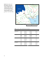
1
CONCEPTUAL DESIGN AND SAMPLING
PROCEDURES OF THE BIOLOGICAL
PROGRAMME OF NUUKBASIC
NERI Technical Report no. 745
AU
2009
NATIONAL ENVIRONMENTAL RESEARCH INSTITUTE
AARHUS UNIVERSITY
[Blank page]
CONCEPTUAL DESIGN AND SAMPLING
PROCEDURES OF THE BIOLOGICAL
PROGRAMME OF NUUKBASIC
NERI Technical Report no. 745
2009
Peter Aastrup1
Josephine Nymand2
Katrine Raundrup2
Torben L. Lauridsen1
Paul Henning Krogh1
Niels Martin Schmidt1
Lotte Illeris3
Helge Ro-Poulsen3
1National Environmental Research Institute, Aarhus University
2Greenland Institute of Natural Resources
3University of Copenhagen, Department of biology
AU
NATIONAL ENVIRONMENTAL RESEARCH INSTITUTE
AARHUS UNIVERSITY
Data sheet
Series title and no.:
Title:
Authors:
Institutions:
Publisher:
URL:
Year of publication:
Editing completed:
Referees:
NERI Technical Report No. 745
Conceptual design and sampling procedures of the biological programme of NuukBasic
Peter Aastrup1, Josephine Nymand2, Katrine Raundrup2, Torben L. Lauridsen1, Paul Henning
Krogh1, Niels Martin Schmidt1, Lotte Illeris3 & Helge Ro-Poulsen3
1
National Environmental Research Institute, Aarhus University 2Greenland Institute of Natural
Resources, 3University of Copenhagen, Department of biology – Terrestrial Ecology
National Environmental Research Institute ©
Aarhus University - Denmark
http://www.neri.dk
December 2009
December 2009
Lars Holst Hansen and Jannik Hansen
Financial support:
The present project has been funded by the Danish Energy Agency as part of the climate support programme to the Arctic. The authors are solely responsible for all results and conclusions
presented in the report, and do not necessary reflect the position of the Danish Energy Agency.
Please cite as:
Aastrup, P., Nymand, J., Raundrup, K., Lauridsen, T.L., Krogh, P.H., Schmidt, N.M., Illeris, L. &
Ro-Poulsen, H. 2009: NuukBasic. Conceptual design and sampling procedures of the biological
programme of NuukBasic. National Environmental Research Institute, Aarhus University. 70 pp.
NERI Technical Report No. 745. http://www.dmu.dk/Pub/FR745.pdf
Reproduction permitted provided the source is explicitly acknowledged
Abstract:
This manual describes procedures for biologic climate effect monitoring in Kobbefjord, Nuuk.
The monitoring is a part of NuukBasic which is a cross-disciplinary ecological monitoring programme in low Arctic West Greenland. Biological monitoring comprises the NERO line which is
a permanent vegetation transect, and monitoring reproductive phenology of Salix glauca, Loiseleuria procumbens, Eriophorum angustifolium, and Silene acaulis. The progression in vegetation greenness is followed along the vegetation transect and in the plant phenology plots by
measurement of Normalized Difference Vegetation Index (NDVI). The flux of CO2 is measured
in natural conditions as well as in manipulations simulating increased temperature, increased
cloud cover, shorter growing season, and longer growing season. The effect of increased UV-B
radiation on plant stress is studied by measuring chlorophyll fluorescence in three series of
plots. Arthropods are sampled by means of yellow pitfall traps. Microarthropods are sampled in
soil cores and extracted in an extractor by gradually heating up soil. The rate of decomposition
is measured in three habitats. The avifauna is monitored with special emphasis on passerine
birds. Only few terrestrial mammals occur in the study area. All observations of mammals will be
recorded ad-hoc. Monitoring in lakes include ice cover, water chemistry, physical conditions,
species composition of plankton, vegetation, bottom organisms and fish. Physical-chemical parameters, phytoplankton and zooplankton are monitored monthly in the period when the lakes
are ice-free.
Keywords:
Monitoring, arctic, phenology, carbon flux, NDVI, UV-B, arthropods, microarthropods, decomposition, lake ecology.
Layout:
Cover photo:
NERI Graphics Group, Silkeborg
Peter Aastrup
ISBN:
ISSN (electronic):
978-87-7073-132-4
1600-0048
Number of pages:
70
Internet version:
The report is available in electronic format (pdf) at NERI's website
http://www.dmu.dk/Pub/FR745.pdf
Contents
Executive summary 5
Resume 9
1
Introduction 10
2
Detailed manual 12
2.1
2.2
2.3
2.4
2.5
2.6
2.7
Plants 12
Arthropods 35
Microarthropods and decomposition 39
Birds 44
Mammals 46
Lakes 47
Disturbance 54
3
Storage of data 55
4
References 56
5
Suggested Handbooks 57
Appendix 58
Appendix 1. 58
Appendix 2A. 59
Appendix 2B. 60
Appendix 2C. 61
Appendix 2D. 62
Appendix 3A. 63
Appendix 3B. 64
Appendix 3C. 65
Appendix 4. 66
Appendix 5A. 67
Appendix 5B. 68
Appendix 6A. 69
Appendix 6B. 70
National Environmental Research Institute
NERI technical reports
[Blank page]
Executive summary
Below is given a short overview of all monitoring elements. The following sections give detailed descriptions of each element.
Plants
Table 1 gives an overview of the monitoring of plants.
Table 1. Overview of monitoring elements
Monitoring Species
element
Number
of plots
Sampling
object
Sampling
period
Buds, flowers, and seeds
May - October
Loiseleuria procumbens
Buds, flowers, and seeds
May - October
Silene acaulis
Buds, flowers, and seeds
Every 5th year
NERO-line Plant communities and species
Phenology Salix glauca
Vegetation analysis - pin point
analysis - to be done
Sampling
frequency
4
4 per plot
Total count Salix glauca
of flowering Loiseleuria procumbens
shoots
Silene acaulis
Weekly
Every 5th year
Plot - four sections
per plot
-
Once per season
at peak flowering
Flowers
Depending on
phenology
Eriophorum angustifolium
NDVI
Along vegetation transect
In phenology plots
CO2 - Flux Control, C
Increased temperature, T
Monthly
May - October
20
Weekly
May - October
6 plots per
treatment
Weekly
Plot
May - October
5
3
Plots
Weekly,
week 29-31
4 plots - 8 sections
Weekly
Specimens
May - October
3 plots
3 times per
season
Specimens
June - September
13 census points
Weekly
May - October
5 times per
season
June - October
(ice free period)
Shading, S Hessian tents
Long growing season, removal
of snow, LG
Short growing season SG,
addition of snow during spring
UVB
Control
Mylar film (0,25 mm)
Filter control (Teflon)
Arthropods All Taxonomic groups
MicroCollembolan species
Arthropods Orbatid and actinedid mites
and others
Birds
Passerines etc.
Ad hoc (Passerines)
Mammals
Ad hoc
Lakes
Water chemistry, Chlorophyll a,
phytoplankton, zooplankton
Nests
Two lakes
Flora
Every year
Fauna
Every 5th year
Arctic char, Stickleback
Isotopes
5
The NERO-line
The NERO line is a permanent vegetation transect which was established
in July 2007 in order to monitor future changes in the distribution and
composition of vascular plant species in the plant communities. Surveys
of the transect will take place with 5 year intervals. It is intended to include mosses and lichens in the monitoring programme in the following
years.
The concept relies on the assumption that changes in the distribution of
plant communities can be seen by changes of boundary lines between
vegetation zones. Therefore each boundary between vegetation zones
has been marked by pegs. The species composition of the vegetation
zones has been documented by Raunkjær analyses. Immigration of new
species is assumed to be documented by the surveys with five year intervals. The concept is also used for the ZERO-line in Zackenberg in high
arctic North East Greenland (Fredskild & Mogensen 1996, Bay 2001,
2006).
Movement of zones is documented by the position of pegs, while
changes in species composition are recorded by Raunkjær–analyses.
Reproductive phenology
It is expected that plant phenology will give an early and distinct response to climate change. This has already convincingly been shown in
Zackenberg. In Nuuk we follow four species: Salix glauca, Loiseleuria procumbens, Eriophorum angustifolium (only total flowering) and Silene acaulis. These species were chosen because they are widely distributed in the
area and they cover a spectrum of different growth forms (deciduous
dwarf shrub, evergreen dwarf shrub, graminoids and cushion forming
herb), and they are comparable to species monitored in Zackenberg.
For each species four observation plots were established. The specific
sites of the plots were chosen in order to cover the ecological amplitude
of the species with respect to duration of snow cover, difference in soil
moisture at the site and altitude. The size of each plot varies depending
on the abundance of individual flowering shoots of the species in question.
Total flowering
Total flowering in the reproductive phenology plots is followed for Salix
glauca, Loiseleuria procumbens, Eriophorum angustifolium, and Silene acaulis.
The number of flowers is counted at peak flowering as the total number
of buds, flowers/catkins and senescent flowers/catkins.
Normalized Difference Vegetation Index (NDVI)
The progression in vegetation greenness is followed along the vegetation
transect and in the plant phenology plots by measuring NDVI with a
scanner. NDVI is used as an index of plant production and vigorousness.
The scanner measures the spectral reflectance of the plant canopy.
6
CO2 flux plots
The CO2 flux is important for understanding the balance between CO2
emission and uptake. This study aims at documenting the present state,
but it will also provide data from manipulations simulating increased
temperature, increased cloud cover, shorter growing season, and longer
growing season.
UV-B exclusion
UV-B radiation will increase as a result of the expected depletion of the
ozone layer in the atmosphere. We monitor the effect of increased UV-B
radiation on plant stress is monitored indirectly by measuring chlorophyll fluorescence in three series of plots: Controls, plots with a filter excluding UV-B, and filter controls with film without exclusion of UV-B.
Measurements of chlorophyll fluorescence are carried out on Betula nana
and Vaccinium uliginosum in a mesic dwarf shrub heath dominated by
Empetrum nigrum and with Betula nana and Vaccinium uliginosum as subdominant species.
Arthropods
Arthropods are sampled by means of yellow pitfall traps. The traps are
emptied weekly throughout the summer season (early June – late September). At the time being, samples are stored at Greenland Institute of
Natural Resources (GINR) awaiting final decision of the future of the
programme. Presently there is no financing for determination of the
sampled specimens.
Microarthropods and decomposition
Microarthropods are sampled in soil cores from which the organisms are
extracted in an extractor by gradually heating up. Microorganisms are
determined at NERI, Dpt. of Terrestrial Ecology.
The rate of decomposition of filter paper is measured in the microarthropods plots.
Birds
The avifauna is monitored with special emphasis on small passerine
birds representing the highest trophic level. Breeding phenology (first
egg dates, hatching, fledging) is monitored throughout the season on an
ad hoc basis.
Weekly counts of birds are carried out at census points during the entire
season from May untill all the birds have left the area in AugustSeptember. Other bird observations are recorded ad-hoc during the entire field season.
7
Mammals
Only few terrestrial mammals occur in the study area: Arctic fox Alopex
lagopus, arctic hare Lepus arcticus, and caribou Rangifer tarandus. The first
year’s observations, however, indicate that mammals are not observed
very often. In 2007 only arctic fox was actually observed, and there were
no new signs like footprints or droppings of caribou. In 2008 two caribou
were observed at one occasion and fresh foot prints were also observed
during the season. All observations of mammals will be recorded ad-hoc.
If arctic fox dens are discovered, reproduction will be followed.
Lakes
The two sampling lakes are located in the Kobbefjord catchment area in
the bottom of Kobbefjord (Badesø 64º07’48’’N, 51º21’23’’ W and Qassi Sø,
64º09’11’’N, 51º18’18’’ W).
Monitoring include ice cover, water chemistry, physical conditions, species composition of plankton, vegetation, bottom organisms and fish.
Physical-chemical parameters, phytoplankton and zooplankton are
monitored monthly in the period when the lakes are ice-free.
8
Resume
Nuuk Basic programmet blev startet i 2007 af Danmarks Miljøundersøgelser ved Aarhus Universitet i samarbejde med Grønlands Naturinstitut, Københavns Universitet og Asiaq (Grønlands forundersøgelser).
Programmet finansieres af Energistyrelsen og Miljøstyrelsen som en del
af Miljøstøtten til Arktis (DANCEA-programmet). Nuuk Basic dokumenterer og undersøger effekter af klimaændringer på marine og terrestriske
økosystemer og består at 4 delprogrammer: MarinBasis som varetager,
det marine miljø, BioBasis som indsamler biotiske parametre, samt Geobasis og KlimaBasis, som indsamler abiotiske parametre.
Denne manual beskriver de metoder og indsamlingsprocedurer, der anvendes i Biobasis. Manualen vil løbende blive opdateret på www.nuukbasic.dk . Moniteringen i Biobasis omfatter bl. a. udvalgte planters reproduktive fænologi, vegetationens grønhed (NDVI), CO2 flux, arthropoder, mikroarthropoder, nedbrydning af organisk materiale, fugle samt
sø-økologi.
9
1
Introduction
The programme is run by the National Environmental Research Institute,
Aarhus University, in cooperation with the Greenland Institute of Natural Resources, University of Copenhagen, and Asiaq (Greenland Survey).
BioBasis is funded by the Danish Energy Agency and the Danish Environmental Protection Agency as part of the environmental support programme DANCEA – Danish Cooperation for Environment in the Arctic.
The present manual describes methods and sampling procedures. The
manual will be updated regularly. The latest version can always be
found here: www.nuuk-basic.dk.
Nuuk Basic is a climate change effects monitoring programme close to
Nuuk in west Greenland. The programme studies the effects of climate
variability and change on marine and terrestrial ecosystems. In terms of
scientific concept, Nuuk Basic copies the investigations carried out in
Zackenberg Basic, at Zackenberg Research Station in Northeast
Greenland (www.zackenberg.dk).
51°36'W
51°30'W
51°24'W
51°18'W
51°12'W
Ko
bb
efj
Nuuk
Qassi dal
Lille-Qassi
or
d
64°10'N
64°10'N
64°12'N
64°12'N
51°42'W
Qassi Sø
64°8'N
64°8'N
Qassi
Badesø Lan
gsø
Storfjeld
Inderdal
64°6'N
64°6'N
Yderdal
64°4'N
64°4'N
Ameralik
51°42'W
51°36'W
51°30'W
51°24'W
0
Figure 1. The study area.
10
51°18'W
51°12'W
10 Km
The study area is situated app. 20 km east of Nuuk as seen on figure 1
and 2. The local climate is low arctic with a mean annual temperature of
-1.4 °C and a mean annual precipitation of 752 mm (1961-90). The drainage basin is situated in an alpine landscape with mountains rising up to
1400 meter above sea level and with glacier coverage of approximately 2
km2. Geologically, the area is homogenous with Precambrium gneisses
as basement throughout the drainage basin.
Figure 2. Close-up of the BioBasis study area
51°18'W
64°10'N
64°10'N
51°24'W
Lille-Qassi
Qassi dal
bb
efj
Sø
Ko
or
Q
as
si
d
esø
Bad
64°8'N
64°8'N
Qassi
Lan
gsø
Inderdal
d
Storfjeld
64°6'N
64°6'N
Yderdal
51°24'W
51°18'W
0
2 Km
11
2
Detailed manual
Appendix 1 gives an overview of the activities during the monitoring
season in Kobbefjord. In the following procedures are described in detail
for all monitoring elements.
2.1
Plants
2.1.1 The NERO line
The NERO line was established in 2007. It is described in detail in Bay et
al. (2008 - http://www2.dmu.dk/Pub/FR693.pdf ). Next survey of the
line is expected in 2012. The location of the line is shown in figure 3. See
also Bay et al. 2008).
Figure 3. The NERO line. The
dots show the positions of the
pegs and the colour indicate the
vegetation zone northeast of the
peg. Numbering of the pegs
starts in the south-western corner. The break in the long black
line to the north-east marks a
steep slope that was not analysed by Raunkjær analyses. The
short line represents the coastal
zone. The black square shows
the position of the characteristic,
but rare plant community dominated by Deschampsia flexuosa
and Juncus trifidus, which is
found on south facing, dry slopes.
The map is based on GPSpositions (accuracy 5-10 m).
Bedrock
Bedrock/heath
Copse
Fen
Heath
Lake
River
River bed
Salt marsh
Snow-patch
Kobbefjord
Deschampsia-Juncus transect
Main vegetation transect
64°8'N
64°8'N
Salt marsh transect
Badesø
0
12
0.5 Km
Input of data into database
Data from the Raunkiær circle analyses are entered into an Access data
base with the columns Peg no., Plot no., Year, Month, Day, Observer,
Vegetation type, species name, Raunkiær value, Uncertain species identifications have cfr. (=confer) added to indicate the need for further confirmation. Fertility is given by Flowering added next to the Raunkiær
value.
Digital pictures are kept at the Greenland Institute of Natural Resources
back up server.
2.1.2 Reproductive phenology
The monitoring consists of weekly counts of buds, flowers, and senescent flowers to monitor the proportion of buds, flowers and senescent
flowers of the species: Salix glauca, Loiseleuria procumbens, and Silene acaulis.
Species to be monitored
Three species: Northern willow Salix glauca (Blågrå pil), Trailing azalea
Loiseleuria procumbens (Kryblyng), and Moss campion Silene acaulis (Tuelimurt):
• Are commonly found in the area.
• Cover a spectrum of different growth forms (deciduous dwarf shrub,
evergreen dwarf shrub, and cushion forming herb/dwarf shrub.
• Are comparable to species monitored by BioBasis in Zackenberg.
There are four plots for each species. The size of each plot varies (see table 2) depending on the abundance of individual flowering shoots of the
species in question.
Frequency of sampling
Censuses of Salix glauca, Loiseleuria procumbens, and Silene acaulis are
made at weekly intervals from May 1 to September 30 depending on the
snow cover. Total counts of flowers are done once a year at peak flowering.
Equipment
• Map with position of study plots (+GPS)
• Data forms (Appendix 2A-C)/ Notebook.
Location and marking of study plots
The positions of the 12 study plots are shown in Figure 4. The plots are
marked with angle iron pegs in each corner. The plots are divided into
four sections (quarters A, B, C, and D separated by pegs at the centre
where the diagonals cross and at the midpoint of each side – see Figure
5). The lettering starts at the corner with the plot-ID and continues
clockwise around the centre. Co-ordinates, dimensions etc. appear from
table 2.
13
Figure 4. The locations of the
plant reproductive phenology
plots and plots for annual total
counts of flowering shoots for
Salix glauca (SAL1-SAL4), Silene
acaulis (SIL1-SIL4), and Loiseleuria procumbens (LOI1-LOI4).
Note that for Eriophorum angustifolium (ERI1-ERI4) only total
counts of shoots are carried out.
Coordinates can be found in table
2.
Kobbefjord
SAL4
SIL3
SIL2
SIL4
ERI1
ERI3
SIL1
SAL1
LOI1
SAL2
ERI2
LOI4
64°8'N
64°8'N
SAL3
ERI4
LOI3
LOI2
Badesø
0
850 m
Table 2. Positions of plant reproductive phenology plots.
Species
Plot
Latitude
Longitude
Eriophorum
angustifolium
ERI1
64,1346
-51,3837
4*10
ERI2
64,1312
-51,3873
10*10
ERI3
64,1348
-51,3789
12*17
ERI4
64,1333
-51,3666
5*9
SAL1
64,1325
-51,3729
7*11
SAL2
64,1316
-51,3714
8*8
SAL3
64,1337
-51,3678
6*9
SAL4
64,1374
-51,3741
4*5
SIL4
64,1361
-51,3681
5*12
SIL1
64,1328
-51,3745
5,5*7
SIL2
64,1364
-51,3703
11*11
SIL3
6,4137
-51,3736
7*11
LOI1
64,1323
-51,3759
1,8*3,85
LOI2
64,1316
-51,3705
1,7*2,95
LOI3
64,1324
-51,3708
1,6*2,6
LOI4
64,1328
-51,3702
1,6*3,0
Salix glauca
Silene acaulis
Loiseleuria
procumbens
14
Plot dimensions (m)
Figure 5. Lettering of subplots in
plant phenology plots. The dot
indicates the corner with the plot
ID. Arrows indicate clock-wise
round direction for NDVImeasurements.
B
C
A
D
Sampling method
The following observations and censuses are entered into the relevant
data forms for all plots:
•
•
•
•
•
•
•
•
•
•
Time
Cloud cover
Plot number
Snow cover
Number of buds
Number of flowers/catkins – note that for Salix both male and female
plants can be found in the plots
Number of senescent female flowers/catkins with hairs (Salix)
Number of senescent flowers (Loiseleuria and Silene)
Total number of flowers (Salix, Eriophorum, Silene and Loiseleuria)
Occurrence of larvae, fungi etc.
Data forms are found in Appendix 2A-C. The data from the weekly
counts of the plots are entered into data files with columns relevant for
each species. The basic data are: Year, Month, Day, Observer, Plot (e.g.
Sal1), Section (sector A, B, C, and D), Snow (percent in sector), Buds (actual numbers counted, not percent), Flowers, Senescent (flowers), Total
(sum of buds, flowers and senescent flowers), and Remarks. Specific columns for individual species appear from the database files.
During snow melt in May/June, percent snow cover in each plot section
is estimated at each sampling trip. If any plant part is visible above the
snow layer, the cover is given as 99%. If any ground/vegetation cover is
free, no more than 98% can be stated.
When visiting Silene-plots, samples of a total of at least 50 flower buds,
flowers or senescent flowers (or capsules with exposed seeds) are recorded within each plot section. In the Salix and Loiseleuria plots a total of
100 buds, flowers and senescent flowers are recorded. This is done by
15
counting the different phenological stages within appropriate group
sizes of individuals concomitantly until a total of 50/100 is achieved. Begin to the right in each section and count towards the left. Avoid biasing
the count by actively selecting a starting point other than the right corner.
In general, flower buds are defined as flowers not yet open, flowers are
open giving insects access to the reproductive organs, and senescent
flowers as flowers that have lost all petals or with all petals almost or
fully faded or brown. In some of the final stages, flower stems from the
preceding year may interfere with the counts. However, such old stems
are always dry and stiff; stems of this year are soft and fleshy.
For each species, the following sampling procedures apply in particular:
Salix:
The sampling unit is catkins, not individual flowers. Most flowers from
one catkin emerge the same day, and they also wilt at the same time.
Hence, catkins are recorded as buds (Figure 6), when no stigmas or anthers are visible, and as male (Figure 7) and female (Figure 8) flowers as
soon as stigmas (f) or anthers (m) are visible (they are often both red in
the early stages, but the colour may vary).
Both senescent flowers and fruits are continued to be recorded as 'flowers' until they are recorded as having exposed seed hairs (Figure 9) from
the time of exposure of the first hairs on top of the splitting capsules. Notice that fruits may be affected by larvae so that they expose seed hairs
from the bottom of the capsules (excreta from the larvae are often visible
among the seed hairs). These capsules must not be recorded as having
seed hairs exposed, but should be recorded separately. In Kobbefjord
there is no experience as to this issue yet.
Figure 6. Salix glauca buds. It is
not possible to discriminate between male and female flowers at
this stage.
16
Figure 7. Salix glauca male
flowers.
Figure 8. Salix glauca female
flowers.
17
Figure 9. Senescent Salix glauca
female flowers with hairs.
Fruits infected by sponges (yellow and twisted) should be recorded
separately (yet still included in the number for 'flowers', i.e. the infected
fruits appear twice in the data forms). Also, infections by insects should
be recorded.
Silene:
Silene acaulis grows in hummocks (Figure 10) and one or a few specimens
may dominate the sample. Therefore, several individuals must be sampled each week.
Flower buds are reddish or light purple (Figure 11). Senescent flowers
(Figure 12) have wilted petals or appear as empty “cups” (Figure 12). Senescent flowers are defined as flowers with faded petals and empty pollen anthers.
18
Figure 10. Silene acaulis hummock.
Figure 11. Silene acaulis – flowers in the foreground and buds
scattered in the hummock. The
buds in the background should
be recorded as buds even though
they are close to opening as
flowers.
19
Figure 12. Silene acaulis – senescent flowers – in the middle
still with wilted petals.
Loiseleuria:
Loiseleuria procumbens is a matted shrub with pairs of tiny, oblong,
closely-set leaves and abundant clusters of small flowers, see Figure 13.
In Greenland plants are not taller than 10 cm. The plant is creeping,
much-branched, mat-forming, with 2-5 pink, bell-shaped flowers in terminal clusters and evergreen leaves with rolled edges.
Figure 13. Loiseleuria procumbens. Half open flowers, opening
buds, closed buds and senescent
flowers from last year.
Input of data into database
The data from the weekly registrations are entered into Excel data sheets
with columns relevant for each of the three species. The basic data are:
Year, Month, Day, Observer, Plot, Sample, Snow cover, Buds, Flowers,
20
Senescent flowers, Total, and Remarks. Specific columns for individual
species appear from the data base.
2.1.3 Total flowering
Species to be monitored
Northern willow Salix glauca (Blågrå pil), Trailing azalea Loiseleuria procumbens (Kryblyng), Moss campion Silene acaulis (Tue-limurt), and Cotton grass Eriopherum angustifolium (Smalbladet kæruld). See previous
section for descriptions of Salix glauca, Loiseleuria procumbens, and Silene
acaulis. E. angustifolium is described below.
Eriophorum angustifolium
The flowers are monoecious (individual flowers are either male or female, but both sexes can be found on the same plant) and are pollinated
by wind. There are two or more flowers on each stem. There are two or
more fruiting heads per plant, which distinguishes it from the other
common species, Arctic cotton grass. Figure 14-16 shows different stages
of Eriophorum flower development.
Figure 14. Eriophorum angustifolium. Buds and young flowers.
21
Figure 15. Eriophorum angustifolium.
Frequency of sampling
Once per season. Total counts of S. glauca, L. procumbens, and S. acaulis
are made at peak flowering. The optimal time for total counts of E. angustifolium is when most or all flower buds have reached senescence.
Equipment
•
•
•
•
•
22
Map with position of study plots
Pieces of cord totalling 100 m
Flower sticks
Tally counters
Data forms Appendix 2A-D/ Notebook
Figure 16. Eriophorum angustifolium. Senescent flowers.
Location and marking of sampling plots
The plots are divided into four sections (quarters A, B, C, and D separated by steel pegs at the centre where the diagonals cross and at the
midpoint of each side). The lettering starts at the corner with the plot-ID
and continues clockwise around the centre. Co-ordinates, dimensions
etc. appear from table 4.1. The plots are identical with the plant reproductive phenology plots shown in figure 4.
Sampling method
Tighten a cord around each section of the plot. In large plots, subsections
are established by placing two additional cords with about 0.5 or 1 m intervals from one end of each section, whereupon the lumped number of
flower buds, flowers and senescent flowers are counted between each
cord. Move one cord at a time and repeat the process until the entire plot
is covered. In small plots, sticks may be used instead of cords. In the
Salix plots, male and female catkins are counted separately. Catkins that
have been grazed, but can still be sexed, are included.
23
Input of data into database
The data from the yearly registrations are entered into Excel data sheets
with columns relevant for each of the three species. The basic data are:
Year, Month, Day, Observer, Plot, Sample, Snow cover, Total, and Remarks. Specific columns for individual species appear from the data
base.
2.1.4 Normalised Difference Vegetation Index (NDVI) in plots and
along the NERO line
The progression in the vegetation greenness is followed along the vegetation transect and in the plant phenology plots. The monitor measures
the spectral reflectance of the plant canopy.
Species or taxonomic groups to be monitored
All vegetation types along the NERO line between VT001 and VT076.
All plants in the reproductive plant phenology plots.
Frequency of sampling
Along the NERO line: Monthly.
Plant phenology plots: Weekly in connection with the plant phenology
censuses.
Equipment
• Map of vegetation transect and plant phenology plot positions
• GPS with positions of vegetation transect and phenology plot positions
• Crop Circle Handheld system. A handheld Crop Circle TM ACS-21 0
Plant Canopy Reflectance Sensor which calculates the greening index
(NDVI). http://www.hollandscientific.com/CC_Handheld.html
• Notebook
• Digital camera.
Location and marking of sampling plots
The NERO-line crosses all the dominating vegetation types found in the
study area. The NERO line is described in detail in Bay et al. 2008. The
measurement is carried out 5 m north-east of the vegetation transect.
Surveying rods mark the transect to be scanned. Figure 17 gives an impression of the vegetation greenness in July 2008.
Plant phenology plots : See Table 3 and Figure 4.
24
51°24'W
Figure 17. The NERO-line–
vegetation greenness. Results of
NDVI-scans July 8, 2008. The
darker coloured the greener the
vegetation.
Ko
bb
ef
jo
64°8'N
64°8'N
rd
51°24'W
0
0.5 km
Table 3. Sequence of phenology plots and NDVI.
ERI1
(Eriophorum 1)
EMP1
(Empetrum 1)
ERI2
(Eriophorum 2)
EMP2
(Empetrum 2)
ERI3
(Eriophorum 3)
EMP3
(Empetrum 3)
LOI1
(Loiseleuria 1)
SIL1
(Silene 1)
SAL1
(Salix 1)
SAL2
(Salix 2)
LOI2
(Loiseleuria 2)
LOI3
(Loiseleuria 3)
LOI4
(Loiseleuria 4)
ERI4
(Eriophorum 4)
EMP4
(Empetrum 4)
SAL3
(Salix 3)
SIL4
(Silene 4)
SIL2
(Silene 2)
SIL3
(Silene 3)
SAL4
(Salix 4)
Sampling method
NDVI is measured by The Crop Circle Handheld System which integrates a Crop Circle ACS-210, GeoSCOUT GLS-400 and a FieldPAK PS12 into a single instrument (See Figure 18). Data is collected and stored
on a SD flash disk.
25
Figure 18. Equipment for measuring NDVI. The Crop Circle
Handheld System. Source:
http://www.hollandscientific.com/
CC_Handheld.html.
Please proceed as follows:
1.
2.
3.
4.
5.
Insert an empty SD flash card into the card slot
Turn on the CropCircle system by pressing the ON/OFF button
Press the DISP button to select MAP mode. Then press OK
When ready press LOG and the CropCircle starts to measure NDVI
Use the trigger switch also connected to the CropCircle between each
subplot (A, B, C, and D)
6. Turn the CropCircle OFF after each plot in order for the data to be
saved on the SD flash card
Scans are conducted by moving the sensor steadily forward (ca. 1 meter
per second) approximately 75 cm above the vegetation. This results in a
measuring footprint of approximately 10 x 45 cm. Refer to the CropCircle
manual for more information.
The sampling order shown in Table 3 must be applied. Also, always
measure all plots in the order A-D (see Figure 5). At each visit, note under Remarks the presence of snow (snow in subplot; snow at plot edge)
and if the vegetation is wet.
All measurements are conducted only on the AB and the CD sides of the
plots (Figure 5). Place yourself at the plot number plate, just outside the
plot. Hold the sensor app. 50 cm into the subsection at the subsection
edge. Switch on the NDVI logger (switch on the left of the stage), and
walk slowly (approximately 1m per second) along the sides indicated by
arrows on figure 5. Use the trigger switch to pause the NDVI logger at
26
the next corner of the subsection. Repeat the procedure in the remaining
subsections. Hence, four scans are made in each of the vegetation plots.
Turn off the Crop Circle system between plots by pressing the ON/OFF
button.
When measuring the NERO line always start at the top of the slope and
walk towards the river.
Ideally all transects should be measured on the same day. If the vegetation is wet, the measurements must be postponed to the following day.
Input of data into database
Data are downloaded from the SD card from the CropCircle using a card
reader. Crop Circle automatically names the files (e.g. ddmmyyAA.CSV;
ddmmyyAB.CSV; etc.) Each file holds the following variables: Longitude, Latitude, Elevation, Fix Type, UTM Time, Speed, Course, SF1, SF2,
SF3, SF4, SF5, and SF6. All Crop Circle data files are saved separately. In
Excel, each data file is supplemented with the following columns: Year,
Month, Day, DOY, Observer, Plot, Section, and Remarks. All files are
merged into one sheet in one file. Please notice that if your computer is
set with a Danish Office-version the ddmmyyAA-file is the last file in the
file list since the AA is regarded as Å (but it is still the first one recorded).
Digital pictures are stored at the Greenland Institute of Natural Resources back up server (F:\40-59 PaFu\41 Vegetation\08 NuukBasic_BioBasis).
2.1.5 CO2 flux plots
The ratio between the uptake of CO2 from photosynthesis, and release
from decomposition of organic matter in the soil, and respiration is
measured. The ratio is called Net Ecosystem Exchange (NEE).
Species or taxonomic groups to be monitored
The vegetation in the ITEX plots which is dominated by Empetrum heath
with Salix as subdominant species. The reproductive phenology of Salix
is followed in all plots. Soil moisture is measured in all plots. Temperature is recorded by TinyTags.
Frequency of sampling
Carbon fluxes are measured weekly. All plots should be measured between 10 AM and 3 PM, and on the same day.
Equipment
•
•
•
•
•
•
•
•
•
ITEX-chambers incl. bolts and guy ropes
TinyTag temperature data loggers and sensors
EGM4 – see Figure 21
Plexiglass measuring chamber (PMC) – measuring 33x33x34 cm
(LxWxH).
Theta-probe for soil moisture measurements
Black plastic bag adjusted for the PMC
Sticky Tack
External 12V battery
Ruler
27
• Digital watch
• Digital camera
• Data forms (Appendix 3A-C)/ Notebook.
Location and marking of sampling plots
30 plots are situated in a mesic dwarf shrub heath dominated by Empetrum nigrum and with Salix glauca as subdominant species. The heath is
facing west.
Figure 19 gives an overview of the site and Figure 20 shows the relative
positions of the plots.
Figure 19. Overview of CO2 flux
plot site with Hessian tents for
shading and ITEX hexagons for
increasing temperature.
Figure 20. Detailed map showing
the position of the CO2 chamber
plots. The position of the midpoint
is 64,137˚N/51,38˚W. For explanation of the abbreviations please
see text.
1S
2LG
1LG
1SG
2SG
1T
2S
2T
2C
3T
1C
3S
3C
3LG
3SG
No
rth
5LG
5C
4LG
5SG
4SG
5T
4S
4T
5S
4C
6C
6T
6LG
28
6SG
6S
The setup consists of 5 treatments each replicated 6 times: Control (C),
increased temperature (T, ITEX hexagons), shading (S, hessian tents),
long growing season (LG, removal of snow during spring) and short
growing season (SG, addition of snow during spring).
Temperature is enhanced at T plots by placing hexagonal open top ITEX
chambers (OTCs), see Figure 22. This way temperature is expected to increase 1-2 ºC during the growing season (for further information, see
Molau & Mølgaard, 1996). The shading treatment (S) imply erecting
dome shaped sack cloth tents over the soil and vegetation causing an expected 60% reduction of incoming light (See Havström et al., 1993).
Short and long growing season will be implemented by respectively adding to and removing snow from SG and LG plots during snow melt at
the spring causing plants and soils to be exposed earlier (LG) or later
(SG) than in control plots.
In each of the 30 plots a metal frame of 35x35 cm has been inserted permanently into the soil. The frame is used for weekly measurements of
ingoing and outgoing fluxes of CO2 to the system by the closed chamber
technique. The metal frames were placed at spots were E. nigrum and S.
glauca dominated the vegetation. The metal frame is not to be removed
by the end of the season.
Sampling method
The CO2 flux plots are established as soon as possible early in the season
(make note of the date). By the beginning of the season, check that the
metal frames are level and adjust if needed. Do not adjust the metal
frames later or in connection with the gas flux measurements!
The six plexiglas sides of each ITEX hexagon is bolted together in the
field, and additionally secured with six guy ropes. Place a TinyTag temperature probe app. 2cm horizontally into the soil. Also place the TinyTag logger inside the plot. TinyTags are programmed to log the temperature every 30 minutes.
Before each measuring round, the EGM must be calibrated to the CO2
level in the air (the level varies between app. 365 and 380 ppm). Also, in
the lab replace the old Soda lime in the EGM with fresh Soda lime. See
the EGM manual for further details (PP Systems 2003).
Before beginning the gas flux measurements in a plot take a digital orthophoto covering the entire area inside the metal frame, take three soil
moisture measurements outside the metal frame but inside the plot using the ThetaProbe. See the ThetaProbe manual for further details, and
measure the height (cm) of the upper edge above the ground of the metal
frame on the four sides of the frame. Measurements of the chamber
height is only done three times during the season (beginning, mid and
end of season) in order to avoid unnecessary tear on the vegetation.
Measurement of carbon flux
1. While at the laboratory make sure the EGM4 is set to automatically
take a measurement every minute (Figure 21). This is done by turning on the EGM4, press 2SET and then the 5RECD button. To change
the recording from manual (M) into automatic (A) press 1REC. When
29
2.
3.
4.
5.
6.
7.
8.
9.
the recording type is changed into automatic the time interval (2INT)
changes from 0 to 1 (1 minute) by default. The time interval can
range from 1 to 720 minutes.
In the field (Figure 22) place the HTR-2 probe into the plexiglas
measuring chamber (PMC), connect the probe and the tubes from the
probe to the EGM4 (in = black tube) and back from the EGM4 to the
PMC (out = clear tube). Seal the entrance to the chamber with sticky
tack.
Turn on the EGM4 and press 1REC for record by pushing button 1.
The EGM4 will have to heat up to approximately 50°C (it takes approximately 5 minutes depending on the surrounding temperature).
Following the “heating-up” it automatically runs a calibration with
the CO2 in the air.
When the EGM4 runs the calibration (called “Counting Zero”) place
the PMC in the metal frame in the first plot to be measured. Make
sure the PMC handle does not cast a shadow on the HTR-2 probe
with the PAR measuring device. While measuring gas flux the EGM4
automatically measures the PAR (light intensity) and the temperature in the PMC.
When the first record is taken turn on the digital watch.
The EGM4 automatically takes a record every minute. Check the
digital watch and when 4 minutes have passed (equalling 5 measurements: t = 0, 1, 2, 3, 4) lift the PMC off the frame. Aerate the PMC
making sure the CO2 level returns to that prior to measuring. Monitor the CO2 concentration on the EGM4. Approximately 15 seconds
before the next measure (at 5 minutes) place the PMC on the frame
again and cover it completely with the black plastic bag. After yet
another 4 minutes lift the PMC and aerate it while walking to the
next plot to be measured.
Since the EGM4 automatically takes a record every minute you have
1 minute (or approximately 45 seconds) to aerate the PMC between
light and dark measurements or to walk between plots.
The external 12V battery is connected to the EGM4 after approximately 2½ hours depending on the surrounding temperature.
When all plots have been measured turn off the EGM4.
Measurement of soil moisture
Take three measurements in each plot by sticking the sensor into the soil,
read out the soil moisture, and enter data into the form Appendix 3A-B.
Reproductive phenology of Salix
Reproductive phenology of Salix glauca is followed in all plots according
to the procedure described in section 3.1. Data are entered into the form
Appendix 3C.
30
Figure 21. Upper figure shows
the EGM4 which is used for
measuring CO2 concentrations.
The lower Figure shows the top
of the instrument.
Figure 22. Measurement of CO2flux in an ITEX-hexagon open-top
chamber with a measuring
chamber (PMC) fitted with a
HTR-2 probe connected to the
EGM4. The black plastic bag is
used for dark (respiration) measurements.
Laboratory work
None.
Input of data into the database
Data are downloaded from the EGM4 using the EGM transfer software,
and the raw files are saved in a separate folder renamed to include the
31
date of the measurements (yymmdd.dat). In Excel, data are supplemented with the following columns: Year, Month, Day, DOY, Hour, Min,
Plot, Treatment, Light, Photo_no, Recno, Cloud cover, Observer, Soil
moisture, Chamber height, and Remarks. All files are merged into one
for one season.
Download digital pictures and rename them to include plot name and
date (e.g. ITEX_1C_090602). Save in a separate folder named Gas Flux.
Data from TinyTags brought back to the station by the end of the season
are downloaded. Rename the individual files to include plot name and
year (e.g. ITEX_5C_2008), and save in a separate folder named
EGM/Temperature.
2.1.6 UV-B exclusion
The impact of ambient UV-B radiation on the vegetation is studied in a
mesic dwarf shrub heath by placing filters approximately 10 cm above
the vegetation. At the time of peak plant growth the chlorophyll a fluorescence is measured as an indicator of plant health.
Species or taxonomic groups to be monitored
A mesic dwarf shrub heath (facing WSW) dominated by Empetrum nigrum and with Betula nana and Vaccinium uliginosum as subdominant
species. Betula nana and Vaccinium uliginosum are measured.
Frequency of sampling
Measurements of chlorophyll fluorescence of leaves of Betula nana and
Vaccinium uliginosum is carried out three times with one week interval at
the peak of plant growth (week 29 to 31).
Equipment
• HandyPea fluorimeter (PEA=Photosynthesis Efficiency Analyzer) –
See figure 23 and further description below.
• 80 leaf clips
• Notebook
• Digital camera
• Frames with UV-B filter (Mylar film, 0.25 mm - with exclusion of UVB)
• Frames of filter control (Teflon film - without exclusion of UV-B).
By the end of the field season, all equipment at UV plots are taken down
and brought back to GNIR.
The Handy PEA chlorophyll fluorimeter consists of a control unit. The
chlorophyll fluorescence signal received by the sensor head during recording is digitised within the Handy PEA control unit. Up to 1000 recordings of between 0.1 - 300 seconds may be saved in the memory of
Handy PEA chlorophyll fluorimeter. Saved data can be viewed onscreen
but shall be transferred to a computer for storage and further analysis.
32
Figure 23. Handy PEA with clips.
Source:
http://hansatech-instruments.com/handyPea.htm.
The sensor unit consists of an array of 3 ultra-bright red LED’s optically
filtered to a peak wavelength of 650 nm, which is readily absorbed by the
chloroplasts of the leaf. The LED's are focused via lenses onto the leaf
surface to provide even illumination over the area of leaf exposed by the
leaf clip (4mm diameter).
Location and marking of sampling plots
The UVB plots are situated west of the CO2 plots. Figure 24 and 25 gives
overviews of the plots.
Figure 24. Overview of UV-B
plots.
33
Figure 25. Schematic presentation of the location of UV-B plots.
No
rth
B1
C1
B3
F2
F1
B2
C2
C3
F3
B4
C4
F4
There are three series of plots with five replicates:
1. Control - no treatment: C1-C5
2. UV-B filter (Mylar film, with exclusion of UV-B) : B1-B5
3. Filter control (Teflon film, without exclusion of UV-B) : F1-F5.
Each treatment plot measures 60 cm x 60 cm; the plots are marked with
aluminium tubes at each corner and covered with a frame with the appropriate filter placed approximately 10 cm above the vegetation. During
summer the vegetation may grow as tall as the filter which may then be
lifted within the aluminium tubes.
Sampling method
Before establishing the UV plots, filters on frames are checked carefully,
and changed if necessary. There are two filter types, Teflon (filter control; the thinnest and most flexible film) and Mylar (excludes UVB;
thicker and less flexible). Frame positions are given by small sticks
within each plot. UV plots are checked regularly during the entire field
season, and repaired if necessary. Specifically, filters in the UV plots
must be checked after heavy rain or wind.
1. Select five green, “healthy-looking” leaves of Betula nana and Vaccinium uliginosum in each plot.
2. Mount leaf clips on all leaves – preferably without removing the leaf
from the branch. Mount on one species at a time. Make sure that the
leaf is visible through the hole in the clip and push the shutter to
cover the hole so the leaf material is in complete darkness.
3. Keep the shutters closed for at least 30 minutes. The closure time
may be longer.
4. Switch on the Handy PEA, Open “main menu” and turn the arrow
on the screen to “Measure”.
5. Fit the sensor head to the clip; uncover the hole by pushing the shutter back. Start measuring by pushing “OK” or push the black button
on the sensor head. During the measurement a number of parameters appear on the screen. Note that the “Fv/Fb” should be about 0.8.
If something goes wrong step three must be repeated before you
carry out a new measurement.
6. Accept to store the measurement. Note which measurement number
corresponds to each plot.
7. Repeat the sampling now measuring on Vaccinium uliginosum leaves.
8. Take a photo of each plot at each measurement round.
Input of data into database
When all measurements have been completed, data must be transferred
to a computer by use of the Handy PEA programme. Make sure that all
data have been transferred to the computer before clearing the memory
in the Handy PEA.
34
Data are downloaded from the HandyPEA using the PEA Plus software,
and the raw files are saved in a separate folder named to include the date
of the measurements (e.g. yymmdd.pcs). In Excel, data are supplemented with the following columns: Year, Month, Day, Observer, Species, Treatment, and File no.
2.2
Arthropods
Surface living arthropods are captured in yellow pitfall traps.
Species to be monitored
All taxonomic groups of arthropods.
Frequency of sampling
The traps are emptied weekly on fixed dates. If bad weather prohibits
visits to the fjord or proper handling of the samples, the traps may be
emptied on the earliest day of convenience.
Equipment
• For field work
• GPS
• 32 yellow (Pantone no. 108U) plastic cups, 10 cm in diameter and 8
cm deep. Cups have been placed permanently for the season. At the
beginning of the season it is checked if all cups are placed properly.
• 8 window traps
• A thermos
• A garden trowel with sharp edge
• 1 x 2 L container for water
• Detergent: Odour free detergent (Coop Änglemark Bluecare Dish
wash, concentrated, without perfume, colour and preservation agent).
• Salt (NaCl) without iodine and anti-caking agent
• 20 Metal pegs (to be used in the fen area)
• 1 lady’s stocking per emptying bout
• A pair of flat tweezers
• 32 plastic containers with lids
• 1,5L of 70% ethanol
• Small bottle with tip (for rinsing the stocking with alcohol)
• Waterproof speed marker
• Disposable syringes for removal of surplus water
• Ethanol resistant labels
• Pencil
• Ethanol resistant speed marker
• Data form Appendix 4/note book.
Location and marking of sampling plots
The position of the study plots are shown on Figure 26. Each plot measures 10 x 20 m and is made up of eight 5 x 5 m squares marked with
metal pegs in each corner. Each plot is identified with a number plate,
and sections (with one trap each) are lettered A-H clockwise from the
number plate, see figure 27.
35
Figure 26. Location of pitfall
traps in relation to vegetation
type. Art1: Empetrum nigrum
heath, Art2: Fen, Art3: Betula
nana/Salix glauca heath, Art4:
Abrasion.
51°24'W
Kobbefjord
Art4
64°8'N
64°8'N
Art1
Art2
Art3
Badesø
51°24'W
0
0.5 Km
Sampling method
A set of eight pitfall traps are established in each plot. Each trap is composed of two plastic cups fitting into each other, so that the upper one
can be lifted and emptied without disturbing the surrounding soil. The
traps are positioned randomly within each of the 5 x 5 m2 squares by using the table with random numbers; see the Microarthropod section. The
trap is then buried on the nearest reasonably level and ‘elevated’ site (so
that it is not flooded during the snow melt or heavy rain) and carefully
sunk into the soil, so that the upper rim levels exactly with the soil surface. Place the turf and the removed soil about a meter away from the
trap. Do not disperse it, since it must be repositioned after the season,
when the traps are removed.
The new traps are placed upside-down during the winter. At the start of
the season (i.e. on the round when the traps have appeared from the
snow), new clean (washed with a little Tween 20) upper cups replace the
‘wintering’ ones. Bring hot water in a thermos in case the two cups are
frozen solid.
If there is any risk that cups will float up due to water in the lower cup,
two metal pegs must be placed along each cup to keep them in position.
36
Figure 27. Schematic diagram
showing positions of Arthropod
plots.
D
E
C
F
B
G
A
H
The upper cup of the trap is then filled 2/3-3/4 with water (1 l needed
per station) added three drops of detergent and a spoonful of salt as killing agent, preservation and to prevent freezing.
Emptying the traps
Catches from each of the traps are kept separate. Before emptying a trap
place the ladies stocking on a spare cup. Then pour the trap liquid
through the stocking into the spare cup. Check the trap cup for remaining arthropods and flush with ethanol down into a 10 ml container
should any still remain in the trap. Reposition the trap cup in the soil.
The catch from the ladies stocking is now emptied into the 10 ml container by turning the stocking upside down on top of the container.
Rinse the inverted stocking with ethanol from the tip of the small bottle.
All remaining invertebrates must be removed carefully from the stocking
using tweezers and put into the container. Plot number and Section (AH) are written with an alcohol proof pen on the containers and Date, Plot
number and Section (A-H) are written on a small water-proof piece of
paper which is placed in the container.
37
After emptying all traps, extra water may be added to the traps to compensate for evaporation since last round (up to ½ l needed per station).
In the middle of each season, a little salt and detergent must be added to
compensate for loss during the season.
Bring an extra pair of cups on each round, together with equipment for
setting up traps, in case a trap has been destroyed, e.g. by a fox. Any
failures such as flooded or floating cups, fox faeces etc. must be recorded. This includes occurrence of fungi in the water. In that case a new
cup with fresh water (+salt and detergent) must be established.
Note the full hour of the day, when the traps in each plot are emptied.
At all visits at the arthropod stations during snow melt, the snow cover
(%) is estimated for each section of the plot.
Never touch the traps with mosquito repellent or suntan oil on your fingers!
Ending the season
At the termination of the catching season the trap liquid must be collected from all the traps and poured into the river. All the ‘old’ traps are
gathered, and the turfs put back into the hollows. New traps are established at all stations. Arthropod samples are kept at GINR.
Figure 28. Location of plots for
microarthropod sampling and
litterbags.
Vegetation type
Empetrum
Loiseleuria
Salix
Silene
Kobbefjord
MART6
MART5
MART1
64°8'N
64°8'N
MART4
MART7
MART8
MART2
MART3
Badesø
0
Laboratory work
None.
38
0.2 km
Input of data into database
After the weekly emptying of the pitfall traps, the following data are entered into a Excel data sheet named Art1-4: Year, Month, Day, DOY,
Hour, Plot, Fieldworker, Sorting, Snow A (% in the section), Snow B,
Snow C, Snow D, Snow E, Snow F, Snow G, Snow H, Days A (trap days
since the last emptying of the trap in the section), Days B, Days C, Days
D, Days E, Days F, Days G, Days H, Taxon, and Remarks. Under Remarks, data of opening and closing together with relevant observations
about the traps are stated. This include any disturbance that may influence the efficiency of the traps such as flooding, drying out, icing, dirt,
faeces, and vandalism by mammals or humans.
After sorting, the total number of individuals per group is entered into
the Excel data sheets according to Taxon and trap section.
2.3
Microarthropods and decomposition
2.3.1 Microarthropods
Species to be monitored
All microarthropods: Collembola at species level and mites at order
level.
Frequency of sampling
Sampling is performed three times during the season corresponding to:
spring (after snow melt), summer and autumn (before the snow appears). Extraction will be very slow in wet samples. To avoid this, sampling should be postponed until soil moisture is lower.
Figure 29. Microarthropods and
litterbag sampling grid in 10x10 m
plots with grid size: 0.5 x 0.5 m.
Row (m)
10
N
5
0
0
5
Column (m)
10
Equipment to be used
• Map/GPS with positions of plots
• Soil auger
39
•
•
•
•
•
•
64 microcosms tubes made of Plexiglas (height 5.5 cm/diameter 6 cm)
128 pieces DBIdut lids (size 89B)
Tape measure
Shears
Knife to cut roots etc.
Pre-printed labels, incl. Date, Plot Id, plant community (Silene, Salix,
Empetrum, Loiseleuria), Replicate Id., Initials
• Transportation boxes.
Location and marking of study plots
The sampling programme consists of collecting microarthropod samples
from:
4 habitats * 2 plots * 8 subsamples * 3 sampling occasion = 192 samples.
The sampling occasions may coincide with the three litterbag collections,
if feasible. To ensure enough undisturbed sampling points for several
years each plot is divided into a ½ meter square grid (Fig. 2).
The coordinates (x,y)=(0 m, 0 m) is the exact position of the iron corner
stick with written label. An Excel table with random sampling points include these coordinates, for each subsample. The sampling points are
sorted according to the x-coordinate. The random sampling Excel table
with x (column) and y (row) coordinates include 10 subsamples to be
used for the litterbags and of those 8 are used for the microarthropod soil
cores. For practical reasons the same set of random numbers are used for
all 8 plots at each sampling occasion.
Sampling method
1. The soil auger including two microcosm tubes is closed and ready
for use.
2. The point of sampling is found using the random sampling table and
a measuring tape.
3. The soil auger is placed vertically at the sampling point so it touches
the soil surface.
4. At sites with dense vegetation it may be necessary to use a knife to
cut around the soil auger before pushing it down into the soil or
peat. Take care not to damage the soil/peat core.
5. Push the soil auger vertically 5.5 cm downwards so that the lowest
tube is just filled with soil. The soil surface shall level the upper rim
of the lowest tube. The soil auger is open in the top so that you can
follow how the soil appears in the tube. The upper tube functions
only to fix the lower tube. While pushing the soil auger down turn it
from side to side thereby avoiding compressing the soil in the tube.
6. Tilt the soil auger from side to side loosen the soil core at the bottom
and take care when you pull the soil auger including the soil core up.
7. Open the soil auger and carefully remove the tube including the soil
core. Place a labelled DBIdut lid at the top immediately to avoid that
organisms on the soil escape.
8. Turn the tube around and cut surplus soil away so the soil surface
levels the bottom of the lower tube. Place a DBIdut lid in the bottom
of the tube.
9. Place the tubes in a box with the top of the sample upwards.
40
Store the samples at low temperature in a shadowed place, and avoid
bumping during transportation. On arrival to the lab the samples are
stored in the dark at 5 ºC until extraction not later than two days after
sampling.
Laboratory work
Extraction of microarthropods
The capacity for extraction is limited so it may be necessary to run the
extraction more than once. To account for differences due to longer storage etc. between two extraction batches the principle of “blocking” is followed. Thus, a fraction of sub-samples, with a unique name e.g. extraction block no. 1, with e.g. half of the samples from a sampling plot, are
randomly selected for the first extraction and the remaining other half,
block no. 2, is stored at 5 ºC until extractors are ready. The blocking enables a statistically valid assessment of the possible differences between
the blocks, i.e. the two extraction sessions.
Equipment
•
•
•
•
•
•
•
•
•
•
•
•
Extractor with temperature sensor and data logger
Insulation foam
X number of soil samples
X number of meshes with a mesh size of 1x1 mm
X number of extraction cups
Saturated benzoic 1 ml acid (14.5 g benzoic acid and approx 1 ml detergent per 5 L)
Manual for extractor
Detergent
X number of lids for extraction cups
Incubator
96% ethanol (may be denatured if pure ethanol is not available)
Small cups for transportation of extracted organisms in extraction liquid and ethanol.
Extraction procedure
1. One day before extraction: Start the refrigerator connected to the extractor as the samples may not be stored at temperatures higher than
5 °C.
2. At the day of extraction: Bring the samples carefully from the storage
room to the extraction room.
3. Fill all extraction cups with a saturated solution of benzoic acid (14.5
g in 5 L) + 1 ml detergent up to 0.5 cm.
4. For each sample: Take a tube containing a soil sample. Move the label from the lid to the extraction cup. Carefully remove the upper lid
and place the mesh on the tube with the sample.
5. Place a suitable cup above the soil sample unit and turn the cup with
the sample around.
6. Remove the DBIdut lid from the bottom and sweep surplus soil
down into the cup.
7. Place the microcosm tube with a net on an extraction cup with the
benzoic acid.
8. Pour the surplus soil into the soil sample.
9. Carefully place the microcosm tube with the soil surface facing
downwards into the extractor.
41
10. Place the insulating material around the samples when all samples
are in place in the extractor. The insulation around the tubes must be
placed carefully so that no soil particles will drop into the cups.
11. Connect one temperature sensor in the extractor for regulation of
temperature and connect three temperature sensors to a data logger
to follow the temperature during the extraction in the benzoic acid
liquid, just above the mesh and on surface of the soil sample facing
the heater.
12. Close the extractor.
13. Turn on the extractor and press the green start button. The extractor
will now heat the samples according to this schedule:
o 30 °C for 48 hours
o 40 °C for 48 hours
o 50 °C for 48 hours
o 60 °C for 24 hours, terminated manually by switching off the
power supply,
but it may be continued until all the samples are dry on the downfacing surface on the mesh.
The cooling system should ensure that the temperature of the benzoic acid solution is minimum 4 °C and maximum 20 °C throughout
the extraction.
14. Samples with high organic matter such as peat should be divided
into two horizons, e.g. the lower 3 and the upper 3 cm, and extracted
independently. The samples may be divided either from the beginning of the extraction or at the temperature, e.g. 50 °C, where the upper 2 cm has become completely dry. In the latter case, the upper 2-3
centimetre is cut off the sample and discarded provided they are
completely dry. The sample is removed from the extractor during
this operation, to ensure that no sample material will drop into the
extraction beaker.
15. The extraction is stopped manually by turning the power off.
16. Check that the samples are dry on the surface facing downwards after termination of the pre-programmed extraction process. If some
samples are still wet continue the extraction at 60 ºC until the samples are dry.
17. Throw the soil away
18. Brush the nets clean. Wash the tubes.
19. Add a drop of detergent to all cups in the extractor to reduce the surface tension of the benzoic acid.
20. Take the cups up from the extractor and put lids on. If there are organisms on the sides of the cups then flush or move them into the
benzoic acid with a brush.
21. Put all cups with lids on into a heating oven for 24 hours at 50 °C.
The heat and the detergent ensure that all organisms sink to the bottom.
22. Pour the content from each cup into plastic cups and fill with 96%
ethanol in a ratio of one part water to two parts of ethanol (resulting
in approx 70% ethanol). If necessary to obtain this proportion divide
the sample into two plastic cups.
23. Store the samples with lids closed tightly until filtering at NERI or
GNIR.
24. Draw a graph (temperature as a function of time) of the extraction in
Excel and save it on the server drives. The curves are used when
evaluating the results.
42
2.3.2 Decomposition
Organic material used for monitoring
Filter paper is generally used for litterbags. A batch of litterbags with
Salix glauca leaves available at GNIR is positioned together with the filter
paper litterbags for the 2009 litterbag study only.
Frequency of sampling
Three times during the season depending on the stage of decomposition.
Equipment to be used
• Map/GPS with positions of plots.
• Litterbags filled with 2 g VWR filter paper corresponding to 4 round
pieces of filter paper, 9 cm in diameter.
• Knife.
• Preprinted labels, incl. Date, Plot Id, subsample no., x-y coordinates,
plant community (Silene, Salix, Empetrum, Loiseleuria), Replicate Id.,
Initials.
• Transportation boxes.
Litterbags
VWR filter paper is used as a surrogate for indigenous litter and filled
into litterbags. Each litterbag (5 mm mesh and 10 by 10 cm) is filled with
2 g of filter paper (corresponding to 4 pieces of filter paper, 9 cm in diameter). Each plot holds 10 litterbags buried horizontally 3-5 cm into the
soil/peat. Each bag is identified with a unique labelling embossed on a
plastic tag and placed inside the closed bag including: sampling occasion
(date), habitat, plot number, subsample no., x coordinate meter, y coordinate meter. The litterbags are left open in one end for ease of emptying
and further processing. Marker sticks are used to locate the litterbags at
the 3 sampling occasions to ease the idenfication and retrieval.
When employing a new batch of filter-paper the dry-weight (DW) is determined by taking 5 representative samples and drying them in an oven
at 50 °C until constant weight. As the filter paper take up water from the
surrounding air they should be stored in an exicator if they cannot be
weighed immediately after drying in the oven.
Location and marking of sampling plots
During the 2009 sampling season each of the 4 habitats will be characterised concerning pH, texture and plant communities. About 0.5 kg soil is
collected and send for analysis in Foulum, Denmark according to the soil
sampling procedure.
Litterbags are placed according to a random sampling scheme in the
field monitoring site each autumn and the last (third) batch is collected at
the same time as the placement of the next year’s set. The litterbags are
placed in a manner ensuring good, natural contact with the underlying
litter layer. The bags are covered by some of the surrounding litter if the
habitat includes a natural litter layer. If the habitat consists of peat, the
bags will be put into the peat layer at max 5 cm depth. In soil habitats
they are covered by approx 3 cm soil. In this case a slit is made with a
shovel and the litterbag is slided into the slit and covered by the soil.
The 30 litterbags in each plot are placed in a ½ m square grid. A stick is
used to fix the litterbag to the soil for easy retrieval.
43
Sampling method
Three sets of litterbags will be collected and brought to the lab for measurement between spring and autumn. When roughly 50% of the original
plant material has disappeared from the litterbags in autumn the 3rd set
of bags are collected. If less than 30% has been decomposed in the autumn, another season may be added to the duration of the decomposition period to obtain a higher decomposition rate around 50%. Each set
of litterbags consists of:
4 habitats x 2 replicates x 10 litterbags (subsamples) * 3 sampling occasions = 240 litterbags.
To check the state of decomposition in addition 10 extra bags are placed
at each habitat, i.e. totally 40, to monitor the current level of decomposition. Only one replicate plot may be chosen for the monitoring purpose.
Three of the monitor litterbags may be collected corresponding to each
sampling occasion and measured before a final date for collection is decided. Decomposition should be terminated when the remaining dryweight is about 30%, so the rate of decomposition of the first and second
sampling occasion would be about 75% and 50%.
Laboratory work
After collection the filter paper is oven-dried in paper bags at 50 °C for
24 hours or longer to ensure the mass (DW) is constant. Any mosses, lichens, fine roots, or other plant parts that have grown into the bags
should be removed prior to weighing.
Input of data into database
1. Labelling of the batch of filter paper with: batch no., date
2. Dry-weight of filter paper after decomposition
3. Daily temperatures and precipitation.
2.4
Birds
Monitoring of birds consists of two elements: Breeding phenology of
small passerines on an ad hoc basis and weekly samplings of bird censuses at permanent points.
2.4.1 Breeding phenology of passerines
Species to be monitored
The passerine bird species Northern wheatear Oenanthe oenanthe, Snow
bunting Plectrophenax nivalis, Lapland Bunting Carduelis flammea, and
Common Redpoll Calcarius lapponicus are monitored in the study area
indicated in figure 2 and from census points as shown in figure 30 an table 4.
Frequency of sampling
During June and July on an ad hoc basis. Nests of breeding passerines
are located ad hoc and the located nests are followed as frequently as
possible until the chicks have left the nest.
44
Equipment
• Binoculars
• GPS
• Data forms Appendix 5A/Notebook.
Sampling method
At all visits at located nests note:
•
•
•
•
•
Species
Date
Number of eggs/chicks
GPS position
Take close up photo of the nest and chicks.
Input of data into database
The position of nests is entered into an Excel file named “Bird_nests.xls”
and holding the following columns: Species, Date, Observer, GPSposition, Number of eggs, number of chicks, and Remarks.
2.4.2 Point sampling
The primary objective of this study is to monitor the birds in the Kobbefjord valley. It is, however, also a very good opportunity to watch for
other kinds of wildlife. The main focus is on the small passerines.
Species to be monitored
All bird species (and mammals if seen).
Frequency of sampling
Weekly during the entire field season.
Equipment
• Binoculars
• Data forms Appendix 5B/Notebook.
Location and marking of sampling plots
The observation points are located by GPS (see Figure 30 and table 4).
Sampling method
Record flock size, sex and age, special behaviour, etc. Watch for 10 minutes at each point. In the records, indicate clearly whether the observation was done within the first or last five minute period. The first period
represents birds having been disturbed; the latter period represents birds
resident in the area.
45
Table 4. Positions of bird observation points.
POINTNAME
FUGLA
Figure 30. Bird census points.
The field cabin is indicated by the
symbol close to the bird census
point A.
LAT
LONG
64,134685
-51,385105
FUGLB
64,135155
-51,391187
FUGLC
64,134592
-51,396234
FUGLD
64,13239
-51,39359
FUGLE
64,131052
-51,38916
FUGLF
64,129385
-51,37833
FUGLG
64,131761
-51,379398
FUGLH
64,132669
-51,374116
FUGLI
64,134509
-51,363874
FUGLJ
64,135639
-51,355553
FUGLK
64,133636
-51,344558
FUGLL
64,132841
-51,336278
FUGLM
64,131031
-51,326204
51°24'W
Kobbefjord
J
I
A
C
D
E
K
H
L
64°8'N
64°8'N
B
Badesø
G
M
F
51°24'W
0
0.4 Km
Input of data into databases
Number of birds observed at each observation point is entered into an
Excel file named “Pointobservations.xls” and holding the following columns: Year, Month, Day, DOY, Time, Observation Point, Observation
period, Cloud cover, Species, Age group, Gender, Number, and Comments.
2.5
Mammals
Species to be monitored
All mammal species.
Frequency of sampling
Ad hoc continuously during entire field season.
46
Equipment
• Binoculars (10x)
• Note book.
Location and marking of study plot
Entire activity area, see Figure 2.
Sampling method
Keep watch for everything with fur. Record geographical position, flock
size, sex and age, special behaviour etc. All personnel must be encouraged to supply observations.
Input of data into data bases
Data are entered into Excel data file named "Random Obs." and holding
the following columns: Year, Month, Day, Observer, Location, GPSposition, Species, Ad., Juv. and Remarks.
2.6
Lakes
Physical-chemical and biological (phytoplankton, zooplankton, fish and
macrophytes) parameters.
2.6.1 Parameters to be monitored monthly
•
•
•
•
•
•
•
•
•
•
•
•
•
•
Ice cover
Water temperature
Water transparency
pH
Conductivity
Chlorophyll a
Total nitrogen
Dissolved nitrogen (nitrite/nitrate and ammonium)
Total phosphorus
Dissolved phosphorus (phosphate)
Dissolved organic carbon (DOC)
Phytoplankton (all taxonomic groups)
Zooplankton (all taxonomic groups)
Submerged macrophytes (all taxonomic groups). Note: only once per
year.
Water samples
Frequency of water sampling
Five times per year, during June (from 50% ice cover), July, August, September and October. Preferably every 4 weeks. If the ice free period is
shorter than 5 month, the period, between samplings, is reduced to fit 5
samplings into the ice free period.
Ice cover is recorded continuously via automatic cameras operated by
GeoBasis.
Location and marking of sampling spots
The two sampling lakes are located in the Kobbefjord catchment area in
the bottom of Kobbefjord (Badesø; Kangerluarsunnguup Tasia
47
64o07’48N, 51o21’23W and Qassi Sø, 64o09’11N, 51o18’18W. The sampling
stations are the deepest spots in the lakes. The positions are marked with
a buoy (floating during the ice free season and 2 m below the surface
during the winter season) connected to the sediment traps (see text below). Positions of the sampling stations are saved in the GPS unit.
Sampling methods
At each sampling date, time, cloud cover (x/8), wind speed (m/sec.) and
ice cover (% of lake area) are recorded. Use for data form Appendix 6a
for recording data in the field.
Bring water sampler, tub, Secchi disc, depth sounder, sampling bottles
for the sediment traps (only in August), oars and a filled outboard. Go to
the sampling station and anchor the boat to the buoy (Notice: the sediment
trap is below the buoy – therefore use a long rope when tying up to the buoy and
be careful not to disturb the sediment trap in calm weather).
Before sampling, rinse all sampling gear and bottles with lake water.
Measure the transparency with the Secchi disc and an accuracy of 0.1 m
on the sun facing side of the boat. Keep the face close to the water surface; lower the disc until it disappears and pull it slowly upwards until it
is just visible – this is the Secchi depth.
Take a depth integrated pooled water sample of approx 25 litres from 0.5
m below the surface to approximately 0.5 m above the bottom. Start from
the top and avoid any sediment in the sample. If the lake sediment is disturbed and occur in the sampler a new sample shall be taken. Wait 10
minutes or move the boat away from the first sampling spot. Measure
the water temperature.
On the shore, stir the water well and take 200 ml water sample for water
chemistry, a 2 litre sample for Chl a, a 50 ml sample for phytoplankton
enumeration (preserved with 1 ml lugol’s solution) and a 15 litre 20 µm
filtered zooplankton sample in a 50 ml bottle, preserved with 2.5 ml
lugol’s solution. All sample bottles are kept dark and cold.
In August: Go back to the sampling station and empty the sediment traps
(see text below) in the two plastic bottles. At the same time the Tid-bit
temperature loggers are replaced with new ones with one-hour logging
intervals (one on the buoy 2 m below the surface, named “lake no”-1 and
the other one on the sediment trap, named “lake no”-2). The sediment
traps are placed in their right positions again. The used Tid-bits are
taken back to the lab and data are downloaded.
After each sampling the dinghy must be de-inflated and stored at Qassi
Sø together with the other sampling gear to prevent damaging due to
foxes etc. At Badesø the dinghy is taken back to the cabin. The outboard
is taken back to the cabin/laboratory after each sampling.
Last sampling. After the last sampling in October the buoy on the lake
surface must be lowered to 2 m depth to prevent ice damage.
48
Sediment trap
A sediment trap is set up at the main station in August 2007. The trap is
emptied during the first and last visit every year. Check that lines and
anchoring is OK.
StowAway Tidbit Temp Loggers are replaced every August (new Tidbits
should log data every 1 hour)
Vegetation
In August submerged vegetation is monitored. The method to be used
for the macrophyte studies is a transect investigation to obtain a relatively good overall description of submerged macrophyte distribution,
density and diversity.
In each lake approx 15 transects and approx 150 observation points are
included. If great spatial variability in plant cover occurs, more transects
may be needed in order to provide an adequate description.
The transects must run in a straight line from one shore to the other (i.e.
including emergent and floating-leaved macrophytes). The transects
should be placed parallel at equidistant intervals to cover the whole lake
area, i.e. different degrees of exposure, sediment type, slope etc. should
be represented. Observation points are placed with equidistant distances
on the transects (Table 1).
The first and the last observation point should be close to the shore. It is
important to ensure that the total open water area is covered. Reference
points and terminal observation points should be determined with GPS.
At each observation point, water depth, total macrophyte coverage (%)
and the species/taxa are recorded (Appendix 6B). To describe the abundance of submerged macrophytes, only the total cover of all submerged
plants is measured as percentage. Macrophytes occurring in scattered or
open beds of reeds are also recorded. All observations are recorded in
the field as in Appendix 6B. A table should be filled in for each transect.
In practice, the investigation is undertaken by two persons; one conducts
all observations (degree of total coverage, dominating species, macrophyte height and water depth). The other person follows the transect, enters all observations in a standard data sheet (Appendix 6B) and saves
the co-ordinates of all observation points into a GPS unit. Observations
are made using a water glass, estimating coverage in a 2x2 m area or by
using the plant rake 2-3 catches in each observation point and estimating
the coverage using a 0-5 scale, where 0 = 0%; 1 = >0 -5%; 2 = >5 - 25%; 3 =
>25 – 50%; 4 = >50 – 75% and 5 = >75 – 100%.
Example of basic analyses of data from the transect investigation
The following observations were obtained in a transect investigation of a
75 ha lake: 25*0%, 32*3%, 40*15%, 19*38%, 15*63%, 11*88% and 8*98%,
i.e. a total of 150 observations.
The relative plant-covered area (RPA) is calculated as follows:
(25*0% + 32*3% + 40*15% + 19*38% +15*63% +11*88% + 8*98%) / 150 =
27%.
49
This requires that all observations have been made at the same equidistant intervals all over the lake. If relatively more observations have
been made in dense near-shore macrophytes, the observations should be
weighted before RPA is calculated.
Laboratory work
Before filtering for Chl a, absolute conductivity, temperature (°C) and
pH is measured (accuracy 1 µS and 0.1 pH unit, respectively). This is
done in the field. For chlorophyll measurements 2 litre in each lake is filtered (exact volume in ml is recorded) through a 47 mm GF/C filter. The
filter is folded, placed in a test tube, wrapped in alufoil, put in a zip plastic bag marked with lake name, date and filtered volume (ml) and frozen
(-20 °C) until analyses.
DOC. A 100 ml subsample of the filtered water is kept dark and cold (<5
°C) in an acid washed and well rinsed bottle. Use gloves to avoid contamination, when handling the water. DOC is analysed at the University
of Copenhagen.
Water samples for water chemistry are frozen until analyses.
Zooplankton and phytoplankton samples are stored in darkness – not
frozen. These samples are send to NERI, Silkeborg (Aarhus Universitet,
Danmarks Miljøundersøgelser, Sø-sektionen, Vejlsøvej 25, 8600 Silkeborg) following the last sampling.
Equipment for monthly field work
• A rubber dinghy with oars, outboard and anchor
• Pump for the dinghy
• Plastic bottles for sediment (two per lake, only during the first and
last visit)
• A water sampler
• 30 litre tub
• Zooplankton filter
• Plastic funnel for 50 ml zooplankton bottles
• Squeeze bottle
• 2 x 50 ml glass bottles including 2% lugols solution for zooplankton
and phytoplankton samples
• Plastic tubs for water chemistry (200 ml) and chlorophyll a (2 litre)
• Secchi disc
• Optic shuttle and Tidbit Coupler for the StowAway Tidbit Temp
Logger
• Depth sounder with thermometer
• Life jacket
• Survival suit
• Data form Appendix 6A.
Equipment for annual vegetation sampling
•
•
•
•
50
Water glass
Plant rake with robe
Data form Appendix 6B.
GPS navigator.
Equipment for laboratory work
•
•
•
•
Whatmann GF/C filters (47 mm) for Chl a, if not filtered in the field.
Alu foil
Small plastic tubes for Chl a filters
Zipper bags.
th
2.6.2 Parameters to be monitored every 5 year
•
•
•
•
Fish (taxonomic groups, population and for isotopes)
Macroinvertebrates (taxonomic groups, abundance and for isotopes)
Phytoplankton and zooplankton for isotopes
Sediment (paleo analyses of chironomids, diatoms and cladocerans).
Fish
In each lake a maximum of 9 (1.5 m deep) sinking Lundgren biological
multi mesh gill nets are used for approx 16-18 hours. Gill nets are set in
the littoral and in the pelagic (in the middle of the water column) and at
the bottom (benthic nets) in the late afternoon. Nets are taken the following morning. The catch is treated per net and per net type (littoral, pelagic, benthic). Each fish is given a number, identified to species and sex,
and length and weight is measured.
a. Tissue samples for isotope analyses (liver and dorsal muscle): For
each species, samples are taken from approx 20 fish per lake considering all size classes of fish. The tissue samples are frozen in plastic
vials and marked with lake name, date, fish number (same as above)
and content.
b. From the above mentioned fish, stomach content is taken as well.
Stomachs are preserved in 96% ethanol in vials or 100, 200 or 300 ml
jars, depending on the size of the stomach. The container is marked
with lake name, date, fish number (same as above) and content.
c. From the above mentioned fish, otoliths are taken as well. These are
kept in paper and marked with lake name, date, fish number (same
as above) and content.
Benthic invertebrates
8 sediment cores are sampled randomly from the profundal zone of the
lake (depth between 70% and 90% of maximum depth) using the kajak
sampler. A visual characteristic of the sediment colour is recorded (light
grey / dark grey / brown / black / layered / plant material). Each core
is emptied into a small bucket in the dinghy (before taking the next).
Samples are kept separate (8 buckets). Based on the content of the
bucket, a visual characteristic of the sediment type is recorded (silt/clay
(< 0.06 mm), fine sand (0.06-0.6 mm), course sand (> 0.6 mm)). Samples
are brought to the laboratory. The following day they are filtered as
much as possible on a 212 µm sieve, gravel and plant remains are removed. If animals are not counted at that time, the sample must be preserved in 96% ethanol to a final concentration of 70%. Samples are kept
separate.
Sediment/paleo samples
1) 5 sediment cores are sampled from the deepest part of the lake (depth
> 80% of maximum depth) using the kajak sampler. Be careful not to disturb the sediment cores when unscrewing the core form the sampler.
When the cores are taken in board there must be a sharp threshold be-
51
tween the sediment and the water phase. If this is not the case it indicates
that the core may have tipped over at the bottom and the sample must be
replaced.
On shore, surface sediment (0-1 cm) from the 5 cores are pooled in a 250
ml plastic jar and marked with lake name, date, number of cores and
depth (0-1 cm).
Samples are kept cool and dark.
Samples are analysed at NERI, Silkeborg.
Isotope sampling and analyses
Samples of fish (see above).
a. Benthic invertebrates: Pelagic and littoral invertebrates are kept
separate. Surface sediment is sampled with a sweep net (littoral and
in macrophytes) or an Ockelmann-sledge. Samples are rinsed as
much as possible in the dinghy before being put into bucket (several
samples from one habitat can be pooled in one bucket – qualitative
sample). On shore the samples are filtered through a 212 µm mesh
and invertebrates are sorted into groups in small glass jars (~5 ml)
and marked with lake name, date.
b. Zooplankton is sampled as two fractions (> 140 µm and > 500 µm).
Both nets are pulled after the dinghy until enough material has been
collected. Samples are put into 20 ml vials.
c. Phytoplankton: A large amount of water is filtered through first a 80
μm mesh followed by a 11 μm mesh and samples are put into 20 ml
vials.
d. Benthic algae: The top 5 mm from one sediment core is put into a
vial. If animals are present they should be removed.
e. Stones: Fist large stones are collected in the littoral and epiphytes are
scraped into a vial.
f. Periphyton: Plants are selected randomly. Plants are washed in a 1 litre jar and periphyton is scraped off. The water including the periphyton is filtered on a 20 μm mesh. Animals are removed and the
filtrate is put into a vial.
g. Macrophytes: A sample is taken of the dominating taxa. Periphyton
is removed and roots are avoided. The sample is put into a vial.
All samples are kept frozen in small glass jars. Keep enough material for
3 replicates of all samples.
Laboratory work
Identifying and counting of benthic invertebrates
Samples are shipped to NERI, Silkeborg together with the plankton
samples. The sample is transferred to a white dissection tray and distributed evenly. Animals are sorted, identified and counted to species or genus level according to table 5 (copepoda and daphnia are not included).
Most groups are identified. For the identification, a stereo microscope
and 10× magnification is used.
52
Table 5. Benthic invertebrates, level of identification.
GROUP
NERI-no
CODE (Rubin)
Level of identification
Porifera
1000000
Sub-group
STADIE
PORIFERA
Genus
Tricladida
6000000
TRICLADI
Genus
Nematoda
18000000
NEMATODA
Bryozoa
76000000
BRYOZOA
Genus
Prosobranchia
65000000
PROSOBRA
Species
Pulmonata
64000000
Schizodonta
Heterodonta
66030100
Pisidium
PULMONA
Species
SCHIZODO
Species
HETERODO
Species
PISIDIUZ
Genus
Hirudinea
22000001
HIRUDINE
Species
Oligochaeta
21000000
OLIGOCHA
Family
Hydracarina
24000001
HYDRACAX
Family
ARANEA
Species
Entomostraca
ENTOMOST
Genus
Malacostraca
MALACOST
Species
Aranea
34000001
Ostracoda
OSTRACOX
Orden
32000001
Cladocera
CLADOCER
Genus
Ephemeroptera
44000001
EPHEMERO
Species
Zygoptera
46000100
ZYGOPTER
Genus 1)
Anisoptera
46000200
ANISOPTE
Genus 1)
Plecoptera
45000000
Heteroptera
47000000
47010000
Megaloptera
52000000
Coleoptera
49000000
Trichoptera
PLECOPTE
Species
Im
HETEROPT
Species
La
HETEROPT
Genus
Corixidae
CORIXIDX
Species
MEGALOPT
Species
Im
COLEOPTE
Species
49020000
Haliplidae
La
HALIPLIX
Genus
49030000
Noteridae
La
NOTERIDX
Genus
49040000
Dytiscidae
La
DYTISCIX
Genus
50010000
Gyrinidae
La
GYRINIDX
Genus
50030000
Hydrophiloidea
La
HYDROPHX
Genus
51010001
Scirtidae
La
SCIRTIDX
Species group
51020000
Psephenidae
La
PSEPHENX
Species
51030000
Elmidae
La
ELMIDAEX
Genus
51040000
Dryopidae
La
DRYOPIDX
Genus
51050000
Chrysomelidae
La
CHRYSOMX
Genus
51060000
Curculionidae
La
CURCULIX
Genus
TRICHOPT
Species
Genus
53000000
51010000
Hydroptilidae
La
HYDROPTX
54080000
Limnephilidae
La (small)
LIMNEPHX
Family
Lepidoptera
56000000
LEPIDOPT
Species
Diptera
57000000
DIPTERA
Family
Genus
58020200
Chaoborus
CHAOBORZ
59000000
Chironomidae
CHIRONOX
Genus
61010300
Chironomus
CHIRONOZ
Species group
1)
: Individuals can be very small; in that case they are identified to family level.
Im: Imago
La: Larvae
Isotope samples
All isotope samples (fish, invertebrates, plankton, periphytes, macrophytes) are prepared for analyses, i.e. each sample is freeze dried, ho-
53
mogenized and a 5 mg sub sample is weighed in a tin capsule (ready for
analyses). Preparation for analyses is undertaken in Nuuk. For analysis
they shall be shipped to: University of California, Davis Stable Isotope
Facility, One Shields Avenue, Mailstop# 1, Davis, CA 95616 (important to
make an appointment in advance).
th
Equipment for every 5 year field work (first year 2008)
Fish
•
•
•
•
•
•
•
•
Gillnets
Floaters and robe
Sinks and robe
Poles for nets
Buckets for fish
Data forms
Ruler, balance
Gear for the isotope sampling (see below).
Sediment
• Kajak sampler
• Sediment cores and rubber stoppers
• Equipment to process sediment cores.
Isotopes
•
•
•
•
•
•
•
•
•
•
•
Tweezers, scalpels,
Rubber gloves
Ethanol and squeeze bottles
Phytoplankton net (prefer 11 µm net but 20 µm is OK)
Zooplankton net, 140 µm
Vertical net for large zooplankton, 500 µm
Sweep net for invertebrates, 500 µm
Sorting trays
Plastic vials for invertebrates
Coolers
Vacuum pump and filtering equipment.
2.7
Disturbance
2.7.1 Parameters to be monitored
‘Person-days’ spent in the area, aircraft activity over the area, boat trips
to and from the area, discharges (burning of waste, human discharges
into the fiord). All of these can only be monitored in periods with personnel on the station.
54
3
Storage of data
Data collected during the season are downloaded at the Greenland Institute of Natural Resources when returning to Nuuk. All data are typed
into or transferred to the specific Excel files immediately. At GINR the
data on the server are security copied every night along with the general
server back up. At the end of the season a DVD with a copy of all data is
send to the National Environment Research Institute, Roskilde for storage. All original data are kept at the servers at GINR. Furthermore written material is stored at GINR along with collected specimens until processed at the appropriate facilities in Denmark.
55
4
References
Bay, C. 2001. The ZERO-line. Zackenberg Ecological Operations. 6th Annual Report 2000. Danish Polar Center and Minestry of Research and Information Technology, pp. 21-22.
Bay, C. 2006. The ZERO line and northern species, pp 42-44 in Meltofte,
H., Sigsgaard, C. and Fredskild, B. 1996. A phytogeographical study of
the vascular flora of West Greenland (62o20´ - 74o00´N). Meddr
Grønland, Biosci. 45: 157.
Bay, C., Aastrup, P. & Nymand, J. 2008: The NERO line. A vegetation
transect in Kobbefjord, West Greenland. National Environmental Research Institute, Aarhus University, Denmark. 40 p. – NERI Technical
Report no. 693. http://www.dmu.dk/Pub/FR693.pdf.
Fredskild & Mogensen 1996. ZERO line. Final report 1997.Greenland Botanical Survey & Botanical Museum, University of Copenhagen 1997, 36
pp.
Havström, M., Callaghan, T.V. and Jonasson, S., 1993. Differential
growth responses of Cassiope tetragona, an arctic dwarf-shrub, to environmental perturbations among three contrasting high- and sub-arctic
sites. Oikos 66, pp. 389–402.
Molau, U. & Mølgaard, P. (ed.) . 1996. Itex Manual, Second edition. Danish Polar Center. 85 pp.
PP systems 2003. EGM-4 Environmental Gas Monitor for CO2. Version
4.11. 48 pp. Available at
http://webh01.ua.ac.be/pleco/TECH/MANUALS/PPS/EGM4/EGM4_Operation_V411.pdf.
56
5
Suggested Handbooks
Arthropods
Böcher, J. 2001: Insekter og andre smådyr – i Grønlands fjeld og ferskvand. – Forlaget Atuagkat.
Chinery, M. 1993: Vesteuropas insekter – en felthåndbog. – Gad.
Goulet, H. & J.T. Huber (eds.) 1993: Hymenoptera of the world: An identification guide to families – Agriculture Canada.
MacAlpine et al. 1981, 1987 & 1989: Manual of nearctic Diptera. Vol. 1, 2
& 3. – Research Branch Agriculture Canada.
Other
Handy PEA with clips. Source:
http://hansatech-instruments.com/handyPea.htm.
CO2 Flux crop scan:
http://www.hollandscientific.com/CC_Handheld.html.
Soil moisture sensor – ThetaProbe:
ThetaProbe Soil Moisture Sensor type ML2x User Manual, v1.21, May
1999. Document Code: ML2x-UM-1.21 – can be downloaded from:
http://www.delta-t.co.uk/support-article.html?article=faq2005100703502.
EGM: EGM-4 Environmental Gas Monitor For CO2. Operator’s Manual.
Version 4.11. PPSystems. 48 pp.
57
58
Appendix
Appendix 1
Date
1
2
3
4
5
6
7
8
9
10
11
12
13
14
15
16
17
18
19
20
21
22
23
24
25
26
27
28
29
30
31
May
Reconnaissance trip
Flowering phen. & arthr. traps
Gas flux
June
July
2.Pinsedag
Gas flux
Flowering phen. & arthr. traps NDVI transects
Gas flux
NDVI transects
August
HandyPea
Flowering phen. & arthr. traps
Gas flux
September
October
Flowering phen. & arthr. traps
Gas flux
NDVI transect
Birds Total flower counts
Flowering phen. & arthr. traps
Flowering phen. & arthr. traps
NDVI transects
Gas flux
Birds
Gas flux
Flowering phen. & arthr. traps Lake K2
Flowering phen. & arthr. traps Lake K1+K2
Gas flux
Gas flux
Lake K1+K2
NDVI transects
Lake K1
Flowering phen. & arthr. traps
Flowering phen. & arthr. traps
Gas flux
Gas flux
Birds Total flower counts
Lake K1+K2
Flowering phen. & arthr. traps
Flowering phen. & arthr. traps
Blade
Gas flux
Birds
Gas flux
Flowering phen. & arthr. traps Lake K1
Flowering phen. & arthr. traps
Gas flux
Gas flux
Veg.tr.K2
Reconnaissance trip
Lake K2
Flowering phen. & arthr. traps
Flowering phen. & arthr. traps
Gas flux
Gas flux
Handy Pea
NDVI transects
Flowering phen. & arthr. traps
Establ. of new art.traps
Birds, Total flower counts
Gas flux
Flowering phen. & arthr. traps
Flowering phen. & arthr. traps NDVI transects
Gas flux
Gas flux
Veg.tr.K1
Birds
Microarthropod
Flowering phen. & arthr. traps
Flowering phenology & arthropod
Gas flux
Gas flux
Handy Pea
Flowering phen. & arthr. traps
Birds
Gas flux
Flowering phen. & arthr. traps
Flowering phen. & arthr. traps Microarthropod
Gas flux
Microarthopod
Appendix 2A.
SALIX
Date:
BioBasis Nuuk 2009
Time
Cloud cover
:
Plot no.
1
Sample
A
:
B
:
C
:
D
:
2
A
:
B
:
C
:
D
:
3
A
:
B
:
C
:
D
:
4
A
:
B
:
C
:
D
COUNT 100
Observer:
Snow
Buds
M flowers
F flowers
Hairs
Fungus
Larvae
Total
Remarks
59
60
Appendix 2B.
SILENE
Date:
BioBasis Nuuk 2009
Time
Cloud cover
:
Plot no.
1
Sample
A
:
B
:
C
:
D
:
4
A
:
B
:
C
:
D
:
2
A
:
B
:
C
:
D
:
3
A
:
B
:
C
:
D
COUNT 50
Observer:
Snow
Buds
Flowers
Senescent
Total
Remarks
Appendix 2C.
LOISELEURIA
Date:
BioBasis Nuuk 2009
Time
Cloud cover
:
Plot no.
1
Sample
A
:
B
:
C
:
D
:
2
A
:
B
:
C
:
D
:
3
A
:
B
:
C
:
D
:
4
A
:
B
:
C
:
D
COUNT 100
Observer:
Snow
Buds
Flowers
Senescent
Total
Remarks
61
62
Appendix 2D.
BioBasis Nuuk 2009
Time
:
Cloud cover
Date:
Plot no.
1
Sample Snow
B
:
C
:
D
2
A
:
B
:
C
:
D
:
3
A
:
B
:
C
:
D
:
4
Buds
A
:
:
ERIOPHORUM
A
:
B
:
C
:
D
ONLY TOTAL COUNTS AT PEAK-FLOWERING
Flowers
Senescent
Observer:
Total
Remarks
Appendix 3A.
BioBasis Nuuk 2009
Date:
EGM-4: A/B
Record nos.
Time
Plot
Light
Soil_moisture
Cloud
cover
Dark
:
1C
-
-
:
1SG
-
-
:
1S
-
-
:
1LG
-
-
:
1T
-
-
:
2SG
-
-
:
2LG
-
-
:
2S
-
-
:
2C
-
-
:
2T
-
-
:
3C
-
-
:
3T
-
-
:
3SG
-
-
:
3LG
-
-
:
3S
-
-
:
4LG
-
-
:
4SG
-
-
:
4S
-
-
:
4T
-
-
:
4C
-
-
:
6S
-
-
:
6SG
-
-
:
6C
-
-
:
6T
-
-
:
6LG
-
-
Photo
1
2
Chamber_height
3
1
2
3
Observer:
4
Remarks
63
64
Appendix 3B.
Carbon Flux
Date:
BioBasis Nuuk 2009
Record nos.
Time
Plot
Light
EGM-4:
Soil_moisture
Cloud
cover
Dark
:
5T
-
-
:
5S
-
-
:
5LG
-
-
:
5SG
-
-
:
5C
-
-
:
-
-
:
-
-
:
-
-
:
-
-
:
-
-
:
-
-
:
-
-
:
-
-
:
-
-
Photo
1
2
Chamber_height Observer:
3
1
2
3
4
Remarks
Appendix 3C.
SALIX in ITEX-PLOTS
BioBasis Nuuk 2009
Date:
Plot no. Snow
M flowers
Buds
Observer:
F flowers
Hairs
Fungus Larvae Total
Remarks
M floPlot no. Snow Buds wers
1C
6T
1SG
6LG
1S
5T
1LG
5S
1T
5LG
2SG
5SG
2LG
5C
2S
2C
2T
3C
3T
3SG
3LG
3S
4LG
4SG
4S
4T
4C
6S
6SG
6C
F flowers
FunHairs gus
Larvae Total
Remarks
65
66
Appendix 4.
ARTHROPODS
Time
Observer:
Date:
BioBasis Nuuk 2009
Plot no.
Sample
:
1
A
:
1
B
:
1
C
:
1
D
:
1
E
:
1
F
:
1
G
:
1
H
:
:
2
2
A
B
:
2
C
:
2
D
:
2
E
:
2
F
:
2
G
:
2
H
:
:
3
3
A
B
:
3
C
:
3
D
:
3
E
:
3
F
:
3
G
:
3
H
:
:
4
4
A
B
:
4
C
:
4
D
:
4
E
:
4
F
:
4
G
:
4
H
Snow
Pitfall opened
Remarks
Appendix 5A.
BioBasis Nuuk 2009
Bird nests
GPS
Date
Remarks/Photo
67
68
Appendix 5B.
BioBasis Nuuk 2009
Date:
Bird countings
Snow bunting
Time
Site
State
:
A
Initial
:
A
Obs
:
B
Initial
:
B
Obs
:
C
Initial
:
C
Obs
:
D
Initial
:
D
Obs
:
E
Initial
:
E
Obs
:
F
Initial
:
F
Obs
:
G
Initial
:
G
Obs
:
H
Initial
:
H
Obs
:
I
Initial
:
I
Obs
:
J
Initial
:
J
Obs
:
K
Initial
:
K
Obs
:
L
Initial
:
L
Obs
:
M
Initial
:
M
Obs
Cloud_
Cover
M
F
Lapland bunting
UK
M
F
Red poll
UK
M
F
Uk
Northern wheatear
Observer:
M
Remarks / Other birds
When arriving at a new site, count the numbers you see within the first 5 min (Initial). Then start your observation (Obs) for 5 min.
If a bird is seen within the Initial period AND the Obs period let it only count in the Obs period
F
UK
Appendix 6A.
BioBasis Nuuk 2009
Date
Time
Lake:
Ice cover
Cloud cover Wind speed
Observer:
Secchi depth Depth
Temperature, surface
:
App. 25 litres of pooled water from 0.5m below the surface to 0.5m above the bottom
depth m/temperature C
Samples taken from pooled water to:
/
Water chemistry (200ml, wrap with tin foil)
/
Chl a (1 litre, wrap with tin foil)
/
Phytoplankton (50ml preserved with 1 ml lugol)
/
Zooplankton(15 litre filtred through 20μm filter into 50ml bottle with 2.5ml lugol)
/
/
pH and conductivity are measured on the pooled water
/
/
/
/
pH
Conductivity Remarks
69
70
Appendix 6B.
Data sheet used to record submerged macrophytes on a transect.
Country:
Cloud cover (x/8): ______
Lake:
Position (UTM):
Date:
__________
Wind speed (m/sec.): _______
Datum: __________
Transect no.:
Dominant species
Observation
Total
waypoint
coverage % m
no.
1
2
3
4
5
6
7
8
9
10
11
12
13
14
15
16
17
18
19
20
Species list:
Height
01:00
2:
3:
04:00
07:00
5:
6:
Depth
m
NERI
DMU
National Environmental Research Institute,
NERI, is a part of
Aarhus University.
NERI undertakes research,
monitoring and consultancy
within environment
and nature.
Further information:
National Environmental Research Institute
Danmarks Miljøundersøgelser
At NERI’s website www.neri.dk
you’ll find information regarding ongoing
research and development projects.
Furthermore the website contains a database
of publications including scientific articles, reports,
conference contributions etc. produced by
NERI staff members.
www.neri.dk
National Environmental Research Institute
Frederiksborgvej 399
PO Box 358
DK-4000 Roskilde
Denmark
Tel: +45 4630 1200
Fax: +45 4630 1114
Management
Department of Arctic Environment
Department of Atmospheric Environment (main address)
Department of Environmental Chemistry and Microbiology
Department of Marine Ecology (main address)
Department of Policy Analysis
National Environmental Research Institute
Vejlsøvej 25
PO Box 314
DK-8600 Silkeborg
Denmark
Tel: +45 8920 1400
Fax: +45 8920 1414
Department of Freshwater Ecology
Department of Marine Ecology
Department of Terrestrial Ecology
National Environmental Research Institute
Grenåvej 14, Kalø
DK-8410 Rønde
Denmark
Tel: +45 8920 1700
Fax: +45 8920 1514
Department of Policy Analysis
Department of Wildlife Ecology and Biodiversity
NERI Technical Reports
NERI’s website www.neri.dk contains a list of all published technical reports along with other
NERI publications. All recent reports can be downloaded in electronic format (pdf) without
charge. Some of the Danish reports include an English summary.
Nr./No.
2009
732
Lokal kvælstofdeposition og kvælstofindhold i lav.
Af Andersen, H.V., Nielsen, K.E., Degn, H.J., Geels, C., Løfstrøm, P., Damgaard, C. &
Christensen, J.H. 46 s.
731
Anvendelse af en feltbaseret metode til bedømmelse af biologisk vandløbskvalitet i danske
vandløb.
Af Skriver, J., Hansen, F.G., Jensen, P.B., Larsen, L.K. & Larsen, S.E. 42 s.
730
Metodeafprøvning af passive diffusionsopsamlere til koncentrationsbestemmelse af ammoniak.
Af Andersen, H.V., Løfstrøm, P., Moseholm, L., Ellerman, T. & Nielsen, K.E. 31 s.
729
Biologiske beskyttelsesområder i Nationalparkområdet, Nord- og Østgrønland.
Af Aastrup, P. & Boertmann, D. 90 s.
728
Danske plantesamfund i moser og enge – vegetation, økologi, sårbarhed og beskyttelse.
Af Nygaard, B., Ejrnæs, R., Baattrup-Pedersen, A. & Fredshavn, J.R. 144 s.
727
Overdrev, enge og moser.
Håndbog i naturtypernes karakteristik og udvikling samt forvaltningen af deres biodiversitet.
Af Ejrnæs, R., Nygaard, B. & Fredshavn, J.R. 76 s.
726
Klimatilpasning og den sociale faktor. 2009.
Af Petersen, L.K, Jensen, A. & Nielsen, S.S. 52 s.
724
Denmark ’s National Inventory Report 2009. Emission Inventories 1990-2007
– Submitted under the United Nations Framework Convention on Climate Change.
By Nielsen, O.-K., Lyck, E., Mikkelsen, M.H., Hoffmann, L., Gyldenkærne, S., Winther, M.,
Nielsen, M., Fauser, P., Thomsen, M., Plejdrup, M.S., Albrektsen, R., Hjelgaard, K., Vesterdal, L.,
Møller, I.S. & Baunbæk, L. 826 pp.
723
Guidelines to environmental impact assessment of seismic activities in Greenland waters.
By Boertmann, D., Tougaard, J., Johansen, K. & Mosbech, A. 38 pp.
722
Grønne kommuner. Indikatorer til belysning af kommunernes indsats på natur- og miljøområdet.
Af Levin, G., Münier, B., Fuglsang, M. & Frederiksen, P. 177 s.
721
Seabirds and marine mammals in Northeast Greenland.
Aerial surveys in spring and summer 2008.
By Boertmann, D., Olsen, K. & Nielsen, R.D. 50 pp.
720
The eastern Baffin Bay. A preliminary strategic environmental impact assessment of hydrocarbon
activities in the KANUMAS West area.
By Boertmann, D., Mosbech, A., Schiedek, D. & Johansen, K. (eds). 238 pp.
719
The western Greenland Sea. A preliminary strategic environmental impact assessment of
hydrocarbon activities in the KANUMAS East area.
By Boertmann, D., Mosbech, A., Schiedek, D. & Johansen, K. (eds). 246 pp.
718
DEVANO. Decentral Vand- og Naturovervågning. Programbeskrivelse 2009.
Af Bijl, L. van der, Boutrup, S. & Nordemann Jensen, P. (red.). 34 s.
717
Oplandsmodellering af vand og kvælstof i umættet zone for oplandet til Horndrup Bæk.
Af Ladekarl, U.L., Jensen, R., Grant, R., Blicher-Mathiesen, G., Mejlhede, P., Olsen, B.Ø. 76 s.
716
Annual Danish informative inventory report to UNECE. Emission inventories from the base year of
the protocols to year 2007.
By Nielsen, O-K., Winther, M., Mikkelsen, M.H., Hoffmann, L., Nielsen, M., Gyldenkærne, S.,
Fauser, P., Plejdrup, M.S., Albrektsen, R. & Hjelgaard, K. 498 pp.
715
Baseline and monitoring studies at Seqi olivine mine 2004 to 2007.
By Asmund, G., Boertmann, D. & Johansen, P. 90 pp.
714
Vandmiljø og Natur 2007. NOVANA. Tilstand og udvikling – faglig sammenfatning.
Af Nordemann Jensen, P., Boutrup, S., Bijl, L. van der, Svendsen, L.M., Grant, R., Bøgestrand, J.,
Jørgensen, T.B., Ellermann, T., Dahl, K., Josefson, A.B., Ejrnæs, R., Søgaard, B., Thorling, L. &
Dahlgren, K. 118 s.
713
Arter 2007. NOVANA.
Af Søgaard, B. & Asferg T. (red.). 140 s.
712
Terrestriske Naturtyper 2007. NOVANA.
Af Ejrnæs, R., Nygaard, B., Fredshavn, J.R., Nielsen, K.E. & Damgaard, C. 150 s.
711
Vandløb 2007. NOVANA.
Af Bøgestrand, J. (red.). 108 s.
[Blank page]
CONCEPTUAL DESIGN AND SAMPLING
PROCEDURES OF THE BIOLOGICAL
PROGRAMME OF NUUKBASIC
This manual describes procedures for biologic climate
effect monitoring in Kobbefjord, Nuuk. The monitoring is a
part of NuukBasic which is a cross-disciplinary ecological
monitoring programme in low Arctic West Greenland.
Biological monitoring comprises the NERO line which is
a permanent vegetation transect, and monitoring reproductive phenology of Salix glauca, Loiseleuria procumbens, Eriophorum angustifolium, and Silene acaulis. The
progression in vegetation greenness is followed along the
vegetation transect and in the plant phenology plots by
measurement of Normalized Difference Vegetation Index
(NDVI). The flux of CO2 is measured in natural conditions as
well as in manipulations simulating increased temperature,
increased cloud cover, shorter growing season, and longer
growing season. The effect of increased UV-B radiation on
plant stress is studied by measuring chlorophyll fluorescence in three series of plots. Arthropods are sampled by
means of yellow pitfall traps and in window traps. Microarthropods are sampled in metal cores and extracted
in an extractor by gradually heating up soil. The rate of
decomposition is measured in three habitats. The avifauna
is monitored with special emphasis on passerine birds.
Only few terrestrial mammals occur in the study area. All
observations of mammals will be recorded ad-hoc. Monitoring in lakes include ice cover, water chemistry, physical
conditions, species composition of plankton, vegetation,
bottom organisms and fish. Physical-chemical parameters,
phytoplankton and zooplankton are monitored monthly in
the period when the lakes are ice-free.
ISBN: 978-87-7073-132-4
ISSN: 1600-0048