1
Chapter 1: GeocodeAddressGlobal
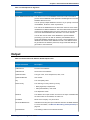
Response Element
Description
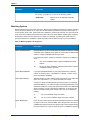
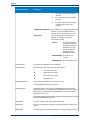
TrailingDirectional
Street directional that follows the street name.
UnitNumberHigh
The highest unit number of the range in which the unit resides.
UnitNumberLow
The lowest unit number of the range in which the unit resides.
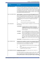
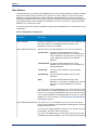
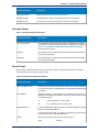
Geocode Output
Table 7: Geocode Output for Argentina
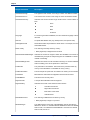
Response Element
Description
CoordinateSystem
The coordinate system used to determine the latitude and longitude
coordinates. A coordinate system specifies a map projection, coordinate
units, etc. An example is EPSG:4326. EPSG stands for European
Petroleum Survey Group.
Latitude
Seven-digit number in degrees and calculated to four decimal places
(in the format specified).
Longitude
Seven-digit number in degrees and calculated to four decimal places
(in the format specified).
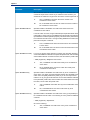
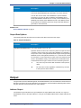
Result Codes
Result codes contain information about the success or failure of the geocoding attempt, as well as
information about the accuracy of the geocode.
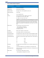
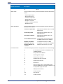
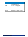
Table 8: Result Code Output for Argentina
Response Element
Description
Geocoder.MatchCode
Indicates how closely the input address matches the candidate address.
For more information, see Result Codes for International Geocoding
on page 33.
IsCloseMatch
Indicates whether or not the address is considered a close match. An
address is considered close based on the "Close match criteria" options
on the Matching tab.
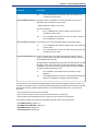
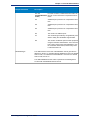
MultiMatchCount
Y
Yes, the address is a close match.
N
No, the address is not a close match.
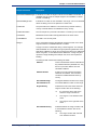
For street address geocoding, the number of matching address positions
found for the specified address.
For intersection geocoding, the number of matching street intersection
positions found for the specified addresses.
Status
Reports the success or failure of the match attempt
null
Geocoding Guide for Argentina - REST
Success
21