1
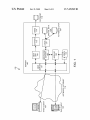
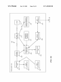
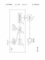
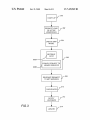
US 7,439,969 B2
7
8
computer system 100 uses a netWork/Internet 118 to connect
technicians utilizing clients such as a thin client 102 (eg a
puter program product”) as used herein is intended to encom
pass logic and/or data accessible from any computer-readable
device, carrier, or media.
PDA, WINCE, or PALM device) or a thick client 104 (e.g., a
Those skilled in the art Will recogniZe many modi?cations
may be made to this exemplary environment Without depart
ing from the scope of the present invention. For example,
those skilled in the art Will recogniZe that any combination of
computer system running a browser) to server computers 1 06.
A thick client 104 as utiliZed in the existing MAPGUIDE
GIS may comprise a computer With a Web broWser (enhanced
With a plugin or vieWer) connected to a Web server 110 that
communicates With a MapGuide server 120 to retrieve data
the above components, or any number of different compo
nents, including different logic, data, different peripherals,
(e. g., raster data, spatial data format (SDF) data 126, attribute
and different devices, may be used to implement the present
invention, so long as similar functions are performed thereby.
Speci?cally, those skilled in the art Will recogniZe that the
present invention may be applied to any database, associated
database management system, or peripheral device.
data 128, etc.).
A thin client includes three classes of devices: handheld
personal computers (HPC), palm-held personal computers
(PPC or PDA), and smart phones. Using these devices, a thin
client 102 may not provide the full processing and memory
capabilities as a thick client 104. For example, as described
SoftWare Embodiments
above With respect to PDAs, thin clients 102 often have
memory less than 100K, storage of less than 2-4 MB, proces
sor speeds of 13 MHZ, and limited display attributes. Conse
quently, additional server 106 side support (e. g., more gener
In accordance With the hardWare descriptions, thick clients
104 are complete computer systems With Web broWsers and
20
aliZed display data, simpli?ed project ?les, de-cluttering
services, and possibly server management of user state) may
PDA, a thin client 102 executing an application 130 is pro
vided. To accommodate the thin client, additional support on
be utiliZed. A typical combination of resources may include a
netWork/Intemet 118 comprising the Internet, LANs, WANs,
SNA netWorks, or the like, clients 102 and 104 that are PDAs,
personal computers or Workstations, and servers 106 that are
25
and 104 executing the appropriate softWare applications 130
to server computers 106 executing Web servers 110,
MapGuide servers 120, and servlets 108. MagGuide servers
120 and servlets 108 may be located Within or part of Web
server 110. The server 106 and its components may also be
referred to as a back of?ce system. Such a back of?ce system
server 106 may be utiliZed. For example, server 106 may
provide more generaliZed display data, simpli?ed project
?les, de-cluttering services, and possibly server management
personal computers, Workstations, minicomputers, or main
frames.
The netWork/Internet 118 connects client computers 102
full processing capabilities. HoWever, the hardWare limita
tions of a PDA device necessitate softWare limitations.
Accordingly, to enable a geographic information system on a
of the user state.
The architecture of the invention includes a data model that
30
combines static raster layers (static raster data for multiple
layers) With live vector objects to deliver good display and
download performance, and also provides interactive select
able objects.
Vector based maps (also referred to as “map layer data”
35
consisting of geographic information/data for one or more
layers) are served by a servlet 108 and are an encoded and
maintains access to corporate databases, synchronization
spatially indexed vector representation of the geographic
utilities, etc. The Web server 110 is typically a program such
data. Such vector maps provide for a more “interactive” dis
as anApache Web Server or Microsoft’ s Internet Information
Server. The servlet 108 communicates With thin client 102
through Web server 110 such that any additional processing
40
required by a thin client 102 may be performed by the servlet
108. Servlet 108 communicates With MapGuide server 120 to
objects: vector graphic shapes (e.g., paths consisting of
straight lines and curves), images, and text. Graphical objects
obtain needed map data/information. Additionally, servlet
108 accesses map WindoWs ?les (MWF) 124 to obtain rel
45
evant data. The servers 106 may also execute a Common
system (DBMS) 114 that may be utiliZed to retrieve relevant
50
geographical data (such as SDF data, raster data, Open Data
Base Connectivity (ODBC) data, etc.) from database 116.
Generally, components 108-116 and 120-130 all comprise
logic and/or data that is embodied in or retrievable from a
55
device, medium, signal, or carrier, e.g., a data storage device,
coupled to the computer via a netWork or via another data
PDA users (e.g., technicians) can make scribbles and anno
60
accommodate such markup, embodiments provide a markup
object that consists of geometric scribbles (points, lines, poly
gons, symbols), GPS (global positioning system) input coor
being performed.
Thus, embodiments of the invention may be implemented
dinates, annotations (positioned text With font information,
etc.), and a geo-reference system that alloWs the markup
as a method, apparatus, or article of manufacture using stan
softWare, ?rmWare, hardWare, or any combination thereof.
The term “article of manufacture” (or alternatively, “com
ing across multiple levels. A smart-cache on thin client 102
alloWs the sWapping of compact tiles from the database to
memory, in a manner appropriate to the device. A single
tations on the map using a paper and pencil metaphor. To
necessary to implement and/or use the present invention
dard programming and/or engineering techniques to produce
A display background (that is raster based) for the geo
graphic data and display layers is managed as a multi-level
library of raster tiles. The raster layers are composed from
multiple vector layers on servlet 108, resulting in better
doWnload and display performance. The raster map on the
PDA alloWs panning (virtual roaming paradigm), and Zoom
Workspace per map provides the de?nition of the map and the
display attributes for the layers on the thin client 102.
a data communications device, a remote computer or device
communications device, etc. Moreover, this logic and/ or data,
When read, executed, and/or interpreted, results in the steps
can be grouped, styled, transformed, and composited into
previously rendered objects.
GateWay Interface (CGI) 112 (or Netscape Application Pro
gramming Interface (NSAPI), Internet Server Application
Programming Interface (ISAPI), etc.), Which interfaces
betWeen the Web server 110 and a database management
play With ?exible Zooming on the client 102, highlighting,
etc. Alternatively, the Scalable Vector Graphics (SVG) repre
sentation as proposed by the WorldWideWeb Consortium
(W3C) may be utiliZed. SVG alloWs for three types of graphic
65
object to be integrated into a spatial database 116 using server
106 and displayed on other maps. The markup system cap
tures user input and alloWs for markup objects to be uploaded