1
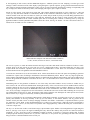
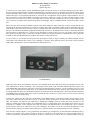
Millisecond Video Timing for the Masses
By Sam Herchak
Updated July 2007
It seems every few years products become affordable that greatly increase the accuracy of occultation timings. In the late 1990’s,
the GPS averaging function became available in handheld units, which allowed a user to determine their location with far greater
accuracy than maps. More recently, inexpensive and easily adapted security cameras (like the Supercircuits PC-164) have allowed
modest telescopes to record asteroid occultations on video down to 11th magnitude, without expensive light intensifiers. Now we
have an extremely accurate and affordable VTI (Video Time Inserter), which will “stamp” any video recording with the correct
Universal Time (UTC) down to the millisecond! When using a VTI, the real limit in getting an exact time of an occultation is the
“slow” field rate of common video cameras and problems with starlight, such as scintillation and the Fresnel effect. More on that
later.
Many years ago, IOTA developed a handful of unique units which could insert time stamps onto a video recording after-the-fact,
triggered by the unique tone broadcast every minute over WWV (and similar), provided the quality of the recorded audio and video
were adequate. This worked pretty well since only the recordings with “hits” needed to be processed. But it still required shipping
the tape to an individual who had the equipment and knowledge to process it. Besides the inconvenience, a much larger factor has
motivated others to find another way—the loss of time broadcasts by nations trying to cut costs. An obvious source for accurate
time signals was already in place—GPS, whose satellites transmit time signals accurate to few hundred nanoseconds. But when
would an accurate and affordable unit be produced? The summer of 2005 is the answer.
As far as I know, a few real-time VTI units have been developed previously in Japan, Germany, the United Kingdom, and the
United States, but each had issues such as cost, availability, or accuracy. Those problems seem to have been overcome with the
KIWI-OSD, manufactured in the US and distributed by PFD Systems, LLC.
The KIWI-OSD II
KIWI comes from “Kiwi Geoff” Hitchcox who lives in New Zealand, the developer and creator of the all important processor code,
while OSD stands for “On Screen Display.” The video output from any NTSC, PAL, SECAM or MESECAM video camera is fed
to the KIWI-OSD, which then time stamps the video fields in milliseconds before passing it on to be recorded by a device of your
choice. A key component of the timing device is the sophisticated Garmin18 GPS unit, which has many features such as GPS
averaging and WAAS (Wide Area Augmentation System, developed for aircraft GPS approaches). All the specifications and details
of the KIWI-OSD are available online at the resources listed at the end of the article. I will provide an overview however, based on
several months of research and testing.
A plastic box contains the guts of the unit, and the latest version (KIWI-2) has an “info” button (formerly the reset button) at one
end, with 4 connection ports on the other. Two are for the video cables; another powers the unit, and the fourth connects to the
GPS. The sequence you make the four connections is unimportant, although I prefer to connect the power cord last so I can
monitor everything the VTI does from the start. Additionally, there is a plugged hole on the side that allows the Garmin 18 to be
connected to a computer via the supplied serial cable (for reasons to be described later). The complete unit uses a miniscule
amount of power from any 12 VDC source (9-15 VDC technically), far less than even the PC-164 camera. Standard RCA video
cables are used to connect your camera and recording device, while the Garmin 18 is connected and powered via a DIN plug.
Since the unit’s primary purpose is timing information, the Garmin is pre-configured to provide information immediately after it
acquires a less accurate “2 D” position fix (this can result in a position error for mobile observers, which I’ll address later). As
soon as the Garmin has valid GPS time information, accurate to 1 millionth of a second, it drives a red LED that flashes precisely
at the beginning of each second, and the KIWI-OSD begins its validation process for time stamping. You then get several
messages visible at the bottom of the video display cycling through in a specific sequence, giving position information before the
video signal is stamped with time information. Unless you are in an area with many obstructions resulting in exceptionally bad
sky coverage (like inside an observatory dome), time stamping will begin in just a couple of minutes.
Except for video experts, most people aren’t aware that video cameras integrate and output in fields, referred to as “odd” and
“even” (you may hear these referred to as half-frames). Both of these fields are combined to make up each frame. For NTSC
cameras common in the US, there are almost 30 frames per second, and just under 60 fields per second. Many playback devices
are capable of stepping through each field by using what they mistakenly call the “frame by frame” function. This effectively
doubles the time resolution of the camera. Another option that is becoming more common is extracting times by using the
application LiMovie created by Kazuhisa Miyashita. (Check the e-book, Chasing the Shadow: The IOTA Occultation Observer’s
Manual for an excellent overview of LiMovie).
KIWI-OSD time stamped video field from a lunar occultation
(17 hrs, 54 min, 02.528 to 02.545 sec; 15078 field count)
The VTI is so precise, it marks the millisecond each field begins and ends! Each NTSC field has a duration of about 17 milliseconds, which is the only reason you can’t time any event to 1 millisecond accuracy—the camera fields take “too long” to be
acquired. With such resolution, a problem arises for users of the KIWI-OSD—if a star dims over several fields, when did the
actual occultation occur? The guidance from David Dunham on this is:
“For most stars, the frame to use is the one with the star at 1/4th its unocculted level; that is the point corresponding to geometric
occultation of a point source, according to calculations of the Fresnel diffraction pattern. But for a few very large red giant stars,
such as Antares and Aldebaran, the star's angular diameter is significantly larger than the approximately 10m scale of diffraction so
for them the geometrical occultation occurs when the star is at 1/2 its unocculted level.” (Note: substitute field for frame in the
first sentence.)
Determining times of the geometric occultation is one of the many areas where LiMovie excels, but that is another story in
itself—back to the VTI. Geoff was adamant about ensuring the accuracy of this VTI, and wrote several validation checks into the
code that controls the unit (as well as a backup procedure if the final validation reports a problem). Whenever a timing run is
ended by pressing the “info” button, the KIWI-OSD verifies that its time information is still within 1 millisecond of the current
UTC. If not, a message is displayed to use the field counter to calculate the exact times for the fields containing an event (see the
user manual online for how this is done). Pressing the button again restarts the unit and begins the whole process from scratch.
This is also the way to trigger new (and easily recorded) position information.
So now is a good time for me to summarize GPS positions, which change constantly, even when your receiver isn’t moving. The
primary GPS satellites are moving constantly in the sky (12 hour orbits), so the number, distance, and sky position of the
satellites used by the GPS receiver are always changing. Sometimes the satellite “constellation” is optimal and allows a precise
fix; sometimes it is not. What is easily demonstrated however, is that over a period of time, a GPS can provide a position that is
accurate to less than 5 meters (16 feet). This is not possible with a topographic map, which for the most part, are not accurate to
15 meters to begin with.
The key is to use the GPS to take several short averages, spaced minutes apart. Thanks to Scott Degenhardt, I began doing this
about 8 years ago. Even before the signal scrambling that only allowed the military full precision was turned off (selective
availability, or S/A), Scott and I went to benchmarks certified in accuracy to millimeters, and proved simple GPS averaging
techniques provide extremely accurate fixes. If you have a GPS unit, see for yourself—the geocaching.com link at the end will
help you locate a certified benchmark in the US near you.
For mobile users of the KIWI-OSD, there is a possible trap with the initial position from the unit. To begin a timing run in the
shortest possible time, the Garmin 18 is pre-configured for “2 D” fix. This means the unit will display information before the
GPS has acquired enough satellites to determine its current elevation. Because GPS units store the last known position and
elevation when powered off, in the 2 D fix mode, the GPS has to assume the elevation hasn’t changed since last stored. This can
severely skew the calculated surface position. In one of my tests, I moved the setup about 60 nautical miles (NM) and climbed
about 1,000 meters in elevation. When the KIWI-OSD displayed the initial 2 D position, it was off by 0.7 NM, a gross error by
any standard.
The best solution is to GPS average. Take a 5 minute average; wait 10 minutes, reset the unit and take another 5 minute average.
Do this 3 times, mathematically average the position and elevation readings, and your position should be accurate to within 5
meters. Be sure to report both the Mean Sea Level elevation and the Geoidal separation. An averaged position is so accurate, IOTA
may need to adjust the elevation figure with a GEOID correction (the Earth’s surface is not a perfect sphere). Also, if you use an
extension cable on the Garmin (to raise it outside your dome for example), be sure to correct for the distance between your
telescope objective and the GPS receiver.
Personally, I chose to change the Garmin 18 configuration from 2 D fix, to “3 D fix required.” This is done with the included
serial cable, a computer, and Garmin’s own Sensor Configuration Software. With 3 D fix required selected, the KIWI unit will not
start a timing run until the elevation has been updated. The delay I have experienced in the field by requiring the 3 D fix is under
five minutes (changing your location a significant distance or poor sky coverage can slow the process down further). If you don’t
move around much, this change isn’t necessary nor recommended.
The kit form of the KIWI-OSD is no longer sold, and in the near future, the early versions (1a and 1b) will also be gone. But the
“ready to go” KIWI-2 is immediately available and is a bargain at $165 USD. That’s much less than many eyepieces these days.
The KIWI-OSD has been used in the field now for almost two years (mine included), and all the feedback shows it to be extremely
reliable and accurate. I highly recommend it for anyone timing events with video. Check out the resources below which are full of
information on video, GPS, time insertion, and the KIWI-OSD. Your comments and experiences are welcomed at:
<[email protected]>
www.pfdsystems.com/kiwiosd.html
www.geocities.com/kiwi_36_nz/kiwi_osd/kiwi_osd.htm
http://groups.yahoo.com/group/kiwiosd
www.edu-observatory.org/gps/height.html
www.ngs.noaa.gov/cgi-bin/GEOID_STUFF/geoid03_prompt1.prl
www.geocities.com/kiwi_36_nz
www.geocaching.com/mark/nearest.aspx
http://www005.upp.so-net.ne.jp/k_miyash/occ02/limovie_en.html