1
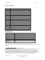
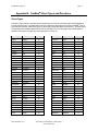
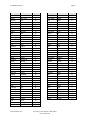
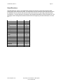
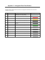
2003 DMTI Spatial Inc. Page 2 Table of Contents ™ ABOUT DMTI SPATIAL ............................................................................................... 4 Really Smart Spatial Solutions™ .....................................................................................5 DMTI Spatial™ Product & Service Portfolio ........................................................................5 Error Reporting & Wish List Services ................................................................................6 Contact Information.....................................................................................................6 ABOUT CANMAP® STREETFILES .................................................................................. 7 FILE DIRECTORY, STRUCTURE AND CONTENT ................................................................ 8 File Properties ...........................................................................................................8 File Naming Convention ...............................................................................................8 Points of Interest Directory ............................................................................................9 Streets Directory ........................................................................................................9 Topographic Directory................................................................................................ 10 Canada Directory ..................................................................................................... 10 USING CANMAP STREETFILES .................................................................................... 11 Viewing CanMap Streetfiles ......................................................................................... 11 APPENDIX A: GEOGRAPHIC AREA ABBREVIATIONS ....................................................... 12 Provinces and Territories ............................................................................................ 12 Topographic Coverage Areas....................................................................................... 13 APPENDIX B: CANMAP STREET TYPES AND DIRECTIONS .............................................. 14 Street Types ........................................................................................................... 14 Street Directions ...................................................................................................... 16 APPENDIX C: CARTOGRAPHIC ROAD CLASSIFICATIONS................................................. 17 APPENDIX D: DATA DICTIONARY ................................................................................. 18 CanMap Streetfiles Data Structure and Content ................................................................. 18 Area Code Boundaries (acb) ..................................................................................... 18 Building Footprints (bf) ............................................................................................ 19 Building Points (bp) ................................................................................................ 22 Bus Transit – Lines (btl) ........................................................................................... 24 Bus Transit - Points (btp) ......................................................................................... 25 Car Pool Lots (cpl) ................................................................................................. 26 Education (edu)..................................................................................................... 27 Expressway Casements (exc) ................................................................................... 28 Golf Courses (glf) .................................................................................................. 29 Health Care (hcr) .................................................................................................. 30 Primary Highway Casements (hpc) ............................................................................. 31 Major Roads and Highways (hrd)................................................................................ 32 Hydrographic Structures (hs) .................................................................................... 33 Secondary Highway Casements (hsc).......................................................................... 36 Highways (hwy)..................................................................................................... 37 Hydrography (hy) ................................................................................................... 38 Industrial and Resource (ir)....................................................................................... 39 Land Feature Labels (ll) ........................................................................................... 41 Canada\USA Roads Linkages (lnk) ............................................................................. 42 Local Road Casements (lrc) ...................................................................................... 43 Land Use (lu)........................................................................................................ 44 Municipality Amalgamation File (maf)........................................................................... 45 www.dmtispatial.com Proprietary and Confidential to DMTI Spatial Not to be disclosed