1
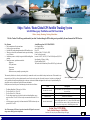
SOFAB MARINE 1 SOFAB Gas, Rebreather & Scuba Tank Cylinder Service Center station (Aluminum & Steel Cylinders) Trust Middle East Company Membership Number CT934 Cylinder Testing & Inspection Service Center Regulations for Gas, Rebreather & Scuba Containers (Cylinders) – New Standards - BS EN 1968:2002 for Steel Gas Containers (Cylinders), and BS EN 1802:2002 for Aluminum Gas Containers. (Combustible & NonCombustible) Association of Scuba Service Engineers & Technicians. A.S.S.E.T. members Cylinder Testing Technicians, 2010-2011. IDEST, the Inspectorate for Diving Equipment Servicing and Testing, advised approved test centers to implement the new standards by 31st August 2002. These came into force on 1st September 2002. Association of Scuba Service Engineers & Technicians. SITA, ASSET & IDEST Approved Cylinder Testing Course. Gas Tank Container (Cylinder), Testing Requirements: Test and Inspect The test is a visual inspection both internally and externally with valve seal replacement on completion of the test at 2.5 years. The 5 year test includes a full proof test at manufacturers recommended pressures. Rebreather & Scuba Tank Container (Cylinder), Testing Requirements: Test and Inspect SCUBA tanks are to be tested every 2.5 years with the first being a visual inspection. The 5 year test includes a full proof test at manufacturers recommended pressures. Other none SCUBA breathing air tanks are tested with proof test and visual every 5 years. Urgent Customer Message: Aluminum alloy is made by extrusion and forming. They are not as strong as steel and therefore require an 11mm wall thickness. They are to be anodized prior to painting and do not corrode as much as steel. Aluminum cylinders are easily identified by their flat bottom. 2 Visual Plus. STATS 2000. Ships / Yachts / Boats Global GPS Satellite Tracking System with SOS Emergency Push Button and Full Vessel Alarm Wireless, Security, Monitoring, Tracking & Surveillance Marine Magellan Insight Wireless Boat Security, Monitoring & Surveillance System with GPS Satellite Tracking and Complete Internet Monitoring. This package includes all the components necessary to help protect your boat and keep an eye on exactly what is happening onboard at all times. You will be notified of high water in the bilge, low battery voltage, loss of shore power, smoke or heat detection and intrusion or theft of your vessel. In the event your boat is stolen, you will be updated every 15 minutes with the vessel‟s speed, heading, latitude and longitude, and distance to closest city. Never be out of range again. Connected to the internet through the Ericsson W25 or the Tellular SX7T this system gives you complete access to your boat from any computer with internet access or through your web enabled mobile phone. The system has full GPS tracking through the new Inmarsat IsatM2M network, and will report in alarm notifications from anywhere in the world. When in wireless range the Marine Magellan Insight will report alarms to you with a voice message and/or email and/or SMS text message. Owners have a personalized webpage they login to which gives them access to view their onboard cameras live and view archived snap shots from triggered events and shows the vessels status, alarms that have occurred and a complete history of events. Owners also have the ability to arm/disarm their vessel and control AC/DC accessories all from the internet. *The Insight DVR adds the ability to record and store the last 30 days onboard your yacht, with a 150GB hard drive you can record 4 cameras at 30 frames a second 24/7/30. You can easily download and archive the DVR to any computer. **Marine Magellan Insight also available (no GPS) Arm/Disarm Option NAV Tracker Antenna Purple Wire Bad Locations Wireless motion Detection Smoke Alarm Wireless Door Contact High Water Alarm Yacht GPS Tracking SOS Distress Button GSM Notification Wireless Low Voltage Wireless 2 way Remote Total Yacht Security with Owner Notification Easy Access Command & Control Panel a Bad Locations Convert SPST switch Blinking LED Bad Locations Wireless Advantages : Good Locations Ground (DC-) Good Locations Bad Locations Antenna Cable (30ft) Alarm/Alarm Clear Option a b b SOS Button Bad Locations Fuse and Holder Ground (DC-) Constant Positive (+) 12VDC or 24VDC The low voltage sensors has a dip switch on the circuit board that allows you to switch it to either 12V or 24V. So there is only one sensor that will do either 12V or 24 V Wireless 2-Way Remote MA-MG-REM2 Marine Magellan MA-MG-6160 Head Unit Communicator Artion GSM Module Blue Wire Negative (-) Ground Wireless Door Contact MA-MG-DCTXP2 SOS Emergency Push Button Smoke Detector MA-MG-SD-738 Wireless Low Voltage 12/24VDC Sensor MA-MG-PM-LVS12/24 Wireless High Water Sensor MA-MG-PM-HWS Wireless Motion Detector MA-MG-PMD75 CODE G 3 Ships / Yachts / Boats Global GPS Satellite Tracking System with SOS Emergency Push Button and Full Vessel Alarm Wireless, Security, Monitoring, Tracking & Surveillance The Nav-Tracker 2.0 will keep you informed of your boat’s location through a GPS tracking service provided by the new Inmarsat Isat M2M service. Key Features: Daily transmissions of location and status Passive geo-fence arm and disarm Real time GPS tracking through Inmarsat Isat M2M satellite service When in geo-fence alarm, unit transmits location, speed and heading every 15 minutes Stand alone system or wirelessly integrate with all Marine Magellan packages Monitor one sensor, optional sensors include: -High water -SOS / panic button -Door contact -Temp sensor -Beam sensor or any normally open sensing device. Actual Message from NAV-TRACKER 2.0 User: Paradox Marine Asset: M/Y Island Time Fleet: ETI DateTime: 2006-07-25 15:06:28 (EDT) Event: Geo-fence breached; Location: 26.05767,-80.13033 (0.75 mi NE of Hollywood,FL(33019) Speed/heading: 9.2 Knots, 144 Deg Google Earth Map: [KML] This email is for notification only. Please DO NOT reply to this email. This extremely reliable service, formerly used exclusively by commercial vessels, is now available to the private boat owner. When armed, the system passively sets a 500 ft. geo-fence (radius) around the vessel. In the event the geo-fence is breached, as many as 4 recipients you designate will receive an email and/or text message displaying the vessel name, its location in latitude and longitude, the closest city, its speed and heading. The unit will also send you a daily status report with the same information. Finally boat owners can have peace of mind knowing where their boat is at all times. The Marine Magellan is 12Volts only or 110Volts. The Nav-Tracker 1.0 is 12V or 24V. The Nav-Tracker 2.0 is 12Volts only. The low voltage sensors have a dip switch on the circuit board that allows you to switch it to either 12V or 24V. So there is only one sensor that will do either 12V or 24V. All of the sensors are powered by AAA batteries and the 2WPGM wireless relays are powered off 12V or 24V. Note: When emergency SOS button is pressed, an immediate SOS signal is sent to monitoring station with ship position identification 4 Marine Magellan Nav-Tracker GPS Tracking System with 30‟ Cable Code Description Quantity MA-MG-NT1.0-30-RTL NAV-TRACKER 1.0 SAT/GPS Tracking Device w/30‟ cable arm/disarm from website only 1 MA-MG-NT-L-Bracket Mounting Bracket for use in gunnel or bulkhead 1 MA-MG-NT-SOS Navtracker IP67 SOS Button 1 MA-MG-VRM-GSM-DST Marine Magellan Wireless Security & Monitoring Package (24 Volt), includes: Marine Magellan MG-6160, 1-Artion Cellular GSM Communicator. 2-DCTXP2 (door contacts), 1-PMD-75 (motion detector), 1-PMLVS (24V low voltage sensor), 1-PM-HWS (high water alarm) 1 System Price : 23,999 SR/Dhs Yearly Satellite Charge is 5,866 SR/Dhs Installation : Site Survey Required (Additional Changes Will Apply) CODE G Civil Ships / Yachts / Boats Global GPS Satellite Tracking System with SOS Emergency Push Button Location Identification The Nav-Tracker 2.0 will keep you informed of your boat’s location through a GPS tracking service provided by the new Inmarsat Isat M2M service. This extremely reliable service, formerly used exclusively by commercial vessels, is now available to the private boat owner. When armed, the system passively sets a 500 ft. geo-fence (radius) around the vessel. In the event the geo-fence is breached, as many as 4 recipients you designate will receive an email and/or text message displaying the vessel name, its location in latitude and longitude, the closest city, its speed and heading. The unit will also send you a daily status report with the same information. Finally boat owners can have peace of mind knowing where their boat is at all times. Actual Message from NAV-TRACKER 2.0 User: Paradox Marine Asset: M/Y Island Time Fleet: ETI DateTime: 2006-07-25 15:06:28 (EDT) Event: Geo-fence breached; Location: 26.05767,-80.13033 (0.75 mi NE of Hollywood,FL(33019) Speed/heading: 9.2 Knots, 144 Deg Google Earth Map: [KML] This email is for notification only. Please DO NOT reply to this email. System Price : 7,068 SR/Dhs Yearly Satellite Charge is 5,866 SR/Dhs Installation : Site Survey Required (Additional Changes Will Apply) Yearly services charges: Total 500 transmissions, of which one heart beat transmission every 24 hours and 135 emergency call button transmissions Yearly charge required, after first 12 month is 5,866 SR/Dhs for 500 message transmissions SOS Emergency Push Button Marine Magellan Nav-Tracker GPS Tracking System with 30‟ Cable Code Description Quantity MA-MG-NT1.0-30-RTL NAV-TRACKER 1.0 SAT/GPS Tracking Device w/30‟ cable arm/disarm from website only 1 MA-MG-NT-L-Bracket Mounting Bracket for use in gunnel or bulkhead 1 MA-MG-NT-SOS Navtracker IP67 SOS Button 1 CODE H 5 Ship Sea Yachts Boat 100% GPS Satellite Tracking System for Boats & Yachts ZGPS-100 PRICING Easy Installation Plug Cable to Cigarette Lighter Turn Device ON Log on to Internet Track your Vehicle /Plane/Ship Walking and Hiking Border Guard Ambulances Vehicles Ships Components Standalone System GPS TX/RX Unit 12~24 Volt DC Cigarette Lighter Plug and Cable You have special needs that other products can‟t meet. You want the Iridium GPS Satellite Transmitter which fits your requirements for today and tomorrow. You want an easy to use solution that is capable and affordable. Introducing the all new Iridium GPS tracking solution. Options Messages per hour Operation Hours / Day Operation Days / Year Total Messages Per / Year PRICCE SR/Dhs A 4 10 365 14,600 8,760 B 4 10 200 8,000 4,800 C 2 10 200 4,000 2,400 D 1 10 200 2,000 1,200 Number of Messages Cost Per Each Signal Transmission Transmission 0.60 SR/Dhs E-Additional yearly Programming Charge : 2,703 SR/Dhs F-Installation Charge : 1,000 SR/Dhs ZGPS-900 - GPS TRACKER with External Antenna PRICE : 9,999 SR/Dhs ZGPS-100 - GPS TRACKER with Internal Antenna PRICE : 6,999 SR/Dhs Complete System Requirements:(A or B or C or D+E+F + ZGPS-900 or ZGPS –100) 1 Year Warranty 6 Emergency Personal Locator Beacons - PLB MA-MC-91-001-210A 406 MHZ PLB with GPS (Personal Locator Beacon) The MA-MC-91-001-210A is a powerful waterproof 406 distress beacon. However, the MA-MC-91-001-210A has a built-in integral 50-channel GPS for additional pinpoint location, further speeding up time of location. The MA-MC-91-001-210A transmits the two signals simultaneously, one to the subscription free global 406 MHz satellite system, and the other (121.5MHz) is to speed up the local recovery response process. Once activated, Our signals will continue to transmit for at least 24 hours, at a powerful 5 watt output, the 406 MHz transmission ensures that a call for help gets through whatever the conditions. It includes a unique SOS LED flash light facility which is manually activated to further assist in speeding up the users recovery during night time rescues. It will operate in temperatures down to -20°c and its integral battery has a user storage life of 5 years, so there‟s no need for constant battery changes and re-charging. Price: 1,886 SR/Dhs Accessories:Wrist Lanyard (short) (MA-MC-91-060-001A): Price: 41 SR/Dhs Neck Lanyard (MA-MC-91-060-002A): Price: 49 SR/Dhs Belt Pouch in black (no lanyard) (MA-MC-91-062A): Price: 86 SR/Dhs Buoyancy pack (black & yellow, no lanyard) (MA-MC-91-063A): Price: 65 SR/Dhs Universal Pouch (MA-MC-91064A) Price: 86 SR/Dhs MA-SAR-MT410G Yearly 100 SR/Dhs for Testing, Re-Activations & Certification. First Year Charges included in the unit price. 406 MHZ PLB with GPS TX (Personal Locator Beacon) GME‟s Accusat MT410G Pocket Pro+ with integrated GPS is leading the world with feature innovation and user benefits. Not only is the AccuSat MT410G the smallest and lightest PLB on the market, it offers a massive 7 year battery replacement life, an „industry first‟ 7 year warranty, a high intensity flashing LED, a „Non Hazmat‟ battery pack for simple and cost effective transportation and a 16 Channel parallel GPS receiver with top mounted Quad helix antenna to improve location accuracy to better than 100 meters typically - all contributing to the unique AccuSat advantage. Features Fitted with NON-HAZMAT long life batteries Featherweight, compact and robust construction 16 Channel Parallel GPS receiver for better than 100 meter accuracy Digital 406 MHz, 5 Watt transmission plus 121.5 MHz homing signal 7 year battery life COSPAS-SARSAT worldwide operation 7 year warranty National & International approvals Typical accuracy (with GPS) <100m Sealed waterproof design (exceeds IP67) High visibility flashing light Retention strap and fully buoyant design reduces risk of loss Unique patented technology- no warm up period Complete with protective carry pouch Price: 2,446 SR/Dhs Yearly 100 SR/Dhs for Testing, Re-Activations & Certification. First Year Charges included in the unit price. CODE F 7 Emergency Position Indicating Radio Beacons - EPIRB Water and Manually Activated EPIRB with GPS MA-SAR-MT403G 406 MHz GPS EPIRB Water & Manual Activation GME MT403 series EPIRBs are a culmination of years of extensive R & D by GME engineers. The end result is a radical new design concept that is not only a significant improvement on existing beacon performance, but dramatically slashes the cost of 406 MHz EPIRB ownership. Features: Price: 3,421 SR/Dhs Unrivaled in Technology, Performance and Price. Easy, in-built self-test with audio / visual alert. COSPAS-SARSAT worldwide operation. Yearly 100 SR/Dhs for Testing, Re-Activations & Certification. First Year Meets AS/NZ 4280.1:2003 standards. C/S T.001/007. Charges included in the unit price. Ground breaking microprocessor based design, delivers unparalleled performance and value. Antenna deploys automatically when the unit is removed from the quick-release mounting bracket. Zero warm-up Digital Technology. Automatically activates on immersion in water (when removed from the bracket) or can be activated manually if desired. High intensity solid state strobe. 6 Year battery life. Non-hazardous batteries for restriction free transportation. 6 Year GME Warranty. Rugged lightweight easy-to-mount compact design. Water and Manually Activated Float Free Auto Release EPIRB with GPS TX MA-SAR-MT403FG 406 MHz GPS EPIRB Water & Manual Activation Features: 8 Unrivaled in Technology, Performance and Price. Meets AS/NZ 4280.1:2003 standards. C/S T.001/007. IMO A810 (19). Ground breaking microprocessor based design delivers unparalleled performance and value. Non-hazardous IATA compliant battery pack for restriction free transportation. Zero warm-up Digital Technology. 16 Channel parallel GPS receiver with top mounted Quad helix antenna for better than 100 meter accuracy. High visibility solid state strobe. Automatically activates on immersion in water (when removed from the bracket) or can be activated manually if desired. Rugged easy-to-mount design. 6 Year battery life. Easy, in-built self-test with audio / visual alert. Price 4,983 SR/Dhs 6 Year GME Warranty. Yearly 100 SR/Dhs for Testing, Re-Activations & Certification. COSPAS-SARSAT worldwide operation First Year Charges included in the unit price. CODE F Emergency Personal Locator Beacons GPS I/O EPIRB Garmin eTREX® H Handheld GPS MA-OT-110128 Price: 639 SR/Dhs MA-OT-620022 Price: 3,196 SR/Dhs The Aquafix 406 from ACR is the smallest and most functional Personal Locator Beacon (PLB) available. ACR GyPSI 406 (PLB) with GPS & Pouch Perfect for outdoor enthusiasts on a budget, eTrex H comes with a high-sensitivity GPS receiver that locks onto satellite signals quickly and maintains accuracy even in the toughest conditions. This little yellow wonder combines an intuitive interface and a rugged exterior into a lightweight handheld that fits in the palm of you hand. Its high-sensitivity WAAS-enabled GPS receiver locates your position quickly and precisely and maintains its GPS location even in heavy cover and deep canyons. 5 buttons are located on either side of the eTrex H for easy one-hand operation. The eTrex H is IPX7 waterproof, so it can take an accidental dunk and still continue to perform. Operates up to 17 hours on 2 AA batteries. Stores up to 500 waypoints. Just enter the point you want to go to, and eTrex H points you to your destination (no street or terrain maps). TrackBack® lets you reverse your track log and navigate back to your starting point. Features hunt/fish calendar. No built-in memory. 4-level gray LCD display measures 1.1" x 2.1". Unit measures 4.4" x 2" x 1.2". One-year warranty. McMurdo FastFind Max-G (PLB) MA-OT-620089 Price: 3,381 SR/Dhs The Aquafix 406 from ACR is the smallest and most functional Personal Locator Beacon (PLB) available. Easily carried on a life jacket or in a pack, it transmits a unique digitally coded distress signal via the COSPAS/SARSAT satellite system that is registered to you. The internal GPS acquires a position when the unit is activated and transmits to rescue agencies the exact LAT/LON within 110 yards. The unit also transmits on the 121.5 MHz SAR homing frequency for added security and speed of rescue. The two lithium batteries provide operational life in excess of 24 hours at -4°F (longer in higher temps) and have a shelf life of 5 years. The Aquafix is small enough to be worn on deck by yachting crews, racers, solo cruisers, or any marine enthusiast. It ships with a removable holster that offers style and protection, as well as a carabiner clip that allows for multiple mounting options to backpacks, webbing, and life vests. The flat stainless steel antenna wraps completely around the unit for easy storage. The Aquafix 406 is completely waterproof down to 33', but it will float if dropped in the water. It measures 5.7"H x 3.0"W x 1.7"D. Weighs only 12 oz. Now available with no additional Hazmat shipping charge. These advanced products from McMurdo have been designed to provide recreational and professional boaters and outdoorsmen the best chance of being found without delay in an emergency. They feature the same advanced digital technology that's found in the award-winning SmartFind 406 GPS EPIRBs. Designed using miniature components to fit into an aesthetically-styled compact case. Both versions employ a simple three-stage manual operation. 48-hour effective transmit time. 406-MHz transmitter. 121.5 MHz homing frequency. Positional accuracy to within 10'. Waterproof down to 38'. User-replaceable battery pack, carry case, and lanyard included. Five-year warranty. Shipped ground only. 9 Si-Tex AIS Radar Receiver (Requires VHF Antennas) Simrad A180 AIS System With GPS Antenna (Requires VHF Antennas) MA-OT-980670 MA-OT-980672 Price: 3,637 SR/Dhs Si-tex's line of AIS Systems receive VHF transmissions from vessels carrying an AIS transponder. The Si-tex AIS Radar system displays AIS transponder information on an easy-to-read 5" monochrome display. The display shows VBM lines giving you the familiar look and feel of a radar screen. If you already own an AIS ready Si-Tex chartplottter, Si-Tex's black box AIS receiver will overlay AIS target data onto your marine chart, so you have the confidence and safety to cross shipping channels. Two-year warranty. Price: 26,201 SR/Dhs Fully Type Approved in Accordance with IMO Requirements. Safety is a key issue for all mariners. With the new Simrad AIS Class A mobile station onboard, you can receive safety related navigational information broadcast from other ships, and in the future, navaids such as buoys and lighthouses. The new Simrad MA-OT-AI80 has the display and controls integrated into the Class A Mobile Station. The Simrad MA-OT-AI80 has a remote mounting transponder and uses a compact control unit (MKD). The Simrad MA-OT-MKD unit can be installed within reach of the mariner, in accordance with the IMO installation guidelines. It provides you with the vessel's position, speed and course over ground as well as static and voyage related information. The Simrad MA-OT-AI80 AIS system consists of four pieces: MA-OT-AI80MKD control head, MA-OT-AI80 transponder, MA-OT -AI80 connection box, and RS5640 GPS antenna (which is a 12 channel GPS receiver. When the MA -OT-AI80 AIS System is connected to an IMO specified radar and electronic chart system, it provides a detailed overview of the shipping in your area. A VHF antenna is needed to complete the installation. The display head measures 8.5'W x 4.4"H x 2"D. 24vDC. Required Accessories: Shakespeare 4 Way Stainless Steele Ratchet Antenna Mount MA-OT-920028 Price: 192 SR/Dhs Si-Tex AIS Black Box 4 Way SS Ratchet Mount Full 4-way ratchet system made of high quality stainless steele. Complete with rubber gasket. MA-OT-980671 Shakespeare VHF Antennas - Commercial 23' Two-piece MA-OT-900033 Price: 1,278 SR/Dhs Finish: Fiberglass. Height: 23'. Element: Brass & Copper. Ferrule: Chr Brass. Cable: 15' RG58. Gain: 9dB. Max: 25. 10 Price: 2,045 SR/Dhs Si-tex's line of AIS Systems receive VHF transmissions from vessels carrying an AIS transponder. The Si-tex AIS Radar system displays AIS transponder information on an easy-to-read 5" monochrome display. The display shows VBM lines giving you the familiar look and feel of a radar screen. If you already own an AIS ready Si-Tex chartplottter, Si-Tex's black box AIS receiver will overlay AIS target data onto your marine chart, giving you the confidence and safety to cross shipping channels. Two-year warranty. ICOM MA-OT-MR1000 MARINE RADAR MA-OT-211000 The Icom MA-OT-MR1000D series are feature packed, easy to use radars with high resolution 10” diagonal CRT displays. Range 36NM Power 4KW Ant Size/Type 24" RADOME Display Size" 10" Hor. Beam Width 3.9 DEGREE Resolution 481 X 640 Construction WATER RESISTANT The Icom MA-OT-MR1000D series are feature packed, easy to use radars with high resolution 10” diagonal CRT displays. The MA-OT-MR1000D comes equipped with a 24” 4kw Radome with a horizontal beamwidth of 4 degrees and a 36nm range. The MA-OT-MR1000D provides an automatic tuning function allowing for simple set up and operation. The frequency pulse width and repetition are automatically adjusted to the range scale you select. Price: 12,778 SR/Dhs The tuning provides a crisp high resolution image in the most demanding sea conditions. Target definition is further enhanced with a low noise front end receiver. Standard features include True Motion display, which discriminates between stationary and moving objects (requires navdata input via NMEA 0183), watch on guard zone, 1/8 nm minimum range, 2x zoom mode for quick target detection, and a smooth operating track pad. Compare these feature packed radars to models costing hundreds of dollars more. Display measures 10.5” H x 10.4” W X 10.1” D 15 meter interconnect cable. 10.2 to 42 V DC. One year warranty. 11 Furuno NavNet vx2 1824CBBNT - C-Map NT+ MAX - Black Box MA-OT-160232 Price: 19,809 SR/Dhs The Furuno NavNet vx2 Black Box system is perfect for installations where you want to combine the power and versatility of the NavNet network with larger video presentations. Designed to be used on virtually any display you want, the NavNet vx2 BB is available as chart/video plotter or a radar/video plotter. Identical in function to the 7" and 10" vx2 units except for the display, the system outputs video in VGA quality(640X480)using the standard 15-pin monitor connection. We have the system displayed on a 30" Jensen LCD monitor/TV with the NavNet vx2 video input feed from an engine room camera, and it looks just great. The systems are available in either C-Map NT MAX or Navionics Gold cartography. Like any other NavNet system, the vx2 BB processor can be expanded with standard NavNet components like the "BlackBox" sounder module. The chart/video plotter comes with Furuno's WAAS/GPS antenna, while the radar/video plotter is available in all the standard Furuno radar antenna configurations(2 & 4kw domes or 4,6,12 & 25kw arrays.) Packages include a waterproof Control Unit/Keyboard that can be bracket or flush-mounted, the "BlackBox" processor unit, and your choice of radar antenna. The processor unit provides VGA video output, video input, three interface ports, and NavNet network connection. Add one of Furuno's marine monitors to complete your system or use your own display. Control Unit/Keyboard measures 14.75"H X 9.25"W X 4.0"D. Two-year warranty. 12 SD Card GPS Navigations Charts for Hummingbird & GEONAV GPS Receivers Navionics Charts 30XG - Africa & Middle East Western Sahara, Mauritania, Senegal, Gambia, Guinea Bissau, Guinea, Sierra Leone, Liberia, Ivory Coast, Ghana, Benin, Nigeria, Cameroon, Gabon, Congo, Angola, Namibia, South Africa, Tanzania, Kenya, Somalia, Madagascar, Comoros, Aldabra Islands, Seychelles, Socotra, Lake Kariba, Red Sea, Persian Gulf. Including Cape Verde Islands, Gulf of Guinea, Gough Island, Tristan da Cunha, Gulf of Oman and Gulf of Aden Navionics Charts 23XG - Mediterranean and Black Sea Entire Mediterranean Sea and Black Sea. Navionics Charts 31XG - Indian Ocean and South China Sea Pakistan, India, Sri Lanka, Bangladesh, Burma, Thailand, Malaysia, Singapore, Cambodia, Vietnam, Maldives, Solomon Islands, Diego Garcia, Philippines, Brunei, Indonesia. Including Selat Sunda, Strait of Malacca, Gulf of Thailand, Andaman and Nicobar Islands, Bay of Bengal and Arabian Sea. Code Description Price SR/Dhs MA-HU-NAV-30XG-SD Navionics Gold Classic Charts Africa and the Middle East (SD) 1,580 MA-HU-NAV-30XG-CF Navionics Gold Classic Charts Africa and the Middle East (CF) 1.580 MA-HU-NAV-31XG-SD Navionics Gold Classic Charts Indian Ocean East (SD) 1,580 MA-HU-NAV-23XG-SD Navionics Gold Classic Charts Mediterranean & Middle East (SD) 1,580 Code G 13 GPS Features Technical Model 1197c SI Combo 997c SI Combo 967c 3D Combo 383c Combo Picture Display Size 10.4” Diagonal 8” Diagonal 8” Diagonal 31/2” Diagonal Display Pixel Matrix 600 V x 800 H 480 V x 800 H 480 V x 800 H 320 V x 240 H Color TFT Color TFT Color TFT Color TFT Display Type Display Colors/Grayscale Sonar - Standard Sonar Coverage Sonar Frequency Sonar Optional Target Separation 650,000 Colors 650,000 Colors 650,000 Colors 256 Colors HD Side Imaging Dual Beam PLUS HD Side Imaging Dual Beam PLUS 3D & 2D Dual Beam PLUS 20o, 60o & 180o @ -10db 20o, 60o & 180o @ -10db 200/83/455/800/50 KHz 200/83/455/800/50 KHz QuardraBeam PLUS QuardraBeam PLUS 1 60o & (6) 16o @ -10db 53o Total Coverage 83/455 KHz 20o, 60o @ -10db 200/83 KHz n/a 1 n/a 1 1 2 /2 inches 2 /2 inches 2 /2 inches 2 /2 inches 1000 Watts (RMS) 1000 Watts (RMS) 1000 Watts (RMS) 300 Watts (RMS) 8000 Watts (Peak-to-Peak) 8000 Watts (Peak-to-Peak) 8000 Watts (Peak-to-Peak) 2400 Watts (Peak-to-Peak) 150 ft SI 150 ft SI 240 ft 3D 100 ft Yes Included Included Included GPS Speed included GPS Speed included GPS Speed included GPS Speed included Backlight Yes Yes Yes Yes Waterproof Yes Power output Depth Capability Temperature Speed Unit Size - in Gimbal Mount 13.1” W x 9.3” H x 2.9” D Yes 1/4 3/4 Yes 1/4 1/4 3/4 Yes 1/4 11 ” W x 6 ” H x 4 ” D 11 ” W x 6 ” H x 4 ” D 5.25” W x 7.4” H x 4” D 111/4” W x 6” H x 21/2” D 111/4” W x 6” H x 21/2” D 5.25” W x 5.12” H x 1.12” D In- dash or Gimbal In- dash or Gimbal In- dash or Gimbal Quick Disconnect Optional In-dash Transducer - Standard XHS-9-HDSI-180-T XHS-9-HDSI-180-T SHS-7W XNT-9-20-T Transducer Mounting Standard Transom Transom Inside Hull or Transom Inside Hull or Transom 10-20 VDC 10-20 VDC 10-20 VDC 10-20 VDC Unit Size - in Dash Mount 13.1” W x 8.8” H x 2.9” D Mount Power Input Model GPS Receiver GPS Trackplotting GPS Chartplotting Waypoints, Routes, Tracks/Points Humminbird UniMap Navionics God/Hot Map Navionics Platinum 997c SI 383c 3,000, 50, 50/20,000 -- -- -- -- -- -- -- -- -- -- -- - - -- -- User Features Screen Snap Shot to Memory Card Sonar Recording Split Screen Zoom Split Screen bottom Lock 3D chart view Large Digits View Wide/Narrow Cone Split Screen Custom Digital Readout Selection Selectable Display Colors View Preset Keys Temperature Graph Temperature Alarm TrueArch Technology Freeze Frame Instant Image Update Mark Structure on Sonar Selective Fish ID+ Real Time Sonar Sonar Echo Enhancement Triplog X-Press menu System 967c 3D Optional Add-Ons GPS Receiver Weather Sense -Wireless Sonar Link Cannon Link InterLink Humminbird PC Upgradeable internal Software Included 14 1197c Optional Technical Model 1157c Combo NVB 998c SI Combo NVB GPS Features 958c Combo NVB 898c Combo SI 858c Combo Picture 1157c NVB Model 10.4” Diagonal 8” Diagonal 8” Diagonal 7” Diagonal 7” Diagonal Display Pixel Matrix 600 V x 800 H 480 V x 800 H 480 V x 800 H 480 V x 800 H 480 V x 800 H Color TFT Color TFT Color TFT Color TFT Color TFT Display Type Display Colors/ Grayscale 650,000 Colors 650,000 Colors Sonar - Standard Sonar Coverage Sonar Frequency Sonar Optional Target Separation Power output GPS Trackplotting GPS Chartplotting Temperature Speed -- Navionics Platinum -- Optional Add-Ons GPS Receiver -- Weather Sense -- -- -- -- -- Dual Beam PLUS Dual Beam PLUS HD Side Imaging Dual Beam PLUS Dual Beam PLUS Wireless Sonar Link Cannon Link -- 20o, 60o @ -10db 20o, 60o & 180o @ -10db 20o, & 60o @ -10db 20o, 60o & 180o @ -10db 20o& 60o @ -10db InterLink -- Humminbird PC -- Upgradeable internal Software -- 200/83/455/800/50 KHz 200/83/455/800/50 KHz 200/83/455/50 KHz 200/83 /455/800 KHz 200/83 /455/50KHz QuardraBeam PLUS QuardraBeam PLUS QuardraBeam PLUS QuardraBeam PLUS QuardraBeam PLUS 2 1/2 inches 2 1/2 inches 2 1/2 inches 2 1/2 inches 2 1/2 inches 1000 Watts (RMS) 1000 Watts (RMS) 1000 Watts (RMS) 1000 Watts (RMS) 500 Watts (RMS) 1500 ft & 3000 ft SI 1500 ft & 3000 ft SI 1500 ft & 3000 ft SI 150 ft,1500 ft & 3000 ft SI 4000 Watts (Peak-to-Peak) 1500 ft & 2000 ft SI Yes Included Included Included Included GPS Speed included GPS Speed included GPS Speed included GPS Speed included GPS Speed included Waterproof Yes 13.1” W x 9.3” H x 2.9” D 13.1” W x 8.8” H x 2.9” D In- dash or Gimbal Yes Yes Yes Yes Yes Yes Yes Yes 111/4” W x 63/4” H x 41/4” D 111/4” W x 63/4” H x 41/4” D 1/4 1/2 11 ” W x 6” H x 2 ” D In- dash or Gimbal 1/4 1/2 11 ” W x 6” H x 2 ” D In- dash or Gimbal 5.25” W x 7.4” H x 4” D 5.25” W x 7.4” H x 4” D 5.25” W x 5.12” H x 1.12” D 5.25” W x 5.12” H x 1.12” D In- dash or Gimbal In- dash or Gimbal Transducer - Standard XNT-9-20-T XHS-9-HDSI-180-T XNT-9-20-T XHS-9-HDSI-180-T XNT-9-20-T Transducer Mounting - Standard Transom Transom Inside Hull or Transom Transom Inside Hull or Transom Power Input Navionics God/Hot Map HD Side Imaging Dual Beam PLUS Yes Mount Humminbird UniMap 650,000 Colors Backlight Unit Size - in Gimbal Mount Unit Size - in Dash Mount 3,000, 50, 50/20,000 650,000 Colors 8000 Watts (Peak-to-Peak) 8000 Watts (Peak-to-Peak) 8000 Watts (Peak-to-Peak) 8000 Watts (Peak-to-Peak) Depth Capability 650,000 Colors 898c SI GPS Receiver Waypoints, Routes, Tracks/Points Display Size 998c SI 958c 3D 10-20 VDC 10-20 VDC 10-20 VDC 10-20 VDC 10-20 VDC User Features Screen Snap Shot to Memory Card -- Sonar Recording -- Split Screen Zoom Split Screen bottom Lock 3D chart view Large Digits View Wide/Narrow Cone Split Screen -- Custom Digital Readout Selection Selectable Display Colors View Preset Keys -- Temperature Graph -- Temperature Alarm TrueArch Technology -- Freeze Frame Instant Image Update Mark Structure on Sonar Selective Fish ID+ Real Time Sonar Sonar Echo Enhancement Triplog X-Press menu System 15 Model 1155c 755c GPS Receiver GPS Trackplotting GPS Chartplotting Waypoints, Routes, Tracks, Points Humminbird UniMap Navionics Gold/HotMaps Navionics Platinum 10.4” Diagonal 600 V x 800 H Color TFT 650,000 Colors Capable GPS Speed included Yes Yes 13.1” W x 9.3” H x 2.9” D 13.1” W x 8.8” H x 2.9” D In- dash or Gimbal --10-20 VDC GPS Features 3,000,50,50/20,000 10.4” Diagonal 640 V x 480 H Color TFT 256 Colors Capable GPS Speed included Yes Yes 6.9” W x 7.5” H x 4.5” D 69” W x 5.4” H x 3.5” D In- dash or Gimbal --10-20 VDC 3,000,50,50/20,000 -- Optional Add-Ons Weather Sense Wireless Sonar Link Cannon Link InterLink Humminbird PC Upgradeable internal Software 3D chart view Large Digits View Man Over Board Sunrise/Sunset/Lunar Tides/Currents Custom View Selection Custom Digital Readout Selection Selectable Display Colors View Preset Keys Triplog X-Press menu System 16 Matrix 97 Combo Matrix 47 3D Display Size Display Pixel Matrix Display Type Display Colors/Grayscale Sonar - Standard 5.5” Diagonal 240 V x 320 H Color TFT 256 Colors Dual Beam PLUS Sonar Coverage 20o & 60o @ -10db 5” Diagonal 640 V x 320 H FSTN LCD 12 Level Grayscale 3D & D (6) 16o & 60o @ -10db o 53 Total Coverage 455/83 KHz n/a 2 1/2 inches 1000 Watts (RMS) 8000 Watts (Peak-to-Peak) 240ft 3D & 1000 ft Included included Yes Yes 7” W x 71/4” H x 4” D -Quick Disconnect SHS-7W Transom 10-20 VDC Picture Picture Display Size Display Pixel Matrix Display Type Display Colors/Grayscale Temperature Speed Backlight Waterproof Unit Size - in Gimbal Mount Unit Size - in Dash Mount Mount Transducer - Standard Transducer Mounting - Standard Power Input Model -- -- User Features - Sonar Frequency Sonar Optional Target Separation Power output Depth Capability Temperature Speed Backlight Waterproof Unit Size - in Gimbal Mount Unit Size - in Dash Mount Mount Transducer - Standard Transducer Mounting - Standard Power Input GPS Receiver GPS Trackplotting GPS Chartplotting Waypoints, Routes, Tracks/Points Humminbird UniMap Navionics God/Hot Map GPS Receiver Weather Sense Wireless Sonar Link Cannon Link Humminbird PC Upgradeable internal Software 200/83 KHz QuardraBeam PLUS 2 1/2 inches 500 Watts (RMS) 4000 Watts (Peak-to-Peak) 1500 ft Included GPS Speed included Yes Yes 71/8” W x 91/4” H x 31/2” D -In- dash or Gimbal XNT-9-20-T Inside Hull or Transom 10-20 VDC GPS Features 750,50, 10/2,000 Optional Add-Ons User Features (Matrix 97 Combo):- Screen Snap Shot to Memory Card. Split Screen Zoom. Split Screen bottom Lock. 3D chart view. Large Digits View. Wide/Narrow Cone Split Screen. Custom View Selection. Custom Digital Readout Selection. Selectable Display Colors. View Preset Keys. TrueArch Technology . Freeze Frame. Instant Image Update .Mark Structure on Sonar. Selective Fish ID+. Real Time Sonar. Sonar Echo Enhancement. Triplog. X-Press menu System 750,0, 10/2,000 -- Included Optional User Features (Matrix 47 3D):- Split Screen Zoom. Split Screen bottom Lock. Large Digits View. Custom View Selection. Custom Digital Readout Selection. Selectable Display Colors. TrueArch Technology . Freeze Frame. Instant Image Update .Mark Structure on Sonar (optional). Selective Fish ID+. Real Time Sonar. Sonar Echo Enhancement. Triplog (optional). X-Press menu System Model 798cx SI Combo 778c Fish Finder 718x Fish Finder Picture Display Size Display Pixel Matrix Display Type Display Colors/Grayscale Sonar - Standard Sonar Coverage Sonar Frequency Sonar Optional Power Output (max.) Depth capability Speed Backlight / Water Proof Unit Size - in Gimbal Mount Unit Size - in Dash Mount Mount Transducer - Standard Transducer Mounting - Standard Power Input 5” Diagonal 600 V x 800 H Color TFT 256 Colors HD Side Imaging Dual Beam PLUS o 20 , 60o & 180o @ -10db 200/83/455/KHz QuardraBeam PLUS 500 Watts (RMS) 4000 Watts (Peak-to-Peak) 100 ft & 1500 ft GPS Speed Included Yes 6.9”W X 7.5”H X 4.5”D 6.9”W X 5.4”H X 1.25”D Optional In- dash XNT-9-SI-180-T Transom 10-20 VDC 5” Diagonal 600 V x 800 H Color TFT 256 Colors Dual Beam PLUS Dual Beam PLUS 20o, & 60o @ -10db 200/83/455/KHz QuardraBeam PLUS 300 Watts (RMS) 2400 Watts (Peak-to-Peak) 1000 ft Capable Yes 6.9”W X 7.5”H X 4.5”D 6.9”W X 5.4”H X 1.25”D Optional In- dash XNT-9-20-T Transom 10-20 VDC 3,000,50,50/20,000 750, 0,10/2,000 -- -- -- User Features 3D chart view Large Digits View Man Over Board Sunrise/Sunset/Lunar Tides/Currents Custom View Selection Custom Digital Readout Selection Selectable Display Colors View Preset Keys Triplog X-Press menu System 5” Diagonal 320 V x 320 H FSTN LCD 16 Level Greyscale 20o, & 60o @ -10db 200/83/455/KHz QuardraBeam PLUS 500 Watts (RMS) 4000 Watts (Peak-to-Peak) 1500 ft Capable Yes 6.9”W X 7.5”H X 4.5”D 6.9”W X 5.4”H X 1.25”D Optional In- dash XNT-9-20-T Transom 10-20 VDC Optional Add-Ons Weather Sense Wireless Sonar Link Cannon Link InterLink Humminbird PC Upgradeable internal Software 597ci Combo 586c Fish Finder 550 Fish Finder Depth capability Speed Backlight / Water Proof Unit Size - in Gimbal Mount Unit Size - in Dash Mount Mount Transducer - Standard Transducer Mounting - Standard Power Input 4.5” Diagonal 640 V x 480H Color TFT 256 Colors Dual Beam 20o, & 60o @ -10db 200/83/KHz 300 Watts (RMS) 2400 Watts (Peak-to-Peak) 1000 ft GPS Speed Included Yes 6.9”W X 7.5”H X 4.5”D 6.9”W X 5.4”H X 1.25”D Optional In- dash XNT-9-20-T Transom 10-20 VDC 5” Diagonal 320 V x 240 H Color TFT 256 Colors Dual Beam 20o, & 60o @ -10db 200/83/KHz 300 Watts (RMS) 2400 Watts (Peak-to-Peak) 1000 ft Capable Yes 6.9”W X 7.5”H X 4.5”D 6.9”W X 5.4”H X 1.25”D Optional In- dash XNT-9-20-T Transom 10-20 VDC 5” Diagonal 320 V x 320 H FSTN LCD 12 Level Greyscale Single Beam 20o, @ -10db 200 KHz 250 Watts (RMS) 2000 Watts (Peak-to-Peak) 800 ft Capable Yes 7”W X 7.25”H X 4”D Optional In- dash XNT-9-20-T Transom 10-20 VDC GPS Receiver GPS Trackplotting GPS Chartplotting Waypoints, Routes, Tracks, Points Humminbird UniMap Navionics Gold/HotMaps Navionics Platinum 3,000,50,50/20,000 Picture GPS Features GPS Receiver GPS Trackplotting GPS Chartplotting Waypoints, Routes, Tracks, Points Humminbird UniMap Navionics Gold/HotMaps Navionics Platinum Model - Display Size Display Pixel Matrix Display Type Display Colors/Grayscale Sonar - Standard Sonar Coverage Sonar Frequency Sonar Optional Power Output (max.) GPS Features 3,000,50,50/20,000 -- 3,000,50,50/20,000 Optional Add-Ons Weather Sense Wireless Sonar Link Cannon Link InterLink Humminbird PC Upgradeable internal Software -- -- User Features 3D chart view Large Digits View Man Over Board Sunrise/Sunset/Lunar Tides/Currents Custom View Selection Custom Digital Readout Selection Selectable Display Colors View Preset Keys Triplog X-Press menu System - 17 GPS Navigator Unique in its genre, the Geonav 3 represents the first GPS navigator that you can do whatever you want with it! Geonav 3 PRICE: 1,546 SR/Dhs Skiing Cruising Hiking Sailin WHY GEONAV IS BETTER THAN GARMIN Difference of Geonav and Garmin 1. 2. 3. 4. 5. 6. Geonav supplies Garmin with mapping data and technical know how. Geonav are clear during day time than Garmin. Geonav is simple to use. Geonav comes with pre-installed with World Maps, Charts and Images for famous locations such as Ports, Cities etc. Geonav has better battery life. Geonav nautical is more water resistant and can with stand, 1 meter submersion for 30 minutes while Garmin will not. CODE 18 F GPS Navigator Geonav 3S Geonav 3 PRICE: 1,990 SR/Dhs PRICE: 2,989 SR/Dhs Weight: 110 gr 12 parallel channels GPS WAAS/EGNOS Dimensions: 110X50X20 mm Display: TFT 2.2‟‟, backlit, 240X320 pixels Lithium battery with 9-hour battery life IP57 Processor ARM9 RISC Receiver Sirf Star III SD card Two versions: Geonav 3 , Geonav 3S Compared to the Geonav 3, the Geonav 3S features also theand Barometer functions 30XG-SD Requires Middle East & Africa Navionics Gold Charts. SD Type Card Price:1,580 SR/Dhs 30XG-SD Requires Middle East & Africa Navionics Gold Charts. SD Type Card Price:1,580 SR/Dhs CODE E 19 GPS Navigator Geonav 3 The standard package includes: Main cradle with Interface Connector box AC/DC battery charger Power supply cable with car lighter plug Neck-belt User manual Carrying case 4 functional keys, 1 joystick, 1 on/off key Compass and Barometer (in the 3S only) Compatible with Outdoor cartography The accessory pack includes: Earphones Bike bracket Car bracket Speaker microphone Compass Available in bundle with Navionics Gold, Platinum, Land&Sea and Land&platinum cartography The menu is really intuitive and thanks to the joystick you can have easy access to any information and option Car Navigator Mode Marine mode Hiking Mode Ski Mode 3D view connected to the compass You can add personal markers and POI in addition to the preexisting ones Full 3D view and bird view navigation Top-down pictures Panoramic pictures Pilot book Unlimited number of waypoints, routes, markers and tracks to be saved in the SD card 20 GOTO function Route calculation Turn by turn indications Vocal indications GOTO function “Walking in the city” mode Earphones to be used as a bike and motorbike navigator Features designed for hiking and other outdoor activities Find: Resort Starting Point Hut Lat/Long UTM Icons, modes and other information can be displayed as you like GPS Navigator Navionics Ski Mode Digital topographic maps: altimetry, trails, ski slopes, huts, lifts and other relevant Points of Interest (POI) Full 3D view and bird view navigation Photos of the most important POI Daily log A diagram view showing your track lenght and its relevant elevation data Navionics Ski Mode 500 ski resorts 20.000 Kms of ski slopes 4.000 points of interest (huts, restaurants, ticket offices and other services) 1.000 panoramic pictures of main huts and ski slopes Daily Log Max. & Min. Attitude Distance, time, average & max. speed for each ski slope difficulty level Ski slopes difficulty level Trip Data Track Length Time of lifts & way down Ski Charts 21 GPS Navigator Geonav 4C XS VGA output Rechargeable batteries NMEA in-out Platinum 3D view on external display PRICE: 4,958 SR/Dhs 30XG-CF Requires Middle East & Africa Navionics Gold Charts. CF Type Card Price:1,580 SR/Dhs Available in bundle with Navionics Gold, Platinum, Land & Sea and Land & Platinum cartography Geonav 4 GIPSY Components quality Battery life Weight PRICE: 2,988 SR/Dhs 30XG-CF Requires Middle East & Africa Navionics Gold Charts. CF Type Card Price:1,580 SR/Dhs IPX7 Waterproof Down to 100cm for 30 minutes CODE 22 F Alahnaf Trading Company Limited P.O. Box 801, Jeddah 21421 Saudi Arabia Tel.: + 966 2 682 1124 Tel.: + 966 2 683 3631 Fax: + 966 2 690 0242 Web: www.sofab.net Email: [email protected] SOFAB MARINE 23