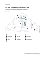
1
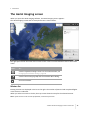
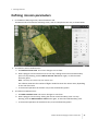
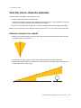
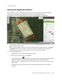
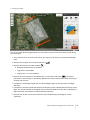
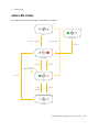
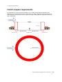
4 Completing a Flight
Note – To ensure smooth turns and limited headwind and tailwind during flight, it is important to
correctly indicate the prevailing wind direction.
b. If the scan area changes to orange, it indicates that the scan area or the additional +/- 200
m (+/- 656 ft) required for turns overlaps an avoidance zone. If the scan area is orange,
resize the scan area by clicking and dragging the corners, or move it away from the
avoidance zone.
3. Check the estimated flight duration for the selected flight. If the flight duration is shown in red,
resize the flight area on the map until the estimated flight duration is 50 minutes or less.
4. The GSD and Height fields show the values entered for the mission. If required, edit the height
for image acquisition for the flight, taking into account specific obstacles in the scan area.
Images are not acquired until the unmanned aircraft climbs to the specified height.
The value you enter in the Height field affects the GSD obtained for the images. For more
information, see GSD and height, page 23.
5. When you have finished making your changes, tap the Parameters tab.
Tips for managing completed flights:
l
To repeat a completed flight, select the flight in the list and then tap the Redo icon
.
Redoing a flight does not overwrite the flight data from the previous flight instance. You can see
and select each set of flight data in the Export wizard when you export the data for processing.
l
l
To delete a completed flight, select the flight in the list and then tap the Delete icon . This
removes the flight data stored on the Tablet for this flight, but not the images for the flight.
If you have not downloaded the log file for a flight, tap the Download Log File icon
post-flight checklist appears.
. The
Trimble UX5 Aerial Imaging Solution User Guide
47