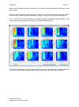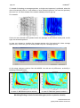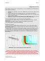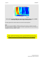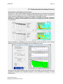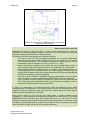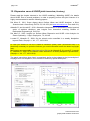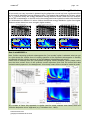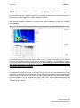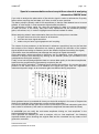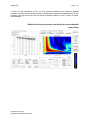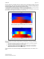
1
winMASW 7.0 beta User manual page 2 winMASW ® [intentionally left blank] www.winmasw.com geophysical software & services winMASW ® page 3 Copyright © 2014 All Rights Reserved www.winmasw.com geophysical software & services page 4 winMASW ® Table of Contents A brief foreword Chapter 1 - Surface Waves: propagation, dispersion and attenuation Chapter 2 - Data Acquisition (active and passive methodologies) Chapter 3 - Understanding Surface Wave Phenomenology Chapter 4 - Horizontal-to-Vertical Spectral Ratio Chapter 5 - Inversion and Joint Inversion: concepts and practice Chapter 6 - Full Velocity Spectrum inversion and other unconventional approaches Chapter 7 - Some final notes References Appendix – Case Studies A brief introduction Case study #1 – A simple ZVF analysis for geotechnical purposes Case study #2 – A simple but interesting dataset Case study #3 – Inverse dispersion by the book Case study #4 – When the joint analysis of Love & Rayleigh waves is necessary Case study #5 – Joint analysis of Rayleigh-wave dispersion and P-wave refraction Case study #6 – A comprehensive survey in the Swiss Alps Case study #7 – Joint analysis of Rayleigh and Love waves via FVS analysis Case study #8 – A typical civil engineering job Case study #9 – A landslide area Case study #10 – Back to the Swiss Alps Case study #11 – Modes and components (a very tricky site) Case study #12 – Analyzing phase and group velocities and HVSR Case study #13 – Some focus on HVSR computation Case study #14 – Surface waves on the Moon How to get it: store.elsevier.com A copy can be otherwise obtained together with winMASW Pro or Academy www.winmasw.com geophysical software & services winMASW ® page 5 winMASW Academy 6.1 (and successive releases) works only on computers with 64bit Operating Systems (OS), Windows8 included (and recommended). Other versions of winMASW 6.x (Lite, Standard, Professional, 3C) properly work on both 32 and 64bit operating systems (included Windows8). Previous winMASW releases (up to 5.2) work on any OS but windows8. For all the versions: all the releases from the 7.0 work only on 64bit Operating Systems. Definition of beta version A development status given to a program or application that contains most of the major features, but is not yet complete. Sometimes these versions are released only to a select group of people, or to the general public. The testers are usually expected to report any bugs they encounter or any changes they'd like to see before the final release. This is the second major stage of development following the alpha version, and comes before the release candidate. from wikipedia NOTE ON WORKSHOPS AND TRAINING Eliosoft is available for workshops and meetings aimed at explaining in details all the practical and theoretical aspects related to MASW (Rayleigh + Love), MFA, ESAC, ReMi and HVSR techniques. winMASW Academy is a highly-sophisticate tool which is impossible to fully/properly exploit without attending our training/workshops www.winmasw.com geophysical software & services page 6 winMASW ® Increase and Improve your equipment Eliosoft now also provides: 4.5Hz vertical and horizontal geophones (for MASW and ESAC acquisitions): remember that, for active MASW, Rayleigh (the radial component) and Love waves can be recorded using only horizontal geophones 2Hz vertical geophones (for ESAC and MAAM acquisitions - MAAM is a kind of mini-ESAC implemented in our HoliSurface® software application, see the article "Unconventional Optimized Surface Wave Acquisition and Analysis: Comparative Tests in a Perilagoon Area" Dal Moro et al., 2014) 3-component geophones (2Hz eigen frequency) for HVSR and optimized joint acquisition of ESAC and MAAM data (see previous article). 3-component HOLI3C geophone (a passive geophone to connect to your seismopragh) Vertical and horizontal geophones and the metallic tripod for working on asphalt cover Your clips: when you order your geophones, please remember to indicate whether your seismic cable accepts Split Spring or Mueller-type clips Split Spring Müller (or Mueller) www.winmasw.com geophysical software & services winMASW ® page 7 Main news in winMASW Academy 7.0 winMASW now recognizes automatically your CPU. Please activate the parallel computing as soon as you launch the software. For performing computationally-heavy analyses/inversions it is important to use a good computer (ideally a 12-core CPU - which means 24 virtual cores) Highly improved the Full Velocity Spectrum/a (FVS) performances in terms of computational load and precision of the solution –see the “system requirements” paragraph, the case studies available from our web site and the following paper: Surface_Waves_Joint_Inversion_via_FVS_Dal_Moro_et_al_2014 Definitive implementation of apparent/effective dispersion curves (e.g. Tokimatsu et al., 1992) for both Rayleigh (radial and vertical components) and Love waves. Use them for passive data only (ESAC method). HVSR modeling considering both Rayleigh and Love waves also considering attenuation and the α factor (Arai & Tokimatsu, 2004) (see Surface Wave Analysis for Near Surface Applications - Dal Moro, Elsevier) Implementation of the joint inversion of HVSR and dispersion (according to FVS or apparent dispersion curve) www.winmasw.com geophysical software & services page 8 winMASW ® Joint Analysis of Seismic Data Software for Surface-Wave analysis (MASW, ReMi, ESAC, FK and MFA), modelling and inversion of Rayleigh and Love waves dispersion, analysis of Rayleigh–wave attenuation for the estimation of QS quality factors, determination of the resonance frequency from microtremor analyses (HVSR, Nakamura’s method) and modelling of the H/V spectral ratio for improving VS vertical profiling in the deeper layers. Synthetic seismograms and Full Velocity Spectra (FVS) inversion (no need of picking/interpretation of dispersion curves). In order to receive our video tutorials and case studies please subscribe to our mailing list ([email protected]) www.winmasw.com geophysical software & services winMASW ® page 9 Fact sheet for the available versions Lite MASW analyses considering both Rayleigh and Love waves (and their joint inversion) HVSR Standard Rayleigh Waves only Vs30 calculation X Band- Low- High-pass filters X X 3C Pro Academy Rayleigh Waves only X X X X X X X X X X X X X X X Analysis of Rayleigh-wave attenuation to determine QS quality factors ReMi analyses (passive seismics) X Group-velocity Analyses (Multiple Filter Analysis) for group-velocity determination (both for Rayleigh & Love) Computation and modelling of the H/V spectral ratio (Nakamura’s method) to estimate the resonance frequency Spectral analyses: computation of amplitude and phase spectra and spectrograms (frequency content over time) X X X X only for P waves 1D modelling of refractions (also considering low-velocity layers) X X X X X X 1D modelling of reflections (also considering low-velocity layers) X Tool to combine two shots and simulate a dataset with a double number of channels (or three times, etc) (see Appendix B) X X X Elastic moduli calculation tool X X X Joint inversion of dispersion curve & HVSR X Synthetic seismograms both for Rayleigh & Love waves X Velocity-spectra inversion via synthetic seismogram computation: no need of dispersion-curve picking but longer computational times X Tool for the vertical stacking X Tool for creating 2D sections X Tool for putting in evidence specific (even “hidden”) modes X linear arrays ESAC and FK analyses (bidimensional arrays) Tool TCEMCD (Three-Component Extraction from Multi-Channel Data) for efficient passive joint ESAC + HVSR acquisitions: connect your vertical geophones and our HOLI3C (3-component geophone) to your seismic cable and with this tool you'll then be able to extract the data for the joint analysis of dispersion (via ESAC) and HVSR (see TCEMCD Appendix). Tool for combining several traces acquired by a single 3component geophone (using different offsets) and obtaining datasets useful for MASW analysis considering both Rayleigh (radial and vertical component) + Love waves. See the GEMINI2 geophone (http://www.holisystem.com - on line from January 2015) www.winmasw.com geophysical software & services X (2D) X X X X page 10 winMASW ® WARNING#1 Buy and use horizontal geophones and jointly analyze Rayleigh (radial component) and Love waves! Please acquire the data strictly following our guidelines and download and read the following collection of case studies: http://www.winmasw.com/brochure_winMASW_%20EAGE.pdf If you are not completely sure about the best type of equipment to buy (type and number of geophones and type of 3-component geophone for HVSR measurements) for analyzing surface waves, please write us ([email protected]) and we will give you our recommendations. REGISTRATION AND MAINTENANCE Do not forget to register your purchase: please provide the name of the reseller, the date of your purchase and the version (Standard, 3C, Professional or Academy). You will receive software updates and our newsletter. To register send an email to: [email protected] If you miss to register in 2 weeks from the purchase no assistance and no free upgrades will be provided during the first year (during which new releases of the software are provided for free) - an annual maintenance fee is required if you wish to receive successive updates. VIDEO TUTORIALS Updates of the present manual can be downloaded from our web site. In addition, it is also possible to download a series of video tutorials aimed at properly using the main winMASW features. The tutorials are focused on specific kinds of analyses: standard MASW analysis (Rayleigh waves), joint analysis of Rayleigh & Love dispersion, joint analysis of phase & group velocities, ReMi and ESAC analyses; HVSR analyses etc. Several helps are displayed just pointing the cursor on the button: a notice on yellow background will display providing basic information. Some of the pictures in the manual might refer to former versions of the software. All upgrades keep their same features, adding new functions. NOTICE Remember that a software is just a tool. Accuracy of results always depends on the users’ skills and experience. We highly recommend to attend to one of our workshops and/or visit us for the 1day training included in our offer. www.winmasw.com geophysical software & services winMASW ® page 11 Index Introduction ..............................................................................................................12 1. System requirements ...........................................................................................13 2. Installation ...........................................................................................................14 3. User License, key and assistance .......................................................................17 4. Use procedure: basics .........................................................................................18 4.1 Velocity Spectra, picking, modelling (dispersion and refraction): MASW, ESAC, ReMi, ESAC & MFA analyses (phase and group velocities)....................................21 4.2 Inversion of the dispersion curve .......................................................................64 5. Recommendations and advices ...........................................................................70 6. Results of the inversion of the dispersion curves .................................................73 7. Analysis of Love waves (Pro & Academy) ...........................................................78 8. Joint Inversion of Rayleigh & Love-wave dispersion curves (Pro & Academy) ....81 9. Analysis of the attenuation of Rayleigh waves (Pro & Academy) ........................85 10. Analyzing HVSR (3C, Pro & Academy) .............................................................96 11. Modelling HVSR (3C, Pro & Academy)............................................................105 12. Dispersion curve & HVSR joint inversion (Academy) ......................................110 13. Synthetic Seismograms (Academy) .................................................................112 14. Full Velocity Spectra (FVS) Inversion (Academy) ............................................117 15. Putting in evidence specific (even hidden) modes (Academy).........................124 16. Demo version and supplied data. ....................................................................126 Some references ...................................................................................................130 Appendix A: ...........................................................................................................133 Data acquisition for MASW, ReMi, ESAC and HVSR analyses .............................133 Appendix B: Combine 2 dataset ............................................................................139 Appendix C: Calculation of the elastic moduli ........................................................144 Appendix D: Vs30 and site resonance frequency ..................................................145 Appendix E: Creating 2D sections (Academy) .......................................................146 Appendix F: case studies, processing, etc ............................................................148 Appendix G: the Stesky's equation ........................................................................150 Appendix H: analysis procedures in brief ..............................................................151 Appendix I: Tool TCEMCD ....................................................................................153 Appendix L: Bugs ..................................................................................................155 Contacts ................................................................................................................156 www.winmasw.com geophysical software & services page 12 winMASW ® Introduction The winMASW software allows to analyze seismic data in order to achieve the vertical profile VS (shear-wave velocity) using the following methods: - - MASW analyses (Rayleigh & Love waves, also jointly) MFA (group velocities) analyses ReMi and ESAC analyses (we highly recommend ESAC) HVSR (Horizontal-to-Vertical Spectral Ratio) (recommended jointly with dispersion analyses) 1D (P and SH waves) refraction travel time modelling generation of synthetic seismograms via modal summation, consequently: inversion of the Full Velocity Spectra (FVS) with no need of picking/mode interpretation (pay attention since this anyway requires a good knowledge of several theoretical aspects and a state-of-the-art PC) Moreover: Rayleigh-wave attenuation analyses (for estimating QS quality factors) and much more Automatic inversion is performed via Genetic Algorithms, but we would like to underline that forward (direct) modelling is often preferred (see Chapter 4). Genetic algorithms represent an optimization procedure belonging to the classification of heuristic algorithms (or also global-search methods or soft computing) Compared to the traditional linear inversion methods based on gradient methods (Jacobian matrix) these inversion techniques grant a very reliable result in terms of precision and completeness. In fact, common linear methods give solutions that heavily depend on the starting method, that the user has to supply. According to the nature of the matter (inversion of dispersion curves) the large quantity of local minima draws the initial model to a local minimum that can really be different from the real one (or global one) In other words, linear methods require the starting method to be as close as possible to the real solution. If not, the risk is to be mistaken, and give wrong solutions. Genetic algorithms offer instead a wider search of possible solutions. Some details on foundations and functioning of genetic algorithms are available below: http://en.wikipedia.org/wiki/Genetic_algorithm http://www.talkorigins.org/faqs/genalg/genalg.html http://www.doc.ic.ac.uk/~nd/surprise_96/journal/vol4/tcw2/report.html The key point of winMASW is anyway represented by the possibility of joint analysis of several datasets/components acquired according the guidelines briefly reported in the Appendix A and explained in a series of articles and white papers indicated in the manual. www.winmasw.com geophysical software & services winMASW ® page 13 1. System requirements The winMASW software application works with all the recent 64bit Operating Systems (OS). It is important to frequently update the operating system (click on “windows update” from the menu Start on Windows) in order to let winMASW properly use updated functionalities. A minimum of 6 Giga RAM and 3 GHz CPU are recommended (see also paragraphs 4.2 and 5 about software performances in term of computing times). Operating systems: 6.x releases may have problems with windows XP (an old operating system already dismissed by Microsoft itself). winMASW Academy and HoliSurface work only on 64-bit operating systems while the other versions can operate on both 32 and 64-bit OS. Suggested OS are anyway win7 or, even better, win8 (64bit). If (Academy version) the user wants to deal with synthetic seismogram computation (and related operation such as the Full Velocity Spectrum (FVS) inversion) the heavy computational load requires up-to-date computers and we recommend a 6-core CPU at least (better more). www.winmasw.com geophysical software & services page 14 winMASW ® 2. Installation winMASW set up is automatic: just click on the appropriate installation file (for details please read the README.PDF file in the winMASW CD) and follow the simple instructions. PAY ATTENTION (for all Operating Systems, and especially for Windows Vista) According to some operative systems (Windows Vista in particular) the management of privileges and writing in some files is quite restrictive. It was noticed that (especially with Vista) installing the software outside the “system folders” (C:\Program Files, C:\Programmi e C:\Windows), that meaning inside dedicated folders (as for instance C:\winMASW o C:\geofisica\winMASW) can help sorting that matter out, avoiding consequent problems. Should you face any problem when launching winMASW (this usually happens with Windows Vista) first check the privilege details (by clicking the right key of the mouse on the winMASW icon on the desktop). It is necessary that the winMASW user has a writing privilege on the folder “winMASW/output” (if you set up the software as “Administrator” and then launch it with a different user this might not happen). If using Windows Vista it is strongly suggested to install the software in an external folder as “C:\winMASW”. ATTENTION If you install winMASW in a folder where former versions of the same software are kept all data files and analysis data will be deleted. Use therefore a different folder and/or make sure you previously run a back up. The winMASW application refers to Matlab libraries, simultaneously installed with the software (choose English as set up language): Should the graphic libraries Matlab already be installed in your Computer (winMASW 4.8 refers to the 7.15 (or later) version of MCRInstaller of Matlab) choose the option “modify” in following window www.winmasw.com geophysical software & services winMASW ® page 15 During the set up of libraries a message as follows might display: Just click on “Ok” , ignoring it! Firewalls and parallel computing If your firewall is particularly strict, it is possible that when you lunch the software a message like the following appears: This happens cause, in order to exploit all the workers/cores of your machine, it is necessary to perform some operation that must be explicitly allowed. So do not worry and allow that. Possible problems with some anti-virus systems Some anti-virus systems might be unable to manage the software protection based on the envelope system that protects winMASW. In this case it is possible that your anti-virus will warn you about a trojan in the winMASW.exe binary application. In that case just tell the anti-virus to ignore the folder where you are installing winMASW. Smarter anti-virus systems (we might suggest the free and excellent AVG) do not have such a problem which so far occurred with AVAST, AVIRA and Panda. Once the set up is done the icon winMASW will display on the desktop (the usual double click will launch the application) Also, a group winMASW is created on the Windows programs main menu (see snapshot): www.winmasw.com geophysical software & services page 16 winMASW ® www.winmasw.com geophysical software & services winMASW ® page 17 3. User License, key and assistance The winMASW software works by means of a hardware key (USB dongle). To know more about costs please ask the distributor or look up the web pages dedicated to winMASW in the ELIOSOFT web site (www.winmasw.com) In case the key gets damaged a new one only can be obtained after receipt of the damaged one and after the new key + its delivery expenses are settled. ELIOSOFT (as well as any software distributor) can’t be responsible for any improper use of the software due to misuse or misunderstanding or bad knowledge of the MASW/MFA/ESAC/ReMi methods. Possible advices/alternative interpretations of the software (the purchase of the license actually gives the possibility to achieve two different interpretations) forwarded by users are allowed to be used by ELIOSOFT for further teaching and exemplification purposes. Technical support is provided by e-mail ([email protected]) or on the phone (visit the website www.winmasw.com for updated information) Free of charge upgrades are available within the first year of purchase (new software versions). That time expired, a fix quote is requested according to both the date of purchase and to the version (standard or professional). The Routine to the calculation of the spectrum ratio H/V from body waves (as available in the 3C, Professional and Academy version) is bestowed to ELIOSOFT under license of Prof. Herak (University of Zagreb, Croatia) - further technical details are reported in the bibliography. REGISTRATION Do not forget to register your purchase: please provide the name of the dealer/seller, the date of your purchase and the version (Standard, 3C, Professional or Academy). You will receive software updates and advices on MASW, MFA, ESAC, ReMi and HVSR techniques. Send an email to: [email protected] If you miss to register in 2 weeks from the purchase no assistance and no free upgrade will be provided during the first year. Educational License Universities and Scientific institutions can ask for an Academic License being granted particular conditions. For info contact: [email protected] www.winmasw.com geophysical software & services page 18 winMASW ® 4. Use procedure: basics When winMASW is launched, a second DOS window more than the main one background displays, containing all information about analysis and operational proceedings. The very first thing to do is the activation of the Parallel Computing (see upper right part of the main window). This will allow a full exploitation of multi-core CPUs thus reducing the computational times required by some operations (this is particularly important if you deal with the computation of synthetic seismograms and related procedures such as the full velocity spectrum inversion). In the following the snapshot of the main winMASW window after the activation of the parallel computing (compare with previous snapshot). In this case we activated 7 “workers” but if your computer has a standard i7 CPU you can activate up to 4 cores (i.e. 8 threads) (to know the number of cores available in your computer, please have a look at its manual). www.winmasw.com geophysical software & services winMASW ® page 19 When determining the VS vertical profile (therefore the Vs30), the first step is the “determination of the velocity spectrum”. Then it is the turn of the direct modelling (suggested procedure) or of the (automatic) inversion of the interpreted (picked, by the user of course) dispersion curve. To do this, first go to the section “determination of the velocity Spectrum” (see paragraph 4.1), from the main winMASW window (shown below) In the Professional version it is possible to analyze the signal attenuation (of Rayleigh waves) in order to get the Q quality factors. In order to achieve it, first of all the reconstruction of the Vs vertical profile is necessary (see then paragraphs 4.1 and 4.2). Once this is done you can step on to analyzing the attenuation, in the relevant section (“attenuation analysis”). Now you can calculate the attenuation curve (i.e. the curve that, for each frequency, describes the amplitude drop of the signal according to the offset-that is the distance) of the signal relevant to the Rayleigh waves in the case of obtained data through the standard acquisition “vertical geophones and hammer”). After that you need to upload the formerly obtained Vs model (.mod extension file). Now it is possible to model or invert the observed attenuation curve, obtaining the Q quality factors. www.winmasw.com geophysical software & services page 20 winMASW ® The software has the following folder structure: Several documents (manual, examples etc). Documents In the sub-folder “videos” you can store the video tutorial you can download from our website (www.winmasw.com). Application The main applications are here. Please do not touch anything (you may create serious problems). Some demo data are stored in this data_disp folder data_HV Some HVSR data are stored here winMASW dispersion_curves Here some picked dispersion curves Output folder for attenuation output_att IO analyse. Output folder for dispersion output_disp (stands for analyses “Input/Output”) output_HV Default output folder for HVSR data processing remi_masw_spectra Spectra from ReMi analyses snapshots Folder to store snapshots Here you might save data useful for 2Dprofiles 2D velocity contouring (see “Creating 2D sections” Appendix) PLEASE NOTICE that if you store your field datasets in a certain folder (anyfolder, e.g. “Desktop/Berlin”), the output folder will be automatically created within your “working folder” (that you can set from the main or any other panel of winMASW). From any panel it is also possible to launch (if properly installed) Google Earth (icon ): We suggest to download our video tutorials (available since January 2011) in the winMASW/Documents/videos folder (then accessible from any panel – icon ). Manuals are also accessible from any panel (icons – for the English & Italian version). See video tutorials from www.winmasw.com (“publications” area). www.winmasw.com geophysical software & services winMASW ® page 21 4.1 Velocity Spectra, picking, modelling (dispersion and refraction): MASW, ESAC, ReMi, ESAC & MFA analyses (phase and group velocities) Important notice: just model, do not invert! Techniques based on the analysis of surface waves (MASW, ReMi and MFA methods) are more and more common, but some aspects related to their generation and propagation impose to proceed with caution, as it means determination of velocity spectra and picking of the dispersion curve we want to invert. This topic is considered for instance in the following papers: Dal Moro G. & Marques Moura R.M., 2014, Multi-component Acquisition and Joint Analysis of Surface Waves: Two Case Studies for Two Possible Inversion Strategies, submitted to J. Appl. Geophysics Dal Moro G. & Ferigo F., 2011, Joint Inversion of Rayleigh and Love Wave Dispersion Curves for Near-Surface Studies: Criteria and Improvements, J. Appl. Geophysics, 75, 573-589 Dal Moro G., 2011, Some Aspects about Surface Wave and HVSR Analyses: a Short Overview and a Case Study, BGTA (Bollettino di Geofisica Teorica e Applicata), invited paper, 52, 241259 Please also regularly visit the www.winmasw.com site (section ”publications”). From a practical point of view please consider the following: 1. It is absolutely untrue that the maximum energy related to the surface waves is necessarily associated to the propagation of the fundamental mode: many modes can coexist in a same dataset 2. It is absolutely untrue that higher modes only appear at high frequencies. They can instead exist at low frequencies as well and several “mode jumps” can take place. As a consequence, it is often advisable to replace the picking->inversion procedure with the “direct modelling” (see relevant section): searching the more logic coherence between energy distribution in the velocity spectrum (so far the only objective data) and theory dispersion curves from a model which the user tests and modifies, starting from prior stratigraphic knowledge and data (through the direct modelling procedures). www.winmasw.com geophysical software & services page 22 winMASW ® MASW Analysis First upload the common-shot gather. Execute it clicking on the icon top left, allowing to open the needed file (see the box regarding the supported format). Due to frequent and possible common shots mistakes, the user always need to verify that the input data (min offset, distances between traces, and so on) are correct and if necessary, correct them. According to the execution mode (order of the traces) it can be possible that the dataset be “inverted”. In this case you only need to click on “rotate traces” (see box “Rotate traces”) giving consequently an order to the data. Once the data are uploaded the next step is the calculation of the Velocity Spectrum, through the relevant homonymous button. The user has to input velocity and max and min frequencies (in other words, the limits of the velocity spectrum) (see picture 1a) The result will be similar to what you can see in picture 1b In the case you are not happy with the spectrum window (frequency-velocity interval) and you prefer to have a better vision of the area where the signal of interest is actually concentrated (the dispersion curve(s) related to surface-wave propagation), you can recalculate the velocity spectrum with new parameters, by clicking again on “phase velocity” (for MASW analyses) or “group velocity” (for MFA analyses). Since the input data here also will be considered for the spectrum as shown in the results window (see Picture 7a). we suggest to use such limits that can give a clear visualization without need to zoom in. Button “flip traces” Wrong lay out An erroneous disposition of the channels can give following common-shot gather (arrival times decrease as the offset increases). Click on the button “rotate traces” ( ) to obtain below lay out. Right lay out Right layout of traces (offset increasing rightwards) www.winmasw.com geophysical software & services winMASW ® page 23 Tool for removing traces from the uploaded dataset Upload a dataset: In this example the shot is “internal” to the geophone array (minimum offset -2.5) By clicking on the icon in the toolbar you will get the following panel: In the “traces to keep” box the user must insert the traces to keep by adopting the following syntax: first trace to keep : step : last trace to keep www.winmasw.com geophysical software & services page 24 winMASW ® In the following example we keep all the traces from 6 to 24 (all of them, since the step is 1) (please notice that by writing for instance “6:2:14” we would keep the following traces: 6 8 10 12 and 14 ) We first click on “show” to see whether the parameters we inserted are the right ones and once we are satisfied with the (new) dataset we just click “accept”. This way we get back to the main panel: Now the user can continue with the analysis (it is not necessary to save the new dataset in a new file, but it can be done using the “save” button in the “data selection” group. www.winmasw.com geophysical software & services winMASW ® page 25 a) b) Figure 1. Calculation of the velocity Spectrum. The limits of the window need to be entered: frequencies and velocities (min and max). www.winmasw.com geophysical software & services page 26 winMASW ® f-k spectrum In case the f-k option is activated the f-k spectrum will also be shown: Thus in case of picking or modelling it is possible to see the curve in both the domains (f-k and f-v): www.winmasw.com geophysical software & services winMASW ® page 27 Seismic data format winMASW can currently read the following formats: 1. segy format (.segy or.sgy). This is a standard format suggested by the Society of Exploration Geophysicists (SEG). 2. seg2 (.dat or .sg2). This is a well known “common gathering” format. Many of the current available seismometers use this data writing format (typically in the integer 32 bits or Floating Point 32 bits formats). From the 3.0 version the software can automatically recognize the format but, in order to correct possible mistakes of the seismometer, the user is allowed to “force” the format 3. SU format (seismic Unix). Traditional format (although not frequently used) 4. ORG format (.org): traditionally used by many OYO seismographs (integer 32 bits traditional format) 5. ASCII format (.txt or .asc formats). Some devices and software use the ASCII format (can be read with all text editors) where the columns stand for the different traces (in other words this is a m x n matrix, with m being the number of data and n the number of traces). Please notice that the first line reports: dt (sampling rate in seconds), dx (geophone distance in meters) , mo (minimum offset in meters). Example (dt 1millisecond, minimum offset 6m, geophone distance 3m): 0.001 3 6 2.89 -40.07 125.33 92.11 -86.07 -16.67 90.11 93.93 130.33 2.11 -151.07 99.33 -36.89 56.93 -77.67 10.11 15.93 126.33 51.11 -118.07 9.33 91.11 57.93 100.33 53.11 -91.07 43.33 4.11 10.93 -94.67 42.11 -1.07 11.33 … 27.35 76.92 -29.89 26.04 -55.37 117.62 -66.34 135.35 62.92 93.11 119.04 38.63 -124.38 57.66 161.35 94.92 170.11 111.04 127.63 -24.38 35.66 8.35 178.92 -8.89 72.04 -93.37 22.62 -21.34 121.35 33.92 171.11 14.04 63.63 -33.38 50.66 43.35 159.92 43.11 127.04 -0.37 95.62 -37.34 43.35 157.92 44.11 -29.96 -116.37 13.62 1.66 228.35 78.92 214.11 146.04 139.63 28.62 66.66 -30.65 139.92 -28.89 41.04 -56.37 75.62 -59.34 124.35 -54.08 190.11 -3.96 -22.37 -95.38 74.66 -24.65 1.92 37.11 117.04 -71.37 92.62 -40.34 6. Matlab format (.mat). Actually very similar to the former one, but written according to the Matlab protocol. It deals with a simple matrix and the user has to input relevant data to the sampling interval, the min offset and the geophone distance. 7. SAC format (big endian): a common format for seismological data (used for 1-channel dataset). www.winmasw.com geophysical software & services page 28 winMASW ® Numerical data format When uploading data it is very important the format be correct (chose from a scroll menu like “Floating-point 32 bits”, “Integer 16 bits” etc.). If the format is not correct the visualization will be different from what you see in picture 1 for instance, where the seismic trace correctly displays according to the so called “wiggle” modus Herewith two more examples of the evidently wrong reading format are provided. winMASW automatically identifies the data format for a .seg2. By the way, there’s always the possibility to force the reading according to different formats, should the seismograph mistake on writing The - velocity domain When calculating the velocity spectrum the data can also be represented in the domain -velocity (just activate the option ”Tau-v” on the toolbar). The parameter is the intercepted time on the time axis and the operation is made by linear Radon transform. For very-expert users the representation of data in this domain can be useful for more considerations, even for teaching purposes. For more details we refer back to future versions of winMASW. www.winmasw.com geophysical software & services winMASW ® page 29 Possible effects of “short” datasets Problems related to a short acquisition time: in the picture over the dataset it is limited to the first 0,2 seconds, while the data below has been “zero padded” (zeros were added to the traces) in order to better determine the spectrum. In brief: gathering the whole trend of surface waves is not enough. Numerical factors impose long enough datasets. www.winmasw.com geophysical software & services page 30 winMASW ® Section “Select data” This section allows to select a specific group of datasets to further analysis. You only need to do the start up (start up button): a polygon will show. Stretching its angles you’ll select a specific area of data. Click on “Select” to cut the portion out, outside the polygon. The number appearing on the button right side is the number of the samples of the used ramp to cut the external data of the studied polygon out. In other words: the values inside the polygon stay the same, the external are set to zero. The number of samples of the ramp actually is the number of samples in the “transit” area. If too limited, different problems related to a sharp signal cut off might happen. The default value (20) adapt to most situations. Full complete Dataset: note the energy linked to higher mode (over than the fundamental). Selection of the signal to mark up the relevant section to higher mode/modes . NOTE: to proceed on with the analyses the new dataset does not need to be saved (“save” button). www.winmasw.com geophysical software & services winMASW ® page 31 Exploring the spectrum The button “explore spectrum” allows to visualize the velocity spectrum in 3D (on the left) also having (on the right) approximate VS values based on the “Steady State Approximation”. The goodness of such approximation is related to the specific site: in case you have strong VS variations (especially if already for shallow depths) the values given by such approximation are not reliable. In other words the approximation is reliable only when the VS gradient does not vary abruptly. www.winmasw.com geophysical software & services page 32 winMASW ® ReMi Analyses From the main panel, by clicking on the “ReMi spectra” button, you can access the section dedicated to the analysis of those spectra obtained by analysis of passive seismic data (seg2 and segy format) Clicking on “input file(s)” you’ll select the relevant file to ReMi acquisition (passive seismic) (see relevant appendix) You can simultaneously upload more files (typically 65 seconds long) by keeping the key CTRL pushed while selecting the wished files to consider. These need to have all same acquisition parameters: geophone distance, sampling interval and length. In order not to overload the computer memory we suggest not to upload more than 5 dataset at once (for instance 65 seconds long each, such value depending anyway on the computer features, therefore even longer) Once the geophone distance, as used in the acquisition phase, and the length of the window to consider are set (the same “sampling rate/interval” can be modified but the read and proposed value is likely to be correct every time and you can modify it only if the seismograph really has some problems or you are confident you’re doing the right thing; consider also that the length can be changed as many times as you need to reach better spectra) you just need to click on “spectra calculation”. At the end of all operations a window like the one below will show. The software splits the dataset (or datasets) in many windows of equal length like the one indicated by the user (the value must rank between 2 seconds and the length of each single dataset) According to the ratio between the dataset and the window dimension, different windows could show like the one displayed on top. The user has to select the best defined spectrum by means of the little button on the right side below of each spectrum. The chosen spectrum in the screen will be displayed again on the top left side of following screen (achieved clicking on “next window” or “save selected spectrum”). www.winmasw.com geophysical software & services winMASW ® page 33 When the last window finally is reached, you’ll save the selected spectrum clicking on that same button. Once the clearer spectrum (therefore more useful to our analysis) is saved, we’ll get access to the module “Velocity spectra, Modelling, Picking” clicking on “Analyze saved spectrum”. Here, in section “#2: velocity spectrum, modelling & picking (MASW & ReMi analyses)”, we’ll upload the just saved spectrum clicking on “upload ReMi spectrum”. The last three plots refer to the average spectra: the first 2 related to the 2 possible direction (so to say: one from left, the other from right), the last one is the total mean spectrum. www.winmasw.com geophysical software & services page 34 winMASW ® If, instead of choosing an average spectrum, a single-event spectrum is preferred, when the user will eventually click on “next window or save selected spectrum” (to save the spectrum) the event (i.e. the time window of the seismic dataset) will also pop up. For instance: On the left the selected event (please notice the passage of the surface waves) and, on the right, the selected spectrum. In case you choose to visualize the average spectra only (just select the “show average spectra only” check box) you will clearly obtain only the 3 average spectra: At this stage analyses continue like with MASW, but with an only difference, as briefly in following scheme/principle: In case of MASW data (active seismic) In case of ReMi data (passive seismic) Modelling/Picking Criteria for both data types (active or passive seismic) www.winmasw.com geophysical software & services winMASW ® page 35 Suggested procedure If you need to “improve” the VS vertical profile you can put a MASW and a ReMi acquisition results together, as follows: 1. determine the dispersion curve from MASW trial and save the picked curve (file.cdp) 2. Analyze ReMi data (save the clearest spectrum- see procedure like before) 3. upload the picking curve of the MASW data (button “input curve” top right in the section “visualize curves”) 4. proceed with the picking of the Spectrum from ReMi analysis as done with the MASW one (the aim is to find some more points at lower frequencies) In the file “data/Lamporecchio” you’ll find some useful data exercises: - file for Rayleigh-wave MASW analysis (Lamporecchio_MASW_vertical.sgy – vertical geophones) - file to Love-wave MASW analysis (Lamporecchio_MASW_horizontal.sgy) - file to ReMi analysis (Lamporecchio-ReMi.sgy) Following two snapshot. The first is relevant to MASW analyses (with picked curve – due to the spectrum type we’ve picked up to about 6Hz, as at lower frequencies a trend reveals an intervention of the first higher mode); The second (below) is relevant to ReMi analyses: laying over the picked dispersion curve on MASW data. You’ll notice that, compared to the ReMi spectrum, this is now laying on the “inferior limit” of the signal (and not on the peak as it happens with MASW data). On this spectrum another point at about 4Hz frequency is now added and phase velocity of about 320m/s MASW data: traces, velocity spectrum and picked curve Please consider that, considering passive acquisitions, we recommend ESAC (rather than ReMi): thanks to its bidimensional acquisition array ESAC is in fact capable of handling the directionality of the signal and its mathematics has in general better performances compared to linear ReMi www.winmasw.com geophysical software & services page 36 winMASW ® Velocity Spectrum from ReMi data: note how the formerly picked curve on MASW data stays along the inferior edge of ReMi spectrum. See also Appendix A for advices about the criteria for data acquisition. Note: We do not recommend MASW + ReMi as decisive tool to retrieve a “perfect” VS profile. The best procedure for obtaining a robust VS profile is represented by the joint analysis of Rayleigh & Love-wave MASW + HVSR. Please consider that because of a series of technical aspects (the main one is probably related to the directionality of the signal and all its consequent problems) we highly recommend to use the ESAC methodology and not the ReMi one. www.winmasw.com geophysical software & services winMASW ® page 37 ESAC and F-K analyses These methods are particularly suited for the analysis of passive datasets acquired while adopting bidimensional (2D) geometry. That means that geophones are planted not in a straight line but following 2D geometries (circles, L-shaped, crosses or "random" distributions). Some relevant points - the possibility of analysing data acquired by means of a 2D geometry allows to overcome the directionality problems which afflicts ReMi methodology. - there's no "ideal" geometry. The way you are able to disseminate your geophones depends on local conditions. The easiest geometries are clearly those that require the minimum effort (L-shaped or crosses); often the circular one is the most difficult (please consider that the location/coordinates [x,y] of the geophones must be accurately reported). The origin of the Cartesian system to adopt is absolutely irrelevant, so your [0,0] point can be anywhere. - since these methodologies assume the planewave condition, it is important that the main "sources" are distant enough to meet such condition (consequently do not use these methods for analysing datasets acquired considering a nearby active source) www.winmasw.com geophysical software & services page 38 winMASW ® Main panel of the ESAC-FK module In the upper-left area it is possible to insert the [x,y] coordinates (which can be actually written/saved in a simple ASCII file - see next pages for the format). In a further line ("channels to remove") it is possible to indicate traces that we want to exclude from the analysis (for instance because too noisy). Positioning of the channels (pay attention) Coordinates of the channels/geophones must be clearly accurately reported. Non-expert users (not familiar with their own seismographs) can reverse the position (i.e. they may think that the channel#1 is the channel#24 and viceversa). A simple way to verify the actual channels is to perform an active acquisition as well (this way the arrival times of the surface waves will confirm the positions). Registered winMASW users will receive further documents to verify if everything is fine by analyzing some outputs/plots provided by winMASW and capable of measuring the overall consistency of the analysis/assumptions. In the upper-right corner user can set the parameters to adopt for the ESAC/FK analyses. In the lower area of the main panel: - on the left, in addition to the resampling option (which is absolutely recommended), there are some buttons to manage/visualize the data and the channel map; - on the right are reported the buttons to manage the obtained dispersion curves and pseudoi velocity spectrum. Options "verbose" and "f-k analysis" nearby the "compute" button (to launch the computation): - by default only ESAC analyses are performed, but the "f-k analysis" option will activate FK analysis as well; - by activating the option "verbose" you will obtain a series of "intermediate" outputs useful to check the data quality etc (see next pages). www.winmasw.com geophysical software & services winMASW ® page 39 Data acquisition - record length: how long should be a dataset to safely perform this kind of analysis? There is no magic number for it since it depends on the site (its stratigraphic conditions and the level of seismic "noise" we intend to use). As a general rule 5 minutes can be sufficient but it is definitely better to acquire at least 10 minutes. - number of channels: a reasonable number is 16-24. It is essential a good distribution covering different distances/wavelength (short wavelengths will "see" the shallow levels while long wavelengths will penetrate deeper - geophones do not have to be equallyspaced). The following plot report an example of a possible (and easy to manage) geometry (Lshaped). From winMASW 5.0 Academy some procedures - ESAC and FK are among these - exploit parallel computation, so using a multi-core computer a significant reduction of computational times is obtained. Very roughly, the reduction is proportional to the number of cores (if you have a 4-core computer your computational times will be reduced to about 1/4 of the times necessary to a single-core machine). Since these techniques are particularly useful for retrieving the dispersive properties at the lowest frequencies, it is important to underline that the equipment should be properly set (good seismograph and low-frequency geophones - minimum 4.5Hz). In the following an example of dataset acquired adopting a L-shaped array characterized by a limited length (maximum radius (distance between geophones) only 58.25m): www.winmasw.com geophysical software & services page 40 winMASW ® Please notice the "signal" between 15 and 25Hz (phase velocity between 100 and 200 m/s)m which is due to aliasing phenomena and consequently has no relevance for our purposes. We can also notice that, as remarked by several authors (e.g. Rosa-Cintas et al., 2011), at the lowest frequencies FK method tends to identify higher velocities with respect to ESAC. The following plot reports the kx, ky diagrams for some frequencies (FK method). The following plots report the results obtained by reducing to 15 the number of channels of the above-presented data (originally composed of 23 traces). www.winmasw.com geophysical software & services winMASW ® page 41 Please notice that the reduction of the adopted traces reflects in an increase in the aliasing phenomena (compare the plot with the one presented while using all the 23 traces). As for any passive acquisition (where the signal amplitude is quite low), those who have an "old" seismograph (with a limited dynamic range), it is important to set a sufficiently-high gain (clearly avoiding signal clipping). Sampling interval/rate: 2ms (500Hz) are absolutely sufficient (we assume that your seismograph has a good anti-alias filter). If you acquire with a higher sampling frequency, in order to avoid uselessly-higher computational times it is recommended a re-sampling (by default winMASW does propose/does that - see option in the lower left corner). New in winMASW 6.x Available two new tools for "cleaning/selecting" the data ("clean data" button) and save them ("save data" button). Please be aware that for ESAC analyses the cleaning process is somehow opposite to the one adopted while performing HVSR analyses. While in HVSR analysis we generally prefer to remove single/transient high-amplitude events, here in ESAC analyses we generally prefer to do the opposite: we keep the large-amplitude events and remove the so-to-say background. Examples and case studies will be disseminated though our newsletter www.winmasw.com geophysical software & services page 42 winMASW ® Understanding the data quality By evaluating our spatial correlations (ESAC method) it is possible (to some degree) to understand the overall quality of our data. The following plot reports hi-quality data (blue dots represent observed correlations, red data are the best-fit Bessel functions). Next plots report the same quantities for a lower-quality dataset (same data presented in the previous box), which depends on several factors: site characteristics in terms of both lithology and environmental noise/signal, length of the array (and positions of the geophones, quality (and setting) of the hardware equipment (seismograph, geophones, cables etc.). www.winmasw.com geophysical software & services winMASW ® page 43 Data input and parameters It is possible to upload several datasets together (as common in Windows, to do it is sufficient to use the ctrl button). In fact, some seismographs can record at the most 1 minute: by recording several datasets (each for instance 1-minte long) it is then possible to acquire a sufficient amount of data to perform all the analysis based on passive acquisitions (ReMi, ESAC, FK) (most of the times 15 minutes are enough). Some points: The "Resampling" option: to reduce the computational times it is absolutely recommended (this option is active by default but can be de-activated). Computational load for the FK method are higher than for ESAC and strongly depend on the adopted parameters. We recommend to consider frequencies not higher than about 30Hz. High frequencies are in fact better imaged via active - MASW - acquisitions and analyses. The lowest useful frequency depends on the array length/dimensions, the characteristics of the site and on the eigen frequency of the used geophones. The positions of the channels/geophones can be reported manually in the pertinent windows or can be written in a simple ASCII file according to the syntax indicated in the following box (the file must have a header line and the .pos extension). File ASCII (.pos extension) Xcoordinates -48 -44 -40 -36 -32 -28 -24 -20 -16 -12 -8 -4 0 0 0 0 0 0 0 0 0 0 0 Ycoordinates 0 0 0 0 0 0 0 0 0 0 0 0 3 6 9 12 15 18 21 24 27 30 33 Outputs: by default it is computed (and saved) only the ESAC dispersion curves and its respective "pseudo velocity spectrum" (this is just the misfit between the observed correlations and the values obtained by the Bessel function computed for the different phase velocities). If you activate the "f-k option" the respective dispersion curve (.cdp file) will also be computed and saved. The "verbose" option will provide further "intermediate" outcomes such for instance the kx-ky plots etcetera. www.winmasw.com geophysical software & services page 44 winMASW ® Outputs Log file, images and files automatically saved (in the "working folder") When the analyses are accomplished, in the working folder you will find the following files (automatically saved): logESACFK.txt (log file summarizing the performed operations) ESACdc.cdp (dispersion curve saved as effective curve - Tokimatsu et al., 1992): since - compared to modal dispersion curves - the computation of the effective curve requires heavier computational load, its automatic inversion requires state-of-the-art PC (recommended an esacore CPU). ESACpsvelspe.mat (pseudo velocity spectrum determined through the ESAC analyses) snapESACFK.png (snapshot of the main panel with the resulting spectrum and the dispersion curves) If you activated the "f-k analysis" option you will get: FKdc.cdp (dispersion curve determined through the FK analyses) Moreover, if you activated the “verbose” option you will also get the following files: CrSpVsFr.png (+ .fig): Cross-spectra versus frequency ESACdata.png (+ .fig) 2Dpassivedata.png (+ .fig): data, channel positions, radii fk8frequencies.png (+ .fig): 8 [kx,ky] plots (for 8 frequencies - FK method) Remember that the.cdp files are simple ASCII files which can be uploaded in winMASW ("input curve" button - see next pages). www.winmasw.com geophysical software & services winMASW ® page 45 ReMi spectra and ESAC dispersion curves In the ReMi panel (where purely-linear arrays can be analyzed) it is possible to activate the ESAC option. By doing that we will obtain an overlap of the ReMi spectra and ESAC dispersion curve. Dataset "Purgessimo" (provided as example dataset together with the software winMASW 5.0 and later). Analyzing just a couple of files (total length 2 minutes) we obtain a clear evidence of a mode jump (which is absolutely not so common while analyzing passive data, but which is absolutely good for our analysis). By analysing the entire dataset (more than 10 minutes) we get the following data: In both cases the lowest frequency which is actually possible to safely consider for the ESAC dispersion curve is about 3.5Hz (below this value the velocity decreases, losing its "meaning"). It is very likely that analyzing a non-linear (i.e. bidimensional) array with longer radii, such lowest frequency would decrease thus allowing the reconstruction of the VS of deeper levels. Pay attention: these evidences cannot be generalized. The aim of these notes is to help the users to get familiar with data, analyses and phenomena. www.winmasw.com geophysical software & services page 46 winMASW ® Rayleigh and/or Love? These methodologies can be easily used for determining the dispersive properties of Rayleigh waves, by considering the vertical motion (which is not influenced by Love waves). In order to analyze Love waves (in the horizontal plane), things become more complex (see e.g. Tokimatsu, 1995; Di Giulio et al., 2006; Kohler et al., 2007). We then suggest to all the newcomers to deal with Rayleigh waves (all the registered winMASW users will receive details on the best procedures to analyze Love waves according to the ESAC approach). Integrating MASW and ESAC dispersion curves and some recommendations ESAC is useful especially in the low-frequency range (active methods such as MASW or MFA can instead better perform in the high-frequency range). Anyway a crucial point to properly image the low-frequency dispersion curve is the total length of the array. ReMi and ESAC (or any other array-based passive method) cannot be properly used if you consider short arrays. As a consequence, if your array is less than about 70m (but possibly much longer) passive techniques are quite useless and it is better to go for a joint MASW+HVSR analysis. Please remember that ESAC is superior to ReMi fundamentally because - thanks to its bidimensional acquisition - better handle the directionality of the signal: do not forget than to set a bidimensioanl array! ESAC analyses performed while considering linear arrays makes little or no sense at all. The following snapshot shows a MASW velocity spectrum with, overlaying, the ESAC dispersion curve: it is quite clear that the ESAC analysis allows to "see" frequencies lower than the ones possible while considering the MASW acquisitions. On the other side MASW data see much better the high frequencies. So they mutually integrate. Almost useless to remark that the results of your analysis depends first of all by your expertise/skill both from the theoretical and "practical" points of view. Please consider that because of a series of technical aspects (the main one is probably related to the directionality of the signal and all its consequent problems) we highly recommend to use the ESAC methodology and not the ReMi one. www.winmasw.com geophysical software & services winMASW ® page 47 MFA (Multiple Filter Analysis) (Academy version) Version 4.7 improves the method MFA (Multiple Filter Analysis) method (e.g. Luo et al., 2011) (previous implementation was more sensitive to noise). This method allows to define dispersion curves for group velocities (not for phase velocities), anyway the procedures are in general absolutely similar to the ones adopted for phasevelocity analyses (MASW or ReMi). First (as usual) upload the common-shot gather (icon top left). Theoretically to perform MFA analyses one trace could be sufficient, nevertheless the resulting spectrum will surely result more robust when obtained as the average of several traces (we may suggest 3-6 traces at least). It is not possible to summarize in a manual all the characteristics and the pros & cons of a methodology, and we will limit the presentation to 2 points only: 1. the link between VSupPH (phase velocity of the surface wave) and VSupGR (group velocity of the surface wave) and VS (shear-wave velocities in depth) is different (in other words the relationship frequency – VS and frequency-VSupPH is different from the one between frequency – VS and VSupGR). 2. with respect to VSupPH, VSupGR seem (sometimes) more sensitive to VS variation in depth (see e.g. Luo et al. 2010). For these reasons we suggest the joint analysis MASW + MFA (+ possibly HVSR) (button “Joint Analysis of Phase & Group Velocities”). Parameters Alpha0 & Alpha1 The Gaussian filter used during MFA depends on 2 parameters: Alpha0 and Alpha1. There are no universal values suitable for any dataset as these values depend on the specific dispersive properties of the considered dataset. Anyway, thanks to some improvements present in the 4.7 version we would suggest 2 fix values: 120 and 0.01, respectively. It is also recommended a re-sampling to 1msec (see panel down here). www.winmasw.com geophysical software & services page 48 winMASW ® By activating the verbose option you will also obtain the 2 following windows. The first one reports the delays as a function of the offset while the second one presents the last considered trace (on the left) and the obtained velocity spectrum (on the right). Please notice that MFA analyses cannot be applied to ReMi-like acquisitions because in that case time and position (thus distance) of the source(s) is not known. In seismology it is possible to apply MFA technique only once the epicentre is defined, thus its time and position is determined with respect to the receiver. www.winmasw.com geophysical software & services winMASW ® page 49 The joint modelling is then performed in the usual way (see example down here): from the uploaded dataset it is computed the velocity spectrum representing the phase velocity (MASW technique) and the group velocities (MFA technique). Of course it is also possible to upload a H/V curve and perform a triple analysis: phase velocities + group velocities +HVSR. www.winmasw.com geophysical software & services page 50 winMASW ® -- Spectral analysis (in particular for active-seismic datasets) A tool for traditional spectral analyses is also available (calculation of an amplitude and phase spectra): button “Spectrum” in the group “filtering & spectra” Considerations must be done according to the selected component (surface waves only, refracted waves, air waves, etc), For instance, while analyzing surface waves only, you’ll notice the “erosion” of the high frequencies (i.e. the disappearing/attenuation of high frequencies at large offsets), due to geometrical spreading and viscosity (attenuation). The soil (especially if made of unconsolidated materials) acts in fact as a filter, thus attenuating especially the high frequencies (see the chapter dedicated to the attenuation of the Rayleigh waves). Here following the pictures relevant to the spectra of the first and last traces of the dataset test-attenuation2.sgy: 1. due to attenuation phenomena the amplitude of both traces is quite different (the peak related to the first trace is over 600, while it decreases to about 100 for the last trace) 2. compared to low frequencies, the highest result more attenuated www.winmasw.com geophysical software & services winMASW ® page 51 Here below the amplitude and phase spectra of the air wave: note the high frequency characterizing the signal (peak around 145 Hz). Consider the potentiality of this tool when selecting a data portion: if in that portion there are frequencies incompatible with the component you aim to isolate/investigate, that can be useful to redefine the selection polygon. Spectrograms In the “utilities” section the button “spectrogram” will give the possibility of computing the spectrograms of the uploaded dataset (trace by trace). This will allow the user to evaluate the spatial and temporal change in the frequency content due to seismic wave propagation and attenuation. www.winmasw.com geophysical software & services page 52 winMASW ® Picking of the dispersion curve To pick the dispersion curve (i.e to select those points that, according to the user, belong to a particular propagation mode of the surface wave) it is necessary to: 1. choose the mode from the scroll menu 2. click (left mouse button) the points along a certain coherence that the user identifies and understands as a particular “mode” (see example in picture 2) 3. save the picking If there are more datasets in our “mode”, just pass to the other one scrolling down the menu (once you’ve done and saved the picking of a mode). Different modes will be marked in different colours. The new data, relevant to the second mode, will be saved in the formerly indicated file. The final inversion will finally consider the whole of data. The picking file is a three columns ASCII file (.cdp-curve of dispersion in Italian): the first shows the frequencies, the second the velocities and the third the mode (as chosen by the user scrolling down the menu). We suggest to save the dispersion curve in the default directory “dispersion curves”. Picture 2. Picking of the dispersion curve www.winmasw.com geophysical software & services winMASW ® page 53 Identifying and picking the dispersion curve is of course an operation of crucial relevance for the final result. The user should have the necessary confidence to do that operation. A misunderstanding (curve profile or assigning the mode) could lead to inconsistent results. In order to have a clearer view on the dangers following article is suggested: Velocity Spectra and Seismic Signal Identification for Surface Wave Analysis (Dal Moro et al., 2006) e Possible Effects of Misidentified Mode Number on Rayleigh Wave Inversion (Zhang & Chan, 2003). “Picking” a too dense dispersion curve won’t give better results but a longer calculation time. We generally suggest to concentrate on not more than 10 couples of points (couple frequency-velocity). Basic structure of a picking file(.cdp) FREQUENCY (Hz) VELOCITY (m/sec) 15.9956 19.1886 17.9342 20.557 22.0395 25.1184 26.4868 28.3114 31.8465 www.winmasw.com geophysical software & services 1135.77 815.43 929.45 761.134 733.986 685.12 668.832 641.684 592.818 MODE 0 0 0 0 0 0 0 0 0 page 54 winMASW ® Visualizing different curves (picking or output curves) Clicking on the button top right of the screen you will visualize and compare different formerly picked dispersion curves (.cdp) and/or dispersion output curves (.cdo). They will show over the velocity spectrum in use. Button MOVIE From the 2.0 version the data can be seen in their animated version (button movie in the box "#1 uploading & processing"). In case of a good dataset it is possible to appreciate the propagation of the surface waves front (see the supplied dataset soma.sgv) www.winmasw.com geophysical software & services winMASW ® page 55 Modelling of the dispersion curve Beneath the velocity spectrum there is the section “direct modelling”, that allows the user to calculate the dispersion curves of a model up to seven layers whose parameters can be fixed by the same user clicking on the displaying menu on “parameters” The calculated curves are screen shown and saved on an ASCII file (Frequency- VR) in the file .modelladiretta.txt in the file winMASW/output. The aim is to get the evaluation of a possible mode in respect of an observed spectrum. In the case of geological complex situations (i.e seismic data of hard interpretation) this is a very useful method and generally the interpretation is enough (as an inversion is no longer necessary). It is clearly possible to fix different values of the Poisson ratio (in order to modify the ratio VP/VS): you’ll notice that the VP values (once the value of the VS has been fixed, as modifying the Poisson ratio means modifying the VP) are not that relevant if compared to the role of the thickness and shear-wave velocities (VS). a) b) Picture 3. Direct modelling: calculation of the dispersion curve (laid on the observed velocity spectrum) of a supplied model by the user. www.winmasw.com geophysical software & services page 56 winMASW ® About the final (deepest) layer: in the picture example below only 5 layers have been input (the last one being a semi-infinite layer and therefore without any thickness value - leave the value equal to zero). www.winmasw.com geophysical software & services winMASW ® page 57 3C, Professional and Academy Versions Joint analysis of Rayleigh and Love waves Since the 4.1 version both dataset relevant to Rayleigh and Love analyses can be jointly analyzed. For this reason the main winMASW screenshot displays a “group” dedicated to a joint analysis of Rayleigh and Love (“Joint Analysis of Rayleigh & Love”). Clicking on “Velocity Spectra, Modelling & Picking” the window containing uploading, picking and modelling of both datasets (one relevant to Rayleigh and the other relevant to Love) displays. Clicking instead on “Rayleigh & Love joint inversion” you’ll get access to the section aimed to the joint inversion of Rayleigh and Love dispersion curves Since the close analogy between the two of them, this chapter is going to show the only procedures involved in the standard analysis of one component, focusing on some features only www.winmasw.com geophysical software & services page 58 winMASW ® Professional & Academy Versions Joint modelling Rayleigh & Love: anisotropy VSH-VSV The window where model parameters can be input also displays a column for anisotropy VS. This parameter determines (supplied in percentage values) how bigger is the VSH (that rules the dispersion of the Love waves) than the VSV (that determines the dispersion of the Rayleigh waves) . www.winmasw.com geophysical software & services winMASW ® page 59 Resonance period (see also Appendix D) If the option “HVSR” is activated (see general settings of the modelling group) both the dispersion curves over a velocity spectrum and the chosen profile by the user with eigen period (and frequency) are displayed. The value of the “resonance frequency” can be determined by means of two procedures: #1. from the equation of resonance : Where both thicknesses and velocities VS of all layers over the bedrock (defined as the layer characterized by a VS ≥ 800 m/s) are taken in consideration #2. from the spectral H/V ratio resulting from the body waves (Nakamura approach, see Herak, 2008) (this last being available in the Pro version only) Compared to the procedure#1, consider that if the given profile has a last layer with a V S ≥ 800m/s this will be taken as bedrock, in the case this value is not reached, then the bedrock (i.e. the layer with VS ≥ 800 m/s) can be determined by the behaviour of the most superficial layers. Case in which the final semi-space has a VS < 800 m/s (the bedrock depth is in this case calculated according to the behaviour of the higher layers VS: in this case the last layer (the final semi-space) as indicated by the user has a VS of about 680 m/s We strongly suggest to always manually give the bedrock depth (both whether clear or supposed, by the way in the region of a VS ≥ 800 m/s). This will avoid poor meaning results. www.winmasw.com geophysical software & services page 60 winMASW ® Spectral ratio H/V from body waves In the Professional and Academy versions it is possible to compute the H/V spectral ratio and model it both according to body waves (Herak, 2008) and Surface Waves (Lunedei & Albarello, 2009). Click on the third little icon from left on the tool bar to upload the dataset relevant to that observed ratio H/V (the traditional yellow folder named HV) The software reads ASCII files and assumes that the first column reports the frequency and the second the spectral ratio H/V (possible “header” lines to be ignored and can’t affect the reading/analysis) In other words the file format is: line#1 (example of site name) line#2 (example of frequency sampling) … line#n F(Hz) 0.1 0.15 0.20 0.25 … 30 H/V 1.00 1.05 1.11 1.09 1.05 On the left the VS profile of the considered model with site eigen period as from the resonance equation; on the right the H/V ratio according to Herak (2008): if no relevant velocity inversion happens, the value determined by the equation and the one determined by the spectral ratio H/V are typically very close. If a formerly observed HV is uploaded, and a model for forward modelling is introduced and its dispersion curves are calculated (having selected the option “eigen period”) both the theoretical HVSR curve (in blue according to body waves and in magenta according to Surface Waves) and the observed curve (in green) are displayed. www.winmasw.com geophysical software & services winMASW ® page 61 Example of observed and modelled (both according to body and surface waves) HVSR. Some notes on the ratio H/V Regarding the nature of the ratio H/V (i.e. those events determining the value as observed in nature) the academic debate is quite lively (not only because of technicalscientific matters but also because of party interests) Following some of the most agreed upon general concepts: - The value of the H/V ratio as observed depends on a complex relationship between surface waves (both Rayleigh and Love) and partly on body waves. The relative importance of the different components depending on the site characteristic (see for instance Bonnefoy-Claudet et al., 2008). - Despite any chosen modelling, don’t ignore the role of quality factors Q (in our case we assume QS value to be the same as VS divided per 10, and QP=2QS) - When adopting different modelling types (i.e. based on only Rayleigh waves, or on Rayleigh and Love, or body waves or all of them together summed up) the spectral ratio changes but the main peak (determining the eigen period) appears at the same frequency, generally speaking. - From the only H/V value it is impossible to get any information on the VS (that’s why in this case you need to consider the MASW/ReMi values and compare) - It isn’t possible as well to directly compare the value of the H/V peak and the value of the lithologic amplification factor: to get this last we suggest to refer to the specific relevant regional rules or guidelines. To recap, if in possession of an experimental H/V value and needing to find a model considering both the dispersion of the surface waves and the H/V observed curve, we suggest to focus on chasing the right peak frequency without trying to find the perfect balance with the amplitude (the H/V value) Note as well (picture on top) that the H/V values allow to identify possible strong contrasts of VS deep underground (remember though that to constrain the VS you need MASW/ReMi values that can give clear details about the VS) and that it is most important to reproduce the correct frequencies when the peak shows. In the case on top for instance a strong discontinuity at about 60 cm depth is clear (it represents an alpine valley covered in a large quantity of fluvio-glacial sediments) www.winmasw.com geophysical software & services page 62 winMASW ® Modelling refraction (Pro & Academy) & reflection (Academy) This section allows the user to model the arrival times of refraction events by means of very similar procedures to those used in the” modelling of dispersion curves” section. Before starting consider that: - The adopted calculation tool allows the insertion of channels with inversion of velocity, a thing that the traditional refraction method (utilized as only method) can’t evaluate (this refers to the known problem of low velocity channel). In our case, making the most of all information from the dispersion curves and refraction we can evaluate inversions of velocity even according to VP (remember you can’t get solid information about it from the dispersion of surface waves). - Consider that in order to get a refraction effect of noteworthy amplitude the acoustic impedance jump (i.e the result of VP multiplied for the density) must be significant - a VP decrease according to depth doesn’t result in a refraction event - the file of the saved or uploaded model has the same format of the one used to model the dispersion curves. - If a modelling of the dispersion has preliminarily been executed (and therefore some V S can be predicted) VS as well as VSV and VSH will be considered as same when writing the refraction model (button “save”). In the opposite case in the .mod file, VS values according to an assumed Poisson value around 0.35 will be reported. As an example look below at a “joint modelling”. The same model is considered from a dispersion curves and first arrivals times point of view. Dispersion of the first three modes of the Rayleigh waves for the model top left In red the arrival times of two refraction events relevant to the 2 only interfaces having a positive impedance jump; in green the arrival times of a direct wave. In the Academy version also reflection travel times are shown. www.winmasw.com geophysical software & services winMASW ® page 63 New in winMASW 6.x Now, when the "Refraction" option is active, an AGC (Automatic Gain Control) is applied to the traces (its value - see value in the box just by the "reflr./refl." button - can be clearly modified). The value represents the window (in seconds) within which the energy is kept "constant" by modified the amplitude of the trace (in order to put in evidence low-amplitude signals usually associated with refraction event). Here two snapshots obtained using two different values (it is apparent that the second case allows a clearer identification of the refraction events): www.winmasw.com geophysical software & services page 64 winMASW ® 4.2 Inversion of the dispersion curve The second (and last) step to obtaining the vertical profile of the VS is the inversion of the formerly picked dispersion curve. Remember by the way that we suggest the direct modelling procedure (see Dal Moro, 2008). Inversion is made by means of an optimization process (genetic algorithms) that requires the computer a big calculation effort. The result is though more reliable and can give an estimation of the outcome reliability too (standard deviations). In picture 4 the main window of “inversion” shows, directly available from the main menu or the section “determination of the velocity Spectrum”. First step select the dispersion curve (formerly achieved) you intend to invert, clicking on (see picture 4). Of course, if you get in this section from the section “determination of the velocity Spectrum”, after the picking of the dispersion curve, the programme will directly upload the curve without therefore uploading the file where it was saved). Once data are uploaded, the dispersion curve will show in the window top on right. The dispersion curve you need to invert can’t be in the output file you’ll choose. The second step aims to optimize the inversion procedure. In fact, assumptions made in the automatic definition of the “search space” (VS values and thicknesses within which the best solution is looked for) can be different if the bedrock is readable or not deep down underground. If the velocity gradient doesn’t dramatically change (as it can happen in alluvial plains where the rocky substratum is quite deep or when the layering directly takes place on the rocks) the so called assumption /2 (or, as recent studies demonstrate, /2.5 – see relevant box) is valid, while in the case there is a significative variation in the gradient (when the bedrock is at scarce depth, let’s say between 5 and 30 mt), this is no longer valid and we need a different strategy to identify the “search space”. If the velocity gradient is constant we can assume an approximate /2.5 that, as mentioned, suggests that at a /2.5 depth a VS about 1.1VR (where VR is the velocity of the Rayleigh wave at a wave length v f ) displays. (actually, a ”correcting” factor balances according to the considered depth) The blue curve (Picture 5) represents that approximate value while the two red ones are to be read as max and min values. These values then depend on the number of layers the user considers to define the “search space” (in green, see picture 6) It is pretty obvious that, on the basis of the site knowledge, the user can modify the assigned values in order to get a faster and better research. In fact, the wider the space of the parameters, the higher the number of the individuals and generations to set in the genetic menu, while if we can limit the research space, these can be kept low (reducing calculation times). Then the user needs to choose the numbers of layers to use through the scroll down menu. Once done the window “parameters” (picture 5) shows, where the user has to put the “search space” . For each layer you need to input thickness and min and max VS you’d consider as possible for each of them. As in picture 5, the software can propose some values. Made assumptions in the automatic definition of “search space” (values of VS and thicknesses within which a solution is looked for) are different according to a constant or not constant velocity gradient. Once the limits of the search space are fixed (search space or parameters space) the parameters of the genetic menu can be input. (table 1). In order not to give the user irrelevant details, some “standard” genetic parameters have already been fixed (crossover and mutation rates). www.winmasw.com geophysical software & services winMASW ® Picture 4. Starting window of the section “inversion”. www.winmasw.com geophysical software & services page 65 page 66 winMASW ® Figura 5. Defnition of the search space. The user can modify it according to own prior knowledge of the geological site (see table A2 for typical VS values of random materials) Poisson’s ratio As known, the dispersion of the surface waves depends primarily on VS and thickness of layers. Since density and VP play a second role on that (try to play with different values of Poisson’s ratios in the direct modelling), their values only can be approximate ones. We generally need to remember that a solid rock can have a Poisson’s ratio between 0.15 and 0.30 (0.25 is the standard value), while soft materials (like silt and clays) value around 0.35 and 0.4. Sands get variable values (from 0.3 up to the theoretic value of 0.5): the issue is “the looser and inconsistent the material, the higher the Poisson’s value” (as said up to the max of 0.5, valid for fluids). Asphalt can be ranged a value around 0.2. Generally speaking, if no detailed information are at hand, it is advisable to choose a value of 0.25 for “healthy” rocks and of 0.35 in the other cases (0.45 in the case of loose surface sands). Anyway: when dealing with the energy distribution among different modes Poisson values (i.e. VP) play major role! (see appropriate box in the Chapter devoted to Synthetic Seismograms) Now it is time to launch the inversion (click on “run”). Calculation times are of course a function of the inversion parameters (table 1) but that should take about 1 minute any case. You can find some more about it in next paragraph “advices” www.winmasw.com geophysical software & services winMASW ® page 67 a) b) Picture 6. Search spaces if a deeper or more near surface bedrock is supposed than the max penetration of the signal. In the case of a surface bedrock the velocity of the last layer is defined at higher levels than those indicated in the approximation /2 (or, better, /2.5). www.winmasw.com geophysical software & services page 68 winMASW ® Inversion parameters Parameter Meaning Advised value Number of layers Number of layers used to rebuild the vertical profile Search space Value limits that each variable can have (thickness and VS of each layer) Number of individuals/models Number of generations Number of models constituting the number of people evolving to better solutions. The higher the number of layers, the more numerous the model to be considered. Number of generations through which new models are explored, that get better and better with time 4-6 Normally 4-5 layers , but 5-6 if a layer with inversion of velocity is suspected Once the number of layers has been given, winMASW proposes a wide range of values which the user can modify (generally limiting them) according to specific knowledge of the area. 30 30 Table 1. Inversion parameters. Max allowed VS anisotropy (in case of joint Rayleigh + Love inversion) In case of joint inversion Rayleigh+Love you can let the algorithm free considering VSH (from Love) different from VSV (from Rayleigh) (the number we herewith consider is the possible percentage difference between these 2 parameters). This may allow to mark some anisotropies up (see for instance Safani et al., 2005) or, easier, (for less expert users) to consider a sort of tolerance in the optimization/inversion process. Possible anisotropies only have a value according to the user’s experience. Therefore consider them in this view. Force the search space Setting this option up the software is allowed to search for other solutions than in the search space (VS and min and max thickness), as indicated by the user. This allows a better fitting shouldn’t the user have set right parameters in the search space. Non expert users should make use of this option. VP and density optimisation Setting this option up, the software, after the search for the best VS and thickness will modify the Poisson’s ratio (compared to those indicated by the user) in order to improve the fitting. Allow it. www.winmasw.com geophysical software & services winMASW ® page 69 Bi-objective space (in case of joint inversion Rayleigh + Love) If this option is active, a “full complete” joint inversion is processed. This means that during the optimization process each model misfit is calculated (both for Rayleigh and Love). In the opposite case optimizations come separately. This option slows calculation times a bit, but allows the expert user to check the distribution of models in the so called bi-objective space (refer to relevant literature on how to proceed) (Dal Moro & Pipan, 2007, Dal Moro, 2008; Dal Moro, 2009). Once launched the inversion a state bar will show both the passed and the remaining time: The procedure ends when following window shows up: www.winmasw.com geophysical software & services page 70 winMASW ® 5. Recommendations and advices General The dispersion of surface waves is a powerful tool to draw the vertical profile of the velocity of transverse waves (VS). Nevertheless, before using this software or others, you need to be confident with the field and with the use and evaluation of picking figures both for inversion and dispersion. It is really advisable to read more about and take part to conventions/workshops too. ELIOSOFT is available to organize such events. Visit www.winmasw.com and/or write to [email protected]. One more recommendation: before interpreting the velocity spectrum you better thorough check the data you’re analyzing (traces), according to the American acronym GIGO (garbage in garbage out): if you input garbage you’ll get garbage. The analysis of the surface waves is not a trick giving a solution even if data quality is low (or the user misunderstands them). Other signals, particularly the guided waves resulting from the presence of layers inside which the waves pass, can result in dispersive signals that the user is likely to wrongly read as surface waves. Besides, the different modes can interfere with each other and give misleading or wrong results. Inversion parameters The used inversion procedure as in winMASW is based on the so called genetic algorithms. This kind of approach lets the user obtain more reliable results compared to the traditional inversion methods based on the Jacobian Matrix and needs longer calculation times. Such times are evidently proportional to the number of individuals (i.e models) and of generations the user chose in the “genetic menu” (see Table 1 and Picture 4) The calculation times also proportionally depend on the number of used layers and on the data quantity (frequency-velocity couple) in the picking file (where the user saved the identified dispersion curve). Increasing the quantity of dispersion points to a number of about 10 won’t bring an effective better result but a longer (and useless) calculation time. Regarding the number of layers: it should be given on the basis of prior geological knowledge. In normal conditions 7 layers are enough, while more strata are sometimes necessary. www.winmasw.com geophysical software & services winMASW ® page 71 Advice#1: number of models and generations The number of individuals/models and generations to adopt has to be proportional to the algorithm effort to achieve a good solution. Parameters then have to balance the number of considered layers (more layers= more freedom for the system and higher computing effort) and the amplitude of the “parameters space”. The search space can be set by the user according to prior geological and stratigraphic information, and to the known VS of the most common lithological types (see Table 2 in relevant appendix). If a site stratigraphy is known (and layers thickness is as well) these can be set in order to give VS. a wider range. This is a way to reduce the freedom of the system and the numbers of individuals and generations to consider too. In a typical case (7 layers with search space similar to the one the software automatically proposes) the pair 60-60 can be a reasonable choice. Advice#2: search space The search space has to be fixed on the basis of the prior geological knowledge. If these are limited, a wide search space is needed, together with a higher number of individuals and generations. If you start the option “force search space” the programme can start searching for the best model apart from the user’s given limits (advised in case of non expert users). Advice#3: get acquaintance with the method, its potentials and limits Upload a dataset and calculate its velocity spectrum. Try to reproduce the observed data introducing models in the section direct modelling. Modify a parameter at once and note how curves change. What happens if you increase the depth of a fast layer? What happens when inserting a velocity inversion in depth? What is the ratio between the VS layer, its depth and phase velocity of the wave observed on surface? These kind of trials and exercises (see the direct modelling) are very helpful to get confident with the methods. www.winmasw.com geophysical software & services page 72 winMASW ® Advice#4: number of layers to use We suggest to use 7-8 layers. You can use more under specific complex stratigraphic situations, when low velocity channels are present (velocity inversion). It isn’t advisable to use less than 4, even if in front of a very simple situation, as for instance when a debris/alluvial layer lays over rock, because: 1. the rock (however healthy) has an altered surface with lower geo-mechanical qualities then the deeper part inside 2. in such situation also a modest debris stratification of the surface can be important when it comes to analyze the dispersion of the surface waves. To end up, we can’t forget to focus on the fact that in those situations (limited, scarce materials over others with a really higher VS ) guided waves of wide amplitude can take place, that can be mistaken for surface waves, since their dispersive features. Be suspicious of any unexpectedly high propagation velocity (a value about the double you’d expect) that needs to be related to guided waves whose propagation depends on the VP but not on VS (see Robertsson et al., 1995; Roth & Holliger, 1999). Since the 4.0 version you can use a former tested and saved (.mod) model (whose curves are in accordance with the velocity spectrum you observed) as starting model to get the inversion of the dispersion curve. If you use this method (option#2 for the inversion) that model can become the starting point for the optimization and solutions in a VS interval and thicknesses (modifiable by the user) with value around that one. This method results very useful when in front of a stratigraphy with strong acoustic impedance contrasts, for which the traditional approximation would be a wrong starting model (on which the automatically suggested search space is based). www.winmasw.com geophysical software & services winMASW ® page 73 6. Results of the inversion of the dispersion curves Results are supplied both graphically and as text files (.txt and .html format, see table 2) and are automatically saved in the folder “output” (or any other file as chosen by the user). Every time the user launches the programme all files in the output folder go deleted. Therefore, if you keep your results in the folder “output”, save the inversion files in another one (named as wished). You’ll notice two models: the “best” model (in terms of lower misfit, i.e the discrepancy between the observed and the calculated curve) and a medium model calculated by means of MPPD (Marginal Posterior Probability Density, see ref. “Rayleigh Wave Dispersion Curve Inversion via Genetic Algorithms and Posterior Probability Density Evaluation” – Dal Moro et al., 2006). Consider this as your final result (however the two models don’t differ significantly). The final screenshot (Picture 7) displays different information. Top left the observed data, the curve of the best model and the medium one-often the two curves are one over the other therefore not clear. Below you can see the graphic “misfit-generation”, that gives evidence of the improvement of the model according to advancing generations. On the right, the VS profile according to velocity. Since version 3.0 we can see the profile up to at least 30 mt. The max depth of the signal penetration can anyway be lower (such theoretic value is in the file winMASW_report.txt). Finally (bottom) the average VS up to 30 mt is given, for both final models (the “best” and the “medium” (VS30 is the fundamental technical parameter as requested by regulations). Quality of inversion 2 aspects can determine a good or bad quality: 1. picking a logic dispersion curve 2. properly setting up the inversion (numbers of layers, VS variability range and thicknesses, number of models and generations) The bad quality of an inversion can really depend on different factors and experience can be of great help. Maximum penetration depth This value is the outcome of the relationship between velocity and the frequencies represented in the dispersion curve. Always deeper layers influence as a matter of fact always lower frequencies (wider wave lengths) so that the lowest frequency will determine the higher depth of penetration. This value is determined by the approximation /2.5 (or /2), therefore it only is indicative. Example: If for your dispersion curve the value of the phase velocity (VR) corresponding to the lower frequency is 500m/s and the frequency is 6Hz, the max wave length will be 83 mt and, consequently, the max depth of penetration will be between 35and40 mt. www.winmasw.com geophysical software & services page 74 winMASW ® a) b) Picture 7. Final screenshot (automatically saved in the “output” folder). If you get in the section “inversion of the dispersion curves” after the analysis of the dataset in the section “determination of the velocity spectrum” you’ll get a picture similar to the one on top (case a), In this case you can associate a curve to the relevant spectrum. If you instead get in the section “Inversion of the dispersion curves” directly from the main winMASW screenshot, uploading a formerly picked curve, that won’t be possible, and you’ll get a picture like the one below (case b) (there is no velocity spectrum on the background of the dispersion curve). The solution on top is to prefer (if not necessary) (a) www.winmasw.com geophysical software & services winMASW ® page 75 Figure 8. Example of final result: mean and best models (in green the adopted search space) As an example, in Figure 9 you can see two examples of inversion obtained on a synthetic 6 layers model. Left, the result of the inversion when using 6 layers, right the result when using 10. www.winmasw.com geophysical software & services page 76 winMASW Results_winMASW.html winMASW_report.txt curve_mode_fundamental.cdo (and/or possibile higher modes) Text file model.mod Deepsoil modelLINEAR.dp figure.* Pictures stratigra.png period.png ® This file (in html format to be readable with any internet browser too) files all useful information to evaluate results and classify soils according to the Italian regulations The full complete report on operations and results: detail information are also present (of scarce interest for the final user) Dispersion curve of the model (medium) got by inversion. The first line reports the name of the picking file used to invert. File with resulting medium model (can be used to visualize the dispersion curves over the velocity spectrum, observed in the section “direct modelling” in its relevant part) Output file (medium model achieved through inversion of the dispersion curves) ready to be read and used by Deepsoil (freeware software to estimate the site response to seismic stress): see http://www.uiuc.edu/~deepsoil (see further on box) The screenshot displaying at the end of the inversion (observed and calculated data, graph misfit-generation and vertical profile of S waves velocity-Pict. 7). .fig format comes from Matlab Picture in the stratigraphic column showing VS, values, density and thickness of the final model (considered the medium model). Picture resuming the model and indicating the site eigen period on the basis of the equation resonance (see paragraph on the site eigen period). In the Professional version the same H/V spectral ratio is shown (its peak is the eigen site period). Table 2. Output file automatically saved in the “out” folder (default one is the "…\winMASW\output"). In this “out” folder there’s the considered picking file too. VP, density and elastic moduli After the 3.0 version the user can get the estimation of density, VP and of some elastic moduli. Since the dispersion of the Rayleigh waves essentially depends on VS and on the thickness of layers (i.e. on geometry), such density and VP values (and consequent elastic moduli) can be viewed as approximate only. Nonetheless, they don’t depend on VP but on density and VS only, the value of the shear modulus (see appendix C) is of course a good estimation. Notice that if using Love waves you’ll get that modulus only (as the others depend on the VP , that has nothing to share with the dispersion of Love waves). www.winmasw.com geophysical software & services winMASW ® page 77 Figure 9. Example of results for a synthetic model. For the inversion on the left 6 layers were used, for the one on the right 10 (in pale grey the search space) Output file stratigra.png: medium model stratigraphic column (VS, density and thickness). www.winmasw.com geophysical software & services page 78 winMASW ® 7. Analysis of Love waves (Pro & Academy) Love waves are generated by a shear wave source (the traditional transversal hammer blow to a layer of geophones) and, since the transversal movement, they need the use of horizontal geophones (for SH waves), transversal to the former mentioned layer to be recorded. It is another kind of surface wave that generally responds to the same rules of the Rayleigh waves. The only big difference is that these waves appear only in the case of a positive velocity gradient (i.e. only if between layer n and layer n+1 (deeper) velocity increases). Besides, Love waves only respond to VS, thickness and density of the mean: VP, already of scarce importance to Rayleigh waves, is now fully pointless. It is obvious that achieving and elaborating dataset from both (see Appendix A) is highly recommended (see Dal Moro & Ferigo, 2011). Do not forget, by the way, that nature is not likely to follow simple standardized rules. It is possible you find sites with great Love waves and very bad Rayleigh ones. Note as when examining the Love waves the only given elastic modulus by winMASW is the shear modulus (other in fact depend on the VP (see Appendix C)that has no importance to the dispersion of Love waves) Why analyzing Love waves There are two reasons. As pointed out by Safani et al. (2005), the superior modes often are less present and velocity spectra often are better defined compared to those given by the Rayleigh waves, as the relevant wave area of the first is less subject to scattering. Love waves only depend, besides, on VS (no longer on VP as the Rayleigh ones). Note that the dispersion of Love waves (as far as refraction) depends on the horizontal component of the VS (VSH) while Rayleigh waves VS depends on its vertical component (VSV). So if you can do a good joint analysis of both waves you’ll be able to find cases of anisotropy due to lithological stratifications and/or tectonic breaks (see again Safani et al., 2005 and Gaherty, 2004). Finally note as well how Love waves only can be used with active seismic data (MASW), and not passive (ReMi), as in this last case you won’t be able to tell the transversal component of micro quakes linked to Love waves from the radial component instead of the Rayleigh waves. Please carefully read Dal Moro & Ferigo (2011), Dal Moro & Moura (2014) and all the case studies available from our web site (www.winmasw.com). www.winmasw.com geophysical software & services winMASW ® Model thickness (m): 2.5, 3.5, 5 VS (m/s): 100, 230, 380, 520 VP (m/s): 2VS 3 density: 2 gr/cm all layers Model thickness (m): 2.5, 3.5, 5 VS (m/s): 100, 230, 180, 420 (notice the VS dispersion deep) VP (m/s): 2VS 3 density: 2 gr/cm all layers www.winmasw.com geophysical software & services page 79 page 80 winMASW ® Model Thickness (m): 2.5, 3.5, 5 VS (m/s): 100, 75, 250, 480 (notice the VS inversion in the second layer) VP (m/s): 2VS 3 density: 2 gr/cm all layers Model thickness (m): 2.5, 3.5, 5 VS (m/s): 75, 75, 250, 480 VP (m/s): 2VS 3 density: 2 gr/cm all layers www.winmasw.com geophysical software & services winMASW ® page 81 Model thickness (m): 4, 8, 6 VS (m/s): 100, 200, 120, 330 (notice VS inversion) VP (m/s): 2VS 3 density: 2 gr/cm all layers The model (file model.mod) in case of analysis of Love waves In the case you analyze the dispersion of Love waves no information about compression waves (VP) will be available (their dispersion only depends on VS, thickness and density). In this case the final model (file model.mod) shows an absolutely arbitrary VP assuming VP=2VS (corresponding to a Poisson’s ratio of about 0.33- an average value typical of tough loose sediments) Search space in case of analysis of Love waves In the case you wish to go on with the inversion of Love waves (remember though that the direct modelling is the best choice to all surface waves analyses!) increase of about 30% the superior limit of deeper layers VS , as the software automatically suggests in the inversion section (when the number of layers to be used is chosen) 8. Joint Inversion of Rayleigh & Love-wave dispersion curves (Pro & Academy) If at site both dataset have been registered (using therefore the vertical geophones with the shared vertical source to obtain data re the Rayleigh waves and the horizontal geophones with shear wave source to obtain data re the Love waves), it is now possible to jointly invert www.winmasw.com geophysical software & services page 82 winMASW ® them (at the same time) in order to have a more solid model and to highlight possible wrong interpretations through the evaluation of the relationship between both components misfits. The module can be uploaded from the main window: Rayleigh & Love Joint Inversion. Upload the dispersion curves (both Rayleigh and Love) already picked in it, as previously done with the single dispersion curves and proceed as usual. Together with the output we already are confident with, among the most relevant we’ll also get (if activating the option “bi-objective space”) a relevant graph to the values of the 2 considered misfit (both Rayleigh and Love). If the picking was done correctly like the inversion, the result in the figure should be quite linear converging to the point [0, 0]. If instead one of the curves (if not both) was misinterpreted (picked) or if the number of layers and the search space is not adequate, the result will be quite irregular (the more irregular the more mistakes you made) Naturally, this is also clear when you can’t identify a model giving dispersion curves sufficiently fitting both Rayleigh or Love component. The anisotropy of VS waves is calculated as follows (percentage values): VSH VSV 100 VSH Notice that the percentage of anisotropy can also be considered as a tolerance as to wrong values in dispersion curves picking. This means that imprecise picking values can be kept under control by means of introducing a difference between the VSV (relevant to the dispersion of the Rayleigh waves) and the VSH (relevant to the dispersion of the Rayleigh waves). We don’t need to mention that the evaluation of anisotropies requires an expert user www.winmasw.com geophysical software & services winMASW ® page 83 Distribution of models in the bi-objective space and Pareto front symmetry Model distribution in case of consistency between the two objectives: the front if pointy and the symmetry of the Pareto front models with respect to the rest of the models is quite high. Model distribution in case of some inconsistency between the two objectives: the front if quite large and the symmetry relatively modest. www.winmasw.com geophysical software & services page 84 winMASW ® Symmetry Index (SI) While performing a joint inversion (e.g. Rayleigh + Love or Surface Waves + HVSR), one of the final plots reports the evacuate models in the bi-objective space also indicating a quantitative value (SI) ex pressing the symmetry of the Pareto front models with respect to the universe of the models (1 means perfect symmetry, 0 completely asymmetric). Quite clearly a simple visual evaluation is more than sufficient and user should not stick to much to SI. Incidentally the symmetry is not the unique parameter to consider to evaluate the overall congruency of the performer inversion process. For more information about Pareto symmetry: Dal Moro G. & Ferigo F., 2011, Joint Inversion of Rayleigh and Love Wave Dispersion Curves for Near-Surface Studies: Criteria and Improvements, J. Appl. Geophysics, 75, 573-589 Dal Moro G., 2011. Some Aspect about Surface Wave and HVSR Analyses: a Short Overview and a Case Study, BGTA (Bollettino di Geofisica Teorica e Applicata), invited paper, 52, 241-259 Dal Moro G., 2010. Insights on Surface Wave Dispersion and HVSR: Joint Analysis via Pareto Optimality, J. Appl. Geophysics, 72, 29-140 Dal Moro G., 2008, VS and VP Vertical Profiling via Joint Inversion of Rayleigh Waves and Refraction Travel Times by means of Bi-Objective Evolutionary Algorithm, J. Appl. Geophysics, 66, 15-24 Dal Moro G. & Pipan M., 2007, Joint Inversion of Surface Wave Dispersion Curves and Reflection Travel Times via Multi-Objective Evolutionary Algorithms, J. Appl. Geophysics, 61, 56-81 www.winmasw.com geophysical software & services winMASW ® page 85 9. Analysis of the attenuation of Rayleigh waves (Pro & Academy) Leaving theoretical details and underlying that the best way to improve your knowledge is attending to one of our workshops, it is anyway useful to remember that seismic waves decrease in amplitude while propagating, for two reasons: 1. because energy distributes on an always wider area (this reduces energy, therefore amplitude) 2. because of complex energy absorption/conversion, depending on the soil they’re passing through The first aspect is called “geometric component”, while with the second we refer to the Q quality factors describing the viscose quality of a mean (high Q values represent a good elastic mean that doesn’t absorb seismic energy that much). The traditional method to analyze seismic attenuation develops in 3 phases: a. determination of the soil elastic method ( VS, VP, density and thickness) b. determination of the attenuation curve (attenuation coefficient depending on the frequency) c. inversion or modelling of the attenuation curve or modelling of the observed attenuation curve, once fixed (see point a) the elastic part (i.e. the soil model V S, VP, density and thickness). From a practical point of view first proceed with the analysis of the dispersion curve of the Rayleigh waves (that is the procedure used to determine the vertical model VS to estimate the Vs30). The result will be the model (file.mod) from where you can start to model/invert the attenuation curve. Remember the analysis of the Rayleigh waves gives a good esteem of the VS, thickness and density but the VP value can be estimated only in an approximate way (on the basis of the Poisson’s value chosen by the user and modified by optimization algorithm). In the case of more details on the VP (for example from refraction studies or well data) it is possible to modify the value of the model from the file .mod (that is a common file ASCII). You can access the section about the analysis of the attenuation both from the main panel of winMASW and from the section “determining the Spectrum”. Here, after uploading the dataset you need to analyze (and in case displaying the velocity spectrum to have a view on the present mode) you’ll analyze (button “calculate curve”) the attenuation curve in the proper frequency interval. Then upload the previously determined soil model that represents the elastic part (files .mod). Now we could model or invert the observed attenuation curve (expression of the viscose part). Since even in the case of attenuation same considerations are valid like those for the dispersion curves we always suggest to direct model instead to invert. Once you identify a model whose attenuation curve is close enough to the observed one the analysis ends and can give the model of quality factors Q (see further how and where to save the result). www.winmasw.com geophysical software & services page 86 winMASW ® Some general considerations: - during the modelling or inversion procedures the only variables are the Q values, not the layers thickness. These last are in fact fixed by the model .mod we uploaded (after we determined it through the analysis of the dispersion curves). This makes the modelling of the dispersion curve easier than the analysis of the inversion curves (for which we had to play both with the VS and the thicknesses) - it is very important to highlight that the attenuation curves, in order to be sufficiently detailed, should refer to the fundamental mode of the Rayleigh waves - if your dataset shows different modes (at same frequencies) you should avoid the analysis of the attenuation (see box dedicated to the section “verbose”) - how to read the attenuation curves: the rule is traditionally the same valid for the dispersion curves: high frequencies refer to the near surface part, while the low ones refer to the deepest part. Geometric corrections When this option is selected, some geometric correction takes place before the analysis of the attenuation. For those analyzing data got at site this selection has to stay selected (this can be avoided only in case of the elaboration of specific datasets already resulting from detailed academic studies) Spectral Ratio (SR) and Matching The software proposes two attenuation curves: one is achieved through the “Spectral Ratio” (SR) method (the average value is shown considering different couples of traces), the other through the “Matching” method (amplitude versus offset-see window with 6 plots generated by the option “verbose”-see Tonn, 1991) (the obtained values are by the way similar). In the case you go on with the inversion of the attenuation curve, take as reference the resulting curve from the Matching method. www.winmasw.com geophysical software & services winMASW ® page 87 Suitable Dataset to attenuation analysis One only mode is visible (and very clear), the fundamental mode To be considered only up to 28 Hz (after that value the first superior mode shows). www.winmasw.com geophysical software & services page 88 winMASW ® Button “Test amplitude” The button “test amplitude” opens a window with reported seismic data and the graphic of the amplitude logarithm compared to the offset for both the two indicated frequencies in fields “Min & max frequencies” on panel “Step#2: calculate attenuation curve”. Depending on the “geometric correction” being active (on) or inactive (off), two different windows will display. Geometric corrections on : Starting from the corner top left and following clockwise you can read: seismic traces in their original recording amplitude, corrected seismic traces, thanks to the geometric correction (therefore on the basis of offsets given when uploading the data), chart of the amplitude logarithm compared to the offset (in this case the graphics refer to corrected data in its geometric component). Example of dataset acquired keeping the same gain for all the channels (amplitude falls according with the offset), therefore theoretically suitable to analyze the attenuation. Notice however some amplitude “changes”(jumps) (compare for instance amplitude of the traces at offset 26 and 30) that can be due to various problems (i.e. to a bad coupling geophone-soil, or the use of different quality geophones Example of dataset acquired using different gains for each channel (trace), therefore unsuitable to analyze the attenuation of the seismic data (notice how the amplitude doesn’t fall according with the offset, because the distant channels have higher gain than the near ones). www.winmasw.com geophysical software & services winMASW ® page 89 Geometric corrections off: In the case the geometric correction is off (“no geometric corrections”) a window with three graphics will show: the amplitude –offset one refers to the data not corrected by geometric component. Example of dataset obtained with different gains for each channel (trace) and therefore unuseful to analyze the attenuation of the seismic data (notice how amplitude doesn’t fall according with the offset) To clarify the meaning of these graphics refer to the box about the acquisition of data for the analysis of the attenuation In Appendix A. www.winmasw.com geophysical software & services page 90 winMASW ® Button “verbose” When calculating the attenuation curves (button “calculate curve”) if you click on “verbose” you’ll get three windows: The first window shows the dataset with highlighted the first and the last considered traces for the analysis of the attenuation. The reason for this option is (such traces need to be defined in the main window of both “Reference trace” and “Maximum considered trace” fields) that for some acquisitions the effects due to proximity of the source (presence of direct waves) can be verified, that not needed to be put in relation with the propagation of the surface waves would lead to a worse quality of the analysis. This can happen if the distance between the first geophone and the source is too little and a serie of events, linked to the near field , happen. We’d suggest not to use offsets lower than 10m Therefore, when the first traces amplitude are much higher than the general trend, due to the presence of direct waves, don’t consider those traces for the analysis. Therefore the following will show: total dataset, selected dataset, amplitude spectrum of the traces and velocity spectrum in the frequency wished range. Following picture reports 6 plots for 6 different frequencies (from the min to the max). These graphics show how the amplitude logarithm changes according to the offset for a given frequency value. These trends help understand in which range we can have good quality data and what frequencies are instead to avoid (because, for instance, at those frequencies the result is more modes or different modes or no signal even). Obviously, what we aim to demonstrate is the fall of the amplitude according to the offset. A different trend means that the data are not suitable for attenuation analyses. The following plots refer to the test-attenuation-50Hz.sgy dataset and show coherent trends but the user should consider that for frequencies lower than about 18Hz the dominant mode is the first higher one (not the fundamental one). That means that the frequency range to consider for good attenuation analysis is only 18-50Hz (there is no signal for frequencies higher than 50Hz). www.winmasw.com geophysical software & services winMASW ® page 91 Quite clearly in case of datasets like the one reported down here it is not possible to analyze the attenuation. www.winmasw.com geophysical software & services page 92 winMASW ® To recap (practically): Once uploaded the dataset (top right), visualized the velocity spectrum (bottom left) and calculated the dispersion curves (box in the middle) upload the model of the soil that was previously calculated through the analysis of the dispersion curves (the obtained .mod file). To do that, click on “Input VS model” and search for the proper .mod file in the output folder of the analysis of dispersion curves. At this stage the VS profile will display in the dedicated window. a) Modelling If we choose the direct modelling (always suggested!) just click on “Q model”. As soon as we identify the wished model (because in accordance with the observed curved) click on “summary plot” to visualize a summary screenshot of the model (see further box). That screenshot is automatically saved in .png format in the folder “…\winMASW\outputattn\” but can be saved wherever and in another format as usual (File Save As…). www.winmasw.com geophysical software & services winMASW ® page 93 Summary plot Example of screenshot/picture resulting when clicking on “summary plot” after the identification (modelling) of the Q model that best approximate our attenuation curves. The number of dispersion curves (modes) to visualize over the velocity spectrum (bottom left) is fixed by the parameter “Modes to visualize” in the panel “Inverting Q” b) Inversion Both parameters “Number of models” and “Number of generations” have the same meaning of those met in the inversion of dispersion curves, so there’s no need to recap. Since modelling modalities, the suggested numbers are respectively 100 and 300 (“in seconds” calculation times) Before launching the inversion, you need to choose a search space (fix it after some direct modelling and bearing in mind the traditional values of Q for different materials-from a min of 3 for highly dissipative soils to over 100 for healthy rocks) In order to be sure an inversion gives satisfactory results you can compare the final misfit value with the attenuation curve medium one: a value about 10% is typical of a good result. Example: if the final misfit value is 0.004 while the medium value of the attenuation curve is around 0.006, then the final misfit is about the 7% of the medium value, that meaning the model is acceptable. www.winmasw.com geophysical software & services page 94 winMASW ® Final screenshot of the attenuation curve inversion (automatically saved as .png file in the folder ../winMASW/outputattn/ , but can be saved wherever and in other graphic format) The number of dispersion curves (modes) to visualize over the velocity spectrum (bottom right) is fixed by the parameter “Modes to visualize” in the panel “Inverting Q” QS=QP o QP=2QS? During the modelling or inversion procedure you’re invited to choose whether to adopt a model for which is valid either QS=QP or QP=2QS. QS is the quality factor of the transverse waves (S), QP is that of the compressional waves (P). Several authors disagree with the relationship between QS e QP. The matter seems purely academic and an only irrevocable answer is impossible. Just consider that (apart very rare cases) in the attenuation of Rayleigh waves the dominant factor is QS (while QP has a minor role): you’ll understand if you play a bit with the direct modelling proving both options alternatively. This also means that what really can be supplied in detail from the analysis of surface waves is QS whereas QP only can be estimated (in general, the value ranges between QS and 2QS). www.winmasw.com geophysical software & services winMASW ® page 95 Typical values of Q Quality factors In low quality soils (very poorly competent) Q values range between 3 and 20; melted soils with better cohesion can reach up to 60. Rock materials can range about 100 up to 200. Consider that the mistake in determining the Q value is proportional to the same value: high Q values are therefore less precisely determined than lower values so that given a Q>100 the mistake can have a value same the Q value in itself (see White, 1992). Incidentally, a damping factor often is quoted to quantify the viscose component instead of the quality factor Q. They are connected through the following formula: D www.winmasw.com geophysical software & services 1 2Q page 96 winMASW ® 10. Analyzing HVSR (3C, Pro & Academy) Parameters to set are clearly indicated (please refer e.g. to SESAME, 2005). The data format is the one adopted by the SESAME project (SAF = SESAME ASCII data Format). SAF file format The SAF (SESAME ASCII data Format) format is a common ASCII file which can be open and edited with any text editor. winMASW assumes that the 3 columns represent: first column: vertical component first column: NS component first column: EW component Moreover: There are 2 relevant parameters in the header: 1) The sampling frequency (“SAMP_FREQ =”) 2) The date (“START_TIME = ”) In case of errors while reading your SAF file (obtained from your triaxial geophone) you may try to correct the header lines and the columns (the order of the columns) and create a SAF file which is consistent with the above-reported format. It is clearly absolutely necessary to have the (correct) sampling frequency reported in the header (the assumed syntax is “SAMP_FREQ =”). In case the starting time (“START_TIME = ”) is not (properly) set a simple “warning” message is visualized (but you can still proceed with the analyses, as this parameter is not vital). Important Notice The software assumes that the data were already corrected for possible amplitude compensation related to the geophone outputs and thus that the used SAF file is free from instrumental bias which might alter the frequency response. Please contact the triaxial-geophone manufacturer about this point. www.winmasw.com geophysical software & services winMASW ® page 97 Visualizing the data By activating the “show data” option the 2 following windows will pop up: Raw data Data after basic processing (zero mean and detrending) www.winmasw.com geophysical software & services page 98 winMASW ® "Show location" button (from the 5.2 version) If your 3-component geophone is equipped with a GPS antenna and geographical data are properly reported in the SAF file, you can obtain a localization map on Goggle Earth with a simple click. Geographical data are reported in the SAF according to the following format: EVT_X (longitude), EVT_Y (latitude) e EVT_Z (altitude) Example of geographical data in the SAF file: EVT_X = 10.2 EVT_Y = 50.1 EVT_Z = 0 In case these data are present, the "show location" button activates and you can see your data location on Goggle Earth (which must be clearly installed on your PC): www.winmasw.com geophysical software & services winMASW ® page 99 Particle motion By activating the “show particle motion (of the original data)” option you will obtain a plot of the soil motion along 3 sections: vertical-NS, vertical-EW and horizontal (NS-EW) (clearly related to the original raw data). www.winmasw.com geophysical software & services page 100 winMASW ® Removing specific events before computing HVSR By clicking the “remove events” button in the main panel the following window will pop up: The user can thus select specific “events” and remove them. The selection is done by clicking the “start selection” button. Then the user will identify each event using the left button of the mouse and clicking the right button just for the very last point. In the case reported in the next figure three events are selected. To do that the user must click 5 points: the first 5 points using the left button, the final one (almost at the end of the dataset) using the right button. If the user is then satisfy with the choice of the points it will be sufficient to click “accept” and get back to the main panel, otherwise the user can cancel his/her choice by clicking the “reset” button. ps this tool substitutes the automatic removal present in previous releases of winMASW. www.winmasw.com geophysical software & services winMASW ® page 101 Main Panel First step: upload the SAF file (second icon on the tool bar). Set all the parameters and launch the computation by the “compute” button. Once analyses are finished the 3 single average spectra and the mean HVSR are shown: A series of tool useful for exploring the data are available on the tool bar (zoom in & out, Data cursor, etc). You can use the “snapshot” button (showing a photo camera) to save the whole panel. At this point you can also decide whether to analyze or not the directivity (see related box) or save the obtained H/V curve (see the “Saving the H/V curve” box for the 2 possible options). In case the user wants to re-perform the analyses using different parameters (e.g. smoothing etc) it is recommendable to re-upload the data. It is also shown the “continuity” of the HVSR during the acquisition (in this case about 12min), that means the HVSR for each considered window: www.winmasw.com geophysical software & services page 102 winMASW ® HVSR Report and SESAME criteria Once computation is done, a .html file is produced - summarizing main points (file is automatically saved in the working directory). SESAME criteria (regarding the reliability of the H/V curve and the possible peaks) are also evaluated. By default these are computed while considering the 0.5-15Hz frequency range, but this interval can be modified by using the fc button in the tool bar. Please also read the following two documents: http://nato.gfz.hr/SfP%20%20980857%20manual%20part%20a%20v1.pdf http://sesame-fp5.obs.ujf-grenoble.fr/Papers/HV_User_Guidelines.pdf ============================================================= In the following the results considering the data in the 0.5-15Hz frequency range Peak frequency (Hz): 3.2 (±0.3) Peak HVSR value: 5.5 (±0.5) = Criteria for a reliable H/V curve =================================== #1. [f0 > 10/Lw]: 3.2 > 0.25 (OK) #2. [nc > 200]: 6314 > 200 (OK) #3. [f0>0.5Hz; sigmaA(f) < 2 for 0.5f0 < f < 2f0] (OK) = Criteria for a clear H/V peak (at least 5 should be fulfilled) =============== #1. [exists f- in the range [f0/4, f0] | AH/V(f-) < A0/2]: yes, at frequency 2.0Hz (OK) #2. [exists f+ in the range [f0, 4f0] | AH/V(f+) < A0/2]: yes, at frequency 4.2Hz (OK) #3. [A0 > 2]: 5.4 > 2 (OK) #4. [fpeak[Ah/v(f) ± sigmaA(f)] = f0 ± 5%]: (OK) #5. [sigmaf < epsilon(f0)]: 0.313 > 0.157 (NO) #6. [sigmaA(f0) < theta(f0)]: 0.642 < 1.581 (OK) Please, be aware of possible industrial/man-induced peaks or spurious peaks due to meaningless numerical instabilities. Remember that SESAME criteria should be considered in a flexible perspective and that if you modify the processing parameters they can change. Some recommendations about it: - SESAME criteria are not a chapter of the Bible - if you modify the processing parameters (length of the analysis window, transient-event removal, tapering etc.) the outcome will change also with respect the SESAME criteria. - the criterium#5 (among the "Criteria for a clear H/V peak") is often the strictest one. Flexibility is thus necessary while considering its value. - please be aware of possible industrial peaks (AA.VV. - Report SESAME Project) 2005) which cannot be identified automatically and that only an human eye can properly recognize. www.winmasw.com geophysical software & services winMASW ® page 103 Directivity Once computed the mean HVSR it is also possible to evaluate possible directivity of the recorded signal up to a specified frequency. Please notice that the plot on the left reports frequencies in logarithmic scale while on the right plot frequencies follow a linear scale. The image is automatically saved in the working directory. Saving the H/V curve At the end you can decide to save the resulting H/V curve (the adopted format is the one suggested by the SESAME project) according to 2 possible options: 1. “option#1 - save HVSR as it is” 2. “option#2 – picking H/V curve” In the first case the user will save the H/V curve in the indicated frequency range. In the second case it will possible to pick the HVSR curve in order to remove possible anthropic artefacts/signals not related to lithology (registered users receive a mailing list with examples etc). New in winMASW 6.x HVSR analyses are performed in two stages. In the first one (by clicking the "compute" button without activating any option), the HVSR curve is computed according to the chosen parameters (which can be modified till we obtain what we want/like). In this first stage two vertical red lines are shown: they indicate the frequency limits used to evaluate the H/V peak according to the SESAME criteria: www.winmasw.com geophysical software & services page 104 winMASW ® User can/must modify the fc limits (fc button on the toolbar in order to "center" the peak he/she wants to evaluate with respect to the SESAME criteria, In the above-reported example we modified the fc limits and, by activating the full output option, obtained the plot reported down here. Now the adopted fc limits are reported more discreetly and point with a H/V value minor than 1 are not marked: This overall approach is designed in order to allow the user to compute the SESAME criteria for each single peak (imagine what otherwise can happen when more than a single peak is present). See also the winMASW-HVSR-SESAME.rar archive in the "Documents" folder in the winMASW installation directory. It is also highly recommended to attend one of our workshops. www.winmasw.com geophysical software & services winMASW ® page 105 11. Modelling HVSR (3C, Pro & Academy) In the Pro & Academy versions, winMASW allows to model the HVSR both according to body waves (Herak, 2008) and surface wave elliptity (Lunedei & Albarello, 2009). About this last possibility winMASW works as a graphical interface for the executable by Albarello & Lunedei (2009). The executable can by downloaded from the following link: http://nato.gfz.hr/SW.zip Once downloaded, save microtremor.exe in the “winMASW/Application” folder. If you activate the HVSR modelling and set a number of modes higher then zero you will get the modelled HVSR both according to body waves and surface waves (in case the number of modes is set to zero you will get HVSR only according to body waves). . In order to approach this method please read (at least) the following papers: Dal Moro G., 2011. Some Aspect about Surface Wave and HVSR Analyses: a Short Overview and a Case Study, BGTA, 52, 241-259 (visit www.winmasw.com for a draft of it) Albarello D. and Lunedei E., 2010. Alternative interpretations of horizontal to vertical spectral ratios of ambient vibrations: new insights from theoretical modelling. Bulletin of Earthquake Engineering 8, 519–534. Dal Moro G., 2010. Insights on Surface Wave Dispersion and HVSR: Joint Analysis via Pareto Optimality, J. Appl. Geophysics, 72, 29-140 Lunedei E. and Albarello D., 2009, On the seismic noise wavefield in a weakly dissipative layered Earth, Geophys. J. Int., 177, 1001-1014 By studying the mentioned papers it will be possible to understand under which conditions the different approaches must be considered valid. In a nutshell: usually body waves properly explain HVSR only for the fundamental frequency while higher frequencies are better explained in terms of SW ellipticity (the problem is sometimes to understand the appropriate number of modes to adopt – also always considering the attenuation). In case you decide to use the Lunedei & Albarello (2009) code (microtremor.exe) it is absolutely necessary to quote the Authors (you would otherwise break the related copyright law): Microtremor.exe executable (http://nato.gfz.hr/SW.zip) by Alberello D. & Lunedei E. (Lunedei E., Albarello D., 2009, On the seismic noise wavefield in a weakly dissipative layered Earth, Geophys. J. Int., 177, 1001-1014) In winMASW, while modelling HVSR the quality factors are set according to the following rule of thumb: QS=VS/5 (and QP=2QS). www.winmasw.com geophysical software & services page 106 winMASW ® Problems in HVSR computation using Surface Wave ellipticity (microtremor.exe) Computing HVSR considering Surface Wave ellipticity is a very heavy task. Under some circumstances it is possible that microtremor.exe so-to-say “stalls”. If, after few seconds the HVSR window does not react (see image down here) It is then necessary to interrupt the process “mictrotremor.exe” in the Activity Manager of the windows operating system (Ctrl+Alt+Canc buttons) Select the microtremor.exe button and terminate the process. To go head it is now necessary to modify the model (as the previous one was responsible for some problematic event in the HVSR computation). www.winmasw.com geophysical software & services winMASW ® page 107 Some quotation from the geopsy forum: "Experience has shown us and various papers confirm it that HV curves are the result of many uncontrolled factors (source location, Love/Rayleigh partition, excitation of surface higher modes, body wave contributions,...)." "Extracting ellipticity curve from a single station measurements is still not a fully validated technique. Contrary to a dispersion curve, if the amplitude is slightly biased you may get very different velocity profiles. Inverting ellipticity curves can be only viewed as an add-on to array measurements or when Vs is already known by other methods. … Keep in mind that H/V amplitudes depend strongly on the measurement conditions. The amplitudes can vary along with time at the same site (hence for the same structure). Inverting this curve is simply NOT reliable unless you perfectly know the wavefield contents at the time of the experiment (rather impossible nowadays)." Marc Wathelet (SESAME project) 3 Site resonance frequency The topic is surely complex and this is not meant as a text book. Here it is possible just to recall that: To 4H VS where: VS = mean VS down to the bedrock H = thickness of the sediments overlying the bedrock For instance, if the bedrock is 37m deep the VS that we have to consideri s a Vs37. The peak in the observed HVSR gives the resonance frequency of the site (the value of the peak cannot be considered as the amplification factor). www.winmasw.com geophysical software & services page 108 winMASW ® Love waves and the Horizontal-to-Vertical Spectral Ratio extracted from The HVSR determined from field data is the result of the combined effect of both Rayleigh and Love waves, basically according to the following equation: Being HR and VR the Rayleigh-wave contributions (in terms of power spectra - see Arai and Tokimatsu, 2004) on the horizontal (H) and vertical (V) axes, and H L the component related to Love waves (the α parameter can be considered as the amount of Love waves in the background microtremor field). While some authors forget to include the effect of Love waves and treat the H/V spectral ratio as simply representative of the Rayleigh-wave ellipticity, others properly include their effect. In the latter case anyway, a problem arises about the proper value of the α parameter, which is likely related to the specific overall regime that characterizes the region and the meteorological/climatic conditions. Incidentally, it can be speculated that the differences in the H/V spectral ratios observed in different days/seasons (see Paragraph 4.3.1 of the above-mentioned book) could be the result of a different amount of Love waves in the background microtremor field. An elementary modelling will clarify the point. Figure A reports a VS model (upper panel) and the two HVSR curves (lower panel) obtained while considering a small (α = 0.2) and a high (α = 0.9) amount of Love waves. As can be seen, the obtained HVSR curves are significantly different (since Love waves moves only on the horizontal plane, the effect is an overall increase in the H/V curve). www.winmasw.com geophysical software & services winMASW ® page 109 Two consequences are straightforward: 1. The amount of Love waves (synthetically expressed by the α factor) should be considered as a further variable in the inversion process aimed at determining the VS profile (experience teaches that its value typically ranges from 0.3 to 0.5). 2. The HVSR curve alone is insufficient to properly and precisely define a V S profile even when geological/stratigraphical information are available. The only viable approach is represented by the joint inversion with further geophysical data (typically the dispersion curves of Rayleigh or Love waves). Figure A Effects of Love waves on the HVSR: (a) considered VS profile; (b) the HVSR curves obtained while considering a different amount of Love waves (the α factor) in the microtremor field. Further details in Surface Wave Analysis for Near Surface Applications (Dal Moro G., 2014 - Elsevier, 252pp). www.winmasw.com geophysical software & services page 110 winMASW ® 12. Dispersion curve & HVSR joint inversion (Academy) Please read the chapter devoted to the HVSR modelling (“Modelling HVSR”) for details about HVSR. Due to several problems, in order to properly perform this joint inversion it is highly recommended to read the following papers:: Dal Moro G., 2011. Some Aspect about Surface Wave and HVSR Analyses: a Short Overview and a Case Study, BGTA, 52, 241-259 (visit www.winmasw.com for a draft of it) Albarello D. and Lunedei E., 2010. Alternative interpretations of horizontal to vertical spectral ratios of ambient vibrations: new insights from theoretical modeling. Bulletin of Earthquake Engineering 8, 519–534. Dal Moro G., 2010. Insights on Surface Wave Dispersion and HVSR: Joint Analysis via Pareto Optimality, J. Appl. Geophysics, 72, 29-140 Lunedei E., Albarello D., 2009, On the seismic noise wavefield in a weakly dissipative layered Earth, Geophys. J. Int., 177, 1001-1014 In case you decide to use the Lunedei & Albarello (2009) code (microtremor.exe) it is absolutely necessary to quote the Authors (you would otherwise break the related copyright law): Microtremor.exe executable (http://nato.gfz.hr/SW.zip) by Albarello D. & Lunedei E. (Lunedei E., Albarello D., 2009, On the seismic noise wavefield in a weakly dissipative layered Earth, Geophys. J. Int., 177, 1001-1014) The panel (see picture down here) is completely similar to that related to the joint analysis of Rayleigh and Love dispersion, thus it does not need any special description. www.winmasw.com geophysical software & services winMASW ® page 111 Some points must be kept in mind very carefully (especially about HVSR): 1. If you are using body waves you should consider fundamental period (resonance) only (thus remove from the HVSR curve all the data referred to higher frequencies – in the above-reported example we should remove the frequencies higher than about 4Hz 2. If you are using surface waves (ellipticity) you must considering 2 main points: a. large computational times b. possible computational problems which can stop the inversion procedure (see box “Problems in HVSR computation using Surface Wave ellipticity (microtremor.exe)”) To get deeper into the topic you can read the two following paper: Alternative interpretations of horizontal to vertical spectral ratios of ambient vibrations: new insights from theoretical modelling (Albarello D. and Lunedei E., 2010). Bulletin of Earthquake Engineering 8, 519–534. Insights on Surface Wave Dispersion and HVSR: Joint Analysis via Pareto Optimality (Dal Moro G., 2010), J. Appl. Geophysics, 72, 29-140 For these and other reasons that we recall during our workshops, it is always preferable to adopt the forward modelling approach from the “Velocity Spectrum, Modelling & Picking” panel rather than the automatic inversion. www.winmasw.com geophysical software & services page 112 winMASW ® 13. Synthetic Seismograms (Academy) In the Academy version, winMASW also generates synthetic seismograms computed via modal summation. Quite clearly to properly use these tools it is necessary to be familiar with several aspects related to seismics (also including signal processing) (this is why the tools are available only for the Academy version). Modelling: main points Minimum and maximum frequencies considered while generating synthetics are the same of the currently-considered velocity spectrum (“phase velocity” button in the “MASW: compute velocity spectrum” group) The adopted number of modes is the same as the number indicated in the “general setting” sub-group (see “modelling” group –by default 3 modes are considered). Source: while analyzing Rayleigh Waves we consider a Vertical Force (VF) (user can choose whether to consider the vertical component ZVF or the radial one, RVF – see Herrmann’s terminology). While analyzing Love wave we are dealing with a shear source (perpendicular to the array –THF, Transversal Horizontal Force). The computed synthetic dataset is automatically saved ion the working folder as SEGY file (the name also reports the fact whether the file refers to Rayleigh or Love waves synthRayleigh.sgy and/or synthLove.sgy). While considering the visco-elastic case (thus the “elastic” check box is inactive) for the modelling we will assume QS=VS/5 (and QP=2QS) as simple rule of thumb. For further information see also next chapter on velocity spectra inversion. Velocity model Q model 0 0 VS QS VP 2 4 4 6 6 8 8 depth (m) depth (m) 2 10 12 10 12 14 14 16 16 18 18 20 20 0 500 1000 1500 2000 QP 0 50 100 velocity (m/s) 150 200 250 300 350 Q Otherwise it is assumed that QS=QP=10000 (see following plots): www.winmasw.com geophysical software & services winMASW ® page 113 Velocity model Q model 0 0 VS QS VP 2 4 4 6 6 8 8 depth (m) depth (m) 2 10 12 10 12 14 14 16 16 18 18 20 20 0 500 1000 velocity (m/s) www.winmasw.com geophysical software & services 1500 2000 QP 0.9999 1 1 Q 1.0001 1.0001 4 x 10 page 114 winMASW ® Example: Rayleigh & Love Rayleigh: on the left the field data, on the right the synthetics. Love: on the left the field data, on the right the synthetics. www.winmasw.com geophysical software & services winMASW ® page 115 Poisson and the Energy Distribution VP are surely not very important in determining the dispersion curves but have a profound effect on the energy distribution among different modes. That means that modifying the Poisson values (i.e. VP) you will modify the energy distribution among different modes. Down here an example: on the left a real dataset; on the left and in the central panels two synthetic models with the same VS–thicknesses but different VP values. Notice the different energy distribution (quite often higher Poisson values determine more energetic higher modes). Synthetic (Rayleigh - ZVF component) Uploaded traces Dataset (Rayleighanalyses analyses) 0.2 0.2 0.2 0.2 0.4 0.4 0.4 0.4 0.6 0.6 15 20 25 30 offset (m) 35 40 45 50 55 5 105 Uploaded Dataset: Velocity Spectrum phase velocity (m/s) 300 200 100 400 300 200 2520 3025 3530 offset (m)offset (m) 4035 4540 5045 5550 55 5 25 5 10 15 20 25 30 offset (m) 35 40 45 50 55 Synthetic Dataset: Velocity Spectrum 500 400 300 200 100 100 15 20 frequency (Hz) 2015 Dispersion-Rayleigh-Rayleigh DispersionVsv /s): 127 152 335 150 971; 127 Vs30: 335 971; Vsv (m /s): 152(m150 250Vs30: 250 thicknessthickness (m ): 2.9 (m 3.0): 2.9 6.8 3.0 4.8 6.8 4.8 500 Poisson: Poisson: 0.30 0.30 0.42 0.30 0.48 0.30 0.45 0.20 0.41 0.25 /s): 238 411 627 719 1586 435 844 1683 Vp (m /s):Vp 284(m281 phase velocity (m/s) 500 Vp (m /s): 411 719 435 844 1683 400 10 1510 Synthetic Spectrum Uploaded Dataset:Dataset: VelocityVelocity Spectrum -Rayleigh DispersionVsv (m /s): 152 150 127 335 971; Vs30: 250 thickness (m ): 2.9 3.0 6.8 4.8 500 Poisson: 0.42 0.48 0.45 0.41 0.25 5 0.6 0.8 phase velocity (m/s) 10 0.6 0.8 0.8 5 time (s) 0 time (s) 0 0.8 phase velocity (m/s) Synthetic traces (Rayleigh analyses - ZVF component) 0 time (s) time (s) Uploaded Dataset (Rayleigh analyses) 0 -Rayleigh DispersionVsv (m /s): 152 150 127 335 971; Vs30: 250 thickness (m ): 2.9 3.0 6.8 4.8 Poisson: 0.30 0.30 0.30 0.30 0.20 Vp (m /s): 284 281 238 627 1586 400 300 200 100 5 10 10 15 20 15 20 (Hz) frequencyfrequency (Hz) 25 25 5 10 15 20 frequency (Hz) 25 New in winMASW 6.x Now, if while computing synthetic seismograms the "just overlap" option is selected, what you get is a plot where the contour lines of velocity spectrum of the synthetic seismograms is actually overlapped with the velocity spectrum of the field dataset (the background colors). Down here an example from the "joint phase and group velocity analysis" panel: please notice how the blue contour lines of the synthetic model reproduce quite well the actual field data (colored velocity spectra in the background - this clearly means that our tentative model is good). As a matter of facts, this approach is similar (and for some reasons even better) than the "effective dispersion curve" approach (e.g. Tokimatsu et al., 1992). www.winmasw.com geophysical software & services page 116 winMASW ® ZVF, RVF, ZEX, REX or THF? In the terminology adopted by Prof. Herrmann, VF stands for “Vertical Force”, HF for “Horizontal Force”, while EX for “Explosive”. These letters clearly refer to the kind of source. About the receivers, these can be vertical (“Z”) horizontal radial (“R”) or horizontal transversal (“T”). As a consequence synthetic seismograms can relate to different acquisitions: ZVF: Vertical Force (e.g. vertical sledgehammer) and vertical geophones (for Rayleigh waves) RVF: Vertical Force (e.g. vertical sledgehammer) and radial geophones (for Rayleigh waves) ZEX: Explosive source and vertical geophones (for Rayleigh waves) REX: Explosive source and horizontal (radial) geophones (for Rayleigh waves) THF: Horizontal Force (shear-wave source) and horizontal (transverse) geophones (for Love waves) See also our “guidelines” for a good data acquisition in the “Documents” folder (within the winMASW installation folder). Down here the same models reported in the “Poisson and the Energy Distribution” box (different Poisson values) but, in this case, for the radial component. Please notice the different energy content for the different modes. As this dataset was acquired using vertical geophones the correct comparison must be done with the synthetics datasets reported in the previous box related to the ZVF component – see the very good agreement between the field dataset (on the left on the “Poisson and Energy distribution” box) and the central model characterized by high Poisson values). Uploadedtraces Dataset (Rayleigh analyses) Synthetic (Rayleigh analyses - RVF component) 0 0.2 0.2 0.2 0.4 0.4 0.4 0.6 40 45 50 0.6 5 55 105 ataset: Velocity Spectrum 1510 2015 25 30 35 20 25 30 offset (m) offset (m) 40 35 45 40 50 45 55 50 5 55 Synthetic Spectrum Uploaded Dataset:Dataset: VelocityVelocity Spectrum phase velocity (m/s) 500 400 300 200 500 400 300 200 100 100 25 5 10 15 20 25 30 offset (m) 35 40 45 50 55 Synthetic Dataset: Velocity Spectrum Dispersion-Rayleigh -Rayleigh Dispersion/s):127 152 335 150 971; 127 Vs30: 335 971; Vsv (m /s):Vsv 152(m 150 250Vs30: 250 thicknessthickness (m ): 2.9 (m 3.0): 2.9 6.8 3.0 4.8 6.8 4.8 500 Poisson: 0.42 0.48 0.45 0.41 0.25 Poisson: 0.30 0.30 0.30 0.30 0.20 Vp (m /s): 409 765 421 858 1682 Vp (m /s): 284 281 238 627 1586 phase velocity (m/s) 1; Vs30: 250 .8 25 15 20 frequency (Hz) 0.6 0.8 0.8 phase velocity (m/s) 35 time (s) 0 0.8 25 30 offset (m) Synthetic traces (Rayleigh analyses - RVF component) 0 time (s) time (s) ataset (Rayleigh analyses) -Rayleigh DispersionVsv (m /s): 152 150 127 335 971; Vs30: 250 thickness (m ): 2.9 3.0 6.8 4.8 Poisson: 0.30 0.30 0.30 0.30 0.20 Vp (m /s): 284 281 238 627 1586 400 300 200 100 5 10 10 15 20 15 20 frequency (Hz) frequency (Hz) 25 25 5 10 15 20 frequency (Hz) 25 www.winmasw.com geophysical software & services winMASW ® page 117 14. Full Velocity Spectra (FVS) Inversion (Academy) This method is meant to invert velocity spectra and not (as in the standard approach) the (picked) dispersion curves (see e.g. O’Neill et al., 2003; Dal Moro & Moura, 2013). That means that no picking must be performer by the user. To invert a velocity spectrum it is necessary to input (“input file” button) a previously saved velocity spectrum. After that, similarly to the standard approach (the inversion of picked dispersion curves) user must set a geologically meaningful search space. Some relevant points (see also the "synthetic seismograms" Chapter): 1. The method is based on the generation of synthetic seismograms via Modal Summation (see "Synthetic seismograms" Chapter). 2. Computational times are necessarily quite heavy. It is then suggested a highperformance PC (e.g. a 8-core (or more) workstation). It is also highly recommended to start (option#2) from a model previously-identified (and saved) via forward modelling Reduce “individuals/models” and “generations” (“number of layers & constrains” group) to 40 and 40, respectively. 3. It is essentials to consider (i.e. save and upload) a velocity spectrum which contains only information/signals related to surface waves. As a consequence: before calculating (and saving) the velocity spectrum, clean carefully your data (e.g. by removing refraction events) and, by removing useless data and re-sampling the traces, try to obtain a dataset with 512 samples Fix velocity and frequency limits within which signals are related to surface waves (thus avoid too high – or too low - frequencies and velocities). A correct determination of the velocity spectrum is clearly vital for a meaningful inversion. www.winmasw.com geophysical software & services page 118 winMASW ® Example: raw data 24 traces; dt=0.125ms (incidentally too much - 1 msec is absolutely sufficient); acquisition length: 2.024 seconds; number of samples 16384 reduce dt to 1 msec and keep the data only down to about 1.2 seconds Data optimized for the FVS inversion: cut the data ("DONE" and "CUT" buttons) and re-sample ("RE-SAMPLE" button) [dt=2ms, acquisition time kept: 1.14 seconds; number of samples 571] Furthermore, let's remove the first 2 traces (scissor button in the toolbar). This way we avoid "near-source effects" also reducing the computational load: www.winmasw.com geophysical software & services winMASW ® page 119 4. Even if it is not necessary to pick any dispersion curves, it is anyway necessary to perfectly understand the procedures and all the relevant points (e.g. be careful when higher modes are heavily dominating the dataset). 5. Poisson moduli are essential in determining the energy distribution among different modes (see the box “Poisson and the Energy Distribution”). We therefore recommend to fix their values (while setting the search space) according to realistic consideration (consider the presence of water etc.) (clearly also allowing the “Vp and density optimization”). 6. As we are dealing with attenuation as well, it must fixed a K factor (QS=VS/K) (see also next box). If you are not an expert please avoid this approach (or ask for our help). www.winmasw.com geophysical software & services page 120 winMASW ® Example of discordance between the spectrum got from a synthetic dataset computed considered also the attenuation and the dispersion curves computed to the simple elastic case. Please notice how – especially in the 12-22Hz frequency range – the dispersion curve computed considered the elastic case is slightly “slower” than the spectrum computed considering synthetic seismic traces calculated considering attenuation as well. Also notice that the signal between 8 and 10Hz is related to the first higher mode. Inversion is finally launch by clicking the “RUN” button (as usual user can set the output folder). www.winmasw.com geophysical software & services winMASW ® page 121 Results At the end of the inversion procedure the following plots will be shown (they refer to the best model): Best (identified) model (velocities and quality facotrs Q) Seismic traces and velocity spectrum: observed data (on the left), best identified model (on the right) www.winmasw.com geophysical software & services page 122 winMASW ® Summary plots: upper left panel the observed velocity spectrum lower left panel the misfit evolution on the right the final retrieved models over the search space A number of case studies solved via FVS are available from our web site and newsletter If you are not too familiar with these topics you can organize a workshop (email: [email protected]) www.winmasw.com geophysical software & services winMASW ® page 123 Full Velocity Spectrum (FVS) analysis: two examples Background colours report the velocity spectra of the field data while black contour lines (overlaying over them) are the velocity spectra of the synthetic data (the identified model). Please notice the very good match between experimental and synthetic data. www.winmasw.com geophysical software & services page 124 winMASW ® 15. Putting in evidence specific (even hidden) modes (Academy) From the main panels (“Velocity spectrum/a, modelling & picking”) the user can access to a tool useful for mode separation (“mode separation” button). After having uploaded a dataset, by clicking the “mode separation” button, the following panel appears: On the left side are reported the original data (in the f-v and x-t domains). By moving the points of the polygon evident in the velocity spectra (f-v domain) it is possible to draw a polygon that will be successively adopted as filter: by clicking the “select” button only the data within the polygon will be kept, while data external to it will be removed (the filter actually works in the f-k domain). An example will clarify the point. In the following on the left side are reported the original data while on the right side the data after having removed the portion of data external to the chosen polygon (user moves the vertices of the polygon and then click the “select” button). We first decided to put in evidence the data in the “area” where fundamental mode was supposed to be (the very high amplitude of the higher mode(s) for frequencies higher than 13Hz prevents to see it). www.winmasw.com geophysical software & services winMASW ® page 125 If instead of putting in evidence the fundamental mode we decide to remove such a mode and putting in evidence the higher one(s) then: The “ramp” represents the value of the ramp of the filter (i.e. how quickly we pass from 0 to 1 in the mask/filter) too-low values might create oscillations in the filtered data (in the x-t domain), while too-high values risk not to remove data we actually want to remove. It is also possible (not necessary): - To save (or upload) a filter (“save filter” & “upload filter” buttons) - To save a filtered spectrum (“save spectrum” button) - To save a filtered dataset ( “save dataset” button) as segy file If we like the action of the adopted filter and want to get back to the main panel considering the filtered dataset, it is sufficient to click the button “Accept”. Otherwise, by clicking the “cancel” button we will close this panel and get back to the original (unfiltered) dataset. Please use such a a tool only if you perfectly know what you are doing. Artefacts due to improper use of it might “appear”. See also Luo et al. (2009). www.winmasw.com geophysical software & services page 126 winMASW ® 16. Demo version and supplied data. Demo The very last demo version available is the 4.1 (which is absolutely inadequate to represent the current features of winMASW). The potentiality of winMASW are now presented in a series of video tutorials that can be downloaded from the internet site www.winmasw.com (“publications” area). Supplied data Some datasets are supplied in the folder “data” together with the software. The first dataset (demo.sgy) supplies a velocity spectrum (and therefore a dispersion curve) typical of a sequence of non consolidated sediments, over a bedrock: the first 13 m consist of fine sediments (silt and sands), then 5 m of conglomerates and at a depth of about 18m, the rocky substratum. This situation appears quite complex, as in the case a strong contrast in velocity happens (here represented by the bedrock) the approximation /2.5 (see box on the max penetration depth) is not enough and the user will have to define a search space. winMASW allows by the way to use the option “surface bedrock” (see second step of the inversion procedure where the user can force the programme to properly modify the procedures in the definition of the automatic search space) The dataset represents an extreme critical event: lack of high frequencies because of a very dissipative soil and sediments (very low) over a massive bedrock at a depth just on the limit of the signal capacity of penetration (according to this geologic asset) We again remind that high velocities and low frequencies assure a deeper penetration, if under given conditions (the expression linking velocity and wave length given) A further wrong side of this dataset depends on the fact that the third layer underground (beneath the two first superficial ones) shows a light velocity inversion (VS about 90 m/s) that further unbalances the approximation /2.5. A possible solution would be the joint use of the higher mode (if correctly interpreted). The user can proceed accordingly. Picture 11. Analysis of the demo.sgy supplied with winMASW. Fortunately, not all cases are that difficult. A further supplied dataset is somma-st1st2.sgy (intergeophonic distance and minimum offset both equal to 1.5m – the segy files only manages whole values and the user has to input the right data when uploading). This dataset is the result of the two datasets stendimento1.dat and stendimento2.dat and it actually is the easiest solution (both files stendimento1.dat and stendimento2.dat have the format "integer16 bits"). Note the wide amplitude of the frequency band (from about 8 to 60Hz) Should a velocity inversion take place, the dataset somma-st1st2.sgy has to be modelled/inverted using at least 5 layers. www.winmasw.com geophysical software & services winMASW ® page 127 The dataset test-attenuation-50Hz.sgy is supplied in order to gain confidence with the analysis of the attenuation. The min acquisition offset is 10m (the automatic value is instead 5): note how the geometric corrections and the attenuation curves change when you differently input the right value or leave the wrong one! The right VS model (that you get from the analysis of the dispersion curve and that you need to upload before proceeding with the inversion/modelling of the attenuation curve) is saved in the file test-attenuation-5strata-ok.mod (folder “output”). As seen in the chapter about the analysis of the attenuation, for this dataset the max usable frequency is 50 Hz (there is no signal connected to the Rayleigh waves over this value- the reason is the presence of both 2 modes, actually you shouldn’t consider frequencies lower than 18Hz). The solution to this site is roughly (starting from the more superficial layer and down, considering QS=QP): 10, 10, 7, 15, 50. A further useful dataset to analyze the attenuation is the test-attenuation2.sgy (min offset 20m), whose solution is following model (also see the sample file test-attenuation2.mod): Layers 4 5 6 7 half-space VS (VP2VS) 110 180 320 500 700 QS=QP 12 13 19 40 50 Note as in both these cases it’s the soil first 10 m that characterize the attenuation curve. Deeper, Q values are higher and the grade of indeterminateness is high (also see box “typical value of the quality factor Q”) Re the analysis of the attenuation note as both the file demo.sgy and somma-st1st2.sgy are not suitable for the analysis of the attenuation (the user can try to understand why according to what read in the chapter re attenuation) In the sub-folder "IO" (within the winMASW installation folder) it is also present a folder named "Data_Purgessimo" containing a complete dataset: MASW data (both Rayleigh and Love waves), HVSR and passive (acquired considering a linear array). The "solution" is discussed/presented in the pdf available at the following link: http://www.winmasw.com/italian/Joint%20Analyses%20in%20winMASW%20%20case%20study%20P.pdf www.winmasw.com geophysical software & services page 128 winMASW ® Data for ReMi analysis and joint inversion Rayleigh & Love In the file data/Lamporecchio you’ll find 3 datasets that have been acquired during a workshop in Tuscany (names are self explanatory). Notice that the relevant data to Love waves have been acquired with 10 Hz geophones and are therefore poorer of low frequencies (and generally a bit more spurious-dirty) The user can proceed with the analysis of data to practice, considering though that the solution model is really similar to following: thickness (m) 2.2 3.0 8.7 - VSV (m/s) 110 130 170 580 VSH (m/s) 100 112 210 580 VP (m/s) 247 343 355 1100 In the folder “remi_spectra” you’ll find a velocity spectrum, outcome of a ReMi analysis. To exercise, upload the relevant dataset to the MASW acquisition in Rayleigh waves and proceed with the picking (see as well the file Lamporecchio-MASW-Rayleigh.cdp). Upload then one of the velocity spectrum you got from the ReMi analysis (LamporecchioReMi-spectrum1.mat, Lamporecchio-ReMi-spectrum2.mat, Lamporecchio-ReMispectrum3.mat) and lay over it the former saved curve (Lamporecchio-MASWRayleigh.cdp). You’ll see how now, according to theory, the curve touches on the lower edge of the spectrum resulting form the ReMi analysis (and notice how you could add a lower frequency data, down to about 4Hz – 350 m/s). www.winmasw.com geophysical software & services winMASW ® page 129 Please consider that because of a series of technical aspects (the main one is probably related to the directionality of the signal and all its consequent problems) we highly recommend to use the ESAC methodology and not the ReMi one. www.winmasw.com geophysical software & services page 130 winMASW ® Some references AA.VV. (2005), Procedure Manual (Measurements Protocol & Crew Manual) - Part A v.1, NATO SfP project 980857- Assessment of Seismic Site Amplification and Seismic Building Vulnerability in the Former Yugoslav Republic of Macedonia, Croatia and Slovenia, http://nato.gfz.hr/SfP%20%20980857%20manual%20part%20a%20v1.pdf (last access Oct. 2012) AA.VV. (2005), SESAME - Guidelines for the Implementation of the H/V Spectral Ratio Technique on Ambient Vibrations Measurements, Processing and Interpretation. Open file (http://sesamefp5.obs.ujf-grenoble.fr/Papers/HV_User_Guidelines.pdf), 62 pp. (last access Oct. 2012) Albarello D. & Lunedei E., 2010. Alternative interpretations of horizontal to vertical spectral ratios of ambient vibrations: new insights from theoretical modeling. Bulletin of Earthquake Engineering 8, 519–534. Bonnefoy-Claudet S., Köhler A., Cornou C., Wathelet M., Bard P.-Y., 2008, Effects of Love Waves on Microtremor H/V Ratio, Bulletin of the Seismological Society of America, 98, 288–300 Dal Moro G., Ponta R., Mauro R., 2014. Unconventional Optimized Surface Wave Acquisition and Analysis: a Geotechnical Application in a Perilagoon Area. Submitted to J. Appl. Geophysics Surface Wave Analysis for Near Surface Applications Dal Moro G., 2014, Elsevier, 252pp ISBN 978-0-12-800770-9 Dal Moro G., Coviello V., Del Carlo G., 2014, Shear-Wave Velocity Reconstruction via Unconventional Joint Analysis of Seismic Data: Two Case Studies in the light of Some Theoretical Aspects, Extended Abstract for the IAEG (International Association for Engineering Geology and the Environment) XII CONGRESS - Turin, September 15-19, 2014. In "Engineering Geology for Society and Territory - Volume 5" - Springer International Publishing, 1177-1182 Dal Moro G., 2014, Joint Inversion of Rayleigh-Wave Dispersion and HVSR of Lunar Seismic Data from the Apollo 14 and 16 sites, submitted to ICARUS Dal Moro G. & Keller L., 2013, Unambiguous determination of the VS profile via joint analysis of multicomponent active and passive seismic data, EAGE Near Surface 2013, Proceedings 19th European Meeting of Environmental and Engineering Geophysics, EAGE Near Surface 2013, Bochum, Germany, 9-11 September 2013 [having received a very high score from the reviewers (during its presentation), the work was invited to be published as full paper in Geophysical Prospecting] Dal Moro G., 2013, Joint Analysis of Lunar Surface Waves: the Apollo 16 dataset, Proceedings 19th European Meeting of Environmental and Engineering Geophysics, EAGE Near Surface 2013, Bochum, Germany, 9-11 September 2013 [having received a very high score from the reviewers (during its presentation), the work was invited to be published as full paper in Geophysical Prospecting] Moura R.M., Noronha F., Almeida F. & Dal Moro G., 2012, VS measurements through dispersive wave methods in the urban environment of Porto (North Portugal), 15th World Conference on Earthquake Engineering, 24-28 September 2012, Lisbon (Portugal) Dal Moro G. & Marques Moura R.M., 2014, Multi-component Joint Analysis of Surface Waves, submitted to J. Appl. Geophysics www.winmasw.com geophysical software & services winMASW ® page 131 Dal Moro G., 2012, Onde di superficie in Geofisica applicata - Acquisizione e analisi di dati secondo tecniche MASW e HVSR, Dario Flaccovio Editore, 192 pagg (www.darioflaccovio.it) (in Italian) Dal Moro G. & Ferigo F., 2011, Joint Inversion of Rayleigh and Love Wave Dispersion Curves for Near-Surface Studies: Criteria and Improvements, J. Appl. Geophysics, 75, 573-589 Dal Moro G., 2011, Some Aspects about Surface Wave and HVSR Analyses: a Short Overview and a Case Study, BGTA (Bollettino di Geofisica Teorica e Applicata), invited paper, 52, 241-259 Dal Moro G., 2010, Insights on Surface Wave Dispersion and HVSR: Joint Analysis via Pareto Optimality, J. Appl. Geophysics, 72, 29-140 Dal Moro G., 2008, Tre divagazioni: il mito dell’inversione, MASW in Friuli, esempi di applicazione congiunta MASW-rifrazione. Presentazione ad invito per la Giornata di studio “Monitoraggio Dinamico per la Valutazione della Sicurezza Sismica dei Ponti”, Centro Internazionale di Scienze Meccaniche (CISM), Udine, 18 aprile 2007. Scaricabile dal link: http://studiosisma.com/uploaded/DOC%20SISMICA/MASW%20-%20ReMi/Dal-Moro.pdf (in Italian) Dal Moro G., 2008, VS and VP Vertical Profiling via Joint Inversion of Rayleigh Waves and Refraction Travel Times by means of Bi-Objective Evolutionary Algorithm, J. Appl. Geophysics, 66, 15-24 Dal Moro G. & Pipan M., 2007, Joint Inversion of Surface Wave Dispersion Curves and Reflection Travel Times via Multi-Objective Evolutionary Algorithms, J. Appl. Geophysics, 61, 56-81 Dal Moro G. & Gabrielli P., Presentazioni Power Point sull’analisi delle onde superficiali e il software winMASW presentate al GEOFLUID2006, Piacenza, 4-7 Ottobre 2006 (CD di winMASW – cartella documenti) Dal Moro G., Pipan M., Forte E., Gabrielli P., Sugan M., Forlin E. & Finetti I., 2005, Shear-Wave Profiling via SH Reflection Analysis and Rayleigh Wave Inversion, Riassunto Esteso per il th convegno SEG (Society of Exploration Geophysicists) 2005, 75 Annual Meeting, Huston, Texas, November 2005 Dal Moro G., Pipan M. & Gabrielli P., 2007, Rayleigh Wave Dispersion Curve Inversion via Genetic Algorithms and Posterior Probability Density Evaluation, J. Appl. Geophysics, 61, 39-55 Dal Moro G., Forte E., Pipan M. & Sugan M., 2006, Velocity Spectra and Seismic Signal Identification for Surface Wave Analysis, Near-Surface Geophysics, 4, 243-251 Dal Moro G., Pipan M., Forte E. & Finetti I., 2003, Determination of Rayleigh wave dispersion curves for near surface applications in unconsolidated sediments, SEG (Society of Exploration st Geophysicists) Proceedings, 73 Annual Int. Mtg. (Dallas, Texas, October 2003) Di Giulio G., Cornou C., Ohrnberger M., Wathelet M., Rovelli A., 2006, Deriving Wavefield Characteristics and Shear-Velocity Profiles from Two-Dimensional Small-Aperture Arrays Analysis of Ambient Vibrations in a Small-Size Alluvial Basin, Colfiorito, Italy, Bulletin of the Seismological Society of America, 96, pp. 1915–1933 Fah D., Kind F., Giardini D.; 2001, A theoretical investigation of average H/V ratios. Geophys. J. Int., 145, 535-549. Gaherty, J.B., 2004, A surface wave analysis of seismic anisotropy beneath eastern North America, Geophys. J. Int., 158, 1053-1066 Gerstoft P. & Mecklenbrauker C.F., 1998, Ocean acoustic inversion with estimation of a posteriori probability distributions, J. Acoust. Soc. Am., 104, 808-819 Goldberg D. E., 1989, Genetic Algorithms in Search, Optimization, and Machine Learning, AddisonWesley Publishing Company, Inc., 412 pp. Herak M., 2008, ModelHVSR - A Matlab tool to model horizontal-to-vertical spectral ratio of ambient noise, Computers & Geosciences, 34, 1514–1526 Herrmann R.B. 2003, Computer Programs in (http://www.eas.slu.edu/People/RBHerrmann/CPS330.html) Seismology. Open files Lunedei E., Albarello D., 2009, On the seismic noise wavefield in a weakly dissipative layered Earth, Geophys. J. Int., 177, 1001-1014 www.winmasw.com geophysical software & services page 132 winMASW ® Luo Y, Xia J., Miller R.D., Xu Y, Liu J., Liu, Q., 2009, Rayleigh-wave mode separation by highresolution linear Radon transform. Geophysical Journal International, 179, 254-264. Luo Y., Xia J., Xu Y. & Zeng C., 2011, Analysis of group-velocity dispersion of high-frequency Rayleigh waves for near-surface applications. Journal of Applied Geophysics, 74, 157-165. Ohori M., Nobata A., Wakamatsu K., 2002, A Comparison of ESAC and FK Methods of Estimating Phase Velocity Using Arbitrarily Shaped Microtremor Arrays, Bulletin of the Seismological Society of America, Vol. 92, No. 6, pp. 2323–2332, August 2002 O'Neill A., Dentith M., List R., 2003, Full-waveform P-SV reflectivity inversion of surface waves for shallow engineering applications, Exploration Geophysics, 34, 158–173 Park C. B., Miller R. D., & Xia J., 1999, Multichannel analysis of surface waves, Geophysics, 64, 3; 800–808 Park C.B., 2002, Multichannel analysis of surface waves (MASW). MASW Workshop Notes, open file (http://www.terrajp.co.jp/MASW_Workshop_Tokyo.pdf) Park D. & Hashash Y.M.A., 2004, Soil Damping Formulation in non-linear Time Domain Site Response Analysis. Journal of Earthquake Engineering, 8, 249-274 Rix G.J., Lai C.G., Spang A.W. Jr., 2000, In Situ Measurement of Damping Ratio Using Surface Waves, Journal of Geothecnical and Geoenvironemanteal Engineering, 126, 472-480 Robertsson, J.O.A., Pugin, A., Holliger, K., Green, A.G., 1995. Effects of near-surface waveguides on shallow seismic data. 65th SEG, Meeting, Houston, USA, Expanded Abstracts, 1329–1332. Rosa-Cintas S., Galiana-Merino J.J., Molina-Palacios S., Rosa-Herranz J., García-Fernández M., Jiménez M.J., 2011, Soil characterization in urban areas of the Bajo Segura Basin (Southeast Spain) using H/V, F–K and ESAC methods, Journal of Applied Geophysics, 75, 2011, 543–557 Roth, M., Holliger, K., 1999. Inversion of source-generated noise in high-resolution seismic data. The Leading Edge 18, 1402–1406. Safani J., O’Neill A., Matsuoka T., Sanada Y., 2005, Applications of Love Wave Dispersion for Improved Shear-wave Velocity Imaging, Journal of Environmental and Engineering Geophysics, 10, 135–150 Stesky, R.M.,1978. Experimental compressional wave velocity measurements in compacting powders under high vacuum - Applications to lunar crustal sounding, Proc. Lunar Sci. Conf. 9th, 3637-3649. Tokimatsu, K., Tamura, S., Kojima, H., 1992. Effects of Multiple Modes on Rayleigh Wave Dispersion Characteristics. Journal of Geotechnical Engineering, ASCE, 118, 10, 1529-1543. Tokimatsu K., 1995, Geotechnical Site Characterization Using Surface Waves, Proc., First Int. Conf. on Earthquake Geotechnical Eng., pp. 1333-1368. Tonn R., 1991, The Determination of the Seismic Quality Factor Q from VSP Data: a Comparison of Different Computational Methods, Geophysical Prospecting, 39, 1-27 Xia J., Miller R.D., Park C.B., Tian G., 2002, Determining Q of near-surface materials from Rayleigh waves. J. Appl. Geophysics, 51, 121-129 Xia. J., Miller R.D., & Park C.B., 1999, Estimation of near-surface shear-wave velocity by inversion of Rayleigh waves, Geophysics, 64, 691-700 Kohler A., Ohrnberger M., Scherbaum F., Wathelet M., Cornou C., 2007, Assessing the reliability of the modified three-component spatial autocorrelation technique, Geophys. J. Int. (2007) 168, 779– 796 White R.E., 1992, The accuracy of estimating Q from seismic data, Geophysics, 57, 1508-1511. Zhang S.X. & Chan L.S., 2003, Possibile Effects of Misidentified Mode Number on Rayleigh Wave Inversion, J. Appl. Geophysics, 53, 17-29 www.winmasw.com geophysical software & services winMASW ® page 133 Appendix A: Data acquisition for MASW, ReMi, ESAC and HVSR analyses Please see also Guidelines for MASW, ReMi, ESAC and HVSR acquisitions.pdf enclosed in the winMASW installation folder (subfolder “documents”) The acquisition of data aimed to MASW analyses is not that different from similar acquisition aimed to refraction studies. You just need to array geophones (standard vertical component geophones if we need to analyze Rayleigh waves or traditional horizontal component geophones if we need to analyze Love waves) lined up with the source (see Figure A1) using a source with vertical hammer impact to generate Rayleigh waves or a “transversal” one for the Love ones. Figure A1. Seismic array. In the case you use a vertical impact source (the traditional hammer blow) and vertical component geophones, you’ll acquire useful data to the analysis of the Rayleigh waves. Using horizontal-component geophones (with axis perpendicular to the array) and transversal (shear) source, you’ll get a dataset useful for the analysis of the Love waves. Remember that horizontal geophones can be used to record both Love waves and Rayleigh waves (radial component), thus optimizing the acquisition procedures (see also Dal Moro & Ferigo, 2011 and all our case studies availabe in the "publication" area of our web site). Please use them instead of using the vertical geophones (capable of recording only the vertical component of Rayleigh waves - often very problematic in terms of complexity of the velocity spectrum). www.winmasw.com geophysical software & services page 134 winMASW ® Figure A2. Example of two Common shot gather: The widening of the initial signal, due to the dispersion of the surface waves is clear. (in this case Rayleigh waves) In the acquisition phase it is important to make sure that the surface waves trend is not cut by a reduced acquisition time. In the shown case an acquisition time lower than 0.40 seconds would have caused the loss of the useful signal to analysis. In the case as reported in Figure A2 an acquisition time of half second could have been enough. By the way, problems coming from the cut of the data (see box “effect of data cut off”) should be avoided, avoiding as well to get more than useful data. In the actual case (as in most, as a matter of fact) 1 second is more than enough: excessively increasing the registration time would give an increase of the relevance of the data without a relevant enhancement of the dataset quality. Material Incompetent soils and peat Competent soils Very competent soils and gravels Weathered rock Solid rock VS (m/s) 60 – 180 180 – 350 350-600 600-1000 > 1000 Table A2. indicative values of VS according to different materials. www.winmasw.com geophysical software & services winMASW ® page 135 Passive seismic acquisition (ESAC and ReMi) In a ReMi acquisition our interest is registering the dispersion of surface waves generated by micro-tremors (i.e. events of whatever nature-even human- coming from unknown sources but typically far and hopefully containing lower frequencies than those generated by acquisitions got in active seismic sessions) Regarding these low frequencies some points should be highlighted: In order to register with enough quality the signal coherence at low frequencies, two aspects should be considered: 1. Necessity of long arrays (that allow to better define the coherence linked to the signal dispersion at low frequencies) 2. use of particularly sensitive geophones to low frequencies (make sure you have good quality 4.5Hz (or less) geophones) A last consideration on the dataset length useful to the ReMi analysis. Aim of the ReMi analysis is the registration of events which we don’t know the place of origin and the moment when they are likely to happen. Therefore we switch on the seismograph and, through the 24 geophones, we register what happens in the hope a useful signal reaches us. This means that the registrations need to be long. Many seismographs are limited though. We consequently advise to make different one by one registrations (in order not to weigh too much on the software as well) in order to get at least 5 minutes registrations (the length of each dataset not being less than 30 seconds) If for instance our seismograph allows to take a data for a minute, we’ll make 5 acquisitions of 1 minute each. Thanks to winMASW we then will be able to upload and analyse all data and choose the most defined velocity spectrum. Geophone spacing (m) Array must be as large as possible Common vertical component geophones (basically, apart from some academic application, in passive Type of geophones seismic you can only analyze the dispersion of Rayleigh waves) Eigen period: 4.5 Hz (or less) Registration time (s) 10-20 minutes (we suggest to acquire different files each 1 minute long, for a total of about 10 to 20 minutes) Number of channels /traces geophones dt (sampling interval) minimum 16 0.002 s (2 ms, 2 milliseconds) No AGC (Automatic Gain Control) Recommendations No filter Table A3. Summary data regarding the suggested parameters for passive seismic acquisitions (ReMi or ESAC) www.winmasw.com geophysical software & services page 136 winMASW ® Note to ReMi acquisitions The reason why ReMi measures are sometime requested instead of (or together with) the MASW ones is that they can catch lower frequencies making the users’ investigations deeper. This is not wrong. But some problems inside the same analysis of the surface waves dispersion make this a bit unrealistic (practically speaking). To cut it short, we remind you that to have good results at low frequencies you should need quite long arrays and very sensitive (low frequency) geophones. About passive (array) measurements we highly recommend ESAC (being based on bidimensional acquisition geometry the directivity problem is solved and the overall robustness of the mathematics behind is such to provide much better results). If you are not completely sure about the best type of equipment to buy for analyzing surface waves (type and number of geophones and type of 3-component geophone for HVSR measurements), please write us and we will give you our recommendations. [email protected] www.winmasw.com geophysical software & services winMASW ® page 137 Special recommendations about acquisitions aimed at analyzing attenuation (MASW data) If you wish to analyze the attenuation of the seismic signal in order to estimate the Q quality factors when acquiring the field data you’ll have to stick to some cautions. The basic principle (actually valid for all acquisitions) is that the field dataset has to be most reliable. In other words, it must represents experimental conditions. The introduction of filters, gains, etc, alters the originality of a data. It is during the analysis of data (at home, in the office,) that some more operations can be introduced (filtering, gains, corrections, etc) in order to highlight some features instead of others. When analyzing seismic wave attenuation there are few crucial points to consider: 1. the gain value has to be the same for all channels 2. no trace can have signal saturation 3. make sure you have a good geophone-soil coupling The reason for that prudence (to be followed in whatever acquisition) lays on the fact that the analysis of the seismic attenuation are aimed to quantify the decrease of the seismic signal amplitude according to distance (and to the different frequencies making the signal) It should be clear that alterations can damage the analysis of signal attenuation. Since attenuation varies according to frequency (as for dispersion, lower frequencies are sensitive to deeper soils features) any filtering is not allowed (unless you are aware of the consequences during the analysis) Finally, since bad coupled geophones lead to a worse data quality in the altered amplitudes, make sure the geophones are permanently coupled to the soil. What is the signal “saturation”? Following picture clarifies the problem. As you can see some portions of the traces result cut off because the signal has gone over the registration instrument dynamic range, as an excessive gain was defined during acquisition. Such problem has to be avoided all times you deal with analysis in the area of frequencies (both for the analysis of the dispersion curves and the attenuation) It is obvious as well that the gain value mustn’t be excessive (to avoid saturation) and of the same value for all traces (if we need to evaluate the amplitude decrease with the offset). In winMASW you can verify the real traces amplitude clicking on “test amplitude” in the section dedicated to attenuation. Once uploaded the dataset you wish to analyze, click on “test amplitude”: the following reported window opens showing the original data and the corrected one by means of the geometric correction. www.winmasw.com geophysical software & services page 138 winMASW ® As you can see the geometric correction (function of the offset) slightly increases amplitudes. In fact following analysis aims to measure the value of the amplitude decrease linked to the only viscose component and not to the geometric factor linked to the distribution of energy over an always wider front. Such component is called “geometric”. In the bottom of this window you can see the amplitude decrease for both limit frequencies as specified on the main window (“Min & Max frequencies” fields). In the reality, what is plotted according to the offset is the amplitude logarithm. This way, the link between amplitude and offset (in itself exponential) becomes linear. The larger data scattering, as observed, for low frequencies can be due to different reasons: problems related to near field effects (bigger for lower frequencies) or to components linked to body waves, data noise, appearing of different modules of the surface wave, etc www.winmasw.com geophysical software & services winMASW ® page 139 Appendix B: Combine 2 dataset From the main panel you can get access to an utility to sum two separately acquired dataset up. The traditional case is that of two dataset each made of 12 channels (many users don’t dispose of 24 channels seismographs). The aim is to obtain an only 24 channels dataset able to generate more detailed velocity spectra. To do that, make sure you executed both acquisitions correctly. There are at least 3 way to acquire data useful for this operation (see following picture). The fastest one is surely the first one (a). With winMASW you can deal with all of these 3 cases. In the following an example of acquisition performed while considering the third type (Mode “sequence” (type#2). Anyway remember: what is really important is not the number of channels (typically 123 are absolutely sufficient - see e.g. Dal Moro et al., 2003) but the total length of the array. www.winmasw.com geophysical software & services page 140 winMASW ® Two datasets have been acquired according to following features: dataset#1: distance between geophones 1.5m, min offset: 1.5m dataset#2: distance between geophones 1.5m, min offset: 19.5m It’s obvious the distance between geophones has to be the same and the min offset of the second dataset has to be equal to the last offset of dataset#1 plus a value equal to the intergeophone distance www.winmasw.com geophysical software & services winMASW ® page 141 To point out the importance of the use of 24 channels datasets we’ve reported windows relevant to velocity spectra obtained when considering the spectra as separated and, finally, windows referring to the final total 24 channels dataset outcome of the 2 initial 12-traceseach datasets. Obtained Velocity spectrum considering the only dataset#1 (near offset) www.winmasw.com geophysical software & services page 142 winMASW ® Obtained Velocity spectrum considering the only dataset#2 (far offsets) With distanced offsets low frequencies are evident but the most proper velocity value to be picked results quite unclear (since the scarce number of traces) and depending on the user’s choices; what velocity has to be picked at 10 Hz? www.winmasw.com geophysical software & services winMASW ® page 143 Obtained velocity spectrum considering the whole dataset (sum of two single datasets) In this case the velocity spectrum is better defined (compare the amplitude of the red coherence bar with the former ones). For relative amplitude reasons low frequencies don’t have the same strength of high ones, but we are now allowed to better identify the velocity relevant to 10 Hz (approximately 600m/s) Combining two SAC datasets SAC datasets are made of 1 trace only (such a format is usually adopted in passive seismology). It is possible to combine two (or more) SAC datasets (using the sequence mode ) and eventually obtain a datasets useful for MASW and MFA analyses. www.winmasw.com geophysical software & services page 144 winMASW ® Appendix C: Calculation of the elastic moduli From the main panel an utility to calculate a series of elastic modules (from the values of VS, VP and density). Velocities have to be expressed in m/s, and density in gr/cm3 while the calculated moduli (Young modulus, shear modulus, compression modulus and Lamé modulus) have to be expressed in MPa (MegaPascal) (Poisson modulus and ratio VP/VS are dimensionless) Remember the estimated VP from MASW analysis mustn’t be considered (and largely depends on the Poisson value you set up before launching the inversion). The only modulus we can consider as a good estimation of the real value is the shear modulus, (that doesn’t depend on the VP). This utility is very useful because considering the obtained VS by MASW analysis and the obtained VP by refraction studies we can get an approximate estimation of the moduli. Formulas to express the moduli according to VS, VP and density: Poisson modulus (dimensionless) V 2 P 2VS2 2V 2 P VS2 Young modulus (in Pa) VS2 4 3k 2 1 k 2 Shear modulus (in Pa) VS2 Lamé modulus (in Pa) Compression modulus (in Pa) VS2 k 2 2 VS2 k 2 4 / 3 where: k = VP/VS (dimensionless) ρ = density (Kg/m3) VS e VP = velocity of shear and compressional waves in m/s Of course, to change the Pascal value in Megapascal value just divide the value per 106 (Mega = 1 million) www.winmasw.com geophysical software & services winMASW ® page 145 Appendix D: Vs30 and site resonance frequency Regulations usually require a Vs30 value from the foundation depth (not from the surface). From the main panel you can start a tool that allows to (re)calculate the Vs30 of whatever formerly determined model by modelling or inversion (.mod extension file), starting from a given depth (that needs to be more than zero but less than 30m) Bonnefoy-Claudet et al. (2008) show how the observed H/V Spectral Ratio cannot be attributed to a single and simple phenomenon, and that, depending on the local geological situation, the observed HVSR carries different modes of the Rayleigh and Love waves (partially together with the body waves too). The whole in a very unpredictable and complex way. What is agreed upon, is that the peak value of the H/V ratio (if any) represents the resonance frequency of the site, but there still isn’t a universal agreement on the meaning of the picked value which does not straightforward represents the amplification factor. In other words, if we record (see e.g. image below) a peak at 6Hz and a H/V value of 2.5 we will be able to claim that the resonance frequency of the site is 6Hz, but the estimation of the amplification factor won’t be an immediate consequence. Depending on the type of analysis we choose, and on the needed accuracy we can stick to the main recommendations issued by the local authorities or work in details referring to the guidelines suggested by software applications like SHAKE or Deepsoil. www.winmasw.com geophysical software & services page 146 winMASW ® Appendix E: Creating 2D sections (Academy) In the Academy version a tool for creating 2D velocity section is also available (“2D velocity contouring” button from the main panel). This way, after careful analyses for several datasets for the vertical VS reconstruction, it is possible to construct a 2D section. Format The data are organized in a standard ASCII file with “.txt” as extension (see as example the example-velthk.txt file in the IO/2Dprofiles folder). Data pertinent to the single vertical profiles are organized according to the following format: Vs1 Vs2 Vs3 Vs4 Thk1 thk2 thk3 Vs1 Vs2 Vs3 Thk1 thk2 Vs1 Vs2 Vs3 Vs4 Thk1 thk2 thk3 In this case there are 3 velocity profiles (please notice that the second profile has a number of layer different with respect to the first and last profiles). Example with 6 profiles (file velthk.txt) 100 200 300 1000 357 110 210 288 999 3.3 2.3 6.6 90 199 999 43 123 188 288 1200 2.1 3.3 6.9 100 200 300 1000 3.3 4.5 7 www.winmasw.com geophysical software & services winMASW ® page 147 Once the data file is uploaded, within the “depth” group it will appear the depth of the last horizon/interface. User must then specify the maximum depth to visualize (a default value is proposed by adding 2meter to the depth of the deepest horizon). It is also possible to specify whether to visualize or not the single profiles (on the 2D section) – just activate or not the “show profiles” checkbox (see plots down here). It is possible to specify the kind of data (VS, VP or none). Actually it is possible to contour any kind of dataset, just respect the format (see “Format” box). Section obtained (single vertical profiles are not visualized). Section obtained while also visualizing single vertical profiles. About the position of the single vertical profiles (“in-line position”). There are 2 possible situations: 1. the distance between the profiles is constant. In this case it is sufficient to specify only such a (constant) distance (for instance 30m). 2. The distance between the profiles is not constant. In this case it is necessary to specify the positions of all the profiles (within square brackets). In the reported example the positions are: [20, 30, 50, 80, 100]. Obtained section can be saved according to several possible formats. In the toolbar “File -> Save”. www.winmasw.com geophysical software & services page 148 winMASW ® Appendix F: case studies, processing, etc Some case studies are included in the "Documents" sub-folder (within the winMASW installation directory), and we suggest to download all the case studies and papers available from our web site (www.winmasw.com), area "publications". More case studies are sent to our users though our newsletter. Joint analysis (forward modelling) of Rayleigh & Love waves Example www.winmasw.com geophysical software & services winMASW ® page 149 Examples of useless datasets Note as, apart from the high noise, the sudden change in character (slope and frequency) from the offset 20 m on. Note the various change in slope and signal character testifying the probable presence of strong lateral variations that make this dataset useless. www.winmasw.com geophysical software & services page 150 winMASW ® Appendix G: the Stesky's equation Very often mixed materials such as the gravels can have very different VS values (approximately ranging from 300 to 500 m/s), depending on the relative amount of cobbles and fine matrix (usually made of sand or clay - see Figure 1.16). In this respect it can be interesting to report the equation describing the resulting effective velocity when two different materials are mixed up (Stesky, 1978): eq.1.2 where Vm is the velocity of the mixed media, VA and VB the velocities of the A and B materials, the volume fraction of the material A in the mixed media. www.winmasw.com geophysical software & services winMASW ® page 151 Appendix H: analysis procedures in brief Here following you’ll find the sequence of the procedures to follow re the different available types of analysis. Refer to each relevant section to deepen needed details. Independently on the kind of analysis you intend to perform, the very first action to do is the setting of the "working folder" from the main winMASW panel (button "working folder"). This is a folder (previously created by the user) where all the field datasets were stored/copied and where the outputs of the performed analyses will be stored. MASW Analysis (in Rayleigh or Love waves) 1. from the main window open the section “Velocity spectrum, Modelling & Picking” 2. upload the site datum (first button top left) checking that acquisition parameters are correct. 3. determine their velocity spectrum clicking on “calculate spectrum” (in section #2 right of the window) (remember to choose the limits of the spectrum on the basis of the datum characteristics) Now there are 2 possibilities (to be used together in order to lead the user to define a final reasoned solution on the basis of the previously known geologic data): a) proceed with a direct modelling of the dispersion curves b) execute the picking of the dispersion curve (that is our interpretation always), save the curve and proceed with the inversion section We strongly advise the first approach (direct modelling) as it allows (forces) a full control over the process: the user can interpret the data on the basis of his stratigraphic knowledge. In order to follow this mode, click on “parameters” in the section “modelling” and insert the relevant data to thickness and layers VS . The aim is to obtain dispersion curves that can perfectly lay over (coherently) the distribution of energy shown by the calculated velocity spectrum. If instead you wish to render this process (search for the best solution) automatic, proceed with the picking of the dispersion curve and pass on to the section “inversion”. Here you’ll choose the numbers of layers to use for the inversion or, in the case a rough model has previously been detected (in the direct modelling) and saved, you can upload it (option#2, “from reference model”). Once fixed other parameters defining the inversion process details (see specific sections in the manual) launch (button “RUN”) the process. What we suggest is a mixed approach where the automatic inversion helps inside a modelling directly done by the user on the basis of given known stratigraphic data. Due to the non-uniqueness issue, if you only rely on the automatic inversion you’ll risk solutions that can be numerically fine (limited misfit) but not perfectly matching the local seismic and stratigraphic situation. www.winmasw.com geophysical software & services page 152 winMASW ® ReMi Analysis (only Rayleigh waves) 1. from main window open the section “ReMi spectra” 2. Once uploaded the data file (at least 1 minute long) and fixed the few parameters calculate the velocity spectrum launching the procedure with a click on “spectra calculation” (try different lengths of the analysis window, from a min of 4 seconds to the whole length of the dataset) 3. save the best defined spectrum (highlight it through the little button) 4. enter the section “Velocity spectrum, Modelling & Picking” clicking on “analyze saved spectrum” 4. in this section just upload the just saved spectrum clicking on “upload ReMi spectrum” The rest of the operation (direct modelling and/or inversion) is absolutely similar to what before reported re the MASW analyses. Remember that the interpretation/picking modalities for a ReMi datum is different from that of a MASW datum (see section 4.1) Attenuation analysis In order to analyze the attenuation of Rayleigh waves you first need to determine the vertical shear-wave velocity profile (e.g. by means of MASW dispersion analysis) in an ASCII .mod file format (where thicknesses, VS, , VP and densities (and preliminary QS and QP values) are reported). 1. open the section “Attenuation analysis”: this can be done from several panels: the main one and the “single-component analysis” or the “Joint Analysis of Rayleigh & Love” panels 2. upload the seismic file (active seismic data) clicking on the button top left 3. in the case of strong refractions or other noises clean the datum (“activate” and “select”) 4. visualize the velocity spectrum (button “calculate/update”) to define the frequency interval inside which it makes sense to determine the attenuation curve. 5. calculate the attenuation curve clicking on “calculate curve” in section “step#2: calculate attenuation curve” 6. upload the model (file .mod with formerly determined VS profile: button “input Vs model” in section “step#3: attenuation curve modelling/inversion” 7. proceed with modelling (section “Modelling Q”) or inversion (section “Inverting Q”) The same considerations as for the dispersion curves are valid here too, with regards to modelling/inversion. www.winmasw.com geophysical software & services winMASW ® page 153 Appendix I: Tool TCEMCD Using our HOLI3C geophone and winMASW Academy (tool TCEMCD) you can efficiently acquire your passive data to process for ESAC and HVSR analyses. In the following picture it is reported a typical acquisition setting: 21 vertical-component geophones and our HOLI3C 3-component (2Hz) geophone are connected to a common 24-channel seismic cable. Using the TCEMCD tool (in the Academy version) you can then extract the data for the ESAC and HVSR analyses (for their joint analysis/inversion): you will obtain a standard SAF file (for HVSR) and a .mat file for the ESAC analyses. This way the vertical geophone of our HOLI3C is exploited also for the ESAC analyses. In the following snapshot are shown 960 seconds (about 15 minutes) of data. In this case the channels 13, 14 and 15 refer to the data collected using our HOLI3C geophone: channel#13 refers to the vertical geophone, channel#14 refers to the NS geophone and channel#15 refers to the EW geophone. By clicking "convert & re-arrange" you will obtain 2 separate files: the SAF file for HVSR analyses and a .mat file to upload in the ESAC panel. www.winmasw.com geophysical software & services page 154 winMASW ® Obtained data/files: on the left the data of the SAF file (for the HVSR analysis); on the right the 22 traces related to the vertical-component geophones to use for the ESAC analysis. TCEMCD and HoliSurface® The same tool (TCEMCD) is also present in our software HoliSurface® and can be used for the joint acquisition and analysis of data according to MAAM (Miniature Array Analysis of Microtremors) + HVSR (Horizontal-to-Vertical Spectral Ratio). www.winmasw.com geophysical software & services winMASW ® page 155 Appendix L: Bugs Any software inevitably has some problem, which is typically due to a usage different than the one planned by the programmers. In the following some possible problems that can be easily solved by the user: 1. It is very important to proceed with a windows update including ALL the components (also those which are not considered “essential”). It was sometimes observed that the final images resulted black just due to missing graphical components which are included in the windows update. 2. Some anti-viruses (it happened only with AVAST AVIRA and PANDA, so far) might not be able to handle/understand the hardware protection (FEITIAN) used for protecting winMASW. You should be able to tell the anti-virus to ignore its “considerations” for the winMASW installation folder or you should use a different anti-virus (e.g. AVG). In case of problems please send an email to [email protected] clearly describing the problem and indicating the User ID (UID) and Serial Number (SN) of your USB dongle. www.winmasw.com geophysical software & services page 156 winMASW ® Contacts e-mail: [email protected] Twitter: https://twitter.com/#!/winmasw Skype: g_dal_moro phone: by appointment only www.winmasw.com geophysical software & services winMASW ® page 157 REGISTRATION Do not forget to register your purchase: please provide the name of the dealer/seller, the date of your purchase and the version (Standard, Professional or Academy). You will receive software updates and advices on MASW ESAC ReMi and HVSR techniques. Send an email to: [email protected] If you miss to register in 2 weeks from the purchase no assistance and no free upgrade will be provided during the first year. Processing of MASW and MFA (Rayleigh & Love), ReMi, ESAC, MAAM and HVSR data We can analyse your data for you (details about proper field procedures necessary to obtain good datasets are provided to all interested customers). e-mail: [email protected] www.winmasw.com geophysical software & services page 158 winMASW ® ADAM-2D Apparent Dispersion Analysis of Multi-component Data - 2D Acquisition and processing of multi-component data for the characterization of vast (2D) areas Thanks to the opportunities which originated from the synergies with some European partner companies and our procedures based on multi-component FVS (Full Velocity Spectrum - Dal Moro et al., 2014) approach, we are now capable of acquiring and/or processing (multicomponent) data aimed at characterizing large areas (2D and 3D) from the geotechnical point of view. Observed and processed velocity spectra analyzed according to the procedure described in Dal Moro et al, 2004). Lateral variations estimated along a 280m long line by means of our ADAM-2D system (acquisition and processing). www.winmasw.com geophysical software & services winMASW ® page 159 Copyright © October 2014 All Rights Reserved For news and updates please visit regularly our web site www.winmasw.com geophysical software & services page 160 winMASW ® www.winmasw.com geophysical software & services