1
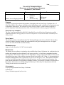
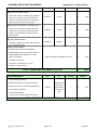
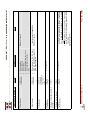
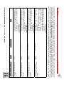
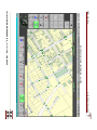
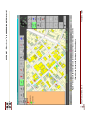
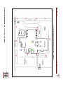
ITEM _____________ VILLAGE OF DOWNERS GROVE REPORT FOR THE VILLAGE COUNCIL WORKSHOP DECEMBER 11, 2007 AGENDA SUBJECT: TYPE: 9 Remote Access Mapping Software SUBMITTED BY: Resolution Ordinance Motion Discussion Only Phil Ruscetti Fire Chief SYNOPSIS A motion is requested to authorize the purchase of mapping software from Group 1 Solutions, Inc., of Glen Ellyn, Illinois. The software will make critical information readily available to Fire Department units responding to emergencies. The software will work with the Village’s current software programs to provide responders with information from GIS, CAD, and firehouse software programs in real time. STRATEGIC PLAN ALIGNMENT The Five Year Plan and Goals for 2006-2011 identified Exceptional Municipal Organization and the supporting objectives of Top Quality Core Services Responsive to Current and Future Community and Citizen Needs. FISCAL IMPACT The software purchase is identified in the FY07 Municipal Budget and will cost $36,091. This includes software licensing, mapping, training and implementation, and project management costs. A support services fee of $6,300 will be assessed annually. RECOMMENDATION Approval on the December 18, 2007 consent agenda. BACKGROUND The Remote Access software is technology only available from Group 1 Solutions, Inc., and therefore, the product and company have been declared a sole source provider. As such, the recommended purchase was negotiated. The software will give the Fire Department’s laptop computers the ability to seize crucial information from many of the software programs already being used by the Village. A common phrase in emergency management circles is information is power at an emergency scene. This software will allow access to crucial information including fire hydrant locations, structure construction information, floor plans, hazmat information, fire apparatus responding locations, special needs or hazards, and directions to the incident. The software is currently being used by many of the nearby Fire Departments which the Village provides and receives mutual aid. ATTACHMENTS Project pricing document from Group 1 Solutions Customer list Group 1 Solutions proposal and overview DOWNERS GROVE FIRE DEPARTMENT Base User Applications End-User Viewing Module ( Appendix IV - Project Pricing Price Remote Access TM ) $1,000.00 $3,000.00 To view drawings, GIS maps & attribute data, photographs, videos, associated attachments and other similar information $5,000.00 0.00 Incident Support Initiative User Application 1 Remote Access 2 Per Quantity 1 License 0 $ - 0 $ - 2 $ Bundle of 5 Licenses Bundle of 10 Licenses Over 25 bundles of 10 Licenses No Cost Subtotal Administration Module (RA_Admin ) TM To add, edit, delete or link site plans, maps, photographs, scanned images and data records Enables the Incident Commander to make notations on a “snapshot” of the incident location, using symbols, text, or drawings. 0 10,000 0.00 ** 0 $ - 20 $ 10,000 $4,000.00 1 License 1 $ 4,000 $500.00 Each additional License 1 $ 500 2 $ 4,500 Subtotal Incident Command Markup Tool (RA_TacPad TM) Subtotal $300.00 1 License 0 $ - $900.00 Bundle of 5 Licenses 0 $ - $1,500.00 Bundle of 10 Licenses 0 $ - Over 25 bundles of 10 Licenses 0 0.00 2 Subtotal Subtotal - Base User Applications 0.00 ** 0 $ 22 $ 14,500 Utility Applications Synchronization Utility (RA Sync TM) To transmit and synchronize data & application updates between the server and clients $4,800.00 1 Server 0 $ - $600.00 Each additional License 0 $ - $90.00 1 Client 0 $ - 0 $ - 0 $ - $275.00 $450.00 0.00 2 Bundle of 5 Licenses Bundle of 10 Licenses Over 25 bundles of 10 Licenses Subtotal Group 1 Solutions, Inc. Page 1 of 7 0 0 0.00 ** $ - 11/20/2007 DOWNERS GROVE FIRE DEPARTMENT Appendix IV - Project Pricing Price 1 Per Quantity 1 License 1 $ 2,000 Subtotal 1 $ 2,000 Subtotal - Base Utility Applications 22 $ 2,000 Utility Applications (continued) RMS Utility (RA_RMS TM) $2,000.00 Subtotal To map data fields in Company Records to external database records for viewing in the field 1 Interfaces Price Asset Tracking (RA_Tracker TM) $300.00 $900.00 To enable interface to third-party firefighter tracking technology $1,500.00 0.00 2 Per Quantity 1 License 0 $ - 0 $ - 0 $ - Bundle of 5 Licenses Bundle of 10 Licenses Over 25 bundles of 10 Licenses Subtotal Mobile Computing Interface (RA_Mobile TM) $300.00 $900.00 To enable wireless interaction between CAD and Remote Access via interface to mobile messaging application, eliminating need to manually enter addresses upon dispatch $1,500.00 0.00 2 1 License Bundle of 5 Licenses Bundle of 10 Licenses Over 25 bundles of 10 Licenses Subtotal GPS Interface (RA_GPS TM) $200.00 For real-time viewing of an individual vehicle's location on the map in the vehicle via an interface with an onboard Global Positioning System (GPS) $600.00 $1,000.00 0.00 2 1 License Bundle of 5 Licenses Bundle of 10 Licenses Over 25 bundles of 10 Licenses Subtotal Oblique Aerial Imagery Interface (RA_Oblique TM) For linked access to the third-party oblique aerial images (e.g., Multivision USA, Pictometry) $200.00 $600.00 $1,000.00 0.00 2 1 License Bundle of 5 Licenses Bundle of 10 Licenses Over 25 bundles of 10 Licenses 0 0.00 ** 0 $ - 0 $ - 0 $ - 2 $ 3,000 0 0.00 ** 20 $ 0 $ - 0 $ - 2 $ 2,000 0 3,000 0.00 ** 20 $ 0 $ - 0 $ - 0 $ - 0 2,000 0.00 ** Subtotal 0 $ - Subtotal - Interfaces 40 $ 5,000 $ 21,500 TOTAL SOFTWARE LICENSE COST Group 1 Solutions, Inc. Subtotal Page 2 of 7 11/20/2007 DOWNERS GROVE FIRE DEPARTMENT Appendix IV - Project Pricing TM Map Importation - Client has electronic map and address database in ESRI Remote Access TM: modifications need to be made for use with Client to supply their GIS map data: Import existing client's ESRI based .shp map file of parcels, street centerline, street intersection, address ranges hydrology, railroads, and data base of Tax ID’s and addresses. Enable dynamic street names. Import utility layers and databases. Import ESRI-based .shp files of neighboring jurisdictions. Edge match the maps without additional modifications. (ArcView/ArcGIS) format. No Price Per Quantity Subtotal $7,500.00 Flat Rate 1 $ 7,500 $3,500.00 Jurisdiction (i.e., County, Municipality, etc.) 0 $ - Subtotal $ 7,500 Intersection Layer Development: < 10 square miles $1,000.00 Unit 0 $ - Between 10 and 30 square miles $1,500.00 Unit 0 $ - Between 31and 100 square miles $2,500.00 Unit 0 $ - Between 101 and 300 square miles $3,500.00 Unit 0 $ - Between 301 and 400 square miles $5,000.00 Unit 0 $ - > 400 square miles $6,000.00 Unit 0 $ - Subtotal $ - TOTAL MAPPING COST $ 7,500 Price Per Quantity Digitize 8.5" X 11" Paper Run Book Site Drawings $42.00 Drawing 0 $ - Digitize All Other Size Paper Drawings $62.00 Drawing 0 $ - $15.00 Drawing 0 $ - $12.00 Drawing 0 $ - $20.00 Drawing 0 $ - Preplan Development and Importation Subtotal All prices include link to Survey Form and/or map at designated address. Clean-up and/or Link Drawings Provided In .dwg Format Import & Link Drawings From AutoCAD, Visio, Fire Zone or Other Approved Systems Update Previously Digitized Electronic Drawings TOTAL PREPLAN COST Group 1 Solutions, Inc. Page 3 of 7 $ - 11/20/2007 DOWNERS GROVE FIRE DEPARTMENT Training and Implementation Appendix IV - Project Pricing Price Per Quantity Subtotal $1,200.00 Course 1 $ 1,200 $1,600.00 Course 1 $ 1,600 $2,200.00 Quantity 0 $ - $ 880 $ 2,120 $ 1,240 $ 4,920 Remote Access Trainer Course: Initial 4-hour course, 10 students, plus refresher training at 6 months, provides train-the-trainer instruction and scenario/dry run use. One paper Manual and electronic file copy included. Remote Access Administrator Training Course: 6-hour course, 4 students, provides training on alterations to data, Interface Support & System Support. One paper Manual and electronic file copy included. RA_Sync Implementation: Installation, configuration, testing and training for the synchronization utility System Implementation: Installation and testing of all workstations Kickoff Meeting, System Specification Review & Interface Meeting (via telephone or on-site) $40.00 Based on Quantity of Application Licenses Vendor coordination 22 Installation coordination Acceptance (via telephone or on-site) Handover to Client Services $20.00 62 TOTAL TRAINING AND IMPLEMENTATION COST Project Management Price Internal Planning meetings Per 12% Materials acquisition and schedule alterations Regular status reports and meetings (telephone) Variable Documentation preparation Test method assistance Travel (out-of-pocket plus 50% of travel time) Subtotal $33,920 Dependent on specific client requirements and number of trips 1 $ 4,070 $ 4,070 0 TOTAL PROJECT MANAGEMENT COST Group 1 Solutions, Inc. Quantity Page 4 of 7 11/20/2007 DOWNERS GROVE FIRE DEPARTMENT Professional Services Appendix IV - Project Pricing Price Per Quantity $1,000.00 Dependent on specific client requirements, at Group 1 and client's consensus 0 Internal Planning and Kickoff meetings Scope Review Meeting Regular status reports (via telephone) Documentation preparation Other tasks as required TOTAL CUSTOMIZATIONS AND MODIFICATIONS COST RA_Counsel TM Subtotal $ $ Price Per Quantity $60.00 Hour 0 - - Subtotal On-site or telephone support of non-Client Services issues On-Site map updates with client data $ - Troubleshooting end-user issues Supplemental training TOTAL RA_Counsel TM COST Required Third-Party Software $ Price Per Quantity $0.00 License 22 - Subtotal ESRI Deployment Licenses MapObjects 2.3 Deployment License Required for each system running a Remote Access product with imbedded mapping $ - Note: Fees are waived due to Client's statement that license of MapObjects Deployment Licenses have already been obtained. TOTAL REQUIRED THIRD-PARTY SOFTWARE COST Group 1 Solutions, Inc. Page 5 of 7 $ - 11/20/2007 DOWNERS GROVE FIRE DEPARTMENT Appendix IV - Project Pricing SUBTOTALS FROM ABOVE PROJECT TOTALS Total Software License Cost Total Mapping Cost Total Preplan Cost Total Training and Implementation Cost Total Project Management Cost Total Professional Services Cost Total RA_Counsel Cost TOTAL PROJECT COST Client Support Services $ 21,500 $ 7,500 $ - $ 4,920 $ 4,070 $ - $ - $ 37,990 $ 6,300 3 Annual Contract for telephone support, bug fixes & application updates. Fees are calculated on the non-bundled Software Cost (20% for all Base User and Utility Applications and 10% for all Interfaces). Non-bundled software value equals………………….. Total Third-Party Software 1 $ 36,500 17.26% $ - Software Pricing reflects discount for Bundled License Packs 2 Site License Bundles (over 25 Bundles) are free of License fees, but require Client Support Services as with any feebased license. 3 Due to the timing of the implementation, Client Support Services costs are not anticipated to be due and payable until calendar year 2008. The amount is not included in Total Project Cost. Group 1 Solutions, Inc. Page 6 of 7 11/20/2007 DOWNERS GROVE FIRE DEPARTMENT Appendix IV - Project Pricing Project Payment Options Option Terms & Conditions Event Amount Due Option #1 - Pre-Payment Discount Discount of five percent (5%) of Total Project Cost At Contract Signing $ 36,091 Option #2 - Contract Signing Invoice Twenty percent (20%) of the Project Cost due at time of contract signing At Contract Signing $ 7,598 Monthly thereafter amount due is based on actual work done or minimum of 20% or remainder of work to be performed, whichever is greater. All amounts to be credited towards remainder of work to be performed. Monthly $ 7,598 Minimum Client Support Services Payment Options Option #1 - Annual Renewal Year 1: Years 2 - x: Option #2 - Pre-Payment $6,300.00 Annual Renewal Invoices subject to yearly increase 2 Year Contract 11,970.00 5.0% discount 3 Year Contract 17,482.50 7.5% discount 4 Year Contract 22,680.00 10.0% discount Payment Policies: The balance of the invoice will be due 30 days after issuance. If an invoice is not paid within 60 days , an 18.0 Annual Percentage Rate (APR) will be applied to the outstanding balance. Monthly Reminder Statements will be issued to indicate the Balance Forward, Finance Charge and Current Balance. For any client with an invoice more than 90 days overdue , sales and service on additional non-software maintenance items will be provided only if the items are paid for in advance. Group 1 Solutions, Inc. Page 7 of 7 11/20/2007 Group One Remote Access Current Illinois List Abbott Labs Lake Zurich Addison Lisle-Woodridge Aurora Lockport Batavia Mundelein FD/PD Bellwood FD/PD Naperville FD/PD Bloomingdale Palatine Bristol Kendall Pleasant view Buffalo Grove Peoria SWAT Carol Stream Rolling Meadows Champaign Sandwich Countryside Schaumburg Elburn Skokie Elgin Tinley Park Elmhurst Tri-State Evanston Villa Park Geneva Wauconda Glen Ellyn West Chicago Glenside Wood Dale Hinsdale Wheaton Zion …mobile intelligence TM Village of Downers Grove Fire Department (IL) © All rights reserved. No part of this publication may be reproduced, stored in a retrieval system or transmitted in any form or by any means, electronic, mechanical, photocopy, recording or otherwise without the expressed written permission of Group 1 Solutions, Inc (“Group 1”). There are a number of proprietary logos, service marks, trademarks, slogans and product designations found in this document. By making them available in this document, Group 1 is not granting a license to use them in any fashion. DOWNERS GROVE FIRE DEPARTMENT Section Table of Contents Remote Access ¥ PROPOSAL Page Number Group 1 Solutions, Inc. Mission Statement A. 1. 2. 3. 4. 5. 6. 7. 8. 9. 10. Remote Access ¥ Product Description ................................................................... A.1 Remote Access ¥Application.................................................................................. A.1 RA_Admin ¥ Administration Module ...................................................................... A.3 RA_Mobile/CAD ¥ Computer Aided Dispatch Interface ..................................... A.3 RA_Tracker ¥ Responder Tracking Interface...................................................... A.4 RA_GPS ¥ Global Positioning System Interface ................................................. A.5 RA_Oblique ¥ Aerial Imagery Interface ............................................................... A.5 RA_RMS ¥ Records Management Interface........................................................ A.6 RA_TacPad ¥ Incident Command Mark-Up Tool................................................. A.6 Information Interoperability ................................................................................. A.7 RA_Sync ¥ and RA_Sync Manager ...................................................................... A.7 11. Hardware Requirements ..................................................................................... A.8 B. Scope of Work .................................................................................................... B.1 1. Application Software ........................................................................................... B.4 2. Professional Services ......................................................................................... B.6 2.1 Geographic Information System Services........................................................... B.6 2.1.1 GIS Map Utilization ............................................................................................. B.6 2.1.2 Address Database .............................................................................................. B.6 2.1.3 Address File Requirements................................................................................. B.1 2.2 Project Management........................................................................................... B.2 2.3 Implementation ................................................................................................... B.3 2.3.1 Installation........................................................................................................... B.3 2.3.2 Training ............................................................................................................... B.4 3. Acceptance ......................................................................................................... B.4 C. Proposal Acceptance ..........................................................................................C.1 Appendices I Remote Access ¥ GIS and Drawing Materials List II III IV Agreement for Client Services End User License Agreement Project Pricing GROUP 1 SOLUTIONS, INC. © DOWNERS GROVE FIRE DEPARTMENT Remote Access ¥ PROPOSAL Mission Statement “Believing in and providing effective solutions that make a difference in the lives of our clients and the people they serve.” GROUP 1 SOLUTIONS, INC. © DOWNERS GROVE FIRE DEPARTMENT Section A Remote Access ¥ PROPOSAL Remote Access Functional Description 1. Remote Access software by Group 1 Solutions, Inc., aids in force and property protection by giving fire, police, EMS and military personnel access to critical emergency response data while enroute to an incident and during pre-incident planning and training activities. Developed with input from dozens of public safety agencies and utilizing the ODBC compliant database, Microsoft Access®, Remote Access provides access to site plans, address maps and tactical database information stored on mobile laptop computers located in frontline vehicles. Here’s how it works: As an incident address is transmitted through a radio or wireless system by your agency’s computer-aided dispatch (CAD) system, Remote Access will search for the incident’s location on the available map information*. Once located and centered on the screen, access to associated site plans and tactical address data is available via large function buttons and screen controls. Of course you can always manually type in the address if the CAD interface is not available at your agency. Remote Access also provides search capabilities by street intersections, commonplace location names, and address ranges. *Note: Types and success of address searches is dependent on the availablility and accuracy of GIS map data provided by the client. Reach mission-critical data. With zoom in & out capabilities, the map viewer in Remote Access can display varying amounts of GIS map detail. Depending on the available layers and system configuration, map details can range from displaying street centerlines only, to fully exposing the individual parcels, building outlines, locations of water, storm water and sewer systems as well as the nearest fire hydrant. For map locations that have associated tactical database information, one click (or screen-touch) takes you to a site plan of the address, revealing the locations of pertinent items such as fire department connections, electrical panel, key box, gas valve, and fire alarm panel. You may also view photographs, video or aerial photos of the location with a single keystroke. One click takes you to a data sheet associated with the address, which lists the presence of hazardous materials; occupancy and key-holder information; and building construction information. Decrease response time. Remote Access is designed to require the least number of keystrokes possible to reach critical information quickly. Function keys can be used to navigate between map, site plan and data sheet, as an option to maneuvering using a mouse or touchpad on non-touchscreen devices. Street names automatically appear when you begin to enter an address. Response time is also minimized by the quickly-processed electronic file format of graphics displayed by Remote Access. GROUP 1 SOLUTIONS, INC. © SECTION A - PAGE 1 OF 8 DOWNERS GROVE FIRE DEPARTMENT Remote Access ¥ PROPOSAL Remote Access Version 6.5.x Standard Features (dependent on the quality and accuracy of client provided maps, database and drawing information): View building outline, street centerline, parcel boundary, hydrology, bridges, railroads and fire hydrant, orthogonal and oblique aerial photography, all on the map viewer Zoom in & out of the map; display full view, and move map with omni-directional pan Search for an exact address, address range, non-addressed location or street intersection and display its location on the map Display utilities such as water, storm sewer and sanitary sewer; toggle the utility layers on and off View GIS attribute data associated with parcels, buildings, hydrants, water mains, street centerline, storm & sanitary sewers, lakes, rivers and gridlines through the use QInfo, an easy one-click feature Move the cursor over a parcel or building to display its street address and latitude/longitude View digital photographs and video clips linked to an address or building View site plans with color-coded industry standard symbols for each floor of commercial, industrial and school buildings (see below) Note: Color coding and symbology must be included in the electronic drawing to be displayed in Remote Access Utilize a variety of file formats for digitized preplan drawings, including AutoCAD® (.dwg), Visio® (.vsd) and. jpg files. Switch Function Key tool bar from one side of the screen to the other on-the-fly, based on user-preference Access and maintain multiple data sheets per address: Occupancy, Building Information, Fire Protection, Special Considerations, Special Hazards and Tactical Move between the site plans, map views, database records, photos and videos with a single mouse click Store and retrieve important contact names, phone, pager and fax numbers Print any map screen, site plan or database record Digital site plans reveal**: Exterior & interior walls and doors Overall building dimensions, when indicated Hydrants Electric panel Knox Box Hazardous materials Gas valve Fire alarm panel Fire alarm control room Suppression systems location and type Sprinkler risers Stairs and elevators Roof features (skylights, access points, fans) Roof construction type ** If included by the Client in the electronic drawing GROUP 1 SOLUTIONS, INC. © SECTION A - PAGE 2 OF 8 DOWNERS GROVE FIRE DEPARTMENT 2. RA _ Admin Administration Tool Standard Features: 3. Remote Access ¥ PROPOSAL Maintain datasheets, maps and site plans Enter and maintain data regarding specific physical locations Link one or many images to a single location Identify the preplan drawings that you want to be associated with a particular address RA_Mobile/CAD Interface Between CAD and Remote Access Remote Access has the ability to automatically search for and display the location of an incident based on the address files used by the client’s CAD system. This function is made possible through an interface between the CAD system and Remote Access. When the address of the incident is transmitted to either the CAD workstation or the MDC’s, the interface between CAD and Remote Access enables the address search to be completed without action required by the end user. In cases where there is an exact match between the addresses in CAD and GIS, the search is automatically performed and the precise location of the incident is displayed. RA_Mobile collects the address information and centers the map at the correct incident location without user action needing to be taken. In this example, a Smoke Detector Activation at 990 Kuhn Road is sent via dispatch to the mobile unit. RA_Mobile collects the address information and centers the map at the correct incident location. GROUP 1 SOLUTIONS, INC. © SECTION A - PAGE 3 OF 8 DOWNERS GROVE FIRE DEPARTMENT 4. RA_Tracker Remote Access ¥ PROPOSAL ™ Responder Tracking Interface Through the use of existing "core" modules (Remote Access, RA_SyncManger ™, RA_Sync ™), Group 1 is developing RA_Tracker, a user interface with the capability for displaying individual responder positions with tracks supplied from a number of different technology vendors for tracking personnel. These tracks will be available on the existing 2D map and building display in the main Remote Access viewer, and Group 1 is developing the capability for end users to view the location of responders in 3D building outlines. The interfaced technology between Group 1 and tracking vendors will enable the operator of the "base station" to select specific tracked responders either by selecting the tracked individual from a roster list (by name and by ID) or by clicking an icon representation of the individual on the tracking display. After selecting an individual, specific data will be displayed about the responder, such as name, rank, agency/department, certifications, special training, etc. The roster display will also be enhanced to allow easy selection of "responder groups" to enable the base station operator to "filter" the track display by "tracks at same relative elevation", "tracks by assigned team or agency", and "tracks by specialty (show all medics, show all search and rescue teams). GROUP 1 SOLUTIONS, INC. © SECTION A - PAGE 4 OF 8 DOWNERS GROVE FIRE DEPARTMENT 5. Remote Access ¥ PROPOSAL RA_GPS ™ Global Positioning System Interface RA_GPS enables a user to track oneself, either moving throughout the map or in response to an incident. An AVL server is not required, and there are no bandwidth requirements. During a response, the user chooses to either display the current location of the vehicle and direction to the incident, the location of the incident with an area around it and direction to the vehicle, or both the vehicle and incident together. The control frame on the right improves the usability of the GPS functions within Remote Access. The large Indicator Arrow displays the relative direction either to the incident location from the unit position or to the unit location from the incident location. To assist in general routing, a graphically depicted Track Line is available to the user. 6. RA_Oblique ™ Aerial Imagery Interface RA_Oblique is an interface between Remote Access and vendors which provide oblique aerial imagery (e.g., Pictometry, MultiVisionUSA). This capability enables quick access to the aerial imagery when an address search is completed in Remote Access by passing the latitude/longitude coordinates from Remote Access to the vendors’ libraries. The user can then easily view the oblique imagery associated with the incident location and utilize and use the vendor-specific interface to measure distances, heights, perimeters, lengths, widths, and area of objects within images. GROUP 1 SOLUTIONS, INC. © SECTION A - PAGE 5 OF 8 DOWNERS GROVE FIRE DEPARTMENT 7. Remote Access ¥ PROPOSAL RA_RMS ™ Records Management Interface Via RA_RMS an association between the premise records in Remote Access and the Department’s Records Management System (RMS) is formed through the creation of data mapping between the two sets of records. This relationship allows Remote Access to populate the premise records with the corresponding data that was originally entered into the RMS. 8. RA_TacPad ™ Incident Command Mark-Up Tool At the incident scene, communicating the actual deployment and personnel and equipment is often left to be documented on sheets of paper or grease boards. The resulting product is often difficult to read and impractical to share in real-time, either with other units staged or en-route to the scene or with a remote Command Unit…until now. RA_TacPad enables the Incident Commander to easily make notations on a “picture” of the incident location, using symbols, text, or drawings. Ideally suited for touch-screen notebook computers, markups are easily made using a stylus (or mouse with non-touch screen computers). As changes are made to the Incident Command image, they are automatically saved for future review, providing a valuable visualization tool for an After Action Report. Coupled with the communications capabilities of RA_Sync Manager and Client, updated RA_TacPad images and corresponding test messages are easily shared among public safety personnel with access to network connectivity. GROUP 1 SOLUTIONS, INC. © SECTION A - PAGE 6 OF 8 DOWNERS GROVE FIRE DEPARTMENT 9. Remote Access ¥ PROPOSAL Information Interoperability Group 1 recognizes the need to meet the federally-mandated stipulation to share information between agencies. The U.S. Department of Homeland Security has specifically stated that future grant funds will be targeted to meet regional and state solutions...no longer simply for local requests. To satisfy this requirement, a copy of another agency’s GIS data can also be stored and accessed locally using the licensed copy of Remote Access installed on the MDC. In this example, Arlington County, Virginia initiates access to the data for the neighboring jurisdiction of Falls Church via the “Launch” button. 10. RA_Sync ™and RA_Sync Manager ™ Many of the Remote Access applications are designed to allow communications between systems running Remote Access and RA_Admin via a TCP-IP based network. RA_Sync is embedded into many of the Remote Access applications. This allows the different applications to communicate with RA_Sync Manager systems and share various form of information need to keep the system updated or provide access to the latest incident information. Through the RA_Sync Protocol users can process updates to the Remote Access database at the record level, allowing field changes to flow through the entire system without the need to touch each system manually. RA_Sync can also process file updates when preplans, maps, photos, or videos are added or changed, providing easy processing of Remote Access data on an ongoing basis. The system requires a network attached Windows XP-based system to operate as the RA_Sync Manager host system. Users and Groups are added to the system to enable easy sharing of information when responding to an incident. A simple SMS messaging system is built into the RA_Sync Protocol which allows first responders to hold on-line conversations while processing incident related information or creating RA_TacPad images. GROUP 1 SOLUTIONS, INC. © SECTION A - PAGE 7 OF 8 Remote Access ¥ PROPOSAL DOWNERS GROVE FIRE DEPARTMENT 11. Hardware Requirements Remote Access is compatible with Microsoft Windows® versions 95, 98, 2000, NT, ME, or XP. ® Note: Some tools and viewers may not be compatible with Windows versions 9X, NT and ME. Prompt access to fire preplans, maps and data may be obtained with a personal computer or laptop possessing the following minimum specifications. Systems configured with less than the minimum hardware specifications will display the data, but less promptly than desired. Configurations Recommended Minimum CPU size CPU speed RAM memory IDE Hard Disk Drive Floppy Disk Drive CD-ROM Mouse Monitor size Monitor type Display Resolution Battery life USB Port Pentium IV 1.4 GHz 1.0 GB 40 GB 3.5” Yes Built-in 14” Touch Screen 768 x 1024 pixels 3 hour Yes Note: Response time and general loading time can be affected by additional software resident and running on each computer, and by the size of the GIS map layers and data contained in the Remote Access database. While slower computers may be adequate for existing office workstations to run Remote Access, Group 1 recommends that any mobile units purchased for use with Remote Access either meet or exceed the above minimum recommendations. If desired, Group 1 is available for consultation as to the appropriate specifications for new laptop computers. (The remainder of this page left intentionally blank) GROUP 1 SOLUTIONS, INC. © SECTION A - PAGE 8 OF 8 Remote Access ¥ PROPOSAL DOWNERS GROVE FIRE DEPARTMENT Section B Scope of Work 1. Application Software The following software applications will be licensed to the Client: Software Application Remote Access RA_Admin Administration Tool RA_TacPad Incident Command Markup Tool RA_Sync Manager RA_Sync Clients RA_RMS Records Management Utility RA_Tracker Responder Tracking Interface RA_Mobile Computer Aided Dispatch Interface RA_GPS Global Positioning System Interface RA_Oblique Aerial Imagery Interface Number of Licenses 20 2 0 0 0 1 0 20 20 0 2. Professional Services 2.1. Geographic Information System Services 2.1.1. GIS Map Utilization Group 1 understands that the Client will obtain all necessary Geographic Information System (GIS) electronic map files in ESRI .shp file format. Group 1 requires that the files be provided in the format as detailed in Appendix I, Remote Access GIS & Drawing Materials List, and will act on the behalf of the Client in discussions with other government entities (e.g. Assessor, Development, Water Utility), if necessary. Accuracy of searches in Remote Access is dependant on the availability and accuracy of the map data provided. 2.1.2. Address Database Group 1 will enable a search of exact addresses for that section of the map defined by the map data’s coverage area if the GIS map data contains appropriate and adequate address information as described below. 2.1.3. Address File Requirements Group 1 typically utilizes the attribute database files (.dbf) associated with the address point, building and/or parcel map layer (.shp) files. For Remote Access to GROUP 1 SOLUTIONS, INC. © SECTION B - PAGE 1 OF 5 DOWNERS GROVE FIRE DEPARTMENT Remote Access ¥ PROPOSAL perform exact address search functionality, the attribute database files must contain, at a minimum: A field that contains a unique identification number, usually represented by Tax ID or Parcel Identification Number (PIN). Address information (i.e., Street Number, Street Name, Street Type, etc.) separated into individual fields, or, b) a full address string (e.g., 123 W MAIN ST) stored in a single field. Remote Access functionality also requires the existence of address ranges based on street segments. The ranges are used to complete approximate street centerline searches when exact address searches are unable to locate an address on one of the address-enabled layers. The absence of address ranges from the street centerline file will impair or eliminate this function in Remote Access. Remote Access can be configured to support different address range formats and layouts. Group 1 will review and report any possible problems when street centerline ranges follow non-standard layouts. Additional address standards that can impact the operation of the software include: inconsistent street naming between different map layers, inconsistent use of street types between map layers and dispatch systems when mobile interfaces are included, lack of required map attributes data to display location or address information in the Remote Access map viewer. Group 1 will complete an assessment of the various maps and address databases during the initial configuration of the system and report these to the Client for further action. Group 1’s pricing assumes that the GIS data contains the address information necessary to be incorporated into Remote Access. Should the Client’s address-based files that are listed above lack the unique identification numbers, addresses or address ranges, Group 1 can create them. Such tasks, however, would require a Change Order to this Statement of Work, and to the associated contract price. Additionally, should the Client’s map files lack associated .dbf information, Group 1 can import address information from other sources. Such a task, however, would also require a Change Order to this Statement of Work, and to the associated contract price. 2.2. Project Management Throughout the execution of the contract, an assigned Client Manager will coordinate and oversee all the phases of the project including the map utilization, digitizing, interface development, installation and training. The Client Manager will schedule various meetings with the Client’s internal staff, implement any Change Orders to the contracted Statement of Work and will be the main Group 1 Point of Contact (POC) for the Client throughout the life of the project. The Client will be required to identify a Client POC that will be the primary representative and contact with Group 1. Due to the dynamic schedule of a typical Remote Access implementation, Group 1 strongly urges that the Client POC be assigned to a Monday-Friday, regular workday shift schedule. Accordingly, the Client POC should be prepared to manage the following responsibilities: GROUP 1 SOLUTIONS, INC. © SECTION B - PAGE 2 OF 5 DOWNERS GROVE FIRE DEPARTMENT Remote Access ¥ PROPOSAL Identify and schedule Client personnel for training sessions Act as a contact between Group 1 POC and various Client resources including, but not limited to, GIS specialists, Information Technology (IT) representatives, Purchasing, Client management, Client third-party vendor representatives (e.g., CAD vendor, RMS vendor) Coordinate contacts with required outside agencies (e.g., regional dispatch center) Approve and/or recommended any changes to the scope of the project Arrange for the provision or work space for at least two (2) Group 1 project personnel, plus 24/7-day access to the computer systems on which Remote Access is schedule to be installed Review and recommend for payment all invoices submitted by Group 1 in accordance with the terms and conditions set forth in this document Typical tasks that are performed by the Group 1 POC include the following: Internal Planning meetings Kickoff Meeting, System Specification Review & Interface Meeting (on-site) Materials acquisition Schedule alterations Vendor coordination Monthly status reports (if required by contract) Monthly meetings (via telephone if required by contract) Documentation preparation Installation and Training coordination Test method assistance Acceptance (on-site) Handover to Client Services (on-site) The Client Manager will work to jointly establish key dates to assure the timeliness of the project. When possible, a 10-day advanced notice of changes to the schedule is requested to minimize project delays and/or extra costs. Group 1 reserves the right to invoice costs associated with changes or cancellation of meetings that involve travel, lodging and other expenses. Group 1 reserves the right to also invoice for the above costs, plus hourly rates of personnel at the then current rate, for time lost should meetings be cancelled and/or the appropriate people are not made available for project tasks after Group 1 has arrived on-site. Every effort will be made to eliminate these issues through communications from the Group 1 Client Manager. 2.3. Implementation 2.3.1. Installation Group 1 will install all required software on computers (both mobile data and desktops) based on the number and type of licenses selected by the Client as defined in Section B.1. The Client will be responsible to make sure Group 1 staff has access to the systems and that appropriate user rights are available to complete the installation of the software on the systems. Any special configuration for network operation will be reviewed on-site and may require additional fees if extensive time or research is required by Group 1. GROUP 1 SOLUTIONS, INC. © SECTION B - PAGE 3 OF 5 DOWNERS GROVE FIRE DEPARTMENT Remote Access ¥ PROPOSAL Alternately, a train-the-trainer approach may be mutually agreed upon based on the skill levels and aptitude of Client personnel. Should it be determined that this approach will be used, Group 1 will perform or supervise several installations of the software to ensure that correct procedures are being followed and the software is functioning correctly. 2.3.2. Training Training is to be conducted in a facility to be provided by the Client with appropriate space and equipment for users and presenter for the following training sessions: Remote Access User Course: This four (4) hour train-the-trainer course may include up to ten (10) students, and will provide training on the use of the software in emergency response scenarios. End-user usage of all ancillary Remote Access software will also be covered. Group 1 will provide one (1) hard copy of the User Manual along with an electronic copy for duplication by the Client. RA_Admin Administrator Course: This six (6) hour course may include up to six (6) students, and will provide training on alterations to the data, system support and maintenance. Additionally, the administrative characteristics of all ancillary Remote Access software will be integrated in the session. Group 1 will provide one (1) hard copy of the Administration Manual along with an electronic copy for duplication by the Client. 3. Acceptance The Client has thirty (30) days after implementation to report any errors occurring with the software. If Group 1 receives no such communication within that thirty (30) day period, the project is automatically deemed Accepted. Implementation is defined as the completion of installation and initial testing of the system by Group 1 and a representative of the Client. The acceptance of the software licenses will be complete when Group 1 provides the Client with the installation media and accompanying license and maintenance agreement(s). This event will constitute the delivery and authorization for the Client to install and use the software. The software will be deemed functional and ready for initial testing acceptance when the following conditions are met: A successful installation of the Remote Access software has been completed on a computer identified by the Client and either (a) the Client provided map data has been configured and loaded onto the test system, or (b) at Group 1’s choice, a sample of data, which may or not be part of the Client’s data, has been installed on the system and successful searches are made to the map locations. This initial test event will constitute that the Remote Access software is functioning and is compatible with the Client’s computer(s). The following is a list of functions that will be tested and verified during the initial tests: à Launch of Remote Access from the Windows® Desktop or Program Menu. à Display of the base test map layers at full extent at start up. à User ability to use the map movement functions including Zoom In, Zoom Out and Move to verify that the map control is functioning with the configured map display. GROUP 1 SOLUTIONS, INC. © SECTION B - PAGE 4 OF 5 DOWNERS GROVE FIRE DEPARTMENT à à à Remote Access ¥ PROPOSAL Perform manual searches to three (3) pre-defined address locations to test the system’s searching function. The type of search (exact or approximate address) will depend on the available data in the test map layers. Access to one (1) test Company Record to demonstrate access to tactical database information including a preplan, photo and video example. Demonstration of any other available features based on the configuration. Other components of the system (i.e., mobile and records interfaces, oblique image software interfaces, etc.) may or may not be delivered and tested at the same time depending on the project schedule, available data for developing interfaces, etc. Due to possible delays in obtaining data and/or support for the external component development and testing, each of the component pieces will be considered separate from the base Remote Access software and as such, invoicing for Remote Access and services rendered to deliver the software will be made at the end of the initial tests described above. (The remainder of this page left intentionally blank) GROUP 1 SOLUTIONS, INC. © SECTION B - PAGE 5 OF 5 Remote Access ¥ PROPOSAL DOWNERS GROVE FIRE DEPARTMENT Section C Proposal Acceptance DOWNERS GROVE FIRE DEPARTMENT (IL): Accepted By: Name, Title: P. O. Number: Date: Group 1 Solutions, Inc.: Accepted By: Ted C. Steinbrecher Name, Title: Ted C. Steinbrecher - Vice President, Business Development Date: November 19, 2007 GROUP 1 SOLUTIONS, INC. © SECTION C - PAGE 1 OF 1 GROUP 1 SOLUTIONS, INC. © Building Outlines or Footprints (Polygon theme) Parcels (Polygon theme) Object Depicted on Map File Electronic Files ¥ GIS AND DRAWING MATERIALS LIST (optional, but recommended) .shp file (optional, but recommended) .shp file Format Parcel Identification Number Street number Street direction Street name Street type (e.g., Rd., St., Ave.) Unit (apartment or suite) City Parcel Identification Number Street number Street direction Street name Street type (e.g., Rd., St., Ave.) Unit (apartment or suite) City Minimum Details Example: Figure 2 PAGE i OF xiii Parcels, building outlines and addresses should include all of the area where detailed map information will be provided. Edge matching and other data manipulation of the various address data sources may be required if the files are obtained from different systems. Example: Figure 1 Notes See Example screenshots at the end of this document. Example numbers are in the Notes section of each layer. The three shaded files in the table are used for, and at least one is required for, exact address searching. The data elements can exist in any or all of the files. Group 1 will use the most accurate address source for exact address searching. on the source data, the system will be developed using the most accurate source of address information. Some GIS maps are developed without specific address information included in the attribute files for a particular file. Often the address information is stored in a separate database and is linked by unique ID’s on the map files back to an address. If this is the case, the external address database should be obtained along with the map files. Remote Access 6.0.x supports the ability to search several “address aware” map layers. Depending All maps should be created in the same projection. All maps, except Street Centerline, should be for the defined service area of the Client. All of the files detailed below are ESRI .shp files. APPENDIX I - Remote Access GROUP 1 SOLUTIONS, INC. © Railroads (Line theme) Hydrology (Polygon or line theme, both if needed.) Bridge (Polygon or Line theme) Hydrant (Point theme) Major Roads (Line theme) Street centerline (Line theme) Address Point File (Point theme) Object Depicted on Map File (optional) .shp file (optional) .shp file (optional) .shp file (optional) .shp file (Optional, but recommended for agencies with large response areas) .shp file (optional, but recommended) .shp file (optional, but recommended) .shp file Format None required None required None required None required Parcel Identification Number Street number Street direction Street name Street type (EX: Rd., St., Ave.) Unit (apartment or suite) City Street name Street type (e.g., Rd., St., Ave.) High and low address ranges for each street segment Street Name Minimum Details ¥ for approximate PAGE ii OF xiii Attributes can be queried by user for information such as flow, pressure, material, connection, etc., if this data is available in the attribute fields. If not available, Group 1 can add a field named Color to allow for color-coding based on NFPA flow rates. Example: Figure 5 Address ranges required location search capabilities. Example: Figure 4 Notes GIS AND DRAWING MATERIALS LIST Example: Figure 3 APPENDIX I - Remote Access (optional) .shp file (optional) .shp file (optional) .shp file (optional) .shp file Format None required None required None required None required Minimum Details Notes GIS AND DRAWING MATERIALS LIST Layers (point & line together) can be turned on/off at the touch of a button when needed. Attributes can be queried for information such as diameter, type, etc., if it is available in the attribute data. Example: Figure 6 Layers (point & line together) can be turned on/off at the touch of a button when needed. Attributes can be queried for information such as diameter, type, etc., if it is available in the attribute data. Example: Figure 7 Layers (point & line together) can be turned on/off at the touch of a button when needed. Attributes can be queried for information such as diameter, type, etc., if it is available in the attribute data. Example: Figure 8 User defined layers that can be turned on/off at user discretion. Up to 15 layers can be configured. Any GIS layers with information that would be valuable to first responders and incident command (i.e.: Helicopter Landing Spots, Launch locations, specific high threat targets, or any layer that can be created to assist responses). Example: Figure 9 ¥ GROUP 1 SOLUTIONS, INC. © PAGE iii OF xiii not maintain their own GIS map information typically use these layers. A Common Locations layer can also be configured to assist in symbolizing common types of locations in the response area such as schools, hospitals, bedridden patients, etc., and symbols can be turned on at the touch of a button. These locations can be searched by Common name instead of address. Group 1 provides this Remote Access can be configured to support up to three user-defined layers that can be formatted in either point, polygon or line theme. Remote Access can also support a temporary address point layer and a temporary street centerline layer. Clients that do Overlays (up to 15 layers) (Can be point, line, or polygon theme) Storm Sewer Utility (Point and line theme, both if desired) Sanitary Sewer Utility (Point and line theme, both if desired) Water Utility (Point and line theme, both if desired) Object Depicted on Map File APPENDIX I - Remote Access ¥ GIS AND DRAWING MATERIALS LIST Architectural drawings (A & E size) Format Printed large scale Format See Notes GROUP 1 SOLUTIONS, INC. © Paper preplans to be digitized Preplan Materials Contents Client’s base map Hardcopy Materials Contents Parcel related Geographical data Client determined details to be included on preplans. Group 1 can provide a guideline upon request. Details Parcels Address numbers in the parcel situated perpendicular to the street Street names Street type (EX: Rd., St., Ave.) Building outlines or footprints on parcel Details Parcel Identification Number Street number Street direction Street name Street type (EX: Rd., St., Av.) Unit (apartment or suite) City name Notes The map should be readable and will be used for verification purposes. The Client needs to label with a unique ID any parcel that contains preplan locations. Building footprints that correspond to each preplan address should be included. Notes This file can be in any standard format (ex: Access, dbase, Excel, .CDF, .SDF). This data may be provided in a .shp file or in a separate .dbf file that correlates to addresses on the map layers. PAGE iv OF xiii The Client needs to identify clearly all elements to be captured on the digitized preplan. It is recommended that the Client maintain an inventory of materials delivered to Group 1 and that a copy of this inventory be included with the preplans. Example: Figures 10A & 10B The following files can be provided to assist Group 1 in verifying address information, if there is a question about addresses on the map. This list is sometimes obtained from the County Tax assessor, CAD systems, etc. Discussions with Group 1 will be required to review specific addressing prior to completing the initial configuration, if address sources conflict with each other. layer, but if there is a Common Location layer available from CAD or another source, this can be reviewed to see if the fields are structured as needed for Remote Access to use or if it will need to be modified. APPENDIX I - Remote Access GROUP 1 SOLUTIONS, INC. © Figure 2 – Buildings: Light green polygons Figure 1 – Parcels: Pale yellow polygons APPENDIX I - Remote Access ¥ PAGE v OF xiii GIS AND DRAWING MATERIALS LIST GROUP 1 SOLUTIONS, INC. © Figure 3 – Address Points: Tan squares APPENDIX I - Remote Access ¥ PAGE vi OF xiii GIS AND DRAWING MATERIALS LIST GROUP 1 SOLUTIONS, INC. © Figure 5 – Hydrants: Red circles APPENDIX I - Remote Access ¥ PAGE vii OF xiii Figure 4 – Street Centerline GIS AND DRAWING MATERIALS LIST GROUP 1 SOLUTIONS, INC. © Figure 4 – Water System: Blue lines and points APPENDIX I - Remote Access ¥ PAGE viii OF xiii GIS AND DRAWING MATERIALS LIST GROUP 1 SOLUTIONS, INC. © Figure 5 – Sanitary System: Brown lines and “+”points APPENDIX I - Remote Access ¥ PAGE ix OF xiii GIS AND DRAWING MATERIALS LIST GROUP 1 SOLUTIONS, INC. © Figure 6 – Storm System: Green lines and points APPENDIX I - Remote Access ¥ PAGE x OF xiii GIS AND DRAWING MATERIALS LIST ¥ GROUP 1 SOLUTIONS, INC. © theme bar can be removed leaving on the chosen layers. PAGE xi OF xiii GIS AND DRAWING MATERIALS LIST Figure 7 – Overlays: Additional layers are turned on and off at user discretion, and the APPENDIX I - Remote Access GROUP 1 SOLUTIONS, INC. © ¥ PAGE xii OF xiii GIS AND DRAWING MATERIALS LIST Figure 8A – Preplans in .dwg format prior to linking in Remote Access APPENDIX I - Remote Access ¥ GROUP 1 SOLUTIONS, INC. © PAGE xiii OF xiii GIS AND DRAWING MATERIALS LIST Figure 10B – Hand-drawn preplan scanned for use or prior to conversion to AutoCAD® format APPENDIX I - Remote Access


![MapInfo [v9.5 - v10.0] User manual PDF](http://vs1.manualzilla.com/store/data/005662542_1-c58f11f989f54f88b5c049879cd1b1b4-150x150.png)
![Autodesk MAP [2007-2009] User manual](http://vs1.manualzilla.com/store/data/005814944_1-7d4ade0f748ad8f526e057550ef902e1-150x150.png)
![Autocad [2007-2009] User manual](http://vs1.manualzilla.com/store/data/005776291_1-e398978f20775312922048f8d5b8f7a5-150x150.png)