1
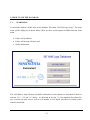
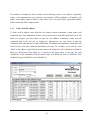
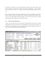
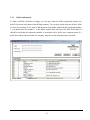
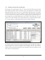
NS WELL LOGS DATABASE USERS MANUAL Updated: May 2018 TABLE OF CONTENTS Section Page 1.0 INTRODUCTION 1.1 Background 1.2 Database Limitations 1-1 1-1 1-1 2.0 HOW TO INSTALL THE DATABASE 2.1 System Requirements 2.2 Installation Instructions 2-1 2-1 2-1 3.0 HOW TO USE THE DATABASE 3.1 Searching 3.1.1 Find A Well By Address 3.1.2 Find A Well By Map Reference 3.1.3 Driller Information 3.1.4 Refining A Search & Other Search Features 3.2 Printing 3.3 Exporting Search Results 3-1 3-1 3-2 3-3 3-5 3-6 3-7 3-7 Appendix A – Database Field Information i 1.0 INTRODUCTION 1.1 BACKGROUND Nova Scotia Environment (NSE) maintains an electronic Well Log Database which contains water well construction and location information for water wells in the Province of Nova Scotia. Information in the database is entered from original paper copies of well logs that are submitted by certified well drillers and diggers. The database currently contains records for over 120,000 wells constructed since 1920. This user’s manual describes how to install the database on your computer, search the database and print the results. 1.2 DATABASE LIMITATIONS Although reasonable care has been taken to ensure the accuracy of the data, there are errors in the database. The database may be useful to search for a specific well log and for reviewing typical well characteristics for an area, however, it should not be relied upon to provide accurate or complete information. If information on a specific well is required, the user should verify the information in the database by obtaining a copy of the original well log. The water well information included in the NS Well Logs Database is intended for the purpose of water resource management. The information is not to be used for any other purpose. The data provided may not be current, accurate or complete. NSE makes no warranties whatsoever, expressed or implied, with respect to the accuracy, completeness, merchantability or fitness for a particular purpose of the information contained in the database. All data in the database is the property of the Province of Nova Scotia. The database cannot be distributed, shared, assigned, sold, leased, or otherwise made available to any other party. 1-1 2.0 HOW TO INSTALL THE DATABASE 2.1 SYSTEM REQUIREMENTS For software, the database requires MS Access 2000 (or compatible higher version). For hardware, the minimum recommended computer system is a 300 MHz CPU with 128 MB RAM and 150 MB of free hard drive space. 2.2 INSTALLATION INSTRUCTIONS Download the database file named “NS Well Logs (Year)” to the desired location on your hard drive. The file is available at this website: http://www.gov.ns.ca/nse/groundwater/welldatabase.asp To start the database, double click on the database file named “NS Well Logs (Year)”. Upon startup, you may receive a message that indicates the database is read-only. This message can be avoided by right-clicking on the database file when the database is closed and selecting Properties. Under Properties, go to Attributes and un-click the Read Only box. Then click Apply and OK. This procedure will only need to be done once. 2-1 3.0 HOW TO USE THE DATABASE 3.1 SEARCHING To search the database, double click on the database file named “NS Well Logs (Year)”. The main menu will be displayed, as shown below. There are three search options available from the main menu: • Find a well by address; • Find a well by map reference; and • Driller information. The well address, map reference and driller information search options are described in detail in Sections 3.1.1, 3.1.2 and 3.1.3 below. As discussed in Section 3.1.4, the database also allows the user to search on other criteria, such as well number or well depth, and allows for initial search results to be refined. 3-1 The database is designed to allow searches on the following criteria: civic address, community, county, well completion date, map reference, map reference, UTM coordinates, well number, well depth, casing depth, depth to bedrock, static water level, well yield, driller registration number, driller’s name and driller company name. 3.1.1 Find A Well By Address To find a well by address, enter either the civic address, nearest community, county, and/or well completion date. Any combination of these search criteria can be used and search fields can be left blank. For example, you may choose to enter the civic address, community, county and well completion date of the well you are looking for. Alternatively, you may choose to enter the community name only and leave all other fields blank. The address and community search fields will search for any wells that contain the information you enter. For example, if you enter the word “Main” in the address search field, the search results will include all wells on Main Street, Main St. Main Ave, Main Road, West Main, etc. As shown in the figure below, if you enter the word “Northfield” in the community field the search results will include all wells in Northfield, West Northfield, Upper Northfield, Lower Northfield, etc. 3-2 The number of wells found in your search is displayed at the bottom of the search window. When the search window is first opened, all records in the database are displayed (i.e., 118,475 records). Once you have run your search, you can refine your results using the methods described in Section 3.1.4. The search results display only summary information for each well, including the well number, address, community, county, well completion date, well depth, casing depth, depth to bedrock, static water level, well yield and driller registration number. You can view the entire well log by clicking on the well number and clicking on the “Get Well Log” button. 3.1.2 Find A Well By Map Reference To find a well by map reference, enter either the NS Map Book/NS Atlas reference, National Topographic System (NTS) map reference or UTM coordinates. Only one type of map reference can be used at one time. Therefore, if you are searching the database using an NTS map reference, you must leave the NS Map Book/Atlas and UTM fields blank. 3-3 You can also search using partial map references. For example, instead of entering a full NS Map Book reference, such as 26C4K10, you may decide to leave out the roamer number/letter and enter only the first part of the reference: Map Page 26, Grid Reference C4. As shown in the figure above, the results will include all wells on Map Page 26, Grid Reference C4. As described in Section 3.1.1 above, the number of wells found in your search is displayed at the bottom of the search window. When the search window is first opened, all records in the database are displayed (i.e., 113,642 records). Once you have run your search, you can refine your results using the methods described in Section 3.1.4. The search results display only summary information for each well, including well number, address, community, county, well completion date, well depth, casing depth, depth to bedrock, static water level, well yield and driller registration number. You can view the entire well log by clicking on the well number and clicking on the “Get Well Log” button. 3-4 3.1.3 Driller Information To find a certified well driller or digger, you can enter either the driller registration number, the driller’s last name or the name of the drilling company. You can only search using one of these fields at a time. For example, if you want to find the name of the driller with the driller registration number 1, you should enter the number 1 in the driller number field and leave the other fields blank. It should be noted that the registration number is associated with a driller, not a company name. If a driller has worked with more than one company, only the current company name is reported. 3-5 3.1.4 Refining A Search & Other Search Features Search results can be refined using the “Filter For” feature on any of the fields in the search results table, including well number, address, community, county, well completion date, well depth, casing depth, depth to bedrock, static water level, well yield and driller registration number. For example, as shown in the figure below, if you have completed a search to find wells located in Halifax and you want to refine the search to display only the wells completed by driller registration number 170, you can right-click on any driller number shown in the “Driller” field and then enter 170 in the “Filter For” box. This will display wells located in Halifax that were constructed by driller number 170. To remove the filter, you must right-click again and select “Remove Filter/Sort”. The “Filter For” feature can be used to search any field listed in the results table. For example, to search the database for a specific well number, open the database, select the “Find a Well by Address” from the main menu and right-click on any well number. Enter the well number you want in the “Filter For” box and press Enter. 3-6 You can also enter a range of values in the “Filter For” box or a greater than or less than value. To search using a range of values, right-click on the field you want to search and enter “Between value1 and value2” in the “Filter For” box (replace value1 and value2 with actual numbers). To search using a greater or less than criteria, right-click on the field you want to search and enter either “> value1” or “<value1”in the “Filter For” box (replace value1 actual numbers). For example, to search for wells that have well yields greater than 100 gpm, right-click on any number in the well yield and enter “>100” in the Filter For” box. 3.2 PRINTING Search results or individual well logs can be printed by clicking on the printer icon button in the search window or well log window. The database has been designed to print on 8.5 X 11 size paper with portrait format, however, before you print you may need to set the print margins. This can be done by clicking on File, Page Setup and setting all margins to 0.25 inches (top, bottom, left, right). This should be repeated for all three search windows (i.e., Find a Well by Address, Find A Well by Map Reference, and Driller Information windows) and the well log reports. If you do not set the print margins, the search results may print across two pages instead of one. If you are running the database from your hard drive the print margins will be saved when you exit, so this procedure should only need to be done once (i.e., only the first time you print from the database). Two types of well logs can be printed: the full log or summary log. The full log resembles the current hard copy version of the NSE well record. This log requires two pages to print. The summary log is an abbreviated log designed to print on one page. In order to set the print margins on the summary log, the summary log must be opened using the “Open Summary Log” button and the print margins can be set by following the instructions in the above paragraph. 3.3 EXPORTING SEARCH RESULTS The search results can be exported to a word processor or spreadsheet file by right-clicking on the blank square located in the top left-hand corner of the search results table (i.e., beside the label “Well#”) and selecting “Copy”. Once you have copied the table, you can paste it into a word processor file or spreadsheet file. If you want to perform statistical calculations (e.g., geometric mean of well yields for a specific community) you can select “Paste Special” in EXCEL and paste 3-7 the table as “Text”. The numbers will be pasted as values and will allow calculations to be performed. 3-8 APPENDIX A – DATABASE FIELD INFORMATION Address: The address where the well is located. The address field may include several types of information, including civic#, street name, subdivision name, lot#, RR#, postal code, etc. In some cases there are several possible abbreviations that may have been used. For example, R R 1, R.R.1, RR 1, RR1, RR#1, etc. Where possible, these have all been changed to RR#1. The subdivision name may be abbreviated with: subdiv, subd, sub-div, sub/div, sd, s/d, etc. Where possible, these have been changed to S/D. In cases where the # sign was used, it has been removed from in front of civic numbers and added to highway or route numbers (e.g., #23 Highway 201 was changed to 23 Highway #201). Note that although the address field is intended to contain information on the location of the well, in some cases it contains the address of the well owner. The well owner may not have the same address as the well. For example, a well owner may live in Halifax but own a cottage with a well in Chester. Search Tip – Search queries that contain “#”, or other symbols considered by MS Access to be special characters, may not properly identify existing well logs in the database that do contain these symbols within data fields. There are at least two ways to conduct a search for an address known to contain special characters. Either the special character can be encased in square brackets in the search field (for example 2745 Highway #2 can be searched as 2745 Highway [#]2), or the # symbol can be replaced with an asterisk “*” when searching (e.g. 2745 Highway *2). The search with “*” will likely provide a greater range of possible results (i.e. less specific). Bedrock depth: Depth to bedrock in feet. Casing: Casing length in feet. Community: The nearest community to where well was drilled, based on community names in the Map Book of Nova Scotia or the Nova Scotia Atlas. Note that some communities may be entered using more than one spelling and some community names may use abbreviations. An effort has been made to change all abbreviations to the full name (e.g., Lower and Harbour are used rather than Lwr. and Hbr.) Like the address field discussed above, this field is intended to contain information on the location of the well, however, in some cases it contains the location of the well owner. The well owner may not be located in the same community as the well. County: The county where the well is located. Date: Date well construction was completed. Driller/ Driller Reg. No.: The license registration number, issued by NSE, of the contractor who drilled or dug the well. It should be noted that the registration number is associated with a driller, not a company name. If a driller has worked with more than one company, only the current company name is reported. The database does not retain historical information about the companies a driller has worked with. Therefore, well logs obtained from this database will show the name of the company that the driller currently works with, which may not be the name of the company shown on the original well log. Therefore, it is better to search the database based on a driller’s name rather than company name. Map location: The map reference for the well location. Older wells have a map reference based on the 1:50000 National Topographic System (NTS) maps (e.g., 21H1A58). Newer wells have a page number, grid reference and roamer number based on the 1995 Map Book of Nova Scotia (e.g., P20A1J8). Since the Map Book is now out of print, the most recent wells have a page number, grid reference and roamer number based on the 2001 Nova Scotia Atlas (e.g., 20Z1A5). It should be noted that although the older well logs (i.e., 1940 to 1977) were originally recorded using the NTS map reference, most of these logs were recently entered into the database using the NS Map Book/Atlas map reference. The following list shows which map reference system was used during various time periods. Note that this list is only a guide, and it is best to search an area using all three types of map reference to avoid missing wells. • 1940 to 1964 - NS Map Book or NTS • 1965 to 1977 - NS Map Book • 1978 to 1985 - NTS • 1986 to 2001 - NS Map Book • 2002 to present - NS Map Book or NS Atlas Static: The static water level in feet below the measuring point (usually either ground level or top of casing). Values of -0.1 or -1.0 represent overflowing wells or static water level at ground level. GPS/UTM coordinates: The UTM coordinates of the well. Most of the UTM coordinates in the database have been approximated based on the centroid of either the map reference or the nearest community. However, the UTM coordinates of wells constructed after 2004 were primarily obtained by well contractors using handheld GPS units and were taken directly from the coordinates reported on the original well log. In cases where no GPS coordinates were reported on the original well log, an attempt was made to use the civic address information provided on the well log to locate the property using the NS Property Registration Database and then assign UTM coordinates based on either the centroid of the property or the building location on the property. GPS/UTM accuracy: The estimated accuracy of the UTM coordinates of the well, expressed in metres. The accuracy of the UTM coordinates is not reported on the original well log, but is estimated when the well log data is entered into the Well Log Database. As discussed above, the UTM coordinates can come from four main sources: GPS, map reference, community centroid, or property/building centroid. The estimated accuracies reported in the database for each of these categories is as follows: • GPS = ±50 m; • Map reference (NS Map Book or NS Atlas) = ±800 m; • Map reference (NTS) = ±1,500 m; • Community centroid = ±8,000 m; • Property/building = ±50 to 8,000 m (i.e., accuracies were assigned on a case-by-case basis and varied depending on the property size and whether or not a building location was available). Well depth: The total well depth in feet below surface. Well number: The NSE assigned reference number for the well. The first two digits refer to the year (e.g., a well drilled in 1990 will have 90 as the first two numbers). Well yield: Well yield in gallons per minute, as estimated by the well contractor at the time of well construction.