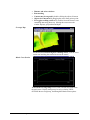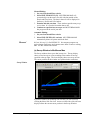
1
User's Manual
HYSWEEP®
HYPACK, Inc.
56 Bradley St.
Middletown, CT
06457
Phone: (860) 635-1500
Fax: (860) 635-1522
Technical Support: [email protected]
Web Address: www.hypack.com
HYPACK®, Inc's HYSWEEP® Manual is not intended to be a
complete manual, but an addendum to the HYPACK® MAX
User's Manual for our multibeam users.
Registration Page
The following information is required in order to register your HYPACK® MAX with
HYPACK®, Inc. Registering your package enables us to send you software upgrades and to
report bugs that have been found in the programs.
Please fill in the following information and fax it to HYPACK®, Inc at (860) 635-1522 or email
the same information to [email protected].
Package:
Hypack® Max
Hypack® Max Lite
Hypack® Max
Survey
Hypack® Max Office
Dredgepack®
Platform:
Windows 2000
Windows XP
License Holder:
Company Name:
Billing Address:
Phone:
Fax:
Email:
Date Purchased:
Purchased From:
Key Number:
FOR SHIPPING OF FUTURE UPDATES: The Maintenance Plan entitles you to all program
updates during that period. Whereas the billing address is often different than where the product
is actually being used, please provide instructions below as to where new release CDs should be
sent.
Contact Person:
Address:
Phone:
Contents
1. HYSWEEP® HARDWARE
I.
II.
III.
IV.
V.
A.
B.
C.
VI.
A.
B.
C.
D.
Specifying Devices in HYSWEEP® Hardware .............................................. 1
Driver Setup in HYSWEEP® Hardware........................................................ 2
Connection Information in HYSWEEP® Hardware .................................... 2
Testing Serial Communication in Hysweep.................................................... 4
Offsets in HYSWEEP® Hardware.................................................................. 5
Position Offsets in HYSWEEP® Hardware................................................................ 6
Rotation Offsets in HYSWEEP® Hardware ............................................................... 7
Latency in HYSWEEP® HARDWARE ..................................................................... 7
Calibrating your System................................................................................... 8
Bar Check .................................................................................................................... 8
Patch Test .................................................................................................................... 9
Adjusting Hardware Offsets ...................................................................................... 16
Applying Data Adjustments to Survey Data ............................................................. 18
2. HYSWEEP® SURVEY
I.
1
21
Hysweep® Display Windows ......................................................................... 21
A.
B.
C.
D.
E.
F.
G.
H.
II.
A.
B.
C.
D.
E.
F.
III.
IV.
A.
B.
C.
V.
VI.
A.
Main Window in Hysweep® Survey ......................................................................... 21
Profile Window in Hysweep® Survey ...................................................................... 23
3D Seafloor in Hysweep® Survey ............................................................................ 23
Multibeam Waterfall in Hysweep® Survey .............................................................. 24
QC Test Window Hysweep® Survey........................................................................ 24
Coverage Map and Cross Section Windows in Hysweep® Survey .......................... 25
Limits Window.......................................................................................................... 27
Seabat 9001 Control Window in Hysweep® Survey ................................................ 27
View Options in Hysweep® Survey............................................................... 28
Range Settings in Hysweep® Survey........................................................................ 28
Multibeam Display Settings in HYSWEEP® Survey ............................................... 29
QC Test Settings in Hysweep® Survey..................................................................... 30
Coverage Map Settings in Hysweep® Survey .......................................................... 31
Other Display Settings in Hysweep® Survey ........................................................... 31
Color Settings in Hysweep® Survey......................................................................... 32
Files and Filenames in Hysweep® Survey .................................................... 32
Corrections in Hysweep® Survey.................................................................. 33
Tide Corrections in Hysweep® Survey..................................................................... 33
Squat and Settlement (Dynamic Draft) Corrections in Hysweep® Survey............... 33
Sound Velocity Corrections in Hysweep® Survey ................................................... 34
Logging Data in Hysweep® Survey............................................................... 36
Logging Options in Hysweep® Survey ......................................................... 37
Data Logger ............................................................................................................... 37
B.
C.
Matrix Files in Hysweep® Survey ............................................................................ 38
Targeting and Target Files in Hysweep® Survey ..................................................... 40
VII.
Playback........................................................................................................... 41
3. MULTIBEAM PROCESSING
I.
II.
A.
B.
C.
D.
E.
F.
G.
H.
I.
J.
K.
III.
IV.
A.
B.
C.
Multibeam Post-processing Sequence Guides .............................................. 43
Multibeam Max Program............................................................................... 44
Multibeam Max Procedure ........................................................................................ 45
Tools.......................................................................................................................... 46
Selecting Sounding Files in Multibeam Max ............................................................ 48
File Open Options in Multibeam Max....................................................................... 49
Corrections in Multibeam Max.................................................................................. 50
Read Parameters in Multibeam Max ......................................................................... 53
Editing Data in Multibeam Max-Phase One.............................................................. 66
Editing Data in Multibeam Max-Phase Two............................................................. 71
Matrix Settings in Multibeam Max ........................................................................... 75
Editing Data in Multibeam Max-Phase Three........................................................... 76
Quality Control Tests in Multibeam Max.................................................................. 82
Clipping Survey Files...................................................................................... 87
Sounding Selection Programs for Multibeam Surveys................................ 88
Comparison of Sounding Selection Methods for Multibeam Data............................ 89
Mapper Program........................................................................................................ 89
Sounding Reduction Program.................................................................................... 95
4. MULTIBEAM APPENDIX
I.
43
99
Multibeam Survey Advantages...................................................................... 99
A.
B.
Sweep Sonar Systems.............................................................................................. 100
Devices Supported in HYSWEEP® Hardware ....................................................... 102
1. HYSWEEP® Hardware
HYSWEEP® HARDWARE is used to install those devices that are
specific to multibeam surveys. The procedure in HYSWEEP®
HARDWARE is similar to that of the HARDWARE program.
1. Open HYSWEEP® HARDWARE by selecting
PREPARATIONS-HARDWARE-HYSWEEP® HARDWARE.
2. Select your devices.
3. Specify the driver and communication settings.
4. Test the communication between the devices and your survey
computer.
5. Enter measured offsets.
6. Calibrate your system and enter your offsets.
7. Exit HYSWEEP® HARDWARE. by clicking [Close]. Your
hardware settings will automatically be saved when you exit.
I. Specifying Devices in HYSWEEP® Hardware
Adding (and removing) devices is easy from the
Manufacturer/Model Tab.
To add a device, select the device in the left-side list then click
[Add]. The device should write to the Installed list. If a device has
setup specifications that need to be defined, the Setup button will be
enabled and will display a dialog with the required setting choices.
To remove a device, select the device name in the Installed list then
click [Remove].
7/04
HYSWEEP® Hardware • 1
The Equipment Tab
II.
Driver Setup in HYSWEEP® Hardware
Some device drivers require settings specific to the device. In these
cases, [Setup] is enabled. Click it and the Driver Setup dialog
appears.
An example of this is the driver that connects HYSWEEP® to
HYPACK® SURVEY. The Driver Setup dialog determines whether
to use the tide corrections, draft corrections and heading provided by
HYPACK®.
Setup dialog for the
HYSWEEP® Interface
III. Connection Information in HYSWEEP®
Hardware
Click the Connect tab to access device communication settings.
Connection settings are required for each serial or network device.
Serial or Network connection options are included in this dialog
according to your device. Drivers that read their data from Shared
2 • HYSWEEP® Hardware
7/04
Memory and the Analog Sidescan driver require no connection
settings.
HYSWEEP®
HARDWARE Setup—
Serial Connections
•
•
•
•
Enabled in the upper left corner. This selection allows devices
to be temporarily removed from the configuration without losing
the device settings.
Ignore Checksum is not recommended, but there are situations
(normally testing) where the checksum is wrong but the data is
good.
The Timeout Interval determines how long after the last data
received from the device that the device alarm turns from green
to red.
Record Raw Messages saves the original data string as it is read
from the device into the raw data file. (Binary data is output in
hexadecimal format.)
Note: The interval for the Nav, MRU, Gyro, Sidescan and
Multibeam alarms are fixed at 10 secs..
Serial Connection Settings:
• Port, Baud Rate, Parity, Data Bits, Stop Bits: Enter your
device settings. These should be in the information received
from the device manufacturer.
• The Read from File checkbox enables you to simulate data
input from this device by reading a file. Many times, when you
are having a problem with a device in the field, we will ask you
to log some of the output from the device to a file and upload it
to us. We can then replay the information using the File setting
to see what is happening.
Network device connections:
In HYSWEEP® HARDWARE, drivers specify the network
connection automatically. Define the network settings in the
Connect Tab.
7/04
HYSWEEP® Hardware • 3
HYSWEEP®
HARDWARE
Connect
Dialog
If you have a DNS server, you can define your destination computer
by name or by IP Address. If you do not have a DNS server, you
must include the IP Address. If these values are unknown, contact
Coastal or the device manufacturer for help.
Configuring Network
Device Connections
IV. Testing Serial Communication in Hysweep®
Hardware
The COM test shows status of serial communication ports 1 through
10. Ports shown as available are those that HYSWEEP® can open
for reading, although this can be misleading. Modems, for example,
show up as available but are seldom used for device connection.
Ports shown as not available are truly that.
Ports connected to working HYSWEEP® devices show the latest
messages. ASCII devices like the TSS and Sperry gyro send easy to
read messages. Binary devices like the Seabat and Seatex show
garbled messages even when the data is good.
The screen capture shows an interfacing problem - the TSS and
Seabat ports are reversed. (If you noticed that, I think you can safely
skip the rest of this manual
4 • HYSWEEP® Hardware
7/04
The COM Test Tab
V.
Offsets in HYSWEEP® Hardware
Click the Offsets tab to enter device mounting offsets and latency
times.
Users of multibeam sonar systems should understand the
importance of these offsets and the difficulties in finding the
right values. Offsets are stored in Hysweep.ini in the
\Hypack\Projects directory. HYSWEEP® HARDWARE also
makes a backup copy in the project directory.
Setting your
Offsets
7/04
HYSWEEP® Hardware • 5
The drop-down list at the top selects one of the offset points that
apply to the device. Offset points are:
Antenna Offsets: Applies to positioning devices such as GPS location of the antenna.
Heading Offset (Yaw): Applies to gyros and other heading devices
– rotation required to measure heading relative to grid north.
MRU Offsets: Applies to devices that measure heave, pitch and roll
- physical location and orientation of the box.
Sonar Head 1 and 2: Applies to multibeam sonar - physical location
and orientation of the sonar head..
[Diagram] displays a visual representation of your hardware setup in
the Boat Reference dialog. Describe the size of your vessel by
entering its Length and Width. The origin defaults to the center of
your vessel based on the specified Length and Width. Reposition the
origin by entering offsets of the origin from that point and the
crosshairs on the diagram will shift accordingly. The Boat Reference
dialog reads the offsets information, lists them under Device
Positions and, when you select the device under Units, plots them on
the boat diagrams.
Boat Reference Dialog
A. Position Offsets in HYSWEEP® Hardware
In multibeam surveys, HYPACK® HARDWARE and HYSWEEP®
HARDWARE typically have different origin points.
The HYPACK® origin is typically the sonar head. The Helmsman
Displays use HYPACK® Offsets for the positioning of the boat. In
SURVEY the Left-Right Indicator will, therefore, be based on the
position of the sonar head enabling the helmsman to record
soundings accurately on the survey line.
The HYSWEEP® origin is typically the vessel's center of mass.
This is the pivot point for roll and pitch rotations and it is where the
MRU should have been mounted. The offsets for the sonar, gyro,
MRU and the Antenna Offsets in the HYSWEEP® SURVEY setup
are all based on this point and are used with the raw positions
received from HYPACK® to calculate the sounding positions.
6 • HYSWEEP® Hardware
7/04
Sample configuration
for a dual origin
Hardware Setup
B. Rotation Offsets in HYSWEEP® Hardware
GPS (from HYPACK®): Use 0, 0, 0.
Multibeam sonar: Use 0, 0, 0 initially then find the true rotations
with the Patch Test.
MRU: Use 0, 0, 0 and calibrate the MRU to reset it’s pitch and roll
zeros.
Gyro: Use 0, 0, 0 and calibrate the gyro to true north.
C. Latency in HYSWEEP® HARDWARE
Although latency is a lag time (a negative time offset), the
convention is to enter latency as a positive number. If you are
preparing to enter a negative latency, stop and re-figure.
1) GPS Latency
GPSs are entered to your setup in HYPACK® HARDWARE.
However, in order for the position data to be recorded to the
multibeam raw data, you must install the HYPACK® Navigation
driver in HYSWEEP® HARDWARE. Enter Antenna Height,
horizontal offsets relative to the HYSWEEP® origin. You will also
need the same latency value as you have in HYPACK®
HARDWARE. They do not affect each other. HYPACK®
HARDWARE offsets will be applied to single beam data, while
HYSWEEP® HARDWARE offsets will be applied to multibeam
data.
2) Multiple Transducer Offsets
If the device is a multiple transducer sonar system, [Multiple
Transducers] is enabled. Click it to show the Multiple Transducer
Offsets form
7/04
HYSWEEP® Hardware • 7
Multiple
Transducer
Offsets
The offset form for multiple transducer systems is self-explanatory.
Enter the number of transducers, then the position offsets of each
transducer. The roll and pitch offsets are included but seldom used.
3) Editing Device Settings in HYSWEEP® Hardware
You can easily modify HYSWEEP® HARDWARE settings by
selecting the device name in the Installed List and changing the
entries in associated dialogs. The new settings will be saved to the
Hysweep.ini file when you exit HYSWEEP® HARDWARE.
VI. Calibrating your System
A. Bar Check
The Bar Check routine enables you to calibrate your echosounder
and save documentation of the process.
1. Open the Bar Check program by selecting TOOLS-BAR
CHECK. The Bar Check window will appear.
8 • HYSWEEP® Hardware
7/04
Bar Check Window
2. Click [Reset Barcheck.txt] to begin a new Bar Check Report.
3. Set your filters.
▪ Depth Gate determines the scope of the display in the lower
part of the window.
▪ Angle Limit defaults to 75 degrees. If you see indications on
the sides that the outer beams are inaccurate you may need to
narrow your focus. We have seen instances where, at 75
degrees, the outer beams were hitting the chains suspending
the bar thus affecting the accuracy of the test.
▪ Bar Depth is the depth at which the bar is currently set.
▪ Measured Depth is a calculated average of all sounding
data over the three-second interval.
4. Set your Bar Depth and watch the data on the screen.
5. When the Measured Depth stabilizes, hopefully approximately
equaling the Bar Depth, click [Save Depth]. This saves
statistical documentation about the data gathered by each beam
over the past three seconds.
6. Repeat the process for each Bar Depth.
7. When the test is complete, click [Barcheck.txt] to view and
print the stored data in Windows® Notepad.
B. Patch Test
While it is difficult to accurately measure the angular mounting
components (roll, pitch, and yaw) of multibeam systems, errors in
these measurements can lead to inaccurate surveys. The patch test is
7/04
HYSWEEP® Hardware • 9
a data collection and processing procedure to calibrate these angles,
along with positioning system latency.
In the PATCH TEST, the roll test is, by far, the most important
because it is misalignment in the roll direction that leads to the
greatest survey errors. The roll test always works and gives
repeatable results.
The other tests that depend on accurate positioning (latency, pitch
and yaw), do not always work. Sometimes they do, but don’t be
surprised if you run one of these tests twice and get somewhat
different results. (Use the average in this case.) We think that drift
in GPS positions is responsible.
1) Patch Test Procedure
1. Collect survey data in the prescribed pattern.
2. Process the data in MULTIBEAM MAX through all three
phases of the editing process. At this point, the Patch Test
option will be enabled in the MULITIBEAM MAX Tools menu
3. Run the Patch Test which will calculate offset adjustment
values for latency, pitch, yaw and roll.
Note: The recommended order of Patch Test Processing has been
(1) Roll, (2) Latency, (3) Pitch then (4) Yaw. The Patch Test will
use each progressive adjustment value to calculate subsequent
adjustments. It is therefore wise to run the calculations in order from
the one unaffected by the others to the one affected by all of them.
Due to improvements in our methods, the influence of order has
become insignificant except for the yaw calculation. It is still wise to
perform this calculation last.
4. Enter the adjustment values in the Offsets Dialogs in the
HARDWARE program.
5. Correct the offsets in data collected with incorrect offsets with
the DATA ADJUSTMENTS program.
6. If hardware or data adjustments are necessary, follow the
directions in the following sections EXACTLY. Making these
adjustments with attention to whether you should add or subtract
and if your number is positive or negative is important.
2) Patch Test Data Collection
Lines are run over specific bottom terrain in a specific way for each
offset. patch test only works on overlapping data so take care to stay
on line. And always collect two sets of data to double-check the
results.
Verify the multibeam power and gain settings before data collection
to minimize spikes.
10 • HYSWEEP® Hardware
7/04
(a) Single Head Data Collection Pattern
Map View of Patch
Test Survey Lines
with Bottom
Contours.
(a) Tests Roll
Angle
(b) Tests
Positioning
System Latency
(c) Tests Pitch
Angle
(d) Tests Yaw
Angle
•
•
•
•
To test the roll angle, locate an area where the bottom is smooth
and flat. Create a 200- to 300-foot planned line over this area,
then run the line in both directions at normal survey speed. Over
these bottom conditions, latency, pitch and yaw angles do not
matter.
To test latency, create a 200- to 300-foot planned line
perpendicular to a bank. Then run the line twice in the same
direction, once at maximum survey speed and again as slowly as
possible. It doesn’t matter whether the line is run up-slope or
down-slope. Choose an area where the current is slow, to
minimize crabbing and make it easier to stay on line. Errors in
pitch and yaw angles cancel out.
To test pitch, run reciprocal survey lines across the bank at
normal survey speed.
To test yaw, create a second planned line parallel to the latency
and pitch line and offset by channel depth. Run each of the
parallel lines in the same direction at normal survey speed.
(b) Dual Head Collection Pattern
The data collection pattern for a dual head multibeam system is a
little different than for the single head system in order to overlap the
soundings and Patch Test for head 1 and head 2 separately.
The data collection pattern for a dual head multibeam system is a
little different than for the single head system in order to overlap the
soundings and Patch Test for head 1 and head 2 separately.
7/04
HYSWEEP® Hardware • 11
Roll data
Yaw (Y),
Latency (L),
Pitch (P)
•
•
•
•
To test the roll angle, locate an area where the bottom is smooth
and flat. Create a set of three, 200- to 300-foot planned lines over
this area, spaced at a distance equal to the depth of the Patch Test
area. Run the lines, at normal survey speed, alternating
directions.
Test latency in the same manner as for the single head system.
To test pitch, locate and area with a sloping bottom and create a
set of three, 200-to 300-foot planned lines over this area, running
with the slope and spaced at a distance equal to the depth in the
shallow end of the Patch Test area. Run the lines, at normal
survey speed, alternating directions.
To test yaw, using the same lines as for the Pitch test, run them,
at normal survey speed, but all in the same direction.
3) Calculating Offset Adjustments with Patch Test
Offset adjustments can be calculated with the PATCH TEST in
MULTIBEAM MAX.
Note: You must be in Phase 3 of the MULTIBEAM MAX editing
process.
Typically, you will load two lines of raw test data at a time to
MULTIBEAM MAX according to which offset you are testing. If
you have a dual head system, it also depends on the head for which
you are testing. Use MULTIBEAM MAX to apply your sound
velocity and tide corrections and remove all spikes and outliers.
After you have completed phase 3 of the MULTIBEAM MAX
12 • HYSWEEP® Hardware
7/04
editing, run the PATCH TEST from the MULTIBEAM MAX Tools
menu.
You can use files that have been previously edited in the old
HYSWEEP® EDITOR or have gone through a sounding reduction
program which saves its results in XYZ format.
MULTIBEAM MAX can read the following files:
• HSX files: raw multibeam data created in HYSWEEP®
SURVEY
• HS2 files: multibeam files that have been edited in
MULTIBEAM MAX
• SWP files: multibeam files that have been edited in the
HYSWEEP® Editor.
• XYZ format: ascii files typically saved from a sounding
selection program.
To Run the PATCH TEST:
1. Run one pair of test lines (roll, latency, pitch or yaw) through
MULTIBEAM MAX.
2. In phase 3 of MULTIBEAM MAX, start PATCH TEST.
a. If you want MULTIBEAM MAX to choose the cross
section on which to base the statistics, select TOOLSPATCH TEST. The PATCH TEST will appear
displaying the selected data and an "Automatic Cross
Section" label. In this case the cross sections will be
positioned as follows:
¾
Roll: Transverse to the survey lines at their mid-point.
¾
Pitch and Latency: Directly under the trackline.
¾ Yaw: mid-way between the tracklines.
b. If you want to choose the cross section on which to base
the statistics yourself, click the wrench icon in the Survey
window then define the cross section by dragging the
cursor across the data in the Survey window. The
PATCH TEST will appear displaying the selected data
and an "Manual Cross Section" label.
The PATCH TEST is a 4-tabbed dialog—one tab for each offset
tested.
3. Select the tab that corresponds to the sounding lines you
selected. (If you selected the lines to test roll, select the roll tab.)
4. Each tab has suggested settings for the Angle/Time Step and
Number of Steps. You may enter new values if you wish.
5. If you are using a system with two sonar heads, tell
MULTIBEAM MAX whether to use data from head 1, head
2 or both. (Select Head 1 if your echosounder has only one
head.) This option is useful where two sonar heads are mounted
in different places on the survey vessel.
6. Click [Start Test]. MULTIBEAM MAX will do the
calculations to determine if any offset adjustments are necessary.
7/04
HYSWEEP® Hardware • 13
When the calculations are complete, the results will be
displayed.
The calculated adjustment will appear under Adjustment. It will be
used with the Initial Adjustment to calculate and update the Final
Adjustment which is entered in the Offsets dialog in HYSWEEP®
HARDWARE. You can view cross sections of your soundings and
the results of the calculations in the graphs in the lower part of the
window.
MULTIBEAM MAX
Roll Test
MULTIBEAM MAX
GPS Latency Test
14 • HYSWEEP® Hardware
7/04
MULTIBEAM MAX
Pitch Test
MULTIBEAM MAX
Yaw Test
4) Example of Patch Test
The following is an example of an actual Patch Test. The data sets
are distributed on your install CD. You will not be able to do the
example problem unless you have a HYSWEEP® installed on your
computer and a HYSWEEP® or Universal hardlock installed on the
printer port.
Example
Catalog file HSX_PATCHTEST.LOG contains raw data files from a
patch test. Use the Patch Test program in Multibeam Max to find the
roll error.
Solution:
1. Open MULTIBEAM MAX by selecting PROCESSINGMULITBEAM MAX.
2. Open a Sounding Catalog by selecting FILE-OPEN (F2). A
file selection dialog will appear.
7/04
HYSWEEP® Hardware • 15
3. Select the HSX_PATCHTEST.LOG file and click [OK]. A
list of files in the catalog will appear.
4. Select ROLL1.hs2 and ROLL2.hs2 for roll testing, then click
[OK]. The File Open Options dialog will appear.
5. Set File Options. These are some basic choices about how
MULTIBEAM MAX will read and save the data
6. Enter your Tide and Sound Velocity corrections. [Open File]
in each section will enable you to browse for each file. Click
[OK] and the READ PARAMETERS window will appear.
7. Select the correct devices for each data type for each file
selected. In this example, select GPS for Navigation, NMEA0183 gyro for Heading, TSS for Heave Pitch and Roll and Seabat
as the echosounder. Click [OK].
8. Examine and edit your data as described in the chapter on
Multibeam Processing.
9. Calculate your Adjustments in the Patch Test.
a. Launch the Patch Test. (Only available in phase 3 of
MULTIBEAM MAX.)
¾
If you want MULTIBEAM MAX to choose the cross
section on which to base the statistics, select TOOLSPATCH TEST.
If you want to choose the cross section on which to
base the statistics yourself, click the wrench icon in the
Survey window then define the cross section by
dragging the cursor across the data in the Survey
window.
b. Select the Roll tab and accept the default settings. Sonar
Head 1 will already be selected.
c. Click [Start Test]. PATCH TEST will do the calculations
to determine if any offset adjustments are necessary.
When the calculations are complete, the results will be
displayed. The calculated adjustment will appear under
Adjustment. It will be used with the Initial Adjustment to
calculate and update the Final Adjustment which is
entered in the Offsets dialog in HYSWEEP®
HARDWARE.
10. Repeat the entire process for each pair of files. After the you
have completed the first set (typically the roll test), when you
load the next pair of files, MULTIBEAM MAX will ask whether
you want to apply the previously calculated values to the current
portion of the patch test.
¾
C. Adjusting Hardware Offsets
Calibration tests calculate adjustments that must be made in your
Hardware Offsets settings to collect accurate depth and position data.
16 • HYSWEEP® Hardware
7/04
The Latency value calculated by the PATCH TEST should be
entered into the hardware setup for your GPS to correct timing errors
in the system.
In the HARDWARE program:
1. Click on the DEVICE menu and select your position device.
2. Click [Offsets] and enter your latency in seconds.
3. Click [OK] to exit OFFSETS, and [OK] again to exit the
DEVICE SETUP.
The change will be saved automatically when you exit the
HARDWARE program.
In the HYSWEEP® HARDWARE program:
Enter the Final Offsets value from the PATCH TEST dialogs to the
device offsets in the HYSWEEP® HARDWARE program. Select
"Hypack Survey" to apply the Latency and the echosounder to apply
the roll, pitch and yaw values.
Note: For devices that are loaded through HYPACK®
HARDWARE but feed information to HYSWEEP® SURVEY,
change the offsets in HYPACK® HARDWARE and in
HYSWEEP® HARDWARE.
For example, for a GPS:
• In HYPACK® HARDWARE, select the GPS and adjust the
Offsets dialog.
• In HYSWEEP® HARDWARE, select HYPACK® SURVEY
and adjust the antenna offsets in the Offsets Tab.
Adjusting Hardware
Offsets in Hardware
7/04
HYSWEEP® Hardware • 17
Adjusting Hardware
Offsets in HYSWEEP®
Hardware
D. Applying Data Adjustments to Survey Data
If you run your calibration test before the survey, and the calculated
adjustments made in the hardware setup, data should not have to be
adjusted. We all know, however, that things happen and we may
need to adjust survey data. When it is are required, existing single
beam data files are fixed by the DATA ADJUSTMENTS program.
Multibeam data is adjusted as it is read into MULTIBEAM MAX.
1) Applying Data Adjustments to Raw Multibeam Data
Beware!
If data adjustments are necessary, follow the directions in the following
section EXACTLY. Making these adjustments with attention to
whether you should add or subtract and if your number is positive or
negative is important.
1. Select UTILITIES-FILE WORK-DATA ADJUSTMENTS
and a dialog will appear.
2. Enter the adjustment values as calculated by the PATCH
TEST.
•
•
•
•
18 • HYSWEEP® Hardware
To adjust roll and pitch, check ADJUST HEAVE, PITCH,
ROLL and enter the dPitch and dRoll adjustment values.
To adjust yaw, check ADJUST GYRO and enter dTheta.
(This old program can not adjust the multibeam directly.)
To adjust latency, check ADJUST POSITIONS and enter
dTime.
Enter the 3-character tag for the adjusted files and click [OK]
to start the adjustment process.
7/04
The Data
Adjustments
Dialog
3. Click [OK] to start and select your raw log file from the file list.
The individual files will be adjusted and re-written with the new
extension. The adjustments program does not overwrite original
raw data files.
2) Applying Data Adjustments to Multibeam Data in PostProcessing
MULTIBEAM MAX has options to modify device offsets in the
Device Information option of the Read Parameters.
The Device Information tab displays settings for each device in your
project. Select the device of interest from the drop-down box and
modify the Offsets. .Any changes you make here will be applied to
all currently selected files.
Note: Editing the offsets in this manner will affect only the edited
data. It will not affect raw data.
7/04
HYSWEEP® Hardware • 19
Device Information
Window
20 • HYSWEEP® Hardware
7/04
2. Hysweep® Survey
HYSWEEP® SURVEY is a multibeam and side scan data collection
and logging program. Real-time displays and quality control testing give
on-the-spot information on bottom conditions and data quality.
Data is logged XTF format, then processed through MULTIBEAM MAX
The playback mode replays HYSWEEP® SURVEY files, as well as
multibeam files logged by HYPACK® 8.1–8.9, giving the same view seen
on the boat.
The HYPACK® and HYSWEEP® SURVEY programs run
simultaneously, with HYPACK® providing navigation and single beam
data collection and HYSWEEP® providing the multibeam features.
I. Hysweep® Display Windows
There are several display windows which may be displayed through
HYSWEEP® for real-time monitoring of your data collection. In
addition to those discussed in the following sections, HYSWEEP
SURVEY also includes the Side Scan Waterfall and Side Scan Signal
windows which are described under SIDE SCAN SURVEY.
Most HYSWEEP® windows have a tool bar at the top, providing
shortcuts to window configuration. Pass the mouse pointer over a tool to
see a hint as to what the tool does. Tool bars are toggled on / off with the
F10 key.
All of HYSWEEP® SURVEY’s windows can be resized and moved
around the screen, retaining it’s size and position until changed. VIEWTILE WINDOWS will arrange the currently open windows in a manner
that attempts to optimize your viewing in each window.
A. Main Window in HYSWEEP® Survey
The main window consists of a menu, some indicators and some
measurements. It can be resized to show only items of interest and will
retain the size on subsequent program runs.
7/04
HYSWEEP® Survey • 21
HYSWEEP®
Survey
The title bar gives logging and playback status. "Offline" is shown when
neither logging nor playback is active. The current data file is shown
when logging or playback is active.
You can choose to display data relative to the boat or to the towfish by
selecting the option at the bottom of the dialog.
1) Alarms in HYSWEEP® Survey
HYSWEEP® SURVEY can be configured to continuously check for and
notify you of data errors or loss of data input. They show green (OK),
yellow (careful) or red (look out) depending on status. Click the
indicator to show status history.
The Nav, MRU, Gyro, Side Scan and Multibeam alarms at the top of
HYSWEEP's main window turn red when no data has been received
from the corresponding device for 10 seconds.
The Devices alarm turns red when no data has been received for a period
longer than the Time Out Interval that you set for each device in the
hardware setup.
There are alarms for heave drift, excessive multibeam–single beam
difference and excessive multibeam overlap difference and several other
problematic conditions.
To set up the alarms and limits, select VIEW-OPTIONS-QC Test and
choose your alarms and limits.
2) HYSWEEP® Survey Measurements
Updated about once a second.
Depth: Nadir beam depth in working units.
Time (Event): Latest sounding time and event number. Time will not
update if no soundings are being received.
Tide Corrections: Latest tide correction from Hypack® Survey.
Draft Corrections: Latest dynamic-draft correction from Hypack® or
from the HYSWEEP® squat & settlement table.
Heave: Latest heave in work units, positive upward.
22 • HYSWEEP® Processing
7/04
Roll: Latest roll in degrees, positive port side up.
Pitch: Latest pitch in degrees, positive bow up.
Heading: Latest ship heading.
Easting / Northing: Latest grid position from HYPACK® SURVEY.
B. Profile Window in HYSWEEP® Survey
The Profile window shows sweep profiles in various ways:
• a profile line
• the beam pattern (shown)
• a bizarre wave-front display.
Only the profile line is available with multiple transducer systems. The
view is looking forward from behind the sonar..
Profile Window
This display is limited to 75 beams and the swath width is displayed in
the status bar. Note the color of the beams. The coding is such that blue
indicates good data, yellow marginal and red bad. The relationship
between color and beam quality code is established under VIEWOPTIONS-Other.
To show the Profile Window, select VIEW-PROFILE WINDOW from
the HYSWEEP® menu. Display settings for the Profile Window are set
by selecting VIEW-OPTIONS then RANGE SETTINGS and
MULTIBEAM DISPLAY.
C. 3D Seafloor in HYSWEEP® Survey
The 3D Seafloor window shows a three-dimensional representation of
the aft seafloor. The view is through the rear-view mirror, which is
somewhat odd but is the only way to draw these 3Dimensional images
effectively. Display methods are:
• 3D Wiggle
• Color Wire Frame
• Solid TIN
• Color TIN (shown)
F11 toggles scrolling on / off and is useful to freeze the frame in case
something interesting shows up. Moving the cursor across the window
displays grid position and depth. Contacts may be targeted by double
7/04
HYSWEEP® Survey • 23
clicking the object of interest and object size is measured by dragging the
cursor from point to point.
3D Seafloor
To show the 3D Seafloor, select VIEW-3D SEAFLOOR from the main
HYSWEEP® SURVEY menu. Display settings may be set by selecting
VIEW-OPTIONS then Range Settings and Multibeam Display.
D. Multibeam Waterfall in HYSWEEP® Survey
The Multibeam Waterfall is a forward-looking representation of the
seafloor shown as a gray or color TIN. The waterfall is a more
traditional display method than the 3D view.
Multibeam
Waterfall
F11 toggles scrolling on / off and is useful to freeze the frame in case
something interesting shows up. Moving the cursor across the window
displays grid position and depth. Contacts may be targeted by double
clicking the object of interest and object size is measured by dragging
the cursor from point to point.
To access this window, select VIEW-MULTIBEAM WATERFALL
from the main HYSWEEP® SURVEY menu. Display settings may be
set by selecting VIEW-OPTIONS then Range Settings and Multibeam
Display.
E. QC Test Window HYSWEEP® Survey
The QC Test window shows the results of one of four HYSWEEP®
quality control tests.
24 • HYSWEEP® Processing
7/04
•
•
•
Depth change by Beam: Shows the depth change of each beam over
a specified number of pings. Faulty beams and incorrect attitude
compensation show up clearly in this test.
Standard Deviation by Beam: Approximates the standard deviation
of each beam over the last 500 pings using the method of Eeg1. May
be used in flat areas to assess overall sounding precision.
Multibeam vs. Single Beam: Compares multibeam nadir with single
beam. Useful for validating the multibeam sonar against the more
traditional (and more widely accepted as correct) single beam
echosounder.
Multibeam vs.
Single Beam
Comparison
•
Multibeam Sounding Overlap: Provides multibeam overlap
statistics within matrix cells. May be used in flat areas to validate
multibeam system calibration.
All of these tests make some approximations and work better over a flat
surface. An example of the multibeam vs. single beam test is shown in
the screen capture. The problem with this test over variable bottom
terrain is that the wide-angle single beam transducer sounds a wider area
per ping than the narrow nadir beam, resulting in a slight shoal bias for
the single beam.
To access this window, select VIEW-QC TESTS from the main
HYSWEEP® SURVEY menu. Set display settings by selecting VIEWOPTIONS then qc tests.
F. Coverage Map and Cross Section Windows in HYSWEEP®
Survey
The Coverage Map views the survey area from above. It has a number
of features and options.
• Multibeam and side scan coverage as scan lines
• Color-coded matrix display showing (1) minimum depth (shown in
the screen capture), (2) maximum depth, (3) average depth, (4)
overlap difference and (5) 1x / 2x multibeam coverage
• A tool bar for (1) cutting cross sections, (2) panning and (3)
zooming
1
Eeg, Jorgen: On the Estimation of Standard Deviation in Multibeam Soundings. The Hydrographic Journal, No.
89, July 1998.
7/04
HYSWEEP® Survey • 25
•
•
•
•
•
Distance and color scale bars
Boat tracking
Contacts may be targeted by double clicking the object of interest
Object size is measured by dragging the cursor from point to point.
F11 toggles scrolling on/off and is useful to freeze the frame in case
something interesting shows up. Moving the cursor across the
window displays grid position and depth.
Coverage Map
To cut a cross-section through the sounding matrix, click the crosssection tool and drag the section line across the matrix.
Matrix Cross Section
To access the Coverage Map, select VIEW-COVERAGE MAP from
the main menu. Display settings may be set by selecting VIEWOPTIONS then coverage map, and through the Matrix menu options.
26 • HYSWEEP® Processing
7/04
G. Limits Window
Limits Window
The Limits window shows information about the depth and width of the
sweep.
• The Corrected Depth displays data from the outer beam on each
side and the nadir beam. The depths on the left of each graph show
the minimum to maximum depths read from that beam. The depths
on the right show the current depth reading.
• The Offset display shows the width of the sweep. The top numbers
are the width of the most recent reading. The bottom numbers show
the maximum distances to either side of the nadir beam and the total
of the two values.
Access the Limit window using VIEW-LIMITS. Display settings may
be set by selecting VIEW-OPTIONS-RANGES.
H. Seabat 9001 Control Window in HYSWEEP® Survey
Seabat 9001
Control Window
This window provides control functions for the Seabat 9001. To access
this window, select TOOLS-SEABAT 9001 CONTROL from the main
menu.
7/04
HYSWEEP® Survey • 27
II.
View Options in HYSWEEP® Survey
Each of the HYSWEEP® SURVEY windows is configurable to a
certain extent. Range settings are adapted to expected bottom depths,
display styles are selected to the operators personal preference, etc. The
options are all available in the View Options form
To access View Options, select VIEW-OPTIONS from the main
HYSWEEP® SURVEY menu or press the F9 short-cut key.
Note: The side scan windows have separate display options accessed
from an icon in their windows.
A. Range Settings in HYSWEEP® Survey
Click the Range tab to set depth, offset and angular display limits. Note
that while these limits are used by the HYSWEEP® SURVEY display
windows, they do not effect data logging. All soundings are logged,
always, period.
Some of the range settings (multibeam depth, offset, angle and quality
limits) are saved in data files for optional use in post-processing. This
feature allows the surveyor, who knows the water he’s working in, to
control range settings for post-processing.
The Range Tab
Work Units: Select survey grid units, Meters, US Feet or International
feet. This option is only available when HYSWEEP® SURVEY is run
without HYPACK® MAX. Otherwise the selections are disabled and
work units are taken from HYPACK® GEODESY.
Multibeam:
• Minimum Depth: Enter minimum depth gate. No soundings above
this depth are displayed.
• Maximum Depth: Enter maximum depth gate. No soundings below
this depth are displayed.. This value also determines the resolution
of the saved depth value (which is always saved in meters).
Max Depth
Resolution
< 500 meters
0.01 meters
> 500 meters and < 5000 meters
0.10 meters
<5000 meters
1.00 meters
28 • HYSWEEP® Processing
7/04
•
•
•
•
•
Port Offset Limit: Maximum horizontal sounding offset allowed for
display (port side).
Starboard Offset Limit: Maximum horizontal sounding offset
allowed for display (starboard side).
Port Angle Limit: Maximum beam take-off angle (from vertical) to
the port side. Beams at angles greater than this setting are not
displayed.
Starboard Angle Limit: Maximum beam take-off angle (from
vertical) to the starboard side.
Depth Range for Overlap Colors: When a matrix is displayed in
the Overlap method, depth differences are color coded from 0 to this
value.
B. Multibeam Display Settings in HYSWEEP® Survey
The Multibeam Display Settings control the style and coloring of the
multibeam displays.
Multibeam
Display Tab
Profile Window:
• Sweep Profile shows the bottom profile of each sweep.
• Beam Pattern shows each beam with color-coding based on quality.
• Wave front shows the sounding wave front and backscatter points.
• Sounding Points: Each sounding is shown as a color-coded dot of
user-defined Point Size (pixels). The point size is defined in the 3D
Seafloor options.
• Fix Vertical=Horizontal Scale keeps the view from being stretched
disproportionately in either direction which causes some distortion.
3D Seafloor:
• Wiggle shows a succession of sweep profiles.
• Wire frame shows a wire frame seafloor model with depth colorcoding.
• Solid TIN shows a TIN model with illumination.
• Color TIN shows a TIN model with depth color-coding.
• Sounding Points: Each sounding is shown as a color-coded dot of
user-defined Point Size (pixels).
Multibeam Waterfall:
7/04
HYSWEEP® Survey • 29
•
•
•
Solid TIN shows a TIN model with illumination.
Color TIN shows a TIN model with depth color-coding.
Intensity: If your echosounder has the capability of measuring the
strength of the return signal, this can be represented in gray scale. A
stronger return is represented by a lighter color.
C. QC Test Settings in HYSWEEP® Survey
QC Test Settings control the QC Test Window.
QC Test Tab
Display: Selects one of the four multibeam QC methods.
• Depth Change by Beam: Shows the depth change seen at each
beam over the last N sweeps.
• Estimated Standard Deviation: Estimates the standard deviation of
each beam over the last 100 sweeps.
• Multibeam vs. Single Beam: Provides multibeam vs. single beam
statistics.
• Multibeam Sounding Overlap: Provides statistics on multibeam
overlap. This test is only available when a matrix file is loaded.
Alarm Limits: Enable QC alarms and set limits. Yellow indicators in
the main window bring these alarms to the surveyors attention.
• Heave Drift: Alarm heave drift (over 10 seconds) beyond the limit.
One must watch this closely on small boats because sharp turns can
cause one or more foot of heave error.
• Multibeam–Single beam Difference: Alarm difference (over 500
samples) beyond the limit.
• Multibeam Overlap Difference: Alarm difference (averaged over
all matrix cells) beyond the limit.
• Show Warning Until SV Profile is Entered provides an alarm if
you have not loaded your sound velocity corrections. Of course
(unless you are using the EM2000, EM3000 or EM3002 driver,
which preprocesses your data) you can add or change these
corrections during post-processing by loading a Sound Velocity
Corrections file (*.VEL) in MULTIBEAM MAX.
30 • HYSWEEP® Processing
7/04
D. Coverage Map Settings in HYSWEEP® Survey
Coverage Map settings control the Coverage Map.
Coverage Map Tab
Selections:
• Show Scale Bar: Displays the distance scale bar.
• Show Matrix: Displays the sounding matrix. This option is enabled
only if you are drawing your soundings to HYSWEEP® SURVEY.
• Follow Boat: Re-centers map when the boat leaves the screen.
• Show Multibeam Coverage: Displays multibeam sweep lines while
logging.
• Show Side Scan Coverage: Show side scan lines while logging.
• Show Planned Lines: Displays the planned survey lines.
Buttons:
• Clear Matrix: Clear matrix file of all sounding data.
• Matrix Options: Select matrix display options.
• Clear History: Clear multibeam and side scan coverage lines.
E. Other Display Settings in HYSWEEP® Survey
The Other Tab
Apply Heave, Pitch, Roll Corrections and Apply Tide Corrections:
Select whether or not to apply these corrections to the multibeam
soundings before display.
Black Window Background: Select black or white window
background. As of this writing, displays over a White background are
pretty bad.
Side Scan Display Has Highest Priority guarantees every scan will be
drawn to the Side Scan Waterfall window providing the clearest image
possible. If this is not checked, logging data gets the precedence. If your
7/04
HYSWEEP® Survey • 31
computer is fast enough, it should be able to do both, but it is your
responsibility to check for complete data files.
Manufacturer’s Beam Coding: Assign as sounding quality based on
quality codes received from the multibeam echosounder. The Profile
window color-codes soundings based on quality: high = green, marginal
= yellow, bad = red.
• High Quality Limit: All soundings greater than or equal to this
value are assumed good.
• Marginal Quality Limit: All soundings less than this value are
assumed bad.
• Show Bad Soundings: Selects display of bad sounding data.
F. Color Settings in HYSWEEP® Survey
The Multibeam Waterfall, 3D Seafloor and Coverage Map windows all
include an icon in their tool bars, to access the standard Color dialog.
You can adjust the color scheme for your project as you would in
HYPACK® MAX. The dialog in HYSWEEP® SURVEY shows an
additional option.
Auto-Scale: When selected, the color range is calculated dynamically
based on depth statistics.
The colors can be distributed over a user-defined depth range by
deselecting this option and setting the minimum and maximum color
depth values.
Standard Color
dialog
III. Files and Filenames in HYSWEEP® Survey
When HYSWEEP® SURVEY is run in combination with HYPACK®
MAX, it bases data and target file names on the HYPACK® names. With
minor changes of course, so the names aren’t identical. When
32 • HYSWEEP® Processing
7/04
HYSWEEP® SURVEY is run stand alone, it has it’s own naming
scheme.
Raw file folder: Uses HYPACK® raw data folder.
Catalog Filenames: “HSX_” + HYPACK® catalog name.
Data Filenames: HYPACK® data filename + “.HSX”
Target File Folder: Uses HYPACK® target folder.
Default Target Filenames: “HSX_” + HYPACK® target filename.
Note: HSX means HYSWEEP® SURVEY extension
IV. Corrections in HYSWEEP® Survey
A. Tide Corrections in HYSWEEP® Survey
HYSWEEP® SURVEY gets real-time tide corrections from HYPACK®
SURVEY. This is done automatically through the shared memory
mechanism.
B. Squat and Settlement (Dynamic Draft) Corrections in
HYSWEEP® Survey
HYSWEEP® SURVEY has two methods for application of dynamic
draft correction. HYSWEEP® SURVEY can
• Take dynamic draft corrections from HYPACK® SURVEY
(whether you enter them manually or use the draft table). This is the
default setting.
• Use the Squat and Settlement Table available in HYSWEEP®
SURVEY.
To enter a squat & settlement table, select CORRECTIONS-SQUAT
AND SETTLEMENT and enter the draft correction values (in survey
units) versus speed (in knots). When a table is entered, HYSWEEP®
SURVEY calculates the dynamic draft correction from boat speed (from
GPS via HYPACK® SURVEY) and the table.
7/04
HYSWEEP® Survey • 33
Squat and Settlement
Corrections Table
Note: If you are using RTK tides with HYPACK® (which presumably
you are since you're reading this) you do not need to enter any draft
corrections.
The GPS.dll (formerly known as the Kinematic.dll) subtracts the
dynamic draft correction to compute the "true" tide correction. Without
a draft correction, the driver will still calculate a correct chart sounding,
but the RTK Tide value will be different from the conventional tide
value.
C. Sound Velocity Corrections in HYSWEEP® Survey
The sound velocity model is entered or imported using the main menu
Corrections-Sound Velocity option. The model is recorded into the data
files for use in post-processing.
Note: If there is a pre-existing Sound Velocity Profile when you enter
HYSWEEP® SURVEY, the Multibeam Alarm will show yellow. It's a
good idea to verify it is accurate before you begin to collect data. The
alarm will turn off when you click [OK] in the Sound Velocity Model.
34 • HYSWEEP® Processing
7/04
Sound Velocity
Model
Average sound velocity calculated from the model. HYSWEEP®
SURVEY uses this average for display calculations instead of the more
time consuming ray path calculations used in post-processing.
Units selects the units of the model. Conversion to HYSWEEP®
SURVEY working units is done automatically.
• Meters, M/Sec: Depth is in meters, velocity is in meters per second.
• Feet, Ft/Sec: Depth is in feet, velocity is in feet per second.
To enter the model, simply start typing into the spreadsheet in
increasing depth order. To check for errors, click [Graph] when you're
done.
To import Sound Velocity Files: Many sound velocity profilers log to
a file. [Import] enables import of these files, preventing a lot of tedious
and error-prone typing. Click [Import] , select the file recorded by your
profiler then the Import Form is shown.
7/04
HYSWEEP® Survey • 35
Import Dialog
Field shows up to 8 fields.
Comma Separates Fields is used when commas separate the fields.
Accept checkboxes pick the depth and velocity fields.
[Skip Record] skips a file record.
[Accept Record] accepts a file record.
[Accept All] accepts all records to end of file.
After Import, you may need to swap columns (use [Swap Columns] ) or
reverse the order (use [Reverse Order] ) of the model.
V.
Logging Data in HYSWEEP® Survey
Data logging may be controlled by HYPACK® SURVEY or
HYSWEEP® SURVEY. Logging commands are passed between the
two programs to keep them in the same mode. You may control logging
in HYSWEEP® SURVEY using menu commands or the same keyboard
shortcuts as HYPACK® SURVEY. You may also use F7 to call up the
DATA LOGGER and use the control buttons in that dialog, though there
is no real benefit to this option.
Note: Data can not be logged for three seconds before and after
midnight. During this time, HYSWEEP® SURVEY will close the
current data files and open new ones named according to the new date
and time.
FILE-HYPACK®
DATA LOGGER
Keyboard
Commands-…
Buttons
Shortcuts
START LOGGING
[Start Logging]
Ctrl + S
END LOGGING
[End Logging]
Ctrl + E
INCREMENT LINE
[Increment Line]
Ctrl + I
DECREMENT LINE
[Decrement Line]
Ctrl + D
SWAP LINE
[Swap Line]
Ctrl + W
36 • HYSWEEP® Processing
7/04
Data Logger
You can log data a selection of formats according to the selection in the
Logging Options dialog.
• ASCII (HSX Format): Default ASCII format with full support of
HYSWEEP® SURVEY features.
• Binary Datagrams (HS2 format) selects the binary format with full
support of HYSWEEP® SURVEY features.
• ASCII (HYPACK® 8.9 Compatible) format used by HYPACK®
8.9 SURVEY. This format should only be selected if recorded files
are to be processed with older versions of HYSWEEP® postprocessing or 3rd party software that does not read the updated HSX
format.
The Control buttons effect all data logging in all of the currently active
Survey programs.
VI. Logging Options in HYSWEEP® Survey
A. Data Logger
Select FILE-DATA LOGGER (or hit F7) and click [Logging Options]
from the Data Logger form. The Logging Options dialog will appear.
Set your options for logging survey data to files.
Logging Options
Window
7/04
HYSWEEP® Survey • 37
File Info: Information used to name data and catalog files. When
running HYSWEEP® SURVEY with MAX, the project name and
logging folder are pre-selected and unchangeable.
Record Method:
• ASCII (HSX Format): Selects ASCII format with full support of
HYSWEEP® SURVEY features.
• Binary Datagrams (HS2 format): Selects the binary format with
full support of HYSWEEP® SURVEY features.
• ASCII (HYPACK® 8.9 Compatible): Selects the ASCII format
used by HYPACK® 8.9 SURVEY. This format should only be
selected if recorded files are to be processed with older versions of
HYSWEEP® post-processing or 3rd party software that does not
read the updated HSX format. Atlas, Simrad and Seabeam systems
can not support this option.
Side Scan:
• Logging Disabled: Check this if you wish to view side scan in real
time but not log it to file.
• 8-Bit Compression: By default, HYSWEEP® SURVEY logs side
scan in 16 bits. Select 8-bit compression to cut the side scan data
volume in half with some loss in image resolution. It’s a judgment
call on your part whether the smaller files are worth the loss in
resolution.
Note: SIDE SCAN SURVEY supports logging to XTF format.
B. Matrix Files in HYSWEEP® Survey
Two of HYSWEEP’s® most useful features–the color-coded coverage
map and multibeam overlap statistics – are available only when a Matrix
File is loaded. Matrix Files are simply areas divided into cells. The files
are created in the HYPACK® MAX MATRIX EDITOR.
Matrix files included in the HYPACK® Survey design are automatically
loaded into HYSWEEP® . In HYSWEEP® SURVEY, the Matrix menu
is used to clear accumulated cell data and select matrix options. Files are
automatically updated and saved at program close.
38 • HYSWEEP® Processing
7/04
Matrix Options
Draw Matrix determines in which window the matrix will be displayed.
HYPACK® SURVEY will draw the matrix in the area map of SURVEY
only, while HYSWEEP® SURVEY will draw the matrix to the
Coverage Map. If you choose to change this option, you must restart the
survey programs for it to take effect.
Note: You must also have the Show Matrix option checked in the
Coverage Map tab of View Options.
Cells options enable you to modify the cell dimensions and calculate the
effects.
• Length and Width: Matrix files are given cell length and width
when designed. The HYSWEEP® operator can override them here.
If the matrix update process is excessively slow in the coverage map,
make the cells larger until an acceptable speed is reached.
• [Calculate] Calculates the number of cells and approximates the
total memory required for the matrix. If a matrix requires 256 Mb of
memory and your computer only has 128 Mb, you need to make the
cells larger.
Show options determine which value to display in HYSWEEP
SURVEY.
• Minimum: For each cell, show the minimum of all soundings falling
within the cell.
• Maximum: Show maximum sounding.
• Average: Show the sounding average
• Overlap: Show sounding difference (Max–Min).
• Coverage: Show 1x / 2x multibeam coverage.
7/04
HYSWEEP® Survey • 39
C. Targeting and Target Files in HYSWEEP® Survey
HYSWEEP® SURVEY provides complete targeting support.
1) Loading Target Files to HYSWEEP® Survey
Target files may be pre-defined in HYPACK® MAX. Alternatively, one
may allow HYSWEEP® SURVEY to create new target files on-the-fly.
Select TARGET-FILE to make your choice.
Selecting a
Target File in
HYSWEEP
Use Default File tells the program to create a target file named by the
current date.
[Load] presents a File Selection dialog for you to choose the target file
to which you want to add any targets you may mark.
2) Marking Targets during Survey
HYSWEEP SURVEY provides complete targeting support. Mark a
target in the real-time displays using any of the following methods:
• Double click the object in the Side Scan Waterfall or Side Scan
Coverage Map, and the target is marked. By default, a Target
Properties dialog will appear for you to edit the file entry. You can
avoid this by clearing the Show Target Editor check box.
Target
Properties
Dialog in
Side Scan
Survey
•
Select TARGETS-QUICKMARK (F5) to mark the position of the
boat origin.
3) Editing Target Properties
The Target Edit dialog is shown whenever a target is marked or when
you select TARGETS-EDIT TARGETS unless the box at the lower left
is checked. This enables you to modify the target properties by selecting
a target from the list on the left and revising the data on the right.
40 • HYSWEEP® Processing
7/04
Target Edit
Dialog
VII. Playback
Playback Controller
HYSWEEP® SURVEY will play back any ASCII or binary file
recorded by HYSWEEP® and multibeam files recorded by the
HYPACK® 8.9 Survey program. Select FILE-PLAYBACK or the F8
shortcut key to access the Playback Controller.
Controls:
[Browse]: Pick a file for playback.
[Pause]: Temporarily pause playback.
[Play]: Playback in real time.
[Fwd]: Forward at 20 x real time.
[Search]: Activates search dialog. You can go directly to a specific
event, to the next event from your current position in the playback, or to
a specific time. Select choice and define the event or time you are
looking for then click [Start Search].
Playback Search
Parameters
[End]: End playback.
7/04
HYSWEEP® Survey • 41
3. Multibeam Processing
I.
Multibeam Post-processing Sequence Guides
With so many sounding selection and final product programs, it can be a
bit confusing, at first, to work out just what your task sequence should
be between your raw data and your final product. The following
flowcharts should guide you along your way.
All multibeam or multiple transducer data should first be run through a
Multibeam Editor (we recommend MULTIBEAM MAX) to apply tide
corrections and edit out bad data. The resulting output is XYZ Format
files. After that you have some choices.
The Sounding Selection programs (MAPPER and SOUNDING
REDUCTION) are optional programs that eliminate data in an attempt
to speed your final product calculations without adversely affecting the
accuracy of the results. Overviews of each may be found later in this
chapter. Choose which of these programs to use based on which
selection methods you like the best.
Multibeam Data to
Hyplot, TIN Model or
Export Final Products
Once your raw data has been edited and sorted (if you so choose), the
resulting output is XYZ format. HYPLOT, TIN MODEL and EXPORT
use XYZ format to create their final products.
7/04
HYSWEEP® Processing •43
Multibeam Data to
Cross Sections and
Volumes
CROSS SECTIONS AND VOLUMES requires channel template
information to do its calculations. Since XYZ files contain no template
data, we have to convert the XYZ format to All format by loading it,
with a Planned Line file, into the TIN MODEL program and cutting
sections where the TIN Model and Planned Line intersect. (See
"Cutting Sections through a TIN Model" in the Final Products chapter.)
II.
Multibeam Max Program
MULTIBEAM MAX primarily reads raw or edited sounding files
containing multibeam and multi-transducer data. If you are using raw
data, it applies tide and ray-bending corrections to the soundings to find
corrected depth or elevation. MULTIBEAM MAX displays all
measurements graphically and provides a number of editing methods.
When editing is complete, the program saves the corrected and cleaned
data for further work in the Sounding Selection and Final Product
programs. You must have a HYSWEEP® key for your printer port to
run this program.
Multibeam Max Shell
The title bar of the MULTIBEAM MAX shell displays which phase of
the 3-phase editing process you are currently working in and the files
you have loaded to the program.
Most procedures initiated from the many display windows are initiated
with the click of an icon. If you are not sure which icon is referred to in
the procedures of this manual, hold the cursor over each button and its
name will appear.
44 • HYSWEEP® Processing
7/04
The file currently being displayed is shown in the field to the right. If
you have loaded a catalog file, you can scroll through the files in the
catalog by using the left and right arrows on the shell. Typically you
would edit the first line then use the right arrow to move on to the next
one.
A. Multibeam Max Procedure
1. Confirm that your Geodetic Parameters match those of your
survey data.
2. If you have not applied tide corrections during SURVEY, create a
Tide Corrections file using the MANUAL TIDES or HARMONIC
TIDES program.
3. If you have not logged Sound Velocity during Hysweep Survey,
take a Sound Velocity cast and create a Sound Velocity file in the
SOUND VELOCITY program.
4. Open MULTIBEAM MAX by selecting PROCESSINGMULTIBEAM MAX or by clicking the icon.
5. If you have XTF files, use the XTF to HSX Conversion Tool to
convert them to the HSX format that MULTIBEAM MAX
recognizes.
6. Select your Soundings file by selecting FILE-OPEN (or using F2).
You can select a Catalog file (*.LOG), which is a list of several data
files, or a single data file. MULTIBEAM MAX can read either raw
or edited soundings. It is intended for use with multibeam and
multiple transducer data. (Beginning with version 2.12a, you can
also load single beam data. It is not particularly impressive or
useful yet, but it’s the first step to being able to overlay single beam
and multibeam data of the same survey area for comparison
purposes.) The File Options dialog will appear next.
7. Set File Options. These are some basic choices about how
MULTIBEAM MAX will read and save the data.
8. Enter your Corrections.
▪ If you are working with raw data and have not applied tide
corrections during Survey, select the Tide Corrections (*.TID)
file to which you want to apply the data. This option is disabled
if you are working with edited files.
▪ If you are working with raw data and have not applied
sound velocity corrections during Survey, select the Sound
Velocity Corrections (*.VEL) file to which you want to apply
the data. This option is disabled if you are working with edited
files.
9. If you are working with raw data, set your Read Parameters. This
enables you to apply pre-filtering and perform other operations on
the data as it is read into the editor.
10. Examine and edit your data. This is a three phase process. Each
phase will automatically display the windows as described but you
can access any window at any time through the View menu options.
7/04
HYSWEEP® Processing •45
a. Phase One: Examine and edit the graphs representing
corrections and track lines.
b. Convert raw data to corrected by selecting FILE-CONVERT
RAW TO CORRECTED (F4).
c. Phase Two: Graphically examine the Soundings. Scroll
through the survey lines by using the arrow buttons, making any
necessary corrections for each sweep. Repeat the editing
process for each selected survey line until you have edited all of
your data
d. Grid your data by selecting FILE-FILL MATRIX (or click the
icon). The Matrix Options dialog will appear. You can choose
to use a Matrix file that has been created in the Matrix Editor.
Otherwise, you may choose to allow MULTIBEAM MAX to
set the matrix dimensions, and rotation while you choose the
cell dimensions.
The edited data will be filled into the matrix and displayed in
the Cell, Profile and Survey Windows that follow.
e. Set your Search and Filter Options. These criteria are used in
the next editing phase to search out cells with data outside of
the specified limits. You can evaluate each instance yourself or
instruct MULTIBEAM MAX to delete all points outside the
limits.
f. Phase Three: View and Edit any additional points in the Cell,
Profile and Survey Windows. You can view the data a little
more closely and from all angles in these windows. The same
editing tools used together with the Search and Filter feature are
effective in cleaning up any stray points.
11. Save the final edited data. FILE-SAVE will save the data, in the
format specified in the File Options, to the Edit directory unless you
choose to perform an XYZ reduction. In this case, it will be saved
to the Sort directory. FILE-SAVE TO MATRIX saves a filled
Matrix File to the project directory.
12. Exit MULTIBEAM MAX by selecting FILE-EXIT.
B. Tools
1) XTF to HSX File Conversion Tool
It is simple to convert XTF files to HYPACK HSX files with the XTF
to HSX File Conversion Tool. This tool can read XTF data from:
• Triton
• the Seabat QINsy
• the Reson DB to XTF converter
1. Open the converter by selecting TOOLS-CONVERT XTF TO
HSX FORMAT. The conversion dialog will appear.
46 • HYSWEEP® Processing
7/04
XTF to HSX File
Converter
2. Input your Settings:
▪ Alternate Position: XTF files have readings from mounted
sonar and towed sonar. If you have loaded an XTF file and are
not getting the correct reading, select the Use Alternate Position
option.
▪ Ignore Count: XTF files often have a number of records that
are not part of the survey data. Input the number of records
Max should ignore in each record before reading the survey
information.
▪ Select your survey files by clicking [Select Files and Convert]
and choosing the files for your conversion. You can select
more than one file using the CTRL or SHFT keys as in
Windows®. File statistics will be displayed in the lower part of
the dialog.
3. Run the conversion by clicking [Open]. For each selected file,
and HSX file will be created, with the same name but with the HSX
extension, and saved to the same directory. The converter will also
create a xtf.LOG file listing the converted files, ready to load into
the
2) PWC File Splitter
The PWC File Splitter splits the data in raw or edited files containing
QTC-ISAH data. It creates two new file sets and stores them to the same
folder as the original data. One data set contains minimum depths and
the other contains instantaneous depths. The original files remain intact.
1. Select TOOLS-PWC FILE SPLITTER and the PWC File Splitter
dialog will appear.
7/04
HYSWEEP® Processing •47
PWC File Splitter
Dialog
2. Click [Start]. A file select dialog will appear for you to select the
log file that contains the data you want to split.
3. Select a Log file from the raw or edit folder and click [OK]. The
dialog indicates the progress of the process by displaying the name
of each file in the catalog as it is affected and “Done” when the
work is complete.
The PWC File Splitter loads the two new Log files with the original one
to your project so they can be enabled and viewed in the Max window.
C. Selecting Sounding Files in Multibeam Max
Select FILE-OPEN to call up an open dialog. The default directory will
be the project file. MULTIBEAM MAX works with multiple file
formats. Multibeam data can be read from any of the following:
• HYPACK® Raw Data: Multibeam (and single beam) files
collected by the HYPACK® SURVEY program. Multibeam raw
files have the HSX extension.
• HS2 Format: Files edited and saved by MULTIBEAM MAX. This
format retains all data and can be reloaded for further editing into
MULTIBEAM MAX. They also can be corrected for invalid
offsets, mounting angles, sound velocity, etc so it's smart to save
this format when your editing is complete.
• XYZ is the format used in the sounding Selection and Final
Products programs.
• HYPACK® SWP: Files edited and saved by the old HYSWEEP
EDITOR
You may select either individual files or a catalog file. A catalog file is
a list of individual data files. If a catalog file is selected, MULTIBEAM
MAX reads the file and provides you with a list of files in the catalog.
48 • HYSWEEP® Processing
7/04
Selecting your files in
Multibeam Max
You can include all of the line files by clicking [Select All] or you can
include individual files by highlighting them and clicking [Select].
Note: MULTIBEAM MAX can handle a maximum of 512 lines at a
time.
MULTIBEAM MAX will default to the next selected file in the list
every time you scroll to the next line file number in the Line field at the
end of the MULTIBEAM MAX toolbar. This list will also be used to
track which files have been edited.
D. File Open Options in Multibeam Max
Once you have selected the files to be included in the edit,
MULTIBEAM MAX provides you with some options for reading and
storing your sounding data. These dialogs may also be accessed by
selecting FILE-OPTIONS after MULTIBEAM MAX has been
launched.
The File Options dialog has two tabs.
File Open Options
Vertical Basis determines depth or elevation mode where elevation
mode will invert the soundings.
Auto Processing skips phase 1 and 2 editing. Tide and Sound Velocity
corrections are applied and the soundings are gridded into a matrix. The
results are displayed in the Survey, Profile and Cell windows, ready for
7/04
HYSWEEP® Processing •49
Phase 3 editing. Check Apply Filters to also edit your data according to
the Search and Filter criteria. (This is the equivalent to the Filter All
button in the main toolbar or [Run Filters] in the Search and Filter
Options dialog.)
Log Edit Transactions to MBEditLog.txt creates a record of:
• Files Loaded
• Vertical Basis
• Correction Files
• Read Parameters
• Search and Filter Options
• Fill Matrix Options
• Files Saved
E. Corrections in Multibeam Max
MULTIBEAM MAX enables you to work in depths or elevations,
applying Tide, Draft and Sound Velocity Corrections along the way.
Details about logging data from real time telemetry gauges and
manually entering the Tide Corrections are contained in the SURVEY
section of this manual. The Utilities section describes creating Tide
Correction files from harmonic predictions, high-low water times and
heights, and tide observations.
Corrected Depth = Tide Correction + (Raw Depth + Transducer Depth
Offset + Draft Correction)
Corrected Elevation = Tide Correction - (Raw Depth +Transducer
Depth Offset + Draft Correction)
If you are working with raw data, the Corrections dialog enables you to
apply depth, tide and sound velocity corrections to your edited data.
Corrections Dialog
1. Select your Tide File by clicking [Open Tide File] and selecting
the correct file from the file selection dialog.
2. Select your Sound Velocity File in the same manner, clicking
[Open SV File]. (Information on creating a Sound Velocity file can
50 • HYSWEEP® Processing
7/04
be found in the Single Beam Processing chapter of this manual
under Sound Velocity Corrections program.)
3. Set the Echosounder setting which tells MULTIBEAM MAX
what sound velocity setting the transducers were using while
collecting data.
4. Apply Corrections to Entire Catalog enables you to use the same
set of corrections for all of your selected files. If this is not
checked, MULTIBEAM MAX will ask you to set corrections for
each survey line selected. Set the corrections for the line named in
the title bar and click [Next]. The Corrections dialog will appear
once for each selected line.
1) Tide Corrections in Multibeam Max
(a) Applying Predicted Tides in Multibeam Max
Tide Corrections are usually read from Tide Files(*.TID) created by the
HYPACK® MANUAL TIDES or HARMONIC TIDES PREDICTION
programs. They may also be read from HYPACK® Raw Survey files
that have tide information in their headers.
Tide Corrections relate raw soundings to the chart (low water) datum.
When creating a tide file for depth mode, enter tide values as negative
numbers. When creating a tide file for elevation mode, enter tide values
as positive numbers. Units are according to those selected under
Geodesy (feet or meters). (Information on creating Tide Files may be
found in the Utilities section of this manual.)
If tide corrections were not recorded during SURVEY or you need to
change your Tide Corrections, select a new Tide File by clicking [Open
File] under Tide Corrections and selecting the correct file from the file
selection dialog.
Note: This will overwrite any tide corrections value previously saved in
your file.
(b) Interpolating Tide Corrections from Multiple Tide
Gauges
This program was written for surveys where there are multiple gauges
along a river (or coastline). TIDE ADJUSTMENTS will interpolate tide
correction values, based on the distances between gauges. This tool is
available during the first phase of editing in MULTIBEAM MAX to
adjust the tide data of the edited output files. You will need:
• A *.TID file for each gauge location
• The distance of each gauge along the center line.
• A *.LNW file that contains just the center line.
• The data files you wish to adjust.
7/04
HYSWEEP® Processing •51
River with 3 Tide
Gauges and a Center
Line LNW File
1. Start the program by selecting TOOLS–TIDE ADJUSTMENTS.
The Tide Adjust dialog will appear.
Tide Adjust Dialog
2. Enter the name of the *.LNW file that has your center line (and
nothing else). Click [Open File] below the LNW File field and
select the file name from the File Select dialog.
3. Enter the names of the *.TID files. For each Tide file, place your
cursor in the first available cell in the table, click [Open File] under
Tide Stations and select the Tide file from the file selection dialog.
4. Enter the Chainage (and their distances along the center line) for
each Tide File.
5. Correct the soundings by clicking [Adjust Tides]. The program
will assign tide correction values only to the edited files. It does not
change the raw files.
2) Sound Velocity Corrections in Multibeam Max
If you are editing raw data and have not yet applied sound velocity
corrections, select your Sound Velocity Corrections file by clicking
[Open SV File] and choosing it from the file selection dialog. Sound
52 • HYSWEEP® Processing
7/04
Velocity Corrections are read from files created in the Sound Velocity
program (*.VEL) described in the Single Beam Processing chapter.
F. Read Parameters in Multibeam Max
The Read Parameters Dialog follows the Corrections Dialog. Set your
options in each tab then click [Finish] to continue.
1) Selections Tab in Multibeam Max Read Parameters
In the Selections Tab, you select the devices to use for navigation,
heading, heave and pitch/roll data, tide corrections and one or more
devices to use for sounding data. If you have side scan data, load it by
checking the box.
Read ParametersSelections Tab
2) Device Information in Multibeam Max Read Parameters
The Device Information tab displays settings for each device in your
project. Select the device of interest from the drop down box at the left.
You can view the record capabilities that were set in the HARDWARE
program's Device Setup at the left. You can view or modify the Offsets
at the right. Any changes you make here will be applied to all currently
selected files.
Note: Editing the offsets will affect only the edited data. It will not
affect raw data.
7/04
HYSWEEP® Processing •53
Device Information
Window
3) Survey Information in Multibeam Max Read Parameters
The Survey Information tab displays some basic project information
entered during SURVEY.
Min Depth deletes all soundings shoaler than the limit.
Max Depth deletes all soundings deeper than the limit.
Port and Starboard Angle Limits deletes data from transducers with a
beam take-off angle greater than the specified limit.
The Quality Limit deletes all soundings with a quality number less than
the limit.
Read Parameters—
Survey Information
Tab
4) Presort Tab in Multibeam Max Read Parameters
If your data collection is too dense, the Presort dialog allows you to
discard 1/2, 2/3, 3/4 or 9/10 of the collected sweeps.
This is not our favorite method to reduce data sets. We prefer using the
MAPPER program for this but, nevertheless, this option is still available.
54 • HYSWEEP® Processing
7/04
To thin the data set somewhat, choose the percentage of data you feel
you can discard and still maintain an accurate picture of your survey
area.
Read Parameters—
Presort Tab
5) RTK and MRU Settings in Multibeam Max
The Advanced tab provides an opportunity to set preferences for RTK
Water Level processing and Motion Reference Unit (MRU) options.
The Advanced
Read Parameters
Tab
(a) RTK Tides in Multibeam Max
The RTK Tides check box tells the program you want to calculate water
level corrections using RTK GPS elevation. If this box is selected, the
two items below it become active to specify the basis for the calculation.
For RTK Tides to accurately determine water levels, you must have
made a Kinematic Tide Data (*.KTD) file and used the Kinematic.dll
device driver.
Filter Based on GPS Mode tells the editor to discard all tide values
where the GPS is not in the "Fixed Integer" mode (cm vertical
accuracy). The program defaults to the standard $GPGGA value of 4,
but you may edit this value if you wish.
7/04
HYSWEEP® Processing •55
The Average Tide Data to Remove Heave method averages the RTK
elevations over a user-specified Average Period to remove the effects of
heave for the tide data.
The Merge Tide Data with Heave method uses the RTK elevation as
the starting point. It then uses the heave data received to determine the
antenna height, until the next RTK elevation is received. The accuracy
of your GPS latency setting affect the accuracy of this method.
Both methods give similar results. The averaging method seems to be
preferable, particularly if your survey boat is in rough waters.
(b) MRU (Motion Reference Unit) in Multibeam Max
The MRU options let you specify how the heave information from a
motion reference unit (MRU) will be applied.
Correct for Induced Heave is used when the MRU is not mounted at the
survey vessel’s pivot point. In this case, the heave measurement is
affected by the pitch (if the MRU is mounted forward or aft of the pivot
point) or roll (if it is mounted port or starboard). This is known as
induced heave.
Induced Heave is
caused when the
MRU is not
mounted at the
pivot point of the
boat
A check in this box tells HYPACK® MAX to determine a heave
correction for every sounding to compensate for this difference.
(c) Sonar Settings in Multibeam Max
Fixed Number of Beams accommodates echosounders (like the
Seabeam 1xxx series) that allow you to change the number of beams in
use.
• If you have used this feature to limit the number of beams for the
entire survey you can enter that number here.
• If you have used this feature during Survey, changing the number of
beams one or more times, or if you are unsure how many beams
were used, enter the maximum number of beams available in the
system.
56 • HYSWEEP® Processing
7/04
6) Display Settings in Multibeam Max
Select VIEW-OPTIONS (F9) to display the View Options dialog. This
dialog has six tabs to configure your MULTIBEAM MAX display
settings.
(a) Survey Window Display Settings in Multibeam Max
The Survey tab controls the Survey window display.
View Options—
Survey Tab
The Show options define what data will be displayed.
The Scaling options determine the size of depth range represented by
each color. MULTIBEAM MAX uses a constant number of colors and
divides the range into that number. (The wider the range results in more
depth values represented by the same color.) Autoscaling will use the
minimum and maximum values and evenly distribute the colors across
that range. It will create the optimal settings unless you have values that
are drastically out of range.
Track Lines and Planned Lines superimposes the lines on the
sounding display.
Depth Numbers converts the color coded cells to numeric depth
readings.
(b) Profile Window Display Settings in Multibeam Max
The Profile options control the display in the profile window.
7/04
HYSWEEP® Processing •57
View Options—
Profile Tab
Define which way in the matrix the cross section is cut to be displayed
in the Profile window and the number of matrix rows or columns in
each profile. If you cut profiles by column, the display in the Survey
Window will rotate 90 degrees so the horizontal cross hair will always
mark the location of the cross section viewed in the Profile Window.
Scaling enables you to set a depth range specifically for the Profile
Window. If this set of options are not selected, the Profile Window will
be scaled according to the Depth/Elevation scale settings for the Survey
and Cell windows (Autoscale Depth/Elevation options).
Show Project Depth draws a line at the user-defined level in the Profile
Window.
(c) Cell Window Display Settings in Multibeam Max
The Cell tab presents options primarily affecting the Cell Window.
Connect Points makes a mesh display by connecting the points with
straight lines to form triangles.
Solid Fill shades the triangles formed by the connected points in gray.
This is only an option if the points are connected.
58 • HYSWEEP® Processing
7/04
View Options—Cell
Tab
(d) Raw Data Display Settings in Multibeam Max
The Raw Data tab sets the scale of the heave, pitch and roll graphs.
Autoscaling will show the total range of the data or you can define your
own display range for each graph.
View Options—Raw
Data Tab
(e) Sweep Window Display Settings in Multibeam Max
The Sweep tab presents options affecting the Sweep Window.
Style:
• Wiggle and Color Wiggle draw one line per sweep. Wiggle is in
black and white, Color Wiggle is color coded according to the
depths it represents.
• Depth Colors displays a series of circles color-coded according to
the depth.
• Solid TIN creates a solid shaded, 3-dimensional picture.
7/04
HYSWEEP® Processing •59
•
Color Code Based on Sonar Head draws data from one head in
green and data from the other head in red.
Scaling:
• Scale to Window scales to the current sweep displayed.
• Scale to Entire Line scales the window to the depth range of the
line (not the sweep).
View Options—
Sweep Tab
(f) Color Settings in Multibeam Max
The Colors Tab determines the depth color settings for all of the
displays.
View Options—Colors
Tab
Choose between a black and white background, and between single or
double lines in the graphs.
You can from a number of color palettes to color code the soundings.
60 • HYSWEEP® Processing
7/04
•
•
•
•
•
Relief uses the color schemes common to relief maps.
Spectrum uses a rainbow color spectrum.
Chart uses the color schemes common to nautical charts.
HYPACK® MAX uses the HYPACK® color settings.
Shoals displays red where the soundings are shoaler than the
specified Shoal Depth.
Point Color Coding in Profile and Cell Windows:
• None shows the data in black and white.
• Depth shows the data in color settings according to the depths.
• Line Number uses different colors to differentiate between survey
lines. The colors repeat every 7 lines.
(g) Other View Options in Multibeam Max
A few options are included at the bottom of the dialog, regardless of
which tab has been selected.
Autoscale Depth/Elevation can be selected to automatically set the
depth range in the Sweep, Profile and Cell windows according to the
depth range of the data. The legend in the Survey window is also scaled
to fit these settings. To manually set the scale of these windows,
deselect this option and enter the minimum and maximum
depths/elevations that you want to use.
Show Active Filters displays yellow X's, during phase two and three,
where data points are out of the range allowed by the search and filter
options.
Show Deleted Points displays red X's, during phase two and three,
where data points have been removed.
[Filter Options] brings up the Search and Filter Options dialog. (See
the section on Search and Filter Options.)
[Apply] enables you to preview the effects of your settings on the
window displays before the dialog is closed.
7) Overlaying a Channel Plan File in Multibeam Max
Select FILE-OVERLAY CHANNEL PLAN to display Channel Plan
files (*.CHN), from ADVANCED CHANNEL DESIGN or CHANNEL
DESIGN MAX, in the Survey, Sweep and Profile windows of
MULTIBEAM MAX. It can be helpful to use it as a guide in your
editing process.
Note: Channel Plan files (*.PLN) created in CHANNEL DESIGN may
be converted to *.CHN format in the ADVANCED CHANNEL
DESIGN program (select FILE-PLN TO CHN). This enables you to
overlay template information from files created in CHANNEL
DESIGN.
7/04
HYSWEEP® Processing •61
8) Creating Targets in Multibeam Max
As you view your data in the various windows of MULTIBEAM MAX,
you can create a Target to mark some point of interest.
1. Select the point where the Target should be placed and hit F5.
The first time in each session you mark a Target, a File Select
dialog will appear.
2. Name your file.
▪ If you are creating a new Target File, provide a name and click
[OK].
▪ If you want to add to an existing Target File, select the file from
your project folder and click [OK].
A Target dialog will appear for you.
Target Dialog
3. (Optional) Edit your Target Name and Position information and
click [OK]. The Target will be saved to your Target File and
displayed in the MULTIBEAM MAX editing windows.
Note: Be careful if you are editing the Easting and Northing, an error in
typing could place it outside of your survey area!
When you exit MULTIBEAM MAX, the Target File can be displayed
in the Max map window and used as any other Target File.
9) Search and Filter Options in Multibeam Max
Open the Search and Filter Options dialog by selecting EDIT-SEARCH
AND FILTER OPTIONS (Ctrl+F). MULTIBEAM MAX will use these
settings in Phases Two and Three of editing multibeam data. You may
search your entire data set or confine the search to a area defined by a
Border File. The Bordering Tab tells MULTIBEAM MAX whether
these search and filter settings should be applied inside the border,
outside the border or to all data (Ignore Border).
(a) General Filters in Multibeam Max
Options in the General Tab enable you to search and filter data based on
certain user-defined limits on sounding values, beam angles, quality
readings and bottom topography.
62 • HYSWEEP® Processing
7/04
Search and Filter
Options Dialog
The Min Depth/Elevation filter (Phase 2 and 3) deletes all soundings
shoaler than the limit.
The Max Depth/Elevation filter (Phase 2) deletes all soundings deeper
than the limit.
Beams (Phase 3) enables you to filter out all readings from selected
beams. List beams to be omitted. The numbers should be space
delimited.
Port and Starboard Angle Limits (Phase 2) deletes data from
transducers with a beam take-off angle greater than the specified limit.
Port and Starboard Offset Limits (Phase 2) deletes all data that falls
outside of the user-defined distance from the center beam.
Spike Limit traverses the soundings in blocks of 16 (4 beams x 4
sweeps) and deletes soundings deviating from the 16 point average by
more than the limit.
The Quality Limit (Phase 2) deletes all soundings with a quality
number less than the limit.
Maximum Bottom Slope (Phase 2) deletes all soundings where the
slope from the previous sounding exceeds the limit.
Beware!
Watch this setting when your data includes side slopes. You could
delete good data.
Filter Overhang and Undercut Topography (Phase 2) deletes stray
soundings that would create these topographical features.
7/04
HYSWEEP® Processing •63
Number of Filter Passes repeats the filtering process according to the
number of times entered. This is supposed to improve the filtering, but
the degree of improvement is not what was anticipated.
Use HYSWEEP® Survey Limits: The depth and angle limits that are
set in HYSWEEP Survey are recorded in the headers of the raw data
files and the HS2 edited files. Click this button and MULTIBEAM
MAX will read the values from the header of the selected files and mark
the data that was filtered during SURVEY as filtered in MULTIBEAM
MAX. The data will remain present until you use the filters to remove
it.
(b) Statistical Filters in Multibeam Max
The Statistical Tab is used by MULTIBEAM MAX in phase three
editing when the data has been gridded to a matrix. It finds the
sounding statistic value in each cell as defined by the Cell Statistic
option. It then refers to the Filter Above and Filter Below options to
search out or delete data outside of the specified ranges from that value.
Search and Filter
Options—Statistical
Tab
Most of the Cell Statistic options are self-explanatory. None disables
this filtering method.
The Median value, with equal number of soundings greater and smaller,
is usually the best choice for the cell statistic.
The Filter Above and Filter Below settings, either one or both, can be
enabled to delete data of significant difference from the cell statistic.
You will choose the limit that defines good vs bad data.
2 Sigma Limit: Two standard deviations from the cell statistic is
dangerous as it can result in the deletion of a lot of good data.
4 Sigma Limit: Four standard deviations from the cell statistic is pretty
safe, but it's still a good idea to search and manually edit the data
instead of blindly filtering all of the data.
64 • HYSWEEP® Processing
7/04
Set Limit enables you to set a customized limit.
Start with one foot in soft bottom surveys, and 3 feet in rock conditions.
Adjust Filters to Account for Sloping Bottom
(c) Search Only Criteria in Multibeam Max
As the tab name "Search Only" says, these options are for search
purposes only. These options are available only in Phase 3 editing and
will not cause any data to be deleted if you filter your files.
Search and Filter
Options—Search Only
Tab
Cell Sigma Above Limit: A large distribution of data would be suspect
and result in a large sigma value. This option enables you to search out
any cell with a standard deviation greater than a user-defined limit.
Cell Vertical Range Above Limit: This option enables you to search
out any cell with a depth range greater than the user-specified limit.
Points Flagged in Phase 2 searches during Phase 3 for any point that
was marked with the flag icon during Phase 2 editing. You can then
view the same point in the Cell, Profile and Survey windows to make
your editing decision.
7/04
HYSWEEP® Processing •65
(d) Bordering Filters in Multibeam Max
Bordering Filters in
Multibeam Max
You can create a Border File in the BORDER EDITOR to
define an area in the survey area. The Bordering dialog
tells MULTIBEAM MAX what Border File to use and
whether the Search and Filter settings should be applied
inside the border, outside the border or to all data (Ignore
Border) during Phase 3 editing.
G. Editing Data in Multibeam Max-Phase One
Phase One editing includes several display windows. You can view
graphs representing your tide, draft and sound velocity corrections and
your heave pitch, roll and heading values. The tracklines will be
displayed in the Survey window. You can only view the Sound
Velocity, pitch, roll and heading data. The rest of the data may be
edited in a limited way.
Click anywhere in the graphs. The cursor points in the other windows
will update to coincide with the new position. You can use your mouse
to reposition the cursor or use the arrow keys to scroll through your
position points. The information in the status windows pertain to the
current cursor point position.
Corrections will be applied to your raw data as you advance to Phase
Two editing.
(a) Tide and Draft Corrections Window in Multibeam
Max
The Tide and Draft Corrections Window shows tide and draft
corrections in time series.
66 • HYSWEEP® Processing
7/04
Tide and Draft
Corrections Window
Point Editing Tide and Draft Corrections
You can edit points in either graph by selecting the point with the cursor
and clicking the Delete Point icon (or the Delete key).
Block Editing Tide and Draft Corrections
1. Click on the [N] button. The Fill Options dialog will appear for
Tide and Draft corrections.
Editing Tide and
Draft Corrections
with Fill Options
2. Check one or both checkboxes according to what you want to edit,
and enter the new values in the corresponding input box.
Draft/Squat Corrections:
When entering draft corrections, enter a positive number when the
boat is riding lower in the water. The reference point is the
waterline when the transducer's depth offset is measured. The draft
correction does not include the transducer depth offset. Squat and
settlement can be applied by changing draft values.
Tide Corrections:
▪ When entering tide corrections for depth mode, enter tide
values as negative numbers.
▪ When entering tide corrections for elevation mode, enter tide
values as positive numbers.
Units are according to those selected under Geodesy (feet or meters).
3. Click [OK]. The graphs will be updated and the new values will be
applied uniformly to your data.
7/04
HYSWEEP® Processing •67
(b) Heave Window in Multibeam Max
The Heave Window shows Heave, in time series format. The graphs
readily show a faulty sensor and heave drift, and give a good idea of
wave dynamics at the time of the survey.
Heave graph
To view the average heave, pitch and roll:
Block
Average
Icon
Click and drag a box around the portion of the data you want to know
about and click the Block Average Icon. The Average dialog will
display the number of samples and the average heave, pitch and roll
values included in the time span defined by your box.
Average Dialog
It is important to edit heave drift. This is typically found at the start and
end of survey lines or where there are sharp curves in your survey lines.
A survey boat traveling a bit too fast could create this effect.
To edit the heave graph:
1. Click and drag a box around the portion of data you want to
edit.
2. Click the [N] button and the Fill Options dialog for heave will
appear.
68 • HYSWEEP® Processing
7/04
Editing Heave with
Fill Options
3. Edit the data defined by the box. You can:
▪ Change the heave value for the defined time. Enter a new
value in the Heave field. This could be useful where the survey
vessel had not quite settled into the regular pattern centered
over the "0" line when the logging began. Since heave
generally averages out to approximately "0", using this feature
to edit the heave for that segment to "0" may improve your
accuracy.
▪ Remove sounding data logged during the defined time by
checking Delete soundings within time range.
Heave correction, applied as you advance to Phase Two, is the average
of heave at ping and receive time (different for each beam).
(c) Pitch, Roll and Heading Window in Multibeam Max
The Pitch, Roll and Heading Window shows the Pitch, Roll and
Heading in time series. Comparing the Heading graph with the
Navigation graph can show a gross error in gyro calibration. The graphs
show a faulty sensor readily and give a good idea of wave dynamics at
the time of the survey.
Pitch, Roll and Heading
Graphs
Position the cursor over any of the graphs. The Status Bar will display
the Line Azimuth, Time and the value in the graph indicated.
To view the average heave, pitch and roll:
7/04
HYSWEEP® Processing •69
Block
Average
Icon
Click and drag a box around the portion of the data you want to know
about and click the Block Average Icon. The Average dialog will
display the number of samples and the average heave, pitch and roll
values included in the time span defined by your box.
Average Dialog
Pitch correction is applied at ping time (the same for all beams) and roll
correction is at receive time (different for each beam) as you advance to
Phase Two.
(d) Sound Velocity Profile Window in Multibeam Max
The Sound Velocity Profile Window shows up when you open a VEL
file, showing velocity variation with depth. The average correction
value from the profile and the sonar setting are shown in the status bar.
Sound Velocity Profile
Window
(e) Survey Window in Multibeam Max (Phase 1)
The Survey Window displays a map view of your data files. It appears
in phases one and three of the editing process. The status bar shows the
XY coordinates, time and the QC statistics (HDOP, Number of
Satellites and GPS Mode) to help guide editing decisions.
70 • HYSWEEP® Processing
7/04
Survey Window
During Phase 1
Editing
Delete
Point Icon
Eraser
Icon
Block
Tool Icon
In Phase One, you can Point Edit or Block Edit your tracklines. You
may also drag the cursor to measure the distance and azimuth between
two points.
To Point Edit you can:
Click the cursor point on the point you wish to delete and click delete
point icon on the MULTIBEAM MAX shell.
Click the eraser icon on the Survey window. The cursor becomes a
small square. Center the cursor over the point (or points) you want to
delete and right click.
To Block Edit, put a rectangle around a group of points then delete all
points inside or outside the block.
1. Select a block of data points by clicking the block tool button and
dragging from one corner to the diagonally opposite corner. (If
you're unhappy with the results, just try again.)
Delete
In/Out
2. Edit the Data by clicking the Delete Inside Block (I) or Delete
Outside Block (O) icon.
H. Editing Data in Multibeam Max-Phase Two
When you have completed Phase One, advance to Phase Two by
selecting FILE-CONVERT RAW TO CORRECTED. The Phase One
displays will be closed and the Sweep and Survey Information windows
will appear.
Search and Filter Options are used in Phases Two and Three of editing
your multibeam data. MULTIBEAM MAX can then search for matrix
cells with data outside of these user-defined limits.
7/04
HYSWEEP® Processing •71
Manual Editing:
1. Set your Search and Filter criteria.
2. Select EDIT-FIND NEXT (F3). MULTIBEAM MAX will
systematically scan the matrix for cells with data outside of the
Search and Filter limits. The data in that cell will be displayed in
the Survey, Profile and Cell windows.
3. Examine and edit your data. These windows provide many ways
to view data. It is your decision what data to edit
4. Continue to repeat the last two steps until MULTIBEAM MAX
has progressed to the end of your data.
Automatic Editing:
1. Set your Search and Filter criteria.
2. Select FILE-FILTER ALL and wait. MULTIBEAM MAX
automatically deletes all points outside the limit.
Beware!
It's fast! It's easy! It's DANGEROUS!!! No computer program can
replace human intelligence and common sense when it comes to editing
data. Use this feature with caution!
(a) Sweep Window in Multibeam Max
The Sweep window shows your data in map view. The top display
shows several sweeps at a time according to the number of sweeps
specified at the top right. The lower display shows one sweep at time.
The cursor positions in this window are synchronized to each other.
Sweep Window
If you have loaded corresponding side scan data, you can view it by
clicking the Show Side scan icon. Arrows at either side of the side scan
display indicate the current cursor position in the Sweep Window.
72 • HYSWEEP® Processing
7/04
Side scan Window
Point Editing
Delete
Point
Icon
Eraser
Icon
To Point Edit you can:
• Click the cursor point on the point you wish to delete and click delete
point icon on the MULTIBEAM MAX shell.
• Click the eraser icon on the Survey window. The cursor becomes a
small square. Center the cursor over the point (or points) you want
to delete and click.
Block Editing
You can put a rectangle around a group of points then delete all points
inside or outside the block.
1. Select a block of data points by clicking and dragging from one
corner to the diagonally opposite corner. (If you're unhappy with
the results, just try again.)
2. Edit the Data by clicking the Delete Inside Block (I) or Delete
Outside Block (O) icon.
The Border Tool enables you to create an irregular area on which to
perform a block edit. Click the Border Tool icon then define the
perimeter of the area to be block edited by clicking series of points
around it in the Sweep Window. When you click the Delete Inside
Block (I) or Delete Outside Block (O) icon, MULTIBEAM MAX closes
the border and performs the edit.
Flagging Questionable Points
If there are any points that you feel unsure about editing, you can mark
them in the Sweep window during Phase 2 by selecting the point in the
sweep window then clicking on the flag icon.
During Phase 3, you can search them out using the search option (Points
Flagged in Phase 2). This gives you the opportunity to evaluate the
questionable point additional contexts that may assist you to make your
decision.
7/04
HYSWEEP® Processing •73
Flagged Point in the
Cell Window of Phase 3
Filter Window
Filter
Window
Icon
The Filter Window button removes all soundings displayed in
the window that are outside of the Search and Filter criteria.
Undoing an Editing Procedure
Undo Icon
Don't panic if you edit or filter your data then discover you've
done it wrong. You have some options during Phase Two and
Three editing.
• Click the Undo icon in the MULTIBEAM MAX shell to reverse
the last operation.
• If it was a Point Edit, set the view option Show Deleted Points, put
your cursor on the point you want to restore and select EDITUNDELETE POINT (or Shift+Del).
• Select EDIT-UNDELETE… and the Undelete Options dialog will
appear. You can reverse deletions of all soundings removed
manually, removed automatically or that fall within a user-defined
depth range. Make your choice, click [Undelete] and the points will
be restored accordingly.
Undelete Options
Dialog
74 • HYSWEEP® Processing
7/04
(b) Sounding Information Window in Multibeam Max
The Sounding Information window displays data about the point at which
the cursor is positioned in the Sweep Window.
I. Matrix Settings in Multibeam Max
Phase three of editing multibeam data requires that your data be gridded
in a Matrix File. Select FILE-FILL MATRIX and the Matrix Options
dialog will appear
Matrix Options
Dialog in
MULTIBEAM MAX
If a Matrix File already exists in the project, you may opt to "Use
HYPACK® Matrix File". In this case, you may either use the cell
dimensions already defined ("Use Length and Width from Matrix File")
or you may define new dimensions by selecting "Enter Cell Length and
Width" and typing in the new dimensions.
If no Matrix File exists in your project, select Auto-Size to Data and
MULTIBEAM MAX will create a Matrix File to fit your selected data.
You can set the cell dimensions or let MULTIBEAM MAX set the size.
7/04
HYSWEEP® Processing •75
Auto Cell Size automatically calculates cell size to average 25-50 points
per cell.
Note: If the user-defined cell dimensions result in cells containing more
than 2000 points, the program will abort loading the soundings to the
matrix and ask you to input new cell dimensions. Do this by reselecting
FILE-FILL MATRIX.
[Shallow Default] will set your cell length and width to five feet or two
meters, according to your survey units. You may set other
measurements if you wish.
J. Editing Data in Multibeam Max-Phase Three
In Phase Three, use the Search and Filter options to re-evaluate any
points you may have left in during Phase Two. This phase grids the
soundings to a matrix and displays the data in ways that were not
previously available to you that may make your editing decisions more
clear.
Phase Three also uses the Statistical Filters which may present you with
some new points to evaluate.
1) Survey Window in Multibeam Max (Phase 3)
The Survey Window reappears in phase three of the editing process,
displaying your soundings in a matrix.
You can block edit and point edit the soundings as you did the tracklines
in phase 1. In this phase, Search and Filter Options are also useful to
search out the last points that may need to be removed.
The display will be oriented in the Survey Window so the horizontal
cross hair will always mark the location of the cross section viewed in
the Profile Window. The information on the status bar reflects the
position of the cursor.
76 • HYSWEEP® Processing
7/04
Survey Window in
Phase Three Editing
Position the cursor by clicking anywhere in the graph. The cursors in
the Profile and Cell Windows will update to coincide with the new
position. The information in the status windows pertains to the current
position. You may also drag the cursor to measure the distance and
azimuth between two points.
2) Profile Window in Multibeam Max
The Profile Window displays cross sections of the sounding data. They
are displayed by row or column in the matrix as designated in the
Profile Tab in View Options. You may also set the colors to designate
depth or survey line number or to appear in black and white in the View
Options.
Profile
Window
1. Position the cursor by clicking anywhere in the graph. The cursors
in the Survey and Cell Windows will update to coincide with the
new position. The information in the status windows at the left
pertains to the current position. You may also drag the cursor to
measure the distance and azimuth between two points.
2. Scroll through your data by the number of matrix cells specified
in the Profile View Options each time, or to jump to the first or last
cell in the column or row using the arrow keys.
7/04
HYSWEEP® Processing •77
You can block edit your data by putting a rectangle around a group of
points then deleting all points inside or outside the block.
1. Select a block of data points by clicking and dragging from one
corner to the diagonally opposite corner. (If you're unhappy with
the results, just try again.)
2. Edit the Data by clicking the Delete Inside Block (I) or Delete
Outside Block (O) icon.
Border Tool
The Border Tool enables you to create an irregular area on which to
perform a block edit. Click the Border Tool icon then define the
perimeter of the area to be block edited by clicking series of points
around it in the Profile Window. When you click the Delete Inside
Block (I) or Delete Outside Block (O) icon, MULTIBEAM MAX
closes the border and performs the edit.
Before
the Edit.
After
the Edit
Filter
Window
Icon
The Filter Window button will filter all of the data that appears in the
Profile window according to the current Search and Filter settings.
3) Cell Window in Multibeam Max
The Cell Window is used to view and edit edited survey data. It
displays the data in the matrix cell corresponding to the cursor position
in the Survey and Profile Windows and which is defined in the status
bars.
78 • HYSWEEP® Processing
7/04
Cell Window
You can scroll through your data one matrix cell at a time using the
arrow buttons. The displays in the Survey and Profile windows will
update accordingly.
If you want to change the rotation and angle of the view, use the
Rotation and Angle slides.
You can also view the data from the eight adjoining cells by clicking on
the Include Neighboring Cells button. You can edit any data that is
showing.
Point editing
To Point Edit you can:
Delete
Point Icon
Eraser Icon
Click the cursor point on the point you wish to delete and click delete
point icon on the MULTIBEAM MAX shell.
Click the eraser icon on the Survey window. The cursor becomes a
small square. Center the cursor over the point (or points) you want to
delete and right click.
Block editing
Put a rectangle around a group of points then deleting all points inside
or outside the block.
1. Select a block of data points by clicking and dragging from one
corner to the diagonally opposite corner. (If you're unhappy with
the results, just try again.)
2. Edit the Data by clicking the Delete Inside Block (I) or Delete
Outside Block (O) icon.
The Filter Cell button will filter all of the data that appears in the Cell
window according to the current Search and Filter settings.
The Search button (or selecting EDIT-FIND NEXT) asks
MULTIBEAM MAX to seek the next matrix cell where the data falls
outside the Search and Filter settings. The data in the cell will then be
displayed. It's up to you whether to edit the data or leave it intact.
7/04
HYSWEEP® Processing •79
Statistics about the current cell are shown at the bottom left. They are
automatically updated after any changes are made.
• Samples: The total number of soundings in the cell.
• Range: The minimum and maximum depths in the cell.
• Average: The average of the depths in the cell.
• Sigma: The standard deviation of the depths of the cell.
• Median: The median depth value of the cell.
• Mode: The mode depth value of the cell.
The Depth Histogram shows the percentage of readings at each depth
reading. The bin size is defined below the graph.
4) File Information in Multibeam Max
The File Information can be displayed during phase three editing, by
clicking the icon in the Multibeam Max shell. It presents a series of
statistics about the XYZ file currently loaded to Multibeam Max.
File Information
Display
5) Saving Edited Multibeam Survey Files
FILE-SAVE displays the File Save dialog to provide the choice to save
your data:
• in the HS2 format to the project's Edit directory using the same
name as the open file.
• To XYZ format to the project's Edit directory (if no reduction is
done) or Sort directory (if you choose XYZ Reduction) using a
name that you will choose. If you save to XYZ format, you may
choose to save all of your edited data or only what is visible in the
Survey Window. You may also choose to perform a data reduction
in the same manner as the MAPPER program.
• FILE-SAVE TO MATRIX asks you to name your file and saves
the filled matrix to the project directory.
80 • HYSWEEP® Processing
7/04
(a) File Save Options in Multibeam Max
In the Save tab, you can choose whether to save your edited data to a
single file or to a catalog file where one file represents one survey line.
You can choose what data you want to save and, if you save XYZ files,
specify whether to do an XYZ reduction during the edit. Define the
reduction criteria in the XYZ Reduction tab. You may also save your
edited data to the *.SWP format from the HYSWEEP® EDITOR.
We recommend that you save your data first to the HS2 format to
preserve all edited data. The HS2 format retains all data should it be
needed for further editing or correction of offsets, mounting angles,
sound velocity, etc. Once this is saved, save it again to the XYZ format
for use in the Sounding Selection and Final Products programs.
File Options-Save Tab
(b) XYZ Reduction Criteria in Multibeam Max
This tab is only available in the third phase of editing and provides the
same results as the MAPPER program.
• If you choose to save XYZ data in the Save Tab, the options in
the XYZ Reduction Tab specify the reduction criteria. It enables
you to determine what information is saved (Minimum, Maximum,
Average, Nearest to Cell Center, or Maximum minus Minimum,
etc.) and if it is saved in its actual position or at the center of the
cell.
• If you choose the Average option, set the minimum number of
points a cell will need to calculate average value. Any cells with
fewer than the defined number of cells will be left empty.
7/04
HYSWEEP® Processing •81
File Options-XYZ
Reduction Tab
Most of the Selection options are mostly self-explanatory.
Strikes enables you to save and display only soundings that are above
or below a user-specified level (the Strike Depth/Elevation). It does not
save the sounding, but saves the difference between the sounding and
the specified level.
Positioning enables you to save the data in its actual position (where
possible) or in the center of the cell.
When you save the data in the center of the cell, it moves the data, not
always the best thing to do.
(c) Sounding Reduction on XYZ files in Multibeam Max
A sounding reduction, which provides the same results as the MAPPER
program, may be done during the save process.
Select FILE-SAVE and the File Options dialog will appear.
• In the Save Tab, select one of the XYZ options and the One Point
per Cell option.
• In the XYZ Reduction Tab, choose the value you want saved to
each cell, as well as the position of the sounding within the cell.
We recommend using the actual position of the sounding for accuracy's
sake.
K. Quality Control Tests in Multibeam Max
Two QC tests are available in MULTIBEAM MAX. The Beam Angle
Test estimates multibeam depth accuracy at various angle limits using a
Reference Surface. The Single Beam Test compares multibeam to
single beam data.
82 • HYSWEEP® Processing
7/04
1) Creating your Reference Surface
The Reference Surface is created by a small test survey over a relatively
flat bottom—the center of a dredged channel provides good results. (A
flat bottom is chosen to minimize the contamination of the depth
accuracy test by position error. Position specs are much looser than
depth specs.) Run the survey at low or high tide to decrease potential
for errors due to changing tide or water conditions.
1. Use the LINE EDITOR to create your survey lines. (No
template information is needed for this process.) Eight survey lines
are run--one set of four parallel lines separated by water depth and
another set of four run perpendicular to the first set, providing 400%
coverage.
Perpendicular
Reference Survey Lines
2. Use the MATRIX EDITOR to create a Matrix File to border the
reference area (reference.mtx). Align the matrix edges with the
survey lines and specify the cell dimensions to by 1'x1'.
3. Take a sound velocity cast within the reference area.
4. Take an initial tide measurement.
5. Run the reference survey and your check lines (multibeam,
single beam or both) in rapid succession.
6. Take your final tide measurement.
7. Create a Tide Corrections File using the MANUAL TIDES
program and your tide measurements.
8. Create a Sound Velocity Corrections File using the SOUND
VELOCITY program.
9. Use MULTIBEAM MAX to apply your Tide and Sound
Velocity corrections and to remove spikes and outliers. Limit
your beam angle to 45 degrees.
10. Save the gridded average to XYZ format (reference.xyz).
11. Select FILE-OPTIONS.
▪ In the Save Tab, select XYZ points only and Save One Point
Per Cell.
▪ In the XYZ Reduction Tab, select Average and Use actual
Position Where Possible.
7/04
HYSWEEP® Processing •83
12. Select FILE SAVE. The processed reference survey becomes the
reference surface.
2) Beam Angle Test
The Beam Angle Test compares multibeam check lines to a reference
surface and estimates the depth accuracy of the multibeam system at
different angle limits. The estimated accuracy can be used to determine
if the multibeam system meets survey specifications.
1. Run the reference survey.
2. Run one or two multibeam check lines through the center of the
reference area immediately after running the reference survey.
Check Lines
3. Process the check lines in MULTIBEAM MAX to apply
corrections and clean the data. No angle limits are applied—all
beams are retained for statistical testing. Use your reference matrix
file (reference.mtx) in the Phase Three editing.
4. Run the Beam Angle Test.
a. Select TOOLS-BEAM ANGLE TEST.
▪ If you want to use all beams less than the angle limit, change
the selection at the top of the Comparison tab. A file selection
dialog will open.
▪ If you want to use only beams within 2.5 degrees of the angle
limit, click [Open Reference Surface/Start Test]. A file
selection dialog will open.
b. Select the Reference Surface to which you will compare the
check lines and click [OK]. The calculations will be made and
the results will be graphed to the screen.
The Beam Angle Test presents two graphs.
• The Comparison graph shows the correlation between depth
accuracy and beam angle. This comparison may be based on all
soundings from beams less than the angle limit or soundings from
beams within 2.5 degrees of the angle limit. Typically, we see a
decrease in accuracy when the beam angle exceeds 75 degrees.
84 • HYSWEEP® Processing
7/04
Beam Angle Comparison
Graph
•
The Beam Angle Test also calculates the differences in depth
readings between the reference surface and the check lines. It then
graphs the number of differences, in increments of 0.1 survey units,
in the Details Tab. Perfect accuracy would be reflected in a single
vertical line centered over the zero. Since surveying technology is
not perfect, you should see the data presented in a bell curve. The
Depth Accuracy is the average difference calculated using data from
the beams within a user-specified angle limit.
You can choose the angle limit to be used in these calculations. The
graph and depth accuracy will update according to the selected depth
angle.
Note: The program will omit any beam angles where the data falls
outside of the reference matrix.
Beam Angle Details
You can view the information in more detail by clicking [Angtest.txt].
The program will show the same information in a more detailed form.
7/04
HYSWEEP® Processing •85
A Sample Angtest
3) Single Beam Test
The Single Beam Test provides a statistical comparison of multibeam to
single beam data.
1. Run the reference survey.
2. Run one or two single beam check lines through the center of
the reference area immediately after running the reference survey.
Check Lines
3. Edit the single beam check lines in the SINGLE BEAM EDITOR.
4. Reformat the check lines to XYZ format using EXPORT.
5. Load the single beam check lines to MULTIBEAM MAX. No
cleaning is required as this file has already been cleaned.
6. Run the Single Beam Test.
86 • HYSWEEP® Processing
7/04
a. Select TOOLS-SINGLE BEAM TEST.
b. Click [Open Reference Surface/Start Test].
c. Choose your reference surface to which you will compare the
check lines from the file selection dialog.
d. Click [OK] and the calculations will be made and the results
displayed.
The Single Beam Test calculates the differences in depth readings
between the reference surface and the check lines. It then graphs the
number of differences, in increments of 0.1 survey units. Perfect
accuracy would be reflected in a single vertical line centered over the
zero. Since surveying technology is not perfect, you should see the data
presented in a bell curve.
Single Beam Test
III. Clipping Survey Files
You can clip sorted XYZ files to fit an area defined by a Border File.
1. Create a Border File that outlines the area you want to work
with. In this example, we will include lines 0 to 4.
7/04
HYSWEEP® Processing •87
Clipping XYZ files
with a Border File
(Before)
2. Right click on the XYZ file you wish to clip and select CLIP TO
BORDER FILE. A file selection dialog will appear.
3. Select your Border File.
4. Name your clipped survey file. The file will be saved with an
XYZ extension to your Sort directory and added to your available
data files list.
Clipping XYZ files
with a Border File
(After)
IV. Sounding Selection Programs for Multibeam
Surveys
HYPACK® MAX has two different routines for Sounding Selection for
multibeam surveys. One may be more appropriate than another,
depending on your final product. Before we go any further, let’s look at
the normal input to the different final product programs.
88 • HYSWEEP® Processing
7/04
Program
Cross Sections & Volumes
Hyplot – Tracklines
Hyplot– Soundings
Export
TIN Model
Input Files
Edited files from the EDITOR program
Edited files from the EDITOR program
Sorted files from Sounding Selection routine
Edited files or sorted files
Sorted files from Sounding Selection routine (unless you
have a lot of time on your hands!)
A. Comparison of Sounding Selection Methods for Multibeam
Data
Method
The following sections take a closer look at the MAPPER and
SOUNDING REDUCTION programs. These programs can be used as
an alternative to the XYZ Reduction option in MULTIBEAM MAX.
MAPPER
SOUNDING REDUCTION
Input file Type
SWP format
Edited *.XYZ files
XYZ format
Edited single beam All format
Output File Type
ASCII XYZ or XYZ ID
ASCII XYZ
Matrix (*.MTX)
Other Files Needed
Matrix (*.MTX)
No
Plot Results
Perpendicular to
Planned Line
Yes, to the nearest active
survey line.
Yes, to the nearest active
survey line.
Guaranteed No
Overwrites in Plotting
No
No
Sounding Selection
Minimum, Maximum, range,
average, closest to cell center
None
Speed
Fast
Not bad for all that it does!
Maintains Sounding
Location
Optional, depending on
sounding selection
Yes
Pleasing to the Eye
Can be
“Beauty is in the eyes of
the beholder.”
Note: XYZ Reduction in MULTIBEAM MAX produces the same
results as MAPPER.
B. Mapper Program
The MAPPER program is a “binning” or “gridding” program. It is
normally used to reduce the volume of multibeam or multiple transducer
7/04
HYSWEEP® Processing •89
data, but it can also be used with single beam data. You must make a
Matrix file (*.MTX).
A Matrix file consists of a rectangular area filled with individual cells.
The MAPPER program can save one sounding for each cell using the
HYPACK® MAX color scheme. You may choose from the following:
• Minimum
• Maximum
• Average
• Sounding Closest to the Cell Center
• Maximum minus the Minimum Sounding.
Advantages:
•
•
•
It is extremely fast
It can be used to judge the quality (range per cell) of the data.
It can be biased to select the data important to you.
Disadvantages:
•
•
If you go to plot it, soundings may overlap.
You can move soundings if you elect to save the soundings at the
center of the cell.
You may not plot soundings perpendicular to the planned line.
•
1) Mapper Program Procedure
The MAPPER
Window
1. Check for a Matrix File (*.MTX). You will need one for the
MAPPER program. Details on making one, if you do not already
have one, are found in the PREPARATION section of this manual.
2. Begin the MAPPER program by selecting PROCESSINGSOUNDING SELECTION- MAPPER.
3. If you are using dual frequency data, set your file options.
Select FILE-OPTIONS and select your options.
90 • HYSWEEP® Processing
7/04
Matrix File Options
4. Open your Matrix File (*.MTX) by selecting FILE-OPEN
MATRIX and choosing the correct file from the file selection dialog
that appears and click [OK].
5. Set what data should be included in the matrix .
▪ If you have chosen a filled matrix, the Matrix Update dialog
appears.
Selecting the Data in
your Matrix
You have several choices.
Load
Soundings
Add Soundings To Matrix
From Matrix
Yes
No
Data Loaded
Only the current
matrix data
Load new data to the
matrix
No
Current matrix data
merged with additional
data.
Yes and click the button corresponding to the
type of the file where your data is currently
saved to select from a file selection dialog.
Yes
Yes and click the button corresponding to the
type of the file where your data is currently
saved to select from a file selection dialog.
▪ If you wish to add more sounding data to the current
matrix, select FILE-LOAD SOUNDINGS and choose the
additional sounding files.
Once the data has been read into the Matrix, it is displayed in the
MAPPER window.
6. Set your mapping options. There are several choices regarding the
sorting and display of your data in MAPPER. These options are
detailed under "MAPPER Options".
7/04
HYSWEEP® Processing •91
7. Save your results by selecting FILE-SAVE SOUNDINGS. You
can you to save the current selections to either an ASCII XYZ or
MTX file.
2) Mapper Options
The Options menu provides a selection of dialogs where you can choose
how your data is displayed. These choices involve matrix properties,
depth colors and which depth is represented in each matrix cell.
(a) Mapper Data Selection Options
Sounding Selection specifies which item will be displayed and saved to
file. It enables you to specify what information is displayed (Minimum,
Maximum, Average, Closest to Cell Center, or Maximum minus
Minimum) and if it is saved in its actual position or at the center of the
cell.
The sounding Closest to Cell Center and maintaining the actual position
will give you the most accurate volumes calculations.
Most of the items are self-explanatory.
The Data Selections
Window in MAPPER
Strikes enables you to save and display only soundings that are above
or below a user-specified level. It does not save the sounding, but saves
the difference between the sounding and the specified level.
Draw lets you specify whether to draw the matrix presentation screen as
solid color-filled cells or a wire mesh pattern.
Positioning enables you to save the data in its actual position (where
possible) or in the center of the cell. When you save the data in the
center of the cell, it moves the data-- not always a great thing to do.
Strike Basis specifies whether strikes (mentioned above) should be
based on the amount the depth is less than the strike level (Depth) or the
amount the depth is deeper than the strike level (Elevation).
Level is the strike level.
92 • HYSWEEP® Processing
7/04
If you are using dual frequency data, select FILE-OPTIONS for
additional choices.
MAPPER File
Options
Sounding Selection instructs the MAPPER program to use either
Depth 1, Depth 2, or Both when filling the matrix.
(b) Mapper Color coding
Select OPTIONS-COLOR CODING to access the Color Settings
Dialog. This is the same dialog that is used to set the depth colors in
HYPACK® MAX. (See "Sounding Color Settings in HYPACK®
MAX" in the Introduction for detailed directions.) Any changes made
here will be displayed in the legend displayed in the MAPPER dialog.
They will also affect HYPACK® MAX and SURVEY. These settings
do not affect the display of seabed identification colors.
(c) Mapper Matrix Setup
Matrix Setup enables you to edit the matrix parameters.
The number of matrix cells and the approximate memory required to use
a matrix with the listed specifications in the MAPPER process can be
calculated and displayed by clicking [Calculate]. If you are not satisfied
with the options, you can change the specifications for the matrix and
recalculate.
Note: If the Matrix is changed, data must be re-read into the matrix,
using the OPEN SOUNDINGS menu item .
The Matrix options
dialog in the MAPPER
OPTIONS Menu
(d) Mapper Matrix Fills
The Options menu also enables you to:
7/04
HYSWEEP® Processing •93
•
•
Erase the data from a filled matrix by selecting OPTIONSCLEAR MATRIX.
Fill your matrix with a user-defined depth by selecting
OPTIONS-FILL MATRIX. The Fill Matrix dialog will appear for
you to set the depth. Click [OK] and the results will be drawn to the
Mapper screen.
Fill Matrix Dialog
Matrix Filled with
Uniform Depth
3) Mapper Statistics
Statistics provides a plot of the Number of Data points vs. Depth Range
per Cell.
The Statistics
Window in MAPPER
Dxf Output tells the MAPPER program how to construct the DXF
Output Polylines. It can be lines along the Matrix length, width or both.
94 • HYSWEEP® Processing
7/04
C. Sounding Reduction Program
The SOUNDING REDUCTION program reads your XYZ data file and
eliminates points where the surroundings are almost the same based on
user-defined criteria. The results are saved in XYZ format, by default,
to the project's Sort directory.
1) Sounding Reduction Procedure
1. Select PROCESSING-SOUND SELECTION-SOUNDING
REDUCTION. The Soundings Reduction window will appear.
2. Select FILE-OPEN (or click the icon) and choose the file you
wish to reduce from the file selection dialog that appears. If the
Smart Max Distance is checked, the Max Distance in the selected
file will be displayed. The number of Input Points will be displayed
under Reduction Status.
3. Enter your Reduction Parameters.
4. Click FILE-RUN REDUCTION (or click the icon). The reduction
will be calculated and the related statistics will be displayed on the
right-hand side of the screen.
If you are not satisfied with the resulting statistics, repeat the same steps
beginning with selecting FILE-OPEN and changing your parameters
until you are satisfied.
5. Save your Reduced File. HYPACK® will suggest the name and
directory for your reduced file. Select FILE-SAVE or FILE-SAVE
AS (or click the icon). The reduced set will be saved and you will
return to the main window.
2) Sounding Reduction Parameters
The program reads the soundings and connects them to each other
forming triangular areas (tetrahedrons). You may then define the
Maximum Distance you wish to allow between points in your reduced
data set and the Maximum allowable angle between these connecting
lines.
The larger each of these numbers is, the greater reduction may occur
and the fewer small variations in readings will remain in your data set.
The Reduction
Window
7/04
HYSWEEP® Processing •95
On the left-hand side of the window are the parameters that are userdefined criteria for the reduction process.
Max. Distance defines the maximum allowable horizontal distance
between points. If you have large flat areas, this value will prevent
large empty areas in your data set.
Smart Max. calculates maximum distance based on the selected set of
points. It overrides the default Max. Distance value and displays the
calculated value for the selected data set.
Reduction Level is maximum allowable angle between the base and
vertex. If any of the angles exceed this angle, the point will remain.
Height of Peaks determines the minimum allowable vertical distance
between the connected points. If the apex of a tetrahedron is greater
than this distance above its base, it will remain in the data set.
Note: If the apex of a tetrahedron falls outside of the area described by
its base, the apex will remain in the data set.
Height of Peaks
Apex falls within the area defined by the
base.
Apex falls outside the area defined by the
base.
Optimize Speed or Reduction seems pretty self-explanatory.
3) Sounding Reduction Statistics
After the reduction has been calculated, the right-hand side of the
window displays several statistics about your proposed reduction.
Input Points is the number of points in your original data set.
Output Points is the number of points in your set after the reduction.
Reduction Time is the amount of time the reduction will take.
Actual Reduction is the percentage of points that would be discarded.
Reduction Error Statistics may tell you something if you’re a
statistician. Basically, they tell you a little about how much flattening
would occur during the process and an approximation of the error
introduced. If the statistics are not acceptable, change your parameters.
96 • HYSWEEP® Processing
7/04
4) Sounding Reduction Setup
FILE-SETUP enables you to set the default values to be displayed in the
Soundings Reduction window. The options are mostly the same as
those in the Sounding Reduction dialog.
Initialize With gives you the option to choose Last Working Settings
or This Setup.
The Setup Window
5) Sounding Reduction Example
Example:
Do a sounding reduction on the Dam7000b.xyz file in the
\HYPACK\PROJECTS\DAM\EDIT directory. Try the parameters of
Maximum Distance = 300 and Reduction Level = 10. Run a second
calculation with the parameters of Maximum Distance = 192 and
Reduction Level = 20. Save the results of the second calculation to
Dam7000b_r.xyz in the same directory.
Solution:
1. Select PROCESSING-SOUND SELECTION-SOUNDING
REDUCTION from the Main Menu. The Soundings Reduction
window will appear.
The SOUNDING
REDUCTION Window
Before the Reduction
Calculation
2. Select FILE-OPEN and choose Dam7000b.xyz, in the
\HYPACK\PROJECTS\DAM\EDIT directory. The number of
Input Points =1989 will be displayed under Reduction Status. If
Smart Max Distance is selected, the Max. Distance will be 192.
7/04
HYSWEEP® Processing •97
3. Enter your Reduction Parameters. Enter Max. Distance = 300
and Reduction Level =10.
The SOUNDING
REDUCTION
Window After the
Reduction
Calculation
4. Click FILE-RUN REDUCTION. The reduction will be calculated
and the related statistics will be displayed on the right-hand side of
the screen.
The Results of the
Second Calculation
5. Repeat the same steps beginning with selecting FILE-OPEN and
changing your parameters to Max. Distance=192 and Reduction
Level=20.
6. Save your Reduced File. HYPACK® will suggest the name
Dam7000b_r.xyz and the project’s edit directory. Click [Save], the
reduced set will be saved and you will return to the main window.
98 • HYSWEEP® Processing
7/04
4. Multibeam Appendix
I. Multibeam Survey Advantages
So you’re interested in multibeam surveying. Known also, at times, as
sweep, swath, multi-transducer and full coverage surveying. There is
never a shortage of terms and buzzwords, but a picture is worth a
thousand words, so take a look at the following figure and see what
multibeam surveying is about.
TIN Model of 6 lines
of multibeam sonar
data. The sonar is a
hull-mounted, Reson
Seabat 9001,
collected, processed
and modeled entirely
by
HYPACK®/HYSWE
EP® . Data
collection courtesy
of USACE, Los
Angeles District.
This lunar-looking image shows dredging progress at the entrance of
Los Angeles Harbor. While the image is presented three dimensionally
with artificial illumination, the data from which the image is created is
accurate to IHO standards bathymetrically.
What an advantage it is to have this type of technology. If this area
were surveyed with a traditional single transducer boat, what would it
look like? The answer is shown below. I wonder if the volumes would
come out the same?
7/04
HYSWEEP® Processing •99
TIN Model of the
same data shown
before, using only
the nadir
(vertical) beam.
So the figures show why there is so much interest in multibeam
surveying. If it was cheap and easy, we would all be working on
multibeam boats and processing multibeam data. There must be a catch.
Well, yes, I suppose there is.
You will pay considerably more for a multibeam than for a single beam
system. But cost justification is usually not the concern of surveyors, so
let’s not worry about that.
Are multibeam systems easy to use? That’s a yes-and-no type of
question. When everything is working well, it is just as easy to collect
multibeam as single beam data, in many cases easier. It’s the part about
getting things to work well that’s a bit harder. Also, the office people
will be working with much more data than they were previously used to.
Of course, the automatic processing tools of HYSWEEP® software
make it easy to process all this data. Really!
II.
Sweep Sonar Systems
The fundamental idea behind sweep sonar is this; instead of sounding
directly beneath the boat, as with single beam systems, the sweep sonars
extend the soundings off to the sides. Hence, it is possible to sound an
area (as opposed to a line) with a single pass. It is easy to see now why
the terms sweep and swath are used. And when the sweep boat returns
with some overlap in the ensonified area (ensonifies translates to
illuminated by sound), it is clear why we speak of full coverage
surveying.
100 • HYSWEEP® Processing
7/04
Map view of Sweep
and single beam
transducer boats.
The Sweep boat
sounds an area, the
single bean boat
sounds a line.
So, how is it that a sweep boat can sound off to the side? There are two
methods supported by HYSWEEP® software and now we get a little
subtle with the terms. The figure below shows what we call a multitransducer system. The separation of the transducers allows for sweep
coverage, even though the sonar beams are directed straight downward.
Typical Multi
Transducer System
The second type is what we call multibeam. The sonar beams originate
from the same approximate location, with sweep coverage attained
through varying beam angles.
Typical Multibeam
System
There are benefits and drawbacks associated with each type. Multitransducer boats have a constant sweep width (usually referred to as
coverage) regardless of water depth, making them well-suited for work
7/04
HYSWEEP® Processing •101
in very shallow water. Note that the coverage is approximately 60 feet - typical for boats working on the Mississippi River. Boats such as this
are not suitable to rough waters due to the lengthy booms on which the
transducers are mounted. Multi-transducer systems are relatively simple
in theory and operation, just 10 (or 12 or whatever) transducers lined up
next to each other. People with single transducer experience should
have no trouble adapting to multi-transducer.
Multibeam boats can survey in much rougher water, with certain
disclaimers. We have seen good results with up to 3-foot heave and +/10 degrees pitch and roll, but there is a limit. Multibeam systems offer
greater coverage in moderate water depth. In the figure to the right,
with water depth of 20 feet and fan of 90 degrees, the sweep width is
approximately 40 feet. With this configuration, coverage is twice water
depth, so beyond 30 feet, the coverage is greater than with the multitransducer.
Some multibeam sonars can be tilted as shown in this figure for bank
and jetty surveys. They may also be purchased with angular coverage
of much greater than 90 degrees.
Multibeam Sonar
Tilted to survey a
Jetty
The power of the multibeam sonars is that the narrow beams may be
directed at practically any angle with great accuracy. These directed
beams are also the source of all the complications including acoustic
refraction, pitch and roll compensation, patch tests, etc. That’s why
training courses are offered!
III. Devices Supported in HYSWEEP® Hardware
Driver
Description
Analog Side Scan
Side Scan driver
Atlas Bomasweep
Multiple transducer driver
Atlas Fansweep (Network)
Multibeam driver using the network interface
Atlas Fansweep (Serial)
Multibeam driver using the COM port
interface
Benthos C3D
Side Scan
102 • HYSWEEP® Processing
7/04
7/04
Driver
Description
Generic Attitude
Generic Pitch, Roll, Heading driver
HYPACK® Navigation
Link to HYPACK® Survey
Imaginex 881 Sportscan
Imaginex Sportscan Sidescan driver
KVH Gyrotrac
Heading, pitch and roll driver
NMEA-0183 Gyro
Gyro driver for NMEA HDT messages
Odom Echoscan II
Multibeam driver
Odom Miniscan
Multiple transducer driver
Reson Dual 8101 (NY)
Dual Head Seabat
Reson Seabat 8101
Multibeam driver
Reson Seabat 81xx (Network)
8124, 8125 and newer 8101 multibeam
driver using the network interface
Reson Seabat 81xx (Serial)
8124, 8125 and newer 8101 multibeam
driver using the COM port interface
Reson Seabat 9001
Multibeam driver
Reson Seabat 9003
Multibeam driver
Ross Smart Sweep
Multitransducer
Seabeam 2100
Multibeam driver
Seabeam SB1000 Series
Multibeam driver
Seatex MRU6
Heave, pitch and roll driver
SG Brown 1000S Gyro
Gyro driver
Simrad EM2000
Multibeam driver
Simrad EM3000
Multibeam driver
Simrad SM2000
Multibeam driver
Tritech SeaKing
Scanning sonar
TSS 335
Heave, pitch and roll driver
TSS DMS
Heave, pitch and roll driver
TSS Pos/MV
Pos/MV Heave, pitch, roll and heading driver
HYSWEEP® Processing •103
Index
3D seafloor window. See Hysweep
Survey:windows:3D seafloor
advanced read parameters
Multibeam Max. See Multibeam
Max:settings:advanced read parameters
alarms
Hysweep Survey
heave drift, 22, 30
multibeam sounding overlap, 22, 30
multibeam vs single beam, 22, 30
settings, 22, 30
sound velocity correction, 34
alignment
device with vessel, 10
all format-edited
Multibeam Max, 49
angle limits
Beam Angle Test, 81, 82
filters
Multibeam Max, 52, 61, 80
autosearch
Multibeam Max, 69
azimuths
grid azimuth
Multibeam Max, 68, 74, 75
line azimuth
Multibeam Max, 67
beam angle display
Multibeam Max, 72
beam angle filters
Multibeam Max, 52, 61, 80
Beam Angle Test
check lines, 81
overview, 81
procedure, 81
reference survey, 80
settings
angle limit, 82
bearing measurements
Hysweep Survey, 23
Multibeam Max, 68, 74, 75
Side Scan Survey, 26
block editing
Multibeam Max, 68, 70, 75, 76
104 • Index
boat shapes
displaying
Hysweep Survey, 31
follow boat
Hysweep Survey, 31
Hysweep Survey
follow boat, 31
positions, 26
tracklines, 26
orientation, 6
border files
loading
Multibeam Max, 64
border tool - Multibeam Max, 71, 75
BRD files
Hypack Max, 84
calibration tests
Patch Test, 8–15
catalog files
naming, 33
saving
Hysweep Survey, 37
cell window. See Multibeam
Max:windows:cell window
centerlines
loading
Multibeam Max, 50
channel templates
displaying
Multibeam Max, 59
loading
Multibeam Max, 59
settings
Multibeam Max, 59
check lines
Beam Angle Test, 81
reference surveys, 80
Single Beam Test, 83
CHN files
Multibeam Max, 59
color settings
Hysweep Survey, 28, 29, 31, 32
Mapper, 91
Multibeam Max, 58
7/04
COM Test, 4
coverage map window. See Hysweep
Survey:windows:coverage map
window
cross lines
Beam Angle Test, 81
reference surveys, 81
cross sections (data)
displaying
Hysweep Survey, 26
Multibeam Max, 14, 74
patch test, 14
Data Adjustments program
correcting offset errors, 18–19
overview, 18
procedure, 18
data logger
Hysweep Survey, 35, 36
DBL (Distance from Beginning of Line)
Multibeam Max, 49
depth mode
Multibeam Max, 47, 48, 49, 65
depths
corrected, 42, 48
correcting
Multibeam Max, 42
displaying
Hysweep Survey, 22, 23, 24, 25, 27
Multibeam Max, 46, 55, 69, 74, 75
filtering. See Also Sounding Selection
programs, Multibeam Max:XYZ
reduction
Multibeam Max, 43, 52, 60, 61
presorting
Multibeam Max, 52
device drivers
listing
Hysweep Hardware, 1, 100
device settings
displaying
Multibeam Max, 19, 51
editing
Hysweep Hardware, 8
Multibeam Max, 19, 51
distance measurements
Hysweep Survey, 24, 26
Multibeam Max, 68, 74, 75
draft/squat corrections
applying
Hysweep Survey, 33
creating
7/04
Hysweep Survey. See Also squat and
settlement table
displaying
Hysweep Survey, 22
Multibeam Max, 64, 72
editing
Multibeam Max, 64
driver setup dialog
Hysweep Hardware, 2
dual frequency data
Mapper, 90
echosounders
multiple transducer offsets, 7
types
comparison, 99
multibeam, 98, 99
multiple transducer, 99
elevation mode
Multibeam Max, 47, 48, 49, 65
elevations-corrected, 42, 48, 54
events
displaying
Hysweep Survey, 22, 40
Multibeam Max, 72
examples
Patch Test, 15
Sounding Reduction, 95
file information
Multibeam Max, 77
file options dialog. See Multibeam
Max:settings:file options
fill options dialog. See Multibeam
Max:settings:tide and draft
corrections, Multibeam Max:heave
corrections
filters
Multibeam Max, 53, 59–64
follow boat
Hysweep Survey, 31
full coverage surveys. See multibeam
surveys
GPS
calibrating
Patch Test, 10
offsets
position, 6
gyros
calibrating
Patch Test, 10
offsets, 6
HYSWEEP® Processing •105
H2S files
Hysweep Survey, 37
Hardware program
settings
heading devices, 2
offsets, 9
pitch, 9
saving, 17
yaw, 9
heading (devices). See yaw
heading (vessels)
correcting data
Multibeam Max, 19
Data Adjustments, 10
displaying
Hysweep Survey, 22
Multibeam Max, 67, 72
measuring
Multibeam Max, 51
settings
Hysweep Hardware, 2
heave
correcting data
Hysweep Survey, 31
Multibeam Max, 54, 65
displaying
Hysweep Survey, 22
Multibeam Max, 57, 65, 72
induced, 54
merging with tide, 54
heave drift alarm, 30
heave window. See Multibeam
Max:windows:heave window
HS2 files
Multibeam Max, 77
HSX files
Hysweep Survey, 33, 37
XTF to HSX File Conversion Tool, 44
Hysweep Hardware
COM Test, 4
overview, 1
procedure, 1
selecting devices, 1, See Also device
drivers
settings
connect, 2
driver setup, 2
editing, 8
heading, 7
latency, 5, 7
network connections, 3
106 • Index
offsets, 7, 5–8, 9, 10
pitch, 7, 8, 9
roll, 7, 8
yaw, 6, 9
Hysweep Survey
keyboard commands, 35
overview, 21
playback, 22, 40
settings
3D seafloor window, 28, 31
alarms, 22, 30
colors, 32
coverage map window, 30
data logger, 36
draft/squat corrections, 33
logging options, 36
matrix options, 37
multibeam waterfall window, 28, 31
profile window, 28, 31
QC test window, 30
sound velocity corrections, 34
tide corrections, 33
view options, 28
windows, 21
3D seafloor, 23
coverage map window, 25, 37
limits window, 27
multibeam waterfall window, 24
profile window, 23
quality control test window, 24
Seabat 9001 Control window, 27
ignore checksum, 3
indicators. See alarms:Hysweep Survey,
alarms:Side Scan Survey
IP addresses
Hysweep Hardware, 4
keyboard commands
Hysweep Survey, 35
latency
calculating offset adjustments
Patch Test, 10
correcting data. See time tags:correcting
Multibeam Max, 19
displaying
Multibeam Max, 19, 51
editing
Hardware, 10
Multibeam Max, 19, 51
settings
Hysweep Hardware, 5, 7
7/04
legends
Mapper, 91
LNW files
Multibeam Max, 49, 50
LOG files
Hysweep Survey, 33, 37
Multibeam Max, 43
logging status
Hysweep Survey, 22
Mapper, 86–92
overview, 86
procedure, 87
settings
color, 91
data selection, 89, 90
matrix, 91
statistics, 92
matrix files
color settings
Hysweep Survey, 29
Multibeam Max, 58
coverage map settings, 31
creating
Multibeam Max, 73
displaying
Hysweep Survey, 25, 30, 37
Multibeam Max, 72
editing
Multibeam Max, 73
filling
Mapper, 87, 88
Multibeam Max, 72
legends
Hysweep Survey, 25, 29
Mapper, 91
loading
Hysweep Survey, 37
Mapper, 87–92
Multibeam Max, 73
multibeam overlap statistics, 25, 29, 30,
37
naming
Multibeam Max, 77
positioning
Multibeam Max, 73
saving
Multibeam Max, 77
settings
Mapper, 91
unloading
Hysweep Survey, 37
7/04
matrix options dialog
Mapper. See Mapper:settings:matrix
Multibeam Max. See Multibeam
Max:settings:matrix file options
MRUs (Motion Reference Units)
settings
Hysweep Hardware, 6
Multibeam Max, 51, 53, 54
MTX files
Hysweep Survey, 30, 37
Mapper, 86
Multibeam Max, 72
reference surveys, 80
multibeam editor. See Multibeam Max
Multibeam Max
filters
depth filters, 60
read filters, 52
search and filter options, 60
statistical filters, 62
overview, 42
procedure, 43
settings
advanced read parameters, 53–54
angle limit, 61, 80
border options, 60
channel overlay, 59
color settings, 55, 57
colors, 58
file options, 43, 47
heave corrections, 66
read parameters, 43, 51–59
search criteria, 63
sound velocity corrections, 50
spike filter, 61
targets, 60
tide and draft corrections, 64
tide corrections, 49
undelete options, 71
view options, 55–59
targets, 60
tools
PWC File Splitter, 45
tide adjustments, 49
XTF to HSX file conversion, 44
windows
cell window, 75
heave window, 65
pitch, roll and heading window, 67
profile window, 74
shell, 42
HYSWEEP® Processing •107
sound velocity profile window, 68
sounding information window, 72
survey window, 68, 73
sweep window, 69
tide and draft corrections window, 64
view options, 55–59
XYZ reduction, 79
multibeam overlap statistics, 25, 29, 30, 37
multibeam surveys, 97–100
multibeam waterfall window. See
Hysweep Survey:windows:multibeam
waterfall window
multiple tranducers
offsets, 7
multiple transducer surveys. See
multibeam surveys
multiple transducers
system overview, 99
navigation system
Multibeam Max, 51
networks
connecting
Hysweep Hardware, 3
offsets
correcting data
Data Adjustments program, 18, 19
Multibeam Max, 19, 51
displaying
Multibeam Max, 19, 51
editing
Multibeam Max, 19, 51
Hardware program
latency, 10
pitch, 9
roll, 9
yaw, 9
Hysweep Hardware, 5–8
forward, 6
height, 6
latency, 5, 7, 10
pitch, 6, 7, 8, 9
roll, 6, 7, 8, 9
starboard, 6
yaw, 9
Multibeam Max
transducer depths, 65
multiple transducers, 48
Hysweep Hardware, 7
overhang topography, 61
overlay
Multibeam Max, 59
108 • Index
Patch Test
calculating offset adjustments, 13
data collection, 10
example, 15
overview, 9
procedure, 10
settings. See Multibeam Max:settings
read parameters, 16
pitch (devices)
calculating offset adjustments
Patch Test, 9, 10
correcting data
Data Adjustments program, 10, 18
Multibeam Max, 19
displaying
Multibeam Max, 19, 51
editing
Hardware program, 10
Multibeam Max, 19, 51
offsets
Hysweep Hardware, 5, 6, 7
pitch (vessel)
correcting data
Hysweep Survey, 31
displaying
Multibeam Max, 57, 67, 72
pitch, roll and heading window. See
Multibeam Max:windows:pitch, roll
and heading window
playback
Hysweep Survey, 21, 22, 40
PLN files
Multibeam Max, 59
point editing
Multibeam Max, 70, 76
positions (boats)
correcting
Data Adjustments program, 18
displaying
Hysweep Survey, 22, 26, 30
Hysweep Survey, 26
Multibeam Max, 68, 72
positions (cursor)
Hysweep Survey, 23, 24, 26
Multibeam Max, 64, 74, 75
positions (files)
matrix files
Multibeam Max, 73
targets
Hysweep Survey, 39
7/04
positions (soundings)
Mapper, 86, 89, 90
Multibeam Max, 53, 68, 69, 74
Multibeam Max XYZ reduction, 78, 79,
80
Sounding Reduction program, 86
presort
Multibeam Max, 52
processing sequences
multibeam data, 41
profile window
Hysweep Survey. See Hysweep
Survey:windows:profile window
Multibeam Max. See Multibeam
Max:windows:profile window
project information
displaying
Multibeam Max, 52, 77
PWC File Splitter, 45
QC tests
Beam Angle Test, 81
Hysweep Survey-QC test window, 24
Single Beam Test, 83
QTC-ISAH data, 45
quality control test window. See Hysweep
Survey:windows:quality control test
window
settings, 22
quality data
displaying
Hysweep Survey, 32
Multibeam Max, 68
saving
Bar Check, 28
quality filter
Multibeam Max, 61
quick mark, 39
raw format files
Hysweep Survey, 21
Multibeam Max, 43, 46
read filters
Multibeam Max, 52
read parameters
Multibeam Max. See Multibeam
Max:settings:read parameters
reduction. See sounding selection
programs
reference surveys
Beam Angle Test, 81
procedure, 80
reference surface
7/04
creating, 80
saving, 80
Single Beam Test, 83
reports
Beam Angle Test, 82
roll (devices)
calculating offset adjustments
Patch Test, 9, 10
correcting data
Data Adjustments program, 10, 18
Multibeam Max, 19
displaying
Multibeam Max, 19, 51
editing
Hardware program, 10
Multibeam Max, 19, 51
offsets
Hysweep Hardware, 5, 6, 7
roll (vessel)
correcting data
Hysweep Survey, 31
displaying
Hysweep Survey, 22
Multibeam Max, 57, 67, 72
search and filter options. See Multibeam
Max:filters:search and filter options
search criteria
Multibeam Max, 60, 63
serial hardware connections-testing, 4
settings
Hardware program
heading devices, 2
pitch, 9
saving, 17
yaw, 9
Hysweep Hardware
connect, 2
driver setup, 2
heading, 7
latency, 5, 7
offsets, 7, 5–8, 10
pitch, 7, 8, 9
roll, 7, 8
yaw, 6, 9
Hysweep Survey
sound velocity corrections, 34
3D seafloor window, 28, 31
alarms, 22
colors, 32
coverage map window, 30
data logger, 36
HYSWEEP® Processing •109
draft/squat corrections, 33
logging options, 36
matrix options, 37
multibeam waterfall window, 28, 31
profile window, 28, 31
QC test window, 30
tide corrections, 33
Mapper
color, 91
data selection, 89, 90
matrix files, 91
matrix files
Mapper, 91
Multibeam Max, 72
Multibeam Max
advanced read parameters, 53–54
channel
overlay, 59
color settings, 55, 57, 58
file options, 47
heave corrections, 66
matrix options, 72
read parameters, 43, 51–59
search and filter, 60
sound velocity corrections, 50
targets, 60
tide and draft corrections, 64
tide corrections, 49
view options, 55–59
Patch Test
read parameters, 16
shoals
Multibeam Max, 52, 59, 61
simulations
Hysweep Survey, 40
Single Beam Test
check lines, 83
overview, 83
procedure, 83
reference survey, 80
sound velocity corrections
alarm
Hysweep Survey, 34
applying
Hysweep Survey, 34
Multibeam Max, 43, 48, 49, 50, 80
displaying
Multibeam Max, 68
reference surveys, 80
110 • Index
sound velocity profile window. See
Multibeam Max:windows:sound
velocity profile window
sounding grid dialog. See
Mapper:settings:data selection
sounding information window. See
Multibeam Max:windows:sounding
information window
sounding reduction. See Sounding
Reduction program, sounding selection
programs
Sounding Reduction program, 86, 96
default settings, 94
example, 95
procedure, 93
statistics, 93, 94
sounding selection programs, 41, 85–96,
See Also Multibeam Max:XYZ
reduction
comparison, 85
input and output files, 85
Mapper, 86–92
Sounding Reduction program, 96
spike filter-Multibeam Max, 61
squat and settlement table. See Also draft
table
statistics
Beam Angle Test, 81
Hysweep Survey
depth change by beam, 24
multibeam sounding overlap, 24
multibeam vs single beam, 24
quality control tests, 24
standard deviation by beam, 24
Mapper, 92
Multibeam Max-cell window, 77
quality data
survey files, 68
Single Beam Test, 84
Sounding Reduction program, 93, 94
strikes
Mapper, 89, 90
Multibeam Max, 79
survey files-edited
correcting
Multibeam Max, 49, 51
tide corrections, 49
displaying
Multibeam Max, 42, 46, 55–59, 68, 69
editing
Multibeam Max, 69, 64–77
7/04
loading
Mapper, 88
Multibeam Max, 43, 46
Sounding Reduction program, 93
saving
Multibeam Max, 44, 77, 78
sorting, 85–96
Mapper, 86
Multibeam Max XYZ reduction, 78, 79
Sounding Reduction program, 92
tide corrections, 49
survey files-raw
correcting
heave, 65
Multibeam Max, 49
tide corrections, 49
displaying
Hysweep Survey, 23, 28
Multibeam Max, 42, 46, 55–59, 68, 69
editing
Multibeam Max, 64–77
overview, 41
loading
Multibeam Max, 43, 46
logging
Hysweep Survey, 21, 35, 36
naming, 33
playback
Hysweep Survey, 40
simulator, 40
tide corrections, 49
survey files-sorted
clipping
Hypack Max, 84
displaying
Mapper, 89, 90
saving
Mapper, 89
Multibeam Max XYZ Reduction, 78,
79
Sounding Reduction program, 93
survey lines
displaying
Hysweep Survey, 31
Multibeam Max, 55
reference surveys, 80
7/04
survey window. See Multibeam
Max:windows:survey window
swath surveys. See multibeam surveys
sweep surveys. See multibeam surveys
sweep window. See Multibeam
Max:windows:sweep window
SWP files
Mapper, 86
Multibeam Max, 46, 78
target files
appending
Multibeam Max, 60
creating
Hysweep Survey, 39
Multibeam Max, 60
displaying
Hysweep Survey, 39
editing
Multibeam Max, 60
loading
Hysweep Survey, 39
Multibeam Max, 60
naming
Hysweep Survey, 32
Multibeam Max, 60
unloading
Hysweep Survey, 39
targets
displaying, 39
marking
Hysweep Survey, 23, 24, 26, 39
Multibeam Max, 60
positions
Hysweep Survey, 39
Multibeam Max, 60
target properties, 39
quick mark
Hysweep Survey, 39
selecting
Hysweep Survey, 39
settings
labels, 39, 60
target properties, 39
TGT files
Hysweep Survey, 39
Multibeam Max, 60
TID files
Multibeam Max, 43, 49, 50
HYSWEEP® Processing •111
Tide Adjustments program. See tide
corrections:tide adjustments
tide corrections
applying
Hysweep Survey, 33
Multibeam Max, 43, 48, 49, 80
displaying
Hysweep Survey, 22
Multibeam Max, 64, 72
editing
Multibeam Max, 65
merging with heave, 54
reference surveys, 80
RTK (Real Time Kinematic) tide
corrections
settings, 53
tide files
selecting
Multibeam Max, 43, 48, 50
time
displaying
Hysweep Survey, 22, 40
Multibeam Max, 72
in file names, 39
time tags
correcting
Data Adjustments program, 10, 18
TIN models
displaying
Hysweep Survey, 23, 24
topography
overhang, 61
undercut, 61
tracklines
displaying
Hysweep Survey, 26
112 • Index
Multibeam Max, 55, 68
editing
Multibeam Max, 68
undelete options dialog. See Multibeam
Max:settings:undelete options
undercut topography, 61
VEL files
Multibeam Max, 51
XTF files
Hysweep Survey, 21
XTF to HSX File Conversion Tool, 44
XTF to HSX File Conversion Tool
overview, 44
procedure, 44
settings, 45
XTF to HSX file converter dialog. See
XTF to HSX File Conversion Tool
XYZ format
clipping, 84
Mapper, 86
Multibeam Max, 77
Sounding Reduction program, 86, 92
XYZ reduction-Multibeam Max, 79
yaw (devices)
calculating offset adjustments
Patch Test, 9, 10
correcting data
Data Adjustments program, 10, 18
Multibeam Max, 19
displaying
Multibeam Max, 19, 51
editing
Hardware program, 10
Multibeam Max, 19, 51
offsets
Hysweep Hardware, 5, 6, 7
7/04